Embed Size (px)
Citation preview
Nueces River Authority
Steering Committee and Stakeholder Update #3 (3rd Quarter of FY 2016-17)
March - May 2016
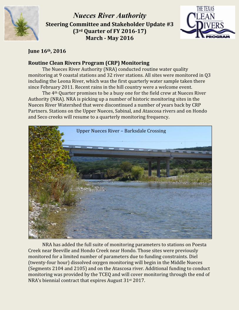
June 16th, 2016 Routine Clean Rivers Program (CRP) Monitoring The Nueces River Authority (NRA) conducted routine water quality monitoring at 9 coastal stations and 32 river stations. All sites were monitored in Q3 including the Leona River, which was the first quarterly water sample taken there since February 2011. Recent rains in the hill country were a welcome event. The 4th Quarter promises to be a busy one for the field crew at Nueces River Authority (NRA). NRA is picking up a number of historic monitoring sites in the Nueces River Watershed that were discontinued a number of years back by CRP Partners. Stations on the Upper Nueces, Sabinal, and Atascosa rivers and on Hondo and Seco creeks will resume to a quarterly monitoring frequency.
NRA has added the full suite of monitoring parameters to stations on Poesta Creek near Beeville and Hondo Creek near Hondo. Those sites were previously monitored for a limited number of parameters due to funding constraints. Diel (twenty-four hour) dissolved oxygen monitoring will begin in the Middle Nueces (Segments 2104 and 2105) and on the Atascosa river. Additional funding to conduct monitoring was provided by the TCEQ and will cover monitoring through the end of NRA’s biennial contract that expires August 31st 2017.
Upper Nueces River – Barksdale Crossing

Drought Status in the Nueces River Basin Much of the Nueces River Basin and adjoining basins experienced significant rainfall events in the third quarter (March – May 2016). The drought index (The US Drought Monitor for Texas) shows the location of drought conditions in Texas compared with the beginning of the quarter. None of the Nueces River Watershed or adjoining Coastal Basins is shown to be under drought conditions according to the
site. However, if judging by the 10-year lake level chart for Choke Canyon Reservoir (below), it would appear that South Texas is still in the throes of a lengthy drought that began in 2007, the last time the reservoir was full. Fortunately, many of the tributaries to Choke Canyon Reservoir were flowing nicely after rain events late in the quarter. Streamflow levels were up on the Leona, Sabinal, and Frio rivers, as well as on Seco, Hondo and San Miguel creeks, all of which provide at least a portion of water to Choke Canyon Reservoir. Percent of capacity in Choke Canyon Reservoir fell from 34.5 to 33.3% for the 3rd quarter (March –May 2016).
0 10 20 30 40 50 60 70 80 90
100
6/1/
2006
10
/1/2
006
2/1/
2007
6/
1/20
07
10/1
/200
7 2/
1/20
08
6/1/
2008
10
/1/2
008
2/1/
2009
6/
1/20
09
10/1
/200
9 2/
1/20
10
6/1/
2010
10
/1/2
010
2/1/
2011
6/
1/20
11
10/1
/201
1 2/
1/20
12
6/1/
2012
10
/1/2
012
2/1/
2013
6/
1/20
13
10/1
/201
3 2/
1/20
14
6/1/
2014
10
/1/2
014
2/1/
2015
6/
1/20
15
10/1
/201
5 2/
1/20
16
6/1/
2016
Choke Canyon Reservoir - Percent of Capacity
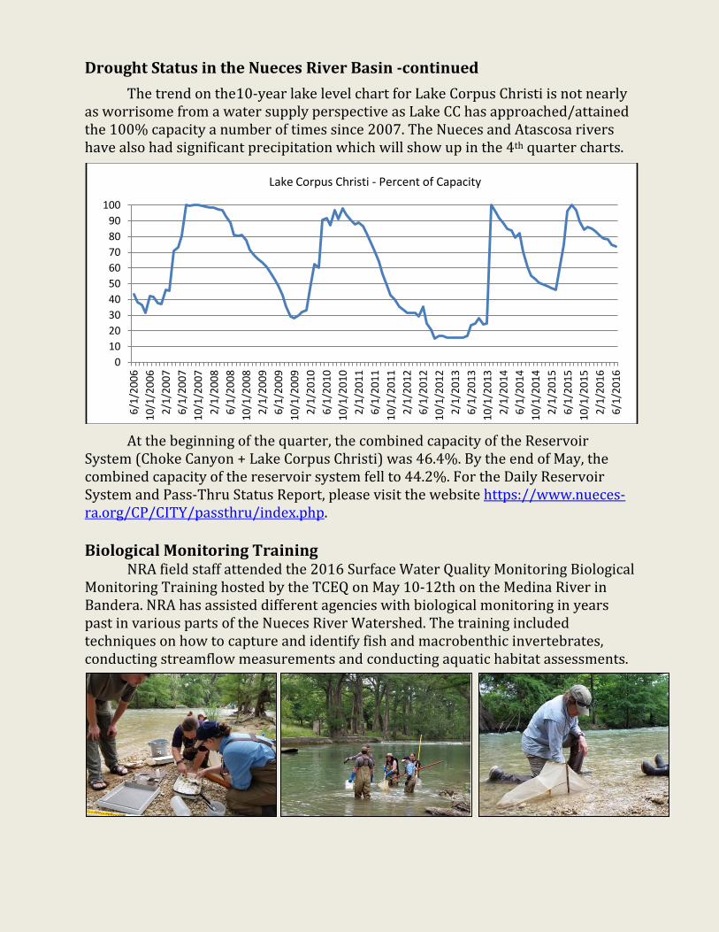
Drought Status in the Nueces River Basin -continued The trend on the10-year lake level chart for Lake Corpus Christi is not nearly as worrisome from a water supply perspective as Lake CC has approached/attained the 100% capacity a number of times since 2007. The Nueces and Atascosa rivers have also had significant precipitation which will show up in the 4th quarter charts.
At the beginning of the quarter, the combined capacity of the Reservoir System (Choke Canyon + Lake Corpus Christi) was 46.4%. By the end of May, the combined capacity of the reservoir system fell to 44.2%. For the Daily Reservoir System and Pass-Thru Status Report, please visit the website https://www.nueces-ra.org/CP/CITY/passthru/index.php. Biological Monitoring Training NRA field staff attended the 2016 Surface Water Quality Monitoring Biological Monitoring Training hosted by the TCEQ on May 10-12th on the Medina River in Bandera. NRA has assisted different agencies with biological monitoring in years past in various parts of the Nueces River Watershed. The training included techniques on how to capture and identify fish and macrobenthic invertebrates, conducting streamflow measurements and conducting aquatic habitat assessments.
0 10 20 30 40 50 60 70 80 90
100
6/1/
2006
10
/1/2
006
2/1/
2007
6/
1/20
07
10/1
/200
7 2/
1/20
08
6/1/
2008
10
/1/2
008
2/1/
2009
6/
1/20
09
10/1
/200
9 2/
1/20
10
6/1/
2010
10
/1/2
010
2/1/
2011
6/
1/20
11
10/1
/201
1 2/
1/20
12
6/1/
2012
10
/1/2
012
2/1/
2013
6/
1/20
13
10/1
/201
3 2/
1/20
14
6/1/
2014
10
/1/2
014
2/1/
2015
6/
1/20
15
10/1
/201
5 2/
1/20
16
6/1/
2016
Lake Corpus Christi - Percent of Capacity

Petronila Creek Tributary Study Petronila Creek (Segment 2204) was listed on the 2000 Texas 303(d) list of impaired water bodies for exceeding the standards for chloride (1,500 mg/l), sulfate (500 mg/l), and total dissolved solids (TDS) (4,000 mg/l). In support of the Implementation Plan (I-Plan) for Petronila Creek, NRA began a monthly monitoring project back in September 2014 that examines the amount of chloride, sulfate, and TDS present in surface waters of the creek and many of its tributaries. Field investigations identified that excessive chloride, sulfate, and TDS concentrations occur in the downstream section of the creek, southeast of US 77, in an area where man-made nonpoint sources such as produced water, brine pits, and brine injection wells, related to oil and gas production, are most numerous. The monthly effort to monitor the tributaries of Petronila Creek resumed in December 2015. Seven sites are being monitored every three weeks until August 2016. Elevated concentrations of chloride, sulfate and TDS have been observed in all sites so far in between rain events. Outreach and Education NRA’s Education and Outreach Program reached out to 2,599 people from March through May using custom made tools including NRA’s watershed, rainwater, and groundwater models. For more information about outreach and education, contact [email protected]. Arroyo Colorado Watershed Partnership NRA attended the Arroyo Colorado Watershed Partnership Steering Committee meeting on April 7th. The group has been updating the Watershed Protection Plan for the Arroyo Colorado and was soliciting feedback from the group. The next meeting is scheduled for June 23rd from 5-7 pm The Estero Llano Grande World Birding Center located at 3301 S. FM 1015 at Pauraque Hall in the rear of the park. For more information please e-mail Jaime Flores at [email protected].
Site # Mar. 2016 Apr. 2016 May 2016 21594 15,700 µmhos 375 µmhos 10,100 µmhos 18484 39,200 2,610 21,100 13095 8,910 976 8,810 18642 20,300 6,220 1,700 21596 16,400 18,300 4,820 13030 12,200 1,670 430 21598 31,300 26,900 366

Nueces River Watershed Partnership – Implementation of the Lower Nueces River Watershed Protection Plan (WPP) The Lower Nueces River WPP was accepted by the EPA in April 2016! The final version is available at http://www.nuecesriverpartnership.org/pubs.php. NRA is moving forward with coordinating its implementation though a grant from the Texas State Soil and Water Conservation Board. The large debris removal was been completed between May 12 – 18, 2016. NRA worked with the Nueces River Preservation Association (NRPA) to develop the list of items to be removed. This list consisted of 10 partially submerged boats and one collapsed pier. Other items located by a side-scan sonar survey conducted in April 2014 were not considered to be hazards or detrimental to water quality, and that these items were better left undisturbed. NRA contracted with J. M. Davidson Inc. to remove the boats and pier. The contractor was on location rebuilding the boat ramp at Hazel Bazemore Park for Nueces County. The City of Corpus Christi Solid Waste Department provided a dumpster for the debris and provided for the debris disposal. Mobilization / demobilization expenses were covered by the County’s contract. As reported in the last update, there were four proposals out for consideration:
• An Urban Small Water Grant application to evaluate connecting some homes within the Corpus Christi city limits that are on on-site sewage facilities (OSSF) to the City’s sewer system. This proposal was not selected for funding, but may be resubmitted to Texas Commission on Environmental Quality’s (TCEQ) FY 2017 Clean Water Act §319(h) Non-Point Source request for proposals, due by September 1, 2016.
• A TCEQ Clean Water Act §319(h) grant application to provide free OSSF inspections and possible funding for replacement systems. TCEQ selected it to be included with their FY 2017 workplan to EPA, and is scheduled to begin November 1, 2016.
• A Coastal Bend Bays and Estuaries Program proposal to install up to five pet waste stations. This proposal is still in the running.
• A Coastal Bend Bays and Estuaries Program proposal to provide a feral hog management workshop and a wildlife management workshop. This proposal did not make the initial cut.

Nueces River Watershed Partnership (continued) The next meeting of the Nueces River Watershed Partnership is tentatively scheduled for the latter part of August. The date will be posted in the ‘Announcements, Meetings, and Workshops’ section on our homepage, http://www.nueces-ra.org. For more information about the Partnership and the WPP, visit http://www.nuecesriverpartnership.org or contact Rocky Freund at (361) 653-2110 or [email protected]. Oso Bay Total Maximum Daily Load Since 2002, Oso Creek (Segment 2485A), which flows 28 miles to the confluence of Oso Bay in Nueces County has been identified as being impaired for having bacteria concentrations that exceed state water quality standards. Since 2003, the TCEQ and the TSSWCB have conducted studies of bacteria sources and quantities in the Oso Creek watershed. Based on the results of those studies, a TMDL for Oso Creek is being developed to address the contact recreation impairment. Staff from the Center for Coastal Studies at Texas A&M University – Corpus Christi and the Coastal Bend Bays Foundation is disseminating information to the public. Learn more about the Oso Bay TMDL and/or the Oso Creek Watershed Public Outreach at the TCEQ project page: http://www.tceq.texas.gov/waterquality/tmdl/67-osobaybacteria.html; You may also go to the CBBF web site at www.baysfoundation.org, email Teresa Carrillo at [email protected] or call 361-882-3439.