Embed Size (px)
Citation preview
1
Case study report
Carried out in County Mayo,
(Ireland) By NUIG and Udaras na Gaeltachta
December 2011
Authors
Kevin Lynch1, Micheál Ó Cinnéide1, Alan DiLucia2 and James Massey3.
Expert Panel Members
Karin Dubsky4, Dick McKeever5, Eugene Nixon6 and Seán Ó Coisdealbha7
Further contributions
Iain Douglas3, Zoe Elliott1, Wesley Flannery1, Mairéad Ní Oistín7 and Michael Roarty1
1NUIG, Geography, 2 Mayo County Council, Planning, 3RPS Coastwatch Europe, 4Coastwatch Europe, 5Department of Environment
Heritage & Local Government, 6Marine Institute and 7Údarás na Gaeltachta
2
Section 1: illustration of the case study activities 4
Description of area 4
Problems and imperatives 5
Case study implementation and objectives 5
Section 2: governance issue 6
Governance of the coast and Coastal Risk 6
Extent to which Coastal Risk is considered in Development Plans 7
Extent to which Coastal Risk is considered in Planning Decisions 12
Perspectives on Coastal Risk in coastal planning decisions 14
Section 3: elements of transferability to other European contexts 15
A decision-maker’s guide to Coastal Risk 15
Rapid field assessment of Coastal Risk 15
A boundary organisation 16
Section 4: executive summary 18
3
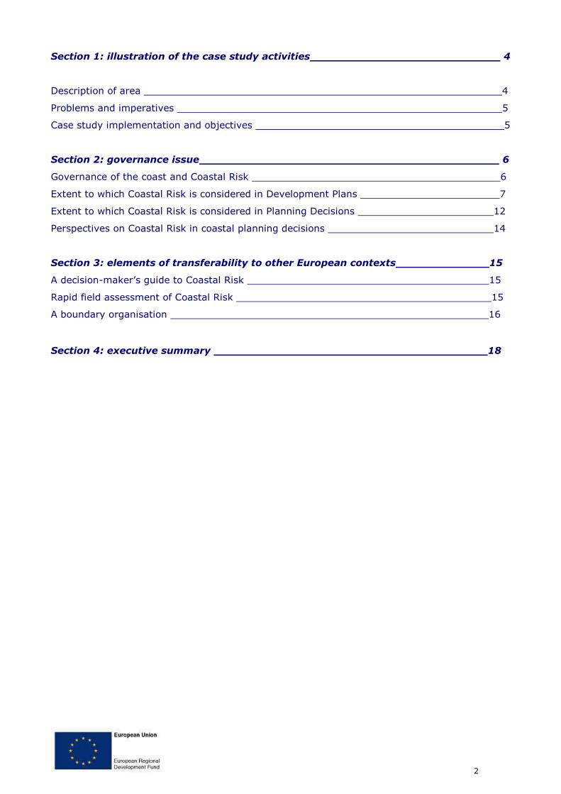
Building planning capacity to combat coastal risks:
a field evaluation from County Mayo
Authors
Kevin Lynch1, Micheál Ó Cinnéide1, Alan DiLucia2 and James Massey3.
Expert Panel Members
Karin Dubsky4, Dick McKeever5, Eugene Nixon6 and Seán Ó Coisdealbha7
Further contributions
Iain Douglas3, Zoe Elliott1, Wesley Flannery1, Mairéad Ní Oistín7 and Michael Roarty1
1NUIG, Geography, 2 Mayo County Council, Planning, 3RPS Coastwatch Europe, 4Coastwatch Europe, 5Department of
Environment Heritage & Local Government, 6Marine Institute and 7Údarás na Gaeltachta
4
Section 1: illustration of the case study activities
Description of area
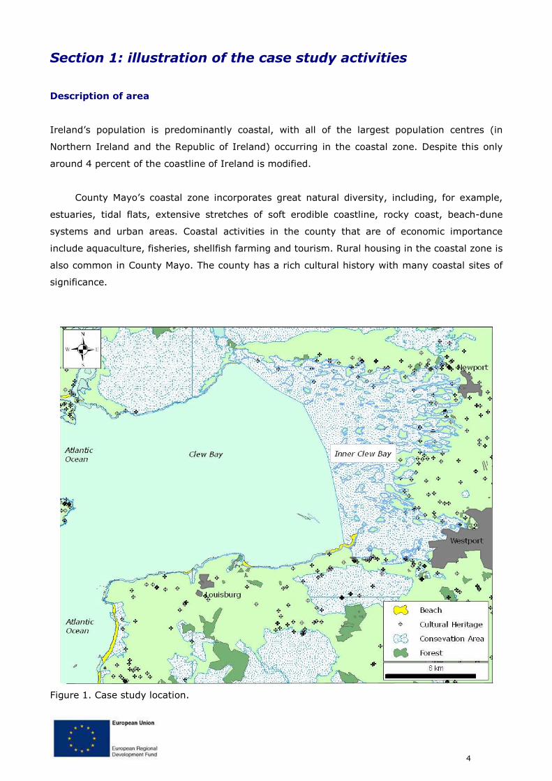
Ireland’s population is predominantly coastal, with all of the largest population centres (in
Northern Ireland and the Republic of Ireland) occurring in the coastal zone. Despite this only
around 4 percent of the coastline of Ireland is modified.
County Mayo’s coastal zone incorporates great natural diversity, including, for example,
estuaries, tidal flats, extensive stretches of soft erodible coastline, rocky coast, beach-dune
systems and urban areas. Coastal activities in the county that are of economic importance
include aquaculture, fisheries, shellfish farming and tourism. Rural housing in the coastal zone is
also common in County Mayo. The county has a rich cultural history with many coastal sites of
significance.
Figure 1. Case study location.
5
Problems and imperatives
The diversity of the physical environment brings with it a significant range of potential coastal
risks that need to be considered when planning decisions are made, for example: active coastal
processes affecting the stability of soft coastlines and threatening coastal defences; seasonal
pressures linked to tourism, pressures from urbanisation; risks from extreme climatic events;
threats to water quality resulting from discharges or accidental spills. These different types of
pressures are potentially heightened by the effects of climate change with, for example, a
possible increase in the number of storms having considerable impact on the coastal zone.
Coastal industries such as fishing, aquaculture, tourism and shipping together with an
embryonic oil and gas industry play significant roles in the support of the large Irish coastal
population. However, the multitude of activities associated with these industries can also have
detrimental effects on coastal habitats and water quality, in addition to creating conflicts of use
among stakeholders (Cummins et al., 2004).
Coastal development pressures arise as a result of social and economic driving forces such
as urban expansion, retirement and second homes and the tourism industry. For example,
coastal tourism has led to increases in the numbers of marinas, golf courses and residential
buildings near the coast (Cummins et al., 2004).
Agriculture is a significant factor and has been identified as the biggest source of pollution
in Irish rivers and lakes, and has implications for coastal water quality as well. Intensive
agriculture in Ireland has also led to a reduction in semi-natural habitats and to a decrease in
biological diversity (Cummins et al., 2004).. As yet the Irish authorities have not fully
implemented the WFD recommendations and to date Ireland has not transposed the Marine
Strategy Directive in to national legislation.
Case study implementation and objectives
The objective of the case study is to demonstrate how current coastal land planning practices
align with legislative and policy frameworks. More importantly, the case study illustrates how
the consideration of coastal risks in planning may be improved through the use of innovative
tools.
6
Section 2: governance issue
Governance of the coast and Coastal Risk
The Department of the Environment, Heritage and Local Government (DEHLG) is primarily
responsible for national planning policy and the legislative framework, and also provides an
expert advisory service on heritage and conservation issues to planning authorities and to An
Bord Pleanála (the Planning Appeals Board). The land planning system is operated on the
ground by the local planning authorities. Ireland is one of only a few European countries that
have an independent third-party planning appeals system operated by An Bord Pleanála
(Bannon, 1989).
Ireland has little integrated coastal management practices, with responsibility for planning
and management divided among authorities that deal almost exclusively with either the land
side or the marine side. This division of responsibility is further compounded by sectorally-
structured legislation. There are also problems with defining the extent of the coastal zone. The
extent of change and complexity of the current system is illustrated by the following description
of the most recent developments in the governance structure.
Following the General Election in May 2007, the Department of the Marine was dissolved
and responsibilities passed to other departments. Coastal developments in Ireland are currently
governed by the Department of Environment, Heritage and Local Government (DoEHLG); local
authorities; the Department of Agriculture, Fisheries and Food (DAFF); and the Department of
Communications, Energy and Natural Resources (DCENR).
Following the General Election in 2011, these powers were further devolved into the
Licensing Unit of the DoEHLG, however that Department is currently being redefined, with the
Nature Conservation responsibilities devolved into a differing government Department. During
this transition period the Marine Licence Vetting Committee (see below) has been maintained to
allow decision making.
The transfer of the foreshore functions has provided the Minister for the Environment,
Heritage and Local Government with the opportunity to start a process of modernization of the
foreshore consent process for certain developments in the offshore environment, including
offshore renewable energy projects such as wave, wind and tidal technologies. In association
with this process and uncertainty of responsibility, Ireland transposed the Marine Strategy
Framework Directive in July 2011, appointing the Minister for the Environment and Department
of Environment as the regulatory body for implementation.
7
The modernisation and streamlining of the consent process for certain developments in the
offshore environment will be introduced on a phased development basis and is envisaged to
include inter alia measures to fully integrate and streamline estate management on the State
owned foreshore with the strategic and wider planning consent processes.
The new architecture for consent is to be managed within an overall spatial plan for
Ireland’s marine environment and while it is acknowledged that this will take time as an interim
measure the Offshore Renewable Energy Development Plan will provide an initial policy
framework and background information for consenting authorities.
However, even since this process has been underway, natural and cultural heritage
responsibilities (including marine conservation and coastal and underwater archaeology) have
been further devolved into a different government department from the Department of
Environment – leading to fragmentation of the governance framework.
With the governance structures for coastal land planning and marine spatial planning at a
transitional stage the description above cannot paint a clear picture of the current situation. The
ongoing attempts by the government - to restructure how coastal and marine space is planned
and managed - presents an ideal opportunity to critically analyse the extent to which coastal
risks are currently considered in coastal planning.
Extent to which Coastal Risk is considered in Development Plans
Analysis of existing policy and plans
It is clear from national policy documents that coastal risks are not explicitly identified as an
integral part of the planning process. In large part they may be identified indirectly as being an
important consideration in planning new developments. For example, both the National Spatial
Strategy and the National Development Plan highlight the need for coastal infrastructure. The
various programmes include development of coastal tourism, sea transport, security of oil and
gas supplies, renewable energy and a range of other objectives that entail coastal developments
and therefore morphological pressure. However, the programmes also identify the need for
ICZM, cross-sectoral management based on the management of areas by catchment (River
Basin Management Plan areas) and physical processes, and outlines needs for research and
implementation programmes. ICZM is an important measure highlighted in many European and
National strategies and legislation. It provides a significant management measure for coastal
risk and cumulative coastal risk assessment, integrating the existing mechanisms to provide
8
effective management. ICZM in Ireland has not, however, progressed past the pilot project
stage and there is no legislative driver or framework for its implementation.
The role of national level policies is to provide direction for planners in the development of
regional and local plans. It is to be expected that the level of detail increases as plans become
more location specific, i.e. as the spatial scale decreases information should increase (d’Auria
and Ó Cinnéide, 2009). An integral part of a planner’s work in drawing up a plan is to use the
SEA process to inform the plan. This assessment involves considering how each of the following
impacts on, or is impacted by, the proposed development contained within the plan:
Biodiversity; Fauna and Flora; Population, Human health; Soil (including Geology); Water
(including quality); Air (including quality); Climatic factors (including climate change); Material
assets; Cultural heritage; and Landscape. While, once again, many coastal risks are not
explicitly mentioned the comprehensive coverage of environmental and socio-economic factors
should ensure the planner includes consideration of coastal risks in the development plan.The
SEA provides a good example of just one of the assessments that a planner will undertake when
developing a plan; other assessments also entail obligations to consider coastal risks. Therefore,
it is to be expected that County Development Plans (CDP) and Local Area Plans (LAP) (where
they exist) should have highly detailed information on coastal risks. When individual projects
are then proposed the planner responsible for the decision can make use of the relevant plan to
inform the decision, including appropriate consideration of coastal risk.
The CDP for Co Mayo and the Westport Town Plan (a LAP) were analysed in light of this
conceptual plan development scenario. The analysis consisted of visually checking through the
listed contents under headings where it might be expected to find information on risks, and
then by searching the digital documents for keywords (e.g., flood, storm, erosion, shoreline
mobility, water quality, etc.). While some of the key coastal risks are dealt with in a
comprehensive manner (and this includes references to more detailed guidelines elsewhere), for
example flood risk, others are given superficial mention and concrete guidance is not available.
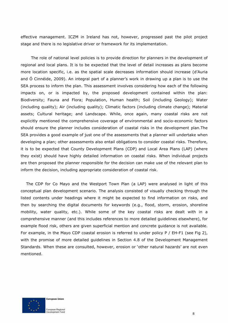
For example, in the Mayo CDP coastal erosion is referred to under policy P / EH-F1 (see Fig 2),
with the promise of more detailed guidelines in Section 4.8 of the Development Management
Standards. When these are consulted, however, erosion or ‘other natural hazards’ are not even
mentioned.
9
Figure 2. Extract from Mayo County Development Plan.
Analysis of the Westport Town Plan found no mention of erosion at all. Despite one quarter of
its boundary being coastal, with unconsolidated glacial sediments and coastal protection works
accounting for the majority of the coastline. Westport’s coastal stretch also incorporates
significant capital - including housing and commercial activity, a Special Area of Conservation,
listed monuments and key roads and cycleway infrastructure - increasing the potential risk for
the area.
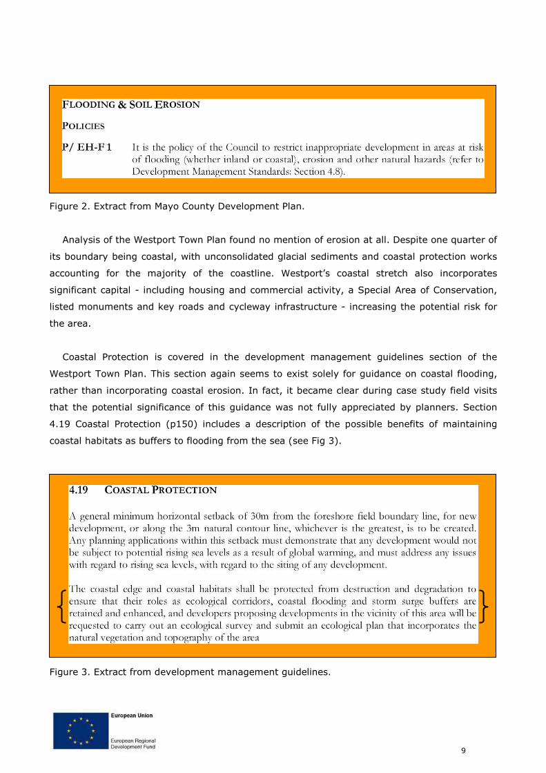
Coastal Protection is covered in the development management guidelines section of the
Westport Town Plan. This section again seems to exist solely for guidance on coastal flooding,
rather than incorporating coastal erosion. In fact, it became clear during case study field visits
that the potential significance of this guidance was not fully appreciated by planners. Section
4.19 Coastal Protection (p150) includes a description of the possible benefits of maintaining
coastal habitats as buffers to flooding from the sea (see Fig 3).
Figure 3. Extract from development management guidelines.
10
On a field visit to Louisburg and its environs this natural protection that may be present at
the coast was illustrated by a coastal geomorphologist (See explanation in Box 1). While recent
efforts to manage and stabilise this dune complex have been concerned with conserving
biodiversity, land planners on the field visit identified the potential to protect this valuable flood
protection asset by means of zoning (in addition to any conservation designations it may be
afforded). This would entail including the land in future village development plans - due
explicitly to its function as a natural protection against coastal flooding. Unfortunately this may
also be counter-productive, with the following scenarios highlighting the nature of the planning
system in Ireland:
Scenario 1 – If the land is not included in the local area plan (red boundary on map): The area
is currently proposed as a Natural Heritage Area. This would give it a degree of protection from
development. This scenario would consolidate development around the core of the town, but
would not assure retention of the natural protection as is.
Scenario 2 - If the land is included in the local area plan (extending to include the blue
boundary): This would afford an opportunity to recognise the role of the dune system and
marsh in protecting Louisburgh from flooding and to have these lands zoned accordingly. There
is, however, a danger that the area could be zoned inappropriately as the final decision is made
by elected representatives, who may be subjected to pressures from vested interests to have
some or all of the lands zoned for development.
11
Sandy beach and dunes Soft erodible cliff.
BOX 1: Beach-dune systems as natural protection
Louisburgh is a rural village (pop. 314) located 1km from the coast. It is expect to double in size by 2022.
The local economy is sustained in part by a small factory, with some agricultural, commercial and retail
activity, most of the village’s inhabitants commute out of the area to work. Holiday homes add to the
economic activity during the summer months. It is expected tourism will be central to the future
development of the area.
Although tidal influences extend up the Bunowen River to the village, flooding is not currently considered a
problem. This situation, however, could change drastically if the coastal environment were altered. The
village is protected on its seaward side by a coastal dune complex, with a salt marsh occupying the low
lying land in between. During storms this environment offers a buffer to elevated water levels
reaching Louisburg. The natural maintenance of this environment is dependent on a constant supply of
sand to the beach and dunes. The erosion of adjacent cliffs supplies this sediment. Therefore, any
development or works (including, paradoxically, coastal protection works) that may hinder or alter this
supply should be avoided. Likewise direct development on, or alteration of, the beach-dune system should
be avoided: it is an inherently mobile system, moving and re-shaping as the driving force of weather and
climate change over time.
Salt Marsh.
Louisburgh.
12
While only a small sample of the analysis of the policies and plans are presented above, it is
evident that the overall trend is for consideration of coastal risks to be lessen as the operational
scale becomes increasingly local – contrary to the theoretical scenario, where it is expected to
increase as local plans include more specific detail. The result of this is that planners who make
decisions on day-to-day basis on proposed developments in the coastal zone may not have
enough relevant information and guidance to make fully informed decisions.
Extent to which Coastal Risk is considered in Planning Decisions
Analysis of Individual Planning Decisions
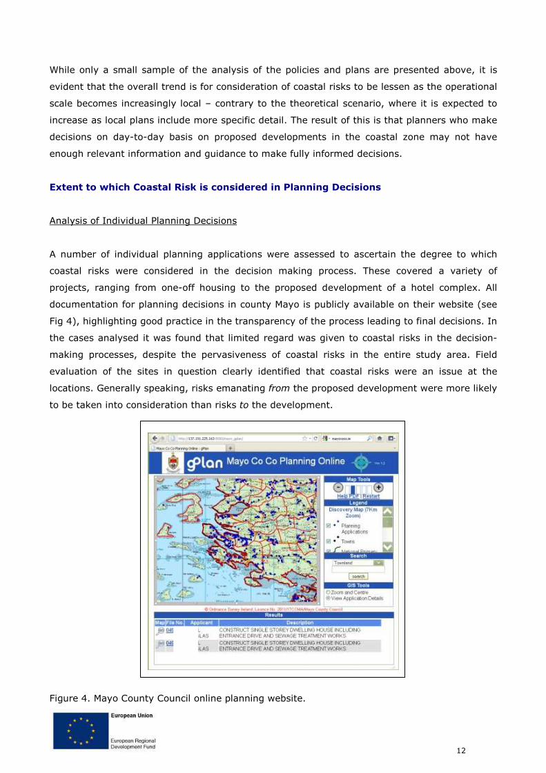
A number of individual planning applications were assessed to ascertain the degree to which
coastal risks were considered in the decision making process. These covered a variety of
projects, ranging from one-off housing to the proposed development of a hotel complex. All
documentation for planning decisions in county Mayo is publicly available on their website (see
Fig 4), highlighting good practice in the transparency of the process leading to final decisions. In
the cases analysed it was found that limited regard was given to coastal risks in the decision-
making processes, despite the pervasiveness of coastal risks in the entire study area. Field
evaluation of the sites in question clearly identified that coastal risks were an issue at the
locations. Generally speaking, risks emanating from the proposed development were more likely
to be taken into consideration than risks to the development.
Figure 4. Mayo County Council online planning website.
13
An example of one such planning application illustrates this point. An application was
made to develop a new dwelling at a coastal site within the Westport plan boundary (marked by
the arrow in Figure 6). All relevant assessments of socio-economic and environmental concerns
were carried out. There was not, however, any mention of the possibility of coastal erosion, or
the possible effects of climate change (or sea level rise) – despite its obvious exposure to the
sea, evident in the image. The proposal was finally refused on the grounds that there was no
‘social need’.
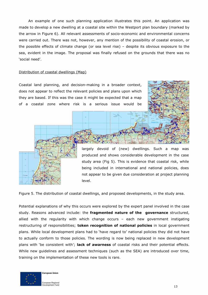
Distribution of coastal dwellings (Map)
Coastal land planning, and decision-making in a broader context,
does not appear to reflect the relevant policies and plans upon which
they are based. If this was the case it might be expected that a map
of a coastal zone where risk is a serious issue would be
largely devoid of (new) dwellings. Such a map was
produced and shows considerable development in the case
study area (Fig 5). This is evidence that coastal risk, while
being included in international and national policies, does
not appear to be given due consideration at project planning
level.
Figure 5. The distribution of coastal dwellings, and proposed developments, in the study area.
Potential explanations of why this occurs were explored by the expert panel involved in the case
study. Reasons advanced include: the fragmented nature of the governance structured,
allied with the regularity with which change occurs – each new government instigating
restructuring of responsibilities; token recognition of national policies in local government
plans. While local development plans had to ‘have regard to’ national policies they did not have
to actually conform to those policies. The wording is now being replaced in new development
plans with ‘be consistent with’; lack of awarness of coastal risks and their potential effects.
While new guidelines and assessment techniques (such as the SEA) are introduced over time,
training on the implementation of these new tools is rare.
14
Perspectives on Coastal Risk in coastal planning decisions
A survey was carried out to explore some of the issues concerned with coastal risk, decision-
making and sustainable development principles. Decision-makers at all levels were targeted
(i.e., it was not limited to county planners) to test whether incorporating risks into decisions
differed depending on the type of decision that was being made (policy, plan or project).
Analysis of these data suggest there may be a disconnect between an individual who decides to
undertake a project and the local authority who decides whether or not to grant permission for
the project. For example, when asked how strongly they agreed or disagreed that ‘The granting
of planning permission by the Local Authority equates to safety from coastal risk’, it was found
that in nearly every instance local residents strongly agreed. On the contrary, respondents from
the local authority and other government agencies strongly disagreed with the statement. In
addition to the question of why these different respondents arrive at polar opposite views of the
same process, it might be asked why projects are being approved if ‘safety from coastal risk’ is
not considered an important aspect of the decision.
15
Section 3: elements of transferability to other European
contexts
A decision-maker’s guide to Coastal Risk
A core aim of the ANCORIM project is to build decision-makers’ capacity to incorporate coastal
risks into decisions. Coastal risks are covered by Ireland’s governance structures (albeit
superficially in some instances) and scientific and technical resources do exist (notwithstanding
some significant gaps). However, as we can see from the evidence presented above the
decisions being made may not be as informed as is possible. In light of this, a didactic
handbook has been developed that gathers in one place the most relevant information on
coastal risk. This handbook guides a decision-maker through descriptions of what coastal risk
are (and how to identify them); why they should be considered (by referencing relevant legal
obligations); and how they could be incorporated into decisions (including adaptive strategies
and links to ANCORIM tools). It also introduces the decision-maker to examples of international
best practice in terms of governance structures and through relevant case studies.
The utility of the guide was tested by re-examining the individual coastal planning
applications analysed earlier. It was found to be very informative and likely to transfer well to
other European regions as it closely aligns with the Strategic Environmental Assessment
template (an EU-wide assessment tool). Another key finding of the test was that the handbook
would be most useful at the plan development stage (i.e., to the forward planner). A possible
hindrance to its immediate applicability might be due to the uncertainty over how the coastal
zone will be managed in the near future, with on-going attempts across Europe to link more
closely land- and marine-based planning.
Rapid field assessment of Coastal Risk
A key aspect of increasing the capacity of decision-makers is to enable them to recognise
evidence of coastal risks in the field. This is not an easy task as the nature of risks is very
complex. It is, however, possible to identify evidence in the field of various facets of a risk
issue. This may be a direct sign (e.g., a road partially falling into the sea) or indirect evidence
(e.g., the presence of ad hoc coastal defences). A two-page photograph-based guide was
produced to facilitate rapid field assessment by non-experts. If the decision-maker identifies
that risk may be an issue in an area they should then seek further expert advice. In field tests
of this tool it was evident that its utility is in creating greater awareness of coast risk rather
than being a robust risk analysis technique. It was also seen to complement quite well the
handbook.
16
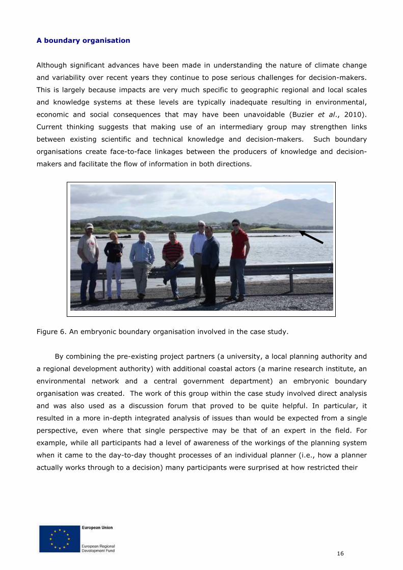
A boundary organisation
Although significant advances have been made in understanding the nature of climate change
and variability over recent years they continue to pose serious challenges for decision-makers.
This is largely because impacts are very much specific to geographic regional and local scales
and knowledge systems at these levels are typically inadequate resulting in environmental,
economic and social consequences that may have been unavoidable (Buzier et al., 2010).
Current thinking suggests that making use of an intermediary group may strengthen links
between existing scientific and technical knowledge and decision-makers. Such boundary
organisations create face-to-face linkages between the producers of knowledge and decision-
makers and facilitate the flow of information in both directions.
Figure 6. An embryonic boundary organisation involved in the case study.
By combining the pre-existing project partners (a university, a local planning authority and
a regional development authority) with additional coastal actors (a marine research institute, an
environmental network and a central government department) an embryonic boundary
organisation was created. The work of this group within the case study involved direct analysis
and was also used as a discussion forum that proved to be quite helpful. In particular, it
resulted in a more in-depth integrated analysis of issues than would be expected from a single
perspective, even where that single perspective may be that of an expert in the field. For
example, while all participants had a level of awareness of the workings of the planning system
when it came to the day-to-day thought processes of an individual planner (i.e., how a planner
actually works through to a decision) many participants were surprised at how restricted their
17
understanding of the ‘real’ workings of the system was. Shedding light on these real world
practices strengthened the participants’ understanding of other perspectives around the table
and lead to progress on certain issues. The boundary organisation also served to highlight
scientific knowledge relating to coastal risks, linked to climate, change that appeared to be
inadequately embraced in local decision-making. This made local decision-makers more acutely
aware of the need to integrate up-to-date scientific information relating to environmental risk
with political, economic and social considerations. It also raised awareness among participating
scientists of the need to communicate scientific results to all relevant constituencies and
appeared to endorse the role of projects such as ANCORIM in this regard.
References
Bannon, M. (1989) Planning: the Irish Experience, 1920-1988. Dublin: Wolfhound Press.
Buizer, J.,Jacobs, K., and Cash, D. (2010) Making short-term climate forecasts useful: linking
science and Action, Proceedings of the National Academy of Sciences,
doi:10.1073/pnas.0900518107.
Cummins, V., O'Mahony, C., and Connolly, N. (2004). Review of Integrated Coastal Zone
Management and Principles of Best Practice, The Heritage Council.
d'Auria, L. and Ó Cinnéide, M. (2009) Integrating strategic environmental assessment into
the review process of a development plan in Ireland, Impact Assessment and Project
Appraisal. 27(4) pp 309-319.
18
Section 4: executive summary
Description of area
County Mayo’s coastal zone incorporates great natural diversity, including for example estuaries, tidal flats, extensive stretches of soft erodible coastline, rocky coast, beach-dune systems and urban areas. Coastal activities in the county that are of economic importance include aquaculture, fisheries, shellfish farming and tourism. Rural housing in the coastal zone is also common in County Mayo. The county has a rich cultural history with many coastal sites of significance. Problems and imperatives
The diversity of the physical environment brings with it a significant range of possible coastal risks that need to be considered when planning decisions are made, for example: active coastal processes affecting the stability of soft coastlines and threatening coastal defences; seasonal pressures linked to tourism, pressures from urbanisation; risks from extreme climatic events; threats to water quality resulting from discharges or accidental spills. These different types of pressures are potentially heightened by the effects of climate change with, for example, a possible increase in the number of storms having considerable impact on the coastal zone Case study implementation and objectives
The objective of the case study is to demonstrate how current coastal land planning practices align with legislative and policy frameworks. More importantly, the case study illustrates how the consideration of coastal risks in planning may be improved through the use of innovative tools. Governance and Coastal Risk
Ireland has little integrated coastal management practices, and coastal risks are often not adequately identified through the planning process due to its non-integrated nature. The land/sea divide is reflected in planning and legislation. Within this land/sea divide there is the further complication of legislation structured by sector. The Planning System does not identify coastal risks as part of its process, however, SEA or EIA are an integral part of the assessment of planning applications. County Development Plans should be subject to SEA and Strategic Flood Risk Assessments. The Department of the Environment, Heritage and Local Government (DEHLG) is primarily responsible for national planning policy and the legislative framework, and also provides an expert advisory service on heritage and conservation issues to planning authorities and to An Bord Pleanála (the Planning Appeals Board). The planning system is operated on the ground by local planning authorities.
CA
SE
ST
UD
Y C
ON
TE
XT
Building planning capacity to combat coastal risks:
a field evaluation from County Mayo
Case Study Summary
CU
RR
EN
T S
ITU
AT
ION
19
Ireland is one of only a few European countries that have an independent third-party planning appeals system operated by An Bord Pleanála (Bannon, 1989). Both the National Spatial Strategy and the National Development Plan highlight the need for coastal infrastructure. The various programmes include development of coastal tourism, sea transport, security of oil and gas supplies, renewable energy and a range of other objectives that will entail coastal development and therefore morphological pressure. However, the programmes also identify the need for ICZM, cross sectoral management based on the management of areas by catchment (RBMP areas) and physical processes, and outlines needs for research and implementation programmes. ICZM is an important measure highlighted in many European and National strategies and legislation. It provides a significant management measure for coastal risk and cumulative coastal risk assessment integrating the existing mechanisms to provide effective management. However, ICZM in Ireland is has not progressed past the pilot project stage and there is no legislative driver or framework for its implementation.
Extent to which Coastal Risk is considered in Planning Decisions
Analysis of Individual Planning Decisions A number of individual coastal planning applications were assessed to ascertain the degree to which coastal risks were considered in the decisions. These covered a variety of scenarios, from one-off housing to the proposed development of a hotel complex. All documentation for planning decisions in county Mayo is publicly available on their website, highlighting good practice in the transparency of the process and final decision. In the cases analysed it was found that limited regard was given to coastal risk in the decision-making process, despite the pervasiveness of coastal risks in the entire study area. Field evaluation of the sites in question clearly identified that coastal risk was an issue at the locations. Generally speaking, risks emanating from the proposed development were more likely to be taken into consideration than risks to the development. Distribution of coastal dwellings (Map) Coastal land planning, and decision-making in a broader context, does not have a simple linear relationship with the relevant policies and plans upon which they are based. If this were the case it might be expected that a map of a coastal zone where risk is an issue would be devoid of (new) dwellings. Such a map was produced and shows considerable development in the case study area. This may be put forward as strong evidence that coastal risk, while being included in international and national policies, is not being considered in practice at the project level.
Perspectives on Coastal Risk in coastal planning decisions
A survey was carried out to explore some of the issues concerned with coastal risk, decision-making and sustainable development principles. Decision-makers at all levels were targeted (i.e., it was not limited to county planners) to test whether incorporating risks into decisions differed depending on the type of decision that was being made (policy, plan or project). Preliminary analysis of these data suggest there may be a disconnect between an individual who decides to undertake a project and the local authority who decides whether or not to grant permission for the project. For example, when asked how strongly they agreed or disagreed that ‘The granting of planning permission by the Local Authority equates to safety from coastal risk’, it was found that in nearly every instance local residents strongly agreed. On the contrary, respondents from the local authority and other government agencies strongly disagreed with the statement. In addition to the question of why these different perspectives arrive at polar opposite views of the same process, it might be asked why projects are being approved if ‘safety from coastal risk’ is not considered an important aspect of the decision.
CU
RR
EN
T S
ITU
AT
ION
20
A decision-makers guide to Coastal Risk
A core aim of the ANCORIM project is to build decision-makers’ capacity to incorporate coastal risks into decisions. Coastal risks are covered by Ireland’s governance structures (albeit superficially in some instances) and scientific and technical resources do exist (notwithstanding some significant gaps), however, as we can see from the evidence presented above the decisions being made may not be the most informed ones that are possible. In light of this, a didactic handbook has been developed that gathers in one place the most relevant information on coastal risk. This handbook guides a decision-maker through descriptions of what coastal risk are (and how to identify them); why they should be considered (by referencing relevant legal obligations); and how they could be incorporated into decisions (including adaptive strategies and links to ANCORIM tools). It also introduces the decision-maker to examples of international best practice in terms of governance structures and through relevant case studies. The utility of the guide was tested by re-examining the individual coastal planning applications analysed earlier. It was found to be very informative and likely to transfer well to other European regions as it closely aligns with the Strategic Environmental Assessment template (an EU-wide assessment tool). Another key finding of the test was that the handbook would be most useful at the plan development stage (i.e., to the forward planner). A possible hindrance to its immediate applicability might be due to the uncertainty over how the coastal zone will be managed in the near future, with on-going attempts across Europe to link more closely land- and marine-based planning. Rapid field assessment of Coastal Risk
A key aspect to increasing the capacity of decision-makers is to enable them to recognise evidence of coastal risks in the field. This is not an easy task as the nature of risks is very complex. It is, however, possible to identify evidence in the field of various facets of a risk issue. This may be a direct sign (e.g., a road partially falling into the sea) or indirect evidence (e.g., the presence of ad hoc coastal defences). A two-page photograph-based guide was produced to facilitate rapid field assessment by non-experts. If the decision-maker identifies that risk may be an issue in an area they should then seek further expert advice. In field tests of this tool it was evident that its utility is in creating greater awareness of coast risk rather than being a robust risk analysis technique. It was also seen to complement quite well the handbook.
A boundary organisation
Current thinking suggests that making use of an intermediary group may strengthen links between existing scientific and technical knowledge and decision-makers. By combining the existing project partners (a university, a local planning authority and a regional development authority) with additional coastal actors (a research institute, an environmental network and a central government department) a temporary boundary organisation was created. The work of this group within the case study involved direct analysis and was also used as a discussion forum. It proved quite successful; in particular, it seemed to produce a more in-depth analysis of issues than would be expected from a single perspective, even where that single perspective may be considered an expert in the field. For example, while all participants would have been aware of the workings of the planning system when it came to the day-to-day thought process of an individual planner (i.e., how a planner physically works through a decision) many of the participants were surprised at how restricted their understanding of the ‘real’ workings of the system was. Shedding light on these real world practices strengthened the participants’ understanding of other perspectives around the table and lead to progress on certain issues.
INN
OV
AT
IVE
SO
LU
TIO
NS