Embed Size (px)
Citation preview
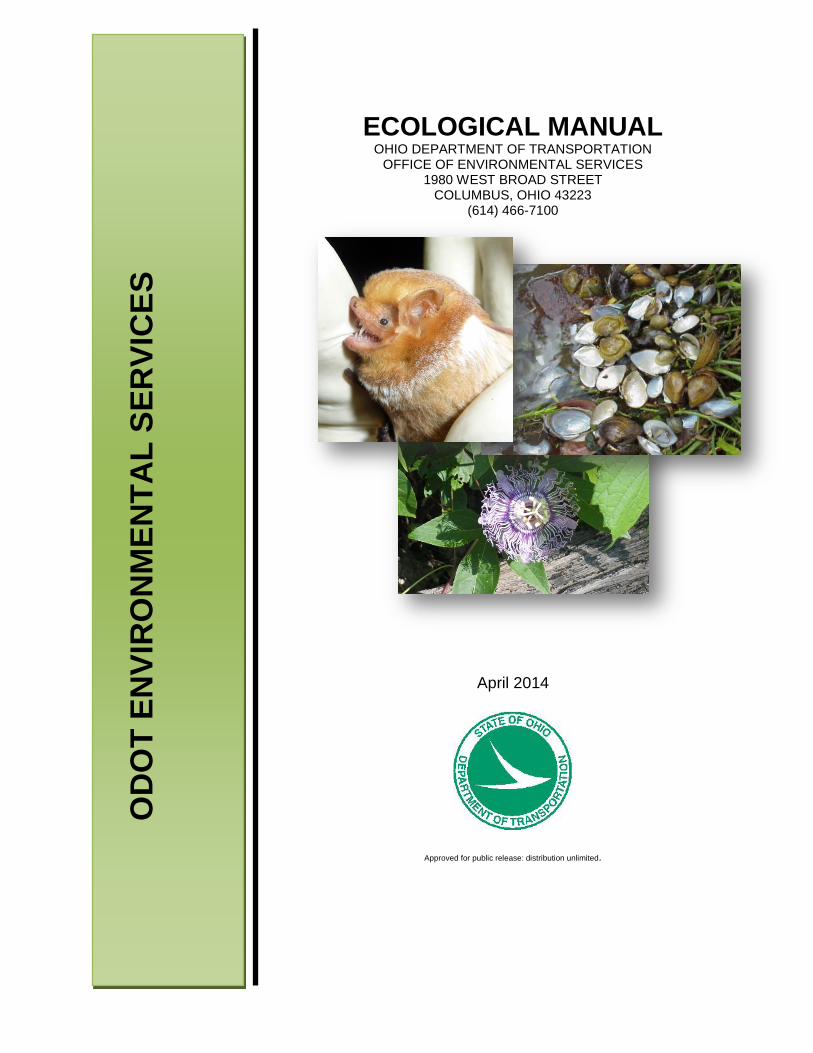
ECOLOGICAL MANUAL OHIO DEPARTMENT OF TRANSPORTATION
OFFICE OF ENVIRONMENTAL SERVICES 1980 WEST BROAD STREET
COLUMBUS, OHIO 43223 (614) 466-7100
April 2014
Approved for public release: distribution unlimited.
OD
OT
ENVI
RO
NM
ENTA
L SE
RVI
CES
Ecological Manual
i
TABLE OF CONTENTS
1: INTRODUCTION.................................................................................................................................................. 3
1.1 INTRODUCTION TO THE ECOLOGICAL MANUAL .................................................................................................. 3
1.2 ECOLOGICAL MANUAL UPDATES ......................................................................................................................... 3
1.3 OBJECTIVE ............................................................................................................................................................ 3
1.4 RELEVANT ENVIRONMENTAL LAWS, DECISIONS, AND AGREEMENTS ................................................................. 4 1.4.1 RELEVANT ENVIRONMENTAL LAWS ............................................................................................................. 4 1.4.2 SUPREME COURT DECISIONS ........................................................................................................................ 6 1.4.3 AGREEMENTS ................................................................................................................................................ 7
1.5 PREQUALIFICATION.............................................................................................................................................. 9
1.6 ECOLOGICAL SURVEY SELECTION, SCOPING CONSIDERATIONS, AND RELATIONSHIP TO ODOT’S PDP ............... 9 1.6.1 ECOLOGICAL SURVEY AND REPORT SELECTION ........................................................................................... 9
2: ECOLOGICAL SURVEY ....................................................................................................................................... 12
2.1 GENERAL INFORMATION ABOUT ECOLOGICAL SURVEY .................................................................................... 12 2.1.1 DEFINING THE ECOLOGICAL SURVEY AREA ................................................................................................ 12 2.1.2 LITERATURE REVIEW SURVEY ..................................................................................................................... 13
2.1.2.1 BACKGROUND LAND USE/COVER AND GEOLOGIC INFORMATION LITERATURE REVIEW SURVEY .. 13 2.1.2.2 AQUATIC ECOLOGY LITERATURE REVIEW SURVEY ............................................................................ 14 2.1.2.3 TERRESTRIAL ECOLOGY LITERATURE REVIEW SURVEY ...................................................................... 18 2.1.2.4 LISTED SPECIES LITERATURE REVIEW SURVEY ................................................................................... 19
2.1.3 FIELD SURVEY METHODS ............................................................................................................................ 19 2.1.4 TIMING OF FIELDWORK .............................................................................................................................. 20 2.1.5 SPECIMEN VOUCHERING ............................................................................................................................ 20
2.2 RESOURCES SUBJECT TO ECOLOGICAL SURVEY ................................................................................................. 21 2.2.1 AQUATIC ECOLOGY ..................................................................................................................................... 21
2.2.1.1 STREAMS ............................................................................................................................................. 21 2.2.1.2 WETLANDS .......................................................................................................................................... 29 2.2.1.3 DITCHES ............................................................................................................................................... 34 2.2.1.4 PONDS, LAKES, RESERVOIRS, RETENTION AND DETENTION BASINS ................................................ 38 2.2.1.5 FISHES .................................................................................................................................................. 41 2.2.1.6 MACROBENTHOS ................................................................................................................................ 43 2.2.1.7 UNIONID MUSSELS (BIVALVES) .......................................................................................................... 46
2.2.2 TERRESTRIAL ECOLOGY ............................................................................................................................... 49 2.2.2.1 VEGETATION ....................................................................................................................................... 49 2.2.2.2 AMPHIBIANS AND REPTILES ............................................................................................................... 54 2.2.2.3 BIRDS ................................................................................................................................................... 56 2.2.2.4 MAMMALS .......................................................................................................................................... 57
2.2.3 FEDERAL AND STATE LISTED SPECIES ......................................................................................................... 59
3 ECOLOGICAL SURVEY REPORTS ......................................................................................................................... 63
3.1 GENERAL INFORMATION ABOUT ECOLOGICAL REPORTING .............................................................................. 63
3.2 LEVEL 1 ECOLOGICAL SURVEY REPORT (Level 1 ESR) ......................................................................................... 64
3.3 LEVEL 2 ECOLOGICAL SURVEY REPORT (LEVEL 2 ESR) ........................................................................................ 65
3.4 LEVEL THREE ECOLOGICAL SURVEY REPORTS (Level 3 ESRs): ............................................................................ 65
Ecological Manual
ii
3.5 ADDITIONAL DOCUMENTATION ........................................................................................................................ 67 3.5.1 STATE SCENIC RIVER REPORTING ............................................................................................................... 67 3.5.2 NATIONAL WILD SCENIC RIVER REPORTING: .............................................................................................. 68 3.5.3 UNIONID MUSSEL SURVEY REPORTS – ODNR AND USFWS COORDINATION ............................................. 70 3.5.4 OTHER SPECIES SPECIFIC REPORTS – ODNR AND USFWS COORDINATION ................................................ 70 3.5.5 BIOLOGICAL ASSESSMENT – FORMAL CONSULTATION WITH USFWS ....................................................... 71 3.5.6 COASTAL ZONE MANAGEMENT – ODNR COORDINATION ......................................................................... 72
4: ECOLOGICAL SURVEY REPORT COORDINATION AND CONCLUSIONS ................................................................ 72
4.1 ECOLOGICAL COORDINATION ............................................................................................................................ 72
4.2 COMMENTS AND ENVIRONMENTAL COMMITMENTS ....................................................................................... 76 APPENDICIES ON-LINE TECHNICAL GUIDANCE AND METHODS REPORT FORMS AND INSTRUCTIONS LITERATURE REVIEW AND RELATED LINKS TRAINING INFORMATION AND PREQUALIFICATION REQUIREMENTS RELEVANT AGREEMENTS
Ecological Manual
3
1: INTRODUCTION
1.1 INTRODUCTION TO THE ECOLOGICAL MANUAL The Ohio Department of Transportation (ODOT) – Office of Environmental Services (OES), Ecological Unit (OES-ECO) has developed this Ecological Manual to provide an overview of the ecological data collection, documentation, and coordination procedures for use on ODOT related projects. The manual and supporting documentation, including the Appendices (see Table of Contents) to the Ecological Manual, can be found at the ODOT Ecological Resources webpage. Ecological data collection begins early in ODOT’s Project Development Process (PDP). ODOT environmental personnel and prequalified environmental consulting firms are often tasked to provide planning and project managers with ecological information for inclusion in the Project Initiation Package. The Project Initiation Package is an early project planning document that identifies locations and issues of concern. The ecological information provided is usually available through literature sources. Three levels of ecological surveys and associated reports, which include Level 1, Level 2, and Level 3 Ecological Survey Reports (ESRs), have been developed to document the ecological resources within proposed project areas. The level of ecological survey and reporting is determined by the ecological resources present in the project area, the relative quality of these resources, and the expected severity of the impacts based on the type of work associated with the proposed project (See Section 2). 1.2 ECOLOGICAL MANUAL UPDATES
Recent changes to the ODOT’s Project Development Process (PDP) have required OES-ECO to update the Ecological Manual to assure the proper level of documentation. As new regulations, rules, and policies are developed, the Ecological Manual will be further revised to address changes. Users of this manual should periodically refer to the Ecological Resources webpage to access the latest technical guidance and revisions to the Ecological Manual. Additionally, technical guidance and Ecological Manual updates will be announced through email to individuals who join the OES mailing list. By signing up to the OES mailing list, an individual will receive updates, announcements and information from the Office of Environmental Services. The OES mailing list can be joined by providing an email address on the Environmental Services web page. 1.3 OBJECTIVE
The Ecological Manual has been developed to provide an understanding of the ecological assessment and documentation processes required for ODOT projects. The goals of this manual are as follows:
• Standardize and streamline the ecological survey process for ODOT related projects. • Provide a link between ODOT’s Project Development Process (PDP) and ecological survey and
reporting. • Increase understanding of the relevant laws, regulations, policies, and procedures governing the
ecological survey process for ODOT related projects. • Provide the guidance and requirements necessary for the development of accurate and
acceptable ecological survey reports for ODOT related projects.
Ecological Manual
4
1.4 RELEVANT ENVIRONMENTAL LAWS, DECISIONS, AND AGREEMENTS
1.4.1 RELEVANT ENVIRONMENTAL LAWS
All ODOT projects undergo environmental evaluation to determine the impacts of their construction and operation in accordance with the following laws and regulations. ODOT ESRs specifically evaluate aquatic and terrestrial resources that will be impacted, with emphasis on streams, wetlands, freshwater mussels, scenic rivers, Lake Erie, terrestrial habitats, and threatened and endangered species. National Environmental Policy Act of 1969 (NEPA). NEPA established a U.S. national policy promoting the enhancement of the environment, and also established the President's Council on Environmental Quality (CEQ). The Act set up procedural requirements for all federal government agencies to prepare Environmental Assessments (EA) and Environmental Impact Statements (EIS). An EA and an EIS both contain statements outlining the environmental effects of proposed federal agency actions. A more detailed discussion on NEPA requirements and environmental document preparation can be reviewed on the Environmental Policy webpage. Clean Water Act (Sections 404 and 401) (CWA). The CWA is the principal federal law that protects our nation’s waters including lakes, rivers, aquifers, wetlands, and coastal areas. The goal of the CWA is to maintain the chemical, physical, and biological integrity of the nation’s waters, while restoring and maintaining the nation’s waterways for the protection and propagation of wildlife and recreation in and on these waters. The CWA requires the states to establish water quality standards and to assess state water quality based on these standards. Sections 401 and 404 of the CWA pertain to the discharge of fill material into surface waters, including wetlands. Section 404 of the CWA is jointly administered by the U.S. Army Corps of Engineers (USACE) and the U.S. Environmental Protection Agency (USEPA). The USACE regulates Section 404 by the authorization of discharge(s) of dredged and/or fill material into waters of the U.S. Within Ohio, Section 401 of the CWA is administered by the Ohio Environmental Protection Agency (OEPA). Within the State of Ohio, anyone (including private citizens, federal, state, and local agencies) who wishes to discharge dredged or fill material into waters of the U.S. must obtain a Section 401 Water Quality Certification issued by the OEPA. The ODOT Waterway Permit Manual provides more detailed information pertaining to Section 404 and 401 permits required for ODOT transportation projects. Fish and Wildlife Coordination Act. This Act requires any department or agency of the U.S. to consult with the U.S. Fish and Wildlife Service (USFWS), and the state agency responsible for wildlife resources within the state (the Ohio Department of Natural Resources within Ohio), whenever proposing to impact or modify waterways or bodies of water. Consultation is to be undertaken for the purpose of preventing loss of and damage to wildlife resources. Endangered Species Act of 1973, as amended. The purposes of this Act are to protect federally endangered and threatened species and to provide a means to conserve their habitats. The Act requires that all federal agencies protect species and preserve their habitats. The law is administered by the USFWS and the National Marine Fisheries Services. Migratory Bird Treaty Act. The Act states that it is unlawful to pursue, hunt, take, capture, kill, possess, sell, purchase, barter, import, export, or transport any migratory bird, or any part, nest, or egg or any such bird, unless authorized under a permit issued by the Secretary of the Interior.
Ecological Manual
5
Executive Order 11990 - Protection of Wetlands. Under this Executive Order, each federal agency must provide leadership and take action to minimize the destruction, loss or degradation of wetlands, and to preserve and enhance the natural and beneficial values of wetlands. The Programmatic Categorical Exclusion Agreement Between The Federal Highway Administration, The Ohio Department Of Transportation, And The Ohio Rail Development Commission provides a more detailed discussion on the required components of a wetland finding. National Wild and Scenic Rivers Act. Created by Congress in 1968 (Public Law 90-542; 16 USC 1271 et seq.), this Act seeks to preserve rivers with outstanding natural, cultural, and recreational values in a free-flowing condition for the enjoyment of present and future generations. The Act is notable for safeguarding the special character of these rivers, while also recognizing the potential for their appropriate use and development. It encourages river management that crosses political boundaries and promotes public participation in developing goals for river protection. The U.S. Department of the Interior, National Park Service (NPS) administers the National Wild and Scenic River Program with assistance from a state managing agency (Ohio Department of Natural Resources within Ohio). Coastal Zone Management Act of 1972. Administered by NOAA's Office of Ocean and Coastal Resource Management (OCRM), the Act provides for management of the nation's coastal resources, including the Great Lakes, and balances economic development with environmental conservation. Within Ohio, the Act is implemented by the Ohio Department of Natural Resources (ODNR). Ohio Scenic River Act. Created as a state program to protect Ohio's remaining high quality streams for future generations, the Act allows State designated scenic rivers to retain most of their natural characteristics at a time when many rivers reflect the negative impacts of human activities (ORC 1547.82). State of Ohio Endangered Plant Ohio Revised Code Laws. These laws allow for the ODNR Chief of the Division of Natural Areas and Preserves (DNAP) to set forth criteria for identifying and designating a list of species of plants native to this state that are in danger of extirpation or are threatened with becoming endangered. The list includes all species native to this state that are listed on the “United States list of endangered and threatened wildlife and plants” pursuant to the “Endangered Species Act of 1973,” 87 Stat. 884, 16 USC 1531-1543, as amended. Further, ODNR publishes lists of plant species which include the names of species of plants that may become threatened in the future through habitat loss, commercial exploitation, or other means (ORC 1518.01). State of Ohio Endangered Animal Ohio Revised Code Laws. These laws allow for the ODNR Chief of the Division of Wildlife (DOW), with the approval of the wildlife council, to adopt, modify, and repeal rules restricting the take or possession of native wildlife that he finds to be threatened with statewide extinction. The rule identifies the common and scientific names of each endangered species and can be modified from time to time to include all species on the list of endangered fish and wildlife pursuant to Section 4 of the “Endangered Species Act of 1973,” 87 Stat 884, 16 USC 1531, as amended, and that are native to this state, or that migrate or are otherwise reasonably likely to occur within the state. Under written permission from the chief, the rules provide for the taking of species threatened with statewide extinction for zoological, educational, and scientific purposes, and for propagation in captivity to preserve the species (ORC 1531.25). Ohio Isolated Wetland Law (ORC, Chapter 6111). ORC 6111.021 provides for the Director of Ohio EPA
Ecological Manual
6
to create a general state isolated wetland permit to cover activities within wetlands determined to be isolated by the Corps of Engineers. "Isolated wetland" is defined by the bill to mean an intrastate wetland that is not connected to navigable waters by a swale, stream, or other distinctive watercourse and that is not a navigable water under the federal Clean Water Act pursuant to the holding in Solid Waste Agency of Northern Cook County v. United States Army Corps of Engineers (sec. 6111.02(A) (3)). The ODOT Waterway Permit Manual should be referred to for further discussion on the Ohio’s Isolated Wetland Law. 1.4.2 SUPREME COURT DECISIONS
SWANCC Decision Solid Waste Agency of Northern Cook County (SWANCC) vs. U.S. Army Corps of Engineers (USACE) was decided January 2001 by the U.S. Supreme Court. SWANCC, a consortium of Chicago municipalities, selected an abandoned sand and gravel pit as a solid waste disposal site. The bottom of the pit contained excavation trenches that became permanent and seasonal ponds and wetlands. Since the operation called for filling in some of the ponds and wetlands, SWANCC applied for a Section 404 permit from USACE. The permit was denied. Section 404 of the CWA authorizes USACE to issue permits for the discharge of dredged or fill material into navigable waters of the United States. USACE defined its authority over hydrologically isolated wetlands, such as those at the SWANCC site, through the 1986 Migratory Bird Rule which states that Section 404 extends to intrastate waters that provide habitat for migratory birds. The SWANCC decision held that USACE exceeded its statutory authority by using the Migratory Bird Rule to assert CWA jurisdiction over isolated wetlands. Since isolated wetlands could no longer be regulated by the USACE, the Ohio EPA forced an emergency rule through the State Congress, and in July 2001 the Ohio Isolated Wetland Law (ORC Chapter 6111) was enacted. The ODOT Waterway Permit Manual should be referenced for further discussion on the CWA. Rapanos Decision Rapanos vs. United States, 547 U.S. 715 (2006), (now referred to as Rapanos) was a United States Supreme Court case challenging the CWA. The Supreme Court heard the case on February 21, 2006 and issued a decision on June 19, 2006. While five justices agreed to void rulings against the plaintiffs, who wanted to fill their wetlands to build a shopping mall and condos, the court was split over further details. A related case, known as Carrabell vs. United States, involved June Carrabell’s development project. Carrabell, who was involved in the associated case Carrabell vs. United States Army Corps of Engineers, sought a permit to build condominiums on 19 acres of wetlands, but the request was denied. Carrabell took the issue to the courts, arguing that the federal government did not have jurisdiction. After losing in the Federal District Court and the Sixth Circuit Court of Appeals, Carrabell appealed to the U.S. Supreme Court. Both the Rapanos and Carrabell cases resulted in the USEPA and USACE redefining how they determine jurisdiction over potential waters of the U.S. Following these court cases, the agencies released a memorandum (June 6, 2007) regarding new procedures for jurisdictional determinations. The agencies followed this with a superseding memorandum (December 2, 2008) that further refined and defined new procedures for jurisdictional determinations.
Ecological Manual
7
The following summarizes the key points of the December 2, 2008 memorandum. • The agencies will assert jurisdiction over the following waters:
o Traditional navigable waters o Wetlands adjacent to traditional navigable waters o Non-navigable tributaries of traditional navigable waters that are relatively permanent where the
tributaries typically flow year-round or have continuous flow at least seasonally (i.e., typically three months)
o Wetlands that directly abut such tributaries • The agencies will decide jurisdiction over the following waters based on a fact-specific analysis to
determine whether they have a significant nexus with a traditional navigable water: o Non-navigable tributaries that are not relatively permanent o Wetlands adjacent to non-navigable tributaries that are not relatively permanent o Wetlands adjacent to but that do not directly abut a relatively permanent non-navigable tributary
• The agencies generally will not assert jurisdiction over the following features: o Swales or erosional features (e.g., gullies, small washes characterized by low volume, infrequent,
or short duration flow) o Ditches (including roadside ditches) excavated wholly in and draining only uplands and that do
not carry a relatively permanent flow of water • The agencies will apply the significant nexus standard as follows:
o A significant nexus analysis will assess the flow characteristics and functions of the tributary itself and the functions performed by all wetlands adjacent to the tributary to determine if they significantly affect the chemical, physical, and biological integrity of the downstream traditional navigable waters
o Significant nexus includes consideration of hydrologic and ecologic factors The USACE Jurisdictional Determination Form Instructional Guidebook (May 5, 2007) outlines the Standard Operating Procedures currently used by the USACE for conducting jurisdictional determinations (JD) and documenting practices to support approved JDs. Information regarding the Rapanos/Carrabell decisions and new jurisdictional determination procures can be found on the USACE’s website for CWA guidance. In addition, the USACE Ohio Regional Transportation Office (ORTO) has provided guidance on assessing roadway ditches, that ODOT has developed into a flowchart for characterizing these ditches. This characterization was designed to help the USACE to determine the jurisdictional status of ditches along Ohio’s roadways (see Section 2.2.1.3). The format for each level of ESR has been developed to include the information needed by the USACE to complete the Jurisdictional Determination. See Section 2.2.1 for details on how the Rapanos decision is applied to water resources relative to ODOT projects. 1.4.3 AGREEMENTS
Each of the following agreements is posted in full on the ODOT Ecological Resources Relevant Agreements webpage. Memorandum of Agreement (MOA) between Ohio Department of Transportation, Federal Highway Administration (FHWA), Ohio Department of Natural Resources and US Fish and Wildlife Service For Interagency Coordination For Highway Projects Which Involve Stream Crossings, Bank Stabilization, and/or Minor Wetland Fills
Ecological Manual
8
ODNR, USFWS, Federal Highway Administration (FHWA) and ODOT have agreed that projects which involve stream crossings, bank stabilization, and/or minor wetland fills, have minimal potential for significantly impacting the natural environment, provided that standard procedures are followed to avoid, minimize, and/or mitigate these impacts. In general, these types of projects have minimal impacts to water resources and can be authorized under the 404 Nationwide Permit program or the Regional General Permit (RGP) for the State of Ohio, Department of Transportation. The MOA was developed to ensure that standard concerns over environmental impacts were addressed, while the paperwork burden and routine data collection efforts for all cooperating agencies were reduced. The agreement includes project specific notification to ODNR and USFWS to ensure that unique resources or concerns can be addressed where warranted. This agreement is referred to as the “ecological MOA” throughout this manual. Biological Opinion on the Ohio Department of Transportation’s Statewide Transportation Program for the Federally-listed Endangered Indiana bat (Myotis sodalis) ODOT and the FHWA initiated formal consultation with the USFWS to address the potential impacts that may result to the federally endangered Indiana bat (Myotis sodalis) as a result of the implementation of Ohio’s statewide transportation program. This formal Programmatic Consultation (PC) included current and future road construction and maintenance projects over a five-year period (which has been extended through January 2016), and addressed the anticipated effects to the Indiana bat (including loss of habitat and possible direct take). The PC defined common terms and the project types that have the potential to affect bat habitat, and established potential avoidance and conservation measures that may be used to reduce impacts to the species. The USFWS issued a Biological Opinion (BO) on the programmatic consultation indicating that ODOT’s statewide transportation program was not likely to jeopardize the continued existence of the Indiana bat. The BO also included an incidental take statement, and established reasonable and prudent measures and terms and conditions that must be followed to reduce impact to the species. The PC in conjunction with the BO established a tiered procedure for consulting on project specific impacts to the bat. Projects that will not likely adversely affect the bat (minor impacts) are coordinated through Tier 1 consultation, a simple process for documenting impacts and applying avoidance and minimization measures. Projects that are likely to impact the bat (greater anticipated impacts) are coordinated under Tier 2 consultation, and include greater detail on anticipated impacts and specific conservation and mitigation measures that will be implemented to minimize impacts to the species. Memorandum of Understanding between ODNR and ODOT (Coastal Zone Management) This document establishes the responsibilities of ODNR and ODOT in coordinating intrastate review of coastal consistency determinations, certifications, and federal assistance proposals as required by the Coastal Zone Management Act, (16 USC 1456, et. seq., and federal regulations in 30 CFR 930, et seq.), and the State of Ohio Coastal Management Program as specified in Section 1506.03 of the Ohio Revised Code. The Procedures outlined are intended to minimize duplication and delays in coordination efforts, while ensuring that the objectives of the Ohio Coastal Management Program are attained. Memorandum of Agreement between ODOT and ODNR (Division of Watercraft) for Project Coordination on Ohio’s State Wild, Scenic and Recreational Rivers (Scenic River MOA) This agreement referred to as the “Scenic River MOA,” established the responsibilities of ODNR and ODOT in coordinating intrastate review of projects within 1,000 feet of a State designated Scenic River. The agreement facilitates and enhances coordination efforts by defining the ODOT District Environmental Coordinator and the ODNR Regional Scenic River Manager as their respective agency points of contact for coordination.
Ecological Manual
9
1.5 PREQUALIFICATION
Any consultant that performs ecological survey work for ODOT must be prequalified. ODOT’s Office of Consultant Services webpage should be referenced for ecological survey and stream & wetland mitigation prequalification requirements. The goal of ODOT’s prequalification process is to ensure that consultant field crews are staffed by biologists with the appropriate education and experience to collect and interpret data in aquatic and terrestrial habitats. Prequalification to perform Ecological Surveys combines the requirements of Aquatic Ecology, Terrestrial Ecology, and Wetland Delineation, as well as the successful completion of ODOT's "Ecological Training" class. A consulting firm requesting prequalification in Ecological Surveys should have at least one person on staff who meets the requirements of each discipline (may be different individuals for each discipline). However, each person must successfully complete ODOT's "Ecological Training" class and retake the class every five (5) years to retain prequalification. The ecological field surveys being conducted for ODOT sponsored projects must be done by an individual (or individuals) that meet all of the prequalification requirements to perform Ecological Surveys. 1.6 ECOLOGICAL SURVEY SELECTION, SCOPING CONSIDERATIONS, AND RELATIONSHIP TO ODOT’S PDP
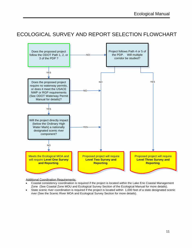
This section provides guidance on the selection of the proper level of ecological survey and reporting requirements, ecological scoping considerations, and an overview of the relationship between the various levels of ESRs and the ODOT’s Project Development Process (PDP). The level of ecological survey and accompanying report is related to the ecological resources present in the project area, the relative quality of the resources, and the expected severity of the impacts based on the type of work associated with the proposed project. There are three types of ecological survey reports: Level One Ecological Survey Report (Level 1 ESR), Level Two Ecological Survey Report (Level 2 ESR), and the Level Three Ecological Survey Report (Level 3 ESR). 1.6.1 ECOLOGICAL SURVEY AND REPORT SELECTION
The following detailed descriptions and flowchart can be used as a guide to determine the level of ecological survey and reporting required for any given ODOT project during the project scoping process. Level 1 Ecological Survey and Report: • Projects follow Paths 1, 2, or 3, of the PDP process and must meet the ecological MOA. • Project impacts may involve stream crossings, bank stabilization, and/or minor wetland fills. • Typically these projects have minimal potential for significant impacts to the environment. • Projects are authorized under the USACE Nationwide Permit (NWP) program or the Regional
General Permits (RGP) and/or OEPA’s Level 1 or 2 Isolated Wetland Permit. • Projects in which state or federally listed species, critical habitat, or mussel beds are present will
require additional project specific coordination. • Cannot impact (below the OHWM) a nationally designated scenic river component. • May impact a tributary within 1,000 feet of the nationally designated component but additional data
may be required. • Coordination requires use of the Level 1 ESR form.
Ecological Manual
10
Level 2 Ecological Survey and Report: • Projects may follow Paths 2, 3 or a low level Path 4 PDP process. • Do not meet the ecological MOA criteria due to more extensive ecological impacts. • May include stream channelization, widening, deepening, relocations, new structures on new
locations, or other extensive long-term modifications of ecological habitats in the vicinity of the proposed project.
• Projects require an individual 404 and/or 401 permit and/or an OEPA Level 3 Isolated Wetland Permit.
• May involve multiple alternatives within a project area. • May require an alternatives analysis. • Coordination requires the use of the Level 2 ESR form.
Level 3 Ecological Survey and Report: • Projects follow Path 4 or 5 of the PDP process. • These projects involve impacts to multiple wetlands and streams, have considerable impacts to
terrestrial habitats, and will require the investigation of one or more corridors. • These types of transportation projects often produce adverse ecological impacts and require an
alternatives analysis. • Requires submission of three separate reports:
o Level 3 Preliminary Draft ESR o Level 3 Draft ESR o Level 3 Final ESR
When preparing a scope or proposal for ecological work, consideration should be given to the type and characteristics of resources within the study area (from a literature and mapping review), the extent of ecological survey data collection that may be necessary, and the potential timing considerations for survey tasks. Things to consider would include, but are not limited to: • Are there known resources (such as National Scenic Rivers) that will require full aquatic sampling
(fish and macrobenthos surveys)? • Are there streams with known mussel populations that will require mussel surveys by a state or
federally permitted malacologist? • What likely time constraints on sampling will there be when conducting the survey? For example,
mussel surveys can only be conducted between May 1 and October 1, and running buffalo clover surveys can only be done from mid-May to early June. From a literature review it should be determined what other factors or species may constrain when the surveys must take place.
• Take into consideration the possibility that additional survey work may result from findings of initial surveys. For example, the results of a Headwater Habitat Evaluation Index scoring form may require the completion of a Headwater Macroinvertebrate Family Evaluation Index.
Section 2 (Ecological Survey) of the manual should be reviewed thoroughly to gain a clear understanding of the possible survey requirements and timing constrains for the various ecological resources.
Ecological Manual
11
ECOLOGICAL SURVEY AND REPORT SELECTION FLOWCHART
NO
YESNO
NO
Proposed project will require Level Three Survey and
Reporting.
Proposed project will require Level Two Survey and
Reporting.
Yes
Meets the Ecological MOA and will require Level One Survey
and Reporting.
NO
Does the proposed project follow the ODOT Path 1, 2, or
3 of the PDP ?
Does the proposed project require no waterway permits, or does it meet the USACE NWP or RGP requirements
(See ODOT Waterway Permit Manual for details)?
Will the project directly impact (below the Ordinary High Water Mark) a nationally designated scenic river
component?
Project follows Path 4 or 5 of the PDP. Will multiple
corridor be studied?
YES
YES
YES
Additional Coordination Requirements:• Coastal consistency coordination is required if the project is located within the Lake Erie Coastal Management
Zone (See Coastal Zone MOU and Ecological Survey Section of the Ecological Manual for more details). • State scenic river coordination is required if the project is located within 1,000 feet of a state designated scenic
river (See the Scenic River MOA and Ecological Survey Section for more details).
Ecological Manual
12
2: ECOLOGICAL SURVEY
2.1 GENERAL INFORMATION ABOUT ECOLOGICAL SURVEY
An ecological survey is required for all ODOT projects that have the potential to impact natural resources (streams, wetlands, listed species, etc.). The level of ecological survey necessary is based on the scope of the construction activities and the type, quantity, and quality of the resources within the project area. Ecological surveys include a thorough literature review and the field characterization of the floral and faunal communities within a project area. The following sections outline the methods that should be used on ODOT projects to identify and assess the aquatic and terrestrial communities and their habitats within a project or study area. 2.1.1 DEFINING THE ECOLOGICAL SURVEY AREA
Project study area boundaries are typically defined by ODOT or the local project sponsor in the early stages of developing the Project Initiation Package in the Planning Phase of the project. Appendix G of the ODOT PDP Manual states that, “It is important to remember that the study area is typically larger than the project area, and is not linked to the project’s logical termini. The study area would be inclusive of the project’s logical termini. The study area should be established so as not to restrict consideration of alternatives.” For new location projects, large corridors will likely be established for study in the early stages of project planning. For smaller projects that do not have a defined project study area, such as bridge replacements, and projects requiring minor alignment shifts, the study area may be established during a site visit. The project study area should include all lands that could possibly be disturbed during construction. If a project area has not been clearly defined, a buffer strip of 50-100 feet (and perhaps wider) beyond the anticipated area of impact should be surveyed. This additional area of survey should accommodate any additions or changes in design that would require another site visit to survey for additional resources. The study area limits should always encompass the construction limits in their entirety. If changes in project scope or design result in the construction limits extending beyond the ecological study area for the project, then the additional areas will require additional survey work to document the presence or absence of ecological resources. Project area boundaries that contain streams are designed to include all representative habitats. Since project-related sedimentation impacts normally affect aquatic habitats beneath and downstream from the proposed crossings, the project areas within streams are normally skewed to emphasize these downstream habitats. Professional judgment must be used when establishing the study areas in streams, as the extent of sedimentation impacts varies with stream size, gradient, and flow regime. Stream study areas can extend 300-400 feet downstream and 100-200 feet upstream from a proposed bridge project. The study area can be lengthened in order to include aquatic habitats not adequately represented upstream or downstream from the bridge. In all instances, the study area must be large enough to encompass the area needed to complete the appropriate habitat and biological assessments. When using an established procedure to study a habitat (such as those developed by the OEPA, ODNR, or the USFWS), the guidance manual describing the method should be referenced to determine the distance or area needed to properly conduct the assessment. The use of some of these established methods are further described in Section 2.2. When the survey area extends beyond ODOT’s right-of-way, property owners must be informed in writing before beginning the survey work. The ODOT district office should be contacted to determine the appropriate procedure for preparing and submitting right of entry letters.
Ecological Manual
13
2.1.2 LITERATURE REVIEW SURVEY
A thorough literature survey is completed on the project study area before conducting any ecological field investigations. A literature survey summarizes all ecological data in the study area available from secondary sources. For many larger Path 4 or Path 5 PDP projects, the information collected during the literature survey is presented in mapping included in the Project Initiation Package, as well as the ESR. The literature review mapping brings together all of the known resources that are located within a corridor. The literature review mapping is used during preliminary engineering to locate feasible corridors (Path 4 or Path 5 projects) or alignments (Path 2, 3, or 4 projects) to aid in avoidance and minimization of impacts to environmental resources. A thorough literature survey includes the location of potential wetland habitats, hydric soils, federal and state listed species, streams, lakes, ponds, scenic rivers, nature preserves, parkland, or any other known sensitive ecological features. In addition, the literature survey may provide a basis for determining the extent of data collection required for an ecological survey. For example, where long-term water quality data are available for a stream, the need for stream sampling may be reduced or eliminated. For large rivers that are difficult to sample with the recommended fish collection methods, literature sources may provide information on fish communities that will be used to supplement the data collected in the field. Well-studied natural areas require very little or no additional field data collection. Judgment on the quality and reliability of the literature sources is necessary to determine what additional studies are needed. For most ODOT ecological surveys there is very little existing data, and the survey report is entirely dependent upon original data collection. Useful secondary sources of data that may be applicable for ecological surveys are listed in the following sections. While some of these sources are appropriate for all projects, others are pertinent only for complex projects, such as highways on new location. The literature sources are not intended to be a complete compilation of all secondary sources of data for ecological surveys, however, items that are bolded in the text must be checked for relevance. Useful information might also be obtained from articles published in various professional journals (The Ohio Journal of Science frequently contains articles on the distribution of plants and animals in Ohio) and dissertations available at universities. Data on a particular species or an assemblage of species may be obtained from collections at museums and herbaria, although these data can be more difficult to obtain. In some cases, unpublished distributional data may be obtained by contacting professors at local colleges and universities, high school teachers, and naturalists at local park districts. 2.1.2.1 BACKGROUND LAND USE/COVER AND GEOLOGIC INFORMATION LITERATURE REVIEW SURVEY The literature review should focus on information on historic and current land use/cover, ecoregion, and basic physiographic and geologic information within a proposed project area. Sources of extensive disturbance (such as strip-mining, large sand and gravel operations, heavily developed areas, etc.) should be noted, as well as the effects of these disturbances have on historical trends in the relative abundance and composition of aquatic and terrestrial communities. The following literature sources should be reviewed as part of an ecological survey. • The National Land Cover Database 2006 (NLCD 2006) has been compiled across all 50 states and
Puerto Rico as a cooperative mapping effort of the Multi-Resolution Land Characteristics (MRLC) Consortium. This land cover database has been created using mapping zones and contains standardized land cover components useful for a variety of applications. As mapping zones are completed, they are made available on the MRLC website.
Ecological Manual
14
• Land cover mapping, based on 1994 LANDSAT Thematic Mapper data (spatial resolution of 30m), have been developed by ODNR for all 88 Ohio counties. The data was classified into the general land cover categories of urban, agriculture/open urban areas, shrub/scrub, wooded, open water, non-forested wetlands, and barren. The land cover information reflects the conditions of the satellite data during the specific year and season the data was acquired. The ODNR 1994 Land Cover GIS layers provide land cover information per county.
• A more detailed (greater number of cover categories) land use/land cover map is available for select counties throughout Ohio. However, the availability of this information is limited to only 55 Ohio counties, and the information may be dated (dates range from 1969 to 1998). These land coverage maps were typically developed through an interpretation of land use and land cover types done from aerial photography by the ODNR, Office of Information Technology. The ODNR Land Use/Land Cover GIS layers provide specific land cover information by county.
• An Ecoregion Map of Indiana and Ohio (Woods et al. 1998) is available from the U.S. EPA. In addition to presenting the location of various ecoregions throughout the state, this map provides descriptive text and summary tables discussing characteristics of each ecoregion.
• The ODNR Geological Survey has a series of map publications pertaining to the geologic regions, physiographic regions, and glacial history of Ohio. The ODNR Geological Survey’s maps provide associated descriptive characteristics that can be summarized for a particular project location.
2.1.2.2 AQUATIC ECOLOGY LITERATURE REVIEW SURVEY An important aspect of conducting ecological surveys is the identification of potential water resources within a study area. The identification of these resources should begin by reviewing existing mapping of the study area. Mapping used for this review includes USGS 7.5 minute topographic quadrangle maps and county soil survey map sheets. • USGS 7.5 minute topographic quadrangle maps can be ordered from U.S. Geological Survey
(USGS) or viewed from your web browser at the USGS National Map site. USGS topographic maps often show the location and name of many of the rivers, streams, lakes, ponds, and canals in an area, and can indicate the location of marsh or swamp areas.
• County soil survey map sheets can be obtained from the U.S. Department of Agriculture, Natural Resources Conservation Service (NRCS) Soil Survey Division. Soil survey map sheets can depict the location of lakes, ponds, reservoirs, and other miscellaneous water features. In addition, areas designated as drainage, stream-perennial, stream-intermittent, stream-unclassified, ditches, springs, drainage end, or alluvial fan can be used to identify small watercourses. While many of the small watercourses depicted on soil survey map sheets may not meet the criteria of a jurisdictional waterway, the maps are an excellent screening tool for determining the location of potential primary headwater streams (<1mi² drainage area).
Once potential water resources have been identified for a study area, the following list of sources is reviewed for existing water quality data and/or designations.
STREAM LITERATURE REVIEW SURVEY
• The Ohio Water Quality Standards (Ohio Administrative Code, Chapter 3745-1) document the Ohio
Ecological Manual
15
Environmental Protection Agency’s Use Designations and Antidegradation Designations for most streams in Ohio. All streams within the corridor or project area that are listed in the Water Quality Standards (OAC 3745-1-08 to 3745-1-30) must have their assigned Aquatic Life Use Designation (i.e. limited resource water, modified warmwater, warmwater, exceptional warmwater, and coldwater habitats) presented in the Aquatic Ecology section of an ESR. If OEPA has not assigned an Aquatic Life Use Designation to a particular stream, a habitat assessment will need to be conducted during the field survey, and included in the ESR to determine a provisional designation. In addition, a stream’s Antidegradation Designation should be listed within the Aquatic Ecology section of a report. These Antidegradation Designations (i.e. general high quality waters, superior high quality waters, outstanding state waters, and outstanding national resource waters) can be found in Tables 5-4 through 5-7 of OAC 3745-1-05. Both the Aquatic Life Use Designations and Antidegradation Designations will influence the level and type of 404/401 Clean Water Act permit required. Stream use designations can be found on OEPA’s Division of Surface Water’s OAC Chapter 3745-1 Water Quality Standards web site.
• Biological and Water Quality Reports have been published by the OEPA for select watersheds in Ohio. Where available, they provide an important source of water quality information. Copies of these reports can be found at OEPA’s Division of Surface Water’s Biological and Water Quality Reports page.
• The 12-digit Hydrologic Unit Codes (HUC) should be noted for each stream segment or wetland located within the project area. The HUCs for Ohio are available through the NRCS web site.
• The Total Maximum Daily Load (TMDL) Program should be reviewed to determine if any of the waterways within the project area are part of a watershed with an approved TMDL, or are listed on the 303(d) TMDL Priority List. If the project area is located within a watershed (defined by 11-digit HUC Assessment Units) with an approved or developing TMDL, or on the 303(d) TMDL Priority List, the Literature Survey section should list the major high magnitude sources and causes of impairment noted for the watershed. Information on streams and watersheds within Ohio that have approved TMDLs, or are on the 303(d) TMDL Priority List, can be obtained from OEPA’s Division of Surface Water’s Total Maximum Daily Load Program web site.
• The National and State Wild and Scenic River lists, and the Nationwide Rivers Inventory (NRI) list, should be reviewed during the literature survey to determine if any of the streams within the project area have been designated as National Wild and Scenic Rivers, Ohio’s NRI streams, or Ohio’s State Wild and Scenic Rivers (see Sections 3.5.1 and 3.5.2 of this manual for additional information on State and National Scenic River coordination).
• The Floodplain Boundaries from the Federal Emergency Management Agency (FEMA) Flood Insurance Rate Maps (FIRM) should be reviewed to determine if the project area lies within the boundaries of a mapped 100 year flood hazard area. Digital GIS coverage’s of flood zones can be obtained for each county from ODNR, Office of Information Technology or from FEMA Map Service Center.
• Ohio’s Coastal Zone Management Area should be reviewed for any projects that lie within Lucas, Wood, Ottawa, Sandusky, Erie, Lorain, Cuyahoga, Lake or Ashtabula Counties. Projects within these counties that pass through the Coastal Zone Management Area will require additional coordination with ODNR’s Office of Costal Management (see the CZMA MOU for more details on the subject
Ecological Manual
16
matter). Mapping depicting the Designated Ohio Coastal Management Area, and a written description of the Coastal Area Boundary within Ohio, can be obtained from ODNR.
• The OEPA provides access to water chemistry and stream sediment data collected by the Agency
throughout the state of Ohio on the Ohio Surface Water Quality Data web map. This data source can provide historic data on water quality within a large number of the streams within Ohio.
• The U.S. Geological Survey (USGS) has published Water Resources Data Report for Ohio. This publication provides flow records for a number of creeks and rivers as well as water quality data for a limited number of locations. Data at these sites have been collected over a number of years, providing a historical perspective on changes in water quality. In addition, the USGS Water Watch website provides publications and data on water quality and stream flow in Ohio (including real-time flow data for select streams).
Note: the State of Ohio’s Web Page on Sport Fish Health should be consulted for a list of stream segments that have been designated “Do Not Wade or Swim”. The waters and/or sediments in these areas have high levels of contaminants. OEPA recommends “that a person not swim or wade in these water body sections.” Stream segments listed as “Do Not Wade or Swim” will not require any ecological sampling that requires contact with the water (sampling may be required by the Ecological Site Assessment/Hazardous Waste Section). OES-ECO should be contacted for guidance if a project area contains a stream segment designated “Do Not Wade or Swim”.
WETLANDS LITERATURE REVIEW SURVEY
A literature review must include the identification of any known or potential wetlands that may be located within a project study area. Several sources are available for making this determination. However, wetlands identified by these sources may not necessarily meet the definition of a regulatory wetland, and will need to be verified during the field investigations conducted for a project. The following sources can be used to determine the potential for wetland habitats to be located within a proposed project area. • National Wetlands Inventory (NWI) maps have been prepared by the USFWS and are available for
all Ohio counties. These maps are based on the wetland classification system of Cowardin et al. (1979) and are on the same scale as the U.S. Geological Survey 7.5 minute topographic map series. The wetland areas shown on the mapping do not necessarily meet the definition of a regulatory wetland, and should be used as a general planning tool and to aid in determining where to focus wetland field investigations. Within Ohio, all of the state’s NWI maps are available in digital format. These digital maps can be downloaded for use in GIS applications, or accessed online using the USFWS Wetland Mapper.
• Ohio Wetland Inventory Mapping (OWI) has been developed by ODNR using satellite data (LANDSAT) and soil survey information. The OWI was created “solely as an indicator of wetland sites for which field review should be conducted” and for “general planning and environmental analyses.” The wetland areas shown on the mapping do not necessarily meet the definition of a regulatory wetland. OWI GIS layers can be obtained for each county through the ODNR, Office of Information Technology website.
• Modern county soil surveys prepared by the NRCS should be examined for the entire project
area/corridor. All soils classified as hydric and non-hydric with hydric components within the project area should be identified, since these soils are the most likely locations for wetlands. These modern
Ecological Manual
17
soil surveys are currently available for all 88 counties in Ohio. A current list of published soil surveys and information on ordering or obtaining unpublished surveys can be obtained from the USDA Soil Survey Division. Detailed Soil Survey Geography (SSURGO) database files (with spatial data) are currently available for Ohio counties. This information can be viewed or downloaded from the NRCS Web Soil Survey website.
• The Ohio Natural Heritage Database has site-specific information on known high quality wetland
communities throughout the state. Ohio Natural Heritage Data Request Forms can be obtained from ODNR Division of Wildlife web site.
• A list of hydric and non-hydric soils with hydric components is available from the NRCS online or by
contacting the NRCS State Conservationist. These lists are very useful in identifying potential wetland areas within the proposed project area or corridor and should be consulted for all ecological surveys and reports.
• The National Soil Survey Handbook has been updated and can be accessed or ordered through the
NRCS webpage.
DITCHES, PONDS, LAKES, AND RESERVOIRS LITERATURE REVIEW SURVEY
• Aerial photographs are the best source for determining if ditches, ponds, lakes, and/or reservoirs are within the ecological study. Aerial photographs are available from a variety of sources in a variety of resolutions. The Ohio Statewide Imagery Program provides relatively recent (2006 and 2011) one foot and six inch resolution orthophotography in GeoTIFF and MrSID formats that can be used in GIS applications. In addition, several web sources such as Bing Maps, Google Maps and Google Earth can be reviewed. These photographs can be useful in determining where water resources are originating, and where they are (or are not) connecting to other waters. As with all date sensitive remote sensing tools, information gathered from aerial photographs will need to be verified during the field survey of the study area.
• USGS 7.5 minute topographic quadrangle maps can be ordered from U.S. Geological Survey
(USGS) or viewed from your web browser at the USGS National Map site. USGS topographic maps often show the location and name of lakes and reservoirs in an area, and may also indicate the location of small ponds.
FISHES, MACROBENTHOS, AND MUSSELS LITERATURE REVIEW SURVEY
After determining the location of potential streams and other water resources within a project study area, a review of the existing literature is conducted to determine the potential fish or aquatic macroinvertebrate communities that may reside in the waterways. If an extensive amount of recent information is available on the biological communities within a stream segment near the proposed project area, it may negate the need to conduct full aquatic sampling. If full aquatic sampling will likely be necessary, it is helpful to review the results of prior studies conducted within the stream basin, and to be familiar with the species that may be encountered within a project area by studying range maps. The following sources are useful in determining the range and distribution of aquatic communities throughout Ohio, and potentially within a project study area. • Biological and Water Quality Reports have been published by the OEPA for select watersheds in
Ohio. Where available, they provide an important source of fish and aquatic macroinvertebrate
Ecological Manual
18
information. Sample locations within these publications are specific to stream segments, and are listed by stream name and river mile (based on distance upstream from the mouth). These publications provide some of the most comprehensive data on fish and aquatic macroinvertebrate communities (typically excluding extensive mussel surveys) throughout the state. Copies of the Biological and Water Quality Reports can be found at OEPA’s Division of Surface Water’s Biological and Water Quality Reports web page.
• The ODNR Division of Wildlife Ohio Natural Heritage Database can provide information on any
known mussel beds or records of rare or special interest fish that may be located within a project area. Ohio Natural Heritage Data Request Forms can be obtained from the Division of Wildlife web site.
• The range and distribution of fishes throughout Ohio can be obtained from the Fishes of Ohio
(Trautman 1981) and more recently, the USGS Ohio Aquatic GAP Analysis Project. See the Ohio Aquatic GAP Analysis webpage.
• Information on mussel and fish collections and publications can be obtained from the Ohio State
University Museum of Biological Diversity. The Mollusc Division web page provides a searchable bivalve database and the Fish Division web page provides a searchable fish database. In addition, the range and distribution of Unionids can be obtained from the Freshwater Mussels of Ohio (Watters et. al., 2009).
2.1.2.3 TERRESTRIAL ECOLOGY LITERATURE REVIEW SURVEY While most of the information obtained on the terrestrial plant and animal communities within a study area will be acquired during the field survey, a brief review of existing literature sources can provide information on any nearby known unique communities or features. In addition, it is often helpful to become familiar with the species that may be encountered within a project area by studying range and distribution maps. The following sources are useful in determining the range and distribution of terrestrial plant and communities throughout Ohio, and potentially within a project study area. • The ODNR Division of Wildlife Ohio Natural Heritage Database has site-specific information on
high quality native plant communities, conservation areas, and rare animal (mammals, birds, amphibians and reptiles) communities throughout the state. Ohio Natural Heritage Data Request Forms can be obtained from the Division of Wildlife web site.
• The Ohio Biological Survey (OBS) has several series of publications (Bulletins, Biological Notes,
Informative Circulars, and Miscellaneous Contributions) that provide information on plant and wildlife communities, and reflect the past and current biodiversity within Ohio.
• The Ohio Breeding Bird Atlas (Peterjohn and Rice 1991) can provide range, distribution, and breeding
information for birds that are known to breed in Ohio. In addition, the Ohio Breeding Bird Atlas was updated between 2006 and 2011. Data from this update can be found on the Ohio Breeding Bird Atlas II website.
• Checklists for plant species that can be found in the glaciated Allegheny Plateau (Andreas 1989) and
the un-glaciated (Cusick and Silberhorn 1977) regions of Ohio can be useful in determining the types of plant species that may be encountered during ecological field investigations. These sources, as
Ecological Manual
19
well as several other Ohio specific botanical sources listed in the Section 2.2.2.1. 2.1.2.4 LISTED SPECIES LITERATURE REVIEW SURVEY Prior to conducting any ecological field investigations, a review of the existing literature must be done to determine if there are any known records for federal or state listed species within or adjacent to the project area, and whether the project is located within the known or historic range of any federally listed species. If the record search indicates that a listed species is likely to be found within the project area (a known location, recent spotting, or capture record), additional literature research will be required to establish the appropriate times and techniques necessary to survey for the species. The following sources should be used to determine the potential for a listed species to be residing within a proposed project area. • The Ohio Ecological Services Field office of the U.S. Fish and Wildlife Service maintains lists of
the federally endangered, threatened, and proposed and candidate species in Ohio, federally listed species by Ohio counties, and federal species of concern in Ohio. These lists are continuously being updated by the USFWS and should be regularly checked. OES-ECO has created a map of the Known Ranges of Federally Listed Species Within Ohio that reflects all federally threatened, endangered, species of concern, and candidate species found in each county within the state of Ohio. NOTE: A letter should not be sent to the USFWS asking for a species list for a specific project, as this letter would be construed as the initiation of ESA Section 7 consultation for that project (Section 7 consultation should only be initiated by OES-ECO).
• The ODNR Division of Wildlife Ohio Natural Heritage Database has site-specific location
information on all listed plants, and many listed animals (both federal and State) recorded within Ohio. Ohio Natural Heritage Data Request Forms can be obtained from the Division of Wildlife web site. The literature search request should include all database records within 1/2 mile for plant species, 1 mile for animal species, Indiana bat capture records within 5 miles of the project area, and any known or suspect Indiana bat hibernacula within 10 miles of the project area. A list of all rare Ohio native plant species can be found at the ODNR DNAP web site. Current lists of wildlife that are considered endangered, threatened, or of special interest in Ohio can be found on the ODNR Division of Wildlife’s State Listed Species web site.
2.1.3 FIELD SURVEY METHODS
Ecological Surveys generally employ a descriptive approach towards data collection. The usefulness of these surveys is dependent upon the expertise of the field biologists collecting the data, relying on them to accurately assess all communities in the study area and subjectively determine their local and regional significance. These methods require expertise with all biotic communities. Since it is unlikely that any single individual has the required expertise in every discipline, a team of biologists that can accurately assess the communities within the project study area should typically conduct the survey. While the methods described in this manual are preferred for ODOT ecological surveys, other approaches may be acceptable. All deviations from the preferred methods must be approved by OES-ECO before they are implemented in the field. Scientific sampling and/or collection of wildlife for ecological surveys requires a scientific collecting permit from the ODNR, Division of Wildlife. See Section 2.2 for more specific field survey methods on each ecological resource. Sufficient data must be collected during the ecological survey on all applicable ecological resources to complete the appropriate Level 1, Level 2, or Level 3 ESR. Section 3 (Ecological Survey Reports) of the manual, as well as the Level 1, Level 2, and Level 3 Ecological Survey Report Forms and form instruction on the ODOT Ecological Resources Report Forms

Ecological Manual
20
webpage, should be referenced to aid in determining necessary data collection and documentation requirements. 2.1.4 TIMING OF FIELDWORK
The time of the year when fieldwork can be conducted is an important consideration. Aspects to consider before determining the field schedule for a project should include; weather conditions conducive to field study, if sampling will produce a representative picture of community structure and development within the project area, and whether or not the organisms found can be identified. Certain federally listed species may require a special survey to determine if they are present in the proposed project area (for example, running buffalo clover requires a spring survey when the plant is in flower). Surveys for Unionid mussels can typically only be done from May 1 to October 1 in accordance with the Ohio Mussel Survey Protocol. Many groups of plants can only be positively identified by the examination of the inflorescence, which is only present certain times of the year. For these reasons, most ODOT surveys are performed during the spring, summer, and fall months. Generally, winter season sampling is not conducive to data collection and should be avoided. The field season is defined as the period between April 15 and October 15. Wetland delineations are discouraged from November 15 through March 15, but there may be times when they are necessary. Deviation from these dates must take into consideration whether the study area can be properly surveyed for ecological resources. While the Regional Supplements to the USACE’s 1987 Wetland Delineation Manual allow for wetland determinations to be conducted outside of the growing season, a delineator must be able to identify “the plant community that is normally present during the wet portion of the growing season.” The ecological investigator must consider if this requirement can be achieved. OES-ECO can be contacted for assistance to help determine if it is appropriate to perform winter ecological survey work. Conducting wetland delineations or stream surveys when the resources are under snow or ice cover is unacceptable. 2.1.5 SPECIMEN VOUCHERING
The data collected for an ecological field study should represent the communities present within a project study area. These communities are often varied, though they may only represent a small percentage of the flora and fauna that occur in the state. Given the potential diversity of organisms within a project area and the probable limitations of the personnel performing fieldwork, on occasion it may be warranted to collect specimens for positive identification by an expert and retained as vouchers. Voucher specimens (pressed plants, color photographs, and/or road killed specimens) may be retained when species are observed outside of their known range, or from uncharacteristic habitats. Distribution and habitat information is generally available in the regional literature, much of which is cited in this manual. Under some conditions (such as rare bird sightings, the presence of federal or state endangered species, or recording the composition of a local flora or fauna that has been precluded from scientific collection), appropriate descriptive information, including color photographs, should be taken and retained to voucher the communities. Any collecting permits required to do fieldwork are the responsibility of the field investigator. OES-ECO may request voucher evidence for all unusual or out of range identifications, and may require the removal of organisms from species lists if the record cannot be verified. The burden of proof is ultimately the responsibility of the field investigator.
Ecological Manual
21
2.2 RESOURCES SUBJECT TO ECOLOGICAL SURVEY
2.2.1 AQUATIC ECOLOGY
2.2.1.1 STREAMS
GENERAL DISCUSSION
A stream is defined as a feature that must carry water for at least a minimal period of time and have an ordinary high water mark (OHWM). This can include ephemeral, intermittent, and/or perennial streams. ODOT projects require that all stream habitats within a project area are identified and assessed to determine their quality and flow characteristics. Within Ohio, a stream’s quality is based on its ability to support aquatic life. The goals of stream sampling on any ODOT project are to; • Identify and map the location of any streams within a project study area. • Describe the flow characteristics and features that define it as a jurisdictional water of the U.S. and/or
state. • Provide a “provisional” aquatic life use designation on any undesignated streams, or to provide
supplemental information on streams with assigned Ohio aquatic life use designations. • Determine if the stream provides habitat for any listed aquatic species or mussel beds. Any assessments of a stream should begin with a thorough literature review of existing designations (see Section 2.1.2.2). Following this literature review, the Aquatic Sampling Flow Chart should be used to determine the level of aquatic sampling required when performing ecological surveys on streams of different sizes and of different quality.
STREAM RESOURCE DESCRIPTIONS
Segments of streams can be described using physical, chemical, and biological characteristics. Generally, if a channel does not have an OHWM it would not be considered a stream, and would not be regulated by the USACE. However, some ditches, which have a defined channel but may or may not have an OHWM, may be jurisdictional waters of the U.S. and fall under regulation of the USACE (see Section 2.2.1.3). Within Ohio several different stream types, classifications, and designations have been defined based on a combination of the physical characteristics and the biology residing within the channel. Common physical characteristics used to describe streams include flow regime, drainage area, habitat characteristics, and water chemistry. In addition, the types of aquatic organisms and their characteristics (habitat requirements, pollution tolerance, etc.) can be used to classify streams and assess their quality. The following discussions outline how physical and biological characteristics can be used to characterize streams within Ohio for both ecological assessment and regulatory purposes. Also included are brief descriptions of commonly used terms and techniques used to evaluate Ohio streams. • Drainage Area: The size of stream’s drainage area can have a great influence on the flow regime,
thereby influencing the channel’s physical characteristics, habitat potential, and biological community. Within Ohio, the OEPA has established classification system based on a framework centered, in part, on drainage area. Stream segments possessing a drainage area less than 1 mi2 and with natural pools less than 40 cm deep have been classified as Primary Headwater Habitat Streams (PHWH), while streams with drainage areas greater than 1 mi2 are considered Headwater (1-20 mi2), or Wading/Boat sites (>20 mi2 drainage area).
• Flow Regime: Stream flow characteristics affect both the channel morphology as well as the biota
Ecological Manual
22
that reside within the channel. The following flow regimes are based on definitions prepared by the USACE in Section G of the March 19, 2012 Nationwide Permits for the State of Ohio describe the different stream hydrology types. o Perennial stream: A perennial stream has flowing water year-round during a typical year. The
water table is located above the stream bed for most of the year. Groundwater is the primary source of water for stream flow. Runoff from rainfall is a supplemental source of water for stream flow.
o Intermittent stream: An intermittent stream has flowing water during certain times of the year, when groundwater provides water for stream flow. During dry periods, intermittent streams may not have flowing water. Runoff from rainfall is a supplemental source of water for stream flow.
o Ephemeral stream: An ephemeral stream has flowing water only during, and for a short duration after, precipitation events in a typical year. Ephemeral stream beds are located above the water table year-round. Groundwater is not a source of water for the stream. Runoff from rainfall is the primary source of water for stream flow.
Recent guidance provided by the USACE also defined stream flow regime in the context of Clean Water Act jurisdiction. These definitions differ from traditional stream hydrology types, but are important for determining the federally jurisdictional potential of the stream. o Relatively Permanent streams possess continuous flow on at least a seasonal basis,
(continuously for three months of the year). Relatively permanent streams would include all perennial, and some intermittent streams.
o Non-Relatively Permanent streams do not flow continuously for a least one season (typically three months). Non Relatively Permanent streams would include all ephemeral and some intermittent streams.
• Traditional Navigable Waters and Tributaries: In addition to flow regime, the USACE has separated streams into Traditional Navigable Waters (TNW) and Tributaries. TNWs are all navigable waters of the U.S. as stated by individual USACE Districts through public notices and determined by court decisions. All TNWs are considered federally jurisdictional. Tributaries to TNWs include natural, man altered, or manmade water courses that carry flow directly, or indirectly, into TNWs. Tributaries are only considered federally jurisdictional waters of the U.S. if they are found to have a significant nexus with a TNW. A tributary is considered to have a significant nexus to a TNW if its flow characteristics and functions, in combination with the ecological and hydrologic functions performed by all wetlands adjacent to the tributary, affect the chemical, physical, and biological integrity of a downstream TNW. The USACE, through ODOT’s coordination process, will determine if a stream within the project area is a jurisdictional water of the U.S. In general, the USACE will make significant nexus determinations on all streams identified as Non-Relatively Permanent Waters and Relatively Permanent Waters with seasonal (intermittent) flow. Relatively Permanent Waters with continuous (perennial) flow and TNWs would not require a significant nexus determination for the USACE to determine that they are jurisdictional Waters of the U.S.
• Stream Habitat Quality: The quality and characteristics of the in-stream and riparian habitat can influence the water chemistry and biota of a stream. The OEPA has developed habitat assessment tools that help to describe the potential a stream may have to support aquatic life. For Primary Headwater Habitat (PHWH) streams the assessment tool is called the Headwater Habitat Evaluation Index (HHEI), and for larger streams (with greater than 1 mi2 drainage area), the habitat assessment tool is called the Qualitative Habitat Evaluation Index (QHEI). Both of these habitat indices include observations of the physical characteristics of the stream, and correlate the presence, absence, and/or abundance of habitat characteristics with the streams potential to support aquatic life.
• Water Chemistry: Water chemistry significantly influences the composition and diversity of the aquatic communities (Warren 1971, Hynes 1974). Factors that play a critical role in determining
Ecological Manual
23
habitat suitability for aquatic organisms include temperature, dissolved oxygen, suspended solids, dissolved ions, and pH. These parameters affect biological integrity by causing mortality of some taxa or by altering the species composition within the communities (Karr and Dudley 1981). Measuring and describing simple water chemistry parameters can help to explain the composition of a particular stream’s biological community, and may provide information on possible causes of impairment.
• Biological Communities: Observing the types and abundance of fish, salamanders, and aquatic macroinvertebrates within a stream can give an indication of the quality of the water and habitats present. These organisms can act as biological indicators of stream health. On typical ODOT projects, qualitative sampling of aquatic organisms may be required. In addition, the OEPA has developed several quantitative and qualitative indices that rely on biological indicators to characterize a stream’s quality. Additional discussion on sampling techniques for aquatic communities can be found in Fishes (Section 2.2.1.5), Macro benthos (Section 2.2.1.6), Unionid Mussels (Section 2.2.1.7), and Amphibians and Reptiles (Section 2.2.2.2).
• Stream Aquatic Life Use Designations: The OEPA has developed beneficial use designations that describe existing or potential uses of water bodies within Ohio. One type of beneficial use designation is the Aquatic Life Use Designation. Aquatic Life Use Designations describe the existing or potential use of a stream by aquatic life, and are determined utilizing the observations collected on physical, chemical, and biological characteristics of a stream. OEPA is responsible for determining the official Aquatic Life Use Designation of a waterway within Ohio (using extensive quantitative sampling and modeling). However, for the purposes of characterizing undesignated streams, unofficial “provisional” Aquatic Life Use Designations often need to be determined by ODOT and consultants using the qualitative data collected. For ODOT projects, every stream within a project area must possess either an official or “provisional” aquatic life use designation. The following OEPA Aquatic Life Use Designations are used to describe Ohio’s waterways. These designations are officially defined in the Ohio Administrative Code (OAC 3745-1-07): o Coldwater Habitat (CWH): possess native cold water or cool water species of fish and aquatic
macroinvertebrates. o Exceptional Warmwater Habitat (EWH): possess a unique and diverse assemblage of fish and
aquatic macroinvertebrates. o Seasonal Salmonid Habitat (SSH): supports lake run steelhead trout fisheries. o Warmwater Habitat (WWH): possess the typical assemblages of fish and invertebrates expected
in less impacted streams throughout Ohio. o Modified Warmwater Habitat (MWH): possesses a more tolerant assemblage of fish and
macroinvertebrates than WWH. These streams possess some type of modification/disturbance that inhibits recovery to a typical (WWH) or better (CWH or EWH) assemblage of organisms.
o Limited Resource Water (LRW): possesses an aquatic community severely limited by physical habitat or other irretrievable condition.
o Limited Warmwater Habitat (LWH): these are lower quality waters that were assigned designations in 1978 based on the Water Quality Standards without use attainability analysis. This designation is being phased out.
Additionally, PHWH stream designations are defined in the Field Evaluation Manual for Ohio’s Primary Headwater Habitat Streams. While these designations are not are not in the OAC, and therefore not official aquatic life use designations, they can be used to characterize the habitat and biota of small drainage area streams. The following classes of streams are defined in the OEPA’s manual: o Class IIIB (PHWH): perennial primary headwater streams that possess cold water adapted
assemblage of native fauna (macroinvertebrates, salamanders, and/or fish) continuously throughout the year.
Ecological Manual
24
o Class IIIA (PHWH): perennial primary headwater streams that possess a cool or warm water adapted assemblage of native fauna (macroinvertebrates, salamanders, and/or fish) continuously throughout the year. These streams do not possess cohabitating cold water vertebrates or benthic macroinvertebrates that exhibit the characteristics of a Class IIIB community.
o Class II (PHWH): perennial or intermittent primary headwater streams that possess warm-water adapted assemblage of native fauna (macroinvertebrates, salamanders, and/or fish) continuously or seasonally throughout the year.
o Class I (PHWH): ephemeral primary headwater streams that possess few or no aquatic fauna due to the lack of water on an annual or seasonal basis. These are typically dry channels for most of the year.
STREAM FIELD DATA COLLECTION METHODS
When a stream has been identified in the project area, the following flow chart must be used to determine the level of aquatic sampling required for ecological surveys. On all projects, if streams ≥ 10 mi² drainage area are present within the project area, a reconnaissance survey and an Ohio Mussel habitat Assessment Form (OMHAF) will be needed on streams listed as Group 1, 3 (if wadeable), or not listed in the Ohio Mussel Survey Protocol. Streams where a reconnaissance survey cannot be completed must be surveyed by a qualified malacologist in accordance with the Ohio Mussel Survey Protocol. If stream(s) listed as Group 2 or 4 in the Ohio Mussel Survey Protocol are present, a reconnaissance survey is not acceptable. A survey by a federally permitted malacologist will be required. If evidence of mussels is observed during a reconnaissance survey, the project will require a survey (and possible relocation) by a qualified malacologist in accordance with the Ohio Mussel Survey Protocol.
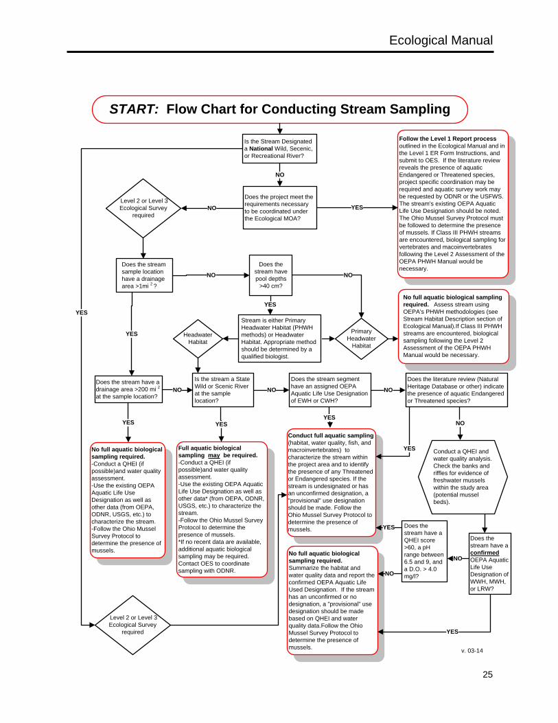
Ecological Manual
25
START: Flow Chart for Conducting Stream Sampling
Does the project meet the requirements necessary to be coordinated under the Ecological MOA?
NO
Does the stream sample location have a drainage area >1mi 2 ?
No full aquatic biological sampling required. Assess stream using OEPA's PHWH methodologies (see Stream Habitat Description section of Ecological Manual).If Class III PHWH streams are encountered, biological sampling following the Level 2 Assessment of the OEPA PHWH Manual would be necessary.
Stream is either Primary Headwater Habitat (PHWH methods) or Headwater Habitat. Appropriate method should be determined by a qualified biologist.
Primary Headwater
Habitat
Headwater Habitat
Does the stream have a confirmed OEPA Aquatic Life Use Designation of WWH, MWH, or LRW?
No full aquatic biological sampling required. Summarize the habitat and water quality data and report the confirmed OEPA Aquatic Life Used Designation. If the stream has an unconfirmed or no designation, a "provisional" use designation should be made based on QHEI and water quality data.Follow the Ohio Mussel Survey Protocol to determine the presence of mussels.
Conduct full aquatic sampling (habitat, water quality, fish, and macroinvertebrates) to characterize the stream within the project area and to identify the presence of any Threatened or Endangered species. If the stream is undesignated or has an unconfirmed designation, a "provisional" use designation should be made. Follow the Ohio Mussel Survey Protocol to determine the presence of mussels.
Does the stream have a drainage area >200 mi 2 at the sample location?
No full aquatic biological sampling required. -Conduct a QHEI (if possible)and water quality assessment. -Use the existing OEPA Aquatic Life Use Designation as well as other data (from OEPA, ODNR, USGS, etc.) to characterize the stream. -Follow the Ohio Mussel Survey Protocol to determine the presence of mussels.
Does the literature review (Natural Heritage Database or other) indicate the presence of aquatic Endangered or Threatened species?
Full aquatic biological sampling may be required. -Conduct a QHEI (if possible)and water quality assessment. -Use the existing OEPA Aquatic Life Use Designation as well as other data* (from OEPA, ODNR, USGS, etc.) to characterize the stream. -Follow the Ohio Mussel Survey Protocol to determine the presence of mussels.*If no recent data are available, additional aquatic biological sampling may be required. Contact OES to coordinate sampling with ODNR.
Is the stream a State Wild or Scenic River at the sample location?
Does the stream segment have an assigned OEPA Aquatic Life Use Designation of EWH or CWH?
Follow the Level 1 Report process outlined in the Ecological Manual and in the Level 1 ER Form Instructions, and submit to OES. If the literature review reveals the presence of aquatic Endangered or Threatened species, project specific coordination may be required and aquatic survey work may be requested by ODNR or the USFWS. The stream's existing OEPA Aquatic Life Use Designation should be noted.The Ohio Mussel Survey Protocol must be followed to determine the presence of mussels. If Class III PHWH streams are encountered, biological sampling for vertebrates and macoinvertebrates following the Level 2 Assessment of the OEPA PHWH Manual would be necessary.
YES
YES
NO
YES
NO
YES
NO
NO
YES
YES
NO
NO
YES
Level 2 or Level 3 Ecological Survey
required
Conduct a QHEI and water quality analysis. Check the banks and riffles for evidence of freshwater mussels within the study area (potential mussel beds).
Does the stream have a QHEI score >60, a pH range between 6.5 and 9, and a D.O. > 4.0 mg/l?
YES
NO
Does the stream have pool depths
>40 cm?
YES
NO
Is the Stream Designated a National Wild, Secenic, or Recreational River?
NO
YES
Level 2 or Level 3 Ecological Survey
required
v. 03-14
Ecological Manual
26
STREAM HABITATS
All streams found within the project area must be identified on project mapping for the purposes of avoidance, minimization, and calculation of impacts. A description of the physical habitats within each stream reach must be conducted. The following features of the stream and its riparian corridor must be recorded during an ecological survey: • Site-Specific Information: At each sample location the stream name, project identification, date,
weather conditions, locality (latitude and longitude), the date of the last precipitation event and quantity of rainfall, and the names of the field investigators should be recorded and noted on the habitat survey form being used.
• Stream Flow Characteristics: The stream’s hydrologic characteristics should be determined and recorded, and a determination of the habitat assessment tools and biological sampling techniques to be used should be made based on the stream’s drainage area and flow regime (perennial, intermittent, ephemeral) at the sample site. Drainage area should be determined by mapping the stream’s watershed. Flow regime should typically be determined by a combination of map review, stream observation(s), and professional experience. An investigator must determine whether a stream is a Relatively Permanent Water or a Non-Relatively Permanent Water (for regulatory purposes). This determination is often an experienced-based judgment call for smaller streams. Information on the flow characteristics, as well as the flow path indicating how the stream connects to a TNW, should be provided.
• Determining the Ordinary High Water Mark (OHWM): Determining the OHWM is critical to identifying a water feature as a stream (or other water body), as well as determining the lateral limits of federal jurisdiction on the stream. Accurately defining the OHWM is important not only for calculating fill quantities for waterway permitting purposes, but also for the proper design of temporary causeways and fills used during construction. The USACE’s Regulatory Guidance Letter No. 05-05 provides guidance on how to identify the OHWM. Accurately identifying an OHWM can be challenging, especially in systems that have been subjected to substantial hydrologic modifications (such as stream channelization, stream entrenchment, urbanization of the watershed, etc.). Investigators conducting ecological surveys should utilize the USACE’s guidance when estimating the OHWM, while being cognizant that substantially underestimating or overestimating the elevation of the OHWM can have serious ramifications for waterway permitting and construction activities. Although marking the OHWM in the field is not a task required during the ecological survey, a consultant or surveyor may be tasked to mark the elevation of the OHWM for incorporation into the construction plans. If necessary, OES-ECO can be contacted to assist with the determination of the OHWM on streams within the construction limits.
• Riparian Habitat Characteristics: The land use immediately adjacent to the stream, and any potential effects the surrounding land use may have on the stream habitat (e.g. livestock, industrial areas, CRP lands, etc), should be noted.
• Stream Habitat Assessment (drainage area dependent): o Stream drainages >1mi² require a Qualitative Habitat Evaluation Index (QHEI) assessment.
Documents discussing the rationale, methods, and application of the QHEI, as well as an electronic copy of the data form, are available from OEPA’s webpage on Biological Criteria for the Protection of Aquatic. The QHEI data form must be used to collect site-specific information on substrate, in-stream cover, riparian characteristics, channel characteristics, pools & riffle quality, gradient & drainage, stream morphology (emphasizing widths, lengths, and depths of all habitat types), and visible pollution causes and sources.
o Stream drainages <1mi² require a Headwater Habitat Evaluation Index (HHEI) assessment. The methods and application of the HHEI as well as an electronic copy of the data form can be obtained from OEPA’s web site on Ohio Primary Headwater Habitat Streams. The HHEI focuses
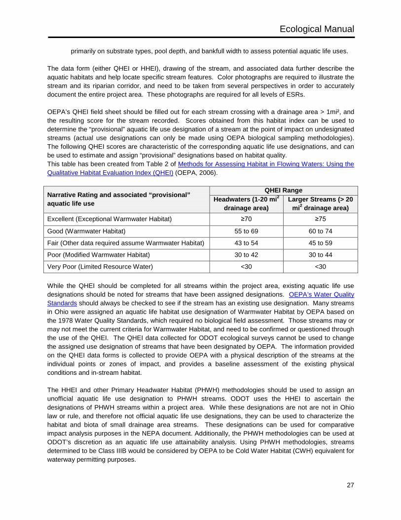
Ecological Manual
27
primarily on substrate types, pool depth, and bankfull width to assess potential aquatic life uses. The data form (either QHEI or HHEI), drawing of the stream, and associated data further describe the aquatic habitats and help locate specific stream features. Color photographs are required to illustrate the stream and its riparian corridor, and need to be taken from several perspectives in order to accurately document the entire project area. These photographs are required for all levels of ESRs. OEPA’s QHEI field sheet should be filled out for each stream crossing with a drainage area > 1mi², and the resulting score for the stream recorded. Scores obtained from this habitat index can be used to determine the “provisional” aquatic life use designation of a stream at the point of impact on undesignated streams (actual use designations can only be made using OEPA biological sampling methodologies). The following QHEI scores are characteristic of the corresponding aquatic life use designations, and can be used to estimate and assign “provisional” designations based on habitat quality. This table has been created from Table 2 of Methods for Assessing Habitat in Flowing Waters: Using the Qualitative Habitat Evaluation Index (QHEI) (OEPA, 2006).
Narrative Rating and associated “provisional” aquatic life use
QHEI Range Headwaters (1-20 mi2
drainage area) Larger Streams (> 20
mi2 drainage area) Excellent (Exceptional Warmwater Habitat) ≥70 ≥75
Good (Warmwater Habitat) 55 to 69 60 to 74
Fair (Other data required assume Warmwater Habitat) 43 to 54 45 to 59
Poor (Modified Warmwater Habitat) 30 to 42 30 to 44
Very Poor (Limited Resource Water) <30 <30 While the QHEI should be completed for all streams within the project area, existing aquatic life use designations should be noted for streams that have been assigned designations. OEPA’s Water Quality Standards should always be checked to see if the stream has an existing use designation. Many streams in Ohio were assigned an aquatic life habitat use designation of Warmwater Habitat by OEPA based on the 1978 Water Quality Standards, which required no biological field assessment. Those streams may or may not meet the current criteria for Warmwater Habitat, and need to be confirmed or questioned through the use of the QHEI. The QHEI data collected for ODOT ecological surveys cannot be used to change the assigned use designation of streams that have been designated by OEPA. The information provided on the QHEI data forms is collected to provide OEPA with a physical description of the streams at the individual points or zones of impact, and provides a baseline assessment of the existing physical conditions and in-stream habitat. The HHEI and other Primary Headwater Habitat (PHWH) methodologies should be used to assign an unofficial aquatic life use designation to PHWH streams. ODOT uses the HHEI to ascertain the designations of PHWH streams within a project area. While these designations are not are not in Ohio law or rule, and therefore not official aquatic life use designations, they can be used to characterize the habitat and biota of small drainage area streams. These designations can be used for comparative impact analysis purposes in the NEPA document. Additionally, the PHWH methodologies can be used at ODOT’s discretion as an aquatic life use attainability analysis. Using PHWH methodologies, streams determined to be Class IIIB would be considered by OEPA to be Cold Water Habitat (CWH) equivalent for waterway permitting purposes.
Ecological Manual
28
HHEIs should be performed on all PHWH streams that fall within the project study area for all three levels of ecological survey. If the HHEI score assesses the stream habitat to be equivalent to Class I, or Class II PHWH, then no additional information would be necessary to characterize the stream. However, if the HHEI results in a score representative of the Class III PHWH designation, a Level 2 Assessment must be done as described in the Field Manual for Ohio’s Primary Headwater Habitat Streams. The Level 2 Assessment involves qualitative biological sampling for vertebrates (fish and salamanders) and macroinvertebrates (using the Headwater Macroinvertebrate Field Evaluation Index, HMFEI). The Level 2 Assessment must be completed to distinguish between the Class IIIA and Class IIIB stream designations using the classification guidance for Level 2 Assessments.
WATER CHEMISTRY:
When conducting Level 2 and Level 3 ecological surveys, the following four water quality parameters should be measured in each stream: • water temperature • pH • dissolved oxygen (mg/l) • conductivity (µs/cm) Water quality measurements are obtained concurrent with the aquatic community surveys. These water quality parameters are easily obtained in the field through the use of calibrated field meters and do not require the collection of a water sample for laboratory analysis. These four basic parameters can give an indication of potential chemical factors that may be impairing the stream. For some projects it may be necessary to analyze additional water quality parameters or the chemical contamination of the sediments composing the stream's substrate. Whether or not these optional parameters or sediments are analyzed is based upon known conditions within the watershed and specific impacts associated with construction, operation, and maintenance of the proposed project. Streams that may require this analysis include large rivers flowing through urban areas and any stream that has been subjected to severe water quality degradation. The necessity for additional water quality or sediment sampling will be determined on a case-by-case basis. OES-ECO will make this determination and provide guidance on sampling procedures and the chemical parameters to be tested. Certain environmental parameters assist in interpreting water quality data and should be recorded with these parameters; • Weather conditions and the time of collection may influence certain parameters. • The stage of the stream will influence all the measured parameters and should be provided whenever
available. When stream stage information is not available, a qualitative description of the stream stage is sufficient (i.e., base flow/annual low flow, normal flow, bank-full discharge or out-of-bank discharge/flood stage).
• Substrate and/or bedrock mineralogy may affect certain parameters, such as pH. Unusually high or low measurements should be noted, particularly those parameters that potentially influence the composition and abundance of the aquatic communities. In addition, any obvious sludge, floating debris, oil and scum, color and odor producing materials, substances that are harmful to human, animal or aquatic life, and algal blooms should be noted (OEPA’s “free from“ criteria applicable to all waters, OAC 3745-1-04, and current Water Quality Standards). Where multiple water quality samples have been obtained, the discussion should analyze seasonal variation in the concentrations of the parameters.
Ecological Manual
29
BIOLOGICAL SAMPLING
Biological sampling of streams, including sampling of fish, stream salamanders, mussels, and other aquatic macroinvertebrates, should be conducted when appropriate (see the Flow Chart for Conducting Stream Sampling). Field methods describing how to sample these biological communities are described in Fishes (Section 2.2.1.5), Macrobenthos (Section 2.2.1.6), Unionid Mussels (Section 2.2.1.7), and Amphibians and Reptiles (Section 2.2.2.2) ODOT projects typically require qualitative sampling of these communities to aid in determining the quality of the stream resource. However, in some circumstances, conducting OEPA’s quantitative indices may be necessary to characterize a stream. Consult with ODOT (the District and OES-ECO) to determine if use of these quantitative methods are appropriate and within the scope of the ecological survey.
STREAM MAPPING CONSIDERATIONS
• All streams within the project study area, including streams passing through culvert structures, should be clearly depicted on ecological resource mapping in the ecological survey report.
• Portions of streams within the study area that flow through culvert structures should be differentiated on project mapping from portions of the stream that are not enclosed, and the map key should reflect the symbology used to differentiate between segments passing through culverts and segments that are not flowing through culverts (for example, by using a different color or by using a dashed or dotted line).
• The direction of stream flow must be depicted on the mapping. • Photograph locations and direction should be clearly depicted on ecological resource mapping. • For Level 2 and Level 3 Ecological Survey Reports, portions of the stream that extend beyond the
study area boundary should be depicted upstream and downstream of the project area on the ecological resource mapping. This will assist the OEPA in their review of potential and existing up and downstream uses and impacts. Mapping these resources outside of the study area should be done using an analysis of aerial photography, and does not require additional field survey. This analysis is only necessary on areas within 1,000 feet of the project study area.
2.2.1.2 WETLANDS
GENERAL DISCUSSION
Wetlands are areas inundated or saturated by surface or groundwater at a frequency and duration sufficient to support, and that under normal circumstances do support, a prevalence of vegetation typically adapted for life in saturated soil conditions. Wetlands generally include swamps, marshes, bogs, and similar areas (OAC 3745-1-02, 90). Within Ohio, a wetland’s quality is based on its position in the landscape, the extent of past and present disturbance, and the diversity and quality of the plant communities residing within the wetland. All wetland habitats potentially impacted by ODOT projects must be assessed and documented as follows; • All wetlands present must be identified and depicted on ecological resource mapping. • The overall size and wetland boundaries must be determined. • The hydro-period and the hydrology characteristics that define a wetland as a jurisdictional water of
the U.S. and/or State must be described. • The wetlands must be characterized in terms of their biological communities.
Ecological Manual
30
• The quality of the wetlands and their appropriate anti-degradation category (in accordance with OAC-3745-54) must be determined, and it must be determined if the wetland provides habitat for any listed plant or animal species.
WETLAND RESOURCE DESCRIPTIONS
There are many methods for determining and describing the presence, functions, and values of wetlands. From a regulatory perspective, a resource defined as a wetland must possess adequate hydrology, a prevalence of hydrophytic vegetation, and the presence of hydric soils in accordance with the U.S. Army Corps of Engineers 1987 Wetland Delineation Manual (and subsequent Regional Supplements). Once it has been determined that an area meets the criteria necessary to be considered a wetland, several terms are pertinent to describing wetlands in a regulatory framework and to determine and assess ecological functions. The physical and biological characteristics used to characterize wetlands within Ohio, for both ecological assessment and regulatory purposes, are described in this section. Also included are brief descriptions of commonly used terms and techniques used to evaluate Ohio wetlands. • Wetland Systems: Wetlands can be found in many different positions throughout the landscape.
Within Ohio, wetlands typically can be characterized by one of the three main systems presented by Cowardin et.al (1979): o Palustrine wetlands are the most common wetland system throughout Ohio, and include wetland
areas typically referred to as marshes, swamps, bogs, and fens. These areas are found in depressions, along ponds, on floodplains, along slopes with seeps, and areas of persistent wetland vegetation along rivers and lakes. These wetlands can be dominated by vegetation types classified as aquatic bed, emergent (non-persistent and persistent), scrub shrub, and forested.
o Riverine wetlands are areas contained within a natural or man-made channel (typically rivers or streams) dominated by aquatic bed or non-persistent emergent vegetation. Areas of persistent vegetation beyond aquatic bed or non-persistent emergent vegetation would be considered palustrine.
o Lacustrine wetlands are areas along lakes, reservoirs, or ponds dominated by aquatic bed or non-persistent emergent vegetation. Areas of persistent vegetation beyond aquatic bed or non-persistent emergent vegetation would be considered palustrine.
• Wetland hydrology: The characteristics of wetland hydrology (duration of inundation and saturation, water depth, varying hydrology sources) can greatly influence the plants and animals that reside within a wetland as well as the development of hydric soil characteristics. The following water regimes summarized from Cowardin et al. (1979) describe the gradient of hydro-periods that can be observed in Ohio wetlands. o Saturated – the wetland substrate is saturated to the surface for extended periods during the
growing season, but with little surface water. o Temporarily Flooded – water is present at the surface of the wetland for brief periods during the
growing season. o Seasonally Flooded – surface water is present in the wetland for extended periods during
portions of the growing season (typically early), but the wetland often becomes dry by the end of the season.
o Semi-permanently Flooded – surface water persists throughout the growing season. o Intermittently Exposed – surface water is present throughout the year except during time of
drought. o Permanently Flooded – surface water is present throughout the year.
Ecological Manual
31
• Wetland connectivity: The USACE requires a determination of a wetland’s connectivity (or lack
thereof) to other waters of the U.S. The terms coined by the USACE to describe hydrologic connections are important for determining whether the wetland is jurisdictional under federal regulations. o Abutting – wetlands that are not physically separated from a TNW or tributary o Adjacent – wetlands that border TNWs or tributaries, but are separated from these waters by
man-made or natural barriers (such as dikes or natural river berms) o Isolated - wetlands that do not possess a surface water connection (are not abutting or adjacent)
to a TNW or tributary. As with streams, wetlands are only considered federally jurisdictional waters of the U.S. if they are found to have a significant nexus with a TNW. A wetland is considered to have a significant nexus to a TNW if its ecological and hydrologic functions affect the chemical, physical, and biological integrity of the downstream TNW. The USACE, through ODOT’s coordination process, will determine if a wetland within the project area is a jurisdictional water of the U.S.. All wetlands thought to be isolated will need to be reviewed by the USACE for verification. If the wetlands are found to be hydrologically isolated, they are not considered jurisdictional waters of the U.S. (unless their impact could have an effect on interstate commerce), but would still be considered jurisdictional waters of the State and subject to Ohio isolated wetland regulations. In general, the USACE will need to make significant nexus determinations on all wetlands found to be abutting or adjacent to Non-Relatively Permanent waters, wetlands adjacent to Relatively Permanent Waters, and wetlands abutting Relatively Permanent waters with seasonal (intermittent) flow. Wetlands abutting Relatively Permanent Waters with continuous (perennial) flow, and wetlands abutting or adjacent to TNWs, do not require a significant nexus determination for the USACE to determine that they are jurisdictional Waters of the U.S. • Wetland Habitat Quality: The quality and characteristics of the wetland habitat can influence the type
and quality of the vegetation and animals residing there. The Ohio Rapid Assessment Method (ORAM) for Wetlands v. 5.0 (Mack, 2001) was developed by OEPA as a general habitat assessment tool to rate wetland quality within Ohio. This assessment focuses on size, surrounding buffer, hydrology, habitat alterations and disturbances, plant communities, and special wetland features (such as the presence of listed species, the maturity of forest areas, and the presence of unique or rare wetland types). This rating form results in a score that is used to estimate the quality of the habitat and assign an Antidegradation Category used in the waterway permitting process.
• Wetland Biology: The type and abundance of plants and animals that comprise a wetland community can provide an indication of the quality of wetland habitat, surrounding landscape, and water chemistry. The prevalence of invasive and/or common tolerant species within a wetland can be an indicator of recent or ongoing disturbances. Conversely, the presence and abundance of rare, unique, or sensitive species can be used as an indicator of the relative lack of disturbance to an area. While ODOT typically uses qualitative observations of plants and animals within a wetland area, quantitative assessment tools have been developed by OEPA to assess wetland plant (Vegetative Index of Biotic Integrity), amphibian (Amphibian Index of Biotic Integrity), and macroinvertebrate (Density-based Invertebrate Community Index) communities. As with the ORAM habitat assessment tool, these biological quantitative assessment tools can be used to estimate the quality of the habitat and assign an Antidegradation category. Documents discussing the rationale, methods, and application of the Vegetative Index of Biotic Integrity (VIBI), Amphibian Index of Biotic Integrity (AmphIBI), and Density-based Invertebrate Community Index (DICI) can be obtained from the
Ecological Manual
32
Reports tab on the OEPA’s Wetland Ecology web page.
• Wetland Antidegradation Categories: The OEPA has developed Antidegradation Categories that define various wetland quality types within Ohio. Every wetland impacted by an ODOT project must be assessed and assigned an Antidegradation Category. The following OEPA Antidegradation Categories are used to describe Ohio’s wetlands: o Category 3 Wetlands: support superior wildlife habitat, hydrological, or recreational functions,
and are comprised of a high diversity of native species with a narrow range of ecological tolerances. These wetlands typically show little indication of current or previous disturbance, and may provide habitat for sensitive, rare, listed, or climax species.
o Category 2 Wetlands: support moderate wildlife habitat, hydrological, or recreational functions, and are comprised of primarily common native species. These wetlands may have been subjected to some level of disturbance, but have a reasonable chance of regaining lost functions or ecological values.
o Category 1 Wetlands: support minimal wildlife habitat, hydrological, and recreational functions, and are typified by low species diversity and a predominance of non-native and/or invasive species. These wetlands are typically highly disturbed with little chance of regaining lost functions or ecological values.
WETLAND FIELD DATA COLLECTION METHODS
A thorough literature review of the site should be conducted to determine if wetlands are present in the study area (see Section 2.1.2.2). Once this background information has been reviewed, a field survey of the project area should be conducted to verify and delineate the presence of any wetlands. The guidelines set forth in the Corps of Engineers Wetlands Delineation Manual (Environmental Laboratory 1987) and the appropriate Regional Supplements to the Corps of Engineers Wetland Delineation Manual must be used to determine if probable jurisdictional wetlands are present. Within Ohio (refer to map), the regional supplements include the Midwest Region (Environmental Laboratory 2010), the North central and Northeast Region (Environmental Laboratory 2012), and Eastern Mountains and Piedmont (Environmental Laboratory 2012). The Latest version of the USACE National Wetland Plant List (Cold Regions Research and Engineering Laboratory 2013) must be used to ascertain the appropriate wetland indicator status for a species. The Wetlands Delineation Manual and Regional Supplements describe in detail how to determine whether the three criteria necessary to determine the presence of wetlands (wetland hydrology, hydric soils, and hydrophytic vegetation) have been met. ODOT projects require the use of the onsite routine delineation method (consisting of a wetland data point and an upland data point) to identify an area as a jurisdictional wetland; however, any of the wetland delineation methods found in the Corps of Engineers Wetlands Delineation Manual and the appropriate Interim Regional Supplements are acceptable. USACE Wetland Determination Forms must be completed for each wetland delineated. In addition, USACE Wetland Determination Forms should be completed for any suspect wetland areas (any areas with a prevalence of hydrophytic vegetation), and included in the ecological survey report. Atypical situations, problem areas, and difficult wetland situations should be delineated in accordance with the Corps of Engineers Wetlands Delineation Manual and the appropriate Regional Supplements. OES-ECO has developed Technical Guidance for Delineating Vegetated Bars within the Active Channel of Rivers and Streams and Delineating Wetlands within Active Floodplains within Ohio Department of Transportation (ODOT) Project Areas to help address two frequent problematic situations encountered on ODOT projects, and to ensure that the USACE is provided with the information necessary to make jurisdictional determinations on projects with these resources.
Ecological Manual
33
Once an area has been determined to be a wetland, the wetland boundary must be delineated and identified on project mapping for the purposes of avoidance, minimization, and calculation of impacts. For all levels of ecological surveys, wetland boundaries located within the project area must be surveyed with a method that will provide a horizontal accuracy of <1 meter within the project study area, and the boundaries should be flagged (where possible). For portions of the wetlands that extend outside of the study area, aerial photographs and contours on topographic mapping can be used to estimate approximate wetland boundaries.
DESCRIPTIONS OF WETLAND HABITATS
In addition to wetland delineations, a description of each wetland must be provided by completing the appropriate boxes in the report tables of an ecological survey report, and when appropriate, by providing a general narrative description in the report. The description should note the dominant wetland plant communities, the type of wetland system, and hydro-period (following Cowardin et al, 1979), the relative quality of the wetland habitat, and the hydrologic connectivity to other waters of the U.S. Narrative discussions should describe observations of any obvious disturbances or unique features, direct observations or evidence of animals occupying wetland habitats, and the potential uses of the wetland (such as its suitability as a breeding site for amphibians or as feeding areas for migratory waterfowl). Color photographs must be taken of each dominant plant community in each wetland. The overall importance of the wetland should be described from a local and regional context.
WETLAND HABITAT ASSESSMENTS
A functional assessment of the habitat must be completed for each wetland delineated, when conducting any level of ecological survey, using the most recent version of the ORAM. Field methods for completing these assessments are found in the Ohio Rapid Assessment Method for Wetlands v. 5.0, User's Manual and Scoring Forms. Evaluating wetlands with this method generates a score that is used to assign the wetland to a category. This category rating must be applied to each wetland or group of contiguous wetlands. The evaluation sheet, score, and corresponding Antidegradation Category must be included in the ESR. In some circumstances, conducting OEPA’s quantitative indices on vegetation (VIBI), amphibians (AmphIBI), and macroinvertebrates (DICI) may be necessary to characterize a wetland and determine its Antidegradation Category. Consult with ODOT (the District and OES-ECO) to determine if the use of these quantitative methods are appropriate and within the scope of the ecological survey.
DETERMINING HYDROLOGIC CONNECTIVITY
Wetlands identified within the project area for ecological surveys must be examined to determine if they are abutting or adjacent to a TNW or tributary, or if they are hydrologically isolated. Each wetland should be thoroughly reviewed to determine if there are any surface water connections or drainage patterns that flow to streams or ditches, or if any streams are periodically connected to the wetlands through flooding. • If a wetland is touching any stream (regardless of whether that stream is a Relatively Permanent
Water or not) or any potentially jurisdictional ditch (see Section 2.2.1.3) it should be considered abutting the stream or potentially jurisdictional ditch.
• If a wetland is separated from a stream or potentially jurisdictional ditch by a natural or manmade barrier, but appears to be hydrologically connected to the stream or potentially jurisdictional ditch by some type of non-jurisdictional conveyance (drainage patterns, channels or drainage ways without an OHWM) or periodic flood events, it should be considered adjacent to the stream or potentially jurisdictional ditch.
Ecological Manual
34
• Wetlands that are not observed to be abutting or adjacent to any streams or ditches should be considered isolated. This isolated determination would also include a wetland that is only connected to a stream or potentially jurisdictional ditch through an adjacency to another wetland (regardless of whether this other wetland is abutting or adjacent to jurisdictional water). An exception to this would be if the wetlands were once one individual wetland that had been separated from one another by a man-made fill. In this scenario, both wetlands may be considered jurisdictional.
Information on how the wetlands connect to a TNW (flow path to the TNW) must be provided for all wetlands that are thought to be adjacent or abutting a waterway within the project area. During their review, the USACE will determine whether these abutting or adjacent wetlands meet the criteria necessary to be considered jurisdictional waters of the U.S. In some cases these determinations will be dependent on determinations made for streams and ditches within the project area.
WETLAND MAPPING CONSIDERATIONS
• All wetlands within the project study area should be clearly depicted on ecological resource mapping in the ecological survey report.
• Mapping should clearly show connectivity (abutting or adjacency) to potential waters of the U.S. when applicable (non-isolated wetlands).
• The location of all data points where wetland determination forms were completed for the ecological survey (both wetland and non-wetlands data forms) should be depicted on the ecological resource mapping. This would include the locations of data forms completed on suspect wetland areas that were determined to not be wetlands.
• Photograph locations and direction should be clearly depicted on ecological resource mapping. • For all Ecological Survey Reports, portions of the wetlands that extend beyond the study area
boundary should be depicted on the ecological resource mapping. This will assist the OEPA in their review of potential and existing uses and impacts. Mapping these resources outside of the study area should be done using an analysis of aerial photography, and does not require additional field survey. This analysis is only necessary on wetland areas for which a portion of the area is found within the project study area.
2.2.1.3 DITCHES
GENERAL DISCUSSION
Ditches are long narrow channels typically constructed for the purposes of providing drainage or irrigation. ODOT projects commonly include ditches constructed along an existing roadway, or intersect ditches constructed through agricultural fields. While some ditches may be considered jurisdictional waters of the U.S., a majority of ditches found within ODOT project areas will likely be considered non-jurisdictional. The goals of ditch characterization on any ODOT project are to; • Identify and map any ditches that may be considered potentially jurisdictional waters of the U.S. • Describe the flow characteristics and features that define a ditch as a potentially jurisdictional water of
the U.S. and/or State. • Identify and map any ditches that may act as a non-jurisdictional conveyance for an adjacent wetland
(this information is needed by the USACE to complete a significant nexus determination for the wetland).
Ecological Manual
35
DITCH DESCRIPTIONS
The common meaning for the term “ditch” can encompass water conveyances that range from grassy swales to captured streams. All ditches possess a constructed defined channel and convey water for at least a minimal period of time. Within Ohio, most ditches function to provide drainage from an area (roadway, agricultural field, residential area, etc…); however, ditches may also have been constructed to provide irrigation to an area. Providing and maintaining adequate roadway drainage is an important aspect of roadway design and construction. However, for the purposes of determining ecological impacts and obtaining the appropriate waterway permits, ODOT is also concerned with the jurisdictional nature of existing ditches. The following terms (formulated from recent unpublished ditch guidance provided by USACE Huntington Office) describe the types of ditches that can be encountered within an ODOT project area. • Non-jurisdictional ditch/conveyance: These constructed features function to drain the landscape,
but are not Relatively Permanent Waters (RPW) and do not possess an OHWM. In addition, these ditches do not possess a captured stream and were not constructed in a hydric soil unit for the purpose of draining a wetland at the time of construction. Typical examples of these types of ditches range from grassy swales to ditches with sufficient hydrology to become fully vegetated with hydrophytes (fully vegetated ditches are considered to be lacking an OHWM). While these ditches are not considered jurisdictional waters of the U.S., they can occasionally act as a non-jurisdictional conveyance for an abutting or adjacent wetland. Any construction or maintenance activities involving these non-jurisdictional ditches are exempt from 404 regulations and do not need to be addressed in the ESR.
• Jurisdictional roadway ditch: These features are constructed entirely on roadway right-of-way and function to drain the roadway and adjacent landscape. Jurisdictional roadway ditches are RPWs with an OHWM (not fully vegetated), or were constructed in a hydric soil unit for the purpose of draining a wetland at the time of construction. The maintenance (restoration to the original configuration) of these drainage ditches is exempt from regulation (as specified the USACE Regulatory Guidance Letter 07-02), however, projects involving impacts to these ditches in the form of widening, deepening, or relocation must be authorized through the 404 and 401 permitting processes.
In addition to non-jurisdictional and jurisdictional ditches, the following jurisdictional waters can also be found within or adjacent to the roadway ditch system. • Captured stream: These features are RPW or Non-RPW streams (possessing a defined channel
and an OHWM) outside of the roadway right-of-way that flow into the right-of-way and become captured within the roadway ditch. Secondary source information, including (but not limited to) soil surveys and topographic mapping can be used to determine the presence of potentially jurisdictional channelized or captured streams. Often these streams appear as a “blue line” on USGS 7.5 minute topographic mapping, and some are named. Caution should be used when referencing this information as many of the smaller “blue line” drainage ditches, and drainage flow lines on soil survey mapping, do not possess an ordinary high water mark in the field and would not be considered jurisdictional streams. Once it has been established that a stream has been captured within the roadway ditch, the ditch should be considered a stream regardless of whether it possesses an OHWM. Often small streams captured in the roadway ditch system lose their OHWM due to maintenance, or may become fully vegetated due to a wide configuration. Captured streams should be characterized and assessed as streams rather than ditches (see Section 2.2.1.1)
• Wetland: Occasionally roadway ditches can form wetlands due to the lack of maintenance (aggraded ditch profiles or clogged culverts) or by their design (such as a fade-away ditch line). In these circumstances, hydrology traveling through the ditch has become impeded in such a way that it has
Ecological Manual
36
resulted in the formation of a jurisdictional wetland (see Section 2.2.1.2) For this characterization to apply to a site, the area of the wetland boundary must extend more than an insignificant amount beyond the configuration of the ditch. Portions of the ditch abutting the wetland should be delineated as part of the wetland. Wetlands formed in this way should be characterized and assessed as wetlands rather than ditches. Sections of ditch flowing into or out of the wetland area should be characterized separately to determine if they are potentially jurisdictional.
• Petition ditch: The term petition ditch refers to historically channelized watercourses that were constructed or improved in accordance with Ohio’s petition ditch laws. Petition ditches are often modified streams, with clearly defined channels and OHWMs. The petition ditch laws were established to facilitate the maintenance of watercourses and reduce flooding. While watercourses designated as petition ditches may be subjected to an abbreviated antidegradation review by the OEPA when being maintained or improved under the ditch laws, this abbreviated review does not apply to impacts to petition ditches that are not implemented in accordance with the ditch laws (such as a roadway project). Petition ditches encountered within an ODOT project area should be evaluated individually to determine if they meet the characteristics of a stream, wetland, or ditch, regardless of the “petition ditch” designation. In most circumstances, these watercourses will be characterized and discussed as streams (see Section 2.2.1.1). Ditch descriptions are documented in all levels of ecological survey reports.
• Ditches constructed as a post-construction best management practice (BMP) to comply with NPDES requirements: If it is known that a ditch has been constructed as a post-construction BMP to comply with NPDES permit requirements, it is not a water of the U.S. Documentation should be provided indicating that the ditch was designed and constructed as a post-construction BMP to remove pollutants from runoff (water quality treatment) and protect streams by attempting to maintain existing stream conditions or by reducing runoff volumes through structural BMP (water quantity treatment). 40 CFR 230.3(s) exempts waste treatment systems, and states, “waste treatment systems, including treatment ponds or lagoons designed to meet the requirements of the Clean Water Act (other than cooling ponds as defined in 40 CFR Section 423.11(m) which also meet the criteria of this definition) are not waters of the United States.” As ODOT constructs more post-construction BMPs within the right-of-way to comply with NPDES requirements, it becomes more likely that these types of features will be encountered. When encountered, post-construction BMPs located in ditch lines should be documented and discussed in the pond, lake, reservoir, and retention and detention basin section of the ecological survey report (see Section 2.2.1.4). Refer to Section 1115.3 of the ODOT Location and Design Manual, Volume 2 for a list of post-construction BMPs that may be encountered with a roadway ditch.
DITCH FIELD DATA COLLECTION METHODS
Roadway ditches are encountered within nearly every ODOT project area. Determining whether these ditches may be potentially jurisdictional waters of the U.S. can be challenging to the most experienced field staff. The following flowchart has been developed to aid in characterizing roadside ditches on ODOT projects based on guidance provided by the USACE Huntington District and past experiences on ODOT projects. The guidance is only intended for use on characterizing and documenting roadway ditches within ODOT project study areas. In all cases, the USACE will make the final determination as to whether a ditch is a jurisdictional water of the U.S.
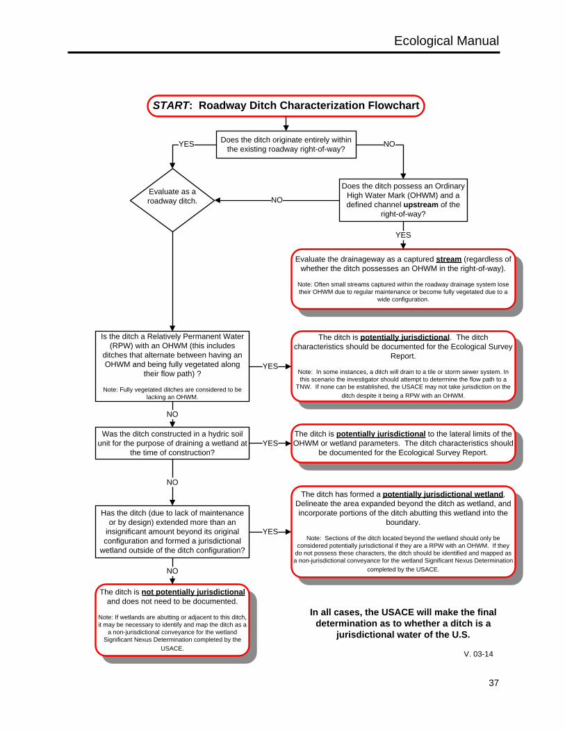
Ecological Manual
37
Does the ditch originate entirely within the existing roadway right-of-way?
Does the ditch possess an Ordinary High Water Mark (OHWM) and a defined channel upstream of the
right-of-way?
Evaluate the drainageway as a captured stream (regardless of whether the ditch possesses an OHWM in the right-of-way).
Note: Often small streams captured within the roadway drainage system lose their OHWM due to regular maintenance or become fully vegetated due to a
wide configuration.
NO
YES
YES
NO
Is the ditch a Relatively Permanent Water (RPW) with an OHWM (this includes
ditches that alternate between having an OHWM and being fully vegetated along
their flow path) ?
Note: Fully vegetated ditches are considered to be lacking an OHWM.
The ditch is potentially jurisdictional. The ditch characteristics should be documented for the Ecological Survey
Report.
Note: In some instances, a ditch will drain to a tile or storm sewer system. In this scenario the investigator should attempt to determine the flow path to a
TNW. If none can be established, the USACE may not take jurisdiction on the ditch despite it being a RPW with an OHWM.
YES
Was the ditch constructed in a hydric soil unit for the purpose of draining a wetland at
the time of construction?
The ditch is potentially jurisdictional to the lateral limits of the OHWM or wetland parameters. The ditch characteristics should
be documented for the Ecological Survey Report.
NO
YES
Has the ditch (due to lack of maintenance or by design) extended more than an
insignificant amount beyond its original configuration and formed a jurisdictional
wetland outside of the ditch configuration?
NOThe ditch has formed a potentially jurisdictional wetland.
Delineate the area expanded beyond the ditch as wetland, and incorporate portions of the ditch abutting this wetland into the
boundary.
Note: Sections of the ditch located beyond the wetland should only be considered potentially jurisdictional if they are a RPW with an OHWM. If they
do not possess these characters, the ditch should be identified and mapped as a non-jurisdictional conveyance for the wetland Significant Nexus Determination
completed by the USACE.
YES
The ditch is not potentially jurisdictional and does not need to be documented.
Note: If wetlands are abutting or adjacent to this ditch, it may be necessary to identify and map the ditch as a
a non-jurisdictional conveyance for the wetland Significant Nexus Determination completed by the
USACE.
NO
In all cases, the USACE will make the final determination as to whether a ditch is a
jurisdictional water of the U.S.
Evaluate as a roadway ditch.
START: Roadway Ditch Characterization Flowchart
V. 03-14
Ecological Manual
38
Roadway ditches should only be documented and included in the ecological survey report if it is believed that they are potentially jurisdictional, or if they may be acting as non-jurisdictional conveyances for abutting or adjacent wetlands. Ditches included in an ecological report should be mapped, photographed, and have their characteristics documented (flow regime, presence of an OHWM, width, length, etc.). The width of a potentially jurisdictional ditch should be calculated based on the width of the wetted channel (not the top of the banks of the constructed channel), and the length should be based on the distance from where the jurisdictional features begin (RPW with an OHWM) to the tributary it flows to (including any areas that may lose the OHWM to wetland vegetation). In addition, information on how any potentially jurisdictional ditches and non-jurisdictional conveyances for wetlands ultimately connect to a TNW (flow path to the TNW) must be provided
DITCH MAPPING CONSIDERATIONS
• All potentially jurisdictional ditches and non-jurisdictional conveyances within the project study area should be clearly depicted on ecological resource mapping in the ecological survey report.
• Mapping should clearly show connectivity to potential waters of the U.S. • Photograph locations and direction should be clearly depicted on ecological resource mapping. • For all Ecological Survey Reports, portions of the potentially jurisdictional ditches and non-
jurisdictional conveyances that extend beyond the study area boundary should be depicted on the ecological resource mapping. This will assist the USACE and OEPA in their review of potential and existing uses and impacts. Mapping these resources outside of the study area should be done using an analysis of aerial photography, and does not require additional field survey. This analysis is only necessary on potentially jurisdictional ditches and non-jurisdictional conveyances for which a portion of the ditch is found within the project study area.
2.2.1.4 PONDS, LAKES, RESERVOIRS, RETENTION AND DETENTION BASINS
GENERAL DISCUSSION
Open water habitats such as ponds, lakes, reservoirs, retention and detention basins are often present within ODOT project study areas. These natural or manmade features can have multiple uses, and many may be considered jurisdictional waters of the U.S. The goals of assessing these features for any ODOT project are to; • Identify any ponds, lakes, or reservoirs, retention and detention basins within a project study area. • Describe the characteristics and features that define a pond, lake, reservoir, or retention and
detention basin as a potentially jurisdictional water of the U.S. • Describe the functions and uses of any identified ponds, lakes, reservoirs, or retention and detention
basins.
DESCRIPTION OF PONDS, LAKES, AND RESERVOIRS
While ponds, lakes, and reservoirs have been grouped together in this manual for the purposes of describing open water habitats, these resources can vary greatly in terms of their size, formation, and function. These habitats are typically characterized by the presence of permanent water depths greater than two meters (Cowardin et al, 1979), inhibiting the growth of emergent vegetation, and often allowing for thermal stratification. Ponds are generally considered to be deep-water habitats less than 5 acres in surface area, while lakes and reservoirs are generally considered to be water bodies greater than 5 acres in size. While human-made ponds and lakes are abundant, very few natural lakes are present within
Ecological Manual
39
Ohio (approximately 110 scattered throughout 21 counties), and most of these have been altered by humans through filling, draining, impounding, and installation of outlet controls, levees and dikes (Black, 1991). The following descriptors should be used on ODOT projects to characterize ponds, lakes, and reservoirs that may be encountered within a project area. • Origin: Ponds, lakes, and reservoirs are separated into two main categories, created features and
natural features: o Created: Many ponds, lakes, and reservoirs have been created throughout Ohio by impounding
streams and drainages, excavating areas with high groundwater tables, and through the construction of up-ground storage reservoirs that typically receive hydrology from pumped sources.
o Natural: Natural lakes and ponds found within Ohio include kettle lakes that formed during the last ice age (although these are rare and many of the smaller lakes have since become bogs or marshes), cutoff stream oxbows, and natural impoundments (such as beaver dams). A list of natural kettle lakes in Ohio is available through the ODNR, Division of Water.
• Hydrology Sources: Ponds, lakes, and reservoirs can receive hydrology from surface water (streams, overland sheet flow from precipitation, other conveyances, etc…), ground water (springs, high ground water table, etc…), or a combination of the two. The determination as to whether a pond, lake, or reservoir is a water of the U.S. is based on its connection to other waters of the U.S. It is important to characterize these waters as to whether they are isolated or non-isolated from other water of the U.S. o Non-Isolated: Non-isolated ponds, lakes, or reservoirs include waters that possess a surface
water connection to a TNW or tributary. This includes ponds, lakes, and reservoirs that are not physically separated from a TNW or tributary (such as impoundments of streams considered to be RPWs, and ponds that discharge to RPWs), and in some cases waters that border TNWs or tributaries but are separated from these waters man-made or natural barriers (an example of which may be an oxbow pond located in the floodplain of a river, or a pond that discharges a non-RPW to a tributary).
o Isolated: Ponds, lakes, or reservoirs that do not possess a surface water connection to a TNW or tributary would be considered isolated.
Ponds, lakes, and reservoirs are only considered jurisdictional waters if they are found to have a significant nexus with a TNW. Ponds, lakes, and reservoirs are considered to have a significant nexus to a TNW if their ecological and hydrologic functions affect the chemical, physical, and biological integrity of the downstream TNW. The USACE, through ODOT’s coordination process, will determine if a pond, lake, or reservoir within the project area is a jurisdictional water of the U.S. In general, any ponds, lakes, or reservoirs that have formed through the impoundment of a water of the U.S. will be considered jurisdictional waters of the U.S. The jurisdictional nature of a water body in a more ambiguous setting (such as a pond connecting to a tributary by means of a non-RPW or non-jurisdictional conveyance) would likely require a significant nexus determination by the USACE. All ponds, lakes, or reservoirs thought to be isolated need to be reviewed by the USACE for verification. If these waters are determined to be isolated, they would not be considered jurisdictional waters of the U.S. (unless their impact could have an effect on interstate commerce). • Functions/Uses: Ponds, lakes, and reservoirs function to provide wildlife habitat, waste water
treatment, recreation, industrial or drinking water supply source, aquaculture, agriculture (stock watering, irrigation, etc…), aesthetics, etc.
• Lake and Reservoir Use Designations: The OEPA’s water use designations and statewide criteria (OAC 3745-1-07) designates the aquatic life use for all lakes and reservoirs as exceptional warmwater habitat, and for all up-ground storage reservoirs as warmwater habitat. In addition, all publicly owned lakes and reservoirs (with the exception of Piedmont Reservoir), and all privately
Ecological Manual
40
owned lakes and reservoirs used as a source of public drinking water, are designated as public water supplies. These water bodies (including ponds) are also designated general high quality waters unless designated superior high quality waters or outstanding state waters in Tables 5-4 and 5-5 of OAC 3745-1-05.
• Lake Erie: Lake Erie is one of Ohio’s most valuable natural resources, and in addition to providing habitat for terrestrial and aquatic flora and fauna (including several rare, sensitive, and listed species), the lake is a major shipping corridor and recreational area. Lake Erie is a unique Ohio water resource that is subject to its own standards and water quality criteria. The lake has been designated as an exceptional warmwater habitat, superior high quality water, public water supply, agricultural water supply, industrial water supply, and bathing water (OAC 3745-1-31). ODOT projects located within the Lake Erie Coastal Zone Management Area will require additional considerations and coordination efforts. This CZMA includes all of the waters of Lake Erie, the islands in the lake, and the lands under and adjacent to the lake, including transitional areas, wetlands, and beaches. More information on coastal consistency and coordinating projects in the CZMA can be obtained from the Memorandum of Agreement between ODNR and ODOT on Coastal Zone Management in Section 1.4.3.
DESCRIPTION OF RETENTION AND DETENTION BASINS
Retention and detention basins are typically constructed as waste treatment systems to treat water quality or water quantity. 40 CFR 230.3(s) exempts waste treatment systems, and states, “waste treatment systems, including treatment ponds or lagoons designed to meet the requirements of the Clean Water Act (other than cooling ponds as defined in 40 CFR Section 423.11(m) which also meet the criteria of this definition) are not waters of the United States.” If a retention or detention basin is known to have been constructed as a post-construction BMP or as a wastewater treatment system to comply with NPDES permit requirements (whether it was constructed by ODOT or another entity), it is not a water of the U.S. Documentation should be provided indicating that the retention or detention basin was designed and constructed as a waste treatment system to remove pollutants. As ODOT constructs more post-construction BMPs within the right-of-way to comply with NPDES requirements, it becomes more likely that these types of features will be encountered within project study areas. When encountered, retention and detention basins should be documented and discussed. Section 1115 through 1117 of the ODOT Location and Design Manual, Volume 2 should be referred to for further information regarding ODOT post-construction BMPs that may be encountered within ODOR right-of-way. Post-construction BMPs that may be encountered include, but would not be limited to: • Extended Detention • Retention Basin • Bioretention Cell • Infiltration Trench • Infiltration Basin • Constructed Wetlands • Manufactured Systems • Vegetated Biofilter • Vegetated Filter Strip
PONDS, LAKES, RESERVOIRS, RETENTION AND DETENTION BASIN FIELD DATA COLLECTION METHODS
All ponds, lakes, and reservoirs, retention and detention basins within a project study area should be
Ecological Manual
41
identified, photographed, and delineated using aerial photography and/or GPS. The total size of the water body should be determined as well as the portion of the pond, lake, or reservoir located within the project area. Functions or uses of the water body should be noted, as well as any official water body use designations. All ponds, lakes, or reservoirs retention and detention basins within a project area need to be mapped, and how they connect to a TNW described (flow path to the TNW) described. If it is known that the feature was constructed as a waste treatment system to treat storm water or waste water, this must be noted in the ecological survey report. Areas along the fringe of a pond, lake, or reservoir may meet wetland criteria (see Section 2.2.1.2). These areas should be delineated and mapped separately from a pond, lake, or reservoir.
PONDS, LAKES, RESERVOIRS, RETENTION AND DETENTION BASIN MAPPING CONSIDERATIONS
• All ponds, lakes, and reservoirs, retention and detention basins within a project study area should be clearly depicted on ecological resource mapping in the ecological survey report.
• Mapping should clearly show connectivity to potential waters of the U.S (if present). • Photograph locations and direction should be clearly depicted on ecological resource mapping. • For all Ecological Survey Reports, portions of the ponds, lakes, and reservoirs, retention and
detention basins within a project study area that extend beyond the study area boundary should be depicted on the ecological resource mapping. This will assist the USACE and OEPA in their review of potential and existing uses and impacts. Mapping these resources outside of the study area should be done using an analysis of aerial photography, and does not require additional field survey. This analysis is only necessary on ponds, lakes, and reservoirs, retention and detention basins within a project study area for which a portion of the ditch is found within the project study area.
2.2.1.5 FISHES
GENERAL DISCUSSION
More than 160 species of fish are known to inhabit Ohio’s waters. Observing the types and abundance of fish within a stream can give an indication of the quality of the water and aquatic habitats. These organisms can act as biological indicators of stream health. On typical ODOT projects, identifying the fish community that resides in a stream may be necessary (see the Flow Chart for Conducting Stream Sampling). The goals associated with sampling the fish community within a stream for ODOT projects are to; • Use observations of fish to aid in determining a “provisional” aquatic life use designation on any
undesignated streams, or to provide supplemental information on streams with assigned Ohio aquatic life use designations.
• Determine if the stream contains any resident populations of listed fish species (see Section 2.2.3).
DESCRIPTION OF FISHES
In order for these species to be used as biological indicators of water and habitat quality, an understanding of the sensitivity of the organisms to pollutants and habitat disturbance is essential. Troutman’s (1981) discussions of species distributions and habitats can often provide some insight into a fish’s habitat preference, and impacts that may have affected species abundance and distribution. In addition, OEPA (2013a) has produced a table that lists the feeding guild, breeding guild, and pollution tolerance for several Ohio species. These species characteristics can be used with qualitative data to help describe the stream habitats and water quality, as well as with OEPA quantitative fish indices.
Ecological Manual
42
Additional identification references including Fishes of the Great Lakes Region (Hubbs et al, 2004), the Fishes of Missouri (Pflieger, 1975), Fishes of Wisconsin (Becker, 1983), and the Handbook of Darters (Page, 1983) possess keys to several species that are found within Ohio. Nomenclature for Ohio fish should follow Common and Scientific Names of Fishes from the United States, Canada, and Mexico, 7th edition, published by the American Fisheries Society (Page et al., 2013).
FISHES FIELD DATA COLLECTION METHODS
The flow chart for conducting stream sampling should be referenced to determine whether the fish community of a particular stream needs to be sampled during the ecological investigation for an ODOT project (see Section 2.2.1.1). ODOT projects typically require qualitative sampling of the fish community to aid in determining the quality of the stream resource. Fish sampling methods used in all ecological surveys should include seining and pulsed DC electro fishing equipment. Both methods are required to adequately assess the composition of the entire fish community. For projects with relatively minor aquatic impacts, the composition of the fish community may be adequately determined from a single sample. More intensive sampling may be necessary for new location projects and those with severe aquatic impacts such as extensive channelization. The recommended methods for ecological surveys vary somewhat depending on stream size, as described below: • Small Streams (generally less than 20 square mile drainage areas):
Backpack electro fishers are normally suitable for these streams. This electro fishing method is most effective in shallow riffle/run habitats, around in-stream structure, and in small pools. The long-line generator method may be required where there are deep pools as frequently occur in the vicinity of bridges. Seining, rather than electro fishing, has been found to be more effective in pools lacking in-stream cover. Riffle and run habitats should also be sampled with seines.
• Moderate Streams (generally between 20-200 square mile drainage areas): Some of these streams can be effectively sampled with a backpack electro fisher, but most will require use of a generator (either a tow-behind unit or set up for long-lining). Standard-sized seines (normally 6 by 10 feet) are generally adequate for these streams, although larger bag seines may be more effective in large pools. While all habitat types should be sampled with both techniques, the electro fishing methods will be most effective around in-stream cover and in the shallower habitats.
• Large Streams (generally greater than 200 square mile drainage areas): A boat shocking system is required to effectively sample the deeper habitats. This type of sampling can be very costly, and neither ODOT nor most consulting firms possess the equipment to conduct this type of survey. Most streams of this size have been previously sampled by other reliable sources (OEPA, ODNR, USGS, or others) and already have a confirmed Aquatic Life Use Designation and biological inventory information. Streams with >200 mi² drainage area within a project area should be characterized using existing biological inventory information from reliable sources (OEPA, ODNR, USFWS, USGS, etc...).
In some circumstances, conducting OEPA’s quantitative and qualitative indices may be necessary to characterize a stream. These fish community indices include the Index of Biotic Integrity (IBI) and the Modified Index of well-being (MIwb), and the methods and rationale for these indices are described by the OEPA in the volumes of the Biological Criteria for the Protection of Aquatic Life and applicable addendums (OEPA 1987a, 1987b, 1989, 2013a, and 2013b). Consult with ODOT (the District and OES-ECO) to determine if use of these quantitative methods are appropriate and within the scope of the ecological survey.
Ecological Manual
43
Fish collected by the methods described above are retained in a live well after capture. Most fish are field identified, counted, and released, while a representative sample may be retained as vouchers. Fish are identified to species, with those of questionable identity retained so their identification can be confirmed in the lab. Voucher specimens should be retained in permanent type collections or deposited in museums. The stream name and the location where the sampling occurred should be recorded, as well as the date, weather conditions, and flow regime at the time of sampling. Along with the numeric fish data, other data collected at each site includes the length of the area sampled, number of fish with anomalies, and the identity and number of hybrids. 2.2.1.6 MACROBENTHOS
GENERAL DISCUSSION
Macrobenthos refers to the aquatic invertebrate community including crayfishes, aquatic insects, other aquatic arthropods, aquatic snails, sphaeriid clams, and other lower invertebrate taxa (due to their unique habits, protected status, and the number of listed species, unionid mussels have been discussed separately from the other macrobenthos in Section 2.2.1.7). Macrobenthos occupy almost every type of aquatic habitat, demonstrate a variety of adaptations to in-stream life, and can be conveniently and economically sampled. On typical ODOT projects, identifying the macrobenthos community that resides in a stream may be necessary (see the Flow Chart for Conducting Stream Sampling). The goals associated with sampling the macrobenthos within a stream on any ODOT project are to: • Use observations of macrobenthos to aid in determining a “provisional” aquatic life use designation
on any undesignated streams, or to provide supplemental information on streams with assigned Ohio aquatic life use designations.
• Determine if the stream contains any resident populations of listed species of macrobenthos (see Section 2.2.3).
Hynes (1974), Roback (1974), Hawkes (1979), Lenat et al. (1980), and Tesmer and Wefring (1981) provide excellent reviews of water quality assessment based on invertebrate species assemblages. Olive et al. (1988) demonstrate that these theoretical treatments are applicable to an understanding of stream quality.
DESCRIPTION OF MACROBENTHOS
• The identification and nomenclature for Aquatic Insects, and other Arthropods, Aquatic Snails, Sphaeriid Clams, and Lower Invertebrates: Only four benthic invertebrate groups have been sufficiently studied to assess their statewide distribution. The dragonflies and damselflies of Ohio were initially listed by Kellicott (1889). Borror (1937, 1938), Borror and Epstein (1942), Price (1958), Alrutz (1959, 1961), Kormondy (1956), Harwood (1960), Cruden and Carrie (1961), and Glotzhober and McShaffrey (2002) have updated or revised this initial list. The distribution of mayflies within Ohio was examined by Hall (1976) and Randolph et al. (1998). Blackflies were studied by Amrine (1971) and leeches were examined by Miller (1929). Regional discussions of benthic communities are given by Walker (1947), Barton (1973), Olive and Smith (1975), and Olive (1981). Additional site-specific data can be obtained from OEPA Division of Surface Water, which maintains invertebrate records in electronic data bases.
Ecological Manual
44
Numerous keys for the identification of aquatic invertebrates are available, but those preferred for ODOT ecological surveys include: Naididae (Hiltunen and Klemm 1980), Tubificidae (Stimpson et al. 1982), leeches (Klemm 1982), gastropods (Birch 1982 and 1989), Sphaeriidae (Herrington 1962 and Burch 1975), insect groups (Merritt and Cummins 1996), mayflies (Burks 1953, Lewis 1974), dragonflies (Needham and Westfall 1975), stoneflies (Claassen 1931, Frison 1935, OEPA 2013), hemipterans (Hilsenhoff 1970, 1984), Chironomidae (Epler 2001, Bolton 2007, Bolton 2012), and trichopterans (Wiggins 1978). Other general references of more limited usefulness include Usinger (1956), Parrish (1975), Pennak (1978), and Thorp and Covich (1991). A more complete list of current taxonomic keys and references is maintained by the OEPA (Table V-1) in 2013 Updates to Biological Criteria for the Protection of Aquatic Life: Volume III. Standardized Biological Field Sampling and Laboratory Methods for Assessing Fish and Macroinvertebrate Communities (OEPA, 2013b). Insect nomenclature should follow the most recent version of the OEPA Macroinvertebrate Taxa List.
• Crayfishes; Identification and Nomenclature: The historic distribution of crayfishes in Ohio is fairly well
established (Turner 1926, Rhoades 1944a and 1944b). Numerous more recent studies describe additional distribution records as well as changes that have occurred in the fauna. Thoma and Jezerinac (1982) discuss crayfish records from the Cuyahoga, Chagrin, Mahoning, and Grand River drainages, and for streams on the Flushing Escarpment. Jezerinac (1982 and 1991) discusses the distribution of all crayfishes encountered in the Chagrin River during fieldwork conducted in the mid-1960s, and in the Licking River watershed for studies conducted during the mid-1970s. Other useful sources include information on the statewide distribution of Procambarus clarkii (Norrocky 1983), the distributions of some of the rarer species in Ohio (Jezerinac 1986), the abundance and distribution of Orconectes sanbornii, O. erismophorous, O. hobbs, O. fitzpatrick, and Orconectes sp. in southern Ohio (Jezerinac 1987), the present distribution of Orconectes sloani (St. John 1988) since its original description by Rhoades (1941), and the most recent county distribution records for all species in the Ohio Crayfish and Shrimp Atlas (Thoma and Jezerinac 2000).
Useful keys for the identification of Ohio crayfishes include Hobbs (1976 and 1989), Jezerinac (1978 and 1995), and Jezerinac and Thoma (1984). Difficult specimens should be examined by specialists for positive identification. The scientific nomenclature and classification of the 19 species of crayfishes that occur in Ohio is presented by Thoma and Jezerinac (2000).
MACROBENTHOS FIELD DATA COLLECTION METHODS
The flow chart for conducting stream sampling should be referenced to determine whether the macrobenthos of a particular stream needs to be sampled during the ecological investigation for an ODOT project (see Section 2.2.1.1). • Many methods can be used to sample aquatic Insects, and other Arthropods, Aquatic Snails,
Sphaeriid Clams, and Lower Invertebrates. Most commonly, ODOT projects employ a qualitative sampling approach using dip nets, dredges, seines, hand picking, and/or hand sieves. On all stream sizes qualitative sampling involves searching all available habitat types (riffles runs, and pools) for at least 30 minutes and then until no new taxa are found. This qualitative sampling procedure is consistent with those used by the OEPA (OEPA 1989 and OEPA 2012). Organisms collected are preserved in 70% ethanol and retained as vouchers, or identified in the field, counted, and released. Organisms retained as vouchers are stored in an appropriate labeled container and taken to the laboratory. Deposition of voucher specimens retained by consultants should be addressed in the final ecological survey report. Identification is generally taken to the level of genus or species; however, recognizing taxonomic difficulties, limitations within the literature, and available expertise, identification to family or order may be acceptable for a few groups or when appropriate (such as
Ecological Manual
45
when conducting a family level evaluation index).
As noted in Section 2.2.1.1, Primary Headwater Habitat (PHWH) streams may require the use of the Headwater Macroinvertebrate Family Evaluation Index (HMFEI) to confirm or differentiate a designation assigned by the Headwater Habitat Evaluation Index (HHEI). A complete discussion of the methods and data forms for calculating the HMFEI can be found in OEPA’s Field Evaluation Manual for Ohio’s Primary Headwater Habitat Streams. The HMFEI method can be used to confirm or challenge an aquatic life use designation determined by use of the HHEI. If an investigator has the impression that the HHEI assessment of a PHWH stream does not accurately represent the biological potential of the stream (better or worse), a HMFEI can be conducted. If a biological evaluation of a PHWH stream is conducted, the results of the biological evaluation should be used to assign a provisional aquatic life use designation rather than the habitat assessment. Additionally, if the HHEI results in a score representative of the Class III PHWH designation, a Level 2 Assessment must be done as described in the Field Manual for Ohio’s Primary Headwater Habitat Streams. The Level 2 Assessment includes qualitative biological sampling for macroinvertebrates using the HMFEI. The Level 2 Assessment and classification guidance must be completed to distinguish between the Class IIIA and Class IIIB stream designations.
On larger streams, qualitative data can be interpreted using community parameters such as species richness and species diversity. Numerically dominant taxa should be specifically noted. Where appropriate, certain aspects of community structure such as the pollution tolerance of the dominant taxa, scraper-grazer/detritivore ratios, and the number of Ephemeroptera (mayflies), Plecoptera (stoneflies), and Tricoptera (caddisflies) taxa should be discussed. The tolerance of taxa to should follow the tolerance categories assigned by the OEPA Macroinvertebrate Taxa List.
The collecting methods and data collection philosophy for ODOT ecological surveys generally differs from that of OEPA. For ODOT surveys, the intent is to document the composition of the community within a zone of possible impact, not to determine whether or not the habitats support predetermined levels of community development. ODOT does not intend to employ strictly quantitative methods in the near future, but these methods may be incorporated into future editions of this manual. In some circumstances, conducting OEPA’s quantitative and qualitative Invertebrate Community Index (ICI) may be necessary to characterize a stream. The methods and rationale for the ICI are described by the OEPA in the volumes of the Biological Criteria for the Protection of Aquatic Life and applicable addendums (OEPA 1987a, 1987b, 1989, 2013a, and 2013b). The ICI requires the use of five Hester-Dendy multiple-plate artificial substrate samplers placed in a stream for a six week period between June 15th and September 30th. Due to time constrains associated with most ODOT project schedules and the level of effort needed to properly conduct an ICI, consult with ODOT (the District and OES-ECO) to determine if use of this quantitative method is appropriate and within the scope of the ecological survey.
• Hobbs (1976) reviews the collecting techniques used to capture aquatic crayfishes. He suggests that
no method provides better results than a 1/4 inch mesh seine. The seine can be anchored and the crayfishes herded downstream accompanied by vigorous agitation of the substrate, or it can be dragged across the substrate. These techniques work equally well for capturing fish and these two activities can be performed simultaneously. Dip nets and hand sieves are also useful for capturing crayfishes. Crayfish traps and baited lift nets are other effective sampling methods described by Hobbs (1976). Survey personnel should keep in mind that burrowing crayfishes are generally terrestrial in nature, but occasionally enter aquatic habitats and therefore might be encountered
Ecological Manual
46
during stream surveys.
For ecological surveys, numbers of individuals of each species should be recorded and representative voucher specimens should be retained when necessary. The voucher specimens should be deposited in museums or retained in an appropriate permanent type collection. Deposition of voucher specimens retained by consultants should be addressed in the final ecological survey report. For most ODOT projects, the survey report discussion should emphasize species composition and relative abundance within the crayfish community. More detailed discussions may be warranted when listed species are encountered.
At every location where macrobenthos sampling is conducted, the stream name, location where the sampling occurred, date, weather conditions, and flow regime must be recorded. 2.2.1.7 UNIONID MUSSELS (BIVALVES)
GENERAL DISCUSSION
Unionid mussels, also known as freshwater mussels, pearly mussels, or naiads, are in the Phylum Mollusca, Class Bivalvia, Family Unionidae. All of the genera in this family live in freshwater, and can be found in streams, rivers, lakes, ponds, and reservoirs. Most of these freshwater mussel species are found in streams and rivers. The freshwater mussels live most of their adult lives buried in the substrate with only their siphons visible. These animals are filter feeders, and act as a ‘kidney’ for the stream; filtering detritus out of the water column. Because they are stationary, they have a very interesting life cycle. Unionids are usually of separate sex, although some species can be hermaphroditic. The males release sperm from the mantle cavity through the excurrent siphon, and the sperm are taken into the female's mantle cavity through the incurrent siphon. Fertilized eggs move from the gonads to the gills (marsupia) where they mature and become glochidia, the larval stage. Mature glochidia are released by the female and then attach to the gills, fins, or skin of a host fish. Many species have specialized mantle flaps or form lures to attract fish. Each mussel species has specific fish species that can act as a host. The glochidia attach to the host fish and stay attached to the fish for weeks or months before falling off as juvenile mussels. Juvenile mussels bury themselves in the sediment and attach to the sediment with a byssal thread. About 1,000 unionid mussel species have been identified worldwide, 297 of which historically occurred in the U.S. This family is one of the most imperiled groups of animals in the U.S. At the turn of the century, the Ohio River basin was home to 127 of the 297 freshwater mussel species native to North America. Now, 11 mussel species are thought to be extinct, and 46 others are classified as endangered, threatened, or species of concern. In Ohio, 80 species of mussel were historically known from this state. Now 24 species are listed as endangered, four are listed as threatened, nine species are listed as species of concern, 13 have been extirpated from Ohio, and five are extinct. Many other species have declining populations, and a few of the species listed as endangered only have one or a few relict populations remaining. At this time, almost 70% of Ohio’s mussel fauna are extinct, extirpated, or are state or federally listed. This decline has been caused by habitat loss and degradation, pollution, siltation, stream bank erosion and floodplain development, toxic spills, dam construction, channel modifications, population isolation, poaching, and the introduction of the exotic zebra mussel (Dreissena polymorpha). Because of this decline, it is no longer legal to harm or kill mussels in Ohio, and they cannot be collected without a scientific collectors permit. The general conditions of the Section 404 CWA Nationwide Permit Program also prohibits impacting
Ecological Manual
47
mussels beds (generally defined as an area with greater than one mussel per square meter). Since many of ODOT’s projects involve bridges over waterways that may support mussel species, ODOT requires some form of mussel survey on any project that may impact a waterway that is large enough to support mussels (streams greater than 10 square miles drainage). The goals associated with sampling the macrobenthos within a stream on any ODOT project are to: • Determine the presence of mussel populations or “mussel beds” that are protected by state law and
Section 404 of the Clean Water Act. • Determine if a mussel relocation may be required for a project. • Determine if the stream contains any resident populations of listed species of mussels (see Section
2.2.3).
DESCRIPTION OF UNIONID MUSSELS
Information on all of Ohio’s freshwater mussel fauna is contained in The Freshwater Mussels of Ohio (Watters et al., 2009). Regional studies provide distributional data on this freshwater family. Stansbery (1961) reported on the unionid mollusks of the Scioto River while Stein (1963) and Hoggarth (1990c) provide data on the mussels of the Olentangy River. Watters (1986,1990,1996) gives the most recent account of the Unionidae of the Big Darby Creek system while Clark provides historical data on the Unionidae of western Ohio: the St. Joseph River system (1977), Maumee River drainage (1987a), Great Miami River drainage (1987b), the Little Miami River system (1987c), and the Wabash River (1987d). Hoggarth (1986) gives a more recent account of the mussels of the St. Joseph River system, and Watters (1988, 1998) gives additional data on the Unionidae, of the Great Miami River system and other streams in south-central and southwestern Ohio. The distribution and ascendance of the Unionidae of the Chagrin, Cuyahoga, Walhonding, and Little Miami Rivers is provided by Hoggarth (1990a, 1990b, 1990c, 1992, 1995-1996). The molluscan faunas of Lake Erie and the Muskingum River are the most thoroughly studied in the state. Clarke (1981) and Clarke and Stansbery (1988) discuss the Lake Erie fauna while Stein et al. (1983), Stansbery and King (1983), and Stansbery et al. (1985) review the historic and current distribution of mollusks in the Muskingum River system. Additional data may also be available from the Ohio Natural Heritage Database (NHDB) and The Ohio State University Museum of Zoology (OSUM), both of which maintain molluscan records in electronic databases. The Ohio State University maintains the Ohio Mussel Atlas, where collection records are mapped. This can be used to determine if mussels will possibly be present within a specific stream or project area. Useful keys for the identification of freshwater mollusks include Burch (1975b) and Watters (1993) for the Unionidae, and Watters et al (2009) contains a key for Ohio mussels. Keys and field guides from other states, including Spoo (2008), INHM (1992), and others may also be useful. Difficult specimens should be examined by appropriate specialists for positive identification. The nomenclature for unionid mollusks is confusing with no universally accepted list. In Ecological Survey Report, the nomenclature utilized by (Watters et al., 2009) is preferred.
UNIONID MUSSEL FIELD DATA COLLECTION METHODS
In 2013 (revised 2014), ODNR and USFWS introduced the Ohio Mussel Survey Protocol. This protocol outlined mussel sampling requirements for Ohio streams, and outlined qualifications for surveyors. The protocol classified Ohio streams into five categories: • Unlisted streams over 10 square miles – streams with no records of mussel populations
Ecological Manual
48
• Group 1 Streams: Streams and smaller rivers with historical or recent records of mussel populations that are not expected to harbor federally listed species.
• Group 2 Streams: Streams and smaller rivers with known populations of federally listed species. • Group 3 Streams: Larger rivers with historical or recent records of mussel populations that are not
expected to harbor federally listed species. • Group 4 Streams: Larger rivers with known populations of federally listed species. Survey work must occur between May 1 and October 1, unless prior approval is given by ODNR (for unlisted, Group 1 and Group 3 streams) or by ODNR and USFWS (For Groups 2 and 4 streams). No prior approval of the survey plan is required for reconnaissance surveys. ODNR must approve study plans for Group 1 and Group 3 surveys, and relocations on Group 1 and 3 streams. ONDR and USFWS must approve study plans for Group 2 and 4 surveys and for mussel relocations on Group 2 and 4 streams. The Ohio Mussel Survey Protocol outlines the types of surveys that may be performed in Ohio streams. For ODOT projects, the following surveys may be required: • Reconnaissance Survey – This survey can be conducted by aquatic ecologists, and are often
performed by the consultant that is conducting the ESR field work. The biologist that is conducting the survey must be on the qualified surveyor list at ODNR and have a valid scientific collectors permit. This type of survey is used to determine if mussels are present or absent within a study area in unlisted streams and on Group 1 streams. Some wade-able areas of Group 3 streams may also be surveyed in this manner. Reconnaissance surveys should be performed at the same time as the other ecological survey work, and the results will be included in the ESR. If mussels are found during this survey, further survey work (mussel relocation) will be required prior to construction. If no mussels are found, no further survey work will be needed.
• Group 1 Survey – This survey is used to determine the species, numbers, and distribution of mussels within a project area in unlisted and Group 1 streams. Biologists that have passed the Ohio Mussel Test, are on the ODNR qualified surveyors list for Group 1 surveys, and have a state collectors permit, or are federally permitted and have a state collectors permit can conduct these surveys. The Group 1 surveys use timed search methods to promulgate a species list and numbers of mussels in the area of direct impact (ADI) of the project, and in upstream and downstream buffer areas. Although the Group 1 surveys can be done concurrently with the other ecological survey work prior to ecological coordination, these surveys are most often done just prior to construction as part of the mussel relocation survey.
• Group 3 Survey -- This survey is used to determine the species, numbers, and distribution of mussels within a project area in Group 3 streams. Biologists that have passed the Ohio Mussel Test, are on the ODNR qualified surveyors list for Group 3 streams, and have a state collectors permit, or are federally permitted and have a state collectors permit can conduct these surveys. The Group 3 surveys use transect methods to promulgate a species list and numbers of mussels in the area that will directly impacted by the project, and in upstream and downstream buffer areas. Although the Group 3 surveys can be done concurrently with the other ecological survey work prior to ecological coordination, these surveys are most often done just prior to construction as part of the mussel relocation survey.
• Group 2 and 4 Survey – These surveys are used to determine the species, numbers, and distribution of mussels within a project area, and are used to determine if federally listed mussels are potentially present within the project area on Group 2 and Group 4 streams. Only Federally permitted malacologists can conduct these surveys. Surveys on Group 2 and 4 streams require transect survey methods to determine where numerous or diverse populations exist within the project area (Phase 1), and use excavations of larger study cells in areas with high numbers and/or diversity to determine if federally listed species (which are mostly very small and fully burrow into the stream substrates) are
Ecological Manual
49
present (Phase 2). For ODOT projects, a combined Phase 1 and Phase 2 survey (where the Phase 2 excavations are performed concurrently at all Phase 1 transect locations that meet the Phase 2 triggers) is performed at the same time as the other ecological studies, and is required prior to project coordination/consultation with USFWS.
• Relocation Surveys – This type of survey is used to locate and collect (salvage) all mussels within the ADI and upstream/downstream buffers, and to locate a relocation area with similar mussel species where the mussels from the impact area will be moved. This method employs timed searches of cells to locate all mussels in the impact area, and brief timed searches of potential relocation areas. A state permitted biologist can conduct relocation surveys on Group 1 and Group 3 streams, but relocation surveys on Group 2 and 4 streams must be performed by a federally permitted malacologist, even if no federally listed mussels were found within the project area. As noted in the previous sections, the relocation survey can be performed concurrently with the Group 1 and Group 3 surveys for streams that were not surveyed during the ecological survey, or where a reconnaissance survey found evidence of mussels. For Group 2 and 4 streams, relocation activities can only occur after consultation with USFWS has concluded. These surveys are always contracted separately from the ecological surveys, and are generally done after NEPA and 404/401 permitting is completed. For projects where in-stream work will begin prior to June 15, the mussels can be moved during the previous field season. For projects where in-stream work will begin after June 15, the mussel relocation must be performed during the same field season.
2.2.2 TERRESTRIAL ECOLOGY
2.2.2.1 VEGETATION
GENERAL DISCUSSION
Determining the nature and types of habitats and plant communities located within a project area is an important aspect of conducting ecological surveys. A thorough knowledge of Ohio’s flora and the ability to distinguish between community types, estimate levels of disturbance to an area, and recognize any rare or unique communities or species that may be present within a project area is essential. The primary objectives of surveying vegetation on ODOT projects are to: • Inventory the plant species found within the project area. • Identify the predominant vegetative communities and land cover within a project area. • Determine the degree of disturbance to these communities. • Determine if there are any unique, rare or high quality communities. • Determine if there are any listed species present.
DESCRIPTION OF VEGETATION AND LAND COVER
Ohio's flora has been extensively studied during the present century, resulting in numerous publications within the literature. Weishaupt (1970) provides the most recent comprehensive key to the vascular plants recorded from Ohio, although this key is somewhat outdated and a number of additional species have been discovered within the state during the past 4 decades. A series of books describing the distribution and identification of Ohio's vascular plants is in preparation. Three volumes have been published, E. Lucy Braun (1967) The Monocotyledoneae, Cattails to Orchids, T. Richard Fisher (1988) Asteraceae; and Tom S. Cooperrider (1995) The Dicotyledoneae of Ohio Part 2: Linaceae through Campanulaceae. The remaining volume will be published in the near future. Present distributional information for other plant families is available in a number of articles published in various sources; many of these articles are cited in Cooperrider (1982).

Ecological Manual
50
Regional floras have not been extensively treated in the literature. Cusick and Silberhorn (1977) described the distribution of plants along the un-glaciated Allegheny Plateau, while Andreas (1989) provides a similar treatment for the flora of the glaciated Allegheny Plateau. However, the floras within other physiographic regions must be gleaned from statewide publications. The plant communities within Ohio have also been studied, although no single publication describes every community. The locations of most remnant prairies are provided in Cusick and Troutman (1978). Similar treatments are not available for other unique plant communities in Ohio. Ohio's historic vegetative communities were extensively described by Gordon (1969). A map accompanying this publication provides the former distribution of the dominant communities. In addition, two web sites, Midwestern Wetland Flora webpage and the NRCS Plants Database, maintain databases of plants with color photographs and range maps, and the Biota of North America Program’s North American Plant Atlas provides distribution maps for plant species throughout North America by county. The standard references for botanical nomenclature are Fernald (1950) and Gleason and Cronquist (1991). However; some families have undergone recent taxonomic revisions and the accepted nomenclature has been modified. The most recent source of botanical nomenclature can be found in the Flora of North America North of Mexico (FNA 1993). Although their taxonomy is not universally accepted, any of these references is an acceptable source of botanical nomenclature in ODOT ecological survey reports. Any deviations from these standard references should be specifically acknowledged in the report. An important aspect of conducting ecological surveys is describing the types of plant communities within a project area. Plant communities are determined by noting the dominant plant species within an area and by determining which community type is characterized by those species. Anderson (unpublished, 1982) developed a preliminary classification and description of plant communities throughout Ohio. This classification focused primarily on the natural plant communities found within the State, and did not discuss the disturbed plant communities that have become established as a result of human development and maintenance. These disturbed plant communities are often dominated by a prevalence of exotic species and tolerant common native taxa, and are frequently encountered within ODOT project areas along roadways, and within agricultural and urban areas. To better describe the vegetative communities and land cover that may be encountered for an ODOT project, a classification scheme was developed that incorporated the major natural plant communities described by Anderson and modified descriptions of disturbed communities described in the National Land Cover Database (NLCD 2001). The following categories (and two letter codes) should be used to describe plant communities and land cover within project areas. Descriptions of disturbed plant community types have been provided, however, Anderson should be referenced for detailed descriptions of natural plant communities (noted with an *). Several of the Anderson natural plant community types have sub-categories, which can further refine community descriptions where appropriate. • Open Water - All areas of open water, generally with less than 25% cover of vegetation or soil. • Barren Land (Rock/Sand/Clay) - Barren areas of bedrock, desert pavement, scarps, talus, slides,
volcanic material, glacial debris, sand dunes, strip mines, gravel pits and other accumulations of earthen material. Generally, vegetation accounts for less than 15% of total cover.
• Cultivated Crops (CC) - areas used for the production of annual crops, such as corn, soybeans, vegetables, tobacco, and cotton, and also perennial woody crops such as orchards and vineyards. Crop vegetation accounts for greater than 20% of total vegetation. This class also includes all land
Ecological Manual
51
being actively tilled. • Developed Open Space (DS) – mostly vegetation in the form of disturbance tolerant non-native lawn
grasses and forbs. Impervious surfaces account for less than 20% of total cover. Examples of this type include: mown right-of-way, large-lot single-family housing units, parks, golf courses, and vegetation planted in developed settings for recreation, erosion control, or aesthetic purposes.
• Developed, Low Intensity (DL) - Includes areas with a mixture of constructed materials and vegetation. Impervious surfaces account for 20-49% of total cover. These areas most commonly include single-family housing units.
• Developed, Medium Intensity (DM) - Includes areas with a mixture of constructed materials and vegetation. Impervious surfaces account for 50-79% of the total cover. These areas most commonly include single-family housing units.
• Developed, High Intensity (DH) - Includes highly developed areas where people reside or work in high numbers. Examples include apartment complexes, row houses and commercial/industrial. Impervious surfaces account for 80 to100% of the total cover.
• Grassland/Herbaceous (GH) - areas dominated by graminoid or herbaceous vegetation, generally greater than 80% of total vegetation. These areas are not subject to intensive management such as tilling, but can be utilized for grazing (new fields, pastures, hay fields).
• Pasture/Hay (PH) - Areas of grasses, legumes, or grass-legume mixtures planted for livestock grazing or the production of seed or hay crops, typically on a perennial cycle. Pasture/hay vegetation accounts for greater than 20% of total vegetation.
• Scrub/Shrub (SS) - areas dominated primarily by shrubs (native or disturbance tolerant non-native and/or invasive species); less than 5 meters tall with shrub canopy typically greater than 20% of total vegetation. This class includes true shrubs, and young trees in an early successional stage.
• Herbaceous Riverine Community* (HR) - submergent, floating, and/or emergent vegetation along rivers and streams.
• Marsh* (MA) - wetland dominated by submergent, floating, and/or emergent vegetation. • Shrub Swamp* (SH) - wetland dominated by true shrubs, and young trees in an early successional
stage. • Forested Swamp* (FS) - wetland dominated by trees. • Floodplain Forest* (FF) - floodplain dominated by trees. • Upland Forest* (UF) - uplands dominated by trees. This can also include areas dominated primarily
by disturbance tolerant non-native and/or invasive trees or non-native planted species. • Bog* (BO) - wetland dominated by herbaceous, shrubby, and/or tree species characteristic of bog
communities. • Fen* (FE) - wetland dominated by herbaceous, shrubby, and/or tree species characteristic of fen
communities. • Prairie* (PR) - area dominated by herbaceous, shrubby and/or tree species characteristic of prairie
communities. • Oak Savanna* (OS) - area dominated by a partial overstory of native oak species above a prairie
understory. • Beach-Dune* (BD) - sand beach or dune formed by an existing lake and dominated by characteristic
grasses and forbs. • Cliff Community* (CL) - calcareous or non-calcareous cliff dominated by characteristic vascular plant
species. It is possible that a project area may include plant communities that are not described accurately by the general plant and land use categories listed above. In these situations, an ecological investigator can provide a description of the plant community encountered in the ecological report. It is also possible that
Ecological Manual
52
the field studies will indicate two or more distinctly different areas that could be categorized by the same community code. For example, a project area may contain two Floodplain Forest (FF) communities that are distinct from one another because of the species composition. In these situations, modifiers can be added to the community codes to distinguish between the areas (such as FF1 and FF2) Plant community types are documented in all levels of ecological survey reports. Once the plant community types present have been determined, the level of disturbance to the community should be estimated. Four categories have been established to describe the approximate level of disturbance to a community. These categories should be defined using the ecological tolerances of the plants that reside within the community, based on descriptions of coefficients of conservatism (C of C) categories found in the Floristic Quality Assessment Index (FQAI) for Vascular Plants and Mosses for the State of Ohio (Andreas et al. 2004). In general, C of C values indicate a plant’s ecological tolerance and how specific its habitat requirements may be: • 0 values indicate tolerant opportunistic taxa (often invasive species or species capable of growing in
highly disturbed habitats), • 1 and 2 values indicate widespread taxa not typical of a particular community (capable of growing in a
wide range of habitats), • 3, 4 and 5 values indicate taxa with an intermediate range of ecological tolerances (typically found in
native dominated stable communities that are somewhat disturbance tolerant), • 6, 7 and 8 values indicate plants with a narrow range of ecological tolerances (typically found in
stable or near climax native communities), and • 9 and 10 values indicate plants with a very narrow range of ecological tolerances and habitat
requirements (typically found in rare or unique native dominated communities). Non-native species were excluded from this ranking and should be considered indicators of disturbance.
The following categories should be used to describe the level of plant community disturbance: • Extreme Disturbance/Ruderal Community - dominated by opportunistic invaders or native, highly
tolerant, taxa. • High Disturbance - dominated by widespread taxa not typical of a particular community. • Intermediate Disturbance - dominated by plants that typify a stable phase of a native community that
persists under some disturbance. • Low Disturbance - dominated by plants with a narrow range of ecological tolerances that typify a
stable or near "climax" community. Disturbance categories should be determined for each plant community within a project area by noting the dominant plant species within a community and their corresponding C of C scores. An approximation of the level of disturbance should be made based on these observations and best professional judgment. For ODOT projects, the calculation of a FQAI, as described in Andreas et al. (2004), is not necessary to make an estimate of the level of plant community disturbance.
DETERMINING HIGH QUALITY, RARE, OR UNIQUE HABITATS
Following the identification and characterization of the plant communities within the project area, a determination of whether the community is rare, unique, or high quality habitat should be made. Any natural plant communities that are dominated by plants with a narrow range of ecological tolerances and that typify a stable or near "climax" community (low disturbance) should be considered high quality. In addition, the following list of natural community types (taken from Anderson, unpublished 1982) represents rare or unique habitats found within Ohio. While not necessarily a complete list of rare
Ecological Manual
53
habitats, any plant communities that meet the description of one of these communities should be noted. • Bog Community – Sphagnum Bog • Bog Community – Leatherleaf Bog • Bog Community – Tall Shrub Bog • Bog Community – Tamarack-Hardwood Bog • Fen Community – Cinquefoil-Sedge Fen • Fen Community – Tamarack Fen • Fen Community – Arbor Vitae Fen • Prairie Community – Slough Grass-Bluejoint Prairie • Prairie Community – Big Bluestem Prairie • Prairie Community – Little Bluestem Prairie • Prairie Community – Post Oak Opening • Prairie Community – Sand Barren • Savanna Community – Oak Savanna • Beach Community – Beach Dune • Cliff Community – Calcareous Cliff • Cliff Community – Non-Calcareous Cliff • Swamp Community (Forested) – Hemlock-White Pine-Hardwood Swamp • Upland Forest Community – Hemlock-White Pine-Hardwood Forest • Upland Forest Community – Arborvitae –Mixed wood Forest Care should be taken when surveying these high quality, rare, or unique habitats, as they are likely to provide habitat for listed plant species. In general, communities that are dominated by exotic species and/or have been subjected to extreme, high, or intermediate levels of disturbance (with the possible exception of disturbed rare or unique communities from above) would not be considered high quality, rare, or unique habitats.
FIELD SURVEY METHOD FOR VEGETATION
During most ecological surveys, the vegetation will be surveyed with qualitative methods. Projects requiring a Level 1 Ecological Survey, each plant community within the project study area should be identified and the level of disturbance and presence of any rare or unique communities should be determined. Vegetation surveys on Level 1 Ecological Surveys should result in: • A determination of the vegetative communities and land cover within a project study area, as well as
the level of disturbance and presence of unique or rare communities. • A map indicating the locations of vegetative communities and land cover. This map can be created
using aerial mapping, GPS, or other sources/tools. An ecological investigator should use best professional judgment to determine community boundaries, disregarding narrow transition zones between communities.
• The GPS point or boundary locations of any listed species that may have been encountered during the survey.
For projects requiring a Level 2 or Level 3 Ecological Survey each plant community within the project study area should be surveyed to establish a comprehensive plant list. The study area for the project should be searched using a qualitative meandering survey until no additional species are encountered. The length of time required to adequately survey the vegetation within the project area is often directly related to the complexity of the communities. Disturbed roadway right-of-way may require only a few
Ecological Manual
54
minutes, while extensive wooded habitats may require 1 hour or longer. In areas with varied and complex habitats, these surveys may require a minimum of 1.5-2 hours. Vegetation surveys for bridge replacements can typically be accomplished in 30-45 minutes. Vegetation surveys should result in: • A complete list of plants encountered within a project area, as well as the vegetative community(ies)
the plant was found in. • Identification of the dominant plants found within the project area (this information will be used
concurrently with the survey to determine the plant community types present). • A map indicating the locations of vegetative communities and land cover. This map can be created
using aerial mapping, GPS, or other sources/tools. An ecological investigator should use best professional judgment to determine community boundaries, disregarding narrow transition zones between communities.
• The GPS point or boundary locations of any listed species that may have been encountered during the survey.
Field notes should always indicate the dates of survey and the names of the field investigators conducting the survey. In some special circumstances quantitative vegetative surveys may be required for ODOT projects. For example, projects involving National or State scenic rivers may require the enumeration of all trees within the proposed work limits. For these types of surveys, each tree located within the construction limits (and impacted by the project) needs to be identified to species, and its diameter at breast height (dbh) measured. These data may be used to aid in the development of a planting and mitigation plan for the project. In addition, projects affecting rare, unique, or protected plant communities may need to be evaluated using quantitative methods. Consult with ODOT (the District and OES-ECO) to determine if quantitative vegetation sampling methods are appropriate and within the scope of the ecological survey. 2.2.2.2 AMPHIBIANS AND REPTILES
GENERAL DISCUSSION
Ohio is home to 46 species of reptiles and 39 species of amphibians. While conducting ecological surveys it is important to note the presence of any amphibians or reptiles within the project study area of Level 2 and Level 3 Ecological Surveys. When species are encountered, it can often be assumed that the area provides foraging, and possibly breeding, habitat for the species. How the proposed project may impact individuals encountered, and possibly the species as a whole, must be taken into consideration. The primary objectives of surveying amphibians and reptiles are to: • Catalog any amphibians or reptiles encountered within the project area during the field survey. • Determine if there are any listed species or suitable habitats for listed species present within the
project area.
DESCRIPTION OF AMPHIBIANS & REPTILES
Recent publications on Ohio’s turtles, lizards, and snakes (Wynn and Moody, 2006), salamanders (Pfingsten and Matson, 2003), frogs and toads (Davis and Menze, 2000 and 2002), and all of the amphibians of Ohio (Pfingsten et. al, 2013) have updated the distribution records for Ohio’s herpatofauna. These publications provide updated county dot maps for all of Ohio’s reptiles and amphibians as well as notes on life history and ecological habit. Additional resources for identification, distribution, and life history include Brandon (1964) and Pfingsten and Downs (1989) for Ohio’s salamanders, Walker (1946) for Ohio’s frogs and toads, and Conant (1951) for Ohio’s reptiles. Conant and Collins (1998) also provide a useful field guide to the reptiles and amphibians of the region. Nomenclature for these taxa should
Ecological Manual
55
follow Scientific And Standard English Names of Amphibians And Reptiles of North America North of Mexico, With Comments Regarding Confidence In Our Understanding, (Crother, 2012).
AMPHIBIAN & REPTILE FIELD DATA COLLECTION METHODS
During most ecological surveys, amphibians and reptiles will be recorded through qualitative observations. Many amphibians and reptiles have very specific habitat requirements and are not likely to be encountered away from their preferred habitats. Biologists performing ecological surveys should become familiar with the habitat requirements of each species, be able to recognize these habitats in the field, and thoroughly search all promising habitats during the surveys. Aquatic salamanders, frogs, snakes, and turtles may be noted during surveys for fishes and macrobenthos. Some of these species may be captured in dip nets, seines, or by hand, or simply observed visually. As noted in Section 2.2.1.1, Primary Headwater Habitat (PHWH) streams may require sampling of the salamander community to confirm or differentiate a designation assigned by the Headwater Habitat Evaluation Index (HHEI). Conducting these surveys should follow the Visual Encounter Survey (VES) methods outlined in the Field Evaluation Manual for Ohio’s Primary Headwater Habitat Streams (OEPA 2012). The VES for salamanders can be used to confirm or challenge an aquatic life use designation determined by use of the HHEI. If an investigator has the impression that the HHEI assessment of a PHWH stream does not accurately represent the biological potential of the stream (better or worse), a VES can be conducted. If a biological evaluation of a PHWH stream is conducted, the results of the biological evaluation should be used to assign a provisional aquatic life use designation rather than the habitat assessment. Additionally, if the HHEI results in a score representative of the Class III PHWH designation, a Level 2 Assessment must be done as described in the Field Manual for Ohio’s Primary Headwater Habitat Streams. The Level 2 Assessment includes qualitative biological sampling for salamanders using the VES. The Level 2 Assessment must be completed to distinguish between the Class IIIA and Class IIIB stream designations using the classification guidance for Level 2 Assessments. Most terrestrial species are identified by direct observation. Secretive species may be observed only by turning over rocks, fallen logs, or searching in piles of debris. Most frogs and toads can be identified by their distinctive vocalizations (often at dusk or during spring rains) and morphological features. Observations of any road killed individuals should also be noted. If populations of terrestrial amphibians and reptiles are relatively large, they may be effectively sampled by erecting drift fences and directing individuals into pit traps. In addition, Herpetological Review, a publication of the Society for Study of Amphibians and Reptiles, often has articles pertaining to survey techniques for these animals. For projects impacting breeding habitats (vernal pools, open water wetland, etc.) additional techniques may be required to more accurately assess the composition of the amphibian and reptilian communities. Aquatic turtles can be surveyed with the use of turtle traps. Mole salamanders (Ambystoma spp.) will be encountered only at breeding ponds during early spring. These salamanders can be captured with dip nets, although their populations are more accurately surveyed with the use of modified funnel traps. In some special circumstances it may become necessary to sample amphibian breeding pool habitats using the Amphibian IBI (AmphIBI) for Ohio Wetlands (Micacchion, 2004) and the Field Manual for the Amphibian Index of Biotic Integrity (AmphIBI) for Wetlands (Micacchion, 2011). The AmphIBI is a quantitative index developed by the OEPA that is used to assess wetland quality based on the presence, abundance, and tolerance of amphibian species. Due to the time constrains associated with most project schedules, and the level of effort needed to properly conduct an AmphIBI, consult with ODOT (the District and OES-ECO) to determine if use of this quantitative method is appropriate and within the scope of the ecological survey.
Ecological Manual
56
Field notes should indicate the dates of survey, weather conditions, and the names of the field investigators conducting the survey, and should include list of the species of amphibians and reptiles encountered. When possible, photographs of any rare or interesting observations should be taken and included in the survey report. 2.2.2.3 BIRDS
GENERAL DISCUSSION
Over 410 species of birds have officially been observed within Ohio, with as many as 193 species likely breeding in the State. While conducting ecological surveys it is important to note the presence of any birds within the project area. When species are encountered, assume that the area may provide foraging, and possibly breeding, habitat for the species. How the proposed project may impact individuals encountered, and possibly the species as a whole, must be taken into consideration. The primary objectives of surveying birds on ODOT projects are to: • Identify and catalog any birds encountered within the project area during the field survey. • Note any possibility of birds nesting within the project area. • Determine if there are any listed species present within the project area.
DESCRIPTION OF BIRDS
Ohio's avifauna has been the subject of fairly intensive studies throughout the present century, which has resulted in the publication of a large quantity of information. Annotated checklists of this avifauna have been prepared at 15-20 year intervals. Peterjohn et al. (1987) produced a checklist noting the abundance and distribution of the birds of Ohio, and more recently the Ohio Ornithological Society, Ohio Bird Record Committee (2004), has produced a checklist of Ohio birds with rarity, times of peak migration, and nesting probability. Additionally, a field checklist for the birds of Ohio is available from the Ohio Department of Natural Resources, represents a comprehensive list of all birds seen in Ohio as of January 2012. Books by Peterjohn (2001) and McCormac and Kennedy (2004) describe the distribution and relative abundance of birds within Ohio, in addition to information on the habitat preferences, breeding chronology, and other aspects of the life histories of most species.
A number of regional references describe the abundance and distribution of birds in various portions of the state. These references include Campbell (1968) for the Toledo area and western Lake Erie, Williams (1950) for the Cleveland region with recent updates by Newman (1969) and Rosche (1988), Buchanan (1980) for Carroll County and northern Jefferson County, Trautman (1940) for the Buckeye Lake area and central Ohio, Mathena et al. (1984) for the Dayton-Springfield area, Kemsies and Randle (1953) for Cincinnati, Clark and Sipe (1970) for the Lake St. Mary's area, Phillips (1980) for the Findlay region, and Bartlett and Hintz (1989) for Seneca County. However, bird populations are relatively dynamic and references only 20-30 years old may be outdated.
The distribution of breeding birds within Ohio is described by Peterjohn (2001). More detailed information is available in the Ohio Breeding Bird Atlas (Peterjohn and Rice, 1991), based on data collected between 1982 and 1987, and the updated Ohio Breeding Bird Atlas II that is based on data collected between 2006 and 2011. This atlas provides distribution information on the breeding birds in Ohio. For some rare species that are currently increasing in Ohio (e.g. bald eagles) and for other species that are expanding their ranges in Ohio (e.g. wild turkeys), Peterjohn (2001) probably provides the most current information on distribution. In addition, population trends of breeding birds in Ohio are examined by Earnst and
Ecological Manual
57
Andres (1996), while Swanson (1996) reviews the literature on ecology and nesting habitat requirements of Ohio grassland species.
In North America, avian taxonomic order and nomenclature are established in the periodic checklists prepared by the American Ornithologists Union (AOU). The most recent AOU Check-list of North American Birds is the 7th edition published in 1998, with its 54th supplement published in 2013.
BIRD FIELD DATA COLLECTION METHODS
Many breeding birds have very specific habitat requirements, and are useful indicators of habitat quality (Graber and Graber 1976). Hence, ecological surveys normally emphasize the composition of the breeding bird communities, and these surveys should be performed between early May and early August whenever possible. Birds are most active during the morning, and all surveys should be performed during these hours of peak activity. Migratory birds are generally less useful as habitat indicators, except in wetlands where migratory waterfowl and shorebirds can be as important of an indicator of habitat quality as the composition of the breeding bird community.
Qualitative observations of birds in and adjacent to the project area are required for Level 2 and Level 3 Ecological Surveys. These surveys require some expertise in bird identification using both visual and auditory field marks. Some judgment may be required to determine which birds should be included as occupants of the habitats within the project area, and which individuals are too distant to be affected by the proposed project.
Quantitative surveys of bird populations may be required when projects will likely have a significant impact on unique or high quality habitats; especially wetlands. These surveys produce estimates of bird density within these habitats. Spot mapping is probably the most accurate of these quantitative methods (International Bird Census Committee, 1970), but time constraints prevent its use under most circumstances. Line transects (Burnham et al; 1980 and Emlen, 1971) and variable circular-plot methods (DeSante, 1981) may be suitable alternatives in most habitats. For new location projects, density estimates may not be necessary, but indices of avian abundance may be useful. Indices of abundance may be developed by copying or modifying the methods utilized by the North American Breeding Bird Survey (Bystrak, 1981).
Field notes should indicate the dates of survey and the names of the field investigators conducting the survey, and should include a list of the species encountered. The surveys should emphasize the composition of the breeding bird communities occupying each habitat type within the project area. Habitat use by migrant birds should be discussed when appropriate. When possible, photographs of any rare or interesting observations should be taken and included in the survey report.
2.2.2.4 MAMMALS
GENERAL DISCUSSION
The Ohio Department of Natural Resources, Division of Wildlife, lists 59 species of wild mammals within Ohio. While conducting ecological surveys it is important to note the presence of any mammals within the project area. When species are encountered, biologists can assume that the area provides foraging, and possibly breeding, habitat for the species. How the proposed project may impact individuals encountered, and possibly the species as a whole, must be taken into consideration. The primary objectives of for surveying mammals on ODOT projects are to:
Ecological Manual
58
• Identify and catalog any mammals encountered within the project area during the field survey. • Determine if there are any listed species present within the project area.
DESCRIPTION OF MAMMALS
Most of the published information on Ohio's mammals is summarized in Gottschang (1981) and Kurta (1995). In addition to providing identification information, these books summarize known statewide distribution patterns, habitat preferences, and information on various aspects of the life histories for each species. There are relatively few regional references describing the abundance and distribution of mammals. These references include Bole and Moulthrop (1942) for the entire state with an emphasis on the northeastern counties, and Goodpaster (1941) for the Cincinnati area and southwestern Ohio. Metzger (1955) and Preble (1942) provide some information on the mammals of Perry and Morrow counties, respectively. Even though mammal populations are not as dynamic as birds, the abundance and distribution of several species have noticeably changed in recent years. Older literature references may not reflect these fluctuating populations or recent changes in habitat availability in various portions of the state. While the life history information provided in Gottschang (1981) is sufficient for most ecological surveys, additional information may be necessary under some circumstances. This information can be obtained in Hall (1981) and Knox and Birney (1988) for all mammals occurring in Ohio, while Barbour and Davis (1969) and Belwood (1998) provide the most extensive life history data for bats. The standard reference for mammalian taxonomy and nomenclature is Hall (1981). A Revised Checklist of North American Mammals North of Mexico that closely corresponds to this taxonomy was prepared by Baker et al. (2003).
MAMMAL FIELD DATA COLLECTION METHODS
Mammals are important occupants of all habitats but are notoriously difficult to survey. Many mammals are crepuscular or nocturnal and are infrequently observed during daylight hours. Others burrow underground or occupy runways under dense vegetation and are very difficult to observe and positively identify in the field. Most mammals are detected by physical evidence rather than direct observation. (For example damp mud along streams can be searched for tracks, fallen logs across streams and, within wooded riparian corridors can also be searched for mammal scat). Qualitative observations of mammals, their tracks, scat, and other evidence of occurrence must be conducted within the project study area for Level 2 and level 3 Ecological Surveys. For new location projects, or other projects where certain mammals have been identified in the scope of services as a significant issue, additional surveys may be necessary in order to more accurately assess the abundance and distribution of mammals. For rodents, shrews, and other small mammals not readily detected by other means, their populations can be sampled with a combination of traps (either live or snap) and pitfalls. This technique can produce quantitative data, usually expressed as numbers of individuals captured per 100 trap nights. Quantitative data is difficult to obtain for most other mammals. Bats can be captured with mist nets where conditions are suitable or can be detected through the use of acoustic surveys. Scent stations may be used to attract some mammals for identification purposes. If enumerating game mammal populations is necessary, some techniques are described in Schemnitz (1980).
Ecological Manual
59
Field notes should indicate the dates of survey and the names of the field investigators conducting the survey, and a list of the species encountered. The surveys should emphasize the composition of mammalian communities in each habitat type within the project area. Habitat use by mammals should be discussed wherever appropriate. When possible, photographs of any rare or interesting observations should be taken and included in the survey report. 2.2.3 FEDERAL AND STATE LISTED SPECIES
GENERAL DISCUSSION
Ohio is within the known or historic range of more than 27 federally listed, proposed, or candidate species, and is home to approximately 323 Sate listed animals and 517 State listed plants (excluding extirpated and extinct taxa). Federal and State laws require that projects be evaluated to determine their potential impacts to listed species, and that efforts be made to avoid and minimize impacts to these species (see Section 1.4.1). When impacts to listed species are deemed unavoidable, often minimization and/or mitigative techniques will be necessary to offset or reduce the impacts to the species. Listed species are found within every county in the State, and all ecological surveys conducted for ODOT projects will need to;
• Determine the potential for listed species to be within a project area (literature review). • Determine the presence of potentially suitable habitats within the project area (field review). • Identify any listed species residing within these areas (field review). • Determine what impacts a proposed project may have on a listed species (to suitable habitat or
the species). The ODOT Ecological Resources Technical Guidance and Methods web page should be reviewed for ODOT technical guidance on surveying for suitable habitat for certain state or federally listed species. If a listed species is likely present within a proposed project area (based on the presence of suitable habitat and/or know occurrences) OES-ECO should be contacted for guidance concerning the extent of biological data to be collected. Additional species-specific investigations and reports may be required to address these species. Consult with ODOT (the District and OES-ECO) to determine if additional listed species studies are appropriate and within the scope of the ecological survey. The procedures and protocol for these species-specific surveys will often be developed through consultation with ODNR and/or the USFWS.
DESCRIPTION OF FEDERALLY LISTED SPECIES
Every ODOT project will need to address the potential impacts to federally listed species. The USFWS-Ohio Ecological Services field office maintains a list of federally listed species by Ohio County. This list represents the counties of current, recent, and possible distribution of a species. The list must be referred to for every ODOT project, and the species located within the county (ies) the project is located in must be addressed. The following terms defined by the USFWS refer to the status of federally listed species.
• Endangered Species: Any species which is in danger of extinction throughout all or a significant portion of its range other than a species of the Class Insecta determined by the Secretary to constitute a pest whose protection under the provisions of this Act would present an
Ecological Manual
60
overwhelming and overriding risk to man. • Threatened Species: Any species which is likely to become an endangered species within the
foreseeable future throughout all or a significant portion of its range. • Candidate Species: A plant or animal species for which USFWS or NOAA Fisheries has on file
sufficient information on biological vulnerability and threats to support a proposal to list as endangered or threatened.
• Species of Concern: An informal term referring to a species that might be in need of conservation action. This may range from a need for periodic monitoring of populations and threats to the species and its habitat, to the necessity for listing as threatened or endangered. Such species receive no legal protection and use of the term does not necessarily imply that a species will eventually be proposed for listing.
• Critical Habitat: Specific geographic areas, whether occupied by a listed species or not, that are essential for its conservation and that have been formally designated by rule published in the Federal Register. Currently, the only federally listed species within Ohio to have designated critical habitat is the piping plover (Charadrius melodus) in Erie and Lake Counties. However; critical habitat for the rabbitsfoot mussel (Quadrula cylindrica cylindrica) has been proposed on three streams segments within Ohio (portions of the Walholding River, Little Darby Creek, and Fish Creek).
For projects that are within a county with one or more federally listed species, review the habitat requirements and behavior for these species. Information on species’ life history and ecology, as well as regulatory information, is on the USFWS’s Endangered Species web site as well as within several of the sources noted in Section 2.1.2. Information concerning federally listed species is coordinated with the USFWS through OES-ECO. The coordination is often through informal consultation (when only minor impacts are expected), but may be elevated to formal consultation (through the submission of a Biological Assessment) on projects with greater expected impacts (see Section 3.5.5)
FEDERAL SPECIES FIELD DATA COLLECTION METHODS
Field surveys should focus on the presence of potentially suitable habitats for the probable species within the project area. If potential suitable habitats are present, an effort should be made to describe and map these habitats, and to determine if the species are present. In general, the field method guidelines described for fish, macrobenthos, mussels, vegetation, reptiles and amphibians, and mammals (see Sections 2.2) should be followed to detect federal species within the project area, and any federally listed species that may be encountered should be noted, photographed, and mapped (preferable using sub-meter GPS). Should a federally listed species be found within the project study area, contact OES-ECO immediately so that the proper experts can be contacted, and an on-site visit planned to confirm the identification. Mobile groups such as fishes, birds, and mammals will probably leave the project area before their identifications can be confirmed. If possible, these individuals should be photographed. If photographs cannot be obtained, then complete descriptions of these individuals should be incorporated into the observer's field notes for future reference. At no time should federally endangered or threatened species be collected without first obtaining the proper USFWS collection permits. OES-ECO has developed technical guidance on surveying and characterizing suitable habitat for the Indiana bat (Myotis sodalis) and the northern long eared bat (Myotis septentrionalis). The technical guidance for the Indiana bat was generated to assure that the potentially suitable habitat for the species is identified and characterized in accordance with the Biological Opinion (B.O.) from the USFWS on the
Ecological Manual
61
impacts of Ohio’s statewide transportation program on the federally endangered Indiana bat for all ODOT projects. The technical guidance for the northern long eared bat was generated based on guidance provided by the USFWS Ohio Field Office and the Northern Long-eared Bat Interim Conference and Planning Guidance, to assure that the potentially suitable habitat for the species is identified and characterized consistently on ODOT projects. While these two ODOT issued technical guidance protocols are the only guidance documents for identifying and characterizing federally listed species at the time of publication of this Ecological Manual, habitat survey guidance for other federally listed species may be added in the future. The Ecological Resources, Technical Guidance and Methods web page should be reviewed for new technical guidance documents or updates to existing guidance before conducting ecological surveys on ODOT projects. OES-ECO should be contacted with any questions regarding surveying for suitable habitat for listed species. Streams that possess suitable habitat for federally listed mussels (streams listed as Group 2 and Group 4 in the Ohio Mussel Survey Protocols) must be surveyed by federally permitted malacologists. Refer to Section 2.2.1.7 for guidance on surveying for federally listed mussels. If federally listed species are believed to be present within a project area, additional field studies will likely be required to determine their location and abundance. These species-specific surveys will be conducted on a case-by-case basis, and will often require the use of biologist considered qualified by the USFWS and possibly special collection permits. Species-specific surveys should be conducted at the proper time of year (when the species may be present and identifiable), and will likely require the use of a method approved by, or developed in conjunction with, the USFWS. Consult with ODOT (the District and OES-ECO) to determine if species-specific surveys methods are necessary for a project and within the scope of the ecological survey. The ecological survey should result in an ability to provide;
• All species listed by the USFWS for the county(ies) that the project occurs in should be discussed.
• For each species, list the species name and listing status. • Include information on any known records near the project study area. • Include discussions on any specialized surveys that were conducted for the project. • Describe the species’ preferred habitats and other pertinent biological information. • Indicate whether suitable habitat was identified within the project area, and whether suitable
habitat will be impacted by the project. If suitable habitat for a federally listed plant species is found within the project area, this habitat must be surveyed for the plant during an appropriate time of year when the plant can be identified. The date(s) of the field surveys should be included in the write-ups for these species.
• If federally listed mussels are located within the county, discuss whether streams listed as Group 2 or 4 in the Ohio Mussel Survey Protocols are located within the project area and whether they will be impacted.
• If a federally listed species is discovered in a project area during the ecological survey, OES-ECO should be contacted to discuss the appropriate survey techniques and coordination efforts. Contact should not be made with any federally listed species without first receiving the appropriate permits and authorization from the U.S. Fish and Wildlife Service.
• All effect determinations for federally listed species will be made in the ecological survey report by ODOT-OES.
Ecological Manual
62
Only ODOT and/or FHWA are responsible for determining effect calls on federally listed species. Please do not include effect calls, programmatic categories, or cutting dates in any ecological reports. Only ODOT and/or FHWA are responsible for project specific consultation with the USFWS. Projects that are likely to have an adverse effect on a federally listed species, and projects that are defined as “major construction activities” by NEPA (projects that require an Environmental Impact Statement) will require formal consultation under the Endangered Species Act. Section 3.5.5 should be referred to for projects that will require formal consultation through preparation of a Biological Assessment or a Formal Conference document. ODOT may propose avoidance, minimization, or mitigation techniques to avoid or reduce impacts to species in the ecological survey report. However, these recommendations should not be made by consultants preparing the reports. When appropriate, these types of actions are determined by ODOT in conjunction with FHWA and the USFWS.
DESCRIPTION OF STATE LISTED SPECIES
The ESR should address potential impacts to any known records for State listed animal species within 1 mile of the project area, and any known records for state listed plant species within ½ mile of the project area. Records for State listed animals and plants can be obtained by querying the Ohio Natural Heritage Database. For projects that are within one mile of a state listed animal record, or within ½ mile of a state listed plant record, review the habitat requirements and behavior for these species. The Division of Wildlife maintains a list of Ohio’s endangered, threatened, species of concern, and special interest wildlife, and the Division of Natural Areas and Preserves maintains a list of Ohio’s endangered, threatened, and potentially threatened plant species. Both of these lists link to species descriptions that include discussions of life history and habitat preferences. In addition, several of the sources noted in discussions on fish, macrobenthos, mussels, vegetation, reptiles and amphibians, and mammals (see Section 2.1.2) can provide information on species habits and ecology. Following a field survey and the preparation of the ecological survey report, information on State listed species will be coordinated with the ODNR through OES-ECO (see Section 4). Depending on the species present within the project study area, and the potential impacts that may result from the implementation of the project, additional surveys and coordination efforts may be necessary.
STATE LISTED SPECIES FIELD DATA COLLECTION METHODS
Field surveys should focus on the presence of potentially suitable habitats for the probable species within the project study area. If potentially suitable habitats are present, an effort should be made to describe and map these habitats, and to determine if the species are present. In general, the field method guidelines described for fish, macrobenthos, mussels, vegetation, reptiles and amphibians, and mammals (see Section 2.2) should be followed for the project area, and any State listed species that may be encountered should be noted, photographed, and mapped (preferably using sub-meter GPS). If a State listed species is found within a project area, contact OES-ECO immediately so that the proper experts can be contacted, and an onsite visit planned to confirm the identification. Mobile groups such as fishes, birds, and mammals will probably leave the project area before their identifications can be confirmed. If possible, these individuals should be photographed. If photographs cannot be obtained, then complete descriptions of these individuals should be incorporated into the observer's field notes for future
Ecological Manual
63
reference. At no time should State endangered or threatened species be collected without first obtaining the proper ODNR collection permits. The Ecological Resources, Technical Guidance and Methods web page should be reviewed to determine if there are any technical guidance documents, or updates to existing guidance, before conducting surveys for state listed species or their habitat on ODOT projects. If State listed species are believed to be present within the project study area, additional field studies may be required to determine their location and abundance. These species-specific surveys will be conducted on a case-by-case basis, and will often require the use of biologist considered qualified by the ODNR and possibly special collection permits. Species-specific surveys should be conducted at the proper time (when the species may be present and identifiable), and will likely require the use of a study plan approved by, or developed in conjunction with, ODNR. Consult with ODOT (the District and OES-ECO) to determine if species-specific survey methods are necessary for a project and within the scope of the ecological survey. The ecological survey should result in an ability to provide;
• All animal species known within 1 mile, and all plant species known within ½ mile of the project study area by the NHDB, or any species found in the project study area should be discussed.
• For each species, list the species name and listing status. • Include information on any known records near the project study area. • Include discussions on any specialized surveys that were conducted for the project. • Describe the species’ preferred habitats and other pertinent biological information. • Indicate whether suitable habitat was identified within the project area, and whether suitable
habitat will be impacted by the project. If suitable habitat for a state listed plant species is found within the project area, this habitat must be surveyed for the plant during an appropriate time of year when the plant can be identified. The date(s) of the field surveys should be included in the write-ups for these species.
• If a state listed species is discovered in a project area during the ecological survey, OES-ECO should be contacted to discuss the appropriate survey techniques and coordination efforts. Include information on the location and number of individuals observed. Collection of any state listed species should not be made with without first receiving the appropriate permits and authorization from the Ohio Department of Natural Resources.
• Include an impact determination for the species. ODOT may propose avoidance, minimization, or mitigation techniques to avoid or reduce impacts to species in the ecological survey report. However, these recommendations should not be made by consultants preparing the reports. When appropriate, these types of actions will be determined by ODOT in conjunction with ODNR, and will be discussed in other coordination efforts and environmental documents. 3 ECOLOGICAL SURVEY REPORTS
3.1 GENERAL INFORMATION ABOUT ECOLOGICAL REPORTING
ODOT-OES-ECO has developed three levels of Ecological Survey Report (ESR), called Level 1, Level 2, and Level 3, for the coordination of various ODOT transportation projects. Level 3 ESR’s produce three separate reports; a Preliminary Draft, Draft, and a Final ESR. The level of ecological survey and reporting
Ecological Manual
64
is determined by the ecological resources present in the project area, the relative quality of these resources, and the expected severity of the impacts based on the type of work associated with the proposed project. The reports must include all required documentation, delineation, and assessment forms needed to identify and characterized ecological resources within a project area. This section will assist document preparers with the information and format required to complete the various reports. Consultants preparing ecological survey reports should not include recommendations (other than those already incorporated into the Other Water Quality Impact Section) for minimizing and/or mitigating impacts associated with ODOT projects. However, ODOT reviewers at the District or OES-ECO may incorporate language on avoidance or minimizing impacts to listed species prior to consulting with the resource agencies. Additionally, ODOT would like feasible design recommendations for the avoidance and minimization of stream and wetland impacts along the preferred alternative to be submitted in a separate letter or document. Consultants should work with engineers, the District Office, and OES to explore appropriate design alternatives that will avoid or minimize impacts to wetlands and streams, and listed species. If appropriate, these avoidance and minimization alternatives will be utilized during the 404/401 Waterway Permit Application/Water Quality Certification process, and possibly consultation with the resource agencies. 3.2 LEVEL 1 ECOLOGICAL SURVEY REPORT (Level 1 ESR)
Projects that meet the requirements of the ecological MOA will be coordinated with the resource agencies utilizing the Level 1 ESR. For these projects, a literature search utilizing the Ohio Natural Heritage Database at ODNR, and the federal database at the Ohio Ecological Services Field Office of the USFWS, is conducted for the Project Initiation Package (PIP) of the PDP to determine the likelihood of encountering federal or State listed species. Consultant prepared reports are submitted to the ODOT district offices and OES-ECO after the Feasibility Study has resulted in the selection of a project alternative. OES-ECO coordinates the Level 1 ESR with ODNR and the USFWS, receives agency comments, and establishes environmental commitments that are incorporated into the environmental document. It is the ODOT District’s or local sponsor’s responsibility to ensure that these environmental commitments are addressed in the environmental document and incorporated into the project plans when applicable. Refer to Section C of the ecological MOA for a list of typical commitments. Projects that impact nationally designated scenic river segments below Ordinary High Water Mark (OHWM) must follow the Level 2 Ecological Survey Report (Level 2 ESR) process, and may require supplemental information. Projects that impact tributaries to a National Scenic River below OHWM, within 1,000 ft. of the National Scenic River, can be coordinated using the Level 1 ESR, but additional information may be needed (see Section 3.5.2). ODOT District staff, OES-ECO, or a prequalified ecological consultant must study the purpose and need and conceptual design of a project to determine if the project can meet the conditions of the ecological MOA, and therefore be coordinated using the Level 1 ESR format. The proposed project’s construction activities must meet the limitations necessary for authorization under the USACE’s 404 Nationwide Permit Program (NWPs), or the Regional General Permit (RGP); and the project must not require an individual OEPA 401 Water Quality Certification, be under consideration for authorization through NWP 23, or need a Level 3 Individual OEPA Isolated Wetland Permit. If necessary, the District or prequalified consultant can contact OES-ECO or the local sponsor to aid in determining the level of environmental permitting that will be required. If limitations cannot be met, a Level 2 ESR or Level 3 Ecological Survey Report (Level 3 ESR) will likely be required.
Ecological Manual
65
A Level 1 ESR should be prepared (by OES-ECO staff, the District, or a pre-qualified consultant) for use in determining impacts to streams, wetlands, endangered species populations, and suitable habitats for endangered species. To aid in the standardization of information required for the ecological MOA and Level 1 ESR format, OES-ECO has designed the Level 1 Ecological Survey form and detailed instructions for filling out the form. These forms can be found on the ODOT Ecological Resources Report Forms webpage. 3.3 LEVEL 2 ECOLOGICAL SURVEY REPORT (LEVEL 2 ESR)
The Level 2 ESR is intended to be used for projects that are more complex and will result in greater ecological impacts than those that meet the requirements of the ecological MOA. These types of projects will require an Individual USACE 404 Permit and/or an OEPA 401 WQC, and may follow Path 3 or 4 of the PDP. Level 2 ESR projects are not associated with corridor studies, but may possess multiple alternatives. These types of projects may be on new alignment segments, or may significantly impact sensitive ecological resources (e.g. high quality waters, endangered species, or scenic rivers). The data collected are intended to provide a basic inventory of the fauna, flora, and water resources present within the vicinity of the project, and to allow for impact prediction based on the known design parameters for the project. The majority of Level 2 surveys require one to several days of field data collection utilizing a team of biologists. A literature search for these projects occurs during the Planning Phase of the project and should be included in the Project Initiation Package. Once the project enters the Preliminary Engineering Phase, a Feasibility Study will be completed that will use the findings of the Planning Phase to select a preferred or multiple feasible alternatives. The Level 2 field surveys, report preparation, and coordination are conducted following the selection of the preferred alternative or alternatives. The results of these studies and coordination efforts are then incorporated into an Alternative Evaluation Report, which results in the recommendation of a final preferred alternative that will be further refined during the Environmental Engineering Phase of the project. Additional environmental field studies (possibly involving revisions to the Level 2 ESR) may be required during this phase to refine the ecological impacts. If formal consultation on federal listed species is required, then consultation between ODOT, FHWA and the USFWS will occur to determine the level of documentation required to obtain a Biological Opinion. Level 2 ESRs can be completed by OES-ECO staff, ODOT District staff, and/or prequalified consultants. To aid in the standardization of information required by the regulatory and resource agencies for ecological coordination and Level 2 ESR format, OES-ECO has designed the Level 2 Ecological Survey form and detailed instructions for filling out the form. These forms can be found on the ODOT Ecological Resources Report Forms webpage. 3.4 LEVEL THREE ECOLOGICAL SURVEY REPORTS (Level 3 ESRs):
The Level 3 ESRs are used to address ecological impacts of complex projects that generally involve road construction on new location. These projects follow paths 4 or 5 of the PDP, and include the preparation of three ESR documents that vary in the level of detail of ecological studies, and the refinement of the project alternatives (from the corridor level to the preferred alternative). The three ESR documents prepared as part of the Level 3 ESR process include; • Level 3 Preliminary Draft ESR – The Level 3 Preliminary Draft ESR incorporates secondary source
literature review studies and limited field reconnaissance studies at the corridor level to identify the ecological resources within each corridor (there are no impacts associated with this report). The Level 3 Preliminary Draft ESR should be completed during the Planning Phase of the project and incorporated into the Project Initiation Package. The data will be used by planners in the Preliminary
Ecological Manual
66
Engineering Phase of the project, along with other information gathered on environmental resources, public opinion, geotechnical data, and design criteria, to prepare the Feasibility Study. The Feasibility Study will result in the identification of multiple feasible project alternatives for further study. The Level 3 Preliminary Draft ESR is typically not submitted to the resource and regulatory agencies for comment, but may be submitted on a case-by-case basis for the selection of corridors and/or conceptual alternative alignments.
• Level 3 Draft ESR – The Level 3 Draft ESR incorporates detailed ecological studies that have been
done on the alternatives identified by the Feasibility Study. The Draft Level 3 ESR includes surveys for ecological resources, and a comparative alternative analysis of impacts on ecological resources found within the alternative alignments. The report utilizes the data from the literature review, data from the Level 3 Preliminary Draft ESR, and detailed field studies conducted for the Level 3 Draft ESR to compare alternatives and to address avoidance and minimization of potentially significant ecological impacts. Field studies conducted for the Level 3 Draft ESR must identify, delineate, and assess all water resources within the alternative alignments. The studies must also characterize and assess all terrestrial and aquatic wildlife, vegetative communities, listed species, and listed species habitat within each alternative in accordance with Section 2 of this manual. Multiple days of fieldwork will be required for these types of studies in order to collect the field data and to inventory and characterize the habitats present. If the ecological literature search for endangered and threatened species reveals an ecological red flag (e.g. potentially unique habitats or species are identified), then the timing of the fieldwork should coincide with the appropriate survey period needed to sample or identify the species. If the primary fieldwork for the project does not occur at the appropriate time for identification of the individual species, then additional field visits will be required to sample at the appropriate time. The Level 3 Draft ESR is coordinated with the environmental regulatory and resource agencies (ODNR, USFWS, NPS, USEPA, OEPA, and USACE), and comments are solicited from these agencies. The results of these studies and coordination efforts, as well as comments from stakeholders and the public, engineering and design constraints, and project costs, are then incorporated into an Alternative Evaluation Report. Review of the Alternative Evaluation Report results in the recommendation of a final preferred alternative for the project.
• Level 3 Final ESR – The Level 3 Final ESR is prepared during the Environmental Engineering Phase
of the project, and includes the impacts for the preferred alternative selected for the project. Data from the Level 3 Draft ESR is updated, refined, and summarized for all ecological resources within the preferred alternative only. Refinement of ecological information and impacts associated with the preferred alternative will be based on stage one plan design. Typically, impacts will be assessed based on ROW limits, or construction limits of the preferred alternative alignment. The report is used to document the impacts to all ecological resources for the preferred alternative, for coordination with the regulatory agencies for permitting, and may be sent to the resource agencies for additional coordination or consultation if warranted. Comments received from the resource and regulatory agencies during the coordination of the Level 3 Draft and Final ESRs will be included in the NEPA document for the project, and may result in environmental commitments for the project. The data presented in the Level 3 Final ESR should be sufficiently detailed to serve as the background document accompanying applications to the U.S. Army Corps of Engineers for a 404 Permit and OEPA’s 401 Water Quality Certification. The Level 3 Final ESR will also be referred to by the USACE and OEPA to complete the jurisdictional determination of waters of the U.S and State.
If formal consultation on federal listed species is required for the project, then consultation between ODOT, FHWA and the USFWS will occur to determine the level of documentation required to obtain a Biological Opinion.
Ecological Manual
67
Level 3 ESRs are typically completed by prequalified consultants. To aid in the standardization of information required by the regulatory and resource agencies for ecological coordination and Level 3 ESR format, OES-ECO has designed the Level 3 Preliminary Draft, Draft, and Final Ecological Survey forms and detailed instructions for completing the forms. These forms can be found on the ODOT Ecological Resources Report Forms webpage. 3.5 ADDITIONAL DOCUMENTATION
On a case-by-case basis, ODOT needs to supply resource agencies with additional information that is not addressed in standard ESRs. The information below is a guide to the specific information and coordination required for the most common types of required supplemental documentation. 3.5.1 STATE SCENIC RIVER REPORTING
Projects located within 1,000 feet of a state designated component of the State of Ohio Scenic River System, lie outside of corporation limits, and are publically funded must receive concurrence from the ODNR Scenic River Program. ODOT and ODNR have developed the Scenic River MOA which provides a standardized tiered coordination and approval process. Under the Scenic River MOA, the ODOT District Environmental Coordinator (DEC) or OES-ECO must coordinate various types of transportation projects including; emergency, minor maintenance, and larger construction projects. • Emergency Projects (Tier I of the Scenic River MOA): The Director of ODOT is authorized, in
accordance with Section 5526.08 of the Ohio Revised Code, to declare an emergency on a project if there is an immediate threat to life, safety, or health. The DEC shall immediately notify the ODNR Scenic River Manager (SRM) of the location, description and start date of a project and provide a copy of the ODOT Director’s written statement. These projects will likely require the submission an ecological survey report following the emergency repair or construction activities.
• Exempt Projects (Tier II of the Scenic River MOA): These projects require minor maintenance to structures over a scenic river or tributaries within 1,000 feet of a scenic river, and do not require notification to the Scenic River Manger prior to commencement of work providing the best management practices (BMPs) and the conditions outlined in the Scenic River MOA are followed. These types of projects include deck cleaning/sweeping, waterproofing, minor painting touchup, guardrail repair/Installation, lighting, and signals.
• Minor Maintenance Projects (Tiers III and IV of the Scenic River MOA): These projects require minor maintenance to structures over a scenic river or tributaries within 1,000 feet of a scenic river, and require notification to the Scenic River Manger prior to commencement of work. Time frames for coordination vary based on the scope of work, and the ability to commit to BMPs and the conditions outlined in the Scenic River MOA. In addition to submission of an ecological survey report, projects that meet Tiers III and IV of the Scenic River MOA require the DEC to submit a copy of the Scenic River Field Review form to the appropriate Scenic River Manager.
• Larger Projects (Tier V of the Scenic River MOA): Larger projects such as new bridges bridge relocations, bridge replacements, culvert replacements, bikeways, new roadways, stream channel modifications, and certain herbicidal spraying applications require full scenic river coordination and an approval by ODNR in accordance with O.R.C., Section 1547.82. Projects being processed and coordinated by ODOT through submission of an ecological survey will not need to complete and submit the Wild, Scenic and Recreational River Program Application for Public Project Review and Approval ORC 1547.82 to Scenic River Program Manager. However, these projects will still require an approval letter from the director of natural resources or the director's representative (the Scenic River Program Manager) in accordance with ORC 1547.82.
Ecological Manual
68
The Scenic River MOA should be referred to for a complete list of project types and the reporting requirements of the Scenic River MOA. 3.5.2 NATIONAL WILD SCENIC RIVER REPORTING:
Ohio has three nationally designated streams; Big & Little Darby Creeks, Little Miami River, and Little Beaver Creek. ODOT has developed a flowchart to help illustrate the Section 7(a) process for consulting and receiving final section 7 approval from the NPS on ODOT projects that impact the designated section of a National Wild or Scenic River. The National Scenic River Section 7 Process Flowchart is available on the Ecological Resources: Technical Guidance & Methods web page. Projects are defined as “water resource projects” if they impact a nationally designated stream, or their direct tributaries below Ordinary High Water Mark (OHWM) within 1,000 feet of the designated section of river. Projects that impact a nationally designated stream below OHWM require the preparation and coordination of a Level 2 ESR. Projects that impact the nationally designated river below OHWM upstream or downstream of the designation, or impact direct tributaries within 1,000 feet of a nationally designated component below OHWM require the preparation and coordination of a Level 1 ESR. Either report requires an additional Preliminary Section 7(a) supplemental information package to comply with Section 7(a) of the National Wild and Scenic River Act. The Preliminary Section 7(a) supplemental information package is coordinated with the National Park Service (NPS) for their review and comment. Comments received from the NPS are used to modify the project to minimize impacts to the scenic river. If necessary, ODOT and NPS meet to discuss specific issues. Once any issues have been resolved, ODOT seeks the Final Section 7(a) approval from the NPS during the waterway permitting process. The following information must be included in the Preliminary Section 7(a) supplemental information package. • Project Sale Date/Project Priority • Construction Plans Sheets (level of detail available per PDP) • Discussion on design considerations • Discussion on Best Management Practices being utilized during construction • Discussion on effects to the Outstanding Remarkable Values (ORVs) – ORVs are the criteria used by
the federal agency to establish minimum thresholds of the values present during the time of designation into the National Wild Scenic River System. Each listed river has its own set of ORVs. ORVs include the following: o Scenery: The landscape elements of landform, vegetation, water, color and related factors that
result in notable or exemplary visual features and/or attractions. When analyzing scenic values, additional factors (such as seasonal variations in vegetation, scale of cultural modifications, and the length of time negative intrusions are viewed) may be considered. Scenery and visual attractions may be highly diverse over the majority of the river or river segment.
o Recreation: Recreational opportunities are, or have the potential to be, popular enough to attract visitors from throughout or beyond the region of comparison, or are unique or rare within the region. Visitors are willing to travel long distances to use the river resources for recreational purposes. River-related opportunities could include, but are not limited to, sightseeing, wildlife observation, camping, photography, hiking, fishing, hunting, and boating. Interpretive opportunities may be exceptional and attract, or have the potential to attract, visitors from outside the region of comparison. The river may provide, or have the potential to provide, settings for
Ecological Manual
69
national or regional usage or competitive events. o Geology: The river, or the area within the river corridor, contains one or more examples of a
geologic feature, process or phenomenon that is unique or rare within the region of comparison. The feature(s) may be in an unusually active stage of development, represent a “textbook” example, and/or represent a unique or rare combination of geologic features (erosional, volcanic, glacial or other geologic structures).
o Fish: Fish values may be judged on the relative merits of fish populations, habitat, or a combination of these river-related conditions. Populations: The river is nationally or regionally an important producer of resident and/or
anadromous fish species. Of particular significance is the presence of wild stocks and/or federal or state listed (or candidate) threatened, endangered or sensitive species. Diversity of species is an important consideration and could, in itself, lead to a determination of “outstandingly remarkable”.
Habitat: The river provides exceptionally high quality habitat for fish species indigenous to the region of comparison. Of particular significance is habitat for wild stocks and/or federal or state listed (or candidate) threatened, endangered or sensitive species. Diversity of habitats is an important consideration and could, in itself, lead to a determination of “outstandingly remarkable”.
o Wildlife: Wildlife values may be judged on the relative merits of either terrestrial or aquatic wildlife populations or habitat or a combination of these conditions. Populations: The river, or area within the river corridor, contains nationally or regionally
important populations of indigenous wildlife species. Of particular significance are species considered to be unique, and/or populations of federal or state listed (or candidate) threatened, endangered, or sensitive species.
Diversity of species is an important consideration and could, in itself, lead to a determination of “outstandingly remarkable”.
Habitat: The river, or area within the river corridor, provides exceptionally high quality habitat for wildlife of national or regional significance, and/or may provide unique habitat or a critical link in habitat conditions for federal or state listed (or candidate) threatened, endangered, or sensitive species. Contiguous habitat conditions are such that the biological needs of the species are met. Diversity of habitats is an important consideration and could, in itself, lead to a determination of “outstandingly remarkable”.
o Prehistory: The river, or area within the river corridor, contains a site(s) where there is evidence of occupation or use by Native Americans. Sites must have unique or rare characteristics or exceptional human interest value(s). Sites may have national or regional importance for interpreting prehistory; may be rare and represent an area where a culture or cultural period was first identified and described; may have been used concurrently by two or more cultural groups; and/or may have been used by cultural groups for rare sacred purposes. Many such sites are listed on the National Register of Historic Places, which is administered by the NPS. Department of the Interior and Agriculture Interagency Guidelines 6 for Eligibility, Classification and Management of River Areas,” published in the Federal Register (Vol. 47, No. 173; September 7, 1982, pp. 39454-39461), provides direction to agencies in the study and administration of WSRs.
o History: The river or area within the river corridor contains a site(s) or feature(s) associated with a significant event, an important person, or a cultural activity of the past that was rare or one-of-a-kind in the region. Many such sites are listed on the National Register of Historic Places. A historic site(s) and/or features(s) is 50 years old or older in most cases.
o Other Values: While no specific national evaluation guidelines have been developed for the “other similar values” category, assessments of additional river-related values consistent with the foregoing guidance may be developed -- including, but not limited to, hydrology, paleontology,
Ecological Manual
70
and botany resources. The Final Section 7(a) coordination is initiated during the waterway permitting process by the USACE. The following information is included in the USACE permit application to obtain Final Section 7(a) approval. • NPS comments on the Preliminary Section 7(a) Coordination • ODOT’s disposition to NPS responses to Preliminary Section 7(a) Coordination (if necessary) • National Wild and Scenic River Act Preliminary Section 7(a) approval • Location maps, schematics, plan sheets and cross sections • Construction plan sheets illustrating impacts below the OHWM of aquatic resources, and that address
the NPS comments (based on the level of detail available at time of submission) The USACE coordinates the waterway permit application with NPS to receive the Final National Wild and Scenic River Act, Section 7(a) approval. The NPS prepares the Final Section 7(a) document which addresses the best management practices and construction techniques that are to be included in the construction plans. The NPS also makes the determination as to whether the project will or will not have a “direct or adverse impact” on the nationally designated scenic river component. If the NPS determines that the project will not have a “direct or adverse impact”, then the Final Section 7(a) will be sent to the USACE. The USACE will incorporate the entire Final Section 7(a) approval into the final waterway permit. Should the NPS determine the project will have a “direct and adverse” impact to the national scenic river; the final waterway permit cannot be authorized. In these situations, ODOT, in consultation with the NPS, will need to resolve any issues that are resulting in the “direct and adverse impact” determination. The NPS and FHWA may conduct Quality Assurance Reviews to ensure that environmental commitments and USACE permit “Special Provisions” have been accomplished. 3.5.3 UNIONID MUSSEL SURVEY REPORTS – ODNR AND USFWS COORDINATION
Projects that will impact streams with the potential to provide habitat for populations of Unionid mussels will require survey to determine the presence or probable absence of mussels (see Section 2.2.1.7). If evidence of mussels is detected within a stream or watercourse that will be impacted by a project, or if the project will impact a stream or watercourse that is known to provide habitat for populations of federally listed mussel species, a mussel survey report will must be prepared in accordance with the most recent version of the Ohio Mussel Survey Protocol developed by the ODNR (Division of Wildlife) and the USFWS (Ohio Ecological Services Field Office). Additional reporting will also be required in accordance with the Ohio Mussel Survey protocol for mussel relocations that are done as part of a project to minimize impacts to mussels. The survey and collecting work associated with mussel survey and relocation reports will need to be done by individuals that meet the qualification requirements listed in the Ohio Mussel Survey Protocol. Reports on mussel surveys and relocations will be coordinated with ODNR and the USFWS (when applicable) to establish environmental commitments, and to receive concurrence and authorization proceed with construction. These reports may be coordinated in conjunction with an Ecological Survey Report (in the appendix), or may be coordinated with ODNR and the USFWS independently. 3.5.4 OTHER SPECIES SPECIFIC REPORTS – ODNR AND USFWS COORDINATION
Specific surveys and reports may be required for state or federally listed species on a case by case basis. These surveys often require a qualified individual to prepare and receive approval of a study plan from the appropriate resource agency (USFWS or ODNR) before conducting the survey. Following the survey, a report will be generated discussing the presence or probable absence of a species from the proposed
Ecological Manual
71
project area. Additional reporting will also be required for species relocations or monitoring that done as part of a project to minimize impacts to a species. Reports on species surveys, relocations, or monitoring will be coordinated with ODNR and the USFWS (when applicable) to establish environmental commitments, to receive concurrence and authorization proceed with construction, and possibly as part of a post construction monitoring. These reports may be coordinated in conjunction with an Ecological Survey Report (in the appendix), or may be coordinated independently with ODNR and the USFWS. 3.5.5 BIOLOGICAL ASSESSMENT – FORMAL CONSULTATION WITH USFWS
ODOT projects are evaluated for their potential effect on federally listed species (see Section 2.2.3). If a project includes a Federal action (typically federal funding or the need for a federal permit) ODOT/FHWA must consult with the USFWS under section 7 of the Endangered Species Act. Nearly all ODOT projects are coordinated and cleared through an informal consultation process. Informal consultation includes any correspondence between ODOT and the USFWS including letters, emails, meetings, and phone conversations. Informal consultation is often concluded when ODOT determines that the project will have no effect on federally listed species, or the USFWS concurs that a project is not likely to adversely affect a listed species. If upon review of the informal consultation the USFWS determines that a project is likely to adversely affect a listed species, formal consultation will be required. On projects that are likely to adversely affect a species officially proposed for listing, a formal conference on the species is requested by ODOT. Formal consultation/conference requires the preparation of a Biological Assessment (BA) for the project. Additionally, regulations require that a BA be prepared for any Federal action considered a “major construction activity” as defined by NEPA. These are typically projects that require an Environmental Impact Statement (EIS). The BA is a document prepared by ODOT/FHWA that contains a detailed description of the project, a description of the action area, a characterization of the listed species, and an explanation of the potential effects to species and/or habitat. The BA must address all federally listed species found within the action area. The BA is submitted through FHWA to the USFWS for the development of the Biological Opinion (BO) or Conference Opinion (on proposed listed species). The BO is the USFWS’ response to the BA, and includes; • The USFWS’ opinion as to whether or not an ODOT project (i.e., federal action) is likely to jeopardize
the continued existence of a listed species or designated critical habitat. • A summary of the information on which the USFWS opinion is based, such as:
o Status of the species, both range wide and with the action area. o The direct, indirect, and cumulative effects of the project on the species. o The jeopardy decision. o Reasonable and Prudent Measures (RPM) to minimize direct impacts to an individual. o Terms and Conditions to accomplish each RPM. o Conservation Measures to minimize effects to the species. o The Incidental Take Statement that allows for direct take of a specific number of the species
during the length of the project. For a more comprehensive description of the USFWS consultation process, please refer to the Endangered Species Act Section 7 Consultation Handbook. Resources for preparation of Biological Assessments (BAs) and the consultation process under Section 7 of the Federal Endangered Species Act for projects where the Federal Highway Administration (FHWA) is the lead federal action agency,
Ecological Manual
72
including a template for preparing a BA, can be obtained from the FHWA ESA webtool. 3.5.6 COASTAL ZONE MANAGEMENT – ODNR COORDINATION
The Ohio Department of Natural Resources (ODNR) implements the Ohio Coastal Management Program (OCMP) in cooperation with other state agencies and local governments. The OCMP implements the federal consistency provisions of the Coastal Zone Management Area and promotes the wise management of those land and water uses that have direct and significant impacts upon the Lake Erie coastal area. The federal consistency provisions of the CZMA function to bring federal actions into compliance with approved state coastal management programs, and also increase state and local participation in federal decision making. All ODOT construction, maintenance, and operational activities in the Lake Erie coastal management area must be consistent with the OCMP. ODOT has developed a Coastal Management Consistency Memorandum of Understanding in conjunction with ODNR for routine projects that directly affect Lake Erie or its tributaries within the zone of lake level influence. Such projects are coordinated with ODNR to obtain a coastal consistency certification from ODNR under the OCMP. The MOU establishes that ODOT projects are considered to be consistent by ODNR if they are processed as Categorical Exclusions and authorized under the Nationwide Permit Program. If an ODOT project is within the coastal management area, but not covered by the MOU then it must be coordinated with ODNR to obtain a coastal consistency certification. The coastal consistency certification may include project specific conditions. A project which has a project specific consistency certification must have the certification included in the waterway permit application. See The ODOT Waterway Permits Manual for further information. 4: ECOLOGICAL SURVEY REPORT COORDINATION AND CONCLUSIONS
4.1 ECOLOGICAL COORDINATION
The Ecological Survey Reports (ESRs) are used by ODOT to avoid and minimize impacts to resources during planning and design. Electronic copies of the ESRs are sent to the following regulatory and review agencies to assure compliance with environmental laws and to receive their input and considerations on project development; • The U.S. Fish and Wildlife Service (USFWS) reviews projects with any potential impacts to federally
listed species, wildlife, streams, and/or wetlands. • The Ohio Department of Natural Resources (ODNR) reviews projects with any potential impacts to
state listed species, wildlife, streams, wetlands, state scenic rivers, and projects within the Lake Erie Coastal Zone Management Area (CZMA).
• The U.S. Army Corps of Engineers (USACE) reviews projects that require a jurisdictional determination on waters of the U.S., projects that may require an individual 404 Clean Water Act permit, projects that may be authorized using a 404 Clean Water Act Nationwide Permit but that will require pre-construction notification, and projects that will impact any navigable waters identified as Section 10 in the Rivers and Harbors Act.
• The Ohio Environmental Protection Agency (OEPA) reviews projects that may require a 401 Water Quality Certification due to impacts to waters of the State (streams and/or wetlands)
• The National Park Service (NPS) reviews any water resource project that impacts a Nation Wild or
Ecological Manual
73
Scenic River, a direct tributary to a Nation Wild or Scenic River, or a stream that is listed on the Nationwide Rivers Inventory (NRI).
• The U.S. Environmental Protection Agency (USEPA) reviews larger projects that will require the preparation of an Environmental Assessment or an Environmental Impact Statement.
• Projects may be coordinated with other federal, state, and local agencies as appropriate based on the resources impacted and their location. The District and OES-ECO will identify and coordinate projects with these agencies as necessary.
Consultants should not coordinate any ecological documents prepared for an ODOT project (ESRs or species specific reports) with any regulatory or review agency without receiving specific instruction to do so by ODOT. Coordination is the sole responsibility of ODOT. This requirement is necessary to assure consistency in the documentation and coordination of ecological resources, and to ensure that coordination efforts are conducted in compliance with the various interagency agreements that ODOT has established. The following sections describe the typical procedures for the review and coordination of each level of ecological survey. These procedures may vary occasionally due to project specific requirements. In all cases, the time period needed for review and coordination is an approximation, and can be extended if the agencies require additional information, or request that additional studies be completed. The receipt of the agency comments or concurrence will be necessary to complete the environmental document (CE, EA, or EIS) for the project. Receiving a jurisdictional determination from the USACE can take substantially longer than typical ecological coordination efforts. However, the receipt of a jurisdictional determination on waters of the U.S. is not required to complete the environmental document for the project. The jurisdictional determination will be needed to accurately determine the level and type of waterway permits necessary to construct the project. The ODOT Waterway Permits Manual should be referenced for more information on the determination and preparation of waterway permits.
LEVEL 1 ECOLOGICAL SURVEY REPORT (LEVEL 1 ESR) COORDINATION
The Level 1 ESR documents the information necessary to coordinate highway projects that meet the criteria of the ecological MOA. Once the Level 1 ESR is prepared, it is submitted to ODOT for review and coordination. The submission requirements include a completed copy of the Level 1 ESR form in Microsoft Word and a complete copy of the entire Level 1 ESR (including all appendices) as an Adobe PDF file. The submission of the ESR is typically made to the ODOT District Environmental Coordinator or staff member responsible for the project (either through the On-line CE system or by some other electronic means). After review the ODOT District will submit the ESR to OES-ECO for further review. Following review of the document, OES-ECO may ask for additional information or revisions. In addition, OES-ECO will incorporate the effect determinations for federally listed species into the report, and may incorporate some environmental commitments that would be needed to receive agency approval or concurrence on the project. Once the document has been deemed acceptable for coordination, the final PDF version of the ESR is filed in the ODOT On-line CE for the project, and is transmitted electronically to the USFWS and ODNR to obtain their comments and/or concurrence on the proposed project impacts. Projects that will require a jurisdictional determination from the USACE will also be sent to that agency for their review. Agency’s comments or concurrence are generally received within 30 days of coordination.
LEVEL 2 ECOLOGICAL SURVEY REPORT (Level 2 ESR) COORDINATION
The Level 2 ESR is prepared for projects that are more complex than those that meet the requirements of the Level 1 ESR. These projects generally require Individual 404 permit, or 401 WQC, and may be on
Ecological Manual
74
new alignments (possibly with multiple alternatives), or may impact sensitive ecological resources. Once the Level 2 ESR has been prepared, it must be submitted to ODOT for review and coordination. The submission requirements include a completed copy of the Level 2 ESR form in Microsoft Word and a complete copy of the entire Level 2 ESR (including all appendices) as an Adobe PDF file. The submission of the ESR is typically made to the ODOT District Environmental Coordinator or staff member responsible for the project (either through the On-line CE system or by some other electronic means). After review the ODOT District will submit the ESR to OES-ECO for further review. Following review of the document, OES-ECO may ask for additional information or revisions. In addition, OES-ECO will incorporate the effect determinations for federally listed species into the report, and may incorporate some environmental commitments that would be needed to receive agency approval or concurrence on the project. Once the document has been deemed acceptable for coordination, the final PDF version of the ESR is filed in the ODOT On-line CE for the project, and is transmitted electronically to the USFWS, ODNR, OEPA, and the USACE to obtain their comments and/or concurrence on the proposed project impacts, and to receive a jurisdictional determination on waters of the U.S. from the USACE. In some circumstances, Coordination with NPS (see Section 3.5.2 for a summary of this process), or other federal, state, or local agencies may also be necessary. Agency comments or concurrence are generally received within 30 days of coordination. However, jurisdictional determinations can take months to receive from the USACE, and are dependent on the timing of a field review by the agency, and the number of resources within the project area.
LEVEL 3 ECOLOGICAL SURVEY REPORTS (Level 3 ESR)
Level 3 ESRs are used to address ecological impacts of complex projects that generally involve road construction on new locations. These projects generally require corridor studies and alternatives analysis. Three distinct ecological studies and accompanying reports (Preliminary Draft, Draft and Final) will be prepared and submitted for review and coordination. The first report is the Level 3 Preliminary Draft ESR. This report is typically an internal ODOT decision making document that incorporates secondary source literature review studies, and limited field reconnaissance studies, at the corridor level to identify the ecological resources within each corridor (there are no impacts associated with this report). Once the Level 3 Preliminary Draft ESR has been prepared, it must be submitted to ODOT for review. The submission requirements include a completed copy of the Level 3 Preliminary Draft ESR form in Microsoft Word and a complete copy of the entire Level 3 Preliminary Draft ESR (including all appendices and mapping) as an Adobe PDF file. This document will be reviewed by the ODOT District and OES-ECO, and any comments or requests for revision will be transmitted to the report preparer through the District office. Once the document has been deemed acceptable, The data will be used by planners in the Preliminary Engineering Phase of the project (along with other information gathered on environmental resources, public opinion, geotechnical data, and design criteria) to prepare the Feasibility Study and the identification of multiple feasible project alternatives for further study. This document is typically not coordinated with review or regulatory agencies, but may be submitted on a case-by-case basis for the selection of corridors and/or conceptual alternative alignments. If the Level 3 Preliminary Draft ESR requires coordination with the regulatory or resource agencies, OES will coordinate the document electronically. The second report is the Level 3 Draft ESR. The Level 3 Draft ESR incorporates detailed ecological studies that have been done on the alternatives identified by the Feasibility Study. Once the Level 3 Draft ESR has been prepared, it must be submitted to ODOT for review and coordination. The submission requirements include a completed copy of the Level 3 Draft ESR form in Microsoft Word and a complete copy of the entire Level 3 Draft ESR (including all appendices) as an Adobe PDF file. The submission of
Ecological Manual
75
the ESR is typically made to the ODOT District Environmental Coordinator or staff member responsible for the project (either through the On-line CE system or by some other electronic means). After review the ODOT District will submit the ESR to OES-ECO for further review. Following review of the document, OES-ECO may ask for additional information or revisions. In addition, OES-ECO will incorporate the effect determinations for federally listed species into the report. Once the document has been deemed acceptable for coordination, the final PDF version of the ESR is filed in the ODOT On-line CE for the project, and is transmitted electronically to the USFWS, USACE, USEPA, ODNR, and OEPA to obtain their comments and/or concurrence on the proposed project. In some circumstances, Coordination with NPS (see Section 3.5.2 for a summary of this process), or other federal, state, or local agencies may also be necessary. Agency comments or concurrence are generally received within 30 days of coordination. The results of these studies and coordination efforts (as well as comments from stakeholders and the public, engineering and design constraints, and project costs) will then be incorporated into an Alternative Evaluation Report. Review of the Alternative Evaluation Report will result in the recommendation of a final preferred alternative for the project. Comments received from the resource and regulatory agencies during the coordination of the Level 3 Draft ESR will be included in the NEPA document for the project, and may result in environmental commitments for the project. The third and final report is the Level 3 Final ESR, which documents the ecological resources located within the preferred alternative alignment, and refines the calculation of the expected impacts to these resources. Once the Level 3 Final ESR has been prepared, it must be submitted to ODOT for review and coordination. The submission requirements include a completed copy of the Level 3 Final ESR form in Microsoft Word and a complete copy of the entire Level 3 Final ESR (including all appendices) as an Adobe PDF file. The submission of the ESR is typically made to the ODOT District Environmental Coordinator or staff member responsible for the project (either through the On-line CE system or by some other electronic means). After review the ODOT District will submit the ESR to OES-ECO for further review. Following review of the document, OES-ECO may ask for additional information or revisions. In addition, OES-ECO will incorporate the effect determinations for federally listed species into the report, and may incorporate some environmental commitments that would be needed to receive agency approval or concurrence on the project. Once the document has been deemed acceptable for coordination, the final PDF version of the ESR is filed in the ODOT On-line CE for the project, and is transmitted electronically to the USFWS, USACE, USEPA, ODNR, and OEPA to obtain their comments and/or concurrence on the proposed project. In some circumstances, Coordination with NPS (see Section 3.5.2 for a summary of this process), or other federal, state, or local agencies may also be necessary. Agency comments or concurrence are generally received within 30 days of coordination. Comments received from the resource and regulatory agencies during the coordination of the Level 3 Final ESR will be included in the NEPA document for the project, and may result in environmental commitments for the project. The Level 3 Final ESR will also be referred to by the USACE and OEPA to complete the jurisdictional determination of waters of the U.S and State. Jurisdictional determinations on projects that require a Level 3 ESR can take months to receive from the USACE, and are dependent on the timing of a field review by the agency and the number of resources within the project area.
ADDITIONAL REPORTS
Throughout the ecological survey and coordination process, additional studies for unique ecological features may be required. These studies may lead to the preparation of stand-alone reports or documents (e.g. Biological Assessments, listed species survey reports, mussel relocation reports, etc.). These additional reports will be prepared and coordinated as necessary. Any additional reports prepared for a project will need to be submitted electronically as a PDF to the ODOT District and OES-ECO. The reports will be coordinated with the appropriate resource agency through electronic submission, and
Ecological Manual
76
review times will vary based on the type of document and the coordinating agencies. 4.2 COMMENTS AND ENVIRONMENTAL COMMITMENTS
Following coordination of the various ecological reports, the regulatory and review agencies will provide comments and/or concurrence on a project. Occasionally, agency comments will require the completion of additional field studies to more completely assess the ecological resources. Other comments may relate to the project design and possible suggestions for the avoidance, minimization, and/or mitigation of impacts to ecological resources. Projects where multiple alternatives have been proposed (Level 2 and Level 3 ESRs), agency comments may indicate their preference for an alternative. In all cases, these comments will need to be included and addressed in the environmental document (CE, EA, EIS) and the construction plans. In some cases, a direct response addressing an agency comment or concern is prepared and sent back to the commenting agency. Responses to agency comments are prepared in coordination with the District office, OES-ECO, and the project designer. Responses may need to include an analysis and discussion of the cost and feasibility of alternatives. The ODOT District office and OES-ECO should be contacted for guidance on how to address regulatory and review agency comments. All responses to agencies comments must be coordinated directly through the Districts to OES-ECO. In many cases, comments received from resource and regulatory agencies are developed into environmental commitments for a project. In turn, these commitments often become plan notes within the construction plans. A list of typical Ecological Commitment Related Plan Notes has been included on the Ecological Resources Technical Guidance and Methods web page.