Embed Size (px)
Citation preview

REPORT
Offshore Ironsands Project
Air Dispersion Modelling Study - Reciprocating Engines
Prepared for
Trans-Tasman Resources Ltd
Prepared by
Tonkin & Taylor Ltd
Date
November 2015
Job Number
29303.v2

Distribution:
Trans-Tasman Resources Ltd 1 copy
Tonkin & Taylor Ltd (FILE) 1 copy

Tonkin & Taylor Ltd Offshore Ironsands Project - Air Dispersion Modelling Study - Reciprocating Engines Trans-Tasman Resources Ltd
November 2015 Job No: 29303.v2
Table of contents
1 Introduction 1
2 Description of discharges to air 2 2.1 Introduction 2 2.2 Power generation 2 2.3 Emissions to air from the reciprocating engines 3
3 Environmental setting 5 3.1 Location and existing air quality 5 3.2 Meteorology 6
4 Air quality assessment criteria 8 4.1 Introduction 8 4.2 National environmental standards 8 4.3 New Zealand ambient air quality guidelines 8 4.4 World Health Organization ambient air quality guidelines 9
5 Dispersion modelling methodology 10 5.1 Introduction 10 5.2 Meteorology dataset 10
5.2.1 Overview 10 5.2.2 MM5 dataset 10 5.2.3 CALMET setup 11
5.3 CALPUFF model settings 11 5.3.1 Modelling domain 11 5.3.2 Building wake effects 11 5.3.3 Dispersion modelling parameters 12
6 Results 13
7 Conclusions 14
8 Applicability 15
Appendix A : FPSO vessel proposed arrangement
Appendix B : Concentration contour plots

Tonkin & Taylor Ltd Offshore Ironsands Project - Air Dispersion Modelling Study - Reciprocating Engines Trans-Tasman Resources Ltd
November 2015 Job No: 29303.v2
Executive summary
Trans-Tasman Resources Ltd is applying for marine consent for its proposed iron ore extraction activities located outside the 12 nautical mile limit off the South Taranaki coast. The activities include discharges to air from the combustion of Heavy Fuel Oil to meet the facility’s energy requirements. An air dispersion modelling study of these emissions to air has been undertaken by Tonkin & Taylor Ltd (T+T).
The air pollutants considered in this study are fine particulate matter (PM10), sulphur dioxide, nitrogen dioxide and carbon monoxide from the operation of six 12V46 engines and one R1, 7 cylinder engine located on the Floating Production, Storage and Offloading (FPSO) vessel.
The emission rates considered for the study were based on USEPA AP-42 emission factors and calculations by T+T using plant and process data supplied by Trans-Tasman Resources.
The proposed mining area is located in the open ocean approximately 22.4 km offshore. A 3D meteorological dataset was developed for the region using terrain and land use information, observations from six meteorological surface sites and 3D upper air data developed by another meteorological model (MM5).
The ground level concentrations of each contaminant have been predicted using the CALPUFF dispersion model over a 52 km x 40 km grid (100 metre grid resolution) surrounding the site, which includes the coastline to the north east of the proposed mining area. The maximum predicted ground levels concentrations anywhere within the modelling domain, as well as the maximum concentration on land, have been reported.
The predicted ground level concentrations of all contaminants considered onshore are below the relevant health-based air assessment criteria.
1
Tonkin & Taylor Ltd Offshore Ironsands Project - Air Dispersion Modelling Study - Reciprocating Engines Trans-Tasman Resources Ltd
November 2015 Job No: 29303.v2
1 Introduction
Trans-Tasman Resources Ltd (TTR) is applying for a marine consent under the Exclusive Economic Zone and Continental Shelf Act 2012 (EEZ Act) to undertake ironsand extraction from the sea bed in a number of areas outside the 12 nautical mile limit. The proposed process will excavate seabed material which will be transferred to a Floating Production, Storage and Offloading (FPSO) vessel which will process the seabed material into iron ore concentrate (Appendix A). The residual material with the ore removed will be discharged to the seabed into the previously extracted area. The proposed FPSO will generate electricity for the on-board operations using six 12V46 engines and one R1, 7 cylinder engine (reciprocating engines). The reciprocating engines will be fuelled by heavy fuel oil (HFO).
Tonkin and Taylor Ltd (T+T) has been engaged by TTR to prepare an air quality study to accompany their marine consent application for the proposed off shore activities. This study has been undertaken in accordance with our proposal dated 26 September 2013. These reports were initially prepared in 2013. T+T have been provided with information relating to TTR’s additional scientific work undertaken since 2014 and this new information does not alter the conclusions of our earlier report.
Discharges to air from the HFO fired reciprocating engines will comprise combustion products including carbon monoxide, oxides of nitrogen, sulphur dioxide and fine particulate matter. The emissions to air have been characterised based on information provided by TTR and published emission factors. The maximum ground level concentrations of contaminants on land have been predicted using air dispersion modelling and the results of the modelling have been compared to appropriate air quality assessment criteria, including the National Environmental Standards for Air Quality (NESAQ).

2
Tonkin & Taylor Ltd Offshore Ironsands Project - Air Dispersion Modelling Study - Reciprocating Engines Trans-Tasman Resources Ltd
November 2015 Job No: 29303.v2
2 Description of discharges to air
2.1 Introduction
This study considers the emissions to air from the electricity generators that are proposed to be installed on the FPSO to meet the facilities energy requirements. This section describes the generators and the nature of discharges to air.
2.2 Power generation
The operation on board the FPSO will require a total power capacity of approximately 80 MW, including requirements for propulsion motors, mining, processing, desalination and various low-voltage requirements. It is proposed that six 12V46 engines (as illustrated in Figure 2.1) and one R1, 7 cylinder engine be installed on the FPSO to meet this demand. The engines will be fuelled with heavy fuel oil. Each engine has its own stack which discharges products of combustion into the air, as described in the following sub-section.
Figure 2.1: Wartsila 12V46 engine

3
Tonkin & Taylor Ltd Offshore Ironsands Project - Air Dispersion Modelling Study - Reciprocating Engines Trans-Tasman Resources Ltd
November 2015 Job No: 29303.v2
2.3 Emissions to air from the reciprocating engines
Each of the six 12V46 engines can generate up to 11.7 MW electrical and has a maximum heat release of 25.4 MW (gross) at its maximum continuous rating (MCR). The one R1, 7 cylinder engine can generate up to 21.9 MW electrical and has a maximum heat release for 47.6 MW (gross) at MCR.
The primary fuel for the engines will be heavy fuel oil (HFO). A total heat release from the six 12V46 engines and the one R1 7 cylinder engine operating at maximum capacity will be 200 MW (gross) corresponds to a fuel usage of 17.75 tonnes per hour of HFO, with a calorific value of 40.6 MJ/kg (gross). With all engines operating the FPSO will use up to 156,000 tonnes per annum of HFO.
The combustion of HFO generates a number of contaminants. The major contaminants of interest with respect to potential effects on air quality are carbon monoxide (CO), oxides of nitrogen (NOx), sulphur dioxide (SO2) and fine particulate matter. Fine particulate matter has been assessed based on the fraction less than 10 micron aerodynamic diameter (PM10).
Emission rates of PM10 and CO have been calculated using AP-42 emission factors (USEPA 2003)1. The USEPA document AP-42 is a compilation of emission factors and process information for more than 200 air pollution source categories. The emission factors have been developed and compiled from source test data, material balance studies and engineering estimates.
For this assessment it has been assumed that all particulate discharged from the reciprocating engines on proposed FPSO will be PM10.
Emission rates of NOx have been based on emission specifications of the reciprocating engines provide by TTR. It has been assumed that all NOx discharged will be converted to NO2 (which is a conservative assumption as usually no more than 10% of total NOx will be converted).
The emission rate of SO2 has been estimated based on the mass of sulphur in the HFO and assuming that all sulphur is converted to SO2. The maximum sulphur content in the fuel specification for HFO is 4.5% w/w.
The 12V46 engines can be fitted with a selective catalytic reduction (SCR) system and scrubbers to reduce the emissions levels of NOx and SO2 if required. For this assessment no additional emission control equipment has been installed on the engines.
The emissions of combustion products have been estimated for on all six 12V46 engines and one R1, 7 cylinder engine operating at Maximum Continuous Rating (MCR). There will be a total of seven stacks (one from each engine) discharging contaminants into the air.
The emission parameters and contaminant mass emission rates used in the modelling study are shown in Table 2.1 and Table 2.2
Table 2.1: Engine stack emission conditions
Stack emission parameter 12V46 engines (6 engines)
R1 - 7 cylinder engine
Temperature (°C) 380 287
Stack height (above water) (m) 48.2 48.2
Stack exit velocity (m/s) 35 35
Stack exit diameter (m) 1.191 1.56
Flow rate (m3/s) at STP 16.37 32.67
Note: Data supplied by TTR
1 USEPA AP-42 Emission factors. External Combustion Sources, September 2003.

4
Tonkin & Taylor Ltd Offshore Ironsands Project - Air Dispersion Modelling Study - Reciprocating Engines Trans-Tasman Resources Ltd
November 2015 Job No: 29303.v2
Table 2.2: Engine contaminant emission rates
Contaminant Emission rate (g/s) Source
12V46 engines R1 - 7 cylinder engine
Particulate matter (PM10) 1.1 2.0 AP-42 emission factors
Nitrogen oxides
(total NOx expressed as NO2)
39 73 Emission specifications of the gas turbines provide by TTR.
Sulphur dioxide 56.4 105.6 Mass balance calculation assuming maximum sulphur content of 4.5% w/w
Carbon monoxide 9 17 AP-42 emission factors

5
Tonkin & Taylor Ltd Offshore Ironsands Project - Air Dispersion Modelling Study - Reciprocating Engines Trans-Tasman Resources Ltd
November 2015 Job No: 29303.v2
3 Environmental setting
3.1 Location and existing air quality
The proposed mining locations consist of four areas with high grade accumulation of ironsand extending beyond 12 nautical miles (22.4 km) off the South Taranaki coastline. The proposed mining area is approximately 66 km2, in water depths ranging from 21 to 42 metres. The boundary of the proposed mining area is approximately one kilometre south of the unmanned offshore Kupe gas platform. The FPSO can be located anywhere inside the proposed mining area. For the purpose of predicting worst case concentrations of contaminants on land, the FPSO has been assumed to be located at the closest point to land, as indicated by the red dot on Figure 3.1.
Other sources of air pollutants in the vicinity of the FPSO may include the Kupe gas platform and shipping emissions. Marine aerosols (salt spray) are a naturally occurring background source of fine particulate. Areas on land that are expected to have the highest predicted contaminant concentrations from as a result of emissions from the FPSO are predominantly rural in nature and background levels of contaminants are expected to be low.
Figure 3.1: Location of proposed mining area

6
Tonkin & Taylor Ltd Offshore Ironsands Project - Air Dispersion Modelling Study - Reciprocating Engines Trans-Tasman Resources Ltd
November 2015 Job No: 29303.v2
3.2 Meteorology
A 3-dimensionally varying meteorological dataset has been prepared for the modelling domain, as described in Section 5.2. This data incorporates observed and modelled weather data from a range of sources. A wind speed frequency distribution plot and wind rose for the FPSO location shown in Figure 3.1 is presented below (Figure 3.2 and Figure 3.3).
Wind speeds and direction over the area of interest are controlled by the prevailing weather systems which typically track from the west to the east. The prevailing winds are predominantly from the west and have higher average winds speeds when compared to land based observations. Winds from the north east have a low occurrence. A low occurrence of calm conditions (<0.5 m/s) and relatively low variations in sea temperature, result in a low frequency of inversion conditions developing. The low occurrence of calms and inversion conditions favours the dispersion of air pollutants.
Figure 3.2: CALMET wind speed frequency
0.1
3.7
8.1
17.6
36.8
19.7
14.0
0
5
10
15
20
25
30
35
40
%
Wind Class Frequency Distribution
Wind Class (m/s)
Calms 0.5 - 2.1 2.1 - 3.6 3.6 - 5.7 5.7 - 8.8 8.8 - 11.1 >= 11.1

7
Tonkin & Taylor Ltd Offshore Ironsands Project - Air Dispersion Modelling Study - Reciprocating Engines Trans-Tasman Resources Ltd
November 2015 Job No: 29303.v2
Figure 3.3: CALMET generated wind rose
WRPLOT View - Lakes Environmental Software
WIND ROSE PLOT:
TTR - Proposed Mining Area
COMMENTS: COMPANY NAME:
Tonkin & Taylor
MODELER:
Brent Kennedy
DATE:
8/20/2013
PROJECT NO.:
29303
NORTH
SOUTH
WEST EAST
3%
6%
9%
12%
15%
WIND SPEED
(Knots)
>= 22
17 - 21
11 - 17
7 - 11
4 - 7
1 - 4
Calms: 0.13%
TOTAL COUNT:
8735 hrs.
CALM WINDS:
0.13%
DATA PERIOD:
Start Date: 1/1/2009 - 00:00End Date: 12/30/2009 - 23:00
AVG. WIND SPEED:
14.51 Knots
DISPLAY:
Wind SpeedDirection (blowing from)

8
Tonkin & Taylor Ltd Offshore Ironsands Project - Air Dispersion Modelling Study - Reciprocating Engines Trans-Tasman Resources Ltd
November 2015 Job No: 29303.v2
4 Air quality assessment criteria
4.1 Introduction
Marine consent is required for the proposed offshore activity under the EEZ Act. In accordance with Section 39 of the EEZ Act, an Impact Assessment must be prepared to detail the scale and significance of the effects of the proposed activity may have on the environment. This air dispersion modelling study predicts the concentrations of contaminants in air that would arise from discharges to air from the reciprocating engines on the FPSO. The concentrations of these contaminants in air have been compared to relevant air assessment criteria, as described in the following sections.
4.2 National environmental standards
In 2004, Ambient Air Quality Standards (AAQS) for ambient (outdoor) air quality were introduced in New Zealand under the Resource Management (National Environmental Standards Relating to Certain Air Pollutants, Dioxins and Other Toxics) Regulations 2004 (NESAQ). The AAQS for the pollutants relevant to this assessment are set out in Table 4.1.
Table 4.1: Ambient air quality standards (Schedule 1 of the NESAQ)
Contaminant Threshold concentration (g/m3) Permissible excess
Particulate matter (PM10) 50 as a 24-hour mean One 24-hour period in a 12-month period
Nitrogen dioxide 200 as a 1-hour mean 9 hours in a 12-month period
Sulphur dioxide 350 as a 1-hour mean 9 hours in a 12-month period
570 as a 1-hour mean Not to be exceeded any time
Carbon monoxide 10,000 as an 8-hour running mean One 8-hour period in a 12-month period
4.3 New Zealand ambient air quality guidelines
The New Zealand Ambient Air Quality Guidelines (AAQG) were first published in 1994 and revised in 2002. There are AAQG for a range of contaminants and averaging periods not included in the AAQS. The AAQG for the pollutants relevant to this assessment are set out in Table 4.2 (noting that many of these are duplicated in the NESAQ).
Table 4.2: New Zealand Ambient Air Quality Guidelines (2002)
Contaminant Concentration (µg/m3) Time average
Particulate matter (PM10) 50 24-hour
20 annual
Nitrogen dioxide (NO2) 200 1-hour
100 24-hour
Sulphur dioxide (SO2) 350 1-hour
120 24-hour
Carbon monoxide (CO) 30,000 1-hour
10,000 8-hour

9
Tonkin & Taylor Ltd Offshore Ironsands Project - Air Dispersion Modelling Study - Reciprocating Engines Trans-Tasman Resources Ltd
November 2015 Job No: 29303.v2
4.4 World Health Organization ambient air quality guidelines
In 2006, the World Health Organization (WHO) published its first global air quality guidelines. The guidelines aim to improve air quality around the world to protect people's health and were developed by reviewing the information on the health effects of each pollutant. The WHO guidelines do not have any regulatory status in New Zealand; however they are relevant to the potential effects of air pollutants and are therefore considered for completeness. The WHO guidelines for the pollutants relevant to this assessment which differ from the AAQS and AAQG are set out in Table 4.3.
Table 4.3: World Health Organization guidelines (2006)
Pollutant Concentration (µg/m3) Time average
Nitrogen dioxide (NO2) 40 annual
Sulphur dioxide (SO2) 20 24-hour

10
Tonkin & Taylor Ltd Offshore Ironsands Project - Air Dispersion Modelling Study - Reciprocating Engines Trans-Tasman Resources Ltd
November 2015 Job No: 29303.v2
5 Dispersion modelling methodology
5.1 Introduction
Air dispersion modelling has been carried out using the CALPUFF non-steady state puff dispersion model. For this application, the primary advantage of the CALMET/CALPUFF suite over alternative Gaussian dispersion models (such as AUSPLUME) is its ability to simulate the effects of coastal fumigation and the differences in sensible heat flux between open water and land. For over-water situations, the Ministry for the Environment Good Practice Guide for Atmospheric Dispersion Modelling recommends the use of an advanced model (such as CALPUFF), which gives a realistic representation of the meteorology in the coastal area.
5.2 Meteorology dataset
5.2.1 Overview
Air dispersion modelling requires good meteorological information that is representative of dispersion conditions near the emission sources. For this assessment a meteorological modelling input file for CALPUFF was constructed for a single year using the associated meteorological modelling programme CALMET (v5.726).
In order to provide a sound basis for developing a meteorological data set for dispersion modelling using CALPUFF, meteorological measurements from six sites were used, for the January 2009 to January 2010 year.
The data was sourced from the following sites:
New Plymouth AWS operated by the MetService;
Spriggens Park, Wanganui EWS operated by NIWA;
Stratford EWS operated by NIWA;
Hawera AWS operated by MetService;
Wanganui AWS operated by MetService; and
Ohakea AWS operated by MetService.
One hour average data from these sites were incorporated into the CALMET model.
CALMET’s upper air input data requirements were derived using the MM5 meteorological model. A three dimensional wind field (3D.DAT), larger than the CALMET domain, was generated from the MM5 dataset.
5.2.2 MM5 dataset
The Penn State Mesoscale Model (MM5) is a limited-area, nonhydrostatic, terrain-following sigma-coordinate model designed to simulate or predict mesoscale atmospheric circulation. It has been developed at Penn State and NCAR as a community mesoscale model and is continuously being improved by contributions from users at several universities and government laboratories.
Since MM5 is a regional model, it requires an initial condition as well as lateral boundary condition to run. To produce lateral boundary condition for a model run, one needs gridded data to cover the entire time period that the model is integrated.
A 2009 MM5 dataset for the area surrounding the proposed iron ore mining area was supplied by Atmospheric Studies Group at TRC Environmental in the United States. TRC Environmental has developed MM5 datasets tiles covering all New Zealand.

11
Tonkin & Taylor Ltd Offshore Ironsands Project - Air Dispersion Modelling Study - Reciprocating Engines Trans-Tasman Resources Ltd
November 2015 Job No: 29303.v2
5.2.3 CALMET setup
CALMET is the meteorological model component of the CALPUFF model and is used to develop 3D wind fields for use in CALPUFF. CALMET also contains algorithms to compute the cloud cover and ceiling height for each CALMET grid point from the relative humidity and liquid water data contained in the MM5 dataset.
For this assessment CALMET has used the following data sources:
Local surface meteorological data;
Terrain and land use data; and
Upper air data developed by MM5 (supplied by TRC Environmental).
Meteorological grid points were defined every 500m in the north-south and east-west directions in the 75 x 75 km meteorological model domain. The centre of the CALMET modelling grid was 276.228, 5591.415 km (UTM coordinates).
Variations of dispersion conditions with height were modelled using 12 vertical levels with grid points at 20m, 40m, 50m, 100m, 150m, 170m, 200,250m, 300, 500m, 1000m, 2000m, and 3000m above ground level.
Near the surface (<60 m) a greater weighting was given to wind speed and direction observations from the six meteorological monitoring site than to the wind field predicted by MM5.
5.3 CALPUFF model settings
5.3.1 Modelling domain
A modelling domain of 52 x 40 km (2080 km2) was used for the air dispersion predictions. The bulk modelling domain is ocean, with land and some hills along the eastern boundary of the modelling domain. A 100 metre gridded receptor data file has been incorporated in the model.
5.3.2 Building wake effects
Airflow around buildings is often very complicated and may create zones of strong turbulence and downward mixing on the lee side of a building or maritime structure (Figure 5.1). This effect is known as building downwash. In such cases, the entrainment of exhaust gases released by short stacks or rooftop vents in the wake of a building can result in much higher ground-level concentrations close to the source than the model would otherwise predict. A well-designed stack can minimise building downwash effects.
Figure 5.1: Schema of the turbulence created behind a building

12
Tonkin & Taylor Ltd Offshore Ironsands Project - Air Dispersion Modelling Study - Reciprocating Engines Trans-Tasman Resources Ltd
November 2015 Job No: 29303.v2
For this assessment, the Plume Rise Model Enhancements (PRIME) has been used to simulate building downwash effects. This is the method recommended in the Ministry for the Environment Good Practice Guide for Dispersion Modelling (MfE, 2004) to account for building downwash effects.
There will be various cranes and other structures on the main deck of the FPSO. The main structures that have been considered with respect to building downwash effects are the wheelhouse, accommodation block and reciprocating engines building.
5.3.3 Dispersion modelling parameters
Key CALPUFF dispersion modelling parameters selected for the assessment are listed below:
Dispersion coefficients calculated internally from micrometeorological variables;
Transitional plume rise modelled;
The PDF (probability density function) method used for sigma-z convective boundary layer; and
Partial plume penetration of mixed layers for area and point sources.

13
Tonkin & Taylor Ltd Offshore Ironsands Project - Air Dispersion Modelling Study - Reciprocating Engines Trans-Tasman Resources Ltd
November 2015 Job No: 29303.v2
6 Results
The predicted maximum ground level concentrations from the dispersion modelling study are compared with the air assessment criteria in Table 6.1. Two sets of results are presented for each contaminant; worst case offshore and worst case onshore concentrations.
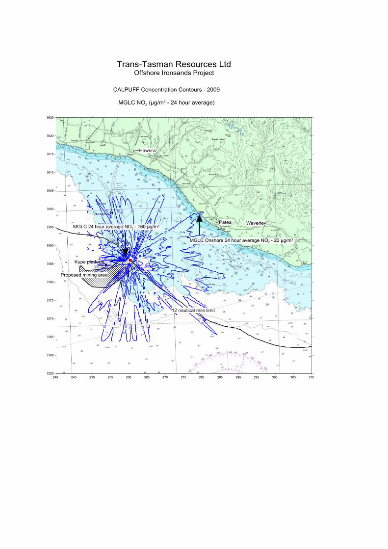
The worst case offshore results are the maximum predicted concentrations anywhere in the modelling domain. These occur over water near the FPSO, and involve nitrogen dioxide and sulphur dioxide. The one hour average and 24 hour average predicted concentrations for nitrogen dioxide and sulphur dioxide both exceed the assessment criteria, and occur approximately 2 km and 1.8 km to the northwest of the FPSO respectively. These locations are outside the 12 nautical mile limit, where it is most unlikely that people would be exposed.
The onshore results are the maximum concentrations that are predicted to occur on land when the FPSO is at the closest point to land (12 nautical miles offshore at the location shown in Figure 3-1). The predicted results for all contaminants considered in this study are well within the relevant New Zealand air quality standards and guidelines. The maximum predicted ground level concentration of SO2 on land exceeds the 24-hour average WHO guideline. The predicted onshore maximum concentrations occur in unpopulated locations where it is most unlikely that people would be exposed.
The maximum predicted concentration onshore will decrease as the FPSO moves further away from the coast.
Concentration contour plots are shown in Appendix B.
Table 6.1: Maximum predicted ground level concentrations
Contaminant Time average Maximum Ground Level Concentration
(µg/m3)
Air assessment criterion (µg/m3)
Offshore Onshore
Particulate matter (PM10)
24 hour
Annual
4.4
0.14
0.6
0.024
50
20
Nitrogen dioxide
1 hour (99.9%)
24 hour
Annual
313
160
5.3
60
22
0.9
200 (9 exceedance allow per 12 months)
100
40
Sulphur dioxide 1 hour (99.9%)
24 hour
453
231
87
31
350 (9 exceedances allow per 12 months)
570 (not to exceed)
120 (20*)
Carbon monoxide 1 hour (99.9%)
8 hour
75
67
14
12
30,000
10,000
*Note: 20 µg/m3 is the WHO 24-hour average guideline, which does not currently have any regulatory status in New Zealand.

14
Tonkin & Taylor Ltd Offshore Ironsands Project - Air Dispersion Modelling Study - Reciprocating Engines Trans-Tasman Resources Ltd
November 2015 Job No: 29303.v2
7 Conclusions
The maximum predicted ground level concentrations of NO2 and SO2 (1 hour (99.9%) and 24 hour averages) anywhere in the modelling domain exceed the relevant New Zealand air quality standards and guidelines. These maxima are predicted to occur over water close to the FPSO and are located outside the 12 nautical mile limit where people are most unlikely to become exposed to these contaminants. The maximum predicted ground level concentrations of PM10 and CO anywhere in the modelling domain are within the relevant New Zealand air quality standards and guidelines.
The maximum ground level concentrations predicted to occur on land for all contaminants considered in this study are well within the relevant New Zealand air quality standards and guidelines. The maximum predicted ground level concentration of SO2 on land exceeds the 24-hour average WHO guideline. However it is noted that this guideline is based on exposure over a 24-hour period and it is unlikely that there would be people exposed for this period of time given that the location is an unpopulated coastline (Refer 24 hour SO2 isopleth - Appendix B).

15
Tonkin & Taylor Ltd Offshore Ironsands Project - Air Dispersion Modelling Study - Reciprocating Engines Trans-Tasman Resources Ltd
November 2015 Job No: 29303.v2
8 Applicability
This report has been prepared for the benefit of Trans-Tasman Resources Ltd with respect to the particular brief given to us and it may not be relied upon in other contexts or for any other purpose without our prior review and agreement.
Tonkin & Taylor Ltd
Authorised for Tonkin & Taylor Ltd by:
...........................….......…...............
Gerard Bird
Project Director
BLK p:\29303\29303.1000\issueddocuments\air dispersion modelling study - reciprocating engines.docx


Appendix A : FPSO vessel proposed arrangement


Appendix B : Concentration contour plots