Embed Size (px)
Citation preview
Overview of Sentinel AsiaOverview of Sentinel Asiaand DPN Report of JAXA
2nd JPTM for Sentinel Asia Step 215-17 July 2009
Sentinel Asia SecretariatJapan Aerospace Exploration Agency
Kazuya Kaku
1
Kazuya Kaku
ContentsContents
1. Background, Concept, Framework, and g , p , ,Current Status
2. Activities of Sentinel Asia2.1 Emergency Observation
including JAXA’s contribution as DPNincluding JAXA’s contribution as DPN2.2 Wildfire Monitoring2 3 Flood Monitoring2.3 Flood Monitoring2.4 Capacity Building
3. Summary2
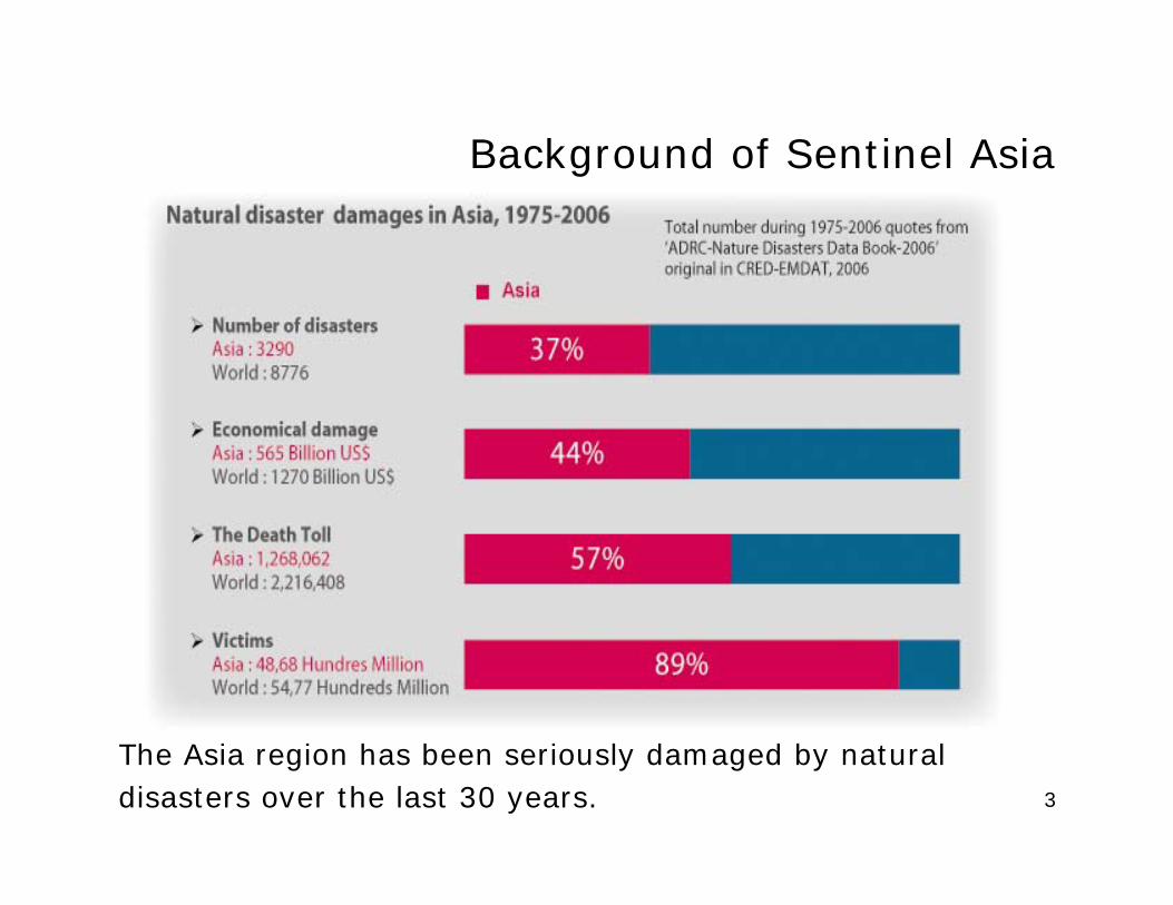
Background of Sentinel AsiaBackground of Sentinel Asia
3
The Asia region has been seriously damaged by naturaldisasters over the last 30 years.
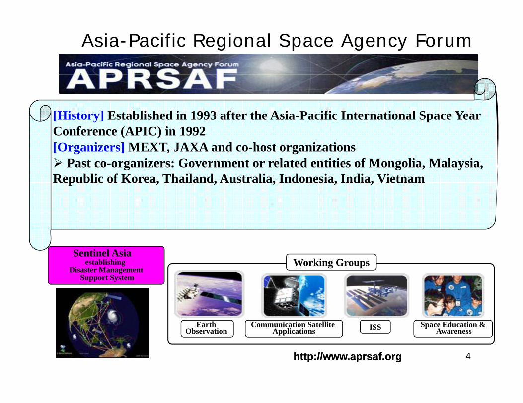
Asia-Pacific Regional Space Agency Forum
[History] Established in 1993 after the Asia-Pacific International Space Year Conference (APIC) in 1992[Organizers] MEXT, JAXA and co-host organizations
Past co-organizers: Government or related entities of Mongolia, Malaysia, R bli f K Th il d A t li I d i I di Vi tRepublic of Korea, Thailand, Australia, Indonesia, India, Vietnam
Sentinel Asia establishing
Disaster ManagementSupport System
Working GroupsSupport System
Communication Satellite A li i
Earth Ob i
Space Education &AISS
4http://www.aprsaf.orghttp://www.aprsaf.org//
ApplicationsObservation AwarenessISS
Sentinel AsiaSentinel Asia
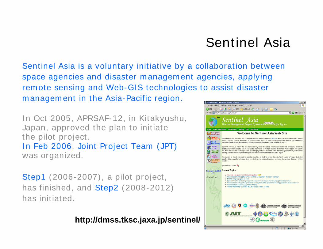
Sentinel Asia is a voluntary initiative by a collaboration betweenspace agencies and disaster management agencies applyingspace agencies and disaster management agencies, applyingremote sensing and Web-GIS technologies to assist disastermanagement in the Asia-Pacific region.
In Oct 2005, APRSAF-12, in Kitakyushu, Japan, approved the plan to initiate the pilot project.p p jIn Feb 2006, Joint Project Team (JPT) was organized.
Step1 (2006-2007), a pilot project,has finished, and Step2 (2008-2012)has initiated.
5http://dmss.tksc.jaxa.jp/sentinel/
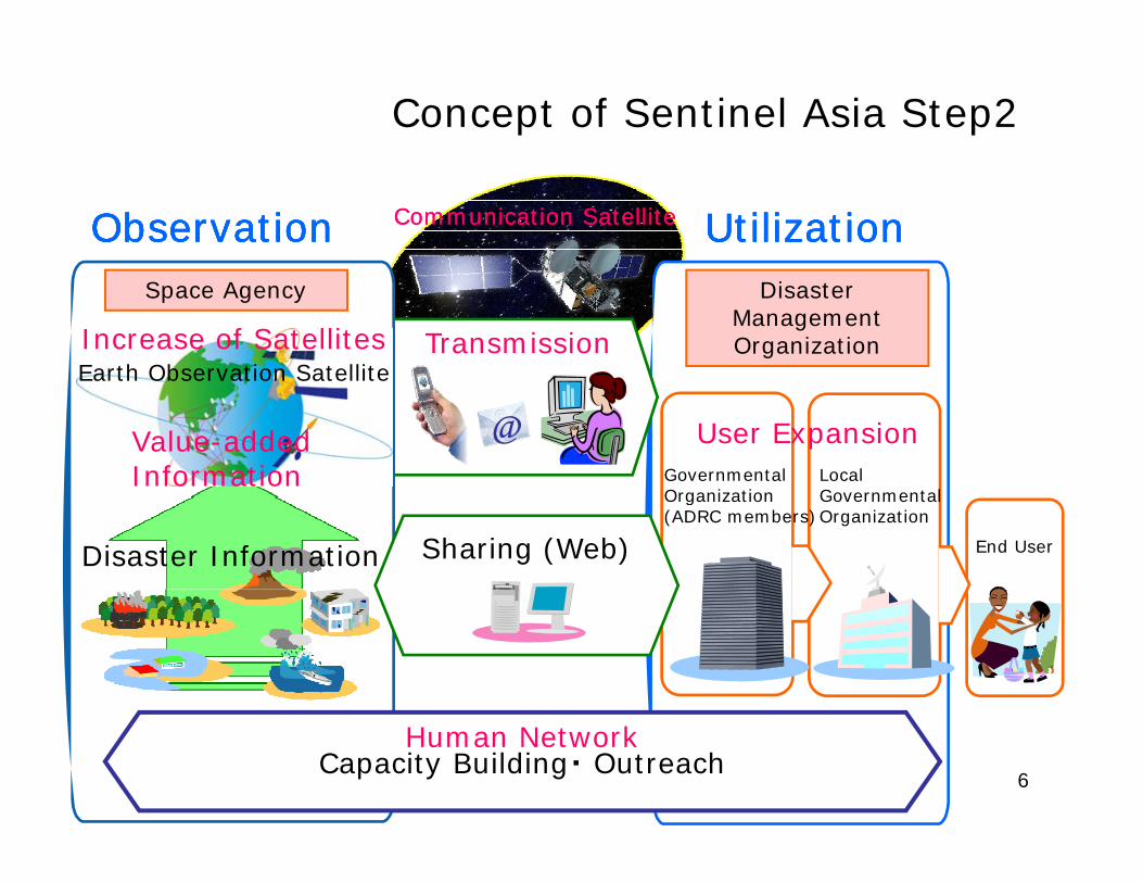
Concept of Sentinel Asia Step2
ObservationObservationObservationObservation UtilizationUtilizationUtilizationUtilizationCommunication SatelliteCommunication Satellite
Transmission
Disaster ManagementOrganization
Space Agency
Earth Observation SatelliteIncrease of Satellites
User Expansion@Value-added Information Governmental
OrganizationLocal Governmental
End UserSharing (Web)Disaster Information
Organization(ADRC members)
GovernmentalOrganization
6
Human NetworkCapacity Building・ Outreach
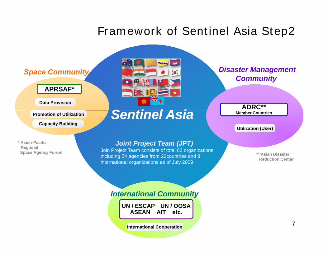
Framework of Sentinel Asia Step2
Space Community Disaster ManagementCommunity
S ti l A iS ti l A i
APRSAF*Community
ADRC**Data Provision
Sentinel AsiaSentinel AsiaPromotion of Utilization
Capacity BuildingUtilization (User)
Member Countries
Joint Project Team (JPT)* Asian Pacific
** Asian Disaster Reduction Center
Joint Project Team (JPT)Join Project Team consists of total 62 organizations including 54 agencies from 22countries and 8 international organizations as of July 2009
Asian-Pacific RegionalSpace Agency Forum
UN / ESCAP UN / OOSA
International Community
7
UN / ESCAP UN / OOSAASEAN AIT etc.
International Cooperation
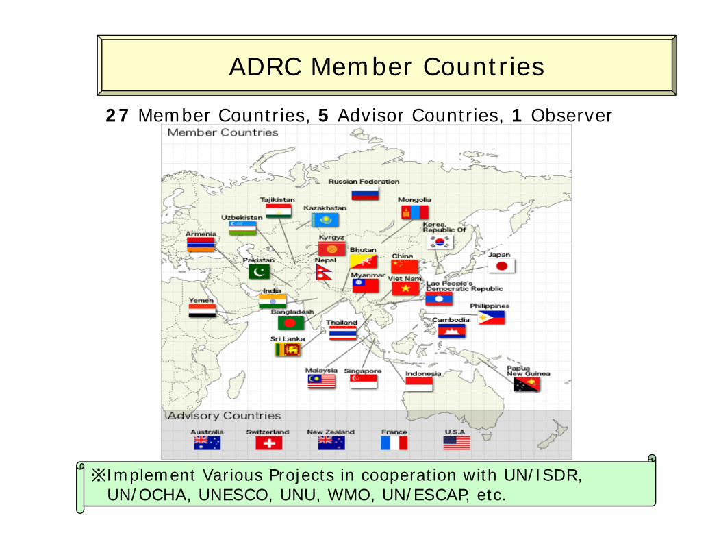
ADRC Member Countries
27 Member Countries, 5 Advisor Countries, 1 Observer
8※Implement Various Projects in cooperation with UN/ISDR,
UN/OCHA, UNESCO, UNU, WMO, UN/ESCAP, etc.
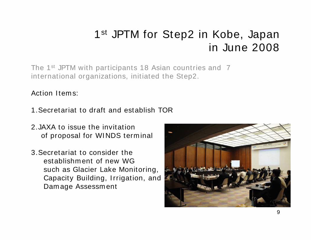
1st JPTM for Step2 in Kobe, Japan i J 2008in June 2008
The 1st JPTM with participants 18 Asian countries and 7 inte national o gani ations initiated the Step2international organizations, initiated the Step2.
Action Items:
1.Secretariat to draft and establish TOR
2.JAXA to issue the invitationof proposal for WINDS terminalof proposal for WINDS terminal
3.Secretariat to consider theestablishment of new WGsuch as Glacier Lake Monitoring,Capacity Building, Irrigation, andDamage Assessment
9
After 1st JPTM for Step2After 1 JPTM for Step2• TOR: established in Sept. 2008• IP: established in Dec 2008• IP: established in Dec. 2008• Data Provider Node (DPN): GISTDA, KARI• Data Analysis Node (DAN): AIT, ADRC, CRISPy ( )• New WG: GLOF WG will be proposed by Keio
Univ. and ADRCSt 2 S t d d l t b JAXA • Step2 System: under development by JAXA including WINDS utilization
• New JPT membersNew JPT members-Land Management Training Center, Nepal-Central Asian Institute of Applied Geosciences (CAIAG), KyrgyzKyrgyz-National Disaster Management Center, Fiji
10
Expanding CooperationExpanding Cooperation
• UNESCAPGovernment Level
• International CharterEmergency Observation
• UN-SPIDER ADRC became RSO
• ASIAESExchange of Imagery Catalog (Meta-data)Exchange of Imagery Catalog (Meta data)
ContentsContents
1. Background, Concept, Framework, and Current g , p , ,Status
2. Activities of Sentinel Asia2.1 Emergency Observation
including JAXA’s contribution as DPNincluding JAXA’s contribution as DPN2.2 Wildfire Monitoring2 3 Flood Monitoring2.3 Flood Monitoring2.4 Capacity Building
3. Summary12
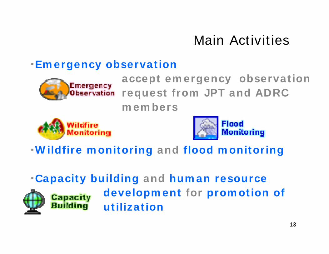
Main Activities
・Emergency observationaccept emergency observationaccept emergency observationrequest from JPT and ADRCmembers
・Wildfire monitoring and flood monitoring
C it b ildi d h ・Capacity building and human resourcedevelopment for promotion of utilization
13
utilization
ContentsContents
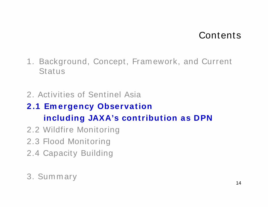
1. Background, Concept, Framework, and Current g , p , ,Status
2. Activities of Sentinel Asia2.1 Emergency Observation
including JAXA’s contribution as DPNincluding JAXA’s contribution as DPN2.2 Wildfire Monitoring2 3 Flood Monitoring2.3 Flood Monitoring2.4 Capacity Building
3. Summary14
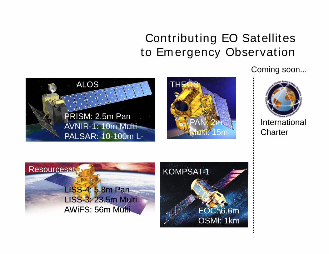
Contributing EO Satellites to Emergency Observation
Coming soon...
THEOSALOS
PAN: 2mMulti: 15m
PRISM: 2.5m PanAVNIR-1: 10m MultiPALSAR: 10-100m L-
InternationalCharter
Resourcesat-1
Band
KOMPSAT-1
LISSLISS--4: 5.8m Pan4: 5.8m PanLISSLISS--3: 23.5m Multi3: 23.5m MultiAWiFS 56 M ltiAWiFS 56 M ltiAWiFS: 56m MultiAWiFS: 56m Multi EOC: 6.6m
OSMI: 1km
IRS THEOS
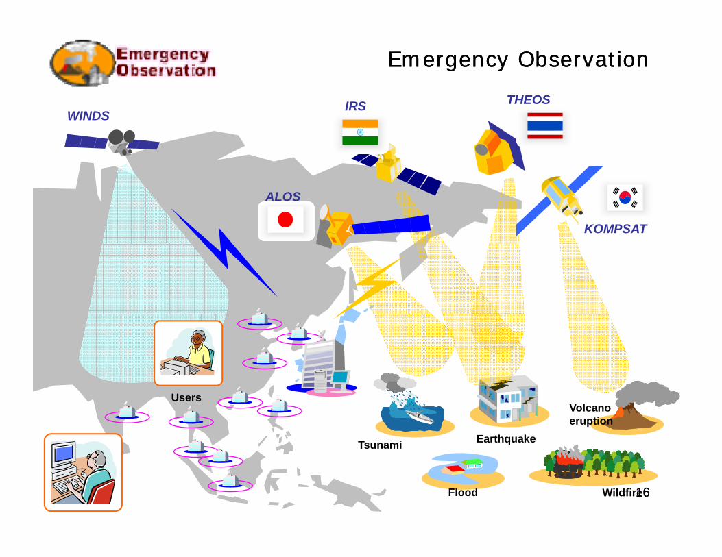
Emergency ObservationEmergency Observation
IRS THEOS WINDS
ALOS
KOMPSAT
EarthquakeTsunami
Volcanoeruption
Users
1616WildfireFlood
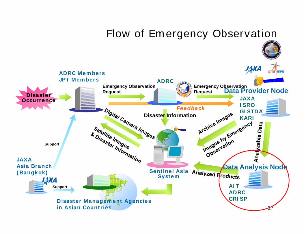
Flow of Emergency Observation
ADRC MembersADRC MembersJPT Members ADRC
JAXA
Emergency Observation Request
Disaster Disaster OccurrenceOccurrence
Emergency Observation Request Data Provider Node
ISROGISTDAKARIDisaster Information
Feedback
JAXA
Support
Sentinel AsiaSystem
Asia Branch(Bangkok)
Support AITADRC
Data Analysis Node
17Disaster Management Agencies in Asian Countries
ADRCCRISP
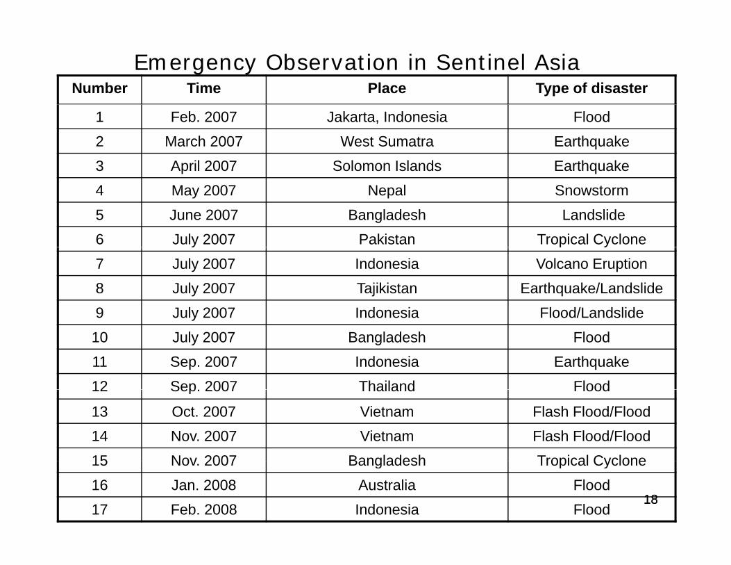
Emergency Observation in Sentinel AsiaNumber Time Place Type of disaster
1 Feb. 2007 Jakarta, Indonesia Flood2 March 2007 West Sumatra Earthquake3 April 2007 Solomon Islands Earthquake4 May 2007 Nepal Snowstorm 5 June 2007 Bangladesh Landslide6 July 2007 Pakistan Tropical Cyclone y p y7 July 2007 Indonesia Volcano Eruption 8 July 2007 Tajikistan Earthquake/Landslide9 July 2007 Indonesia Flood/Landslidey10 July 2007 Bangladesh Flood11 Sep. 2007 Indonesia Earthquake 12 Sep 2007 Thailand Flood12 Sep. 2007 Thailand Flood
13 Oct. 2007 Vietnam Flash Flood/Flood 14 Nov. 2007 Vietnam Flash Flood/Flood 15 Nov 2007 Bangladesh Tropical Cyclone
1818
15 Nov. 2007 Bangladesh Tropical Cyclone 16 Jan. 2008 Australia Flood17 Feb. 2008 Indonesia Flood
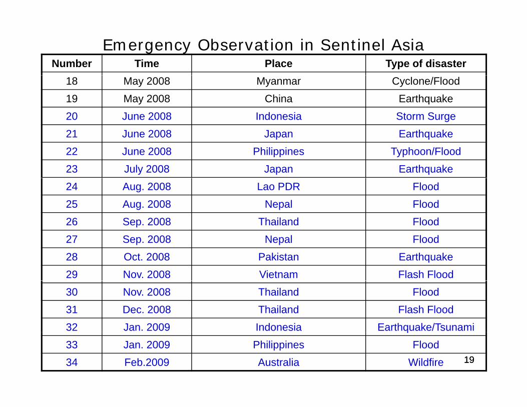
Emergency Observation in Sentinel Asia Number Time Place Type of disaster
18 May 2008 Myanmar Cyclone/Flood19 May 2008 China Earthquake20 June 2008 Indonesia Storm Surge21 June 2008 Japan Earthquake 22 June 2008 Philippines Typhoon/Flood23 July 2008 Japan Earthquake 24 Aug. 2008 Lao PDR Flood 25 Aug. 2008 Nepal Flood26 Sep. 2008 Thailand Flood27 Sep. 2008 Nepal Flood28 Oct. 2008 Pakistan Earthquake 29 Nov. 2008 Vietnam Flash Flood30 Nov. 2008 Thailand Flood31 Dec. 2008 Thailand Flash Flood32 Jan. 2009 Indonesia Earthquake/Tsunami
1919
q33 Jan. 2009 Philippines Flood34 Feb.2009 Australia Wildfire
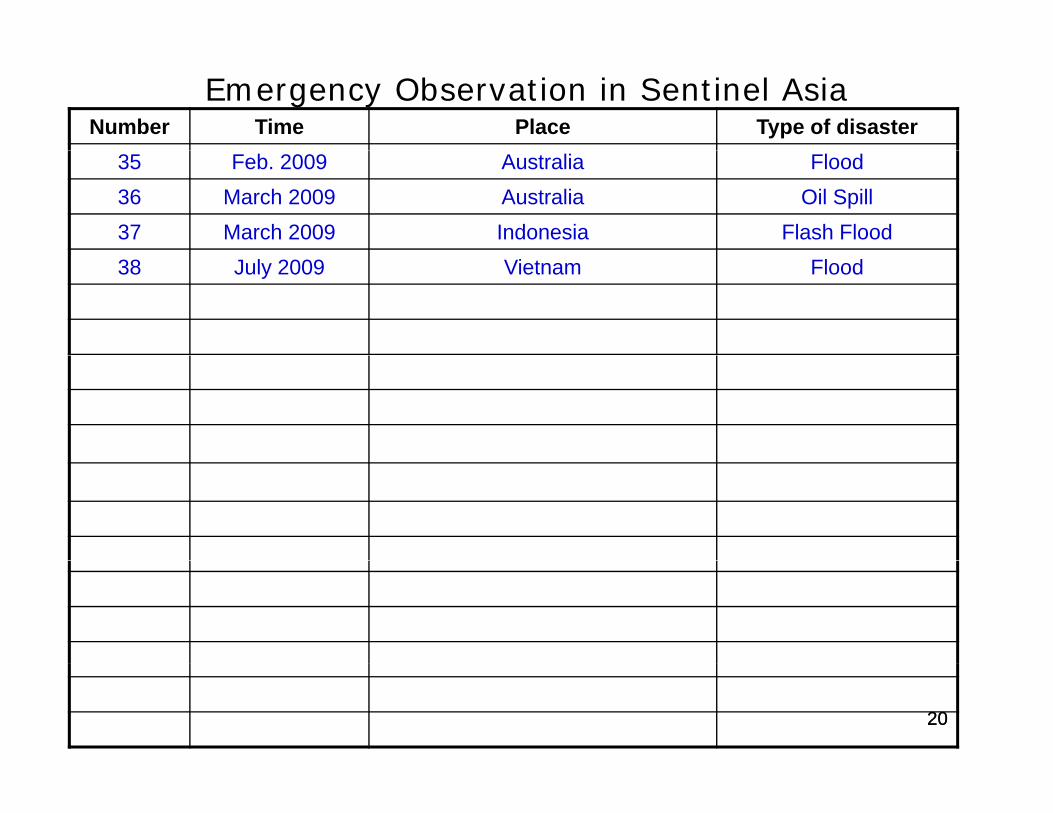
Emergency Observation in Sentinel Asia Number Time Place Type of disaster
35 Feb. 2009 Australia Flood36 March 2009 Australia Oil Spill37 March 2009 Indonesia Flash Flood38 July 2009 Vietnam Flood
2020
JAXA’s Contribution as DPNJAXA s Contribution as DPN
• After last JPTM, 19 emergency observationsAfter last JPTM, 19 emergency observationswere carried out.
• For all of them JAXA made emergency • For all of them, JAXA made emergency observation and provided observed imageryby ALOS, together with archived imagery by ALOS, together with archived imagery before disaster.
21
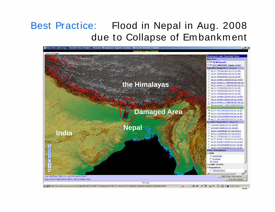
Best Practice: Flood in Nepal in Aug. 2008due to Collapse of Embankmentdue to Collapse of Embankment
the Himalayas
Damaged Area
NepalIndia
22
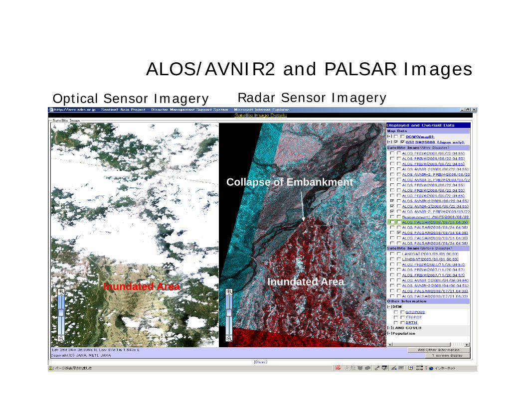
ALOS/AVNIR2 and PALSAR ImagesALOS/AVNIR2 and PALSAR ImagesRadar Sensor ImageryOptical Sensor Imagery
Collapse of Embankment
I d t d AInundated AreaInundated Area
23
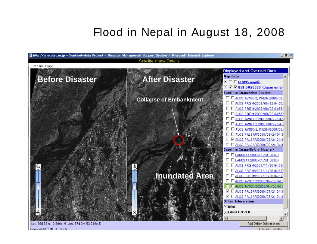
Flood in Nepal in August 18, 2008
Collapse of Embankment
Before Disaster After Disaster
Inundated Area
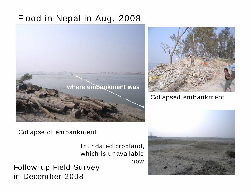
Flood in Nepal in Aug. 2008
where embankment was Collapsed embankment
Collapse of embankment
Inundated cropland, which is unavailable
Collapse of embankment
Follow-up Field Survey in December 2008
now
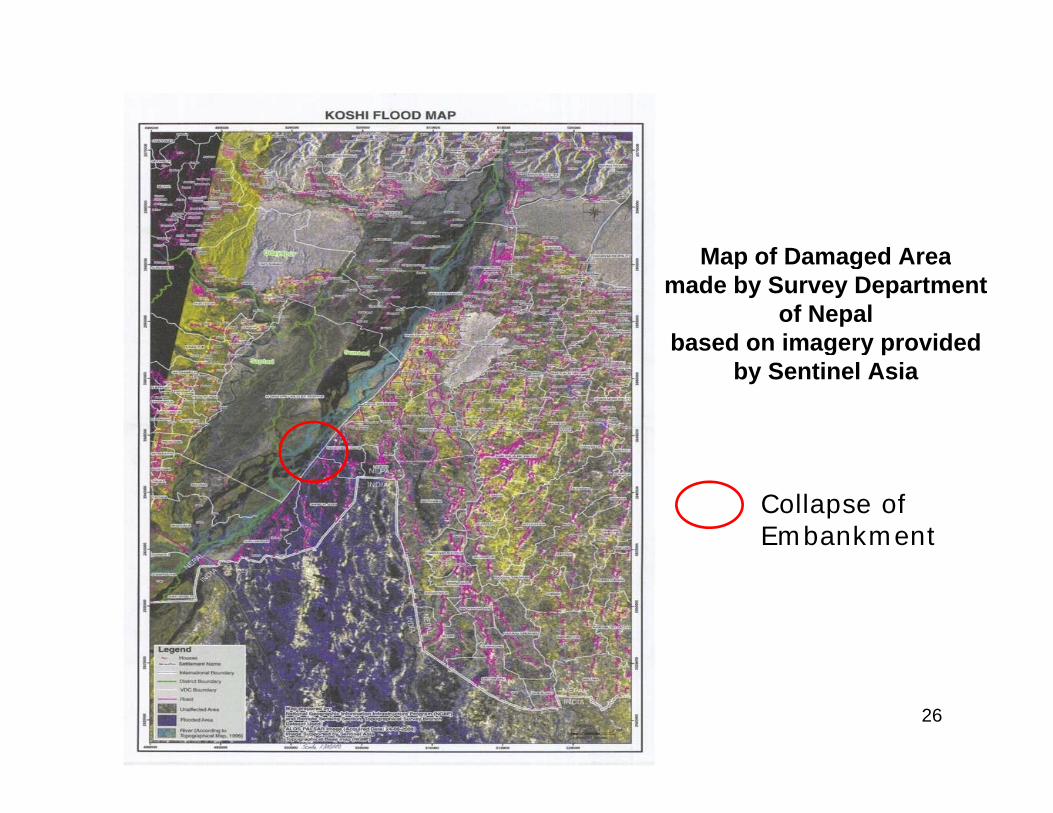
Map of Damaged AreaMap of Damaged Areamade by Survey Department
of Nepalbased on imagery provided g y
by Sentinel Asia
Collapse of Embankment
26
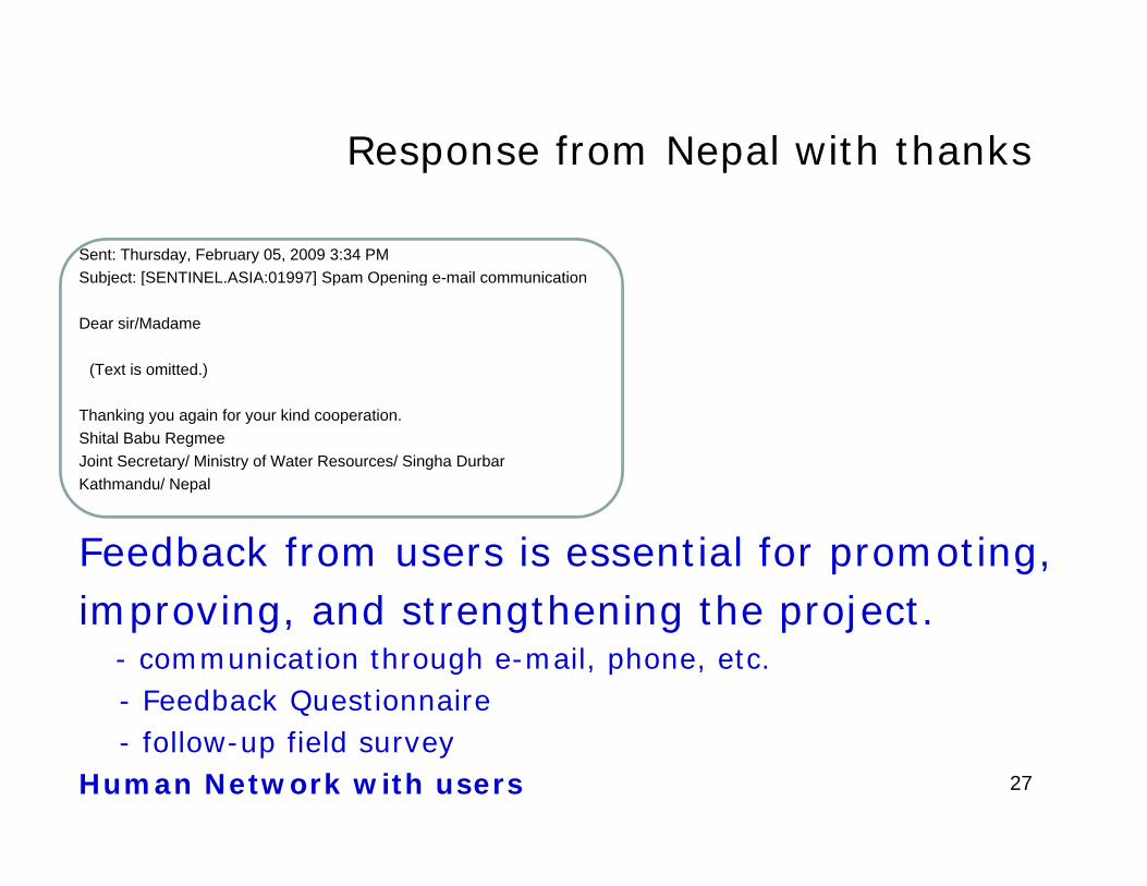
Response from Nepal with thanksResponse from Nepal with thanks
Sent: Thursday, February 05, 2009 3:34 PMSubject: [SENTINEL ASIA:01997] Spam Opening e mail communicationSubject: [SENTINEL.ASIA:01997] Spam Opening e-mail communication
Dear sir/Madame
(Text is omitted.)
Thanking you again for your kind cooperation.Shital Babu RegmeeJoint Secretary/ Ministry of Water Resources/ Singha DurbarKathmandu/ Nepal
Feedback from users is essential for promoting,improving and strengthening the projectimproving, and strengthening the project.
- communication through e-mail, phone, etc.- Feedback Questionnaire- follow-up field survey
Human Network with users 27
ContentsContents
1. Background, Concept, Framework, and Current g , p , ,Status
2. Activities of Sentinel Asia2.1 Emergency Observation
including JAXA’s contribution as DPNincluding JAXA’s contribution as DPN2.2 Wildfire Monitoring2 3 Flood Monitoring2.3 Flood Monitoring2.4 Capacity Building
3. Summary28
Wildfire Monitoring
Contribution to the Asia-Pacific region for Wildfire Management and Control; and contribution tomitigation of Global Warming• Hotspots information of the Asia-Pacific Region on Hotspots information of the Asia Pacific Region on
Web-GIS: MODIS, MTSAT-1R(Meteorological Satellite)
• Validation and Improvement of MODIS Hotspots Detection Algorithm
• Forecasting of Fire Expansion and Risk Analysis
Step2 Regional Coope ation fo Fi e Cont ol in 29
• Step2: Regional Cooperation for Fire Control in cooperation with local Firefighters in Asia
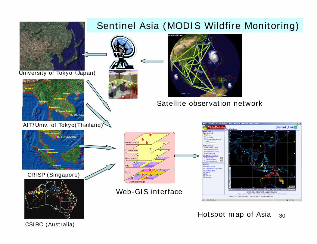
Sentinel Asia (MODIS Wildfire Monitoring)
University of Tokyo (Japan)
Satellite observation network
AIT/Univ. of Tokyo(Thailand)
Map
Base Location
Corps Location
Wildfire Location
CRISP (Singapore)Overlaid Image
Web-GIS interface
30CSIRO (Australia)
Hotspot map of Asia
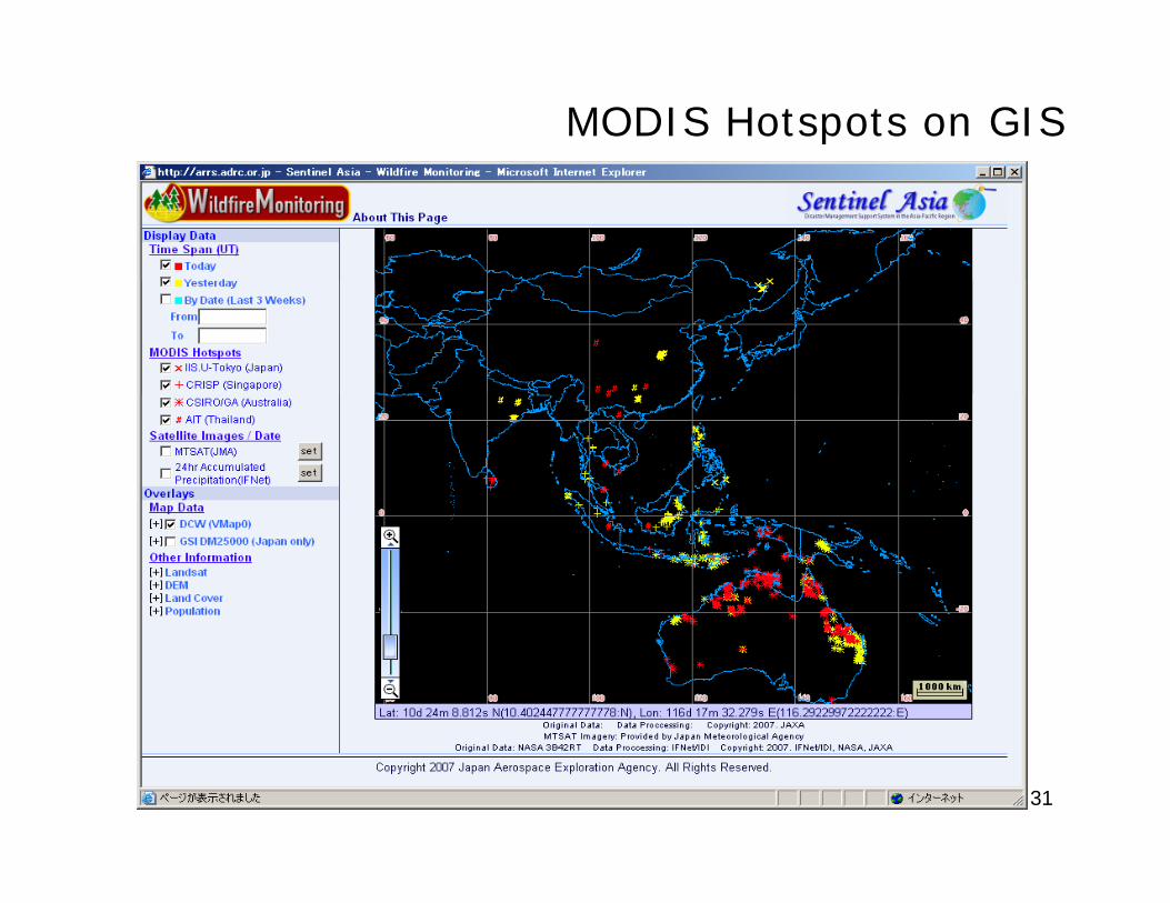
MODIS Hotspots on GIS
31
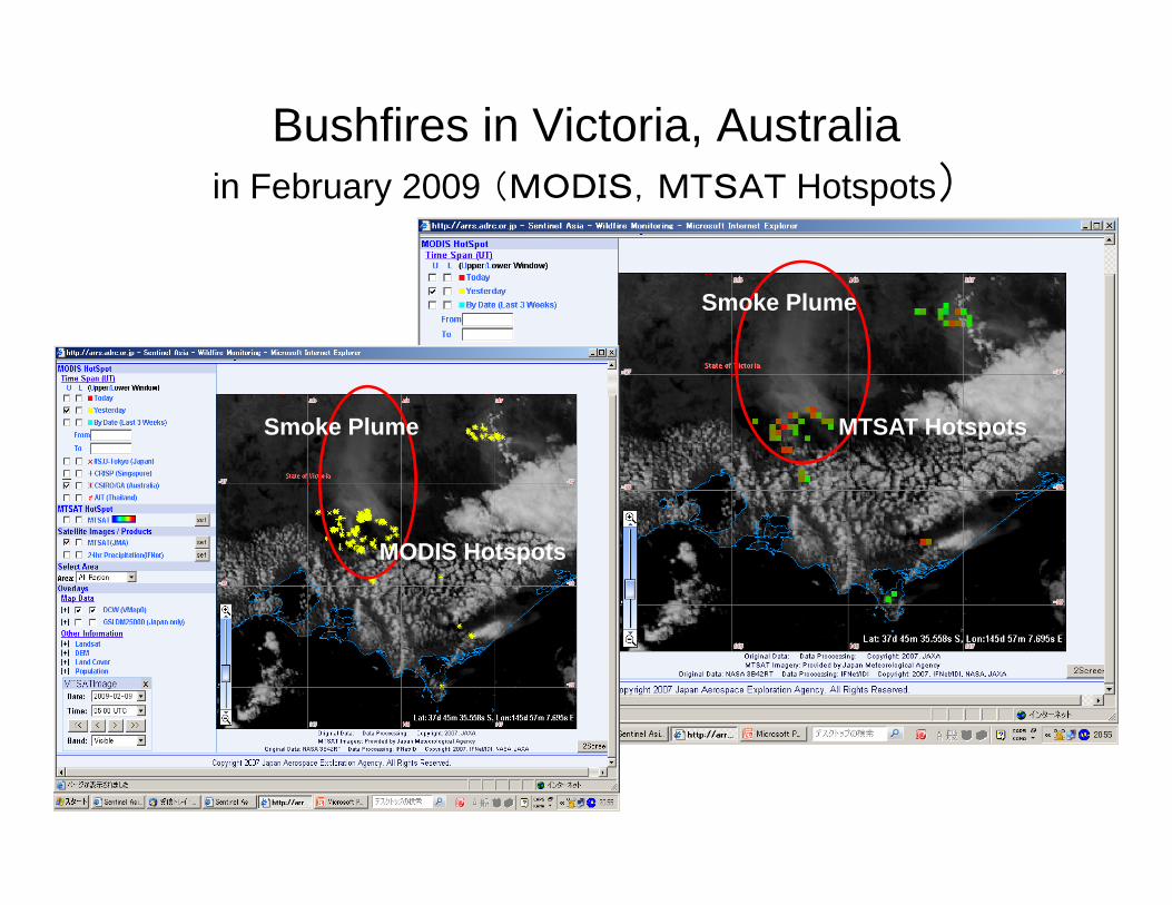
Bushfires in Victoria, Australia)in February 2009 (MODIS,MTSAT Hotspots)
Smoke Plume
Smoke Plume MTSAT Hotspots
MODIS Hotspots
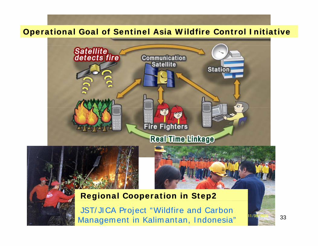
Operational Goal of Sentinel Asia Wildfire Control InitiativeOperational Goal of Sentinel Asia Wildfire Control Initiative
Regional Cooperation in Step2Regional Cooperation in Step2
33JST/JICA Project “Wildfire and Carbon Management in Kalimantan, Indonesia”
ContentsContents
1. Background, Concept, Framework, and Current g , p , ,Status
2. Activities of Sentinel Asia2.1 Emergency Observation
including JAXA’s contribution as DPNincluding JAXA’s contribution as DPN2.2 Wildfire Monitoring2.3 Flood Monitoring2.3 Flood Monitoring2.4 Capacity Building
3. Summary34
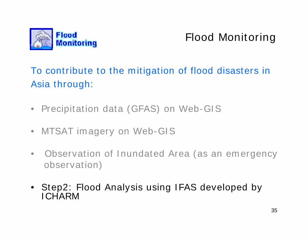
Flood Monitoring
To contribute to the mitigation of flood disasters ingAsia through:
• Precipitation data (GFAS) on Web-GIS
• MTSAT imagery on Web-GISMTSAT imagery on Web GIS
• Observation of Inundated Area (as an emergencyobservation) observation)
• Step2: Flood Analysis using IFAS developed by ICHARM
35
ICHARM
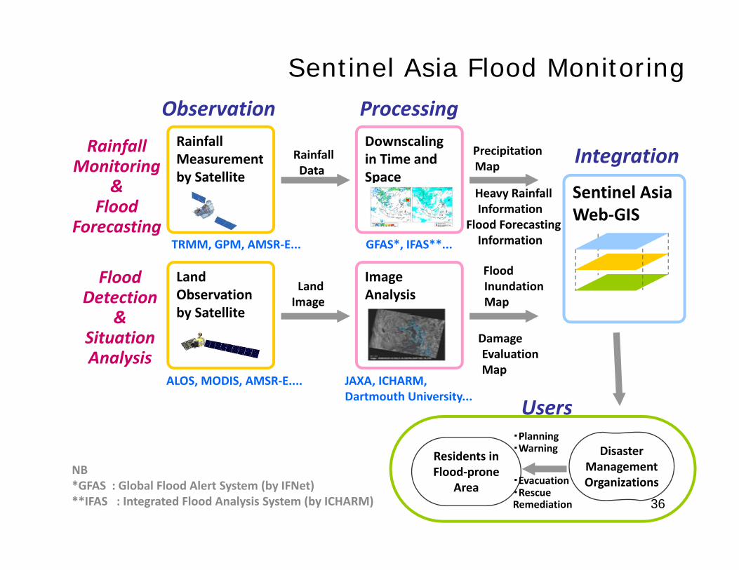
Observation Processing
Sentinel Asia Flood Monitoring
RainfallMonitoring
Observation Processing
IntegrationRainfallMeasurementby Satellite
RainfallData
PrecipitationMap
Downscalingin Time and Space
Sentinel AsiaWeb‐GIS
&Flood
Forecasting
by SatelliteHeavy RainfallInformation
Flood ForecastingInformation
Space
TRMM, GPM, AMSR‐E... GFAS*, IFAS**...
FloodDetection
&
LandImage
Flood Inundation Map
ImageAnalysis
LandObservationby Satellite
, , ,
&SituationAnalysis
ALOS, MODIS, AMSR‐E.... JAXA, ICHARM, D t th U i it
Damage EvaluationMap
Disaster Management
Residents in
・Planning・Warning
UsersDartmouth University...
36
Management Organizations
Flood‐prone Area
・Evacuation・RescueRemediation
NB *GFAS : Global Flood Alert System (by IFNet)**IFAS : Integrated Flood Analysis System (by ICHARM)
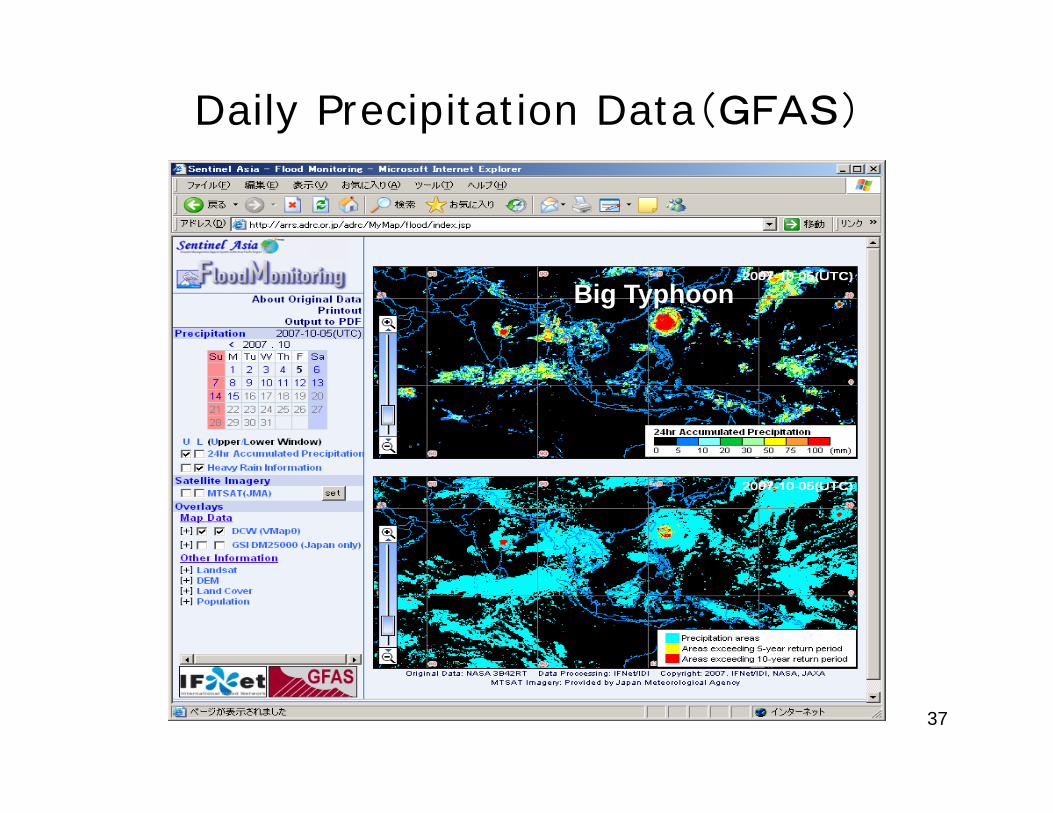
Daily Precipitation Data(GFAS)
Big Typhoon
37
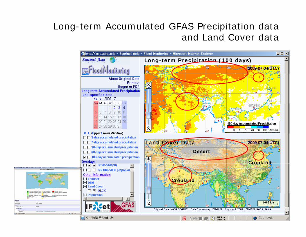
Long-term Accumulated GFAS Precipitation dataand Land Cover data
Long-term Precipitation (100 days)
Land Cover Data
Desert
Cropland
Cropland
Cropland
38
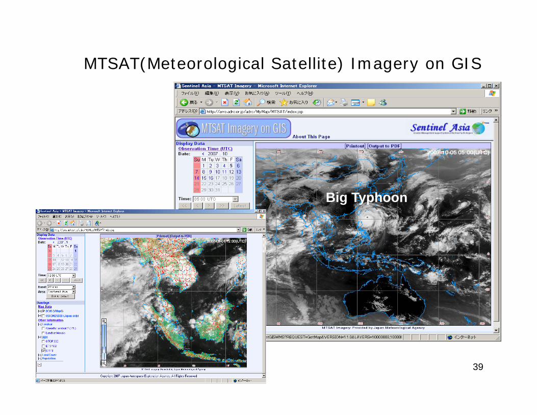
MTSAT(Meteorological Satellite) Imagery on GIS
Big Typhoon
39
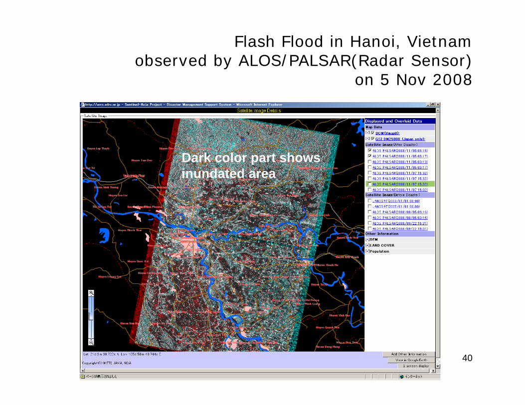
Flash Flood in Hanoi, Vietnamobserved by ALOS/PALSAR(Radar Sensor)
5 N 2008on 5 Nov 2008
Dark color part showsinundated areainundated area
40
ContentsContents
1. Background, Concept, Framework, and Current g , p , ,Status
2. Activities of Sentinel Asia2.1 Emergency Observation
including JAXA’s contribution as DPNincluding JAXA’s contribution as DPN2.2 Wildfire Monitoring2 3 Flood Monitoring2.3 Flood Monitoring2.4 Capacity Building
3. Summary41
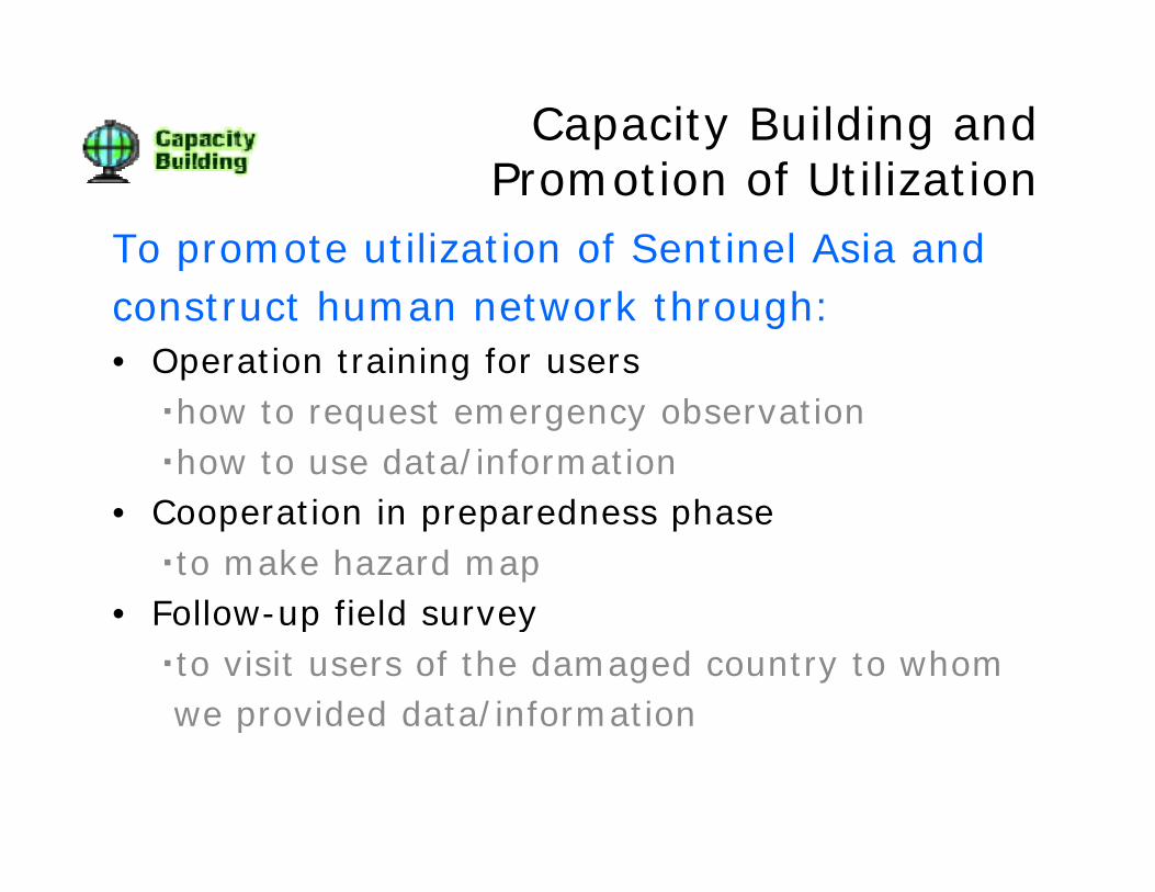
Capacity Building and P ti f Utili tiPromotion of Utilization
To promote utilization of Sentinel Asia andconstruct human network through:• Operation training for users
・how to request emergency observation・how to use data/informationC ti i d h• Cooperation in preparedness phase・to make hazard map
• Follow-up field survey• Follow-up field survey・to visit users of the damaged country to whomwe provided data/informationp /
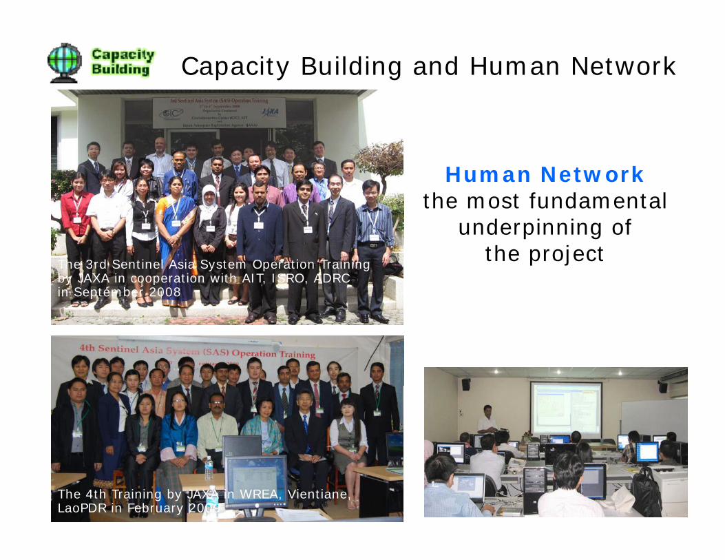
Capacity Building and Human Network
Human NetworkHuman Networkthe most fundamental
underpinning of hthe projectThe 3rd Sentinel Asia System Operation Training
by JAXA in cooperation with AIT, ISRO, ADRCin September 2008
The 4th Training by JAXA in WREA, Vientiane, LaoPDR in February 2009
ContentsContents
1. Background, Concept, Framework, and Current g , p , ,Status
2. Activities of Sentinel Asia2.1 Emergency Observation
including JAXA’s contribution as DPNincluding JAXA’s contribution as DPN2.2 Wildfire Monitoring2 3 Flood Monitoring2.3 Flood Monitoring2.4 Capacity Building
3. Summary44
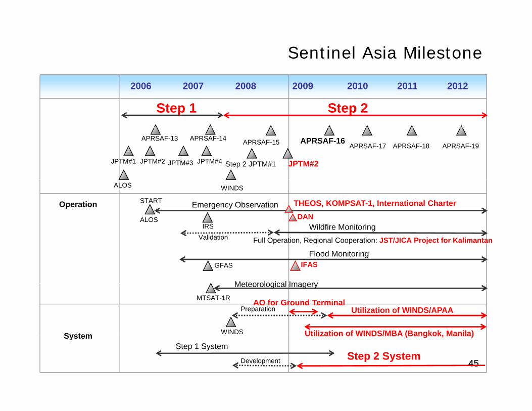
Sentinel Asia Milestone
2006 2007 2008 2009
Step 1
2010 2011 2012
Step 2
APRSAF-13 APRSAF-14
JPTM#1 JPTM#2 JPTM#3 JPTM#4
APRSAF-18APRSAF-17APRSAF-15 APRSAF-16APRSAF-19
Step 2 JPTM#1 JPTM#2
Emergency ObservationOperation
ALOS WINDS
ALOS
START
IRS Wildfire MonitoringDAN
THEOS, KOMPSAT-1, International Charter
Full Operation, Regional Cooperation: JST/JICA Project for Kalimantan
Flood MonitoringGFAS
Meteorological Imagery
Validation
IFAS
System
Meteorological ImageryMTSAT-1R
WINDS
Utilization of WINDS/APAAPreparationAO for Ground Terminal
Utilization of WINDS/MBA (Bangkok, Manila)
4545Step 2 System
SystemStep 1 System
Development
Utilization of WINDS/MBA (Bangkok, Manila)
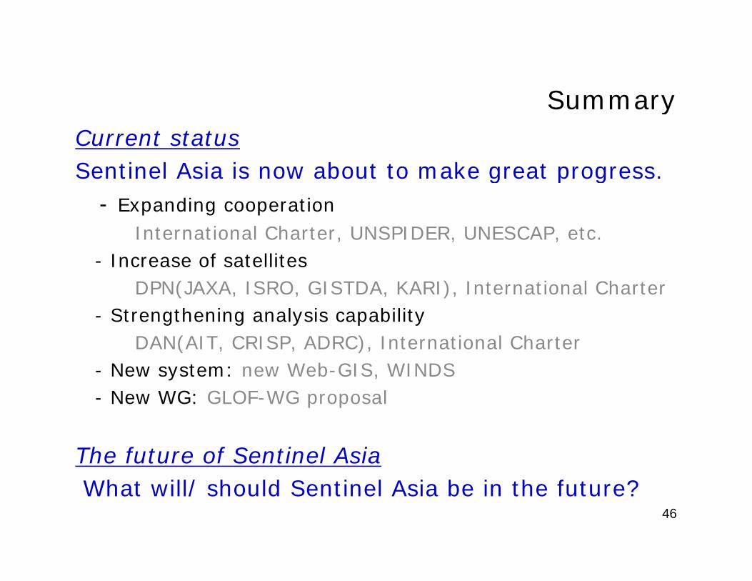
SummarySummaryCurrent statusSentinel Asia is now about to make great progress.g p g
- Expanding cooperationInternational Charter, UNSPIDER, UNESCAP, etc.
I f t llit- Increase of satellitesDPN(JAXA, ISRO, GISTDA, KARI), International Charter
- Strengthening analysis capabilityDAN(AIT, CRISP, ADRC), International Charter
- New system: new Web-GIS, WINDS- New WG: GLOF-WG proposalNew WG: GLOF WG proposal
The future of Sentinel AsiaWhat will/ should Sentinel Asia be in the future?
46

Thank you for your attention.
Japan Aerospace Exploration Agency Office of Space ApplicationsSentinel-Asia Project Office
E-mail : [email protected]


![01 Japan Sentinel Asia.ppt [Read-Only] · • Step-by-step approach: – Step1: Utilization of earth observation satellite data for disaster management, which is called “Sentinel-Asia](https://img.pdfslide.net/doc/110x75/5f09f2e87e708231d4294750/01-japan-sentinel-asiappt-read-only-a-step-by-step-approach-a-step1-utilization.jpg)