Embed Size (px)
Citation preview
Our vision for
Euston Healthy
Streets
2
Preface
Euston will become a new area of London rejuvenated as both a local hub of activity and a
gateway to London through transformational development above and around Euston
Station. HS2 is expected to bring 25,000 passengers into Euston during the morning peak
by 2041. The over-station development by HS2’s masterplan development partner is
expected to deliver at least 2,800 new homes and over 16,000 jobs.
This scale of redevelopment will significantly change travel demand and patterns of
movement on the surrounding streets. This growth and redevelopment present a once in a
generation opportunity to consider how the area can respond to these changing demands
and be transformed in line with key policy objectives including the Mayor’s Transport
Strategy (MTS) and Camden’s Transport Strategy (CTS).
Euston Healthy Streets (EHS) has been established as a joint project between Transport for
London (TfL) and the London Borough of Camden (LBC). The purpose of this project is to
carry out a strategic review of the main streets surrounding Euston Station (Eversholt
Street, Hampstead Road and Euston Road), to enable them to respond and support this
regeneration and the changing travel demand in this area, in a way that is sustainable and
meets Healthy Streets objectives1.
This document sets out LBC and TfL’s proposed approach to defining and agreeing a
shared vision for EHS. It will inform how we design and evaluate future change in the area.
Produced jointly by London Borough of Camden and Transport for London.
September 2021
1 details of the Healthy Streets objectives can be found under section 2 “policy context”
3
Contents ................................................................................................................................................. 3
Our vision ................................................................................................................................................ 4
Euston Healthy Streets........................................................................................................................... 8
1. Scope .............................................................................................................................................. 8
2. Policy context ................................................................................................................................. 9
3. Transport context ......................................................................................................................... 12
4. Stakeholder engagement .. .......................................................................................................... 20
5. Challenges .. .. ............................................................................................................................... 21
6. Next steps ..................................................................................................................................... 21
Appendix A: Planned schemes in the area ........................................................................................... 22
Appendix B: Extract of supporting data used for transport context ................................................... 23
Contents
Our vision approachContents

4
Our vision for the streets around Euston Station is one of a safe, healthy and inclusive high-
quality network that prioritises sustainable and active modes of travel, maximises public
benefit and supports local communities.
The following vision statements for each of the streets outlines the potential to create the
right conditions for change:
EUSTON ROAD
A corridor that balances economic prosperity with improved conditions for active travel and
public transport, reducing the reliance on private vehicles.
A street that prioritises safe and inviting pedestrian links, legible and well connected from all
points, with improved crossing opportunities reducing the barrier between the north and south
balanced with high quality and reliable bus provision throughout.
An interchange area supporting onward travel by sustainable modes, creating quality public
spaces and quality cycle infrastructure that safely connects Euston Station into the broader
road network.
A green artery with clean air that is configured and landscaped and accentuated by trees and
Euston Square Gardens to enhance the street environment and attract pedestrians.
An emblematic point of arrival to Euston and London that is inviting, draws visitors and
actively facilitates movements of people and goods safely to and through the stations and
links east – west and beyond.
A street whose public realm reflects the range of character areas and enhances world-class
knowledge and innovation institutions along its length.
HAMPSTEAD ROAD
A safe pedestrian and cyclist friendly environment along its full length with a new hub
anchored by areas of growth and active frontages, with positive street-level animation, public
realm and open spaces that serve public uses and meaningfully connect east and west.
A strategic street with comfortable pavements and frequent accessible crossings for
pedestrians, dedicated infrastructure for cyclists and high-quality bus provision.
Legible, green and navigable pedestrian links to northern and western station entrances, bus
stops and routes to Mornington Crescent and Tottenham Court Road.
Intuitive and seamless access to cycle facilities within Euston and connection into the broader
cycle network.
Our Vision

5
EVERSHOLT STREET
A pedestrian and cyclist focused street that links Euston north and south, lined by a vibrant
mix of buildings and frontages with generous footways, safe and well-located crossings and
easily navigable connections through the stations to east-west routes.
Cycle infrastructure that connects into the broader network north and south with high- quality
bus provision designed to make the street and public realm welcoming and accessible places.
A street where kerbside space is reconfigured and revaluated in order to prioritise sustainable
and active modes of travel, such as walking and cycling.
A green street with abundant landscaping, including mature trees, and exemplary air quality.
An inviting and accessible public realm that accommodates all street users and prioritises the
quality of environment around interchanges, with careful consideration of areas of
concentrated movement along the station side and nearest to Euston Road:
TfL and LBC have worked together reviewing the areas transport context, existing data and
policy objectives and through a series of workshops established the key principles for each
of the streets through existing character, role and future potential. These form the basis of
our overarching vision statements for each of the streets.
The statements have been shared through various stakeholder engagement exercises. The
responses from this exercise confirm the themes a safe, healthy and inclusive high-quality
network of streets as an effective means of looking at the essential components of the area
around the station. In addition, the feedback from the community, businesses and resident
groups has helped endorse the aims of the emerging Vision which seeks to address issues
that are important to the future success of the Euston Healthy Streets project.

6
What is a vision?
A clear project vision is key for success by capturing aspirations and defining desired
outcomes
A benchmark for creating plans, making decisions, coordinating and evaluating
work on any project
It provides a sense of purpose and direction for the project and ensures key
stakeholders are focused and aligned.
Why it is important to develop a vision for EHS?
A unique approach tailored to meet particular needs to developing proposals and
shared outcomes is needed at an early stage given the level of ambition and the
number of stakeholders involved in the EHS project
We need to establish a clear understanding of the local context, key characteristics
and transport systems that operate within the area. A vision helps to identify
appropriate measures to improve the area and achieve key policy objectives
A vision for EHS is also needed to reflect the views of key stakeholders and the local
community and ensure buy-in and attract support from third parties to help fund
the improvements over the life of the project
What outcomes are we seeking to achieve from the EHS vision?
We are seeking to achieve the following high-level outcomes:
Healthy Streets and People
Places for walking: deliver a high quality, safe and inclusive walking environment, remove existing barriers and prioritise pedestrian crossings and comfort. Support urban realm and place making opportunities.
Connected cycling: enable high quality, safe and well-connected cycle routes. Prioritising crossing points over the Euston Road that link into the existing and planned cycle networks. Ensure easier and safer east- west and north-south movements through the project area with good quality cycle infrastructure that links to the cycle network and key destinations.
Road Danger Reduction: prioritise measures to reduce collisions, particularly those involving cyclists and pedestrians, in known hotspots considering future changes in street layouts.

7
Efficient use of street space: reallocation of space / capacity from cars to support walking, cycling and public transport outcomes, fostering a positive perception of routes to maximise connectivity and support mode shift. Reduce adverse impacts of freight and service vehicles on street network in line TfL’s freight action plan, including considering more sustainable loading and servicing practices.
Improve the environment: identify opportunities to deliver green infrastructure, improve air quality, reduce traffic noise, reduce private car use and prioritise sustainable modes of travel.
Good Public Transport Experience
Quality Public Transport: explore opportunities to improve, protect and maintain public transport, whilst balancing the need for quality pedestrian and cycling infrastructure, to encourage active travel
Enhancing customer service: high quality, legible and accessible transport interchange between Euston and Kings Cross through bus, cycle and walking connectivity
Local Community
Meeting the needs of the Local Community: explore opportunities for removing existing barriers that disconnect the communities surrounding Euston Station and work with the Local Community to ensure their transport, movement and public realm needs and priorities are accounted for within the EHS proposals.
Figure 1: Vision outcomes
Our approach
Our vision aims to set out the quality of aspirations and scope of change that is sought for
the area over the next 15 years and beyond. It will act as a point of reference for designing
and evaluating future change ensuring that the same vision and priorities are met by LBC,
TfL and other key stakeholders as we collectively transform the Euston area.
The content of the vision has been shaped by research and understanding existing context,
through stakeholder and community engagement and underpinned by key policy
documents including:
The Mayor’s Transport Strategy
Camden’s Transport Strategy
Euston Area Plan and draft planning brief
Draft new London Plan
This vision has been developed to be flexible to respond to change and could be updated
where necessary to reflect future significant changes in circumstances, particularly any
significant developments relating to the HS2 project.
This vision document provides the context of the changes happening in the area affecting
local streets, key policy objectives, stakeholder engagement and our agreed vision.

8
1. Scope
In advance of significant planned redevelopment in the Euston area, EHS is conducting
a strategic review of the streets to develop a strategy aligned to policy objectives and
aspirations and to meet the needs of the changed Euston site. This will ensure that the
roads around Euston station are safe and accessible for those who currently live, work
and travel through the area, and those who will do so in the future.
The EHS scope includes Euston Road (A501), Hampstead Road (A400) and Eversholt
Street (A4200). These roads surround Euston station and are closely interlinked, so it is
important for us to consider these roads holistically. The extent of the vision is shown in
the map below extending to Great Portland Street in the west, Mornington Crescent to
the north and King’s Cross heading east.
Figure 2: Scope of Euston Healthy Streets
Existing data, local context, stakeholder engagement and key policy documents all
emphasise the need to improve the environment on these roads.
There are opportunities to reduce traffic dominance, rebalance the needs of road users
and to improve air quality. Collectively this will help to break down physical and
Euston Healthy Streets

9
psychological barriers between communities, and help to meet the needs of the new
station campus while considering the impact on the local road network to create a
successful place in the future.
2. Policy context
There are several key plans and strategies produced by TfL and LBC, which will be used
and applied throughout EHS:
The Mayor’s Transport Strategy (MTS)
The MTS sets out ambitious policies and proposals to reshape London’s transport
system over the next two decades. This is to be delivered in line with the Healthy
Streets approach which prioritises health and wellbeing and has the overall objective of
delivering a transport system where everyone can travel safely. It includes policy
objectives in relation to:
A steady reduction in private car use
95% of trips to be on foot, by cycle or by using public
transport in central London by 2041
Buses prioritised and protected in order to remain reliable
Vision zero – aim for no one to be killed in or by a London
bus by 2030, and for all deaths and serious injuries from
road collisions to be eliminated from London’s streets by
2041
Deliveries and servicing to be consolidated and re-timed
The MTS also includes a specific proposal (75) in relation to Euston / HS2:
“The Mayor, through TfL, will work to encourage the DfT to ensure the delivery of High
Speed 2 is complemented by Crossrail 2, new gateway stations at Euston and Old Oak
Common and other improvements to London’s transport system, so that people are able
to reach their final destination efficiently and in a timely manner by public transport,
cycling or walking”.
Camden’s Transport Strategy
This strategy sets out LBC’s priorities for transport in the borough until 2041 and sets
out how the Mayor’s Transport Strategy will be delivered in Camden. It includes key
policy objectives in relation to:

10
Increasing walking and cycling
Improving public transport in the borough
Reducing car ownership and use
Improving the quality of our air
Making our streets and transport networks safe, accessible
and inclusive for all
The strategy also sets out a clear road user hierarchy (policy 1a,
April 2019) as shown below (1 – 6 in order of highest priority):
*Including vehicles for disabled people.
The Euston Area Plan and draft planning brief
The Euston Area Plan (EAP) and draft Euston Planning Brief also aspire to improve
connectivity for pedestrians and cyclists by creating a network of healthy streets,
quality open spaces and public realm, with a 7% cycle mode share target (up from 3%
currently) for people travelling to and through Euston. The EAP is currently being
reviewed and there will be an opportunity to update it to reflect emerging Healthy
Streets aspirations and new mode share targets.
The EAP and draft planning brief include the following aims:
To promote walking and cycling in the area through improvements to streets
and enhancing facilities for pedestrians and cycles, with at least a 7% cycle mode
share for people travelling to and through Euston and increase walking mode
share from 20% to at least 22% for all trips to and from Euston Station
To create new and improved crossing points across Euston Road for both
pedestrians and cyclists
To improve pedestrians and cyclists experience of travelling along these roads
To ensure any new station and development has integrated design, is easy to
access, complements the character and heritage of the area, and helps to
improve the image and function of the Euston area
1. Pedestrians
2. Cyclists
3. Pubic transport*
4. Freight
5. Taxis
6. Motorcycles and private cars
11
To address long standing accessibility and public realm issues in the Euston area,
and provide the opportunity to significantly enhance connections to key
surrounding destinations and attractors to ensure communities on all sides of
Euston Station are connected
To prioritise local people’s needs by ensuring that the new homes, jobs,
businesses, schools, community facilities and open space lost or affected by HS2
are re-provided in the Euston area.
The New London Plan
Euston has also been identified as an Opportunity Area in the March 2021 London Plan
with significant employment (14,100 new jobs) and residential growth potential (3,800
new homes) which will significantly change the characteristics of the area and local
movement demand.
Camden’s Climate Action Plan
Camden’s Climate Action Plan is a five-year programme of projects and activities that
brings to life a vision of a zero-carbon borough.
Highlights of the plan include:
increasing the number of segregated cycle routes
requiring all new major developments to be zero carbon
switching the Council’s energy supplies to 100% renewable sources
Citizens’ Assembly on the climate crisis
In order to develop a borough-wide response to the climate emergency, Camden held
the UK’s first Citizens’ Assembly on the climate crisis as part of an unprecedented
community engagement process around Climate Action.
The Citizens proposals then fed into borough-wide policies and community-led action
within the Climate Action Plan. This resulted in the creation of a citizen panel made up
of people who live and work in Camden. It was established to help review and scrutinise
the progress of Camden’s Climate Action Plan.
Small Change, Big Impact
The Mayor and TfL established a new direction for the streets of London, a practical
guide to changing London’s public spaces. It aims to deliver temporary, light touch and
low-cost projects to change the way a street looks and feels. These projects can have a
big impact on people's lives and can often be the first step towards more permanent
12
changes. The visioning work should look to identify scalable levels of changes that could
have a big impact.
Proposed changes in the Euston area
It is acknowledged that there are several projects planned or already underway in the
area. The vision will be used to inform and influence some of the already planned
changes in the area which are listed in Appendix A.
It is also recognised there is a strong policy emphasis at national, London-wide and local
levels to promote sustainable transport modes including the use of public transport.
The existing transport pressures and growth expected in association with HS2, and
other developments will create the need for significant infrastructure enhancements to
enable the onward movement of passengers.
3. Transport context
Euston will be a new area of the city rejuvenated as both a local hub of activity and a
gateway to London through new, high-quality, comprehensive and transformational
development above and around a world class transport interchange at Euston Station.
The arrival of High Speed 2 (HS2) and other developments including:
the proposed redevelopment of the existing National Rail (NR) station
a proposed new Crossrail 2 station
improved and increased facilities at Euston and Euston Square London
Underground (LU) stations
Delivery of a significant amount of Over-Station Development and associated
improvements
The EAP/Euston Growth Strategy estimate at least 2,800 new homes and over 16,000
jobs could be delivered by Lendlease as HS2’s masterplan development partner
(although we understand that Lendlease have ambitions to deliver a significantly higher
number of jobs). As a result of significant development, it is expected that
complementary measures and improvements will be required on surrounding streets to
accommodate increased travel demands in and around Euston.
An understanding of the local transport networks (both planned and existing) and
connectivity is vital in developing an effective and comprehensive vision for EHS. There
are major transport challenges through competing demands for limited road space. It is
currently unclear how all transport infrastructure will be accommodated in future so it is
essential that the vision provides a clear framework to which stakeholders can jointly
develop proposals against. This should also facilitate trade-offs between different
modes to deliver tangible benefits and value for money.

13
Figure 3: Map of the Euston Area
Euston Station
Euston Station is recognised as a well-connected strategic transport hub with National
Rail, London Underground (linking both branches of the Northern lines and Victoria line
at Euston and sub-surface lines at nearby Euston Square station), and bus routes, as
well as proximity to King’s Cross and St Pancras International Stations and key
destinations such as the West End, Camden Town and renown Knowledge Quarter
institutions including The British Library and The Welcome Trust.
HS2’s southern terminus is London Euston and by 2041 25,000 passengers are expected
to arrive into the station in the morning peak. The station includes an underpass link to
a new Underground entrance on Gordon Street, a new bus station, a new taxi rank and
a reconfigured Cobourg St. The precise form these will take will be subject to further
discussions as the design progresses. Delivery of works will require road closures,
including a closure of a section of Euston Road (one lane in each direction) for a period
of three to five years.
Currently, HS2 is committed to reinstating existing road layouts, on Euston Road,
Hampstead Road and Eversholt Street, once works are complete. These works provide
a once in a generation opportunity to review the existing road layouts and establish
proposals for reinstatement that deliver greater Healthy Streets objectives and re-
balance the needs of all road users. TfL and LBC are working with HS2, Lendlease and
other partners in developing requirements for their end state proposals. This will be

14
crucial to achieving ambitious modal shift targets, contributing to policy objectives and
accommodating future growth and travel demands.
Network Rail is also developing proposals for upgrading the conventional station, which
is currently over capacity and is nearing the end of its design life. HS2 provides an
impetus to consider what changes are required to the existing station. The current
configuration of the station and its associated infrastructure creates a barrier to
pedestrian movements, cycle movements and separates the surrounding communities.
Lendlease’s development aspirations will generate large amounts of additional demand
for transport, both within the station itself and at street-level and further improvements
to the transport network may be needed to accommodate these movements. Current
aspirations could potentially see the delivery of improvements such as new north-south
and east-west pedestrian and cycle connections, additional cycle parking and an
improved streetscape on the adjacent street network.
There is an opportunity to enhance the area as a world-class gateway by ensuring the
streets surrounding the station provide a high-quality environment and are suitable for
sustainable onward travel including improved east-west connections. The current
configuration of the station does not allow for east-west pedestrian movements across
the station so there is an opportunity to create a sense of place and connect
communities too.
Figure 4: Concept image of Euston station redevelopment
Euston Bus Station
The current Euston bus station layout, whilst being effective from an operational
viewpoint, is not fit for purpose and does not meet stakeholder aspirations. There is a
perceived lack of permeability, due to the high number of buses and guard railing, and a
more permeable layout which provides an improved sense of place and a more inviting
station interchange is needed.
HS2 is required to deliver a new bus interchange at Euston once Phase 2 opens. This is
to ensure the growing demand generated by HS2 and new development is adequately
met to maximise connectivity between Euston and surrounding areas. The bus station is

15
a critical part of the transport offering and needs to tie in with planned highway
changes developed by EHS, Lendlease and NR.
Figure 5: Image of existing Euston bus station
Euston LU Station
As part of HS2 works, improvements to Euston LU and Euston Square LU stations are
proposed, namely increased capacity and lifts providing step free access (SFA) to both
stations from street level to platform.
Euston Cycling Network
There are a series of existing and planned cycleways and routes providing safer and
more direct cycling in and around Euston Station. There are currently routes along
Tavistock/ Torrington Place, Judd Street/ CS6, Royal College Street and Gray’s Inn Road
amongst others with permanent routes planned along Hampstead Road, Euston Road
and Ossulton/Mabledon streets amongst others. Further details on existing and planned
cycle routes in and around Euston can be found in Figure 6 on the next page.

16
Figure 6: Cycling network around Euston station
Euston Road (A501)
Euston Road currently experiences high levels of traffic congestion, poor air quality and
noise. These conditions, as well as crowded footways and crossing facilities that are not
signalised, create a poor-quality environment for pedestrians and cyclists. Analysis of
traffic collision data found collisions in the area are 200-400% higher than the TfL Road
Network (TLRN) average.
Euston Road forms part of the TLRN (red routes), the northern corridor of the Inner
Ring Road (IRR), the northern boundary of the Congestion Charging Zone (CCZ) and the
Ultra-Low Emissions Zone (ULEZ) until October 2021 (when the ULEZ will be expanded
to the North Circular).
Euston Road provides an important strategic freight and bus corridor with its east-west
movement function facilitating trips on the periphery of London’s Central Activities
Zone (CAZ) as well as providing a key pedestrian route between Euston and King’s
Cross & St Pancras stations. It has high bus passenger demand (approximately 30,000
passengers per day) and bus kms making it one of the busiest bus links in central
London. It will also continue to be an important freight corridor with freight predicted
to increase by over 20% between 2016 and 2041. It is also a busy taxi corridor with high
demand for taxi ranks in the area.
17
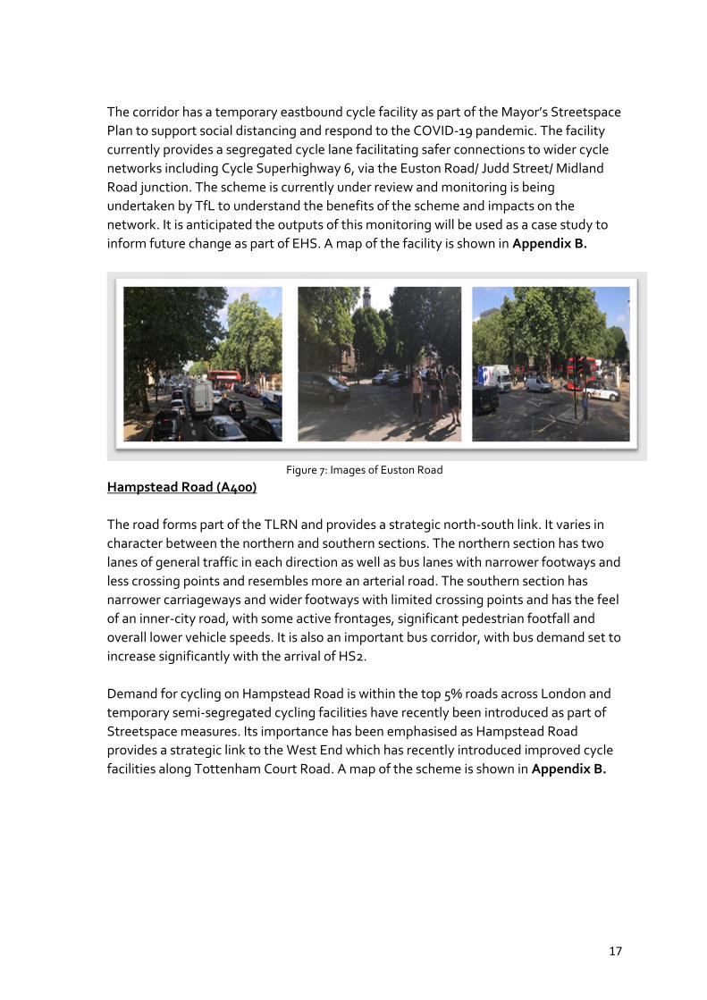
The corridor has a temporary eastbound cycle facility as part of the Mayor’s Streetspace
Plan to support social distancing and respond to the COVID-19 pandemic. The facility
currently provides a segregated cycle lane facilitating safer connections to wider cycle
networks including Cycle Superhighway 6, via the Euston Road/ Judd Street/ Midland
Road junction. The scheme is currently under review and monitoring is being
undertaken by TfL to understand the benefits of the scheme and impacts on the
network. It is anticipated the outputs of this monitoring will be used as a case study to
inform future change as part of EHS. A map of the facility is shown in Appendix B.
Figure 7: Images of Euston Road
Hampstead Road (A400)
The road forms part of the TLRN and provides a strategic north-south link. It varies in
character between the northern and southern sections. The northern section has two
lanes of general traffic in each direction as well as bus lanes with narrower footways and
less crossing points and resembles more an arterial road. The southern section has
narrower carriageways and wider footways with limited crossing points and has the feel
of an inner-city road, with some active frontages, significant pedestrian footfall and
overall lower vehicle speeds. It is also an important bus corridor, with bus demand set to
increase significantly with the arrival of HS2.
Demand for cycling on Hampstead Road is within the top 5% roads across London and
temporary semi-segregated cycling facilities have recently been introduced as part of
Streetspace measures. Its importance has been emphasised as Hampstead Road
provides a strategic link to the West End which has recently introduced improved cycle
facilities along Tottenham Court Road. A map of the scheme is shown in Appendix B.
18
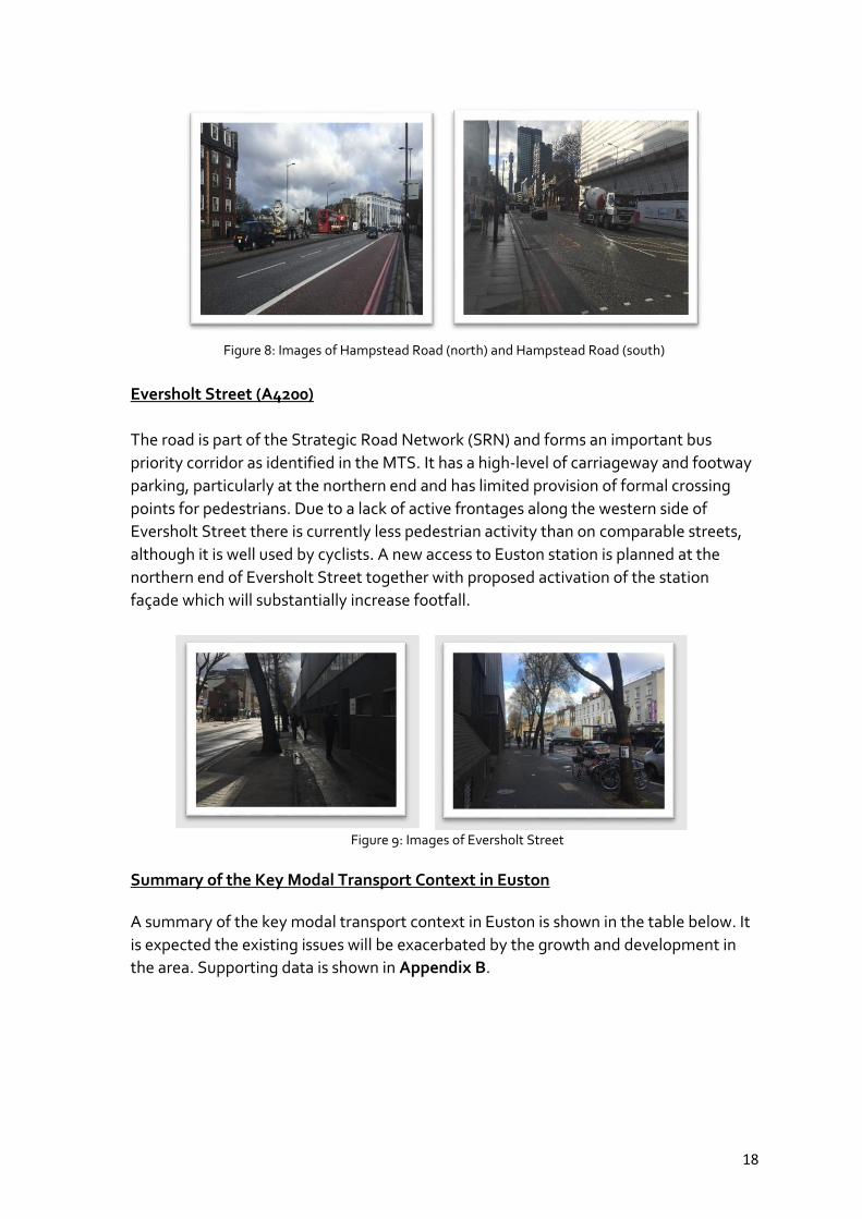
Figure 8: Images of Hampstead Road (north) and Hampstead Road (south)
Eversholt Street (A4200)
The road is part of the Strategic Road Network (SRN) and forms an important bus
priority corridor as identified in the MTS. It has a high-level of carriageway and footway
parking, particularly at the northern end and has limited provision of formal crossing
points for pedestrians. Due to a lack of active frontages along the western side of
Eversholt Street there is currently less pedestrian activity than on comparable streets,
although it is well used by cyclists. A new access to Euston station is planned at the
northern end of Eversholt Street together with proposed activation of the station
façade which will substantially increase footfall.
Figure 9: Images of Eversholt Street
Summary of the Key Modal Transport Context in Euston
A summary of the key modal transport context in Euston is shown in the table below. It
is expected the existing issues will be exacerbated by the growth and development in
the area. Supporting data is shown in Appendix B.

19
Summary Context Issues * Opportunities
Walking
High pedestrian flows
Lots of key attractors within 800m of station
High pedestrian density along Euston Road, particularly between Euston and Kings Cross St Pancras Station
High levels of traffic dominance
Inadequate pedestrian crossing facilities
Pedestrian severance associated with Euston Road
Create a network of high-quality, safe, and inclusive walking environments which connect local communities,
Reduce air pollution and noise
Remove barriers to walking and incorporate greening measures
Urban realm improvements
Cycling
High demand for cycling around Euston Station
High modelled cycle flows on Hampstead Road and Eversholt Street
High potential to attract new cycling trips north-south as well as east-west.
Insufficient permanent east-west and north-south connectivity
Insufficient cycle parking to encourage mode shift to cycling
Inadequate cycling facilities at signalised junctions
Create high-quality cycle network and improve safety
Provide permanent cycle infrastructure to support modal shift and remove barriers
Encourage more sustainable travel
Road Safety Road danger and collisions
are a significant issue
(Euston Road has 200-400%
more collisions than TLRN
average)
On Euston Road between
March 2017 and March 2020
one pedestrian was killed
and 16 pedestrians and
seven cyclists were seriously
injured
Traffic dominated environment
Uncontrolled crossings for pedestrians and cyclists
Lack of permanent cycle infrastructure
Introduce road safety measures
Reduce collisions and reduce barriers to sustainable travel i.e., perception of safety
Buses
High bus passenger demand and bus kms on Euston Road making it one of the busiest bus links in central London.
Bus demand set to increase
on Hampstead Road with
the arrival of HS2.
Current bus station not fit for purpose – poor urban realm
Congestion contributes to worsened bus journey times and reliability
High quality bus interchange which supports onward journeys by sustainable modes
Support the role of buses in providing accessible, affordable public transport option in Euston
Protect and maintain bus journey time reliability
Freight
High freight and servicing
flows in area
Euston Road and
Hampstead Road key freight
corridors
important east-west freight
corridor
Freight flows are forecast to increase by over 20% between 2012 and 2041 on Euston Road
Servicing demands to include due to development in the area
Reduce adverse impacts of freight and service vehicles on street network in line TfL’s freight action plan that aims to reduce the number of lorries and vans entering central London in the morning peak (07:00-10:00) by 10 per cent by 2026”
Manage and minimise impacts to improve air quality

20
Enable an uptake in more sustainable loading and servicing practices
Taxis and Private Hire Vehicles (PHVs)
High demand for both Taxi and PHVs in the area
Euston Road is a busy taxi corridor with high demand for taxi ranks particularly for Euston Station and Kings Cross St Pancras
High number of
PHVs and
observations of
illegal stopping and
parking
Relocation of Euston taxi rank associated with HS2 provides opportunity to consider strategic view
Recognise the role of taxis for an accessibility and inclusivity perspective
Private cars
High levels of congestion in the area
Majority of local trips (under 5km) taken by car
High levels of traffic dominance in the area
High dependency on use of private vehicles
Road transport emissions contribute to poor air quality
Make sustainable travel alternatives more attractive and reduce car dependency
Explore traffic reduction measures
Figure 10: Summary of modes in Euston
4. Stakeholder engagement
The joint project team at TfL and LBC identified key project stakeholders and carried
out early engagement to develop the vision for EHS.
What was the purpose of early engagement?
To capture stakeholder views, aspirations, ideas and requirements to
determine how the streets around Euston could be changed to deliver policy
objectives and cater for growth
To factor stakeholder views and aspirations into vision development
including vision statements for each road
To brief stakeholders about changes that will be taking place in the area and
the opportunity to shape and inform what change will be delivered on-street
Key stakeholders engaged in vision development to date:
LBC TfL (including Buses and
Network Management) Residents Local businesses HS2 / Lendlease Knowledge Quarter

21
Network Rail Greater London Authority Various built environment
professionals – e.g. Farrells, Arup
Stakeholder engagement activities to date:
5. Challenges
It is recognised there are several challenges, enablers and opportunities which need to be
considered alongside this vision including:
These vision statements set out the level of ambition we are seeking to achieve as part of
EHS, however it is expected trade-offs will be required in order to achieve the project
outcomes given there are competing priorities and limited road space available. Any
interventions considered on these roads will be carefully assessed during the feasibility
stage, with key stakeholders, to ensure that this is in accordance with the overarching
vision.

22
6. Next steps
Our vision statements are the first step in our journey together to deliver healthier, safer
and more attractive streets around Euston. We are now proposing to undertake the
following activities:
Develop a forward plan for the project, including developing and agreeing joint
objectives, funding strategy and a robust programme which includes opportunities
for residents and businesses in the area to shape the project.
Preparation for next project phase – Feasibility to identify options and measures to
achieve the vision and desired outcomes.
The outputs of the Vision and its supporting studies shall be used to inform the Transport
Strategy being developed for the Euston Area Plan review. It will also be used to form the
basis of identifying surface level transport and public realm interventions to be considered
and tested as part of the Transport Study.
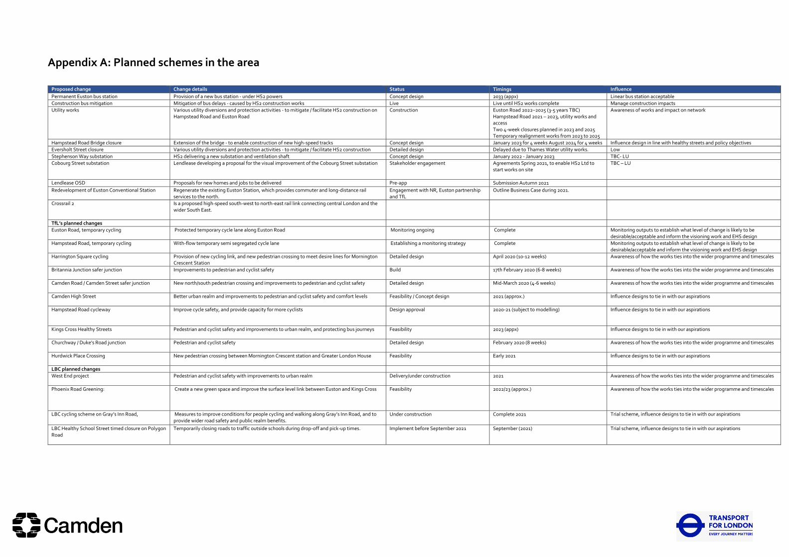
Appendix A: Planned schemes in the area
Proposed change Change details Status Timings Influence
Permanent Euston bus station Provision of a new bus station - under HS2 powers Concept design 2033 (appx) Linear bus station acceptable
Construction bus mitigation Mitigation of bus delays - caused by HS2 construction works Live Live until HS2 works complete Manage construction impacts
Utility works Various utility diversions and protection activities - to mitigate / facilitate HS2 construction on Hampstead Road and Euston Road
Construction
Euston Road 2022–2025 (3-5 years TBC) Hampstead Road 2021 – 2023, utility works and access Two 4-week closures planned in 2023 and 2025 Temporary realignment works from 2023 to 2025
Awareness of works and impact on network
Hampstead Road Bridge closure Extension of the bridge - to enable construction of new high-speed tracks Concept design January 2023 for 4 weeks August 2024 for 4 weeks Influence design in line with healthy streets and policy objectives
Eversholt Street closure Various utility diversions and protection activities - to mitigate / facilitate HS2 construction Detailed design Delayed due to Thames Water utility works. Low
Stephenson Way substation HS2 delivering a new substation and ventilation shaft Concept design January 2022 - January 2023 TBC- LU
Cobourg Street substation Lendlease developing a proposal for the visual improvement of the Cobourg Street substation Stakeholder engagement
Agreements Spring 2021, to enable HS2 Ltd to start works on site
TBC – LU
Lendlease OSD Proposals for new homes and jobs to be delivered Pre-app Submission Autumn 2021
Redevelopment of Euston Conventional Station Regenerate the existing Euston Station, which provides commuter and long-distance rail services to the north.
Engagement with NR, Euston partnership and TfL
Outline Business Case during 2021.
Crossrail 2
Is a proposed high-speed south-west to north-east rail link connecting central London and the wider South East.
TfL’s planned changes
Euston Road, temporary cycling Protected temporary cycle lane along Euston Road Monitoring ongoing Complete Monitoring outputs to establish what level of change is likely to be desirable/acceptable and inform the visioning work and EHS design
Hampstead Road, temporary cycling With-flow temporary semi segregated cycle lane Establishing a monitoring strategy Complete Monitoring outputs to establish what level of change is likely to be desirable/acceptable and inform the visioning work and EHS design
Harrington Square cycling Provision of new cycling link, and new pedestrian crossing to meet desire lines for Mornington Crescent Station
Detailed design April 2020 (10-12 weeks) Awareness of how the works ties into the wider programme and timescales
Britannia Junction safer junction Improvements to pedestrian and cyclist safety Build 17th February 2020 (6-8 weeks) Awareness of how the works ties into the wider programme and timescales
Camden Road / Camden Street safer junction New north/south pedestrian crossing and improvements to pedestrian and cyclist safety Detailed design Mid-March 2020 (4-6 weeks) Awareness of how the works ties into the wider programme and timescales
Camden High Street Better urban realm and improvements to pedestrian and cyclist safety and comfort levels Feasibility / Concept design 2021 (approx.) Influence designs to tie in with our aspirations
Hampstead Road cycleway Improve cycle safety, and provide capacity for more cyclists Design approval 2020-21 (subject to modelling) Influence designs to tie in with our aspirations
Kings Cross Healthy Streets Pedestrian and cyclist safety and improvements to urban realm, and protecting bus journeys Feasibility 2023 (appx)
Influence designs to tie in with our aspirations
Churchway / Duke's Road junction Pedestrian and cyclist safety Detailed design February 2020 (8 weeks) Awareness of how the works ties into the wider programme and timescales
Hurdwick Place Crossing New pedestrian crossing between Mornington Crescent station and Greater London House Feasibility
Early 2021 Influence designs to tie in with our aspirations
LBC planned changes
West End project Pedestrian and cyclist safety with improvements to urban realm Delivery/under construction 2021 Awareness of how the works ties into the wider programme and timescales
Phoenix Road Greening:
Create a new green space and improve the surface level link between Euston and Kings Cross
Feasibility 2022/23 (approx.) Awareness of how the works ties into the wider programme and timescales
LBC cycling scheme on Gray’s Inn Road,
Measures to improve conditions for people cycling and walking along Gray’s Inn Road, and to provide wider road safety and public realm benefits.
Under construction
Complete 2021 Trial scheme, influence designs to tie in with our aspirations
LBC Healthy School Street timed closure on Polygon Road
Temporarily closing roads to traffic outside schools during drop-off and pick-up times. Implement before September 2021 September (2021) Trial scheme, influence designs to tie in with our aspirations
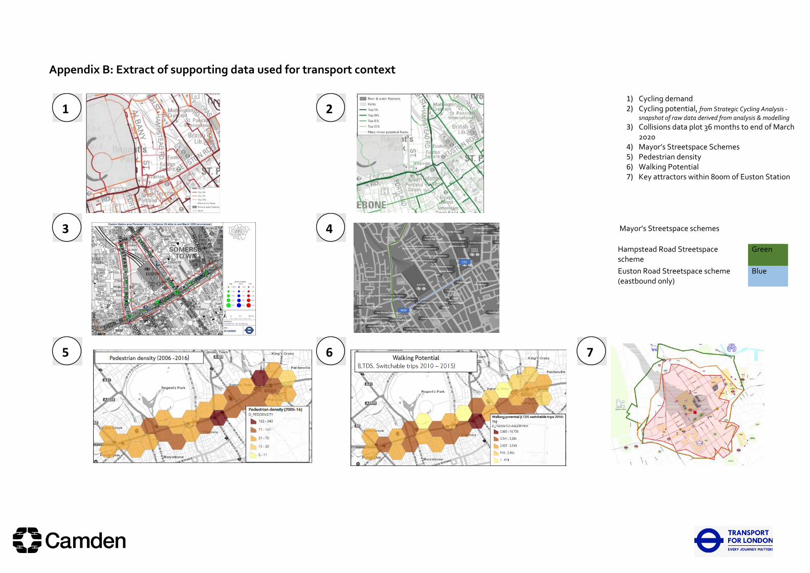
Appendix B: Extract of supporting data used for transport context
1) Cycling demand 2) Cycling potential, from Strategic Cycling Analysis -
snapshot of raw data derived from analysis & modelling 3) Collisions data plot 36 months to end of March
2020 4) Mayor’s Streetspace Schemes 5) Pedestrian density 6) Walking Potential 7) Key attractors within 800m of Euston Station
Mayor’s Streetspace schemes
Hampstead Road Streetspace scheme
Green
Euston Road Streetspace scheme (eastbound only)
Blue
1
1
2
2
3
3
4
4
5
5
6
6
7
7