Embed Size (px)
Citation preview
Overview of Parana Delta1
Author: Verónica M.E. Zagare
2
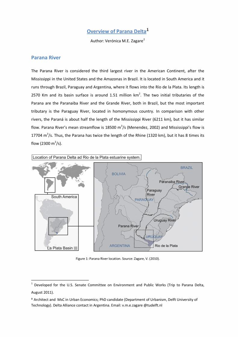
Parana River The Parana River is considered the third largest river in the American Continent, after the
Mississippi in the United States and the Amazonas in Brazil. It is located in South America and it
runs through Brazil, Paraguay and Argentina, where it flows into the Río de la Plata. Its length is
2570 Km and its basin surface is around 1.51 million km2. The two initial tributaries of the
Parana are the Paranaiba River and the Grande River, both in Brazil, but the most important
tributary is the Paraguay River, located in homonymous country. In comparison with other
rivers, the Paraná is about half the length of the Mississippi River (6211 km), but it has similar
flow. Parana River’s mean streamflow is 18500 m3/s (Menendez, 2002) and Mississippi’s flow is
17704 m3/s. Thus, the Parana has twice the length of the Rhine (1320 km), but it has 8 times its
flow (2300 m3/s).
Figure 1: Parana River location. Source: Zagare, V. (2010).
1 Developed for the U.S. Senate Committee on Environment and Public Works (Trip to Parana Delta,
August 2011). 2 Architect and MsC in Urban Economics; PhD candidate (Department of Urbanism, Delft University of Technology). Delta Alliance contact in Argentina. Email: v.m.e.zagare @tudelft.nl
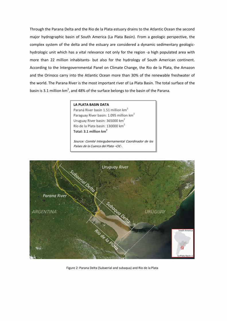
Through the Parana Delta and the Rio de la Plata estuary drains to the Atlantic Ocean the second
major hydrographic basin of South America (La Plata Basin). From a geologic perspective, the
complex system of the delta and the estuary are considered a dynamic sedimentary geologic-
hydrologic unit which has a vital relevance not only for the region -a high populated area with
more than 22 million inhabitants- but also for the hydrology of South American continent.
According to the Intergovernmental Panel on Climate Change, the Rio de la Plata, the Amazon
and the Orinoco carry into the Atlantic Ocean more than 30% of the renewable freshwater of
the world. The Parana River is the most important river of La Plata Basin. The total surface of the
basin is 3.1 million km2, and 48% of the surface belongs to the basin of the Parana.
Figure 2: Parana Delta (Subaerial and subaqua) and Rio de la Plata
LA PLATA BASIN DATA Paraná River basin 1.51 million km2 Paraguay River basin: 1.095 million km2 Uruguay River basin: 365000 km2 Río de la Plata basin: 130000 km2
Total: 3.1 million km2 Source: Comité Intergubernamental Coordinador de los Países de la Cuenca del Plata –CIC-.
Parana Delta The Parana River Delta is considered both, a complex estuary delta (Parker –Marcolini, 1992),
and a wetland, influenced by fresh water tides (Kandus – Malvarez, 2002). In fact, it is one of the
largest coastal wetlands systems of Argentina, spreading over 320 km and covering a surface of
15000 km2. The Delta presents a variable width, from 18 Km up to 100 km, and according to
landscape parameters and hydrologic regimes, it presents more than 10 landscape units
(Malvarez, 1997).
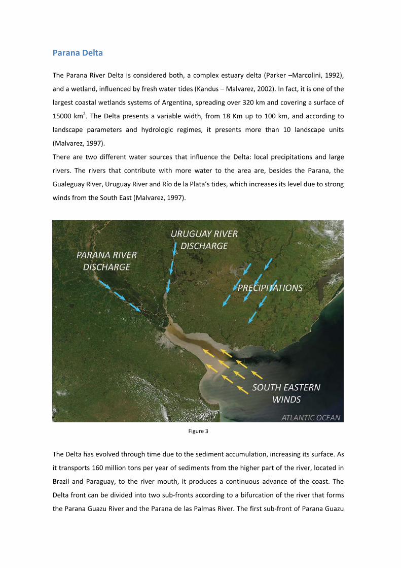
There are two different water sources that influence the Delta: local precipitations and large
rivers. The rivers that contribute with more water to the area are, besides the Parana, the
Gualeguay River, Uruguay River and Río de la Plata’s tides, which increases its level due to strong
winds from the South East (Malvarez, 1997).
Figure 3
The Delta has evolved through time due to the sediment accumulation, increasing its surface. As
it transports 160 million tons per year of sediments from the higher part of the river, located in
Brazil and Paraguay, to the river mouth, it produces a continuous advance of the coast. The
Delta front can be divided into two sub-fronts according to a bifurcation of the river that forms
the Parana Guazu River and the Parana de las Palmas River. The first sub-front of Parana Guazu
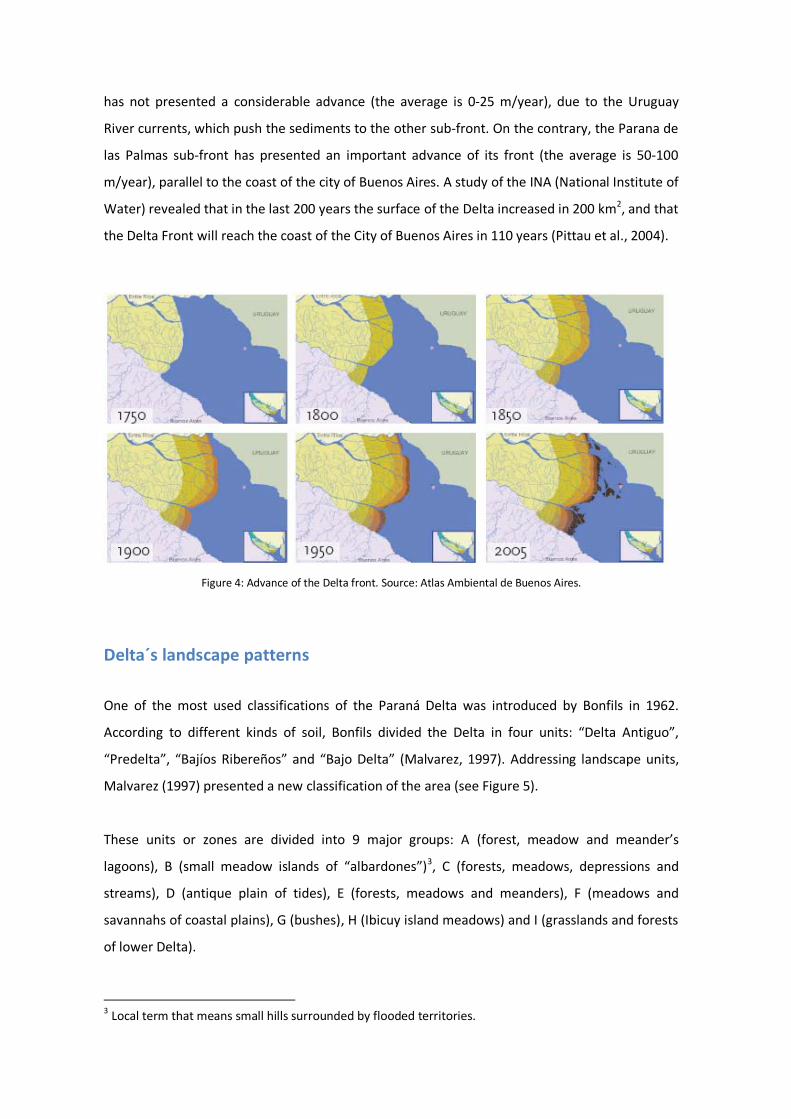
has not presented a considerable advance (the average is 0-25 m/year), due to the Uruguay
River currents, which push the sediments to the other sub-front. On the contrary, the Parana de
las Palmas sub-front has presented an important advance of its front (the average is 50-100
m/year), parallel to the coast of the city of Buenos Aires. A study of the INA (National Institute of
Water) revealed that in the last 200 years the surface of the Delta increased in 200 km2, and that
the Delta Front will reach the coast of the City of Buenos Aires in 110 years (Pittau et al., 2004).
Figure 4: Advance of the Delta front. Source: Atlas Ambiental de Buenos Aires.
Delta´s landscape patterns
One of the most used classifications of the Paraná Delta was introduced by Bonfils in 1962.
According to different kinds of soil, Bonfils divided the Delta in four units: “Delta Antiguo”,
“Predelta”, “Bajíos Ribereños” and “Bajo Delta” (Malvarez, 1997). Addressing landscape units,
Malvarez (1997) presented a new classification of the area (see Figure 5).
These units or zones are divided into 9 major groups: A (forest, meadow and meander’s
lagoons), B (small meadow islands of “albardones”)3
, C (forests, meadows, depressions and
streams), D (antique plain of tides), E (forests, meadows and meanders), F (meadows and
savannahs of coastal plains), G (bushes), H (Ibicuy island meadows) and I (grasslands and forests
of lower Delta).
3 Local term that means small hills surrounded by flooded territories.
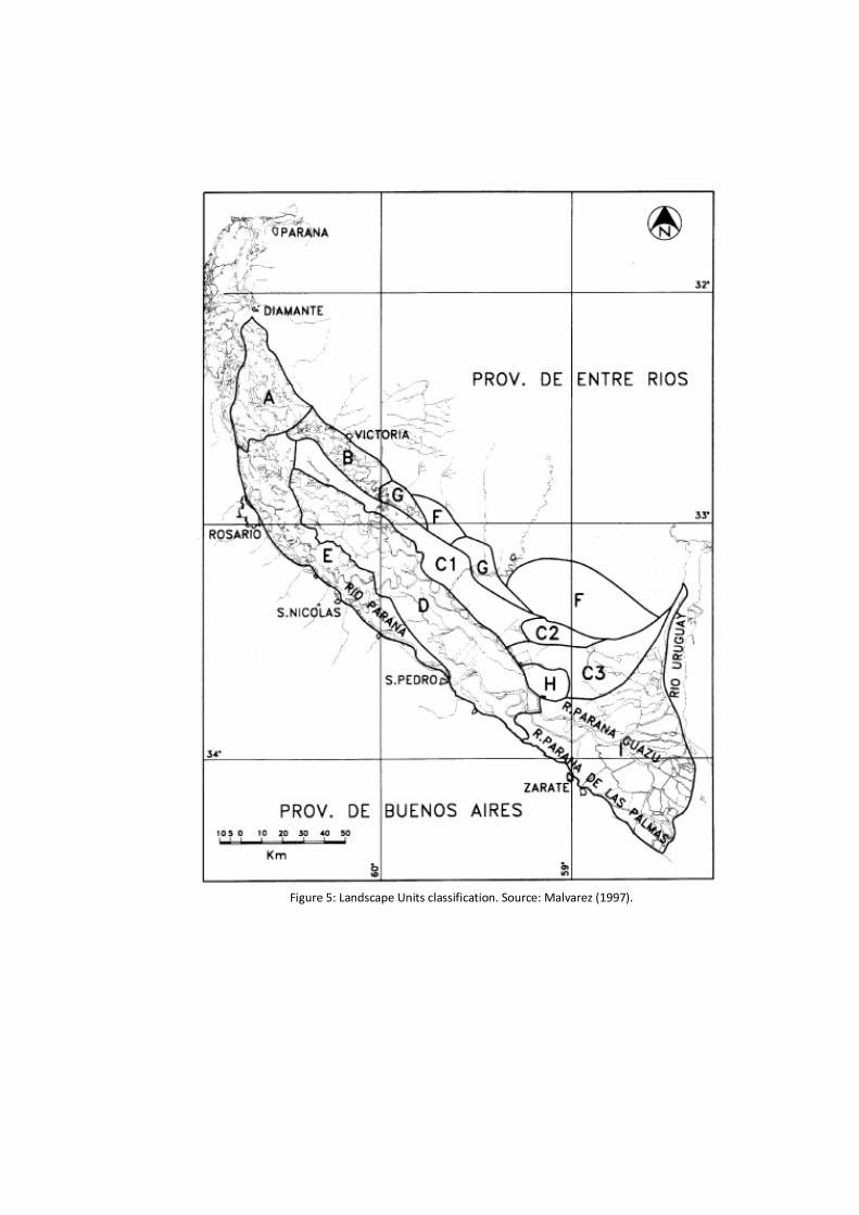
Figure 5: Landscape Units classification. Source: Malvarez (1997).
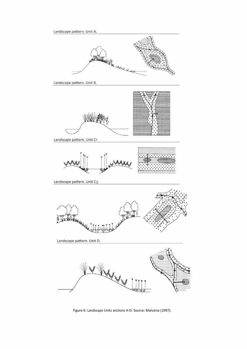
Figure 6: Landscape Units sections A-D. Source: Malvárez (1997).
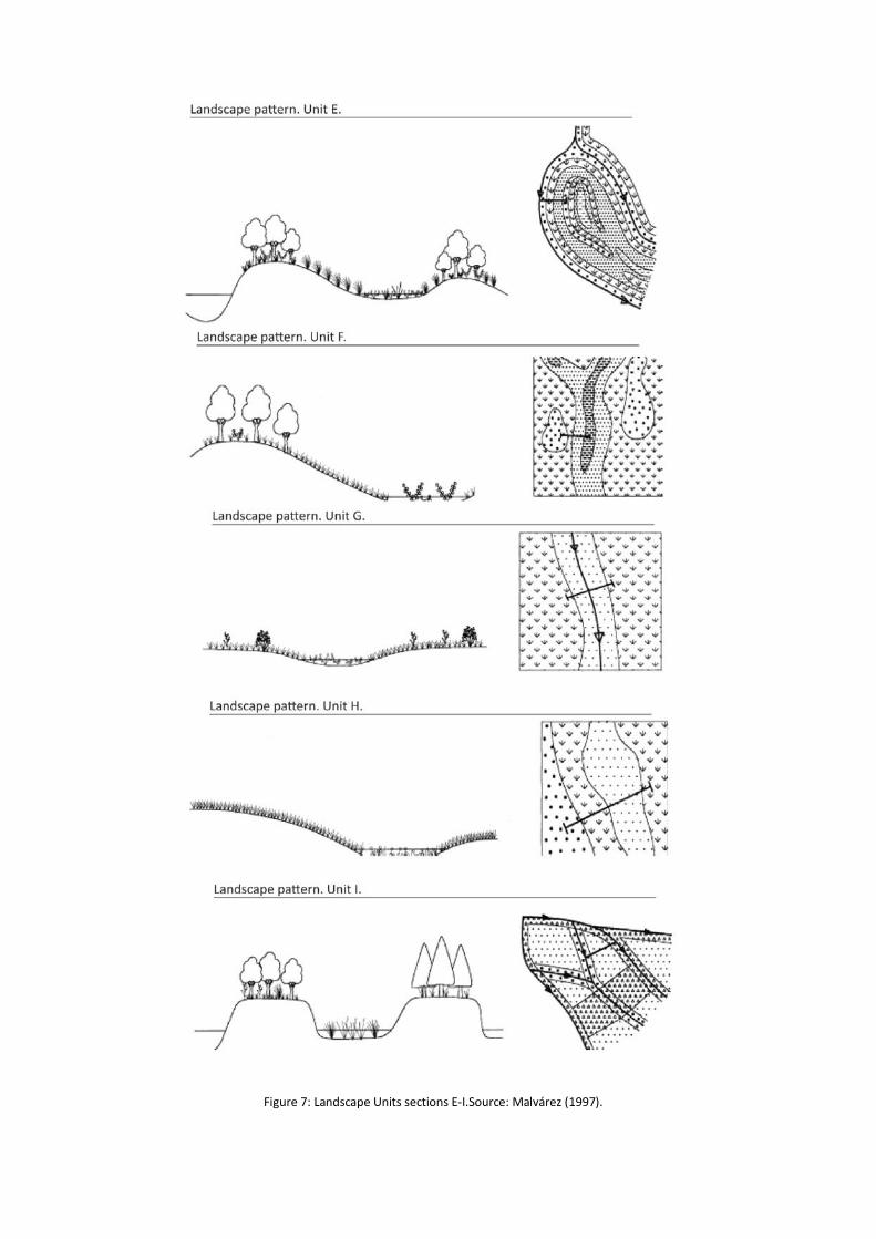
Figure 7: Landscape Units sections E-I.Source: Malvárez (1997).
Economic activities Delta lands are suitable for forestry, especially for the plantation of softwoods, such as willow
and poplar. The forested lands of the Lower Delta constitute a surface of around 60000 ha. (80%
of willow and 20% of poplar). Another economic activity that is being developed on the Delta is
stockbreeding, which has grown considerably during the latest years. In 2003, 40000 heads of
cattle were living on the Delta and the amount increased five times by the year 2008. On the
contrary, fishing has decreased due to the intensive practice for commercial purposes and the
development of infrastructure works – such as bridges-, which do not allow some species to
evolve. Intensive agriculture is practiced too, being important the cultivation of soy, which has
replaced other kinds of grains such as weat. That replacement is a consequence of the increase
of the international prices of soy and the good performance of the cultivation for each hectare,
compared with other species. Private farming is another way of living for the inhabitants of the
Delta’s islands. They cultivate crops, such as organic vegetables and a type of nut called “Pecan”,
a very popular product.
Furthermore, tourism and leisure activities are relevant for the Delta. Visitors can navigate
down the river -in catamarans, kayaks, yachts, boats and motorboats-, practice water sports –
kayaking, rowing, water skiing, etc-, fish and rest in luxury lodges. These activities are an
important income for the communities.
Along the Delta of the Paraná, there are several industrial poles, which are strategically located
as they are close to important ports. All the municipalities of the Delta have industrial
establishments but the most important are located in San Nicolás, Ramallo, Zárate and
Campana. Most of the commercialized products are wood, woodwork, metalwork, aluminium
frames, electrical goods, motor parts, paper, corn and other types of grains, oil, alcohol, iron,
concrete and fuel. The industrial establishments are located along the river, next to national and
international routes, along the Mercosur´s axis of commerce.
The Paraná River is part of a system of fluvial communication called “Hidrovía Paraná-
Paraguay”4 was designed by governmental authorities with the financial help of international
institutions5
4 Paraná-Paraguay waterway.
in order to guarantee the constant flow of commercial ships, barges and tug boats
along the river and the communication between Brazil, Paraguay, Argentina and Uruguay. The
waterway project consists on dredging and constructing infrastructures to allow the
development of commerce.
5 Interamerican Development Bank, United Nations –UNDP-, Corporación Andina de Fomento –CAF-, Fondo Financiero para el Desarrollo de la Cuenca del Plata –Fonplata-.
Positive and negative externalities caused by economic activities.
Externalities are positive or negative impacts that an activity has on something. These effects
are not often possible to be reflected in the market prices or measured, but they have to be
taken into consideration in cost-benefits analysis. Economic activities generate both positive and
negative externalities, and it is necessary to consider the impacts and plan the development of
each activity in an integral and sustainable way. Positive externalities of the development of the
economic activities can be related to the social welfare in terms of economics. The expansion of
agricultural borders and the increase of stockbreeding, forestry and soy production create jobs
and generate higher incomes. The growth of industrial activities helps the labour market,
decreases the unemployment rates and benefits local and national economy. Nevertheless, each
activity has to be developed taking into account the negative impact that it can have if it is not
regulated, especially when it can damage the environment and the community. This negative
potential impact can be considered as a threat. The Delta of the Paraná is a relatively young
territory that has not been studied in all its complexity, so it remains important to research
about the consequences of the activities that are being developed on it.
Urban dynamics
Delta´s islands are under the jurisdiction of the provinces of Buenos Aires, Entre Rios. Although
they are not so populated, they face the spatial pressures of three important metropolitan
regions: Buenos Aires Metropolitan Area (BAMA) –the largest conurbation of the country, with a
population of around 14 million inhabitants-, Gran Rosario Metropolitan Area –the third
urbanized area of the nation, with more than 1.2 million inhabitants-, and Santa Fe –with almost
0.5 million inhabitants-. The BAMA concentrates 31% of the national population in less than
0.15% of the country´s territory and participates in 53% of the GDP (Gross Domestic Product).
Urban pressures of the BAMA on the Lower Parana Delta The political and economic context of 1990´s promoted the development of private
urbanizations for medium and high classes, most of them located in the North area of the
province of Buenos Aires, even reaching the Parana Delta´s coastline. The scenario was
characterized by a deep Reform of the Estate, new urban laws, a decrease of the inflation rate,
an increase of External Direct Inversions due to the decrease of the international rates of
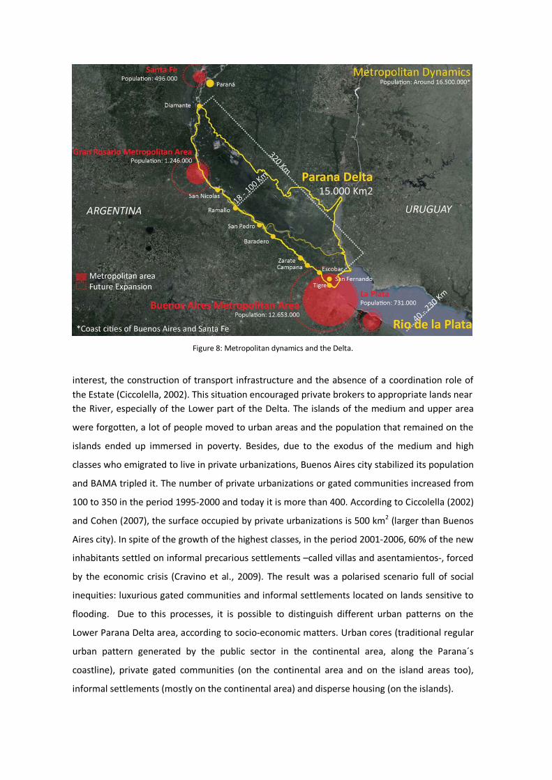
Figure 8: Metropolitan dynamics and the Delta.
interest, the construction of transport infrastructure and the absence of a coordination role of the Estate (Ciccolella, 2002). This situation encouraged private brokers to appropriate lands near the River, especially of the Lower part of the Delta. The islands of the medium and upper area
were forgotten, a lot of people moved to urban areas and the population that remained on the
islands ended up immersed in poverty. Besides, due to the exodus of the medium and high
classes who emigrated to live in private urbanizations, Buenos Aires city stabilized its population
and BAMA tripled it. The number of private urbanizations or gated communities increased from
100 to 350 in the period 1995-2000 and today it is more than 400. According to Ciccolella (2002)
and Cohen (2007), the surface occupied by private urbanizations is 500 km2 (larger than Buenos
Aires city). In spite of the growth of the highest classes, in the period 2001-2006, 60% of the new
inhabitants settled on informal precarious settlements –called villas and asentamientos-, forced
by the economic crisis (Cravino et al., 2009). The result was a polarised scenario full of social
inequities: luxurious gated communities and informal settlements located on lands sensitive to
flooding. Due to this processes, it is possible to distinguish different urban patterns on the
Lower Parana Delta area, according to socio-economic matters. Urban cores (traditional regular
urban pattern generated by the public sector in the continental area, along the Parana´s
coastline), private gated communities (on the continental area and on the island areas too),
informal settlements (mostly on the continental area) and disperse housing (on the islands).

Figure 9: Different urban patterns on the Lower Parana Delta.
The impact that urban growth has on the territory of the islands and the river coastline must be
studied in order to reach to sustainable solutions to reduce the negative effects and allow
economic development. Thus, land uses must be analyzed to find a balance between the
different activities and the effects that each one causes on the natural environment in order to
increase the capacity to adapt to future climate and economic changing scenarios.
Some negative examples of private development of gated communities are 2Isla del Este” and
“Colony Park”, which are changing the topography and the lands generating strong effects and a
constant resistance of the natural inhabitants of the islands (See figures 10 and 11).
Figures 10 and 11: before Colony Park (left); Colony Park project (right).
Climate Change in the Delta Some of the climatic trends for the area indicate:
• A possible temperature raise from 0.4°C to 1.8°C by in the next ten years, and up to
7.5°C in the next eighty years (Magrin et al., 2007, IPCC).
• An increase of precipitations. In La Plata Basin, precipitation increased 16% comparing
he periods of 1951-1970 and 1980-1999 (Barros and Bejaran, 2005).
• An increase of river discharges -from every one percent change in precipitations there is
a two percent change in streamflow for the area- (Berbery et al., 2006).
• Changes in evaporation rates, which must be balanced with precipitation level to pre-
empt floods and guarantee aquifer refills (Barros et al., 2006).
• Displacement of isohyets towards west (Barros and Bejaran, 2005).
• Increase of frequency and intensity of Extreme Hydrological Events (Sudestadas and
ENSO). El Niño southern oscillation is the main source of variability in South America and
in spite of not always being followed by precipitations, it has a great influence on them
(Berbery et al., 2006).
• Increase of the frequency and duration of positive storm surges, causing an increase of
water level of the Rio de la Plata (D´Onofrio et al., 2008).
• Decrease of the frequency and duration of negative storm surges (causing decrease in
water level of the Rio de la Plata), but an increase in intensity (causing troubles for
water supply). (D´Onofrio et al., 2008).
• Increase of water level due to Sea Level Rise (Re, 2009).
All these events are related to the most important issue about climate change in the area, which
is climate variability. This variability is related to long periods of droughts and floods, caused by
the rise and fall of the rivers´ water level and the changes in precipitations. This is a natural
phenomenon which takes place on the Delta and which is increasing due to climate change.
The analysis of river discharges variability is important for the area because changes in river flow
lead to floods and droughts. Parana River drains to the Rio de la Plata through the bifurcation
into two rivers: the Parana de las Palmas River and the Parana Guazu River. Parana de las Palmas
discharge represent 25% of the total Parana river´s discharge and Paraná Guazu represents the
other 75%. Between Parana river and Uruguay river there are a lot of natural and artificial canals
which flow from West to East or vice versa, depending on the rise and fall of river streamflow.
This characteristic makes the territory a very changing environment.
Among other factors, changes in river streamflow are related to precipitations and also to the El
Niño Southern Oscillation (ENSO). The ENSO is a cycle that takes place in the tropical Eastern
Pacific Ocean and is characterized by a change of temperature and pressure of surface waters.
The warming phase is called El Niño and the cooling phase is called La Niña. ENSO is the main
source of variability in South America and in spite of not always being followed by precipitations,
it has a great influence on them. In the case study, precipitation variability is mostly influenced
by ENSO during the warming phase El Niño and during neutral periods –phases between El Niño
and La Niña.
Scientific evidence shows that there is a deep connection between the ENSO phenomenon and
extreme increases of river discharges, mostly during the period of 1971-2001.
Final considerations: Parana Delta Management Issues
• The most relevant issues that must be considered to generate management policies for
the area are related to finding a balance between economic activities, urban growth,
climate adaptation and environmental conservation.
• Sustainable ways of producing goods and living must be developed in order to guarantee
the ecosystem goods and services provided by the wetland.
• Land use regulations and other policies must take into consideration the conservation of
the natural land, avoiding great changes in island´s land levels and water courses. In
fact, one of the most important issues on the Delta is land use changes (from pasture to
agricultural or residential use).
• A balance between the occupation of the lands and the maintenance of the natural
wetland must be addressed in order to guarantee the system´s functions.
• It is also important to give the natural inhabitants the possibility of economic
development and to generate new strategies for agricultural activities facing climate
variations.
References
Ciccolella, P., 2002. La metrópolis postsocial: Buenos Aires, ciudad – rehén de la economía global, in: Actas del Seminario Internacional “El desafío de las áreas metropolitanas en un mundo globalizado. Una mirada a Europa y América Latina”, Barcelona. Cohen, M., 2007. Convertibilidad, crisis y desafíos para el futuro: 1991-2006. In Gutman, M. and Hardoy, E. (Eds.), Buenos Aires 1536-2006. Historia Urbana del Área Metropolitana. Ediciones Infinito, Buenos Aires, pp. 270-313. Constanza R., Darge, R., de Groot, R., Farber, S., Grasso, M., Hannon, B., Limburg, K., Naeem, S., O´Neill, R.V., Paruelo, J., Raskin, R.G., Sutton, P., van den Belt, M., 1997. The value of the world´s ecosystem services and natural capital, Nature, Vol 387, pp. 253-260. Cravino, M., Del Río, J., Duarte, J., 2009. Magnitud y crecimiento de las villas y asentamientos en el Área Metropolitana de Buenos Aires en los últimos 25 años. http://www.fadu.uba.ar/mail/ difusion_extension/ 090206_pon.pdf D´Onofrio et al., 2008, Changes in the Regime of Storm Surges at Buenos Aires, Argentina. Journal of Coastal Research, Vol.24, N°1A (Supplement). Jaime, P., Menendez, A., Torchio, J.,2003. Vinculación entre el caudal del Río Paraná y el fenómeno de El Niño. Informe LHA 02-216-03, Proyecto LHA 216, Instituto Nacional de Agua (INA), Buenos Aires. Kandus, P., Malvárez, A., 2002. Las islas del Bajo Delta del Paraná, in: Borthagaray, J. (Ed.), El Río de la Plata como territorio. Ediciones Infinito, Buenos Aires. Magrin, G., Gay García, C., Cruz Choque, D., Gimenez, J.C., Moreno, A.R., Nagy, G.J., Nobre, C., Villamizar, A., 2007. Latin America. Climate Change 2007: Impacts, Adaptation and Vulnerability, in: Parry, M.L., Canziani, O.F., Palutikof, J.P., van der Linden, P.J., Hanson, C.E. (Eds.), Contribution of Working Group II to the Fourth Assessment Report of the Intergovernmental Panel on Climate Change, Cambridge University Press, Cambridge, pp.581-615. Malvárez, A., 1997. El Delta del Río Paraná como mosaico de humedales, Laboratorio de Ecología Regional, Departamento de Ciencias Biológicas. Facultad de Ciencias Exactas y Naturales, Universidad de Buenos Aires, Buenos Aires. Menendez, A.: 2002. Análisis del régimen hidrológico de los ríos Paraná y Uruguay. Informe LHA 05-216-02, Proyecto LHA 216, Instituto Nacional de Agua (INA), Buenos Aires. Parker, G., Marcolini, S., 1992. Geomorfología del Delta del Paraná y su extensión hacia el Río de la Plata, Revista de la Asociación Geográfica Argentina No.47, Buenos Aires, pp. 243-249. Pittau, M., Sarubbi, A., Menéndez, A., 2004. Análisis del avance del frente y el incremento areal del Delta del Río Paraná, Instituto Nacional del Agua (INA), Buenos Aires. Re, M. 2005. Impacto del Cambio Climático Global en las costas del Río de la Plata. Tesis de Maestría en Ciencias Ambientales. Facultad de Ciencias Exactas y Naturales. Universidad de Buenos Aires. Buenos Aires. Zagare, V. (2010). Natural territory, urban growth and climate change in the Parana River Delta and Rio de la Plata estuarine system. Department of Urbanism. Delft University of Technology (Internal report).