Embed Size (px)
Citation preview
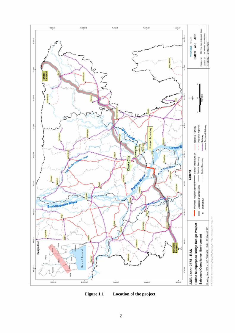
Bangladesh Bridge Authority Ministry of Communications, Government of the People’s Republic of Bangladesh
6 September 2010
Volume I ENVIRONMENTAL AND SOCIAL IMPACT ASSESSMENT
EXECUTIVE SUMMARY
EXECUTIVE SUMMARY
PADMA MULTIPURPOSE BRIDGE PROJECT
Pub
lic D
iscl
osur
e A
utho
rized
Pub
lic D
iscl
osur
e A
utho
rized
Pub
lic D
iscl
osur
e A
utho
rized
Pub
lic D
iscl
osur
e A
utho
rized
Pub
lic D
iscl
osur
e A
utho
rized
Pub
lic D
iscl
osur
e A
utho
rized
Pub
lic D
iscl
osur
e A
utho
rized
Pub
lic D
iscl
osur
e A
utho
rized

ii
Table of contents 1 INTRODUCTION 1
2 PROJECT DESCRIPTION
4
3 POLICY, LEGAL AND ADMINISTRATIVE FRAMEWORK
6
4 ANALYSES OF ALTERNATIVES
10
5 DESCRIPTION OF THE ENVIRONMENT
5.1 Physical Environment
5.2 Natural Environment
5.3 Socio-economic environment
5.4 Quality of the environment
11
11
13
14
15
6 SIGNIFICANT IMPACTS AND THEIR MITIGATIONS 17
6.1 Overall impacts of the PMBP
6.2 Impacts during pre-construction stage
6.3 Impacts during construction stage
6.4 Impacts during operation and maintenance stage
7 CLIMATE CHANGE AND OTHER RELEVANT ISSUES FOR BRIDGE DESIGN
17
17
19
22
23
8 SOCIAL ACTION PLAN AND ENVIRONMENTAL MANAGEMENT PLAN
24
8.1 Social Action Plan
8.2 Environmental Management Plan
9 INSTITUTIONAL ASPECTS
24
25
35
10 PUBLIC CONSULTATIONS AND DISCLOSURE
36
List of tables
Table 3.1 Compliance of project with GOB legislation and Safeguard Policies Co-financers 9
Table 6.1 Land acquisition for PMBP
17
Table 6.2 Summary of affected households/persons
17
Table 8.1 Summary of cost of SAP and EMP
28
Table 8.2 Overview of significant impacts, mitigation and monitoring measures
29
List of figures
Figure 1.1 Location of the project 2
Figure 2.1 Location of the main project components
5
Figure 9.1 Proposed institutional structure for implementation of SAP and EMP
35
iii
ABBREVIATIONS AND ACRONYMS
AEC Atomic Energy Commission ADB Asian Development Bank
BBA Bangladesh Bridge Authority
BP Bank Policy
CEMP Community Environmental Management Plan
CIMF Charland Impact Management Framework
CSC Construction Supervising Consultant
DOE Department of Environment
ECC Environmental Clearance Certificate
ECP Environmental Code of Practices
EIA Environmental Impact Assessment
EISA Environmental Impact and Social Assessment
EMP Environmental Management Plan
FS Feasibility Study
GDP Gross Development Product
GHG Green House Gasses
GIS Geographic Information System
GOB Government of Bangladesh
GRP Gross Regional Product
IDB Islamic Development Bank
IEE Initial Environmental Examination
IPPC Intergovernmental Panel on Climate Change
IUCN International Union for Nature Conservation
JBIC Japan Bank for International Cooperation
JICA Japan International Cooperation Agency
LAP Land Acquisition Plan
M&E Monitoring and Evaluation
MOEF Ministry of Environment and Forests
NGO Non Governmental Organisation
O&M Operation and Maintenance
OP Operational Policy
PIU Project Implementation Unit
PMBP Padma Multipurpose Bridge Project
PWD Public Works Datum
RAP Resettlement Action Plan
RTW River Training Works
SA Social Assessment
SAP Social Action Plan
SDF Social Development Fund
STI Sexually Transmitted Infections
TDS Total Dissolved Solids
TOR Terms of Reference
TSS Total Soluble Salts
USD United States Dollar
WB World Bank

1
1 INTRODUCTION
1. The Padma Multipurpose Bridge Project (PMBP) aims to remove the last major physical barrier in
the road connection between Dhaka and the Southwest and South Central regions of Bangladesh, home to
about one quarter of the Bangladesh population. Currently there is a rather unreliable ferry connection
over the Padma River with limited capacity and long waiting times. Ferry services are sometimes
interrupted for days during fog and high floods. A number of the ferryboats are obsolete; they are often
overloaded and there are frequent accidents, some resulting in considerable loss of life. The construction
of the Padma Bridge will replace the unreliable and unsafe ferry connection with a reliable and safe fixed
river crossing. The bridge will shorten the distance from the Southwest to Dhaka by 100 km and travelling
time will be considerably reduced. When completed a reliable highway connection will be established1
between Dhaka and the land port of Benapole, the seaport of Mongla and the district capitals of Khulna
and Barisal. The provisions for a railway line on the Padma Bridge will make it possible to construct a
new railway connection between Dhaka and the Southwest within the framework of the Trans Asian
Railway network. Padma Bridge will also include options for major utility connections to the Southwest
including gas, power transmission, and communication lines.
2. The project area is located at about 35 km southwest of Dhaka (see figure 1.1, location of the project).
The bridge will be constructed between a site near the village of Mawa, lying north of the Padma River
and Janjira on the south side. Components of the project such as approach roads and bridge end facilities
will affect an area of 6 km inland on the Mawa side and 4 km inland on the Janjira side; bridge and river
training works may even affect a corridor 15 km upstream and 7 km downstream in the river. The 250
km2 project area comprises areas located in 3 separate administrative districts: Munshiganj district on the
Mawa side (north bank) and Shariatpur and Madaripur districts on the Janjira side (south bank).
Lauhajong and Sreenagar upazilla (sub-district) lie on the north bank and Janjira and Shibchar upazilla lie
along the south bank.
3. Strategic context. The new bridge, which will be over 6 km long, will form an integral part of the
realisation of the Transnational Asian Highway network (Asian Highway no1), which construction
programme was ratified by the Government of Bangladesh (GOB) in 2004. The Road Masterplan for
Bangladesh prepared in 2007, earmarks the development of this highway (also called National Highway
no 8), the Padma Bridge and the two missing links as high-priority projects. The highway is of national
importance since it will link Dhaka to the Southwest of the country as well as to two major ports of the
country. GOB has approved this plan and earmarked the project as a national priority project for early
implementation. The completion of this project opens the way for accelerated socio-economic
development of the Southwest region, which is currently a relatively isolated and underdeveloped area.
The incidence of poverty in the Southwest region is higher than in the rest of the country. The Gross
Regional Product (GRP) of the SW region (Khulna and Barisal divisions) is only 17.4 % of the GDP
compared to 38 % in Dhaka division. The Padma Bridge will help to stimulate economic activity in the
SW region by providing a reliable and rapid transport connection.
4. Environmental and Social Impact Assessment. The project will have considerable environmental
and social impacts. This summary document of Environmental and Social Impact Assessment (EISA)
describes the most important environmental and social impacts of the bridge and associated works, which
will entail a considerable land acquisition and resettlement effort. Planning efforts have been going on for
the past decade to assess and develop mitigation measures against these impacts, including early studies
and planning efforts funded by JICA and ADB. These measures are described and included in
environmental and social action plans, including implementation schedules, budgets, responsibilities,
institutional requirements and monitoring plans. These measures are developed in line of domestic laws
and regulations in Bangladesh as well as relevant policies of the co-financiers, including the World Bank
(WB), Asian Development Bank (ADB), Japan International Cooperation Agency (JICA) and Islamic
Development Bank (IDB).
1 Currently there are still two sections between Dhaka and Banapole which are not up to standard
2
Figure 1.1 Location of the project.

3
5.Social Action Plan (SAP). It is anticipated that about 73,300 persons will be affected by the project,
either by losing land or structures, or by impact on their business or employment. The project will also
have impacts on public health, gender and physical cultural resources. Several action plans have been
developed to address the impacts based on various impact screening activities, field surveys and extensive
consultations in the past decade. These action plans are included in a Social Action Plan for Padma
Bridge Project, including three component Resettlement Action Plans, a gender action plan, a public
health action plan and a consultation and participation plan. The SAP also describes the planning efforts,
the management setup for the implementation of the project, monitoring arrangements, grievance redress
mechanism, implementation schedule, costing and financing arrangements. .
6.Environmental Impact Assessment. The environmental impacts of the project will be considerable
given that the bridge and associated works are for a large part situated in the active floodplain of the
Padma River, which combines the outflow of two of the longest rivers in the world: the Ganges and the
Brahmaputra. The project area is densely populated, yet also part of a highly dynamic environment
consisting of moving river channels, sandbanks and chars (newly accreted lands from the river), as well as
cultivated temporary wetlands in the floodplain. The impact assessment addresses the impacts and
mitigating measures on the physical, the biological and the human environment. The EIA has been
prepared to ensure that the PMBP is environmentally sound and sustainable as well as in compliance with
the agreed harmonized safeguard requirements of the co-financiers and GOB.
4
2 PROJECT DESCRIPTION
7. Background. A prefeasibility study for the Padma Multipurpose Bridge Project was carried out in
2000. It investigated a number of potential alignments for the proposed bridge. On the basis of the
outcome of that study Japan International Cooperation Agency (JICA), at the request of GOB, carried out
a feasibility study (FS) in 2002-2004. This study concluded that the most feasible bridge site is at Mawa-
Janjira point. The selection of this site was subsequently approved by GOB. The FS included, among
others, a preliminary technical design, economic and financial evaluation, a framework for land
acquisition and a Resettlement Action Plan (RAP), Initial Environmental Examination (IEE), and an
Environmental Impact Assessment (EIA). As the FS concluded that Padma Bridge is economically viable,
GOB moved forward for implementation and accordingly BBA conducted a study to update the previous
EIA and to prepare an Environmental Management Plan (EMP), a Land Acquisition Plan (LAP) and a
Resettlement Action Plan (RAP) in 2006. The Asian Development Bank (ADB) also conducted a FS
including an EIA and resettlement plan in 2007. The above studies formed the basis for the decision of
GOB to proceed with Phase 2, which includes the detailed engineering design and implementation of the
project funded by an ADB TA Loan. In 2009 a Safeguard team on environmental and social issues, and
part of the design consultants team, started the detailed EIA study in accordance with the relevant laws
and regulations in Bangladesh and EIA guidelines of all the co-financiers.
8. Development objective. The main development objective of the project is to establish a permanent
road crossing, including a provision for a future railway crossing over the Padma River, replacing the
existing unreliable and unsafe ferries. This would remove an important obstacle in the development of
National Highway 8 (Asian Highway no 1) that will connect Dhaka with the Southwest and South Central
regions of Bangladesh. Together with the future railway link between Dhaka (Narayanganj) and Khulna in
the southwest, the way for accelerated economic development of this rather isolated region of Bangladesh
would be opened. The project will comprise a bridge across the Padma River, approach road and railway
viaducts, major river training works and bridge end facilities, such as toll plaza’s and service areas. See
figure 2.1 Project components.
9. Main Bridge and Transition Structures. The main bridge will be 6.15 km long and will comprise a
two level steel truss bridge with a concrete upper deck carrying a four-lane divided highway. On the lower
deck of the bridge there will be a provision for a single railway track and utility crossings, such as a high
pressure gas pipeline and an optical fibre telecommunication cable. The bridge will consist of 41 spans
each of 150 m length. The substructure consists of 42 concrete piers, each resting on a pile cap on top of 5
piles driven to a depth of 103 m into the riverbed. The navigational clearance of the bridge is about 18 m
which is sufficient for larger types of inland vessels. Transition structures connecting the bridge with road
and railway consist of 3.9 km of road viaducts and 5.7 km rail viaducts. The embankments for the railway
between the stations of Mawa and Janjira are included but not the railway itself. A 400-kv double circuit
electricity line will be erected on separate platforms about 1-2km downstream of the bridge. The current
distance between two towers is about 1km. This will require construction of 6 additional platforms able to
carry the load of the tower, conductors, and ancillary facilities including inspection and safety measures
by the contractor responsible for the main bridge.
10. River Training Works. River Training Works (RTW) is required to protect project infrastructure
against erosion by the river. The north bank of the Padma is relatively high and stable. Here only about 2
km of revetment will be constructed to reinforce the current embankment and to protect the landing site of
the bridge. The situation along the south bank is more complex. This part of the project is situated in the
active flood plain and subject to very dynamic processes. The area near the landing site at Janjira is
currently affected by strong bank erosion and the South channel is being silted up requiring frequent
dredging to keep it open and accessible for the ferries. However this situation could easily change in
coming years. Study of river dynamics revealed that more erosion could be expected along the southern
side of the river. Especially the southern approach road which runs not far from the South channel
embankment has to be protected. After extensive geotechnical and hydromorphological model studies it
was decided that there will be a continuous about 13 km long bank revetment works at Janjira side (at
various levels) and about 2km at Mawa side to protect the river bank,..
11. Approach Roads. The approach road on the relatively high elevated Mawa side will be about 2.3 km
long. Along the south bank there will be a 12.8 km long road elevated above maximum flood level. The

5
road crosses a number of small streams and natural gullies draining the area. Since this part of the
floodplain is inundated annually by one or more meters of floodwater a number of structures is required to
restore and maintain the natural drainage pattern of the area, including outfalls to the South channel. In
total there will be 6 bridges (between 30 m and 270m long) and 14 drainage culverts. Also there will be 7
underpasses and 11 junctions with local and service roads.
12. Bridge End Facilities. The bridge end facilities consist of toll plaza’s and service areas on both sides
of the river. For toll plaza’s a total area of 22.3 ha is needed. The service area on the north bank will
occupy about 27 ha whereas on the south bank a larger area of approximately 63.7 ha will be needed.
Figure 2.1 Location of main project components
13. Land Acquisition and Resettlement. The implementation of the project will require the acquisition
of 1,144 ha of land. Almost half of the land to be acquired is needed for the construction of river training
works. Over 170 ha are estimated to be required temporarily for the construction operations. Land
acquisition for the project will affect at least 13,500 households, estimated at 73,300 persons. Close to
5,000 households will lose their houses and need to be relocated. A detailed compensation and livelihood
support program has been developed covering a 10-year timeframe. A relocation program has been
developed that includes the development five resettlement sites and supports housing development and
relocation for the relocating households. These are critical components of the project.

6
3 POLICY, LEGAL AND ADMINISTRATIVE FRAMEWORK
14. Applicable legislation on land acquisition in Bangladesh
The Acquisition and Requisition of Immovable Property Ordinance 1982 is the basic instrument
governing land acquisition in Bangladesh. It is restricted to legal owners of property as supported by
records of ownership such as deeds, title or agreements, compensating for land as well as any
business, structure, trees and crops on the land. Owners of acquired land receive cash compensation at
market value with a 50% premium above the assessed price.
The East Bengal State Acquisition and Tenancy Act 1951 defines the ownership and right of use of
alluvial and diluvial land in the country. This law is relevant to the project for the acquisition of lands
within the bank line of the river for river training works.
The Padma Multipurpose Bridge Project (Land Acquisition) Act 2009 has been promulgated to refuse
any fraudulent claim for compensation of land or structures. Video filming the right-of-way is a
provision of the law to ensure compensation for genuine losses only.
15. Applicable environmental legislation in Bangladesh
Environment Conservation Act (1995), which includes environmental guidelines to control and
mitigate environmental pollution, conservation and improvement of environment and provisions for
obtaining an Environmental Clearance Certificate (ECC) for development projects.
Environment Conservation Rules (1997), which provide a first set of rules under the Environment
Conservation Act giving categories of development projects and requirements for Initial
Environmental Examination (IEE), Environmental Impact Assessment (EIA), and preparation of
Environmental Management Plan (EMP), and the procedure for obtaining an ECC. Also quality
standards for air, surface water, groundwater, drinking water, industrial effluents, emissions, noise and
vehicular exhausts are given.
Guidelines for Industrial and Development Projects (1997) were prepared by the Department of
Environment (DOE), the regulatory and enforcement organization under the Ministry of Environment
and Forests (MOEF). The document provides guidance for preparing an EIA.
16. Other relevant legislation in Bangladesh
Environment Court Act (2000), describing environment related legal proceedings.
The Vehicle Act (1927) and the Motor Vehicles Ordinance (1983), provide rules for exhaust emission,
air and noise pollution, and road and traffic safety.
Rules for Removal of Wrecks and Obstructions in inland Navigable Water Ways (1973).
Water Supply and Sanitation Act (1996), regulates the management and control of water supply and
sanitation in urban areas.
The Ground Water Management Ordinance (1985) describes the management of groundwater
resources and licensing of tubewells.
The Forest Act (1927) for the protection of forest reserves, protected forests and village forests.
The Private Forests Ordinance Act (1959) deals with the conservation of private forests and
afforestation of wastelands.
Bangladesh Wild Life Act (1974) describes the preservation of wildlife sanctuaries, parks and reserves.
The Protection and Conservation of Fish Act (1950) deals with the protection and conservation of
fishes in Government-owned water bodies
The Embankment and Drainage Act (1952) describes the protection of embankments and drainage
facilities.
The Antiquities Act (1968) describes the preservation of cultural heritage, historic monuments and
protected sites.
Acquisition and Requisition of Immovable Property Ordinance (1982) describes procedures and
provides guidelines for the acquisition and requisition of land.
Bangladesh Labour Law (2006) deals with occupational rights and safety of factory workers; provision
of comfortable work environment and reasonable working conditions.
17. Environmental Impact Assessment
The Environmental Conservation Rules (1997) stipulate that the construction of a bridge of over 100 m
length falls under the Red Category of projects requiring the implementation and approval of a full-scale
EIA in order to obtain environmental clearance from GOB. An Environmental Clearance Certificate is

7
issued by the Department of Environment (DOE), the technical arm of the Ministry of Environment and
Forest (MOEF) and the regulatory body and enforcement agency of all environmental related activities.
DOE has approved the TOR of this study and provided a number of additional conditions and suggestions
to be incorporated in it.
18. National policies and International treaties
During recent years a number of national policy documents have been prepared which emphasize the
protection of the environment and natural resources in order to achieve sustainable development. It is
relevant to mention that GOB has also prepared a National Strategy for Accelerated Poverty Reduction
showing its strong commitment to achieving the Millennium Development Goals as defined by the UN.
Bangladesh has signed most international treaties, conventions and protocols on environment, pollution
control, biodiversity conservation and climate change, including the Ramsar Convention, the Bonn
Convention on migratory birds, the Rio de Janeiro Convention on biodiversity conservation and the Kyoto
protocol on climate change.
19. World Bank Safeguard policies
OP/BP/GP 4.01 – Environmental Assessment. The World Bank requires an Environmental
Assessment (EA) for all projects proposed for Bank financing to ensure that these projects are
environmentally sound and sustainable. The PMBP was classified Category A, because of the
scope of the expected impacts from construction and operation, the impacts of land acquisition,
the resettlement of about 25,000 persons and the expected impacts on the natural environment.
OP 4.04 – Natural Habitats. There are no designated conservation areas or nature reserves in the
project area. However OP 4.04 does apply since part of the area consists of semi-natural charlands
in the active Ganges/Brahmaputra floodplain, with typical floodplain habitats and breeding
grounds that might be affected by the project.
OP 4.11 – Physical and Cultural Resources. This policy is triggered for any project that requires
an EA. The project involves large-scale earth moving along both embankments and dredging
activities in the Padma River. The policy requires a proper management plan for unexpected
chance finds during implementation of the project
OP/BP 4.12 - Involuntary Resettlement. Some 26,000 people will have to be resettled. Separate
social studies have been carried out and resettlement action plans (RAP) prepared. These aim to
minimize resettlement while offering adequate compensation or settlement alternatives in
conformity with World Bank policies and Bangladesh law.
BP 17.50 - Public Disclosure of Information. According to the Bank Policy the EA should be
made available to the public by disclosure at public libraries or other places accessible to project-
affected groups, including a Summary EA in the local language.
Environmental Health and Safety Guidelines. The EHS Guidelines contain performance levels
and measures for development of industrial projects that are considered to be achievable in new
facilities at reasonable costs by existing technology.
20. Asian Development Bank Policies
Safeguard Policy Statement (2009). The policy of the Asian Development Bank (ADB) includes
operational guidelines that seek to avoid, minimize or mitigate adverse environmental and social
impacts, including protecting the rights of those likely to be affected or marginalized by the
development process.
Three Safeguard Policies. ADB’s safeguard framework consists of three operational policies on
Environment, Indigenous Peoples, and Involuntary Resettlement. Two of the safeguard policies
are triggered in this project: Environment and Involuntary Resettlement. There are no indigenous
peoples as defined by the policy affected by the project. The policies involve a structured process
of impact assessment, planning, and mitigation to address the adverse effects of projects
throughout the project cycle. The safeguard policies require that:
(i) impacts are identified and assessed early in the project cycle;
(ii) plans to avoid, minimize, mitigate, or compensate for the potential adverse impacts are
developed and implemented; and that
(iii) affected people are informed and consulted during project preparation and implementation.
Category A project. The PMBP is classified as a Category A project, which are projects with a
potential for significant adverse environmental impacts. An EIA including EMP is required to
8
address significant impacts. The draft EIA report will be disclosed on ADB website for a period
of 120 days before board consideration.
21. Japan International Cooperation Agency
Guidelines. The JICA guidelines for loan aid (Japan Bank for International Cooperation
Guidelines for Confirmation of Environmental and Social Considerations, April 2002) apply.
Principle. The guidelines are based on the following principles:
- A wide range of environmental and social impacts should be addressed;
- Measures for environmental and social consideration should be applied from an early stage
until the monitoring stage;
- During the entire process accountability and transparency should be ensured;
- Stakeholders opinions should play an eminent role in the decision-making process;
- Information should be disclosed in consultation with the project proponent;
- The capacity of organizations involved in environmental and social operations should be
enhanced;
- Promptness in implementation.
Category A project. The PMBP is classified as Category A, as it is likely to have significant
environmental and social impacts. The project proponent must submit EIA reports and for
projects that result in large-scale involuntary Resettlement Action Plans should be submitted.
Disclosure. JICA discloses final reports of preparatory surveys, EIA reports and RAPs on the
websites 120 days prior to final environmental review and board considerations.
22. Islamic Development Bank. The EIA Guidelines of the Islamic Development Bank (IDB) are
reported to be under preparation and yet to be published. However the IDB has expressed its support for
the harmonized safeguard policies applicable to the project.
23. Harmonized Safeguard Policies. In view of the different requirements of GOB and the potential co-
financiers of the PMBP a harmonized environmental safeguard framework was developed to conduct the
EIA. This framework was used to prepare the TOR for the EIA, which document has been reviewed and
approved by the BBA, DOE and the potential co-financiers of the project. As regards social assessment,
the project safeguard policies are based on harmonization of the co-financiers safeguard policies with
GOB legislation involving the 1982 Ordinance II and gap-filling measures. The harmonization also
benefited from the Jamuna “best practices” in resettlement. The project safeguard policies address project
impacts in terms of minimized impacts, disclosure of impacts, public consultation and participation of the
affected people, payments of compensation at replacement cost, resettlement of the affected persons and
livelihood restoration and improvements in the post-resettlement period.
24. Compliance with Bangladesh Legislation and Harmonized Safeguard Policies. The present status
of compliance of the project with Bangladeshi legislation and harmonized safeguard policies is indicated
in Table 3-1.

9
Table 3.1 Compliance of project with GOB legislation and Co-financers Safeguard Policies
Legislation/Policy Actions taken to comply
GOB Environment
Conservation
Rules, GOB-EIA
guidelines and
conditions by DOE
TOR for EIA study approved by DOE
Community EMP/IEE for resettlement sites prepared
EIA for PMBP prepared and submitted for approval
Permanent consultations with stakeholders and disclosure of EIA
Application for ECC
EIA guidelines for
Industrial Projects
Post Project Monitoring Plan included
International
treaties
Verification protected sites, Red List and protection of vulnerable
habitats
Harmonized
Framework
Co-
financers-
DOE
Early screening and
Scoping
Previous environmental studies reviewed (IEE, EIA -JICA, BBA,
EIA -ADB)
Scoping sessions held
Participatory
approach
57 meetings, workshops, consultation meetings and focus group
discussions held
Integrate EA and
SA
Natural environment, human health, social aspects, physical cultural
resources integrated in planning documents
Risk assessment Labour, health and safety risks determined
Environmental Code of Practices (occupational health, labour) in
tender documents contractor
Emergency Preparedness Plan prepared
Climate Change Impact climate change and effect on GHG emissions studied
Regional and Strategic cumulative impacts determined
Alternatives 4 different alignments compared
4 alternative bridge design types and 2 bridge types compared
3 alternatives for river training works compared
2 alternatives for transition structures compared
Without project alternative studied
Involuntary
Resettlement
Social and Poverty Assessment of Affected Households carried out
Joint verification with BBA of census data
Public Consultation and Participation Plan prepared and carried out
Resettlement Action Plans prepared for Resettlement sites (RAP I),
Main Bridge and Approach Roads (RAP II), River Training Works
(RAP III)
Resettlement Framework including legal basis for compensation
prepared
Assistance to BBA in land acquisition and compensation programme
Permanent monitoring
Pollution Baseline survey of environmental quality carried out
Stricter Environmental standards applied and Environmental Code
of Practices (ECPs) included in contract documents
Natural habitats Verification of protected areas and vulnerable habitats carried out
Wildlife survey (baseline) carried out
Physical and
Cultural Resources
Verification with Department of Archaeology implemented
Chance find procedure included in contract documents
Gender Gender Action Plan prepared
Public Health Public Health Action Plan prepared
Vulnerable
communities
Additional assistance to poor women and vulnerable groups
Charland Monitoring, Management and Development Plan prepared
Consultation and
Information
Disclosure
Early consultations and participation of affected people in RAP and
EMP
Disclosure of EIA summary in Bangla
Stakeholder consultation meetings, focus group discussions and
formal public consultations held

10
4 ANALYSES OF ALTERNATIVES
25. Without project scenario. The without project scenario is not acceptable since this will severely
constrain the potential for socio-economic development in the entire Southwest region, where about one
quarter of the Bangladesh population lives. Relative isolation of this part of the country because of the
absence of a good communication infrastructure, in the form of adequate road and railway connections
with the rest of the country, will further deprive the region of the potential for increased production,
relocation or generation of new economic activities and employment. A stagnating regional economy will
affect incomes and increase the number of people living below the poverty line, especially in the major
urban centres such as Khulna and Barisal. Opportunities for more export through Mongla seaport and
Benapole land port will be reduced because of high transport costs. Current risky and unreliable ferry
services will remain in service, often resulting in long waiting times for trucks (10 hours and more) and
cars (2 hours). Noise, oil pollution and hindrance of commercial navigation caused by the fleet of ferries,
launches and speedboats crossing the river on daily basis will continue.
26. Comparison of four different bridge sites. The 2005 feasibility study reviewed and compared four
different locations for the bridge. Out of two preferred options the Mawa- Janjira site was finally selected
as best option, mainly on the basis of factors such as travel time and distance to Mongla seaport and the
cost of associated works. The evaluation also took environmental and social impacts (more or less
comparable in the two options) into account. Out of three possible bridge types, a bridge with a 180 m
span concrete extra-dosed girder superstructure was recommended. The length of the bridge was
estimated at 5.6 km in 2005. The recommended alternative combined a railway and a road on the concrete
upper deck, comparable to the Jamuna Bridge completed in 1998.
27. Alternative bridge designs. Four possible bridge design options were studied in the detailed design
phase, including three options with a bridge superstructure consisting of two levels (road on upper deck
and railway below) and another option with a single level bridge with both railway and road on the same
level. From these studies a two level steel truss bridge was selected and compared with the feasibility
study recommended option (the single-level concrete bridge). It was concluded that concrete bridges are
generally more expensive than steel truss bridges. Another major advantage of the latter is that the
construction of a steel truss is relatively simple and does not require a long construction period. Thus, a
detailed evaluation was made of the single level concrete extra-dosed bridge and the double level steel
truss bridge based on the following factors: technical robustness, constructability, maintenance, cost,
social aspects, environmental impacts and proven previous use. In October 2009 the steel truss bridge
design was selected, mainly on the basis of its robustness and construction time, which is only 3 years,
while the concrete bridge would take double that time. The environmental impact on river hydrology and
aquatic life in the selected option is also lower in view of the restricted construction time and fewer piers
required.
28. Alternative transition structures. To minimize the length of the viaduct structures two options were
studied to separate road and rail alignments at the end of the approach road. In the first option the four-
lane road from the bridge is divided into two carriageways of which one passes under the railway viaduct.
In the second option the whole road passes over the railway viaduct. The first option has been selected in
view of lower cost, better aesthetics and some technical advantages. The preferred option does require
about 7 ha more land acquisition.
29. Alternative river training works designs. The purpose of the river training works is to protect the
river bank from erosion so that bridge, approach roads and railways remain functional during high floods.
The risk of erosion is fairly low for the relatively stable north bank and therefore the design principals of
the feasibility study with some minor modifications have been followed. However, the south bank near
Janjira is vulnerable and highly susceptible to bank erosion. Since the feasibility study an area of 500 m
land inwards has been eroded; this process can be seen on satellite observations of subsequent years. The
optimal type of river training works has been the subject of detailed hydrological and model studies, and
consultations between experts. Periodicities in the behaviour of the river have been established and the
most vulnerable points subject to bank erosion and scour were identified. Also physical and numerical
hydraulic model studies were applied to determine the effect of various options of bank protection.

11
30. Two options. Two major alternative designs for river training works (RTW) were identified:
Alternative 1 consists of a 13 km continuous bank revetment works along the south bank and the bank of
the channel to protect all project components on this side of the river. A 6 km section of this revetment
bund near the bridge will be raised above flood level to prevent overtopping or outflanking from
floodplain flows; the remainder will be constructed slightly above bank level. The revetment works will
more or less reshape and strengthen the river bank. Alternative 2 consists of a guide bund to protect the
landing site of the bridge and two hard points on the bank of the south side channel to protect the
approach road, which is only situated a few kilometres inland and runs parallel to the bank of the south
channel. This alternative was later optimized by shifting the two hard points across the channel on the
charland. This Alternative 2-modified was believed to give better hydraulic performance and would not
require the purchase of too much land on the populated channel bank, where there are also two ferry
ghats.
31. Comparison of the two alternatives. A detailed comparison of both alternatives revealed that
Alternative 1 will both adequately protect major project components from erosion and have fewer
environmental impacts on river ecology and charlands. It involves less dredging but it needs 190 ha of
land on the floodplain. The south channel will remain open (requested by the char people) and the
charlands will not be affected. Alternative 2-modified requires less agricultural and residential area but a
considerable charland area (200 ha) will disappear. Moreover, the south channel will be closed in this
alternative. A detailed comparison of the two alternatives concluded that Alternative 1 is preferred.
5 DESCRIPTION OF THE ENVIRONMENT
5.1 Physical environment
32. Project area and influence area. The PMBP including its components covers an area stretching 6
km inland from the Padma River on the Mawa (north bank) and 4 km inland at Janjira (south bank).
Bridge and river training works may affect an area 15 km upstream and 7 km downstream of the river.
The project influence area upon completion of missing links is much larger and will eventually comprise
(i) the entire corridor of the Trans Asian Highway 1 from Tamabil- Sylhet – Sorail – Kanchpur – Dhaka –
Mawa- Bhatiapara – Norail – Jessore- Benapole, and (ii) the corridor of the Trans Asian Railway and the
railway missing link from Gendaria- Mawa through the bridge to Bhanga- Kashiani- Narail- Jessore-
Benapole,
33. Climate. The climate in the project area is a typical monsoon climate with three main seasons:
summer (March to May), monsoon (June to October) and winter (November to February). The summer is
warm and humid with average monthly temperature of 28 0C with occasional moderate to heavy rainfall.
The monsoon period is generally humid with 80 % of total annual rainfall. Total annual rainfall varies
between 1750 and 2500 mm, with most rain from May to October with a usual peak in July (331-753
mm). The winters are dry and relatively cool with few rains and an average monthly temperature of 18 0C. During the year humidity is high with daily maxima of 95-100 %. Wind mainly comes from two
directions: a northerly light wind mainly blows in the winter season, while winds from the south and
south-east dominate in summer and monsoon. Highest wind speeds are usually recorded between March
and May, but also during monsoon.
34. Geomorphology and landscape. There are three different geomorphologic units in the project area,
each with different characteristics.
The north bank is part of the Lower Ganges/Brahmaputra River floodplain, which is characterized by a
relatively stable and elevated river levee (elevation +7.5 to 8mPWD) with medium textured soils,
which have been silted up to a level which is slightly above annual flood level. At some distance from
the river there are lower lying back swamp deposits (elevation +2.5 to 4.5mPWD) with clay soils, even
some peat deposits at the lowest parts. The area is densely populated; most occupation and trees are on
the high river levee while rice cultivation is in the lower lying areas.
The south bank near Janjira is located on a north-south oriented meander belt complex, consisting of
parallel sandy ridges and lower lying medium textured depressions often with some form of natural
drainage towards the main channel. Homestead development and trees are found on the higher ridges
and on the bank of the channel (elevation +5 to 5.5 mPWD). In the lower depressions, which are
12
treeless areas (elevation +3.5 to 4.5mPWD) a wide variety of crops is grown in winter and in summer,
including rice. There is also livestock holding and a few fish ponds in the area.
The third unit consists of Char Janajat, which is a complex of aggregated chars. A char is a tract of land
surrounded by water, which emerges as a result of river dynamics. Chars can appear and disappear
through accretion and erosion. Char Janajat was formed in the last 20 years by the braiding and
meandering Padma River. The area consists mainly of vegetated and often cultivated charlands, which
are slightly raised above the average river level (elevation + 2.5 to 4mPWD).
35. Soils. Soils in the area are of alluvial origin. The river levees consist of well drained medium textured
greyish-brown soils (mainly loam or silt loams) on top of stratified fine sandy and silty deposits. These
soils are non-saline and non-alkaline and slightly calcareous. Soils usually have good physical and
chemical properties and have a pH of 7.5 – 8.0. They are moderately fertile and suitable for a broad range
of crops. At some distance from the river finer textured grey coloured clayey material has been deposited
in the lower basins and depressions. These soils can be characterized as grey soils. Groundwater tables
can be found at 0.10 – 0.60 m, depending on the season. These soils are very suitable for rice cultivation.
The soils of the charlands consist mainly of very fine sand or silt loam. Outside the monsoon season
groundwater tables in the chars can be found near the surface or at shallow depth.
36. Land use. Both embankments of the Padma River can be characterized as rural areas with agriculture
being the predominant land use. However, there is more urban and commercial influence on the northern
Mawa side. The distance from Mawa to Dhaka by car takes only 1- 1.5 hour by car/truck. The presence of
the capital is reflected in the lower share of agricultural land as compared to the other side of the river. On
the northern side of the river only 65 % of the land is occupied by farms, whereas 86 % of the land is
farmland on the south side. Residential development on the north bank is considerably higher (31 %) than
on the south bank (12 %). Land use on the chars is completely different. Most people are fishermen and
about 34 % of the charlands is used for agriculture. A considerable area (43 %) is classified as fallow land
(bare, semi-natural grassland, or wetlands covered with sedges and reeds) and partly used for grazing
cattle. Only 3 % of charland is occupied by housing and settlement.
37. Padma River. The Padma River is the confluence of two of the world’s longest rivers, the Ganges
(2700 km) and the Brahmaputra (2900 km). The rivers have their sources in the glaciers of the Himalaya
Mountain Range and both drain a huge catchment area in the Indian Plains. The width of the Padma at the
project site varied from 2 to 6 km in the period 1976 to present. The behaviour of the river at Mawa is
fairly unpredictable and varies between braiding, straight and meandering in cycles of about 20 years.
There were periods that the river flowed as a single thread, but there were also periods in the past when
multiple channels occurred. Historically the main channel can be located anywhere. At present it runs near
the north bank, but it is expected to move towards the south channel. Maximum discharge of the Padma
River at Mawa measured during the 1998 flood was 115,711 m3/sec. The once in 100 year flood has been
estimated at 148,000 m3/sec. The average water level slope of the Padma is about 5 cm/km.
38. Other surface waters. The Arial Khan is a distributary from the Padma River that takes off about 15
km upstream from Janjira. The South channel is another relatively short river channel near Janjira,
separating the southern bank of Padma River and Char Janajat. The channel has been silted up, but is kept
open (by dredging) to facilitate the ferries and other vessels reaching the ferry ghats at Kathalbari and
Kawrakandi and Naodoba village on the south side of the river. Other surface waters in the area include
khals (natural drainage canals), beels (natural depressions), haors (oxbow lakes) and a number of
fishponds.
39. Bank erosion. The width of the Padma River near the proposed site of the bridge is changing due to
severe bank erosion along the southern embankment. The embankment near Janjira is rather low and has
been subject to heavy erosion during the past few years. This is also why the bridge will be longer (6.15
km) than anticipated in the 2005 feasibility study (5.6 km). Structural measures through river training
works are necessary to reinforce and protect the embankment. The north bank is fairly stable and there is
hardly any erosion from the river.
40. Floods. A large part of the project area is inundated during the annual floods. In normal years the
floods have little impact, because people have learnt to live with them and have built their houses on the
highest places. Most agricultural land, especially the rice areas are deeply flooded and this is considered

13
to be beneficial, since fertile silt and clay is deposited in the floodplains some distance from the main
river. Major damage to crops and food supply only occurs when floods come early and many kharif crops
are still in the field. Exceptionally high floods (1987, 1988, 1998, and 2004) often cause serious damage
to property and losses of food stocks. Generally, the people living on the river embankments are better
prepared against floods, since main roads and other infrastructure and housing is raised above maximum
flood level. However the charland communities are very vulnerable and people here are affected most
during exceptional floods, which can inundate their chars with 1.5 m of water or more.
5.2 Natural environment
41. Ecosystems. The deltaic plain where the project is situated consists of a number of ecological zones,
each with their associated flora and fauna. The variability is mainly determined by the hydrological
conditions (seasonal variations in water levels and seasonal connections between river and floodplain) and
the composition of soils. Typical ecosystems are partly natural and partly manmade. The natural systems
are: (i) Padma River and its tributaries, and (ii) the charlands within the river. The manmade ecosystems
are located in the older parts of the floodplain and comprise: (iii) homesteads and settlements, (iv)
agricultural fields, (v) tree ecosystems, and (vi) permanent and seasonal wetlands.
42. Biodiversity. The ecosystems in the project area show a relatively high biodiversity. Although the
population of most species has declined considerably under influence of the high population pressure,
plant and animal diversity is still high although largely dependent on sharing their habitat with humans to
survive. Especially the river systems and their direct surroundings are biodiversity hotspots, not only as a
habitat for water-dwelling organisms including fish, but also as a refuge for terrestrial flora and fauna, and
as ecological corridor between relatively less disturbed areas. From field observations it appears that 380
vertebrates, or about one quarter of the Bangladeshi species is present in the area, including 53 that are in
a vulnerable or critical stage. The area is also important as wintering ground for migrating birds.
43. River ecosystem. The river’s ecosystem is significant as habitat for numerous species of vertebrates
and invertebrates. Most are also found elsewhere in the delta, but for some species the project area is of
special importance, namely the highly threatened Gangetic Dolphin and two otter species. The Dolphin
population is under heavy pressure and this part of the Padma River is known for their regular presence
and breeding. It is known that reproduction success and thus survival can be drastically affected by
acoustic disturbances. The project area is also of special importance for a few reptiles and amphibians as
well as three endangered turtle species. Also the presence of the nearly extinct Gangetic Gharial has been
confirmed in the area.
44. Fish There are 158 species of channel migratory fish species known in Padma River including major
carps and floodplain resident species. At least 29 fish species are endangered. Some species of fish are
confined to the river water, some migrate from the floodplain to the river mostly for breeding, and others
migrate to the upper reaches during the monsoon season. The major migratory fish of the Padma is Hilsa.
Hilsa migrates from the Bay of Bengal via the Padma River to spawn in the upper reaches of the river.
They pass the project construction site during March–May, together with catfishes and major carps that
migrate in the same period. Janjira is considered one of the main fish breeding grounds, but a number of
smaller spawning and nursing grounds are found within 5-15 km of the project site to the SE (Naria) and
NW. During the baseline survey 86 species of fish have been recorded.
45. Charland ecosystem
Charlands are newly accreted lands from river deposits. If charlands do not erode quickly, they are
colonized by pioneer vegetation including a dense growth of tall grasses and reeds which anchor the loose
deposits and accelerate further silt deposition. Subsequently either natural succession by other grasses,
bushes and finally trees follows, or human activities result in development of cultivable and inhabitable
land. In the direct surrounding of the project site (within 5 km) there are three significant complexes of
charlands: (i) Char Janajat, upstream (NW) of the proposed bridge, (ii) a young complex of Char Tarapasa
and Majhir Char situated directly under and near the bridge alignment, (iii) a charland complex
downstream (E) Char Teotia consisting of Chandra Bari Char, Char Lauhajong and the more developed
Char Korhati. The ecological significance of the charlands is considerable. They provide the typical
biotope for the endangered Fishing Cat and the critically endangered Indian Crested Porcupine. Large
numbers of footprints of the first species were actually seen in the project area. The submerged areas of

14
the chars are favourable microhabitats for fishes and since fish is the main food for dolphins, the chars and
sandbanks in the middle of the river are important biotopes for the dolphins. Majhir Char (under the
bridge) is considered a major staging ground for migratory birds in winter. Thirteen amphibian species
were observed in the project area of which two are endangered and three vulnerable; six different turtle
species, including some endangered and very rare species and two different Monitors both categorized as
endangered in the IUCN Red List. Ten species of snakes were found of which three are on the Red List.
46. Terrestrial ecosystem. These include homesteads and settlements, agricultural fields and semi-
forested areas. These ecosystems provide living opportunities to the rural population, but also support
floral and faunal biodiversity, albeit that most species are common and found all over the country. The
significance is the ecological corridor function and the availability of trees supporting a fauna that
otherwise would not be available in the area. About 92 terrestrial bird species were observed including
one listed in the IUCN Red Data Book: the Brown Fish Owl.
47. Wetland ecosystem. Temporary wetlands are agricultural lands flooded during the monsoon period.
Their ecological significance is major and could be compared to that of the submerged areas around the
chars. They are important breeding and especially nursing biotopes for fish and crustacean species,
including Hilsa, major carps and catfishes. Permanent wetlands are the manmade ponds, the oxbow lakes,
depressions (beels) and channels. They are important for aquaculture. About 65 aquatic bird species were
observed in these areas including three Red-listed species and four other with CITES status.
5.3 Socio-economic conditions.
48. General. The degree of urbanization in the three project districts is high and many people in the area
have migrated to or work in urban centres, including Munshiganj and Dhaka. At Mawa site most people
work in trade, business or services (70%) with only a minority (5%) working in agriculture. At the Janjira
site the picture is totally different. About 50% of the population depends on agriculture, whereas only
25% works in trade, business or services. Poverty rates in the area are high and estimated at 30% of the
households, with most of the hard core poor living on the Janjira side of the river. The population of the
main char Janajat (about 60 km2) is estimated at 200,000 people. Most of them are very poor and live
mainly on agriculture and fishing.
49. Agriculture. This is still the most important economic activity in the area. However farm sizes are
small (below 1 ha and often smaller than 1 acre) and despite good soil productivity, farm incomes are low.
Only a small part of the farms (19%) in the project area is irrigated by tubewells. Rice is by far the most
important crop (83%) grown in Mawa. Other crops grown in winter are potato, onion, and mustard. At the
Mawa site most farmland is only single cropped, with a minority of land used for double cropping.
Overall cropping intensity is around 130%. Crops grown during kharif are often affected by early floods
or insect attacks and suffer considerable losses. At the Janjira site there is a different type of agriculture
with much higher cropping intensity. A wide variety of crops is grown during winter including onion,
pulses, spices, wheat and mustard. About 73% of the area is double cropped and on 16% of the land
followed by a third crop, resulting in an overall cropping intensity of 205%. Rice and jute are also major
crops, especially on the lower lying areas.
50. Fisheries. Less than 2% of the households indicate that they depend on fishing, but most people in the
area are part-time fishermen. Fishing is probably an additional source of income for many people. This
could also explain why a significant part of the economy is generated through marketing fish. Probably a
substantial part of the catch is made by the char people and comes from the waters of Char Janajat and
some of the other chars upstream to be marketed at the Mawa wholesale fish market. About 9,000 people
are directly dependant on the fish market and trade.
51. Ferries. There are three ferry ghats located near the project area: at Mawa, and at Kathalbari and
Kewrakandi on the Janjira side. At least 11 larger ferries, 50 launches, 220 speedboats and 1100
mechanized boats are involved in the daily traffic between the two embankments (on a 24-hours basis).
About 20,000 people directly or indirectly depend on the various economic activities in and around the
ferry ghats.
15
52. Health services. All three districts have a district hospital and in the upazillas there are health clinics
with a capacity of 50 to 100 beds. Each upazilla consists of several unions and each union has a health and
family centre and a rural health sub-centre. NGOs also arrange temporary health care facilities in these
areas. Common diseases are diarrhoea, anaemia, skin diseases, deficiency diseases, eye diseases, ear
diseases, and waterborne diseases due to malnutrition and lack of hygiene. The quality of the health
services in the project is poor. Most people go to quacks and medicine shops for minor medical treatment.
Qualified doctors are available at a distance of 4 km and 10 km and hospital facilities at a distance of 6
km and 40 km on Mawa respectively Janjira side.
53. Access to education. A sample survey of 390 households in the project districts indicates that about
10% male and 7% female population of schooling age never attended school; 32% male and 20% female
population of schooling age drop out during secondary level of school on various grounds, poverty being
the main factor. The literacy rate on the Mawa side is estimated at 67.5% and 64% on the Janjira side. On
the charlands there are only few primary schools and many char children have to travel long distances to
the mainland to go to primary or secondary schools; consequently the literacy rate is low at only 38%.
54. Gender. Women in the project area are mainly involved in traditional home-based reproductive and
unpaid productive work. Participation of women in agriculture is mainly in the form of rice husking and
crop processing at the household level. There are few gender differences between Mawa and Janjira. In
both sites men are more mobile. In Mawa many husbands and sons work in Dhaka and women often live
in rented houses on relatively small plots. In Janjira they usually live on larger plots of own land. Other
characteristics such as economic participation, status, empowerment and ownership of assets are not very
different to the national averages.
55. Energy. Fuel supply for cooking is a major concern to the population in the project area. There is a
considerable difference between the requirements on either side of the river. At Mawa 88% of the
population buy fuel for cooking (gas, electricity, or firewood) whereas only 12% collect firewood, cow
dung or crop residues themselves from free sources. In Janjira the picture is reversed. Most households
(82%) collect their own firewood, cow dung or crop residues from their homestead gardens or from
nature, whereas only 18% purchase their fuel.
56. Physical and cultural resources. There are no designated historical, archaeological or cultural
resources within the project area. However, Lauhajang on the north bank has a rich cultural and historical
heritage with some beautiful mosques and tall minarets. Idrakpur Fort, the earliest Muslim architecture, is
a popular tourist place. These monuments will not be affected by the project.
5.4 Quality of the environment
57. Air quality The major sources of air pollution in the project area are ferry traffic, vehicular traffic and
dust and emissions from brick fields. At the three ferry ghats there are heavy traffic congestions of
waiting trucks, busses and cars resulting in extensive exhaust emissions. Also emissions from the
numerous, often poorly maintained ferries, launches and speedboats crossing the river contribute to air
pollution.
58. Noise
The major sources of noise in the project area are the ferry ghats and the traffic on road and river.
Vibration also occurs at ferry ghats during uploading and offloading of heavy vehicles. Highest noise
levels of 77 dBA were recorded at the Mawa (near ferryghat) during the day and 73 dBA during the
night., which is above the standard set by the Bangladesh Environment Conservation Rules of 1997 (60
dBA for commercial and mixed areas).
59. Surface water quality
Surface water quality of the Padma River, the Naodoba Channel and other surface streams and ponds was
measured during the monsoon and dry period. Compared to irrigation water standards the water quality is
satisfactory, with the exception of the high amounts of total and faecal coliforms. Without boiling this
water is definitely unsafe for use as drinking water.

16
60. Groundwater quality. Most people in the project area use groundwater from tube wells for drinking
(90%) and the rest use surface water from the river and ponds. Groundwater at the Mawa side is not
always safe, especially from the more shallow tubewells. In some shallow tubewells (<90 m) on the
Mawa side, high values of arsenic have been recorded and these tubewells should not be used for potable
water. Arsenic values in deep tubewells (>90 m) are below the national standards and they can be
considered safe. Iron and manganese content in some tube-wells is slightly higher than the national
standards for drinking water. This may result in a bad taste and problems of clogging and flocculation of
iron and manganese oxides in pipes.
61. Riverbed sediment quality. Analyses of riverbed sediments of the Padma River show that there are
no major concentrations of heavy metals in the silty material from the riverbed. Mercury (Hg) was slightly
higher than standards in two samples of a series which was analysed in Dhaka. This was not confirmed by
other samples, which were analyzed for heavy metals and toxic organics in Singapore. The results of these
tests indicate that there are no harmful concentrations in any of the samples. More monitoring is required,
especially of the deeper sediment layers which will be exposed by dredging.

17
6 SIGNIFICANT IMPACTS AND THEIR MITIGATIONS
6.1 Overall impacts of the PMBP
62. Safe and reliable fixed river crossing. The most important impact of the Padma Bridge will be the
establishment of an easy, safe and reliable communication link between the banks of Padma River. Road
and railway connections with the Southwest will improve considerably and this will both have an
accelerating effect on local as well as regional socio-economic development. A river crossing utility
infrastructure will facilitate connection of the Southwest to the gas, electricity and telecommunication
networks in the rest of the country and avoids expensive alternative constructions. In the project area new
employment and business opportunities will be created and the improved connectivity will enhance access
to healthcare, educational and recreational facilities. Air and noise pollution will be reduced and traffic
congestion and long waiting times for ferries will disappear.
6.2 Impacts during pre-construction stage
Social impacts:
63. Land acquisition and changes in land use. One of the major negative impacts of the project is
caused by the acquisition of land needed for the project and the subsequent displacement (both physical
and economic) of its current inhabitants. The construction of road, railway, river training works and
associated areas will require the acquisition of about 1,144 ha of land.
Table 6.1 - Summary of land acquisition for PMBP
An estimated total of 13, 500 households or some 73,300 persons will be directly affected by the project.
This includes (i) households to be physically displaced because of loss of residential/commercial
structures, (ii) those affected by loss of agricultural land only and (iii) affected persons, e.g. by the
closure of the ferries. A summary of these project impacts is given below.
Table 6.2 - Summary of affected households/persons
Guiding principle in land acquisition is to minimize impacts as much as possible. To mitigate the physical
and economic losses a Resettlement Framework and three Resettlement Action Plans have been prepared:
RAP I for the resettlement sites, RAP II for the main bridge, approach roads and associated works and
RAP III for the river training works. These plans were prepared using the results of census surveys, field
visits, and meetings and intensive consultations with project-affected persons. RAP III was based on the
impact inventory survey conducted in 2006. This is due to the fact that the embankment cannot be
determined at this stage as the engineering design will be conducted section by section during
1 only individual wage earners are accounted for.
Land Acquisition ha
1 Approach road/railway Acquisition 176
2 Service areas Acquisition 90.73
3 Toll Plaza Acquisition 28.9
4 Resettlement sites Acquisition 68.7
5 River training works Acquisition 508.7
6 Main Bridge (Charland) Acquisition 190.0
7 Total to be acquired: 1144.03
Type of losses Affected households Affected persons
Agricultural land 8,526 46,637
Structures (housing, business and other structures) 4,975 26,692
Subtotal 13,501 73,329
Indirect impacts (wage earners and others) 2,8821
Total 13,501 76,211

18
implementation, and at the same time banks will continue to suffer from flooding erosions. The inventory
survey will be updated on the basis of section designs during implementation.
64. Losses of land, livelihood and income. Full compensation at replacement cost will be provided for
lost assets, including land, structures, trees etc. Mechanisms have been established for evaluation of
replacement rates. Compensation package will include i) compensation payment as per law and ii) the
amount to bridge gaps between the amount under the law and the replacement rate as determined by the
evaluation committee. Additionally, livelihood assistance is planned to include near-team and long-term
assistance, with the objective to assist in the achievement of livelihood restoration. . Households
physically displaced and affected economically will receive due compensation, relocation assistance and
allowances in accordance with the project Resettlement Policy Framework.
65. Relocation in resettlement sites A total of 4975 households with 26,700 will need to relocate. This
includes 31 households due to resettlement site development, 1542 households due to main bridge and
approach road and 3,402 households due to river training works. . Four resettlement sites have been
selected in close consultation with the population and have been designed using previous experience from
the Jamuna Bridge resettlement operation. About 22% of households to be resettled has indicated their
preference for relocation in one of the four resettlement sites. Most of these families belong to the group
of landless, poor and vulnerable groups.
66. Self-relocation. . Consultations with the affected communities indicate that a significant number of
households prefer to relocate on their own. Often they own residual land or have kin who can provide
them with suitable land for housing. The SAP has built in options for self-resettlement or smaller group
resettlement where the project will assist them in their new site identification and development. The
RAPs provide a budget to support this group settling in the host areas. This support will be based on a
needs assessment and could consist of improved access roads, tube-wells for drinking water, extension or
new buildings for educational and health facilities, or the construction of mosques and temples.
67. Development of resettlement sites. The development of four resettlement sites, two on each bank of
the river, will require the acquisition of 68 ha of land at an early stage of project preparation. The
relocation of the basic and religious services has been discussed with the communities and it has been
widely accepted that relocation of most facilities (as far as possible) within the resettlement area would be
preferred. The detailed plans and budgets for these facilities have been included in RAP I. A separate EA
and IEE have been prepared for the development of the resettlement sites. This followed the inputs
provided to site design at each location. Environmental management measures required for the
construction stage have been included in the contracts for development of the sites. A Community
Environmental Management Plan has been prepared for the post-construction stage to involve the
residents of these sites in the use, supervision, and monitoring of environmental services.
68. Shifting ferry ghats. The ferry ghats at Mawa (500 m) and at Kathalbari (60 m) and Kewrakandi
(200 m) on the south side will have to be relocated in view of the river training works, which will be
carried out at these locations. So far no decision has been taken about the various options for (temporary
or permanent) relocation of these ferries. Once the bridge is operational the larger government ferries will
probably be taken out of service, but few private ferry services with smaller ships and launches will
remain to provide connections with communities on the river banks and charlands. There is also a
considerable social impact connected to the existing ferries since 591 business establishments in Mawa
and 148 shops are related to these services and they will lose income and employment through the project.
Compensation for loss of business and property has been included in the RAPs.
Environmental impacts:
69. Impact of land clearing. Land clearing and removal of trees and other vegetation will have a major
impact on landscape and wildlife. All vegetation and trees growing on the right-of-way of scheduled road
and railway alignments and other project sites will be removed, before infertile fine sandy dredge material
is used to raise the level of these areas with an average 5 m to elevations above maximum flood level.
The terrestrial ecosystem of these areas will be changed permanently. It has been estimated that 201,273
trees, mostly small trees and saplings (only 14% of the trees have a girth > 1.0m) will be cut during site
clearance. In addition, total quantities of affected banana and bamboo have been estimated as 359,549.

19
Owners of trees will get compensation under the RAPs and are also allowed to cut down their own trees
and take wood free of cost to be used as timber or firewood. To compensate most of the negative impacts
a tree plantation and green belt development plan has been drafted, which includes the planting of
402,556 trees. . In addition, 719,098 bamboo and banana saplings will be distributed to the people of the
host villages. The share of bamboo and banana will be 60:40.The plan also includes the preservation and
temporary storage of fertile topsoil in the areas to be cleared. Trees will be planted in forest strips along
road and railway alignments to mitigate noise, to form green belts around construction yards and
resettlement sites, and alongside slopes and behind guide bunds of river training works (about 100 ha in
total).
70. Loss of agricultural land. An estimated 640 ha of agricultural land will be lost in the project area.
This loss will impact 8,525 farmer families, who will receive compensation in cash. It is not considered
realistic to expect that the loss of production can be covered by boosting the production in the remaining
neighbouring areas of the project. Those affected by the project will receive cash compensation for land
and other assets at full replacement cost as per market price at the time of dispossession. Besides this, the
households are eligible for additional support in the Income and Livelihood Restoration Plan which
includes also an Agricultural Development Programme. Under the programme a number of agricultural
extension workers will assist and train farmers in close cooperation with the Department of Agricultural
Extension.
71. Loss of fish ponds. An estimated 12 ha of fish ponds will be lost due to project activities, but only
about 2.5 ha are privately owned and the rest is government owned, but used by part-time fishermen. With
a common production level in ponds of 2,000 kg/ha, some 24,000 kg of fish will be lost yearly. In
addition, food fish production from 767 ha of floodplain (at least 150,000 kg) will be lost. The average
consumption is in the order of 20 kg/capita/year, resulting in a loss of food fish for some 9,000 persons
per annum. The following compensation measures are identified: (i) Provision of an equal pond area in
the resettlement areas to compensate private owners of ponds. (ii) Establishment of fish (reproduction)
sanctuaries in the Padma river.
72. Construction of yards near to charlands with high biodiversity. Especially reed lands on Char
Chandra Bari (Teotia) and Char Janajat are important wildlife areas, which should not be subject of any
project building activity or disturbance. The selected sites for the construction yards are both situated
within short distance (1-4 km) from these areas. Use of Char Chandra Bari and Janajat for vegetation
clearance, stockpiling of project materials or dredge materials, dumping of waste, pollution and/or
disturbance is ecologically unacceptable. Barring these two main charlands for yard construction also
excludes their use for transportation and storage activities and for replacement of ferry ghats.
6.3 Impacts during construction stage
Social impacts:
73. Employment. During the construction period, temporary employment is estimated to be created for
about 5,000 people. In recruitment of workers and technicians for the project priority will be given to
individuals who are affected by the project, including women. Women and vulnerable groups of people
will be employed in the tree plantation and maintenance programme. After finalization of construction
there will be new permanent jobs created, most of them related to Operation and Maintenance (O & M) of
the Padma Bridge. Also new employment will be created by associated components of the project (e.g. in
the nature reserve, visitors centre, tourism and recreational facilities). But there will also be new
businesses opportunities in the resettlement sites and jobs to replace the loss in employment in agriculture,
fisheries and ferry operations.
74. Safety and health risks. Besides construction-related impacts (see below) the affected population
identified potential negative impacts to be: (i) the possibility of an increased number of accidents in the
area during construction, (ii) the increased safety risk for women and children, and (iii) the possible
increase of infectious diseases, especially of HIV/AIDS. The Public Health Action Plan is designed to
address project-related health impacts, not only for the construction period but also for the period
afterwards. This plan also covers other health issues in the area, such as improved sanitation, malaria
prevention and improved child care.
20
75. Loss of income and livelihood. Persons whose livelihoods are affected as a result of the project
will be supported with short-term income and livelihood restoration assistance, the transitional period.
These short-term measures will be for immediate assistance and include the following: (i) Compensation
for land and other lost assets in full prior to relocation. (ii) Temporary or short-term employment in
construction activities at the resettlement or project construction sites; (iii) Special assistance for
vulnerable groups such as women, the aged and disabled. A long-term livelihood support program for
post-relocation activities is committed for a period of 10 years. A national NGO experienced in rural
livelihood development will be engaged to design the program in consultation with the stakeholders and
implemented over a period of 10 years (see below).
Environmental impacts:
76. Construction related impacts. In a project of this magnitude and complexity there are many impacts
and risks which potentially could affect air, soil, and water quality, and which could cause hindrance
(noise, dust, traffic) or pose safety hazards (health and safety). The majority of these impacts are less
significant and could be avoided, prevented or mitigated by contractors adopting good operational
practices and environmental management guidelines and by permanent monitoring and inspection. Most
impacts could be prevented or mitigated by including an Environmental Code of Practices and
Environmental Management Guidelines in the contract documents. The less significant impacts are not
further discussed here.
77. Transport of materials over land and river: Large quantities of concrete, steel and rock, and other
building materials will be transported both on water and by road during mobilization and construction.
These transports will cause traffic congestions and hindrance on roads and during navigation in the river.
There are also associated safety hazards to be considered. Especially local roads are not designed for
carrying heavy traffic and this may result in considerable damage to local roads. Prevention and
mitigation can be achieved by constructing temporary bypass roads in order to maintain uninterrupted
traffic flows to ferries and urban centres. Damaged roads should be repaired. Movement of vessels,
barges and dredgers will be allowed only through designated areas to reduce risks of collisions and
accidents. Given the large quantities to be transported additional impacts such as pollution (of air, land
and water) due to fugitive emissions and spillage might be expected. Strict monitoring of transportation
therefore is required.
78. Dredging: Dredging works will be carried out during the dry season along river banks up to a depth of
-25 m PWD to remove the riverbed sediments for construction of RTW. In addition, dredging will be
carried out in the shallow riverbeds along the bridge alignment to provide adequate depths for the barges
carrying cranes and other heavy construction equipment for the main bridge substructure and
superstructure works. This includes dredging some vegetated charlands under the bridge. Dredging is
also required for smooth ferry operations during construction. Further, additional dredging may also be
required to source borrow material for filling up of some of the project sites, which will be developed
prior to RTW.
79.Impacts of dredging. Dredging will be carried out during the dry season when currents are not strong;
increased turbidity may cause high concentrations of suspended materials in the water for longer periods,
which creates negative effects on aquatic life. Dredging destroys the benthic communities, which are
especially abundant in the shallower parts of the river and form the nursing and feeding grounds for fish.
There are no toxic substances to be expected in view of the good quality of riverbed sediments (silty fine
sand). The following significant adverse impacts are expected from dredging:
- Water quality deterioration during dredging (high turbidity) will affect aquatic fauna and to some
extent also the use of river water (bathing/washing) by the population;
- Dredging of charlands and submerged embankments will result in loss of wildlife habitat and aquatic
fauna will be forced out of their preferred habitat. It is estimated that about 1267 ha of acquatic habitat
of which 485 ha is in Padma River will be lost due to RTW and about 767 ha of floodplains and 12 ha
of ponds;
- Deep dredging in main gully during March – May will stop Hilsa migration;
- Disposal of dredge material on charlands will severely impact flora and fauna on the chars, whereas
disposal of dredge material in the river in the dry season will create negative impacts on aquatic life.

21
80. Mitigation of adverse impacts of dredging. A dredging material management plan is to be prepared in order to reduce permanent damage to breeding
and nursing biotopes for numerous fish, crustacean species, and feeding grounds for dolphins. This plan
should be based on the following principles:
- use of anti-turbidity technology during dredging
- constant monitoring of cutter head turbidity, especially TSS and TDS values
- dredging operations in upstream direction to prevent concentration of silt and other suspended
materials (clay, waste)
- avoid dredging of vegetated charlands
- suspension of dredging during the main Hilsa migration period (March to May) in the main channel
on the North side of the river. In the other parts of the river dredging may continue.
The outline and conditions for the dredging material management plan should be prepared by the Design
Consultant. The plan describes the method of operations, the type of equipment to be used, methods and
conditions for each of the areas for dredging and stockpiling and sensitive periods when operations can be
interrupted. All these elements will be part of the contract documents for dredging contractors. Their
compliance will be checked by the Supervising Consultant and monitored by an appropriate professional
and independent organization such as IUCN.
The loss of wildlife habitat in the submerged embankments and the charlands should be compensated by
the establishment of a 1,000 ha protected wetland area (500 ha char and 500 ha river) or sanctuary for
charland wildlife (see also under RTW).
81. Impacts of piling. Piling takes place during the construction of the bridge substructure for an
estimated period of 2.5 years. Impacts will therefore mainly have a temporary character, but effects are
significant and lasting. Impacts are twofold:
- Vibrations disturb fish migration routes. For most commercially important species (Hilsa, carps,
catfish) migration is indispensable to reach the breeding areas close to or upstream of the project site.
Hilsa fish migrate upstream for feeding and breeding during March-May. Vibrations caused by piling
will chase fish away from the wider area, resulting in loss of recruitment. Although these disturbances
will only take place during two years, the effect on especially Hilsa will be long-lasting: interruption of
its migration from the sea to the upstream breeding areas will result in the absence of two year-classes
born upstream of the project site, and those year-classes will subsequently not use the same migration
route when they are adult. This will virtually eliminate the breeding opportunities for this important food
fish in the traditional Padma breeding areas upstream of the project site.
- Noise pollution disturbs behaviour of aquatic fauna. Dolphins as well as fish have very sensitive
acoustic organs, and thus are sensitive to noise and vibration. Gangetic River Dolphins are present within
the project site; they are likely to avoid the area during the construction period and especially during the
calving period (mainly May-July). Both dolphins and fish use sounds for communication; strong
vibrations might well disturb their common behaviour patterns, potentially resulting in loss of
reproduction capacity. The combination of these effects with the loss of breeding and nursing biotopes
for fish and feeding ground for dolphins will have a major project impact. There might also be impacts
on the endangered aquatic turtles using most of the non-vegetated and vegetated chars both upstream and
downstream of the bridge as their nesting site. Monitoring of these endangered species should be done
by an independent professional organization such as IUCN. It is expected that bird species will avoid the
area close to the project site during construction activities, but that they will return to the charlands
immediately thereafter.
82.Mitigation of impacts of piling. The following mitigation is required:
- In order to safeguard fish (Hilsa) migration, piling in water should be discontinued during March-May
in areas deeper than 7 meters. Piling on land and in water shallower than seven meter might continue
during March-May, provided that vibration measurements and Hilsa observations indicate uninterrupted
migration; if monitoring results point at severe interruption of Hilsa migration the acceptable piling
depth should be reduced;
- The piling system with lowest sound generation should be selected in order to keep disturbances as
minimal as possible;
- In order to prevent impacts on reproduction of the Gangetic Dolphin, noise should be kept as low as
possible during the main calving period, which is May to July. Piling in deep water should be

22
discontinued between March to July to minimize the combined effects on Hilsa migration and dolphin.
Additional mitigating measures are not required.
83. River Training Works. Impacts of RTW construction on floodplain and river ecology are in
principle long lasting or permanent. It is estimated that 1267 ha of aquatic habitat is lost or severely
affected due to the construction of the RTW and associated activities. The footprint of the RTW alone is
estimated at 767 ha. Other losses of aquatic habitat in the River are due to dredging of access and transit
channels for barges, cranes and harbour construction and for the construction of alternative ferry channels.
Altogether 485 ha aquatic habitat in the Padma River will be affected.
- Impacts on the floodplain. The main impact in the floodplain will be a decline of seasonal wetlands,
which are the agricultural lands flooded during the monsoon periods. Their ecological significance is
more or less comparable to that of the submerged areas around the chars; decrease of these temporary
wetlands will result in a loss of feeding and nursing biotope of all fish and crustacean species.
- Impacts on river ecology. The impact on the river ecology is the destruction of important feeding and
breeding biotopes for virtually all aquatic fauna in the submerged parts of the embankment that will be
replaced by a smooth sloping revetment bund consisting of dredge spoil material covered with artificial
material, which will be used as protection for the riverbank. Protected stable riverbanks with underwater
slope coverage have the positive impact of providing more shelter to fish and other aquatic life
compared with present embankments, but shelter is substantially less important than other habitat
functions. There is no direct mitigation of impacts possible, but the impacts support the need for the
compensation in the form of a wildlife reserve or sanctuary in the riverine zone.
- Impacts on charlands. Given the limited availability of uninhabited lands in Bangladesh and their high
natural biodiversity, it is essential to keep as many as possible charlands untouched. The selected
alternative has the advantage that it is expected to adequately protect approach road and landing sites of
the bridge from erosion. It also leaves the charlands largely untouched. Despite this, dredging, filling
and reshaping 14.5 km of embankments will result in considerable loss of wildlife habitat. It is
estimated that about 44 million m3 of dredge materials will be generated over two seasons due to the
construction of RTW alone. River dredging will force aquatic fauna away from their preferred habitat.
- Impacts on Hilsa migration. The longitudinal character of dredging for river training works will have
an additional impact on Hilsa migration, especially along the northern embankment. Dredging for river
training works should be suspended during the main Hilsa migration period (March-May), especially
along the northern shore. Dredging along the south-western side stream may continue.
- Impacts on natural drainage system. The RTW and the raised alignments of the approach road will
obstruct the natural drainage flow in the area. This may lead to waterlogging problems and stagnation of
flood water after floods retreat. For mitigation and prevention of these problems it is important to keep
the existing natural drainage system functioning and to improve the system where the natural flow is
blocked, hampered or changed in direction. A number of bridges and culverts have been designed to
overcome these problems, but waterlogging may still create local problems in residential and agriculture
areas. It is important to monitor the natural flow system during the monsoon and flood period for a
number of years. It is expected that improvements to the drainage systems might be required at a
number of localized places. Special attention should be given to the outflow of the natural drains,
streams and gullies collecting flood/rainwater from the areas behind the RTW.
84. Mitigation of impacts RTW. Most of the losses of the aquatic habitat due to the construction of
RTW cannot be mitigated but can be compensated by establishing a 1,000 ha protected wetland area (500
ha charland and 500 ha river sanctuary). Establishment of a protected char area (the first in the country),
including a fisheries sanctuary will have a positive effect on the country’s natural resources. Next to a
potential for development of eco-tourism such and a reserve can demonstrate the ecological and economic
importance of the charlands for the poorest segment of the population (studies have revealed that the
economic benefits of 1 ha of charland is larger than 1 ha of rice land). The area must acquire official
governmental status. The protected char and river area will contain a core zone and a buffer zone, both
clearly demarcated. Human activities in the area will be restricted, but people presently dwelling in the
area can continue to find their living and could find employment in eco tourism or wildlife management.

23
6.4 Impacts during operation and maintenance stage
Social impacts:
85. Livelihood impacts. Project affected persons and communities will experience loss of livelihood
sources mainly due to loss of shops/commercial enterprises and agricultural fields. In addition wage
earners such as employees in shops and businesses, and workers on the agricultural fields will also incur
impacts on their incomes. To mitigate these impacts adequate provisions have been made in the three
RAPs by means of alternative income generation/skill development and other enabling strategies. A long-
term programme to achieve sustainable livelihood and income restoration has been worked out in the
Livelihood and Income Restoration Plan. In addition a dedicated Social Development Fund (SDF) has
been created to ensure livelihood restoration of the affected households.
86. Impacts on public health. Within the affected communities there are fears for negative impacts on
public health and safety, especially on the spread of HIV/AIDS and sexually transmitted infections during
construction and operation of the bridge. A Public Health Action Plan has been prepared to address,
mitigate and monitor possible public health risks at an early stage. The plan also addresses long-term
improvement of public health care in the project area by including a 5-year plan to provide preventive and
curative health care, training of staff, equipment, salaries and operational research. After this period of 5
years the health care units will be integrated in the regular health care systems of the upazillas.
Environmental impacts:
87. Impacts of increased traffic. A considerable increase in traffic passing the bridge is expected from
12,056 vehicles per day in 2014 to more than 75,000 in 2044. This increase will also have impacts on the
environmental quality for the population living in the roadside settlements. Without measures such as
proper settlement planning, traffic management and noise reduction the quality of living will decline
considerably and safety hazards and accidents will increase.
88. Contribution to Green House Gas emissions. It is expected that 75,000 vehicles will cross Padma
River daily in the year 2036 contributing GHG emissions of 334,203 ton CO2 equivalents/year. Total
project GHG emission contribution as compared to the national total and world emission is insignificant.
With the introduction of new techniques and new sources of fuel this figure will certainly decrease. Also
the suspension of regular ferry services will contribute to a further reduction of GHG emissions.
89. Increased accident risks. The most common emergency event will be road traffic accidents.
However, there are several other emergencies that could have impacts on the operation of the bridge.
These include flooding of land areas near the bridge, railway accidents, spill or leakage of hazardous
materials (oil, chemicals) on land and in the river, civil disturbances, terrorist attacks, gas leaks and
explosions. An Emergency Response Plan has been prepared, which covers all aspects of emergency
management including prevention, preparation, response and follow-up of emergencies. An Emergency
Response Team and an Emergency Response Centre with trained staff and equipment will be established
to deal with such events.
7 CLIMATE CHANGE AND OTHER RELEVANT ISSUES FOR BRIDGE DESIGN
90. Climate change. Climate change may result in the rise of future sea levels, higher temperatures, and
wind speeds and increased cyclone intensities and rainfall, which are all factors that may affect the design
of the Padma Bridge. A study was carried out as part of the EIA into the potential effects of climate
change.
91. Future sea level rise. Sea level rise in the Bay of Bengal is the combined effect of global sea level
rise, local changes in sea level due to ocean density and circulation changes and possible subsidence or
uplift of the delta. The study used a model previously used in climate studies in Bangladesh. Three
scenarios for global sea level rise in the year 2100 as projected by the Intergovernmental Panel on Climate
Change (IPCC), 2007 were used:
- a high-end, low-probability estimate of sea level rise of 0.98 m;
- a low-end, estimate of sea level rise of 0.26 m;

24
- a pragmatic mid-range estimate of sea level rise of 0.60 m;
The above scenarios would cause a water-level rise at the bridge of respectively 0.47 m, 0.27 m and 0.09
m. Even in the most extreme scenario seawater intrusion would remain far from the bridge site, which is
located 240 km inland.
92. Temperature and wind force. Maximum, mean and minimum temperatures can rise between 2º and
4º C. The maximum temperature can reach values of 43.9º C in 2050 and 46.6 º C in the year 2100 in the
once in hundred year event. Cyclone intensities may increase with 10 to 20%. Wind forces can increase to
110 km/hr and during cyclones even up to 126 km/hr.
93. Rainfall and hydrology. Due to climate change the maximum rainfall may increase to 372 mm for 1-
day and 514 mm for a 2-day period. The increased rainfall intensities can affect the entire hydrology of
the Ganges- Brahmaputra basin. Model studies show that increased precipitation could result in a potential
peak discharge of 151,711 m3/sec at Padma Bridge and a minimum flow of 7,345 m
3/sec.
94. Impacts on bridge design. Based on the results of the climate change studies the following extreme
situations were taken into consideration in the design of the Padma Bridge:
- A maximum extra water-level increase at the bridge site of 0.63 m, which is the combined impact of sea
level rise (extreme scenario) and increased rainfall in the catchment area leading to a maximum water
level of 7.44m PWD;
- A maximum temperature of 46.6 ºC and a minimum temperature of 9.3 ºC;
- A maximum rainfall of 372 mm in 1-day period and 514 mm in a 2-day period;
- A predicted maximum peak discharge of 151,100 m3/sec and a lowest flow of 7,345 m
3/sec;
- Maximum wind speed of 126 km/h.
95. Natural bank erosion. Erosion of river banks and of charlands is a common phenomenon in the
active Padma River system. Periods with little erosion and more accretion usually alternate with periods
of increased land erosion. During the last two years Char Janajat has been exposed to increased land
erosion and it is expected that the charlands upstream of the Arial Khan off take also may experience
some massive erosion, especially on Char Badrashan. This could be caused by a change in the main
channel flow of the Padma River in southern direction. This will happen both with and without the
project. It is not very likely that the bridge will have much influence on this erosion process. The affected
area lies more than 15-20 km upstream of the bridge and studies with numerical and physical models
concluded that the expected backwater effect from the bridge would be not more than 2 km upstream.
Further protection of the charlands at the present time would fall beyond the scope of the present project.
96. Possible impacts on charlands. Hydrological studies indicate that the project construction would not
have erosion impact on charland. Nevertheless, due to the apprehension from char dwellers, a Charland
Impact Monitoring and Management Framework has been prepared which gives guidelines for monitoring
and identifying possible erosion impacts on the charland communities due to the construction of the
project.
8 SOCIAL ACTION PLAN AND ENVIRONMENTAL MANAGEMENT PLAN
8.1 Social Action Plan (SAP)
97. The SAP is a package of various social action plans developed to address social impacts under the
construction of the Padma Bridge Project. It describes the overall policy framework, planning process,
mitigation measures, costing and budget, management setup, implementation arrangements, as well as
monitoring and grievance redress systems.
The SAP contains the following,
Vol. 1 Executive Summary (Technical summary of all SAP documents)
Vol. 2 Socioeconomic Profiles of the Project Area
Vol. 3 Resettlement Action Plan I (Resettlement Sites Development)
Vol. 4 Resettlement Action Plan II (Main Bridge and Approach Roads)*

25
Vol. 5 Resettlement Action Plan III (RTW) *
Vol. 6 Resettlement Policy Framework
Vol. 7 Public Consultation and Participation Plan
Vol. 8 Gender Action Plan
Vol. 9 Public Health Action Plan
Vol.10 Charland Monitoring and Management Framework
Vol.11 Institutional and Implementation Arrangements
98. Resettlement Policy Framework. The project planning team has conducted a comparison of
resettlement policies of the government and those of the co-financiers to identify the gaps. Various policy
interventions were proposed under the project to bridge the identified gaps to develop an entitlement
policy framework that complies with government and co-financiers resettlement policies. The policy
framework lays down the objectives, principles, entitlement policies and resettlement approach for the
project. It guides the preparation of the three resettlement action plans as well as resettlement planning
for resettlement impacts to be determined for the construction operations. The overall objective of the
resettlement program is to restore and improve livelihoods for those affected, with the following guiding
principles,
Avoid or minimize impacts through alternative designs;
Consultation of affected households and disclosure of plans at the project sites;
Compensation of lost assets at full replacement cost determined by an independent property valuation
commission;
Provision of resettlement assistance to all affected persons;
Establish grievances committees to resolve disputes;
Provision of additional assistance to poor women and vulnerable groups;
Provision of income and livelihood restoration support;
Monitoring by independent external agency/experts
99. Resettlement Action Plans. The RAPs were developed following the resettlement policy
framework. The resettlement approach combines group resettlement with self-resettlement options. Both
options would be open to any relocating households while the final decisions are with the households.
For households who choose self-relocation, the project will assist them in identifying, securing and
preparing the identified sites. Five group resettlement sites have been selected along the river. These sites
are confirmed through participation of the affected population and technical assessment. The sites will be
fully developed with infrastructure services. The site development plan, household plot allocation and
relocation arrangements are described in the three RAPs.
A package of assistance has been developed for livelihood development. It consists of cash compensation
upfront and livelihood assistance planned to last for a period of 10 years. The cash compensation package
has two parts. The first part is Cash Compensation under the Law (CCL), which will be determined and
delivered under the law. The second part is the amount bridging any gaps between CCL package and
replacement cost as determined through the Land Evaluation Committee. This part will be delivered by
BBA. The livelihood assistance program will focus on income-generation and vocation training, around
the opportunities to be created under the project. It will be developed in full with an implementing NGO,
with close participation of the local communities.
100. Public Consultation and Participation Plan. The plan is prepared to ensure that adequate and
timely information is made available to the affected people and communities throughout the planning and
the implementation cycle, and to give them the opportunity to voice opinions, identify concerns and be
involved in the entire process. This plan describes the consultations undertaken during the planning
process and the strategy as well as measures to continue the consultation process during implementation..
101. Gender Action Plan. A gender action plan has been prepared on the basis of a gender assessment
and consultations with women in the project areas. It aims to promote women’s participation in project
planning and implementation and to maximize women’s access to project benefits. It is expected that the
bridge and the improvement of road and communications network will have far-reaching impacts on their
lives. Improvement of road connections will increase mobility and access to health clinics, educational
institutions and social services, especially for women. Better opportunities for employment and income

26
generating activities will also be created. The plan pays special attention to support for poor, female-
headed and disabled households.
102. Public Health Action Plan. This plan is developed based on expert experiences in public health
issues in big infrastructure project, a screen of existing health services in the project areas and
consultations with various stakeholders in the project areas. The objective of this plan is to set up a
programme of preventive health care aimed at the resettled communities in the four resettlement sites, the
construction workers coming into the project areas and the local population in general. The programme of
information, education and communication will focus on issues like personal health, sanitation, food and
nutrition, vaccination, malaria prevention and HIV/Aids/STI prevention. Also curative health facilities
and services will be set up in the four resettlement sites and in two service areas. These centres will
provide medical services to resettled people, the general public as well as to the work force in the project.
The two facilities in the service areas will also have the capacity to treat emergency cases. The centre on
the south bank will be able to manage trauma patients. The programme is designed to facilitate an easy
integration into the public sector health care system of the respective upazillas after completion of the
project.
103. Charland Monitoring and Management Framework. Hydro-morphological studies of the Padma
River during the last decades have revealed that there is a risk of bank erosion of the Char Janajat
upstream of the bridge due to the construction of the bridge. According to local people on this char there
has been about 2 km of erosion during the last two years and more erosion is to be expected during the
years to come. This natural process which is a common phenomenon in the delta of Bangladesh is rather
unpredictable and massive erosion may occur with or without bridge. The construction of the bridge and
the associated river training works is not expected to accelerate the erosion process, since the backwater
effect of bridge and RTW is limited to a few kilometres only and model studies have confirmed that
bridge construction is expected to have no impact on the river flow.. Given the apprehension of local
communities over erosion and accretion in the floodplain of the Padma River a Charland Monitoring and
Management Framework has been developed to monitor developments and implement mitigation
measures in case of adverse developments affecting the charland communities, who are amongst the most
vulnerable groups of people in Bangladesh.
8.2 Environmental Management Plan.
104. Categories of mitigating measures. The Environmental Management Plan (EMP) includes various
categories of mitigating measures. These are potential impacts or risks that could be either prevented or
mitigated or compensated by adopting appropriate measures. These measures include: (i) measures that
can be included in design and contract documents; (ii) stand-alone mitigation measures; and (iii) proactive
compensatory measures, e.g. measures to preserve specific habitats.
105. Measures in design and contract documents. Most of the construction related impacts and some of
the operation related impacts can be prevented, minimised or mitigated by following environmentally
friendly design options and by including special conditions in the respective construction bid documents.
The EIA process was instrumental in improving some of the earlier design options (in river training
works, resettlement sites, approach roads etc). The engineering consultant has incorporated general and
specific environmental protection measures into the contract documents. During construction the
supervising consultant responsible for supervision of EMP and RAP will supervise civil works contractors
and verify that they implement the works in accordance with the measures mentioned in the construction
bid documents. They will also raise environmental sensitivity and awareness of the personnel of
contractors and sub-contractors working on the project.
106. Dredging Material Management Plan. Dredging works will be carried out during the entire
construction period. This in order to remove riverbed sediments for the construction of the RTW, but also
to prepare channels in the shallow parts of the river near the bridge alignment and make them accessible
to barges carrying cranes and other heavy construction equipment. Alternative channels have to be
dredged for ferry operations. These operations generate an enormous quantity of dredge spoil part of
which will be needed at a later stage of the project. Large quantities of spoil are needed for earth filling
activities of the various project sites to levels above maximum flood level, although at different moments
during construction, requiring stockpiling of dredge spoil for some time in temporary basins. A Dredging
Material Management Plan has been prepared in order to optimize operations and meanwhile minimize

27
damage to charlands and wildlife habitats. This plan describes the method of dredging operations and type
of equipment to be used, the designated dredging areas and method and conditions, and methods for
temporary or permanent disposal.
107. Preservation of topsoil. The topsoil of the areas to be filled with dredge spoil should be preserved,
since this material represents the most fertile part of the soils in the project area containing humus and
clay. Material from dredge disposal mostly consists of infertile and sterile fine sand and silt, without any
clay or humus and devoid of any soil life. It would take many years and a lot of compost and manure to
achieve sufficient water holding capacity and fertility to make the spoil suitable for tree cultivation and as
homestead garden. Therefore it is important that a layer of 0.25- 0.50 m of topsoil (depending on later
land use) is stripped off and put aside and stored for later application as covering layer on top of the sandy
dredge spoil.
108. Tree replanting plan. Total 402,556 trees and 719,098 bamboo and banana (ratio 60:40) will be
planted to compensate for the loss of 201,273 trees and 359,549 bamboo and banana by the project. The
trees will be planted in strips along the approach roads and railway line, along internal roads and as green
belts around resettlement sites, construction sites, public places. Species selected include 50% trees for
timber, 30% fruit trees, 10% medicinal tree species and 10% trees suitable as fire wood. About 3000
households in the host villages will receive a number of 719,098 bamboo and banana saplings free of cost
to be planted around their houses. Preparations for the tree replanting should start in the pre-construction
period with the preparation of a plan to set up nurseries to grow seedlings, to contract agencies for
implementation of planting and maintenance of young trees, supervision and distribution of saplings.
109. Community Environmental Management Plan. A community environmental management
committee will be established for each resettlement site to assist the project authorities in providing
infrastructural facilities such as water supply, sanitation, schools, mosque, health centres and other
services. The committee will assist in implementing mitigating measures for each site as described in the
Community Environmental Management Plan. The activities will also include environmental monitoring
and organizing awareness campaigns.
110. Agricultural Development Plan. Most of the land acquired by the project was agricultural land.
Farmers have been compensated for the loss of farmland, but usually in money and not in farmland. It is
expected that average farm sizes in the area will decrease and that farmers will have to increase their
productivity in order to generate the same farm income as before. In the agricultural development plan
mitigating measures are included to raise productivity, mainly through increasing cropping intensity
(especially on the north bank) and through diversification of high-value horticultural and agricultural
crops, improved varieties and better marketing. Provisions have been made to recruit a number of
agricultural extension workers in close cooperation with the Department of Agriculture and to supply
inputs for demonstration plots on farmers land. Farmers will be trained how to increase their farm
incomes through farm-based training. The agricultural development plan has been included in the Income
and Livelihood Restoration Programme.
111. Protected area and charlands visitor centre. A protected area or reserve for charland wildlife will
be established on part of Char Janajat or elsewhere. The protected area on the char must acquire official
status and will contain a core area and a buffer zone. Rangers will have to be trained to monitor and
protect the area. A Charland Visitors Centre will be established to improve local and national knowledge
about charlands and their biodiversity. A suitable location would be in Mawa, from where tourists and day
trippers from Dhaka can travel per electric boat to the reserve to make a guided walk along an eco-trail in
the nature reserve and watch the reed lands and its flora and fauna.
112. Emergency Response Plan. An Emergency Response Plan has been prepared for unexpected
events and accidents such as extreme flooding, traffic accidents (road and rail), leakage or spill of
hazardous materials, civil disturbance/riot, terrorist attacks/threats and gas leaks or explosions. The plan
aims at applying effective prevention techniques to avert an emergency event from ever taking place. It
further includes measures for a rapid and effective emergency response; the provision of assistance to
emergency and security services; the implementation of an evacuation plan if required, and the
establishment of good communications with persons/institutions involved in transport and emergency
services.

28
113. Monitoring Plan. The monitoring programme has a dual purpose. It is designed (i) to monitor the
contractor’s work during project implementation in order to check contractual compliance with specified
mitigation measures, and subsequently (ii) to assess the actual environmental impacts of the project over
the years following completion of the various project components. The first type of monitoring will be the
done by the CSC. The second type of monitoring will be commissioned out by local
organizations/consultants with sufficient experience in hydrological and ecological monitoring. The role
of BBA is to select consultants, NGO’s and organizations needed for implementing the EMP. Also they
will supervise progress and quality of EMP and take over regular monitoring activities during O&M
phase. Monitoring will be continued for a period of 5 years. Result of monitoring of impacts will have to
be reviewed and evaluated from time to time by the M&E consultants. Findings might be used to revise
the operational rules of the project.
114. Environmental Enhancement Fund. This fund will be created in order to finance sustained
environmental development and protection of the project area during the O&M stage. The fund will be
created by earmarking a 1% contribution to the vehicle tolls of the Padma Bridge for development and
management of the environment at the project site.
115. Cost of SAP and EMP. The overall budget requirements, spread over the entire project period for
implementation of the EMP and SAP including Land Acquisition and Resettlement is USD 298.17
million, whereas the cost of the EMP is USD 18.59 million, which is less than 1% of the total project cost
USD 2,419 million as can be seen in Table 8.1.
116. Overview of Impacts and Mitigating measures. An overview of all impacts and mitigating
measures, including responsibilities and monitoring requirements is given in Table 8.2.

29
Table 8.1 - Summary of cost of SAP and EMP
Nr ITEM Budget Subtotal Total Cost
in USD million
During project preparation (2010-1011)
1 Baseline ecology and biodiversity External
agency 0.37
During Construction (3 years)
2 RESETTLEMENT ACTION PLAN
- Replacement cost
- Relocation cost
- Rehabilitation assistance
- Public health programme
- Resettlement sites/Host area development
- Administration and management
- Contingency
TOTAL RAP I, II and III
RAP
BBA
208.00
1.07
2.36
0.09
28.94
5.72
24.41
270.59
4 ENVIRONMENTAL MITIGATION PLAN Contractor 5.84
5 ENVIRONMENTAL COMPENSATION PLAN
- Tree planting and reforestation
- Establishment of protected sanctuary
- Agricultural Development Plan
TOTAL COMPENSATION PLAN (phase I)
BBA/PIU
In ILRIP
1.38
1.35
-
2.73
6 EMERGENCY RESPONSE PLAN (phase I) BBA 1.23
7 CAPACITY BUILDING BBA/PIU 2.38
8 MONITORING PLAN (phase I) External
agency
0.30
During Operation and Maintenance (5 years)
9 RESETTLEMENT ACTION PLAN
- Public Health Action Plan (5 years)
- Public Consultation and Participation Plan
TOTAL RAP (Phase II)
8.68
0.07
8.75
10 ENVIRONMENTAL COMPENSATION PLAN
- Maintenance tree plantation (2 years)
- Emergency Response Plan
- Operational Cost Protected Sanctuary (5 years)
- Operation Cost Visitor Centre (5 years)
- O/M Cost of Hydrometeorological Stations (5 years)
- Community Environmental Management Plan
TOTAL COMPENSATION PLAN (Phase II)
BBA/PIU
0.92
1.23
0.08
0.85
0.20
0.43
3.72
11 MONITORING PLAN
- Monitoring ecology and biodiversity
- Environmental Quality
BBA
0.08
0.07
0.15
12 CHARLAND MONITORING AND MANAGEMENT
FRAMEWORK
0.5
TOTAL 296.05
Total Cost SAP 279.34
Total Cost EMP 16.71

30
Table 8.2 - Overview of significant impacts, mitigation and monitoring measures
IMPACTS/ISSUES MITIGATION
MEASURES
TIME
FRAME
COST IN
USD x 10³
RESPONSIBILITY MONITORING
INDICATORS
MONITORING
FREQUENCY Implement. Supervision
PADMA MULTIPURPOSE BRIDGE PROJECT (overall impacts)
1 Safe and reliable fixed river
crossing
1 Desirable outcome of
project
>2014
Total of
2,419,000
Contractors,
NGO
BBA traffic volume monthly
2 Economic indirect benefits on
development of SW region
2 Desirable outcome of
project
>2014 Contractors,
NGOs
GOB regional economic
statistics
yearly
A1 - PRE-CONSTRUCTION STAGE: SOCIAL IMPACTS
1 Land Acquisition for project
(1,144 ha)
1 Compensation according
to Resettlement Action
Plans (RAP I, II, III) and
Entitlement Matrix
2009-2014
Total for
RAP I, II
and III
270,590
DC, INGO,
BBA
PIU, EMA - land acquired
- compensation paid
by DC and BBA
- persons resettled,
-grievances and
claims submitted
and solved
monthly
2 Land Requisition (temporary) for
construction yards (78 ha)
2 Engage NGOs for
implementation of RAPs
2009-2014 INGO,
BBA, NGO
PIU, EMA quarterly
3 Resettlement of 4,975
households (HH) from project
areas
3a Resettlement of 1944
households in 4
Resettlement sites (RS)
3b Resettlement of 2567
households by self -
relocation in” host” areas
3c Provide physical and
social infrastructure in RS
and Host areas
3d Assistance through
Income and Livelihood
Restoration Programme
(ILRIP) for poor and
vulnerable groups
2010-2011
2010 -2011
2010 - 2012
2010-2020
INGO
PIU, NGOs
PIU, NGOs
NGOs
PIU
BBA, DAE
BBA, DAE
CSC, PIU
- HH resettled in RS
- HH resettled in
host areas
- Infrastructure &
- services in place
- Persons receiving
short-term and
long-term
assistance
permanent
permanent
permanent
permanent
4 Loss of 640 ha of agricultural
land and crops
4a Agricultural Development
Plan within ILRIP
4b Compensation under RAP
to 8,526 families for loss
of land, crops and stock
2010-2014
2010 - 2011
Included in
RAP I, II
and III
NGO, AED
DC, INGO,
BBA
PIU, BBA
PIU, EMA
Farmers trained
Compensation paid
by DC and BBA
permanent
permanent

31
IMPACTS/ISSUES MITIGATION
MEASURES
TIME
FRAME
COST IN
USD x 10³
RESPONSIBILITY MONITORING
INDICATORS
MONITORING
FREQUENCY Implement. Supervision
5 Decreasing of crop land quality
5a Compacting of filled areas
5b Reuse of top soil after
filling
5c Turf planting
2010 - 2011
2010-2011
2011-2014
In budget
Contractor
Contractor
Contractor
Contractors
PIU, CSC
PIU, CSC
PIU, CSC
Pollutants in fill
Topsoil in place
Turf planted
Weekly
permanent
permanent
6 Loss of 12 ha of fish ponds
6a Full compensation for loss
of fish
6b Construction of 1.5 ha of
new ponds
2010-11
2010-2011
1.5 ha
included in
RAPs
NGO, BBA
Contractors
PIU
PIU, CSC
Compensation paid
Ponds
permanent
permanent
7 Relocation of local ferry ghats to
a new site
9 Compensation of affected
businesses
2014 Included in
RAPs
9 NGO, BBA CSC, PIU Ferries relocated
monthly
A2 - PRE-CONSTRUCTION STAGE: ENVIRONMENTAL IMPACTS
1 Large quantities of rocks, sand,
gravel imported from abroad
1 Clearance from relevant
environmental authorities
2010-2011
In budget
contractor
Contractors
PIU
Clearance
documents
permanent
2 Removal of about 560,822 trees
including bamboo and banana
trees
2a Compensation of tree
owners
2c Replanting of
405,461trees of upto 1
year old (saplings) and
with comparable diversity
(without bamboo and
banana)
2d Maintenance and watering
of replanted trees
2e Distribution of banana and
bamboo saplings to the
people of host villages
2010-2012
2014-2016
2011-2015
In RAPs
1,383
922
461
NGO, BBA
NGO
NGO
NGO
PIU
FD
FD
FD
Compensation paid
Nr of trees planted
Nr of trees cared for
Nr of saplings
planted
permanent
permanent
permanent
permanent
3 Relocation of local ferry ghats to
a new site
3 Relocation not through
valuable charlands
2010
p.m. PIU
Routes through
“old” lands
permanent
4 Pollution from field camps and
construction yards
4 Suitable waste disposal
and processing facilities
2010-2014 In budget
contractor
Contractors PIU Solid waste; water
quality
bi-monthly

32
IMPACTS/ISSUES MITIGATION
MEASURES
TIME
FRAME
COST IN
USD x 10³
RESPONSIBILITY MONITORING
INDICATORS
MONITORING
FREQUENCY Implement. Supervision
B1 - CONSTRUCTION STAGE: CONSTRUCTION-RELATED ENVIRONMENTAL IMPACTS
1 Interference with river
transportation
1a Provide safe alternative
ferry routes;
1b Movement of barges only
in designated areas
2010-2014
2010-2014
0
0
Contractors
Contractors
PIU
PIU
Ferry functioning
Uninterrupted river
transport
permanent
permanent
2 Impacts from land and river
transport of materials
2a Construct and maintain
temporary road bypasses
2b Repair damage on roads
2c Maintain uninterrupted
traffic flows
2010-2014
2010-2014
2010-2014
100
100
0
Contractors
Contractors
Contractors
PIU
PIU
PIU
Roads and bypasses
Road status reports
Nr of complaints
permanent
monthly
permanent
3 Increased risk of accidents
3 Restrict movement of
vessels, barges, dredgers
to designated areas
2010-2014
0
Contractors
PIU
Nr of accidents
permanent
4 Increased human activity in the
project area
4 Keep night-time activities
to a minimum
2010-2014
0
Contractors
PIU Logbooks; nr of
complaints
permanent
5 Use of traditional bricks (highly
polluting production)
5 Use hollow blocks where
appropriate
2010-2014 0
Contractors
PIU Blocks used
permanent
B2 – CONSTRUCTION STAGE: DREDGING-RELATED ENVIRONMENTAL IMPACTS
2 Deterioration of river water
quality
2 Permanent monitoring
2010-2014
43
Contractors
PIU, AEC
TDS, heavy metal
ions, usual water
quality parameters,
plankton
weekly during
dredging
3 Loss of approx. 1,267 ha of
wildlife habitat because of
charland and riverine dredging
3a Compensation by
establishment and 5 year
O&M of 1,000 ha
protected wetland area on
Char Janajat or elsewhere,
incl. riverine fisheries
sanctuary
3b Establishment and 5 year
O&M of a Charland
Visitor Centre
3c Dredging Material
2010-2014
2010-2014
2011-2012
1,434
1,279
In budget
Consultants,
contractors,
NGOs
Consultants,
contractors,
NGOs
Contractors
PIU, IUCN
PIU, IUCN
PIU, IUCN
Status reports;
monitoring reports
Progress reports
DMMP;
quarterly
quarterly
mid-2010

33
IMPACTS/ISSUES MITIGATION
MEASURES
TIME
FRAME
COST IN
USD x 10³
RESPONSIBILITY MONITORING
INDICATORS
MONITORING
FREQUENCY Implement. Supervision
Management Plan,
excluding biodiversity
hotspots on Char
Janajat/Char Chandra Bari
3d Minimize release of oil
and other toxic substances
2010-2014
Contractor
0
Contractors
PIU
Monitoring reports
Inspection reports
permanent
4 Interference with Hilsa migration
4 No dredging in water at
Mawa side during March-
May
2010-2014
0
Contractors
PIU
Inspection reports
Monitoring reports
permanent
5 Impact on buried archaeological
or historic objects or sites in
flood plain and river
5 Chance-finds procedures
in dredging contracts
2010 0 Contractor PIU, DOA Number of chance
finds
permanent
6 Stockpiling of dredged material 6a Dredging Material
Management Plan,
excluding biodiversity
hotspots on Char
Janajat/Char Chandra Bari
6b Find market for dredged
material
6c Consider creation of an
artificial char at a location
with low erosion
2010-2014
2010
2010-2011
0
0
0
Contractors
Contractors,
NGOs
Consultant,
IUCN
Contractors
PIU
PIU
PIU
DMMP;
Monitoring reports
Sales
Char for protected
area
mid-2010
end of 2010
quarterly
B3 – CONSTRUCTION STAGE: PILING-RELATED ENVIRONMENTAL IMPACTS
1 Disturbance of fish migration
routes
1 No piling in water >7 m
deep during March-May,
accompanied by Hilsa
migration monitoring
2010-2014
40
Contractors
PIU, IUCN
Vibration,
Hilsa movements
Monitoring reports
permanent
2 Noise pollution disturbs
behaviour of aquatic fauna
2a Use piling system with
lowest sound generation
2b No piling in water > 7 m
deep during April-July
(main dolphin calving
period)
2010-2014
2010-2014
0
0
Contractors
Contractors
PIU
AEC (noise)
PIU, IUCN,
Noise
Piling Plan
Monitoring reports
permanent
mid-2010

34
IMPACTS/ISSUES MITIGATION
MEASURES
TIME
FRAME
COST IN
USD x 10³
RESPONSIBILITY MONITORING
INDICATORS
MONITORING
FREQUENCY Implement. Supervision
B4 – CONSTRUCTION STAGE: RIVER TRAINING WORKS-RELATED ENVIRONMENTAL IMPACTS
1 Dredging, filling, reshaping of
embankments will result in loss
of 1,267 ha of wildlife habitat
1 Establishment of
compensation wildlife
habitat;
See under dredging-3
2 Increase of turbidity will limit
plankton growth
2a Permanent monitoring;
see under dredging-2
2b Dredge in upstream
direction
See under dredging-2
2010-2014 0 Contractors PIU DMMP mid-2010
3 Natural drainage flow will be
influenced by stockpiling of
dredged material and higher
embankments
3 Drainage provisions 2010-2014 0 Contractors PIU DMMP mid-2010
C1 – OPERATION AND MAINTENANCE STAGE: SOCIAL IMPACTS
1 Enhanced traffic volume
decreases quality of life
1a Traffic management and
noise reduction in
settlement planning
1b Emergency response plan,
team and centre
1c Provision of sound screens
in selected places, if
required
2010
2010
2010-2014
50
1,228
p.m.
NGOs
Contractors
ERC, O/M
contractor
NGOs
Contractors
PIU
PIU
Settlement plan
Response on
emergencies
Noise measurements
mid-2010
yearly
monthly
2 Increased greenhouse gas
emissions due to increased traffic
volume
2a Introduction of new fuels
2b Compensation by using
hollow cement bricks for
building activities instead
of traditional bricks
2010-2014
2010-2014
0
10
GoB
Contractors
GoB
PIU
Air quality
Hollow cement
bricks used
monthly
monthly
C2 – OPERATION AND MAINTENANCE STAGE: ENVIRONMENTAL IMPACTS
1 Increased noise levels
1a Silent sleepers on bridge
1b Speed reduction devices
on bridge for traffic/train
2014
2014
p.m.
5
Contractors
Operator
PIU
PIU, HWD
AEC (noise)
Noise measurements
Noise measurements
monthly
monthly
2 Oil spills from bridge 2 Oil gutters 2014 200 Operator PIU Gutters in place 2014
3 Waterlogging because of raised
alignments
3 Adequate drainage
systems (underpasses,
gutters)
2011-2014
100 Contractors
PIU
Drainage flows
during monsoon
permanent

35
IMPACTS/ISSUES MITIGATION
MEASURES
TIME
FRAME
COST IN
USD x 10³
RESPONSIBILITY MONITORING
INDICATORS
MONITORING
FREQUENCY Implement. Supervision
4 River and floodplain hydrology
might change
4 Regular monitoring
from 2012
0 BBA BBA
Flow patterns
quarterly
5 Morphological changes in river
might cause bank erosion along
the South bank
5 Extension of revetment
bund to protect Southern
approach road
from 2012
Included in
RTW
BBA BBA
Erosion patterns
quarterly
6 Shifting of main channel Padma
River to the South Bank may
induce new bank erosion up
stream of Arial Khan
6 Design solution to prevent
erosion during high floods
and to stabilize char
from 2012
p.m. BBA
BBA
Stabilization plan
2014

36
9. INSTITUTIONAL ASPECTS
117. Institutional structure of implementing SAP and EMP. The proposed institutional structure to
implement the SAP/EMP is shown in figure 9.1.
Figure 9.1 Proposed institutional structure for implementing SAP and EMP
Executive Director, BBA
Project Director, PIU, BBA
Bridges Unit
Construction Supervision Consultant
Environment
Management
Committee External Expertise
including Twinning
Institutions
Panel of Experts
Man
agem
ent
Su
pp
ort
Co
nsu
ltan
t fo
r E
MP
and S
AP
(M
&E
)
Approach
Roads and
Bride End
Facilities Unit
River Training
Works Unit
Contractor
for Approach
Roads and
Bridge End
Facilities
EMMP
------>CEAP
Safeguards
(Environment
and Social)
Unit
Contractor
for Main Bridge
EMMP
------>CEAP
Contractor
for
River
Training
Works
EMMP
------>CEAP
Contractor Resettlement
Sites
(Implementat
ion of CEMP
by residents
with NGO
Support)
NGOs for Plantation
facilitation
Sanctuary
identification
Support to
RS residents
for CEMP
NGOs for RAP I, II and
III
Implementati
on
Other Social
Action Plan
Components
Executive Director, BBA
Project Director, PIU, BBA
Bridges Unit
Environment
Management
Committee External Expertise
including Twinning
Institutions
Panel of Experts
Approach
Roads and
Bride End
Facilities Unit
River Training
Works Unit
Safeguards
(Environment
and Social)
Unit

37
118. Project Implementation Unit. A project Implementation Unit (PIU) headed by a project director
has been established by BBA to implement the PMBP. The PIU consists of four units: (i) Bridges and
Roads, (ii) River Training Works, (iii) Resettlement, and (iv) Environment. The PIU will have the
overall project coordination and management of the project. At present a programme of institutional
strengthening is being developed and new staff is being recruited. The PIU is advised in its task by a
Panel of Experts, appointed by BBA with national and international experts to provide guidance and
periodic review of procedures and the work of the design consultants. The resettlement unit has
established field offices in Mawa and Janjira and also has a Monitoring and Evaluation section. The
environmental unit is currently being strengthened to be fully operational during the construction of the
PMBP.
119. Safeguard Division. BBA will eventually establish a Safeguard Division directly under the
Executive Director of BBA next to the PIU in order to give due importance to environmental and social
issues. Upon completion of the PMBP the environmental and resettlement staff now under the PIU will
be integrated into the Safeguard Division. This division will then be charged with the management of
environmental and resettlement aspects of all present and future projects implemented by BBA. The
unit will consist of 3 senior resettlement specialists and 3 senior environmental specialists.
120. Implementation of SAP and EMP. BBA will engage specialized NGOs and agencies to
implement the safeguard plans developed under the SAP and EMP. From previous experience it is now
widely recognized that the task of successfully implementing resettlement programmes requires the
typical experience, attitude and skills of NGOs working at grassroots level. Most of the components of
the SAP will therefore be implemented with the help of such organizations. In total it is expected that 5
NGOs will be hired to implement RAP I, II and III, the Public Health Action Plan, the Gender Action
Plan and the Charland Impact Monitoring and Development Framework. Also the establishment of a
nature conservation reserve and the establishment and management of a Charland Visitors Centre could
best be carried out by a national or international NGO like IUCN. The bidding document for Works
Contracts will provide the guidance to prospective contractors, based on the EMMP, to prepare their
own Construction Environmental Action Plan (CEAP), which will be reviewed and approved for the
successful bidder. The supervision by the CSC will also cover the CEAP. A separate Management
Support Consultant to be hired by BBA, will provide regular M&E support to the PIU. Certain elements
of the EMP, not implemented by Contractors, would be implemented through NGOs.
121. Grievance Redresses. A two-tier GRC will be established. The local GRCs consist of (i)
Executive Engineer (Resettlement), PMBP as Convener, (ii) Representative of INGO as Member
Secretary, (iii) Chairman of concerned Union Parishad (UP), (iv) female member of concerned ward of
the union parishad, (v) representative of female APs and representative other APs as members. An
independent GRC will be established at project level. This GRC will be headed by a retired District
Judge with two other members (BBA-RU head and representative of the civil society). Any cases that
cannot be addressed at the first level will be forwarded to the second level for consideration, whose
decision is binding upon the project. If any grievances cannot be addressed within the project, the
unsatisfactory parties can always resort to the legal option of going to courts.
122. APs will be able to file their grievances without any fear and intimidation. Where required, the
implementing NGO will assist the APs in drafting the grievances. The judgment made by GRC will be
communicated to the concerned AP in writing. If dissatisfied, and with the agreement of the GRC, the
AP may request a further review of the judgment of local GRC by the Project level Independent GRC.
In such cases, the case will be forwarded to the Independent GRC with all documentations. If the
disputant still remain unsatisfied, he/she can go to the formal court of law. GRC procedures and
operational rules will be publicized widely through community meetings and pamphlets in the local
language (Bangla) so that APs are aware of their rights and obligations, and procedure of grievance
redress.

38
123. Monitoring and evaluation. BBA has designed a monitoring system. It consists of internal and
external monitoring, and periodic and ex-post evaluation. The internal M&E system is part of BBA
management setup, consisting of regular progress reporting and monitoring using the services of the
implementing NGO and BBA-RU field offices. The external M&E will be conducted by an independent
external monitoring agency (EMA) to be recruited through a competitive process. The EMA will carry
out external monitoring on a quarterly basis and also conduct annual, mid-term and final evaluation of
SAP implementation. The M&E will cover all aspects of SAP implementation, including detailed
planning, physical progress, public consultation and participation, grievance mechanism and assessment
of SAP performance. The POE with nominated members from co-financiers comprising international
and national technical experts will commission periodic monitoring and evaluation of SAP
implementation.
124 Monitoring and evaluation. To assist the Resettlement and Environmental Units of PIU
independent M&E consultants will be engaged to undertake monitoring of RAP and non- RAP
components and of the EMP.
10 PUBLIC CONSULTATIONS AND DISCLOSURE
125. During project preparation and design. The process of public consultation and participation has
been an integral part of all project preparations since 2003. During the prefeasibility and feasibility
study a series of consultations were organized and these were stepped up during detailed design. These
consultations were held as proposed in the Public Consultation and Participation Plan with formal and
informal meetings, village level workshops and disclosures of project impacts to the affected
households and communities. The views, needs and aspirations of the affected people as expressed
during these consultations have been incorporated in the project design and the proposed mitigating
measures with the objective to maximize benefits and minimize adverse social and environmental
effects.
126. Focus group discussions. There were different types of consultations. A very important role was
played by the Focus group discussions, where discussions were held with affected groups of persons
focussing on specific subjects. At the beginning of such meetings the anticipated impacts were disclosed
and followed by discussions on possible solutions to prevent or mitigate such impacts. Major issues
discussed in such meetings typically included: (i) land acquisition and possible alternatives; (ii)
hydrology, drainage and river erosion; (iii) fisheries and wildlife; (iv) health hazards, (v) tree cutting
and impacts on local ecosystems; (vi) community severance; (vii) employment/job opportunities and
occupational changes; (viii) traffic congestion; (ix) cultural resources and infrastructure; (x) impacts on
char lands; and (xi) relocation and resettlement. Participants actively joined in discussions and
contributed very useful suggestions and ideas, which were recorded for follow up.
127. Public consultation meetings. Formal public consultations meetings were held at three locations
involving about 350 participants representing affected persons, union and upazilla leaders, NGOs, and
national and local government representatives. The recommendations from the public consultations
have been incorporated in the engineering design and the resettlement and compensation plan for the
affected communities.
128. Expert consultations. Consultations with various groups of experts were held during the detailed
design. The objective was to share information on the project and to obtain feedback on important
social and environmental issues to be considered in the Social Assessment and Environmental Impact
Assessment. Guidance and expert advice on the social and environmental studies was also received
from the Panel of Experts appointed by BBA consisting of 10 national and international experts charged
with periodic review of procedures and progress of the PMBP.

39
129. Disclosure. After completion of the English version of the Environmental Impact and Social
Assessment a summary in Bangla will be prepared and distributed to local authorities and relevant
stakeholders. The draft Summary and the EIA and EMP are published on the website of BBA. RAPs
have been translated into Bangla and also will be published on the website of BBA. Five consultation
meetings to disclose the results of the environmental and social assessment and the EMP and SAP are
held in the project area during 16 – 19 March 2010. A national workshop is planned to be hold later this
year. More details on public consultation meetings are given in the Main EA Report.
230. Conclusion. It is finally concluded that project preparation and detailed design of PMBP are in full
compliance with the harmonized safeguard policies of the Co-financers and the Government of
Bangladesh. BBA and its dedicated staff with proven experience in a project of similar scale are ready
to implement this challenging project.
_____________________
Executive
Director
BBA