Embed Size (px)
Citation preview

- i -
PALEONTOLOGICAL EVALUATION REPORT
FOR THE FULTON-FITCH MOUNTAIN RECONDUCTORING PROJECT
IN SONOMA COUNTY, CALIFORNIA
Prepared for:
Pacific Gas and Electric Company 1919 Webster Street Oakland, CA 94612
and
TRC Companies, Inc.
101 2nd Street, Suite 300 San Francisco, CA 94105
PaleoResource Consultants
F & F GeoResource Associates, Inc. 550 High Street, Suite #215
Auburn, CA 95603 888-887-9745
[email protected] [email protected]
24 September 2015

- ii -
TABLE OF CONTENTS SECTION 1 Summary of Findings ............................................................................................ 1 SECTION 2 Introduction ........................................................................................................... 2 2.1 Project Location ............................................................................................... 2
2.2 Project Description ........................................................................................... 2 2.3 Purpose of Investigation ................................................................................... 4
SECTION 3 Regulatory Framework ......................................................................................... 5 3.1 Federal Regulations .......................................................................................... 5 3.2 State Regulations .............................................................................................. 5 3.3 Local Regulations ............................................................................................. 7
SECTION 4 Methods .................................................................................................................. 9 4.1 Professional Standards ..................................................................................... 9 4.2 Literature Review and Records Search ............................................................ 9
4.3 Field Inspection .............................................................................................. 10 4.4 Key Personnel ................................................................................................. 10 SECTION 5 Results ................................................................................................................... 12
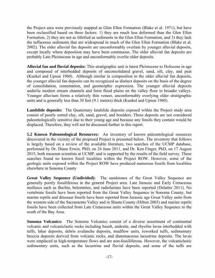
5.1 Project Geology .............................................................................................. 12 5.2 Known Paleontological Resources ................................................................. 18
5.3 Museum Records Search ................................................................................ 20 5.4 Field Inspection .............................................................................................. 20 SECTION 6 Paleontological Significance and Sensitivity ..................................................... 25
6.1 Definitions of Significance and Significance Criteria .................................... 25 6.2 Definitions of Sensitivity and Sensitivity Criteria ......................................... 26
6.3 Determination of Sensitivity for Geologic Units within Study Area ............. 27 SECTION 7 Findings and Recommendations ........................................................................ 33 7.1 Findings .......................................................................................................... 33 7.2 Recommendations .......................................................................................... 33 SECTION 8 Acronyms ............................................................................................................. 35 SECTION 9 References ............................................................................................................ 36
LIST OF FIGURES
Figure 1 Satellite photograph of the proposed Fulton-Fitch Mountain Reconductoring Project area .................................................................................................................... 4 Figure 2 Geologic map showing the location of the proposed Fulton-Fitch Mountain Reconductoring Project ............................................................................................... 14 Figure 3 Road cut exposure of water-lain tuffs in the Sonoma Volcanics along Chalk Hill Road approximately one mile east of the Project ROW ...................................... 16 Figure 4 Road cut exposure of Glen Ellen Formation along Chalk Hill Road approximately one-quarter mile west of the Project ROW ................................................................. 17 Figure 5 Geologic map showing PFYC ratings for geologic units potentially impacted by the proposed Fulton-Fitch Mountain Reconductoring Project .................................... 31

- iii -
LIST OF TABLES Table 1 Project components involving significant potential ground disturbance ................................ 22 Table 2 Paleontological sensitivities of geologic formations that may be impacted by the proposed Fulton-Fitch Mountain Reconductoring Project ............................................. 30
LIST OF APPENDICES
Appendix A Records Search Results: UCMP Data ..................................................................... 42 Appendix B Staff Resumes ......................................................................................................... 44

-1-
SECTION 1
SUMMARY OF FINDINGS The purpose of this report is to provide an assessment of potential adverse impacts on scientifically significant paleontological resources (fossils – the remains of prehistoric plants and animals) resulting from earth-moving activities related to the Fulton-Fitch Mountain Reconductoring Project (hereinafter Project). The proposed Project by Pacific Gas and Electric (PG&E) consists of the reconductoring the Fulton-Hopland 60kV transmission line between the Fulton and Fitch Mountain Substations as well as reconductoring of small segments of adjacent transmission lines. The purpose of the Project is to ensure that safe and reliable electric service will remain available to existing and future development. Proposed Project activities include the replacement of wood transmission poles with either light duty steel poles (LDSP) or tubular steel poles (TSPs); the installation of new cables; and the repairing or upgrading of insulators, switches, and other associated equipment. PaleoResource Consultants (PRC) was retained by Tremaine & Associates, Inc., subcontracted to TRC Companies, Inc. (TRC) to complete the Paleontological Evaluation Report (PER) presented below. This PER presents the results of the impact assessment and makes recommendations for mitigating potential adverse impacts of Project construction on known and suspected paleontological resources. Five (5) geologic units may be impacted by the proposed Project. From oldest to youngest, these units are the Mio-Pliocene Sonoma Volcanics, Plio-Pleistocene Glen Ellen Formation (Quaternary/Tertiary Gravels), Pleistocene older alluvial fan deposits, Quaternary landslide deposits, and younger alluvial fan deposits. However, the Quaternary landslide deposits and younger alluvial fan deposits are not paleontologically significant due to their young age and because any fossils they contain would be displaced and no longer found in situ. Only the older three (3) units will be considered further in this report.
Based on the Bureau of Land Management (BLM) Potential Fossil Yield Classification (PFYC) rating system three of the geologic units, the Sonoma Volcanics, the Glen Ellen Formation, and the older alluvial fan deposits, have a high sensitivity (Class 4) with respect to paleontological resources. Using the same criteria, the Great Valley Sequence is assigned a moderate paleontological sensitivity (Class 3). The younger alluvial fan deposits are assigned a low paleontological sensitivity (Class 1 and 2).
Actual impacts on paleontological resources will be related closely to the location and depth of excavations (e.g., access road cuts, boring, and grading) in paleontologically sensitive geologic units within the Project area. Units identified as having a Class 4 potential (Sonoma Volcanics, Glen Ellen Formation, and older alluvial fan deposits) should receive part-time monitoring by a qualified paleontologist, while those identified as having a Class 1 or 2 potential (Quaternary landslides and younger alluvial fan and fluvial deposits) should require no monitoring.

-2-
SECTION 2
INTRODUCTION 2.1 Project Location The proposed Project by PG&E consists of the reconductoring of a 9.9-mile (15.8 km) long segment of the Fulton-Hopland 60kV transmission line between the Fulton and Fitch Mountain Tap and 1.3 miles (2.1 km) of the Geysers #12-Fulton Line. The Project is located to the east of Highway 101 on the east side of the Santa Rosa Valley between the cities of Windsor and Healdsburg in Sonoma County, California (Figure 1). The Project originates at the Fulton Substation located in Fulton, a census-designated place within the Santa Rosa Valley and extends more or less northwards to terminate at the Fitch Mountain Tap located on a ridge on the Minaglia Ranch to the south of the Russian River and Healdsburg, CA. 2.2 Project Description PG&E proposes to reinforce the electric transmission system in Sonoma County by replacing conductor (reconductoring) and poles on portions of the Fulton-Hopland 60 kilovolt (kV) Power Line (Fulton-Hopland Line). The Project will also include the reconductoring of a minor segment of the #12 circuit of the existing double-circuit Geysers-Fulton 230 kV Transmission Line (Geysers #12-Fulton Line) and minor modifications to Fitch Mountain Substation. The following project details may be subject to minor modifications once project construction and engineering are finalized. The Project will consist of the following components: Fulton-Shiloh segment. The existing, single-circuit Fulton-Hopland Line is primarily
underbuilt (supported on the same structures) on tubular steel poles (TSPs) that also support the double-circuit Geysers-Fulton 230 kV Transmission Line for the first 1.8 miles (2.9 km) of the Project. Although the existing TSPs will remain, conductors on both the existing Fulton-Hopland 60 kV Line and the Geysers #12-Fulton circuit of the Geysers-Fulton 230 kV Line will be replaced.
Shiloh-Fitch segment. The existing Fulton-Hopland Line between the Geysers-Fulton 230 kV Transmission Line takeoff pole and the Fitch Mountain Tap is supported primarily by wood poles for the remaining 8.1 miles (13 km) of the proposed Project. To support the new conductor, these poles (approximately 68 pole structures) will be replaced either with LDSPs or TSPs (at locations with large spans).
Substation modifications. Minor modifications to substation equipment at Fitch Mountain Substation will be completed to tie the upgraded line into the existing system.
Potential impacts to paleontological resources can arise due to project activities that impact potentially fossiliferous geologic units (i.e., earth disturbance activities). For this Project, the following is a description of Project earth disturbance activities.

-3-
Figure 1. Satellite photograph of the proposed Fulton-Fitch Mountain Reconductoring Project area.
Pole Replacement: Approximately 68 of the 71 current poles within the Shiloh-Fitch segment will be replaced with a combination of LDSPs and TSPs. Replacement LDSPs will be approximately 3 feet (0.9 meters) at the base and range in height from 58-73 feet (17.7-22.3 meters). Each pole will be embedded in the ground to a depth of approximately 14 feet (4.3 meters). Replacement TSPs will be approximately 2 feet (0.6 meters) wide at the base and reach heights of approximately 60-75 feet (18.3-22.9 meters). All TSPs will have concrete foundations approximately 5 feet (1.5 meters) in diameter reaching depths of approximately 20 feet (6.1 meters). Pole installation will be accomplished by a combination of auguring and hand tools and will require the excavation of a hole 3 to 6 feet (0.9-1.8 meters) in diameter and 14-30 feet (4.3-9.1 meters) deep. Staging Areas: Staging areas for workers, vehicle parking, helicopter landing and refueling, and equipment and construction material storage will be prepared at least at the following locations:
River Road Park and Ride, located south of Fulton Substation; an undeveloped area along the existing alignment on the north side of Shiloh Ridge Road; an undeveloped area 200 feet (70 meters) southeast of Brooks Road; an undeveloped area approximately 500 feet (152 meters) east of Foothill Regional Park; an area at Minaglia Ranch; and other PG&E facilities, such as Airport Yard, located near the Santa Rosa Airport, and Fulton Substation.

-4-
Staging areas are expected to range in size from 1-5 acres (0.4-2.0 hectares). Preparation of these areas will involve placement of geotextile fabric and gravel, but no grading will be required. Access Roads: Project work areas will be accessed using a combination of public and private roads, existing unpaved access roads, and overland travel routes that are currently used for operation and maintenance. No new roads are proposed. A width of approximately 16 feet (4.9 meters) will be required to allow the passage of construction vehicles. Most existing dirt and gravel access roads will require vegetation trimming and removal, and several will require improvements consisting of minor grading and laying of gravel to improve traction and all-weather access. Turnarounds, requiring minor grading to prepare, are proposed for seven (7) locations along the Shiloh-Fitch segment. Vegetation Clearance: Approximately 30 acres (12.1 hectares) of vegetation trimming and tree and shrub removal is proposed. About 200 trees are expected to be removed. Vegetation trimming and removal will be accomplished by hand crews with hand and chain saws, driving line trucks with pull-behind chippers. Pull Sites: Pull sites are required to install the new conductor onto poles. Six (6) pull sites will be needed along the Fulton-Fitch segment where the alignment changes, approximately one (1) pull site every mile. The footprint of each pull site will vary depending on local conditions and will range in size from 0.6 to 0.8 acres (0.2 to 0.3 hectares). Pull sites outside of paved areas will require minor ground disturbance to ensure a flat working surface, namely minor blading, grading, and filling. 2.3 Purpose of Investigation PaleoResource Consultants (PRC) was retained by Tremaine & Associates, Inc., subcontracted to TRC Companies, Inc. (TRC) to complete the PER presented below. This PER presents the results of the impact assessment and makes recommendations for mitigating potential adverse impacts of Project construction on known and suspected paleontological resources. This PER meets all requirements of the National Environmental Policy Act (NEPA), California Environmental Quality Act (CEQA), and the standard procedures for mitigating adverse construction-related environmental impacts on paleontological resources established by the Society of Vertebrate Paleontology (SVP 2010, see Appendix A). This PER was prepared by Dr. David Haasl, PhD, Senior Paleontologist; Dr. Lanny H. Fisk, PhD, PG, a California registered Professional Geologist (PG) and Principal Paleontologist, and Brendan J. Pfeiffer, Staff Paleontologist, all with PRC. This report and its identification and analysis of the paleontological sensitivity of geologic units located within the Project area is based on a field survey of the Project area and a review of the available geological and paleontological literature and museum records of the University of California Museum of Paleontology (UCMP), summarized in an earlier report on the Project area (Pratt et al. 2011).

-5-
SECTION 3
REGULATORY FRAMEWORK Paleontological resources are classified as non-renewable scientific resources and are protected by several federal and state statutes (California State Historic Preservation Office 1983; Marshall 1976; West 1991; Fisk and Spencer 1994; Gastaldo 1999), most notably by the 1906 Federal Antiquities Act and other subsequent federal legislation and policies and by the State of California’s environmental regulations (CEQA, Section 15064.5). Professional standards for assessment and mitigation of adverse impacts on paleontological resources have been established by the SVP (2010). Design, construction, and operation of the proposed Project needs to be conducted in accordance with regulations applicable to paleontological resources. Therefore, the LORS applicable to paleontological resources are briefly summarized below. 3.1 Federal Regulations Federal legislative protection for paleontological resources stems from the Antiquities Act of 1906 (Public Law [P.L.] 59-209; 16 United States Code [U.S.C.] 431 et seq.; 34 Statute 225), which calls for protection of historic landmarks, historic and prehistoric structures, and other objects of historic or scientific interest on federal land. The Antiquities Act of 1906 forbids disturbance of any object of antiquity on federal land without a permit issued by the responsible managing agency. This act also establishes criminal sanctions for unauthorized appropriation or destruction of antiquities. The Federal Highways Act of 1958 specifically extended the Antiquities Act to apply to paleontological resources and authorized the use of funds appropriated under the Federal-Aid Highways Act of 1956 to be used for paleontological salvage in compliance with the Antiquities Act and any applicable state laws (Fisk and Spencer 1994). The language in the Highways Act makes it clear that Congress intended that, to be in compliance with the Antiquities Act, highway construction projects must protect paleontological resources. Federal protection would apply to this Project if it is federally funded or located on federal lands. Paleontological resources on federal lands are also explicitly protected under the Paleontological Resources Preservation Act of 2009 (16 U.S.C. 470aaa). This act, signed into law on 30 March 2009, criminalizes the unauthorized removal of fossils from federal land. In addition to the Antiquities Act and the Paleontological Resources Preservation Act, other Federal statutes protecting fossils include the following. The National Environmental Policy Act of 1969 (P.L. 91-190, 31 Statute 852, 42 U.S.C. 4321-4327) requires that important natural aspects of our national heritage be considered in assessing the environmental consequences of any proposed project. The Federal Land Policy Management Act of 1976 (P.L. 94-579; 90 Statute 2743, U.S.C. 1701-1782) requires that public lands be managed in a manner that will protect the quality of their scientific values. Paleontological resources are also afforded federal protection under Code of Federal Regulations Title 40, Section 1508.27 as a subset of scientific resources. 3.2 State Regulations The primary California state environmental law protecting fossils is the California Environmental Quality Act (CEQA; Public Resources Code Section 21000 et seq.). CEQA requires that public agencies and private interests identify the environmental consequences of

-6-
their proposed projects on any object or site of significance to the scientific annals of California (Division I, California Public Resources Code, Section 5020.1 [b]). Administrative regulations for the implementation of CEQA are set forth in the California Code of Regulations (CCR) Section 15000 et seq., commonly known as the “CEQA Guidelines”. The Guidelines define procedures, types of activities, persons, and public agencies required to comply with CEQA. Appendix G of the Guidelines also contains an Environmental Checklist of questions that a lead agency should normally address if relevant to a project’s environmental impacts. One of the questions to be answered in this Environmental Checklist (CCR Section 15063; Appendix G, Section V, Part c) is the following: “Would the project directly or indirectly destroy a unique paleontological resource or site…?”
Although neither CEQA nor the Guidelines define “a unique paleontological resource or site”, CEQA Section 21083.2 defines “unique archaeological resources” as “…any archaeological artifact, object, or site about which it can be clearly demonstrated that, without merely adding to the current body of knowledge, there is a high probability that it meets any of the following criteria:
1) Contains information needed to answer important scientific research questions and that there is a demonstrable public interest in that information.
2) Has a special and particular quality such as being the oldest of its type or the best available example of its type.
3) Is directly associated with a scientifically recognized important prehistoric or historic event.”
With only slight modification, this definition is equally applicable to recognizing “a unique paleontological resource or site”. Additional guidance is provided in CEQA Guidelines Section 15064.5 (a)(3)(D), which indicates “generally, a resource shall be considered historically significant if it has… yielded, or may be likely to yield, information important in prehistory or history”, including fossils that yield “information important in prehistory....”
CEQA Guidelines Section XVII, Part a, of the Environmental Checklist asks a second question equally applicable to paleontological resources: “Does the Project have the potential to…eliminate important examples of the major periods of California history or pre-history?” Fossils are important examples of the major periods of California prehistory. To be in compliance with CEQA, environmental impact assessments, statements, and reports must answer both these questions in the Environmental Checklist. If the answer to either question is yes, a mitigation must be considered or implemented to protect significant paleontological resources.
The State of California Public Resources Code (Chapter 1.7), Sections 5097.5 and 30244, includes additional state level requirements for the assessment and management of paleontological resources. These statutes require reasonable mitigation of adverse impacts to paleontological resources resulting from development on state lands, define the removal of paleontological sites or features from state lands as a misdemeanor, and prohibit the removal of any paleontological site or feature from state land without permission of the applicable jurisdictional agency. Section 30244 requires reasonable mitigation for impacts on paleontological resources that occur as a result of development on public lands.

-7-
3.3 County Regulations California Planning and Zoning law requires each county and city jurisdiction to adopt a comprehensive, long-term general plan for its development. Cities and county general plans may include objectives, policies, and actions for the identification and protection of paleontological resources. However, because the CPUC has exclusive jurisdiction over utility project siting, design, and construction, PG&E is not subject to local discretionary regulations. A description of regulations that designate local paleontological resources is provided below for informational purposes and to assist with CEQA review.
The Open Space and Resource Conservation (OSRC) Element of the Sonoma County General Plan 2020 (2008) contains the following provision regarding paleontological resources:
Policy OSRC-19j: Develop an archaeological and paleontological resource protection program that provides:
(1) Guidelines for land uses and development on parcels identified as containing such resources, (2) Standard project review procedures for protection of such resources when discovered during excavation and site disturbance, and (3) Educational materials for the building industry.

-8-
SECTION 4
METHODS 4.1 Professional Standards PG&E has adopted the Bureau of Land Management (BLM) classification system for ranking areas according to their potential to contain significant fossils (BLM 1998, PG&E 2014). This ranking system, known as the Potential Fossil Yield Classification (PFYC), ranks areas according to their potential to contain significant fossils. These rankings are used in land-use planning, as well as to identify areas that may warrant special management and/or special designation such as Areas of Critical Environmental Concern. The SVP, a national scientific organization of professional vertebrate paleontologists, has established standard procedures (SVP 2010) that outline acceptable professional practices in the conduct of paleontological resource assessments and surveys, monitoring and mitigation, data and fossil recovery, sampling procedures, and specimen preparation, identification, analysis, and curation. Most practicing professional paleontologists in the nation adhere closely to the SVP’s assessment, mitigation, and monitoring requirements as specifically spelled out in its standard procedures. The SVP’s standard procedures were approved by a consensus of professional paleontologists and are the standard against which all paleontological monitoring and mitigation programs are judged. Many federal and state regulatory agencies have either formally or informally adopted the SVP’s standard procedures for the mitigation of construction-related adverse impacts on paleontological resources, including both federal (FERC, USFS, BLM, NPS, etc.) and state agencies (CEC, CPUC, Caltrans, etc.). Briefly, SVP standard procedures require that each project have literature and museum archival reviews, a field survey, and, if there is a high potential for disturbing significant fossils during project construction, a mitigation plan that includes monitoring by a qualified paleontologist to salvage fossils encountered, identification of salvaged fossils, determination of their significance, and placement of curated fossil specimens into a permanent public museum collection (such as the designated California state repository for fossils, UCMP. As it has been adopted by PG&E, the PFYC system will be used and discussed in this report. 4.2 Literature Review and Records Search A paleontological resource inventory report (Pratt et al. 2011) was previously prepared for this project by PRC. Much of this earlier report forms the basis of this PER. The findings of Pratt et al. (2011) were based on the compilation, synthesis, and review of the available published and unpublished literature, geologic maps, and a records search of the UCMP specimen and locality database. In addition to the literature and locality search, the following paleontologists and geologists with knowledge of the geology and paleontology of the Project area were consulted: Dr. Pat Holroyd, PhD (UCMP), and Mr. James Allen, MSc, consulting paleontologist.

-9-
4.3 Field Inspection Two field surveys, which included visual inspection of exposures of potentially fossiliferous strata in the Project area, were conducted to document the presence of sediments suitable for containing fossil remains at areas of proposed ground disturbance within the Project area and the presence of any previously unrecorded fossil sites. The first field survey was conducted 08 and 09 November 2012 by Dr. Lanny H. Fisk, PhD, Principal Paleontologist, and Dr. David M. Haasl, PhD, Senior Paleontologist, both with PRC. A second survey was conducted from 16-20 August 2015 by PRC Staff Paleontologists Stephen J. Blakely and Brendan J. Pfeiffer. Dr. David Haasl, PhD, joined the survey team on 20 August 2015 to resolve stratigraphic questions and review the results of the survey. 4.4 Key Personnel Project Paleontologist Dr. Lanny H. Fisk, PhD, PG, has over 30 years experience as a professional paleontologist and 25 years as a paleontological consultant doing paleontological resource impact assessments and surveys, preparing CEQA and NEPA environmental documents and mitigation measures, designing and managing environmental compliance monitoring programs, and coordinating and consulting with state and federal resource agencies to resolve environmental concerns regarding paleontological resources. He has been a consulting paleontologist on numerous large earth-moving construction projects in California, including pipelines, power plants, highways, tunnels, dams, fiber-optic cables, landfills, and housing developments. These projects have involved extensive coordination and consultation with project sponsors, other consulting firms, and permitting agencies; adherence to strict delivery schedules; and completion within specified budget limits. Dr. Fisk has also taught paleontology courses at the university/college level and authored or co-authored scientific research contributions on paleontological resources. His experience includes preparing paleontological resource impact assessments or paleontological resource monitoring and mitigation programs. Dr. Fisk has a PhD degree with emphasis in paleobiology, plus all the coursework and research for a PhD in Geology. He holds a Bureau of Land Management Scientific Paleontological Collecting Permit, which demonstrates the qualification to do Federal Antiquities Act studies. Dr. David M. Haasl, PhD, has five (5) years experience as a museum scientist at UCMP and is the author of several scientific papers on paleontology, specifically on Cenozoic marine molluscs. He has a PhD in paleobiology from the University of California at Davis and a MSc in paleontology from Western Washington University. Dr. Haasl has five (5) years experience in paleontological mitigation and has contributed to the preparation of numerous paleontological resource impact assessments, field surveys, and paleontological mitigation and monitoring plans. Brendan J. Pfeiffer has a BSc in Geology from University of Northern Colorado. He is a staff paleontologist with PRC and has experience with field assessments, fossil recovery and cataloging, daily report generation, and laboratory preparation and identification of micro- and macrofossils. Stephen J. Blakely has several years experience working in the construction industry and geological experience working at the University of California at Davis’ sedimentology laboratory. He has a background in geology from study at the University of California at Davis.

-10-
He has contributed on the preparation of numerous paleontological resource impact assessments and surveys, as well as on the preparation of paleontological mitigation and monitoring plans.

-11-
SECTION 5
RESULTS 5.1 Project Geology: Regional geologic mapping in the vicinity of the proposed Project has been provided by Jenkins (1938), Bailey (1946), Gealey (1951), Cardwell (1965), Fox et al. (1973), Jennings et al. (1977), Huffman and Armstrong (1980), Fox et al. (1985b), Blake et al. (2000, 2002), and Delattre (2011). These geologic maps were reviewed to determine the stratigraphic units that might be impacted by Project-related excavations. During the field surveys for this proposed Project, these geologic maps were “ground-truthed” and determined to be reasonably accurate, given the limited exposures and extensive vegetation cover. Stratigraphy was observed primarily in natural exposures, road cuts, and drainage ditches. The proposed Project is located within the Coast Ranges Physiographic Province, which is positioned south of the Klamath Mountains Physiographic Province, north of the Transverse Ranges Physiographic Province, west of the Great Valley Physiographic Province, and east of the Pacific Ocean. The Coast Ranges Physiographic Province generally consists of folded and faulted, northwest trending mountain ranges separated by narrow valleys underlain by thick, highly deformed Mesozoic and Cenozoic rock units that are in places overlain by younger volcanic and sedimentary deposits (Blake et al. 2002). Both mountains and valleys are composed of three major pre-Tertiary rock groups: the Franciscan Complex, the Coast Range ophiolite, and the Great Valley Sequence (Gealey 1951). All three pre-Tertiary rock groups, which overlap in age, were tectonically accreted to the continental margin of California during Mesozoic to early Cenozoic time (Wakabayashi and Unruh 1995, Graymer et al. 2006). During and after accretion, the rocks were folded and faulted into mountain ranges and intervening valleys (Taliaferro 1943). Most of the valleys and ridges have formed in response to regional tectonic stresses which produced northwest-trending, right-lateral, strike-slip faults, high-angle reverse faults, and normal faults. These faults are part of the San Andreas Fault system that occupies a wide strip of coastal California north of the San Francisco Bay (Fox 1983). Basement rocks in the vicinity of the Project area consist of the largely Mesozoic age metamorphosed Franciscan Complex and Late Jurassic to Early Cretaceous age sedimentary rocks of the Great Valley Sequence. These units crop out intermittently to the west of the proposed Project in places where overlying rocks have been removed by erosion and northeast of the Project area where they form the core of the Mayacamas Mountains (Blake et al. 2002, Delattre 2011). The Franciscan Complex consists of deformed, metamorphosed, marine sedimentary rocks intercalated with pillow basalts and basic igneous rocks. However, the Franciscan rocks do not outcrop within the immediate Project area and will not be discussed further in this report. The Great Valley Sequence consists of interbedded marine clastic sediments that were deposited on submarine fans or other deeper marine environments. In the study area, the units that overly the Franciscan and Great Valley rocks are the Mio-Pliocene Sonoma Volcanics, Plio-Pleistocene Glen Ellen Formation, Pleistocene older alluvial fan deposits, latest Pleistocene and Holocene younger alluvial fan and fluvial deposits, and

-12-
Quaternary landslide deposits. The Great Valley Sequence and the overlying geologic units will be discussed separately below. Blake et al. (2002) described the geological environment in the Project vicinity during the late Tertiary as one of low-lying coastal hills (likely underlain by Franciscan Complex rocks) and shallow marine embayments flanked on the east by active volcanic centers which produced the Sonoma Volcanics. Episodic volcanic ash eruptions spilled across the west-facing alluvial fans to produce the interbedded alluvial and tuffaceous deposits of the Glen Ellen Formation. During the Pleistocene, beginning about 2.6 million years ago, glaciation resulted in a marine regression. River gradients were greatly steepened from the combined effects of lowered sea level and tectonic uplift of the still emerging Coast Ranges. These effects resulted in deep incision of river canyons through the stratigraphic succession, including the underlying Franciscan Complex bedrock. At the end of Pleistocene glaciation, as sea level rose, the mouths of rivers were flooded and sediment spilled out across the valley floor, forming the older alluvial deposits, which were subsequently tectonically uplifted and preserved. In the latest Pleistocene and Holocene time, younger alluvial deposits were deposited as fans near the mouths of streams and across the valley floor. Some of these sediments have been locally displaced, forming landslide deposits. The geology exposed in the Project vicinity consists largely of Tertiary and Quaternary age sedimentary and volcanic rocks, overlying older sedimentary and metamorphic rocks in a highly structurally complex area with numerous active and inactive faults. Geologic mapping in the vicinity of the proposed Project has been provided by Jennings et al. (1977, 1:750,000), Jenkins (1938, 1:500,000), Koenig (1963, 1:250,000), Wagner and Bortugno (1982, 1:250,000), Fox et al. (1985b, 1:125,000), Blake et al. (2000, 2002; 1:100.000), Bailey (1946, 1:62,500), Gealey (1951, 1:62,500), Cardwell (1965, 1:62,500), Blake et al. (1971, 1:62,500), Fox et al. (1973, 1:62,500), Huffman and Armstrong (1980, 1:62,500), and Delattre (2011, 1:24,000). The geologic maps listed above were reviewed to determine the stratigraphic sequence of rocks that might be impacted by Project-related excavations. Unfortunately, in their geologic maps of the middle to late Cenozoic deposits of the study area, geologists have not always used formally named stratigraphic units and have not consistently used the same map units. The mapping by Delattre (2011) is the most recent, high resolution geological mapping of the study area and its nomenclature is largely adopted in this report. The information in the geological maps listed above and the available geological literature form the basis of the following discussion. Individual maps and publications are incorporated into this report and referenced where appropriate. The aspects of geology pertinent to this report are the types, distribution, and age of the rocks and sediments immediately underlying the Project area and their probability of producing fossils during Project construction. The site-specific geology in the immediate vicinity of the Project ROW is discussed separately below.
The anticipated excavation activities in support of the proposed Project have the potential to affect a number of Pliocene, Plio-Pleistocene, Pleistocene, and Holocene age stratigraphic units, including from oldest to youngest, the Sonoma Volcanics, Glen Ellen Formation, older alluvial

-13-
Figure 2. Geologic map showing the location of the proposed Fulton-Fitch Mountain Reconductoring Project. Modified from the 1:24,000 scale geologic map by Delattre (2011).

-14-
fan deposits, younger alluvial fan and fluvial deposits, and Quaternary landslide deposits (Delattre 2011 see Figure 2). Cretaceous Great Valley Sequence (Undivided): The Jurassic to Late Cretaceous Great Valley Sequence is composed of interbedded sandstones, mudstones and shales originally deposited on a submarine fan along the continental margin (Graymer et al. 2002). To the east of the Project, along the western margin of the Sacramento Valley, the Great Valley Sequence has been subdivided into six formations (Kirby 1943). However, towards its western extent (including the area of the proposed Project), much of the unit remains undivided with only poor age controls. Within the Project vicinity, the Great Valley Sequence consists of Upper Jurassic to Lower Cretaceous marine sandstones and mudstones (Fox 1983, Blake et al. 2002, Dellattre 2011). Concretionary carbonate interbeds within this unit have produced invertebrate fossils, including Buchia, belemnites, and radiolarians (Delattre 2011). This unit is not exposed at the surface in the Project right-of-way (ROW) but could be present at an unknown depth underneath the Sonoma Volcanics. These rocks are, in turn, underlain at an unknown depth by the Franciscan Complex and the Coast Range Ophiolite (McLaughlin et al. 2004). It is highly unlikely that rocks of either the Franciscan Complex or Coast Range Ophiolite will be impacted by Project construction. However, it is possible that rocks of the Great Valley Sequence could be impacted. Sonoma Volcanics: The volcanic and volcaniclastic rocks now recognized as the Sonoma Volcanics were first described by Osmont (1905) who subdivided them, in ascending order, into the Mark West Andesite, Sonoma Tuff, and St. Helena Rhyolite. Later workers (e.g., Morse and Bailey 1935, Weaver 1949) combined Osmont’s units into the Sonoma Volcanics. This nomenclature has been followed by later workers and will be used in this report. The Sonoma Volcanics are widely distributed throughout Sonoma and Napa Counties. In the Project area, the Sonoma Volcanics unconformably overlie the Great Valley Sequence, and are conformably underlain by and are in part coeval with the Glen Ellen Formation. Where not overlain by the Glen Ellen Formation, the Sonoma Volcanics are overlain by Pleistocene older alluvial fan deposits. The Sonoma Volcanics include tuff, obsidian, lava flows, pyroclastic breccia, and mud flows which range in composition from rhyolite to basalt, along with interbedded volcaniclastic sedimentary rocks. This volcanic material originated from numerous vents and fissures that intermittently erupted material of variable chemical and lithologic composition forming a complex assemblage of flows, dikes, plugs, mudflows, breccias, pumice beds, and intercalated bodies of stratified material, essentially volcanic in composition, but largely sedimentary in deposition (Fox et al. 1985a). These rocks have been folded, faulted, and eroded so that they now form a series of elongate ridges separated by narrow alluvial valleys. Andesitic and basaltic flows form the most prominent outcrops of the Sonoma Volcanics because of their hard, erosionally resistant qualities (Gealey 1951). According to Weaver (1949), lava flows constitute more than 60 percent of the entire sequence. However, water-lain tuffs and tuffaceous diatomites may be several hundreds of feet thick (Kunkel and Upson 1960, see Figure 3). On the basis of their stratigraphic position, the Sonoma Volcanics are interpreted to be Miocene to Pliocene in age (Delattre 2011). Additional evidence supporting this age

-15-
Figure 3. Road cut exposure of water-lain tuffs in the Sonoma Volcanics along Chalk Hill Road approximately one mile east of the Project ROW. assignment is provided by plant fossils found in diatomaceous deposits in the middle part of the Sonoma Volcanics and identified by Axelrod (1944, 1950). Radiometric ages from the Sonoma Volcanics range from 6.95 ± 0.2 Ma to 2.9 ± 0.2 Ma (Fox 1983; Fox et al. 1985a). The Sonoma Volcanics are thought to have formed as part of a northward younging series of volcanic centers related to initiation of the San Andreas Fault system (Fox et al. 1985b). Glen Ellen Formation: The Glen Ellen Formation and equivalents (Sweetkind et al. 2010, Wagner et al. 2011, "Fluvial and Lacutrine Deposits" of McLaughlin et al. 2004,"unnamed fluvial deposits" [QTg] of Delattre 2011 and Figure 2 of this report) are composed of a heterogeneous mixture of partially cemented, interstratified, buff to yellowish-brown clay, silt, sand, and gravel (see Figure 4). These deposits are largely fluvial in origin and consist of beds and lenses of alluvial fan and piedmont deposits interbedded with conglomerate and silicic tuffs (Cardwell 1958). Some of the deposits adjacent to and beneath the Santa Rosa Valley may have been laid down in shallow bays or lagoons and may grade westward into marine deposits (Kunkel and Upson 1960). Locally, the Glen Ellen Formation contains abundant interbeds of reworked tuff that have been mapped as a separate member by Blake et al. (2002). The reworked tuffs, along with most other clasts in the Glen Ellen Formation, appear to be derived primarily from the Sonoma Volcanics, though pebbles of Franciscan Complex rocks are common.

-16-
Obsidian pebbles are characteristic of this unit (Fox 1983, Ford 1975, Jackson 1989, Allen 2003, Delattre et al. 2007).
Figure 4. Road cut exposure of Glen Ellen Formation long Chalk Hill Road approximately one-quarter mile west of the Project ROW. In the Project area, the Glen Ellen Formation conformably overlies the Sonoma Volcanics, with the basal portion possibly being coeval and interfingering with the upper part of the Sonoma Volcanics, and is unconformably overlain on the margin of the Santa Rosa Valley by older alluvial fan deposits. The Glen Ellen Formation is Plio-Pleistocene in age (Gealey 1951) based on stratigraphic relationships with other stratigraphic units of Pliocene and Pleistocene age (Cardwell 1958). Radiometric dates from interbedded tuffs suggest that the Glen Ellen Formation is as old as 3.1 Ma (McLaughlin and Nilsen 1982) and as young as 0.8 Ma (Allen 2007). Older alluvial fan deposits: Older alluvial fan deposits, where exposed, consist principally of alluvium but are probably contemporary with and also include some terrace deposits and old valley fill. The older alluvial fan deposits are generally slightly to moderately dissected and consist of roughly horizontal beds of buff siltstone and claystone, with gray, fine- to coarse-grained pebbly sandstone, pebbly mudstone, and pebble to cobble conglomerate (see Figure 4). Clasts include silicic to intermediate volcanics, obsidian, varicolored chert, graywacke, quartzite, quartz, charcoal, and petrified wood (Blake et al. 2002). The older alluvial fan deposits within
-17-
the Project area were previously mapped as Glen Ellen Formation (Blake et al. 1971), but have been reclassified based on three factors: 1) they are much less deformed than the Glen Ellen Formation, 2) they are not as lithified as sediments in the Glen Ellen Formation, and 3) they lack the tuffaceous sediments that are widespread in much of the Glen Ellen Formation (Blake et al. 2002). The older alluvial fan deposits are unconformably overlain by younger alluvial deposits, except locally where deposition may have been continuous. The older alluvial fan deposits are probably Late Pleistocene in age and unconformably overlie older deposits. Alluvial fan and fluvial deposits: This stratigraphic unit is latest Pleistocene to Holocene in age and composed of interbedded deposits of unconsolidated gravel, sand, silt, clay, and peat (Kunkel and Upson 1960). Although similar in composition to the older alluvial fan deposits, the younger alluvial fan deposits can be recognized as distinct deposits on the basis of the degree of consolidation, cementation, and geomorphic expression. The younger alluvial deposits underlie modern stream channels and form flood plains on the valley floor in broader valleys. Younger alluvium forms a relatively thin veneer, unconformably overlying older stratigraphic units and is generally less than 30 feet (9.1 meters) thick (Kunkel and Upson 1960). Landslide deposits: The Quaternary landslide deposits exposed within the Project study area consist of poorly sorted clay, silt, sand, gravel, and boulders. These deposits are not considered paleontologically sensitive due to their young age and because any fossils they contain would be displaced. Therefore, they will not be discussed further in this report. 5.2 Known Paleontological Resources: An inventory of known paleontological resources discovered in the vicinity of the proposed Project is presented below. The inventory that follows is largely based on a review of the available literature, two searches of the UCMP database, performed by Dr. Diane Erwin, PhD, on 24 June 2011, and Dr. Ken Finger, PhD, on 17 August 2015, both museum scientists at UCMP, and is supported by the results of the field survey. These searches found no known fossil localities within the Project ROW. However, some of the geologic units exposed within the Project ROW have produced numerous fossils from localities elsewhere in Sonoma County Great Valley Sequence (Undivided): The sandstones of the Great Valley Sequence are generally poorly fossiliferous in the general Project area. Late Jurassic and Early Cretaceous molluscs such as Buchia, belemnites, and radiolarians have been reported (Delattre 2011). No vertebrate fossils have been reported from the Great Valley Sequence in Sonoma County, but marine reptile and dinosaur fossils have been reported from Jurassic age Great Valley units from the western side of the Sacramento Valley and in Shasta County (Hilton 2003) and marine reptile fossils have been collected from Late Cretaceous units within the Great Valley Sequence to the south of the Bay Area. Sonoma Volcanics: The Sonoma Volcanics consist of a diverse assortment of continental volcanic and volcaniclastic rocks including basalt, andesite, and rhyolite lavas interbedded with tuffs, lahar deposits, debris avalanche deposits, mudflow units, reworked tuffs, sedimentary breccia deposits derived from volcanic rocks, and diatomaceous lacustrine deposits. The lavas were emplaced as high-temperature flows and are non-fossiliferous. However, the volcaniclastic sedimentary units, such as the lacustrine and fluvial deposits, and some of the tuffs are

-18-
fossiliferous and have previously produced highly significant fossil floras (Axelrod 1944, 1950), including a spectacular petrified forest near Calistoga (Dorf 1930, Axelrod 1944, Fisk et al. 2013), and horse (Equus) fossils (Woodburne 1966, Fisk and others 2013, UCMP records for locality V6317). Kunkel and Upson (1960) reported finding fossils of snails and clams in the lower portion of the Sonoma Volcanics. Microfossils have also been reported from the Sonoma Volcanics. Kunkel and Upson (1960) listed diatoms identified from the middle or “diatomaceous member” (= Sonoma Tuff Member) and Zeeb et al. (1996) reported twenty-one taxa of silicified chrysophycean algal cysts also from the “diatomaceous member”. More recently, Fisk et al. (2013) reported palynomorphs (pollen, spores, algal cysts, and dinoflagellates) from both the Sonoma Tuff Member and the overlying St. Helena Rhyolite Member of the Sonoma Volcanics. Glen Ellen Formation: This unit is composed of stratified, fluvial, clay-rich deposits of poorly sorted, loosely consolidated sand, silt and gravel, interbedded with minor beds of matrix-supported conglomerate and silicic tuffs. Our search of the UCMP database produced only a single fossil locality (UCMP locality V90056) from the Glen Ellen Formation. However, fossils from this locality, consisting of Equus (horse) teeth, are only tentatively assigned to the Glen Ellen Formation and are listed in the UCMP database as being Rancholabrean in age (Late Pleistocene). If correct, this age assignment suggests that these fossils are too young to be from the Glen Ellen Formation and instead may be from the overlying older alluvial fan deposits. However, the UCMP locality is known as "Rincon Valley West" and the Glen Ellen Formation is mapped on the western Rincon Valley (Sowers 1998, Graymer et al. 2007) while the Rancholabrean-age older alluvial fan deposits are not. McLaughlin et al. (2004) indicate that the Glen Ellen Formation contains both fossil diatoms, sponge spicules, and fresh-water molluscs (see also Starratt et al. 2005). Cardwell (1958) also reported "clam shells" in a "tongue" of the Glen Ellen Formation and Charles L. Powell, II (USGS paleontologist, personal communication 01 Sepember 2015) stated that fresh-water molluscs are known from the Glen Ellen "or closely related units". Equivalent stratigraphic units informally known as the "Russian River gravels", "sands and gravel of Cotati", and "Little Lake gravels" are also fossiliferous (Cardwell 1965, McLaughlin et al. 2004, Graymer et al. 2007). Older alluvial fan deposits: Numerous Pleistocene vertebrate fossil localities have been reported from the older alluvial fan deposits within Sonoma County (Hay 1927, Savage 1951, Jefferson 1991, UCMP online database). These localities have produced a diverse assemblage of vertebrates including a turtle (Clemmys), horse (Equus), ground sloth (Glossotherium), bison (Bison), mastodon (Mammut), and deer (Odocoileus). In addition to vertebrate fossils, Blake et al. (2002) and Haydon (2007) mention petrified and charcoalified wood in this stratigraphic unit. None of these fossil localities are within the Project ROW; however, the presence of fossils elsewhere in the local area from sediments of similar age and origin to those found in the Project area suggests that additional Pleistocene fossils could be encountered during Project earth disturbance.
Alluvial fan and fluvial deposits: The younger alluvial fan and fluvial deposits in the Project area are not known to have produced fossils in the past.

-19-
5.3 Museum Record Search An inventory of known fossil localities in proximity of the Project area was accomplished by a museum records search of the UCMP, supplemented by a search of the available literature. UCMP records 166 known fossil localities from Sonoma County. The vast majority of these localities are from the Wilson Grove and Petaluma Formations, marine units exposed elsewhere in Sonoma County, but not near the Project ROW. There are ten (10) UCMP vertebrate localities known from the older alluvial fan deposits and nine (9) fossil plant localities known from the Sonoma Volcanics (see Appendix B). None of these localities are within the Project ROW, but these museum records support the determination that both the Sonoma Volcanics and older alluvial fan deposits have a high potential to produce additional fossils. 5.4 Field Inspection The initial field survey in 2012 documented the general geology of the Project area, and confirmed that the existing geologic mapping was accurate. Immediately following this field survey, new geologic mapping (Delattre 2011) became available showing the geology in greater detail. During the second, more in-depth survey in 2015, the location of each Project feature (pole location, pull-site, access roads, etc.) was visited to determine the specific geology at each site. At each site, any surficial sediment exposures, spoils from existing electrical poles or towers, or nearby geological outcrops were examined to determine the geologic formation and specific facies present at that site. In addition, attempts were made to locate any paleontological resources near each site. As a result of the 2015 survey, data were collected from each area of proposed ground disturbance and are included as Table 1. Based on available geological exposures, five (5) geologic units will be impacted by Project construction. These are: Holocene alluvial fan deposits (Qhf), Quaternary landslide deposits (Qls), Pleistocene older alluvial fan deposits (Qof), the Glen Ellen Formation (QTg), and Sonoma Volcanics (Tsv) (Delattre 2011). Additionally, where it was clear that the surficial geology was different from the underlying geology at shallow depth, inferences were made as to which geologic unit should underlie the surficial exposures (see Table 1). These inferences were made based upon geologic maps, local topography, and personal observations. Approximately the southern two-thirds of the Project ROW is underlain by either Holocene alluvial fan deposits, Quaternary landslide deposits, older alluvial fan deposits, or the Glen Formation (see Figure 2). Where observed, the younger Holocene alluvial fan deposits occur as modern valley fill, which is not potentially fossiliferous, and will not be discussed further here. The Quaternary landslide deposits, while also having a low potential for paleontological resources, occur as a surficial deposit that overlies other geological formations with variable thickness. Where Project features were located within landslide deposits, inferences were made as to what underlies the Qls at that specific location (Table 1). During the field survey, Pleistocene older alluvial fan deposits were only observed overlying the Glen Ellen Formation. These older alluvial fan deposits were observed as poorly to moderately indurated, very poorly sorted silt-cobbles with a reddish matrix. This alluvium is approximately 1 to 6 feet (0.3 to 1.8 meters) in thickness, and does not appear on the latest geologic map (Delattre 2011) at many of the locations where it was observed. Although it does not appear on the map, the description matches that of the older alluvial fan deposits described in Delattre

-20-
(2011). This alluvium appears to be thicker on the hilltops, and decreases in thickness on the slopes. The cobble component is apparent in drainages, although this is undoubtedly reworked material from erosion of the topographic highs. The alluvium is also inferred to be present in other areas where cobbles were observed at the surface but there was no access to vertical exposures. The Glen Ellen Formation underlies most of the Project ROW. This geologic unit was identified and differentiated from overlying alluvium by degree of induration, facies represented (fluvial vs. alluvial), and attitude of strata. The clasts of the Glen Ellen Formation are dominated by volcanics (andesite and basalt cobbles, obsidian pebbles, and gravel) with a minor component of chert and metamorphic clasts. The clast size varies from fine grained (silt and sand) to very coarse (cobbles), and is indicated in Table 1. The Sonoma Volcanics occur at or near the surface in the northern Project area. During the field survey, a diverse range of lithologies were observed including lava flows, mud flows, and volcaniclastic sediments (both air-fall and fluvially deposited), the latter being potentially fossiliferous facies. An approximately 3 foot (1 meter) thick volcanic mudflow was identified near pole 8/7, and fluvial facies within the Sonoma Volcanics were observed approximately one mile east of the Project ROW (see Figure 3). Directly underlying the Project ROW the topography is quite steep, with lava flows forming dominant outcrops on the topographic highs. The vegetation-covered topographic lows probably represent volcaniclastic facies and the presence of these volcanic mudflows, volcaniclastics, and fluvial/lacustrine facies in the Project vicinity make it likely that these facies will be encountered at a shallow depth.

-21-
Table 1. Project Components Involving Significant Potential Ground Disturbance that may disturb stratigraphic units with Class 3 or 4 potential to impact significant paleontological resources (fossils).
Component
Types Specific
Components Potential Ground
Disturbance Geologic
Formation Recommended
Mitigation Poles (Light-Duty Steel Poles = LDSP) (Tubular Steel Poles = TSP)
TSP 1/7 grading of large pad, 5' x 20' augered hole
Glen Ellen Formation spot check grading, spot check spoils
LDSP 1/8 grading of small pad, 3' x 14' augered hole
Glen Ellen Formation spot check grading, spot check spoils
LDSP 1/9 grading of small pad, 3' x 14' augered hole
Glen Ellen Formation spot check grading, spot check spoils
LDSP 2/0 grading of small pad, 3' x 14' augered hole
fine-grained Glen Ellen Formation spot check grading, spot check spoils
LDSP 2/1 grading of small pad, 3' x 14' augered hole
Glen Ellen Formation spot check grading, spot check spoils
LDSP 2/2 grading of small pad, 3' x 14' augered hole
Glen Ellen Formation spot check grading, spot check spoils
LDSP 2/3 grading of small pad, 3' x 14' augered hole
Glen Ellen Formation spot check grading, spot check spoils
LDSP 2/4 grading of small pad, 3' x 14' augered hole
Glen Ellen Formation spot check grading, spot check spoils
LDSP 2/5 grading of small pad, 3' x 14' augered hole
Glen Ellen Formation spot check grading, spot check spoils
LDSP 2/6 grading of small pad, 3' x 14' augered hole
Glen Ellen Formation spot check grading, spot check spoils
LDSP 3/0 grading of small pad, 3' x 14' augered hole
Glen Ellen Formation spot check grading, spot check spoils
LDSP 3/1 grading of small pad, 3' x 14' augered hole
Glen Ellen Formation spot check grading, spot check spoils
LDSP 3/2 grading of small pad, 3' x 14' augered hole
Glen Ellen Formation spot check grading, spot check spoils
LDSP 3/3 grading of small pad, 3' x 14' augered hole
fine-grained Glen Ellen Formation spot check grading, spot check spoils
LDSP 3/4 grading of small pad, 3' x 14' augered hole
fine-grained Glen Ellen Formation spot check grading, spot check spoils
LDSP 3/5 grading of small pad, 3' x 14' augered hole
Glen Ellen Formation spot check grading, spot check spoils
TSP 3/6 grading of large pad, 5' x 20' augered hole
Glen Ellen Formation spot check grading, spot check spoils
TSP 3/7 grading of large pad, 5' x 20' augered hole
Glen Ellen Formation spot check grading, spot check spoils
LDSP 3/8 grading of small pad, 3' x 14' augered hole
Glen Ellen Formation spot check grading, spot check spoils
LDSP 3/9 grading of small pad, 3' x 14' augered hole
Glen Ellen Formation spot check grading, spot check spoils
LDSP 3/10 grading of small pad, 3' x 14' augered hole
Glen Ellen Formation spot check grading, spot check spoils
LDSP 4/1 grading of small pad, 3' x 14' augered hole
Glen Ellen Formation spot check grading, spot check spoils
LDSP 4/2 grading of small pad, 3' x 14' augered hole
Glen Ellen Formation spot check grading, spot check spoils
LDSP 4/3 grading of small pad, 3' x 14' augered hole
Glen Ellen Formation spot check grading, spot check spoils
LDSP 4/4 grading of small pad, 3' x 14' augered hole
Glen Ellen Formation spot check grading, spot check spoils
LDSP 4/5 grading of small pad, 3' x 14' augered hole
Glen Ellen Formation spot check grading, spot check spoils
(continued)

-22-
Component Types
Specific Components
Potential Ground Disturbance
Geologic Formation
Recommended Mitigation
Poles (cont.) LDSP 4/5A grading of small pad, 3' x 14' augered hole
Glen Ellen Formation spot check grading, spot check spoils
LDSP 4/6 grading of small pad, 3' x 14' augered hole
Glen Ellen Formation spot check grading, spot check spoils
LDSP 5/0 grading of small pad, 3' x 14' augered hole
Glen Ellen Formation spot check grading, spot check spoils
LDSP 5/1 grading of small pad, 3' x 14' augered hole
Glen Ellen Formation spot check grading, spot check spoils
LDSP 5/2 grading of small pad, 3' x 14' augered hole
Glen Ellen Formation spot check grading, spot check spoils
LDSP 5/3 grading of small pad, 3' x 14' augered hole
Older alluvial fan deposits over Glen Ellen Formation
spot check grading, spot check spoils
LDSP 5/4 grading of small pad, 3' x 14' augered hole
Glen Ellen Formation spot check grading, spot check spoils
LDSP 5/5 grading of small pad, 3' x 14' augered hole
Glen Ellen Formation spot check grading, spot check spoils
LDSP 5/6 grading of small pad, 3' x 14' augered hole
Glen Ellen Formation spot check grading, spot check spoils
LDSP 5/7 grading of small pad, 3' x 14' augered hole
Glen Ellen Formation spot check grading, spot check spoils
TSP 6/0 grading of large pad, 5' x 20' augered hole
Glen Ellen Formation spot check grading, spot check spoils
TSP 6/1 grading of large pad, 5' x 20' augered hole
Glen Ellen Formation spot check grading, spot check spoils
LDSP 6/2 grading of small pad, 3' x 14' augered hole
Glen Ellen Formation spot check grading, spot check spoils
LDSP 6/3 grading of small pad, 3' x 14' augered hole
Glen Ellen Formation spot check grading, spot check spoils
LDSP 6/4 grading of small pad, 3' x 14' augered hole
Glen Ellen Formation spot check grading, spot check spoils
LDSP 6/5 grading of small pad, 3' x 14' augered hole
Glen Ellen Formation spot check grading, spot check spoils
LDSP 6/6 grading of small pad, 3' x 14' augered hole
Glen Ellen Formation spot check grading, spot check spoils
LDSP 6/7 grading of small pad, 3' x 14' augered hole
Glen Ellen Formation spot check grading, spot check spoils
TSP 7/0 grading of large pad, 5' x 20' augered hole
Glen Ellen Formation spot check grading, spot check spoils
LDSP 7/1 grading of small pad, 3' x 14' augered holes
Glen Ellen Formation spot check grading, spot check spoils
LDSP 7/2 grading of small pad, 3' x 14' augered hole
Quaternary landslide deposits derived from Sonoma Volcanics
spot check grading, spot check spoils
LDSP 7/3 grading of small pad, 3' x 14' augered hole
Quaternary landslide deposits derived from Sonoma Volcanics
spot check grading, spot check spoils
LDSP 7/4 grading of small pad, 3' x 14' augered hole
Glen Ellen Formation spot check grading, spot check spoils
LDSP 7/5 grading of small pad, 3' x 14' augered hole
Sonoma Volcanics with minor Quaternary landslide deposits near site
spot check grading, spot check spoils
LDSP 7/6 grading of small pad, 3' x 14' augered hole
Sonoma Volcanics with minor Quaternary landslide deposits near site
spot check grading, spot check spoils
LDSP 7/7 grading of small pad, 3' x 14' augered hole
landslide deposits over Sonoma Volcanics spot check grading, spot check spoils
LDSP 8/0 grading of small pad, 3' x 14' augered hole
Sonoma Volcanics spot check grading, spot check spoils
LDSP 8/1 grading of small pad, 3' x 14' augered hole
landslide deposits over Sonoma Volcanics spot check grading, spot check spoils
continued)

-23-
Component Types
Specific Components
Potential Ground Disturbance
Geologic Formation
Recommended Mitigation
Poles (cont.)
LDSP 8/2 grading of small pad, 3' x 14' augered hole
Sonoma Volcanics spot check grading, spot check spoils
LDSP 8/3 grading of small pad, 3' x 14' augered hole
Sonoma Volcanics spot check grading, spot check spoils
LDSP 8/4 grading of small pad, 3' x 14' augered hole
Sonoma Volcanics spot check grading, spot check spoils
LDSP 8/5 grading of small pad, 3' x 14' augered hole
Sonoma Volcanics spot check grading, spot check spoils
LDSP 8/6 grading of small pad, 3' x 14' augered hole
Sonoma Volcanics spot check grading, spot check spoils
LDSP 8/7 grading of small pad, 3' x 14' augered hole
Sonoma Volcanics spot check grading, spot check spoils
LDSP 9/0 grading of small pad, 3' x 14' augered hole
Sonoma Volcanics spot check grading, spot check spoils
LDSP 9/1 grading of small pad, 3' x 14' augered hole
Sonoma Volcanics spot check grading, spot check spoils
LDSP 9/2 grading of small pad, 3' x 14' augered hole
Sonoma Volcanics spot check grading, spot check spoils
LDSP 9/3 grading of small pad, 3' x 14' augered hole
Sonoma Volcanics spot check grading, spot check spoils
LDSP 9/4 grading of small pad, 3' x 14' augered hole
Sonoma Volcanics spot check grading, spot check spoils
LDSP 9/5 grading of small pad, 3' x 14' augered hole
Sonoma Volcanics spot check grading, spot check spoils
TSP 9/5A grading of large pad, 5' x 20' augered hole
Sonoma Volcanics spot check grading, spot check spoils
LDSP 0/1 grading of small pad, 3' x 14' augered hole
Sonoma Volcanics spot check grading, spot check spoils
LDSP 0/2 grading of small pad, 3' x 14' augered hole
Sonoma Volcanics spot check grading, spot check spoils
Pull Sites PS-01 minor grading Younger alluvial fan deposits none PS-02 minor grading Younger alluvial fan deposits none PS-03 no ground disturbance N/A none PS-04 minor grading Younger alluvial fan deposits none PS-05 no ground disturbance N/A none PS-06 major grading Glen Ellen Formation spot check grading PS-07 thru -12 only minor leveling N/A none
Staging /Work Areas
all staging areas no ground disturbance N/A none all work areas only minor leveling N/A none
Existing Access Roads
from PS-01 to -02
minor grading Younger alluvial fan deposits none
to LZ- 02 minor grading Younger alluvial fan deposits none to PS-05 widening & grading Quaternary landslide deposits derived
from Sonoma Volcanics spot check grading
Faught Road to PS-05
widening & grading Younger alluvial fan deposits none
all other roads no ground disturbance N/A none Overland Roads all other roads no ground disturbance N/A none Landing Zones LZ-01 thru -06 only minor leveling N/A none Turnarounds all turnarounds only minor grading N/A none

-24-
SECTION 6
PALEONTOLOGICAL SENSITIVITY AND SIGNIFICANCE 6.1 Definitions of Significance and Significance Criteria Paleontological resources (fossils) are the remains or traces of prehistoric plants and animals. Fossils are important scientific and educational resources because of their use in (1) documenting the presence and evolutionary history of particular groups of now extinct organisms, (2) reconstructing the environments in which these organisms lived, and (3) in determining the relative ages of the strata in which they occur and of the geologic events that resulted in the deposition of the sediments that entombed them.
Existing technical guidance such as the PFYC (BLM 2007, PG&E 2014) considers individual fossil specimens to be scientifically important if they are:
type specimens (i.e., individual(s) from which a taxon has been described), members of a rare species, members of a species that is part of a diverse assemblage wherein other species are also
identifiable, and important information regarding life histories of individuals can be drawn,
element(s) different from, or more complete than, those now available for their species, or complete specimens.
More specificially, fossils may be considered significant if they meet the following criteria:
They are scientifically judged to be important for representing rare or unknown taxa, such as defining a new species.
They are scientifically judged to represent important states in evolutionary relationships, to fill gaps or enhance under-represented intervals in the stratigraphic record.
They are scientifically judged to be important for determining or constraining relative geologic age, or for use in regional to interregional stratigraphic correlation.
They are scientifically judged to be important for reconstructing ancient organismal community structure and interpretation of ancient sedimentary environments.
They are scientifically judged to be exceptionally well or unusually or uniquely preserved, or are relatively rare in the stratigraphy.
Identifiable land mammal fossils are often considered scientifically important because of their potential use in providing age determinations and paleoenvironmental reconstructions for the sediments in which they occur. Moreover, vertebrate remains are comparatively rare in the fossil record. Although fossil plants are usually considered of lesser importance because they are less helpful in age determination and more abundant, they are actually more sensitive indicators of their environment and, thus, as sedentary organisms, more valuable than mobile animals for paleoenvironmental reconstructions. For marine sediments, invertebrate and marine algal fossils, including microfossils, are scientifically important for the same reasons that land mammal and/or land plant fossils are valuable in terrestrial deposits. The value or importance of different fossil groups varies depending on the age and depositional environment of the stratigraphic unit that contains the fossils.

-25-
6.2 Definition of Sensitivity and Sensitivity Criteria Potential Fossil Yield Classification (PFYC): The Bureau of Land Management (BLM) uses a classification system for ranking areas according to their potential to contain significant fossils. In 2007, the BLM introduced the Potential Fossil Yield Classification (PFYC) System which is intended to classify geologic units by identifying the potential for the occurrence of significant paleontological resources in a geologic unit and the associated risk for impacts within that unit. The class rankings listed below attempt to classify geologic units based upon the relative abundance of paleontological resources found within, and therefore the risk of adversely impacting those resources. Geologic units are classified under the PFYC based upon the following criteria: Class 1 – Very Low. Geologic units that are not likely to contain recognizable fossil remains.
• Units that are igneous or metamorphic, excluding reworked volcanic ash units. • Units that are Precambrian in age or older.
Class 2 – Low. Sedimentary geologic units that are not likely to contain vertebrate fossils or scientifically significant nonvertebrate fossils.
• Vertebrate or significant invertebrate or plant fossils not present or very rare. • Units that are generally younger than 10,000 years before present. • Recent aeolian deposits. • Sediments that exhibit significant physical and chemical changes (i.e., diagenetic
alteration). Class 3 – Moderate or Unknown. Fossiliferous sedimentary geologic units where fossil content varies in significance, abundance, and predictable occurrence; or sedimentary units of unknown fossil potential.
• Often marine in origin with sporadic known occurrences of vertebrate fossils. • Vertebrate fossils and scientifically significant invertebrate or plant fossils known to occur intermittently; predictability known to be low. (or) • Poorly studied and/or poorly documented. Potential yield cannot be assigned without
ground reconnaissance.
Class 3a – Moderate Potential. Units are known to contain vertebrate fossils or scientifically significant non-vertebrate fossils, but these occurrences are widely scattered. Common invertebrate or plant fossils may be found in the area, and opportunities may exist for hobby collecting. The potential for a project to be sited on or impact a significant fossil locality is low, but is somewhat higher for common fossils. Class 3b – Unknown Potential. Units exhibit geologic features and preservational conditions that suggest significant fossils could be present, but little information about the paleontological resources of the unit or the area is known. This may indicate the unit or area is poorly studied, and field surveys may uncover significant finds. The units in this Class may eventually be placed in another Class when sufficient survey and research is performed. The

-26-
unknown potential of the units in this Class should be carefully considered when developing any mitigation or management actions. Class 4 – High. Geologic units containing a high occurrence of significant fossils. Vertebrate fossils or scientifically significant invertebrate or plant fossils are known to occur and have been documented, but may vary in occurrence and predictability. Surface disturbing activities may adversely affect paleontological resources in many cases. Class 4a – Unit is exposed with little or no soil or vegetative cover. Outcrop areas are extensive with exposed bedrock areas often larger than two acres. Paleontological resources may be susceptible to adverse impacts from surface disturbing actions. Illegal collecting activities may impact some areas. Class 4b – These are areas underlain by geologic units with high potential but have lowered risks of human-caused adverse impacts and/or lowered risk of natural degradation due to moderating circumstances. The bedrock unit has high potential, but a protective layer of soil, thin alluvial material, or other conditions may lessen or prevent potential impacts to the bedrock resulting from the activity.
• Extensive soil or vegetative cover; bedrock exposures are limited or not expected to be impacted. • Areas of exposed outcrop are smaller than two contiguous acres.• Outcrops form cliffs
of sufficient height and slope so that impacts are minimized by topographic conditions.• Other characteristics are present that lower the vulnerability of both known and unidentified paleontological resources.
Class 5 – Very High. Highly fossiliferous geologic units that consistently and predictably produce vertebrate fossils or scientifically significant invertebrate or plant fossils, and that are at risk of human-caused adverse impacts or natural degradation. Class 5a – Unit is exposed with little or no soil or vegetative cover. Outcrop areas are extensive with exposed bedrock areas often larger than two contiguous acres. Paleontological resources are highly susceptible to adverse impacts from surface disturbing actions. Unit is frequently the focus of illegal collecting activities. Class 5b – These are areas underlain by geologic units with very high potential but have lowered risks of human-caused adverse impacts and/or lowered risk of natural degradation due to moderating circumstances. The bedrock unit has very high potential, but a protective layer of soil, thin alluvial material, or other conditions may lessen or prevent potential impacts to the bedrock resulting from the activity.
• Extensive soil or vegetative cover; bedrock exposures are limited or not expected to be impacted.
• Areas of exposed outcrop are smaller than two contiguous acres. • Outcrops form cliffs of sufficient height and slope so that impacts are minimized by
topographic conditions. • Other characteristics are present that lower the vulnerability of both known and
unidentified paleontological resources.

-27-
6.3 Determination of Sensitivity for Geologic Units Within Study Area A stratigraphic unit (such as a formation, member, or bed) known to contain significant fossils is considered to have a high potential to yield additional significant fossils. These paleontological resources could be adversely impacted by earth-moving or ground-disturbing activities. The resource could be disturbed or destroyed. Fossils are an integral component of the rock unit below the ground surface, and, therefore, are not observable unless exposed by erosion or human activity. Thus, a paleontologist cannot know either the quality or quantity of fossils present before the rock unit is exposed as a result of natural erosion processes or earth-moving activities. The paleontologist can only make conclusions on sensitivity to impact based upon what fossils have been found in the rock unit in the past, along with a judgment on whether or not the depositional environment of the sediments that compose the rock unit was likely to result in the burial and preservation of fossils. Fossils are seldom uniformly distributed within a rock unit. Most of a rock unit may lack fossils, but at other locations within the same rock unit concentrations of fossils may exist. Even within a fossiliferous portion of the rock unit, fossils may occur in local concentrations. For example, Shipman (1977, 1981) excavated a fossiliferous site using a three dimensional grid and removed blocks of matrix of a consistent size. The site chosen was known prior to excavation to be richly fossiliferous, yet only 17% of the excavated blocks actually contained fossils. These studies demonstrate the physical basis for the difficulty in predicting the location and quantity of fossils in advance of actual Project-related ground disturbance. The non-uniform distribution of fossils within a rock unit is essentially universal and many paleontological resource assessment and mitigation reports conducted in support of environmental impact documents and mitigation plan summary reports document similar findings (see for instance Lander 1989, 1993; Reynolds 1987, 1990; Spencer 1990; Fisk et al. 1994; and references cited therein). In fact, most fossil sites recorded in reports of impact mitigation (where construction monitoring has been implemented) had no previous surface expression. Because the presence or location of fossils within a rock unit cannot be known without exposure resulting from erosion or excavation, an entire rock unit is assigned the same level of sensitivity based on recorded fossil occurrences. Using PFYC criteria, the paleontological potential of a rock unit is the measure most amenable to assessing the significance of paleontological resources because the areal distribution of that rock unit can be delineated on a topographic or geologic map. The paleontological importance of a stratigraphic unit reflects: (1) its potential paleontological productivity (and thus sensitivity), and (2) the scientific significance of the fossils it has produced. This method of paleontological resource assessment is the most appropriate because discrete levels of paleontological importance can be delineated on a topographic or geologic map. The potential paleontological productivity of a stratigraphic unit exposed in a project area is based on the presence of fossil specimens and/or previously recorded fossil sites in exposures of the unit in and near a project site. The underlying assumption of this assessment method is that exposures of a stratigraphic unit in a project site are most likely to yield fossil remains both in

-28-
quantity and density similar to those previously recorded from that stratigraphic unit in and near the project site. The following tasks were completed to establish the paleontological significance and potential of each stratigraphic unit exposed in or near the Project site:
The potential paleontological productivity of each rock unit was assessed based on previously recorded and newly documented fossil sites it contains at and/or near the Project site.
The scientific importance of fossil remains recorded from a stratigraphic unit exposed at and/or near the Project site was assessed.
The paleontological importance of a rock unit was assessed, based on its documented and/or potential fossil content in the area surrounding the Project site.
The following is a determination of the paleontological sensitivity for each geological unit potentially impacted by Project ground disturbance and a discussion of the rationales used to assign each unit’s sensitivity rating. The PFYC rating system was used in assessing each geologic unit’s potential or sensitivity. Table 2 presents a summary of the age, lithology, known paleontological resources, and potential or sensitivity rating for each potentially impacted geologic unit. Figure 5 presents a map of the Project area illustrating the PFYC rating for each impacted geologic unit.
-29-
Table 2. Paleontological sensitivities of stratigraphic units that may be potentially impacted by construction of the Fulton-Fitch Mountain Reconductoring Project in Sonoma County, California.
Map Symbol
(Delattre 2011) Age
Stratigraphic Unit Lithology PFYC Rating
Qa, Qhf Latest
Pleistocene and Holocene
Alluvial fan and fluvial deposits
Unconsolidated gravel, sand, silt, and clay
2
Qof Pleistocene Older alluvial fan deposits
Buff siltstone and claystone with buff to gray, fine- to coarse-grained lithic sandstone, pebbly sandstone, pebbly mudstone, and pebble to cobble conglomerate
4a
QTg Plio-Pleistocene
Glen Ellen Formation
Brown- to buff-weathering, interbedded siltstone, fine- to coarse-grained sandstone, pebbly and cobbly sandstone, conglomerate, and tuff
4a
Tsb Mio-Pliocene Sonoma Volcanics
Basalt, andesite, and rhyolite lavas interbedded with tuffs, lahar deposits, debris avalanche deposits, mudflow deposits, reworked tuffs, sedimentary breccia deposits, diatomites, and lacustrine deposits
4b
KJgvs Jurassic and Cretaceous
Great Valley Sequence
Marine turbidite sandstones, siltstones, and shales
3a

-30-
Figure 5. Geologic map showing PFYC ratings for geologic units potentially impacted by the proposed Fulton-Fitch Mountain Reconductoring Project. Modified from the 1:24,000 scale geologic map by Delattre (2011).

-31-
Great Valley Sequence: The Great Valley Sequence does not outcrop within the Project ROW but does appear at the surface less than 100 yards (meters) from the Project ROW. It is overlain within the Project area by an unknown thickness of Sonoma Volcanics and Glen Ellen Formation. Deeper excavations could impact Great Valley sediments. Great Valley Sequence sediments of the age exposed near the Project have yielded invertebrate and microfossils from Sonoma County and rare vertebrate fossils from elsewhere in California. Based on these findings, the Great Valley Sequence in the vicinity of the Project is assigned a Class 3a (moderate potential yield) using the PFYC system. Sonoma Volcanics: The Sonoma Volcanics comprises a wide range of volcanic and volcaniclastic facies. Some facies, such as the basaltic and andesitic lava flows as well as pyroclastic flow breccias are extremely unlikely to produce fossils; while others such as tuffs, mudflows, and lacustrine facies have yielded fossils, some of which are highly significant. Within the Project area, lava flows are found at the surface, but the field survey found evidence that tuffaceous beds and mudflows are likely present at depth. Because sedimentary strata in the Sonoma Volcanics have produced significant plant fossils, microfossils, vertebrate fossils, and invertebrate fossils in the past and might produce additional important specimens in the future and because facies conducive to the preservation of fossils are likely present in the subsurface of the Project area, therefore, the entire Sonoma Volcanics as a stratigraphic unit is assigned a PFYC Class 4b (high potential yield). Glen Ellen Formation: This sedimentary unit consists largely of fluvial deposits interbedded with volcanic tuffs. These deposits have not produced fossils from the project area but have produced fossils elsewhere in Sonoma County. Diatoms, freshwater molluscs, and plant remains have been reported (Cardwell 1958, McLaughlin et al. 2004). Several horse teeth (UCMP locality V90056) have also been tentatively assigned to the Glen Ellen Formation. Stratigraphically equivalent beds outcropping to the north and west are also fossiliferous (Cardwell 1965, McLaughlin et al. 2004, Graymer et al. 2007). Because this geologic unit has produced fossils elsewhere in Sonoma County and because sedimentary facies conducive to the preservation of fossils (fine-grained deposits, sands, and gravels similar to fossil-bearing facies elsewhere in Sonoma County) were observed during the field survey of the project area, the Glen Ellen Formation is assigned a high sensitivity (Class 4a) using the PFYC system. Older Alluvial Fan Deposits: Pleistocene-age alluvial fan deposits have yielded vertebrate fossils in Sonoma County. For this reason, these deposits are assigned a PFYC Class 4a (high potential yield). Alluvial Fan and Alluvial Deposits: These deposits are not known to have produced fossils in the general Project area and also include sediments too young to produce significant fossils. Because these criteria, these sediments are assigned a PFYC Class 2 (low potential yield).
-32-
SECTION 7
FINDINGS AND RECOMMENDATIONS 7.1 Findings Project earth disturbance activities have the potential to impact two geologic units with a high potential paleontological yield (PFYC Class 4) (see Table 2). These units are the Sonoma Volcanics and the (Pleistocene) older alluvial fan deposits. Both of these geologic units have produced significant fossils from Sonoma County and elsewhere and there remains a good potential that they will yield additional significant fossils within the Project area. Two additional geologic units have a moderate or undetermined potential paleontological yield (PFYC Class 3): the Great Valley Sequence and the Glen Ellen Formation. Of these two, Project activities are unlikely to affect the sediments of the Great Valley Sequence even at depth but will impact the Glen Ellen Formation. Project activities that involve ground disturbance include: grading of pull sites, excavations for pole replacement, and grading to improve access roads (see Table 1). If these activities occur within geologic units of high or undetermined paleontological sensitivity, they could adversely impact significant paleontological resources and would require some level of appropriate mitigation. 7.2. Recommendations This section describes proposed mitigation measures that could be implemented to reduce potential adverse impacts to significant paleontological resources resulting from Project construction (see Table 1 for a summary). Mitigation measures are necessary because of potential adverse impacts of Project construction on significant paleontological resources within the Sonoma Volcanicsand older alluvial deposits. These units occur at or near the surface along the Project alignment as shown in Figure 2. As proscribed in the PG&E’s Paleontological Resources Standards and Procedures (PG&E 2014), excavation activities that will impact geologic units with a high potential rating require spot checking nd mitigation. In addition, because the field survey demonstrated that sediments of the Glen Ellen Formation were conducive to the burial and preservation of fossils, periodic spot checking of Project excavations within the Glen Ellen Formation is recommended to insure that fossils are not being impacted . In order to reduce potential adverse impacts to significant paleontological resources resulting from Project activities, the following Applicant Proposed Measures are proposed: PAL-1 Unanticipated Discovery If significant paleontological resources are discovered during construction activities, the following procedures will be followed:
• Stop work immediately within 100 feet; • Contact the designated project inspector and Cultural Resource Specialist (CRS) immediately; • Protect the site from further impacts, including looting, erosion or other human or natural
damage;

-33-
• The project CRS will arrange for a Principal Paleontologist to evaluate discovery. If the discovery is determined to be significant PG&E will implement measures to protect and document the paleontological resource Such measures may include preservation in place, excavation, documentation, curation, or other appropriate measures. Permission from the landowner must be secured before treating the fossil;
Work may not resume within 100 feet of the find until approval by the Principal Paleontologist and Cultural Resource Specialist. PAL-2 Workers Environmental Awareness Training If moderate, high or very high sensitivity formations are identified within the project area, PG&E (or contractor) will provide environmental awareness training on paleontological resources protection. For this Project, the Sonoma Volcanics, the Glen Ellen Formation, and older alluvial fan deposits all have moderate or high paleontological sensitivities. This training may be administered by the project paleontologist as a stand- alone training or included as part of the overall environmental awareness training as required by the project. The training will include at minimum, the following: • The types of fossils that could occur at the project site; • The types of lithologies in which the fossils could be preserved; • The procedures that should be taken in the event of a fossil discovery; • Penalties for disturbing paleontological resources. PAL-3 Monitoring Monitoring should be required all Project excavation activities that impact the Sonoma Volcanics, the Glen Ellen Formation, and the older alluvial fan deposits (see Table 1 for summary). However, since fossils do not predicatively occur within these formations and the amount of earth disturbance in relatively small, fulltime monitoring is not required, barring the occurrence of an unanticipated, highly-fossiliferous bed. Instead, monitoring will consist of periodic spot checking of grading and pole installation to check for the occurrence of fossils or facies highly likely to produce fossils. In the event that a highly fossiliferous bed is encountered, monitoring shall be fulltime until excavations within that bed are complete. Monitoring shall be done only by qualified field paleontologists. These field paleontologists will document monitoring activities on daily logs. Monitoring logs and reports should include the activities observed, geology encountered, description of any resources encountered, and measures taken to protect or recover discoveries. Photographs and other supplemental information should be included as necessary. PAL-4 Fossil Recovery In the event that significant paleontological resources are encountered during the project, protection and recovery of those resources may be required. On public lands, treatment and curation of fossils will follow procedures outlined by the land managing agency. On private property, treatment and curation of fossils will be conducted in consultation with the landowner, PG&E and the lead agency. Procedures for recovering significant fossils are typically outlined in the Paleontological Resource Monitoring and Mitigation Program. A Principal Paleontologist is

-34-
responsible for developing the recovery strategy and will lead the recovery effort, which will include establishing recovery standards, preparing specimens for identification and preservation, documentation and reporting, and securing a curation agreement from the approved agency. A Paleontological Monitor or other qualified individual may conduct the recovery of fossil discoveries under the direction of the Principal Paleontologist. The proposed mitigation program would reduce to an insignificant level the direct, indirect, and cumulative adverse environmental impacts on paleontological resources that could result from Project construction. The mitigation measures proposed are consistent with PG&E (2014) standard guidelines and procedures for mitigating adverse construction-related impacts on paleontological resources.

-35-
SECTION 8
ACRONYMS
BLM Bureau of Land Management Caltrans California Department of Transportation CCR California Code of Regulations CEC California Energy Commission CEQA California Environmental Quality Act CPUC California Public Utilities Commission CRS Cultural Resource Specialist FERC Federal Energy Regulatory Commission LDSP Light Duty Steel Poles LORS Laws, Ordinances, Regulations, and Standards Ma Millions of years NCRM North Coast Resource Management NEPA National Environmental Protection Act NPS National Park Service OSRC Open Space and Resource Conservation PG Professional Geologist PG&E Pacific Gas and Electric P.L. Public Law PRC PaleoResource Consultants SVP Society of Vertebrate Paleontology TSP Tubular Steel Poles UCMP University of California Museum of Paleontology U.S.C. United States Code USFS United States Forest Service USGS United States Geological Survey

-36-
SECTION 9
REFERENCES
Allen, J.R.,2003, Stratigraphy and tectonics of Neogene strata, northern San Francisco Bay Area: unpublished Master’s Thesis, San Jose State University, 378 p.
Allen, J.R., 2007, Composition, age and geographical extent of the Glen Ellen, Huichica and Petaluma formations, Sonoma and Napa counties, California: Geological Society of American Annual Meeting Abstracts, Denver, CO, p. 114.
Axelrod, D.I., 1944, Pliocene floras of California and Oregon: the Sonoma flora: Carnegie Institute Washington Publication 553, p. 162-206.
Axelrod, D.I., 1950, A Sonoma florule from Napa, California: Carnegie Institute Washington Publication 590, p. 23-71.
Bailey, E.H., 1946, Geological map and sections of the Mayacamas quicksilver district, Sonoma, Lake, and Napa Counties, California: California Journal of Mines and Geology, State Mineralogist’s Report, vol. 42, no. 3, pl. 29, scale 1:62,500.
Blake, M.C., Jr., Smith, J.T., Wentworth, C.M., and Wright, R.H., 1971, Preliminary geologic map of western Sonoma County and northernmost Marin County, California: U.S. Geological Survey Open-File Report 71-44, 5 sheets, scale 1:62,500.
Blake, M.C., Jr., Graymer, R.W., and Jones, D.L., 2000, Digital geologic map and map database of parts of Marin, San Francisco, Alameda, Contra Costa, and Sonoma Counties, California: U.S. Geological Survey Miscellaneous Field Studies Map MF-2337, 29 p., 2 sheets, scale 1:100,000.
Blake, M.C., Jr., Graymer, R.W., and Stamski, R.E., 2002, Geologic map and map database of western Sonoma, northern Marin, and southern Mendocino counties, California: U.S. Geological Survey Miscellaneous Field Studies Map MF-2402, 42 p, scale 1:100,000.
Bureau of Land Management (BLM), 1998, General procedural guidance for paleontological resource management: BLM Handbook H-8270-1.
Bureau of Land Management (BLM), 2007, The potential fossil yield classification (PFYC) system: BLM IM2008-009_att1.
California State Historic Preservation Office, 1983, Summary of state/federal laws protecting cultural resources: California State Historic Preservation Office, Sacramento, CA, 10 p.
Cardwell, G.T., 1958, Geology and ground water in the Santa Rosa and Petaluma Valley areas, Sonoma County, California: U.S. Geological Survey Water-Supply Paper 1427, 270 p.
Cardwell, G.T., 1965, Geology and ground water in Russian River Valley areas and in Round, Laytonville, and Little Lake Valleys, Sonoma and Mendocino Counties, California: U.S. Geological Survey, Water-Supply Paper 1548, scale 1:62,500.

-37-
Delattre, M.P., 2011, Preliminary geologic map of the Healdsburg 7.5’ Quadrangle, Sonoma County, California – a digital database: California Geological Survey, accessed at http://www.conservation.ca.gov/cgs/rghm/rgm/preliminary_geologic_maps.htm, scale 1:24,000.
Delattre, M.P., Wagner, D.L., Higgins, C.T., Witter, R.C., and Sowers, J.M., 2007, Geologic map of the Kenwood 7.5' Quadrangle, Sonoma and Napa counties, California -- a digital database: California Department of Conservation, California Geological Survey, scale 1:24,000.
Dorf, E., 1930, Pliocene floras of California: Carnegie lnstitute Washington Publication 412, p. 1-112.
Fisk, L. H., Erwin, D.M., and Elder, W., 2013, Fieldtrip guide to the Napa Valley, Calistoga Petrified Forest, Muir Redwoods, and Golden Gate Bridge headlands in northern California: AASP-The Palynological Society 46th Annual Meeting Pre-Conference Field Trip, 20 October 2013, San Francisco, CA, 21 p.
Fisk, L.H., and Spencer, L.A., 1994, Highway construction projects have legal mandates requiring protection of paleontologic resources (fossils): p. 213-225 in Burns, S.F. (editor), Proceedings of the 45th Highway Geology Symposium, Portland, OR, 258 p.
Fisk, L.H., Spencer, L.A., and Whistler, D.P., 1994, Paleontologic resource impact mitigation on the PGT-PG&E Pipeline Expansion Project, Volume II: PG&E Section, California: unpublished report prepared for the Federal Energy Regulatory Commission, California Public Utilities Commission, Pacific Gas and Electric Company, and Bechtel Corporation by Paleo Environmental Associates, Inc., Altadena, CA, 123 p.
Ford, R., 1975. Evaluation of ground water resources: Sonoma County Volume 1 -- geologic and hydrologic data: State of California Resources Agency, Department of Water Resources, 322 p.
Fox, K.F., Jr., 1983, Tectonic setting of late Miocene, Pliocene, and Pleistocene rocks in part of the Coast Ranges north of San Francisco, California: U.S. Geological Survey Professional Paper 1239, 33 p.
Fox, K.F., Jr., Sims, J.D., Bartow, J.A., and Helley, E.J., 1973, Preliminary geologic map of eastern Sonoma County and western Napa County, California: U.S. Geological Survey Miscellaneous Field Studies Map MF-483, 4 sheets, scale 1:62,500.
Fox, K.F., Jr., Fleck, R.J., Curtis, G.H., and Meyer, C.E., 1985a, Implications of the northwestwardly younger age of the volcanic rocks of west central California: Geological Society of America Bulletin, vol. 96, p. 647-654.
Fox, K.F., Jr., Fleck, R.J., Curtis, G.H., and Meyer, C.E., 1985b, Potassium-argon and fission track ages of the Sonoma Volcanics in an area north of San Pablo Bay, California: U.S. Geological Survey Miscellaneous Field Studies Map MF-1753, 9 p., 1 sheet, scale 1:125,000.
Gastaldo, R.A., 1999, International laws: collecting, transporting and ownership of fossils – USA: p. 330-338, in Jones, T. P. and Rowe, N. P. (editors), Fossil plants and spores, The Geological Society, London, England, 396 p.

-38-
Gealey, W.K., 1951, Geology of the Healdsburg Quadrangle, California: California Division of Mines Bulletin 161, 50 p., scale 1:62,500.
Graymer, R.W., Jones, D.L., and Brabb, E.E., 2002, Geologic map and map database of northeastern San Francisco Bay region, California -- most of Solano County and parts of Napa, Marin, Contra Costa, San Joaquin, Sacramento, Yolo, and Sonoma Counties: U.S. Geological Survey Miscellaneous Field Studies Map MF-2403, scale 1:100,000.
Graymer, R.W., Brabb, E.E., Jones, D.L., Barnes, J., Nicholson, R.S., and Stamski, R.E., 2007, Geologic map and map database of eastern Sonoma and western Napa counties, California: U.S. Geological Survey Scientific Investigations Map 2956, scale 1:100,000.
Hay, O.P., 1927, The Pleistocene of the western region of North America and its vertebrate animals: Carnegie Institute of Washington Publication 322, p. 1-346.
Hilton, R.P., 2003, Dinosaurs and other Mesozoic reptiles from California: University of California Press, Berkeley, CA, 356 p.
Huffman, M.E., and Armstrong, C.F., 1980, Geology for planning in Sonoma County: California Division of Mines and Geology Special Report 120, scale 1:62,500.
Jackson, T.L., 1989, Late prehistoric obsidian production and exchange in the north Coast Ranges, California: Contributions of the Archaeological Research Facility Number 48, 79-94.
Jefferson, G.T., 1991, A catalogue of late Quaternary vertebrates from California: Part Two, Mammals: Natural History Museum of Los Angeles County Technical Report No. 7, 129 p.
Jenkins, O.P., 1938, Geologic map of California: California Division of Mines and Geology, Sacramento, CA, scale 1:500,000.
Jennings, C.W., Strand, R.G., Rogers, T.H., Boylan, R.T., Moar, R.R., and Switzer, R.A., 1977, Geologic map of California: California Division of Mines and Geology, scale 1:750,000.
Kirby, J.M., 1943, Upper Cretaceous stratigraphy of the west side of the Sacramento Valley south of Willows, Glenn County, California: American Association of Petroleum Geologists Bulletin, vol. 27, p. 279-305.
Koenig, J.B., 1963, Walker Lake sheet, Geologic map of California: California Division of Mines and Geology, scale 1:250,000.
Kunkel, F., and Upson, J.E., 1960, Geology and ground water in Napa and Sonoma Valleys, Napa and Sonoma Counties, California: U.S. Geological Survey Water-Supply Paper 1495, 252 p.
Lander, E.B., 1989, Interim paleontological resource technical report, Eastside Reservoir Project Study -- Phase 1, Riverside County, California: unpublished report prepared for Metropolitan Water District of Southern California by Paleo Environmental Associates, Inc., Altadena, CA, 20 p.

-39-
Lander, E.B., 1993, Paleontologic/cultural resource impact mitigation program final report: unpublished report prepared for Midway Sunset Cogeneration Company, Mojave Natural Gas Pipeline, and Kern County, California by Paleo Environmental Associates, Inc., Altadena, CA, 57 p.
Marshall, L.G., 1976, Paleontological salvage and federal legislation: Journal of Paleontology, vol. 50, p. 346-348.
McLaughlin, R.J., and Nilsen, T.H., 1982, Neogene non-marine sedimentation and tectonics in small pull-apart basins of the San Andreas Fault system, Sonoma County, California: Sedimentology, vol. 29, no. 6, p. 865-876.
McLaughlin, R.J., Sarna-Wojcicki, A.M., Fleck, R.J., Wright, W.H., Levin, V.R.G., and Valin, V.C., 2004, Geology, tephrochonology, radiometric ages, and cross sections of the Mark West Springs 7.5’ Quadrangle, Sonoma and Napa counties, California: U.S. Geological Survey Scientific Investigations Map 2858, 16 p., scale 1:24,000.
Morse, R.R., and Bailey, T.L., 1935, Geological observations in the Petaluma district, California: Geological Society of America Bul1etin, vol. 46, p. 1437-1456.
Osmont, V.C., 1905, A geological section of the Coast Ranges north of the Bay of San Francisco: California University, Department of Geology Bulletin, vol. 4, p. 39-87.
Pacific Gas and Electric (PG&E), 2014, Paleontological Resources Standards and Procedures: Pacific Gas and Electric Company, San Ramon, CA, 44 p.
Pratt, L.R., Haasl, D.M., and Fisk, L.H., 2011, Paleontological resources inventory report for the Fulton-Fitch Mountain 60kV Reconductoring Project in Sonoma County, California: unpublished report prepared for PG&E and North Coast Resource Management by PaleoResource Consultants, Auburn, CA, 40 p.
Reynolds, R.E., 1987, Paleontologic resource assessment, Midway-Sunset Cogeneration Project, Kern County, California: unpublished report prepared for Southern California Edison Company by San Bernardino County Museum, San Bernardino, CA, 15 p.
Reynolds, R.E., 1990, Paleontological mitigation program, Midway-Sunset Cogeneration Project, Kern County, California: unpublished report prepared for Midway-Sunset Cogeneration Company, by San Bernardino County Museum, San Bernardino, CA, 45 p.
Savage, D.E., 1951, Late Cenozoic vertebrates of the San Francisco region: University of California Publications, Bulletin of the Department of Geological Sciences, vol. 28, p. 215-314.
Shipman, P., 1977, Paleoecology, taphonomic history and population dynamics of the vertebrate assemblage from the middle Miocene of Fort Turnan, Kenya: unpublished PhD dissertation, New York University, New York, NY, 193 p.
Shipman, P., 1981, Spatial distribution of fossils in sediments: p. 65-98, in Shipman, P. (editor), Life history of a fossil, an introduction to taphonomy and paleoecology, Harvard University Press, Cambridge, MA, 222 p.

-40-
Society of Vertebrate Paleontology (SVP), 2010, Standard procedures for the assessment and mitigation of adverse impacts to paleontological resources: Society of Vertebrate Paleontology, 11 p., accessed online at: http://vertpaleo.org/PDFS/24/2482305f-38f8-4c1b-934c-1022d264e621.pdf.
Sonoma County Permit and Resource Management Department, 2008, Sonoma County General Plan 2020 Open Space and Resource Conservation Element: Accessed online: http://www.sonoma-county.org/prmd/gp2020/index.html.
Spencer, L.A., 1990, Paleontological mitigation program, Midway-Sunset Cogeneration Project, natural gas pipeline, Kern County, California: unpublished report prepared for Midway-Sunset Cogeneration Company by Paleo Environmental Associates, Inc., Altadena, CA, 12 p.
Sowers, J.M., Noller, J.S., and Lettis, W.R., 1998, Quaternary geology and liquefaction susceptibility, Napa, California 1:100,000 quadrangle – a digital database: U.S. Geological Survey Open-File Report 98-460, scale 1,100,000.
Starratt, S.W., Allen, J.R., Powell, C.L., Peterson, D.E., Ruck, E., et al., 2005: Geological Society of America Abstracts with Programs, vol. 37, p. 69.
Sweetkind, D.S., Taylor, E.M., McCabe, C.A., Langenheim, V.E., and McLaughlin, R.J., 2010, Three-dimensional geologic modeling of the Santa Rosa Plain, California: Geosphere, vol. 6, p. 237-274.
Taliaferro, N.L., 1943, Geologic history and structure of the central Coast Ranges of California: California Division of Mines Bulletin 118, p. 119-163.
Wagner, D.L., and Bortugno, E.J., 1982, Geologic map of the Santa Rosa Quadrangle, California: California Division of Mines and Geology, Regional Geol Map Series, Map #2A scale 1:250,000.
Wakabayashi, J., and Unruh J.R., 1995, Tectonic wedging, blueschist metamorphism, and exposure of blueschists - are they compatible?: Geology, vol. 23, p. 85-88.
Weaver, C.E., 1949, Geology of the Coast Ranges immediately north of the San Francisco Bay region, California: Geological Society of America Memoir 35. 78 p.
West, R.M., 1991, State regulation of geological, paleontological, and archaeological collecting: Curator, vol. 34, p. 199-209.
Woodburne, M.O., 1966, Equid remains from the Sonoma Volcanics, California: Bulletin of the Southern California Academy of Science, vol. 65, p. 185-189. Zeeb, B.A., Smol, J.P. and VanLandingham, S.L.. 1996, Pliocene chrysophycean stomatocysts from the Sonoma Volcanics, Napa County, California: Micropaleontology, vol. 42, no. 1, p. 79-91.

-41-
APPENDIX A
RECORDS SEARCH RESULTS:
UCMP DATA

-42-
Appendix B. Confidential table of UCMP fossil localities within Sonoma County from stratigraphic units which will be potentially impacted by the proposed Fulton-Fitch Mountain Reconductoring Project.
UCMP Locality Number Locality Name Age Formation Specimens Published
PA1380 Aqua Rico Ranch Pleistocene Older Alluvium 2 specimens: Turtle, Horse
PA3023 McGrew's Ranch Pleistocene Older Alluvium 1 specimen: Ground Sloth
V3646 Eureka School Pleistocene Older Alluvium 1 specimen: Bison
V3650 Crandall Pleistocene Older Alluvium 1 specimen: Ground Sloth V5213 Five Oaks Ranch Pleistocene Older Alluvium 1 specimen: Mastodon
V6517 Ducker Ranch Pleistocene Older Alluvium 1 specimen: Mastodon
V6775 Petaluma Pleistocene Older Alluvium 1 specimen: Proboscidean
V72107 Ebabias Creek Pleistocene Older Alluvium 2 specimens: Horse, Bison
V80005 Cardinaux Pleistocene Older Alluvium 1 specimen: Bison V90056 Rincon Valley West Pleistocene Glen Ellen? 1 specimens: Horse 91 Calistoga Petrified Forest I Pliocene Sonoma Tuff
150 Calistoga Petrified Forest II Pliocene Sonoma Tuff
45 specimens: Conifers, Magnoliopsids, Type Specimens Axelrod 1944
539 Calistoga Petrified Forest III Pliocene Sonoma Tuff P3845 Calistoga Petrified Forest IV Pliocene Sonoma Tuff
151 Monarch Tree Pliocene Sonoma Tuff 4 specimens: Sequoia, Oak, Bay Laurel, Type Specimens Dorf 1930
152 Matanzas Creek Pliocene Sonoma Tuff
16 specimens: Sequoia, Magnoliopsids, Type specimens Dorf 1930
153 Taylor Mountain Pliocene Sonoma Tuff 3 specimens: Chain Fern, Sequoia, Oak, Type Specimens Dorf 1930
154 Neers Hill Pliocene Sonoma Tuff
86 specimens: Conifers, Magnoliopsids, Type Specimens Axelrod 1944
PA250 Mantanzas Dam Pliocene Sonoma Volcanics

-43-
APPENDIX B
STAFF RESUMES

-44-

PaleoResource Consultants
-45-

PaleoResource Consultants
-46-

PaleoResource Consultants
-47-

PaleoResource Consultants
-48-
PaleoResource Consultants
-49-

PaleoResource Consultants
-50-

PaleoResource Consultants
-51-

PaleoResource Consultants
-52-

PaleoResource Consultants
-53-

PaleoResource Consultants
-54-

PaleoResource Consultants
-55-
PaleoResource Consultants
-56-

PaleoResource Consultants
-57-

PaleoResource Consultants
-58-

PaleoResource Consultants
-59-

PaleoResource Consultants
-60-

PaleoResource Consultants
-61-

PaleoResource Consultants
-62-
PaleoResource Consultants
-63-
PaleoResource Consultants
-64-
PaleoResource Consultants
-65-

PaleoResource Consultants
-66-

PaleoResource Consultants
-67-