Embed Size (px)
Citation preview
PAPERS AND PROCEEDINGS OF THE ROYAL SOCIETY OF TASMANIA, VOLUME 91
THE GEOLOGY OF THE ST. HELENS-SCAMANDER AREA,TASMANIA
By
K. R. WALKER
Bureau oj Mineral Resources, Canberra
(Comrnun£catcd by Professor S. Warren Carey)
(With 3 Maps)
ABSTRACT
The Scamander Slate and Quartzite consist essentially of a succession of stratified slates, quartzites and sub-greywackes with a few siltstone bands,which probably form part of the Mathinna Group.They contain primitive plants (Hostimella (?» andare regarded to be of Siluro-Devonian age. Theyare intruded by a Devonian (?) quartz monzonitebatholith, and possibly at a later date by St.Marys Porphyrite, which may however prove to bea dacitic fiow. At present their structure is confusing; close parallel folding occurs which is overfolded from the west and complicated by numerousminor fault breaks. Major faulting in the areaoccurred in lower Tertiary, isolating the coastalplain physiographic unit from the hinterland.
The Permian System which follows unconformably has been divided into the following six formations:-
1. Sisters Granule Conglomerate.2. Lohrey's Gully Sandstone and Calcareous
Mudstone.3. Enstone Park Limestone.4. Binn's Gully Mudstone.5. German Town Tillite.6. Rays Hill Arkose.
The structure of these sediments is controlledby the Mt. Nicholas dolerite sill which intrudesthem, and the concomitant faulting developed atthe time of its emplacement in the Jurassic.
Lower Tertiary faulting and sedimentation during the Cainozoic resulted in the development ofTertiary wash covering the coastal plain to 350 feetabove sea level, and probably the alluvial tindeposits at st. Helens were formed at this time.
Economic considerations reviewed include potential tin, tungsten, and copper deposits.
INTRODUCTION
The boundaries of the area mapped are definedby the co-ordinates 600,000 yards to 610,000 yardseast and 800,000 yards to 910,000 yards north zoneon the International Grid on sheet No. 4 of the4-mile State map of Tasmania. The total areamapped is about 85 square miles.
23
The object of the survey was to produce a regionalgeological map of the area for submission to theUniversity of Tasmania as a B.Sc. Honours Thesis.It was undertaken during 1952.
Aerial photographs were used to complete a basemap from a slotted template layout controlled bytrigonometric fixes, and for the plotting of fielddata. The aerial photographs were not amenableto photogeological interpretation, owing mainly tothe regular development of topographic features bythe systematic trellised drainage in the area, whichgave rise to a monotonous repetition of hills andgullies of similar type. Photographs reveal onlya few structural features such as some majorfaults. No characteristic photo patterns can berecognized from different rock and soil types oras a result of differential erosion.
Rock outcrop is poor, even though the soil coveris in general thin or absent. Disintegration of theshort-jointed Scamander Slate and QuartZite hasresulted in the shedding of a veneer of angularrock fragments, which conceals the underlyingrocks. Consequently, boundaries between differentrock types are indefinite, and this with frequentminor breaks results in confusion. The shatterednature of the terrain suggests a complexity ofstructure too detailed to be solved by this investigation.
Since the terrain is of poor quality, it is of littlevalue for land settlement. Apart from the TasmanHighway, and the Golden Fleece Rivulet, theUpper Scamander and German Town roads, onlya few access tracks exist to areas attractive to thetimber miller.
Specimen and slide numbers referred to in thispaper are of rocks kept in the Geology DepartmentMuseum at the University of Tasmania.
I am indebted to the Tasmanian Mines Department for the loan of microscope slides belongingto Twelvetrees (911), and for access to unpublishedreports.
I wish to express my appreciation to M. R. Banks,B.Sc., and A. Spry, M.Sc., for their help andnumerous suggestions in the field and the laboratory, which aided in the compilation of this report. Finally, my thanks are due to Professor S.W. Carey and Dr. G. A. Joplin who critically readthe manuscript and offered numerous helpfulsuggestions.


30 GEOLOGY OF THE ST. HELENS-SCAMANDER AREA, TASMANIA
No evidence exists to indicate that these sediments ha'Ve been faulted, and it appears that conditions of sedimentation reflect their formation during or after lower Tertiary faulting. The exactorigin and process of development of the washremains unknown, but if it were developed duringthat time, it is either a flood plain deposit ormarine wash elevated and isolated from the hinterland by f3ulting.
The absence of marine fossils and foraminifera,the poor sorting of the unconsolidated sediments,and the sub-angular to sub-rounded character ofthe rock fragments, all suggest fluvial or flood plainorigin from local source material rather thanmarine deposition. Also, no elevated coastal physiographic features are apparent or preserved in thecoastal plain area.
Alluvial Sediments
Alluvial tin-bearing localities differ in a numberof places. At 906,050-602,060, an old tin sluicingarea, sluicing exposes poorly sorted slate andquartzite fragments in a matrix of yellow ferruginous clay deposited on Scamander Slate. Thismaterial is angular to sub-rounded, and possiblynot transported far from its source.
Deposits along the Upper Scamander road havebeen worked for alluvial tin and these probablYoccupy the old course of the Seamandel' River whenits outlet was in the Falmouth area.
In the St. Helens area the thickness of the leaddeposits changes, increasing towards their mouth.Nye (1933) estimates that Thureau's Lead is 200feet thick in the north-south portion of the GoldenFleece Rivulet. The bottom of the lead is belowsea level where it crosses Medeas Cove and is some200 feet above sea level near Goshen. Theseferruginous and argillaceous quartz granule conglomerates, and are characterized by lead depositsin their superflcial layers (Nye, 1933). He alsostates that it appears that the upper beds orhigher horizons of Thureau's Lead were tin-bearing to a much greater extent than the lower ones,and that this infers that the land surface remained at much the same level for some time during concentration in the upper beds, or the greaterpart of the primary tin was not uncovered untilthe formation of the upper beds of the lead, orflnally, the upper levels of the original leads havebeen denuded and as a result the tin has been concentrated in 5 to 10 feet of derived gravels.
At present no accurate information exists to datethe leads. Provisionally they may be consideredTertiary and equivalent to those which are coveredby Tertiary basalt flows in the Derby area, thoughthey need not necessarily be related to those deepleads. The fact that nowhere are the leads reported to be dislocated suggests that they are notearlier than the lower Tertiary faulting.
Whether any relationship exists between theleads and eustatic fluctuations of sea level in thePleistocene seems doubtful, though some reworking of deposits may have occurred. If any Pleistocene sediments exist in the area, unravelling themfrom Tertiary deposition on the scale of mapping
undertaken would be impossible. Hence, in localities such as George Bay disentangling of Cainozoic sediments is not easy because of the uniformity of source material.
The rapid erosion and modiflcation of the landsurface following lower Tertiary faulting has beensuggested by S. W. Carey (personal comment) asthe logical time when lead development could takeplace, and ensuing sedimentation could comply withthe controlling factors of tin source and deposition.
RECENTAlluvium covers the area in a number of places,
especially river flats and flood plains. Such alluvial flats occur at Binn's Gully near Falmouth, thelower reaches of the Seamandel' River, and also anextensive development surrounds st. Helens.
IGNEOUS GEOLOGYThe Coastal Range Quartz MonzoniteField Observations
The main exposure of quartz monzonite in thearea roughly corresponds to the axis of the CoastalRange, crossing it diagonally from its eastern sidein the south to its western side in the north. Atthe Constable Creek tungsten mine, the graniticoutcrop possibly represents the apex of a cupola.Granitic rocks also extend from the Golden FleeceRivulet beyond the northern boundary of the areaunder review. This extension constitutes thesouthern portion of a large granitic mass whichpasses north-west to Derby and as far north asGladstone. Numerous other exposures occur,especially along the coastal plain. Twelvetrees(911) reports that Paddys Island and St. HelensIsland appear to consist of light-yellow muscovitegranite, similar to an occurrence which crops outon the coast at st. Helens Point.
The area of granite mapped is 7 square miles.It intrudes the Scamander Slate and Quartzite withsharp transgressive contacts.
The coastal section, 1 mile north of DianaBasin from 903,490-610,850 to 903,650-611,050, reveals that the magma intruded by plucking slabsof country rock from the roof and wall of themagma chamber, possibly by piecemeal stoping(Daly, 1933), and assimilating these xenoliths inits upward migration. Xenoliths in all stages ofassimilation were suspended in the magma whenit consolidated, and gave rise to localized zones ofcontamination within the granitic rocks, now recognized by zones enriched in ferromagnesian constituents. Such zones occur in both central andmarginal portions, but are more common towardsthe margins. Different localized modiflcations oftexture and mineral content in the fleld, at firstappearance, give the impression that the batholith is a heterogeneous acid igneous mass, sincesuch zones have no deflnite boundaries betweenthem.
At 910,910-605,620 and 911,140-605,820, orientation of ferromagnesian minerals is a localized effect.This would result from flow in the magma (Balk,1937), or from injection of the magma underlateral pressure, giving it a gneissic structure asseen at 911,010-605,020, where foliation is 330 0
•


K. R. WALKER 39
CopperThe copper deposits lie about two miles north,
north-east of the Upper Scamander Bridge. TheOrieco lode runs north-west for two miles from thewestern bank of the north arm of the ScamanderRiver.
The occurrence consists of groups of parallelarsenopyrite - quartz-chalcopyrite veins withoccasional development of zones of mineralizedmaterial on each side of the primary fissure. Theveins occur in fissures of great length, along whichdifferential movement is not extensive. The shootsof ore appear to pitch in a southerly direction.
The copper minerals have been leached to adepth of 200 feet, and the oxidized ores includecuprite, chalcanthite, azurite and malachite.
Henderson (941) states that the chief concentrations of secondary are occur as selvages on awide formation of much kaolinized slaty lodematerial, and that mineralization appears to beconfined to crush zones, particularly in the thinlybedded slates, and follows the many componentfractures of the zone.
The structure of the west fault block is essentiallyan overturned south pitching fold, the truncatedcrest of which is composed of dense blocky sandstone and quartzites with occasional intercalationsof thinly bedded slates. Few crush zones aredeveloped on the eastern side of the main orechannel where thinly bedded slates are more apparent. Many crush zones occur in essentially blockysandstones or quartzites, but no mineralization isassociated with them.
HENDERSON, Q. J., 1939c.-·Report on the Geological Survey ofthe Country between Scamander and Mathinna. Tas.Mines Dept. (Typewritten report, unpuhlished.)
~~~~~~~. 1941.-Scamander Copper Field. Map804/41. Tas. Mines Department. (Typewritten report,unpublished. )
HILLS, C. L. AND CAREY. S. 'N., 1949.~Geology and MineralIndustry Handbook for 'fasmania., A.N.Z.A.A,S' j HobartMeeting, pp. 21-44.
HILLS, L., 1916.-Tungsten and Molybdenum. Tas. Geol. Surv.Min. Res. No.1. Part 1. (N.E. and E. Tasmania.)
HILLS, E. S., 1940.-0ntlines of Structural Geology. Methuen& Co. Ltd. Londo'll.
JOPLIN, G. A., 1987.-The Petrology of the Hartley District IV.The altered dolerite dykes. Proc. Lin. Soc. N.S. W., Vol.62. Pts. 5-6.
Kgm, H. Q. W., 1946b.-BIue Tier Quadrangle, No. 33. Tas.Mines Dept. (Typewritten report, nnpnblishcd.)
MONTGOMERY, A., 1898b.-Report on Thureau's Deep Lead, nearGeorge Bay. Sec. Mines Rep. 1892i-3. Tag. ParI.Paper, No. 50.
.---------, 1893.-Report on the Silver~bearing Lodes ofthe Scanw.nder River District. June 22nd, 1893.
NYE, P. R, 1933.-The St. Helens District. Tas. MinesDepartment. (Type report, unpublished.)
SMITH, J. H., 1897a.-Report on the Scamander Mining District.Sec. Mines Rep., 1896-7. Tas. ParI. Po.p., No. 44, pp.39-42.
THOMAS. D. E., 1943.-The Tin Deposits of the Blue Tie'r District. 'ras. Mines Dept. (Typewritten report, unpub.)
THUREAU, G., 1886.--Reported on the" BIue Tier Mining Districtand its Tin Deposits". Tas. Pa,rl. Pap., No. 72.
-------, 1886.-Report on the Scamander Silver and GoldDeposits. Tas. ParI. Pap.• No. 73.
'rWELVETREES, W. H .• 1900b.-Report on Gold Mines near Hogan'sTracIe Sec. Mines Rep., 1899-1900. TaB. ParI. Pap.,No. 63, pp. i-iv.
-----, 1904a.--Report on Deposits of Clay atGeorge Bay and Elsewhere. TaB. Mines Dept. Pub.
, 1911.--The Scamander Mine-ral District.TaB. Geol. Sur. Bull., No.9. (Map and slides.)
WALLER, G. A., 1901b.-Report on the Miniug District ofScamander River .and St. Helens. Tas. Pad. Pap .• No.4.Also in Sec. Mines Report 1900-1901.
REFERENCES
BALK. R., 1937.--8tructural Behaviour of Igneous Rocks.Geol. Soc. Am. Mem. 5.
BANKS, M. R., 1957.-Recent Additions to Knowledge of thePermian System in Tasmania. XX Int. Geol. Con.
CHAYES, F., 1952.-Notes on the Staining of Potash Feldsparswith Sodium Cobalt Nitrite in Thin Sections. Am. Min.,Vol. 37, Nos. 3 & 4, p. 337.
COOKSON, 1. C., 1936.-The Occurrence of Fossil Plants atWarrentinna, Tasmania. Proc. Roy. Soc. Ta8.~ p. 73.
DALY, R., 1933.-Igneous Rocks and the Depths of the Earth.McGraw-Hili Book Co.
DAVID, T. W. E. AND BROWNE, W. R., 1950.-The' Geology of theCommonwealth of Australia. Edward Arnold & Co.
EDWARDS, A. B., 1942.-The Differentiation of the Dolerites ofTasmania. Joy,r. of Geol., Vol. 50, Nos. 5 and 6.
HALE, G. E. A. AND BRILL, K. G., 1955.-Clay Minerals fromPermian Strata of Tasmania. Proc. Roy. Soc. Tas., Vol.89.
Coastal RangeDiana Basin (Inlet)FalmouthGeorge BayGerman TownGoshenHendersons LagoonMeadeas CoveMoriarty LagoonMount NicholasPaddy's IslandSt. HelensSt. Helens PointSt. Helens IslandSt. Marys PassSt. Patricks HeadScamanderUpper ScamanderWrinklerr's Basin
LOCALITY INDEX
Quadrangle
St. Helens 41St. Helens 41St. Marys 49St. Helens 41St. Marys 49St. Helens 41St. Helens 4]St. Helens 4]St. Helens 41St. Marys 49St. Helens 41St. Helens 41St. Helens 41St. HeIens 41St. Marys 49St. Marys 49St. Helens 41St. Helens 41St. Helens 41
S. Lat.
41' 22'41' 23'41' 29'41' 19'41' 32'41 0 17'41' 29'41 0 20'41 0 18'41' 32'41' 24'41' 18'41' 17'41' 21'41 0 35'41 0 34'41 0 27'41' 27'41' 27'
E. Long.
148' 20'148' 18'148' 16'148' 18'148' 17'148' 6'148 0 16'148 0 14'1480 20'148 0 12'148 0 19'148' 14'148' 22'148 0 20'148' 17'148' 19'148 0 21'148' 13'148 0 20'

1
1
1
1
11
11
1 1
1 1
1 1
1 1
I 1
I 1
I 1
I 1
I 1
I 1
I 1
1
1
1
1
1
1
1
1
1
1
1
1
1
1
1
1
1
1
1
1
1
1
1
1
1
1
1
1
1
1
1
1
1
1
1
1
1
1
1
1
1
1
1
1
1
1
o--u-- FAULT WITH DOWNTHROWN SIDE INDICATED
-,-- PHOTO ·INTERPRE.TED FAUl.T
---- ESTABLISHED BOUNDARY - POSITION ACCURATE
-- -- ESTABLISHED BOUNDARY - POSITION APPROXIMATE
---- DISCORDANT INTRUSIVE BOUNDARIES
~-_.~ DISCORDANT INTRUSIVE BOUNDARY WITH
Quaternary SystemRECENT SERIES
I Qra IALLUVIUM
TQ:rtiary Syshmo DIANA'S llASIN SANDS AND GRAVELS
Permian System
o
Compilation from Aerial Photographs,
Trigonometric Station Control by
courtesy Lands and Surveys Dept.
Origin of co-ordinates 400,000 ydS.
West and r,800,OOO ydS. South of
True Origin of Zone 7.
= ROADS
= :-:::== == VEHICULAR TRACK
-------- TRACK
- SCALEa J 2 MILES
1'=\~"\='=T'==-'='=F,',=====,;-"o 5,o00 10,000 FEET
KEY MAP SHOWING MAGNETIC DECLINATIONS
SECULAR VARIATION 7 ""INS. PER ANNUM
/
AND QUARTZITE
MAPPED AND COMPILED BY
K. R. WALKER 195$
IGNEOUS ROCKSo ..JURASSIC DOLERITE
.. ST. MARY'S PORPHYRY
'81 COASTAL RANGE QUARTZ MONZONITE
CENTRE
CONCOMITANT FAULTING
STRIKE AND DIP
o
4S"
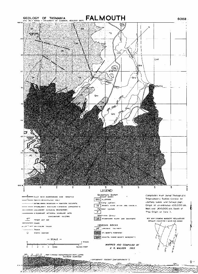
GEOLOGY OF FALMOUTHSHEET 6088
PHYSIOGRAPHY.Two physiographic units occur in this area, a low, mountainous, early mature hinterland anda partially rejuvenated, youthful coastal plain Drainage more or less radiates from the areaaround German Town and St Patrick's Head. The streams are in mountain tract for about halftheir course and then enter volley tract in which they remain till they reach the sea. In theScamander Slate and Quartzite the joints control the streams and in the St. Marys Porphyry streamsare controlled by faults. The coastal plain ranges from 350 feet above sea level inland to 170feet towards the coast. This plain is deeply dissected but the hills still corry a cover of sedimentand hill levels are accordant. Still closer to the coast are the barred lakes, lagoons and swampsbehind the beach ridges and beaches. South of Falmouth the coast is cliffed but to the north itis mainly long beaches, and the coast is comparatively straight. The Scamander River is considered to have originally flowed into the sea near Falmouth.
STRATIGRAPHY AND IGNEOUS ROCKS.The basement rock in the area is the Scamander Slate and Quartzite. This formation is ofunknown thickness and contains argillites and arenites of the sub-greywacke suite. North of thearea it contains primitive vascular plants and fragmental marine fossils. It may be in portSilurian or Lower Devonian. The deposition of these beds was followed by folding, then intrusionof the Coastal Range Quartz Monzonite. Sometime later the St. Marys Porphyry was emplaced,perhaps as a lava flow. Tilting and erosion followed before deposition of the Permian sedimentsbegan. Several Permian formations are present and include a limestone and a glauconiticsandstone. Later, probably in the Jurassic Period, the Permian sediments were disrupted bydolerite intrusions.
Later faulting further disrupted the Permian and older rocks and after this the coastal plainand the sediments on it developed.
STRUCTURAL GEOLOGY.The Scomander Formation is folded along axes trending NI5°E to N200E and generally somewhat overturned to the east. Where -the base of the St. Marys Porphyry is exposed it is seento be dipping 15° to the south. The Permian and Tertiary beds are virtually horizontal.
Faults affect the Scamander Formation, Coastal Range Monzonite, St. ·Marys Porphyry and thePermian sediments. These form a conjugate system, trending north-west and north-east. Someof these at least are post-Permian as the Enstone Park Limestone (Permian) occurs on RaysHill and much lower topographically at Enstone Park. Faults associated with the intrusion ofdolerite also affect the Permian beds near German Town.
POINTS OF SPECIAL INTEREST.Permian Section on Rays Hill (6005E8805N)
St Marys Porphyry in St. Marys Pass (6025E8805N)
Bose of St. Marys Porphyry (602.2E.886N)
REFERENCES.Twelvetrees, W.
Walker, K. R,
Woller, G. A,
H, 1910--The Scamander Mineral District. Tos. Dept. Mines Geol. Surv. Bull.,No.9
1957-Gealogy of the Falmouth-St. Helens Area. Pop. Proc. Roy. Soc. Tos.,Vol. 91.
1901-Report On the Mining Districts of the Scamander River and St. HelensSec. Mines Rept., 1900-1901 ParI. Paper, No ~, 1901.

GEOLOGY OF SCAMANDER.SHEET 6089
PHYSIOGRAPHY.There are three physiogrophic units in this area. The western-most one is characterised byScamonder Tier and the Coastal Range and is on area of late youthful or early mature topography drained dominantly by streams in their mountain tract. The exception to this is theScamander River which is a drowned river in its volley tract. Further east still is the coastalplain' with a veneer of gravels and sands up to a height of 350 feet. This is deeply dissectedbut still youthful. Neor the coast this plain is succeeded by a strip of lagoons, swamps,marshes, beoch ridges ond long sweeping sondy beaches with occasional rocky heodlands.The western unit seems to hove been part of an easterly dipping uplifted surface whichlocally reaches 1,500 feet high onScamander Tier. Drainage in the western area has a trellisedpattern, being controlled by bedding and prominent joints at right angles to it.
STRATIGRAPHY.The oldest rock in the area is the Scamander Slate and Quartzite. This formotion consists ofslates, siltstones, quartzites, sondstones ond sub-greywackes. Some bonding is present. Depositional rolls, slump structures and cross-bedding occur. Fossils in this formation include primitivevascular plants and fragmental marine fossils.The next formation is the Diona's Basin Sand and Gravel which cops the coastal plain. Thesereach a thickness of 150 feet and are up to 350 feet above sea level at which height aferruginous granule conglomerate is common. No fossils have been found in the formotionand it is regarded as Tertiary on physiographic grounds.The youngest beds in the area are the dune and beach sands and river alluvium.
IGNEOUS ROCKS.The Coastal Range Quartz Monzonite forms the axis of the Coastal Range where it intrudesthe Scamander Slate and Quartzite with sharp contacts. Temperature of the intrusion wasjust enough to produce plastic deformation of the intruded rocks. The monzonite containsandesine, microcline, quartz, biotite and hornblende with some orthoclase, apatite, muscoviteand other minerals in small amounts. Numerous textural variations occur; aplitic and pegmatiticveins occur associated with the main stock. Transgressing the quartz monzonite are dykes ofdiorite porphyry which also intrudes some of the aplites The diorite porphyry consists essentiallyof labradorite and hornblende. Quartz dolerite dykes cut the Scamander Formation and themonzonite and may be late magmatic differentiates of the monzonite magma .
STRUCTURAL GEOLOGY.The Scamander Formation is folded along axes trending N15°E to N200E and usually overturnedslightly to the east.Foults with a north-easterly, easterly and south-easterly trend offset the monzonite contactbut only by small amounts. A fault trending somewhat south of east displaces the contact ofthe monzonite, south side east, on the Scamander River and reduces the width of outcrop of themonzonite stock considerably suggesting a downthrow to the south.
ECONOMIC GEOLOGY.The Pyramid, Orieco and Beulah Mines occur within this area. The Orieco deposit containscopper in the form of chalcopyrite in ore shoats in crush zones in thinly bedded slates. TheBeulah Mine was worked unsuccessfully for silver. None of the mines is economically significantat present.
POINTS OF SPECIAL INTEREST.Scamander Formation with fossils in cuttings on the Upper Scamander Road (604.000E.891.5N)Scamander Formation marine fossils in quarry on south side of bridge over Scamander River(6068E8916N)Beulah Mine (6063E891.6N).
BIBLIOGRAPHY.Hermon, H, 1914-Australian Tin Lodes ond Tin Mills. Proc. Aus. I.M.E.N.S. No 14.Hills, C. L. and Carey. S. W, 1949-Geology and Mineral Industry Handbook for Tasmania
A.N.Z.A.A.S., 1949, p 29.Montgomery, A., 1893-Report on the Silver-bearing Lodes of the Scamander River District
Sec. Mines Rep. 1892-1893. ParI. Paper, No. 50, 1893.Nye, P. B. and Bloke, F., 1938-The Geology and Mineral Deposits of Tasmania. Tas. Dept.
Mines Geol. Surv. Bull. No. 44.Smith, J. H., 1897-Report on the Scamander Mining District. Sec. Mines Rept., 1896-1897
ParI. Paper No. 44, 1897.Thureau, G, 1886---The Scamander Silver and Gold Deposits. ParI. Paper, No. 73.Twelvetrees, W. H., 1900--Report on the Queen of the Eorth Gold Mine and Neighbourhood
Sec. Mines Rep., 1899-1900. ParI. Paper No. 63, 1900., . 1903-0n the Nomenclature ond Classification of Igneous Rocks in
Tasmania. A.A.A.S., 1902.---------~, 1910-The Scamander Mineral District. Tas. Dept. Mines Geol. Surv.
Bull. No.9.Walker, K R., 1957-Geology of the Falmouth-St. Helens Area. Pap. and Proc. Roy. Soc. Tas.,
Vol. 91Woller, GA., 1901-Report on the Mining Districts of the Scamander River and St. Helens.
Sec. Mines Rept., 1900-1901 ParI. Paper No.4, 1901
GEOLOGY OF TASMAN IAONE: INCH SERIES - UNIVERSITY OF TASMANIA/GEOLOGY DEPT
910 N
ST. HELENS
LEGEND
6090
-----:-- TRACK
===== VEHiCULAR TRACK
KEY MAP SHOWING MAGNETIC DECUNATIONS
SECULAR YARfATlON 7 ""INS. P A.
I
Compilation from Aerial photographs.
Trigonometric Station control by
courtesy Lands and Surveys Dept.
Origin of co-ordinates 400,000 ydS
West and ',800,000 yds. South of
True Origin of Zone 7
AND QUARTZITE
MAPPED AND COMPILED BY
K. R. WALKER 1953
IGNEOUS ROCKS
__ COASTAL RANGE QUARTZ
Quaternary SyshmRECENT SERIES
rB ALLUVIUM
PLEISTOCENE SERIFS
~ ST. HELENS CLAYS AND GRAVELS
Tertiary System~ DIANA'S BASIN SANDS AND GRAVELS
Group
- SCALE-
PHOTO CENTRE
VERTICAL DIP
o
2 MILES
F=,='=:=='="=="'=r,"======----.==;--"'5,000 10,000 FEET
-- -- ESTABLISHE.D BOUNDARY - POSiTION APPROXIMATE
STRIKE AND OIP
---- ESTABLISHED BOUNDARY - POSITION ACCURATE
o--u-- FAULT WITH OOWNTHROWN SIDE INDICATED
-- -- PHOTO - INTERPR6TED FAULT
= ROADS
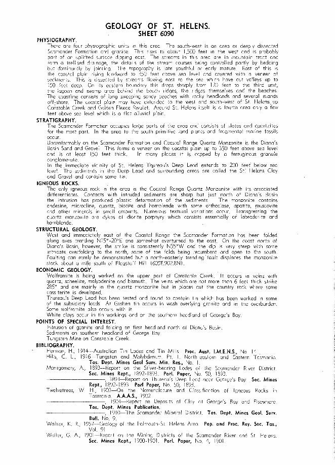
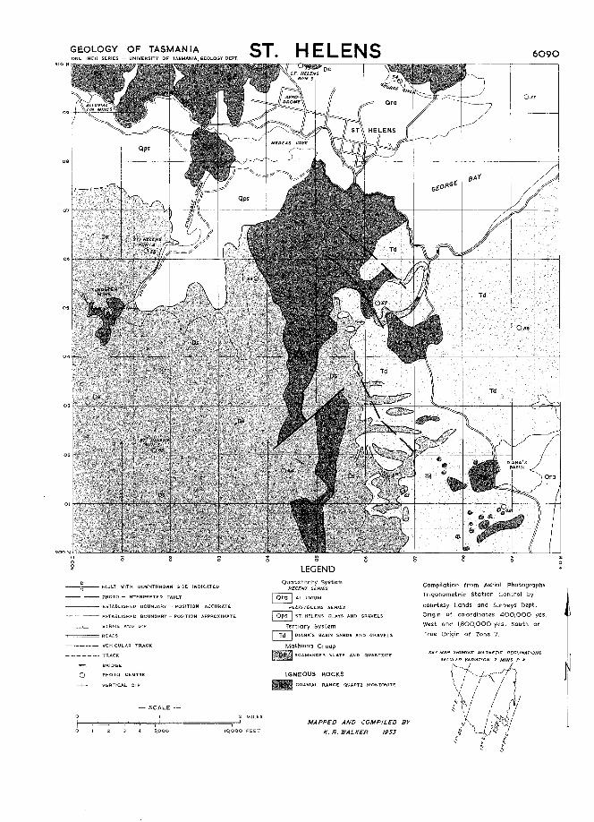
GEOLOGY OF ST. HELENS.SHEET 6090
PHYSIOGRAPHY.There are four physiogrophic units in this area. The south-west is on area of deeply dissectedScamander Formation and granite. This rises to about 1,500 feet in the west and is probablypart of an uplifted surface dipping east. The streams in this area are in mountain tract andform a trellised drainage, the details of the stream courses being controlled partly by beddingbut dominantly by jointing. The topography is late youthful or early mature. East of this isthe coastal plain rising landward to 350 feet above sea level and covered with a veneer ofsediments. This is dissected by streams flowing east to the sea which have cut volleys up to150 feet deep On its eastern boundary this drops sharply from 170 feet to the third unit,the lagoon and swamp area behind the beach ridges, fhe ridges themselves and the beachesThe coastline consists of long sweeping sandy beaches with rocky headlands and several islandsoff-shore. The coastal plain may have extended to the west and south-west of" St. Helens. upConstable Creek and Golden Fleece Rivulet. Around St. Helens itself IS a fourth area only a fewfeet above sea level which is a flat alluvial plain.
STRATIGRAPHY.The Scamander Formation occupies large parts of the area and consists of slates and quartzitesfor the most part. In the area to the south primitive land plants and fragmental marine fossilsoccur.Unconformably on the Scamander Formation and Coastal Range Quartz Monzonite is the Diana'sBasin Sand and Gravel. This forms a veneer on the coastal plain up to 350 feet above sea leveland is at least 150 feet thick. In many places it is copped by a ferruginous granulecong lomera te.In the. immediate vicinity of St. Helens Th..wreou's Deep Lead extends to 200 feet below sealevel. The sediments in the Deep Lead and surrounding areas are called the St.' Hel.ens Cloyand Gravel and contain some tin.
IGNEOUS ROCKS.The only igneous rock in the area is the Coastal Range Quartz Monzonite with its associateddifferentiates. Contacts with intruded sediments are sharp but just north of Diona's Basinthe intrusion has produced plastic deformation of the sediments. The monzonite containsandesine, micracline, quartz, biotite and hornblende with some orthoclase, apatite, muscoviteand other minerals in small amounts. Numerous textural variations occur. Transgressing thequartz monzonite are dykes of diorite porphyry which consists essentially of labradorite andhornblende.
STRUCTURAL GEOLOGY.West and immediately east of the Coastal Range the Scamander Formation has been foldedalong axes trending NI5°-200E and somewhat overturned to the east. On the coast north ofDiana's Basin, however, the strike is consistently N55°W and the dip is very steep with someintricate overfolding to the north, some of the folds being recumbent and open to the south.Faulting con rarely be demonstrated but a north-easterly trending fault displaces the monzoni testock about a mile south of Flagstaff Hill (605E.9028N).
ECONOMIC GEOLOGY.Wolframite is being worked on the upper part of Constable Creek. It occurs in veins withquartz, scheelite, molybdenite and bismuth. The veins which are not more than 6 feet thick strike285° and are mainly in the quartz monzonite but in places cut the country rock where somecassiterite is developedThureau's Deep Lead has been tested and found to contain tin which hos been worked in someof the subsidiary leads. At Goshen tin occurs in wash overlying granite and in the overburden.Some wolframite also occurs with it.White cloys occur in tin workings and on the southern headland of George's Bay
POINTS OF SPECIAL INTEREST.Intrusion of gtanite and folding on first headland north of Diana's Basin.Sediments on southern headland of George Bay.Tungsten Mine on Constable Creek.
BIBLIOGRAPHY.Herman, H, 1914-Australian Tin Lodes and Tin Mills. Proc. Aust. I.M.E.N.S., No 14..Hills, C. L, 1916-Tungsten and Molybdenum. Pt. I. North-eastern and Eastern Tasmania
Tas. DelJt. Mines Geol Surv. Min. Res., No.1.Montgomery, A, 1893-Report on the Silver-beoring Lodes of the Scamander River District.
Sec. Mines Rept., 1892-1893. ParI. Paper, No. 50, 1893.------- , 1893-Report on Thureau's Deep Lead near George's Bay Sec. Mines
Rept., 1892- I 893. Pari Paper, No 50, 1893.Twelvetrees, W. H., 1903-0n the Nomenclature and Classification of Igneous Rocks in
Tasmania. A.A.A.S., 1902.--------, 1904'-Report on Deposits of Clay at George's Bay and Elsewhere.
Tas. Deot. Mines Publication.----------, '1910-The Scamander Mineral District. Tas. Dept. Mines Geol. Surv.
Bull. No.9.Walker, K. R, 1957-Geology of the Falmouth-St. Helens Area. Pap. and Proc. Roy. Soc. Tos.,
Vol. 91Waller, G. A, 1901-Report on the Mining Districts of the Scamander River and St. Helens.
Sec. Mines Rept., 1900-1901. PorI. Paper, No.4, 1901.