Embed Size (px)
Citation preview
PM_TM_2014 Page 1 of 27
Parcel and Tract Maps
Updated January 17, 2014 What is a Parcel Map? Generally, a Parcel Map is a recorded map of a subdivision where four or fewer parcels are created simultaneously. What is a Tract Map? Again, generally a Tract Map is a recorded map of subdivision where five or more parcels are created simultaneously. Parcel and Tract Map Preparation Submittal of a Parcel or Tract Map to the County Surveyor’s Office for recordation may only be made after approval of the Tentative Map. The Board of Supervisors, Planning Commission, or Zoning Administrator may grant approval of a Tentative Map. The technical requirements to prepare a Parcel or Tract Map are almost identical, with the exception of a few differences. Both maps are the same size, the same mediums are used, the information required to be shown upon is the same, and both require preparation by a Licensed Land Surveyor or Registered Civil Engineer authorized to practice Land Surveying. About the only real difference between the two is a Tract Map requires Board of Supervisor approval prior to recordation, while a Parcel Map normally does not. The following pages are intended to be used as a guide to prepare both types of maps. Should you have any questions regarding the preparation of these maps, please call our office at 568-3020 and a representative will be happy to assist you. For the purposes of this guide, the terms Tract Map and Final Map are synonymous when reference is made to State Law. The terms Final Map and Parcel Map are synonymous when reference is made to Local Ordinance. Finally, reference to the California Government Code is meant to be synonymous with the California State Subdivision Map Act (SMA).
PM_TM_2014 Page 2 of 27
Procedural Explanation Local Agency to Regulate and Control Design of Subdivision Regulation and control of the design and improvement of subdivisions are vested in the legislative bodies of local agencies. Each local agency regulates and controls the initial design and improvement of common interest developments as defined in Section 1351 of the Civil Code and subdivisions for which the California Government Code §§ 66410 – 66499.58 (State Subdivision Map Act) requires a tentative and final or parcel map. Parcel Map – When Required A Parcel Map is required when: 1) The land before division contains less than five acres, each parcel created by the
division abuts upon a maintained public street or highway, and no dedications or improvements are required by the legislative body.
2) Each parcel created by the division has a gross area of 20 acres or more and has approved access to a maintained public street or highway.
3) The land consists of a parcel or parcels of land having approved access to a public street or highway, which comprises part of a tract of land zoned for industrial or commercial development, and which has the approval of the governing body as to street alignments and widths.
4) Each parcel created by the division has a gross area of not less than 40 acres or is not less than a quarter of a quarter section.
5) Until January 1, 2003, the land being subdivided is solely for the creation of an environmental subdivision pursuant to California Government Code § 66418.2.
Tract Map – When Required A Tract Map is required for all subdivisions creating five or more parcels, five or more condominiums as defined in Civil Code § 783, a community apartment project containing five or more parcels, or for the conversion of a dwelling to a stock apartment project containing five or more dwelling units. Computing the Number of Parcels – Designated Remainder 1) When a subdivision is a portion of any unit of improved or unimproved land, the
subdivider may designate as a remainder, that portion which is not divided, for the purpose of sale, lease and financing. The subdivider may omit entirely that portion which is not divided, for the purpose of sale, lease and financing.
2) The designated remainder parcel shall not be counted as a parcel for the purpose of determining whether a parcel map or final map is required.
3) The designated remainder or any omitted parcel may subsequently be sold without any further requirement of the filing of a parcel map or final map, but the local
PM_TM_2014 Page 3 of 27
agency may require a certificate of compliance or conditional certificate of compliance.
4) Any conveyance of land to a governmental agency, public entity, public utility or subsidiary of a public utility for conveyance to that public utility for rights-of-way shall not be considered a division of land for purposes of computing the number of parcels. Any conveyance of land to a governmental agency shall include a fee interest, an easement, or a license.
5) If the Parcel Map includes a “designated remainder” parcel or similar parcel, and the gross area of the “designated remainder” parcel or similar parcel is 5 acres or more, that remainder parcel need not be shown on the map and its location need not be indicated as a matter of survey, but only by deed reference to the existing boundaries of the remainder parcel.
6) A parcel designated as “not a part” shall be deemed to be a “designated remainder”. Time Limit & Extensions * 1) When a tentative map is required, an approved or conditionally approved tentative map
shall expire 24 months after its approval or conditional approval, or after any additional period of time as may be prescribed by local ordinance, not to exceed an additional 12 months.
2) An approved or conditionally approved Tentative Parcel Map shall expire thirty-six (36) months after its approval or conditional approval unless otherwise provided pursuant to Government Code § 66463.5.
3) An approved or conditionally approved Tentative Tract Map shall expire thirty-six (36) months after its approval or conditional approval unless otherwise provided pursuant to Government Code § 66452.6.
* 2008, 2009 and 2011 legislative acts have extended the expiration for maps that expire after 2011, 2012 and 2014 respectively. Please contact Planning & Development for details. Field Survey Required for Tract Map After the approval of the Tentative Tract Map by the decision-maker, the subdivider may cause a Final Map to be prepared. As many copies of the proposed Final Map as may be required by the County Surveyor and other applicable County Departments and Agencies, shall be submitted to each Department or Agency responsible for approving or reviewing such map. The proposed Final Map shall be prepared in accordance with the completed survey of the subdivision based upon a field survey of the boundaries of the subdivision made as required by law. Field Survey Required for Parcel Map 1) In all cases where a parcel map is required, such map shall be based on a field survey
made in conformity with the Land Surveyor’s Act when required by local ordinance, or, in the absence of such requirement, shall be based either upon a field survey made
PM_TM_2014 Page 4 of 27
in conformity with the Land Surveyor’s Act or be compiled from record data when sufficient survey information exists on filed maps to located and retrace the exterior boundary lines of the parcel map if the location of at least one of these boundary lines can be established from an existing monumented line.
2) After the approval of the Tentative Tract or Parcel Map by the decision-maker, the subdivider may cause a Final or Parcel Map to be prepared. As many copies of the proposed Final Map as may be required by the County Surveyor and other applicable County Departments and Agencies, shall be submitted to each Department or Agency responsible for approving or reviewing such map. The proposed Final Map shall be prepared in accordance with Article 2 of the Subdivision Map Act and in accordance with the completed survey of the subdivision based upon a field survey of the boundaries of the subdivision made as required by law. The proposed Parcel Map shall be prepared in accordance with Article 3 of the Subdivision Map Act and in accordance with the completed survey of the subdivision based upon a field survey, or from compiled data if authorized by the County Surveyor.
Parcel Map Waiver 1) Subdivisions of a portion of the operating right-of-way of a railroad corporation, as
defined by Public Resources Code § 230, which are created by short-term leases (terminable by either party on not more than 30 days notice in writing).
2) Land conveyed to or from a governmental agency, public entity, public utility, or for land conveyed to a subsidiary of a public utility for conveyance to that public utility for rights-of-way, unless a showing is made in individual cases, upon substantial evidence, that public policy necessitates a parcel map. Land conveyed to or from a governmental agency shall include a fee interest, an easement or a license.
Submittal of Prints & Fees
1) The local agency may establish reasonable fees for the processing of tentative, final
and parcel maps and for other procedures required or authorized by the State Subdivision Map Act or local ordinance.
2) To record a parcel map, a registered engineer or licensed surveyor shall submit to the County Surveyor two prints of the proposed parcel map, together with the County Surveyor's checking fees as the same are established by the Board of Supervisors.
3) Fees to process Parcel and Tract Maps are set per Santa Barbara County Board of Supervisors. Please see current adopted fee schedule.
Signatures of Owners and Holders of Record Title Interest Required (Parcel Maps) Tract and Parcel Maps No final or parcel map required by Government Code or local ordinance which creates a subdivision shall be filed with the local agency without the written consent of all parties having any record title interest in the real property proposed to be subdivided, except as otherwise provided in the State Subdivision Map Act.
PM_TM_2014 Page 5 of 27
Parcel Maps Only 1) Subject to the provisions of California Government Code § 66436, a statement,
signed and acknowledged by all parties having any record title interest in the real property subdivided, consenting to the preparation and recordation of the parcel map is required, except that less inclusive requirements may be provided by local ordinance.
2) Where dedications or offers of dedications are not required, the statement shall be signed and acknowledged by the subdivider only. If the subdivider does not have record title ownership interest in the property to be divided, the local agency will require that the subdivider provide the local agency with satisfactory evidence that the persons with record title ownership have consented to the proposed division (This applies primarily to banks who hold deeds of trust). For purposes of this paragraph, “record title ownership” shall mean fee title of record unless a leasehold interest is to be divided, in which case “record title ownership” shall mean ownership of record of the leasehold interest. Record title ownership does not include ownership of mineral rights or other subsurface interests which have been severed from ownership of the surface.
3) Notwithstanding any other provisions of Article 3 of the State Subdivision Map Act, local agencies may require those statements and acknowledgements required pursuant to subdivision (e) be made by separate instrument to be recorded concurrently with the parcel map being filed for record.
4) Whenever a certificate or acknowledgement is made by separate instrument, there shall appear on the final map a reference to the separately recorded document. The County Recorder pursuant to California Government Code § 66468.1 shall complete this reference.
Signatures of Holders of Record Title Interest - Omission Tract and Parcel Maps 1) The signature of either the holder of beneficial interest under trust deeds or the trustee
under the trust deeds may be omitted, but not both. 2) Signatures of parties owning the following types of interest may be omitted if their
names and the nature of their respective interests are stated on the map: a) Rights-of-way. b) Easements. c) Other interests which cannot ripen into a fee, except those owned by a public
entity, public utility, or subsidiary of a public utility for conveyance to the public utility for rights-of-way.
d) Minerals. Separate Document to Record Additional Information 1) In accordance with California Government Code § 66445(g) and § 66434(f), on or after
January 1, 1987, no additional survey or map requirements shall be included on a Parcel Map which do not affect record title interests. However, the map shall contain a
PM_TM_2014 Page 6 of 27
notation of reference to survey and map information required by the State Subdivision Map Act.
2) Pursuant to Government Code § 66434.2, additional information may be required in the form of a separate document or an additional map sheet to be filed or recorded simultaneously with a Final or Parcel Map. The additional information shall be in the form of a separate document or an additional map sheet which shall indicate its relationship to the Final or Parcel Map, and shall contain a statement that the additional information is for informational purposes, describing conditions as of the date of filing and is not intended to affect record title interest. The document or additional map sheet may also contain a notation that the additional information is derived from public records or reports, and does not imply the correctness or sufficiency of those records or reports by the preparer of the document or additional map sheet. Additional survey and map information may include, but shall not be limited to: building setback lines, flood hazard zones, seismic lines and setbacks, geologic mapping and archaeological sites.
3) A final map or parcel map for a subdivision approved prior to January 1, 1987, and conditioned on recordation of additional information thereon, shall be found in substantial compliance with the previously approved tentative map provided the required additional information is separately recorded pursuant to Chapter 21-9.1(b) of local ordinance.
Cross Referencing of Concurrent Documents Whenever separate documents are to be recorded concurrently with the final or parcel map pursuant to Government Code § 66435.1 or 66445, the County Recorder shall complete the cross-reference to such concurrently recorded separate documents. Substantial Compliance with Approved Tentative Map A legislative body shall not deny approval of a final or parcel map if it has previously approved a tentative map for the proposed subdivision and if it finds that the final or parcel map is in substantial compliance with the previously approved tentative map. Where the subdivider desires to obtain approval of alterations on the final map from the approved tentative map or of changes made in conditions imposed as conditions of approval of the tentative map, he shall petition, in writing, the subdivision committee for its recommendation on such alterations or changes and submit with the petition the number of final map prints requested by the County Surveyor. Changes and alterations shall be approved in the same manner as the original tentative map was approved. Taxes and Assessments Prior to the filing of the final map or parcel map with the legislative body, the subdivider shall, in accordance with procedures established by the county, file with the County Recorder of the county in which any part of the subdivision is located, a certificate or statement from the official computing redemptions in any public agency in which any part of the subdivision is located, showing that, according to the records of that office, there are no liens against the subdivision or any part thereof for unpaid, state, county,
PM_TM_2014 Page 7 of 27
municipal or local taxes or special assessments collected as taxes, except taxes or special assessments not yet payable. This section shall not be applicable to amending maps filed in accordance with the provisions of Government Code § 66469. Clerk of the Board’s Statement (with dedications) Tract and Parcel Maps 1) Dedications of, or offers to dedicate interests in, real property for specified public
purposes shall be made by a statement on the final map, signed and acknowledged by those parties having any record title interest in the real property being subdivided, subject to the provisions of Government Code § 66436.
2) If dedications or offers of dedication are required, they may be made either by a
statement on the final or parcel map or by separate instrument, as provided by local ordinance. If dedications or offers of dedication are made by separate instrument, the dedications or offers of dedication shall be recorded concurrently with, or prior to, the final or parcel map being filed for record.
3) There may be a requirement imposed by local ordinance that dedications or offers of
dedication of streets include a waiver of direct access rights to any such street from any property shown on a final map or parcel map as abutting thereon and if the dedication is accepted, any such waiver shall become effective in accordance with its provisions.
4) There may be a requirement imposed by local ordinance of dedication or irrevocable
offer of dedication or real property within the subdivision for streets, alleys, including access rights and abutter’s rights, drainage, public utility easements and other public easements. Such irrevocable offers may be terminated as provided in subdivision (c)and (d) of Government Code § Section 66477.2.
5) At the time the legislative body or the official designated pursuant to Government Code
§ 66458 approves a final map, the legislative body or the designated official shall also accept, accept subject to improvement, or reject any offer of dedication. The clerk of the legislative body shall certify or state on the map the action taken by the legislative body or designated official.
Engineer’s or Surveyor’s Statements The Engineer or Surveyor must sign as to the preparation of the map. See statements and certificates at the end of this section for specific language. County Surveyor’s Statement 1) If a subdivision lies within an unincorporated area, a certificate or statement by the
County Surveyor is required. The County Surveyor shall sign, date, and below or
PM_TM_2014 Page 8 of 27
immediately adjacent to the signature, indicate his or her registration or license number with expiration date and the stamp of his or her seal and state that:
a) He or she examined the map. b) The subdivision as shown is substantially the same as it appeared on the tentative
map, if required, and any approved alterations thereof. c) All provisions of this chapter and of any local ordinances applicable at the time
of approval of the tentative map, if required, have been complied with. d) He or she is satisfied that the map is technically correct.
2) When the County Surveyor is satisfied that the map is technically correct, conforms to
the approved tentative map or any approved alterations thereof, complies with all applicable laws and regulations, that all departments and agencies have certified that the requirements have been satisfied and that all bonds or cash deposits have been received by the County Clerk, the County Surveyor shall notify in writing the engineer or surveyor who prepared the map and request delivery of the original tracing of the parcel map. The County Surveyor shall execute his certification on the original tracings and shall transmit the same to the County Recorder.
Recorder’s Examination and Statement The County Recorder shall have not more than 10 days within which to examine a final or parcel map and either accept or reject it for filing. If the County Recorder rejects a final or parcel map for filing, the County Recorder shall, within 10 days thereafter, mail notice to the subdivider and the City Engineer if the map is within a city, or the County Surveyor if the map is within the unincorporated area, that the map has been rejected for filing, giving the reasons therefore, and that the map is being returned to the city clerk if the map is within a city, or to the clerk of the board if the map is within the unincorporated area, for action by the legislative body. If the County Recorder accepts the map for filing, the acceptance shall be certified on the face thereof. The fee for filing and indexing the map is as prescribed in Government Code § 27372 of the Government Code. The map must also contain a County Recorder’s Statement which is shown at the end of this section. Surveys and Monuments and Survey Procedures 1) At the time of making the survey for the final map or parcel map, unless the survey is
not required pursuant to Government Code § 66448, the engineer or survey shall set sufficient durable monuments to conform with the standards described in Business and Professions Code § 8771 so that another engineer or surveyor may readily retrace the survey. He shall also set such additional monuments as may be required by local ordinance. The local ordinance shall require that at least one exterior boundary line of the land being subdivided be adequately monumented or referenced before the map is recorded.
PM_TM_2014 Page 9 of 27
2) A parcel map shall be prepared in conformance with Government Code § 66444 through 66450, inclusive and, in the case of a parcel map showing a division of land into five or more parcels as authorized under Government Code § 66426(a), (b), (c), and (d), the parcel map shall be based upon a survey which has been monumented in the same manner as required in Chapter 21-16 of local ordinance for a final map.
3) The survey to be used in preparation of a final or parcel map (if required) shall be made
in a manner satisfactory to the County Surveyor. The location, size and type of all monuments shall be subject to the inspection and approval of the County Surveyor before approval of the final map.
4) Monuments shall be set in accordance with Chapter 21-16 of local ordinance:
a) Along exterior boundaries at all angle points and the beginning and ending of curves.
b) County-approved monument wells shall be set along the center lines of all public streets at the intersection of all streets, centerline angle points, beginning and ending of curves, the center of all cul-de-sacs, and at the intersection with the exterior boundary as to maintain line of sight from monument to monument within the specified right-of-way. All monuments set in monument wells shall be no less in size than two inch brass or aluminum caps set on one and one-half inch galvanized steel pipe eighteen inches in length.
c) Monument kind, size, and location may be modified by the County Surveyor as necessary on a case by case basis
d) All street centerline intersections and centers of cul-de-sacs shall be referenced to four lead plugs and tags in curbs or permanently affixed with epoxy or similar adhesive except where well monuments have been set. Where no curbs are installed, such points shall be referenced to four lot corner monuments. Distances to said reference monuments shall be shown on eight and one-half by 11 inch transparent material and shall be filed in the County Surveyor's office.
e) All lot corners shall be marked by permanent monuments with brass tags, aluminum or brass caps set on galvanized iron pipe a minimum of one-half inch in inside diameter by eighteen inches in length driven flush with the ground. All exterior subdivision corners shall be marked by permanent monuments with a minimum size of two inch brass or aluminum caps set on galvanized steel pipe a minimum of one and one-half inch inside diameter by eighteen inches in length driven flush with the ground.
f) Front lot corners may be lead plugs and brass tags or tags permanently affixed with epoxy or similar adhesive set in the sidewalk or permanently affixed in the top of curb on prolongation of lot line or radially where point falls on a curve. Where no concrete curbs or sidewalks exist, actual front lot corners shall be monumented.
g) The types of markers and the sizes used at the above locations, and ties, where necessary, shall all be clearly indicated on the final or parcel map legend.
h) All monuments set shall be permanently and visibly marked with the certificate number preceded by the letters "L.S." or "R.C.E." as the case may be.
PM_TM_2014 Page 10 of 27
5) For the subdivision of public lands or section property, for the restoration of lost section corners, and for the retracement of section lines, the method to be followed shall be in accord with the instructions set forth in the "Manual of Instructions for the Survey of Public Lands of the United States”, published by the Commissioner of the General Land Office, Department of the Interior, Washington, D.C.
6) A traverse of the boundaries of the tract and all lots and blocks shall close within a limit
of error ratio of 1:25000 or 0.02’, whichever is greater. Monument Bonds
1) Interior monuments need not be set at the time the map is recorded, if the engineer or
surveyor certifies on the map that the monuments will be set on or before a specified later date, and if the subdivider furnishes to the legislative body security guaranteeing the payment of the cost of setting such monuments. Acceptable forms of security are cash, certified check, or a bond from an admitted surety. Payment will be received by the Clerk of the Board.
2) Within 5 days after the final setting of all monuments has been completed, the
engineer or surveyor shall give written notice to the subdivider and to the County Surveyor or any other public official or employee authorized to receive these notices, that the final monuments have been set.
3) Upon payment to the engineer or surveyor for setting the final monuments, the
subdivider shall present to the legislative body evidence of the payment and receipt thereof by the engineer or surveyor.
4) The County Surveyor shall also obtain written notice from the County Clerk that he
has received all required bonds and cash deposits. 5) To request the release of the monumentation bond, the surveyor of record shall
submit in writing to the County Surveyor’s Office, a letter signed and sealed, stating:
a) All monumentation has been set, and b) Payment for all services has been received
6) After a field inspection/verification of the monuments (fee required for inspection), a
request to release the bond will be docketed for the Board’s approval. Clearances 1. Each department, agency, or utility company affected by conditions of approval imposed
on the division shall file written clearance notice with the County Surveyor certifying that the requirements of the department or agency have been satisfied.
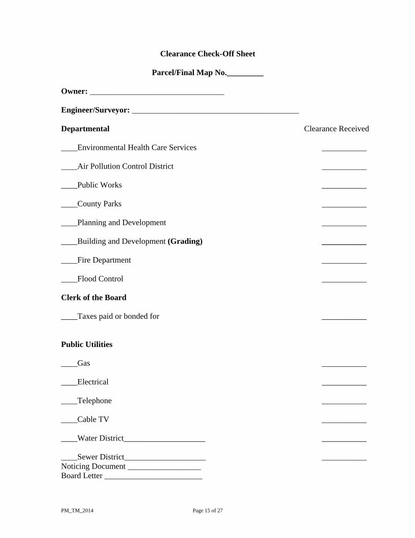
See clearance check-off sheet on page 15 of this document.
PM_TM_2014 Page 11 of 27
2. The Surveyor shall be responsible for coordinating recommendations of various County
Departments concerned with Final and Parcel Maps, and clearances after the decision-maker has approved the particular Tentative Tract Map or Tentative Parcel Map concerned.
Taxes Prior to the filing of a final map or parcel map with the legislative body, the subdivider shall, in accordance with procedures established by the county, file with the County Recorder of the county in which any part of the subdivision is located, a certificate or statement from the official computing redemptions in any public agency in which any part of the subdivision is located, showing that, according to the records of that office, there are no liens against the subdivision or any part thereof for unpaid state, county, municipal or local taxes or special assessments collected as taxes, except taxes or special assessments not yet payable. Whenever any part of the divisions is subject to a lien for taxes or special assessments collected as taxes which are not yet payable, the final map or parcel map shall not be recorded until the owner or subdivider does both of the following:
1) Files with the Clerk of the Board of Supervisors of the County wherein any part of the subdivision is located a certificate or statement prepared by the appropriate state or local official giving his or her estimate of those taxes or assessments.
2) Executes and files with the Clerk of the Board of Supervisors of the County wherein any part of the subdivision is located, security conditioned upon the payment of all state, county, municipal and local taxes and the current installment of principal and interest of all special assessments collected as taxes, which at the time the final map is recorded are a lien against the property, but which are not yet payable.
Map Body
After the approval of the tentative map including tentative parcel map by the decision-maker, the subdivider may cause a final or parcel Map to be prepared. As many copies of the proposed final or parcel Map as may be required by the County Surveyor and other applicable county departments and agencies, shall be submitted to each department or agency responsible for approving or reviewing such map. The proposed final Map shall be prepared in accordance with Article 2 of Chapter 2 of the State Subdivision Map Act and in accordance with the completed survey of the subdivision based upon a field survey of the boundaries of the subdivision made as required by law. The proposed parcel Map shall be prepared in accordance with Article 3 of Chapter 2 of the State Subdivision Map Act and in accordance with the completed survey of the subdivision based upon a field survey or from compiled recorded data if authorized by the County Surveyor. Both proposed final and parcel Maps shall be prepared according to the following standards:
PM_TM_2014 Page 12 of 27
(a) Sizes and material. The final or parcel map shall be clearly and legibly drawn upon
tracing cloth or polyester film of good quality. All lines, letters, figures shall be printed or reproduced by a process guaranteeing a permanent record in black on tracing cloth or polyester base film. The size of the sheets of tracing cloth or polyester film shall be eighteen by twenty-six inches, leaving an entirely blank margin of one inch from the edges of the sheets. The final or parcel map number and all drawings, affidavits, statements, acknowledgements, endorsements, acceptances of dedication, and notarial statement must be within the margin line. The scale shall be not less than one inch equals 60 feet unless approved otherwise by the County Surveyor prior to the first submittal of the final or parcel map in order to show the details clearly and enough sheets shall be used to accomplish this end. Each sheet shall be numbered “# of # sheets”. The relation of one sheet to another shall be clearly shown and the number of sheets used shall be set forth in the title of the map.
(b) Title. The first sheet shall contain the final or parcel map number conspicuously placed. Below the final or parcel map number shall be a subtitle consisting of a general description of all the property being subdivided, by reference to deeds or to maps which have been recorded or to official United States surveys. References to tracts and subdivisions shall be spelled out and worded identically with original records, with complete reference to proper book and page of such record.
Maps filed for the purpose of reverting subdivided land to acreage shall be so designated on the title sheet by an appropriate note containing the words "MAP OF VACATION" followed by "REVERSION TO ACREAGE."
Every sheet, other than the title sheet, shall bear the final or parcel map number (but no subtitle), scale, north arrow, the basis of bearings (or reference to), legend and sheet number.
(c) Statements. A statement of the licensed surveyor or civil engineer licensed to practice land surveying, accompanied by his seal, shall appear stating to the accuracy of the final or parcel map and of all data shown thereon. In addition, there shall be such other certificates or statements as may be required by law including:
(1) Statement of owner, consenting to subdivision (final and parcel maps). (2) Statement of owner, offering to dedicate streets and other lands and
reserving the right to convey easements to public utilities as shown on such map.
(3) Clerk of the Board of Supervisors’ statement indicating official approval of the final or parcel map and acceptance of dedications.
(4) Statement of County Surveyor indicating that the final or parcel map complies with state law and local ordinance.
(5) Statement of the County Recorder accepting the final or parcel map for recordation.
(d) Surveying data for lots. Sufficient data shall be shown to determine readily the bearing and length of every lot line, block line, easement line and boundary line. Linear dimensions shall be expressed in feet and decimals of a foot. Dimensions of lots shall reflect net and gross dimensions as defined by Chapter 35 where applicable. All lots more shall show net and gross acreage to nearest hundredth, where applicable. Length, radius, and total delta of all curves and the bearing of
PM_TM_2014 Page 13 of 27
radial lines to each non-tangent curve shall be shown. All data shall be shown upon the line or segment of curve to which it pertains unless different is authorized by the County Surveyor. Bearings and distances shall be given for all lines.
(e) Surveying data for streets. The final or parcel map shall show the center lines of all streets, the total width of each street, the width of the portion being dedicated, and the width of existing dedication, and the widths each side of the center line, also the width of railroad right-of-ways, flood control or drainage channels, and of any other easements appearing on the map. Where streets are to be private or public easements, sidelines of lots shall be shown as solid lines to centerline of street and sidelines of streets shown as broken lines. Where streets are to be public (fee), the sidelines of lots common with the streets shall be shown as solid lines.
(f) Record easements. The final or parcel map shall show the lines of all easements to which the lots are subject. If the easement is not definitely located of record, a statement of the easement shall appear on the title sheet. Easements for storm drains, sewers and other purposes shall be denoted by fine dashed lines. Distances and bearings on the sidelines of lots which are cut by an easement shall be arrowed or so shown that the final or parcel map will indicate clearly the actual lengths of the lot lines. The width of the easement or the lengths and bearings of the lines thereof and sufficient ties to locate the easement definitely with respect to the individual lots and the subdivision shall be shown. The easement shall be clearly labeled and identified, and if already of record, proper reference to the records given, including the name of the current easement holder if available, nature, and recording information. Easements for public utilities shall be so designated on the final or parcel map. If an easement is being dedicated by the final or parcel map, it shall be properly set out in the owner's certificate of dedication. All easements whether existing or created by the final or parcel map shall be labeled as public or private.
(g) Existing monuments. The final or parcel map shall show clearly what stakes, monuments, or other evidence was found to determine the boundaries of the subdivision. The corners of all adjoining subdivisions or portions thereof shall be identified by lot number, tract number, and place of record with all found monuments being shown with measured data thereto (both record and measured data shall be shown), or by section, township, and range, or by other proper designation.
(h) Established lines. Wherever the County Surveyor or a City Engineer has established the center line of a street or alley, that data shall be shown on the final or parcel map, indicating all monuments found and making proper references to field books or maps bearing records of surveys of such monuments. If the points were reset by ties, that fact shall be stated. The final or parcel map shall show all city boundaries crossing or adjoining the subdivision clearly designated and tied in.
(i) Lot and block identification. There shall be no separate identification by individual blocks within a subdivision. All lots within a subdivision shall be numbered consecutively without omission or duplication of numbers, except street "denial" strips shall be shown as parcels with an alphabetical letter designation for each. Each lot shall be shown entirely on at least one sheet.
(j) Private Restrictions. Any private restrictions to be shown on the final or parcel map or reference to them made therein shall be accompanied by proper acknowledgements of owners and mortgagees accepting such restrictions.

PM_TM_2014 Page 14 of 27
(k) Open spaces. All open spaces shall be designated by the letters "O.S." or words "open space" on the final or parcel map.
(l) Dedications. Easements being created by the final or parcel map shall state if they are public or private in nature. All offers of dedication shall state if they are public or private in nature.
(m) Monuments. All monuments shall be set in accordance with the monumentation policy as defined herein. In the case of final maps, all monuments shall be set within one year after recordation of the map. In the case of parcel maps, all monuments shall be set prior to recordation.
(n) Basis of Bearings. The acceptable methods used to determine a basis of bearings are:
(1) Astronomic observation. (2) A line, appearing between two found monuments, shown on a recorded map. (3) California Coordinate system as defined and regulated by the California
Public Resources Code § 8801 et seq. (o) Additional mapping standards consistent with this ordinance and state laws may be
established by the County Surveyor by guidelines as necessary. (p) Survey procedures. Where the real property being subdivided is described by
sectionalized description, the surveying procedure used to establish the boundary of the final or parcel Map shall follow the procedures as defined by the Manual of Instructions for the Survey of Public Lands of the United States, 1973 or its successor.
(q) Distinctive Border. Both final and parcel maps shall delineate the land to be included within the subdivision by distinctive symbol or heavier line weight and clearly designated as such.
PM_TM_2014 Page 15 of 27
Clearance Check-Off Sheet
Parcel/Final Map No._________
Owner: _________________________________ Engineer/Surveyor: _________________________________________ Departmental Clearance Received ____Environmental Health Care Services ___________ ____Air Pollution Control District ___________ ____Public Works ___________ ____County Parks ___________ ____Planning and Development ___________ ____Building and Development (Grading) ___________ ____Fire Department ___________ ____Flood Control ___________ Clerk of the Board ____Taxes paid or bonded for ___________ Public Utilities ____Gas ___________ ____Electrical ___________ ____Telephone ___________ ____Cable TV ___________ ____Water District____________________ ___________ ____Sewer District____________________ ___________ Noticing Document __________________ Board Letter ________________________
PM_TM_2014 Page 16 of 27
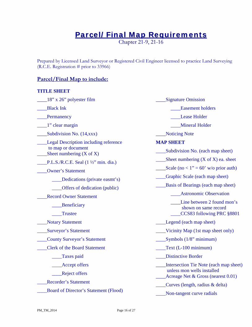
PPaarrcceell//FFiinnaall MMaapp RReeqquuiirreemmeennttss CChhaapptteerr 2211--99,, 2211--1166
Prepared by Licensed Land Surveyor or Registered Civil Engineer licensed to practice Land Surveying (R.C.E. Registration # prior to 33966) Parcel/Final Map to include: TITLE SHEET
____18” x 26” polyester film
____Black Ink
____Permanency
____1” clear margin
____Subdivision No. (14,xxx)
____Legal Description including reference to map or document
____Sheet numbering (X of X)
____P.L.S./R.C.E. Seal (1 ½” min. dia.)
____Owner’s Statement
____Dedications (private easmt’s)
____Offers of dedication (public)
____Record Owner Statement
____Beneficiary
____Trustee
____Notary Statement
____Surveyor’s Statement
____County Surveyor’s Statement
____Clerk of the Board Statement
____Taxes paid
____Accept offers
____Reject offers
____Recorder’s Statement
____Board of Director’s Statement (Flood)
____Signature Omission
____Easement holders
____Lease Holder
____Mineral Holder
____Noticing Note
MAP SHEET
____Subdivision No. (each map sheet)
____Sheet numbering (X of X) ea. sheet
____Scale (no < 1” = 60’ w/o prior auth)
____Graphic Scale (each map sheet)
____Basis of Bearings (each map sheet)
____Astronomic Observation
____Line between 2 found mon’s shown on same record
____CCS83 following PRC §8801
____Legend (each map sheet)
____Vicinity Map (1st map sheet only)
____Symbols (1/8” minimum)
____Text (L-100 minimum)
____Distinctive Border
____Intersection Tie Note (each map sheet) unless mon wells installed
____Acreage Net & Gross (nearest 0.01)
____Curves (length, radius & delta)
____Non-tangent curve radials
PM_TM_2014 Page 17 of 27
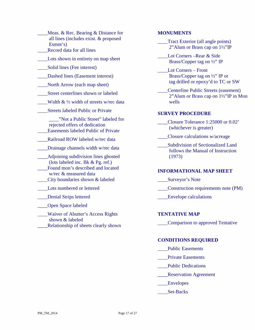
____Meas. & Rec. Bearing & Distance for all lines (includes exist. & proposed Esmnt’s)
____Record data for all lines
____Lots shown in entirety on map sheet
____Solid lines (Fee interest)
____Dashed lines (Easement interest)
____North Arrow (each map sheet)
____Street centerlines shown or labeled
____Width & ½ width of streets w/rec data
____Streets labeled Public or Private
____”Not a Public Street” labeled for rejected offers of dedication
____Easements labeled Public of Private
____Railroad ROW labeled w/rec data
____Drainage channels width w/rec data
____Adjoining subdivision lines ghosted (lots labeled inc. Bk & Pg. ref.)
____Found mon’s described and located w/rec & measured data
____City boundaries shown & labeled
____Lots numbered or lettered
____Denial Strips lettered
____Open Space labeled
____Waiver of Abutter’s Access Rights shown & labeled
____Relationship of sheets clearly shown
MONUMENTS
____Tract Exterior (all angle points) 2”Alum or Brass cap on 1½”IP ____Lot Corners –Rear & Side Brass/Copper tag on ½” IP ____Lot Corners – Front Brass/Copper tag on ½” IP or tag drilled or epoxy’d to TC or SW ____Centerline Public Streets (easement) 2”Alum or Brass cap on 1½”IP in Mon
wells SURVEY PROCEDURE
____Closure Tolerance 1:25000 or 0.02’ (whichever is greater)
____Closure calculations w/acreage
____Subdivision of Sectionalized Land follows the Manual of Instruction (1973)
INFORMATIONAL MAP SHEET
____Surveyor’s Note
____Construction requirements note (PM)
____Envelope calculations
TENTATIVE MAP
____Comparison to approved Tentative
CONDITIONS REQUIRED
____Public Easements
____Private Easements
____Public Dedications
____Reservation Agreement
____Envelopes
____Set-Backs
PM_TM_2014 Page 18 of 27
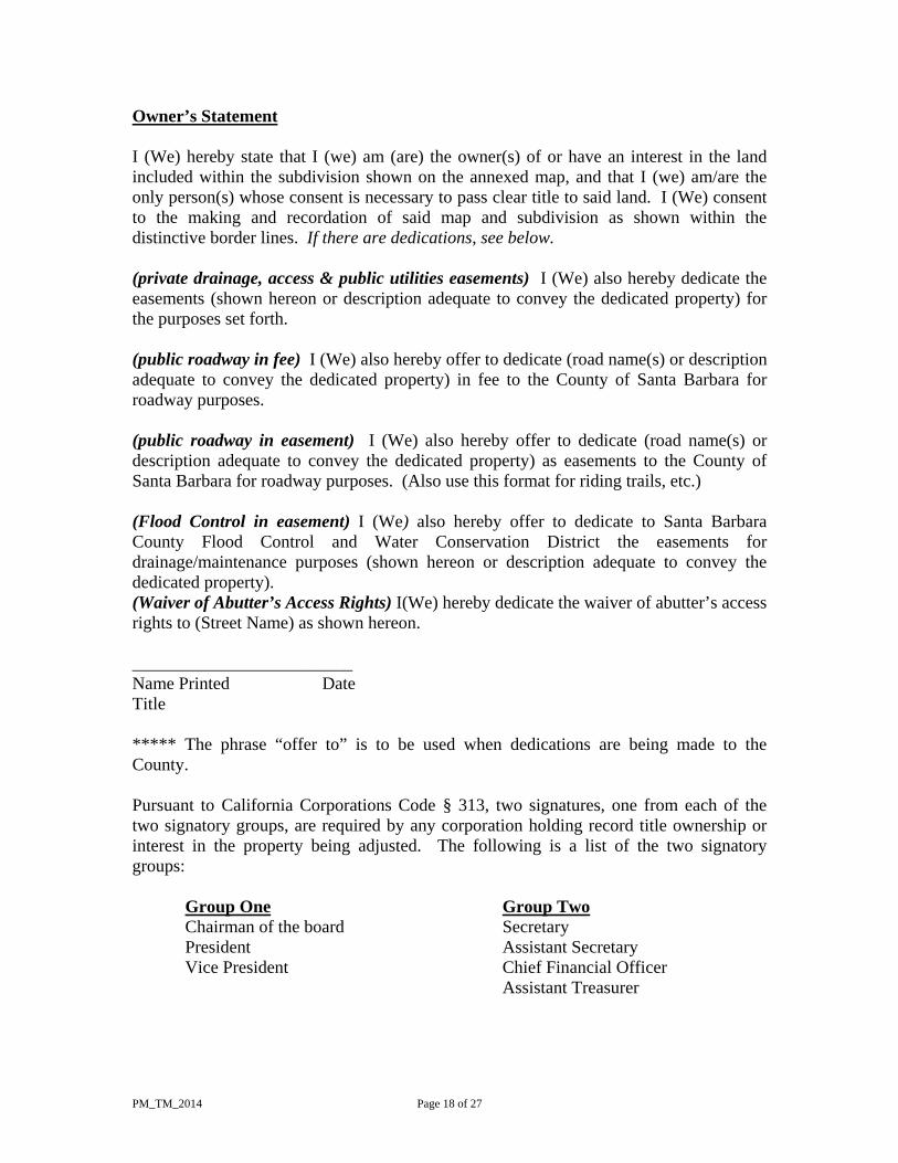
Owner’s Statement I (We) hereby state that I (we) am (are) the owner(s) of or have an interest in the land included within the subdivision shown on the annexed map, and that I (we) am/are the only person(s) whose consent is necessary to pass clear title to said land. I (We) consent to the making and recordation of said map and subdivision as shown within the distinctive border lines. If there are dedications, see below. (private drainage, access & public utilities easements) I (We) also hereby dedicate the easements (shown hereon or description adequate to convey the dedicated property) for the purposes set forth. (public roadway in fee) I (We) also hereby offer to dedicate (road name(s) or description adequate to convey the dedicated property) in fee to the County of Santa Barbara for roadway purposes. (public roadway in easement) I (We) also hereby offer to dedicate (road name(s) or description adequate to convey the dedicated property) as easements to the County of Santa Barbara for roadway purposes. (Also use this format for riding trails, etc.) (Flood Control in easement) I (We) also hereby offer to dedicate to Santa Barbara County Flood Control and Water Conservation District the easements for drainage/maintenance purposes (shown hereon or description adequate to convey the dedicated property). (Waiver of Abutter’s Access Rights) I(We) hereby dedicate the waiver of abutter’s access rights to (Street Name) as shown hereon. _________________________ Name Printed Date Title ***** The phrase “offer to” is to be used when dedications are being made to the County. Pursuant to California Corporations Code § 313, two signatures, one from each of the two signatory groups, are required by any corporation holding record title ownership or interest in the property being adjusted. The following is a list of the two signatory groups: Group One Group Two Chairman of the board Secretary President Assistant Secretary
Vice President Chief Financial Officer Assistant Treasurer
PM_TM_2014 Page 19 of 27
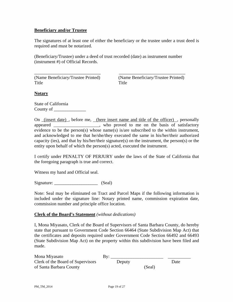
Beneficiary and/or Trustee The signatures of at least one of either the beneficiary or the trustee under a trust deed is required and must be notarized. (Beneficiary/Trustee) under a deed of trust recorded (date) as instrument number (instrument #) of Official Records. _____________________________ _____________________________ (Name Beneficiary/Trustee Printed) (Name Beneficiary/Trustee Printed) Title Title Notary State of California County of ______________ On _(insert date)_, before me, (here insert name and title of the officer) , personally appeared ____________________, who proved to me on the basis of satisfactory evidence to be the person(s) whose name(s) is/are subscribed to the within instrument, and acknowledged to me that he/she/they executed the same in his/her/their authorized capacity (ies), and that by his/her/their signature(s) on the instrument, the person(s) or the entity upon behalf of which the person(s) acted, executed the instrument. I certify under PENALTY OF PERJURY under the laws of the State of California that the foregoing paragraph is true and correct. Witness my hand and Official seal. Signature: ___________________ (Seal) Note: Seal may be eliminated on Tract and Parcel Maps if the following information is included under the signature line: Notary printed name, commission expiration date, commission number and principle office location. Clerk of the Board’s Statement (without dedications) I, Mona Miyasato, Clerk of the Board of Supervisors of Santa Barbara County, do hereby state that pursuant to Government Code Section 66464 (State Subdivision Map Act) that the certificates and deposits required under Government Code Section 66492 and 66493 (State Subdivision Map Act) on the property within this subdivision have been filed and made. Mona Miyasato By: _______________________ __________ Clerk of the Board of Supervisors Deputy Date of Santa Barbara County (Seal)
PM_TM_2014 Page 20 of 27
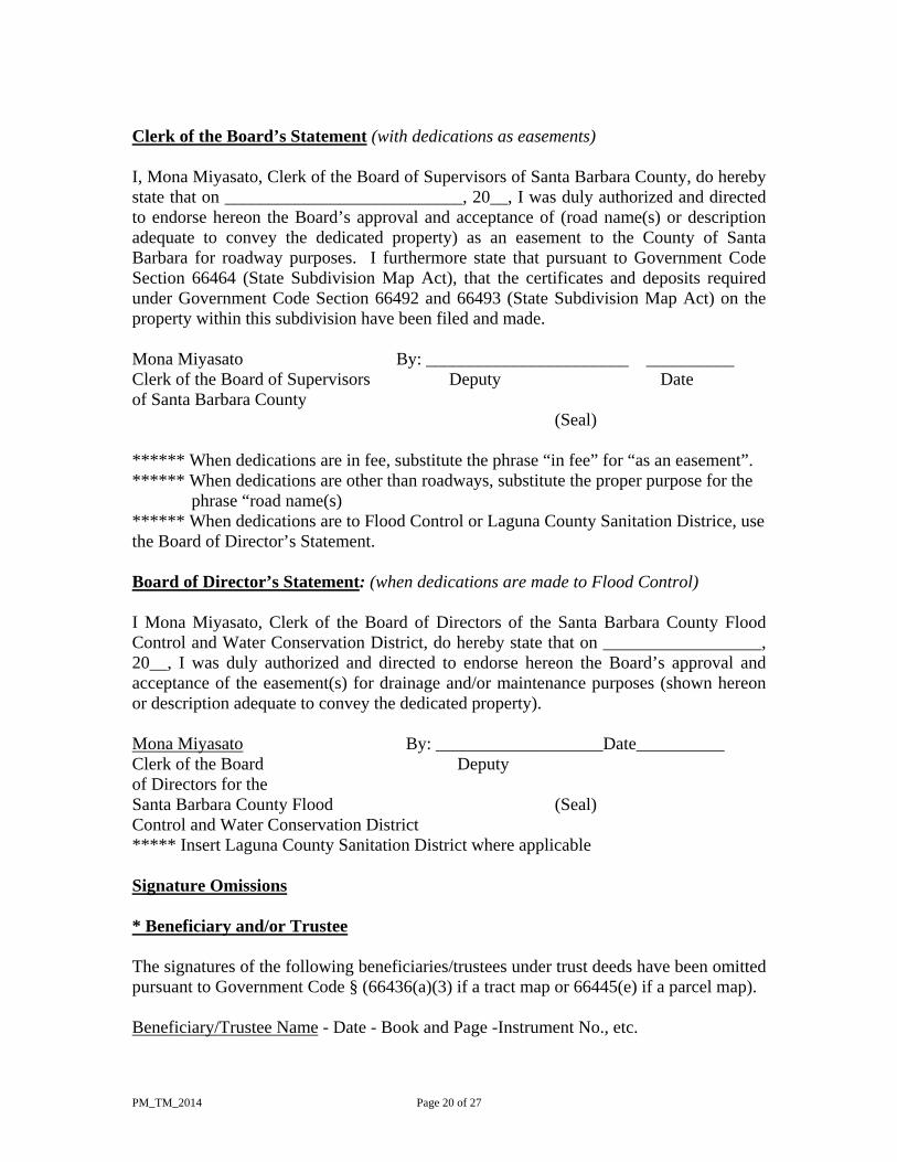
Clerk of the Board’s Statement (with dedications as easements) I, Mona Miyasato, Clerk of the Board of Supervisors of Santa Barbara County, do hereby state that on ___________________________, 20__, I was duly authorized and directed to endorse hereon the Board’s approval and acceptance of (road name(s) or description adequate to convey the dedicated property) as an easement to the County of Santa Barbara for roadway purposes. I furthermore state that pursuant to Government Code Section 66464 (State Subdivision Map Act), that the certificates and deposits required under Government Code Section 66492 and 66493 (State Subdivision Map Act) on the property within this subdivision have been filed and made. Mona Miyasato By: _______________________ __________ Clerk of the Board of Supervisors Deputy Date of Santa Barbara County (Seal) ****** When dedications are in fee, substitute the phrase “in fee” for “as an easement”. ****** When dedications are other than roadways, substitute the proper purpose for the
phrase “road name(s) ****** When dedications are to Flood Control or Laguna County Sanitation Districe, use the Board of Director’s Statement. Board of Director’s Statement: (when dedications are made to Flood Control) I Mona Miyasato, Clerk of the Board of Directors of the Santa Barbara County Flood Control and Water Conservation District, do hereby state that on __________________, 20__, I was duly authorized and directed to endorse hereon the Board’s approval and acceptance of the easement(s) for drainage and/or maintenance purposes (shown hereon or description adequate to convey the dedicated property). Mona Miyasato By: ___________________Date__________ Clerk of the Board Deputy of Directors for the Santa Barbara County Flood (Seal) Control and Water Conservation District ***** Insert Laguna County Sanitation District where applicable Signature Omissions * Beneficiary and/or Trustee The signatures of the following beneficiaries/trustees under trust deeds have been omitted pursuant to Government Code § (66436(a)(3) if a tract map or 66445(e) if a parcel map). Beneficiary/Trustee Name - Date - Book and Page -Instrument No., etc.
PM_TM_2014 Page 21 of 27
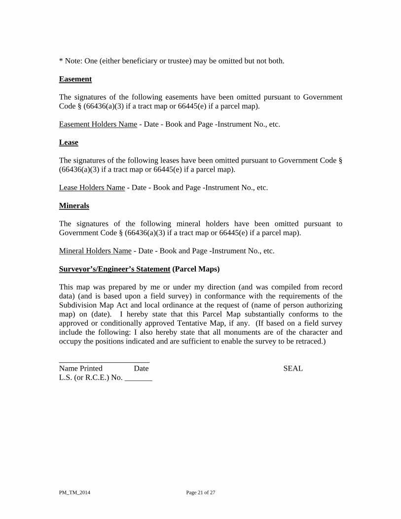
* Note: One (either beneficiary or trustee) may be omitted but not both. Easement The signatures of the following easements have been omitted pursuant to Government Code § (66436(a)(3) if a tract map or 66445(e) if a parcel map). Easement Holders Name - Date - Book and Page -Instrument No., etc. Lease The signatures of the following leases have been omitted pursuant to Government Code § (66436(a)(3) if a tract map or 66445(e) if a parcel map). Lease Holders Name - Date - Book and Page -Instrument No., etc. Minerals The signatures of the following mineral holders have been omitted pursuant to Government Code § (66436(a)(3) if a tract map or 66445(e) if a parcel map). Mineral Holders Name - Date - Book and Page -Instrument No., etc. Surveyor’s/Engineer’s Statement (Parcel Maps) This map was prepared by me or under my direction (and was compiled from record data) (and is based upon a field survey) in conformance with the requirements of the Subdivision Map Act and local ordinance at the request of (name of person authorizing map) on (date). I hereby state that this Parcel Map substantially conforms to the approved or conditionally approved Tentative Map, if any. (If based on a field survey include the following: I also hereby state that all monuments are of the character and occupy the positions indicated and are sufficient to enable the survey to be retraced.) _______________________ Name Printed Date SEAL L.S. (or R.C.E.) No. _______
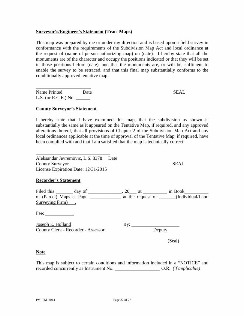
PM_TM_2014 Page 22 of 27
Surveyor’s/Engineer’s Statement (Tract Maps) This map was prepared by me or under my direction and is based upon a field survey in conformance with the requirements of the Subdivision Map Act and local ordinance at the request of (name of person authorizing map) on (date). I hereby state that all the monuments are of the character and occupy the positions indicated or that they will be set in those positions before (date), and that the monuments are, or will be, sufficient to enable the survey to be retraced, and that this final map substantially conforms to the conditionally approved tentative map. _______________________ Name Printed Date SEAL L.S. (or R.C.E.) No. ______ County Surveyor’s Statement I hereby state that I have examined this map, that the subdivision as shown is substantially the same as it appeared on the Tentative Map, if required, and any approved alterations thereof, that all provisions of Chapter 2 of the Subdivision Map Act and any local ordinances applicable at the time of approval of the Tentative Map, if required, have been complied with and that I am satisfied that the map is technically correct. _______________________________ Aleksandar Jevremovic, L.S. 8378 Date County Surveyor SEAL License Expiration Date: 12/31/2015 Recorder’s Statement Filed this _______ day of ______________, 20___ at __________ in Book__________ of (Parcel) Maps at Page _____________ at the request of _______(Individual/Land Surveying Firm)___. Fee: ____________ Joseph E. Holland By: ____________________ County Clerk - Recorder - Assessor Deputy
(Seal) Note This map is subject to certain conditions and information included in a “NOTICE” and recorded concurrently as Instrument No. ___________________ O.R. (if applicable)
PM_TM_2014 Page 23 of 27
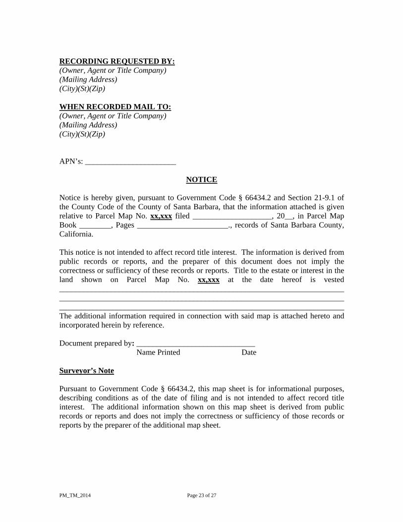
RECORDING REQUESTED BY: (Owner, Agent or Title Company) (Mailing Address) (City)(St)(Zip) WHEN RECORDED MAIL TO: (Owner, Agent or Title Company) (Mailing Address) (City)(St)(Zip) APN’s: _______________________
NOTICE
Notice is hereby given, pursuant to Government Code § 66434.2 and Section 21-9.1 of the County Code of the County of Santa Barbara, that the information attached is given relative to Parcel Map No. xx,xxx filed ____________________, 20__, in Parcel Map Book ________, Pages _______________________., records of Santa Barbara County, California. This notice is not intended to affect record title interest. The information is derived from public records or reports, and the preparer of this document does not imply the correctness or sufficiency of these records or reports. Title to the estate or interest in the land shown on Parcel Map No. xx,xxx at the date hereof is vested ________________________________________________________________________________________________________________________________________________________________________________________________________________________ The additional information required in connection with said map is attached hereto and incorporated herein by reference. Document prepared by: ______________________________ Name Printed Date Surveyor’s Note Pursuant to Government Code § 66434.2, this map sheet is for informational purposes, describing conditions as of the date of filing and is not intended to affect record title interest. The additional information shown on this map sheet is derived from public records or reports and does not imply the correctness or sufficiency of those records or reports by the preparer of the additional map sheet.
PM_TM_2014 Page 24 of 27
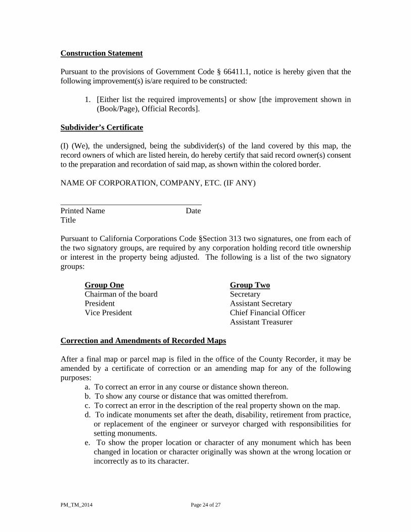
Construction Statement Pursuant to the provisions of Government Code § 66411.1, notice is hereby given that the following improvement(s) is/are required to be constructed:
1. [Either list the required improvements] or show [the improvement shown in (Book/Page), Official Records].
Subdivider’s Certificate (I) (We), the undersigned, being the subdivider(s) of the land covered by this map, the record owners of which are listed herein, do hereby certify that said record owner(s) consent to the preparation and recordation of said map, as shown within the colored border. NAME OF CORPORATION, COMPANY, ETC. (IF ANY) ___________________________________ Printed Name Date Title Pursuant to California Corporations Code §Section 313 two signatures, one from each of the two signatory groups, are required by any corporation holding record title ownership or interest in the property being adjusted. The following is a list of the two signatory groups: Group One Group Two Chairman of the board Secretary President Assistant Secretary
Vice President Chief Financial Officer Assistant Treasurer Correction and Amendments of Recorded Maps After a final map or parcel map is filed in the office of the County Recorder, it may be amended by a certificate of correction or an amending map for any of the following purposes:
a. To correct an error in any course or distance shown thereon. b. To show any course or distance that was omitted therefrom. c. To correct an error in the description of the real property shown on the map. d. To indicate monuments set after the death, disability, retirement from practice,
or replacement of the engineer or surveyor charged with responsibilities for setting monuments.
e. To show the proper location or character of any monument which has been changed in location or character originally was shown at the wrong location or incorrectly as to its character.
PM_TM_2014 Page 25 of 27
f. To correct any additional information filed or recorded pursuant to Government Code § 66434.2, if the correction does not impose any additional burden on the present fee owner of the property and does not alter any right, title, or interest in the real property reflected on the recorded map.
g. To correct any other type of map error or omission as approved by the County Surveyor or City Engineer, which does not affect any property right. Such errors and omissions may include, but are not limited to, lot numbers, acreage, street names, and identification of adjacent record maps.
As used in this section, "error" does not include changes in courses or distances from which an error is not ascertainable from the data shown on the final or parcel map. Certificate of Correction Index The amending map or certificate of correction shall be prepared and signed by a registered civil engineer licensed to practice land surveying or licensed land surveyor. An amending map shall conform to the requirements of Government Code § 66434, if a final map, or subdivisions (a) to (d), inclusive, and (f) to (i), inclusive, of Government Code § 66445, if a parcel map. The amending map or certificate of correction shall set forth in detail the corrections made and show the names of the present fee owners of the property affected by the correction or omission. Upon recordation of a certificate of correction, the County Recorder shall within 60 days of recording transmit a certified copy to the County Surveyor or county engineer who shall maintain an index of recorded certificates of correction. The County Recorder may charge a fee, in addition to the fee charged for recording the certificate of correction, which shall be transmitted to the County Surveyor or the county engineer, as compensation for the cost of maintaining an index of recorded certificates of correction. The amount of this additional fee shall not exceed the fee that is charged for recording the certificate of correction. Examination of Amending Map or Certificate of Correction by County Surveyor If the subdivision is in unincorporated territory, the County Surveyor shall examine the amending map or certificate of correction and if the only changes made are those set forth in Government Code § 66469, he or she shall certify to this fact on the amending map or certificate of correction. If the subdivision is in the city, such examination and certification shall be by the City Surveyor or City Engineer. As to a certificate of correction, the County Surveyor, City Surveyor, or City Engineer shall have 20 working days in which to examine the certificate of correction for compliance with Government Code § 66469 and 66470, endorse a statement on it of his or her examination and certification, and present it to the County Recorder for recordation. In the event the submitted certificate of correction fails to comply with Government Code § 66469 and 66470, the County Surveyor, City Surveyor, or City Engineer shall return it within the same 20 working days to the person who presented it,
PM_TM_2014 Page 26 of 27
together with a written statement of the changes necessary to make it conform to the requirements of Government Code § 66469 and 66470. The licensed land surveyor or registered civil engineer submitting the certificate of correction may then make the changes in compliance with Government Code § 66469 and 66470 and resubmit the certificate of correction to the County Surveyor, City Surveyor, or City Engineer for approval. The County Surveyor, City Surveyor, or City Engineer shall have 10 working days after resubmission and approval of the certificate of correction to present it to the County Recorder for recordation. Amending of Final Maps In addition to the amendments authorized by Government Code § 66469, after a final map or parcel map is filed in the office of the County Recorder, such a recorded final map may be modified by a certificate of correction or an amending map, if authorized by local ordinance, if the local agency finds that there are changes in circumstances which make any or all of the conditions of such a map no longer appropriate or necessary and that the modifications do not impose any additional burden on the present fee owner of the property, and if the modifications do not alter any right, title, or interest in the real property reflected on the recorded map, and the local agency finds that the map as modified conforms to the provisions of Government Code § 66474. Any such modification shall be set for public hearing as provided for in Government Code § 66451.3 of this division. The legislative body shall confine the hearing to consideration of and action on the proposed modification. If you are processing a Recorded Map Modification then please see our RMM guide for Certificate of Correction examples.
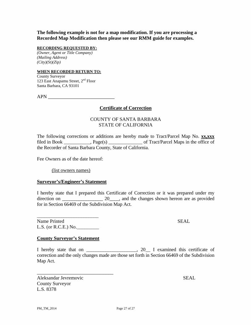
PM_TM_2014 Page 27 of 27
The following example is not for a map modification. If you are processing a Recorded Map Modification then please see our RMM guide for examples. RECORDING REQUESTED BY: (Owner, Agent or Title Company) (Mailing Address) (City)(St)(Zip) WHEN RECORDED RETURN TO: County Surveyor 123 East Anapamu Street, 2nd Floor Santa Barbara, CA 93101 APN ___________________________
Certificate of Correction
COUNTY OF SANTA BARBARA
STATE OF CALIFORNIA The following corrections or additions are hereby made to Tract/Parcel Map No. xx,xxx filed in Book ___________, Page(s) ______________ of Tract/Parcel Maps in the office of the Recorder of Santa Barbara County, State of California. Fee Owners as of the date hereof: (list owners names) Surveyor’s/Engineer’s Statement I hereby state that I prepared this Certificate of Correction or it was prepared under my direction on _________________ 20____, and the changes shown hereon are as provided for in Section 66469 of the Subdivision Map Act. _________________________ Name Printed SEAL L.S. (or R.C.E.) No._________ County Surveyor’s Statement I hereby state that on _____________________, 20__ I examined this certificate of correction and the only changes made are those set forth in Section 66469 of the Subdivision Map Act. _______________________________ Aleksandar Jevremovic SEAL County Surveyor L.S. 8378