Embed Size (px)
Citation preview
337
National Marine Fisheries Service/NOAA, Commerce § 224.101
PART 224—ENDANGERED MARINE AND ANADROMOUS SPECIES
Sec. 224.101 Enumeration of endangered marine
and anadromous species. 224.102 Permits for endangered marine and
anadromous species. 224.103 Special prohibitions for endangered
marine mammals. 224.104 Special requirements for fishing ac-
tivities to protect endangered sea tur-tles.
224.105 Speed restrictions to protect North Atlantic Right Whales.
AUTHORITY: 16 U.S.C. 1531–1543 and 16 U.S.C. 1361 et seq.
SOURCE: 64 FR 14066, Mar. 23, 1999, unless otherwise noted.
§ 224.101 Enumeration of endangered marine and anadromous species.
The marine and anadromous species determined by the Secretary of Com-merce to be endangered pursuant to section 4(a) of the Act, as well as spe-cies listed under the Endangered Spe-cies Conservation Act of 1969 by the Secretary of the Interior and currently under the jurisdiction of the Secretary of Commerce, are the following:
(a) Marine and anadromous fish. The following table lists the common and scientific names of endangered species, the locations where they are listed, and the citations for the listings and crit-ical habitat designations.
Species 1 Where listed
Citation(s) for listing deter-mination(s)
Citation for crit-ical habitat des-
ignation Common name Scientific name
Shortnose stur-geon.
Acipenser brevirostrum.
Everywhere .......................................................... 32 FR 4001, Mar. 11, 1967.
NA.
Smalltooth sawfish Pristis pectinata ... U.S.A. .................................................................. 68 FR 15674, Apr. 1, 2003.
NA.
Totoaba ............... Cynoscion macdonaldi.
Everywhere .......................................................... 44 FR 29480, May 21, 1979.
NA.
Gulf of Maine At-lantic salmon.
Salmo salar ......... U.S.A., ME, Gulf of Maine Distinct Population Segment. The GOM DPS includes all anad-romous Atlantic salmon whose freshwater range occurs in the watersheds from the Androscoggin River northward along the Maine coast to the Dennys River, and wher-ever these fish occur in the estuarine and ma-rine environment. The following impassable falls delimit the upstream extent of the fresh-water range: Rumford Falls in the town of Rumford on the Androscoggin River; Snow Falls in the town of West Paris on the Little Androscoggin River; Grand Falls in Township 3 Range 4 BKP WKR, on the Dead River in the Kennebec Basin; the un-named falls (im-pounded by Indian Pond Dam) immediately above the Kennebec River Gorge in the town of Indian Stream Township on the Kennebec River; Big Niagara Falls on Nesowadnehunk Stream in Township 3 Range 10 WELS in the Penobscot Basin; Grand Pitch on Webster Brook in Trout Brook Township in the Penob-scot Basin; and Grand Falls on the Passadumkeag River in Grand Falls Town-ship in the Penobscot Basin. The marine range of the GOM DPS extends from the Gulf of Maine, throughout the Northwest Atlantic Ocean, to the coast of Greenland. Included are all associated conservation hatchery pop-ulations used to supplement these natural populations; currently, such conservation hatchery populations are maintained at Green Lake National Fish Hatchery (GLNFH) and Craig Brook National Fish Hatchery (CBNFH). Excluded are landlocked salmon and those salmon raised in commercial hatcheries for aquaculture.
65 FR 69469; November 17, 2000; 74 FR 29344, June 19, 2009.
NA
VerDate Mar<15>2010 11:01 Jan 05, 2011 Jkt 220227 PO 00000 Frm 00347 Fmt 8010 Sfmt 8010 Q:\50\220227.XXX ofr150 PsN: PC150
338
50 CFR Ch. II (10–1–10 Edition) § 224.101
Species 1 Where listed
Citation(s) for listing deter-mination(s)
Citation for crit-ical habitat des-
ignation Common name Scientific name
Snake River sock-eye.
Oncorhynchus nerka.
U.S.A., ID, including all anadromous and resid-ual sockeye salmon from the Snake River Basin, Idaho, as well as artificially propagated sockeye salmon from the Redfish Lake cap-tive propagation program.
56 FR 58619, Nov. 20, 1991.
June 28, 2005.
58 FR 68543, Dec. 28, 1993.
Sacramento River winter-run Chi-nook.
Oncorhynchus tshawytscha.
U.S.A., CA, including all naturally spawned pop-ulations of winter-run Chinook salmon in the Sacramento River and its tributaries in Cali-fornia, as well as two artificial propagation programs: winter-run Chinook from the Living-ston Stone National Fish Hatchery (NFH), and winter run Chinook in a captive broodstock program maintained at Livingston Stone NFH and the University of California Bodega Ma-rine Laboratory.
52 FR 6041; Feb. 27, 1987, 55 FR 49623; Nov. 30, 1990. 59 FR 440; Jan. 1, 1994.
June 28, 2005.
58 FR 33212, June 16, 1993.
Upper Columbia spring-run Chi-nook.
Oncorhynchus tshawytscha.
U.S.A., WA, including all naturally spawned populations of Chinook salmon in all river reaches accessible to Chinook salmon in Co-lumbia River tributaries upstream of the Rock Island Dam and downstream of Chief Joseph Dam in Washington (excluding the Okanogan River), the Columbia River from a straight line connecting the west end of the Clatsop jetty (south jetty, Oregon side) and the west end of the Peacock jetty (north jetty, Washington side) upstream to Chief Joseph Dam in Washington, as well as six artificial propaga-tion programs: the Twisp River, Chewuch River, Methow Composite, Winthrop NFH, Chiwawa River, and White River spring-run Chinook hatchery programs.
64 FR 14308, Mar. 24, 1999.
June 28, 2005.
NA. [vacated 9/29/
03; 68 FR 55900].
Central California Coast coho.
Oncorhynchus kisutch.
U.S.A., CA, including all naturally spawned pop-ulations of coho salmon from Punta Gorda in northern California south to and including the San Lorenzo River in central California, as well as populations in tributaries to San Fran-cisco Bay, excluding the Sacramento-San Joaquin River system, as well four artificial propagation programs: the Don Clausen Fish Hatchery Captive Broodstock Program, Scott Creek/King Fisher Flats Conservation Pro-gram, Scott Creek Captive Broodstock Pro-gram, and the Noyo River Fish Station egg- take Program coho hatchery programs.
61 FR 56138, Oct. 31, 1996.
June 28, 2005.
64 FR 24049, May 5, 1999.
Southern Cali-fornia Steelhead.
Oncorhynchus mykiss.
U.S.A., CA, Distinct Population Segment includ-ing all naturally spawned anadromous O. mykiss (steelhead) populations below natural and manmade impassable barriers in streams from the Santa Maria River, San Luis Obispo County, California, (inclusive) to the U.S.- Mexico Border.
62 FR 43937, Aug. 18, 1997.
Jan. 5, 2006
70 FR 52488, Sept. 2, 2005.
Puget Sound/ Georgia Basin DPS—Bocaccio.
Sebastes paucispinis.
U.S.A., Washington, and British Columbia, in-cluding Puget Sound and Georgia Basin.
75 FR 22290, Apr. 28, 2010.
75 FR 22290, Apr. 28, 2010.
1 Species includes taxonomic species, subspecies, distinct population segments (DPSs) (for a policy statement, see 61 FR 4722, February 7, 1996), and evolutionarily significant units (ESUs) (for a policy statement, see 56 FR 58612, November 20, 1991).
(b) Marine mammals. Beluga whale (Delphinapterus leucas), Cook Inlet dis-tinct population segment; Blue whale (Balaenoptera musculus); Bowhead whale (Balaena mysticetus); Chinese river dolphin (Lipotes vexillifer); Cochito (Phocoena sinus); Fin or finback whale (Balaenoptera physalus); Hawaiian monk seal (Monachus schauinslandi);
Humpback whale (Megaptera
novaeangliae); Indus River dolphin (Platanista minor); Mediterranean monk seal (Monachus monachus); North At-lantic right whale (Eubalaena glacialis); North Pacific right whale (Eubalaena japonica); Southern right whale (Eubalaena australis); Saimaa seal (Phoca hispida saimensis); Sei whale
VerDate Mar<15>2010 11:01 Jan 05, 2011 Jkt 220227 PO 00000 Frm 00348 Fmt 8010 Sfmt 8010 Q:\50\220227.XXX ofr150 PsN: PC150
339
National Marine Fisheries Service/NOAA, Commerce § 224.103
(Balaenoptera borealis); Sperm whale (Physeter catodon); Western North Pa-cific (Korean) gray whale (Eschrichtius robustus); Steller sea lion, western pop-ulation, (Eumetopias jubatus), which consists of Steller sea lions from breed-ing colonies located west of 144° W. lon-gitude.
(c) Sea turtles. Green turtle (Chelonia mydas) breeding colony populations in Florida and on the Pacific coast of Mexico; Hawksbill turtle (Eretmochelys imbricata); Kemp’s ridley turtle (Lepidochelys kempii); Leatherback tur-tle (Dermochelys coriacea); Olive ridley
turtle (Lepidochelys olivacea) breeding colony population on the Pacific coast of Mexico.
NOTE TO § 224.101(c): Jurisdiction for sea turtles by the Department of Commerce, Na-tional Oceanic and Atmospheric Administra-tion, National Marine Fisheries Service, is limited to turtles while in the water.
(d) Marine invertebrates. The following table lists the common and scientific names of endangered species, the loca-tions where they are listed, and the ci-tations for the listings and critical habitat designations.
Species Where Listed Citation (s) for Listing Deter-
minations
Citations (s) for Critical Habitat Designations Common name Scientific name
Black abalone Haliotis cracherodii
USA, CA. From Crescent City, California, USA to Cape San
Lucas, Baja California, Mexico, including all offshore islands.
74 FR 1937; January 14, 2009 N/A
White abalone Haliotis sorenseni
USA, CA. From Point Conception, California to Punta
Abreojos, Baja California, Mexico including all offshore
islands and banks.
NOAA 2001; 66 FR 29054, May, 29, 2001.
Deemed not prudent NOAA 2001; 66 FR
29054, May, 29, 2001.
[64 FR 14066, Mar. 23, 1999, as amended 64 FR 14328, Mar. 24, 1999; 65 FR 20918, Apr. 19, 2000; 65 FR 69481, Nov. 17, 2000; 66 FR 29055, May 29, 2001; 67 FR 21598, May 1, 2002; 68 FR 15680, Apr. 1, 2003; 70 FR 37203, June 28, 2005; 70 FR 69912, Nov. 18, 2005; 71 FR 861, Jan. 5, 2006; 73 FR 12030, Mar. 6, 2008; 73 FR 63907, Oct. 28, 2008; 73 FR 62930, Oct. 22, 2008; 74 FR 1946, Jan. 14, 2009; 74 FR 29386, June 19, 2009; 75 FR 22290, Apr. 28, 2010]
§ 224.102 Permits for endangered ma-rine and anadromous species.
No person shall take, import, export, or engage in any activity prohibited by section 9 of the Act involving any ma-rine species that has been determined to be endangered under the Endangered Species Conservation Act of 1969 or the Act, and that is under the jurisdiction of the Secretary, without a valid per-mit issued pursuant to part 222, sub-part C of this chapter.
§ 224.103 Special prohibitions for en-dangered marine mammals.
(a) Approaching humpback whales in Hawaii. Except as provided in part 222, subpart C, of this chapter (General Per-mit Procedures), it is unlawful for any person subject to the jurisdiction of
the United States to commit, to at-tempt to commit, to solicit another to commit, or to cause to be committed, within 200 nautical miles (370.4 km) of the Islands of Hawaii, any of the fol-lowing acts with respect to humpback whales (Megaptera novaeangliae):
(1) Operate any aircraft within 1,000 feet (300 m) of any humpback whale;
(2) Approach, by any means, within 100 yard (90 m) of any humpback whale;
(3) Cause a vessel or other object to approach within 100 yd (90 m) of a humpback whale; or
(4) Disrupt the normal behavior or prior activity of a whale by any other act or omission. A disruption of normal behavior may be manifested by, among other actions on the part of the whale, a rapid change in direction or speed; es-cape tactics such as prolonged diving, underwater course changes, underwater exhalation, or evasive swimming pat-terns; interruptions of breeding, nurs-ing, or resting activities, attempts by a whale to shield a calf from a vessel or human observer by tail swishing or by other protective movement; or the abandonment of a previously fre-quented area.
VerDate Mar<15>2010 11:01 Jan 05, 2011 Jkt 220227 PO 00000 Frm 00349 Fmt 8010 Sfmt 8010 Q:\50\220227.XXX ofr150 PsN: PC150
340
50 CFR Ch. II (10–1–10 Edition) § 224.103
(b) Approaching humpback whales in Alaska—(1) Prohibitions. Except as pro-vided under paragraph (b)(2) of this sec-tion, it is unlawful for any person sub-ject to the jurisdiction of the United States to commit, to attempt to com-mit, to solicit another to commit, or to cause to be committed, within 200 nau-tical miles (370.4 km) of Alaska, or within inland waters of the state, any of the acts in paragraphs (b)(1)(i) through (b)(1)(iii) of this section with respect to humpback whales (Megaptera novaeangliae):
(i) Approach, by any means, includ-ing by interception (i.e., placing a ves-sel in the path of an oncoming hump-back whale so that the whale surfaces within 100 yards (91.4 m) of the vessel), within 100 yards (91.4 m) of any hump-back whale;
(ii) Cause a vessel or other object to approach within 100 yards (91.4 m) of a humpback whale; or
(iii) Disrupt the normal behavior or prior activity of a whale by any other act or omission, as described in para-graph (a)(4) of this section.
(2) Exceptions. The following excep-tions apply to this paragraph (b), but any person who claims the applica-bility of an exception has the burden of proving that the exception applies:
(i) Paragraph (b)(1) of this section does not apply if an approach is au-thorized by the National Marine Fish-eries Service through a permit issued under part 222, subpart C, of this chap-ter (General Permit Procedures) or through a similar authorization.
(ii) Paragraph (b)(1) of this section does not apply to the extent that a ves-sel is restricted in her ability to ma-neuver and, because of the restriction, cannot comply with paragraph (b)(1) of this section.
(iii) Paragraph (b)(1) of this section does not apply to commercial fishing vessels lawfully engaged in actively setting, retrieving or closely tending commercial fishing gear. For purposes of this paragraph (b), commercial fish-ing means taking or harvesting fish or fishery resources to sell, barter, or trade. Commercial fishing does not in-clude commercial passenger fishing op-erations (i.e. charter operations or sport fishing activities).
(iv) Paragraph (b)(1) of this section does not apply to state, local, or Fed-eral government vessels operating in the course of official duty.
(v) Paragraph (b)(1) of this section does not affect the rights of Alaska Na-tives under 16 U.S.C. 1539(e).
(vi) These regulations shall not take precedence over any more restrictive conflicting Federal regulation per-taining to humpback whales, including the regulations at 36 CFR 13.65 that pertain specifically to the waters of Glacier Bay National Park and Pre-serve.
(3) General measures. Notwithstanding the prohibitions and exceptions in paragraphs (b)(1) and (2) of this section, to avoid collisions with humpback whales, vessels must operate at a slow, safe speed when near a humpback whale. ‘‘Safe speed’’ has the same meaning as the term is defined in 33 U.S.C. 2006 and the International Regu-lations for Preventing Collisions at Sea 1972 (see 33 U.S.C. 1602), with respect to avoiding collisions with humpback whales.
(c) Approaching right whales—(1) Pro-hibitions. Except as provided under paragraph (c)(3) of this section, it is unlawful for any person subject to the jurisdiction of the United States to commit, attempt to commit, to solicit another to commit, or cause to be com-mitted any of the following acts:
(i) Approach (including by intercep-tion) within 500 yards (460 m) of a right whale by vessel, aircraft, or any other means;
(ii) Fail to undertake required right whale avoidance measures specified under paragraph (c)(2) of this section.
(2) Right whale avoidance measures. Except as provided under paragraph (c)(3) of this section, the following avoidance measures must be taken if within 500 yards (460 m) of a right whale:
(i) If underway, a vessel must steer a course away from the right whale and immediately leave the area at a slow safe speed.
(ii) An aircraft must take a course away from the right whale and imme-diately leave the area at a constant airspeed.
(3) Exceptions. The following excep-tions apply to this section, but any
VerDate Mar<15>2010 11:01 Jan 05, 2011 Jkt 220227 PO 00000 Frm 00350 Fmt 8010 Sfmt 8010 Q:\50\220227.XXX ofr150 PsN: PC150
341
National Marine Fisheries Service/NOAA, Commerce § 224.105
person who claims the applicability of an exception has the burden of proving that the exception applies:
(i) Paragraphs (c)(1) and (c)(2) of this section do not apply if a right whale approach is authorized by the National Marine Fisheries Service through a permit issued under part 222, subpart C, of this chapter (General Permit Proce-dures) or through a similar authoriza-tion.
(ii) Paragraphs (c)(1) and (c)(2) of this section do not apply where compliance would create an imminent and serious threat to a person, vessel, or aircraft.
(iii) Paragraphs (c)(1) and (c)(2) of this section do not apply when ap-proaching to investigate a right whale entanglement or injury, or to assist in the disentanglement or rescue of a right whale, provided that permission is received from the National Marine Fisheries Service or designee prior to the approach.
(iv) Paragraphs (c)(1) and (c)(2) of this section do not apply to an aircraft unless the aircraft is conducting whale watch activities.
(v) Paragraph (c)(2) of this section does not apply to the extent that a ves-sel is restricted in her ability to ma-neuver and, because of the restriction, cannot comply with paragraph (c)(2) of this section.
(d) Special prohibitions relating to en-dangered Steller sea lion protection. The regulatory provisions set forth in part 223 of this chapter, which govern threatened Steller sea lions, shall also apply to the western population of Steller sea lions, which consists of all Steller sea lions from breeding colonies located west of 144° W. long.
[64 FR 14066, Mar. 23, 1999, as amended at 66 FR 29509, May 31, 2001; 69 FR 69537, Nov. 30, 2004; 70 FR 1832, Jan. 11, 2005]
§ 224.104 Special requirements for fishing activities to protect endan-gered sea turtles.
(a) Shrimp fishermen in the south-eastern United States and the Gulf of Mexico who comply with rules for threatened sea turtles specified in § 223.206 of this chapter will not be sub-ject to civil penalties under the Act for incidental captures of endangered sea turtles by shrimp trawl gear.
(b) Summer flounder fishermen in the Summer flounder fishery-sea turtle protection area who comply with rules for threatened sea turtles specified in § 223.206 of this chapter will not be sub-ject to civil penalties under the Act for incidental captures of endangered sea turtles by summer flounder gear.
(c) Special prohibitions relating to sea turtles are provided at § 223.206(d).
[64 FR 14066, Mar. 23, 1999, as amended at 66 FR 44552, Aug. 24, 2001; 66 FR 67496, Dec. 31, 2001; 68 FR 8471, Feb. 21, 2003; 69 FR 18453, Apr. 7, 2004; 72 FR 31757, June 8, 2007]
§ 224.105 Speed restrictions to protect North Atlantic Right Whales.
(a) The following restrictions apply to: All vessels greater than or equal to 65 ft (19.8 m) in overall length and sub-ject to the jurisdiction of the United States, and all other vessels greater than or equal to 65 ft (19.8 m) in overall length entering or departing a port or place subject to the jurisdiction of the United States. These restrictions shall not apply to U.S. vessels owned or op-erated by, or under contract to, the Federal Government. This exemption extends to foreign sovereign vessels when they are engaging in joint exer-cises with the U.S. Department of the Navy. In addition, these restrictions do not apply to law enforcement vessels of a State, or political subdivision there-of, when engaged in law enforcement or search and rescue duties.
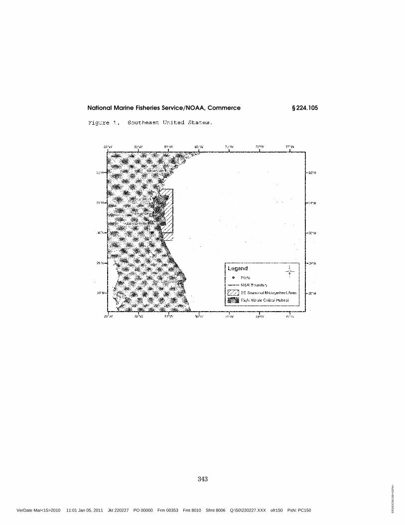
(1) Southeast U.S. (south of St. Augus-tine, FL to north of Brunswick, GA): Vessels shall travel at a speed of 10 knots or less over ground during the period of November 15 to April 15 each year in the area bounded by the fol-lowing: Beginning at 31°27′00.0″ N– 080°51′36.0″ W; thence west to charted mean high water line then south along charted mean high water line and inshore limits of COLREGS limit to a latitude of 29°45′00.0″ N thence east to 29°45′00.0″ N–080°51′36.0″ W; thence back to starting point. (Fig. 1).
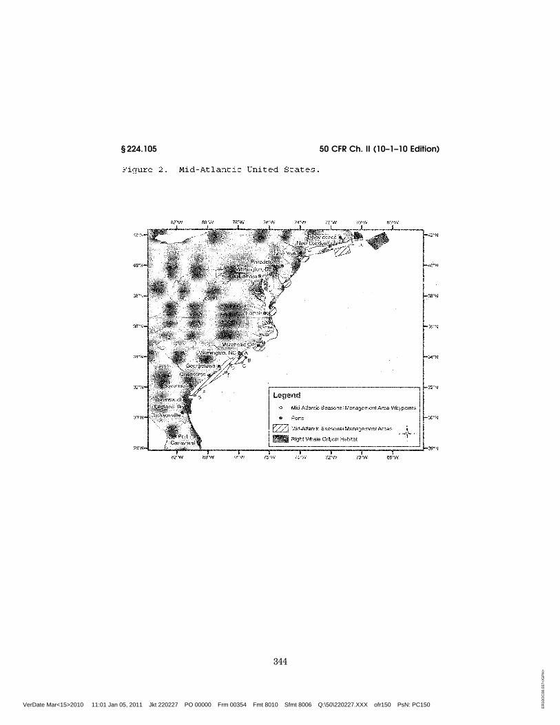
(2) Mid-Atlantic U.S. (from north of Brunswick, Georgia to Rhode Island): Vessels shall travel 10 knots or less over ground in the period November 1 to April 30 each year:
(i) In the area bounded by the fol-lowing: 33°56′42.0″ N–077°31′30.0″ W; thence along a NW bearing of 313.26°
VerDate Mar<15>2010 11:01 Jan 05, 2011 Jkt 220227 PO 00000 Frm 00351 Fmt 8010 Sfmt 8010 Q:\50\220227.XXX ofr150 PsN: PC150
342
50 CFR Ch. II (10–1–10 Edition) § 224.105
True to charted mean high water line then south along mean high water line and inshore limits of COLREGS limit to a latitude of 31°27′00.0″ N; thence east to 31°27′00.0″ N–080°51′36.0″ W; thence to 31°50′00.0″ N–080°33′12.0″ W; thence to 32°59′06.0″ N–078°50′18.0″ W; thence to 33°28′24.0″ N–078°32′30.0″ W; thence to 33°36′30.0″ N–077°47′06.0″ W; thence back to starting point.;
(ii) Within a 20-nm (37 km) radius (as measured seaward from COLREGS de-lineated coast lines and the center point of the port entrance) (Fig. 2) at the
(A) Ports of New York/New Jersey: 40°29′42.2″ N–073°55′57.6″ W;
(B) Delaware Bay (Ports of Philadel-phia and Wilmington): 38°52′27.4″ N– 075°01′32.1″ W;
(C) Entrance to the Chesapeake Bay (Ports of Hampton Roads and Balti-more): 37°00′36.9″ N–075°57′50.5″ W; and
(D) Ports of Morehead City and Beau-fort, NC: 34°41′32.0″ N–076°40′08.3″ W; and
(iii) In Block Island Sound, in the area bounded by the following coordi-nates: Beginning at 40°51′53.7″ N– 70°36′44.9″ W; thence to 41°20′14.1″ N– 70°49′44.1″ W; thence to 41°04′16.7″ N– 71°51′21.0″ W; thence to 40°35′56.5″ N– 71°38′25.1″ W; thence back to starting point. (Fig. 2).
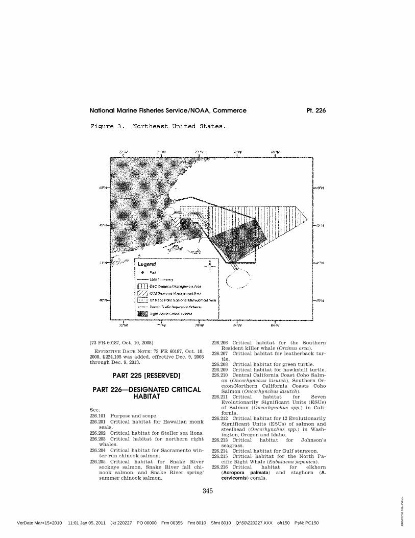
(3) Northeast U.S. (north of Rhode Is-land):
(i) In Cape Cod Bay, MA: Vessels shall travel at a speed of 10 knots or less over ground during the period of Janu-ary 1 to May 15 in Cape Cod Bay, in an area beginning at 42°04′56.5″ N– 070°12′00.0″ W; thence north to 42°12′00.0″ N–070°12′00.0″ W; thence due west to charted mean high water line; thence along charted mean high water within Cape Cod Bay back to beginning point. (Fig. 3).
(ii) Off Race Point: Vessels shall trav-el at a speed of 10 knots or less over ground during the period of March 1 to April 30 each year in waters bounded by straight lines connecting the fol-lowing points in the order stated (Fig. 3): 42°30′00.0″ N–069°45′00.0″ W; thence to 42°30′00.0″ N–070°30′00.0″ W; thence to 42°12′00.0″ N–070°30′00.0″ W; thence to 42°12′00.0″ N–070°12′00.0″ W; thence to
42°04′56.5″ N–070°12′00.0″ W; thence along charted mean high water line and inshore limits of COLREGS limit to a latitude of 41°40′00.0″ N; thence due east to 41°41′00.0″ N–069°45′00.0″ W; thence back to starting point.
(iii) Great South Channel: Vessels shall travel at a speed of 10 knots or less over ground during the period of April 1 to July 31 each year in all wa-ters bounded by straight lines con-necting the following points in the order stated (Fig. 3):
42°30′00.0″ N–069°45′00.0″ W 41°40′00.0″ N–069°45′00.0″ W 41°00′00.0″ N–069°05′00.0″ W 42°09′00.0″ N–067°08′24.0″ W 42°30′00.0″ N–067°27′00.0″ W 42°30′00.0″ N–069°45′00.0″ W
(b) Except as noted in paragraph (c) of this section, it is unlawful under this section:
(1) For any vessel subject to the ju-risdiction of the United States to vio-late any speed restriction established in paragraph (a) of this section; or
(2) For any vessel entering or depart-ing a port or place under the jurisdic-tion of the United States to violate any speed restriction established in para-graph (a) of this section.
(c) A vessel may operate at a speed necessary to maintain safe maneu-vering speed instead of the required ten knots only if justified because the ves-sel is in an area where oceanographic, hydrographic and/or meteorological conditions severely restrict the maneu-verability of the vessel and the need to operate at such speed is confirmed by the pilot on board or, when a vessel is not carrying a pilot, the master of the vessel. If a deviation from the ten-knot speed limit is necessary, the reasons for the deviation, the speed at which the vessel is operated, the latitude and longitude of the area, and the time and duration of such deviation shall be en-tered into the logbook of the vessel. The master of the vessel shall attest to the accuracy of the logbook entry by signing and dating it.
(d) This final rule expires on Decem-ber 9, 2013.
VerDate Mar<15>2010 11:01 Jan 05, 2011 Jkt 220227 PO 00000 Frm 00352 Fmt 8010 Sfmt 8010 Q:\50\220227.XXX ofr150 PsN: PC150
343
National Marine Fisheries Service/NOAA, Commerce § 224.105
VerDate Mar<15>2010 11:01 Jan 05, 2011 Jkt 220227 PO 00000 Frm 00353 Fmt 8010 Sfmt 8006 Q:\50\220227.XXX ofr150 PsN: PC150 ER
10O
C08
.036
</G
PH
>
344
50 CFR Ch. II (10–1–10 Edition) § 224.105
VerDate Mar<15>2010 11:01 Jan 05, 2011 Jkt 220227 PO 00000 Frm 00354 Fmt 8010 Sfmt 8006 Q:\50\220227.XXX ofr150 PsN: PC150 ER
10O
C08
.037
</G
PH
>
345
National Marine Fisheries Service/NOAA, Commerce Pt. 226
[73 FR 60187, Oct. 10, 2008]
EFFECTIVE DATE NOTE: 73 FR 60187, Oct. 10, 2008, § 224.105 was added, effective Dec. 9, 2008 through Dec. 9, 2013.
PART 225 [RESERVED]
PART 226—DESIGNATED CRITICAL HABITAT
Sec.
226.101 Purpose and scope.
226.201 Critical habitat for Hawaiian monk seals.
226.202 Critical habitat for Steller sea lions.
226.203 Critical habitat for northern right whales.
226.204 Critical habitat for Sacramento win-ter-run chinook salmon.
226.205 Critical habitat for Snake River sockeye salmon, Snake River fall chi-nook salmon, and Snake River spring/ summer chinook salmon.
226.206 Critical habitat for the Southern Resident killer whale (Orcinus orca).
226.207 Critical habitat for leatherback tur-tle.
226.208 Critical habitat for green turtle. 226.209 Critical habitat for hawksbill turtle. 226.210 Central California Coast Coho Salm-
on (Oncorhynchus kisutch), Southern Or-egon/Northern California Coasts Coho Salmon (Oncorhynchus kisutch).
226.211 Critical habitat for Seven Evolutionarily Significant Units (ESUs) of Salmon (Oncorhynchus spp.) in Cali-fornia.
226.212 Critical habitat for 12 Evolutionarily Significant Units (ESUs) of salmon and steelhead (Oncorhynchus spp.) in Wash-ington, Oregon and Idaho.
226.213 Critical habitat for Johnson’s seagrass.
226.214 Critical habitat for Gulf sturgeon. 226.215 Critical habitat for the North Pa-
cific Right Whale (Eubalaena japonica). 226.216 Critical habitat for elkhorn
(Acropora palmata) and staghorn (A. cervicornis) corals.
VerDate Mar<15>2010 11:01 Jan 05, 2011 Jkt 220227 PO 00000 Frm 00355 Fmt 8010 Sfmt 8010 Q:\50\220227.XXX ofr150 PsN: PC150 ER
10O
C08
.038
</G
PH
>