Embed Size (px)
Citation preview
© Crown copyright Met Office
Physics Presentation – Mike Bush
for 30th EWGLAM and 15th SRNWP Annual Meeting 2008 6th – 9th October 2008 Madrid, Spain
Paul Agnew, Maria Athanassiadou, Jorge Bornemann, Pete Clark,
James Manners, Gabriel Rooney, Jonathan Wilkinson, Damian Wilson et al.
© Crown copyright Met Office
Talk Outline
• NAE Physics
• UK1.5 km results
© Crown copyright Met Office
Talk Outline
• NAE Physics
• UK1.5 km results
© Crown copyright Met Office
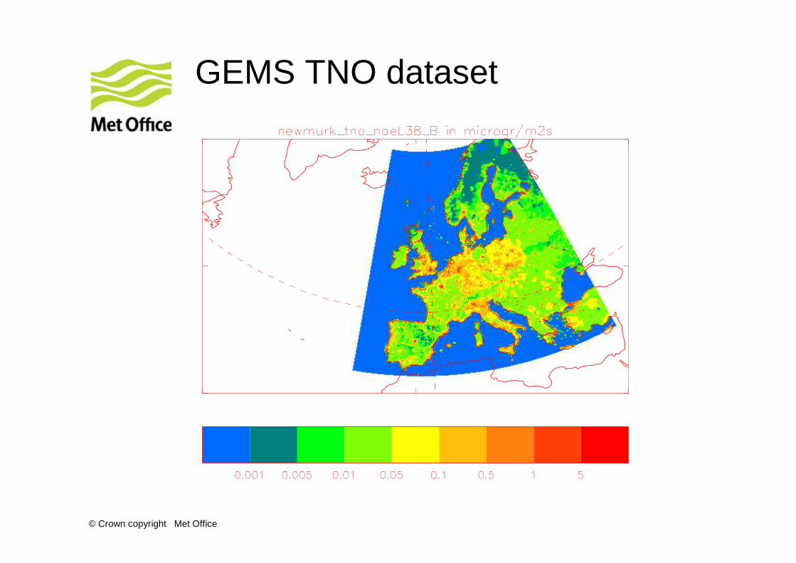
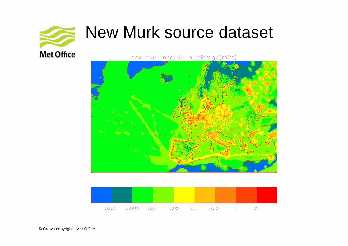
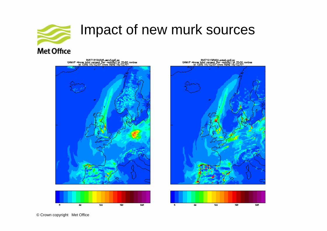
Creating a new murk aerosol source dataset
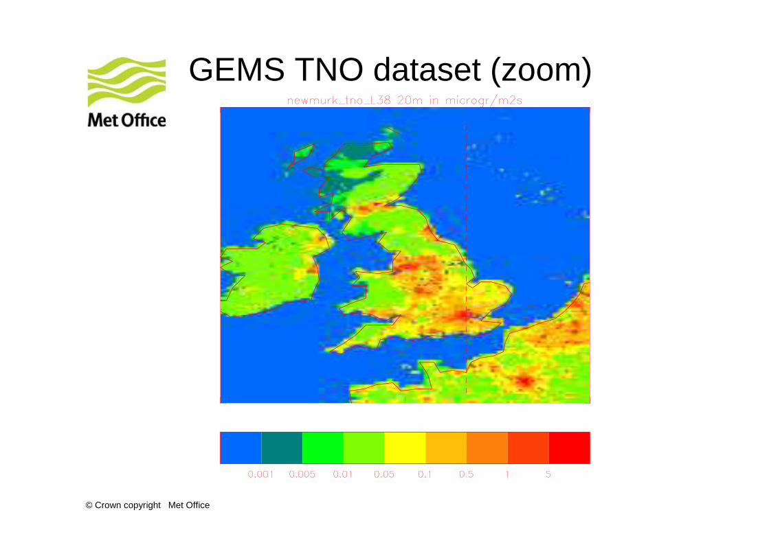
• GEMS-TNO emissions. These are in a latitude, longitude format with a resolution of 0.125˚ x 0.0625˚ (approx 5 km × 5 km). They cover the GEMS domain (15˚ W to 35˚ W and 15˚N to 70˚ N) but not all of the NAE domain.
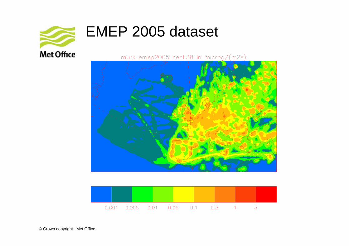
• Emep 2005, in a resolution of 50 km × 50 km, covering almost all of the NAE domain. Emissions from shipping are included here.
• A nominal value of sea salt = 0.007 mg/m2s (all sea points)
• A nominal value of 0.021 mg/m2s over N. Africa where there are no emissions.
• Over the UK only, where stack heights from point sources are known, GEMS-TNO emissions from grid points corresponding to elevated point sources have been moved from the surface to the appropriate model level.
© Crown copyright Met Office
GEMS TNO dataset
© Crown copyright Met Office
GEMS TNO dataset (zoom)
© Crown copyright Met Office
EMEP 2005 dataset
© Crown copyright Met Office
New Murk source dataset
© Crown copyright Met Office
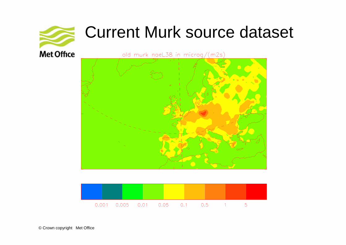
Current Murk source dataset
© Crown copyright Met Office
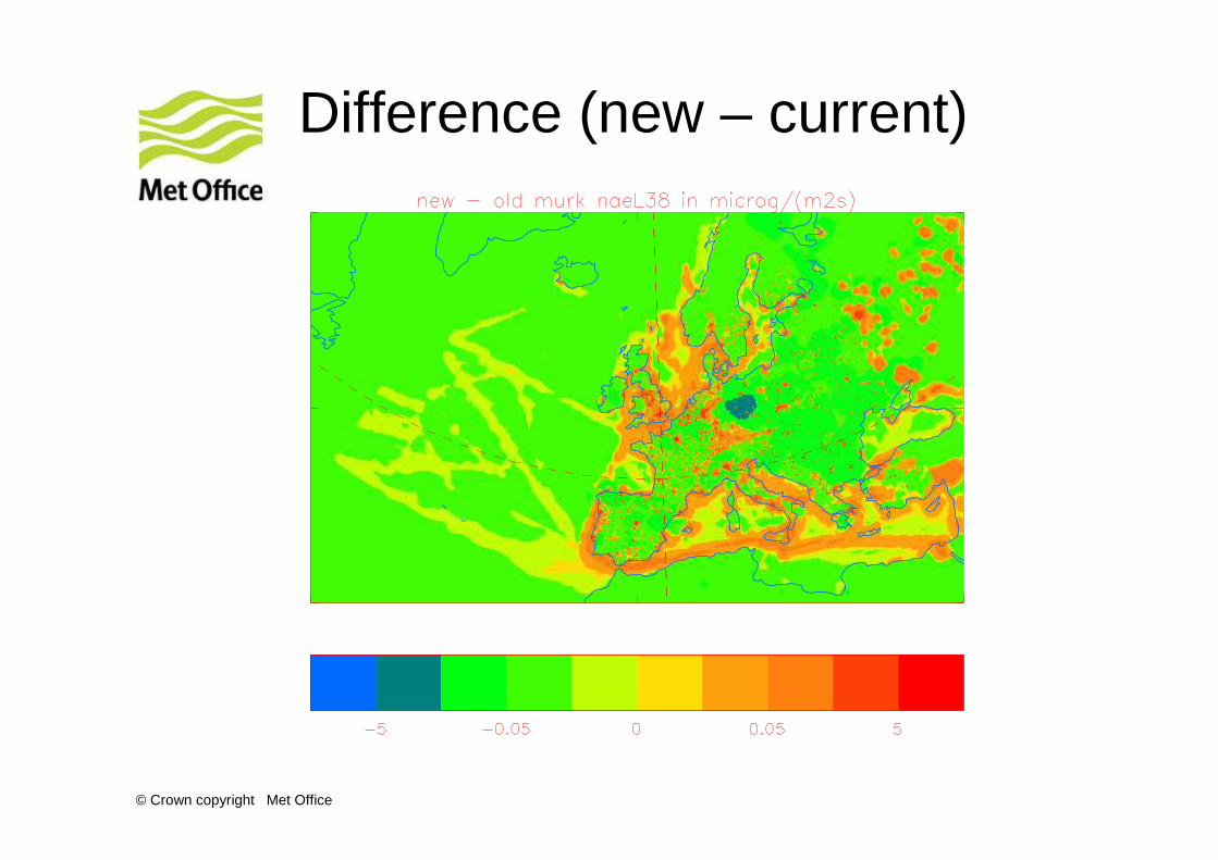
Difference (new – current)
© Crown copyright Met Office
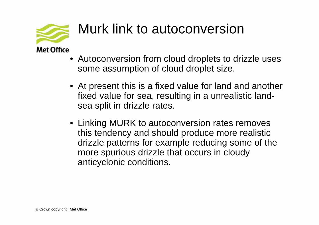
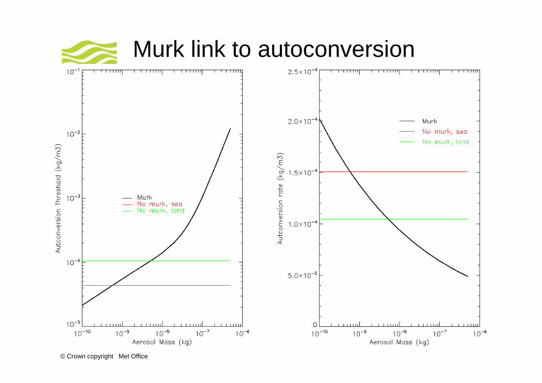
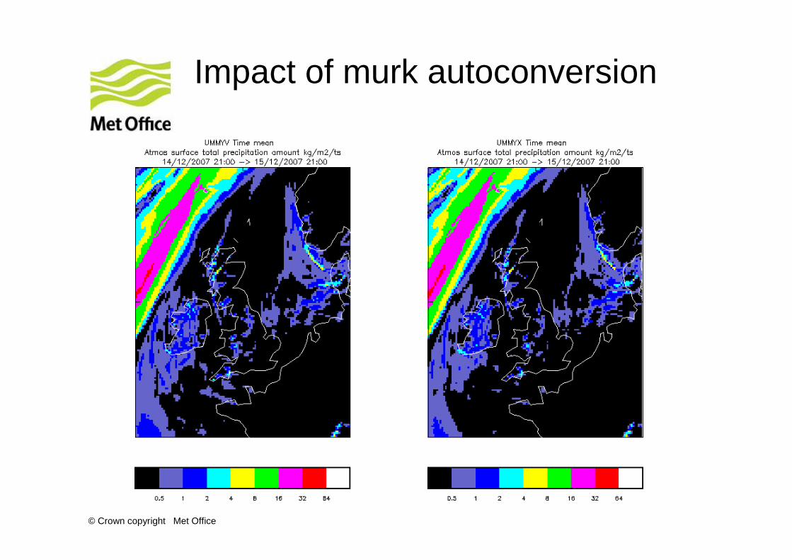
Murk link to autoconversion
• Autoconversion from cloud droplets to drizzle uses some assumption of cloud droplet size.
• At present this is a fixed value for land and another fixed value for sea, resulting in a unrealistic land-sea split in drizzle rates.
• Linking MURK to autoconversion rates removes this tendency and should produce more realistic drizzle patterns for example reducing some of the more spurious drizzle that occurs in cloudy anticyclonic conditions.
© Crown copyright Met Office
Murk link to autoconversion
© Crown copyright Met Office
Other microphysics changes
• Brown and Francis Ice Particle Densities
• There is evidence from radar data that the density relationship used within the UM is too large, causing thick ice cloud to develop in the model. This new relationship gives a more realistic ice particle size to density relationship.
• Mitchells 2nd Re-X Relationship
• Changing the density relationship for calculating ice crystal fall speeds will hence alter the fall speed of the ice crystals.This change should be run in conjunction with Brown and Francis to prevent this happening.
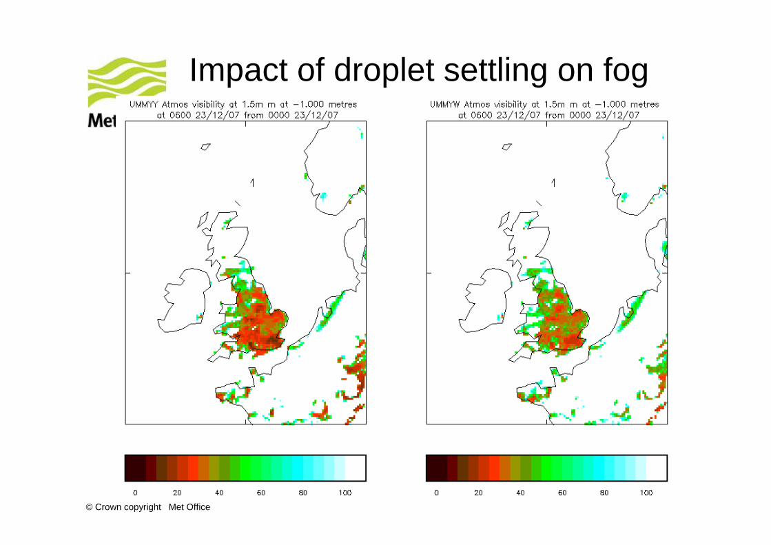
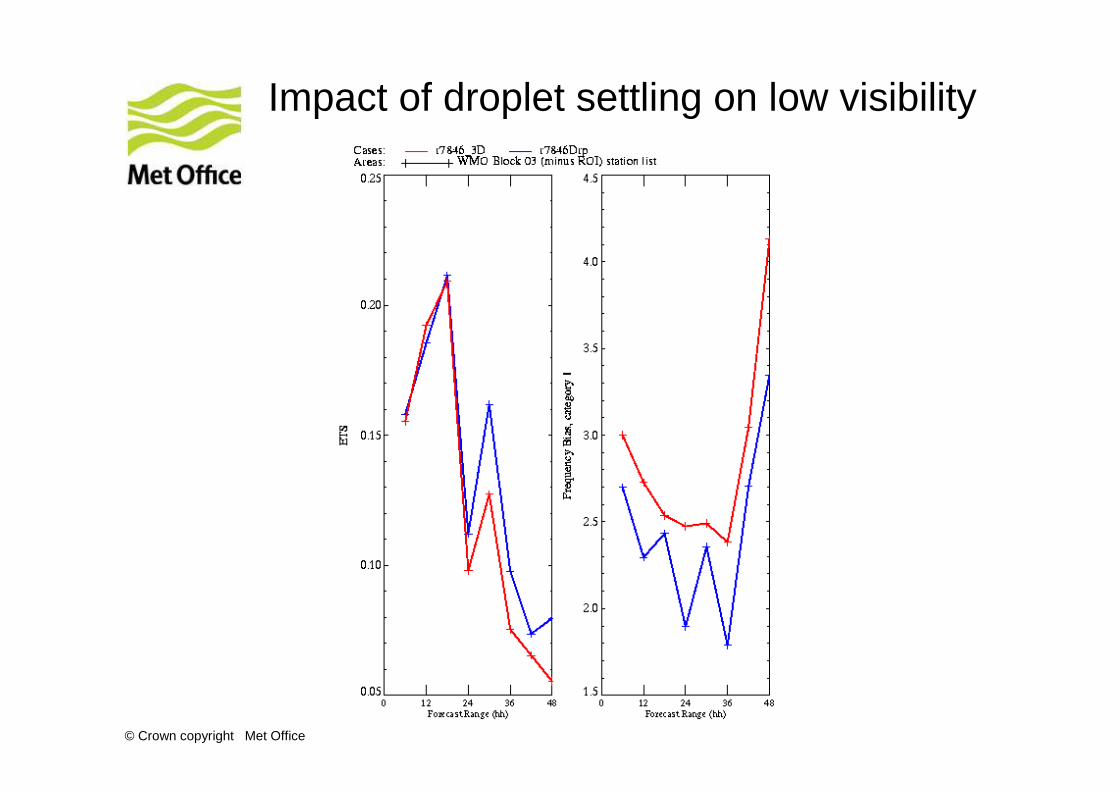
• Droplet settling allows the cloud droplets to fall out slowly (typical velocities of ~ 1 m/s).
• This has very little effect on cloud or surface rain rates, but has been shown to be rather good at removing persistent fog (e.g. Christmas Fog 2006).
© Crown copyright Met Office
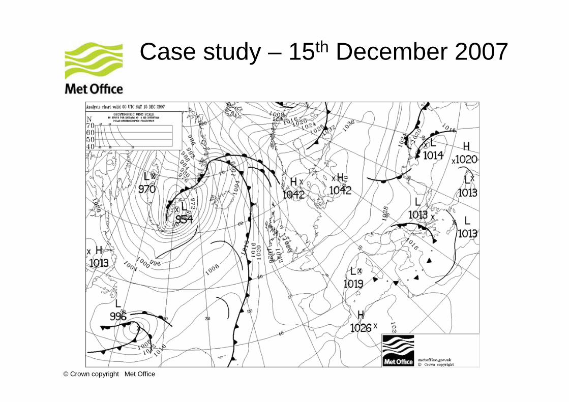
Case study – 15th December 2007
© Crown copyright Met Office
Impact of new murk sources
© Crown copyright Met Office
Impact of murk autoconversion
© Crown copyright Met Office
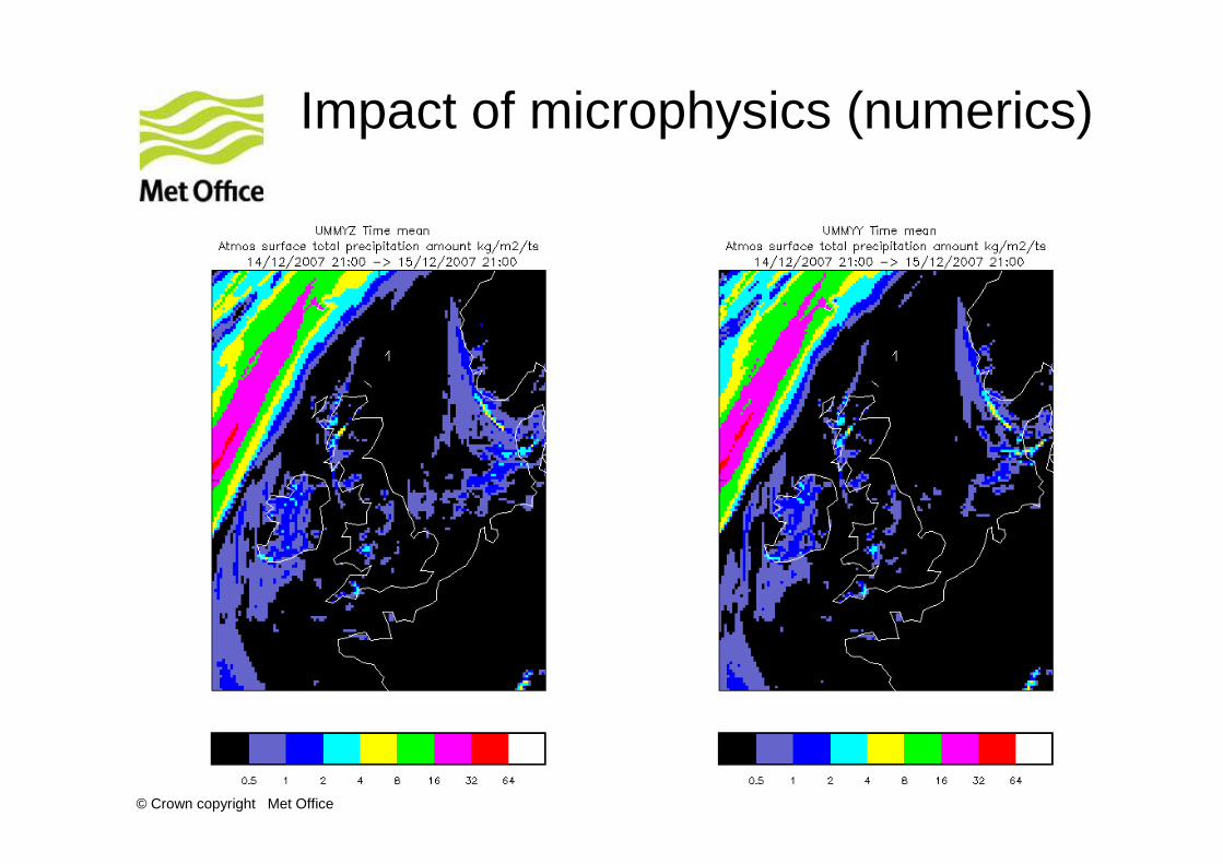
Impact of microphysics (numerics)
© Crown copyright Met Office
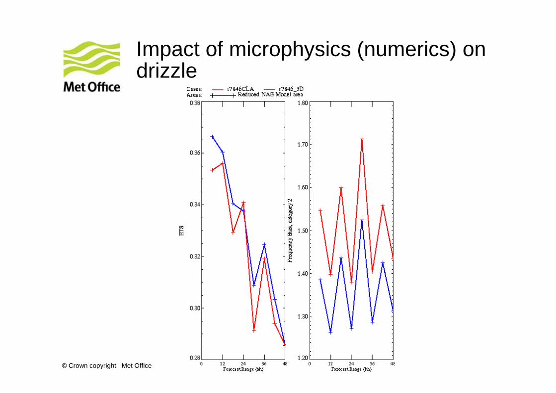
Impact of microphysics (numerics) on drizzle
© Crown copyright Met Office
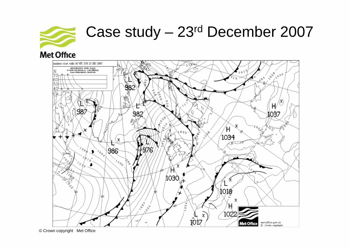
Case study – 23rd December 2007
© Crown copyright Met Office
Impact of droplet settling on fog
© Crown copyright Met Office
Impact of droplet settling on low visibility
© Crown copyright Met Office
CLASSIC albedos
• This change uses date provided by the Climate and Land-Surface Systems Interaction Centre (CLASSIC).
• Based on MODIS observations this gives a much more accurate specification of albedo of the MOSES vegetated tiles and of the underlying bare soil, particularly in partially vegetated areas.
© Crown copyright Met Office
Snow canopy
• This option allows snow to reside under, as well as on top of, needle-leaf trees, with a calculation made for the rate of transfer between the two stores.
• The result is reduced sublimation of the snow, warmer surface temperatures and snow can persist for longer under the trees.
© Crown copyright Met Office
Radiation changes
• The concentrations of CO2 and other trace gases needs to be updated as the previous concentrations were consistent with the observations in 1985 and so do not account for the continued increases in the concentration of these gases.
• Update Meso Spectral Files to remove bug in ice processes. The LW ice parametrisation contained an error that significantly overestimated the extinction due to ice.
• Rayleigh Scattering: A long standing error has been found in the code which produces the part of the spectral files which describe the Rayleigh scattering properties of dry air.
• Correcting this error slightly increases the scattering of solarradiation in clear skies but has a minimal impact on the quality of the forecast.

© Crown copyright Met Office
Talk Outline
• NAE Physics
• UK1.5 km results
© Crown copyright Met Office
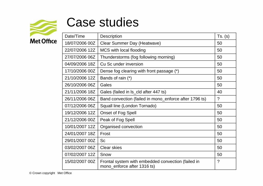
Case studies
?Frontal system with embedded convection (failed in mono_enforce after 1316 ts)
15/02/2007 00Z
50Snow07/02/2007 12Z
50Clear skies03/02/2007 06Z
50Sc29/01/2007 00Z
50Frost24/01/2007 18Z
50Organised convection10/01/2007 12Z
50Peak of Fog Spell21/12/2006 00Z
50Onset of Fog Spell19/12/2006 12Z
50Squall line (London Tornado)07/12/2006 06Z
?Band convection (failed in mono_enforce after 1796 ts)26/11/2006 06Z
40Gales (failed in ls_cld after 447 ts)21/11/2006 18Z
50Gales26/10/2006 06Z
50Bands of rain (*)21/10/2006 12Z
50Dense fog clearing with front passage (*)17/10/2006 00Z
50Cu Sc under inversion04/09/2006 18Z
50Thunderstorms (fog following morning)27/07/2006 06Z
50MCS with local flooding22/07/2006 12Z
50Clear Summer Day (Heatwave)18/07/2006 00Z
Ts. (s)DescriptionDate/Time
© Crown copyright Met Office
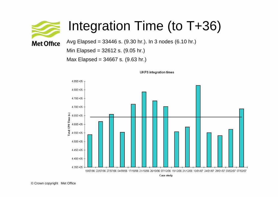
Integration Time (to T+36)Avg Elapsed = 33446 s. (9.30 hr.). In 3 nodes (6.10 hr.)
Min Elapsed = 32612 s. (9.05 hr.)
Max Elapsed = 34667 s. (9.63 hr.)
© Crown copyright Met Office
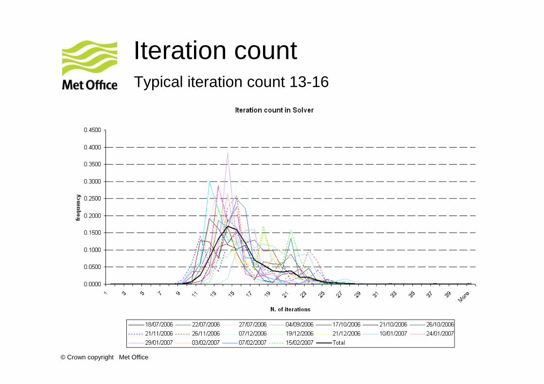
Iteration countTypical iteration count 13-16
© Crown copyright Met Office
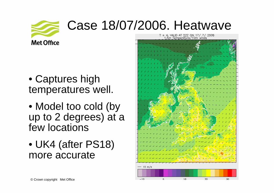
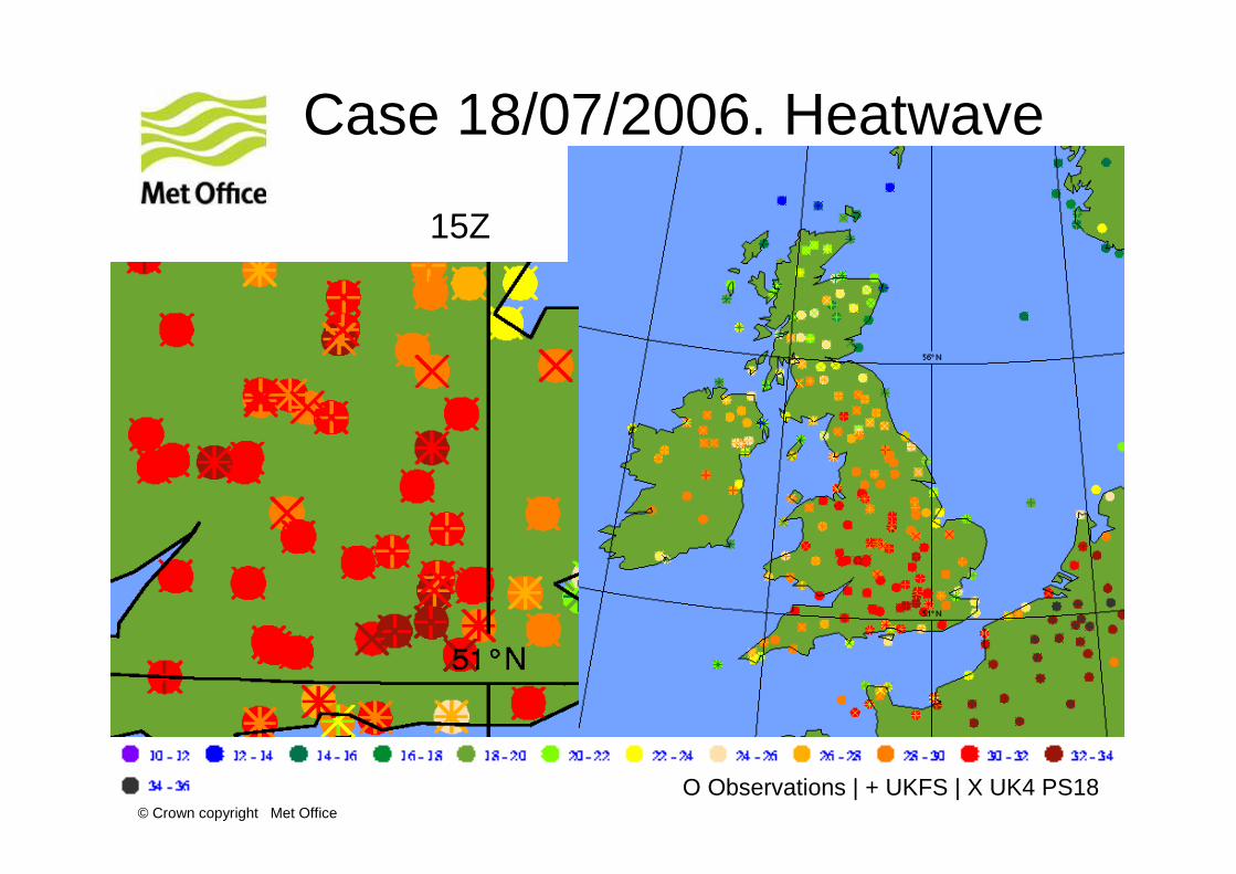
Case 18/07/2006. Heatwave
• Captures high temperatures well.
• Model too cold (by up to 2 degrees) at a few locations
• UK4 (after PS18) more accurate
© Crown copyright Met Office
Case 18/07/2006. Heatwave
O Observations | + UKFS | X UK4 PS18
15Z
© Crown copyright Met Office
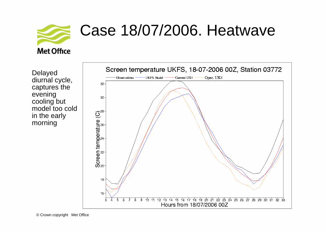
Case 18/07/2006. Heatwave
Delayed diurnal cycle, captures the evening cooling but model too cold in the early morning
© Crown copyright Met Office
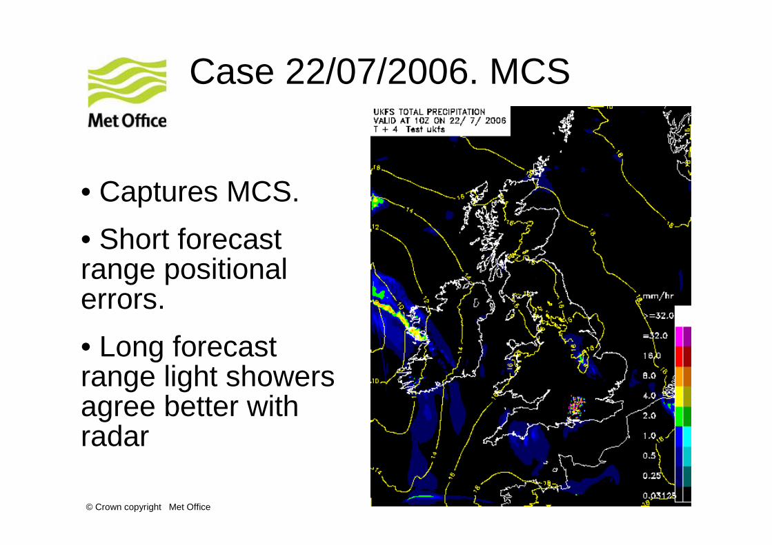
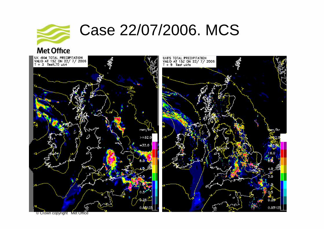
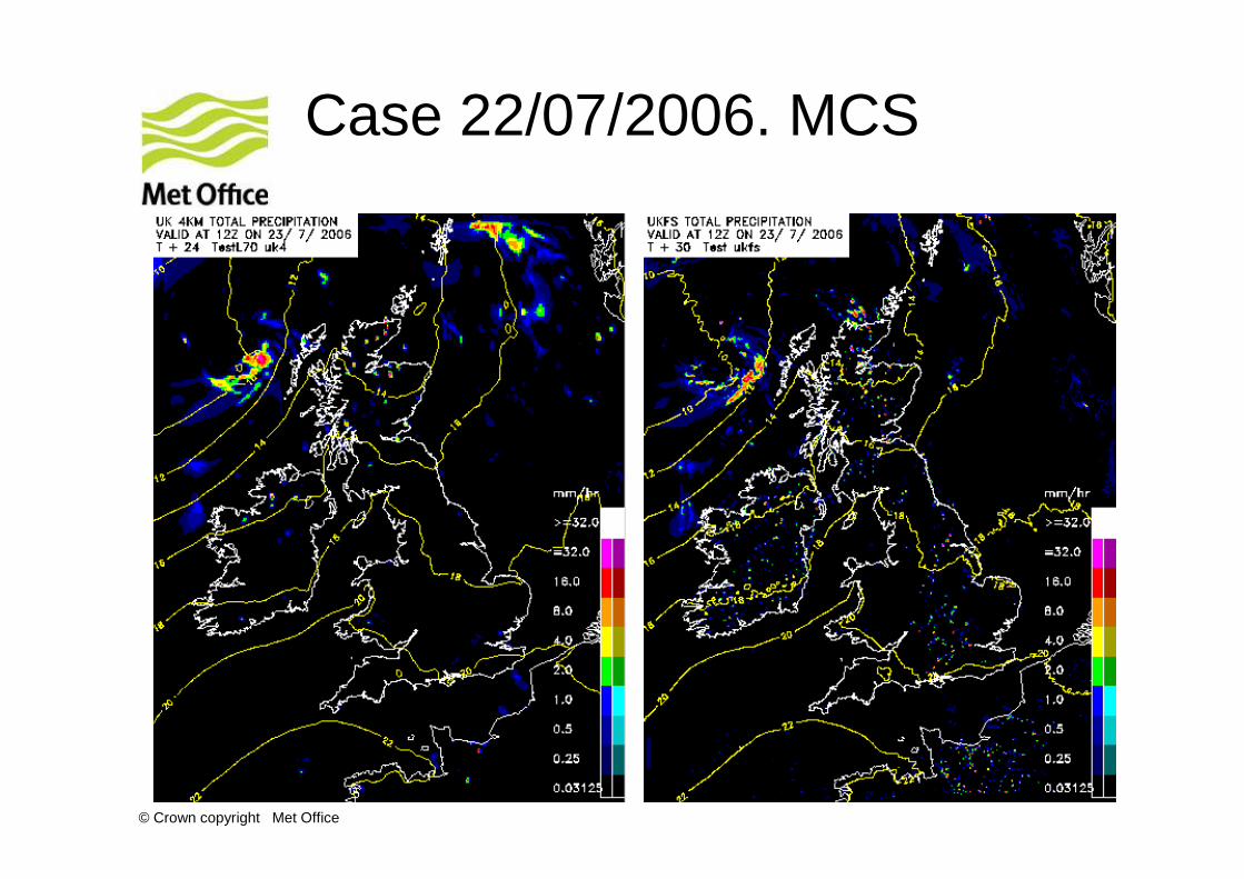
Case 22/07/2006. MCS
• Captures MCS.
• Short forecast range positional errors.
• Long forecast range light showers agree better with radar
© Crown copyright Met Office
Case 22/07/2006. MCS
© Crown copyright Met Office
Case 22/07/2006. MCS
© Crown copyright Met Office
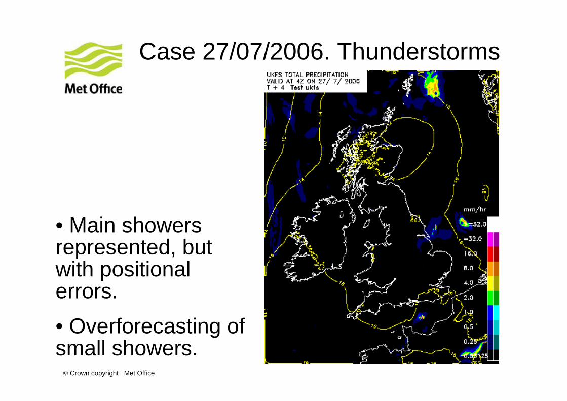
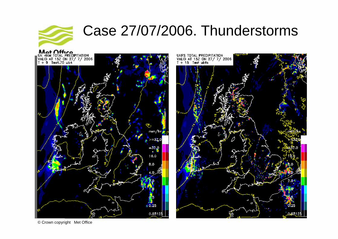
Case 27/07/2006. Thunderstorms
• Main showers represented, but with positional errors.
• Overforecasting of small showers.
© Crown copyright Met Office
Case 27/07/2006. Thunderstorms
© Crown copyright Met Office
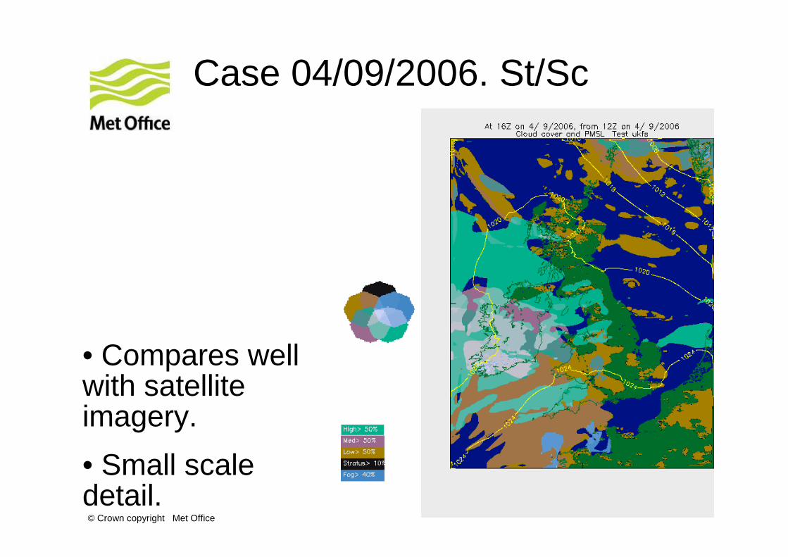
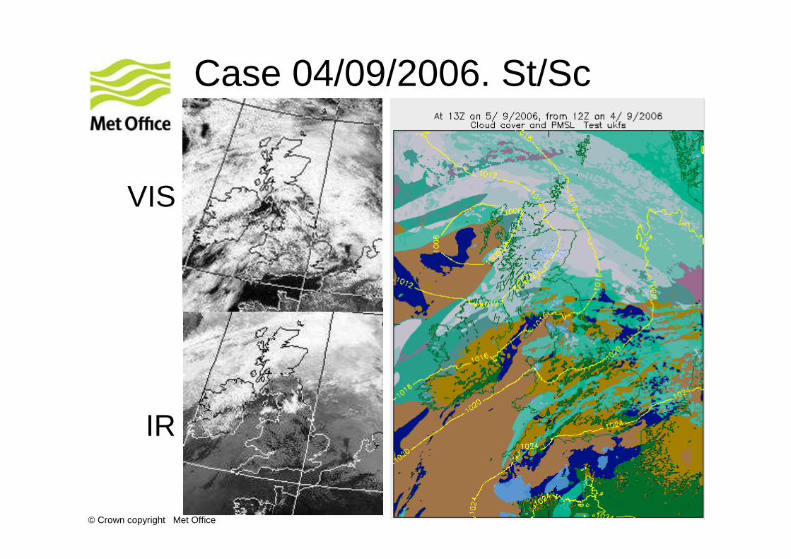
Case 04/09/2006. St/Sc
• Compares well with satellite imagery.
• Small scale detail.
© Crown copyright Met Office
Case 04/09/2006. St/Sc
VIS
IR
© Crown copyright Met Office
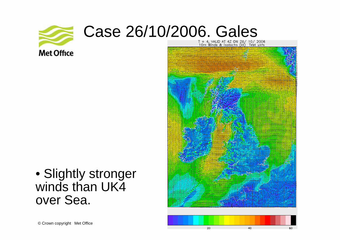
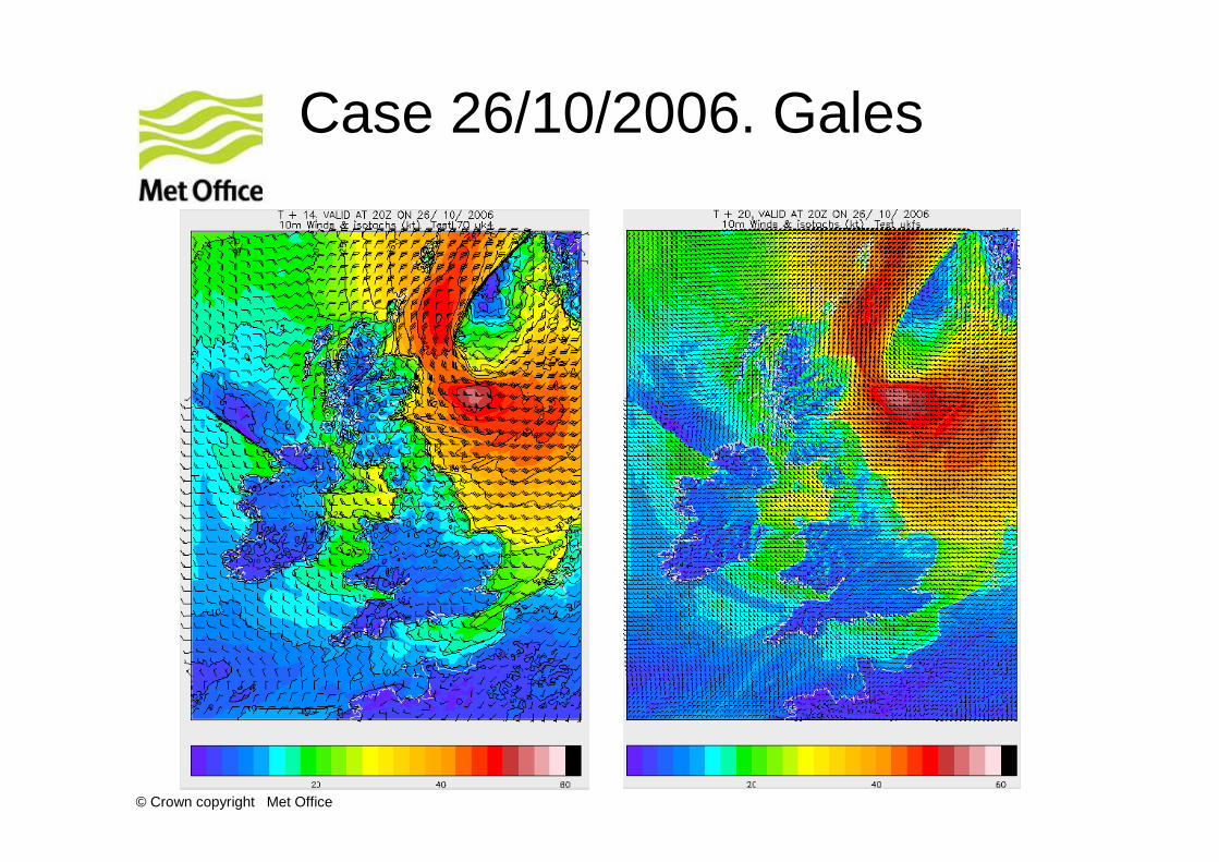
Case 26/10/2006. Gales
• Slightly stronger winds than UK4 over Sea.
© Crown copyright Met Office
Case 26/10/2006. Gales
© Crown copyright Met Office
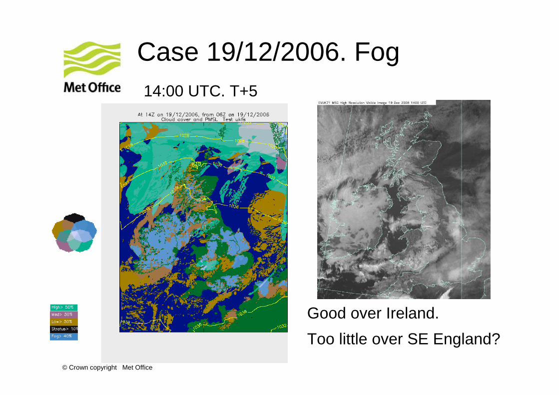
Case 19/12/2006. Fog
Good over Ireland.
Too little over SE England?
14:00 UTC. T+5
© Crown copyright Met Office
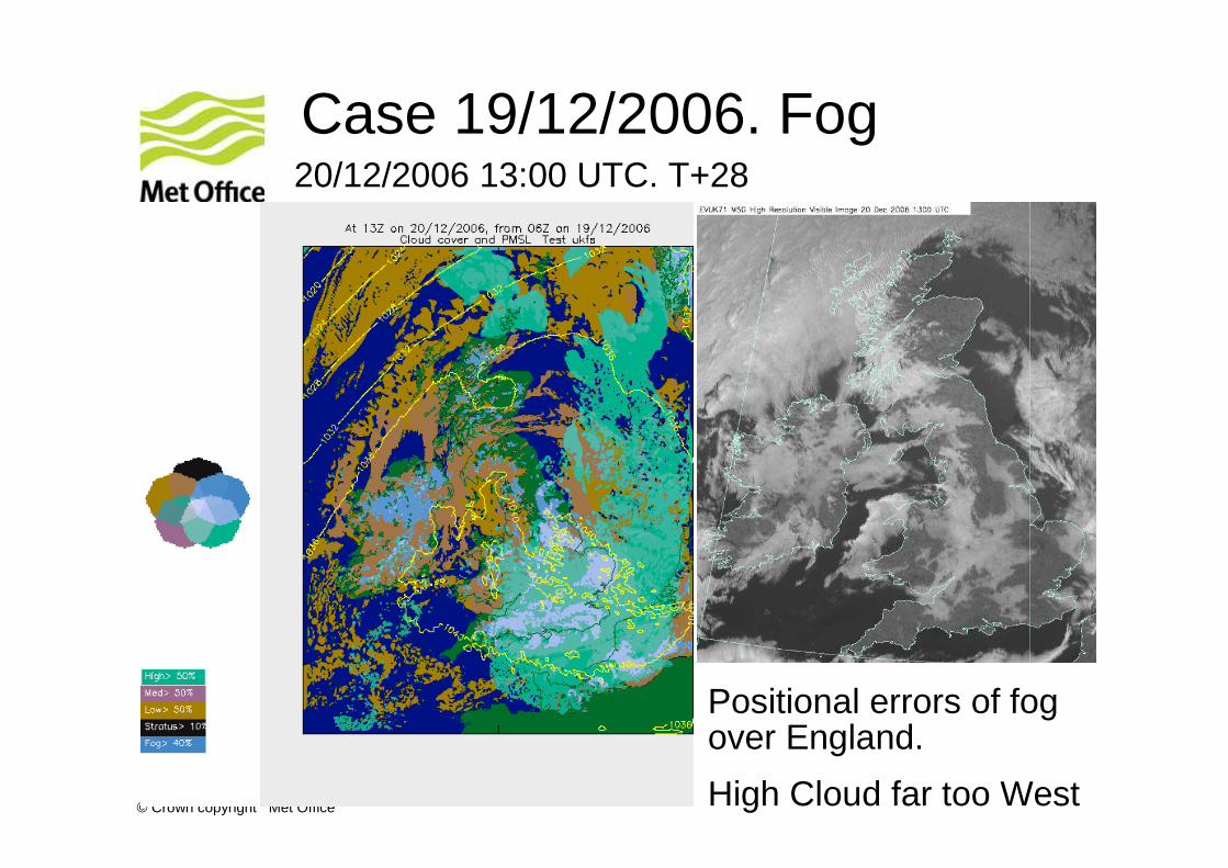
Case 19/12/2006. Fog
Positional errors of fog over England.
High Cloud far too West
20/12/2006 13:00 UTC. T+28
© Crown copyright Met Office
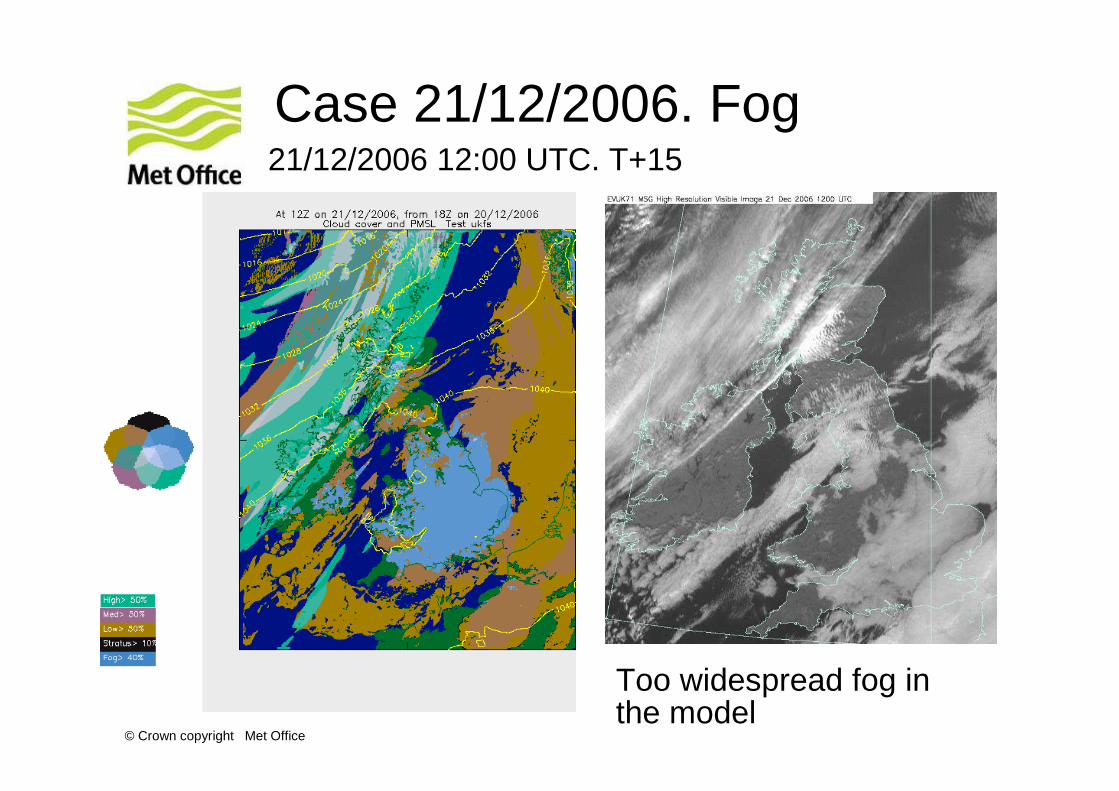
Case 21/12/2006. Fog
Too widespread fog in the model
21/12/2006 12:00 UTC. T+15
© Crown copyright Met Office
Summary of UKFS case studies
• Fairly stable model
• No gross errors identified
• Tuning of the model physics has yet to be done
• Difference in resolution between the driving model (12km NAE) and the 1.5km UKFS does not cause a noticeable deterioration in forecast quality.
• Shortcomings are more likely to come from Initial Conditions.
© Crown copyright Met Office
Implementation strategy
• UKFS is fixed resolution and spins up from a 12km NAE
• UKFS is only a stepping stone to what we plan to implement.
• The plan is to introduce a variable resolution model with 3D-VAR (3 hour cycle)
• Purpose of variable resolution is to move ‘spin-up’domain away from product area AND improve stability by reducing boundary mismatch.
© Crown copyright Met Office
Issues for variable resolution
• Variable resolution code on NEC is as fast (CPU/point/timestep) as original fixed-resolution code.
• In addition, new pre-conditioner saves ~5% and may improve scalability.
• Best judgement is Variable resolution code same speed as benchmark. +/- 20% certainly plausible.
• 1.5-4 km runs have always been at least as good as 4 km in variable zone, 1.5 in fixed.
• We have little experience 1.5-12 km – transition from parametrized to resolved is more of an issue. We have methods which work reasonably well in idealised studies, but no proof that they work in real cases.
© Crown copyright Met Office
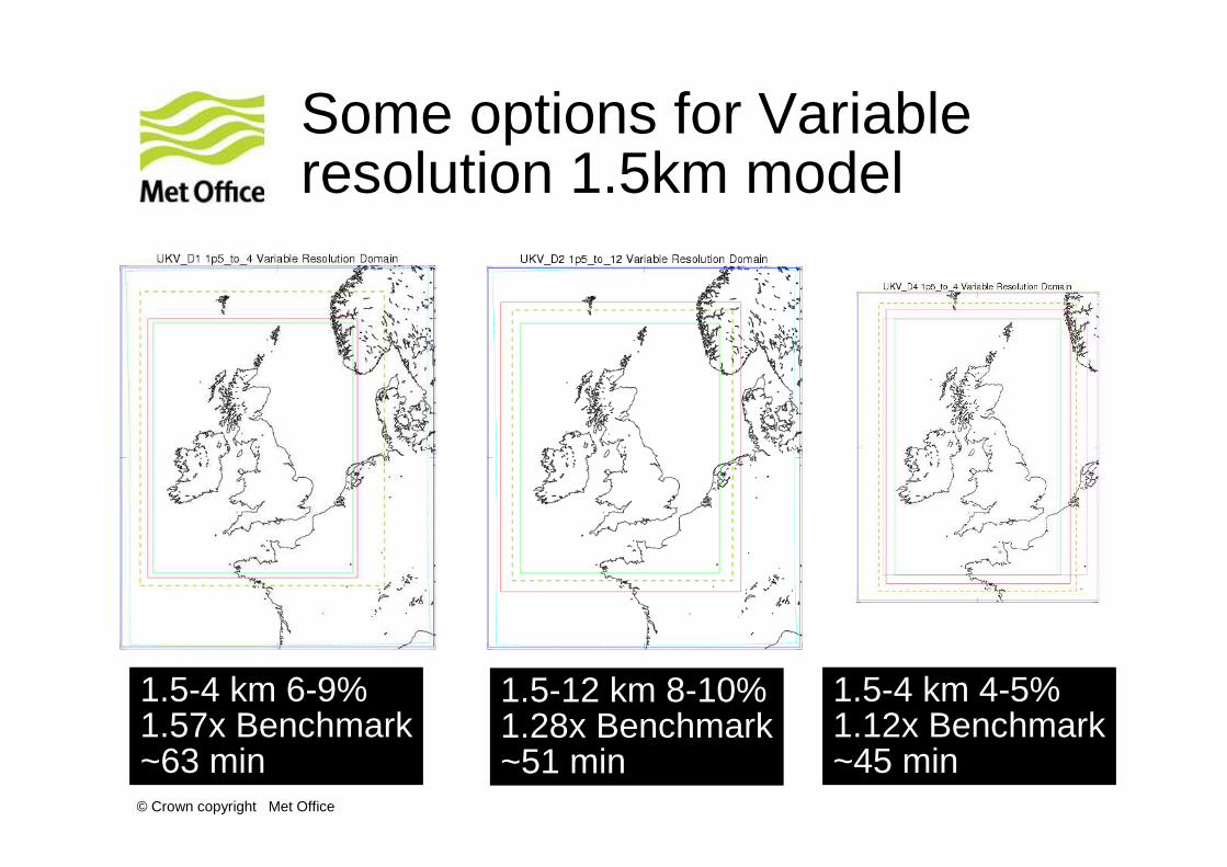
Some options for Variable resolution 1.5km model
1.5-4 km 6-9%1.57x Benchmark~63 min
1.5-12 km 8-10%1.28x Benchmark~51 min
1.5-4 km 4-5%1.12x Benchmark~45 min

© Crown copyright Met Office
Questions and answers