Embed Size (px)
Citation preview
PHYSIOGRAPHIC COMPONENTS OF TRAIL EROSION
by
Ian Chandler Paterson Godwin
A thesis submitted in partial fulfillment
of the requirements for the degree
of
Master of Science
in
Earth Sciences
MONTANA STATE UNIVERSITY
Bozeman, Montana
August 2000
ii
APPROVAL
of a thesis submitted by
Ian C.P. Godwin
This thesis has been read by each member of the thesis committee and has been found to be satisfactory regarding content, English usage, format, citations, bibliographic style, and consistency, and is ready for submission to the College of Graduate Studies. Andrew Marcus _________________________________ _______________ (Signature) Date
Approved for the Department of Earth Sciences
James Schmitt _________________________________ _______________ (Signature) Date
Approved for the College of Graduate Studies
Bruce McLeod _________________________________ _______________ (Signature) Date

iii
STATEMENT OF PERMISSION TO USE
In presenting this thesis in partial fulfillment of the requirements for a master's
degree at Montana State University, I agree that the Library shall make it available to
borrowers under rules of the Library.
If I have indicated my intention to copyright this thesis by including a copyright
notice page, copying is allowable only for scholarly purposes, consistent with "fair use"
as prescribed in the U.S. Copyright Law. Requests for permission for extended quotation
from or reproduction of this thesis in whole or in parts may be granted only by the
copyright holder.
Signature ____________________________________
Date ____________________________________

iv
"Supposing a tree fell down, Pooh, when we were underneath it?" "Supposing it didn't", said Pooh after careful thought. Piglet was comforted by this, and in a little while they were knocking and ringing very cheerfully at Owl's door. The Te of Piglet by Benjamin Hoff

v
ACKNOWLEDGMENTS
I would most like to thank Andrew Marcus for his significant assistance in the
preparation of this thesis. I also appreciate the input and assistance of the two other
members of my committee, Jon Wraith and Kathy Hansen. John Wilson gets credit for
proposing the project. Heidi M. Graham-Godwin gets credit for her patience and support
throughout the extended period of preparation of this work.
I would also like to acknowledge the Colorado Outward Bound School for both
the help and hindrance they provided. Without their willingness to employ me, I could
not have afforded to complete my coursework and research. Without their willingness to
employ me, I might have finished this much sooner.
vi
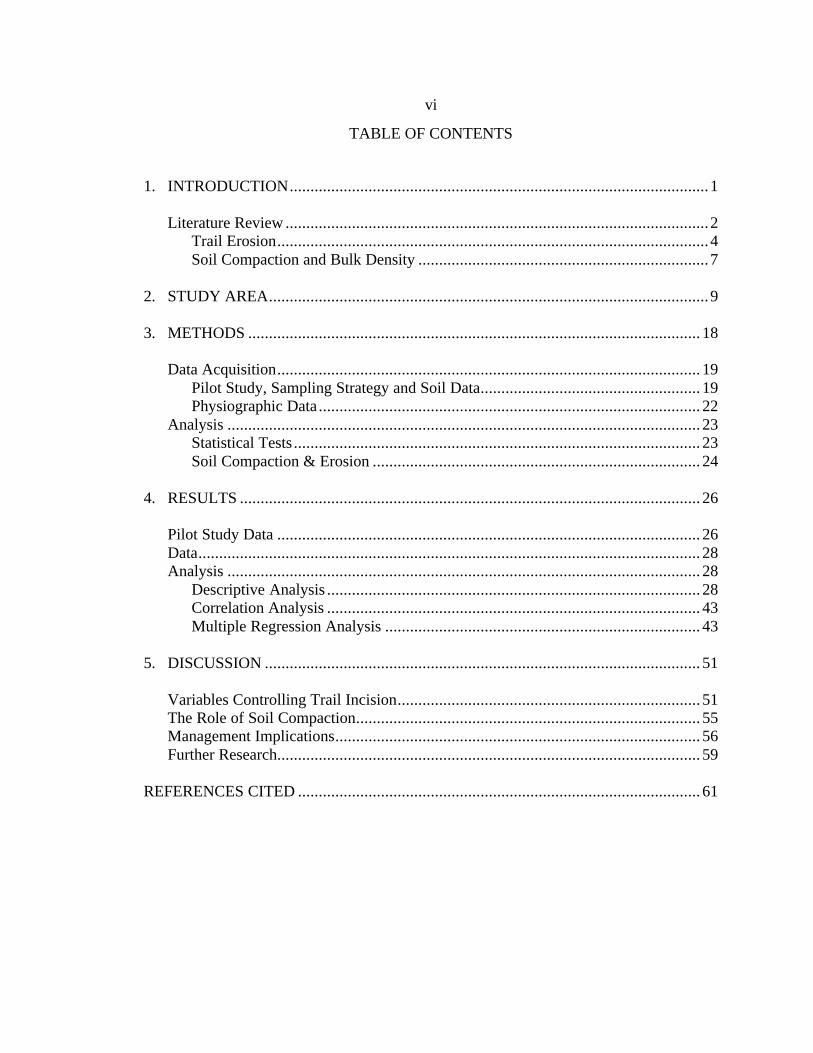
TABLE OF CONTENTS
1. INTRODUCTION.....................................................................................................1
Literature Review ......................................................................................................2 Trail Erosion........................................................................................................4 Soil Compaction and Bulk Density ......................................................................7
2. STUDY AREA..........................................................................................................9
3. METHODS ............................................................................................................. 18
Data Acquisition...................................................................................................... 19 Pilot Study, Sampling Strategy and Soil Data..................................................... 19 Physiographic Data ............................................................................................ 22
Analysis .................................................................................................................. 23 Statistical Tests .................................................................................................. 23 Soil Compaction & Erosion ............................................................................... 24
4. RESULTS ............................................................................................................... 26
Pilot Study Data ...................................................................................................... 26 Data......................................................................................................................... 28 Analysis .................................................................................................................. 28
Descriptive Analysis .......................................................................................... 28 Correlation Analysis .......................................................................................... 43 Multiple Regression Analysis ............................................................................ 43
5. DISCUSSION ......................................................................................................... 51
Variables Controlling Trail Incision......................................................................... 51 The Role of Soil Compaction................................................................................... 55 Management Implications........................................................................................ 56 Further Research...................................................................................................... 59
REFERENCES CITED ................................................................................................. 61
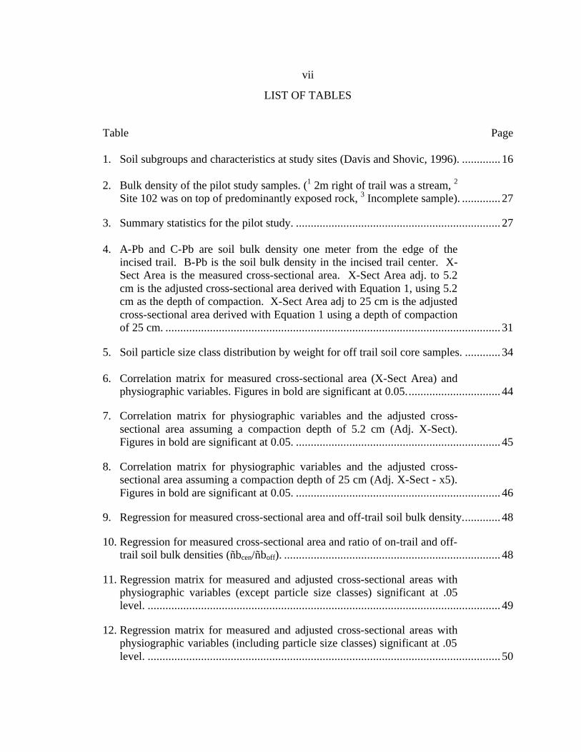
vii
LIST OF TABLES
Table Page
1. Soil subgroups and characteristics at study sites (Davis and Shovic, 1996). ............. 16
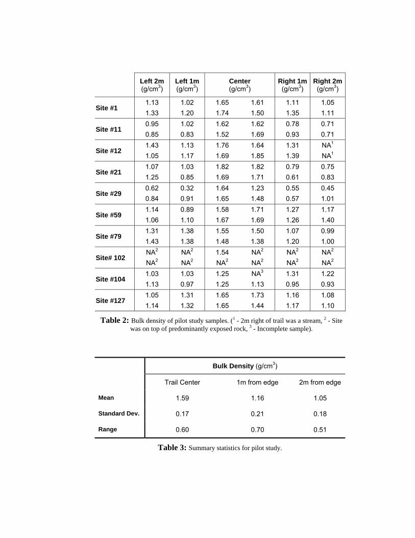
2. Bulk density of the pilot study samples. (1 2m right of trail was a stream, 2 Site 102 was on top of predominantly exposed rock, 3 Incomplete sample). ............. 27
3. Summary statistics for the pilot study. ..................................................................... 27
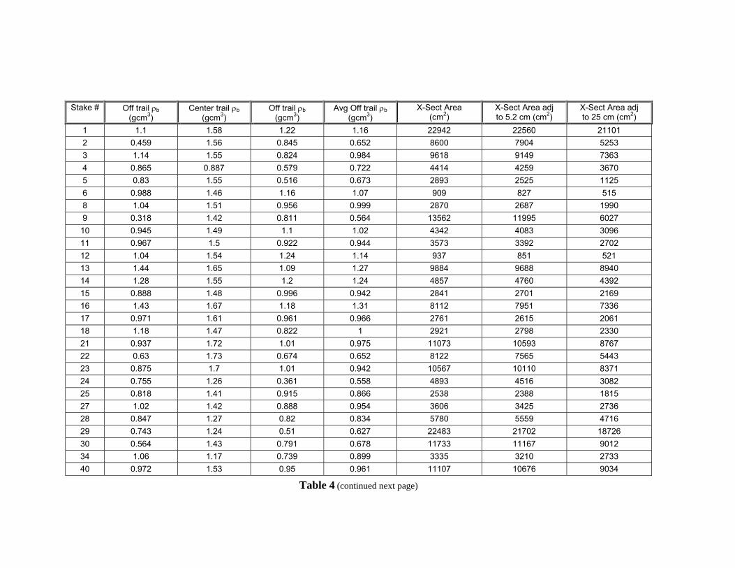
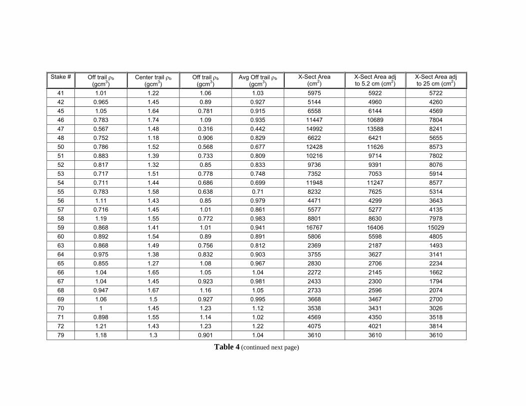
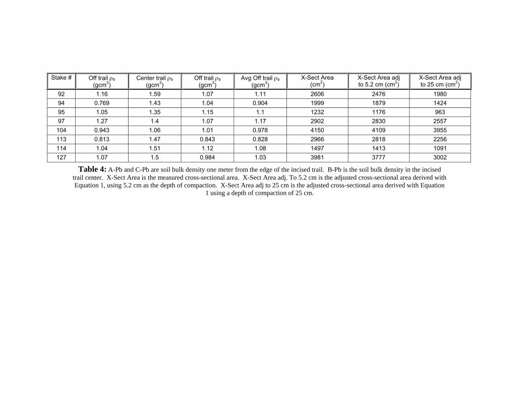
4. A-Pb and C-Pb are soil bulk density one meter from the edge of the incised trail. B-Pb is the soil bulk density in the incised trail center. X-Sect Area is the measured cross-sectional area. X-Sect Area adj. to 5.2 cm is the adjusted cross-sectional area derived with Equation 1, using 5.2 cm as the depth of compaction. X-Sect Area adj to 25 cm is the adjusted cross-sectional area derived with Equation 1 using a depth of compaction of 25 cm. ................................................................................................................. 31
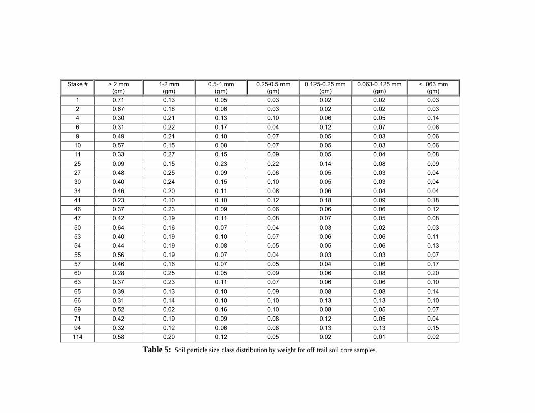
5. Soil particle size class distribution by weight for off trail soil core samples. ............ 34
6. Correlation matrix for measured cross-sectional area (X-Sect Area) and physiographic variables. Figures in bold are significant at 0.05................................ 44
7. Correlation matrix for physiographic variables and the adjusted cross-sectional area assuming a compaction depth of 5.2 cm (Adj. X-Sect). Figures in bold are significant at 0.05. ..................................................................... 45
8. Correlation matrix for physiographic variables and the adjusted cross-sectional area assuming a compaction depth of 25 cm (Adj. X-Sect - x5). Figures in bold are significant at 0.05. ..................................................................... 46
9. Regression for measured cross-sectional area and off-trail soil bulk density............. 48
10. Regression for measured cross-sectional area and ratio of on-trail and off-trail soil bulk densities (ñbcen/ñboff). ......................................................................... 48
11. Regression matrix for measured and adjusted cross-sectional areas with physiographic variables (except particle size classes) significant at .05 level. ....................................................................................................................... 49
12. Regression matrix for measured and adjusted cross-sectional areas with physiographic variables (including particle size classes) significant at .05 level. ....................................................................................................................... 50
viii
LIST OF FIGURES
Figure Page
1. General location of study area near Bozeman, Montana. Trails are in the Northeastern corner of the Gallatin Mountain Range. ................................................9
2. Study area map with approximate location of sample sites. 60 m contour interval. ................................................................................................................... 10
3. Relative location of sample sites along New World Gulch and Bozeman Creek Trails............................................................................................................. 11
4. Topography of New World Gulch / Bozeman Creek trails study area. Red points indicate sample locations. Colors represent elevation change......................... 13
5. Braided trail with moderate incision. (Site #8, July 1994) ........................................ 14
6. Broad trail (~2 m) along relatively steeper slope. (Site #17, July 1994).................... 14
7. Narrow meadow trail with little incision. (Site #58, July 1994)................................ 15
8. Core sampler in center of trail.................................................................................. 20
9. Core off trail with vegetation clipped....................................................................... 20
10. The adjusted area derived using the 5.2 cm (above) and 25 cm depths (below) of compaction in Equation (1)..................................................................... 29
11. Measured cross-sectional area vs. off-trail soil bulk density. .................................... 30
12. Measured cross-sectional area vs. ratio of on-trail and off-trail soil bulk density. ..... 30
13. Measured and adjusted (to 5.2 cm depth of compaction) cross-sections vs. trail slope................................................................................................................. 35
14. Measured and adjusted (to 5.2 cm depth of compaction) cross-sections vs. soil water. ................................................................................................................ 35
15. Measured and adjusted (to 5.2 cm depth of compaction) cross-sections vs. percent particle size greater than 2mm. .................................................................... 36
16. Measured and adjusted (to 5.2 cm depth of compaction) cross-sections vs. percent particle size 0.25 - 0.125 mm....................................................................... 36
ix
17. Measured and adjusted (to 5.2 cm depth of compaction) cross-sections vs. percent particle size 0.125 - 0.065 mm..................................................................... 37
18. Measured and adjusted (to 5.2 cm depth of compaction) cross-sections vs. percent particle size 1.0 - 0.5 mm. ........................................................................... 37
19. Measured and adjusted (to 5.2 cm depth of compaction) cross-sections vs. percent particle size 0.5 - 0.25 mm........................................................................... 38
20. Measured and adjusted (to 5.2 cm depth of compaction) cross-sections vs. percent particle size less than 0.063 mm. ................................................................. 38
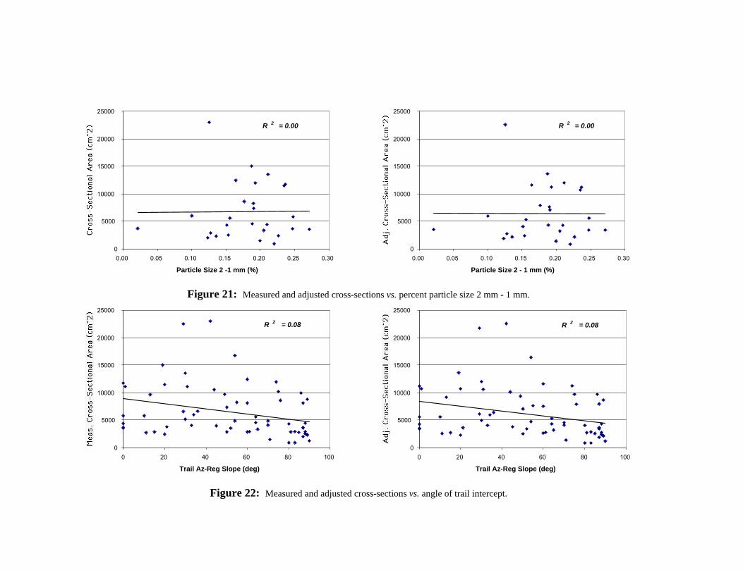
21. Measured and adjusted (to 5.2 cm depth of compaction) cross-sections vs. percent particle size 2 mm - 1 mm. .......................................................................... 39
22. Measured and adjusted (to 5.2 cm depth of compaction) cross-sections vs. angle of trail intercept. ............................................................................................. 39
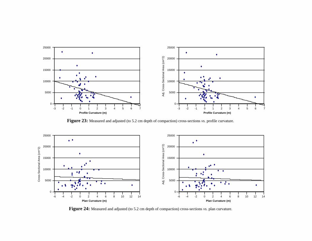
23. Measured and adjusted (to 5.2 cm depth of compaction) cross-sections vs. profile curvature. ..................................................................................................... 40
24. Measured and adjusted (to 5.2 cm depth of compaction) cross-sections vs. plan curvature.......................................................................................................... 40
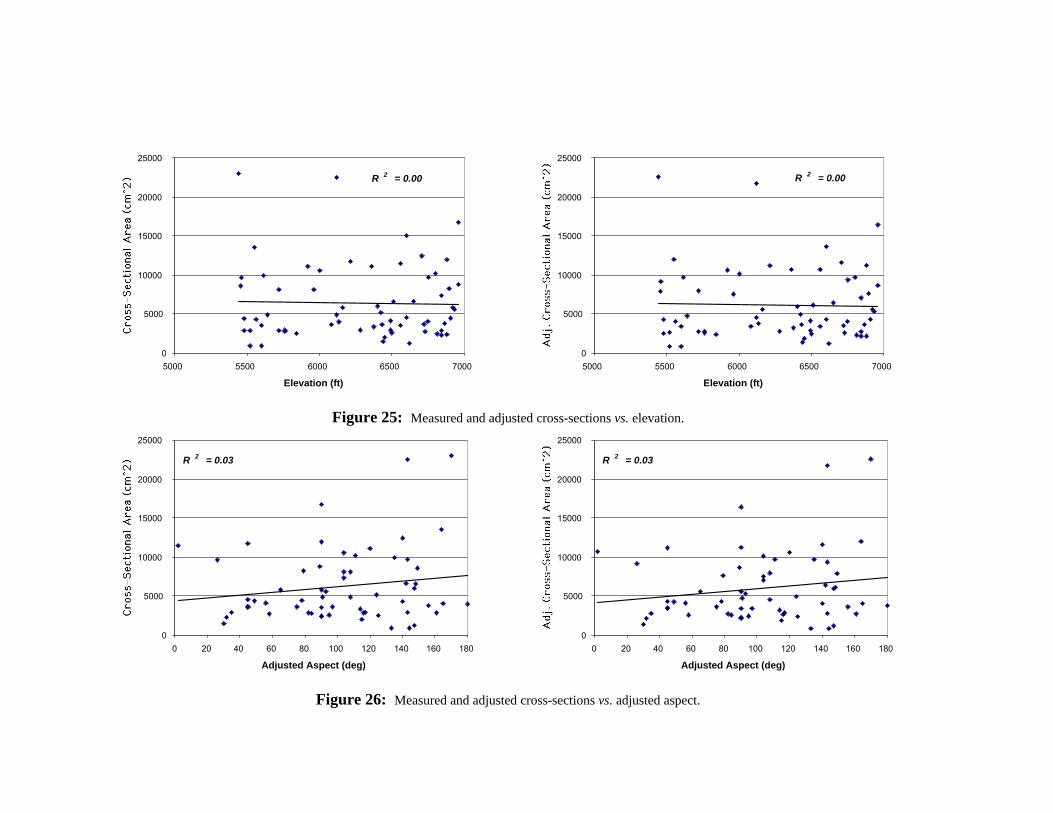
25. Measured and adjusted (to 5.2 cm depth of compaction) cross-sections vs. elevation.................................................................................................................. 41
26. Measured and adjusted (to 5.2 cm depth of compaction) cross-sections vs. adjusted aspect......................................................................................................... 41
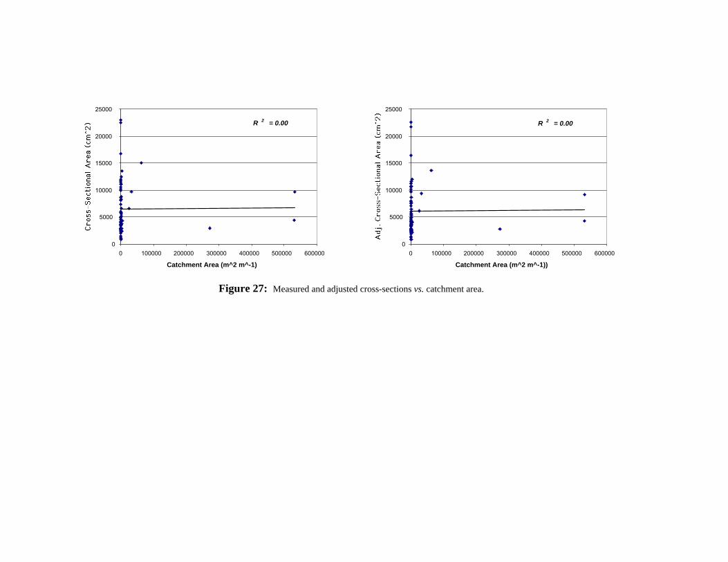
27. Measured and adjusted (to 5.2 cm depth of compaction) cross-sections vs. catchment area......................................................................................................... 42
x
ABSTRACT
No previous study has sought to discriminate between soil erosion and soil compaction when explaining the “missing” cross-sectional areas of incised trails, assuming instead that erosion was the dominant process. Separating the two processes of erosion and compaction is critical to understanding the relationship between physiographic variables and the structure of trails.
The purposes of this project are to estimate the relative effects of compaction and erosion on trail cross sectional area along the New World Gulch Trail, Montana, and to better understand the relationship between erosion, compaction, local topography, vegetation, soil bulk density, and soil texture. The following hypotheses were addressed: 1) adjusting the incised cross sectional area of a trail, by removing the effects of soil compaction, will increase the amount of variance in erosion explained by collected physiographic variables; and 2) inclusion of soil bulk density and soil texture as physiographic variables will increase the amount of variance in cross-sectional area explained along the trail.
The goals of this study required the collection of field data, analysis of soil samples, and statistical analysis of data. Soil samples and other field measurements were collected over several months during the summer and fall of 1994. Some of the topographic information used in the statistical analysis originated in Urie's (1994) study of recreational trails.
The determination of trail slope as one of the primary components of trail incision is consistent with previous studies. Soil water content is the second most significant independent variable when the percentage of particle sizes are not considered. Percent vegetative cover is also significant in the stepwise regression, although it is not significantly correlated to cross-sectional area.
The most significant variable added to those already studied was soil bulk density. When individual variables were regressed against the measured cross-sectional area, off-trail soil bulk density accounted for the second greatest amount of variance (r2 = 0.12) after trail slope (r2 = 0.35). The ratio of on-trail soil bulk density to off-trail soil bulk density, which could be considered a measure of compaction, accounted for even more variance (r2 = 0.18) than soil bulk density.
1
CHAPTER ONE
INTRODUCTION
A 1975 survey of wilderness managers indicated that trail deterioration and
erosion were major backcountry concerns (Godin and Leonard, 1979). Since that time,
the use and abuse of mountain trails has increased, forcing managers to expend more
resources to maintain, rebuild and relocate trails (Cole, 1991). With ever increasing
numbers of hikers, cross-country skiers, mountain bikers, and horse riders using trails,
land managers need to be more knowledgeable and conscientious about the placement,
maintenance and management of trails.
The goal of backcountry management is to maintain a healthy and sustainable
recreational and natural resource (U.S. Department of Agriculture, 1981). Brooks et al.
(1991) state that where erosion is concerned, best management practices (BMP’s) are
well known for agriculture, forestry, and road construction activities. Research on
erosion in backcountry areas that could lead to the development of appropriate BMP’s,
however, is scarce.
In particular, no previous study has sought to discriminate between soil erosion
and soil compaction when explaining the “missing” cross-sectional areas of incised trails,
assuming instead that erosion was the dominant process (Urie, 1994). The greater the
amount of soil compaction at a given location along a trail, the deeper the trail incision
and the greater the amount of error in the measurement of erosion. Separating the two
processes of erosion and compaction is critical to understanding the relationship between
physiographic variables and the structure of trails. Being able to more clearly recognize
2
and distinguish between the effects that various physiographic factors have on trail
erosion and compaction will facilitate defining BMP’s for trail location and remediation.
The purposes of this project are to estimate the relative effects of compaction and
erosion on trail cross sectional area along the New World Gulch Trail, Montana, and to
better understand the relationship between erosion, compaction, local topography,
vegetation, soil bulk density, and soil texture. While compaction has been measured and
observed to be an important component contributing to trail erosion, it has not been
evaluated as a possible cause for the “missing” trail cross-sectional area commonly used
to quantify the amount of erosion from a given point. Similarly, aside from the "Leave
No Trace" principal of traveling cross country on durable surfaces to minimize erosion,
the bulk density of pre-trampled soils has been overlooked as a significant control on
erosion. The results should assist forest and park managers in evaluating the appropriate
location for planned and future trails.
The following hypotheses will be addressed: 1) adjusting the incised cross
sectional area of a trail, by removing the effects of soil compaction, will increase the
amount of variance in erosion explained by collected physiographic variables; and 2)
inclusion of soil bulk density and soil texture as physiographic variables will increase the
amount of variance in cross-sectional area explained along the trail.
Literature Review
Much has been written about human impacts on wilderness recreation areas.
People seek wilderness to commune with the untouched wild, so their wilderness
experiences are easily affected by relatively minor impacts. Recreational misuse or abuse
3
of wilderness areas thus destroys this conceptual resource, as well as placing significant
strains on the actual natural resources. Vogler and Butler (1996), for example, state that
when path erosion rates exceed an adjacent streams ability to transport the increased
sediment influx, stream clogging and diversion can occur. Similarly, Hardin (1992) notes
that significant water quality degradation can occur due to increased loads from trail
erosion.
The topic of recreational degradation of wilderness has been one of concern since
at least 1933, when Bob Marshall noted the impacts of excessive use at campsites and the
need for user education programs (Lucas, 1987). Since that time, there has been an ever
increasing number of wilderness users (Lucas and Stankey, 1989) and access to many
areas is now restricted. At the same time, most users are willing to accept the restrictions
with few complaints (Lucas, 1983). The acceptance of restrictions is frequently the result
of impact studies that show that wilderness areas are suffering in some ways under the
increased pressure of use.
The increasing degradation of wilderness recreation resources is primarily
restricted to trails (Godin and Leonard, 1979), other frequent use corridors such as
saddles between popular drainages, and near or within established campsites. Much of
the research done on the impacts of recreational use prior to 1990 had focused on
backpacker impacts on soils and vegetation at campsites (e.g., Price, 1985; Cole, 1989;
Cordell et al., 1990) and was descriptive in nature (Cole 1986). More recent quantitative
studies document the influence of variables such as use, vegetation density and fragility,
and topographical variables on the amount of degradation at wilderness campsites (e.g.
4
Cole, 1992; Steele, 1998). In recent years, a large portion of the literature regarding
recreational impacts has also focused on trail erosion.
Trail Erosion
Soil erosion primarily occurs when soil particles are entrained by wind or water
and transported to another location. Most erosion research has focused on agricultural
areas, particularly since the Oklahoma dustbowl in the 1930’s (Wischmeier, 1970;
Wischmeier and Smith, 1978; Dutch et al., 1998), although increasing resources have
been devoted to trail erosion studies since the late 1970's (McQuaid-Cook, 1978;
Summer, 1980; Quinn et al., 1980; Fish et al., 1981; Cole, 1983; Bayfield, 1985; Tinsley
and Fish, 1985; Bayfield, 1986; Summer, 1986; Lance et al., 1989; Cole, 1991; Seney,
1991; Urie, 1994; Wilson and Seney, 1994).
At its' most basic level, water erosion is often the result of the overland flow
caused when water inputs exceed the soil’s infiltration rate (Quinn et al., 1980; Harden,
1992; Oyarzun, 1995). Much research has shown that climate, soil properties, and
topography are the three primary factors effecting erosion rates (Martz, 1992). McQuaid-
Cook (1978), Cole (1983), Wilson and Seney (1994), and Vogler and Butler (1996) have
also shown that user type and intensity of use are also key controls of erosion on trails.
Climate primarily influences erosion rates through the frequency, timing and
intensity of precipitation. The force generated by the impact of raindrops is capable of
displacing sediment up to a meter or more (Brooks et al., 1991). Beyond simple
displacement, long-term precipitation events may exceed soil infiltration rates, which
leads to overland flow and entrainment of dislodged sediment. Additionally, infiltration
5
rates are more likely to be exceeded if the soil water content is already near field capacity
due to either frequent or recent precipitation or snowmelt.
Soil properties effecting erosion potential include texture, partially defined by the
rock fragment and clay content, and organic matter content. Rocks are more resistant to
erosion and transportation by water than individual soil particles. As the rock fragment
content of the soil increases, the overall resistance to water erosion also increases (Davis
and Shovic, 1996). The presence of clay in the soil generally results in decreased
hydraulic conductivity relative to coarser soils. Reduced conductivity, combined with
some clays' tendency to swell when moistened, diminishes the amount of time required
for a given precipitation event to exceed the soils' infiltration rate. Once the infiltration
rate is exceeded, ponding, possibly followed by overland flow, begins and loose sediment
or particles detached by rainfall may become entrained and transported by the flow.
Increased soil organic matter content has the reverse effect from clay. As organic
matter content increases, total porosity generally increases (Kay and Angers, 2000). Soil
organic content has also been shown to mitigate soil compaction and reduce soil
erodibility by increasing aggregate stability (Kay and Angers, 2000). The spaces created
by root growth and spreading allow surface moisture easier access to the subsoil system,
thus enhancing infiltration (Marshall, et al., 1996). Additionally, once a rain event has
concluded, plant transpiration removes the moisture within the root zone more rapidly.
Along with the climate and soil properties, the shape of the landscape, or
topography, also influences the rate and amount of erosion. Martz (1992) showed that
about 40% of the variability in rain splash erosion could be explained by slope position.
Wischmeier and Smith (1978) indicated the importance of topography in the soil erosion
6
process by including the slope-length factor in the Universal Soil Loss Equation. In her
1994 study, Urie identified slope as one of the primary factors influencing trail erosion.
All other things being equal, as slope increases so does the velocity and resulting kinetic
energy of overland flow, which increases the ability of runoff to entrain sediment.
Harden (1992) bridged the gap between agricultural erosion studies and trail
erosion studies in her work evaluating the feasibility and ability of agriculturally based
erosion models to include erosion from roads and foot trails. She found that roads and
trails are the most active runoff generators in inhabited mountain landscapes. The
effectiveness of trails in initiating downslope soil erosion depended on the potential for
path spillage, which is the transport of sediment beyond the confines of the trail, and
downslope surface vulnerability, which is the presence of disturbed and degraded soils
that are predisposed to transport.
The type and amount of use have been identified as important controls on the
amount of trail erosion (McQuaid-Cook, 1978; Summer, 1980; Cole, 1983; Vogler and
Butler, 1996; Seney, 1991), although studies have been hampered by the scarcity of data
on users in back country areas (Krumpe and Lucas; Daigle, et al., 1994). More people
tracking over the same land reduce the vegetative cover and increase disturbance to the
soil surface. Different user types, such as hikers, bikers and horses, all may eliminate
vegetation and disturb soil particles, but each produces different amounts and rates of soil
erosion on trails. Wilson and Seney (1994) found that different user types caused
differing amounts of soil displacement depending on whether they were ascending or
descending a trail. Generally, horses caused the most soil displacement when descending
7
trails, followed in quantity by hikers and mountain bikers. Mountain bikers produced the
most soil displacement when ascending trails, followed by hikers and horses.
Soil Compaction and Bulk Density
Soil compaction may result when pressure is applied to soils. Compaction
increases the soil’s bulk density and decreases its porosity, which in turn reduces the
infiltration rate, influences plant root propagation, and increases the potential for
overland flow (McQuaid-Cook, 1978; Quinn et al., 1980; Vogler and Butler, 1996).
Compaction often occurs in soils under intensive agriculture, grazing, and forestry.
Animals, machinery and the dragging of fallen logs can exert pressures up to 100 kPa
(Marshall et al., 1996).
McQuaid-Cook (1978) found that the type of terrain, user type, soil type, soil
water content, and intensity of use were the primary factors controlling soil compaction
and the resulting trail "incision". Incision occurs because soil compaction reduces soil
volume and therefore depresses the elevation of pathways and trails. Incised trails, with
their low permeability, act as intermittent stream channels, funneling water during
precipitation and melt events (McQuaid-Cook, 1978; Quinn et al., 1980; Harden, 1992;
Oyarzun, 1995; Vogler and Butler, 1996). This funneling can increase the velocity and
subsequently the erosive power of water.
According to Vogler and Butler (1996), paths on level ground at their University
campus were more susceptible to compaction than they were to water erosion. Their
assertion is based on previous research by others (Liddle, 1975; Bratton et al., 1979;
Coleman, 1981; Morgan and Kuss, 1986; Garland, 1990; Ferris et al., 1993; Wilson and
8
Seney, 1994) showing the effects of trampling on trail soil, and they suggest that soil bulk
density data on paths and in adjacent untrampled areas be collected to evaluate
differences in compaction. They observed a weak correlation between depth of path
incision and slope, though they ascribed the relationship more to the user types than
specific terrain attributes. They found that the steeper paths were located next to
stairways and used almost exclusively by bicyclists.
In their laboratory based experiments, Quinn et al. (1980) found that the
maximum compressive load occurs as a hiker’s heel places pressure on a small contact
area of the ground. In keeping with their findings regarding the compressive effects of
the heel, Quinn et al. viewed the shearing action associated with toe action at the end of
each step, and loss of vegetation, as the major controls on soil detachment.
9
CHAPTER 2
STUDY AREA
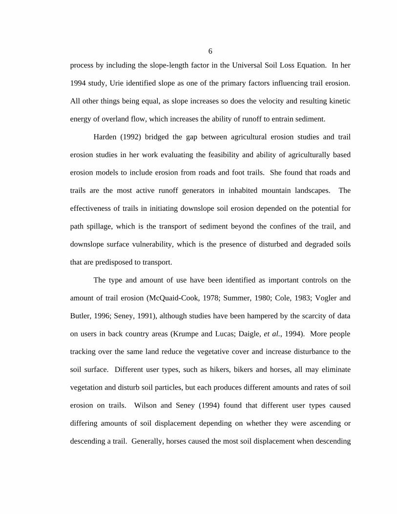
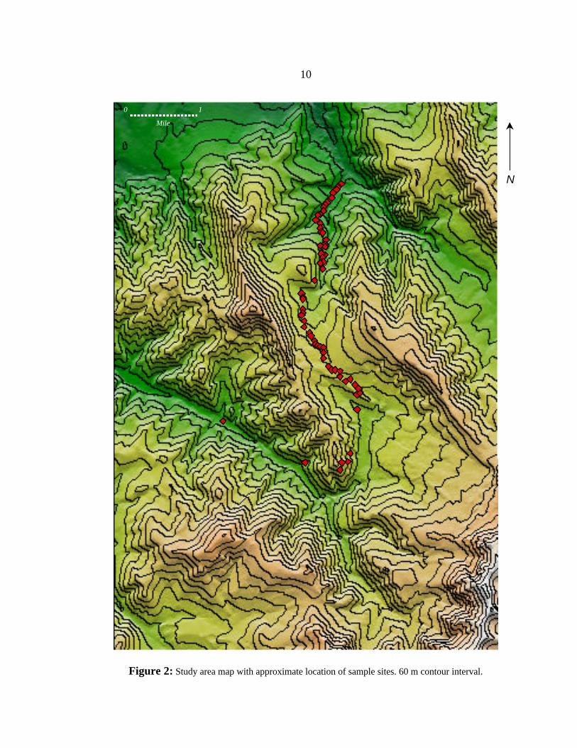
The study area consists of the New World Gulch and Bozeman Creek Trails in
Southwest Montana (Figure 1). The two trails have a combined length of approximately
13 km and an elevation change of approximately 400 meters (Figure 2).
Figure 1: General location of study area near Bozeman, Montana. Trails are in the Northeastern corner of the Gallatin Mountain Range.
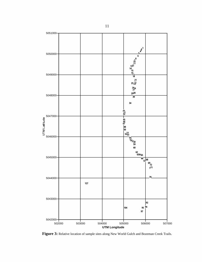
The New World Gulch and Bozeman Creek trails were chosen for this study
because the sites had been previously sampled by Urie (1994), and could be positively
identified by relocating the site markers. Urie's sites were used because topographic and
soils data had been previously collected and entered into a GIS for these locations. Only
67 of Uries 130 sites could be relocated with precision that was adequate for this study
(Figure 3). The Urie sites which were relocated were 1 - 6, 8 - 18, 21 - 30, 34,
10
Figure 2: Study area map with approximate location of sample sites. 60 m contour interval.
N
0 1
Mile
11
5042000
5043000
5044000
5045000
5046000
5047000
5048000
5049000
5050000
5051000
502000 503000 504000 505000 506000 507000UTM Longitude
12345
68
91011
121314
15161718
212223
24
25
26272829
30
34
404142
4546474850
5152535455565758
5960
62636465
666768
69
707172
79
92
9495
97
104
127
Figure 3: Relative location of sample sites along New World Gulch and Bozeman Creek Trails.
12
40 - 42, 45 - 48, 50 - 60, 62 - 72, and 79 found along the New World Gulch trail, with
sites 92, 94 and 95, 97, 104, 113 and 114, and 127 found along the Bozeman Creek trail
(Figures 2 and 3).
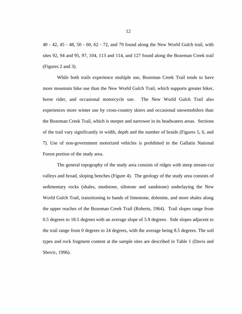
While both trails experience multiple use, Bozeman Creek Trail tends to have
more mountain bike use than the New World Gulch Trail, which supports greater hiker,
horse rider, and occasional motorcycle use. The New World Gulch Trail also
experiences more winter use by cross-country skiers and occasional snowmobilers than
the Bozeman Creek Trail, which is steeper and narrower in its headwaters areas. Sections
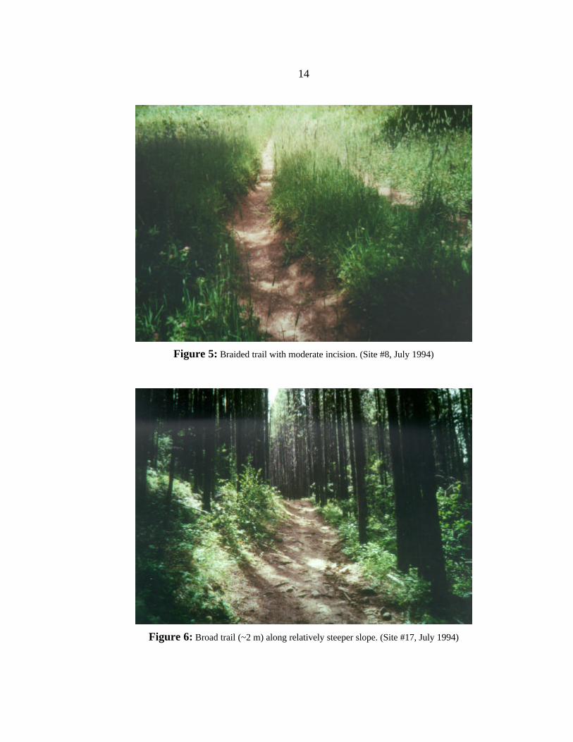
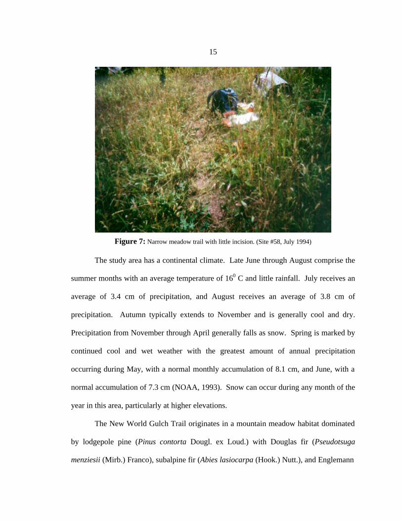
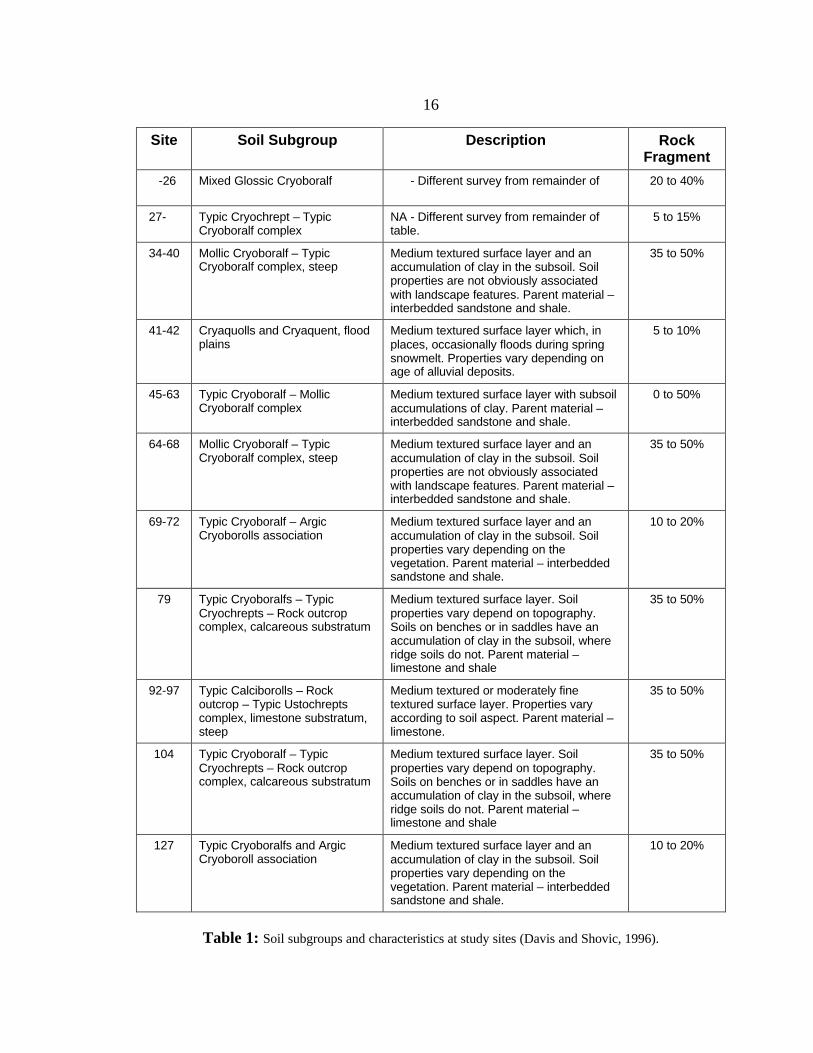
of the trail vary significantly in width, depth and the number of braids (Figures 5, 6, and
7). Use of non-government motorized vehicles is prohibited in the Gallatin National
Forest portion of the study area.
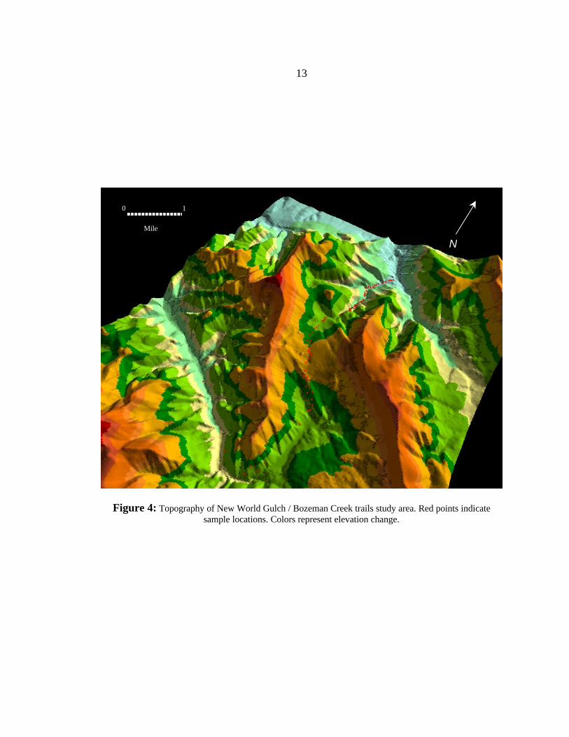
The general topography of the study area consists of ridges with steep stream-cut
valleys and broad, sloping benches (Figure 4). The geology of the study area consists of
sedimentary rocks (shales, mudstone, siltstone and sandstone) underlaying the New
World Gulch Trail, transitioning to bands of limestone, dolemite, and more shales along
the upper reaches of the Bozeman Creek Trail (Roberts, 1964). Trail slopes range from
0.5 degrees to 18.5 degrees with an average slope of 5.9 degrees. Side slopes adjacent to
the trail range from 0 degrees to 24 degrees, with the average being 8.5 degrees. The soil
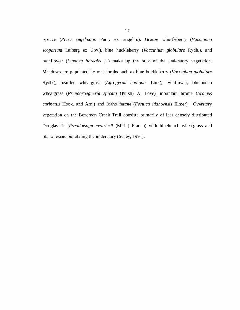
types and rock fragment content at the sample sites are described in Table 1 (Davis and
Shovic, 1996).
13
Figure 4: Topography of New World Gulch / Bozeman Creek trails study area. Red points indicate sample locations. Colors represent elevation change.
N
0 1
Mile
14
Figure 5: Braided trail with moderate incision. (Site #8, July 1994)
Figure 6: Broad trail (~2 m) along relatively steeper slope. (Site #17, July 1994)
15
Figure 7: Narrow meadow trail with little incision. (Site #58, July 1994)
The study area has a continental climate. Late June through August comprise the
summer months with an average temperature of 160 C and little rainfall. July receives an
average of 3.4 cm of precipitation, and August receives an average of 3.8 cm of
precipitation. Autumn typically extends to November and is generally cool and dry.
Precipitation from November through April generally falls as snow. Spring is marked by
continued cool and wet weather with the greatest amount of annual precipitation
occurring during May, with a normal monthly accumulation of 8.1 cm, and June, with a
normal accumulation of 7.3 cm (NOAA, 1993). Snow can occur during any month of the
year in this area, particularly at higher elevations.
The New World Gulch Trail originates in a mountain meadow habitat dominated
by lodgepole pine (Pinus contorta Dougl. ex Loud.) with Douglas fir (Pseudotsuga
menziesii (Mirb.) Franco), subalpine fir (Abies lasiocarpa (Hook.) Nutt.), and Englemann
16
Site Soil Subgroup Description Rock Fragment
-26 Mixed Glossic Cryoboralf - Different survey from remainder of
20 to 40%
27- Typic Cryochrept – Typic Cryoboralf complex
NA - Different survey from remainder of table.
5 to 15%
34-40 Mollic Cryoboralf – Typic Cryoboralf complex, steep
Medium textured surface layer and an accumulation of clay in the subsoil. Soil properties are not obviously associated with landscape features. Parent material – interbedded sandstone and shale.
35 to 50%
41-42 Cryaquolls and Cryaquent, flood plains
Medium textured surface layer which, in places, occasionally floods during spring snowmelt. Properties vary depending on age of alluvial deposits.
5 to 10%
45-63 Typic Cryoboralf – Mollic Cryoboralf complex
Medium textured surface layer with subsoil accumulations of clay. Parent material – interbedded sandstone and shale.
0 to 50%
64-68 Mollic Cryoboralf – Typic Cryoboralf complex, steep
Medium textured surface layer and an accumulation of clay in the subsoil. Soil properties are not obviously associated with landscape features. Parent material – interbedded sandstone and shale.
35 to 50%
69-72 Typic Cryoboralf – Argic Cryoborolls association
Medium textured surface layer and an accumulation of clay in the subsoil. Soil properties vary depending on the vegetation. Parent material – interbedded sandstone and shale.
10 to 20%
79 Typic Cryoboralfs – Typic Cryochrepts – Rock outcrop complex, calcareous substratum
Medium textured surface layer. Soil properties vary depend on topography. Soils on benches or in saddles have an accumulation of clay in the subsoil, where ridge soils do not. Parent material – limestone and shale
35 to 50%
92-97 Typic Calciborolls – Rock outcrop – Typic Ustochrepts complex, limestone substratum, steep
Medium textured or moderately fine textured surface layer. Properties vary according to soil aspect. Parent material – limestone.
35 to 50%
104 Typic Cryoboralf – Typic Cryochrepts – Rock outcrop complex, calcareous substratum
Medium textured surface layer. Soil properties vary depend on topography. Soils on benches or in saddles have an accumulation of clay in the subsoil, where ridge soils do not. Parent material – limestone and shale
35 to 50%
127 Typic Cryoboralfs and Argic Cryoboroll association
Medium textured surface layer and an accumulation of clay in the subsoil. Soil properties vary depending on the vegetation. Parent material – interbedded sandstone and shale.
10 to 20%
Table 1: Soil subgroups and characteristics at study sites (Davis and Shovic, 1996).
17
spruce (Picea engelmanii Parry ex Engelm.). Grouse whortleberry (Vaccinium
scoparium Leiberg ex Cov.), blue huckleberry (Vaccinium globulare Rydb.), and
twinflower (Linnaea borealis L.) make up the bulk of the understory vegetation.
Meadows are populated by mat shrubs such as blue huckleberry (Vaccinium globulare
Rydb.), bearded wheatgrass (Agropyron caninum Link), twinflower, bluebunch
wheatgrass (Pseudoroegneria spicata (Pursh) A. Love), mountain brome (Bromus
carinatus Hook. and Arn.) and Idaho fescue (Festuca idahoensis Elmer). Overstory
vegetation on the Bozeman Creek Trail consists primarily of less densely distributed
Douglas fir (Pseudotsuga menziesii (Mirb.) Franco) with bluebunch wheatgrass and
Idaho fescue populating the understory (Seney, 1991).
18
CHAPTER THREE
METHODS
The goals of this study required the collection of field data, laboratory analysis of
soil samples, and statistical analysis of data. Soil samples and other field measurements
were collected over several months during the summer and fall of 1994. In addition,
some of the topographic information used in the statistical analysis originated in Urie's
(1994) study of recreational trails.
Urie's (1994) examination of the relationship between landscape variables and
trail condition concluded that the variables that she collected explained roughly 50% of
the variation in cross-sectional area. Cross-sectional area was defined by taking a
transect at each sample site and measuring the: 1) width of the disturbed zone between
two fixed points on either edge of the trail, and 2) the depth of the trail across this width
at 10 cm intervals (Urie, 1994). In order to further explain the variation, I examined
variables that had not been examined in Urie's study: soil bulk density, estimated degree
of compaction, slope intersection angles, adjusted trail azimuth, and soil particle size
distribution.
Soil bulk density measurements were made on and off the trail to document the
undisturbed and disturbed soil bulk densities needed to estimate the amount of
compaction that had occurred. Considering the compaction effect on the cross-sectional
area of the trail also provides a more accurate measure of the erosion along the trail,
which was the primary emphasis of Urie's (1994) study.
19
The difference between the azimuth of the trail and the aspect of the dominant
regional slope was determined at each site. This measurement provided information on
whether the angle of interception of overland flow from the regional slope influenced
trail erosion (Bratton et al., 1979). The aspect data used by Urie was adjusted to
represent angular deviations from a North - South base line. This adjustment to Urie's
data was designed to eliminate the use of Urie's aspect units in the regression analysis.
Particle size distribution was determined for approximately 1/3 of the samples and
recorded as percentages of the total sample mass to negate the effect of the variation in
mass from sample to sample.
Data Acquisition
Pilot Study, Sampling Strategy and Soil Data
Field work began with the relocation and/or reestablishment of as many as
possible of the 130 study sites originally established by Urie (1994). Ultimately, with the
assistance of Urie, 67 of the sites were relocated. Seven of those sites (12, 29, 59, 79,
104, and 127), representing the extremes of the cross-sectional area "missing" from the
trail, along with three others (1, 11, and 21) were used as pilot study sites to establish the
optimum sampling strategy.
At each of the ten pilot study sites, the sampling strategy consisted of taking
twelve 5.2 cm diameter by 5.2 cm deep (approximately 111 cm3) cores. Four of the cores
were taken along the center and parallel to the trail. Four cores were taken one meter
from the edge of either side of the trail (two core samples each side), and four cores were
taken two meters from the edges of the trail (two core samples each side) in order to
20
capture trends in variability between soil bulk densities and to determine the appropriate
sampling strategy needed to collect a representative sample.
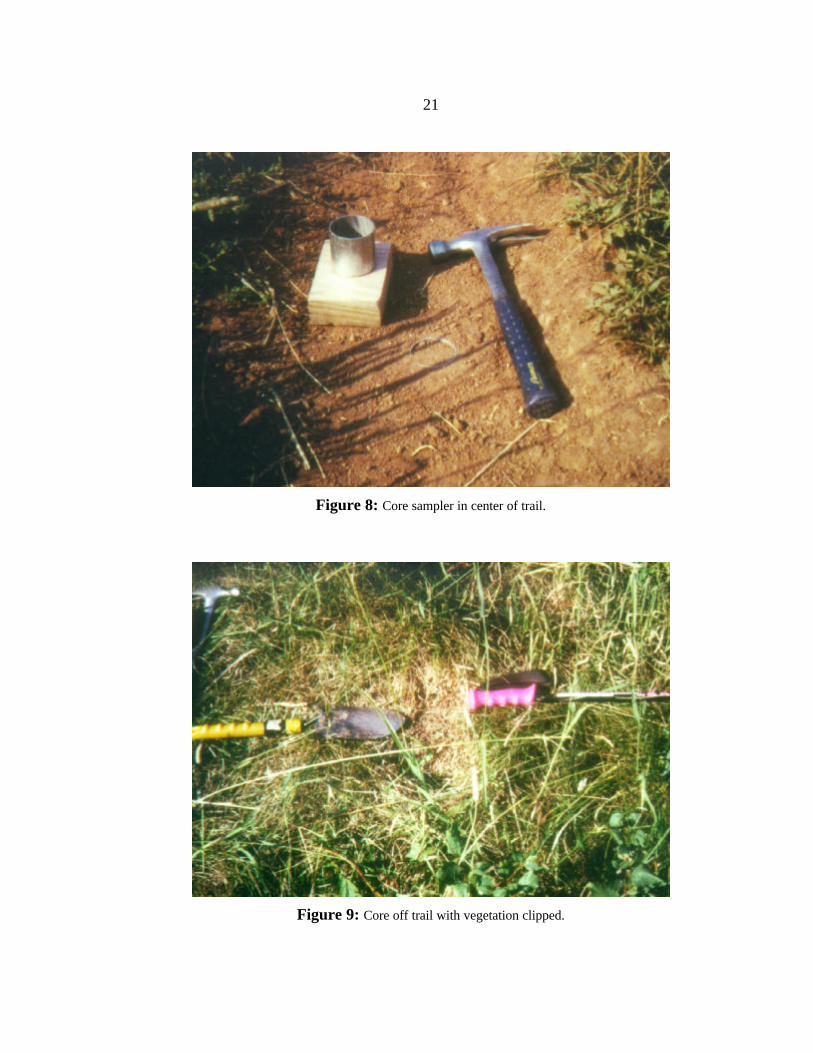
The metal coring cylinders were driven into the soil until the top of the tube was
even with the surface (Figure 8). To minimize the sampling error due to dislocation of
soils during the coring process, wood block buffers were placed between the hammer
driver and the top of the core. Soil cores that were noticeably disturbed during the coring
process were discarded.
Even cores that were not noticeably disturbed may have had their in situ bulk
densities compromised by the coring process (Black, 1965; Page-Dumroese et al., 1999).
In some cases, the brittle nature of the dry compacted soils on the trail may have resulted
in a slight under representation of that soil's true bulk density due to "delaminating"
between soil layers caused by vibration. On the other hand, particularly soft or
compressible soils may have been slightly compacted in the coring process, thereby
increasing the bulk density. Care was taken to minimize such effects.
Pilot study core samples along the sides of the trail frequently included vegetative
litter. The inclusion of litter reduced the measured bulk densities of the "off trail"
samples, thereby confounding estimates of compaction. All sites sampled after the pilot
study phase were therefore clipped of vegetation and cleared of the litter to the uppermost
surface of the mineral soil (Figure 9).
Pebbles in the soil influenced the compactability of the soil, so they were included
in the calculations of the bulk densities. However, where pebbles constituted in excess of
about one third of the volume of the core, that core was discarded and another taken due
to the possible misrepresentation of that sample to the surrounding soil. One of the pilot
21
Figure 8: Core sampler in center of trail.
Figure 9: Core off trail with vegetation clipped.
22
study sites, #102, was unusable for the entire project because it consisted of a large
boulder with only a veneer of soil, making coring impossible.
Once the core samples were extracted, they were placed in paper sacks in a
shaded pack for transport to the lab where they were weighed on the day of collection.
Later, the samples were dried in an oven for 24 hours at 1100 C. The dry samples were
then reweighed and the soil bulk density (ρb) calculated by dividing the oven dry weight
(ms) by the total core volume (Vt).
The results of the pilot study, as discussed in the results section, indicated that
collecting one core in the center of the trail and one core one meter from each trail edge
would represent the range of bulk densities on and off the trail at each site. This was
done for the remaining study sites. All other soil sample collection and laboratory
analysis techniques established during the pilot study were maintained.
Particle size distributions were measured using the sieve method (Marshall et al.,
1996). Seven sieve sizes were used, resulting in the following sieved particle size
classes: < 0.063 mm, 0.063 - 0.125 mm, 0.125 - 0.25 mm, 0.25 - 0.5 mm, 0.5 - 1 mm, 1 -
2 mm, and > 2 mm. Each sample was sieved for ten minutes. Particle size classes were
weighed and converted to a percentage of the total sample weight. Moving the lab while
the researcher was gone resulted in the loss of some samples, so only a portion of the
sites have particle size results.
Physiographic Data
Topography as well as bulk density can contribute to trail erosion and changes in
cross-sectional area. Data was therefore collected on the trail aspect and the dominant
23
slope aspect at each site. It was assumed that as the difference between the trail azimuth
and slope aspects increase, trail erosion might decrease due to the trail acting increasingly
like a sediment trap rather than a channel (Bratton et al., 1979). There may be some
discrepancy between the slope aspect measured for this study and that reported by Urie
(1994) due to the fact that Urie's values were derived from a Digital Elevation Model
(DEM), while those for this work were measured directly.
In addition to the soil bulk density, soil type, and aspect data collected by this
author, Urie (1994) collected data at each site on trail slope, soil water content, and
vegetative cover. Soil water content was measured three times (June ,1993; July, 1992;
September, 1992) with a Tektronic time domain reflectometry (TDR) tester for the top 20
cm of the soil profile along the trail. The mean of the measurements at each site was
used in the analysis of the data (Urie, 1994). Urie also used the Topographic Analysis
Programs for Environmental Sciences - Grid version (TAPES - G) program coupled with
a Geographic Information System (GIS) and Digital Elevation Model (DEM) to generate
data on regional slope, profile curvature, plan curvature, trail aspect, elevation, and
specific catchment area.
Analysis
Statistical Tests
A t-test was used to determine if bulk densities on and off of the trail were
significantly different. A correlation matrix established association among variables and
suggested whether variables could be included together in a multiple regression.
Scatterplots for the measured and adjusted cross-sectional trail areas were developed for
24
all variables. Those scatterplots were used to identify any nonlinear and/or threshold
relationships between variables. Multiple regression analysis was the primary statistical
tool used to establish the degree to which variations in erosion and compaction at each
site were controlled by different driving variables.
Soil Compaction & Erosion
Equation (1) was used to calculate the depth of trail incision due to compaction
(∆d) occurring at each site, where ρbcen is the bulk density at the center of the trail, ρboff is
the mean soil bulk density off the trail at each site, and dc is the depth of the soil in which
compaction occurred. The bulk density samples (Table 3) from the 64 reestablished sites
were entered into eq. (1) to estimate the potential magnitudes of the cross-sectional
erosion and compaction at each site. The trail incision due to compaction was calculated
by subtracting the adjusted cross-sectional area from the measured area.
∆d = dc
ρboffρbcen
−1
(1)
Equation (1) assumes that the on trail bulk density was the same as the off trail
bulk density before compaction. The "soil expansion" equation was first used with the
depth of the core sample (5.2 cm) to determine the minimum difference between the
measured and adjusted cross-sectional areas. The 5.2 cm depth was used as a minimum
(conservative) estimate because it was the depth of the soil core sample, and because
visual observation suggested that compaction occurred to at least this depth.

25
Through visual inspection during the coring process, it was apparent that
compaction occurred below the 5.2 cm depth at many sites. To estimate the potential
maximum effect of soil compaction, eq. (1) was used again assuming a uniform
compaction depth of 25 cm.
CHAPTER FOUR
RESULTS
This chapter summarizes the data, reports on the results of the pilot study, and
examines the relation of cross-sectional area to soil bulk density, compaction and
topographic variables. To isolate the significant variables, correlation matrices were
developed for both the cross-sectional and adjusted cross-sectional areas. Scatter plots
were used to verify the strength of relationships and to inspect for nonlinear relationships.
Finally, multiple stepwise regressions were used to assess the amount of variability in the
measured and adjusted cross-sectional areas that could be explained by measured and
derived variables.
Pilot Study Data
Bulk density samples from the pilot study (Table 2) were evaluated to determine
the most efficient sampling strategy for documenting any differences between on and off
trail bulk densities. A t–test showed significant differences in bulk density at the 0.05
level between the combined samples taken on and off the trail. It also showed that there
was no significant difference between the samples taken 1 meter off the trail versus those
taken 2 meters off the trail. Additionally, all samples taken on the trail at a site were
found to be statistically similar in bulk density (Table 3).
Left 2m (g/cm3)
Left 1m (g/cm3)
Center (g/cm3)
Right 1m (g/cm3)
Right 2m(g/cm3)
1.13 1.02 1.65 1.61 1.11 1.05 Site #1
1.33 1.20 1.74 1.50 1.35 1.11 0.95 1.02 1.62 1.62 0.78 0.71
Site #11 0.85 0.83 1.52 1.69 0.93 0.71 1.43 1.13 1.76 1.64 1.31 NA1
Site #12 1.05 1.17 1.69 1.85 1.39 NA1
1.07 1.03 1.82 1.82 0.79 0.75 Site #21
1.25 0.85 1.69 1.71 0.61 0.83 0.62 0.32 1.64 1.23 0.55 0.45
Site #29 0.84 0.91 1.65 1.48 0.57 1.01 1.14 0.89 1.58 1.71 1.27 1.17
Site #59 1.06 1.10 1.67 1.69 1.26 1.40 1.31 1.38 1.55 1.50 1.07 0.99
Site #79 1.43 1.38 1.48 1.38 1.20 1.00 NA2 NA2 1.54 NA2 NA2 NA2
Site# 102 NA2 NA2 NA2 NA2 NA2 NA2
1.03 1.03 1.25 NA3 1.31 1.22 Site #104
1.13 0.97 1.25 1.13 0.95 0.93 1.05 1.31 1.65 1.73 1.16 1.08
Site #127 1.14 1.32 1.65 1.44 1.17 1.10
Table 2: Bulk density of pilot study samples. (1 - 2m right of trail was a stream, 2 - Site was on top of predominantly exposed rock, 3 - Incomplete sample).
Bulk Density (g/cm3)
Trail Center 1m from edge 2m from edge
Mean 1.59 1.16 1.05
Standard Dev. 0.17 0.21 0.18
Range 0.60 0.70 0.51
Table 3: Summary statistics for pilot study.
Data
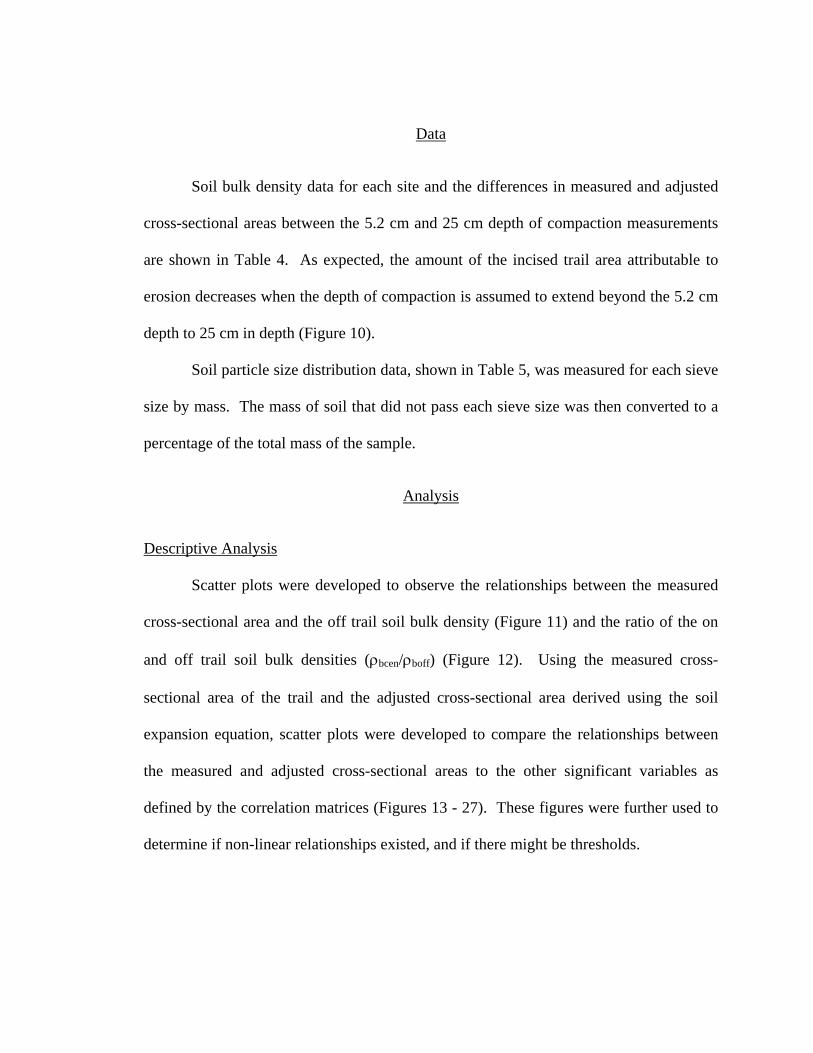
Soil bulk density data for each site and the differences in measured and adjusted
cross-sectional areas between the 5.2 cm and 25 cm depth of compaction measurements
are shown in Table 4. As expected, the amount of the incised trail area attributable to
erosion decreases when the depth of compaction is assumed to extend beyond the 5.2 cm
depth to 25 cm in depth (Figure 10).
Soil particle size distribution data, shown in Table 5, was measured for each sieve
size by mass. The mass of soil that did not pass each sieve size was then converted to a
percentage of the total mass of the sample.
Analysis
Descriptive Analysis
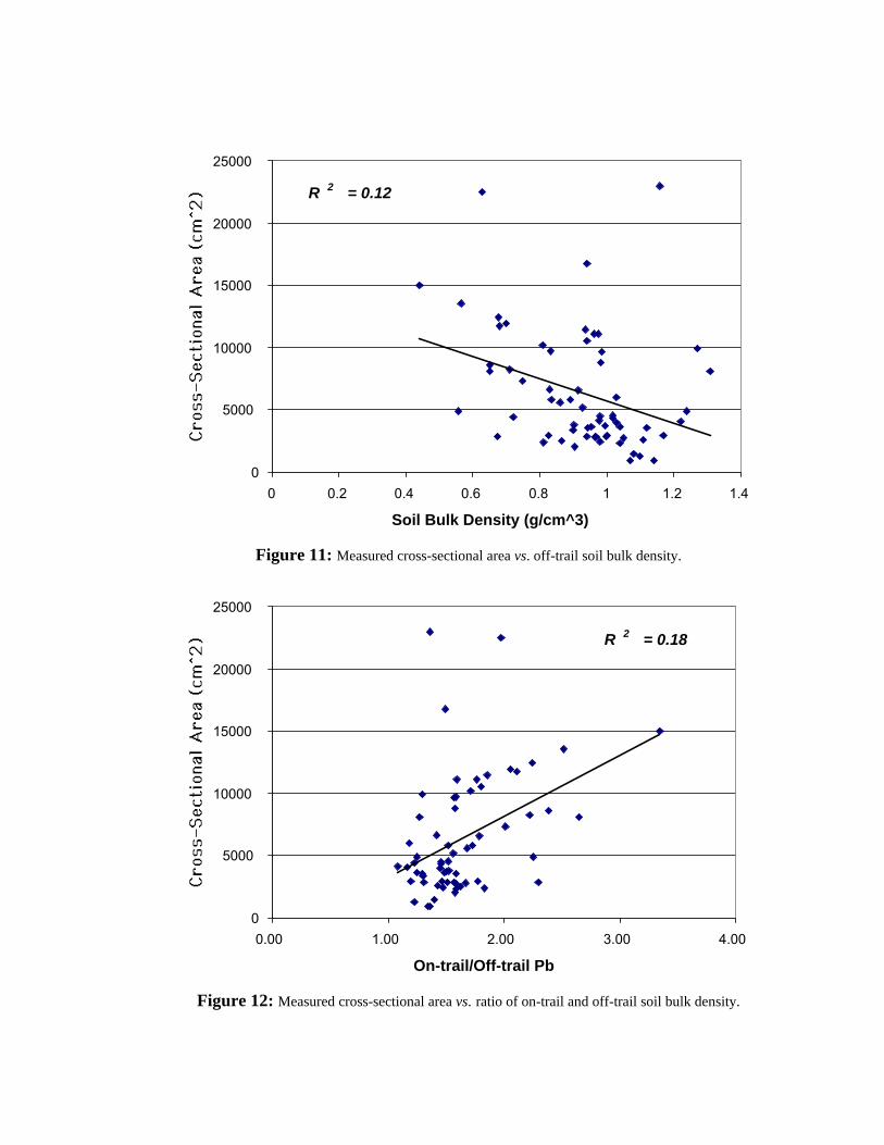
Scatter plots were developed to observe the relationships between the measured
cross-sectional area and the off trail soil bulk density (Figure 11) and the ratio of the on
and off trail soil bulk densities (ρbcen/ρboff) (Figure 12). Using the measured cross-
sectional area of the trail and the adjusted cross-sectional area derived using the soil
expansion equation, scatter plots were developed to compare the relationships between
the measured and adjusted cross-sectional areas to the other significant variables as
defined by the correlation matrices (Figures 13 - 27). These figures were further used to
determine if non-linear relationships existed, and if there might be thresholds.
Gullied Cross Sectional Area of Trail
0
5000
10000
15000
20000
25000
1 9 17 25 33 41 49 57 65 73 81 89 97 105 113 121 129
Site Number
Meas. X-Sect Area Adj. X-Sec Area
Gullied Cross Sectional Area of Trail
0
5000
10000
15000
20000
25000
1 9 17 25 33 41 49 57 65 73 81 89 97 105 113 121 129
Site Number
Meas. X-Sect Area Adj. X-Sect Area (x5)
Figure 10: The adjusted area derived using the 5.2 cm (above) and 25 cm depths (below) in Equation (1).
R 2 = 0.12
0
5000
10000
15000
20000
25000
0 0.2 0.4 0.6 0.8 1 1.2 1.4
Soil Bulk Density (g/cm^3)
Figure 11: Measured cross-sectional area vs. off-trail soil bulk density.
R 2 = 0.18
0
5000
10000
15000
20000
25000
0.00 1.00 2.00 3.00 4.00
On-trail/Off-trail Pb
Figure 12: Measured cross-sectional area vs. ratio of on-trail and off-trail soil bulk density.
Stake # Off trail ρb(gcm3)
Center trail ρb(gcm3)
Off trail ρb(gcm3)
Avg Off trail ρb(gcm3)
X-Sect Area (cm2)
X-Sect Area adj to 5.2 cm (cm2)
X-Sect Area adj to 25 cm (cm2)
1 1.1 1.58 1.22 1.16 22942 22560 211012 0.459 1.56 0.845 0.652 8600 7904 52533 1.14 1.55 0.824 0.984 9618 9149 73634 0.865 0.887 0.579 0.722 4414 4259 36705 0.83 1.55 0.516 0.673 2893 2525 11256 0.988 1.46 1.16 1.07 909 827 5158 1.04 1.51 0.956 0.999 2870 2687 19909 0.318 1.42 0.811 0.564 13562 11995 602710 0.945 1.49 1.1 1.02 4342 4083 309611 0.967 1.5 0.922 0.944 3573 3392 270212 1.04 1.54 1.24 1.14 937 851 52113 1.44 1.65 1.09 1.27 9884 9688 894014 1.28 1.55 1.2 1.24 4857 4760 439215 0.888 1.48 0.996 0.942 2841 2701 216916 1.43 1.67 1.18 1.31 8112 7951 733617 0.971 1.61 0.961 0.966 2761 2615 206118 1.18 1.47 0.822 1 2921 2798 233021 0.937 1.72 1.01 0.975 11073 10593 876722 0.63 1.73 0.674 0.652 8122 7565 544323 0.875 1.7 1.01 0.942 10567 10110 837124 0.755 1.26 0.361 0.558 4893 4516 308225 0.818 1.41 0.915 0.866 2538 2388 181527 1.02 1.42 0.888 0.954 3606 3425 273628 0.847 1.27 0.82 0.834 5780 5559 471629 0.743 1.24 0.51 0.627 22483 21702 1872630 0.564 1.43 0.791 0.678 11733 11167 901234 1.06 1.17 0.739 0.899 3335 3210 273340 0.972 1.53 0.95 0.961 11107 10676 9034
Table 4 (continued next page)
Stake # Off trail ρb(gcm3)
Center trail ρb(gcm3)
Off trail ρb(gcm3)
Avg Off trail ρb(gcm3)
X-Sect Area (cm2)
X-Sect Area adj to 5.2 cm (cm2)
X-Sect Area adj to 25 cm (cm2)
41 1.01 1.22 1.06 1.03 5975 5922 572242 0.965 1.45 0.89 0.927 5144 4960 426045 1.05 1.64 0.781 0.915 6558 6144 456946 0.783 1.74 1.09 0.935 11447 10689 780447 0.567 1.48 0.316 0.442 14992 13588 824148 0.752 1.18 0.906 0.829 6622 6421 565550 0.786 1.52 0.568 0.677 12428 11626 857351 0.883 1.39 0.733 0.809 10216 9714 780252 0.817 1.32 0.85 0.833 9736 9391 807653 0.717 1.51 0.778 0.748 7352 7053 591454 0.711 1.44 0.686 0.699 11948 11247 857755 0.783 1.58 0.638 0.71 8232 7625 531456 1.11 1.43 0.85 0.979 4471 4299 364357 0.716 1.45 1.01 0.861 5577 5277 413558 1.19 1.55 0.772 0.983 8801 8630 797859 0.868 1.41 1.01 0.941 16767 16406 1502960 0.892 1.54 0.89 0.891 5806 5598 480563 0.868 1.49 0.756 0.812 2369 2187 149364 0.975 1.38 0.832 0.903 3755 3627 314165 0.855 1.27 1.08 0.967 2830 2706 223466 1.04 1.65 1.05 1.04 2272 2145 166267 1.04 1.45 0.923 0.981 2433 2300 179468 0.947 1.67 1.16 1.05 2733 2596 207469 1.06 1.5 0.927 0.995 3668 3467 270070 1 1.45 1.23 1.12 3538 3431 302671 0.898 1.55 1.14 1.02 4569 4350 351872 1.21 1.43 1.23 1.22 4075 4021 381479 1.18 1.3 0.901 1.04 3610 3610 3610
Table 4 (continued next page)
Stake # Off trail ρb(gcm3)
Center trail ρb(gcm3)
Off trail ρb(gcm3)
Avg Off trail ρb(gcm3)
X-Sect Area (cm2)
X-Sect Area adj to 5.2 cm (cm2)
X-Sect Area adj to 25 cm (cm2)
92 1.16 1.59 1.07 1.11 2606 2476 198094 0.769 1.43 1.04 0.904 1999 1879 142495 1.05 1.35 1.15 1.1 1232 1176 96397 1.27 1.4 1.07 1.17 2902 2830 2557
104 0.943 1.06 1.01 0.978 4150 4109 3955113 0.813 1.47 0.843 0.828 2966 2818 2256114 1.04 1.51 1.12 1.08 1497 1413 1091127 1.07 1.5 0.984 1.03 3981 3777 3002
Table 4: A-Pb and C-Pb are soil bulk density one meter from the edge of the incised trail. B-Pb is the soil bulk density in the incised trail center. X-Sect Area is the measured cross-sectional area. X-Sect Area adj. To 5.2 cm is the adjusted cross-sectional area derived with Equation 1, using 5.2 cm as the depth of compaction. X-Sect Area adj to 25 cm is the adjusted cross-sectional area derived with Equation
1 using a depth of compaction of 25 cm.
Stake # > 2 mm
(gm) 1-2 mm
(gm) 0.5-1 mm
(gm) 0.25-0.5 mm
(gm) 0.125-0.25 mm
(gm) 0.063-0.125 mm
(gm) < .063 mm
(gm) 1 0.71 0.13 0.05 0.03 0.02 0.02 0.032 0.67 0.18 0.06 0.03 0.02 0.02 0.034 0.30 0.21 0.13 0.10 0.06 0.05 0.146 0.31 0.22 0.17 0.04 0.12 0.07 0.069 0.49 0.21 0.10 0.07 0.05 0.03 0.06
10 0.57 0.15 0.08 0.07 0.05 0.03 0.0611 0.33 0.27 0.15 0.09 0.05 0.04 0.0825 0.09 0.15 0.23 0.22 0.14 0.08 0.0927 0.48 0.25 0.09 0.06 0.05 0.03 0.0430 0.40 0.24 0.15 0.10 0.05 0.03 0.0434 0.46 0.20 0.11 0.08 0.06 0.04 0.0441 0.23 0.10 0.10 0.12 0.18 0.09 0.1846 0.37 0.23 0.09 0.06 0.06 0.06 0.1247 0.42 0.19 0.11 0.08 0.07 0.05 0.0850 0.64 0.16 0.07 0.04 0.03 0.02 0.0353 0.40 0.19 0.10 0.07 0.06 0.06 0.1154 0.44 0.19 0.08 0.05 0.05 0.06 0.1355 0.56 0.19 0.07 0.04 0.03 0.03 0.0757 0.46 0.16 0.07 0.05 0.04 0.06 0.1760 0.28 0.25 0.05 0.09 0.06 0.08 0.2063 0.37 0.23 0.11 0.07 0.06 0.06 0.1065 0.39 0.13 0.10 0.09 0.08 0.08 0.1466 0.31 0.14 0.10 0.10 0.13 0.13 0.1069 0.52 0.02 0.16 0.10 0.08 0.05 0.0771 0.42 0.19 0.09 0.08 0.12 0.05 0.0494 0.32 0.12 0.06 0.08 0.13 0.13 0.15114 0.58 0.20 0.12 0.05 0.02 0.01 0.02
Table 5: Soil particle size class distribution by weight for off trail soil core samples.
R 2 = 0.35
0
5000
10000
15000
20000
25000
0 5 10 15 20
Trail Slope (%)
R 2 = 0.35
0
5000
10000
15000
20000
25000
0 5 10 15 20
Trail Slope (%)
Figure 13: Measured and adjusted cross-sections vs. trail slope.
R 2 = 0.11
0
5000
10000
15000
20000
25000
0 10 20 30 40 50
Soil Water (%)
R 2 = 0.11
0
5000
10000
15000
20000
25000
0 10 20 30 40 50
Soil Water (%)
Figure 14: Measured and adjusted cross-sections vs. soil water.
R 2 = 0.23
0
5000
10000
15000
20000
25000
0.00 0.20 0.40 0.60 0.80
Particle Size >2mm (%)
R 2 = 0.23
0
5000
10000
15000
20000
25000
0.00 0.20 0.40 0.60 0.80
Particle Size >2mm (%)
Figure 15: Measured and adjusted cross-sections vs. percent particle size greater than 2mm.
R 2 = 0.18
0
5000
10000
15000
20000
25000
0.00 0.20 0.40 0.60 0.80
Particle Size .25-.125 (%)
R 2 = 0.17
0
5000
10000
15000
20000
25000
0.00 0.20 0.40 0.60 0.80
Particle Size .25-.125 (%)
Figure 16: Measured and adjusted cross-sections vs. percent particle size 0.25 - 0.125 mm.
R 2 = 0.17
0
5000
10000
15000
20000
25000
0.00 0.20 0.40 0.60 0.80
Particle Size .125-.063 (%)
R 2 = 0.17
0
5000
10000
15000
20000
25000
0.00 0.20 0.40 0.60 0.80
Particle Size .125-.063 (%)
Figure 17: Measured and adjusted cross-sections vs. percent particle size 0.125 - 0.065 mm.
R 2 = 0.14
0
5000
10000
15000
20000
25000
0.00 0.20 0.40 0.60 0.80
Particle Size 1-.5mm (%)
R 2 = 0.14
0
5000
10000
15000
20000
25000
0.00 0.20 0.40 0.60 0.80
Particle Size 1-.5mm (%)
Figure 18: Measured and adjusted cross-sections vs. percent particle size 1.0 - 0.5 mm.
R 2 = 0.10
0
5000
10000
15000
20000
25000
0.00 0.20 0.40 0.60 0.80
Particle Size .5-.25mm (%)
R 2 = 0.10
0
5000
10000
15000
20000
25000
0.00 0.20 0.40 0.60 0.80
Particle Size .5-.25 (%)
Figure 19: Measured and adjusted cross-sections vs. percent particle size 0.5 - 0.25 mm.
R 2 = 0.05
0
5000
10000
15000
20000
25000
0.00 0.05 0.10 0.15 0.20 0.25
Particle Size < .063 mm (%)
R 2 = 0.04
0
5000
10000
15000
20000
25000
0.00 0.05 0.10 0.15 0.20 0.25
Particle Size < .063 (%)
Figure 20: Measured and adjusted cross-sections vs. percent particle size less than 0.063 mm.
R 2 = 0.00
0
5000
10000
15000
20000
25000
0.00 0.05 0.10 0.15 0.20 0.25 0.30
Particle Size 2 -1 mm (%)
R 2 = 0.00
0
5000
10000
15000
20000
25000
0.00 0.05 0.10 0.15 0.20 0.25 0.30
Particle Size 2 - 1 mm (%)
Figure 21: Measured and adjusted cross-sections vs. percent particle size 2 mm - 1 mm.
R 2 = 0.08
0
5000
10000
15000
20000
25000
0 20 40 60 80 100
Trail Az-Reg Slope (deg)
R 2 = 0.08
0
5000
10000
15000
20000
25000
0 20 40 60 80 100
Trail Az-Reg Slope (deg)
Figure 22: Measured and adjusted cross-sections vs. angle of trail intercept.
♦
♦♦
♦
♦♦
♦
♦♦
♦
♦
♦♦
♦
♦ ♦
♦
♦
♦
♦
♦♦
♦
♦
♦
♦
♦
♦♦
♦
♦
♦
♦
♦
♦♦
♦
♦
♦
♦♦
♦
♦
♦
♦♦
♦♦ ♦♦♦♦♦♦♦
♦♦♦♦♦♦♦
♦
0
5000
10000
15000
20000
25000
-3 -2 -1 0 1 2 3 4 5 6 7
Profile Curvature (m)
♦
♦♦
♦
♦♦
♦
♦♦
♦
♦
♦♦
♦
♦ ♦
♦
♦
♦
♦♦
♦♦
♦
♦
♦
♦
♦♦
♦
♦
♦
♦
♦♦♦
♦
♦
♦
♦♦
♦
♦
♦
♦♦
♦♦ ♦♦♦♦♦♦♦
♦♦♦♦♦♦♦
♦
0
5000
10000
15000
20000
25000
-3 -2 -1 0 1 2 3 4 5 6 7
Adj
. Cro
ss-S
ectio
nal A
rea
(cm
^2)
Profile Curvature (m)
Figure 23: Measured and adjusted (to 5.2 cm depth of compaction) cross-sections vs. profile curvature.
♦
♦♦
♦
♦♦
♦
♦
♦
♦
♦♦
♦
♦ ♦
♦
♦
♦
♦
♦♦
♦
♦
♦
♦♦
♦
♦
♦
♦
♦ ♦
♦♦
♦♦
♦
♦
♦♦
♦♦♦ ♦♦ ♦♦♦ ♦
♦♦ ♦♦
♦♦
♦
♦
0
5000
10000
15000
20000
25000
-6 -4 -2 0 2 4 6 8 10 12 14
Cro
ss-S
ectio
nal A
rea
(cm
^2)
Plan Curvature (m)
♦
♦♦
♦
♦♦
♦
♦
♦
♦
♦♦
♦
♦ ♦
♦
♦
♦
♦♦
♦
♦
♦
♦
♦♦
♦
♦
♦
♦♦ ♦
♦ ♦
♦♦
♦
♦
♦♦
♦♦♦ ♦♦ ♦♦♦ ♦
♦♦ ♦♦
♦♦
♦
♦
0
5000
10000
15000
20000
25000
-6 -4 -2 0 2 4 6 8 10 12 14
Adj
. Cro
ss-S
ectio
nal A
rea
(cm
^2)
Plan Curvature (m)
Figure 24: Measured and adjusted (to 5.2 cm depth of compaction) cross-sections vs. plan curvature.
R 2 = 0.00
0
5000
10000
15000
20000
25000
5000 5500 6000 6500 7000
Elevation (ft)
R 2 = 0.00
0
5000
10000
15000
20000
25000
5000 5500 6000 6500 7000
Elevation (ft)
Figure 25: Measured and adjusted cross-sections vs. elevation.
R 2 = 0.03
0
5000
10000
15000
20000
25000
0 20 40 60 80 100 120 140 160 180
Adjusted Aspect (deg)
R 2 = 0.03
0
5000
10000
15000
20000
25000
0 20 40 60 80 100 120 140 160 180
Adjusted Aspect (deg)
Figure 26: Measured and adjusted cross-sections vs. adjusted aspect.
R 2 = 0.00
0
5000
10000
15000
20000
25000
0 100000 200000 300000 400000 500000 600000
Catchment Area (m^2 m^-1)
R 2 = 0.00
0
5000
10000
15000
20000
25000
0 100000 200000 300000 400000 500000 600000
Catchment Area (m^2 m^-1))
Figure 27: Measured and adjusted cross-sections vs. catchment area.
Correlation Analysis
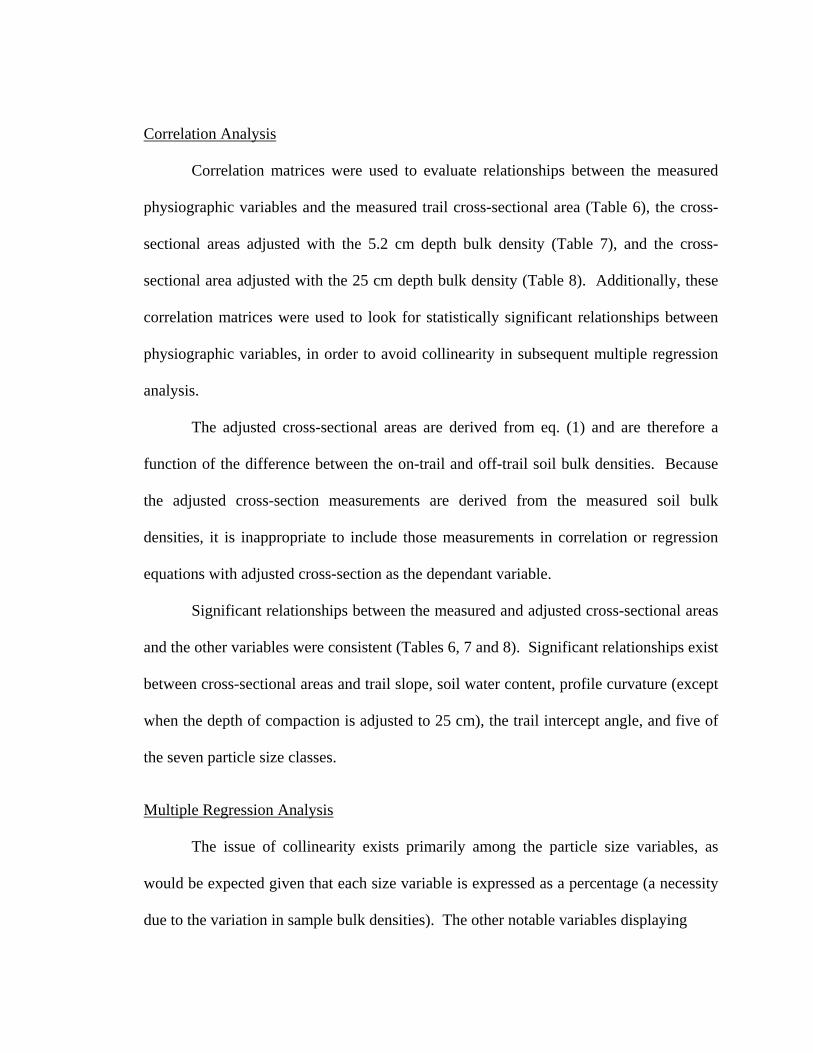
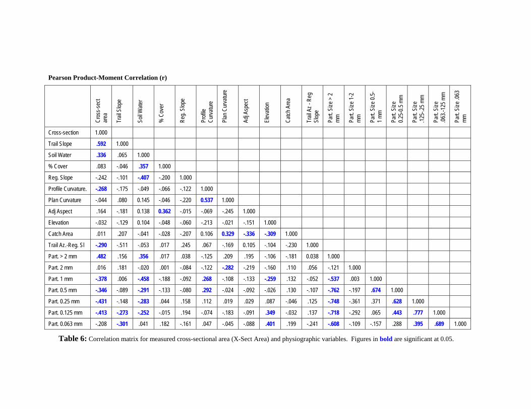
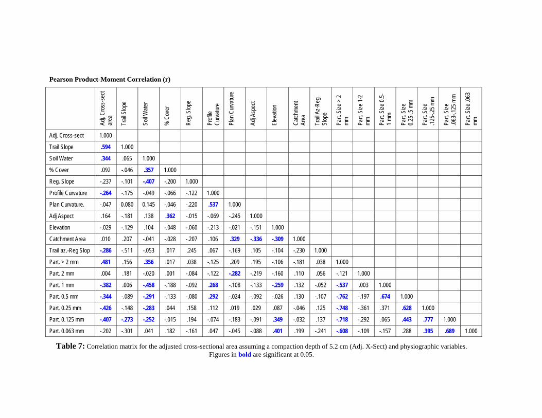
Correlation matrices were used to evaluate relationships between the measured
physiographic variables and the measured trail cross-sectional area (Table 6), the cross-
sectional areas adjusted with the 5.2 cm depth bulk density (Table 7), and the cross-
sectional area adjusted with the 25 cm depth bulk density (Table 8). Additionally, these
correlation matrices were used to look for statistically significant relationships between
physiographic variables, in order to avoid collinearity in subsequent multiple regression
analysis.
The adjusted cross-sectional areas are derived from eq. (1) and are therefore a
function of the difference between the on-trail and off-trail soil bulk densities. Because
the adjusted cross-section measurements are derived from the measured soil bulk
densities, it is inappropriate to include those measurements in correlation or regression
equations with adjusted cross-section as the dependant variable.
Significant relationships between the measured and adjusted cross-sectional areas
and the other variables were consistent (Tables 6, 7 and 8). Significant relationships exist
between cross-sectional areas and trail slope, soil water content, profile curvature (except
when the depth of compaction is adjusted to 25 cm), the trail intercept angle, and five of
the seven particle size classes.
Multiple Regression Analysis
The issue of collinearity exists primarily among the particle size variables, as
would be expected given that each size variable is expressed as a percentage (a necessity
due to the variation in sample bulk densities). The other notable variables displaying
Pearson Product-Moment Correlation (r)
Cro
ss-s
ect
a rea
ro
art.
Size
art.
Size
art.
Size
Trai
l Slo
pe
Soil
Wat
er
% C
over
Reg
. Slo
pe
Pfil
e C
urva
ture
Plan
Cur
vatu
re
Adj A
spec
t
Elev
atio
n
Cat
ch A
rea
Trai
l Az
- Reg
Sl
ope
Part.
Siz
e >
2 m
m
Part.
Siz
e 1-
2 m
m
Part.
Siz
e 0.
5-1
mm
P 0.25
-0.5
mm
P .125
-.25
mm
P .063
.-125
mm
Part.
Siz
e .0
63
mm
Cross-section 1.000
Trail Slope .592 1.000
Soil Water .336 .065 1.000
% Cover .083 -.046 .357 1.000
Reg. Slope -.242 -.101 -.407 -.200 1.000
Profile Curvature. -.268 -.175 -.049 -.066 -.122 1.000
Plan Curvature -.044 .080 0.145 -.046 -.220 0.537 1.000
Adj Aspect .164 -.181 0.138 0.362 -.015 -.069 -.245 1.000
Elevation -.032 -.129 0.104 -.048 -.060 -.213 -.021 -.151 1.000
Catch Area 00 .011 .207 -.041 -.028 -.207 0.106 0.329 -.336 -.309 1.0
Trail Az.-Reg. Sl -.290 -.511 -.053 .017 .245 .067 -.169 0.105 -.104 -.230 1.000
Part. > 2 mm .482 .156 .356 .017 .038 -.125 .209 .195 -.106 -.181 0.038 1.000
Part. 2 mm .016 .181 -.020 .001 -.084 -.122 -.282 -.219 -.160 .110 .056 -.121 1.000
Part. 1 mm -.378 .006 -.458 -.188 -.092 .268 -.108 -.133 -.259 .132 -.052 -.537 .003 1.000
Part. 0.5 mm -.346 -.089 -.291 -.133 -.080 .292 -.024 -.092 -.026 .130 -.107 -.762 -.197 .674 1.000
Part. 0.25 mm -.431 -.148 -.283 .044 .158 .112 .019 .029 .087 -.046 .125 -.748 -.361 .371 .628 1.000
Part. 0.125 mm -.413 -.273 -.252 -.015 .194 -.074 -.183 -.091 .349 -.032 .137 -.718 -.292 .065 .443 .777 1.000
Part. 0.063 mm -.208 -.301 .041 .182 -.161 .047 -.045 -.088 .401 .199 -.241 -.608 -.109 -.157 .288 .395 .689 1.000
Table 6: Correlation matrix for measured cross-sectional area (X-Sect Area) and physiographic variables. Figures in bold are significant at 0.05.
Pearson Product-Moment Correlation (r)
Adj.
Cro
ss-s
ect
a rea
ro
art.
Size
art.
Size
art.
Size
Trai
l Slo
pe
Soil
Wat
er
% C
over
Reg
. Slo
pe
Pfil
e C
urva
ture
Plan
Cur
vatu
re
Adj A
spec
t
Elev
atio
n
Cat
chm
ent
Area
Trai
l Az-
Reg
Sl
ope
Part.
Siz
e >
2 m
m
Part.
Siz
e 1-
2 m
m
Part.
Siz
e 0.
5-1
mm
P 0.25
-.5 m
m
P .125
-.25
mm
P .063
-.125
mm
Part.
Siz
e .0
63
mm
Adj. Cross-sect 0 1.0 0
Trail Slope .594 1.000
Soil Water .344 .065 1.000
% Cover .092 -.046 .357 1.000
Reg. Slope -.237 -.101 -.407 -.200 1.000
Profile Curvature -.264 -.175 -.049 -.066 -.122 1.000
Plan Curvature. -.047 0.080 0.145 -.046 -.220 .537 1.000
Adj Aspect .164 -.181 .138 .362 -.015 -.069 -.245 1.000
Elevation -.029 -.129 .104 -.048 -.060 -.213 -.021 -.151 1.000
Catchment Area .010 .207 -.041 -.028 -.207 .106 .329 -.336 -.309 1.000
Trail az.-Reg Slop -.286 -.511 -.053 .017 .245 .067 -.169 .105 -.104 -.230 1.000
Part. > 2 mm .481 .156 .356 .017 .038 -.125 .209 .195 -.106 -.181 .038 1.000
Part. 2 mm .004 .181 -.020 .001 -.084 -.122 -.282 -.219 -.160 .110 .056 -.121 1.000
Part. 1 mm -.382 .006 -.458 -.188 -.092 .268 -.108 -.133 -.259 .132 -.052 -.537 .003 1.000
Part. 0.5 mm -.344 -.089 -.291 -.133 -.080 .292 -.024 -.092 -.026 .130 -.107 -.762 -.197 .674 1.000
Part. 0.25 mm -.426 -.148 -.283 .044 .158 .112 .019 .029 .087 -.046 .125 -.748 -.361 .371 .628 1.000
Part. 0.125 mm -.407 -.273 -.252 -.015 .194 -.074 -.183 -.091 .349 -.032 .137 -.718 -.292 .065 .443 .777 1.000
Part. 0.063 mm -.202 -.301 .041 .182 -.161 .047 -.045 -.088 .401 .199 -.241 -.608 -.109 -.157 .288 .395 .689 1.000
Table 7: Correlation matrix for the adjusted cross-sectional area assuming a compaction depth of 5.2 cm (Adj. X-Sect) and physiographic variables. Figures in bold are significant at 0.05.
Pearson Product-Moment Correlation (r)
Adj.
Cro
ss-s
ect
a rea
art.
Size
art.
Size
Trai
l Slo
pe
Soil
Wat
er
% C
over
Reg
. Slo
pe
Prof
ile
Cur
vatu
re
Plan
Cur
vatu
re
Adj A
spec
t
Elev
atio
n
Cat
chm
ent
Area
Trai
l Az-
Reg
Sl
ope
Part.
Siz
e >
2 m
m
Part.
Siz
e 1-
2 m
m
Part.
Siz
e 0.
5-1
mm
P 0.25
-.5 m
m
P .125
-.25
mm
Part.
Siz
e .0
63-.1
25 m
m
Part.
Siz
e .0
63
mm
Adj. Cross-sect 1.000
Trail Slope 0.589 1.000
Soil Water 0.367 0.065 1.000
% Cover 0.131 -.046 0.357 1.000
Reg. Slope -.208 -.101 -.407 -.200 1.000
Profile Curvature -.237 -.175 -.049 -.066 -.122 1.000
Plan Curvature. -.062 0.080 0.145 -.046 -.220 0.537 1.000
Adj Aspect 0.158 -.181 0.138 0.362 -.015 -.069 -.245 1.000
Elevation -.015 -.129 0.104 -.048 -.060 -.213 -.021 -.151 1.000
Catchment Area 0.006 0.207 -.041 -.028 -.207 0.106 0.329 -.336 -.309 1.000
Trail az.-Reg Slop -.256 -.511 -.053 0.017 0.245 0.067 -.169 0.105 -.104 -.230 1.000
Part. > 2 mm 0.458 0.156 0.356 0.017 0.038 -.125 0.209 0.195 -.106 -.181 0.038 1.000
Part. 2 mm -.056 0.181 -.020 0.001 -.084 -.122 -.282 -.219 -.160 0.110 0.056 -.121 1.000
Part. 1 mm -.385 0.006 -.458 -.188 -.092 0.268 -.108 -.133 -.259 0.132 -.052 -.537 0.003 1.000
Part. 0.5 mm -.318 -.089 -.291 -.133 -.080 0.292 -.024 -.092 -.026 0.130 -.107 -.762 -.197 0.674 1.000
Part. 0.25 mm -.379 -.148 -.283 0.044 0.158 0.112 0.019 0.029 0.087 -.046 0.125 -.748 -.361 0.371 0.628 1.000
Part. 0.125 mm -.361 -.273 -.252 -.015 0.194 -.074 -.183 -.091 0.349 -.032 0.137 -.718 -.292 0.065 0.443 0.777 1.000
Part. 0.063 mm -.166 -.301 0.041 0.182 -.161 0.047 -.045 -.088 0.401 0.199 -.241 -.608 -.109 -.157 0.288 0.395 0.689 1.000
Table 8: Correlation matrix for the adjusted cross-sectional area assuming a compaction depth of 25 cm (Adj. X-Sect - x5) and physiographic variables. Figures in bold are significant at 0.05.
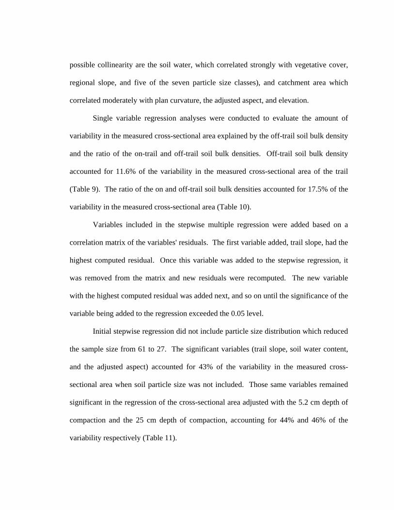
possible collinearity are the soil water, which correlated strongly with vegetative cover,
regional slope, and five of the seven particle size classes), and catchment area which
correlated moderately with plan curvature, the adjusted aspect, and elevation.
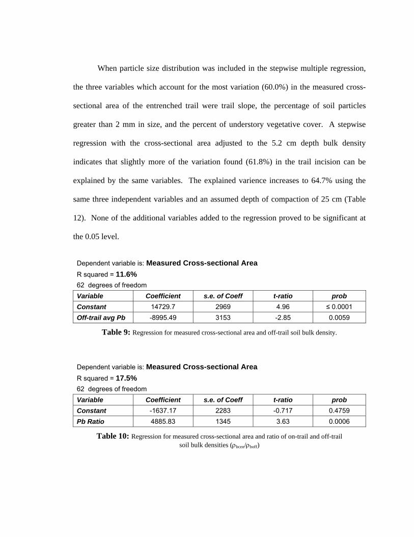
Single variable regression analyses were conducted to evaluate the amount of
variability in the measured cross-sectional area explained by the off-trail soil bulk density
and the ratio of the on-trail and off-trail soil bulk densities. Off-trail soil bulk density
accounted for 11.6% of the variability in the measured cross-sectional area of the trail
(Table 9). The ratio of the on and off-trail soil bulk densities accounted for 17.5% of the
variability in the measured cross-sectional area (Table 10).
Variables included in the stepwise multiple regression were added based on a
correlation matrix of the variables' residuals. The first variable added, trail slope, had the
highest computed residual. Once this variable was added to the stepwise regression, it
was removed from the matrix and new residuals were recomputed. The new variable
with the highest computed residual was added next, and so on until the significance of the
variable being added to the regression exceeded the 0.05 level.
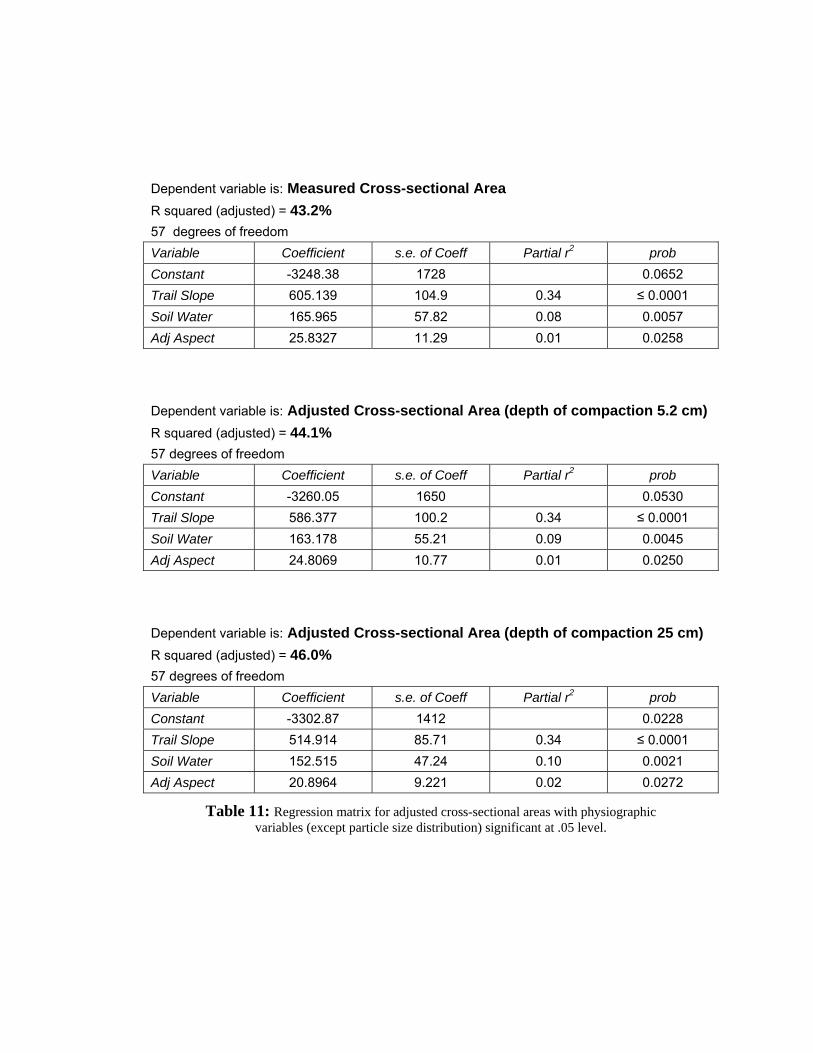
Initial stepwise regression did not include particle size distribution which reduced
the sample size from 61 to 27. The significant variables (trail slope, soil water content,
and the adjusted aspect) accounted for 43% of the variability in the measured cross-
sectional area when soil particle size was not included. Those same variables remained
significant in the regression of the cross-sectional area adjusted with the 5.2 cm depth of
compaction and the 25 cm depth of compaction, accounting for 44% and 46% of the
variability respectively (Table 11).
When particle size distribution was included in the stepwise multiple regression,
the three variables which account for the most variation (60.0%) in the measured cross-
sectional area of the entrenched trail were trail slope, the percentage of soil particles
greater than 2 mm in size, and the percent of understory vegetative cover. A stepwise
regression with the cross-sectional area adjusted to the 5.2 cm depth bulk density
indicates that slightly more of the variation found (61.8%) in the trail incision can be
explained by the same variables. The explained varience increases to 64.7% using the
same three independent variables and an assumed depth of compaction of 25 cm (Table
12). None of the additional variables added to the regression proved to be significant at
the 0.05 level.
Dependent variable is: Measured Cross-sectional Area R squared = 11.6% 62 degrees of freedom Variable Coefficient s.e. of Coeff t-ratio prob Constant 14729.7 2969 4.96 ≤ 0.0001 Off-trail avg Pb -8995.49 3153 -2.85 0.0059
Table 9: Regression for measured cross-sectional area and off-trail soil bulk density.
Dependent variable is: Measured Cross-sectional Area
R squared = 17.5% 62 degrees of freedom Variable Coefficient s.e. of Coeff t-ratio prob Constant -1637.17 2283 -0.717 0.4759 Pb Ratio 4885.83 1345 3.63 0.0006
Table 10: Regression for measured cross-sectional area and ratio of on-trail and off-trail soil bulk densities (ρbcen/ρboff)
Dependent variable is: Measured Cross-sectional Area R squared (adjusted) = 43.2% 57 degrees of freedom Variable Coefficient s.e. of Coeff Partial r2 prob Constant -3248.38 1728 0.0652 Trail Slope 605.139 104.9 0.34 ≤ 0.0001 Soil Water 165.965 57.82 0.08 0.0057 Adj Aspect 25.8327 11.29 0.01 0.0258
Dependent variable is: Adjusted Cross-sectional Area (depth of compaction 5.2 cm) R squared (adjusted) = 44.1% 57 degrees of freedom Variable Coefficient s.e. of Coeff Partial r2 prob Constant -3260.05 1650 0.0530 Trail Slope 586.377 100.2 0.34 ≤ 0.0001 Soil Water 163.178 55.21 0.09 0.0045 Adj Aspect 24.8069 10.77 0.01 0.0250
Dependent variable is: Adjusted Cross-sectional Area (depth of compaction 25 cm) R squared (adjusted) = 46.0% 57 degrees of freedom Variable Coefficient s.e. of Coeff Partial r2 prob Constant -3302.87 1412 0.0228 Trail Slope 514.914 85.71 0.34 ≤ 0.0001 Soil Water 152.515 47.24 0.10 0.0021 Adj Aspect 20.8964 9.221 0.02 0.0272
Table 11: Regression matrix for adjusted cross-sectional areas with physiographic variables (except particle size distribution) significant at .05 level.
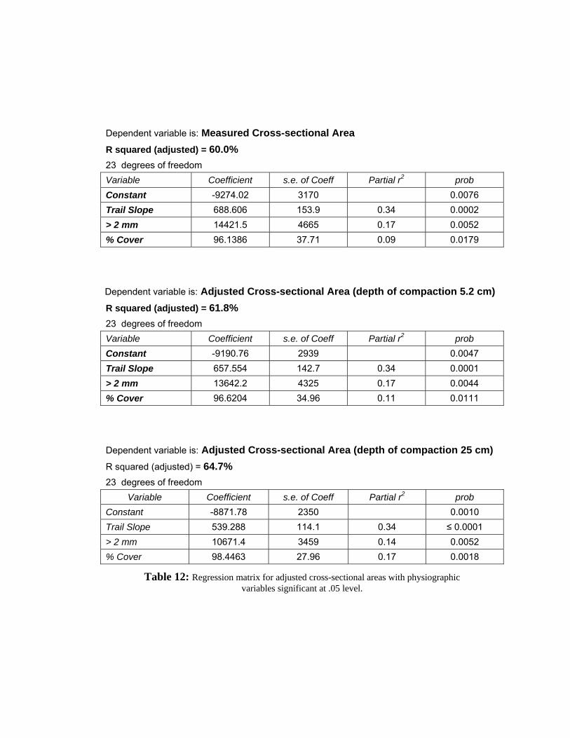
Dependent variable is: Measured Cross-sectional Area R squared (adjusted) = 60.0% 23 degrees of freedom Variable Coefficient s.e. of Coeff Partial r2 prob Constant -9274.02 3170 0.0076 Trail Slope 688.606 153.9 0.34 0.0002 > 2 mm 14421.5 4665 0.17 0.0052 % Cover 96.1386 37.71 0.09 0.0179
Dependent variable is: Adjusted Cross-sectional Area (depth of compaction 5.2 cm) R squared (adjusted) = 61.8% 23 degrees of freedom Variable Coefficient s.e. of Coeff Partial r2 prob Constant -9190.76 2939 0.0047 Trail Slope 657.554 142.7 0.34 0.0001 > 2 mm 13642.2 4325 0.17 0.0044 % Cover 96.6204 34.96 0.11 0.0111
Dependent variable is: Adjusted Cross-sectional Area (depth of compaction 25 cm) R squared (adjusted) = 64.7%
23 degrees of freedom Variable Coefficient s.e. of Coeff Partial r2 prob
Constant -8871.78 2350 0.0010 Trail Slope 539.288 114.1 0.34 ≤ 0.0001 > 2 mm 10671.4 3459 0.14 0.0052 % Cover 98.4463 27.96 0.17 0.0018
Table 12: Regression matrix for adjusted cross-sectional areas with physiographic variables significant at .05 level.
51
CHAPTER FIVE
DISCUSSION
Urie (1994) stated that the significant variables associated with trail cross-
sectional area along the New World Gulch and Bozeman Creek trails were trail slope,
soil water content, and regional slope. Those variables accounted for 50% of the
variability in trail cross-sectional area. Urie proposed that additional variables not
measured in her study, in particular the failure to account for the contribution of soil
compaction to the system, may have accounted for portions of the unexplained variance.
The following sections evaluate the role of these additional variables proposed by Urie,
discusses general controls on trail incision and the utility of including compaction,
presents management implications of these findings, and outlines some potential avenues
for future research.
Variables Controlling Trail Incision
The role of trail slope as one of the primary physiographic determinant of trail
incision (Tables 11 and 12) is consistent with previous studies (Bratton et al., 1979; Urie,
1994; Leung and Marion, 1996). As local trail slope increases, downslope gravitational
forces increase the likelihood of overland flow of water deposited by precipitation events,
and the dislocation and transport of sediment by water or user disturbance. Sediment
transported from inclines will lead to trail incision at that site, and deposition elsewhere.
The soil particle size class distributions as reported in the results (Table 5) are
biased because a significant portion of those particles reported as greater than 2 mm are
52
aggregates of smaller particles. Including the weight of the aggregated particles with the
finer particle size classes may suggest an explanation for the role of soil particle size that
is more consistent with previous studies. The correlation matrices indicate that fine
particles of <1 mm are inversely related to the measured or adjusted cross-sectional areas
(without the inclusion of the aggregated particles). This indicates that increases in the
percentage of < 1 mm soil classes are associated with decreases in the amount of trail
incision. This is inconsistent with the other findings of this work (Figure 11) showing
that increases in soil bulk density, associated with greater percentages of larger particle
size classes, are associated with decreases in trail incision. However, increasing the
percentage of fine soil particles (by breaking up the aggregated material) and the
associated increase in total pore space, which decreases the soil bulk density, might
reverse the inverse relationships displayed in Figures 15-21. The general decreases in the
correlation values of the fine particle size classes from the measured to the adjusted
cross-sectional areas (Tables 6, 7, and 8) also suggest that soils with more fines are more
sensitive to compaction than they are to erosion.
Soil water content is the second most significant independent variable when the
percentage of particle sizes are not considered in the regression equation (Table 11). This
is consistent with the significant correlation between soil water content and the particle
size classes. Soil water holding capacity is partially a function of particle size
distribution, so when particle size distribution is absent from the equation, soil water
content, dependant as it is on the size and availability of pore spaces, replaces it as a
significant variable in the regression.
53
Percent vegetative cover is significant in the stepwise regression (Table 12),
although it is not significantly correlated to cross-sectional area (Tables 6, 7, and 8).
However, the percent of vegetative cover is significantly correlated with soil water and
the adjusted aspect. When included in the regression with the particle size distribution
data, it is conceivable that the vegetation data, which is related to both soil moisture and
aspect, acts to represent both of those variables in the regression.
One goal of this study was to include additional physiographic variables not
considered in Urie's (1994) study to explain a greater amount of the variance in cross-
sectional areas along the trail. The most significant variable added to those already
studied was soil bulk density. Users are frequently advised to hike and camp on durable
or resistant surfaces to minimize impact in less traveled and untrailed areas (LNT, 2000),
the belief being that soils with greater bulk density are more resistant to mechanical stress
and should therefore be more resistant to disturbance, erosion and incision.
When individual variables were regressed against the measured cross-sectional
area, off-trail soil bulk density accounted for the second greatest amount of variance (r2 =
0.12) (Table 9) after trail slope (r2 = 0.35). The ratio of on-trail soil bulk density to off-
trail soil bulk density (ρbcen/ρboff), which could be considered a measure of compaction,
accounted for even more variance (r2 = 0.18) than soil bulk density. This would indicate
that compaction, or the difference between the on-trail and off-trail soil bulk densities at a
given site, explains a significant portion of the variability in trail incision. Unfortunately,
it was inappropriate to use soil bulk density and the ratio of soil bulk densities in a
regression model with the adjusted cross section, because the method for defining the
54
adjustment was based on the same bulk density variables, automatically producing high r2
values.
Urie speculated that a second variable untested by her, the orientation of the trail
relative to the regional slope orientation, could improve the explanation of the regression
model. Bratton et al. (1979) determined that the slope alignment angle was significant in
intercepting or channeling water and sediment and influenced user-related trail widening.
The negative correlation of slope alignment angle with cross-sectional area (Tables 6, 7,
8) does indicate that as the difference between the trail azimuth and regional slope
orientation increases, trail incision decreases. This variable had a r2 value of 0.08 when
regressed individually against both the measured and adjusted cross-sections, but it failed
to be a significant factor when entered in the stepwise regression model.
One other variable, soil type, was considered for inclusion in the evaluation of
physiographic factors influencing incision. The use of soil k values (or erosivity factor
used in the Universal Soil Loss Equation) might have offered a way to include soil type
as an indicator variable in the regression equation. However, just as Urie found that
inaccuracies in coregistering sample sites and geologic unit boundaries hindered the use
of geology as an indicator variable, inaccurate coregistration of sample sites with soil
map units also hindered the use of this variable in the multiple regression equation. The
use of different scales and soil map units by National Forest soil surveys and state soil
surveys also made the use of this variable problematic.

55
The Role of Soil Compaction
Identifying the effective depth of soil compacted along the trail should lead to a
more accurate understanding of the relationship between various physiographic variables
and erosion. Defining the effective depth of the soil compacted was problematic for two
reasons. First, it was necessary to assume that the difference between the soil bulk
densities was due to compaction, although this is probably a reasonable assumption.
Second, defining the depth to which soils in a natural system can be compacted seems to
have been a topic so far overlooked. Soil physicists have spent time looking at the effects
of soil compaction on crop growth, the depth to which stress can be transmitted through a
column of soil (Das, 1997; Horn and Baumgartl, 2000), and increases in soil bulk density
(Marshall et al., 1996; Larson et al., 1980), likewise geotechnical engineers have studied
structure settlement in soils (Maugeri et al., 1998) and the effects of compaction on soil
and fill strength. Little information is available, however, on the depth to which various
soil types are compacted due to walking in a natural system. Without knowing how deep
a given soil can be compacted and the variations in compaction through the soil column,
actual changes in depth due to compaction can not be accurately estimated. While it
might have been possible to define an estimate of the depth to which given soils have
been compacted based on existing soil bulk density versus compaction curves and
consideration of other variables influential in the soil compaction process, such efforts
were beyond the scope of this study.
The amount of estimated trail incision can vary significantly when the compacted
soil is "expanded" to provide more accurate estimates of erosion at each site. The depth

56
of the soil compaction determines how much resulting incision estimates will vary. As
the depth of the compacted soil increases, the relative amount of incision due to erosion
decreases. Removing the effects of compaction on trail incision increased the amount of
variance in cross-sectional area explained by the collected physiographic variables
(Tables 11 and 12) from 43.2% to 46% when particle size was not included, and from
60% to 64.7% when particle size data is included (Tables 11 and 12). Regardless of
whether or not particle size was included, increasing the estimated depth of the
compacted soil, did not change which controls were significantly related to trail incision.
Management Implications
Land managers at all levels find themselves in the quandary of being asked to do
more with ever diminishing resources. While the total amount of erosion from trails
could be considered negligible at lanscape scales, trail erosion and subsequent
sedimentation and degradation of those local habitats is a management problem.
Additionally, of increasing concern over the past two decades has been the perceptions of
the users of these managed parcels of land. Due to their need to maximize their
management options with minimum resources, it will be a great benefit to be able to
isolate the major contributing variables to trail erosion and incision. From there,
managers can determine how and where to focus control efforts.
This research suggests where managers can locate new trails or relocate existing
trails to minimize trail incision. Trail slope is the most critical physiographic variable to
control in any trail construction or restoration project. Minimizing trail slope should be
the clear priority for managers trying to mitigate trail erosion and disturbance. In areas of

57
comperable slope, soil bulk densityis an important secondary control. Soils with the
highest bulk densities will tend to erode less readily. Finally, locating trails in areas with
vigorous and resilient vegetation, where soil structures tend to be more consolidated with
better infiltration and less direct exposure to rainfall, seems to be the third most
significant variable to consider. None of these variables, however, exhibit clear
thresholds that need to be considered when evaluating potential trail locations.
DEM, soil and vegetation coverages coupled with a GIS might minimize the
effort and error involved in siting trails, but these tools can be expensive and the data
hard to locate or expensive to develop. Ferguson (1998) also found that GIS user-
assisted trail design methods were both less effective in minimizing potential
disturbances and more costly than more traditional "office oriented" trail design
techniques. Similar results could be realized with a topographic map to initially site trail
options, followed by bulk density and particle size disribution sampling to help define the
options with the least impact.
It is possible that a weighted average rating system could be developed using the
significant controls on trail erosion: trail slope, soil bulk density, particle size distribution
and percent vegetative cover. Using those controls in proportion to the amount of
variability in erosion that they account for (Tables 9 and 12) could provide a general
erosion potential index. Before such a system was universally applied, duplicate studies
in other climates and regions should be conducted to see if the controls and/or ratios of
the controls need to adjusted for localities in a manner similar to the adjustment of
constants in the USLE.
58
Trails are generally designed to get users from one location to other locations
where a resource or attraction exists. Given that the locations of one or more of these
points are fixed, the possibilities for minimizing the impact of any trail due to its design
are not unlimited. Land managers, who presumably have made the decision to make a
location more accessible through construction or relocation of a trail, are inevitably
constrained by the landscape on which the trail will be placed. Keeping in mind that the
actions of land managers are also usually constrained by the availability of time and
resources (both human and equipment) the following course of action when siting trails
to minimize compaction and erosion is proposed.
The process should start by identifying the realistic corridors where a trail could
be located, or relocated, to achieve the objective of providing access to the specific
feature or point(s) of interest. Areas where soil erosion and the resulting sedimentation
would be the most harmful, such as those immediately adjacent to streams and other
aquatic or sensitive habitats, should be eliminated. Areas along the proposed travel
corridor where the slope of the proposed trail can be minimized can be identified with a
topographic map. Using soil maps, the manager can next identify the soils along the low
slope corridors with the greatest resistance based on soil texture. The spatial resolution
of soil maps will probably be insufficient for identifying site specific soil properties,
particularly on or near soil map unit boundaries. The manager should therefor identify
those areas where the clear definition of soil properties along the predetermined corridors
may be questionable. Selective soil bulk density sampling in these areas, requiring
minimal time and effort, should then be used to isolate the site specific location of the
proposed trail.
59
Further Research
Up to 64.7 percent of the variability in trail erosion along the New World Gulch /
Bozeman Creek trail system can be ascribed to trail slope, soil bulk density, proportions
of fine soil particle sizes, and percent vegetative cover. It may be possible to increase the
explanation by incorporating user types and numbers, or by continuing to look at
additional physiographic and climatic variables.
To better quantify the role of soil compaction on the amount of incision along a
trail, further studies should be initiated to evaluate the rate and maximum depth of soil
compaction in a natural environment. To do this successfully would require paired soil
testing (compressed and control samples) on varied soil types.
Further exploration into the role of understory vegetative cover should be
conducted. While it proved to be a significant variable in the regression equations
including soil particle size classes, its exact role in the moderation of the trail incision
process is unclear. The possibility that percent vegetative cover is an indicator of
combinations of other variables (soil water content, slope aspect, organic content, etc.)
warrants study for definition.
The more obvious physiographic variables to look at would include soil type (k
factors, rock fragment content, texture) and geology. If this approach were to be pursued,
the optimum study site would need to have complete and consistent soil and geologic
surveys available at a resolution fine enough to differentiate categories along the length
of the trail. Additionally, one would need to consider how nominal soil or geologic
classes could be incorporated into multivariate statistical analysis.
60
In this study, some of the climate effects have been accounted for through
surrogate data such as soil wetness and percent vegetative cover. What has not been
adequately accounted for are the effects of snow deposition, accumulation and melt
patterns on trail erosion. Traditionally, snow has been considered insignificant as far as
erosion processes are concerned, primarily because snow melt regimes rarely exceed
infiltration rates in undisturbed forest soils (Hart and Loomis, 1982). Multi-use, multi-
season trails, however, may have defined circumstances that make snowmelt one of the
more significant variables involved in the trail erosion process.
Specifically, it has been shown that winter use trails may have up to 1.3 to 2.3
times the snow water equivalent of the adjacent snow covered terrain (Hogan, 1972;
Kattelmann, 1985). This is due to compaction of snow along the trail, which creates
surface variations leading to wind eddy deposition of more snow along the trail, followed
by more compaction of the snow along the trail. It has further been demonstrated that
compacted snow has a different melt regime than undisturbed snow, so that it tends to
melt later but more quickly (Grady, 1982; Kattelmann, 1986). The result is that there is
more snow water equivalent being released over a shorter amount of time in a confined
trail which has significantly lower infiltration rates. This may likely increase the amount
of overland flow within the trail, which increases the erosion potential. With this in
mind, another possible area of research into the factors influencing trail erosion might
involve the collection of snow water equivalent measurements, snowmelt, and infiltration
rates for insertion into the regression analysis.
61
REFERENCES CITED
Bayfield, N.G. 1985. The effects of extended use on mountain footpaths in Britian. In: The ecological impacts of outdoor recreation on mountain areas in Europe and North America. Recreational Ecologic Resource Group Report No. 9. Wye, UK: Wye College, Department of Horticulture, Recreation Ecology Research Group: 100-111.
Bayfield, N.G. 1986. Penetration of the Cairngorm Mountains, Scotland, by vehicle tracks and footpaths: impacts and recovery. In: Lucas, R.C. Proceedings – national wilderness research conference: current research; 1985 July 23-26; Fort Collins, CO. Ogden, UT: U.S. Department of Agriculture, Forest Service, General Technical Report INT-212.
Bratton, S.P., Hickler, M.G., and Graves, J.H. 1979. Trail erosion patterns in Great Smokey Mountains National Park. Environmental Management. 3: 431-445.
Brooks, K.N., P.F. Ffolliott, H.M. Gregersen, and J.L. Thames. 1991. Hydrology and the Management of Watersheds. Ames, IA: Iowa State University Press.
Cole, D.N. 1983. Assessing and monitoring backcountry trail conditions. Ogden, UT: U.S. Department of Agriculture, Forest Service, Research Paper INT-303.
Cole, D.N. 1986. Resource Impacts Caused by Recreation: A Literature Review. The Presidents Commission on American Outdoors. U.S. Department of Agriculture, Forest Service, Research Paper INT-4901.
Cole, D.N. 1989. Recreation Ecology: What we know, what geographers can contribute. The Professional Geographer, 41 (2): 143-148.
Cole, D.N. 1991. Changes on Trails in the Selway-Bitterroot Wilderness, Montana, 1978-1989. Ogden, UT: U.S. Department of Agriculture, Forest Service, Research Paper INT-450.
Cole, D.N. 1992. Modeling Wilderness Campsites: Factors that Influence Amount of Impact. Environmental Management, 16 (2): 255-264.
Coleman, R. 1981. Footpath Erosion in the Lake District. Applied Geography, 1: 121-131.
Cordell, K.H., J.C. Bergstrom, L.A. Hartman, and D.B.K. English. 1990. An Analysis of the Outdoor Recreation and Wilderness Situation in the United States: 1989-2040. Fort Collins, CO: U.S. Department of Agriculture, Forest Service, General Technical Report RM-189.
62
Daigle, J.J., A.E. Watson, and G.E Haas, 1994. National Forest Trail Users: Planning for Recreational Opportunities. U.S. Department of Agriculture, Forest Service, Northeastern Forest Experiment Station. Research Paper NE-665.
Das, B.M. 1997. Advanced Soil Mechanics. London: Taylor and Francis Publishers.
Davis, C.E., and H.F. Shovic. 1996. Soil survey of Gallatin National Forest, Montana. U.S. Department of Agriculture, Forest Service and Natural Resources Conservation Service in cooperation with the Montana Agricultural Experiment Station.
Dutch, S.I., J.S. Monroe, and J.M. Moran. 1998. Earth Science. Belmont,CA: Wadsworth Publishing Company.
Ferguson, J.Y. 1998. Location and Design of Recreational Trails: Application of GIS Technology. M.S. Thesis. Virginia State University. Blacksburg, VA.
Ferris, T.M.C., Lowther, K.A., and Smith, B.J. 1993. Changes in footpath degredation 1983-1992: A study of the Brandy Pad, Mourne Mountains. Irish Geography. 26: 131-140.
Fish, E.B., G.L. Brothers, and R.B. Lewis. 1981. Erosional Impacts of trails in Guadalupe Mountains National Park, Texas. Landscape Planning. 8: 387-398.
Garland, G.G. 1990. Technique for assessing erosion risk from mountain footpaths. Environmental Management. 14: 793-798.
Godin, V.B. and R.E. Leonard. 1979. Management Problems in designated Wilderness Areas. Journal of Soil and Water Conservation, 34 (3): 141-143.
Grady, T.R. 1982. The Effects of Snow Compaction on Water Release and Sediment Yield. M.S. Thesis. Montana State University. Bozeman, MT.
Harden, C.P. 1992. Incorporating roads and footpaths in watershed-scale hydrologic and soil erosion models. Physical Geography. 13 (4): 368-385.
Hart, G.E. and S.A. Loomis. 1982. Erosion from Mountain Snowpack Melt. Journal of Soil and Water Conservation. Jan-Feb: 55-57.
Hogan, A.W. 1972. Snowmelt Delay by Oversnow Travel. Water Resources Research. 8(1): 174-175.
Horn, R. and T. Baumgartl. 2000. Dynamic Properties of Soil. In Handbook of Soil Science. Sumner, M.E., ed., Boca Raton, FL: CRC Press.
63
Kattlemann, R. 1985. Snow Management at Ski Areas: Hydrologic Effects. In Watershed Management in the Eighties. Jones, E.B., and T.J. Ward, eds., American Society of Civil Engineers. New York.
Kattlemann, R. 1986. Snow Compaction Effects on Nighttime Freezing. Proceedings of the Western Snow Conference. Fort Collins, CO: Colorado State University. 168-171.
Kay, B.D. and D.A. Angers. 2000. Soil Structure. In Handbook of Soil Science. Sumner, M.E., ed., New York: CRC Press.
Krumpe, E.E. and R.C. Lucas. Research on Recreation Trails and Trail Users. A Literature Review: The President's Commission on Americans Outdoors. INT 4901, Publication #168.
Lance, A.N., I.D. Baugh, and J.A. Love. 1989. Continued footpath widening in the Cairngorm Mountains, Scotland. Biological Conservation. 49: 201-214.
Larson, W.E., S.C. Gupta, and R.A. Useche. 1980. Compression of Agricultural Soils from Eight Soil Orders. Soil Science Society of America Journal. 44: 450-457.
Leave No Trace, Inc. Principles of Leave No Trace. 22 August 2000. <http//www.lnt.org/TeachingLNT/LNTEnglish.html>
Leung, Y. and J.L. Marion. 1996. Trail degradation as influenced by environmental factors. Journal of Soil and Water Conservation. 51 (2): 130-136.
Liddle, M.J. 1975. A selective review of the ecological effects of human trampling on natural ecosystems. Biological Conservation. 7: 17-36.
Lucas, R.C. 1983. The Role of Regulations in Recreation Management. Western Wildlands, 9 (2): 6-10.
Lucas, R.C. 1987. Perspectives on the History of Wilderness Research. In: Proceedings – National Wilderness Research Conference: Issues, State-of-knowledge, Future Directions. Ogden, UT: U.S. Department of Agriculture, Forest Service, General Technical Report INT-220.
Lucas, R.C. and G.H. Stankey. 1989. Shifting Trends in Wilderness Recreation Use. In Alan E. Watson, comp. Outdoor recreation benchmark 1988: proceedings of the national outdoor recreation forum; 1988 January 13-14; Tampa, FL. Gen. Tech. Rep. SE-52, Asheville, NC: US Department of Agriculture, Forest Service, Southeastern Experiment Station. 357-367
Marshall, T.J., J.W. Holmes, and C.W. Rose. 1996. Soil Physics. Cambridge, U.K.: Cambridge University Press.
64
Martz, L.W. 1992. The variation of soil erodibility with slope position in a cultivated Canadian prairie landscape. Earth Surface Processes and Landforms. 17: 543-556.
Maugeri, M., F. Castelli, M.R. Massimino, and G. Verona. 1998. Observed and Computed Settlements of Two Shallow Foundations on Sand. Journal of Geotechnical and Geoenvironmental Engineering. 124 (7): 595-605.
McQuaid-Cook, J. 1978. Effects of hikers and horses on mountain trails. Journal of Environmental Management, 6: 209-212.
Morgan, J.M. and Kuss, F.R. 1986. Soil loss as a measure of carrying capacity in recreational environments. Environmental Management. 10(2): 263-270.
National Oceanic and Atmospheric Administration. 1993. Climatological Data: Montana. National Oceanic and Atmospheric Administration, Ashville, North Carolina. 96 (5-9).
Oyarzun, C.E. 1995. Land use, hydrological properties, and soil erodibilities in the Bio-Bio River Basin, Central Chile. Mountain Research and Development. 15 (4): 331-338.
Page-Dumroese, D.S., M.F. Jurgensen, R.E. Brown, and G.D. Mroz. 1999. Comparison of Methods for Determining Bulk Densities of Rocky Forest Soils. Soil Science Society of America Journal. 63 (2): 379-383.
Patric, J.H. 1976. Soil erosion in the eastern forest. Journal of Forestry. 74: 671-676.
Price, M.F. 1985. Impacts of Recreational Activities on Alpine Vegetation in Western North America. Mountain Research and Development. 5 (3): 263-77.
Quinn, N.W., R.P.C. Morgan, and A.J. Smith. 1980. Simulation of Soil Erosion Induced by Human Trampling. Journal of Environmental Management. 10: 155-165.
Roberts, A.E. 1964. Geologic Map of the Mystic Lake Quadrangle, Montana. Washington, D.C.: U.S. Geological Survey, Miscellaneous Geological Investigations, Map I-398.
Seney, J.P. 1991. Erosional impact of hikers, horses, off-road bicycles, and motorcycles on mountain trails. M.S. Thesis. Montana State University. Bozeman, MT
Steele, V.G. 1998. Assessment of Resource Changes in Backcountry Campsites from 1989-1996 in Rocky Mountain National Park, Colorado. M.S. Thesis. Montana State University. Bozeman, MT
Summer, R.M. 1980. Impact of horse traffic on trails in Rocky Mountain National Park. Journal of Soil and Water Conservation. 35: 85-87.
65
Summer, R.M. 1986. Geomorphic impacts of horse traffic on montane landforms. Journal of Soil and Water Conservation. 41: 126-128.
Tinsley, B.E., E.B. Fish. 1985. Evaluation of trail erosion in Guadalupe Mountains National Park, Texas. Lanscape Planning. 12: 29-47.
Urie, W.A. 1994. Environmental Factors Influencing Recreational Trail Condition. M.S. Thesis. Montana State University. Bozeman, MT
U.S. Department of Agriculture, Forest Service. 1981. The Northern Region Plan. Missoula, MT: U.S. Department of Agriculture, Forest Service, Northern Region.
Vogler, J.B., and D.R. Butler. 1996. Pedestrian and bicycle induced path erosion on a university campus. Physical Geography. 17 (5): 485-494.
Wilson, J.P. and Seney, J.P. 1994. Erosional Impact of Hikers, Horses, Motorcycles and Off-Road Bicycles on Mountain Trails in Montana. Mountain Research and Development. 14: 77-88.
Wischmeier, W.H. 1970. Relation of soil erosion to crop and soil management. Proceedings for the International Water Erosion Symposium, International Committee for Irrigation Drainage. 2: 201-220.
Wischmeier, W.H., and D.D. Smith. 1978. Predicting rainfall erosion losses: A guide to conservation planning. Washington, D.C.: U.S. Department of Agriculture, Agricultural Handbook No. 537.