Embed Size (px)
Citation preview

mar
y ca
rrol
l pa
rk -
vis
ion
plan
15
Placemaking
Dry Wetland Pattern Seasonal Changes Natural Form Existing Infrastructure Education
Placemaking is the process of creating diverse and resilient local places which are connected to the larger system. It involves a multidisciplinary approach to the development and revitalisation of communities and the public realm. A placemaking approach considers the impacts of global trends, but reinforces and utilises the local assets of a place, refl ecting the needs and aspirations of the local community. The ultimate result of a placemaking approach is the portrayal of the unique story inherent to a particular location or its ‘genius loci’.
The standard approach to placemaking for most planning projects is traditionally a “top-down” implemented urban design – characterised by a master plan and the user groups are consulted at the end of the process. In contrast to this, the Mary Carroll Park Vision Plan process is characterised by a local community driven “bottom-up” approach, which seeks to enhance the existing social glue within the Gosnells community – encouraging them to come together towards a common vision of a resilient and diverse recreational and environmental place.
Design Strategies People Involve the community in the decision making and managment of a place. This is not about ticking the community consultation box, but is an authentic and transparent relationship with all stakeholders.
Place Utilise the existing physical amenities and emphasize the biophysical characteristics that make this site unique.
The design collaborative highlighted fi ve key design generators and two site-inspired colour palettes to drive the physical manifestation of the Vision Plan as well as the experiential elements including natural processes.

Site Inspired Colour PaletteMain Colour Palette
mar
y ca
rrol
l pa
rk -
vis
ion
plan
16

mar
y ca
rrol
l pa
rk -
vis
ion
plan
17
Extended Colour Palette

Wayfi nding Strategy Network and Legibility In order to ensure a resilient and linked design outcome for Mary Carroll Park it is essential the wetland precinct be connected to the Gosnells Town Centre and public transport network. The Vision Plan aims to strengthen this connection through the reinforcement of the existing streetscape environment through practical and innovative urban design solutions.
Establishing these connections will capitalise on the local landscape character, recreational assets and provide physical and visual references for the local community and visitors to the area. Ultimately this Wayfi nding Strategy will utilise existing public meeting spaces and highlight the amazing destinations within walking distance, thus promoting a healthy and vibrant community environment.
mar
y ca
rrol
l pa
rk -
vis
ion
plan
18

mar
y ca
rrol
l pa
rk -
vis
ion
plan
19
N
T
0 .5 KM
1 KM
1 .5KM
GOSNELLSTOWN CENTRE
GOSNELLSTRAIN STATION
TO PERTH
TO ARMADALE
GOSNELLSOVAL
EUDORIA STREET
BARCOMBE WAY
BARCOMBE WAY
JAMES STREET
ALBANY HIGHWAY
VERNA STREET
PAPERCAP ST
SHIPTON STREET
MAY STREET
CLARA STREET
MURIEL STREET
DOROTHY STREET
STALKER R
OADGOODALL S
TREET
HICKS STREET
PERCY STREET
1KM TOSEAFORTHPRIMARY SCHOOL
7KM TOTHORNLIEHIGH SCHOOL
GOSNELLSPRIMARYSCHOOL
LUMENCHRISTI
COLLEGE
CANNINGRIVER
BUS STOP
BUS STOP
BUS STOP
LEGEND
S T R E E T S C A P E T R E A T M E N T T Y P E A
S T R E E T S C A P E T R E A T M E N T T Y P E B
S T R E E T S C A P E T R E A T M E N T T Y P E C
S T R E E T S C A P E T R E A T M E N T T Y P E D
P R I M A R Y P E D E S T R I A N / C Y C L E P A T H
S E C O N D A R Y P E D E S T R I A N / C Y C L E P A T H
M A J O R W A Y F I N D I N G S I G N A G E( D I R E C T I O N A L A N D L O C A T I O N P L A N )
M I N O R W A Y F I N D I N G S I G N A G E( D I R E C T I O N A L A N D S E A T I N G N O D E )
T E M P O R A R Y / S E A S O N A L I N T E R P R E T A T I O N( R O A D T R E A T M E N T S / S C H O O L A R T P R O J E C T S )
I N T E R P R E T I V E S E A T I N G N O D E( S E A T I N G W I T H I N T E G R A T E D I N T E R P R E T A T I O N )
N E W R O U N D - A B O U T

Major Directional Signage
mar
y ca
rrol
l pa
rk -
vis
ion
plan
20

mar
y ca
rrol
l pa
rk -
vis
ion
plan
21
Minor Directional Signage

Gosnells Primary School Bus Stop, Hicks Street.
Gosnells Primary School, May Street.
Gosnells Primary School, Clara Street.
Verna Street.
Gosnells Train Station, Main Street.
Gosnells Oval, Stalker Road.
James Street.
Eudoria Street.
mar
y ca
rrol
l pa
rk -
vis
ion
plan
22
mar
y ca
rrol
l pa
rk -
vis
ion
plan
23
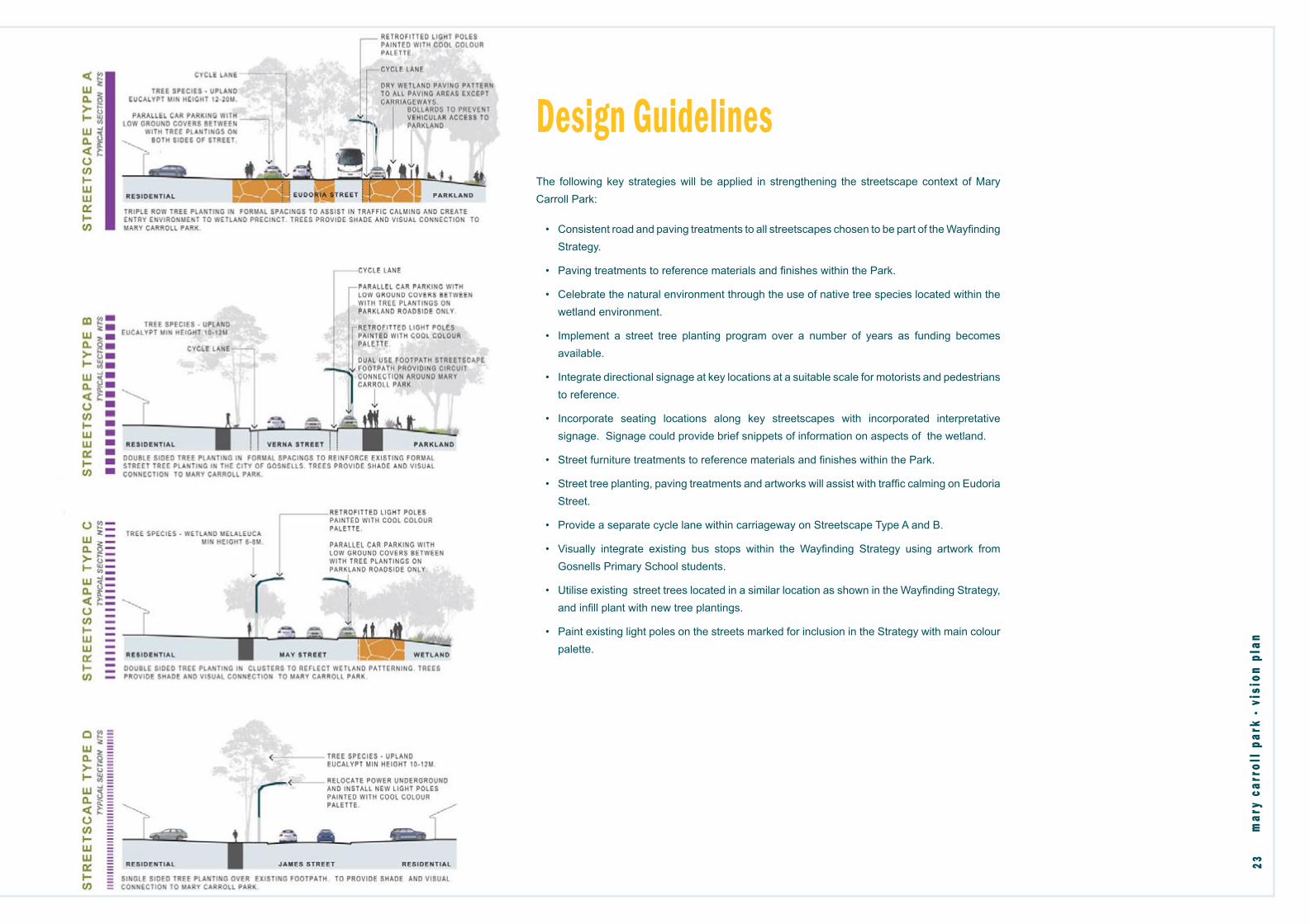
Design Guidelines The following key strategies will be applied in strengthening the streetscape context of Mary Carroll Park:
• Consistent road and paving treatments to all streetscapes chosen to be part of the Wayfi nding Strategy.
• Paving treatments to reference materials and fi nishes within the Park.
• Celebrate the natural environment through the use of native tree species located within the wetland environment.
• Implement a street tree planting program over a number of years as funding becomes available.
• Integrate directional signage at key locations at a suitable scale for motorists and pedestrians to reference.
• Incorporate seating locations along key streetscapes with incorporated interpretative signage. Signage could provide brief snippets of information on aspects of the wetland.
• Street furniture treatments to reference materials and fi nishes within the Park.
• Street tree planting, paving treatments and artworks will assist with traffi c calming on Eudoria Street.
• Provide a separate cycle lane within carriageway on Streetscape Type A and B.
• Visually integrate existing bus stops within the Wayfi nding Strategy using artwork from Gosnells Primary School students.
• Utilise existing street trees located in a similar location as shown in the Wayfi nding Strategy, and infi ll plant with new tree plantings.
• Paint existing light poles on the streets marked for inclusion in the Strategy with main colour palette.

Interpretation StrategyI n t e r p r e t a t i o n i n v o l v e s t r a n s l a t i n g s t o r i e s o f p l a c e s ,
t h e b i o t a a n d p e o p l e i n t e r m s t h a t m o t i v a t e a n d i n s p i r e
v i s i t o r s t o g r e a t e r u n d e r s t a n d i n g a n d c a r e .
Establishing a successful interpretation solution that is engaging, innovative and dynamic over time will provide visitors to MCP with a unique experience. MCP has a rich and diverse biophysical and sociocultural past and future. The following issues were considered in developing the Strategy:
• Determining how to layer the various types of interpretation and how to appeal to all different learning styles including auditory, visual and kinaesthetic.
• Ensuring that the links between education, environment and heritage are clear and consistent.
• Reference to the existing Signage Strategy Manual used at Ellis Brook Valley.
• Ensuring that the concepts are as vandal and fi re resistant as possible.
• Interpretation will take the form of various elements including footpaths, play equipment, furniture, built form as well as standalone signage and art forms.
mar
y ca
rrol
l pa
rk -
vis
ion
plan
24

mar
y ca
rrol
l pa
rk -
vis
ion
plan
25
Thematic Analysis of Mary Carroll Park
Mary Carroll Park is a living classroom which teaches us about its environmental importance, strong community connection, history of the Gosnells area and about ourselves.
The primary interpretative experience for MCP is based around the concept of ‘learning’ and education. MCP is presented to a visitor as a ‘living classroom’ in which the unique values and stories of the area are passed down, taught and learnt in an engaging, unique and meaningful way. The living classroom theme is solid whilst allowing for creativity and quirkiness in its design and execution and presents both the human and natural interaction and life of the area.
This concept has been inspired by the Park’s namesake, Mrs Mary Carroll, a teacher of some 33 years at the Gosnells Primary School who was well known for her passion for nature and the importance of caring for the environment. Mrs Mary Carroll is a key link between the wetland environment, community/visitor and the Primary School.
The interpretation design will bring to life the notion that the wetlands of MCP were once an important classroom ‘extension’ of the Gosnells Primary School and if you unravel its mysteries and clues, you will fi nd it still is.
Primary Themes The three primary themes provide a focus for all interpretive stories and experiences. These are based around the values a ‘visitor’ can learn and the discoveries they can make from MCP. The signifi cant connection the Gosnells Primary School has to the Park is evident and applied across all three theme areas.
Environmental Signifi cance and Value
The wetlands of MCP teach us why looking after our environment is important.
History and Context
MCP reveals our history, how our area developed and why our city is the way it is today.
Community and Connection
MCP instils in us the strong personal and community connection which many people have to the area.
Interpretation Guiding Principles1. Aboriginal interpretation should be
throughout the whole site and wherever possible the Aboriginal name/language used when referencing animals, plants, places and other features. Also make connections and comparisons with traditional Aboriginal management practice, history and lifestyle to form a balanced interpretive experience.
2. Look at the use of the narrow-form and dry wetland pattern as a linking element.
3. All education-related interpretation to be linked to the new Australian Curriculum where it is available.
4. Aim interpretation at a range of age levels and backgrounds.
5. Use a variety of interpretive methods and allow for technology to be incorporated where appropriate.
1907 Gosnells Primary School photo. (Courtesy of Gosnells Museum)
Mary Carroll (Courtesy of The West, 1971)

“Wild fowl” - is a common Aboriginal expression for a place of abundance.
mar
y ca
rrol
l pa
rk -
vis
ion
plan
26

mar
y ca
rrol
l pa
rk -
vis
ion
plan
27
Aboriginal Connections Whadjuk is the name of the Aboriginal dialectal group from the Perth area. Mary Carroll Park is located in Whadjuk Country which is situated south of Juat and north of the Pindjarup dialectal groups.
The major cities and towns within the Whadjuk region include Perth, Fremantle, Joondalup, Armadale, Toodyay, Wundowie, Bullsbrook and Chidlow. The approximate size of the Whadjuk region is 5,580 km. A key Noongar site is the Dyarlgarro Beeliar, commonly known as the Canning River.
Coastal dwelling Whadjuk have an oral tradition describing the separation of Rottnest Island from the mainland, which occurred between 10,000–6,000 BC, technically a post-glacial Flandrian transgression. Like other Noongar peoples, the Whadjuk historically moved inland in the wetter weather of winter, returning to the coast as interior seasonal lakes dried up. The Whadjuk, like many Noongar people, divided the year into six seasons.
These seasons are roughly divided (rather than by specifi c date) and Whadjuk took account of environmental signals in marking seasons such as the spring call of the Motorbike frog (Green Tree Frog), as the onset of Kambarang, or the fl owering of the Western Australian Christmas Tree showing the onset of Bunuru.
Birak (December to January)
This is the “fruiting” season, characterised by the onset of hot, easterly winds which blow during the day. Noongar people used to burn mosaic sections of scrubland through fi restick farming to force animals into the open to hunt,
Natural landscape patterns and materials.
and to open the canopy and allow the few November rains to increase germination of summer foodstuffs and marsupial grazing. This is the season of harvesting wattle seeds which were pounded into fl our and stored as damper.
Bunuru (February to March)
This season was the “hot-dry”, characterised by hot dry easterly conditions with an afternoon sea-breeze, known locally in Western Australia as the Fremantle doctor. To maximise the effects of the cooling breeze, the Noongars traditionally moved to coastal estuaries and reefs where fi sh and abalone constituted a large proportion of the seasonal diet. Mallee fowl eggs from tuart forests also formed a part of the diet.
Djeran (April to May)
This season is “fi rst rains-fi rst dew”, with the weather becoming cooler with winds from the south west. Historically fi shing continued (often caught in fi sh traps) and zamia palm (djiriji) nuts (buyu), bulbs (nardoo) and other seeds were collected for food. Zamia palm, which is naturally highly poisonous, was prepared in a fashion which removed its toxicity. Burrowing Frogs (kooyar) were caught in large numbers with the opening rains of winter.
Makuru (June to July)
Traditionally this season is “the wet”, and Noongars moved inland from the coast to the Darling Scarp to hunt grey kangaroo (yongka) and Tammar once rains had replenished inland water resources. This was the season of mid-latitude cold frontal rains. Noongar Gnow (mallee fowl) were also caught.
Djilba (August to September)
This season is “the cold-wet”, and historically saw Noongar groups moving to the drier soils of the Guildford and Canning-Kelmscott areas, where roots were collected and emus (Wej), ringtail possums (Goomal) and kangaroo were hunted.
Kambarang (October to November)
This season is “the fl owering” at the height of the wildfl ower season. This time sees rain decreasing. Noongar families moved in this season towards the coast where frogs, tortoises and freshwater crayfi sh or gilgies and blue marron (Marrin) were caught. Birds returning from their northern hemisphere migration also formed a part of their diet.
blackwood r.
whadjuk
gascoyne r.
moore r.
helena r.
canning r.
harvey r.murray r.
collie r.
preston r.
a.
b.c.
d.
f.g.
fremantle
mandurah
bunbury
a juatb whadjukc balardungd pindjarupe wilmunf kaneungg pibelmen
e.