Embed Size (px)
Citation preview

PORT MOODY ARM
PROPOSED CHANNEL DREDGE
PROJECT ENVIRONMENTAL REVIEW DOCUMENT
Proposed by:
Mr. Andre Olivier, P.Eng.
Manager, Engineering
Pacific Coast Terminals Ltd.
2300 Columbia Street
Port Moody, BC
V3H 5J9
Prepared by:
Andrew MacKay, M.E.S., EP (EMSLA)
Suite 206 - 267 Esplanade West
North Vancouver, BC
V7M 1A5
www.envirochem.com
Mark Adams, B.Sc., R.P.Biol
Envirowest Consultants Inc.
Suite 101 – 1515 Broadway Street
Port Coquitlam, BC V3C 6M2
Version Date: May 12, 2015

Port Moody Arm Channel Dredge Project Environmental Review Document Page ii
PCT Dredge Project Env Review Doc Sent May 12 2015.docx
TABLE OF CONTENTS
1.0 INTRODUCTION .......................................................................................................... 1
2.0 PROPOSED DREDGE WORKS ....................................................................................... 2
2.1 DREDGE LOCATION ................................................................................................................ 2
2.2 PROJECT REGULATORY FRAMEWORK ......................................................................................... 2
2.2.1 Environment Canada Requirements ...................................................................... 4
2.2.2 Department of Fisheries and Oceans Regulatory Requirements – Fisheries Act .. 5
2.3 EXISTING CONDITIONS ............................................................................................................ 6
2.3.1 Dredge Material Properties ................................................................................... 6
2.3.2 Biota .................................................................................................................... 10
2.3.3 Local Marine Conditions ...................................................................................... 14
2.4 ALTERNATIVE DREDGE AND DISPOSAL OPTIONS CONSIDERED ....................................................... 15
2.4.1 Alternative Disposal Options ............................................................................... 15
2.4.2 Dredging Equipment Considered ......................................................................... 17
2.4.3 Detailed Dredge Option Evaluation ..................................................................... 18
3.0 OPERATIONS PLAN, POTENTIAL ENVIRONMENTAL IMPACTS AND MITIGATION ......... 23
3.1 OPERATING PLAN ........................................................................................................... 23
3.1.1 Phase I: Containment Berm Construction ........................................................... 25
3.1.2 Phase II: Dredge and Placement ......................................................................... 29
3.2 OPERATING MITIGATION MEASURES ............................................................................. 31
3.3 POTENTIAL RESIDUAL PROJECT IMPACTS ....................................................................... 32
3.4 PROJECT MONITORING PLAN ......................................................................................... 33
3.4.1 Measured Parameters and Sampling Protocols .................................................. 33
3.4.2 Sample Locations ................................................................................................. 34
3.4.3 Sample Scheduling & Frequency ......................................................................... 35
3.4.4 Post Dredge Bathymetry ..................................................................................... 36
4.0 HABITAT RESTORATION ............................................................................................ 37
5.0 GEOTECHNICAL CONSIDERATIONS ............................................................................ 38
5.1 GENERAL CRITERIA .............................................................................................................. 38
5.2 CONCEPTUAL DESIGN OF CONTAINMENT AREA ......................................................................... 38
6.0 COMMUNITY AND FIRST NATIONS ............................................................................ 39
6.1 PRELIMINARY COMMUNICATION ACTIVITIES.............................................................................. 39
6.2 PLANNING ALIGNMENT ......................................................................................................... 40
7.0 CONCLUSION ............................................................................................................ 41
Port Moody Arm Channel Dredge Project Environmental Review Document Page iii
PCT Dredge Project Env Review Doc Sent May 12 2015.docx
LIST OF TABLES
Table 1: Sampling Summary ....................................................................................................... 6
Table 2: Comparative Cadmium Levels, At Depth and Surface.................................................. 9
Table 3: Summary of 2013 Sampling .......................................................................................... 9
Table 4: Individual Equipment for Disposal at Sea (Transit to Pt. Grey) .................................. 18
Table 5: Dredge Option Summary - Combined Equipment for Local Placement..................... 19
Table 6: Air Emission Summary ................................................................................................ 20
Table 7: Proposed Planning & Operations Schedule ................................................................ 23
Table 8: Proposed Sampling Frequency ................................................................................... 36
LIST OF FIGURES
Figure 1: Planned Dredge and Containment Berm Locations ..................................................... 3
Figure 2: Map Location of DAS Samples, Port Moody Arm ......................................................... 8
Figure 3: Map Location of Sediment Ponar Grab Samples, Port Moody Arm........................... 12
Figure 4: Map Location of Benthic Visual Survey Transects, Port Moody Arm ......................... 13
Figure 5: Dredge Equipment Operating Locations .................................................................... 16
Figure 6: Six Inch IOCO Pipeline Section* ................................................................................. 24
Figure 7: Twelve Inch Pipeline Cross Section ............................................................................ 24
Figure 8: Planned Placement Area Berm .................................................................................. 26
Figure 9: Planned Berm Construction Profile ........................................................................... 29
Figure 10: Proposed Shoreline Sample Locations ....................................................................... 34
LIST OF APPENDICES
Appendix I: 1995 Letter from EC to BERC
Appendix II: 2009 Sediment Sample Results
Appendix III: Professional Chemist Opinion on AVS-SEM
Appendix IV: 2012 Sediment Sample results (ponar grab)
Appendix V: 2012 Sediment Core Sample Results (3m core)
Appendix VI: Benthic Organism Summary Table
Appendix VII: 2012 Sediment Core Sample Logs
Appendix VIII: Columbia Noise Assessment – August 22, 2012

Port Moody Arm Channel Dredge Project Environmental Review Document Page iv
PCT Dredge Project Env Review Doc Sent May 12 2015.docx
Appendix IX: An Island Complex: concepts for Habitat Creation / Restoration
Appendix X: Test Dredge Notification
Appendix XI: Proposed Project Letter of Advice, Brian Naito, February 26, 2014

Port Moody Arm Channel Dredge Project Environmental Review Document
PCT Dredge Project Env Review Doc Sent May 12 2015.docx
Page 1
1.0 INTRODUCTION
The section of Port Moody Arm navigation channel in front of Reed Point Marina is a shipping
restriction for loaded vessels departing Pacific Coast Terminals (PCT). Vessels currently require
up to 4.0m of tidal assistance to navigate the channel posing a significant safety and economic
restriction for PCT and its shipping partners.
The proposed project involves capital dredging within the navigation channel to increase
channel depth from 10.5m to 13.5m. The added depth enable more ship schedule flexibility by
allowing loaded vessels to safely sail from PCT with less dependence on tides. The Port Moody
Arm was most recently dredged in 1995 with Vancouver Port Corporation as the proponent.
Including the approach channel and turning basin, approximately 280,000m3 was dredged and
placed behind a sub-tidal berm that was constructed adjacent to the turning basin as
e pe i e tal fish ha itat e ha e e t .
In 2009 at the request of PCT, Port Metro Vancouver (PMV) initiated planning and designs to
deepen the navigation channel by further dredging westward from PCT. In the interim, PMV
deemed PCT as the sole beneficiary of the dredge. Consequently, PCT is now the project
proponent.
The revised dredge plan is to operate variable hours (including 24 hours a day, 7 days a week
for the navigation channel dredge only) to efficiently relocate approximately 550,000m3 of
sediment within an expanded area including the existing and an additional containment
perimeter berm in Port Moody Arm. Dredging is planned to involve an effective combination of
three equipment types:
1) Trailing Suction Hopper Dredge, with modified piping, for the navigation channel;
2) Clamshell for precision in the immediate vicinity of the submerged Ioco pipeline (located
within the dredge cut) and dockface; and,
3) Cutter dredge, with floating pipeline, for the turning basin.
The berm construction and dredge works are proposed to last for approximately seven (7) and
10 weeks respectively.
The creative project plan achieves a balanced approach that supports Port Metro Vancouver
initiatives for a sustainable enterprise. Expected benefits include vital business process
efficiency at PCT through more timely and safer shipping; temporary and minimal to no residual
environmental impact; restored historical fish habitats; new seabed elevations that will provide
the potential for future compensation works (outside the scope of this project); a dredge plan
that makes good financial sense; and potential opportunities to partner with local First Nations.

Port Moody Arm Channel Dredge Project Environmental Review Document
PCT Dredge Project Env Review Doc Sent May 12 2015.docx
Page 2
2.0 PROPOSED DREDGE WORKS
Pacific Coast Terminals is planning a modified approach to the dredge that was conducted in
1995. After considerable research, PCT is proposing an innovative combination of hopper,
cutter suction and clamshell dredges with direct placement in an expanded version of the
containment basin established in 1995. Keeping the dredge spoils within Port Moody Arm will
achieve many advantages ranging from significantly reduced emissions and shorter work
duration to helping restore fish ha itat i p e iousl d edged a eas i a 96 ’s he the original site was developed). Provided below and in subsequent sections is the sustainable,
holistic decision-making framework used to achieve desired engineering objectives, optimize
cost effectiveness, minimize environmental impacts and restore historical fish habitats through
placement of dredged material.
The operations plan will involve sequential dredging from west to east at an average of
7,800 m3 / day using the three equipment types. The berm will be constructed of readily
available course granular fill and / or other material suitable for subsurface and subterranean
containment. Material to construct the berm will consist of a gula pit u o k sou ed f o nearby suppliers. Alternative sources including dredging within the harbour at first and / or
second narrows and clean concrete from demolition sites will also be considered if adequate
supplies can be secured on a timely basis. Free-draining imported material was selected instead
of using dredged sediment for berm construction to ensure stability of placement. The very
short interval between berm construction and sediment placement would not allow the
sediment berm enough time to consolidate. The excessive pore pressure during material
placement could therefore result in berm failure.
2.1 DREDGE LOCATION
The proposed dredge is located in Port Moody Arm from the west side of Reed Point Marina
progressing eastward to the PCT turning basin. The dredge channel is approximately 1000m
long by 150m wide before expanding into the semi-circular vessel turning basin at the east end
Port Moody Arm Channel Dredge Project Environmental Review Document
PCT Dredge Project Env Review Doc Sent May 12 2015.docx
Page 3
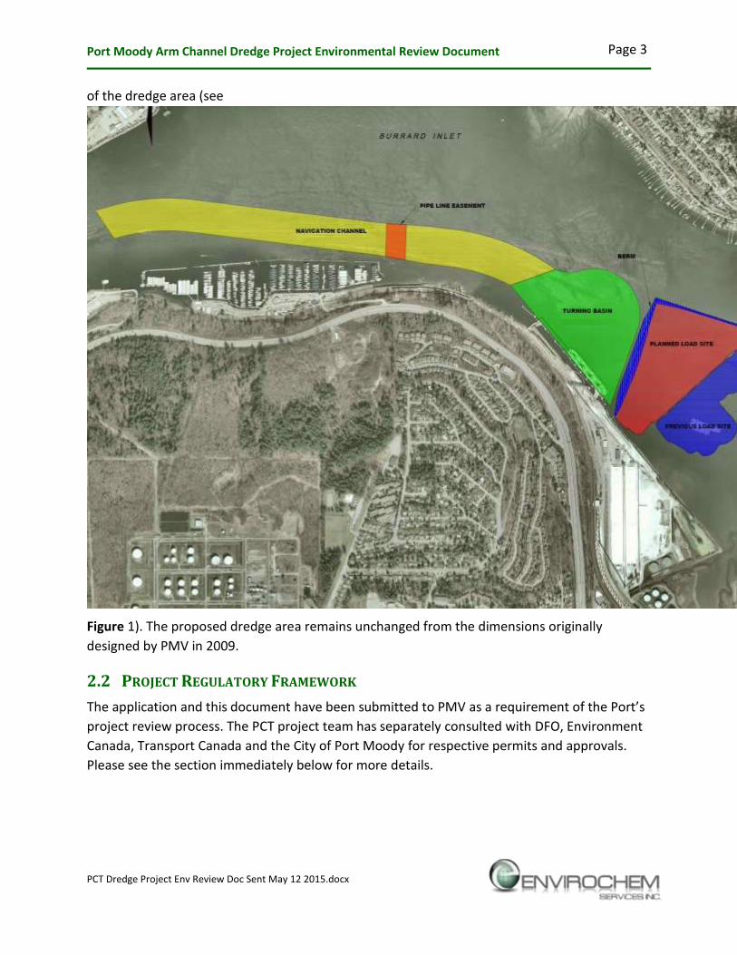
of the dredge area (see
Figure 1). The proposed dredge area remains unchanged from the dimensions originally
designed by PMV in 2009.
2.2 PROJECT REGULATORY FRAMEWORK
The application and this document have been submitted to PMV as a e ui e e t of the Po t’s project review process. The PCT project team has separately consulted with DFO, Environment
Canada, Transport Canada and the City of Port Moody for respective permits and approvals.
Please see the section immediately below for more details.

Port Moody Arm Channel Dredge Project Environmental Review Document
PCT Dredge Project Env Review Doc Sent May 12 2015.docx
Page 4
FIGURE 1: PLANNED DREDGE AND CONTAINMENT BERM LOCATIONS

Port Moody Arm Channel Dredge Project Environmental Review Document
PCT Dredge Project Env Review Doc Sent May 12 2015.docx
Page 5
2.2.1 Environment Canada Requirements
In a letter dated January 11, 1995 from Adrian Duncan of Environment Canada to Nancy Yates
of BIEAP, the dredge and placement project completed in 1995 was deemed not a disposal
project under Environment Canada but a construction project accepted by DFO as an
experimental fish habitat enhancement (see Appendix I for a copy of the letter). Due to
changes in the Fisheries Act, DFO would not render an opinion on proposed fish habitat
enhancement. As a result, the proposed project has proceeded through Environ e t Ca ada’s Disposal at Sea permitting process.
Dredge material will be carefully placed behind an existing and new berm (adjacent to the
Pacific Coast Terminals turning basin). Placement will restore the historical bathymetry of the
sea bottom at this location. Ecological services, including those benefiting fishery species, will
also be restored. The planned outcome, through restoration of the sea bottom, is to enhance
production of fishery species. See Section 4.0, Habitat Creation for full details.
There must be evidence that the placement can be done so it does not result in deleterious
effects to the marine environment or conflict with other legitimate uses of the sea. The
proponent should provide additional detail substantiating how this criterion is met.
The proponent plans to employ a holistic approach that will prevent deleterious marine
effects and not obstruct other uses of the sea. Additional factors considered include
minimizing air pollution, noise and minimizing turbidity. Controls for protection of
marine habitat (namely water column turbidity) will include use of customized silt
curtains; operational modifications including installation and placement of a diffuser
close to the seabed; minimizing dredge pressure that will lower the velocity at the
diffuser; and placing material that meets Environment Canada Disposal at Sea (DAS)
criteria. Please see Section 3.0 for additional details on operations and mitigation
measures.
The material must be clean and the proponent should provide additional detail substantiating
how this criterion is met. For example, material destined for the marine environment must
be below the lower action levels as set out in the Disposal at Sea Regulations under CEPA
1999.
Since 2009, 82 surface and sub-surface sediment samples from the planned dredge and
placement areas have been analyzed as per Disposal at Sea requirement for chemistry
and biological testing. The 20 surficial samples analyzed in 2009 (PMV) and 10 surficial
samples in 2012 (PCT) respectively indicated compliance with DAS requirements. The
most recent and extensive round of sampling in 2013 indicated conformance with DAS
criteria as supported by biological test results and supplemental analysis. See sections
2.2.2.1 and 2.2.2.2 for additional details.

Port Moody Arm Channel Dredge Project Environmental Review Document
PCT Dredge Project Env Review Doc Sent May 12 2015.docx
Page 6
2.2.2 Department of Fisheries and Oceans Regulatory Requirements –
Fisheries Act
The Fisheries Act is the prevailing legislation administered by DFO for this project. In late June,
2012, Omnibus Bill C-38 received Senate approval, thereby introducing several changes to the
Act. Under the new legal framework, the project will not involve the release of deleterious
substances (Section 34.1) as defined by the Act.
As previously mentioned potential turbidity generated by dredging and placement activities
will be effectively controlled using several mitigation measures including sediment curtains,
containment berms (including extra height to accommodations for sediment bulking factors),
use of a discharge diffuser, regular monitoring and possible operational adjustments to further
reduce discharge velocity.
In the context of the Fisheries Act, with the application of appropriate mitigation measures
noted above, DFO has determined in their letter of advice dated February 26, 2014 (Brian
Naito) that the project will not result in serious harm to fish. Section 35(1) of the Fisheries Act
states that No perso shall arry o ork, u dertaki g or a ti ity that results i serious harm to fish that are part of a commercial, recreational or Aboriginal fishery, or to fish that
support such a fishery . The A t defi es serious har to fish as the death of fish or a y per a e t alteratio to, or destru tio of, fish ha itat .
DFO interprets a permanent alteration to fish ha itat to e of a spatial s ale, du atio o intensity that limits or diminishes the ability of fish to use such habitats as spawning grounds, or
as nursery, rearing, or food supply areas, or as a migration corridor, or any other area in order
to carry out o e o o e of thei life histo p o esses . DFO i te p ets the dest u tio of fish ha itat to e of a spatial s ale, du atio , o i te sit that fish a o lo ge el upo su h habitats for use as spawning grounds, or as nursery, rearing, or food supply areas, or as a
ig atio o ido , o a othe a ea i o de to a out o e o o e of thei life p o esses .
Temporary impacts resulting from the dredge are not a HADD. The guild of organisms
represented within sediment samples and observed during underwater camera surveys
(conducted in September, 2012) is dominated by polychaetes. These worms readily
recolonize disturbed sediments. The community structure represented this winter,
when dredging is to occur, will be replicated by the structure of the bottom community
for the following winter. From a fish habitat perspective, this dredging program is akin
to transfer pit dredging that occurs within the Fraser River. The invertebrates of the
river bottom readily colonize disturbed areas. An Authorization is not issued for transfer
pit dredging within the Fraser River.
The bottom sediments are composed predominantly of mud and clay, with some fine
sand. The sediments are anoxic, with the odour of hydrogen sulfide otte eggs evident when brought to the surface during sampling. The thin top layer of sediments is
poorly consolidated.

Port Moody Arm Channel Dredge Project Environmental Review Document
PCT Dredge Project Env Review Doc Sent May 12 2015.docx
Page 7
Eelgrass was not observed or captured during sampling. Macroalgae, less than 150mm
in length, occurred on the surface of the 1995 gravel retention berm. Macroalgae were
not observed on the soft bottom of the disposal area. Plumose anemones occurred
sporadically through the disposal area, wherever debris allowed attachment and
adequate anchorage.
Fish were not observed during the underwater camera surveys. Dungeness crabs were
observed along the landward margin of the proposed disposal area. The crabs occurred
upon the face of the transitory slope between the bottom of the disposal area and the
sea bottom outside of the disposal area, in proximity to the eastern margin of land
based activities of Pacific Coast Terminals.
Please see more details in Section 3.0 of this document regarding potential operational
environmental impacts.
2.3 EXISTING CONDITIONS
2.3.1 Dredge Material Properties
Dredge materials within the defined project area were examined by PMV in 2009 and by PCT in
2012 and 2013. As shown in the Table 1 below, sampling methods resulted in obtaining
material from the sediment surface and depths of 0.5m, 2.0m and planned channel depths
(e.g., 4.0m or more). Material properties (predominantly fine sediment) and chemistry were
largely homogenous.
TABLE 1: SAMPLING SUMMARY
Year Method Depth Location # of
Samples Analysis Results
2009 Divers Surface Load Channel 20 DAS Chemistry exceedances
AVS-SEM passed DAS
2012 Ponar Surface Load Channel /
Reference
10 DAS Chemistry exceedances
Passed DAS Biological
2012 Vibracore 3m Load Channel 3 DAS Chemistry exceedances
2013 Ponar Surface Load Channel,
Receiving and
Reference Sites
17 DAS Chemistry exceedances
2013 Vibracore 0.5m, 2.0m and
channel depth
Load Channel,
Receiving and
Reference Sites
32 DAS Chemistry exceedances
17/18 passed biological
testing; one failure
attributed to high
background H2S

Port Moody Arm Channel Dredge Project Environmental Review Document
PCT Dredge Project Env Review Doc Sent May 12 2015.docx
Page 8
2.3.1.1 PMV Sampling Results
When the dredging project was originally conceived by PMV in 2009, Mr. Dave Hart, Operations
Dredging Specialist, defined the dredge area by conducting surficial seabed sampling using
divers. A total of 20 composite samples were submitted for analysis. The approach taken and
results were reported as follows:
Twenty (20) sites within Port Moody Arm were sampled on July 21, 2009.
Samples were collected at about 20cm below the surface using divers.
Two (2) samples were taken at each site ranging between 5 to 10m apart.
Samples were submitted for analysis of PAH’s, PCB’s, full etal suite plus load dete tio for Cadmium.
Numerical values for Cadmium were exceeded on all samples. To further explore the
elevated Cadmium levels we carried out an AVS-SEM test (measure of the biological
availability). See Appendix II for analytical results.
Based on the results from all the tests conducted, Environment Canada advised the
results support disposal at sea.
Since the 2009 sampling program, Environment Canada has modified DAS requirements,
substituting biological testing (Microtox Solid Phase, Amphipod Survival, Echinoid
Fertilization) for AVS-SEM. Envirochem, supported by the opinion of a professional
chemist, believe that the AVS-SEM test remains a credible predictor of contaminant
(metals) bioavailability. Please see Appendix III for professional opinion rendered by Mr.
Jamie Downie, P.Chem.
2.3.1.2 PCT 2012 Sampling Results
In advance of conducting the channel dredge, PCT had planned in 2012 to undertake a small
scale (4000m3) trial using the FRPD hopper dredge. In support of the trial, ponar (surface) and
vibracore (sub-surface depth) sampling was conducted to:
Assess compliance with Environment Canada Disposal at Sea criteria; and,
Examine particle size to determine hopper dredge effectiveness.
Regarding DAS compliance assessment, a total of 10 discrete samples for chemical analysis and
four composite samples (including a reference point) for biological testing was collected using
ponar grab. DAS sampling was done by Envirochem in the presence of Roanna Leung of
Environment Canada. Figure 2 below shows DAS sample locations.

Port Moody Arm Channel Dredge Project Environmental Review Document
PCT Dredge Project Env Review Doc Sent May 12 2015.docx
Page 9
Summary DAS results for regulated chemical requirements were as follows:
Cadmium: all sites, including reference, exceeded the limit.
Mercury: no exceedances.
Lead: eight sample points, including reference, exceeded the limit.
PCB: no exceedances.
PAHs: two exceedances.
Othe etals of i te est , spe ifi all a se i , oppe a d zi , also e eeded the DAS criteria
at various sample locations.
Biological tests conducted were Microtox, Amphipod Survival, and Echinoid Fertilization as per
Environment Canada DAS requirements. Testing was initiated on January 12 and 13, 2012.
Maxxam Analytical reported that all samples passed each biological test – none were
considered toxic according to the Ocean Disposal Guidelines. Please see Appendix IV for
chemical and biological test results.
Core sampling was conducted in three locations within the defined dredge area. Sampling sites
were proximal to ST1A (west side of Reed Point Marina); ST1C (mid Marina); and on the east
side of ST2B opposite Reed Point (see Figure 2 above). Cores varied in depth, from 1.5m to
2.1m. Within each core, three discrete samples were collected to form a single composite. All
three composites were analyzed for DAS chemistry - all regulated parameters met DAS criteria
with the exception of cadmium as expected (high background levels). As seen in Table 2 below,
the at depth o e sa ple eadi gs fo ad iu e e eithe elo o odestl highe that surface (ponar grab) samples collected in the near vicinity on January 6, 2012. Furthermore, all
results are well below conservative BC Contaminated Site Regulation sediment quality limits of
2.6 mg/kg (SedQCscs) and 5.0 mg/kg (SedQCtcs) respectively (see Appendix V for analytical
results).
FIGURE 2: MAP LOCATION OF DAS SAMPLES, PORT MOODY ARM

Port Moody Arm Channel Dredge Project Environmental Review Document
PCT Dredge Project Env Review Doc Sent May 12 2015.docx
Page 10
TABLE 2: COMPARATIVE CADMIUM LEVELS, AT DEPTH AND SURFACE
Type Sample Locations
West / ST 1A Central / ST 1C East / ST2B
Depth Samples (mg / kg) 0.883 1.34 1.28
Surface Samples (mg / kg) 1.11 1.07 1.52
In December 2012, Environment Canada determined that the 30 samples collected and
analyzed to date did not fully characterize the planned dredge volume (530,000m3). PCT was
subsequently instructed to conduct further sediment testing.
2.3.1.3 PCT 2013 Sampling Results
A sampling plan was submitted to and subsequently approved by Environment Canada in April
2013. Please see the 2013 sediment sampling compendium (separate report) for details.
During the week of May 6, 2013, a total of 49 discrete samples were acquired in the presence
of Sean Standing of Environment Canada and submitted to ALS Environmental for DAS
chemistry analysis. The samples acquired are presented in Table 3 below.
TABLE 3: SUMMARY OF 2013 SAMPLING
Location Depths Method # of
Samples
Reference Site Surface; 0.5m, 2.0m, channel depth Ponar, vibracore 4
Load Site Surface; 0.5m, 2.0m, channel depth Ponar, vibracore 37
Receiving Site Surface Ponar 8
General conclusions derived from the DAS chemical analysis:
Historical (e.g., 2012) and most current (2013) surface sample results were very similar
Organic contamination (total PAHs and total PCBs) were non-detect below 0.5m
There were no PCB exceedances at any station
Metal concentrations declined with depth
The e e e o e ide t o ta i a t hot spots
DAS exceedances in reference, load and placement stations < typical CSR SedQ.
Please see the 2013 sediment sampling compendium (separate report) for details on sediment
chemistry interpretation and core logs.
Due to the DAS sediment chemistry exceedances, PCT was instructed to conduct biological tests
(Microtox, Amphiod Survival and Echinoid Fertilization) on the sediment originally acquired
during the week of May 6, 2013. Biological tests were done by Maaxam Analytical. A total of
six samples were assembled as follows:

Port Moody Arm Channel Dredge Project Environmental Review Document
PCT Dredge Project Env Review Doc Sent May 12 2015.docx
Page 11
One discrete at Reference Station surface
Two composites each of four load stations at surface
One discrete at 0.5m depth of Load Station #12
Two composites each of four receiving stations at surface.
A total of 18 tests were conducted (i.e., the six samples were subject to each of the three
biological tests). Summary results were as follows:
17 of the 18 samples met DAS biological test criteria (i.e., not toxic);
One sample, from Load Station #12 at 0.5m depth, failed the Amphipod Survival test.
The low level of contaminants identified during chemical analysis did not cause the
dramatic drop in survival to 11%. As verified by third party opinion rendered by
Integrated Resource Consultants (see letter in the separate sediment compendium
report), sample failure was caused by highly elevated pore water H2S, calculated to be
669 times the CCME probable effects level (PEL).
Based on these data, PCT concluded that no additional sediment characterization was required.
Environment Canada subsequently concurred with this statement
Risk to marine organisms from the temporary release of H2S entering the water column during
operations (sediment disturbance during berm construction and dredging) is low based on the
following:
Potentially high H2S containing sediment from load station #12 at 0.5m depth
represents less than 10% of the total dredge volume
The material with an elevated H2S level will not be suspended all at once
Mitigation controls (diffuser and silt curtains) will help contain material
No fish kills were reported in previous 1995 dredge.
During a September 13, 2013 meeting between PCT, PMV, Environment Canada and
Department of Fisheries and Oceans, a former PMV Environment Department Director (J.
Bauman) stated that the H2S should not be a concern during project operations.
2.3.2 Biota
2.3.2.1 Benthic Organisms
The design footprints of the proposed navigation channel, turning basin, and placement area
are characterized by soft bottom benthic communities. Mud typically comprises greater than
90 percent of bottom sediments (Burd and Brinkhurst 19901) and subsequently verified during
the January, 2012 core sampling event described above.
1 Burd, B.J., and R.O. Brinkhurst. 1990. Vancouver Harbour and Burrard Inlet benthic infaunal sampling program, October 1987.
Canadian Technical Report of Hydrography and Ocean Sciences No.122. 49p.

Port Moody Arm Channel Dredge Project Environmental Review Document
PCT Dredge Project Env Review Doc Sent May 12 2015.docx
Page 12
Burd and Brinkhurst (1990) present data, for the portion of the project that interfaces the
terminal, revealed that a benthic invertebrate community of low diversity and abundance.
Member species included the deposit feeders Capitella capitata (oligochaete-like polychaete),
Pectinaria californiensis (tube-dwelling polychaete) and Macoma calcarea (clam), and predators
Nephtys cornuta franciscanum (errantiate polychaete) and Philine polaris (sea slug). The
presence of Capitella capitata is notable as it often occurs in areas characterized by organic
pollution (Tsutsumi 19872, Dean 20083).
That portion of the project seaward of the terminal is described by Swanston (20114). He
des i ed the su st ate as e soft, a o i ud o e lai a thi la e of o sedi e t . Little visible marine life was apparent. Several Clevlandia ios, a small goby, were noted.
Plumose anemones (Metridium farcimen) were attached to debris.
Adams et al. (20125) provide a contemporary description of the benthic environment similar to
that of Swanston (2011). Adams et al. (2012) sampled the benthos of the proposed dredge
material disposal area and adjacent areas outside of both the proposed disposal area and the
1995 dredged material disposal area. These adjacent areas are characterized by depths
shallower than that of the proposed disposal area. Benthic sampling was conducted utilizing a
Ponar Grab sampler. Visual surveys of the sea bottom, utilizing an underwater camera, were
also conducted.
Benthos sampling locations are presented by Figure 3. In general, bottom sediments were
predominantly comprised of fines and clays; fines were typically dark grey to black; clays were
typically light grey, and occurred as colloidal clumps. The smell of hydrogen sulfide was evident
during processing. Shell fragments and small fibrous wood debris were conspicuous but never
dominant within any of the samples. Fine sand occurred infrequently, and when it did, it was a
very small component of the overall mass of sediments. As for Swanston (2011), the surface of
the benthic samples was characterized by a thin layer of brown sediment.
2 Tsutsumi, H. 1987. Population dynamics of Capitella capitata (Polychaeta; Capitellidae) in an organically polluted cove. Marine
Ecology – Progress Series Vol. 36 pp.139-149.
3 Dean, H.K. 2008. The use of polychaetes (Annelida) as indicator species of marine pollution: a review. Rev.Biol.Trop
(Int.J.Trop.Biol.ISSN-0034-7744) Vol.56 (Suppl.4): 11-38.
4 Swanston, D. 2011. Subtidal Biophysical Inventory East of a Proposed Marine Expansion Reed Point Marina, Port Moody. BC.
Seacology, North Vancouver, BC. 17p.
5 Adams, M.A., C. Gibson and C. Dillman. 2012. Pacific Coast Terminals -Subtidal Benthic Survey of Proposed Dredged Material
Disposal Area. Letter Report addressed to Andrew Mackay, Envirochem Services Inc., North Vancouver, BC. Envirowest
Consultants Inc., Burnaby, BC.

Port Moody Arm Channel Dredge Project Environmental Review Document
PCT Dredge Project Env Review Doc Sent May 12 2015.docx
Page 13
Soft sediments did not characterize all of the samples. Samples 1-1 and 2-5 were characterized
by sands and gravels with some fines. The sample locations correspond to the location of the
1995 dredged material retention berm.
The guild of benthic organisms is representative of the soft sediments observed (see Appendix
VI). Predaceous errantiate (i.e., wandering, motile) polychaetes (e.g., Sigalionidae, Glyceridae
and Nereidae) are numerically dominant. Sedentary (e.g. Terebellidae and Pectinariidae),
oligochaete-like burrowing polychaetes (e.g., Capitellidae) and tubificid oligochaetes occur
scattered throughout the samples. In terms of clams, very small soft shell clams (Macoma sp.)
and cockles (Clinocardium nuttallii) were numerically dominant, while the numerically
dominant snail was Nassarius mendicus.
Interestingly, arthropods are poorly represented within the proposed dredged material disposal
area. Nearshore shallow subtidal samples (in particular samples 1-4, 1-5 and 1-6), less than 4.5
metres below chart datum were characterized by relatively high numbers of Corophium sp., a
tube dwelling amphipod of soft sediments. This amphipod is accompanied within the samples
by cumaceans, another arthropod. The nearshore shallow subtidal samples are characterized
by the highest number of species and highest number of individuals of all the samples collected.
The visual surveys were conducted along two transects ( Figure 4).These transects traverse
the general areas sampled for benthic organisms. The surveys were conducted with an
underwater camera tethered to a boat; a cable transmitted images from the camera to a
monitor onboard the boat. The camera was equipped with lights.
FIGURE 3: MAP LOCATION OF SEDIMENT PONAR GRAB SAMPLES, PORT MOODY ARM

Port Moody Arm Channel Dredge Project Environmental Review Document
PCT Dredge Project Env Review Doc Sent May 12 2015.docx
Page 14
FIGURE 4: MAP LOCATION OF BENTHIC VISUAL SURVEY TRANSECTS, PORT MOODY ARM
The sea bottom was flat and homogenous. Observed structural complexity was poor. Where
the occasional boulder or piece of wood debris occurred, it typically functioned as an anchoring
point for plumose anemones. The brown surficial sediments were readily disturbed and
suspended when the camera touched the bottom.
Relatively high structural complexity was limited to the face of the 1995 retention berm. The
berm was characterized by large gravels and small cobble. The berm displayed the highest
density of plumose anemones. A single adult Dungeness crab (Cancer magister) was observed
on the berm along Transect 2.
Numerous (>20 adults) Dungeness crabs were observed at the inflection point (220m) of
Transect 1, along the slope that marks the transition between the 1995 dredged material
disposal area to the nearshore shallow subtidal environment not affected by 1995 material
placement. The crabs were observed moving across and buried within soft sediments. The
location of the crabs is outside of the proposed dredged material disposal area.
Fish were not observed along either transect. Eelgrass (Zostera marina) was not observed.
Macroinvertebrates, other than Dungeness crab, observed along the transects on the sea
bottom were comprised entirely of errantiate polychaetes. The polychaetes were very
conspicuous and active.

Port Moody Arm Channel Dredge Project Environmental Review Document
PCT Dredge Project Env Review Doc Sent May 12 2015.docx
Page 15
2.3.2.2 Fish
From a fisheries perspective, species of note within Port Moody Arm include salmon and
flatfishes.
The City of Port Moody (20116) states:
Two local hatcheries on Noons and Mossom Creeks release tens of thousands of salmon
fry and smolts into local streams and into the Arm annually.
Juvenile salmonids are known to use the foreshore areas of Burrard Inlet as rearing
grounds (Naito and Kwang, 20007).
Salmonids captured included coho salmon, chum salmon, pink salmon, chinook salmon,
and cutthroat trout.
Use of marine and estuarine environments by juvenile salmonids is focused within nearshore
areas, in particular intertidal mudflats and marshes, and the immediate nearshore subtidal
environment. The project engages the bottom of Port Moody Arm substantively below local
low water, below intertidal and shallow subtidal (<4 m below local low water) environments.
The project will not directly affect these environments, thereby mitigating interactions with
juvenile salmonids and their habitats.
Commercial flatfishes occur throughout Burrard Inlet (Levings and Ong 20048). English sole is
the most common bottom fish species in Port Moody Arm. Although fish were not observed
during the visual surveys, it is anticipated dredging activities will engage bottom fish species
within the navigation channel and within the placement area.
2.3.3 Local Marine Conditions
Burrard Inlet has been described as narrow deep water fjord in which tides transport silt into
the Port Moody Arm to be deposited on the mudflats located at the east end of the Arm (Eikos
Consultants, 1972). It is therefore expected that this eastward deposition pattern will favour
containment of suspended sediment generated by the project within the Arm.
Overall, marine conditions in the Arm are expected to have minimal effect (e.g., sediment
transport) on the proposed dredge. Modest tidal currents (e.g., 10-20 cm. /s; Jiang et al., 2002)
and low fetch resulting in minimal to low erosion characteristics of the area will enhance
turbidity control and enable dredged material to settle within the containment berms.
6 City of Port Moody. 2011. What Swims Beneath: A Fish Survey of Port Moody Arm. City of Port Moody, British
Columbia. 40p.
7 Naito, B. and J. Hwang. 2000. Timing and distribution of juvenile salmonids in Burrard Inlet, British Columbia:
February to August 1992. Canadian Data Report of Fisheries and Aquatic Sciences 1069. 74p. cited in: City of Port
Moody 2011.
8 Levings, C., and S. Ong. 2004. Fish communities and life history attributes of English sole (Pleuronectes vetulus) in
Vancouver Harbour. Marine Environmental Research 57(1-2): 103-120.

Port Moody Arm Channel Dredge Project Environmental Review Document
PCT Dredge Project Env Review Doc Sent May 12 2015.docx
Page 16
2.4 ALTERNATIVE DREDGE AND DISPOSAL OPTIONS CONSIDERED
Clamshell, Hopper and Cutter-Suction dredging options were evaluated against relevant
environmental and economic factors.
2.4.1 Alternative Disposal Options
2.4.1.1 Upland Disposal
Upland disposal was immediately eliminated due to prohibitive cost, impractical logistics
including barge to land transfer and traffic generated by thousands of dump truck trips,
prolonged duration for construction, excessive air emissions, and no prospect for improving the
marine habitat (i.e., wasted resource).
2.4.1.2 Disposal at Sea (DAS)
Sediment sampling results ultimately indicated conformance with DAS criteria. Disposal at Sea
would only be feasible if the material were to remain in Port Moody Arm at a newly designated
disposal site, ot essels t a siti g Bu a d I let a d disposi g at E i o e t Ca ada’s approved site (e.g., Pt. Grey). To prove the point, only a far less efficient combination of
clamshell / barge and closed hopper dredger could be used in the scenario for disposing at Pt.
Grey (i.e., cutter suction is not mobile). The consequences of the transit option would include:
Increased navigational traffic in the harbour;
Elevated air emissions of either option for tug assist for scows or transit of the hopper
vessel;
Vastly extended project duration (potential noise and visual impacts);
No potential for marine habitat improvement using dredge material in Port Moody Arm;
and,
Unwarranted and unacceptable costs.
For these reasons, Disposal at Sea, with distant transit to Pt. Grey, is NOT a viable option for
this project.
The viable option for this project is to follow a similar approach used in 1995. The process will
involve relocating dredge spoils to defined areas behind the existing berm and a newly
constructed berm for containment. With knowledge accumulated since the 1995 dredge, the
proponent will employ additional planning and operational mitigation measures including the
key objective to minimize turbidity. Benefits of keeping the material in Port Moody Arm under a
Disposal at Sea permit will include reduced harbour traffic, vastly reduced air emissions, much
shorter project schedule (reduced potential for noise and visual obstruction) while using the
material to improve current marine habitat conditions (instead of treating the material as a
waste with no value).
Details of each option, including dredgers, are discussed below. Figure 5 shows the planned
equipment operating locations.

Port Moody Arm Channel Dredge Project Environmental Review Document
PCT Dredge Project Env Review Doc Sent May 12 2015.docx
Page 17
FIGURE 5: DREDGE EQUIPMENT OPERATING LOCATIONS

Port Moody Arm Channel Dredge Project Environmental Review Document
PCT Dredge Project Env Review Doc Sent May 12 2015.docx
Page 18
2.4.2 Dredging Equipment Considered
2.4.2.1 Clam Shell Dredge
A clamshell dredge, (e.g., FRPD McKenzie), located on a
barge, would collect material in an approximately 5m3-
bucket, then place on a bottom dumping scow. The full
scow would then be towed by tug to the disposal site
where the dredge material would be released.
Multiple scows (e.g., two or three) would be anchored in proximity to the clamshell to enable
continuous loading. The process would require up to 212 days to complete the entire dredge
for the disposal at sea scenario. Under the local placement approach, it would be used for up to
approximately 10 days for precision dredging in the vicinity of the Ioco pipeline and dock face
and to shape the new containment berm.
2.4.2.2 Hopper Dredge
The FRPD 309 is 124m long sea-going, self-propelled vessel
equipped with two suction pipes designed to trail along the
side of the vessel. At the lower end of the suction pipe is a
drag head which will contact the sea bed exhuming
sediments through the combined process of erosion and
excavation. Loosened sediments are transported from the
drag head through the suction pipe to the vessel by sucking
water through the drag head inlets forming a slurry
mixture. Suction is provided by pumps inboard the vessel, which discharges the mixture of
sediment and water into the hopper. The vessel will transport the slurry to the disposal area
and discharge through a pipe connected to a diffuser located at or near the seabed. There will
not be bottom discharging from the bottom gates through the water column to the seabed.
Dredging occurs with the vessel on the move at approximately 1.5 to 2.0 knots. The hopper
dredge has a capacity of approximately 4900m3 (rounded).
Results from the 2012 sediment sampling episode (see section 2.3.1.2) near Reed Point Marina
indicated largely fine particle sized silts and clay (see core logs in Appendix VI). Based on this
knowledge, the expected load within the FRPD 309 vessel hold would be comprised of
approximately 20% sediment and 80% water (e.g., 980m3 of sediment). Considering this
relative operational inefficiency combined with long transit distance to the (Point Grey) disposal
site and operating cost ($20 million), the hopper dredge was not considered viable for disposal
at sea to Point Grey. However, with much shorter transit distances between one to three
kilometres in the local placement scenario, the hopper dredge would only be needed for
approximately 42 days instead of 225 days in the disposal at sea scenario. Overall, the FRPD
309 is only viable for local dredging and disposal within Port Moody Arm.

Port Moody Arm Channel Dredge Project Environmental Review Document
PCT Dredge Project Env Review Doc Sent May 12 2015.docx
Page 19
2.4.2.3 Cutter-Suction Dredge
The FRPD Columbia cutter suction dredge operates a
suction tube with a cutting mechanism at the suction
inlet. The cutting mechanism loosens the bed material
and transports it to the suction mouth. The dredged
material is subsequently sucked up by a wear-resistant
centrifugal pump and will then be discharged through a
pipe line and diffuser at the designated placement site.
The material is fine enough that a booster pump will
likely not be required for moving the sediment. A
number of operational modifications will be attempted (e.g., lower pressure; diffuser at
discharge point) to reduce dredge and placement turbidity respectively. The Columbia would
be used to dredge the turning basin, requiring approximately 21 days.
2.4.3 Detailed Dredge Option Evaluation
The table and text below summarizes the key variables in selecting the most appropriate
dredge option. Environmental, economic and social factors were considered. Table 4 shows
conditions and costs for the disposal at sea option using clamshell or hopper dredge.
TABLE 4: INDIVIDUAL EQUIPMENT FOR DISPOSAL AT SEA (TRANSIT TO PT. GREY)
*Sediment recovered per bucket (clamshell) or hopper.
Table 5, shows applicable conditions and costs associated with local placement using a
combination of hopper, clamshell and hopper dredges.
Dredge Option
Comparison Variables
Dredge
Turbidity
Limit
Dredge
Duration
(days)
Air
Emissions
tCO2e
Material
Recovery
/ Load*
Economic:
Dredge Only
Economic:
DAS Fee
($0.47 /t)
Total
Economic / Cost
Clamshell Complies 212 5,910 80-85% $8 million $250,000 $8.3 million
Closed Hopper Complies 265 15,050 20-25% >>$19.8 million $250,000 >>$20 million

Port Moody Arm Channel Dredge Project Environmental Review Document
PCT Dredge Project Env Review Doc Sent May 12 2015.docx
Page 20
TABLE 5: DREDGE OPTION SUMMARY - COMBINED EQUIPMENT FOR LOCAL PLACEMENT
*includes overdredge, engineering and mobilization
2.4.3.1 Turbidity
All dredge options are expected to remain in compliance with typical turbidity restrictions (e.g.,
75 NTU above background set in the 1995 dredge).
The fine particulate sediment will remain predominantly as a solid mass in the water column
when dredged by the clamshell bucket and when released into the placement area from a
bottom dumping scow. The FRPD 309 will discharge at a depth in the designated disposal areas
via floating pipeline connected to a diffuser for discharging near the seabed and bottom of the
water column.
With respect to the cutter-suction method, turbidity generated at the cutter-head is expected
to remain at depth. The majority of sediment will be collected by suction and the cutter head
and placed via surface pipeline with a diffuser at depth in the placement area.
2.4.3.2 Dredge Duration
Under the disposal at sea option requiring transit to Pt. Grey, clamshell and hopper dredges are
expected to require 212 and 225 days, respectively. These are reduced to 10 and 42 days,
respectively, with the cutter suction dredge requiring 21 days under the local disposal option.
Similarly operating efficiency for the hopper dredge is expected to increase from 2900m3/day
(disposal to Pt. Grey- only three trips) to at least 8800m3/day (local disposal– up to nine trips).
The significantly shortened duration for works will result in lower emissions and a decreased
potential for noise disturbance and visual impacts.
2.4.3.3 Air Emissions
Under the disposal requiring transit option, the clamshell and hopper dredge will generate
5,910 and 15,050 of CO2 equivalents (GHG) respectively. The total air emissions estimate for
local disposal, including berm construction, using the combined equipment option is projected
Dredge
Option
Comparison Variables
Dredge
Turbidity
Dredge
Duration
(days)
Air
Emissions
tCO2e
Placement
Logistics
Material
Recovery
Economic:
Dredge Only
Economic:
Berm
Construction
Total
Economic / Cost
Clamshell Comply 10 280 Good 80-85% $100,000
Closed
Hopper Comply 42 2,810 Good 20-25% $5.0 million
Cutter-
Suction Comply 21 880 Best 80-90% $670,000
Totals Comply 73 3,970 Good - $5.8 million $2.3 million *$8.1 million

Port Moody Arm Channel Dredge Project Environmental Review Document
PCT Dredge Project Env Review Doc Sent May 12 2015.docx
Page 21
at 3,970 tonnes of CO2 equivalents. This option will reduce air emissions between 33% and 74%
from the same operating equipment.
As indicated in Table 6 below, other contaminants including particulate matter (PM), Carbon
Monoxide (CO), Oxides of Nitrogen (NOx), Sulphur Oxides (SOx) and Volatile Organic
Compounds (VOCs) will also be substantially lower (e.g., 50%-75% less) in the combined
equipment / local placement option than the disposal at sea option. These potential emission
savings are clearly aligned with PMV air quality conservation initiatives.
TABLE 6: AIR EMISSION SUMMARY
Dredge
Option
Comparison Variables
Dredge
Duration
(days)
GHGs
(t CO2e) PM (t) CO (t) NOx (t) SOx (t) VOCs (t)
Individual Equipment for Disposal at Sea – Transit to Pt. Grey
Clamshell 212 5,910 3.4 28.9 64.7 51.6 2.9
Closed
Hopper 265 15,050 8.8 54.3 121.3 96.7 5.4
Combined Equipment for Local Disposal – Port Moody Arm
Clamshell 10 280 0.2 1.4 3.1 2.5 0.1
Closed
Hopper 42 2,810 1.6 13.4 31.1 24.8 1.3
Cutter-
Suction 21 880 0.5 4.3 9.7 7.7 0.4
Totals 73 3970 2.3 19.7 43.9 35.0 1.8
2.4.3.4 Economic Considerations
Including berm construction, the local disposal approach cost is estimated as low as $7.5 million
(with potential overdredge adjustments) to $8.1 million. Disposal at sea with transit estimates
are $8.3 million to over $20 million. As such, savings for the local disposal option are significant
(e.g., between $800,000 to nearly $12 million).
2.4.3.5 Local Disposal Logistics
Under the local disposal option, the cutter suction dredge fitted with floating pipeline and
mobile diffuser head will be very efficient means to distribute sediment within the planned
containment areas. The FRPD 309, with careful navigation within the placement area can
achieve very similar results, including prevention of voids progressing from higher to lower
elevations on the sea bed.

Port Moody Arm Channel Dredge Project Environmental Review Document
PCT Dredge Project Env Review Doc Sent May 12 2015.docx
Page 22
2.4.3.6 Lighting
Dredge vessel lighting is required for safe operation and navigation. Operations will require
predominantly spot rather than flood lighting (i.e., used to illuminate large areas). The cutter
suction (Columbia) uses lights from the gantry (pointed downward to a ladder), deck and spud
lights and navigation lights. The FRPD 309 uses lights on deck, in the hopper well and
navigation lights. Similarly, lighting on the clamshell will remain localized, including deck, crane
and navigation lights. Lighting systems on cranes are mounted to minimize light throw during
the raising and lowering of the equipment (keep the lights pointed down), no matter what the
position of the gantry arm.
Potentially sensitive receptors (e.g., Pleasantside waterfront homes) will be at least 400m from
any dredge vessel during the project, a distance that should reduce light intensity to tolerable
non-intrusive levels. Additionally, light cast from any of the dredgers is not expected to affect
marine life or birds.
The dredge contractor, FRPD, has not received a light-related complaint on any project to date.
As a result, light-related impacts are expected to be low to negligible.
2.4.3.7 Noise
Peak noise levels from operations are most likely to remain at or below background in nearby
residential locations on the north side of Port Moody Arm.
With engines located on deck, the Columbia cutter-suction dredge may generate more noise
than the hopper and clamshell dredges. A noise survey of Columbia operations was conducted
by FRPD staff on August 22, 2012 (see Appendix VIII). Results showed that noise level readings
declined from a high of 90 dBA adjacent to the Columbia to an average of 61 dBA located 122
metres (400 ft.) from the Columbia. Given that the closest residential community will be
located in excess of 400m from the Columbia at any time, noise levels from operations should
approximate should conform to the City of Port Moody Sound Level By-law for activity zones
during daytime hours. Additionally, the Columbia will be operated only within the Sound Level
By-law construction hour period between 7:00 am to 8:00 pm, Monday through Saturday.
Engines on the FRPD 309 are enclosed below deck. A recent noise survey (February 2015)
conducted by FRPD indicated that the 309 will operate largely within or very close to City of
Port Moody Sound Bylaw activity zone criteria (continuous or non-continuous day and
nighttime sound levels). The survey was conducted on the Fraser River where conditions are
not the same as Port Moody Arm, however, they provide a reasonable basis for project
planning. The 64dBA, 67dBA and 58dBA readings represent dredging, transit (sailing) and
sediment discharging sounds at 500m from the vessel. The closest residence from the channel
dredge work area is approximately 520m (Google Earth). It is proposed that the FRPD operate
24 hours and day, 7 days a week for maximum operational efficiency which, in turn, reduces
project duration and probability for community disturbance at expect sound levels.

Port Moody Arm Channel Dredge Project Environmental Review Document
PCT Dredge Project Env Review Doc Sent May 12 2015.docx
Page 23
Furthermore, dredging operations are planned during seasonally poor weather (e.g., October
through January-February), when most people are inclined to insulate themselves indoors from
precipitation and, therefore, possible noise from the project.
2.4.3.8 Dredge Material Recovery
Bathymetric analysis suggests that upwards of 83% of the material dredged in 1995 (using the
Columbia) remained in place behind the constructed berm located east of the turning basin
(see Section 3.0 for details). Over 90% containment is expected using the Fraser FRPD 309 and
Columbia combined with silt curtains and expanded berms.
2.4.3.9 Summary Conclusion for Dredge Type
After comparing dredge types under disposal at sea with transit versus local disposal options,
the combined equipment approach with local disposal in Port Moody Arm was clearly the
preferred option. Through operating efficiencies, it has:
The lowest environmental impact, including shortest duration to minimize potential
community disturbances;
The best value (lowest cost) to achieve the desired outcome (13.5m channel depth); and
Potential for sediment to be used as a valued resource to help improve marine habitat
instead of an opportunity lost as a waste.

Port Moody Arm Channel Dredge Project Environmental Review Document
PCT Dredge Project Env Review Doc Sent May 12 2015.docx
Page 24
3.0 OPERATIONS PLAN, POTENTIAL ENVIRONMENTAL
IMPACTS AND MITIGATION
3.1 OPERATIONS PLAN
The estimated planning and operations schedule is shown in Table 7, which includes the
elapsed period from PMV project review to completion of berm construction and dredging.
TABLE 7: PROPOSED PLANNING & OPERATIONS SCHEDULE
Approximate Timeframe
March April May June July Aug Sept Oct Nov Dec Jan
2016 Feb
Mar -
July
PMV Application Review
Fis
he
rie
s W
ind
ow
First Nation Consultation
PMV, TC & EC - DAS
Permits
x
PCT Detailed Planning /
FRPD Mobilization
PCT Berm Construction
PCT Dredge
Notes: PMV = Port Metro Vancouver; TC = Transport Canada; EC -DAS = Environment Canada Disposal at Sea;
DFO Letter of Advice for construction was obtained February 26, 2014 – no approval / authorization required
In addition to environmental, community and cost considerations, operations planning has also
accounted for navigational safety and coordinating with a separate project to remove
decommissioned pipelines that are currently located within the dredge cut. With respect to
navigational safety and related logistics:
Marine construction and dredging equipment will be stored within the new
containment berm. A laydown area outside the project footprint will not be required.
During dredging, the FRPD 309 and Columbia will temporarily mobilize outside the
active dredging areas while vessels transit to and from PCT docks. With approximately
30 vessels calling over the dredge period duration, extensive communications between
the contractor, Pilots, Harbour Master, etc., will ensure equipment is moved well in
advance of vessel traffic in Port Moody Arm. Contingencies have been inserted into the
p oje t s hedule fo these sta d pe iods. A Noti e of Wo ks u de T a spo t Ca ada’s Navigation Protection Program has been
submitted to the Pacific Region office.
The FRPD ill efuel as pe PMV’s u ke i g p o edu e at a desig ated lo atio to e confirmed (e.g., Lynnterm). All other equipment will be fueled using the FRPD Fred
Barber fuel barge which is being retrofitted to Transport Canada requirements including
secondary containment.

Port Moody Arm Channel Dredge Project Environmental Review Document
PCT Dredge Project Env Review Doc Sent May 12 2015.docx
Page 25
Among the earliest stages of the dredging project will be the removal of two decommissioned
pipelines owned by Imperial Oil Corporation (IOCO). The six and twelve in pipelines are located
south of and adjacent to Reed Point Marina (see Figure 5 above for pipeline easement).
Figure 6 and Figure 7 show the parallel six and twelve inch pipeline cross sections within the
planned dredge cut.
FIGURE 6: SIX INCH IOCO PIPELINE SECTION*
FIGURE 7: TWELVE INCH PIPELINE CROSS SECTION
(*Note: these images were derived from the Preliminary Port Metro Vancouver Project Review Application –
Burrard Inlet Pipeline Removal report prepared by Golder Associates, December 18, 2013.)
6 Pipeli e Ele atio
Sediment Surface Elevation
Sediment Surface Elevation
12 Pipeli e Ele atio

Port Moody Arm Channel Dredge Project Environmental Review Document
PCT Dredge Project Env Review Doc Sent May 12 2015.docx
Page 26
The pipelines were cleared of contents and idled since 1995. In 2013, the pipeline was cleaned
pigged and elevations surveyed. As a result, each of the six and twelve inch pipeline
segments located within the dredge channel will be safely cut and capped through a separate
project permitted by PMV. The PCT project team will coordinate with PMV, IOCO and its
contractor to ensure that dredging is only initiated subsequent to pipeline removal.
More details for berm construction and dredging are provided below.
3.1.1 Phase I: Containment Berm Construction
An evaluation of recent bathymetric data furnished by Department of Fisheries and Oceans
(2012) indicated that available volume for placement behind (east of) the existing berm is
limited to approximately 55,000m3. With a total dredge volume estimated at 550,000m3,
building a second berm is required to accommodate the remaining volume. Design and
construction concepts are summarized below.
3.1.1.1 Berm Design Concepts
The new berm will be located west of the existing berm, adjacent and no closer than
31m to the turning basin. The structure will proceed linearly to a 6.5m contour north of
the turning basin and make a right angle until it intersects with the existing berm at
4.5m chart datum. This triangular alignment creates a full enclosure at depth (see
Figure 8).
Combined with the existing berm, there will be total containment of 655,000m3. This
volume was selected for two reasons:

Port Moody Arm Channel Dredge Project Environmental Review Document
PCT Dredge Project Env Review Doc Sent May 12 2015.docx
Page 27
FIGURE 8: PLANNED PLACEMENT AREA BERM

Port Moody Arm Channel Dredge Project Environmental Review Document
PCT Dredge Project Env Review Doc Sent May 12 2015.docx
Page 28
To accommodate the planned load site volume (550,000m3); and,
To accommodate sediment bulking factor demonstrated by Tarbotton et al. (19999,
using a US Army Corp of Engineers method - sediment column test). The factor indicates
volumetric consolidation of suspended sediment over time (see Section 3.1.2.1 for
additional details). Using a final bulking factor of 1.2 times the planned sediment
volume, including a conservatively high 95% retention, results in a final volume of
627,000m3.
The berm will be built with 2.5:1 side slope and 4.5m chart datum, an elevation that will
not cause a navigable water obstruction. This was confirmed with the PMV dredge
specialist (D. Hart).
Up to 33,000m3 of material (including 5% contingency for settling into the soft bottom
seabed) is required to build the berm.
Pit run angular aggregate from local suppliers (e.g., Mainland or Pitt Rive Quarries) will
be the most likely source for berm construction material. Alternative sources for clean,
eusa le ate ial ill also e o side ed e.g., lea e-purposed concrete from
demolition sites or dredged aggregates from First or Second Narrows should they be
available on a timely basis).
3.1.1.2 Berm Construction
Berm construction will take place exclusively waterside. Clean material will be towed to the
designated site and released from the surface via bottom-dumping scows. One or two derricks
will be used to shape (trim) the berms to the specified side slopes and cap. Final elevations will
be confirmed to ensure compliance with the planned 6.0m and subsequent 4.5m chart datum
heights along the length of the berm. Construction will require approximately thirty days
including material transport, dumping and trimming. The preferred option for berm
construction scheduling is to begin late August / early September 2015, followed immediately
by dredging and disposal in late October, early November 2015 through February 2016 (shown
in Table 7 above).
The retention berms in the planned configuration would have a slope of 2.5: 1 (H: V) and a
minimum crest width of 1.0m. The berm would be placed directly on the ocean floor. The
purpose of the berm is two-fold:
Short-term containment of the bulk of the dredged material as it is being placed. Finer
sediments would most likely be hydrodynamically suspended in the water column and be
controlled more with silt curtains.
9 Tarbotton, M., M. Mattila, and J. Jordan. 1999. Underwater Containment of Hydraulic Dredge Material Pacific
Coast Terminals, Vancouver Harbour British Columbia. In Proceedings of the 1999 Canadian Coastal Conference.
May 19-22 Royal Roads University, Victoria, British Columbia. pp. 531-542.

Port Moody Arm Channel Dredge Project Environmental Review Document
PCT Dredge Project Env Review Doc Sent May 12 2015.docx
Page 29
Long-term containment of all settled materials as consolidation takes place and pore
pressures within the dredge fill are reduced. Although the consolidated fill would
strengthen, the berm would serve as a slope stabilizer and thus eliminate any subterranean
slides within the fill to the west. This design concept is based on keying in the berm fill
materials into the ocean sediment with coarse materials and a presumption that no lateral
failures would occur under the disposal area, including the berm –i.e., o eak ho izontal
layer in the ocean floor subgrade that could fail laterally under load.
Note: the berm is being placed per the 1995 experience and there are no specific static or
seismic design criteria for stability. The presumption is that localized failure of the berm and/or
liquefaction of the dredge fill would be of negligible consequence.
The berm volume is approximately 33,000m3 in place and would be free-draining; in 1995,
a i e g a els e e used. Ideall , the e ate ials ould e ho oge eous, ut variances
in gradation and material type would be allowed to maximize use of readily available materials.
There would be two main soil profiles in the berm:
Base: the layer placed directly over the ocean floor sediments.
Berm Fill: the import material that would form the berm.
The Base should comprise a well-graded 500mm minus blast rock (min fine gravel/coarse sand
size, less than 1% fines) that would be placed in a single layer directly on the ocean floor to a
nominal thickness of 0.5m above the sea bed. The angular rock would settle into the sediments
and the finer fill fractions would serve to contain sediment loss in the Base structure.
The Berm Fill would typically comprise the flowing:
Core to comprise 150mm – 200mm minus, well-graded, min particle size of medium gravel,
less than 5% fines.
Coarser material, up to 900mm minus (same gradation) to be placed on the outer slope and
est o l , as e ui ale t a ou .
The conceptual design will use suitable and readily available coarse granular material. Actual
berm material and final design may vary. As noted above, materials may include blast rock,
bank run (oversize and blends with granular rejects), crushed concrete etc. Coarse refuse (un-
crushed concrete, old shoreline armour, timber cribs) may also be selectively considered, but in
the shallower areas of the berm. Asphalt particulate, fine soils, rail ballast, waste ore, ceramics,
contaminated fill, organics, plastics, general domestic or industrial refuse etc. would not be
acceptable. The trend to fill placement would be coarser from the inner fill slope to the exposed
outer slope. The generalized berm profile is illustrated in Figure 9 below:

Port Moody Arm Channel Dredge Project Environmental Review Document
PCT Dredge Project Env Review Doc Sent May 12 2015.docx
Page 30
It would not be our intent to limit any particular fill material, but the selection process would be
such to control the overall level of heterogeneity, drainage performance and stability at the
design slopes within the context of supply and placement cost and project sustainability.
3.1.2 Phase II: Dredge and Placement
3.1.2.1 Historical Perspective
The proposed dredge and placement plan builds on the 1995 program. At that time,
approximately 280,000m3 of marine sediments were dredged to create a new turning basin at
Pacific Coast Terminals (Tarbotton et al. 19997). A berm was constructed at the opening of the
basin to retain dredged material. The berm was successful in retaining material, creating
130,000m2 of seabed at an elevation of 4.5m (local chart datum) (Tarbotton et al. 19997).
The 1995 dredging program tested the sediments to be dredged to identify physical properties.
The properties of the sediments strongly influenced the methodology employed for removal
and placement. These properties included:
higher than anticipated dredged material production or bulking factor;
a high degree of sediment bulking; and,
difficulty with dredge positioning and anchoring as the soft sediments had poor holding
ability (Tarbotton et al. 19997).
Upon discharge, sediments comprised a slurry that flocculates and settles rapidly as
demonstrated by settling column tests (Tarbotton et al. 19997). Three types of settlement
behaviour were observed:
150-200mm minus 900mm minus
500mm minus base
Coarser
Dredge
Fill Ocean
FIGURE 9: PLANNED BERM CONSTRUCTION PROFILE

Port Moody Arm Channel Dredge Project Environmental Review Document
PCT Dredge Project Env Review Doc Sent May 12 2015.docx
Page 31
Zone settling (0 to about 8 hours): zone settling is the initial rapid and linear settling of
the slurry/supernatant liquid interface. The mean rate of settling of the interface during
zone settling was 0.11m per hour.
Consolidation settling (8 hours to about 150 hours): consolidation settling is the non-
linear settling that occurs after the initial zone settling. During this settlement water is
being squeezed out of lower layers of sediment as the weight of the overlying layers
bear down. The bulking factor decreases with increasing settlement.
Consolidation (150 hours onward): consolidation is the final stage of settlement during
which the settling essentially stops.
The settling column test results displayed a bulking factor of approximately 2 at 150 hours. In
essence, for every cubic metre of sediment excavated, 2m3 of material would prevail (settle)
after 150 hours. Over time, settlement would proceed, with the bulking factor decreasing, and
the volume of material placed at the disposal site approaching that initially dredged.
The material was placed within the basin in April, 1995 to an elevation of 4.5m. The material
was surveyed in April 2012. Intuitively, after 17 years, it is expected that settlement would
have resulted in a lower elevation, whereby the sea bottom is deeper than what was
determined in 1995. Indeed, the 2012 survey data reveals that this has occurred, with a typical
bed elevation of approximately 6.0m. Settlement has apparently manifested a decrease in the
height of placed material of approximately 1.5m.
The dredging program comprising Phase 1 would be similar to that employed in 1995 including
new and existing placement areas previously described. Disposal would consider the initial
bulking factor of eight (8) associated with settling column test results of Tarbotton et al.
(19997). The bulking factor decreases dramatically to approximately 3.5 after 10 hours. The
operations work plan will modify the rate of dredged material disposal to ensure that the new
retention berm is not overtopped by the unconsolidated slurry.
3.1.2.2 Dredge and Disposal Operations Plan
Dredging will require approximately 70 days. Sequenced activities are generally planned as
follows (and subject to change pending equipment performance):
Begin with the Fraser FRPD 309 to dredge the navigation channel operating 24 hours per
day and 7 days per week (24/7). The overflow chute will be closed. The FRPD 309 will
take on approximately 980m3 of sediment and 3820m3 of water, then transit to the new
contained disposal area to discharge the hopper contents then return to the dredge
channel work area. It is expected to make approximately 9 to 10 sailings per day and
complete this section of the dredge in approximately 42 days.
The next major step is to dredge turning basin using the Columbia cutter dredge. It will
take an estimated 21 days to dredge and dispose via the floating pipeline and diffuser.
Plans are to operate from 7am to 8pm, Monday through Friday, with the occasional
Saturday if needed to keep on schedule.

Port Moody Arm Channel Dredge Project Environmental Review Document
PCT Dredge Project Env Review Doc Sent May 12 2015.docx
Page 32
The clamshell may operate concurrently with the cutter-suction dredges for seven days
to dredge the dockface. It will otherwise add approximately three days duration to
complete precision dredging near the Ioco pipelines. PCT is regular communication with
Imperial Oil for safe operations in this area. The pipeline has not been used for over 25
years, but the pipeline has been cleaned of all contents.
The average dredging rate using all three dredgers will be approximately 7800m3 / day.
Dredge spoils will be placed in multiple locations within each containment area. The
new containment area will be used as the primary placement site. The area behind the
existing berm will be used for contingency, most likely for short durations (e.g., <24
hours) to allow settling in the main (new) containment area. This may change pending
operational conditions (i.e., this is an adaptive plan).
The operators will attempt placement of material from higher to lower elevations to
encourage more even settling and minimize voids.
3.2 OPERATING MITIGATION MEASURES
Building on the knowledge obtained from the 1995 dredge, several planning and operational
controls will be implemented to minimize and / or prevent environmental and social impacts
resulting from the project.
The project will be timed to occur:
Within a fisheries window so as to not interfere with sensitive juvenile salmonid
development stages.
During the early to mid-fall season where most residents will be indoors due to typically
poor weather. This will help reduce visual obtrusion and potential noise disturbance.
Within the City of Port Moody Sound Level By-law construction hours limits as much as
possible. Berm construction, dock face dredging (clamshell) and turning basin dredging
(cutter suction) will take place between 7am and 8pm. PCT has request from the City to
operate the FRPD 309 on a 24/7 basis for up to 10 weeks.
Multiple turbidity control measures:
While maintaining operational efficiency, pump velocity rates may be adjusted to help
minimize potential turbidity (1995).
Diffuser installation to reduce discharge velocity (verified by Tarbotton et al. (19997) to
reduce turbidity).
Deployment of silts screens (geotextile, sisal, etc.) to a depth of 6m (20ft) near the
diffuser to trap sediments in the water column that may otherwise escape from the
placement area.
Berm design that accommodates time required for suspended volumes to settle within
the planned containment area.
Allow for temporary shutdowns if indicated by monitoring, although none where
necessary during the 1995 dredge.

Port Moody Arm Channel Dredge Project Environmental Review Document
PCT Dredge Project Env Review Doc Sent May 12 2015.docx
Page 33
Potential to further reduce dredge pump rates to, in turn, reduce discharge velocity if
and when necessary when using the cutter suction.
Timely Project Notification:
PCT will work with PMV to ensure that First Nations and stakeholders, including local
residents and water based businesses and interest groups are informed of project
timing and potential short-term impacts (noise, turbidity). Project notification will
follow previous project communications undertaken by PCT and PMV (see Section 6.1,
Preliminary Communication Activities) for additional detail.
Department of Fisheries and Oceans (DFO) Construction Assessment
On February 26, 2014, Mr. Brian Naito of DFO issued a letter of advice indicating that
the proposed works (berm construction and dredging) will not create serious harm to
fish if prescribed mitigation measures are implemented. No fo al app o al is e ui ed from the Program under the Fisheries Act in order to p o eed ith ou p oposal. See
Appendix XI for a copy of the letter.
3.3 POTENTIAL RESIDUAL PROJECT IMPACTS
There are no long-term residual negative impacts expected as a result of the proposed dredge
and placement activities. This is supported by available historical information and related
interpretations as follows:
Recent bathymetric analysis confirmed that 83% of the planned dredge volume
(231,000m3 out of 280,000m3) was successfully deposited behind the berm. It is
otherwise assumed that the remaining 17% entered the water column and was
subsequently deposited elsewhere in the Arm and Burrard Inlet. Consequences of a
likely sediment rain were likely positive in a short-term nutrient distribution followed by
rapid recovery of the benthic community through colonization and reproduction.
Post 1995 dredge monitoring conducted by Tarbotton et al. (19997 stated that ongoing
site e i o e tal o ito i g i di ates a full e o e of the lo al ha itat . Material properties led to rapid settlement as demonstrated by monitoring data
accumulated during dredging. Data indicated quick settling within 100m of the
discharge point and that material largely remained near the seabed after discharge from
the diffuser.
F o a positi e i pa t pe spe ti e, the p oje t offe s se e al lo g-term environmental
benefits:
As a result of an elevated sea bottom (to 4.5m chart datum) achieved through material
placement, the duration and intensity of light reaching the sea bottom is enhanced,
increasing primary productivity (likely through green algae) and hence, foraging
opportunities for benthic invertebrates. Further, as demonstrated by the Ponar Grab
sample data of Adams et al. (2012), there appears to be a relationship between the
abundance of both number and species of invertebrates and subtidal bottom elevations;

Port Moody Arm Channel Dredge Project Environmental Review Document
PCT Dredge Project Env Review Doc Sent May 12 2015.docx
Page 34
samples collected at elevations less than 4.5 m chart datum displayed the highest
number of individuals and species.
Many of the benthic invertebrates documented at the shallow elevations are common
prey for commercial fishery species, including flatfishes and Dungeness crab (see Adams
201310). As such, an increase in bottom elevation may result in an increase in the
number of food organisms available to fishery species. Increased prey availability will
likely result in an increase the consumption of prey, and an increase in growth, vigour
and survivorship of fishery species.
An opportunity to reuse clean construction material and aggregates for developing
habitat instead of losing the material as waste to landfills or disposal at a distant
Environment Canada disposal site (e.g., Pt. Grey).
Protecting air quality by selecting the most efficient approach of dredging and direct
placement within the Arm. This approach also offers the shortest duration of potential
noise and visual disturbances to local citizens.
3.4 PROJECT MONITORING PLAN
The proposed monitoring plan significantly expands the geographical and technical scope
undertaken in 1995. Changes include increasing the number of on-shore sampling locations
from two to eight in order to get a more accurate indication of turbidity within the Arm; and
biophysical parameters to assess potential changes caused by sedimentation. The approach
includes logic and correction for natural seasonal events (e.g., avoid algal bloom) and
anthropogenic sources (e.g., tracking in water works). The monitoring program scope will cover
the pre-dredge, dredge and post-dredge periods.
3.4.1 Measured Parameters and Sampling Protocols
Total Suspended Solids
Total Suspended Solids (TSS) provides a measure of the loading of solids within the marine
environment; it will provide an indication of the: potential of sedimentation of intertidal
habitats; fouling of the gills of marine organisms; and the attenuation of light throughout the
water column.
Nephelometric Turbidity Units
Nephelometric Turbidity Units (NTU) provides of measure of the attenuation of light
throughout the water column which, if it persists over an extended duration, can have an effect
on the vigor of benthic algae, kelp and eelgrass.
10
Adams, M.A. 2013. Enhancement of Habitat for Fishery Species. Port Moody Arm – Placement of Dredged
Material. Letter Report addressed to Brian Naito, Fisheries and Oceans Canada, Vancouver, BC. Envirowest
Consultants Inc. Port Coquitlam, BC. 5p.

Port Moody Arm Channel Dredge Project Environmental Review Document
PCT Dredge Project Env Review Doc Sent May 12 2015.docx
Page 35
Particle Size Distribution
The distribution of particle sizes of TSS and of sediments will indicate what portion of the initial
TSS readily settles within the immediate zone of influence and what portion may be
transported outside the immediate zone of influence.
Sedimentation
Sediment plates will be utilized to measure sedimentation within the intertidal zone;
sedimentation provides a measure of the prospective impact on benthic/epibenthic/encrusting
invertebrates and algae.
Areal Cover/Abundance of Intertidal Benthic/Epibenthic/Encrusting Invertebrates and Algae
The measure of areal cover and abundance of invertebrates and algae provide an indication of
the response of the biological component of the environment to TSS, NTU and sedimentation.
Note that only CAEAL certified laboratories such as ALS Environmental and Maxaam will be
used for sediment quality analyses.
3.4.2 Sample Locations
Proposed open water and shoreline sample locations are outlined below and shown in
Figure 10. Shoreline locations are situated to monitor the primary zone of influence in Port
Moody Arm. Monitoring stations are not located within Indian Arm as factors extrinsic to
project (e.g., currents, fetch, water uses, fluvial discharge) would confound monitoring data
obtained from such stations.
Open Water Sample Locations
One-hundred (100) and two-hundred (200) metres (to be confirmed) from dredge scow in
aligned in direction of tide, both upstream and downstream (daily NTU during operations).
Similar to the 1995 monitoring program, samples would be taken at one (1) metre gradations to
FIGURE 10: PROPOSED SHORELINE SAMPLE LOCATIONS

Port Moody Arm Channel Dredge Project Environmental Review Document
PCT Dredge Project Env Review Doc Sent May 12 2015.docx
Page 36
a depth of 5m. Turbidity limits utilized in 1995 will again be used as criterion for operational
adjustments during dredging. Those limits were: 75 NTU above background, 5m depth and
50m from the vessel.
Shoreline Sample Locations
North Side Port Moody Arm:
Point of Headland at western margin of Burrard Thermal Plant
Sunnyside Beach
Pleasantside Point
Old Mill Park
South Side of Port Moody Arm:
Rocky Point Park
Schoolhouse Creek
Reed Point
Barnet Marine Park
3.4.3 Sample Scheduling & Frequency
Sampling will be done over three (3) distinct phases:
Pre-Dredge: to establish a baseline for measured parameters, representing the pre-
effect condition.
Dredging: to represent the effects condition (during operations, including placement).
Post-Dredge: to represent the recovery phase, which, depending upon extent of
recovery, will provide an indication of the severity of effects.
An initial sampling schedule is shown below in Table 8, Proposed Sampling Frequency, expands
on the 1995 monitoring approach using criteria derived from the BC Water Quality Guidelines.
Frequencies and parameters may be adjusted (with prior consultation and approval with DFO)
pending field sampling results. It is proposed that field sampling teams will consist of approved
monitors with professional credentials and experience and potentially interested members of
local First Nations (e.g., Tsleil Waututh, Squamish and / or Musqueam) for capacity building.

Port Moody Arm Channel Dredge Project Environmental Review Document
PCT Dredge Project Env Review Doc Sent May 12 2015.docx
Page 37
TABLE 8: PROPOSED SAMPLING FREQUENCY
3.4.4 Post Dredge Bathymetry
Post dredge soundings will be taken in two locations:
Channel, in order to verify depth achieved; and,
Placement Area, to verify sediment volume relocated.
Initial soundings for the channel and placement area will be done four weeks post dredge.
Soundings will be obtained a second time in the placement area one year post dredge to assess
further settlement (i.e., more accuracy in sediment volume placed).
PARAMETER
DREDGE PHASE & SAMPLING FREQUENCY
PR
E -D
RE
DG
E
July 1
, 20
15
July 1
5, 2
01
5
DR
ED
GE
& P
LAC
EM
EN
T
We
ek 1
(Octo
be
r 15
, 20
15
)
We
ek 2
(Octo
be
r 22
, 20
15
)
We
ek 3
(Octo
be
r 29
, 20
15
)
We
ek 4
(No
vem
be
r 5, 2
01
5)
We
ek 5
(No
vem
be
r 12
,20
15
)
We
ek 6
(No
vem
be
r 19
,20
15
)
We
ek 7
(No
vem
be
r 26
, 20
15
)
We
ek 8
(De
cem
be
r 2, 2
01
5)
We
ek 9
(De
cem
be
r 9, 2
01
5)
We
ek 1
0 (D
ece
mb
er 1
6, 2
01
5)
PO
ST
-DR
ED
GE
We
ek 1
(Jan
ua
ry 25
, 20
16
)
We
ek 2
(Feb
rua
ry 1, 2
01
6)
We
ek 3
(Feb
rua
ry 8, 2
01
6)
We
ek 4
(Feb
rua
ry 15
, 20
16
)
We
ek 3
8 (O
ctob
er 1
0, 2
01
6)
We
ek 4
0 (O
ctob
er 2
4, 2
01
6)
We
ek 4
2 (N
ove
mb
er 7
, 20
16
)
We
ek 4
4 (N
ove
mb
er 2
1, 2
01
6)
We
ek 4
6 (D
ece
mb
er 5
, 20
16
)
We
ek 4
8 (D
ece
mb
er 1
9, 2
01
6)
We
ek 5
2 (Ja
nu
ary 1
6, 2
01
7)
Total Suspended
Solids
NTU
Particle Size
Distribution
Sedimentation
Areal Cover and
Abundance

Port Moody Arm Channel Dredge Project Environmental Review Document
PCT Dredge Project Env Review Doc Sent May 12 2015.docx
Page 38
4.0 HABITAT RESTORATION
The placement of dredged material within the new and historic placement areas is compatible
with the work plan to improve marine fish and wildlife habitats at these locations. The plan
defines an optional two-phased approach that includes the opportunity for habitat creation,
whereby material is placed in the designated disposal area to achieve a construction milestone
that produces an intermediary habitat that is more productive and supportive of local fish. This
milestone may subsequently facilitate future development of an island complex (i.e., Phase 2)
that creates upland, intertidal and sub-tidal features characteristic of estuarine environments of
Port Moody and Indian arms. The proponent may seek approval for the island complex under a
separate application process. General concepts for the island complex are provided in
Appendix IX, Habitat Creation / Restoration.
Phase 1 of the work plan would create approximately 230,000m2 of seabed at an elevation of
4.5m chart datum. A similar area of seabed predominantly within the elevation range of
approximately 5.0m to 12.0m chart datum would be impacted by the placement of dredged
material.
The bed elevation of 4.5m set for material placement during the 1995 work program was
sele ted ith the goal of increasing the area of biologically productive shallow sub-tidal
sea ed Ta otte et al. 1999). Regulatory agencies accepted the premise of enhanced benthic
productivity through approval of the work program. It is interpreted that the premise for
enhanced benthic productivity is founded upon the increase in irradiance of the seabed, in
terms of both intensity and duration, thereby increasing primary productivity (predominantly
by benthic mats of algae) of the bottom of Port Moody Arm. Light attenuation through the
water column decreases with decreasing depth.
The majority of the 1995 placement area sea bed rests at 6.0m chart datum. Typically, within
waters of coastal British Columbia not unduly affected by suspended solids, green algae
typically do not occur below 6.0m chart elevation. The lower limit for green algae within Port
Moody Arm is likely considerably less than 6.0m elevation. Port Moody Arm receives
considerable loading of suspended solids from stormwater sewers and creeks. The catchment
areas of these drainages are highly urbanized. As such, current benthic productivity, based
upon the premise of increased irradiance and the subsequent increase in primary productivity
attributable to algae, is likely only marginally greater than the pre-1995 condition.
The increased irradiance of the sea bottom under the current design scenario will manifest an
increase in primary productivity within the benthic environment. This increase in primary
productivity is anticipated to result in an increase in the production of benthic invertebrates
that are common prey for fishery species that occur within Port Moody Arm. Increased prey
availability is anticipated to translate into increased prey consumption resulting in the increase
in the production of fishery species.

Port Moody Arm Channel Dredge Project Environmental Review Document
PCT Dredge Project Env Review Doc Sent May 12 2015.docx
Page 39
5.0 GEOTECHNICAL CONSIDERATIONS
5.1 GENERAL CRITERIA
The geotechnical behaviour of hydraulically-placed fill in a marine environment is different from
that experienced on terrestrial land. The density, gradation and plasticity of the fill significantly
influence the strength of the material through shear. As consolidation and settlement take
place, induced pore pressures in the fill dissipate and shear strength increases; the rate of
consolidation is important in this regard and thus the method and rate of fill placement may
need to be controlled. The fill thickness itself results in additional load on the native sub-base
and thus bearing capacity and stability of the marine sediments must be addressed in terms of
providing overall support for an earth structure such as that contemplated in Phase 2. Lastly, in
BC, the potential for liquefaction and seismic failure is also a design issue; however,
consequences of such an event are negligible for the containment berm or future uninhabited
islands.
5.2 CONCEPTUAL DESIGN OF CONTAINMENT AREA
The conceptual design at present presumes containment of the fill with toe berms to local low
water chart datum. As previously described (Section 3.1.2.1), the berms would provide for
635,00m3 of containment to local low water chart datum.
This design minimizes geotechnical concerns significantly in that containment is provided, thus
controlling the dispersion of the hydraulically-placed fill and ensuring minimal scour velocities
as the water in the fill is displaced.

Port Moody Arm Channel Dredge Project Environmental Review Document
PCT Dredge Project Env Review Doc Sent May 12 2015.docx
Page 40
6.0 COMMUNITY AND FIRST NATIONS
6.1 PRELIMINARY COMMUNICATION ACTIVITIES
Building on a history of open communication, PCT has taken several steps to date to inform and
engage stakeholders. These communications were initiated to help foster long-term positive
and productive relationships well beyond the immediate project horizon. These
communications are not a substitute in any way for the PMV duty to consult. A summary of key
activities to date include:
Preliminary and interim project disclosure to City of Port Moody council and mayor
(beginning 2012). Members of council have toured the site and have received three
formal presentations that included information on the project. More recently in 2015,
the City was requested to consider a request to dredge 24/7 with supporting
information to minimize and / or avoid community disturbance.
Preliminary project notification and meeting requests to Musqueam, Squamish and
Tsleil-Waututh Nations (letter issued December 2011 - see Appendix X for copy of
letter).
Interim project Information sharing meetings with Tselil-Waututh Nation (TWN) and
Squamish Nation to 2013. Among the potential outcomes discussed was capacity
building for with respect to project monitoring activities.
Circulation of key project milestones (e.g., sediment characterization results) to the
Musqueam, Squamish, Stó:lō and TWN. (Note: A record of all communications with
these First Nations has been compiled and maintained as part of project records).
Detailed information on the project, reference documents and public communications
has ee kept u e t o a dedi ated e site se tio e titled G o i g Ou Busi ess at www.pct.ca/growing-our-business. Community Open Houses hosted by PCT were
held on several occasions at the Rocky Point Sailing Club to discuss expansion plans
including the dredge project (e.g., , June 2013, September 2013, September 2014).
Multiple meetings with industrial neighbors including Mill & Timber and to ensure
project awareness and minimize potential disruption to waterfront operations.
Dialogue with the Port Moody Ecological Society, Mossom Creek Hatchery and Burke
Mountain Naturalists regarding habitat enhancement.
Ongoing community notification and engagement activities include:
Pu lishi g Channels , PCT’s o u it newsletter every 4 months, available online
from our website and in hard copy. Information on the expansion project, including
dredge information on occasion, has been included in every newsletter since July 2012.
The May 2012 and May 2015 issues include community surveys that gauge and
e h a k the eside t’s a a e ess of PCT ope ations and performance and allow for
public feedback.
PCT’s e site, Fa e ook page, T itte a ou t a d YouTu e ha el a e updated ith new information and details of project work as appropriate.

Port Moody Arm Channel Dredge Project Environmental Review Document
PCT Dredge Project Env Review Doc Sent May 12 2015.docx
Page 41
Communications with First Nations has also generated potential interest in partnership and
capacity building. Key activities may include water quality and on-shore monitoring and on-
board observations during dredge and placement operations.
6.2 PLANNING ALIGNMENT
Through ongoing communications and project planning, PCT has designed the dredge and
placement activities intended to align with numerous local and regional plans and initiatives
represented by a wide variety of stakeholders as follows:
PMV Project Application Process
Tsleil-Waututh Nation Stewardship Policy, Marine (and Salmon) Stewardship
City of Port Moody
Port Moody Ecological Society.

Port Moody Arm Channel Dredge Project Environmental Review Document
PCT Dredge Project Env Review Doc Sent May 12 2015.docx
Page 42
7.0 CONCLUSION
The PCT proposal to deepen the navigation channel is critical to long-term viability of our
business and the safety of marine vessels that transit the Arm to and from our site. We have
assembled the most logical approach that meets environmental, social and economic
objectives. In summary, our approach:
Improves on proven 1995 approach with even higher anticipated material placement
rate efficiency (e.g., 90% plus).
Will effectively control and limit turbidity to short duration and remain predominantly
within the immediate project area.
Is not expected to cause serious harm to fish. The dredge cut will cause a temporary
disturbance of the local seabed community that is expected to recover in a short period.
Will help restore historical fish habitats instead losi g ate ial as aste disposi g at the distance Pt. Grey disposal site. Furthermore, it may become foundation for an
innovative island complex for additional habitat enhancement.
Creates the shortest operational duration to limit potential noise and visual disturbance.
Is the lowest of all options for generating GHGs (lowest CO2e profile including berm
placement).
Provides the basis of anticipated partnership with First Nation(s) for environmental
monitoring (e.g. water quality).

Port Moody Arm Channel Dredge Project Environmental Review Document
PCT Dredge Project Env Review Doc Sent May 12 2015.docx
Page Left Blank Intentionally.