Embed Size (px)
Citation preview

INSTALLATION RESTORATION PROGRAM
* - PRELIMINARY ASSESSMENT
106th Civil Engineering Flight
Sr6 Roslyn Air National Guard StationNew York Air National Guard
Roslyn, New York
* February 1991
DEFENSE TECHNICAL INFORMATION CENTER/
R238847
I ,
' i)II "
3=I
HAZWRAP SUPPORT CONTRACTOR OFFICEOak Ridge, Tennessee 37831
Operated by MARTIN MARIETTA ENERGY SYSTEMS, INC.For the U.S. DEPARTMENT OF ENERGY under contract DE-AC05-840R21400
... 91 050

I
. . .. , - -
X/ Iliar r' -M
'. .I
____ NEWYORK __
Ntation Treiarty rain evc
Sprngfeld Vigna 216
Copie fefnTeal reo nfoyberan Cetrm
Cameon Tecnclfration Sevc
Aled, Virginia 2231614
Itaeron Statopetn s ".
Alxnra Vigii 223414

Form Approved
REPORT DOCUMENTATION PAGE OMB No 004o-0188
1. AGENCY USE ONLY (Leave blank) 2 REPORT DATE 3. REPORT TYPE AND DATES COVERED
February 1991 Preliminary Assessment
4. TITLE AND SUBTITLE Preliminary Assessment S. FUNDING NUMBERS
106th Civil Engineering Flight
Roslyn Air National Guard Station
Roslyn, New York6. AUTHOR(S)
N/A
7. PERFORMING ORGANIZATION NAME(S) AND ADDRESS(ES) 8. PERFORMING ORGANIZATIONREPORT NUMBER
Science and Technology, Inc.
704 South Illinois Ave.Oakridge, TY 37830
9. SPONSORING/MONITORING AGENCY NAME(S) AND ADDRESS(ES) 10. SPONSORING MONITORING
Hazardous Waste Remedial Actions P-ogram AGENCY REPORT NUMBER
Oakridge, TN
Air National Giard Bureau
Andrews AFB, Mcryland 20331
11. SUPPLEMENTARY N(.TES
12a. DISTRIBUTION 'AVAILABILITY STATEMENT 12b. DISTRIBUTION CODE
Approved for public release; distribution is unlimited
13. ABSTRACT (Maximum 200 words)Preliminary environmental assessment for Rosyln Air National Guard Station, as partof the Installation Restoration Program. The report reflects data gathered from
records review, interviews, and a site visit. Three sites were identified as
potentially contaminated and recommended for further investigation.
14. SBJECTTERMS15. NUMBER OF PAGES14. SUBJECT TERMS New Yurk Aii National Guard; Rosyln Air National
Guard Station; Installation Restoration Program; Peliminary 16. PRICE CODEAssessment; Waste Holding Area; Waste Disposal Area
17. SECURITY CLASSIFICATION 18. SFCLIRITY CLASSIFICATION 19 SECURITY CLASSIFICATION 20 LIMITATION OF ABSTRACTOF REPORT OF THIS PAGE OF ABSTRACT
Urc lass i I led
NSN 7540-01-280-5500 S!aodadc 298 Qe' 2 89; " "<2

I
INSTALLATION RESTORATION PROGRAMPRELIMINARY ASSESSMENT
106th CIVIL ENGINEERING FLIGHT
213th ENGINEERING INSTALLATION SQUADRON
274th COMBAT COMMUNICATIONS SQUADRON
ROSLYN AIR NATIONAL GUARD STATIONNEW YORK AIR NATIONAL GUARD
ROl YN, N1-EW YORK
Prepared for
National Guard BureauAndrews Air Force Base, Maryland 20331-6008
I Prepared by
Science & Technology, Inc.704 South Illinois Avenue
Suite C-103Oak Ridge, Tennessee 37830
Contract No. DE-AC05-87OR21704
Submitted to
HAZWRAP Support Contractor OfficeOak Ridge, Tennessee
Operated by Martin Marietta Energy Systems, Inc.for the Department of Energy,
Under Contract DE-AC05-84OR21400
I February 1991
II
i
i TABLE OF CONTENTS
* Page
EXECUTIVE SUMMARY ............................ ES-1
I. INTRODUCTION .............................. I-1A. Background .............................. 1-13 B. Purpose ................................ 1-5C . Scope . .. . . . . .. . . . . . . . . . . . . . . . .. . .. . . . . . 1-5D. M ethodology .............................. 1-6
II. INSTALLATION DESCRIPTION ....................... II-1A. Location ................................ I-1B. Organization and History .... ..................... -1
III. ENVIRONMENTAL SETTING ..................... 1II-1A. M eteorology .............................. III-IB. Geology ................................. III-1C. Hydrology ............................... 111-8
1. Surface W ater ......................... 111-82. Groundwater .......................... III-10
D. Critical Habitats/Endangered orThreatened Species ......................... III-14
TV. SITE EVALUATION ........................... IV-1A. Activity Review ........................... LV-1U B. Disposal/Spill Site Information,
Evaluation, and Hazard Assessment ............... IV-1C. Other Pertinent Facts ....................... IV-8
V. CONCLUSIONS ............................... V-1
i VI. RECOMMENDATIONS .......................... VI-1
BIBLIOGRAPHY .................................. Bi-1
GLOSSARY OF TERMS ............................. GI-1
IIIIU

I
APPENDICES i
Page IAPPENDIX A. Outside Agency Contact List .................. A-1i
APPENDIX B. USAF Hazard Assessment RatingMethodology (HARM) .... ................... B-1 i
APPENDIX C. Site Hazard Assessment RatingForms and Factor Rating Criteria ............ C-1i
IIIiiIIiIII
ii Ii

I
LIST OF FIGURES
Page
Figure 1.1 Preliminary Assessment MethodologyFlow Chart ............................. 1-7
Figure II.1 Location Map of the Roslyn AirNational Guard Station ......................... 11-2
Figure 111.1 Physiographic Map of New York .................. 111-2
Figure 111.2 Generalized Stratigraphic Column of the Area ...... 111-4
j Figure 111.3 Surficial Geologic Map of the Area ............... 111-6
Figure III.4 Generalized Cross Section of the Area ............. 111-7
U Figure 111.5 Drainage Map of the Roslyn AirNational Guard Station ..................... 111-9
U Figure 111.6 Surface Runoff Route Map ...................... III-11
Figure IV. 1 Potential Sites at the Roslyn AirNational Guard Station ..................... IV-6
ILIST OF TABLES
Table IV.1 Hazardous Materials/Hazardous WastesDisposal Summary ........................ IV-2
IIII iii
II

I
ACRONYM LIST iAGE Aerospace Ground EquipmentAMSL Above Mean Sea LevelANG Air National GuardBMSL Below Mean Sea LevelCAP Civil Air Patrol ICERCLA Comprehensive Environmental Response,
Compensation, and Liability Act of 1980CCS Combat Communications Squadron ICEF Civil Engineering FlightCFR Code of Federal RegulationsDEQPPM Defense Environmental Quality Program Policy
Memorand,.unDoD Department of DefenseDOT Department of TransportationDRMO Defense Reutilization and Marketing OfficeEIS Engineering Installation SquadronEO Executive OrderEPA Environmental Protection AgencyFR Federal RegisterFS Feasibility StudyGPM Gallons Per MinuteHARM Hazard Assessment Rating MethodologyHAS Hazard Assessment ScoreHAZWRAP Hazardous Waste Remedial Actions ProgramIRP Installation Restoration ProgramJP-4 Jet FuelMOGAS Automotive GasolineNGB National Guard BureauOSHA Occupational Safety and Health AdministrationOWS Oil/Water SeparatorPA Preliminary AssessmentPCB Polychlorinated BiphenylsPL Public Law iPOC Point of ContactPOL Petroleum, Oil, and LubricantRCRA Resource Conservation and Recovery Act of 1976 IR&D Research and DevclopmentRI Remedial InvestigationSARA Superfund Amendments and Reauthorization Act of
1986SciTek Science & Technology, Inc.SI Site Investigation IUSAF United States Air ForceUSC United States CodeUSDA United States Department of AgricultureUSGS United States Geological SurveyUST Underground Storage Tank
iv lI

II
EXECUTIVE SUMMARYIA. INTRODUCTION
In Science & Technology, Inc. (SciTek) was retained to conduct the InstallationRestoration Program (IRP) Preliminary Assessment (PA) of the 106th CivilEngineering Flight (CEF), 213th Engineering Installation Squadron (EIS), andthe 274th Combat Communications Squadron (CCS), Roslyn Air National GuardStation [hereinafter referred to as the Station], New York Air National Guard,located in the city of Roslyn, New York. For the purpose of this document, theStation shall include the area licensed to the Air National Guard (ANG) by theAir Force.
The PA included the following activities:
0 an on-site visit, including interviews with a total of seven personsfamiliar with Station operations, and field surveys by SciTekrepresentatives during the week of June 11-14, 1990;
o acquisition and analysis of information on past hazardous materials use,waste generation, and waste disposal at the Station;
o acquisition and analysis of available geological, hydrological,meteorological, and environmental data from federal, state, and localagencies; and
I o the identification and assessment of sites on the Station that may havebhien enntaminated with hazardous wastes.I
B. MAJOR FINDINGS
I The 213th EIS and 274th CCS have used hazardous materials and generatedsmall amounts of wastes in mission-oriented operatic= a-nd i.i-_+nc-! ince at theStation since 1959.
Operations that have involved the use of hazardous materials and the disposalof hazardous wastes include vehicle maintenance and aerospace groundequipment (AGE) maintenance. The hazardous wastes disposed of throughthese operations include varying quantities of petroleum-oil-lubricant (POL)products, acids, paints, thinners, strippers, and solvents.
The field surveys and interviews resulted in the identification of three sitesthat exhibit the potential for contaminant presence and migration.
ES-1
I

II
C. CONCLUSIONS
It has been concluded there are three sites where a potential for contaminant Ipresence exists.
o Site No. 1 - Access Road to AGE Shop (HAS - 74)
o Site No. 2 - Old Waste Holding Area No. 1 (HAS - 72) 1o Site No. 3 - Old Waste Holding Area No. 2 (HAS - 68)
D. RECOMMENDATIONS I
Further work under the IRP is recommended for the idetitified sites todetermine the presence or absence of contamination.
IIiIIIIIII
ES-2
II

I
I. iNTRODUCTION
A. Background
The 106th Civil Engineering Flight (CEF), 213th Engineering InstallationSquadron (EIS), and the 274th Combat Communications Squadron (CCS,Roslyn Air National Guard (ANG) Station [hereinafter referred to as theStation] is located at Roslyn, New York. The units have been active at theStation since 1959. Both the past and current operations have involved theuse of potentially hazardous materials and the disposal of wastes. Because ofthe use of these materials and the disposal of resultant wastes, the NationalGuard Bureau (NGB) has implemented the Installation Restoration Program(IRP).
The IRP is a comprehensive program designed to:
0 Identify and fully evaluate suspected problems associated with pasthazardous waste disposal and/or spill sites on Department of Defense(DoD) installations and
0 Control hazards to human health, welfare, and the environment thatmay have resulted from these past practices.
During June 1980, DoD issued a Defense Environmental Quality ProgramPolicy Memorandum (DEQPPM 80-6) requiring identification of past hazardouswaste disposal sites on DoD installations. The policy was issued in responseto the Resource Conservation and Recovery Act (RCRA) of 1976 and inanticipation of the Comprehensive Environmental Response, Compensation, andLiability Act (CERCLA, Public Law (PL) 96-510) of 1980, commonly known as"Superfund." In August 1981, the President delegated certain authorityspecified under CERCLA to the Secretary of Defense via an Executive Order(EO 12316). As a result of EO 12316, DoD revised the IRP by issuingDEQPPM 81-5 (December 11, 1981), which reissued and amplified all previousdirectives and memoranda.
Although the DoD IRP and the Environmental Protection Agency (EPA)Superfund programs were essentially the same, differences in the definition ofprogram activities and lines of authority resulted in some confusion betweenDoD and state/federal regulatory agencies. These difficulties were rectified viapassage of the Superfund Amendments and Reauthorization Act SARA. Pl,-99-499) of 1986. On January 23, 1987, Presidential Executive Order EO 12580was issued. EO 12580 effectively revoked EO 12316 and implemented thechanges promulgated by SARA.
II

I
The most important changes effected by SARA included the following:
o Section 120 of SARA provides that federal facilities, including those inDoD, are subject to all provisions of CERCLA/SARA concerning site Iassessment, evaluation under the National Contingency Plan [40CFR300],listing on the National Priorities List, and removal/remedial actions.DoD must therefore comply with all the procedural and substantiverequirements (guidelines, rules, regulations, and criteria) promulgated bythe EPA under Superfund authority.
0 Section 211 of SARA also provides continuing statutory authority for DoDto conduct its IRP as part of the Defense Environmental RestorationProgram. This was accomplished by adding Chapter 160, Sections 2701-2707 to Title 10 United States Code (10 USC 160).
0 SARA also stipulated that terminology used to describe or otherwiseidentify actions carried out under the IRP shall be substantially thesame as the terminology of the regulations and guidelines issued by theEPA under their Superfund authority.
As a result of SARA, the operational &ctivities of the IRP are currently definedand described as follows:
o Preliminary Assessment
The Preliminary Assessment (PA) process consists of personnel interviewsand a records search designed to identify and evaluate past disposaland/or spill sites that might pose a potential and/or actual hazard topublic health, public welfare, or the environment. Previously Iundocumented information is obtained through the interviews. Therecords search focuses on obtaining useful information from aerialphotographs; Station plans; facility inventory documents; lists of Ihazardous materials used at the Station; Station subcontractor reports-Station correspondence; Material Safety Data Sheets; federal/state agencyscientific reports and statistics; federal administrative documents;federal/state records on endangered species, threatened species, andcritical habitats; documents fiom local government offices; and numerousstandard reference sources.
o Site Inspection/Remedial Investigation/Feasibility Study
The Site Inspection consists of field activities designed to confirm the ipresence or absence of contamination at the potential sites identified inthe PA. An expanded Site Inspection has been designed by the AirINational Guard as a Site Investigation. The Site Investigation (SI1 willinclude additional field tests anid the installation of' monitoring well- it,
1-2 U
I

I
I provide data from which site-specific decisions regarding remediationactions can be made. The activities undertaken during the SI fall intothree distinct categories: screening activities, confirmation anddelineation activities, and optional activities. Screening activities areconducted to gather preliminary data on each site. Confirmation anddelineation activities include specific media sampling and laboratoryanalysis to confirm either the presence or the absence of contamination,levels of contamination, and the potential for contaminant migration.Optional activities will be used if additional data is needed to reach adecision point for a site. The general approach for the design of the SIactivities is to sequence the field activities so that data are acquired andused as the field investigation progresses. This is done in order todetermine the absence or presence of contamination in a relatively shortperiod of time, optimize data collection and data quality, and to keepcosts to a minimum.
I The Remedial Investigation (RI) consists of field activities designed toquantify and identify the potential contaminant, the extent of the3 contaminant plume, and the pathways of contaminant migration.
If applicable, a public health evaluation is performed to analyze thecollected data. Field tests, which may necessitate the installation ofmonitoring wells or the collection and analysis of water, soil, and/orsediment samples, are required. Careful documentation and qualitycontrol procedures in accordance with CERCLA/SARA guidelines ensurethe validity of data. Hydrogeologic studies are conducted to determinethe underlying strata, groundwater flow rates, and direction ofcontaminant migration The findings from these studies result in theselection of one or more of the following options:
1. No Further Action - Investigations do not indicate harmfil levelsof contamination that pose a significant threat to human healthor the environment. The site does not warrant further IRP action,
and a Decision Document will be prepared to close out the site.
2. Long-Term Monitoring - Evaluations do not detect sufficientcontamination to justify costly remedial actions. Long-termmonitoring may be recommended to detect the possibility of futureproblems.
3. Feasibility Study - Investigation confirms the presence ofcontamination that may pose a threat to human health and/or theenvironment, and some sort of remedial action is indicated. TheFeasibility Study (FS) is therefore designed and developed toidentify and select the most appropi-la' iernedid action. The FSmay include individual sites, groups of sites. or all sites on an
1-3
II

Iinstallation. Remedial alternatives are chosen according toengineering and cost feasibility, state/federal regtlatoryrequirements, public health effects, and environmental impacts.The end result of the FS is the selection of the most appropriate Iremedial action with concurrence by state and/or federal regulatoryagencies.
0 Remelial Design/Remedial Action
The Remedial Design involves formulation and approval of theengineering designs required to implement the selected remedial action. IThe Remedial Action is the actual implementation of the remedialalternative. It refers to the accomplishment of measures to eliminate thehazard or, at a minimum, reduce it to an acceptable limit. Covering alandfill with an impermeable cap, pumping and treating contaminatedgroundwater, installing a new water distribution system, and in situbiodegradation of contaminated soils are examples of remedial measuresthat might be selected. In some cases, after the remedial actions havebeen completed, a long-term monitoring system may be installed as aprecautionary measure to detect any contaminant migration or todocument the efficiency of remediation.
o Research and Development IResearch and Development (R&D) activities are not always applicablefor an IRP site but may be necessary if there is a requirement foradditional research and development of control measures. R&D tasksmay be initiated for sites that cannot be characterized or controlledthrough the application of currently available, proven technology. It can Ialso, in some instances, be used for sites deemed suitable for evaluatingnew technologies.
o Immediate Action Alternatives
At any point, it may be determined that a former waste disposal siteposes an immediate threat to public health or the environment, thusnecessitating prompt removal of the contaminant. Immediate action,such as limiting access to the site, capping or removing contaminatedsoils, and/or providing an alternate water supply may suffice as effectivecontrol measures. Sites requiring immediate removal action maintainIRP status in order to determine the need for additional remedialplanning or long-term monitoring. Removal measures or otherappropriate remedial actions may be implemented during any phase ofan IRP project.
1-4 III

I B. Purpose
The purpose of this IRP PA is to identify and evaluate suspected problemsassociated with past waste handling procedures, disposal sites, and spill sitesassociated with Station activities.
3 The potential for migration of hazardous contaminants was evaluated byvisiting the Station, reviewing existing environmental data, analyzing Stationrecords concerning the use of hazardous materials and the generation ofhazardous wastes, and conducting interviews with current Station personnelwho had knowledge of past waste disposal techniques and handling methods.Pertinent information collected and analyzed as part of the PA included arecords search of the history of the Station; the local geological, hydrological,and meteorological conditions that might influence migration of contaminants;and ecological settings that indicate environmentally sensitive conditions.
C. Scope
I The scope was limited to the identification of sites at or under primary controlof the Station and evaluation of potential receptors. The PA included:
I o an on-site visit during the week of June 11-14, 1990;
o acquisition of records and information on hazardous materials use andwaste handling practices;
o acquisition of available geological, hydrological, meteorological, land useand zoning, critical habitat, and related data from federal and stateagencies;
3 o a review and analysis of all information obtained; and
o preparation of a summary report to include recommendations for furtheraction.
The subcontractor effort was conducted by the following Science & Technology,Inc. (SciTek) personnel: Mr. Tracy C. Brown, Environmental Analyst;Mr. Charles T. Goodroe, Environmental Protection Specialist; and Mr. StephenB. Selecman, Geologist/Hydrogeologist. Mr. Michael Minior of the NGB is3 Project Officer for this Station and participated in the overall assessmentduring the week of the station visit. Mr. Steven Fleming of the HazardousWaste Remedial Actions Program (HAZWRAP) also participated in the station
* visit.
I 1-5
I

I
The points of contact (POCs) at the Station were Major James J. Gross(Station Supervisor) and First Lieutenant Larry Johnson (Bae Ci,i Engineer).Colonel Robert L. Healy (Director of Resource Management) and Major RalphD. Jones (Division of Military and Naval Affairs) were representatives from Ithe New York ANG.
D. Methodology
The PA began with a visit to the Station to identify all operations that mayhave used hazardous materials or may have generated hazardous wastes.Figure 1.1 is a flow chart of the PA methodology.
Seven present Station employees familiar with the various operating procedures Uwere interviewed. These interviews were conducted to determine those areaswhere waste materials (hazardous or nonhazardous) were used, spilled, stored,disposed of, or released into the environment. The interviewees' knowledge andexperience with Station operations averaged 22 years and ranged from 12 to31 years.
Records contained in the Station files were collected and reviewed tosupplement the information obtained from the interviews.
Detailed geological, hydrological, meteorological, and environmental data for thearea were obtained from the appropriate federal, state, and local agencies. Alisting of agency contacts is included as Appendix A.
After a detailed analysis of all the information obtained, it was concluded thatthree sites may be potentially contaminated with hazardous wastes. Under theIRP program, when sufficient information is available, sites are numerically
scored using the Air Force Hazard Assessment Rating Methodology (HARM).A description of HARM is presented in Appendix B.
1II
I-6 1II

* DECISION TREE
RECORDS SEARCH & INTERVIEWS
I COMPLETE LIST OF LOCATIONS
AND POTENTIAL SITES
__ _ _ __ _ _ __ _ _ _
EVALUATION OF PAST OPERATIONSI I AT LISTED SITES
ITPOETAIO OTNNTO E
IL
i~i2Vl HAARD RATIN
~~ET MEhOOLGNIJMEIAJ CALERAE
SITE RATAN
DEIINAPLII OCDOUETHZADRTN
MEHDLGIURIA
Figure 1.1
I Preliminary Assessment Methodology Flow Chart
* 1-7
I3 II. INSTALLATION DESCRIPTION
3 A. Location
The Station is located at 209 Harbor Hill Road in the Village of East Hills,within the city of Roslyn, Long Island, New York. The Station is located ona portion of a former World War II base known as the Roslyn Filter Center,I Fighter Command. Figure II.1 illustrates the location and boundaries of the
* Station.
The Station occupies 50.34 acres and is licensed to the ANG by the Air Force.The land the Station occupies was originally leased from Mr. John W. MackeyI on July 8, 1943, and was finally purchased by the United States Governmentin 1953. The Station was used principally by the I Fighter Command andlater by the 26th Air Division, United States Air Force (USAF). In 1959, theRoslyn Air Force Station was redesignated the Roslyn Air National GuardStation. The ANG obtained possession of the Station on July 1, 1959, andhas remained in residence since that date. The property is fairly level on thesouthern portion with an upgradient to the north. Station elevations rangefrom 189 to 368 feet above mean sea level (AMSL). The popu!ation duringthe week numbers 66 members. Unit Training Assembly occurs one weekendper month. The Station population during this weekend is 390 members.[These figures do not include approximately 50 individuals attending the weeklymeeting of the Civil Air Patrol (CAP).]
B. Organization and History
The Station supports several organizations. The host unit is the 106th CEFwhich provides day to day operational support to the Station. The twoprincipal tenants at the Station are the 213th EIS and the 274th CCS. Thereare satellite offices for branches of the federal government, CAP, and the USAFRecruiting Office. These satellite offices produce no hazardous wastes.
I The 106th CEF arrived at the Station in 1984. Prior to its arrival, the 152ndTactical Control Squadron provided the function of the host unit. The missionof the 106th CEF is to provide daily engineering support and host unitfunctions to the Station. Its military mission is to provide civil engineeringservice and support on a world wide basis. The 106th CEF does not possessheavy equipment but obtains these assets, as necessary, from its parentorganization, the 106th Civil Engineering Squadron, located at West HamptonBeach, New York.
I The 213th EIS moved from the state armory in Brooklyn. New York to theStation in 1959. It is one of the original units that formed the Station. 1T
I II-1
II

rI
Ha ag I vl e ok4
X_ Inuueo Tcnl
N
VI
Fiur ,71
Locatio Map o
thT'lnAi ainlGur tto
\ 71-2

I
arrived at the Station as the 213th Ground Electronic Engineering InstallationAgency. Prior to its present designation as the 213th ETS. the iinit iinden entseveral name changes but always retained its numerical designator. Themission of the 213th EIS is to accomplish the engineering, installation,removal, and relocation of ground communications-electronics facilities and toperform serviceability certification and emergency and/or on-site repair and3 modification of communications equipment. The mission of the unit hasremained essentially the same. The 213th EIS has a vehicle maintenanceshop.
I The 274th CCS was originally organized as the 102nd CommunicationsSquadron in March 1948. It was redesignated as the 274th in 1953. The274th CCS was also one of the original units to establish the Station. Theunit moved from Westchester County Airport, White Plains, New York to theStation in 1959. The mission of the 274th CCS is to maintain, deploy, andoperate tactical communications packages in support of Air Force missionsworldwide. This includes tactical telephonic services and routine and classifiedmessages for aircraft flights, weather, supplies, maintenance, and intelligencereports. The mission has not changed significantly except for improvements inequipment. The 274th CCS has a vehicle maintenance and an AGEmaintenance shop.
I The original structures on the property were of World War II vintage. At onetime, the Station was capable of providing its own water and electricalrequirements; however, these capabilities do not exist today. Over the years,the principal buildings were either renovated or replaced with more permanentones. The newest addition to the Station is the Base Civil Engineer and 274thCCS Composite Training Complex to be completed in 1990.
Since 1959, the property has supported a maintenance function, including therepair and servicing of motor vehicles and AGE items, and, to a lesser degree,electronic equipment. Little information exists on the use of the property priorto 1959 other than as a radio/communications center. One oil/water separator(OWS) and numerous above ground and underground storage tanks (USTs) for
Sheating oil, diesel oil, JP-4, and MOGAS are on this property.
Materials recognized as hazardous today have always been generated on thisproperty. A common practice of using liquid waste for dust control has takenplace in the past. With the awareness of hazardous materials and therecognition of their impact on the environment, acceptable disposable practicesand procedures have evolved. The majority of hazardous wastes are nowcollected and disposed of through contractors and the Defense Reutilizationand Marketing Office (DRMO).
II II-3
II

II
III. ENVIRONMENTAL SETTING
A. Meteorology
The following climatological data are largely derived from the Climatic Atlasof the United States (United States Department of Commerce, NationalClimatic Center, Ashville, N.C., 1979) and from the Soil Survey of NassauCounty, New York (United States Department of Agriculture (USDA): SoilConservation Service, February, 1987). Nassau County is characterized by ahumid climate with relatively cold winters and mild summers. The totalaverage annual precipitation is 42 inches based on a 29-year record from 1951-1980. Rainfall is well distributed throughout the year and ranges from anaverage monthly high of 4.44 inches in March to an average monthly low of2.93 inches in June. By calculating net precipitation according to the methodoutlined in the Federal Regulations CERCLA Pollution Contingency Plan(United States Environmental Protection Agency, 55 FR 8813, Subpart K,March 8, 1990), a net precipitation value of 12 inches is obtained. The 1-year, 24-hour rainfall event for the county is approximately 2.75 inches.Thunderstorms occur on an average of 22 days a year, and the heaviest rainfallwas 8.2 inches on August 12, 1955, at Mineola. Snowfall averages 27 inchesa year, and approximately 15 days each winter have at least 1 inch of snowcover. The average daily temperature is 52.9'F and ranges from an averagedaily high of 74.6°F in July to an average daily low of 31.4'F in January.Prevailing winds are from the west-northwest, and the average wind speed ishighest in the spring at 14 miles per hour.IB. Geology
3 Nassau County is located in the western part of Long Island, and it is situatedentirely in the Coastal Plain physiographic province (Figure III.1). The CoastalPlain physiographic province is characterized by rolling hills and an undulatinglandscape in northern Nassau County while the southern part of the countyexists as a flat plain that gently slopes south toward the Atlantic Ocean. At
the end of the Pleistocene Epoch, two stages of glaciation in Wisconsin glacialstage had a dramatic influence on the landforms of Long Island. Three distinctgeomorphologic areas were formed in the vicinity of the Station, withinnorthwestern Nassau County. They exist from north to south as the3 headlands, the Harbor Hill terminal moraine, and the glacial outwash plain.
The headlands area consists of a relatively uniform undulating land surfacewhich rises abruptly above the north-south oriented bays of Long Island Sound.Located immediately south of the headlands area, the Harbor Hill termin.1lmoraine is composed of a series of irregular hills that form a distinct northeast
i llI-1
I

LTIADIRONDAC
APPALACHIAN UPLANDS
-~ ...- ...-. '"STATION.
0
j.S~ IL
SOUIRCE: Broughton. J. C. et al, Geologty of New York: A Short Account. Educational Leaflet No. 20.,1966.
Figure 111.1
Physiographic Map of New York
111-2I

I
trending ridge. The highest surface elevations on western Long Island areassociated with this ridge, and the highest point measures 368 feet AMSTL onthe crest of Harbor Hill. South from the Harbor Hill terminal moraine, theglacial outwash plain slopes southward at a rate of 20 feet per mile. Innorthwestern Nassau County, the surface elevations range from 140 feet to 80feet AMSL in the glacial outwash plain as it extends southward toward thecoast (Swarzenski, 1963). Specifically, the Station is located along thesoutheastern side of Harbor Hill, and it exists partially in the terminal morainearea and in the glacial outwash plain. The northwest one-half of the Stationproperty is located in the terminal moraine, and the southeast one-half existsin the glacial outwash plain. The topographic relief is greatest in thenorthwest one-half of the property along Harbor Hill, and a flattening of theland surface occurs to the southeast in association with the outwash plain.Surface elevations range from 273 feet AMSL in the northwest to 189 feetAMSL in the southeast corner of the Station property.
The surficial material in northwestern Nassau County is almost entirelycomposed of Pleistocene glacial deposits. Only on a very localized basis domore recent deposits exist, and they are commonly associated with streams,marshes, and coast lines. Wisconsin glaciation produced two types of glacialdrift in the area, and they are known as the Ronkonkoma and Harbor Hilldeposits (Figure 111.2). Each type of drift is composed of till, which isassociated with ground and terminal moraines, and of stratified drift that isattributed to outwash plains.
The Ronkonkoma drift was deposited as the ice sheet advanced south to apoint that is represented by the terminal moraine deposits forming a series ofdiscontinuous hills located approximately 2 miles south of the Station. Asequence of stratified drift and till was deposited north of the terminal moraineby the advance of the ice front, and south of the terminal moraine stratifieddrift was deposited on an outwash plain. The Ronkonkoma ice sheet retreatednorthward depositing additional amounts of ground moraine and stratified driftin its wake.
The last phase of glaciation occurred subsequent to the Ronkonkoma ice retreatas the Harbor Hill ice sheet advanced southward to a point that is marked bythe Harbor Hill terminal moraine and the corresponding discontinuous Harbor
I Hill ridge. South of the Harbor Hill terminal moraine, a thin layer ofstratified drift was deposited in the outwash plain on top of the Ronkonkomadrift. North of the Harbor Hill terminal moraine, the associated drift is muchthicker and consists of a sequence of till and stratified drift deposited by theadvance and retreat of the ice sheet. The Harbor Hill drift occurs at thesurface and blankets the Ronkonkoma drift at almost every location in northernNassau County, except where the Ronkonkoma exists as terminal moraine.
The two phases of glaciation produced a sequence of nonpermeable till anvdpermeable stratified drift with thicknesses ranging up to 200 or 300 feet in the
111-3
I

DepthSystem Geologic Unit T~hickness from land Character of deposits Water-bearing characteristics
(feet) surface
(feet)
Recent deposits: 0-50 0 Sand. gravet. silt and clay; organic Permeable zones near the shoreline or inArtificial fill, aat-tnarsh mud, peat, loam and shells. Colors stream valleys may yield small quantities
deposits, swamp deposits. ame gray, black, and brown, of fresh or brackish water.!t shallowstream alluvium. etc.dets
Till composed of unsorted clay, sand. Till, relatively icoptnrnohle. may cause
and boulders, present in Harbor Hill local conditions of perched water andI
moraine and, as, ground moraine, in impede downward percolation of waterHarbor Hill tdrift 20-200 0-50 ares adjacent to north.
upper Outwash deposits of stratified brownPleist- sand and gravel, including advance
occne outwash plain and other interglacialQuaterraty osits deposits Ourwash deposits of sand and gravel are
highly permeable. Wells screened inTill composed of unsorted clay, sand glacial outwash deposits. generally atand boulders present in Ronkonkoma depths of less than 130 ft. yield as MuchItermiinal moraine and, as boried as 1400 gpm to wells, Specific capacite
Ronkonkoma drift 1-120 20-2m0 ground moraine, in an area extensding of -tel1% range from 5 to "1 gpm per ft. ofnorthward into Manhasset Neck. drawdown. Water is geercally fresh sod
Outwash deposits of stratified brown unconfirred.
sand and gravel, including proglacieldeposits from Ronkonkoma ice shect,
-Unconformity?
Clay and silt, gray-greeni some lenses Relatively impermseable, Confines water inGlardiners clay 0-200 60-170 of sand and gravel. May contain shel, underlying Jasmero gravel Lenses of FandI
Altitude of surface generally between and gravel maoy provide small source. of ws-50 and 90 ft. below mean sea level. ter supply.
-Unconformirs?
Sand. fine to coarse, gray and brown. Moderately to highly Permeable Yield- aJameco gravel and and gravel May contain clay and silt much as 500 gpm to wells, Water is con-Uundifferentiated 0-200 120-350 laye"s. Probably early glacial outwash fined under artesian pressure.
deposits deposits.
Unconformity,
Sand. fine to medium. clayey. gray. Moderately to highly Permeable. We~llsI
white, pink aed yellow. Gravel gen- screened in basal cone of formation yieldCretaceouis Magothy 0-400 5-200 erally in lower 50.-100 f. of formation. as much as 1400 gpmr Formation is princi.
formation pal source of public supply Excellent
lUnconformity -qaiy itT
1.50 Clay. solid and silty, gray, white and Relatively impermreable Retard, but doesClay member 0-200 0-50 red. May contain lenses or layers of not pevent movement of water berweens the
Raritan sand and gravel. Magothy formation and Lloyd send memberformat-
inSand, fine to coarse, white, gray. or Moderately permeable. Wells yield aLloyd sand 0-200 350-700 yellow, and gravel, commonly in much as 1600 gpm. Water is lenier.11% ofmember clayey matrix. Contains lenses and excellent quality hut may have high irin
and layers of solid or silty clay. content.
UncnfrmtyCrystalline metamorphic and igneous Relatively impermeable. Contains soe
Precambrian Bs,'ut
.-- 190-900 rocks: museovite-biotite swhist, gneiss water in fractures, but imrpermeable to clev.and granite. Weathered zone at top elop owing to low permeabiliv
may be as much as 706f. thick.
SOURCE: USGS, Hydrology of Nonlhwestern Nassau and Northeaslenl..Queens Counliev Long Island, New York. 1961~
Figure 111.2
Generalized Stratigraphic Column of the Area
111-41

I
terminal moraine areas. In addition, the more permeable stratified depositsare associated with outwash plains: therefore, a thicker sequence of permeablestratified drift occurs south of the existing terminal moraines (Swarzenski,
I 1963, and Isbister, 1966). Specifically, the Station is located on the southeastside of the Harbor Hill terminal moraine where it overlaps the contact betweenthe terminal moraine and the outwash plain. Surficial mapping (S'Warzenski,1963) indicates the Station property to be underlain by the Harbor Hillterminal moraine and the pitted outwash plain deposits to the northwest andsoutheast, respectively (Figure 111.3). lased on structure mapping on the topof the Cretaceous surface (Swarzenski, 1963), the thickness of the glacialsequence at the Station location ranges from approximately 140 to 225 feet.
The Pleistocene glacial deposits rest unconformably on top of Upper Cretaceousdeposits that are identified as the Magothy Formation and the deeper RaritanFormation (Figure III4). The Raritan Formation is further subdivided into the
* upper Clay Member and the lower Lloyd Sand member. The Cretaceousdeposits are continental in origin and consist of unconsolidated, interbeddedsand, gravel, clay, and silt (Figure 111.2). Lithologically, these formations arecommonly very lenticular; however, as a whole they are relatively permeabledeposits with the exception of the Clay Member of the Raritan Formation. TheMagothy Formation is generally more permeable than the Lloyds Sand memberand contains a permeable basal gravel member that is of significance from agroundwater standpoint. The thickness of the Cretaceous deposits ranges fromzero along northern Long Island to approximately 800 feet in the south partof the island (Figure III.4). In the northern extreme of Long Island, Tertiaryerosion and subsequent deposition has removed and replaced the Cretaceousmaterial (Swarzenski, 1963; and Isbister, 1966). From that point southward,the Cretaceous deposits thicken, and their total thickness is estimated atapproximately 575 feet at the Station location (Swarzenski, 1963). Thethickness of the Cretaceous deposits is likely evenly divided between theMagothy and Raritan Formations.
The Cretaceous age formations were deposited unconformably on top ofPrecambrian age bedrock. The bedrock consists of impermeable crystallinemetamorphic and igneous material that has an upper weathered zone rangingfrom 5 to 100 feet in thickness (Figure 111.2). The bedrock surface generallydips to the southeast and strikes to the northeast. This structural orientationis also reflected upward in the sequence in the overlying younger beds. Valleyshave been eroded into the bedrock surface perpendicular to geologic strike andproduce local variations in strike and dip. In addition, this results in a localthickening of the overlying Cretaceous material (Isbister, 1966). Structuremapping (Swarzenski, 1963) on top of the bedrock surface indicates it existsapproximately 814 to 898 feet below the land surface at the Station location.
The Station is underlain by soils of the Riverhead. Plymouth. and Enfieldseries. Riverhead and Plymouth series are very deep. well-drained soils OvIfform in glacial outwash deposits. They occur on the crests and slopes oi
111-5
I

Shoreline deposits Alluvial deposits Swamp deposits R A 7Chiiefly well sorted Strean-delposited Sand, silt, and clay E -1
gravel. and pebbles send and silt: may .nixed with decaying
C nt anr'or aVMeC of organic inaterual. ulated in murky areas. T q
662 A A
Outwash plain Pitted outwasli )GU~terace Ai ,.E95 A 1"6panA A A
Well sorted a&d Outwash plain of sand Stratified sand and :.1 A a istratified sand and and gravel witho ii- gravel deposited 17Igns,,el of fluvio- regular derpzesions along valley walls 58162Aorigins; may in- thai are due to melt- by glacial stams. A-- J q A kd
elude Ronkonkomna ing of buried ice IAo51waslt bMocks. Or Ab
FLOAT (L Oq
Kame delta65 , 1.,"\A
Hc'riiontally bedded 52sand and gravel Over- Oq
lying steepsly inclined.well-sorted sand and liro
A - ~gravel stratas. *)\
Harbor H-ill ground Harbor Hill 1 1
moraine terminal moraine S T6"X
Till. anassorted mixture Thtck accumulation of 0 Iof clay. sand and boulders dep- unassorted till and strati- C 0
oaised by glacial ice. fled sand and gravelI, E
Harbor Hill Ronkonkoma Ronkonkoma Op
advance outwash ground moraine terminal moraine CWell-atratified sand Till, unassorted mix- Accumulation of uns'Opand gravcl: largely lure of clay. sand. and sorled till and stratified 4 art
polacial ourwailt boulders deposited sand and grael marking 0
from Harbor Hill by glacial ice. stationary front of ice C3
Ronkonkoma Cretaceous Artificial fill Eoutwash Outcrop TWell-stratifsed sand Exposure of clayeyA
and gravecl: largely sand and solid clay of E
proglacial outwash from various colors: lignite. 0 P*~4Ronskonkomsa ice pyrite. and ferruginious
shrei. concretiotts.
Contact
Dashed where gradational or approximately located.
SOURCE USGS. flvdrogeology of Northwestern Nassau and NorthwesternQueertsCqunliesLon~ln Ne- York. I Qt,
Figure 111.3
Surficial Geologic Map of the Area
111-6

STATION3 U~fNWIST1ERSN*L uO*'k..' 10
4UPPE R C.E" TNSANDS POINT -aDE .L30'~ ,o
_n ~ LAYAN SON EP)S
7I 4
cc 0 2le
I Figue 111.Genealizd Coss ectin o theAre
IF1.7

I
morainic hills and on top of outwash plains. The Enfield series is alsocomposed of deep and well-drained soils that are commonly formed inassociation with eolian material as it overlies sand and gravel deposits.Enfield soils are generally located on the side slopes and tops of outwash Iplains.
Riverhead and Plymouth soils occupy the northwest one-half of the Stationproperty located on Harbor Hill. The principal soil types in the northwestone-half of the property are the Riverhead sandy loam (RdC), the PlymouthRiverhead complex, and, to a lesser degree, the urban derivatives of thePlymouth soils (UpC and UpB). These soil types are generally composed ofsandy loam and loamy sand, respectively, with a gravelly sand substratumoccurring in each type. The depth of the typical soil layer is 60 inches withpermeabilities ranging from moderately rapid (2.00 to 6.00 inches per hour or1.41 x 10' to 4.24 x 10' cm/sec) to very rapid (more than 20.00 inches perhour or more than 1.41 x 10.2 cm/sec) for the group.
Enfield series soils are the most areally extensive soils in the southeast one-half of the Station property because of their location with respect to theoutwash plain. The specific soil types are the Enfield silt loam (EnB), theUrban land (Ug), and the Riverhead sandy loam (RdC). The EnB soil occursto a depth of 60 inches with a very gravelly sand substratum, and thepermeability ranges from moderate (0.63 to 2.00 inches pe hour or 4.45 x 10 -' to 1.41 x 10' cm/sec) to very rapid (more than 20.00 inches per hour or morethan 1.41 x 10.2 cm/sec). A considerable part of the southeast one-half isoccupied by the Ug soil type. Ug soils are urban areas where 85 percent of Ithe surface is covered by impermeable building material such as asphalt orconcrete. The RdC soils occupy only a small part of this area in the northeastcorner of the property. The information pertaining to soils contained in thistext was derived from the Soil Survey of Nassau County, New York (UnitedStates Department of Agriculture (USDA): Soil Conservation Service, 1987).
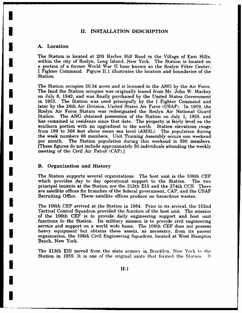
C. Hydrology
1. Surface Water ISurface water drainage at the Station can be divided into three basic drainageareas: the west one-half, the southeast one-quarter, and the northeast one-quarter of the property (Figure 111.5). Each area functions independent of oneanother and transports surface runoff to separate destinations. Surface runofffrom the west area of the Station property flows overland to the south andeast, down the slope of Harbor Hill via natural drainage pathways. Overlandrunoff that occurs to the east and southeast is collected in an open ditch thatparallels the main north-south street. The ditch transports surface water tothe southwest along the west side of the street before empting into a cat'hbasin located immediately west of the main entrance to the Station.
111-8
I
I
,' In 10q Ca W t
I eW Cn Storage Tank
1 Surac WaGErS.-
* "r Pla
ta 14Pan72o
I __UndergoundSto __.....
I LEGENDNew Building Surface Fi
SRetentio Basin #72 F
* Leach Pit*/
Underground Storm_-Drain anDtc e
Open Ditch
Runoff DirectionFlow Through 01 o 1 300ftDrains and DitchesDrainage Area Boundary ... Sca
I Station Bounda ...
SOURCE: Roslyn ANG Station.
I Figure 111.5
* Drainage Map of
the Roslyn Air National Guard Station
111-9

I
Overland runoff from the western part of the west area is routed east at the 3base of Harbor Hill along the southwest perimeter road to the catch basinlocated west of the main entrance. The catch basin collects and transports allsurface water runoff from the west area underground to the southapproximately 0.35 miles to the Nassau County #72 surface water retentionbasin (Figure 111.6). Surface water does not exit the retention basin exceptthrough percolation into the groundwater system. 3The northeast area of the Station property is drained primarily by overlandrunoff (Figure 111.5). Surface water from the north and west part of thenortheast area is collected in an open ditch paralleling the east side of thenorthern segment of the main north-south road. The ditch transports watersouth and east to a point just west of Building #36 where it is emptied ontothe ground. Runoff continues to the east from this point where it is ultimatelycollected in two catch basins located on the southeast corner of Building #36.The two catch basins also collect overland surface runoff from the south andeast parts of the northeast area. Surface water collected in the catch basins Iis transported north along the east side of Building #36 and emptied into twoleach pits just northeast of the building. Water entering the leach pits isintroduced into the groundwater system through natural seepage.
The southeast area is drained by a combination of overland runoff and buriedstorm sewers (Figure 111.5). Overland runoff is primarily directed toward the Isouth where it is absorbed into the groundwater system in the area of thesewage leach field and through a leach pit that exists along the southboundary of the Station property. Two catch basins, located along the west mside of Building #37, collect surface water runoff and transport it undergroundsouth to the leach pit located along the southern boundary. The western partof the southeast area is also drained by a leach pit that is located along thewest side of Building #3. Surface water in the vicinity of Buildings #2 and #3is collected in two catch basins and is transported north to the leach pit. Theleach pit also receives overland runoff from the north in the vicinity ofBuilding #14. Surface runoff from the southeast area does not outflow theStation property but is introduced into the groundwater system through theleach pits and natural seepage. The Station is not located within the 100-year flood plain (Southard, William, New York State Department ofEnvironmental Conservation, Verbal, 1990). I2. Groundwater
In northwestern Nassau County, three aquifers are identified by Swarzenski, I1963, to comprise the groundwater reservoir. Although the aquifers areidentified separately, they are considered to constitute a single hydraulicsystem. The aquifers are classified as the shallow unconfined, the principal.and the deep confined. In addition to the aquifers. groundwater can also occiuin localized perched bodies that form a temporary zone of saturation above
111-10
I

I2/9
IS-,1 _e7 N
ra er<~ e
ICMan
I -do
00'
TIPtNNG .426
Ua T... _
Loatono
Watr Wllse ~ciw~g~rvH
Surac WterReenioBasin
Scl " 00I SURC: UGS Se Clff ndHicsvie (ewYot 7. MNu-2oorahcQad~I7
0 Fiur 111.
Sra RuofRot8a
I 11LANE

Ithe water table. With regards to the Station location, each of the threeaquifers is present. Perched groundwater exits locally in the Pleistocene glacildeposits above the water table and close to the land surface. Percolatingsurface water becomes trapped in depressions underlain by impermeable clayrich till. Areas north of the Harbor Hill terminal moraine and within theHarbor Hill and Ronkonkoma terminal moraines commonly have perched bodiesof groundwater. Isolated bodies of perched water also occur in theintermorainal area between the Harbor Hill and Ronkonkoma terminalmoraines. As a result of the Station's position with respect to the Harbor Hillterminal moraine, it would not be unlikely for perched groundwater to occurat this location. However, perched water is not used as a source ofgroundwater because of its high susceptibility to surface contamination(Swarzenski, 1963, and Isbister, 1966).
The shallow unconfined aquifer is defined by Swarzinski, 1963, as permeablePleistocene and Cretaceous deposits that occur below the water table to a pointjust below mean sea level (BMSL). By this definition, the shallow unconfinedaquifer would be approximately the lower most 15 to 20 feet of the Pleistocenedeposits &.id the upper 50 to 60 feet of the Cretaceous Magothy Formation atthe Station location. The determination of the shallow unconfined aquifer at Ithe Station location is based on information obtained from mapping on top ofthe Cretaceous surface (Swarzenski, 1963) in conjunction with potentiometricmaps of the water table (Swarzenski, 1963, and Donaldson and Koszalka, I1979). Higher water yields from the shallow unconfined aquifer occur from thepermeable sand and gravel deposits associated with the glacial outwash plainsthat occur in the area south from the Harbor Hill terminal moraine. The IStation is located in an area where permeable outwash deposits can beexpected to occur; however, the majority of the glacial deposits here likely existabove the water table which precludes them as a probable aquifer. The 3existence of the permeable glacial deposits above the water table is significantin that their presence enhances the downward movement and flow ofgroundwater toward the water table (Swarzenski, 1963).
The principal aquifer is defined by Swarzenski, 1963, as being that section ofthe Magothy Formation that occurs above the Clay Member of the RaritanFormation to approximately 50 feet BMSL. Also included in the principalaquifer are more recent deposits that are associated with channel erosion andsubsequent deposition in the upper Magothy Formation. In addition, the entireMagothy Formation is absent north of the Station along the northern reachesof Long Island. Here, the Magothy Formation is replaced by more recentdeposits that are in hydraulic communication with the Magothy Formation andrest unconformably on top of the Gardiners Clay (Figure III.4). The depth tothe base of the Magothy Formation is projected at approximately 275 feetBMSL at the Station location. Groundwater exists under both unconfined andconfined conditions in the principal aquifer. The upper part of the principal Iaquifer is generally unconfined and in hydraulic communication with th.,shallow unconfined aquifer. However, artesian conditions commonly exist and
111-12
II

I
become more frequent with increased depth in the principal aquifer. Artesianconditions are related to the lenticiflar nature of the Magothy Formation alongwith the high concentration of clay lenses (Swarzenski, 1963, and Isbister,1966). At the base of the Magothy Formation, the Clay Member of the RaritanFormation serves as a bottom confining aquiclude. The principal aquifer is themajor source of water in the Station area, and water yields from wellspenetrating the Magothy Formation are highest from the basal zone. Yieldsas high as 1400 gallons per minute (GPM) have been reported from the basalzone while the upper part rarely yields more than 500 GPM (Isbister, 1966).
The deep confined aquifer consists of the Lloyd Sand member of the RaritanFormation. It is confined at the base by impermeable bedrock and at the topby the Clay Member of the Raritan Formation or locally by the Gardiners Claywhere it exists. Although the deep aquifer is considered to be confined(Swarzenski, 1963 and Isbister, 1966), it actually functions as a semi-confinedaquifer as a result of the leaking nature of the upper confining unit. At theStation location, the top and bottom of the Lloyds Sand member is projectedto occur at approximately 450 feet and 625 feet BMSL, respectively. Like theMagothy Formation, the Raritan Formation has been eroded and replaced byyounger deposits north of the Station along the northern reaches of LongIsland (Figure III.4). Here, the Lloyd Sand member is eroded and replacedlocally by the Jameco gravel; however, they are in hydraulic communication.The deep confined aquifer is a major source of water in the area, and wateryields from wells have been reported as high as 1600 GPM (Swarzenski, 1963and Isbister, 1966).
Recharge of the groundwater system occurs solely from precipitation. Theshallow unconfined aquifer is recharged by downward percolating surface water.The principal and deep confined aquifers are similarly recharged by thecontinued downward movement of groundwater from the shallow unconfinedaquifer. Groundwater movement and recharge rates are affected by thepermeability of the overlying material. Nonpermeable deposits like glacial tillretard groundwater flow while permeable deposits such as those associated withthe glacial outwash plains enhance movement. Consequently, recharge of theshallow unconfined aquifer is more rapid in areas underlain by outwashdeposits. Recharge of the deep confined aquifer is severely retarded by theoverlying Clay Member of the Raritan Formation. Although the Clay Memberserves as an aquiclude, groundwater does penetrate the zone and recharges theLloyd's Sand throughout the area (Isbister, 1966). The potentiometric map onthe shallow unconfined aquifer suggests a major recharge area exists east ofthe Station in eastern Nassau County. In addition, many surface waterretention basins exist to enhance local recharge through the collection andinduction of surface water runoff into the groundwater system. Generalgroundwater movement is interpreted from the potentiometric maps for eachaquifer as being in a general westerly direction at the Station location. Thedepth to the water table on the Station property in March 1979 was estimatedat 215 to 125 feet below the land surface from northwest to southeast,
111-13
I

respectively (Donaldson and Koszalka, 1979). Three public supply wells in theRoslyn Water District are significant in that they are located in close proximityto the Station (Figure 111.6). Well numbers N-5852 and N-4265 are locatedapproximately 1600 feet north-northwest and 1000 feet northeast from theStation boundary, respectively. Well number N-2400 is located approximately1800 feet south from the surface water retention basin receiving surface waterrunoff from the Station property. Each of these wells is screened in theprincipal aquifer and was drilled to total depths ranging between 439 feet and490 feet below the land surface. Approved water yield capacities for thesewells range from 1000 GPM to 1200 GPM.
The susceptibility of the groundwater to contamination from the Station isconsidered to be moderately high to high. This conclusion stems primarilyfrom the permeable nature of the glacial outwash deposits which likely existat the Station location, the permeable character of the soil, and the localizedrecharge of the groundwater system from precipitation. Furthermore, surfacewater is locally collected and induced into the groundwater system through the Iuse of leach pits and surface water retention basins. The shallow unconfinedaquifer is most susceptible, followed by the principal aquifer, and, to a muchlesser degree, the deep confined aquifer. It should be noted that because of the Ihigh density of urbanization in the area the shallow aquifer is currentlyconsidered to be contaminated and is not used as a source of public watersupply.
D. Critical Habitats/Endangered or Threatened Species
According to current records maintained by the New York State Departmentof Environmental Conservation, no endangered or threatened floral or faunal ispecies have been officially identified within a 1-mile radius of the potentialsites at the Station. No significant habitats have been identified within thisarea. 3Under the HARM, the presence of recharge areas must be considered undercritical environments (section I.E.). Surface water drainage from the potentialsites at the Station is collected in two large, cylindrical leach pits locatedimmediately northeast of the AGE Shop (Building #36). The water collectedin these structures directly recharges the groundwater at their locations. Forthis reason, a Factor Rating of 3 for a "recharge area is used to calculate theHAS.
1lI
111-14 II

I
IV. SITE EVALUATION
* A. Activity Review
A review of Station records and interviews with personnel were used to identifyspecific operations in which the majority of hazardous materials and/orhazardous wastes are used, stored, processed, and disposed. Table IV. 1provides a history of waste generation and disposal for operations conductedby shops at the Station. If an item is not listed on the table on a best-estimated basis, that activity or operation produces negligible (less than 1gallon/year) waste requiring disposal.
Potable water for the Station is provided by the Roslyn Water District.Sanitary sewer services are not provided to the Station by a public or private3 entity. The Station uses septic tanks and a leach field.
3 B. Disposal/Spill Site Information, Evaluation, and Hazard Assessment
Seven persons were interviewed to identify and locate potential sites that mayhave been contaminated by hazardous wastes as a result of past Stationoperations. Three potentially contaminated sites were identified through theinterviews. These site identifications were followed up by visual fieldexaminations of the sites.
Each of these sites was rated by application of the USAF HARM (Appendix B),and since the potential for contaminant migration exists at these three sites,each is recommended for further investigation under the IRP program. Copiesof completed HARM forms and an explanation of the factor rating criteria usedfor site scoring are contained in Appendix C.
The potential exists for contaminant migration at each of the three rated sites.Contaminants that may have been released at these sites have the potentialto be transported by groundwater and surface water. The seasonal high watertable, in the shallow aquifer, which is 125 to 215 feet below the ground surfaceat the Station, has the highest risk for groundwater contamination. Theshallow aquifer is already contaminated and the deeper aquifers could becomecontaminated by groundwater migration. Released contaminants that areexposed on the ground surface have the potential to be transported by surfacewater migration into leach pits located on the Station property. These leachpits are part of the Station's storm water sewer system, the purpose of whichis to collect and dissipate storm water. Once surface water reaches one ofthese destinations, it is introduced into the groundwater system.
IIV-1
I!V-

0)
0*
0 0U
0)U4)4 )
4.)0 0 O
-.4 -l4040
0 02 z .
6 , Z H OD0 g2 0 z014 0 U) I02
4 4. 0 - - n , , .
1.4 0 H
m w200
43
H m0) -o4 0
414
-,1 0 44q. -r
4) .0>N 4)E4J C m l 4 C4 4 0 L ) 0 C H0d
0 1 LA 4-.) 4 4 ). mo1 a1 toE0
V20 -d mH mw a~ U , 4
002 w -m t)
42 ZN -H4 to m 0U 02 C~ 44 P ~ 0 5
tp0 t &) 4$ 0 002 w w N o 0 m- -0
0'40 0 LA 0 0: LA LA 04 0 0 0 02 V V-~4 01.~~ ~~~~~ ~~~~~ 04) 0 r-w 1~J - A L A C -0 * 0 441> r ) -4 w1 V t0-4 M C 4.)0 H . ~ I 0
4)> 4 D0 4)cUf 0 m 0 - 0L 01.)1(C 004NH 0 C 4) 4. 0 0.4 0 20 .0 AM
m - H D C -14 4) o - mO0 4 Lo 0 0 1 V04) 9-0)~~~~~O Z44 -1 0( 4 : j 4 30' 0 4)
:3 to4) q -4 r. 0 -) . C.0-4 m C 02 c 0C
.,4 M 0 0 a.40 c 4)E .O Z000 .4 4) -- N C)-mm>
$4. N v4-V1 - 0 . ) 4 o En w0 4 i00 0 1.m 4 v t) 0 0 -fGr 0N r 4 -) 41 C x 0 r. *4) $4)W0)40 - 0 C 'a 04) C%00 4) 0V 17 v 0 r4 v0D g W " 4 C C W .0 C .0* C0C:24) 4
4. 1' 02 04 m 0 4 , 0, m :s 0.0C ) '0 0 002 0 0 w x, c.- 0tc 0 0 0 0 0 2 - I0E0. C
4)~~~~- 4 -d r-4 0- )4)NC 0 00 .. 4.0~~~~~~~~- 02 .- - ) t 2 '- d )0 01I ) U) m
02 0 0 a w w w w w 020 0 C02CLI 0L UL 01 a) 4) a) Q) 4) (1~ CLC0 O CL CL S
(0 0~ (n 0O 44 4.) 0J 0 ) U) NM M. V0> 0 ' I40 )
02 C.) 04 U) C) 0 ) 0 ~ ( 4 U 02 2 0 0 r.
0 00 N C C 0 0 -0 r04 -4
I'll- J HHH 0O0Hz0 H000"01202p22V00020
02 V2 0) 0 z . . '4 - 0) 0 l 3-
IV-

00 -
00
4.))
p4 E- U) 0zD z
34a 0 0 tto -4 U L) 44
0 0
m
44
410
H 0
0.
* ~44000
-H 0 4414
C;N 4) ov
I0 -1 m j-1 U ; L) L O 0 C 1 0 L4 00 H1 r
04) 0 U) 0 -. 4 -4to C;4 a-i =1 01
N H o r- V4) 4
41 I 0 LA 0o 0) 0 0 LA LA 0A 04.)H 0L0N 0N 0. LA 0 V' (N (N 0M .4 4 4
02c
0 44 0 t z0V4~ 4.)fn4.
0 0 0. _C 04 m . m -d0 4..)
tv~ 4) 1 4) 'o Ul U) 0 0 .H) 0 0 N
V .0.: l 0c0 0 k54 >1 -4 41 0 0'4- 0 40 V t% 00 04.)4
N~~0 0 0 C 0 4 0 10 .4 4 C 04
4 )4 4-4 0 J 0J 0) 44 44 1" ) 41
04 -44- -4 -4 U ) )U --4
o I I o t ) 4) a o(
0 00 Ww00P
0 0 4)'
010
a (a M-4 IV-4)3 C
0 0
o mlU))
4. 0
a] CD
(D0 0
0 -04- 0
0: 0
4.))
$4.4;
0 044.)
,~4 0
64 .4nm
I 4
If 01
0) 4.J
0LO C -H
W.4.
"404 a0
41 A. r.~
m 4 -14 m)
'a 02 -H V. UCOj. V . c 41)
) CD ca 0 M r. U4a) -H 0 (D ~ 4
0 O J-O 40- 4 >J4 41 fd LA- 44-
la m0 -40 V a gN2 -H-A 0-4 . 0 ) 0 r
0 0' a -- 0 40 4441 0 Cm 4 C 4 C-0-
-4 'a Vi 0 r.4 44 V004160 0D 0 - 0 4J 144 W 0 0 C
44U 0 0 c 0~ tr~o
W (D 44]40 m 4-) 4a
to~ U)0) U .4 >, d .o )m 0 -4 -. . ) 4) a) 0) r -0
41 41 -4 4w w 01 X1. m64).L 0 0 U %
I ) 0 m 04)Q- $4 4J 4 0 r..
a z 0 0 V
00 ~ - I) 00m0rC~~C 14-e'O
U) 01 4 4) 0.Nm 0 $4 0~ A 4 . . 44 - 0E- 4 CoW o4 00.c 0
to Q m 0 m C v0o 0~ 0 t a
0a 0r. 0 a. 00 wZ w w w 0 0
CV. I49 JM1

I
Site No. 1 - Access Road to AGE Shop (HAS - 74)
Site No. 1 is a portion of the currently paved access road that extends to thewest from the east perimeter road to the front of the AGE Shop and beyond.The potential site extends from about 10 feet west of the east perimeter roadto about 10 feet west of the AGE Shop. The site measures approximately 330feet east-west by 20 feet north-south, and distinct pavement breaks currentlydelimit its east and west ends (Figure IV.A).
From 1961 to 1971, this portion of the road was unpaved. During this period,waste oil, and possibly PD-640 solvent, paint thinner, diesel fuel, and leadedMOGAS, were poured on the road bed to dispose of these materials and to
* settle dust.
One 55 gallon drum of liquid waste was used per application, and applicationswere made up to a maximum of three times per year. Assuming theapplications took place over a 10-year period, as many as 1650 gallons of mixedliquid wastes were applied to the road bed.
There is a potential for soil and groundwater contamination from the moderatequantity (1155 to 4675 gallons) of wastes released at this potential site. Forthis reason, a HAS was calculated.
Site No. 2 - Old Waste Holding Area No. 1 (HAS - 72)
Site No. 2 is the old waste holding area for the Vehicle Maintenance Shop.It is located adjacent to the north wall of the Vehicle Maintenance Shop(Building #16). It extends east-west from a point 10 feet east of the shop'sback door to a UST, once used for waste oil storage. Beginning at the northwall of the Vehicle Maintenance Shop, the potential site measuresapproximately 15 feet north-south (Figure IV.1).
Fresh product oil, solvents, and cleaning compounds have been stored atdifferent locations in this area since 1959. Drips and withdrawal overflowsfrom the containing drums have been received by the soil at this potential sitethroughout its 31-year history. Recent stains from fresh product spills arecurrently visible at the site.
U Waste oil, PD-640 solvent, paint thinner, and leaded MOGAS from the VehicleMaintenance Shop have been stored for disposal in the site area o cer a 31-year period. Liquid wastes from the Old AGE Shop, which was in use priorto 1971, were also stored here, and for a brief but unknown period of time,liquid wastes from the new AGE Shop were stored here. With the possibleexception of JP-4 and toluene, these wastes were essentially the same as thosefrom the Vehicle Maintenance Shop. Spills often occurred during the filling ofcontainers with liquid wastes. During periods of precipitation, petroleumproducts were floated out of some containers and onto the soil.
IV-5
I

SiteNo. I
j L
7>" -' ~ ~Old Wastedn -Area No.
SiteSit No.1.Sal
SOURCE:Aces Road AGStfin
rV-6-

I
The quantity of fresh product materials and waste materials spilled at this siteover its life is unknown. Since there is a potential for soil and groundwatercentamination from these wastes, a HAS was calculated for the site. Forcalculation purposes, a small quantity (1100 gallons or less) of these wastes isassumed to have been spilled.
Site No. 3 - Old Waste Holding Area No. 2 (HAS - 68)
This site is the old waste holding area for the AGE Shop. It is located alongthe north wail of the AGE Shop and for approximately 10 feet along the northend of the shop's east wall. The use area probably extended 5 to 10 feet fromeach wall (Figure IV.A).
I Site No. 3 was used as a waste holding area from 1971 to 1989. However, fora brief but unknown time, liquid wastes from the AGE Shop were held in OldWaste Holding Area No. 1 along with those from the Vehicle MaintenanceShop.
Waste oil, paint thinner, JP-4, PD-640, diesel fuel, toluene, and leaded MOGASwere stored for disposal at Site No. 3. Six to eight drums of waste, all storedon wooden pallets, were usually present in this area at one time, and as manyas 15 to 20 drums of waste accumulated here during a year.
Petroleum products stored in this area were often floated out onto the soilduring periods of precipitation, and at least one drum burst along its seam in1977. From 1982 to 1989, 25 to 30 gallons of liquid wastes per year may havebeen spilled to the soil in this area. Petroleum product stains are visuallyevident within the site's confines. However, the total quantity of liquid wastesspilled at this potential site throughout its total period of use is unknown.
Five or six times during the period of 1982 to 1989, a tractor was used to skimstained soil from the site. The cut was one inch deep across a 15 feet x 15feet area. On one occasion, the cut was two inches deep. New sand and
crushed stone fill were placed in the area of this deeper cut. Throughout thisIperiod, all of the skimmed soil was disposed of in the general refuse dumpster.
Since there is a potential for soil and groundwater contamination from thewastes spilled at this potential si~e, a HAS was calculated for it. Since theamount of wastes spilled at this location is unknown, a small quantity (1100gallons or less) is used for calculation purposes.
IIi IV- 7
I

I
C. Other Pertinent Facts Io Trash and nonhazardous solid wastes from the Station are collected and
disposed of by the A-1 Carting Company. Io Several surface dump areas are located on the north side of the Station.
One of these is just west of Building #32. The other three are in thenorthwest corner of the Station. Dumping at these locations beganduring the Air Force occupation of the Station property and has beencontinued by the Station until he present time.
The dump near Building #32 contains waste concrete, scrap lumber, treecuttings, discarded office furniture, and appliances such as refrigerators Iand air conditioners. The only chemical materials now suspected of
being present are very small quantities of refrigerant and compressor oilassociated with the appliances. The other dumps contain waste concrete iand asphalt pavement, scrap metal, tree cuttings, and leaves.
The names and whereabouts of former Air Force personnel who workedon Station prope.-ty are currently unknown. However, a documentprovided by the Station indicates that the Air Force initially dumped "...earth fill and surplus natural materials (tree stumps and limbs, buildinglumber, and concrete)..." on Harbor Hill. Similar materials were laterdumped here by the Station. During the course of this PA, no evidencewas found that would indicate that significant quantities of hazardouswastes have been disposed of in these dumps.
o Around 1982, the top of a transformer blew off in the Primary Powerarea near the southeast corner of the Station. An interviewee whoobserved the transformer after the explosion indicated that it was fullof oil but that it had not leaked. Whether or not this oil wascontaminated with PCBs is unknown. The Long Island Lighting ICompany does not have thorough records on PCB contamination of itstransformers and cannot provide information on specific items ofelectrical equipment. After the explosion, the Long Island Lighting iCompany removed the transformer from the Station.
o Between 1970 and 1980, a batch of used radioactive tubes from radio itransmitters and receivers was disposed of in the trash.
o The Station has one OWS. It is located outside of the west wall ofBuilding #36 (AGE Shop). First installed in 1979, this OWS is connectedto the sanitary sewer system, which drains to the leach field. On amonthly basis, the OWS holding tank is checked, and the OWS effluentis sampled for water quality monitoring in accordance with thestipulations of the Station's State Pollutant Discharge Elimination SvstemPermit.
IV-8 3
I

iI
o A National Pollutant Discharge Elimination System Permit is notrequired of the Station.
o Two 5000 gallon JP-4 tanks that once contained heating oil are locatedon the west side of Building #17. JP-4 was first contained in thesetanks in 1978. Just prior to the changeover, the tanks were cleaned.One interviewee noticed severely corroded welds and stress cracks inparent metal at middle and high locations during the cleaning process.Based on this, the interviewee believed that they might have leaked, butthere is no firm indication of leakage. These tanks were installed in1951.
I Two abandoned diesel fuel USTs dating to 1951 are located on the southside of Building #18 (Power House). These tanks have capacities of 8500and 6000 gallons. One of these tanks still has 1800 gallons of fuel init. They were abandoned in 1984.
An abandoned 275 gallon UST once used for waste oi storage is locatedimmediately south of Building #16 (Vehicle Maintenance Shop). Thistank was installed about 1978 and abandoned around 1988.
i o The Station does not have a Spill Prevention, Controls, andCountermeasures or Spill Prevention and Response Plan.
9iIiiIII
i IV-9
I

I
I V. CONCLUSIONS
I Information obtained through interviews with Station personnel, reviews ofrecords, and field observations was used to identify possible spill or disposalsites on the Station property. Three potentially contaminated sites wereidentified.
The following sites exhibit the potential for contaminant migration throughsurface water, soil, and/or shallow groundwater:
o Site No. 1 - Access Road to AGE Shop (HAS - 74)
o Site No. 2 - Old Waste Holding Area No. 1 (HAS - 72)
o Site No. 3 - Old Waste Holding Area No. 2 (HAS - 68)
IIUIIIIIII
V-1II

I
i VI. RECOMMENDATIONS
IThe PA identified three potentially contaminated sites. As a result, additionalwork under the IRP is recommended for these sites to confirm thepresence/absence of contamination.
iIIIInII
III
II VTI.1
I

I
U BIBLIOGRAPHY
I Donaldson, C. D. and E. J. Koszakla. Potentiometric Surface of the LloydAquifer Long Island, New York, In January, 1979. United StatesGeological Survey, Open File Report 82-162, 1979.
Donaldson, C. D. and E. J. Koszakla. Potentiometric Surface of theMagothy Aquifer, Long Island, New York, In March, 1979. UnitedStates Geological Survey, Open File Report 82-160, 1979.
Donaldson, C. D. and E. J. Koszalka. Water Table on Long Island, NewYork, March 1979. United States Geological Survey, Open FileReport 82-163, 1979.
3 Isbister, J. Geology and Hydrology of Northeastern Nassau County LongIsland, New York. United States Geological Survey, Water-SupplyPaper 1825, 1966.
New York State Geologic Survey. Surficial Geologic Map of New YorkLower Hudson Sheet. 1989.
New York State Museum and Science Service. Geologic Map of New YorkLower Hudson Sheet. 1970.
New York State Museum and Science Service. Geolo-y of New York: AShort Account. Educational Leaflet No. 20, 1976.
I New York State Museum and Science Service. Landforms and BedrockGeology of New York State. Reprinted 1976.
I Swarzenski, W. V. Hydrology of Northwestern Nassau and NortheasternQueens Counties Long Island, New York. United States GeologicalSurvey, Water-Supply Paper 1657, 1963.
United States Department of Agriculture (USDA): Soil Conservation3 Service. Soil Survey of Nassau County, New York. 1987.
United States Department of Commerce. Climatic Atlas of the UnitedStates. National Climatic Center, Ashville, N.C., 1979.
United States Department of Commerce. Rainfall Frequency Atlas of theUnited States. Technical Paper No. 40, U.S. Government PrintingOffice, Washington, D.C., 1963.
I3 Bi-1
I

I
BIBLIOGRAPHY (continued) i
United States Environmental Protection Agency. Federal Regulations iCERCLA Pollution Contingency Plan. 55 FR 8813, FederalPRegi.try, Wash.fgtcn. D.C., March 8. 1990.
United States Geological Survey (USGS). Hicksville Quadrangle (NewYork). 7.5 Minute Series (Topographic), 1979.
United States Geological Survey (USGS). Sea Cliff Quadrangle (NewYork). 7.5 Minute Series (Topographic), 1979.
IIIIIII[
IBi-2 I
I
I

I
3GLOSSARY OF TERMS
ALLUVIAL - Pertaining to or composed of alluvium, or deposited by a streamof running water.
ALLUVIUMi - A general term for detrital ceposits made by streams on riverbeds, flood plains, and alluvial fans. The term applies to stream deposits ofrecent time.
UANNUAL PRECIPITATION - The total amount of rainfall and snowfall for theyear.
ANTICLINE - A fold, generally convex upward, whose core contains thestratigraphically older rocks.
IAQUICLUDES - A body of rock that will absorb water slowly but will nottransmit it fast enough to supply a well or spring.
IAQUIFER - A body of rock that is sufficiently permeable to conductgroundwater and yield economically significant quantities of water to wells andsprings.
ARGILLACEOUS - Like or containing clay.
ARTESIAN AQUIFER - A water-bearing bed that contains water underhydrostatic pressure.
BASALT - A dark colored igneous rock, commonly extrusive, composedprimarily of calcic plagioclase and pyroxene; the fine grained equivalent ofgabbro.
BASIN - (a) A depressed area with no surface outlet; (b) A drainage basin orriver basin; (c) A low area in the Earth's crust, of tectonic origin, in whichsediments have accumulated.
BAY - A wide, curving open indentation, recess, or inlet of a sea or lake into3the land or between two capes or headlands, larger than a cove, and usuallysmaller than, but of the same general character as a gulf.
BED [stratig] - The smallest formal unit in the hierarchy of lithostratigraphicunits. In a stratified sequence of rocks, it is distinguishable from layers aboveand below. A bed commonly ranges in thickness from a centimeter to a few3meters.
Gi-1
II

I
BEDDING [stratig] - The arrangement of sedimentary rock in beds or layers 3of varying thickness and character.
BEDROCK - A general term for the rock, usually solid, that underue8 soil orother unconsolidated, superficial material.
BOULDER - A dctachi rock mass larger than r cobble, having _Q diretr ngreater than 256 mm, being somewhat rounded or otherwise distinctly shaped iby abrasion in the course of transport.
CALCAREOUS - Containing calcium carbonate.
CLAY [geol] - A rock or mineral fragment or a detrital particle of anycomposition smaller than a fine silt grain, having a diameter less than 1/256mm (4 microns).
CLAY [soil] - A rock or mineral particle in the soil having a diameter less than i0.002 mm (2 microns).
COARSE-GRAIlrED - 1. Said of a crystalline rock, and of its texture, in which Ithe individual minerals are relatively large, e.g. an igneous rock whoseparticles have an average diameter greater than 5 mm (0.2 inc.) 2. Said ofa sedimentary rock, and of its texture, in which the individual constituents are measily seen with the unaided eye, i.e. have an average diameter greater than2 mm (0.08 in.)
COARSE-TEXTURED - (light textured) SOIL - Sand or loamy sand.
COBBLE - A rock fragment between 64 and 256 mm in diameter, thus larger nthan a pebble and smaller than a boulder, rounded or otherwise abraded in thecourse of aqueous, eolian, or glacial transport.
CONE OF DEPRESSION - The depression of heads around a pumping wellcaused by the withdrawal of water.
CONFINED AQUIFER - An aquifer bounded above and below by impermeable ibeds, or by beds of distinctly lower permeability than that of the aquifer itself.
CONGLOMERATE - A coarse-grained sedimentary rock, composed of rounded ipebbles, cobbles, and boulders, set in a fine-grained matrix of sand or silt, andcommonly cemented by calcium carbonate, iron oxide, silica, or hardened clay.
CONSOLIDATION - Any process whereby loosely aggregated, soft, or liquidearth materials become firm and coherent rock; specif. the solidification of amagma to form an igneous rock, or the lithification of loose sediments to forma sedimentary rock.
GI.2n
I

II
I CONTAMINANT - As defined by Section 101(f)(33) of Superfund Amendmentsand Reauthorization Act of 1986 (SARA) shall include, but not be limited toany element, substance, compound, or mixture, including disease-causingagents, which after release into the environment and upon exposure, ingestion,inhalation, or assimilation into any organism, either directly from theenvironment or indirectly by ingestion through food chains, will or mayI... onab! be enti,-ipn+-l to ralme death, disease, behavioral abnormalities.cancer, genetic mutation, physiological malfunctions (including malfunctions inreproduction), or physical deformation in such organisms or their offspring;
Sexcept that the term "contaminant" shall not include petroleum, includingcrude oil or any fraction thereof which is not otherwise specifically listed ordesignated as a hazardous substance under:
(a) any substance designated pursuant to Section 311(b)(2)(A) of theFederal Water Pollution Control Art,
I (b) any element, compound, mixture, solution, or substancedesignated pursuant to Section 102 of this Act,
I (c) any hazardous waste having the characteristics identified underor listed ptw uant to Section 3001 of the Solid Waste DisposalAct (but not including any waste the regulation of which underthe Solid Waste Disposal Act has been suspended by Act ofCongress),
I (d) any toxic pollutant listed under Section 307(a) of the FederalWater Pollution Control Act,
I (e) any hazardous air pollutant listed under Section 112 of theClean Air Act, and
S(f) any imminently hazardous chemical substance or mixture withrespect to which the administrator has taken action pursuantto Section 7 of the Toxic Substance Control Act;
and shall not include natural gas, liquefied natural gas, or synthetic gas ofpipeline quality (or mixtures of natural gas and such synthetic gas).
CREEK - A term generally applied to any natural stream of water, normallylarger than a brook but smaller than a river.
CRITICAL HABITAT - The specific areas within the geographical area occupiedby the species on which are found those physical or biological features (I)essential to the conservation of the species and (II) which may require specialmanagement consideration or protection.
IGI-3
I

I
CUESTA - An asymmetrical ridge, with a long, gentle slope on one side 3conforming with the dip of the underlying strata, and a steep or clifflike faceon the other side formed by the outcrop of the resistant beds.
DEPOSITS - Earth material of any type, either consolidated or unconsolidated,that has accumulated by some natural process or agent.
DIP - The angle that a stratum or any planar feature makes with thehorizontal, measured perpendicular to strike and in the vertical plane.
DOLOMITE - A sedimentary rock consisting of calcium magnesium carbonate,CaMg(Co3 )2. Occurs in beds formed by the alteration of limestone.
DRAINAGE CLASS (natvral) - Refers to the frequency and duration of periodsof saturation or partial saturation during soil formation, as opposed to altereddrainage, which is commonly the result of artificial drainage or irrigation butmay be caused by the sudden deepening of channels or the blocking of drainageoutlets. Seven classes of natural soil drainage are recognized:
Excessively drained - Water is removed from the soil very rapidly.iExcessively drained soils are commonly veiY coarse textured, rockty,or shallow. Some are steep. All are free of the mottling related towetness.
Somewhat excessively drained - Water is removed from the soilrapidly. Many somewhat excessively drained soils are sandy and $rapidly pervious. Some are shallow. Some are so steep that muchof the water they receive is lost as runoff. All are free ol hh.,imottling related to wetness.
Well-drained - Water is removed from the soil readily, but not rapidly.It is available to plants throughout most of the growing season, andwetness does not inhibit growth of roots for significant periods during
most growing seasons. Well-drained soils are commonly mediumtextured. They are mainly free of mottling.
Moderately well drained - Water is removed from the soil somewhatslowly during some periods. Moderately well drained soils are wetfor only a short time during the growing season, but periodically forlong enough that most mesophytic crops are affected. They commonlyhave a slowly pervious layer within or directly below the solum, orperiodically receive high rainfall, or both.
Somewhat poorly drained - Water is removed slowly enough that thesoil is wet for significant periods during the growing season. Wetnessmarkedly restricts the growth of mesophytic crops unless artificial
GI-I
I

Idrainage is provided. Somewhat poorly drained soils commonly havea slowly pervious layer, a high water table, additional water fromseepage, nearly continuous rainfall, or a combination of these.
Poorly drained - Water is removed so slowly that the soil is saturatedperiodically during the growing season or remains wet for longperiods. Free water is commonly at or near the surface for longenough periods during the growing season that most mesophytic cropscannot be grown unless the soil is artificially drained. The soil is notcontinuously saturated in layers directly below plow depth. Poordrainage results from a high water table, a slowly pervious layerwithin the profile, seepage, nearly continuous rainfall, or a
* combination of these.
Very poorly drained - Water is removed from the soil so slowly thatfree water remains at or on the surface during most of the growingseason. Unless the soil is artificially drained, most mesophytic cropscannot be grown. Very poorly drained soils are commonly level ordepressed and are frequently ponded. Yet, where rainfall is high andnearly continuous, they can have moderate or high slope gradients,as for example in "hillpeats" and "climatic moors."
3 DRAINAGEWAY - A channel or course along which water moves in drainingan area.
DRUMLIN - A low, smoothly rounded, elongate hill of compact glacial till, orrarely other kinds of drift, built under the margin of the ice and shaped by itsflow, or carved out of an older moraine by readvancing ice; its longer axis isparallel to the direction of movement of the ice.
END MORAINE - A ridgelike accumulation of till that marks a stillstand* position of a present or past glacier front.
ENDANGERED SPECIES - Any species which is in danger of extinctionthroughout all or a significant portion of its range, other than a species of theClass Insecta determined by the secretary to constitute a pest whose protectionwould present an overwhelming and overriding risk to man.
IEROSION - The general process or the group of processes whereby thematerials of the Earth's crust are loosened, dissolved, or worn away, andsimultaneously moved from one place to another by natural agencies, butusually exclude mass wasting.
ESCARPMENT - A long, more or less continuous cliff or relatively steep slopefacing in one general direction, separating two level or gently sloping surfaces,and produced by erosion or faulting.
IGI-5
II

I
FAULT - A fracture or fracture zone along which there has been displacement 3of the sides relative to one another parallel to the fracture.
FELDSPAR - Any of several crystalline minerals made up of aluminumsilicates with sodium, potassium, or calcium, usually glassy and moderatelyhard, found in igneous rocks.
FERRUGINOUS - Pertaining to or containing iron.
FINE-GRAINED - 1. Said of an igneous rock, and its texture, whose particleshave an average diameter less than 1 mm (0.04 in.). 2. Said of a sedimentary irock, and of its texture, in which the particles have an average diameter lessthan 1/16 mm (62 microns, or silt size and smaller). 3FINE-TEXTURED (heavy textured) SOIL - Sandy clay, silty clay, and clay.
FLOOD PLAIN - The surface or strip of relatively smooth land adjacent to a iriver channel, constructed by the present river in its existing regimen andcovered with water when the river overflows its banks.
FOLD [geol struc] - A curve or bend of a planar structure such as rock strata,bedding planes, foliation or cleavage.
FORMATION - A lithologically distinctive, mappable body of rock.
FOSSILIFEROUS - Containing fossils. IFRACTURE [struc geol] - A general te,'m for any break in a rock, whether ornot it causes displacement, due to mechanical failure by stress. Fracture Iincludes cracks, joints, and faults.
GEOLOGIC TIME - See Figure G1.1.
GLACIAL - (a) Of or relating to the presence and activities of ice or glaciers,(b) Pertaining to distinctive features and materials produced or derived from Iglaciers and ice sheets.
GLACIAL DRIFT - A general term for drift transported by glaciers or icebergs 3and deposited on land or in the sea.
GLACIAL TILL - Unstratified drift, deposited directly by a glacier withoutreworking by meltwater and consisting of a mixture of clay, silt, sand, gravel,and boulders ranging widely in size and shape.
iGI-6 I
I

The Geologic Tune Scal*(Numbers are in millions
of years before the present)
Eon Era Period Epoch
Recent orQ uaternary Holocene
Pleistocene2
Pliocene INeogene 5icn
oOligocene I
Paleogene Eocene
Cretaceous
N0 Jurassic 20
S± Tnassic 45
205Permisssppa
36P enlania
Silunian 40
438-rdovician 55
Cambrian
T Proterozoic Eon-S0 Precam brianComprisesI______________About
87%1__________________of the
2500- Geologic
Archean Eon wolTime IScale
NO Record Onin of ErtM
UFigure GI.1
IThe Geologic Time Scale
I Gl.7

I
GLAUCONITIC SANDSTONE - Greensand, composed of a green mineral, Iclosely related to the micas and essentially a hydrous potassium iron silicate.
GRANITE - Broadly applied, any crystalline, quartz-bearing plutonic rock; also icommonly contains feldspar, mica, hornblende, or pyroxene.
GRANODIORITE - A group of coarse-grained plutonic rocks intermediate incomposition between quartz diorite and quartz monzonite, containir g quartz,plagioclase, and potassium feldspar with biotite, hornblende, or mo,,? rarely,pyroxene, as the mafic contents.
GRAVEL - An unconsolidated, natural accumulation of rounded rock fragmentsresulting from erosion, consisting predominantly of particles larger than sand,such as boulders, cobbles, pebbles, granules or any combination of thesefragments.GROUNDWATER - Refers to the subsurface water that occurs beneath the iwater table in soils and geologic formations that are fully saturated.
GUNKI - A trademark for a family of different chemical products imanufactured by the Radiator Specialty Company of Charlotte, North Carolina.While these products have specific names, their users may refer to any one ofthem colloquially by this name.
HARM - Hazard Assessment Rating Methodology - A system adopted and usedby the United States Air Force to develop and maintain a priority listing ofpotentially contaminated sites on installations and facilities for remedial actionbased on potential hazard to public health, welfare, and environmental impacts.(Reference: DEQPPM 81-5, December 11, 1981.)
HAS - Hazard Assessment Score - The score developed by using the HazardAssessment Rating Methodology (HARM).
HAZARDOUS MATERIAL - Any substance or mixture of substances havingproperties capable of producing adverse effects on the health and safety of the ihuman being. Specific regulatory definitions also found in OSHA and DOT
rules.
HAZARDOUS WASTE - A solid or liquid waste that, because of its quantity,concentration, or physical, chemical, or infectious characteristics may:
a. cause, or significantly contribute to, an increase in mortality oran increase in serious or incapacitating reversible illness, or
II
GI-I

I
I b. pose a substantial present or potential hazard to human healthor the environment when improperly treated, stored,transported, disposed of, or otherwise managed.
HERBICIDE - A weed killer.
HILL - A natural elevation of the land surface, rising rather prominently abovethe surrounding land, usually of limited extent and having a well-definedoutline (rounded) and generally considered to be less than 1000 feet from base3 to summit.
IGNEOUS ROCKS - Rock or mineral that has solidified from molten orpartially molten material, i.e. from magma.
INTERBEDDED - Beds lying between or alternating with others of differentcharacter; especially rock material laid down in sequence between other beds.
KAME - A mound, knob, or short irregular ridge, composed of stratified sandand gravel deposited by a subglacial stream as a fan or delta at the marginof a melting glacier; by a superglacial stream in a low place or hole on thesurface of the glacier; or as a ponded deposit on the surface or at the margin3 of stagnant ice.
LACUSTRINE - Pertaining to, produced by, or inhabiting a lake or lakes.
I LENTICULAR - 1. Resembling in shape the cross section of a lens. 2.Pertaining to a stratigraphic lens or lentil.
I LIMESTONE - A sedimentary rock consisting of the mineral calcite (calcitecarbonate, CaCO3 ) with or without magnesium carbonate.
LIMONITE - A common secondary material, formed by weathering (oxidation)of iron-bearing materials.
LITHOLOGY - (a) The description of rocks. (b) The physical character of arock.
3 LOAM - A rich, permeable soil composed of a friable mixture of relatively equalproportions of sand, silt, and clay particles, and usually containing organicmatter.
MEAN LAKE EVAPORATION - The total evaporation amount for a particulararea; amount based on precipitation and climate (humidity).
III

m
MEDIUM-GRAINED - 1. Said of an igneous rock, and of its texture, in which mthe individual crystals have an average diameter in the range of 1-5 mm (0.04- 0.2 in.). 2. Said of a sedimentary rock, and of its texture, in which theindividual particles have an average diameter in t.he range of 1/16 to 2 mm m(62-2000 microns, or sand size).
METAMORPHIC ROCK - Any rock derived from pre-existing rocks bymineralogical, chemical, and/or structural changes, essentially in solid state,in response to marked changes in temperature, pressure, shearing stress, andchemical environment, generally at depth in the Earth's crust.
MIGRATION (Contaminant) - The movement of contaminants through pathways(groundwater, surface water, soil, and air).
MINERAL - A naturally occurring inorganic element or compound having anorderly internal structure and characteristic chemical composition, crystal formand physical properties.
MORAINE - A mound or ridge of unstratified glacial drift, chiefly till, depositedby direct action of glacier ice.
MORPHOLOGY - The shape of the earth's surface.
NET PRECIPITATION - Precipitation minus evaporation.
NORMAL FAULT - A fault in which the hanging wall appears to have moved Idownward relative to the footwall. The angle of dip is usually 450 - 90'.
OUTCROP - That part of a geologic formation or structure that appears at the msurface of the Earth.
OUTWASH [glac geol] - A stratified detritus (chiefly sand and gravel) removed mor "washed out" from a glacier by meltwater streams and deposited in frontof or beyond the end moraine or the margin of an active glacier.
OUTWASH PLAIN - a broad, gently sloping sheet of outwash deposited bymeltwater streams flowing in front of or beyond a glacier, and formed bycoalescing outwash fans. IPERMEABILITY - The capacity of a porous rock, sediment, or soil fortransmitting a fluid without impairment of the structure of the medium; it isa measure of the relative ease of fluid flow under unequal pressure.
POND - A natural body of standing fresh water occupying a small surfacedepression, usually smaller than a lake and larger then a pool. I
IGI-IO
II

I
3 POROSITY - The ratio of the aggregate volume of interstices in a rock or soilto its total volume.
POTENTIOMETRIC SURFACE - An imaginary surface representing the totalhead of groundwater and defined by the level to which water will rise in awell. The water table is a particular potentiometric surface.
QUARTZ - A crystalline silica, an important rock forming mineral: SiO,.Occurs either in transparent hexagonal crystals (colorless or colored byimpurities) or in crystalline or cryptocrystalline masses. Forms the majorproportion of most sands and has a widespread distribution in igneous,metamorphic and sedimentary rocks.
I RECHARGE - The processes involved in the addition of water to the zone ofsaturation; also, the amount of water added.
U RIVER - A general term for a natural freshwater surface stream ofconsiderable volume and a permanent or seasonal flow, moving in a definitechannel toward a sea, lake, or another river.
SAND - A rock or mineral particle in the soil, having a diameter in the range0.52 - 2 mam.
SANDSTONE - A medium-grained fragmented sedimentary rock composed ofabundant round or angular fragments of sand, size set in a fine-grained matrix(silt or clay) and more or less firmly united by a cementing material (commonlysilica, iron oxide, or calcium carbonate).
SANDY LOAM - A soil containing 43 - 85% sand, 0 - 50% silt, and 0 - 20%clay, or containing at least 52% sand and no more than 20% clay and havingthe percentage of silt plus twice the percentage of clay exceeding 30% orcontaining 43 - 52% sand, less than 50% silt, and less than 7% clay.
SCHIST - A medium- or coarse-grained, strongly foliated, crystalline rock;formed by dynamic metamorphism.
SEDIMENTARY ROCK - A rock resulting in the consolidation of loose sedimentthat has accumulated in layers; e.g., a clastic rock (such as conglomerate ortillite) consisting of mechanically formed fragments of older rock transportedfrom its source and deposited in water or from air or ice; or a chemical rock(such as rock salt or gypsum) formed by precipitation from solution; or anorganic rock (such as certain limestones) consisting of the remains or secretionsof plants and animals.
I SHALE - A fine-grained detrital sedimentary rock, formed by the consolidation(especially by compression) of clay, silt, or mud.
IGI-11
II

II
SILT [soil] - (a) A rock or mineral particle in the soil, having a diamptpr in therange 0.002-0.005 mm; (b) A soil containing more than 80% silt-size particles,less than 12% clay, and less than 20% sand.
SILT LOAM - A soil containing 50 - 88% silt, 0 - 27% clay and 0 - 50% sand.
SILTSTONE - An indurated silt having the texture and composition of shalebut lacking its fine lamination or fissility; a massive mudstone in which siltpredominates over clay.
SLATE - A compact, fine-grained metamorphic rock that possesses slatycleavage and hence can be split into slabs and thin plates. Most slate was Iformed from shale.
SOIL PERMEABILITY - The characteristic of the soil that enables water tomove downward through the profile. Permeability is measured as the distanceper unit time tI.at water movcs downward through the sacurated soil.
Terms describing permeability are:
Very Slow - less than 0.06 inches per hour (less than 4.24 x 10' Icm/sec)
Slow - 0.06 to 0.20 inches per hour (4.24 x 10⁵ to 1.41 x 10⁴ncm/sec)
Moderately Slow - 0.20 to 0.63 inches per hour (1.41 x 10' to 4.45 X 10' Icm/sec)
Moderate - 0.63 to 2.00 inches per hour (4.45 x 10." to 1.41 x 10' Icm/sec)
Moderately Rapid - 2.00 to 6.00 inches per hour (1.41 x 10' to 4.24 x 10' Icm/sec)
Rapid - 6.00 to 20.00 inches per hour (4.24 x 10" to 1.41 x 102cm/sec)
Very Rapid more than 20.00 inches per hour (more than 1.41 x 10.2
cm/sec)
(Reference: U.S.D.A. Soil Conservation Service)
Gl-12 II
I
U SOLVENT - A substance, generally a liquid, capable of dissolving othersubstances.
SORTED - Said of a sediment or detrital rock consisting of uniform size lyingwithin the limits of a single grade.
STRATIFIED - Formed, arranged, or laid down in layers or strata; especiallysaid of any layered sedimentary rock or deposit.
3 STRATIGRAPHIC UNIT - A body of strata recognized as a unit for description,mapping, or correlation.
STRIKE - The direction taken by a structural surface, e.g., a bedding or faultplane, as it intersects the horizontal.
STRUCTURAL - Of or pertaining to rock deformation or to features that resultfrom it.
SURFACE WATER - All water exposed at the ground surface, includingstreams, rivers, ponds, and lakes.
SWAMP - An area intermittently or permanently covered with water, havingshrubs and trees but essentially without the accumulation of peat.
TECTONIC - Pertaining to the forces involved in, or the resulting structuresof, tectonics.
TECTONICS - A branch of geology dealing with the broad architecture of theouter part of the earth, that is, the major structural or deformational featuresand their relations, origin, and historical evolution.
TERMINAL MORAINE - The outermost end moraine of a glacier or ice sheet,marking the maximum advance of the ice.
TERRACE [geomorph] - Any long, narrow, relatively level or gently inclinedsurface, generally less broad than a plain, bounded along one edge by a steeperdescending slope and along the other by a steeper ascending slope.
THREATENED SPECIES - Any species which is likely to become anendangered species within the foreseeable future throughout all or a significant
* portion of its range.
THRUST FAULT - A fault with a dip of 450 or less over much of its extent,on which the hanging wall appears to have moved upward relative to thefootwall. Horizontal compression rather than vertical displacement is itscharacteristic
feature.IGl1
II

TILL - Dominantly unsorted and unstratified drift, generally unconsolidated,deposited directly by and underneath a glacier without subsequent reworkingby meltwater, and consisting of a heterogeneous mixture of clay, silt, sand and Igravel and boulders ranging widely in size and shape.
TIME [Geologic] - See Figure GI.1. ITOPOGRAPHY - The general conformation of a land surface, including itsrelief and the position of its natural and man-made features. iUNCONSOLIDATED - (a) Sediment that is loosely arranged or unstratified, orwhose particles are not cemented together, occurring either at the surface or mat depth. (b) Soil material that is in a loosely aggregated form.
VALLEY - Any low-lying land bordered by higher ground, especially anelongate, relatively large, gently sloping depression of the earth's surface, Icommonly situated between two mountains or between ranges of hills andmountains, and often containing a stream or river with an outlet. It is usuallydeveloped by stream or river erosion, but can be formed by faulting.
VOLCANIC - Pert-ining to the activities, structures, or rock types of a volcano.
WATER TABLE - The upper limit of the portion of the ground that is whollysaturated with water; the surface on which the fluid pressure in the pores ofa porous medium is exactly atmospheric.
WETLANDS - Those areas that are inundated or saturated by surface orgroundwater at a frequency and duration sufficient to support, and that under Inormal circumstances do support, a prevalence of vegetation typically adaptedfor life in saturated soil conditions. Wetlands generally include swamps,marshes, bogs, and similar areas.
WILDERNESS AREA - An area unaffected by anthropogenic activities anddeemed worthy of special attention to maintain its natural condition.
iIII
Gi.14
II

IIIII
U Appendix AII Outside Agency Contact List
IIIIIIIIIII

I
I OUTSIDE AGENCY CONTACT LIST
1) County of NassauDepartment of Public WorksHighways and General Engineering1 West StreetMineola, New York 11501Donald Trusch, P.E.(516) 535-3165
2) Long Island Lighting Company1660 Walt Whitman RoadMelville, New York 11747Dave Berger(516) 420-6144
3) New York Geological SurveyNew York State MuseumCultural Education CenterRoom 3140Albany, New York 12230(518) 474-5816
4) New York State Department of Environmental ConservationSTINY, Building 40Stony jh-ook, New York 11794William Southard(516) 751-7900 Ext. 290
5) New York State Department of Environmental ConservationWildlifeSUNY, Building 40
Stony Brook, New York 11794Michael S. Scheibel(516) 751-7900 Ext. 248
6) Roslyn Water District24 West Shore RoadRoslyn, New York 11576Carmine Cipriano(516) 621-7770
II* A-i
I

I
OUTSIDE AGENCY CONTACT LIST (continued) I
7) United States Department of Agriculture (USDA)Soil Conservation Service1425 Old Country Road, Building JPlainview, New York 11803Josephine Mitchell
(516) 454-1579
8) Village of East Hills IVillage Clerk20 Town Path RoadEast Hills, New York 11576A. J. Schuermann(516) 621-4251
IIIIIIIIII
I

UIIUI| Appendix BII USAF Hazard Assessment
* Rating Methodology
U
IIIIIIII

I
USAF HAZARD ASSESSMENT RATING METHODOLOGY
3 The DoD has developed a cumprehensive program to identify, evaluate, andcontrol hazardous waste disposal practices associated with past waste disposaltechniques at DoD facilities. One of the actions required under this program
* is to:
Develop and maintain a priority listing of contaminatedinstallations and facilities for remedial action based onpotential hazard to public health, welfare, andenvironmental impacts (Reference: DEQPPM 81-5,1 December 11, 1981).
Accordingly, the USAF has sought to establish a system to set priorities fortaking further action at sites based upon information gathered during the PAphase of the IRP.
I PURPOSE
The purpose of the site rating model is to assign a ranking to each site wherethere is suspected contamination from hazardous substances. This model willassist the ANG in setting priorities for follow-up site investigations.
I This rating system is used only after it has been determined that (1) potentialfor contamination exists (hazardous waste present in sufficient quantity), and(2) potential for migration exists. A site may be deleted from rankingconsideration on either basis.
* DESCRIPTION OF THE MODEL
Like the other hazardous waste site ranking models, the USAF's site ratingmodel uses a scoring system to rank sites for priority attention. However, inspecific DoD needs.
The model uses data readily obtained during the Preliminary Assessmentportion of the IRP. Scoring judgment and computations are easily made. Inassessing the hazards at a given site, the model develops a score based on themost likely routes of contamination and worst hazards at the site. Sites aregiven low scores only if there are clearly no hazards. This approach mesheswell with the policy for evaluating and setting restrictions on excess DoDproperties.
B-1
I

Site scores are developed using the appropriate ranking factors presented in ithis appendix. The site rating form and the rating factor guidelines areprovided at the end of this appendix
As with the previous model, this model considers four aspects of the hazardposed by a specific site: (1) possible receptors of the contamination, (2) thewaste and its characteristics, (3) the potential pathways for contaminant imigration, and (4) any effort that was made to contain the waste resultingfrom a spill.
The receptors category rating is based on four rating factors: (1) the potentialfor human exposure to the site, (2) the potential for human ingestion ofcontaminants should underlying aquifers be polluted, (3) the current andanticipated use of the surrounding area, and (4) the potential for adverseeffects upon important biological resources and fragile natural settings. Thepotential for human exposure is evaluated on the basis of the total populationwvithin 1000 feet of the site, and the distance between the site and the baseboundary. The potential for human ingestion of contaminants is based on thedistance between the site and the nearest well, the groundwater use of theuppermost aquifer, and population served by the groundwater supply within 3miles of the site. The uses of the surrounding area are determined by thezoning within a 1-mile radius. Determination of whether or not criticalenvironments exist within a 1-mile radius of the site predicts the potential foradverse effects from the site upon important biological resources and fragilenatural settings. Each rating factor is numerically evaluated (0-6 andincreased by a multiplier. The maximum possible score is also computed. Thefactor score and maximum possible scores are totaled, and the receptorssubscore computed as follows: receptors subscore = (100 X factorsubtotal/maximum score subtotal).
The waste characteristics category is scored in three steps. First, a pointrating is assigned based on an assessment of the waste quantity and the Ihazard (worst case) associated with the site. The level of confidence in the
information is also factored into the assessment. Next, the score is multipliedby a waste persistence factor, which acts to reduce the score if the waste is Inot very persistent. Finally, the score is further modified by the physical stateof the waste. Liquid wastes receive the maximum score while scores for solidsare reduced. 1The pathways category rating is based on evidence of contaminant migrationalong one of three pathways: surface water migration, flooding, andgroundwater migration. If evidence of contaminant migration exists, thecategory is given a subscore of 80 to 100 points. For indirect evidence, 80points are assigned, and for direct evidence, 100 points are assigned. If noevidence is found, the highest score among the three possible routes is used.The three pathways are evaluated and the highest score among all four of thepotential scores is used.
B-2
I

I
The scores for each of the three categories are added together and normalizedto a maximum possible score of 100. Then the waste management practicecategory is scored. Scores for sites with no containment are not reduced.Scores for sites with limited containment can be reduced by 5 percent. Ifsite is co eda wlm e d its sco can e reduced.site is contained and well-managed, its score can be reduced by 90 percent.
The final site score is calculated by applying the waste management practicescategory factor to the sum of the score for the other three categories.
BIIIIIIIIIUII
I B-3
I

HAZARD ASSESSMENT RATING FORM I
NAME OF SITE
LOCATION
DATE OF OPERATION OR OCCURRENCE I
OWNER/OPERATOR
COMMENTS/DESCRIPTION ISITE RATED BY
I. RECEPTORS Factor Maximum
Rating Factor PossibleRating Factor (0-3) Multiplier Score Score
A. Population within 1000 ft. ot site 4 12
B. Distance to nearest well 10 30
C. Land use-zoning within 1-mile radius 3 9
D. Distance to installation boundary 6 18
E. Critical environments within 1-mile radius of site 10 30
F. Water quality of nearest surface water body 6 18
G. Groundwater use of uppermost aquifier 9 27
H. Population served by surface water supply within 3 6 18miles downstream of site
I. Population served by groundwater supply within 3 6 18miles of site
Subtotals 180 1Receptors subscore (100 x factor score subtotal/maximum score subtotal)
II. WASTE CHARACTERISTICS
A. Select the factor score based on the estimated quantity, the degree of hazard, and the confidence level ofthe information.I
1. Waste quantity (S = small, M = medin, L = large)
2. Confidence level (C = confirmed, S = suspected) 33. Hazard rating (H = high, M = medium, L = low)
Factor Subscore A (from 20 to 100 based on factor score matrix) 3B. Apply persistence factor
Facto.r subscore A x Persistence Factor = Subscore B
x
C. Apply physical state multiplierSubscore B x Pf-ysical State Multiplier = Waste Characteristics Subscore
x =
B-4 1
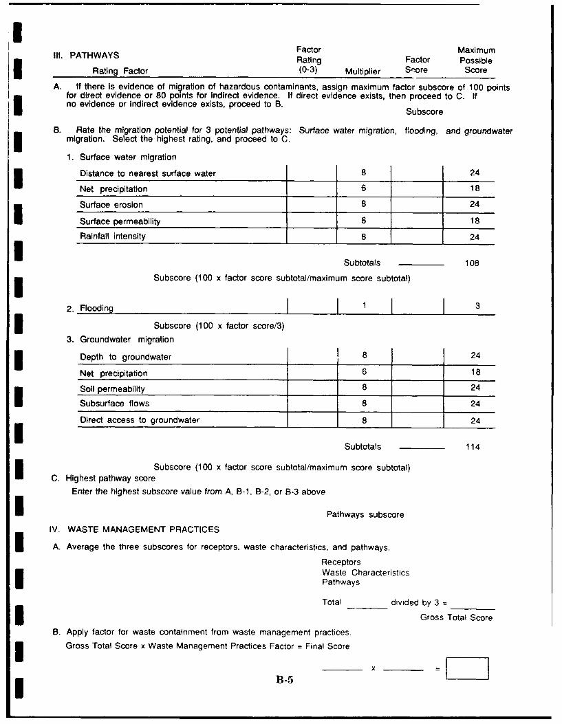
Ill. PATHWAYS Factor MaximumRating Factor Possible
Rating Factor (0-3) Multiplier Score Score
A. If there Is evidence of migration of hazardous contaminants, assign maximum factor subscore of 100 pointsfor direct evidence or 80 points for Indirect evidence. If direct evidence exists, then proceed to C. Ifno evidence or indirect evidence exists, proceed to B.
Subscore
B. Rate the migration potential for 3 potential pathways: Surface water migration, flooding, and groundwatermigration. Select the highest rating, and proceed to C.
1. Surface water migration
Distance to nearest surface water 8 24
Net precipitation 6 18
Surface erosion 8 24
Surface permeability 6 18
Rainfall intensity 8 24
Subtotals 108
Subscore (100 x factor score subtotal/maximum score subtotal)
2. Flooding I i j j3 Subscore (100 x factor score/3)
3. Groundwater migration
Depth to groundwater 8 24
Net precipitation 6 18
Soil permeability 8 24
Subsurface flows 8 24
Direct access to groundwater 8 24
Subtotals 114
Subscore (100 x factor score subtotal/maximum score subtotal)C. Highest pathway score
Enter the highest subscore value from A, B-, B-2, or B-3 aboveI Pathways subscore
IV. WASTE MANAGEMENT PRACTICES
A. Average the three subscores for receptors, waste characteristics, and pathways.
ReceptorsWaste CharacteristicsPathways
Total divided by 3Td Gross Total Score
B. Apply factor for waste containment from waste management practices.3 Gross Total Score x Waste Management Practices Factor = Final Score
B5I I

10 0
0
U 0
0 0 Io- 0
41 41 ~L 0 L.
0 0 a . i u
4. 0
4 1 4 U 0 C 0C L'0~ L S 4.
LS.u u z U
41, 0 t.. ~ ~ ~ U 1fl0u
cc 0 w wa a- 0 0
vo C A m L '0
UA g
'0'7E 0 LL0
c F
Va ' "S 90 '
aC u0-
z WO
L - - 0 L IU 0
cU
cco Im V
-A m U m 0'04
0. (' - 0 1 'u - 'A L2 4L0 0c
L 0~1 OC U
B-6

.m a
T15 ICMA45
>41 IV
V -Z z
- 40 45u~ ~~ 0 oss
0 m 0 I
Cl 0 0 35 0. a0 0. 0~ ~
> C ) at
II 91 m,
-o c
000
0 r*0
0* .50 -4j-
to 3 4, Qm0-) . 0 00.1
6-% -- IC
I I-(A ~ ~ . x4 -j Ul u a
416 '5.4log
7. ~ -0N 4, ~IC 6 c
06 .0% .B-

40
- - I'0 u i m 0
Mu L?.t ; c-C * V L
----- LI -(SJ 00.0- > > >> m c" C I'.
m C 'D
-0 m I 3 r
0. U U ~ C.I 0 000
m 0u2 >.u 00 VI VIu
-I ) ~ ~ n 4 .CVI a..- v -v
C - '
0 I D -a -L0C
= Z ~ - -~ )~JI'*-C
II> 0
'0CV
MM C. 0 40V
ui u a. >
CIO - 4) m'0 v 01
cc
CL.-uj 'a - .I >.)
4)**
4 IOI0 I.V, cca.Li : V
B-804

I...
0 cI v c
1. >. 002 9 o I
01
> 2o
VI U
- 0
41 C 0
04 >3 0
a, j W% :0 K -08 .0 7
.0 t"U 0 N
>0>
0y 0
C 4
0I0S ,
0 C
LCD VI- 0 0
0u * 0 OC -
.0 0 0
T - M 1 0 V 0 t
EIV -C C 00 0
0
>
0
c 0
C .2 0 .0C v0 I 0- 00 c 0I m .,
-C -U -C'0 - 0 2 . C >. .
L 4 ,0 *; -,a " VI 0 - .0 m a
.K 0 0 -. C3 0 0 - z 0 1'> 'AV UV 4 m 0 1 l-vC I 1 0 ~ ula c --
490 > 1 0 4,- U, -l 00 0 . vo
CL w U CL 0. s- a s
OLV 0. = 0 z0 IC . --- a5-
->A gn Os 00 mI VI , c0 Z U U
B-9

a. 6U
-' I
%I m
cm IU-7;7
.0 .
-S1
-j w0~ 04 I
m - "- -
* *0 a o
B-10
IIIII
1 Appendix Ci
| Site Hazard Assessment* Rating Forms and Factor
Rating Criteria
IIIIIIIII

HAZARD ASSESSMENT RATING FORM
NAME OF SITE Access Road to AGE Shop (Site Nn. 1)
I LOCATION South and Southeast of AGE Shop (Building 36)
DATE OF OPERATION OR OCCURRENCE 1961-1971
OWNER/OPERATOR Roslyn Air National Guard Station
I COMMENTS/DESCRIPTION
SITE RATED BY Science & Technology, Inc.
I I. RECEPTORS Factor Maximum
Rating Factor PossibleRating Factor (0-3) Multiplier Score Score
A. Population within 1000 ft. of site 3 4 12 12
B. Distance to nearest well 3 10 30 30
C. Land use-zoning within 1-mile radius 3 3 9 9
D. Distance to installation boundary 3 6 18 18
E. Critical environments within 1-mile radius of site 3 10 30 30
F. Water quality of nearest surface water body 0 6 0 18
G. Groundwater use of uppermost aquifier 2 9 18 27
H. Population served by surface water supply within 3 0 6 0 18miles downstream of site
I. Population served by groundwater supply within 3 6 18 18I miles of site
135Subtotals 180
Receptors subscore (100 x factor score subtotal/maximum score subtotal) 75
I II. WASTE CHARACTERISTICS
A. Select the factor score based on the estimated quantity, the degree of hazard, and the confidence level ofthe information.
M1. Waste quantity (S = small, M = medium, L = large)
C2. Confidence level (C = confirmed, S = suspected)IH3. Hazard rating (H = high, M = medium, L = low)
Factor Subscore A (from 20 to 100 based on factor score matrix) 80I B. Apply persistence factor
Factor subscore A x Persistence Factor = Subscore B
80 1.0 80I xC. Apply physical state multiplier
Subscore B x Physical State Multiplier = Waste Characteristics Subscore
80 x 1.0 80
C-Ii-

Ill. PATHWAYS Factor MaximumRating Factor PossibleRating Factor (0-3) Multiplier Score Score
A. If there Is evidence of migration of hazardous contaminants, assign maximum factor subscore of 100 pointsfor direct evidence or 80 points for Indirect evidence. If direct evidence exists, then proceed to C. Ifno evidence or indirect evidence exists, proceed to B. Subscore 80
B. Rate the migration potential for 3 potential pathways: Surface water migration, flooding, and groundwatermigration. Select the highest rating, and proceed to C.
1. Surface water migration
Distance to nearest surface water 3 8 24 24
Net precipitation 2 6 12 18 ISurface erosion 1 8 8 24
Surface permeability 1 6 6 18
Rainfall intensity 2 8 t6 24
Subtotals 66 108
Subscore (100 x factor score subtotal/maximum score subtotal) 61
2. Flooding 10 1 1 1 03Subscore (100 x factor score/3) 0
3. Groundwater migration
Depth to groundwater 1 8 8 24
Net precipitation 2 6 12 18
Soil permeability 3 8 24 24
Subsurface flows 0 8 0 24
Direct access to groundwater 3 8 24 24
Subtotals 114
Subscore (100 x factor score subtotal/maximum score subtotal) 60C. Highest pathway score
Enter the highest subscore value from A, B-1, B-2, or B-3 above
Pathways subscore 80
IV. WASTE MANAGEMENT PRACTICES
A. Average the three subscores for receptors, waste characteristics, and pathways.
Receptors 75Waste Characteristics 80Pathways 80
Total 235 divided hb 3 - qGross Total Snr
B. Apply factor for waste containment from waste management practices.
Gross Total Score x Waste Management Practices Factor = Final Score78 0.95
C-2 -I "1

HAZARD ASSESSMENT RATING FORM
NAME OF SITE Old Waste Holding Area No. 1 (Site No. 2)
LOCATION North of the Vehicle Maintenance Shop (Building 16)
I DATE OF OPERATION OR OCCURRENCE 1959-1990
OWNER/OPERATOR Roslyn Air National Guard Station
I COMMENTS/DESCRIPTION
SITE RATED BY Science & Technology, Inc.
I I. RECEPTORS Factor Maximum
Rating Factor PossibleRating Factor (0-3) Multiplier Score Score
3 A. Population within 1000 ft. of site 3 4 12 12
B. Distance to nearest well 3 10 30 30
C. Land use-zonIng within 1 -mile radius 3 3 9 9
D. Distance to installation boundary 3 6 18 18
E. Critical environments within 1-mile radius of site 3 10 30 30
F. Water quality of nearest surface water body 0 6 0 18
G. Groundwater use of uppermost aqulfier 2 9 18 27I H. Population served by surface water supply within 3 0 6 0 18
miles downstream of site
I. Population served by groundwater supply within 3 3 6 18 18miles of site
135Subtotals 180
Receptors subscore (100 x factor score subtotal/maximum score subtotal) 75
I II. WASTE CHARACTERISTICS
A. Select the factor score based on the estimated quantity, the degree of hazard, and the confidence level ofI the information.
1. Waste quantity (S = small, M = medium, L = large)C
2. Confidence level (C = confirmed, S = suspected)
3. Hazard rating (H = high, M = medium, L = low)
Factor Subscore A (from 20 to 100 based on factor score matrix) 60
I B. Apply persistence factorFactor subscore A x Persistence Factor = Subscore B
60 1.0 60x
C. Apply physical state multiplierSubscore B x Physical State Multiplier = Waste Characteristics Subscore
60 1.0 60
IC-3I

111. PATHWAYS Factor Maximum IRating Factor Possible
Rating Factor (0-3) Multiplier Score Score
A. If there is evidence of mlgration of hazardous contaminants, assign maximum factor subscore of 100 pointsfor direct evidence or 80 points for Indirect evidence. If direct evidence exists, then proceed to C. Ifno evidence or indirect evidence exists, proceed to B. Subscore 80
B. Rate the migration potential for 3 potential pathways: Surface water migration, flooding, and groundwatermigration. Select the highest rating, and proceed to C.
1. Surface water migration
Distance to nearest surface water 3 8 24 24
Net precipitation 2 6 12 18
Surface erosion 1 8 8 24
Surface permeability 1 6 6 18
Rainfall intensity 2 8 16 24
66Subtotals 108
Subscore (100 x factor score subtotal/maximum score subtotal) 61
2. Flooding I o 10 ISubscore (100 x factor score/3) 0
3. Groundwater migration
Depth to groundwater 1 8 8 24
Net precipitation 2 6 12 18
Soil permeability 3 8 24 24
Subsurface flows 0 8 0 24
Direct access to groundwater 3 8 24 24
68Subtotals 114
Subscore (100 x factor score subtotal/maximum score subtotal) 60C. Highest pathway score
Enter the highest subscore value from A, B-1, B-2, or B-3 above
Pathways subscore 80
IV. WASTE MANAGEMENT PRACTICES
A. Average the three subscores for receptors, waste characteristics, and pathways.
Receptors 75Waste Characteristics 60Pathways 80)
Total 21 divided bv3= , -
Gross Total Scorn
B. Apply factor for waste containment from waste management practices. IGross Total Score x Waste Management Practices Factor = Final Score
72 1.0- ?2
C-4 x =L~z

HAZARD ASSESSMENT P.'TING FORM
NAME OF SITE Old Waste Holding Area No. 2 (Site No. 3)
LOCATION North Side and Northeast Corner of AGE Shop (Building 36)
DATE OF OPERATION OR OCCURRENCE 1971-1989
OWNER/OPERATOR Roslyn Air National Guard Station
I COMMENTS/DESCRIPTION
SITE RATED BY Science & Technology, Inc.
I . RECEPTORS Factor MaximumRating Factor Possible
Rating Factor (0-3) Multiplier Score Score
A. Population within 1000 ft. of site 3 4 12 12
B. Distance to nearest well 3 10 30 30
C. Land use-zoning within 1-mile radius 3 3 9 9
D. Distance to installation boundary 3 6 18 18
E. Crtical environments within 1-mile radius of site 3 10 30 30
F. Water quality of nearest surface water body 0 6 0 18
G. Groundwater use of uopermost a-"' 2 9 18 27
H. Population served by surface water supply within 3 0 6 0 18miles downstream of site
I. Population served by groundwater supply within 3 3 6 18 18miles of site
135Subtotals 180
Receptors subscore (100 x factor score subtotal/maximum score subtotal) 75
Ill . WASTE CHARACTERISTICS
A. Select the factor score based on the estimated quantity, the degree of hazard, and the confidence level ofthe information.
1. Waste quantity (S = small, M = medium, L = large)C
2. Confidence level (C = confirmed, S = suspected)H
3. Hazard rating (H = high, M = medium, L = low)
Factor Subscore A (from 20 to 100 based on factor score matrix) 60B. Apply persistence factor
Factor subscore A x Persistence Factor = Subscore B
I 60 1.0 60
C. Apply physical state multiplierSubscore B x Physical State Multiplier = Waste Charactcriotics Subscore
60 1.0 60
IC-5I

Ill. PATHWAYS Factor MaximumRating Factor Possible
Rating Factor (0-3) Multiplier Score Score
A. If there Is evidence of migration of hazardous contaminants, assign maximum factor subscore of 100 pointsfor direct evidence or 80 points for indirect evidence. If direct evidence exists, then proceed to C. Ifno evidence or indirect evidence exists, proceed to B. Subscore 80
B. Rate the migration potential for 3 potential pathways: Surface water migration, flooding, and groundwatermigration. Select the highest rating, and proceed to C. II1. Surface water migration
Distance to nearest surface water 3 8 24 24
Net precipitation 2 6 12 18
Surface erosion 1 8 8 24
Surface permeability 1 6 6 18
Rainfall intensity 2 8 16 24
66Subtotals 108
Subscore (100 x factor score subtotal/maximum score subtotal) 61
2. Flooding 10 1 0 3_____
Subscore (100 x factor score/3) 0
3. Groundwater migration
Depth to groundwater 1 8 8 24
Net precipitation 2 6 12 18
Soil permeability 3 8 24 24
Subsurface flows 0 8 0 24
Direct access to groundwater 38 24 24
Subtotals 68 114
Subscore (100 x factor score subtotal/maximum score subtotal) 60
C. Highest pathway score
Enter the highest subscore value from A, B-1, B-2, or B-3 above
Pathways subscore 80
IV. WASTE MANAGEMENT PRACTICES
A. Average the three subscores for receptors, waste characteristics, and pathways.
Receptors 75Waste Characteristics 60Pathways AO
Total 2n vided hv 2= T
Gross oTc;a' q"...
B. Apply factor for waste containment frum waste management practices.
Gross Total Score x Waste Management Practices Factor = Final Score
72 0.95- 68
C-6 I

I
Roslyn Air National Guard StationRoslyn, New York
USAF Hazard Assessment Rating MethodologyFactor Rating Criteria
The following is an explanation of the HARM factor rating criteria for thethree potential sites identified at the Station:
I. Receptors
I A. Population Within 1000 Feet of Site.
Site Nos. 1-3, Factor Rating 3. The population of the Station onUnit Training Assembly weekends is 390 persons. Using ahousehold size of 3.8 individuals, it is estimated thatapproximately 270 additional persons live in the neighborhoodadjacent to the Station and within the 1000-foot radius.
3 B. Distance to Nearest Well.
Site Nos. 1-3, Factor Rating 3. Site No. 1 is loceted approximately900 feet west of the nearest water well. Site Nos. 2 and 3 areapproximately 1200 feet from the nearest water well.
C. Land Use - Zoning (within 1-mile radius).
Site Nos. 1-3, Factor Rating 3. The area within a 1-mAle radius
of Site Nos. 1-3 is predominantly residential.
D. Distance to Installation Boundary.
Site Nos. 1-3, Factor Rating 3. Site No. 1 is 35 feet from theinstallation boundary. Site No. 2 is 175 feet from it, and Site No.3 is 200 feet from it.
E. Critical F vironments (within 1-mile radius).
Site Nos. 1-3, Factor Rating k. Surface runoff from Site Nos. 1-3 flows to two leach pits located immediately northeast of the AGEShop (Building 36). These pits directly recharge the groundwater3 at their locations.
II (C-7
I

i
F. Water Quality/Use Designation of Nearest Surface WaterBody.
Site Nos. 1-3, Factor Rating 0. Surface runoff from Site Nos. 1-3 does not flow to a naturally occurring body of surface water. Itflows to two leach pits located immediately northeast of the AGEShop (Building 36).
G. Groundwater Use of Uppermost Aquifer.
Site Nos. 1-3, Factor Rating 2. Well records dating as late as theearly 1960s (Swazenski, 1963) indicate that some domestic wellstapped the uppermost, unconfined aquifer. This aquifer is nowconsidered to be too contaminated for use as a source of potablewater. Although treated municipal water from deeper aquifers isreadily available to the local populace, it is at least conceivablethat someone could still be obtaining water from the uppermostaquifer.
H. Population Served by Surface Water Supplies Within 3 iMiles Downstream of Site.
Site Nos. 1-3, Factor Rating 0. No one within a 3-mile radius of iSite Nos. 1-3 receives potable water from a surface water source.
1. Population Served by Aquifer Supplies Within 3 Miles of mSite.
Site Nos. 1-3, Factor Rating 3. The entire population within a 3-mile radius of Site Nos. 1-3 receives potable water from aquifers.This population is estimated at about 14,000 persons.
II. Waste Characteristics
Site No. 1
A-i: Hazardous Waste Quantity - Factor Rating M (Moderate). Asmany as 1650 gallons of mixed waste oil PD-640 solvent, paintthinner, diesel fuel, leaded MOGAS, and denatured alcohol mayhave been disposed of at this site.
A-2: Confidence Level - Factor Rating C (Confirmed). This site wasconfirmed through interviews with Station personnel.
C-8
I

I
I A-3: Hazard Rating - Factor Rating H (High). This site was given ahigh hazard rating because of the high toxicity of many pptroliim
* products.
Site No. 2
A-i: Hazardous Waste Quantity - Factor Rating S (Small). Anunknown quantity of waste oil, PD-640 solvent, paint thinner,diesel fuel, leaded MOGAS, and denatured alcohol was spilled atthis site. For calculation purposes, a small quantity is used.
A-2: Confidence Level - Factor Rating C (Confirmed). This site wasconfirmed through interviews with Station personnel.
A-3: Hazard Rating - Factor Rating H (High). This site was given ahigh hazard rating because of the high toxicity of many petroleumproducts.
Site No. 3
A-1: Hazardous Waste Quantity - Factor Rating S (Small). Anunknown quantity of waste oil, paint thinner, JP-4, PD-640solvent, diesel fuel, toluene, and leaded MOGAS was spilled at thissite. For calculation purposes, a small quantity is used.
I A-2: Confidence Level - Factor Rating C (Confirmed). This site wasconfirmed through interviews with Station personnel.
I A-3: Hazard Rating - Factor Rating H (High). This site was given ahigh hazard rating because of the high toxicity of many petroleumproducts such as J-P-4.
B. Persistence Multiplier for Point Rating.
Site Nos. 1-3 were assigned a persistence multiplier of 1.0 basedon the presence of leaded MOGAS. This material corresponds tothe HARM category of "Metals, Polycyclic Compounds, andHalogenated Hydrocarbons."
C. Physical State Multiplier.
U A physical state multiplier of 1.0 was applied to Site Nos. 1-3because the materials spilled or disposed of at these sites were
* liquids.
9i C-9
I

I
IIl. Pathways Category
A. Evidence of Contamination
Site Nos. 1-3 were given a score of 80 (Indirect Evidence) becausethey are greatly suspected of being sources of contamination.Although no staining or stressed vegetation is present, interview Iinformation indicated that a moderate quantity of mixed wasteswere disposed of at Site No. 1. Petroleum product stains areevident at Site Nos. 2 and 3.
B-1. Potential for Surface Water Contamination.
" Distance to Nearest Surface Water: Factor Rating 3. SiteNos. 1-3 are located within 350 feet of a storm sewer line onthe Station property.
" Net Precipitation: Factor Rating 2. The average annual netprecipitation for Site Nos. 1-3 is 12 inches.
o Surface Erosion: Factor Rating 1. Surface erosion is slightat Site Nos. 1-3.
" Surface Permeability: Factor Rating 1. The surfacepermeability at Site Nos. 1-3 is 4.45 x 10' to 1.41 x 10'cm/sec (Moderate).
" Rainfall Intensity Based on 1-Year, 24-Hour Rainfall: FactorRating 2. The rainfall intensity at Site Nos. 1-3 is 2.75 Iinches.
B-2. Potential for Flooding. n
Factor Rating 0. Site Nos. 1-3 are located beyond the 100-yearflood plains of local streams. I
B-3. Potential for Groundwater Contamination.
o Depth to Groundwater: Factor Rating 1. The depth togroundwater at Site Nos. 1-3 is 135 feet.
o Net Precipitation: Factor Rating 2. The average annual netprecipitation for Site Nos. 1-3 is 12 inches.
o Soil Permeability: Factor Rating 3. The soil permeability Iat Site Nos. 1-3 is 4.24 x 10' to 1.41 x 102 cm/sec. (Rapidto Very Rapid).
C-10
I
i o Subsurface Flows: Factor Rating 0. The bottoms of SiteNos. 1-3 are greater than 5 feet ahove high grnoindwiter
* level.
o Direct Access to Groundwater: Factor Rating 3. Based onthe presence of permeable surficial glacial deposits, there isa high risk of groundwater contamination from Site Nos. 1-3.
U IV. Waste Management Practices Factor.
Site Nos. 1 and 3 were given scores of 0.95. Site No. 1 is entirelycapped by asphalt road pavement. A portion of the potentiallycontaminated soil at Site No. 3 has been removed. Site No. 2 was givena score of 1.0 because no cleanup or containment measures have beeninitiated at this location.
II
Ii
I
III
i C-11
I