Embed Size (px)
Citation preview
131Report of Activities 2015
SummaryTwo weeks of fieldwork were conducted in the sum-
mer of 2015, in the Stephens Lake area near the town of Gillam and along the Nelson River downstream from Gillam, in northeastern Manitoba. Fieldwork included collection of till samples for textural and geochemi-cal analyses, as well as descriptions of surficial materi-als for mapping and stratigraphy. This work builds upon two previous Manitoba Geological Survey field seasons led by M.S. Trommelen in 2013 and 2014, and provides additional field data for an M.Sc. project at the University of Waterloo. During the previous field seasons, six ice-flow phases were identified in the landform (depositional) and bedrock (erosional) records. A goal of the 2015 field season was the collection of till samples and clast-fabric measurements to examine local till stratigraphy in the context of previously recognized ice-flow phases. The quantitative properties of till samples, such as grain size, geochemistry and clast lithlology, will assist in the cor-relation of local till units. In total, 39 sites were visited and 44 till samples were collected. Ten new stratigraphic sections were documented along the Nelson River, bring-ing the total number of sections examined/re-examined to 42. These new data and observations will address ques-tions raised in the previous field seasons, and add to our growing understanding of the complex glacial history of northeastern Manitoba.
IntroductionIn 2015, the Manitoba Geological Survey (MGS)
continued a Quaternary geology multiyear collaborative program with the University of Waterloo. The goal is to investigate the Quaternary stratigraphy of the Gillam area of northeastern Manitoba, with the aim of unravelling the glacial history in terms of surficial materials (mapping and aggregate-resource assessment) and till composition as it relates to drift exploration. Exposures of Quaternary sediments, typically up to tens of metres high, along the Nelson River record deposition from at least three glacial cycles (Dredge and McMartin, 2011). At many sites, the glacial and interglacial sediments are overlain by Holo-cene lacustrine and marine deposits, left as the Lauren-tide Ice Sheet (LIS) retreated. Findings from the first two years of the project have started to unravel the complex Quaternary geology of the Gillam area, but a number of
questions still need to be resolved (Trommelen 2013; Trommelen et al., 2014).
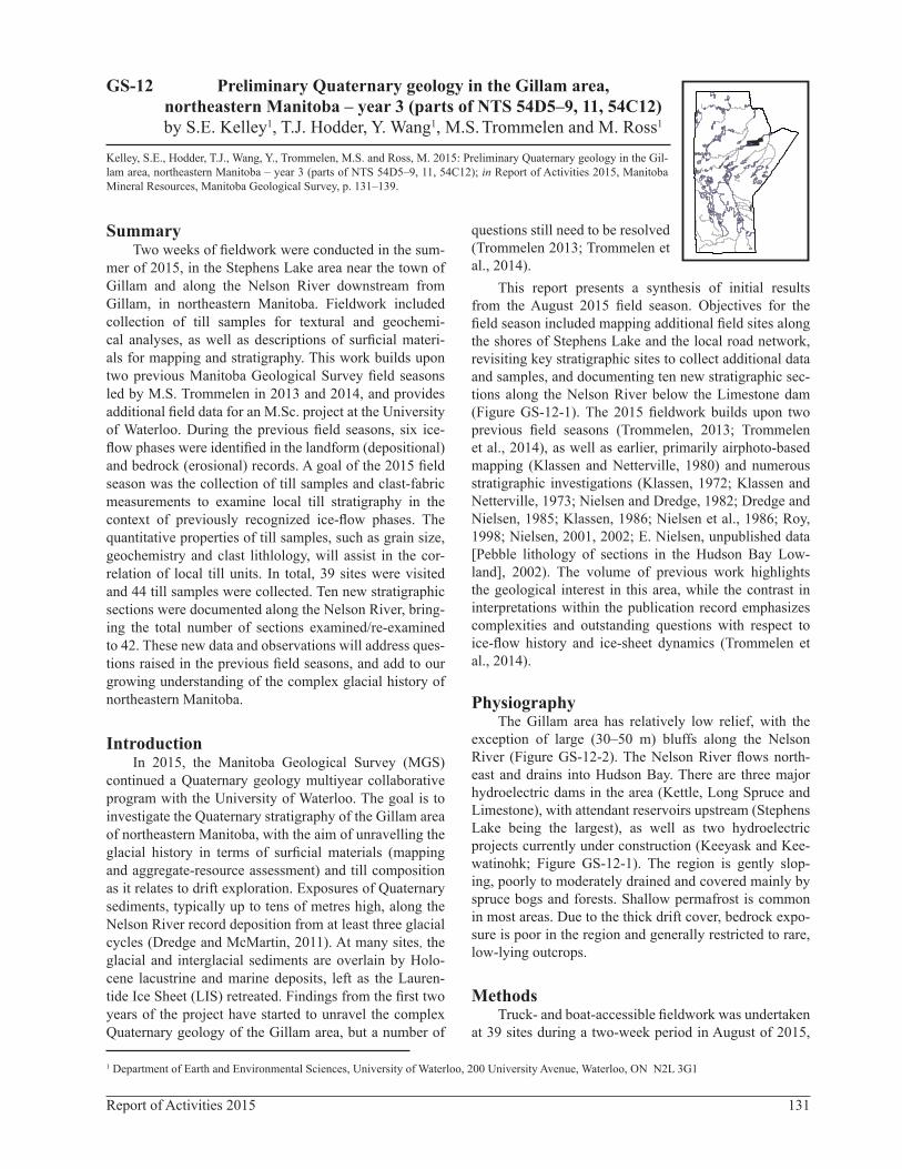
This report presents a synthesis of initial results from the August 2015 field season. Objectives for the field season included mapping additional field sites along the shores of Stephens Lake and the local road network, revisiting key stratigraphic sites to collect additional data and samples, and documenting ten new stratigraphic sec-tions along the Nelson River below the Limestone dam (Figure GS-12-1). The 2015 fieldwork builds upon two previous field seasons (Trommelen, 2013; Trommelen et al., 2014), as well as earlier, primarily airphoto-based mapping (Klassen and Netterville, 1980) and numerous stratigraphic investigations (Klassen, 1972; Klassen and Netterville, 1973; Nielsen and Dredge, 1982; Dredge and Nielsen, 1985; Klassen, 1986; Nielsen et al., 1986; Roy, 1998; Nielsen, 2001, 2002; E. Nielsen, unpublished data [Pebble lithology of sections in the Hudson Bay Low-land], 2002). The volume of previous work highlights the geological interest in this area, while the contrast in interpretations within the publication record emphasizes complexities and outstanding questions with respect to ice-flow history and ice-sheet dynamics (Trommelen et al., 2014).
PhysiographyThe Gillam area has relatively low relief, with the
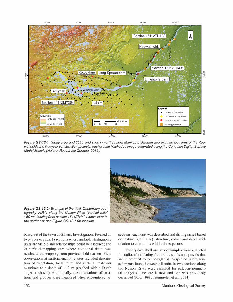
exception of large (30–50 m) bluffs along the Nelson River (Figure GS-12-2). The Nelson River flows north-east and drains into Hudson Bay. There are three major hydroelectric dams in the area (Kettle, Long Spruce and Limestone), with attendant reservoirs upstream (Stephens Lake being the largest), as well as two hydroelectric projects currently under construction (Keeyask and Kee-watinohk; Figure GS-12-1). The region is gently slop-ing, poorly to moderately drained and covered mainly by spruce bogs and forests. Shallow permafrost is common in most areas. Due to the thick drift cover, bedrock expo-sure is poor in the region and generally restricted to rare, low-lying outcrops.
MethodsTruck- and boat-accessible fieldwork was undertaken
at 39 sites during a two-week period in August of 2015,
1 Department of Earth and Environmental Sciences, University of Waterloo, 200 University Avenue, Waterloo, ON N2L 3G1
Preliminary Quaternary geology in the Gillam area, northeastern Manitoba – year 3 (parts of NTS 54D5–9, 11, 54C12)by S.E. Kelley1, T.J. Hodder, Y. Wang1, M.S. Trommelen and M. Ross1
GS-12
Kelley, S.E., Hodder, T.J., Wang, Y., Trommelen, M.S. and Ross, M. 2015: Preliminary Quaternary geology in the Gil-lam area, northeastern Manitoba – year 3 (parts of NTS 54D5–9, 11, 54C12); in Report of Activities 2015, Manitoba Mineral Resources, Manitoba Geological Survey, p. 131–139.
132 Manitoba Geological Survey
based out of the town of Gillam. Investigations focused on two types of sites: 1) sections where multiple stratigraphic units are visible and relationships could be assessed; and 2) surficial-mapping sites where additional detail was needed to aid mapping from previous field seasons. Field observations at surficial-mapping sites included descrip-tion of vegetation, local relief and surficial materials examined to a depth of ~1.2 m (reached with a Dutch auger or shovel). Additionally, the orientations of stria-tions and grooves were measured when encountered. At
sections, each unit was described and distinguished based on texture (grain size), structure, colour and depth with relation to other units within the exposure.
Twenty-five shell and wood samples were collected for radiocarbon dating from silts, sands and gravels that are interpreted to be postglacial. Suspected interglacial sediments found between till units in two sections along the Nelson River were sampled for paleoenvironmen-tal analyses. One site is new and one was previously described (Roy, 1998; Trommelen et al., 2014).
Figure GS-12-2: Example of the thick Quaternary stra-tigraphy visible along the Nelson River (vertical relief ~50 m), looking from section 15112TH431 down river to the northeast; see Figure GS-12-1 for location.
Figure GS-12-1: Study area and 2015 field sites in northeastern Manitoba, showing approximate locations of the Kee-watinohk and Keeyask construction projects; background hillshaded image generated using the Canadian Digital Surface Model Mosaic (Natural Resources Canada, 2012).
Section 15112TH431
Kettle dam
Limestone dam
Stephens Lake
Gillam
Nel
son
Riv
er
Anglin
g R
iver
Keeyask
Conawapa
Section 15112TH423
Long Spruce dam
Keeyask
Keewatinohk
Section 14112MT254
High: 260 m asl
Low: 17 m asl
2014/2014 field station
2015 field-mapping station
2013/2014 station revisited
2015 logged section

133Report of Activities 2015
Forty-four till samples, each weighing approximately 2–3 kg, were collected from C-horizon tills throughout the study area and will be submitted for textural, geochemis-try (<63 µm fraction) and clast lithology (2–30 mm frac-tion) analyses. Clast- and magnetic-fabric measurements (see below for more detail about fabric measurements) were conducted at stratigraphic sections in order to assess paleo–ice flow. Till samples collected in 2015 are all from new mapping and stratigraphic field sites. Results from these samples will be added to the regional database of till-sample analyses compiled over the last two years. Ongoing work strives to differentiate between till units within (time) and between (space) stratigraphic sections and field-mapping sites.
Clast- and magnetic-fabric measurements were con-ducted at 12 stratigraphic sections. Clast-fabric measure-ments were taken on elongate clasts (with an a:b ratio of 1.5:1 or greater) within excavations, measuring approxi-mately 30 by 30 by 30 cm, into till exposures. Clasts touching other clasts within the till were not measured, nor were small clasts situated near much larger clasts. This was done to ensure that the clasts were matrix supported and would have been allowed to align to local stresses within the till matrix. Samples for magnetic-fabric mea-surements were also collected from similar 30 by 30 by 30 cm excavations into the till. From each excavated area, 25 individual 1 cm3 plastic geomagnetic sampling boxes were filled with sediment following the methods of Hop-kins et al. (in press). To collect a sample, a pedestal was carved out of the till and an uncapped sampling box was fit over the pedestal. The dip of the box in three direc-tions and the orientation of the z-axis (into the face) were measured before the sample was broken off the exposure for collection. The magnetic fabric of samples will be analyzed using an AGICO Kappabridge at the Western University paleomagnetics lab in the fall of 2015. When measured, each magnetic fabric will consist of compiled measurements for the 25 separate samples from the sin-gle, 30 by 30 by 30 cm sampling location.
Preliminary results
StratigraphySections were visited along lakes and rivers through-
out the study area. Lake and river levels frequently vary due to local control by hydroelectric dams, resulting in frequent changes in the number, extent and quality of exposures. The 2015 fieldwork focused on documenting new exposures, obtaining additional fabric measurements (both clast and magnetic) and sampling of till units for textural, geochemical and clast-composition analyses.
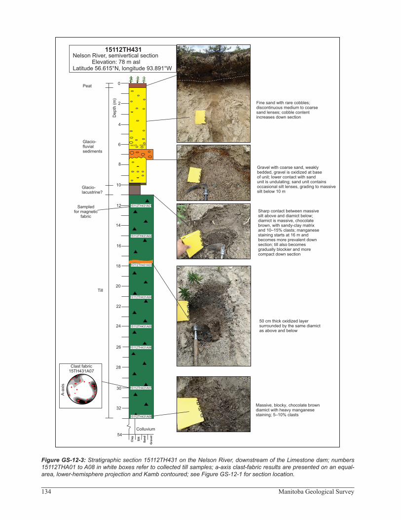
Section 15112TH431Figure GS-12-3 illustrates observations and data col-
lected at a newly described section from this summer (sec-tion 15112TH431 on Figure GS-12-1). The site is located
on the Nelson River, approximately 20 km northeast of the Limestone dam. At section 15112TH431, 11 m of sands, silts and gravel overlie 22 m of diamict. The sands, silts and gravel are interpreted as postglacial sediments, which were deposited during changing environmental conditions during the local retreat of the LIS. The diamict is chocolate brown with 5–15% clasts and a sandy-clay matrix. It becomes increasingly blocky and stiff with depth, and manganese staining was observed from ~16 m depth downward, its prevalence increasing with depth. This diamict is interpreted as till, deposited during one or more glacial cycles. Due to its great thickness, it remains to be determined whether the till section is composed of one or multiple till units, possibly deposited over a long period of time and from multiple directions. Composition and fabric data will be used to resolve this question.
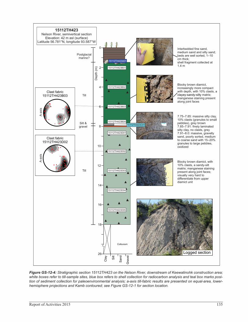
Section 15112TH423
Figure GS-12-4 is a second example of a newly described section, accessed by boat on the Nelson River (section 15112TH423 on Figure GS-12-1). In contrast to the previous section, almost 2 m of bedded sand overlies ~16 m of diamict that contains a thin silt and gravel unit at 7.75 m depth. The upper sand contains shell fragments and is probably marine in origin. The upper part of the brown diamict is blocky with 10% clasts and a clayey-sandy silt matrix. Manganese staining is present along joint surfaces and the diamict is increasingly more dense with depth. The silt and gravel unit, at 7.75–8.0 m depth, consists of massive silty clay with 10% clasts (7.75–7.85 m) in con-tact with finely laminated silty clay with no clasts (7.85–7.91 m), which then sharply overlies massive, oxidized gravelly sand (7.91–8.0 m). This unit then unconformably (sharp contact) overlies a brown, blocky diamict that con-tains 10% clasts and has a sandy-silt matrix. Manganese staining is present along joint surfaces throughout the lower diamict.
The lower silt and gravel unit may have been depos-ited beneath a glacier (‘subglacial sediments’) or during a nonglacial period. Based on the stratigraphic position of this unit, the authors suspect it may be nonglacial, deposited during an interglacial or interstadial time. To determine the age and genesis of this unit, samples were collected and will be submitted for detailed pollen and macrofossil analysis. Previous work in the region iden-tified sub-till nonglacial sediment of uncertain age at several sections along the Nelson River (Nielsen et al., 1986).
If the silt and gravel unit is nonglacial, then the two diamict units could be interpreted as tills deposited during two separate glacial cycles. The field characteristics of both till units are similar, and only subtle colour and tex-tural changes were observed. However, since these two characteristics are subjective, till samples were collected
134 Manitoba Geological Survey
Figure GS-12-3: Stratigraphic section 15112TH431 on the Nelson River, downstream of the Limestone dam; numbers 15112THA01 to A08 in white boxes refer to collected till samples; a-axis clast-fabric results are presented on an equal-area, lower-hemisphere projection and Kamb contoured; see Figure GS-12-1 for section location.
0
2
4
6
8
10
12
14
16
18
20
22
24
26
28
30
32
Colluvium
Clay
Silt
Gravel
Sand
De
pth
(m
)
15112TH431Nelson River, semivertical section Elevation: 78 m aslLatitude 56.615°N, longitude 93.891°W
Till
15112TH431A01
15112TH431A02
15112TH431A03
15112TH431A04
15112TH431A05
15112TH431A06
15112TH431A07
15112TH431A08
Sampledfor magnetic
fabric
Fine sand with rare cobbles;discontinuous medium to coarse sand lenses; cobble content increases down section
Gravel with coarse sand, weakly bedded, gravel is oxidized at base of unit; lower contact with sand unit is undulating; sand unit containsoccasional silt lenses, grading to massive silt below 10 m Sharp contact between massivesilt above and diamict below; diamict is massive, chocolatebrown, with sandy-clay matrixand 10–15% clasts; manganese staining starts at 16 m and becomes more prevalent downsection; till also becomes gradually blockier and more compact down section
50 cm thick oxidized layer surrounded by the same diamictas above and below
Massive, blocky, chocolate browndiamict with heavy manganese staining; 5–10% clasts
Glacio-fluvial sediments
54
Glacio-lacustrine?
Peat
Clast fabric15TH431A07
A-a
xis
135Report of Activities 2015
Figure GS-12-4: Stratigraphic section 15112TH423 on the Nelson River, downstream of Keewatinohk construction area; white boxes refer to till-sample sites, blue box refers to shell collection for radiocarbon analysis and teal box marks posi-tion of sediment collection for paleoenvironmental analysis; a-axis till-fabric results are presented on equal-area, lower-hemisphere projections and Kamb contoured; see Figure GS-12-1 for section location.
18
16
14
12
10
8
6
4
2
7.75–7.85: massive silty clay, 10% clasts (granules to small pebbles), grey brown7.85–7.91: finely laminated silty clay, no clasts, grey7.91–8.0: massive, gravelly sand, poorly sorted, medium to coarse sand with 15–20% granules to large pebbles, oxidized
Blocky brown diamict, increasingly more compact with depth, with 10% clasts, a clayey-sandy-silty matrix; manganese staining present along joint faces
0 Interbedded fine sand, medium sand and silty sand; beds are well sorted, 1–10 cm thick; shell fragment collected at 1.4 m
Postglacialmarine?
26
Colluvium
Cla
y
Silt
Sa
nd
Gra
vel
Depth
(m
)Till
Till
15112TH423B01
15112TH423Nelson River, semivertical section
Elevation: 42 m asl (surface)Latitude 56.781°N, longitude 93.587°W
15112TH423B02
15112TH423B03
15112TH423B04
15112TH423D01
15112TH423D02
15112TH423D03
15112TH423D04
15112TH423D05
15112TH423A01
15112TH423C01
Blocky brown diamict, with 10% clasts, a sandy-silt matrix; manganese staining present along joint faces; visually very hard to differentiate from upper diamict unit
A-a
xis
Clast fabric15112TH423D02
A-a
xis
Clast fabric 15112TH423B03
Silt & gravel
Logged section
136 Manitoba Geological Survey
at 2 m intervals. Laboratory texture results, along with till-composition analyses (geochemistry and clast lithol-ogy), will aid in determining how different the two till units are. Clast-fabric measurements were also conducted within each till unit, and the results suggest different ice-flow directions (Figure GS-12-4).
Ice-flow reconstructionNorthern Manitoba, including the Gillam area, has
undergone repeated glaciations during the Quaternary (Dredge and Thorleifson, 1987; Dyke and Dredge, 1989; Dredge et al., 1990; Dredge and Nixon, 1992). Ice-flow measurements obtained during the 2013 and 2014 field seasons documented numerous striations representing six ice-flow phases (Trommelen, 2013; Trommelen et al., 2014). The work reported herein has added to the ice-flow history of the region by providing 21 clast-fabric measure-ments from 12 stratigraphic sections. This information is enabling correlation of ice-flow phases with till units.
Section 14115MT254Section 14115MT254 (Figure GS-12-5) is a section
of thick till that overlies bedrock. The uppermost diamict, overlain by 0.3 m of clay, is stratified, loose and inter-preted as water laid during retreat of the LIS. In contrast, the lowermost diamict is dense and cemented, and over-lies oxidized sand that, in turn, overlies bedrock. One question that arose at this site was whether the abnor-mally thick till (for this part of Stephens Lake) was all one unit or could be split into different units. The changes in stratification and density suggest multiple till units, but the field characteristics did not enable differentiation of multiple tills. This section was revisited in 2015 to further investigate the character of the till—through collection of clast-fabric data.
Erosional indicatorsStriation and groove measurements at the base of
the section indicated three different ice-flow orientations (Figure GS-12-5b). Old ice flows toward 238° and 220° were found on facets that were protected from the young-est ice flow, which trends between 266° and 272° (Trom-melen, 2014). The westerly ice-flow event(s) was strong, as it formed striations and grooves on most bedrock sur-faces and also generated larger roches moutonnées with wrap-around grooves (Figure GS-12-5b).
Clast-fabric measurementsThe a-axis clast-fabric measurements were conducted
at three different depths in the section (Figure GS-12-5c), where till samples were also taken. Results from the lowermost clast fabric, in the cemented diamict, indicate flow to the west-southwest or east-northeast. Given the position of the study area within the LIS and the regional
ice-flow history (Trommelen et al., 2014), it is more likely that this old ice flow was toward the west-southwest. The middle clast fabric is interpreted to document a strong ice-flow phase toward the southwest (230°). Lastly, the uppermost clast fabric is interpreted to document a strong ice-flow phase toward the northwest (300°).
Preliminary interpretationPreliminary interpretations at this section suggest a
correlation between deposition of the lowermost diamict and the 238° or 270° ice-flow recorded in the erosional record. This implies that the bedrock was protected by till cover from further erosion by later ice flows (Veillette and Roy, 1995; Trommelen and Ross, 2011). Higher up in the section, the two clast-fabric analyses are correlated with ice-flow phases represented in the landform (depo-sitional) record of the region (Figure GS-12-5d). The middle fabric is correlated with the Hayes lobe ice-flow phase (southwest) and the upper fabric with the younger Stephens Lake advance (west to northwest).
This section provides an excellent example of the need to incorporate information from the erosional and depositional record at varying scales to understand past glacial dynamics. It will be further investigated using till-sample geochemistry, clast lithology and till-matrix tex-ture analyses to solidify the above interpretations.
Surficial geology mappingBuilding on surficial mapping in the Gillam area
(Trommelen, 2013; Trommelen et al., 2014), 18 field sta-tions (4 truck, 16 boat) were added in 2015. Sites were targeted to fill gaps within the existing dataset, particu-larly along the north and northwest shores of Stephens Lake (Figure GS-12-1). Boat-mapping sites in northern Stephens Lake commonly consisted of thick sequences of brown clay that is interpreted as glaciolacustrine. Diamict was more common along the southern shore of Stephens Lake.
Future WorkLaboratory and data analyses of samples and obser-
vations collected during the 2015 field season are ongo-ing. A particular focus is the characterization of till(s) in stratigraphic sequences and at the surface. Results from the 2015 field season will be incorporated with outcomes from previous surficial-geology investigations in the area (e.g., Nielsen, 2001, 2002; E. Nielsen, unpublished data [Pebble lithology of sections in the Hudson Bay Low-land], 2002; Trommelen, 2013, Trommelen et al., 2014), with the principal objective of generating a new till classi-fication. This work aims to improve upon previous work, where units were identified using qualitative methods in the field and correlated over long distances (Nielsen and Dredge, 1982; Nielsen et al., 1986; Roy, 1998). This updated classification, relying on quantitative rather than

137Report of Activities 2015
Figure GS-12-5: a) Stratigraphic log for section 14115MT254, with sites of clast-fabric measurement shown in the white boxes. b) Summary of the erosional paleo–ice-flow record on the bedrock at the section; an example of a roche mou-tonnée, trending 270°, with rat tails on the side is shown. c) The a-axis till-fabric measurements from the 14115MT254 section, presented in stratigraphic order from top to bottom, on equal-area, lower-hemisphere projections and Kamb con-toured. d) Summary of the streamlined landform record near Stephens Lake, highlighting the Hayes lobe and Stephens Lake ice-flow phases.
4
2D
ep
th (
m)
Massive, blocky, beige diamict with 15–20% clasts; has a silty-sand, calcareous matrix
0 Massive clayGlaciolacustrine
Till
6
Massive, dense, blocky, beige diamict with 10–20% clasts; has a silty-sand, calcareous matrix
8
10
Till
Metasedimentarybedrock
Stratified, loose, beige diamict with 15–20% clasts
Massive, dense, cemented, grey diamict with 15% clasts; has a sandy-silt, calcareous matrix
Discontinuous, heavily oxidized, well-sorted, fine to medium sand
Metasedimentary bedrock; well striated and moulded
270°
Cla
y
Silt
Sand
Gra
vel
Fabric14115MT254B01
Fabric14115MT254A01
Water-laid diamict
n=28
n=29
n=29
Fabric14115MT254A02
A-axis till fabric
300°
230°
255°
12
3
Outcrop erosional ice-flow record
14115MT254Gull Rapids, Stephens LakeElevation: 143 m (surface)
Latitude 56.352°N, longitude 95.188°W
a
1511
2M
T254B
01
1511
2M
T254A
02
1511
2M
T254A
01
Till
Sand
Landform record near Stephens Lake
b c d
Hayes lobe
Stephens Lakeadvance
Section 14115MT254
kilometres

138 Manitoba Geological Survey
qualitative methods to classify the local till stratigraphy, will allow integration of previous information of a quali-tative nature.
Field observations from 2013–2015 are currently being incorporated with digital airphoto interpretation to produce surficial-geology maps for NTS areas 54D6–8 at 1:50 000 scale. These maps will aid infrastructure devel-opment, highlight areas of potential aggregate resources and provide a framework for mineral exploration in this remote region of northeastern Manitoba.
Economic considerationsThis project will provide maps that delineate
aggregate deposits, a valuable resource for the ongo-ing hydroelectric projects in the region. Additionally, as bedrock outcrops are limited, resource exploration in glaciated regions relies largely on till geochemistry and drift prospecting to determine the source for anomalies. The outcome of this project is geared toward providing mineral-exploration geologists with a modern Quaternary knowledge base of ice-flow directions and related till-production phases, which give important insights into the broader ice-sheet configuration at different times. It will also provide more systematic and comprehensive facies descriptions of subsurface units, which is an essential tool for more accurate prospecting in Manitoba’s drift-covered areas.
AcknowledgmentsThis project received funding from the Manitoba
Geological Survey and from the Geomapping for Energy and Minerals (GEM-2) program of Natural Resources Canada (grant and contribution to M. Ross, University of Waterloo). The authors thank Manitoba Hydro for provid-ing access and assistance during work in the Keewatinohk area, especially A.A. Harling and A. Kaus for being espe-cially accommodating. D. Shaw (University of Manitoba) is thanked for providing skilled and enthusiastic field assistance and N. Brandson for logistical support.
ReferencesDredge, L.A. and McMartin, I. 2011: Glacial stratigraphy of
northern and central Manitoba; Geological Survey of Can-ada, Bulletin 600, 27 p.
Dredge, L.A. and Nielsen, E. 1985: Glacial and interglacial deposits in the Hudson Bay Lowlands: a summary of sites in Manitoba; in Current Research, Geological Survey of Canada, Paper 85-1A, p. 247–257.
Dredge, L.A. and Nixon, F.M. 1992: Glacial and environmental geology of northeastern Manitoba; Geological Survey of Canada, Memoir 432, 80 p.
Dredge, L.A. and Thorleifson, L.H. 1987: The Middle Wiscon-sinan history of the Laurentide Ice Sheet; Geographie phy-sique et Quaternaire, v. 41, no. 2, p. 215–235.
Dredge, L.A., Morgan, A.V. and Nielsen, E. 1990: Sangamon and pre-Sangamon interglaciations in the Hudson Bay Lowlands of Manitoba; Geographie physique et Quater-naire, v. 44, no. 3, p. 319–336.
Dyke, A.S. and Dredge, L.A. 1989: Quaternary geology of the northwestern Canadian Shield; in Chapter 3 of Quater-nary Geology of Canada and Greenland, R.J. Fulton (ed.), Geological Survey of Canada, Geology of Canada, no. 1, p. 189–214.
Hopkins, N.R., Evenson, E.B., Kodama, K.P. and Kozlowski, A. in press: An anisotropy of magnetic susceptibility (AMS) investigation of the till fabric of drumlins: support for an accretionary origin; Boreas. doi:10.1111/bor.12138
Klassen, R.W. 1972: Quaternary geology inventory, lower Nel-son River basin (53 M, 54 C, D, 63 O, P, 64 A, B); in Cur-rent Research, Part A, Geological Survey of Canada, Paper 72-1A, p. 166.
Klassen, R.W. 1986: Surficial geology of north-central Mani-toba; Geological Survey of Canada, Memoir 419, 57 p.
Klassen, R.A. and Netterville, J.A. 1973: Descriptions of expo-sures of unconsolidated deposits at locations shown on photogeologic mosaics of the Hayes River and Kettle Rap-ids areas, Manitoba; Geological Survey of Canada, Open File 134, 25 p.
Klassen, R.W. and Netterville, J.A. 1980: Surficial geol-ogy, Kettle Rapids, east of Principal Meridian, Manitoba (54D); Geological Survey of Canada, Map 1481A, scale 1:250 000.
Natural Resources Canada 2012: Canadian digital surface model mosaic; Natural Resources Canada, 20 m cell, <http://geogratis.gc.ca/api/en/nrcan-rncan/ess-sst/34F13DB8-434B-4A37-AE38-03643433FBBB.html> [Septem-ber 2015].
Nielsen, E. 2001: Quaternary stratigraphy, till provenance and kimberlite indicator mineral surveys along the lower Hayes River; in Report of Activities 2001, Manitoba Industry, Trade and Mines, Manitoba Geological Survey, p. 121–125.
Nielsen, E. 2002a: Quaternary stratigraphy and ice-flow history along the lower Nelson, Hayes, Gods and Pennycutaway rivers and implications for diamond exploration in north-eastern Manitoba; in Report of Activities 2002, Manitoba Industry, Trade and Mines, Manitoba Geological Survey, p. 209–215.
Nielsen, E. and Dredge, L.A. 1982: Quaternary stratigraphy and geomorphology of a part of the lower Nelson River; Geo-logical Association of Canada–Mineralogical Association of Canada, Joint Annual Meeting, Winnipeg, Manitoba, May 17–19, 1982, Field Trip Guidebook 5, 56 p.
Nielsen, E., Morgan, A.V., Morgan, A., Mott, R.J., Rutter, N.W. and Causse, C. 1986: Stratigraphy, paleoecology and gla-cial history of the Gillam area, Manitoba; Canadian Journal of Earth Sciences, v. 23, p. 1641–1661.
Roy, M. 1998: Pleistocene stratigraphy of the lower Nelson River area – implications for the evolution of the Hudson Bay Lowland of Manitoba, Canada; M.Sc. thesis, Univer-sité du Québec à Montréal, Montréal, Quebec, 220 p.

139Report of Activities 2015
Trommelen, M.S. 2013: Preliminary Quaternary geology in the Gillam area, northeastern Manitoba (parts of NTS 54D5–9, 11, 54C12); in Report of Activities 2013, Manitoba Min-eral Resources, Manitoba Geological Survey, p. 169–182.
Trommelen, M.S. 2014: Field-based ice-flow indicator data, Gillam to Gull Lake, north-central Manitoba (NTS 54D5, 6, 7); Manitoba Mineral Resources, Manitoba Geological Survey, Data Repository Item DRI2014003, Microsoft® Excel® file.
Trommelen, M.S. and Ross, M. 2011: Far North Geomapping Initiative: palimpsest bedrock macroforms and other com-plex ice-flow indicators near Churchill, northern Manitoba (part of NTS 54L16); in Report of Activities 2011, Mani-toba Innovation, Energy and Mines, Manitoba Geological Survey, p. 29–35.
Trommelen, M.S., Wang, Y. and Ross, M. 2014: Preliminary Quaternary geology in the Gillam area, northeastern Mani-toba – year two (parts of NTS 54D5–9, 11, 54C12); in Report of Activities 2014, Manitoba Mineral Resources, Manitoba Geological Survey, p. 187–195.
Veillette, J.J. and Roy, M. 1995: The spectacular cross-striated outcrops of James Bay, Quebec; in Current Research 1995-C, Geological Survey of Canada, p. 243–248.