Embed Size (px)
Citation preview
REPORTS OF THE AWATOVI .EXPEDITION
PEABODY MUSEUM, HARVARD UNIVERSITY
REPORT NO. t
PAPERSOF THE
PEABODY MUSEUM OF AMERICAN ARCHAEOLOGY.'AND ETHNOLOGY, HARVARD UNIVERSITY
VOL. X.XXV-NO. 2
PREHISTORIC COAL MININGIN THE JEDDITO VALLEY,
ARIZONA
BY
JOHN T. HACK
CAMBRIDGE, MASSACHUSETTS, U.S.A.PUBLISHED BY TBWMUSEUM
1942_

PAPERS OF THE PEABODY MUSEUMVOLUME I complete, with Index, $4.50; bound in cloth,
$6.00.No. I. STANDARD OR HEAD-DRESS? By Zelia Nuttall. 1888.
52 pages and 3 colored plates. 75 cents. An historicalessay on a relic of Ancient Mexico.
No. 2. THE KARANKAWA INDIANS, THE COAST PEOPLE OFTEXAS. By Albert S. Gatschet. 1891. 104 pages andmap. $1.00. Notes by C. A. Hammond and Alice W.Oliver, and a vocabulary obtained from Alice W.Oliver. Signature only.
No. 3. THE ATALATL OR SPEAR-THROWER OF THE AN-CIENT MEXICANS. By Zelia Nuttall. 1891. 36 pages and3 plates. 55 cents.
No. 4. REPORT UPON PILE-STR'UCTIMES IN NAAMAN'SCREEK, NEAR CLAYMONT, DELAWARE. By Hilbome T.Cresson. 1892. 24 pages and illustrations in the text.25 cents.
No. 5. A STUDY OF OMAHA INDIAN MUSIC; INCLUDINGTRANSCRIPTIONS OF 92 SONGS, WORDS AND MUSIC. ByAlice C. Fletcher, aided by Francis La Fleschc. 1893.152 pages. $1.25. With a report on the structuralpeculiarities of the music by John Comfort Fillmore.
No. 6. PREHISTORIC BURIAL PLACES IN MAINE. By C. C.Willoughby. 1898. 52 pages, 4 plates, and 50 illustra-tions in the text. 75 cents.
No. 7. A PENITENTIAL RITE OF THE ANCIENT MEXICANS.By Zelia Nuttall. 1904. 26 pages, 5 plates, and 8 illus-trations in the text. 35 cents.
VOLUME II, $3.50; bound in cloth $5.00.THE FUNDAMENTAL PRINCIPLES OF OLD AND NEW WORLD
CIVILIZATION. By Zelia NuttalL 1901. 602 pages, 7plates, 73 illustrations in the text, and Index.
VOLUME III complete, with Contents and Index, $3.00;bound in cloth, $4.50.
No. I. THE CAHOKIA AND SURROUNDING MOUND GROUPS.By D. I. Bushnell, Jr. 1904, 20 pages, 5 plates, map,and 7 illustrations in the text. 40 cents.
No. 2. EXPLORATION OF MOUNDS, COAHOMA COUNTY,
MISSISSIPPI. By Charles Peabody. 1904. 44 pages and17 plates. 75 cents.
No. 3. INHERITANCE OF DIGITAL MALFORMATION IN MAN.By W. C. Farabee. 1905.13 pages and 5 plates. 25 cents.
No. 4. THE MANDANS: A STUDY. OF THEIR CULTURE,
ARCHAEOLOGY, AND LANGUAGE. By G. F. Will andH. J. Spinden. 1906. 141 pages, 4 maps, 15 plates, and16 illustrations in the text. $1.45.
No. 5. DISCOVERY OF A FRAGMENT OF THE PRINTED COPYOF THE WORK ON THE MILLCAYAC LANGUAGE [OFCHILE] BY Luis DE VALDI VIA. By Rudolph R. Schuller.1913. 37 pages. 35 cents. Photographic reproductionof 4 pages of the work, with Bibliographic Notice.
VOLUME IV complete, with Contents, $3.25; bound incloth, $4.75.
No. 1. REPRESENTATIONS OF DEITIES OF THE MAYA MANU-SCRIPTS. By Paul Schellhas. 1904.47 pages, 1 plate, and65 illustrations in the text. 35 cents. A translation.
No. 2. COMMENTARY ON THE MAYA MANUSCRIPT IN THEROYAL PUBLIC LIBRARY OF DRESDEN. By ErnstForstemann. 1906. 221 pages, 1 plate, and 10 illustra-
tions in the text. $1.50. (A few copies have been inter-leaved, $2.35.) A translation.
No. 3. THE ANIMAL FIGURES IN THE MAYA CODICES. By
A. M. Tozzer and G. M. Allen. 1910. 100 pages, 39
plates, and 24 illustrations in the text. $1.75.
VOLUME V, $5.75; bound in cloth, $6.25.THE ARCHAEOLOGY OF THE DELAWARE VALLEY. By
Ernest Volk. 1911. 258 pages, 2 maps, 125 plates, and26 illustrations in the text.
VOLUME VI complete, with Contents, $3.25; bound : incloth, $4.75.
No. I. COMMENTARY ON THE MAYA-TZENTAL CODEXPEREZ. By William E. Gates. 1910. 64 pages, 2 plates,and illustrations in the text. 50 cents.
No. 2. A POSSIBLE SOLUTION OF THE NUMBER SERIES ONPAGES 51 TO 58 OF THE DRESDEN CODEX. By Carl E.Guthe. 1921. 31 pages and 1 plate. 25 cents.
No. 3. ASTRONOMICAL NOTES ON THE MAYA CODICES. ByRobert W. Willson. 1924. 46 pages, 9 plates, and 6illustrations in the text. 55 Cents.
No. 4. THE REDUCTION OF MAYAN DATES. By Herbert J.Spinden. 1924. 286 pages, 4 plates, and 62 illustrationsin the text. $2.00.
VOLUME VII, $1.50; bound in cloth, $3.00.HISTORY OF THE SPANISH CONQUEST OF YUCATAN AND OF
THE IrzAs. By Philip Ainsworth Means. 1917. 206pages, 5 plates, and map.
VOLUME VIII complete, with Contents, $5:00; boundin cloth, $6.50.
No. 1. INDIAN VILLAGE SITE AND CEMETERY NEAR MADI-SONVILLE, Onto. By E. A. Hooton. 1920. 137 pages,30 plates, and 5 illustrations in the text. $1.75. Noteson the artifacts by C. C. Willoughby.
No. 2. BASKET-MAKER CAVES OF NORTHEASTERN ARI-ZONA. By S. J. Guernsey and A. V. Kidder. 1921. 121pages, 44 plates, and 16 illustrations in the text.$2.00.
No. 3. THE TURNER GROUP OF EARTHWORKS, HAMILTONCOUNTY, Omo. By C. C. Willoughby. 1922. 132pages, 27 plates, and 47 illustrations in the text. $1.60.Notes on the skeletal remains by E. A. Hooton.
VOLUME IX, $2.00; bound in cloth, $3.50.A GRAMMAR OF THE MAYA LANGUAGE INCLUDING A
BIBLIOGRAPHY, WITH AN APPRAISAL OF THE VARIOUS
WORKS. By A. M. Tozzer. 1921. 301 pages.
VOLUME X, $2.00; bound in cloth, $3.50.INDIAN TRIBES OF EASTERN PERU. By William C. Farabee.
1922. 194 pages, 28 plates, and 20 illustrations in thetext. Introduction by Louis J. de Milhau.
VOLUME XI complete, with Index, $3.00; bound incloth, $4.50.
No. 1. INDIAN BURIAL PLACE AT WINTHROP, MASSACHU-SETTS. By C. C. Willoughby. 1924. 37 pages, 4 plates,and 20 illustrations in the text. 35 cents. Notes on theskeletal remains by E. A. Hooton.
No. 2. OFFICIAL REPORTS OH the towns of Tequizistlan,Tepechpan, Acolman, and San Juan Teotihuacan, sentby Francisco de Castefieda to His Majesty, Philip II,and the Council of the Indies in 1580. 1926. 45 pages,2 plates, and 2 illustrations in the text. 35 cents. Trans-lated and edited, with an introduction and notes, byZelia Nuttall.
No. 3. AN ANTHROPOMETRIC STLTDY OF HAWAIIANS OFPURE AND MIXED BLOOD. By Leslie C. Dunn. 1928.
122 pages and tables. $1.00. Based upon data collectedby Alfred M. Tozzer.
(Continued on inside back cover)

PREHISTORIC COAL MINING IN THEJEDDITO VALLEY, ARIZONA
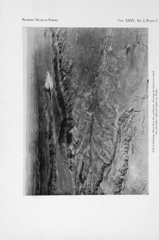
PEABODY MUSEUM PAPERS
VOL. XXXV, No. 2, PLATE I.
_c
_c
to,o.
• 7
E
0u
0
0.7
EEC E
cTs`,13
-tC
Lr..1

PAPERSOF THE
PEABODY MUSEUM OF AMERICAN ARCHAEOLOGYAND ETHNOLOGY, HARVARD UNIVERSITY
VOL. XXXV-NO. 2
PREHISTORIC COAL MININGIN THE JEDDITO VALLEY,
ARIZONA
BY
JOHN T. HACK
REPORTS OF THE AWATOVI EXPEDITION
PEABODY MUSEUM, HARVARD UNIVERSITY
REPORT NO. 92
CAMBRIDGE, MASSACHUSETTS, U.S.A.PUBLISHED BY THE MUSEUM
19492
COPYRIGHT, 1942
BY THE PRESIDENT AND FELLOWS OF HARVARD COLLEGE
PRINTED BY THE GEORGE BANTA PUBLISHING COMPANY
MENASHA, WISCONSIN, TJ.S.A.

PREFACE
THIS report is one of the series giving theresults of the excavations and studies of the
Peabody Museum Awatovi Expedition. The ex-pedition conducted five years' field research,1935-1939, under permission of the United StatesDepartment of the Interior, in the drainage ofthe Jeddito River, which lies partly in the Hopiand partly in the Navaho Indian Reservations,northeastern Arizona, between 35° and 36° N.Lat. The immediate area of investigation includesthe Jeddito Valley, Antelope Mesa, RobertsMesa, Tallahogan Valley, and Bluebird Canyon.Certain studies embrace the entire Hopi countryand Black Mesa as a whole.
Twenty-one sites were excavated by the ex-pedition, a site survey of the Jeddito drainage wasmade, and numerous specialized studies wereundertaken. The field work was supported by theExploration Fund of the Peabody Museum and bythe liberal contributions of Mr. and Mrs. WilliamH. Claflin, Jr., and Mr. and Mrs. Raymond Emer-son, Mr. Henry S. Morgan, and Mr. and Mrs.Phillip Allen.
The Awatovi Expedition grew out of Mr.Claflin's interest in the prehistory of the Hopicountry. During various trips to Northern Ari-zona he had acquired a thorough knowledge of theReservation which has been of inestimable valueto the Expedition. Faith in the archaeological pos-sibilities of the Jeddito Valley led Mr. Claflin toinstigate an extensive reconnaissance trip in 1935which was followed by four seasons of intensiveexcavation.
The activities and accomplishments of theAwatovi Expedition were many and varied. Thefield program included numerous studies outsidethe confines of "ordinary archaeology." It wasthe basic policy of the expedition to encourage thecooperation of students in other branches of learn-ing who believed that their techniques couldappreciably augment the strictly archaeologicalapproach to the problems of prehistory. The pol-icy has been justified beyond all expectation.
The excavated sites revealed remains of habi-tations of the region from early in the secondhalf of the first millenium A.D. to the beginningof the 18th century. In terms of the Pecos Con-
* Roberts, F. H. H., Jr., "A Survey of SouthwesternArchaeology," Am. Anth., Vol. 37, pp. 1-35, 1935.
ference of Southwestern cultures,* on the basis ofarchitecture, pottery, and tree-ring dating, theperiods represented were: Basket Maker III,Pueblo I, Pueblo II, Pueblo III, Pueblo IV, andpart of Pueblo V.
The chief reason for the selection of Awatovi,instead of one of the other large ruined pueblosin the Jeddito, for major excavation was the ap-parent assurance, obtained in preliminary recon-naissance, that it held the longest record ofoccupation. Furthermore, that record was not re-stricted to prehistoric remains, for Awatovi wasthe site of the Franciscan mission of San Bernadode Aguatubi and it is known from definite thoughmeager historic references that the pueblo wasstill inhabited at the close of the 17th century.
It is generally assumed from the descriptiongiven that Awatovi, although not mentioned byname, was the first of the Tusayan pueblos en-countered by Tobar of the Coronado Expedition in1540. Espejo visited Awatovi in 1583, and Onatein 1598. In 1629 the Franciscan mission wasauthorized, and from approximately that date untilthe Pueblo Rebellion in 1680 the inhabitants werein close contact with at least a few Europeans.
After the Rebellion twelve years elapsed beforethe Spaniards returned. In 1692 the "Moqui"pueblos, including Awatovi, were visited bydeVargas with a military expedition and oncemore fell under the influence of Christianity andEuropean civilization. The re-acceptance of Span-ish suzerainty and religion seems to have beenmore complete at Awatovi than in the other vil-lages of Tusayan. This fact may have contributedto the eventual downfall of the town.
The nature of the abandonment of Awatovi isnot very clear. At present, based on Hopi tradi-tion and very limited references in contemporaryofficial New Mexican documents, the followingstory can be pieced out. Sometime during thewinter of 1700-1701 bands of men, probablyrecruited from the Hopi towns of First and Sec-ond Mesas (there is great disagreement in Hopistories on this point), attacked the village and aresaid to have massacred the male inhabitants. Asfar as our information goes, this marked the endof Awatovi as an inhabited site. However, the un-satisfactory nature of this evidence is apparent,and the possibility of people living at Awatovi
4 92

Vi PREFACE
after 1701 must be considered. But we do knowthat at least one hundred and sixty' years of lifeafter the first Spanish contact lies recorded inthese ruins.
A more extensive statement of the field work ofthe expedition, a list of the staff members, and adescription of the plan of publication will befound in the preface to the first report issued:
"Changing Physical Environment of the HopiIndians of Arizona" by John T. Hack, Papersof the Peabody Museum of Harvard University,vol. XXXV, no. 1, 1942.
J. O. BREWDirector and Editor, Arwatovi
Expedition of the Peabody Museum,Harvard University

CONTENTS
PREFACE J. O. BREW JEDDITO MINING AREA . 9Introduction 9
ABSTRACT ix Excavations. 9Tools . .... 11
INTRODUCTION xi Amount of Coal Mined 12
OCCURRENCE OF COAL 3 AWATOVI MINING AREA 12
Black Mesa Coal Field 3 Occurrence of Coal . 12Occurrence in the Jeddito Valley. 3 Ash Heaps ... 12
The Mines .... 13QUALITY OF COAL 4 Amount of Coal Mined 17
USES OF COAL 7 CONCLUSIONS . 17
Use in Ruins Ash Heaps
77
REFERENCES . . 19
Period of Use of Coal 7 BIBLIOGRAPHY OF REPORTS ONABORIGINAL MINING IN THE
MINING TECHNIQUE . 8 UNITED STATES . . 23
LIST OF PLATES
I. End of Antelope Mesa from the southwest,showing the bench on which the coal minesand coal seams are found
II. a. Western end of Awatovi mining areab. Ash heap in Jeddito mining area
III. Trench B in Jeddito mining area
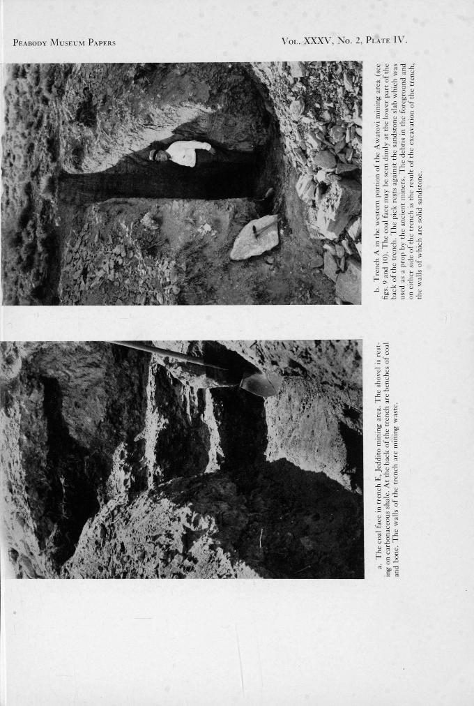
IV. a. The coal face in trench E, Jeddito miningarea
b. Trench A in the western portion of theAwatovi mining area
V. a. The coal face at point C, fig. 9b. Outcrop of mining waste in the under-
mined area
LIST OF FIGURES
1. Generalized geological map of north- 7. Generalized section of cliff at Awatovieastern Arizona . . ..... 2 mining area 13
2. Sketch map of Jeddito Valley showing 8. Plane table map of bench below Awa-location of principal ruins . . . . 6 tovi, showing ash heaps and stripped
3. Ideal section of a typical Hopi strip mine 9 areas 144. Map of excavations, Jeddito mining area5. Section of main trench X-Y in the Jed-
10 9. Sketch map of western portion of Awa-tovi mining area, showing areas of strip-
dito mining area . . ..... 12 ping, and the location of undermined area 156. Reconstructed section of strip mine at 10. Section across arroyo and along trench
time of mining . . . . . . 12 (A, fig. 9) 16
vii


ABSTRACT
THE Jeddito Valley ruins as well as the mod-em Hopi towns are located on the southern
edge of Black Mesa, a dissected aggregate ofsmaller mesas underlain by Upper Cretaceous in-terbedded sandstones, shales, and coal beds. Inthe Jeddito Valley the coal beds crop out on awide bench on the valley rim accessible to theruins. That the inhabitants of the valley utilizedthis coal extensively is shown by the large quanti-ties of coal ash which occur in the ruins of PuebloIII, IV, and V age, or roughly in the 13th to 17thcenturies A.D. Coal was also used for firing pot-tery at least during Pueblo IV time, as is shownby the kinds of broken pottery found in the manyheaps of ashes. The ash heaps are convenientlynear the coal outcrops. One of them was exca-vated and contained a group of pots left in place
"after firing.The simple technique of ancient mining con-
sisted of removing the overburden and excavatingthe coal. The waste was piled behind the miningface. The result of mining was to leave an areastripped of coal and overlying rock, piled highwith heaps of waste material. When the over-burden became very thick the mine was aban-doned, but in at least one area mining by under-ground methods was used.
More than 27,000 tons of coal were minedclose to Awatovi and the total for the wholeJeddito Valley probably exceeded 100,000 tons.Over 90 percent of the coal was carried to thehouses for fuel. Comparatively little was used forfiring pottery. The use of coal was an importantaspect of the culture of the Hopis in this region inPueblo III, IV, and V time. The utilization ofcoal may have been an accidental discovery, butthe technique of mining demonstrates the inge-nuity and industry of the Hopis.
ix


INTRODUCTION
THE modern Hopi Indians are an agriculturalpeople living for the most part in ancient
towns located on the southern edge of BlackMesa.' With few exceptions they use wood forheating their houses, and sheep dung for firingtheir pottery. Coal, which is easily available tothem, is also used to some extent as fuel, but themodern use is very recent. At the time the UnitedStates Government developed mines to supplyschools and agencies the Indians did not use coalgenerally. Several hundred years ago, however, itwas in use as is shown by the observations of aSpanish priest. In 1697, Fray Agustin de Vetan-curt who had visited the Pueblo of Awatovi wrotein his Chi-Mica de la Provincia del Santo Evangelicode Mexico: "There is pumice stone in quantity,and stones which serve for coal, but the smoke isnoxious in its strength." 2
The first proof by archaeological methods thatcoal was burned long ago by the Hopis was foundby J. Walter Fewkes, 3 in 1895, who noticed coalashes in the rooms of Awatovi. Archaeologistsbecame convinced of the former use of coal byeach excavation in the Tusayan ruins. But notuntil 1935 was any detailed information publishedon the subject. Bartlett then wrote a short accountof the heaps of coal ash which are very abundantthroughout the Hopi country near the ancientand modern towns. She believed that pottery wasfired with coal at these spots during Pueblo IVand part of Pueblo V time, and that the use ofcoal was discontinued when the Spaniards occu-pied the region and introduced sheep, whose dungcame to be used in place of coal for firing pot-tery. 4 In 1936 Colton described some ancient coalmines which had been disclosed by modem miningoperations near the Pueblo of Shungopovi on Sec-ond Mesa.'
Excavations of the Peabody Museum AwatoviExpedition indicated that a great deal of coal hadbeen used as fuel by the early inhabitants of theJeddito Valley, and its use extended back as far asPueblo II time. In the 1938 season, the writer, asgeologist on the expedition staff, undertook aninvestigation of ash heaps of the Jeddito Valley
See Hack, 1942, fig. 2, P. 4.2 Hodge, 1904, p. 581.3 Fewkes, 1895, p. 580.4 Bartlett, 1935, pp. 41-44.
region. It became clear that these were indeed theremains of pottery firing heaps, and that potterywas fired with coal near the coal outcrops. In asearch for the source of the coal it was found thatmuch could be learned about the technique of coalmining and that the mining of coal went on ac-tively from the latter part of Pueblo III time,through Pueblo IV and the early part of Pueblo Vtime, or roughly from the 13th to 17th centuriesA.D. It was, in fact, a major Hopi industry. Theprincipal technique was the simple one of stripmining. So much coal was mined by this methodthat it seems probable that it largely supplantedwood as fuel.
The Hopi apparently discovered the value ofcoal at about the same time as the English. Coalwas known in England at least as early as the 9thcentury, A.D., but it was not generally used inLondon until the 13th century.' At first it wasused as a substitute for charcoal, because it waseasier to obtain and therefore cheaper. As thechimney was developed its use grew and finallyit became an important factor leading to the in-dustrial revolution.' Although in the Hopi coun-try the use of coal had the same beginnings as inEngland, it led to no important changes in theculture of the inhabitants. It was used extensivelyfor a time and then almost forgotten.
In the following report, the terms Pueblo II,Pueblo III, Pueblo IV, and Pueblo V are fre-quently used. They refer to major divisions of thePueblo chronology and are used here in the sensefirst proposed at the Pecos conference in 1927,i.e. Pueblo II extends roughly from 900 to 1100A.D., Pueblo III from 1100 to 1300 A.D., PuebloIV from 1300 to 1600 A.D., and Pueblo V from1600 A.D. to the present.
The importance of coal as a natural resource ofthe peoples ancestral to the modern Hopi was seenby Dr. J. O. Brew, the Director of the PeabodyMuseum Awatovi Expedition, and Mr. A. B.Stevens, surveyor to the 1935 expedition. In thesummer of 1938, the writer, at Dr. Brew's sug-gestion, undertook a study of the ash heaps usedfor firing pottery, and out of this study the presentone developed. The writer was greatly aided in
' Colton, 1936, pp. 59-61.Brew and Hack, 1939.Rickard, 1922.
xi

xii THE CHANGING PHYSICAL ENVIRONMENT OF THE HOPI INDIANS OF ARIZONA
archaeological matters by Dr. Brew, Mr. J. A.Lancaster, and other members of the expeditionstaff. The work was financed by the PeabodyMuseum, and labor and materials were generouslysupplied whenever needed.
Coal samples were generously analyzed free ofcharge by the U. S. Bureau of Mines (see p. 5).The interest of Mr. Wilmer C. Roberts of Jed-dito Trading Post in the development of the study
was greatly appreciated. The writer is especiallyindebted to Professor Kirk Bryan who visited theexcavations, made many valuable suggestions, andguided the preparation of the manuscript, and toProfessor D. L. McLaughlin.
JOHN T. HACK
Hofstra CollegeHempstead, N.Y.September, 1941
PREHISTORIC COAL MINING IN THE
JEDDITO VALLEY, ARIZONA

.37°,_ _111 * —•
As.
..,
-- UTAH . . 110ARIZONA 1:'.4 Tertiary sedimentary rocks
1 r._,;":1 Tertiary volcanic rocks
( &N Mesaverde fm "(coal bearin)), B...--,,.. ' or A Man.cos"and 'Dakota fme. cs-̀:,43
f•-•••••• 4-515fayenta....., l
• .
(coal bearing),Pre-Cretaceous rocksExisting coal' mines
' t
i5Z'14 ,
o i...
t.\\. .. \ ‘\
/\\ \N( zarach;„6.
..
f . 41 \ '64•.!4. 1(t VAsib
BLACIT MESATkr p '' \ ./,
••I/*,/
'.11 =,
/oMponkopi
0- 4\/ n \\\
vo,§1
.• I -\•-?: .,--••••---
(.. .
: •.........• .
A
36°A ,
. r A101Or ail .e. ....4--4:4., 30 '
• P 0— ,0 N p,,E ,",:' V v.. / N ti/ A.4, , ir \N •
N 1tklk i,./
4( \ 1 '.,
/•4 A
1•Ir .
t ,oc °7 Os..
zw,sa..tovr # '6 44s -6- ana 'doI A
.. •''''' 1?97 •Vl...''. 0,‘
6o . .• ; .'• . .
n
• 1n
tk N
_V/,--"'e .( /
Oil r;3 / -,-- \-,..4-‘7-
- -%-‘11.,!.. , \
•44 ) N0 ,N
I
N-.e.
' -r
._ —_--. r-..<
l%
0 ---LT)-1. •',a
HOP/ BUT ES'*- clZ i''q\ k '0 .1
a 6. ) .../••:./
:•19V.1.--...
Lx,)ç
....)--
•
...
...1.A#0,040
• • • • • . •• • • .• . • .- • ... ...... .... :
•".-e
/
:..n ''. ° t
..
,P"- • • ... ... ••
.-.../
Winslow. \ ..._...../ • .. .
IPIRY' Holbrook
.•,-•.,
111 0
—1100 . .
40 .Miles1 Kilometers
9
2,0 o
Fm. 1. Generalized geological map of northeastern Arizona, after N. H. Darton, "Geologic Map of Arizona."Boundaries of Tertiary rocks subject to correction.

PREHISTORIC COAL MINING IN THE JEDDITO VALLEY, ARIZONA
OCCURRENCE OF COAL
BLACK MESA COAL FIELD
IT is characteristic of the Plateau Country that the rock strata are not strictly horizontal, but
are gently warped or folded into broad shallowdomes, or arches, and corresponding structuralbasins. Erosion has beveled the edges of thewarped rock strata and exposed the cores ofdomes, and the edges of beds bent down into shal-low structural basins. The present topographydoes not depend on the gentle structures, but highplaces exist where the rocks are hardest, and lowplaces are generally carved out of softer rocks.All the rocks older than the Tertiary were in-volved in the folding from the pre-Cambrian tothe Upper Cretaceous. The coal of the region oc-curs entirely within the Upper Cretaceous rocks.In most places they have been stripped off by ero-sion, but they remain and are now exposed in thebroadly downwarped structural basins. There areseveral basins in the Plateau Country which pre-serve the Upper Cretaceous rocks. One of thelargest is known as the Tusayan downwarp. It isa large area, extending from the Little ColoradoRiver on the west, to the Chinle Wash on theeast, and from Holbrook on the south to theMonument Valley and Kayenta region on thenorth. At its center the Upper Cretaceous coalbearing rocks are exposed. Since the upper bedsof this group of rocks are more resistant than theunderlying next older rocks, they rise to a higherlevel, and hold up the outline of the complex ofmesas which taken together are called BlackMesa. Thus the area of Black Mesa is underlainby rocks containing coal beds at several horizons,and the region is known as the Black Mesa coalfield.
In general the Upper Cretaceous rocks of theBlack Mesa region may be divided into 3 zones,an upper zone predominantly of sandstone, a mid-dle zone predominantly of shale, and a lower zonepredominantly of sandstone, all three containingsome coal. Gregory called these the Mesaverdesandstone, Mancos shale, and Dakota sandstone.respectively, correlating them on lithologicgrounds with similar Upper Cretaceous rocks ofsouthwestern Colorado.' Although it has beenshown by Reeside and Baker that the "Mancos"
represents only a small part of the typical Mancos,and that the "Mesaverde" is considerably olderthan the typical Mesaverde,' the terms applied byGregory are still retained.
Coal occurs principally in the Mesaverde andMancos formations, though small seams of poorquality are sometimes found in the Dakota. Atthe present time, mines are operated in both ofthe upper formations. Campbell and Gregoryhave estimated that there are over 14 billion tonsof coal in these two formations in the Black Mesacoal field.'"
Black Mesa may be described as a greatly dis-sected group of smaller mesas or plateaus sepa-rated by narrow valleys.'"a It is about 50 miles indiameter, and rises from 500 to 1500 feet abovethe surrounding country which consists of lowerand less dissected plateaus. The individual mesasof the aggregate are underlain by the Mesaverdesandstone, and their elevation is preserved becauseof the resistant nature of this rock. As a whole,Black Mesa slopes gradually to the south andsouthwest. The streams of the region head in itsupper portions, and flow southwestward. Theybegin in narrow steepwalled valleys which widentoward the southwest. At the southern and loweredge of the mesa the streams have cut broadervalleys, leaving the Mesaverde sandstone pro-jecting southwestward in long narrow prongs,known as Roberts, Antelope, First, Second andThird Mesas. The valleys between these prongsare underlain by the Mancos shale, which alsocontains coal. But the valleys are also filled withalluvium so that the only coal available to theprimitive miners is that in the Mesaverde sand-stone which crops out in the cliffs that bound themesas. The Hopi towns, ancient and modem, withthe exception of Moenkopi are located near theedges of the Mesa within short distance of theoutcropping coal beds.
OCCURRENCE IN THE JEDDITO VALLEYThe present study was conducted entirely
along the north wall of the Jeddito Valley, whichlies between Roberts Mesa and Antelope Mesa.
8 Gregory, 1917.9 Reeside and Baker, 1929, p. 35.1 ° Campbell and Gregory, 1909, pp. 229-238.1°' See fig. 2, Flack, 1942.
3

4
PREHISTORIC COAL MINING IN THE JEDDITO VALLEY, ARIZONA
Many large ruins of Pueblo III and IV age arelocated on the southern edge of Antelope Mesaoverlooking the valley. One of them, Awatovi,was continuously occupied during Pueblo III, IV,and V time. A sketch map of this region is shownin fig. 2. Like the rest of the Hopi Country, thefloor of the Jeddito Valley is underlain by theMancos shale, and the valley walls are largelycomposed of the Mesaverde sandstone. In the re-gion of Awatovi the north wall of the valley isabout 500 feet higher than the lowest point of thevalley floor, and the wall itself is a rather pre-cipitous cliff about 350 feet high. The lower 85feet of this cliff belongs to the Mancos formation;the upper 265 feet belongs to the Mesaverde for-mation. This formation consists predominantly ofinterbedded sandstones and shales, sandstonebeing dominant Where sandstone beds crop outthe slopes are steep, and where shale beds cropout the slopes are usually gentle. Thus the cliffhas a step-like cross-section rising upward in aseries of benches of varying width. The base ofthe formation is composed of 112 feet of massivesandstone. Above this, as shown in fig. 7, lieabout 50 feet of soft interbedded sandstones andshales. Here two coal seams crop out. Above thewide, sloping bench is a steep cliff, about 150 feethigh, rising in sharp steps to the top. Thus thecoal beds at Awatovi lie on a wide bench about150 feet below the top of the mesa edge.
This same bench may be traced a distance east-ward along the mesa edge. However, further upthe valley, the floor of the valley rises with re-spect to the top of the cliff wall so that at the ruinof Lululongturque the bench is much closer to thevalley floor. Beyond this ruin, the bench and thecoal seams lie at an elevation below the valleyfloor.
As shown in fig. 7 there are two coal seams onthe wide bench near Awatovi. The lower one isabout 1-1- feet thick, and the upper one is only 8inches thick. Near Jeddito at the same horizon,there is only one large seam, which, however, isabout 6 feet thick.
At the present time the outcrop of the coal isgenerally obscured by mining waste, landslides,and slope wash, as well as dune sand. But in pre-historic times, before it was mined, the coal musthave cropped out in many places, and an abundantsupply must have been exposed or only slightlyconcealed by a thin cover. Such outcrops weresufficiently numerous so that opportunities tomine were present at each ancient town.
In many places, however, dune sand extendsfrom the valley floor to the mesa top, and thusburies or partly buries the cliffs and covers thecoal to a considerable depth. The dune sand is nolonger moved by the wind except where it hasbeen disturbed. It was in place on the valley wallslong before the occupation by the Hopis or theirimmediate predecessors." With the exception ofthe areas covered by ancient dune sand or by largelandslides the coal seams were exposed or couldbe uncovered for mining by the removal of a thinmantle of debris and slope wash. Conversely it isa safe assumption that no mines once operated bythe Indians are now covered by dune sand.
QUALITY OF COAL
Though coal is abundant in the Hopi Country,its quality is poor when judged by modern stand-ards. Coal seams always contain impurities, eitherin the form of lenses or layers of carbonaceousshale, known as bone, or in the form of impuritiesin the coal itself which will not burn, usually re-ferred to as ash. The Black Mesa coal seams usu-ally contain much bone, and the coal between thelayers of bone has a high ash content. Further-more the coal usually contains sulfur which makesthe burning of it in an open fire rather unpleasant.
The coal seams are not uniform from place toplace in any of their characteristics. In general,the coal may be classed as subbituminous. Expo-sure of the coal to the air, however, decreases itsquality after a time, and it is thought likely thatwith the sporadic mining presumably used by theprimitive miners of the region, an unweatheredcoal face was rarely exposed. Such exposurewould certainly have resulted in considerable loss.Three samples of the coal seams of the north wallof the Jeddito Valley were collected in the locali-ties of the ancient mines. In making these samplesthe amount of bone in the coal seam was meas-ured, and then it was discarded. The samples werenot of fresh coal, but of more or less weatheredcoal, probably typical of the coal actually burnedby the Indians."
Large seam near Jeddito Trading Post: This coalseam is about 6 feet thick. It contained wheremeasured about 40 percent bone, distributed inthe seam as follows, from top to bottom:
n Hack, 1942, p. 39.12 The 3 samples were very generously analyzed by the
U. S. Bureau of Mines.
bonecoalbonecoalbone
Feet02o
o
QUALITY OF COAL
Inches v7o g2S254
HydrogenCarbonNitrogenOxygenSulphurAsh
.7 .6 .7
5
1.0
coal o 11bone o 6
British thermal units 8530 7530 9170 11900
11 Softening temperatureof ash 2860° F.
An analysis of the coal of this seam shows that itcan be classed as a lignite:
Analysis i
Air-dry Loss 14.8Coal(Air
dried)
Coal(As re-ceived)
Coal(Mois-
turefree)
Coal(Mois-turc andash free)
Moisture 10.9 24.0Volatile matter 34.6 29.5 38.8 54.3
*P Fixed carbon 29.1 24.8 32.7 45.7
494'4 Ash 25.4 21.7 28.5
100.0 100.0 100.0 100.0
0 w f HydrogenCarbonNitrogenOxygen
<4 Sulphur .9 .7 1.0 1.3Ash
British thermal units 6140 5230 6890 9630Softening temperature
of ash 2800°F.Classification of Coal: (47.-68)-NAa.Lignite.
Lower seam at Awatovi: This seam was the oneprincipally used by the inhabitants of Awatoviboth for firing their pottery and as fuel in theirtowns. It is 1 foot 6 inches thick where measured,and contains a layer of bone in the middle 4 inchesthick. The coal of this seam is classed as subbitu-minous .
Analysis 2Coal Coal
Coal
Coal (Mois- (Mois-Air-dry Loss 11.7 (Air (As re- ture turc and
dried) ceived) free) ashfree)
V,, '41 Moisture 7.0 17.9
Volatile matter 32.6 28.8 35.0 45.4oc Fixed carbon 39.1 34.5 42.1 54.6
Ash 21.3 18.8 22.9
100 .0 100.0 1 00.0 100.0
Classification of Coal: (56.-94)-NAa.Subbituminous B.
Upper seam at Awatovi: This seam is 8 inchesthick, and contains no bone, where sampled. It isalso of subbituminous grade. It was apparentlyused mostly for firing pottery.
Analysis 3
CoalAir-dry Loss 4.7 (Air
dried)
Coal(As re-ceived)
Coal(Mois-
turcfree)
Coal(Mois-
turc andash free)
Moisture 8.3 12.6Volatile matter 31.4 29.9 34.2 54.3Fixed carbon 26.4 25.2 28.8 45.7Ash 33.9 32.3 37.0
100.0 100.0 100.0 100.0
HydrogenCarbonNitrogenOxygenSulphur 1.0 .9 1.0 1.6
Ash
British thermal units 6270 5970 6840 10850Softening temperature
of ash 2340°F.Classification of Coal: (48.-92)-NAa.Subbituminous C.
Though the coal of the region is of poor qual-ity, it makes an economical fuel for use in theU. S. Government buildings, and it has come tobe used by the modern Hopi and Navajo Indiansto some extent, who now operate many smallmines in the region. Furthermore, were it not forthe fact that the Black Mesa coal field is so farfrom a large market for coal it might be minedcommercially. At Gallup, New Mexico, coal ismined from the Mesaverde formation, and itsquality is little different from that of the BlackMesa coal. Comparing the two, Campbell andGregory say : 13
3 Campbell and Gregory, 1909, p. 238.

6
PREHISTORIC COAL MINING IN THE JEDDITO VALLEY, ARIZONA
USES OF COAL 7
In physical appearance the Black Mesa coal appears tobe somewhat superior to the Gallup coal. Joints are morehighly developed in the Black Mesa coal and it will prob-ably withstand the action of the weather better than theGallup coal. It evidently belongs on or about the dividingline between bituminous and subbituminous coal, but thehigher percentage of ash would doubtless be a drawback ifthe coal were put on the market.
The Gallup coal field is on the Santa Fe Rail-road, but the Black Mesa coal is over 70 miles byroad from the nearest railroad or large white set-tlement. Thus it is likely that it will be used onlylocally for some time to come. As a fuel it is eco-nomical because of its abundance and not becauseof its quality, and this was probably as true inprehistoric time as it is now.
USES OF COAL
USE IN RUINSIn the course of the excavation of the site of
Awatovi many fire pits in houses and kivas havebeen uncovered which contain coal ash. Further-more the waste material, or the fill of the ruins,which consists of broken stones, ashes, sand, andtrash of all kinds, contains a large amount of coalash throughout much of the ruin of Awatovi, andcoal ash has been seen in the fill of many otherruins in the Hopi Country of Pueblo III, IV,andV age. The quantity of the ash suggests that itwas used extensively. Coal ash was found in fire-pits in the kivas (subterranean ceremonial cham-bers) and in firepits and crude stone "stoves"both inside and outside the houses. It was not usedexclusively, however, as wood ash is also com-mon. In Pueblo IV kivas two firepits are alwaysfound, one containing coal ash, the other woodash. The flagstone floors of these kivas were oftenlaid upon a bed of coal ash and clinkers.
ASH HEAPSNumerous heaps of coal ash are found along the
benches of the north wall of the Jeddito Valley,close to the coal seams. The typical ash heap isabout 10 feet in diameter', about 3 feet high, androughly conical in shape. It is composed of buffcolored, fluffy coal ash, with many fragments ofwhite or reddish burned bone and shale. Potteryfragments lie scattered throughout the heap,many of which are hard, reddened, and obviouslyimproperly fired.(Erosion has removed the fluffyash from the surface of the heap, leaving a hardresistant cover of shale, bone and pottery frag-
ments. It is only by digging through the surfacethat the fine coal ash is exposed.
Ç. large ash heap near Jeddito Trading Post wasexcavated (see fig. 4). Near the top of the heap anest of miniature undecorated pots was found,completely fired, but left in place and surroundedby coal ash, and slabs of burned shale. This findproves conclusively that the ash heaps are theremains of pottery firing places. Further excava-tion in the ash heap disclosed many large slabs ofreddened sandstone and burned shale which wereprobably used during the firing to hold the potteryor to control the draught. Also several lenses ofwood charcoal, and burned corncobs were found.These materials were probably used in kindlingthe coal fires. The presence of several such lensesof residues from kindling, as well as the stratifica-tion of the coal ash prove that the heap was builtup gradually and was the result of not one butmany firings in the same place.1
The ash heaps in the Jeddito Valley are dis-tributed along the benches of the cliff close to thecoal seams. Clay beds also crop out on the benches,and it is probable that the pottery was made andfired near the necessary coal and clay rather thanin the towns as is now the custom.taksh heaps areprobably more abundant near thé large JedditoValley ruins than in other places along the valleywall, but they are found wherever the bencheson the cliff are not covered with dune sand of pre-mining age. It is probable that the location of ashheaps is controlled as much by the accessibilityof the coal as by the distance from the ruins.
;Bartlett believes that the use of coal for firingpottery was the most important factor in thechange in pottery types from Black-on-white toBlack-on-yellow» This hypothesis is supportedby the fact that no Black-on-white or earliersherds were found on any of the ash heaps ex-amined in the Jeddito Valley region. Collectionswere made from over 30 ash heaps. Pueblo IVtypes of sherds are abundant in and around all ofthe ash heaps.
PERIOD OF USE OF COALIt has been shown that coal was used exten-
sively both as fuel in the towns and as fuel forfiring pottery. Its earliest use for firing potteryseems from the evidence available now, to havebeen early in Pueblo IV time. Its use in the vil-lages, however, antedates this. Throughout PuebloIII and IV time, it was used extensively for
14 Bartlett, 1935, pp. 41-44.

8 PREHISTORIC COAL MINING IN THE JEDDITO VALLEY, ARIZONA
heating and cooking in the houses and kivasand continued to be used in Pueblo V or Spanishtime as we know from the ash in the fill of thatperiod, as well as from the mention of its use bya Spanish priest (see page xi). But its use becameless general sometime during e seventeenth,eighteenth or nineteenth century. The Hopis usecoal at the present time but have been taught touse it by the U. S. Government employes of theIndian service. The Hopi workers who assisted inthe excavation of the ancient mines seemed to lackcompletely any knowledge of the manner of oc-currence of coal, and the large areas of miningwaste apparently meant nothing to them. ModernHopi pottery is fired with sheep dung and wood.
MINING TECHNIQUEIn modern coal mining several techniques are
used in obtaining coal from flat-lying rocks, incoal fields similar to those of the Hopi country.One of the most obvious mining techniques is thesimple one of quarrying, or open pit mining, inwhich the overburden above the coal is removedand the coal is then taken out. This method iscommonly called strip mining as the overburdenis "stripped off." It is used when the overburdenis thin enough so that it is cheaper to remove itthan to undermine and support the roof. In modernmining of flat-lying coal beds, strip mines infavorable places yield very cheap coal, but under-ground methods are the usual technique.
There are two general types of undergroundmethods. The first is known as the room andpillar method. In this method a shaft is sunkthrough the overburden to the coal seam, or atunnel is driven into the coal where it crops outon a hillside. The coal is then taken out through apermanent way or tunnel, supported by pillars ofcoal on either side, which are of sufficient sizeto support the roof. From this tunnel, secondarydrifts are cut and rooms excavated. Bodies of coal,or pillars, are left between the rooms to supportthe roof.
The second type is known as the longwallmethod. In this technique the coal is completelymined from a continuous face or breast extendedfrom the main or a branch, access tunnel whichprovides entry from the shaft or outcrop. Nopillars are left and the roof is allowed to cave asmining progresses with only enough support pro-vided by timber props or pack walls to keep spaceopen for actual mining and the removal of coal.The pack walls in modern mining usually con-
sist of waste rock, taken out in the mining opera-tion and piled up so as to form a support for theroof, and to prevent its collapse at the face wherethe miners are working and also along the accesstunnels. The packing material is usually knownas "gob." The partial caving of the roof whichtakes place at the mining face as the coal is re-moved aids the miner, as the pressure of the roofcauses the coal to spall off.
Thus it may be said that three main types ofmining are in use today for removing coal fromessentially flat-lying rocks. The first, and simplestof them is open pit, or strip mining. In manyplaces it is considered that one foot of overburdencan be profitably removed by hand for each footof coal obtained. By the use of power shovels orhydraulic methods, thicker overburden can betaken off. When the overburden is thick in pro-portion to the coal seam, one of the undergroundtypes of mining is usually cheaper.
The inhabitants of the Jeddito Valley used aprimitive form of strip mining, and it can beshown in two places that they also resorted tounderground mining, and used primitive forms ofboth the longwall and possibly the room andpillar methods.
In the Jeddito Valley the coal seams crop outalong the cliff, usually on a wide bench. The mostcommon situation is that the coal seam is overlainby soft sandstone, and underlain by shale. The coalseam ordinarily crops out but is covered by débrisof its own weathering and by sand and rock frag-ments washed down from the slope above. Thefirst operation in the primitive form of strip min-ing which was used here is to clear the coal seamby removing the weathered coal and the slopedébris. This waste is piled behind the miner.Following this operation the coal face, now ex-posed, is broken up and the coal removed. Thisis most easily done by removing it in benches. Thefirst or uppermost layer of coal is picked out orhammered out down to a layer of bone, producinga bench floored by bone. Then the bone flooringthe bench is removed and discarded. The coalbelow this layer of bone, and above the next layerof bone is then removed, and so on. Thus the coalface is worked back in a series of benches, eachone floored by bone. The bone is piled in heapsbehind the miner. The miner continually worksin an open trench with piles of waste behind himand the coal and rock face in front of him. Asmining continues the overburden of sandstonebecomes increasingly thicker. This must be ex-

Waste, mostly sands/one
14/a3te, MX*/ &,,e
JEDDITO MINING AREA 9
FIG. 3. Ideal section of a typical Hopi strip mine.
cavated and discarded with the bone, so that asoperations continue the débris piles behind theminer contain more and more sandstone frag-ments. Finally as the overburden becomes verythick the amount of waste increases greatly, thedébris piles become much larger, and the propor-tion of sandstone fragments to bone becomeslarger.
The result of this operation is to strip the coaland sandstone from the underlying shale, leavinga flat area of shale overlain by mining waste, theproportion of sandstone to bone in the waste in-creasing toward the cliff. An ideal cross sectionof such a mine is shown in fig. 3.
The limit of mining by such a method isreached when the cost of removing the over-burden exceeds the value of the coal. As theancient Hopis had no accounting system theymust have reached a decision on this point bysome other means. After a strip mine is aban-doned, the débris piles will be partially eroded,and the open trench at the coal face will be filledin with slope wash. This type of mine is ex-tremely common along the north rim of theJeddito Valley. In many places areas of flat shalemay be seen just below the coal horizon. Alsoaround the largest mines the outlines of the greatdébris piles may still be seen. But most commonlythe mines are covered with slope wash, and theoutlines are so modified that they can be com-pletely verified only by excavation.
Below the ruin of Awatovi a primitive form ofthe longwall technique was found, in which themining was carried in under the thick overburdenof sandstone at the back of a strip mine. The over-burden was held up by gob packed in behind theminer. The details of this mine will be describedin a later section (page 16)). This technique wasprobably resorted to because it seemed easier tothe miners to undermine the overburden, andtake the risk of being trapped under it, than toremove it; and for some reason it must have beenless laborious than starting a new strip mine.
Colton has described ancient mines on SecondMesa, which appear to be of the room and pillartype." They consist of small irregular rooms cutout of the coal seam, but no such mines werefound in the Jeddito Valley.
Ancient mines were studied in two localities,one near Jeddito Trading Post, and one nearAwatovi (localities B and A, fig. 2). From adescription of these mines it is possible to showthat the methods of mining outlined above werefollowed and that the strip mining technique wasthe one most commonly used.
JEDDITO MINING AREA
INTRODUCTION
The Jeddito mining area is near Jeddito Trad-ing Post where ash heaps are abundant, andwhere there is evidence of the removal of con-siderable amounts of coal. The coal in this regionoccurs in one large seam, about 6 feet thick, whichis underlain by dark gray to black shale and isoverlain by soft sandstone. In most places thecoal is covered by slope wash and mining wasteand now crops out in only a few places. The coalis of slightly poorer quality than the coal nearAwatovi, and is probably a lignite. It containsmany layers of bone, and a high percentage of ash.
About 30 ash heaps, all of Pueblo IV age, andsome of them very large, were counted in thisarea at situations close to the altitude of the coalseam. Nearby are several small ruins occupiedduring Pueblo IV time, including Pink Arrow,and Nesuftonga. A larger ruin, Kokopnyama, isless than a mile away, and it is possible that theinhabitants of all these ruins used the JedditoMining area.
EXCAVATIONSOne of the largest of the ash heaps was trenched
(see also page 11), and after finding mining waste
1 5 Colton, 1936.

Surface debris(Mostly Slope Wash)
Sandstone 51ocks
1 0 PREHISTORIC COAL MINING IN THE JEDDITO VALLEY, ARIZONA
FIG. 4. Map of excavations in the Jeddito mining area.
beneath the ashes, it was decided to trench thefill between the ash heap and the hillside. Thefirst trench was run in a northwesterly direction,at right angles to the local slope of the hill (fig. 4).At a depth of about 2 meters (6.5 feet) below thesurface, a layer of carbonaceous shale was en-
countered. The material above the shale wasloose mining waste containing many fragmentsof sandstone and here and there a potsherd. Thetrench was extended for a distance of 10 meters(32.8 feet) toward the hill slope. In the bottomof the trench and at a uniform elevation carbona-
JEDDITO MINING AREA 11
ceous shale was exposed. As the trench advancedsandstone blocks became more numerous andlarger, so that the expense of trenching becametoo great, and this trench was abandoned (B,in fig. 4). Two shorter trenches were then dugat right angles to it. These trenches encountereda bench of coal above the carbonaceous shale.Finally a separate trench was dug farther south(E, fig. 4), which encountered the whole coal face.
A plan of the trenches is shown in fig. 4. Intrench E several benches in the coal seam, eachone floored by bone, are exposed. The wholeseam was encountered in this trench. In trenchesC and D, only part of the coal seam, the lowestbench is exposed. The main trench (B), is flooredby carbonaceous shale, underlying the coal. Theline along which stripping began is defined bythe outer edge of the carbonaceous shale, intrenches E and B. The line which marks the topof the coal, or the end of stripping may be locatedat the end of trench E. The position of this linein the area north of E must be estimated, as theother trenches were not carried far enough toencounter the whole coal face. However, thisestimation can be easily made. A hard sandstoneledge crops out on the hillside as shown in fig. 4.Stripping must have ended at the ledge. Numerousblocks of the sandstone have slumped down thehillside and now rest on the surface débris. Pre-sumably these blocks have slumped since themining. Thus the original ledge at the time of themining ended can be reconstructed by fitting theblocks back into place, and this line is the limitof strip mining. Thus at this locality the limitsof mining are known with fair accuracy, andalso the thickness of the coal seam, so that theamount of coal removed can be estimated.
The excavations prove the existence of stripmining, as the underlying shale, excavated to aflat surface, is covered with mining waste andslope wash, whose artificial character and PuebloIV date are proved by potsherds contained in it.Also the trench exposes the coal seam with thebenches left by the miners. One wonders whythe wide benches of coal exposed in trenches Cand D were not removed. Perhaps during themining they were carelessly or accidentallycovered with débris, and once covered the ancientminers forgot or did not bother to clear them. Thestratification of the débris as exposed in the wallsof the trenches suggests that the débris consistsof a complex of small individual piles, modifiedby erosion and covered with slope wash. This
evidence supports the presumption that miningwas sporadic. The miners returning to theirexcavations after a period of absence might easilyforget that small bodies of coal were left un-excavated by the previous operation.
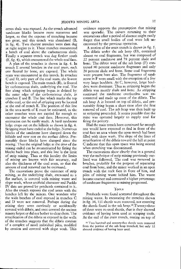
A section of the main trench is shown in fig. 5.The débris under the ash heap (D), containedalmost no coal fragments, but was composed of22 percent sandstone and 78 percent shale andbone. The débris west of the ash heap (F) con-tained 80 percent sandstone fragments and only20 percent shale and bone. Some coal fragmentswere present here also. The fragments of sand-stone in F were small with the exception of a fewvery large boulders. At C, however, large boul-ders were dominant. Thus as stripping began thedébris was mostly shale and bone. As strippingcontinued the sandstone overburden was en-countered and made up most of the débris. Theash heap A is located on top of débris, and pre-sumably firing began a short time after the firstremoval of coal. The ash heap was then built upas stripping proceeded. It seems possible that themine was operated largely to supply coal forfiring the pottery.
Had the main trench been continued far enoughone would have expected to find in front of thecoal face an area where the open trench had beenfilled with slope wash. The slope of the lines ofstratification of the débris toward the hill at pointC indicate that this open space was being nearedwhen trenching was discontinued.
The excavations show clearly that in a generalway the technique of strip mining previously out-lined was followed. The coal was removed inbenches, probably for the purpose of separatingcoal from bone, and the miner worked in an opentrench with the rock face in front of him, andpiles of mining waste behind him. The wastebecame coarser and contained a higher percentageof sandstone fragments as mining progressed.
TOOLSPotsherds were found scattered throughout the
mining waste. In excavating the trenches shownin fig. 34, 111 sherds were removed, not countingthe sherds found in the ash heap.' 6 Twenty-threeof them were re-used sherds, that is they showedevidence of having been used as scraping tools.At the end of the main trench, resting on top of
16 Two hundred and seventy-five sherds were removedfrom the portion of the ash heap trenched, but only 12showed evidence of having been used.
12 PREHISTORIC COAL MINING IN THE JEDDITO VALLEY, ARIZONA
Mining face
i projectedsal/op
T Mders
1 P 2P Fee+FIG. 5. Section of main trench X-Y in the Jeddito mining area. C—coarse waste, F—fine debris or waste, mostly of sand-stone fragments, D—waste mostly of bone and shale, A—ashes, S—slope wash.
the shale a hammerstone was found, of heavy,quartzitic sandstone. It was probably used inbreaking up overlying rock, or in breaking upthe coal. Potsherds may have been used at thecoal face in prying coal loose by working alongits prominent vertical joints.
AMOUNT OF COAL MINEDIn the area shown in fig. 4, which is only a
small part of the Jeddito mining area, about 2000cubic feet of coal were removed. In this estimateallowance is made for the discarded bone. Thevolume of the ash heap is about 300 cubic feet orabout one sixth of the volume of the coal whichhas been removed. As this coal seam has a highash content it is a safe assumption that nearly allthe coal mined at this place was burned on theash heap. However, a brief survey of the wholeJeddito Mining area indicates that the totalamount of coal mined was probably many tonsin excess of the amount needed to supply the ashheaps.
AWATOVI MINING AREA
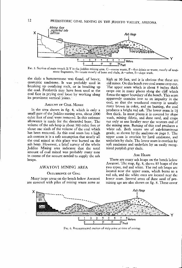
OCCURRENCE OF COALMany large areas on the bench below Awatovi
are covered with piles of mining waste some as
high as 30 feet, and it is obvious that these areold mines On this bench two coal seams crop out.The upper seam which is about 8 inches thickcrops out in many places along the cliff whichforms the upper boundary of the bench. This seamapparently contains iron as an impurity in thecoal, so that the weathered outcrop is usuallyrusty brown in color, and on burning, the coalproduces a bright red ash. The lower seam is 11feet thick. In most places it is covered by slopewash, mining débris, and dune sand, and cropsout only at one locality near the western end ofthe mining area. Burning of this coal produces awhite ash. Both seams are of sub-bituminousgrade, as shown by the analyses on page 5. Theupper seam is overlain by hard sandstone, andunderlain by shale. The lower seam is overlain bysoft sandstone and underlain by an easily recog-nized purplish gray shale.
ASH HEAPSThere are many ash heaps on the bench below
Awatovi. The map, fig. 8, shows 85 heaps of thetwo types, red and white. The red ash heaps arelocated near the upper seam, which burns to ared ash, and the white ones are located near thelower seam. Several areas of dune sand of pre-mining age are also shown on fig. 8. These cover
X
FIG. 6. Reconstructed section of strip mine at time of mining.

AWATOVI MINING AREA 13
the lower seam, but in most places do not extendhigh enough to cover the upper seam. Thus ashheaps of the red type are found all along the cliffto the end of Antelope Mesa. Although the whiteash heaps are much more numerous than the redones they are confined to the smaller areas notcovered by dune sand. The area shown in fig. 8has the greatest concentration of ash heaps, nearAwatovi, but farther east there are other largeconcentrations of ash heaps and heaps of miningwaste.
THE MINES
The mines at Awatovi are probably the largestin the Jeddito Valley region. A generalized cross
Proiectec positionof rot»
piles of mining waste became so high that the coalface of the lower seam is now buried to a greatdepth in most places. In the western part of themining area the lower seam does crop out in asmall arroyo in the area of the detailed map (seefig. 8). Elsewhere it is buried by mining waste,so that the northern limit of stripping must beestimated.
Fig. 8 shows two boundaries for the strip minesof the lower seam, a maximum and a minimum.The ash heaps are built on piles of débriswhich in some cases are known to be piles ofmining waste; others may be shale beds coveredwith loose slope débris. It is possible to determinethe exact limit of stripping only by excavating,
'me.s3venie fie
//u iurn///7/1/ ///// /
Shale, attributed to -Mancos.fm:
• 3.° 4° 30 Mtters•sO too ir 200 Feet
FIG. 7. Generalized section of cliff at Awatovi mining area.
0 10
section of the cliff in this area is reproduced infig. 7, and shows the relation of the two coalseams, the ash heaps, and the mining waste, to thetopography and to the rocks that form the cliff.The succession of sandstones and shales is some-what generalized and applies best to the westernpart of the area shown in the map of fig. 8. Muchcoal was taken out in this area as shown by thelarge areas of stripped shale overlain by miningwaste. The piles of waste are, however, incon-spicuous as they are in many places eroded andcovered with slope wash.
The ground plan of the strip mines can beroughly determined by mapping the southernedge of the areas of stripped shale, which cropsout beneath the mining waste, or is exposed wherethe mining waste has been eroded. This edgemarks the line of beginning of stripping. The lineof the end of stripping is of course buried byslope wash, and in the Awatovi mining area the
the expense of which is prohibitive, for in manyplaces trenches 20 to 30 feet deep would be neces-sary. However, in places arroyos cut back intothe high piles of débris north of the line of ashheaps and have uncovered mining waste in theirwalls. Thus probably most of the lower whiteash heaps were built on high piles of mining wasteas indicated in the section, fig. 7. Other heapsmay have existed which, as mining proceeded,were buried by mining waste and cannot now beseen.
There is only one large stripped area at thelevel of the upper coal seam. Red ash heaps,however, occur near the upper seam where thereis now no evidence of stripping. These places aredesignated by the letter A, fig. 8. As each ashheap requires only about 5 or 10 tons of coal,and as this amount could be removed from theupper seam along a considerable breadth of out-crop without leaving any evidence of the removal

14 PREHISTORIC COAL MINING IN THE JEDDITO VALLEY, ARIZONA

o 10 20 30 40 Meterso 25 SP 75 100
-.j Ash heaps
419,4 coverednylh
minify ifas/e
AWATOVI MINING AREA
15
FIG. 9.9. Sketch map of western portion of Awatovi mining area, showing areas of stripping,and the location of undermined area.
of coal, it appears that some mining, as in thiscase, was carried on without any systematicmethod. It was merely gouged out of the coaloutcrop or sorted out of the slope wash. Further-more at these places the slope on which the coalcrops out is so steep that stripping would beimpossible because of the thickness of the over-burden.
In the western part of the mining area, in thearea of the detailed map, shown in fig. 9, theexact limits of stripping have been determined.Here an arroyo has cut down through the miningwaste to a level below the coal horizon. The
southern limit of the strip mine is defined by theedge of a flat area underlain by the purplish shalewhich is the recognizable horizon below the coal.The northern limit of stripping can be clearly seenat points D, E, and F, where the coal face is ex-posed in the arroyo banks. At H, and all alongthe eastern banks of the arroyos, in this region,the purplish shale underlies high piles of miningwaste. At G, the contact between the coal faceand the mining waste is covered with slope washso that the exact northern limit of stripping can-not be determined.
From D to C coal lies directly on shale, and is

o
Probable surfaceat end of
alining period
10
1 6 PREHISTORIC COAL MINING IN THE JEDDITO VALLEY, ARIZONA
FIG. 10. Section across arroyo and along trench (A, fig. 9). C—sand-filled cracks in sandstone,A—slab of hard sandstone, used as prop, S—waterlaid sand.
overlain by sandstone. From B to C, however,where the coal should crop out, only mining wasteoccurs between the sandstone and shale. In manyplaces in this outcrop blocks of sandstone arepiled in like bricks, as though to hold up the sand-stone overburden. Modern miners pack in wasteunder a roof in this fashion and call it "gob."
From point B to C it is obvious that strippingwas discontinued, the sandstone ledge was under-mined, and gob was packed in to prevent caving.In order to ascertain the extent of undermining atrench was dug at point A. As shown in fig. 10,the floor of the trench was cut into the shalebeneath the coal horizon, and the direction of thetrench was as nearly the direction of the steepestslope of the hill as possible.
The first two meters (6.5 feet) disclosednumerous sand-filled cracks in the sandstone (C,fig. 10), suggesting settling and cracking of therock after removal of the coal. Beneath the sand-stone, gob consisting of sandstone, clay, and bone,was found. About 2 meters from the arroyo, ahard sandstone slab was encountered (A). It waspropped up against a collapsed portion of theoverburden, and rested on gob. The slab is com-posed of very hard sandstone, differing from thesoft sandstone forming the overburden. It wasundoubtedly brought in from outside and used asa prop to prevent complete collapse of the roof.Between the slab and the coal face only a smallamount of gob lay on the shale floor. Most of thefill from the slab to the coal face, 2 meters (6.5feet), was waterlaid sand and clay. This material
must have washed in after mining stopped. It isevident that an open working space existed at thecoal face.
The open space, indicated in the trench, fig. 10,may also be seen at C, fig. 9, where the coal faceis exposed in the western bank of the arroyo. Herefor about 2 meters south of the coal face the fillbetween the floor and the roof is waterlaid sand.
A very interesting feature of this mine is theconcave surface of the coal face. Both in thetrench and in the arroyo bank (point C) the coalface is concave (see plate Va). This concave sur-face must have been caused by spalling off of thecoal due to the pressure of the overburden.
In the section, fig. 10, the original floor of thearroyo is shown as having been level with the bot-tom of the coal seam. It is obvious that the limitof strip mining determined the course of the ar-royo, and that at the time stripping ended the floorof the arroyo was level with the floor of the stripmine. As outlined on page (15) the inner bound-ary of a strip mine always consisted of an opentrench which was later usually filled in with slopewash. In this case the open trench determined thecourse of an arroyo, and it is this arroyo whichhas supplied the sand and clay for the filling ofthe open spaces in the undermined area.
Thus during the mining period when the minersfound that the overburden was becoming too thickto be easily removed, they undermined the sand-stone ledge. When they had taken out so muchcoal that there was danger of collapse of the roof,they propped it up with gob. Thereafter in work-
CONCLUSIONS 17
ing the mine, the miner must have lain prone inan open tunnel parallel to the coal face. As headvanced the face he packed gob behind him. Oneof the advantages in this system is common to alllongwall systems in that the pressure of the over-lying rock caused the coal to spall off and thusit was more easily removed. This dangerous min-ing technique, probably would not have been un-dertaken had not the coal easily available by strip-ping been exhausted. In this undermined area, it isestimated that only 9,600 square feet were minedand about 300 tons of coal obtained. How farunder the ledge the primitive miners might havecarried their mine is problematical. In the localityof (A) the distance was only 4 meters (13.1 feet)but without the use of timbers and with discon-tinuous operations even this mine must have beenhighly dangerous.
AMOUNT OF COAL MINED
Knowing the thickness of the coal seams andthe outlines of the areas stripped as shown in themap, fig. 8, it is possible to estimate roughly theamount of coal mined. Considering first the lowercoal seam, a minimum figure is about 18 acre-feet, and a maximum figure is about 22 acre-feet.As 22 percent of this coal seam is bone, whichwas probably discarded, these figures are reducedto 14 and 17 acre-feet of coal. From the upperseam probably less than 1 acre-foot of coal wasremoved. Assuming that the coal has a specificgravity of about 1.3, a minimum of 27,000 and amaximum of 33,000 tons of coal were removed.
The average ash heap probably has a volume offrom 50 to 100 cubic feet and required to produceit only 2 or 3 tons of coal. To produce all theash heaps in the Awatovi mining area, only 250to 300 tons of coal, or less than 10 percent of thetotal amount mined, would be necessary. As onlythe coal used for firing pottery was burned onthe ash heaps near the coal seams we can safelysay that most of the coal was carried up to theruin and burned there.
CONCLUSIONSAlthough a careful study was made of only
two mining areas, the one near Awatovi and theone near Jeddito Trading Post, there is evidenceof mining activity all along the north rim of theJeddito Valley from the end of Antelope Mesato Kokopnyama and Lululongturque, except atthe widely separated areas where the rim isburied by dune sand of pre-mining age. This evi-
dence is most prominently displayed in thenumerous ash heaps, but stripped areas and heapsof mining waste can usually be found nearby.The Awatovi mining area is certainly the largestand appears to have been the most actively workedarea.
Kawaika-a, Chakpahu, and Kokopnyama, areruins comparable in size to Awatovi and containcoal ash in their fill. If 27,000 tons of coal wasburned at Awatovi, it is likely that a total of atleast 40,000 tons was burned in these three otherruins. If the large number of small sites in whichcoal was burned are considered, it seems certainthat at least 100,000 tons of coal was burned inthe Jeddito Valley region in prehistoric time.
Ash heaps have been seen on the mesa edgesnear all the Hopi towns located on First, Second,and Third Mesas, and it is probable that theactivity in those regions was comparable to thatin the Jeddito Valley. No prehistoric coal mineshave been recorded in other areas in the UnitedStates, but there is a possibility that mines may befound at other localities in the Southwest whereruins of Pueblo III and IV age lie close to coalbeds and where the wood supply may not havebeen too abundant.
Aboriginal mines in search of materials otherthan coal have been described in many parts of theUnited States. In central and eastern UnitedStates there is evidence that iron (as a paint ma-terial), flint, copper, pipestone, and soapstonewere mined. In the Southwest, salt, turquoise,and chert were quarried or mined. A bibliographyof papers on prehistoric mining which, however,makes no pretense of being complete, is includedat the end of this report.
The techniques used to obtain such materialsas copper and turquoise were generally more ad-vanced or more difficult than the techniques usedto obtain coal in the Hopi country. The miningof both copper and turquoise required the removalof large volumes of waste rock which was fre-quently so hard as to force the use of heat tobreak up the rock face. Large as the waste excava-tion was it is very unlikely that the total volumeremoved was as large as the necessitated in theruining of coal by the Hopis in late Pueblo timebecause of the extensiveness of the latter opera-tions.
The great amount of coal mined by the Hopisat Awatovi implies that it was of considerableimportance to the inhabitants. Assuming thatonly 27,000 tons of coal were mined at Awatovi,

1 8 PREHISTORIC COAL MINING IN THE JEDDITO VALLEY, ARIZONA
during a period of 300 years (coal was used mostextensively at Awatovi during Pueblo IV time),the daily output would be about 450 pounds.With the primitive methods used in mining, thisimplies great activity when it is remembered thatAwatovi probably had a population of only a fewhundred persons at one time. The use of so largea quantity implies that coal must have largely,if not almost entirely supplanted wood as fuel.Coal, to the prehistoric Hopis became in the 13thto 17th centuries, and perhaps even earlier, animportant natural resource.
There is no evidence as to why coal came to beused as fuel. The Jeddito Valley lies in the borderzone between the desert scrub type of vegetationto the southwest, and the pihon-juniper forest tothe north and east. It may be that coal was dis-covered accidentally (which is easy to imagine sinceit crops out so widely near the ruins) and was usedwhen the forest border was pushed back from thevillages by cutting, or when it retreated becauseof climatic change. It may, however, have beeneasier to use coal than to cut wood with the primi-tive stone axes, then in use, even though the burn-
ing of coal must have been somewhat unpleasant.The reason for the abandonment of coal as fuel
is also a puzzling problem. During Spanish timewood came to be used again as a fuel in the houses,and sheep dung as a fuel for firing pottery. Severalexplanations might be given to account for thischange. It may be that wood was again used be-cause the supply of coal easily available by strip-ping became exhausted. That this may actuallyhave been the case at Awatovi is suggested by thedangerous undermining that was resorted to inthe western end of the mining area. More im-portant than this factor is perhaps the change inculture resulting from contact with the Spaniards.After their entry into the country the Indianscould obtain sheep, burros, carts, and iron tools.With iron axes and beasts of burden the gatheringof wood became much less laborious, and the areaaround the towns from which wood could begathered without excess labor was greatly in-creased. It may have been a combination of thiscultural factor with the factor of the dwindlingof the easily-mined supply that brought about theabandonment of coal.
REFERENCES
BARTLETT, K.1935. Prehistoric mining in the Southwest.
Museum of Northern Arizona, Notes,vol. 7. Flagstaff.
BREW, J. O. AND HACK, J. T.1939. The prehistoric use of coal by Indians
of northern Arizona. Plateau, vol. 12,no. 1. Flagstaff.
CAMPBELL, M. R. AND GREGORY, H. E.1909. The Black Mesa coal field, Arizona.
United States Geological Survey, Bul-letin 431, part 2. Washington.
COLTON, H. S.1936. Hopi coal mines. Museum of Northern
Arizona, Notes, vol. 8. Flagstaff.FEWKES, J. W.
1895. Cliff villages of the Red Rock country.Smithsonian Institution Report for1895. Washington.
GREGORY, H. E.1917. Geology of the Navajo country. United
States Geological Survey, ProfessionalPaper, no. 93. Washington.
HACK, J. T.1942. The changing physical environment of
the Hopi Indians of Arizona. PeabodyMuseum Papers, vol. 35, no. 1. Cam-bridge.
HODGE, F. W.1904. Hopi pottery fired with coal. American
Anthropologist, n. s., vol. 6. Lancaster.REESIDE, J. B. AND BAKER, A. A.
1929. The cretaceous section in Black Mesa,northeastern Arizona. WashingtonAcademy of Science, Journal, vol. 19.Washington.
RICKARD, T. A.1932. Man and metals. Vol 2. New York.
VETANCURT, FRAY AGUSTIN DE1871. Cronica de la Provincia del Santo
Evangelico de Mexico. 1679. Reprinted1871, Mexico.
19
192492

BIBLIOGRAPHY OF REPORTS ON ABORIGINALMINING IN THE UNITED STATES


BIBLIOGRAPHY OF REPORTS ON ABORIGINAL MINING IN THEUNITED STATES
GENERAL
BARTLETT, K.1935. Prehistoric mining in the Southwest.
Museum of Northern Arizona, Notes,vol. 7. Flagstaff.
LINCOLN, F. C.1924. Ancient mining. Black Hills Engineer,
vol. 12, no. 1. Rapid City.
COALCOLTON, H. S.
1936. Hopi coal mines. Museum of NorthernArizona, Notes, vol. 8, no. 12. Flag-staff.
FEWKES, J. W.1895. Cliff villages of the Red Rock country.
Smithsonian Institution Report for1895. Washington.
HODGE, F. W.1904. Hopi pottery fired with coal. American
Anthropologist, n. s., vol. 6. Lancaster.HOUGH, W.
1927. First use of coal. El Palacio, vol. 22.Santa Fe. 0 ;
TURQUOISEBLAKE, W. P.
1858. The chalchichuitl of the ancient Mexi-cans; its locality and association, andits identity with turquoise. AmericanJournal of Science, 2nd series, vol. 25.New Haven.
1883. New locality of the green turquoise,known as chalchuite, and on the iden-tity of turquoise with the callais ofcallaina of Pliny. American Journal ofScience, 3rd series, vol. 25. NewHaven.
1899. Aboriginal turquoise mining in Arizonaand New Mexico. American Anti-quarian, vol. 21, no. 5. Chicago.
KUNZ, G. F.1890. Gems and precious stones of North
America. New York.POGTJE, J. E.
1915. The turquoise. National Academy Sci-ence, Memoir 3, vol. 12. Washington.
1917. The turquoise in Spanish America. PanAmerican Union, vol. 45, no. 3. Wash-ington.
ROGERS, M. J.1929. Report of an archaeological reconnais-
sance in the Mohave Sink region. SanDiego Museum, Archaeology, vol. 1,no. 1. San Diego.
SILLIMAN, B.1881. Turquoise of New Mexico. American
Journal of Science, 3rd series, vol. 22.New Haven.
SALTHARRINGTON, M. R.
1925. Ancient salt mine near St. Thomas,Nevada. Museum of the AmericanIndian, Heye Foundation Indian Notes,vol. 2. New York.
1926. Another ancient salt mine in Nevada.Museum of the American Indian, HeyeFoundation, Indian Notes, vol. 3. NewYork.
MORRIS, E. H.1928. An aboriginal salt mine at Camp Verde,
Arizona. American Museum of Nat-ural History, Anthropological Papers,vol. 30. New York.
PAINTHOLMES, W. H.
1904. Traces of aboriginal operations in aniron mine, near Leslie, Missouri. Smith-sonian Institution Annual Report for1903. Washington.
COPPERBARRETT S. A.
1924. Aboriginal copper mines at McCar-goe's Cove, Isle Royale. MilwaukeePublic Museum, Yearbook, vol. 4.Milwaukee.
HOLMES, W. H.1901. Aboriginal copper mines of Isle Royale,
Lake Superior. American Anthropolo-gist, n. s., vol. 3. Lancaster.
23

24 PREHISTORIC COAL MINING IN THE JEDDITO VALLEY, ARIZONA
HOUGHTON, J. J.1879. Ancient copper mines of Lake Superior.
Wisconsin Historical Collections, vol.8. Madison.
PACKARD, R. L.1893. Pre-Columbian copper mining in North
America. Smithsonian Institution An-nual Report for 1892. Washington.
PHILLIPS, G. B.1923. A prehistoric copper mine. Wisconsin
Archaeologist, n.s. vol. 2. Milwaukee.WEST G. A.
1929. Copper: its mining and use by theaborigines of the Lake Superior region.Milwaukee Public Museum, Bulletin,vol. 10. Milwaukee.
WHITTLESEY, C.1863. Ancient mining on the shores of Lake
Superior. Smithsonian Institution, Con-tributions to Knowledge, vol. 13.Washington.
PIPESTONE OR CATLINITEBARRETT S. A.
1924. Field studies for catlinite and quartzitegroups. Milwaukee Public Museum,Yearbook, vol. 4. Milwaukee.
HAYDEN, F. V.1866. On the pipestone quarry of Dakota.
Philadelphia Academy of Natural Sci-ences, Proceedings. Philadelphia.
1867. Sketch of the geology of NortheasternDakota with a notice of a short visit tothe celebrated pipestone quarry. Ameri-can Journal of Science 2nd series, vol.43. New Haven.
WHITE, C. A.1869. A trip to the great red pipestone quarry
(Minnesota). American Naturalist, vol.2. Salem.
SOAPSTONEBULLEN, R. P.
1940. The Dolly Bond steatite quarry. Massa-chusetts Archaeological Society, Bul-letin, vol. 2, no. 1. Andover.
BUSHNELL, D. K.1926. Ancient soapstone quarry in Albe-
marle County, Virginia. WashingtonAcademy of Science, Journal, vol. 16,no. 19.Washington.
HOLMES, W. H.1890. Excavations in an ancient soapstone
quarry in the District of Columbia.American Anthropologist, vol. 3, no. 4.Lancaster.
WALKER, E. F.1926. A prehistoric soapstone quarry. Mas-
terkey, vol. 9. Los Angeles.
FLINT AND CHERT 1
HOLMES, W. H.1894a. An ancient quarry in Indian territory.
Bureau of American Ethnology, Bul-letin 21. Washington.
1894b. Stone implements of the Potomac-Chesapeake tidewater province. Bu-reau of American Ethnology, FifteenthAnnual Report. Washington.
MISCELLANEOUSHOLMES, W. H.
1895. Archaeological studies among the an-cient cities of Mexico. Field Museum,Anthropological Series, vol. 1. Chi-cago. (An account of quarrying andcutting of building stone at ancientMitla.
1 The literature on this subject is very extensive; only 2very interesting and descriptive papers are listed here.

PLATES


PEABODY MUSEUM PAPERS
VOL. XXXV, No. 2, PLATE II.
a. Looking eastward in the western end of Awatovi mining area ata high pile of ruining waste surmounted by an ash heap.
b. Ash heap in the Jeddito mining area, showing stratified coal ash (white) restingon dark mining waste (see fig. 4).

PEABODY MUSEUM PAPERS
VOL. XXXV, No. 2, PLATE III.
PEABODY MUSEUM PAPERS
VOL. XXXV, No. 2, PLATE IV.

PEABODY MUSEUM PAPERS
VOL. XXXV, No. 2, PLATE V.
a. The coal face at point C, fig. 9. The pick is resting against coal. Above it is the sandstone overburden. Note the concavesurface of the coal face. To the left of the concave face is waterlaid sand, which filled in a once open tunnel.
b. Outcrop of mining waste in the undermined area. The pick rests on the arroyo floor. Above the handle may be seen
blocks of sandstone piled up like masonry, known as gob. They support the solid sandstone overburden. Two cracks which
are presumably the result of settling of the sandstone after the mining, may be seen to the right of the pick.

No. 4. AZILIAN SKELETAL REMAINS FROM MONTARDIT
(ARIÉGE), FRANCE. By Ruth Otis Sawtell. 1931. 55pages and 7 plates. .75 cents:
No. 5. THE EVOLUTION OF THE HUMAN PELVIS IN RELA-TION TO THE MECHANICS OF THE ERECT POSTURE. ByEdward Reynolds. 1931. 100 pages, 3 plates, and 10illustrations in the text. $1.00.
VOLUME XII complete, $4.00; bound in cloth, $5.50.No. 1. EXPLORATIONS IN NORTHEASTERN ARIZONA. By
S. J. Guernsey. 1931. 120 pages, 1 color plate, 65plates, map, and 30 illustrations in the text. $2.25.
No. 2. NOTES ON THE ARCHAEOLOGY OF THE KAIBITO ANDRAINBOW PLATEAUS IN ARIZONA. By Noel MOTSS.
1931. 28 pages and 7 plates. 35 cents.NO. 3. THE ANCIENT CULTURE OF THE FREMONT RIVER
IN UTAH. By Noel Morss. 1931. 112 pages, 43 plates,and 5 illustrations in the text. $1.75.
VOLUME XIII Complete, $4.50; bound in cloth, $6.00.No. 1. MAYA-SPANISH CROSSES IN YUCATAN. By George
D. Williams. 1931. 250 pages, 47 plates, and tables.$3.00:
No. 2. THE PHONETIC VALUE OF CERTAIN CHARACTERS INMAYA WRITING: By B. L. Whorf. 1933. 48 pages,frontispiece, and 13 illustrations in the text. 75 cents.
No. 3. THE RACIAL CHARACTERISTICS OF SYRIANS': ANDARMENIANS. By Carl C Seltzer. 1936. 77 pages, 2maps, and tables. $1.00.
VOLUME XIV complete, $5.00; bound in cloth, $6.50.No. 1. THE STALLING'S ISLAND MOUND, COLUMBIA
COUNTY, GEORGIA. By William H. Claflin, Jr. 1931.60 pages and 72 plates. $1.75.
No: 2. THE BARAMA RIVER CARIBS OF BRITISH GUIANA.By John Gillin. 1936. 288 pages, 30 halftones, and 13illustrations in the text. $3.50.
VOLUME XVTHE SWARTS RUIN: A TYPICAL MIMBRES SITE IN
SOUTHWESTERN NEW MEXICO. By H. S. and C. B.Cosgrove. With a section on the skeletal material byW. W. Howells. 1932. 178 pages, 239 plates, and 17illustrations in the text. $4.50. $6.00 cloth.
VOLUME XVI complete $2.50; bound in cloth $4.00.No. 1. ANTEIROPOMETRY OF THE NATIVES OF ARNHEM
LAND AND THE AUSTRALIAN RACE PROBLEM. Analysisby W. W. Howells; Data collected by W. L. Warner.1937. 96 pages, frontispiece, and 2 maps. $1.00.
No. 2. CONTRIBUTIONS TO THE RACIAL ANTHROPOLOGY OFTHE NEAR EAST. By Carl C. Seltzer. Based on datacollected by Henry M. Huxley. 1940. 72 pages, 8plates, and tables. $1.00.
No. 3. FOSSIL MAN IN TANGIER. By Muzaffer SüleymanSenyiirck. Introduction by Carleton S. Coon. 1940.•35 pages, 3 plates, and tables. 50 cents.
The page size of Volumes I-XV I is 64X93' inches, un-trimmed; beginning with Volume X‘7 11, 7U X10% inches,trimmed
VOLUME XVIINo. 1. NAVAHO POTTERY MAKING. By Harry Tschopik,
jr. 1941. 85 pages, 16 plates and 7 illustrations in thetext: $1.75.
No 2. ARCHAEOLOGICAL INVESTIGATIONS IN CENTRAL
UTAH. By John Gillin. With an analysis of the animalbones by Glover M. Allen. 1941. 50 pages, 9 plates,5 tables, and 16 illustrations in the text. $1.50.
VOLUME XVIII •LANDA'S RELACON DE LAS COSAS. DE YUCATAN. A trans
lation. Edited with notes by Alfred : M. Tozzer. 1941;400 pages: $4.75, paper; $6.25, chith.
VOLUME XIX:No. 1. THE PREHISTORIC ARCHAEOLOGY OF NORTHWEST
AFRICA: By Frederick R.Wulsin. 1941. 173 pages, 92illustrations in the text. $3.00.
No. 2. NOTES ON THE PORO IN LIBERIA. Ay George W.Harley. 1941. 36 pages, 14 plates and 3 illustra-tions in the text. $1.25.
VOLUME XXTHE .DIXON MEMORIAL VOLUME. Studies in the anthro-
polcigy of Oceania and Asia presented in memory ofRoland B. Diiion by - fourteen former students, 1942.In press.
. VOLUME XXIINo. 1. OLD °RAHN. A study of the Hopi Indians of Third. Mesa. By Mischa Titiev. 1942. In prcss.
VOLUME XXXV

MEMOIRS OF THE PEABODY MUSEUM
(Quarto)
VOLUME I complete, with Index, $7.50; bound in cloth,$9.65.
No. 1. PREHISTORIC RUINS OF CORAN, HONDURAS. 1896.48 pages, map, 8 plates, and illustrations in the text.$1.75. A Preliminary Report of the Explorations bythe Museum, 1891-95.
No, 2. EXPLORATIONS OF THE CAVE OF LOLTUN, YUCATAN.By E. H. Thompson. 1897. 22 pages, 8 plates, and il-lustrations in the text. $1.15.
No. 3. THE CHULTUNES OF Lainvk By E. H. Thompson.1897. 20 pages, 13 plates, and illustrations in the text.$1.40.
No. 4. RESEARCHES IN THE ULOA VALLEY. By GeorgeByron Gordon. 1898. 44 pages, map, 12 plates, and il-lustrations in the text. (Under same cover with No. 5.)
No. 5. CAVERNS OF CORAN. By George Byron Gordon.1898. 12 pages, map, and 1 plate. Nos, 4 and 5 underone cover, $1.65.
No. 6. THE HIEROGLYPHIC STAIRWAY. RUINS OF COPAN.
By George Byron Gordon. 1902. 38 pages, 18 plates,and 26 illustrations in the text. $2.20.
VOLUME II complete, with Index, $8.50; bound in cloth,$10.65.
No. 1. RESEARCHES IN THE CENTRAL PORTION OF THE
USUMATSINTLA VALLEY. By Teobert Maier. 1901. 75pages, 33 plates, and 26 illustrations in the text. $3.80.
No. 2. RESEARCHES IN THE USUIVIATSINTLA VALLEY, PART
11. By Teobert Maier. 1903. 130 pages, 47 plates, and42 illustrations in the text. $5.35.
VOLUME III complete, with Index, $6.00; bound incloth, $8.25.
No. 1. ARCHAEOLOGICAL RESEARCHES IN YUCATAN. ByEdward H. Thompson. 1904. 20 pages, 3 color plates,6 plates (3 of which are double), and 11 illustrations inthe text. $2.15.
No. 2. THE Rums OF Houvtut, GUATEMALA. By R. E.Merwin and G. C. Vaillant. 1932: 101/4313ages, frontis-piece, 36 plates, and 31 illustrations in the text. $4.50.
VOLUME IV complete, with Index, $6.50; bound incloth, $9.00.
No. 1. EXPLORATIONS OF 'THE UPPER USUMATSINTLA AND
ADJACENT REGION. By Teobert Maier. 1908. 52 pages,13 plates, map, and 8 illustrations in the text. $2.15.
No. 2. EXPLORATIONS IN THE DEPARTMENT OF PETEN,GUATEMALA, AND ADJACENT REGIONS. By TeobertMakr. 1908. 74 pages`, 30 plates, and 22 illustrations inthe text. $4.25.
No. 3. EXPLORATIONS IN THE DEPARTMENT OF PETEN,GUATEMALA, AND ADJACENT REGIONS (continued)..By Teobert Maier. 1910. 42 pages and 2 plates. $1,15.
VOLUME V complete, with Index, $8.00; bound incloth, $10.00.
No. 1. EXPLORATIONS IN THE DEPARTMENT OF PETEN,GUATEMALA. TtitAL. By Teobert Maier. 1911. 92pages, 28 plates, and 17 illustrations in the text. (Un-der same cover with No. 2.)
No. 2. PREHISTORIC RUINS OF TIKAL, GUATEMALA. By-Alfred M. Tozzer. - 1911. 42 pages, 2 plates, and 30 il-lustrations in the text. Nos. 1 and 2 under one cover,$5.25.
No. 3. A PRELIMINARY STUDY OF THE PREHISTORICRUINS OF NAKUM, GUATEMALA. By Alfred M. Tozzer.1913. 60 pages, 23 plates, and 54 illustrations in thetext. $3.20.
VOLUME VI, out of prinold only with a completeset of Memoirs. $10.00 paper, $12.5.0 cloth.
MAYA ART. By Herbert J. Spinden. 1913. 308 pages, 29plates, map, and 286 illustrations in the text.
VOLUME VIIARCHAEOLOGY OF COCLt, PANAMA. By Samuel K. Lothrop
and others.PART I. HISTORY, DESCRIPTION OF EXCAVATIONS, AND INS-
cassIoN OF ARTIFACTS. 1937. 370 pages, 4 color plates,maps, and 271 illustrations in the text. $10.00 paper;$12.50 cloth.
VOLUME, ,VIIICoca: PART II. PO'TTERY OF THE SITIO dONTE AND OTHER
ARCHAEOLOGICAL Seras. By Samuel K. Lathrop. 260pages, 3 color plates, maps, and 491 illustrations in.thEtext. $8.00, paper; $10.00, cloth. In Press.
VOLUME IXNo. 1. ARCHAEOLOGY OF THE NORTH COAST OF piON:-
DURAS. By Doris Stone. 1941. 101 pages. 99 illustra-tions in the text. $2.50.

.Qs•alsfistastsrsd
GAYLORD BROS. Int.Syracuse, N. Y.Stockton, Calif, I
!VERIGIMSNMUMENRS n
E51. H337 V35-2
11 I II I I Ill\a39001 001122269b

![The Sun. (New York, NY) 1879-05-25 [p ].If to hi bp ther John VY. IJoolt of Now York. lm ... White Hewing Machine Company, who alleges thnl ho was assaulted nnd beaten by robbers at](https://img.pdfslide.net/doc/110x75/5e9a26c5fa1c80351142e629/the-sun-new-york-ny-1879-05-25-p-if-to-hi-bp-ther-john-vy-ijoolt-of-now.jpg)