Embed Size (px)
DESCRIPTION
New Update of our analysis on Weimar Nord
Citation preview

December 15, 2010 Kyu Suk Byun, Tania König, Onur Camurlu, Jennifer Nitschke, Sonia Cubides, Christian Wagner
LOCATION:Access & Realm
MARKET:Typology & Trends
CONFLICT:Conflicts & Qualities
IBA:Internationale Bauaustellung
Group 1
Project Development: Weimar Nord Region, IBABauhaus-University Weimar
December 15, 2010 Kyu Suk Byun, Tania König, Onur Camurlu, Jennifer Nitschke, Sonia Cubides, Christian Wagner
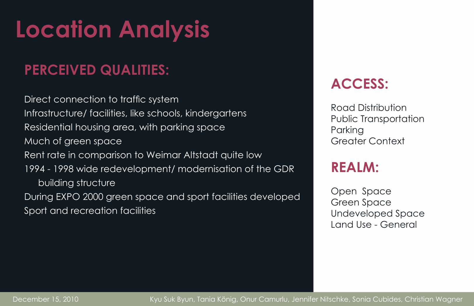
ACCESS:Road DistributionPublic TransportationParkingGreater Context
REALM:Open SpaceGreen SpaceUndeveloped SpaceLand Use - General
Location AnalysisPERCEIVED QUALITIES:
Direct connection to traffic systemInfrastructure/ facilities, like schools, kindergartensResidential housing area, with parking spaceMuch of green spaceRent rate in comparison to Weimar Altstadt quite low 1994 - 1998 wide redevelopment/ modernisation of the GDR building structure During EXPO 2000 green space and sport facilities developedSport and recreation facilities

lützendorfer weg
lützendorfer str.
bonhoe�erstraße
marcel-paul straße
ettersburger str.
ernst-thälmann str.
marcel-paul straße bonhoe�erstraße
primary road
secondary road
tertiary road
bonhoe�erstraße
lützendorf
�lzweidenweg
etterburer str.
nordstraße
rießnerstraße
December 15, 2010 Kyu Suk Byun, Tania König, Onur Camurlu, Jennifer Nitschke, Sonia Cubides, Christian Wagner
Primary, Secondary, Tertiary StreetsAccess
Primary Access
Secondary Access
Tertiary Access
Weimar Nord feels gloomy, abandoned and the buildings are in disrepair. The gateway functions as the transition that separates the historical UNESCO World Heritage Old City Center from Weimar Nord. The existing bridge feels dangerous, as the steel sections are rusty and the concrete is weathered. Weimar Nord has an inclining topography, making pedestrian travel difficult.

bus line 5weimar nord - klinikum
bus line 1weimar nord - ehringsdorf - taubach
rießnerstraße
�lzweidenweg
lützendorf
lützendorfer weg
etterburer str.
nordstraße
lützendorfer str.
bonhoe�erstraße
marcel-paul straße
ettersburger str.
ernst-thälmann str.
marcel-paul straße
bonhoe�erstraße
bonhoe�erstraße
December 15, 2010 Kyu Suk Byun, Tania König, Onur Camurlu, Jennifer Nitschke, Sonia Cubides, Christian Wagner
Access Routes and Stops
Sources:Netzplan weimarhttp://www.sw-weimar.de/fileadmin/user_up-load/swi/pdf/netzplan_20090628.pdf
Bus Line 1 -Weimar Nord - Ehringsdorf -Taubach -
Bus Line 5 -Weimar Nord -Klinikum -
Bus line 1 loops around the entire site, while bus line 5 makes a smaller loop around the GDR developments.
December 15, 2010 Kyu Suk Byun, Tania König, Onur Camurlu, Jennifer Nitschke, Sonia Cubides, Christian Wagner
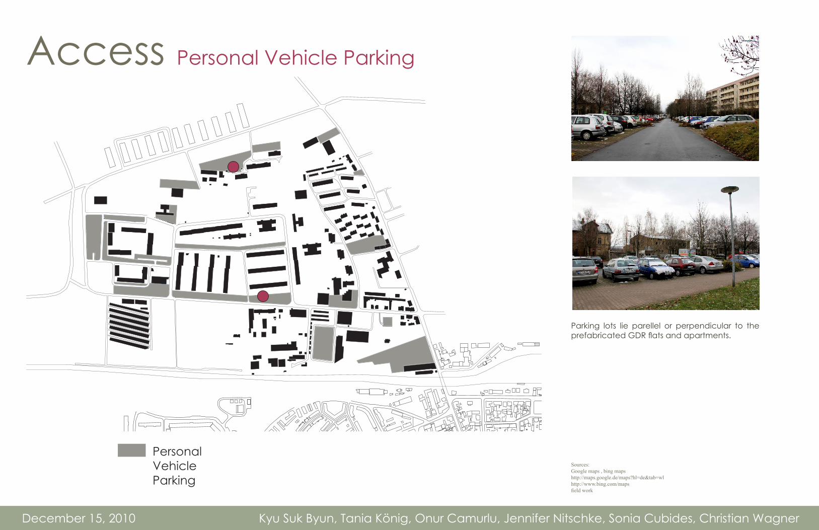
Access Personal Vehicle Parking
Parking lots lie parellel or perpendicular to the prefabricated GDR flats and apartments.
Personal Vehicle Parking
Sources:Google maps , bing mapshttp://maps.google.de/maps?hl=de&tab=wlhttp://www.bing.com/mapsfield work

Access Greater Context
December 15, 2010 Kyu Suk Byun, Tania König, Onur Camurlu, Jennifer Nitschke, Sonia Cubides, Christian Wagner
The new roads make it easier for the commuters to reach supermarkets and other amenities from other areas.
Source: The Weimar and Weimarer Land Economic Region. Page 2

Realm Open Space
open space
developed space
rießnerstraße
�lzweidenweg
lützendorf
lützendorfer weg
etterburer str.
nordstraße
ernst-thälmann str.
There are numerous gaps between buildings, and these gaps are used for public greenery and privacy between buildings during the summer. The wooden barn and the abandoned Villa in the South-East corner of our site showcases the disrepair of the existing commercial building stock. The Villa has not been used for decades, whereas the large barn has been used as an art gallery and a Papieraufkauf.
December 15, 2010 Kyu Suk Byun, Tania König, Onur Camurlu, Jennifer Nitschke, Sonia Cubides, Christian Wagner
Open Space Developed Space Sources:
Google maps , bing mapshttp://maps.google.de/maps?hl=de&tab=wlhttp://www.bing.com/mapsfield work

Realm Green Space
playground
park | open space
Private Gardens
Playgrounds are spread at the edges, whereas parks are integral to the fabric of the neighborhood. Private Gardens are included. Weekend farms are situated on the southwest portion of our site. Open green areas were sometimes covered with garbage and glass; however an advantage included the sheer number of green spaces and corridors between buildings. There are also numerous play spaces for children on the site.
December 15, 2010 Kyu Suk Byun, Tania König, Onur Camurlu, Jennifer Nitschke, Sonia Cubides, Christian Wagner
Private GardenAthletic Facility
Playground Public ParkSources:Google maps , bing mapshttp://maps.google.de/maps?hl=de&tab=wlhttp://www.bing.com/maps
field work

Realm Undeveloped spaces
undeveloped spacewithout use
undeveloped spaceused for recreation
rießnerstraße
�lzweidenweg
lützendorf
lützendorfer weg
etterburer str.
nordstraße
ernst-thälmann str.
30% of the whole site is not developed, and only a quarter of it is used as recreation which consists of park and open space.
December 15, 2010 Kyu Suk Byun, Tania König, Onur Camurlu, Jennifer Nitschke, Sonia Cubides, Christian Wagner
Undeveloped with recreation
Undeveloped without use Sources:
Google maps , bing mapshttp://maps.google.de/maps?hl=de&tab=wlhttp://www.bing.com/maps
field work
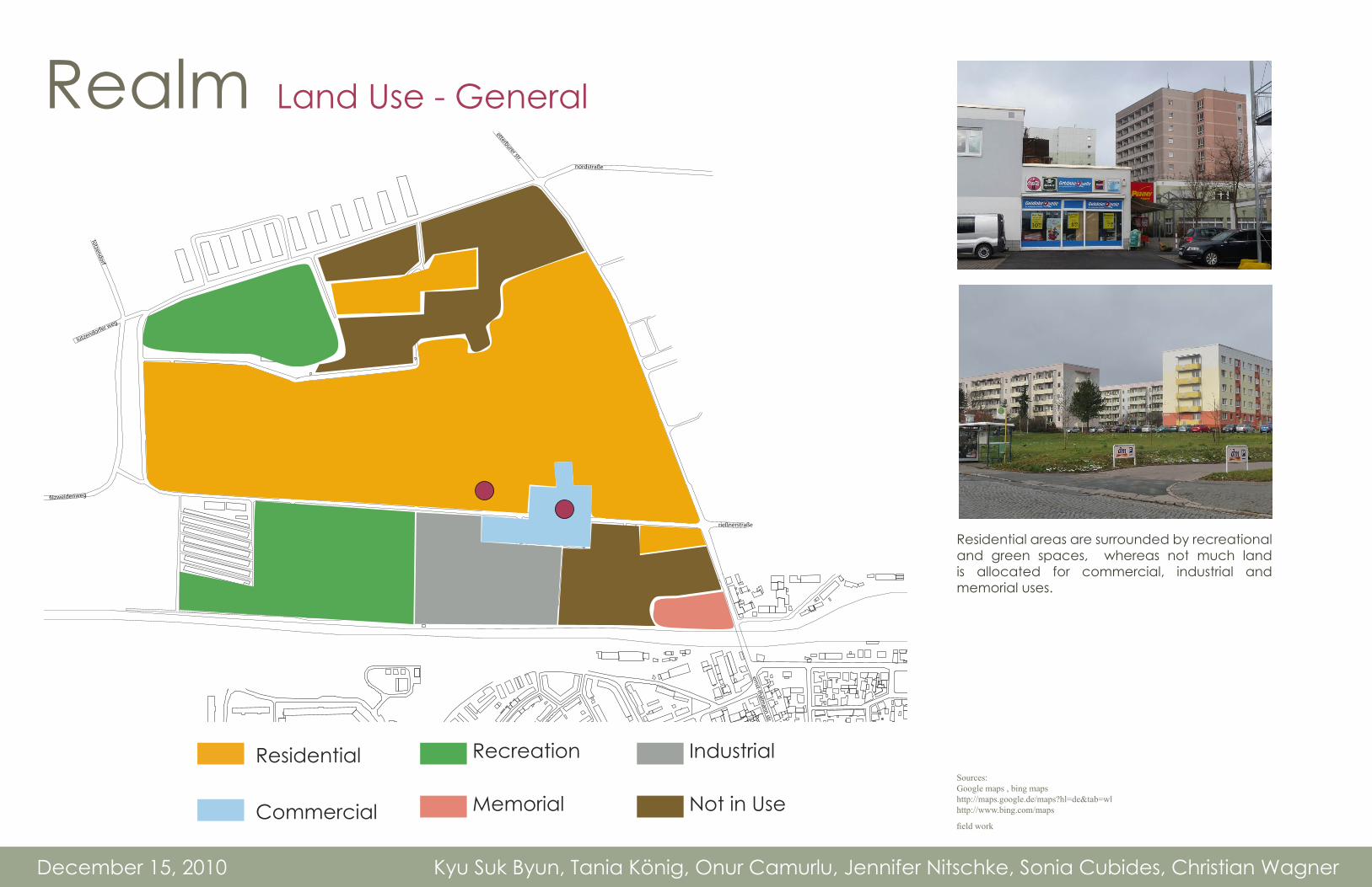
Realm Land Use - General
residential
recreation
industrial
commercial
memorial
recreation
rießnerstraße
�lzweidenweg
lützendorf
lützendorfer weg
etterburer str.
nordstraße
ernst-thälmann str.
Residential areas are surrounded by recreational and green spaces, whereas not much land is allocated for commercial, industrial and memorial uses.
December 15, 2010 Kyu Suk Byun, Tania König, Onur Camurlu, Jennifer Nitschke, Sonia Cubides, Christian Wagner
Residential
Commercial
Recreation
Memorial
Industrial
Not in UseSources:Google maps , bing mapshttp://maps.google.de/maps?hl=de&tab=wlhttp://www.bing.com/maps
field work

December 15, 2010 Kyu Suk Byun, Tania König, Onur Camurlu, Jennifer Nitschke, Sonia Cubides, Christian Wagner
TYPOLOGY:Heritageby Functionby Buildingby Residential
TRENDS:Population NordstadtPopulation WeimarAge Distributions
Market AnalysisBusiness Sector Structure
Good Condition for Small BusinessesHandcraft
Vacancy Rate30% of the area is not developed10% in use but not developed
Benchmarks
Weimar Nord:5.359 inhabitants1,83 km²2.928 inhabitants/ km²
Benchmarks
Entire Weimar65.233 inhabitants84,26 km²774 inhabitants/ km²
December 15, 2010 Kyu Suk Byun, Tania König, Onur Camurlu, Jennifer Nitschke, Sonia Cubides, Christian Wagner
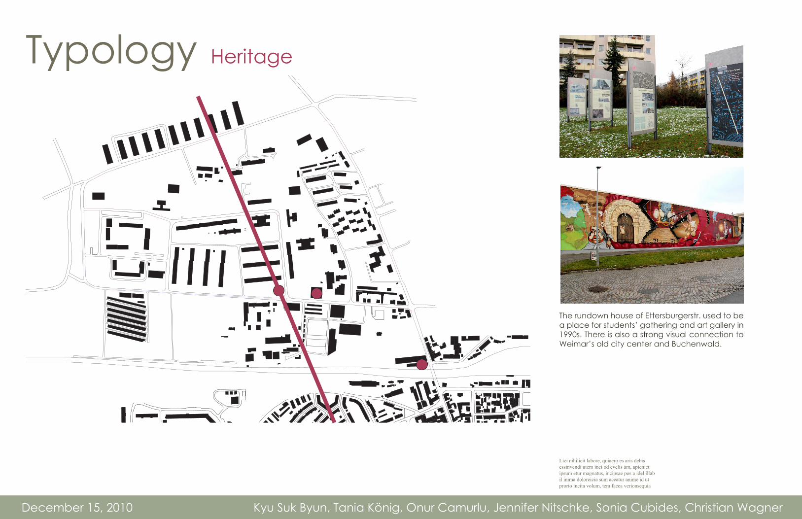
Typology Heritage
The rundown house of Ettersburgerstr. used to be a place for students’ gathering and art gallery in 1990s. There is also a strong visual connection to Weimar’s old city center and Buchenwald.
Lici nihilicit labore, quiaero es aris debis essinvendi utem inci od evelis am, apieniet ipsum etur magnatus, incipsae pos a idel illab il inima doloreicia sum aceatur anime id ut prorio incita volum, tem facea verionsequia

Typology By Function
services
shops
school
health
recreation
hotel | restaurant
rießnerstraße
�lzweidenweg
lützendorf
lützendorfer weg
etterburer str.
nordstraße
ernst-thälmann str.
Facilities such as the school, health clinic, hotel/restaurants, services, and shops tend to lean on the south east border, while the recreation facilities are situated in the northwest. Marcel-Paul Str. is planned, car-dominated, commercial corridor that supplies conveniences for the residents in the entire site. Few pedestrians were visible upon our visit to the site. Some of the commercial amenities found on this street included a hairdresser, a stone shop, numerous supermarkets and dollar stores, an insurance company and a carpenter’s workshop.
December 15, 2010 Kyu Suk Byun, Tania König, Onur Camurlu, Jennifer Nitschke, Sonia Cubides, Christian Wagner
Shops
Services
Health
Hotel/Restaurant
Recreation
SchoolSources:Weimar Stadtkarte/ Stadt Weimarhttp://stadtplan.weimar.de/
field work

Typology By Building
detached housing
industrial buildings(di�erent structure)
old brick structure
cottages(1 �oor)
former cattle industry hall
education buildingpre-fabricated
former loading station(connected with rail track)
apartment building4 �oors/ old
pre-fabricatedresidential building5 to 8 �oors
industrial hall(for commercial)
apartment building(3 �oors/ 2002)
rießnerstraße
�lzweidenweg
lützendorf
lützendorfer weg
etterburer str.
nordstraße
ernst-thälmann str.
The dominant building typology in our site is a prefabricated residential building that is 5-8 storeys.
December 15, 2010 Kyu Suk Byun, Tania König, Onur Camurlu, Jennifer Nitschke, Sonia Cubides, Christian Wagner
Old Brick Structure
Detatched Housing Pre-fabricated residential building 5-8 floors
Industrial Buildings (different structure)
Former Loading Station (connected to Rail)
Apartment building (3 floors/2002)
Eductation Building (pre-fabricated)
Former cattle industrial hall
Apartment Building 4-floors/old
Industrial Hall (for Commercial)
1-Floor Cottages
Sources:Weimar_2008.pdfhttps://elearning2.uni-weimar.de/mcbuw/ses-sion/desktop.php?SID=b17eb53c3271325bb9dbdd926f8dc97d&CID=100980metacoon platform
pdf map of weimar

December 15, 2010 Kyu Suk Byun, Tania König, Onur Camurlu, Jennifer Nitschke, Sonia Cubides, Christian Wagner
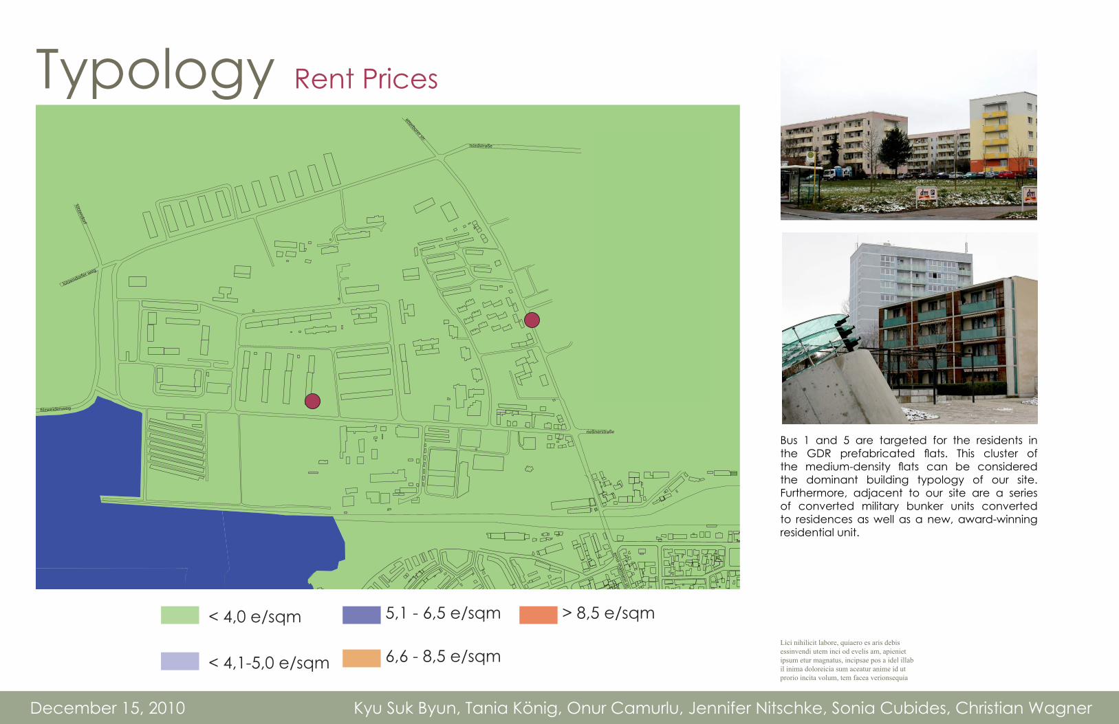
Typology Residential
Bus 1 and 5 are targeted for the residents in the GDR prefabricated flats. This cluster of the medium-density flats can be considered the dominant building typology of our site. Furthermore, adjacent to our site are a series of converted military bunker units converted to residences as well as a new, award-winning residential unit.
Lici nihilicit labore, quiaero es aris debis essinvendi utem inci od evelis am, apieniet ipsum etur magnatus, incipsae pos a idel illab il inima doloreicia sum aceatur anime id ut prorio incita volum, tem facea verionsequia
detached housing
industrial buildings(di�erent structure)
old brick structure
cottages(1 �oor)
former cattle industry hall
education buildingpre-fabricated
former loading station(connected with rail track)
apartment building4 �oors/ old
pre-fabricatedresidential building5 to 8 �oors
industrial hall(for commercial)
apartment building(3 �oors/ 2002)
rießnerstraße
�lzweidenweg
lützendorf
lützendorfer weg
etterburer str.
nordstraße
ernst-thälmann str.
Detatched Housing Pre-fabricated residential building 5-8 floors
Apartment building (3 floors/2002)
Apartment Building 4-floors/old
1-Floor Cottages
rießnerstraße
�lzweidenweg
lützendorf
lützendorfer weg
etterburer str.
nordstraße
ernst-thälmann str.
4,1 - 5,0 € per sqm
< 4,0 € per sqm
5,1 - 6,5 € per sqm
6,6 - 8,5 € per sqm
> 8,5 € per sqm
December 15, 2010 Kyu Suk Byun, Tania König, Onur Camurlu, Jennifer Nitschke, Sonia Cubides, Christian Wagner
Typology Rent Prices
Bus 1 and 5 are targeted for the residents in the GDR prefabricated flats. This cluster of the medium-density flats can be considered the dominant building typology of our site. Furthermore, adjacent to our site are a series of converted military bunker units converted to residences as well as a new, award-winning residential unit.
Lici nihilicit labore, quiaero es aris debis essinvendi utem inci od evelis am, apieniet ipsum etur magnatus, incipsae pos a idel illab il inima doloreicia sum aceatur anime id ut prorio incita volum, tem facea verionsequia
< 4,0 e/sqm
< 4,1-5,0 e/sqm
5,1 - 6,5 e/sqm
6,6 - 8,5 e/sqm
> 8,5 e/sqm

2 room apartment, 4th floor, 39m² 3 room apartment, 2nd floor, 52.5m²
Angebotsart Rent Rent
Immobilienart Apartment Apartment
Street Bonhoefferstraße Bonhoefferstraße
Building number 50 30
City Weimar Weimar
Area Nordstadt Nordstadt
Building type MFH (Plattenbau) prefabricated building MFH (Plattenbau) prefabricated building
Room number 2 3
Area 39,0 m² 52,5 m²
Level 4 2
Lift Yes no
Furnished No no
kitchen yes yes
Built in kitchen nein no
Bathroom/ WC Bathroom (shower) Bathroom
Balcony/ Terrace yes yes
Basement yes yes
Built 1985 1978
Rent 257,40 EUR 260,00 EUR Service fee 58,50 EUR 60,00 EUR
Heating fee 46,80 EUR 63,00 EUR
Bond 771,00 EUR 550,00 EUR
Available now now
December 15, 2010 Kyu Suk Byun, Tania König, Onur Camurlu, Jennifer Nitschke, Sonia Cubides, Christian Wagner
Typology Rent Prices
2 room apartment, 4th floor, 39m²
3 room apartment, 2nd floor, 52.5m²
http://www.weimarer-wohnstaette.de/Scripts/ProductDetail.aspx?CLSOID=10001&MODE=3&PAGE=1&PRODUCTOID=40002&VAL_60000=Vermietung&VAL_60011=Wohnung&VAL_60018=Nordstadt

December 15, 2010 Kyu Suk Byun, Tania König, Onur Camurlu, Jennifer Nitschke, Sonia Cubides, Christian Wagner
Trends Population Decline in Nordstadt
5750
Population Weimar Nordstadt/ area: 1,82 sq km
5300
2000
source: Statistisches Jahrbuch Weimar 2009, Stadt Weimar; page 100 Weimar in Zahlen 2010, Stadt Weimar - Abt. Geoinformationen und Statistik
source: Statistisches Jahrbuch Weimar 2009, Stadt Weimar; page 101
2001 2002 2003 2004 2005 2006 2007 2008 2009
5359
5597
year
5400
5500
5600
5350
5450
5550
5650
5700
1000
2000
3000
4000
5000
6000
7000
8000
9000
10000
11000
12000
13000
Population Weimar Nordstadt / Weimar
100
0-3 3-6 6-10 10-15 15-18 18-25 25-30 30-45 45-60 60-65 65-75 75-85 85- age groups
Nordstadt
Weimar
300
500
700
200
400
600
800
900
Population Weimar/ area: 84,26 sq km
62.000
2000
source: Statistisches Jahrbuch Weimar 2009, Stadt Weimar; page 96 Weimar in Zahlen 2010, Stadt Weimar - Abt. Geoinformationen und Statistik
2001 2002 2003 2004 2005 2006 2007 2008 2009
65.233
62.425
year
63000
64000
65000
62.500
63500
64500
65500
66000
Industriegebiet Nord
Gaberndorf
TröbsdorfInd.-ge.West
Schönblick
Niedergrunstedt
Gelmeroda
Legefeld
Possendorf
Oberweimar/Ehringsdorf Taubach
Süßenborn
Schöndorf
Nordstadt
Weststadt Nordvorstadt
Westvorstadt
AltstadtParkvorstadt
Tiefurt
Südstadt
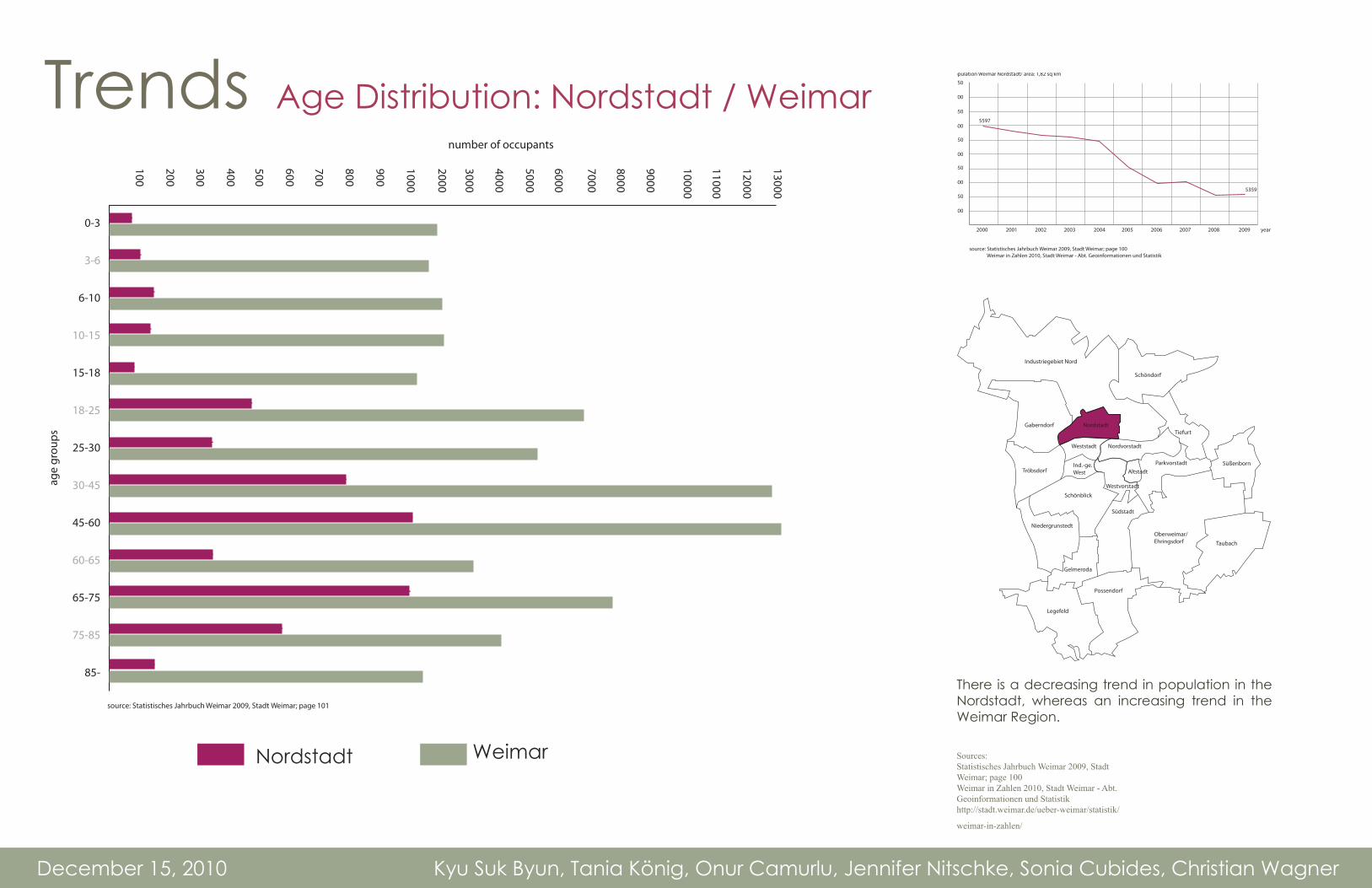
There is a decreasing trend in population in the Nordstadt, whereas an increasing trend in the Weimar Region.
Sources:Statistisches Jahrbuch Weimar 2009, Stadt Weimar; page 100Weimar in Zahlen 2010, Stadt Weimar - Abt. Geoinformationen und Statistikhttp://stadt.weimar.de/ueber-weimar/statistik/
weimar-in-zahlen/

December 15, 2010 Kyu Suk Byun, Tania König, Onur Camurlu, Jennifer Nitschke, Sonia Cubides, Christian Wagner
Trends Population Growth in Weimar
5750
Population Weimar Nordstadt/ area: 1,82 sq km
5300
2000
source: Statistisches Jahrbuch Weimar 2009, Stadt Weimar; page 100 Weimar in Zahlen 2010, Stadt Weimar - Abt. Geoinformationen und Statistik
source: Statistisches Jahrbuch Weimar 2009, Stadt Weimar; page 101
2001 2002 2003 2004 2005 2006 2007 2008 2009
5359
5597
year
5400
5500
5600
5350
5450
5550
5650
5700
1000
2000
3000
4000
5000
6000
7000
8000
9000
10000
11000
12000
13000
Population Weimar Nordstadt / Weimar
100
0-3 3-6 6-10 10-15 15-18 18-25 25-30 30-45 45-60 60-65 65-75 75-85 85- age groups
Nordstadt
Weimar
300
500
700
200
400
600
800
900
Population Weimar/ area: 84,26 sq km
62.000
2000
source: Statistisches Jahrbuch Weimar 2009, Stadt Weimar; page 96 Weimar in Zahlen 2010, Stadt Weimar - Abt. Geoinformationen und Statistik
2001 2002 2003 2004 2005 2006 2007 2008 2009
65.233
62.425
year
63000
64000
65000
62.500
63500
64500
65500
66000
Industriegebiet Nord
Gaberndorf
TröbsdorfInd.-ge.West
Schönblick
Niedergrunstedt
Gelmeroda
Legefeld
Possendorf
Oberweimar/Ehringsdorf Taubach
Süßenborn
Schöndorf
Nordstadt
Weststadt Nordvorstadt
Westvorstadt
AltstadtParkvorstadt
Tiefurt
Südstadt
There is a decreasing trend in population in the Nordstadt, whereas an increasing trend in the Weimar Region.
5750
Population Weimar Nordstadt/ area: 1,82 sq km
5300
2000
source: Statistisches Jahrbuch Weimar 2009, Stadt Weimar; page 100 Weimar in Zahlen 2010, Stadt Weimar - Abt. Geoinformationen und Statistik
source: Statistisches Jahrbuch Weimar 2009, Stadt Weimar; page 101
2001 2002 2003 2004 2005 2006 2007 2008 2009
5359
5597
year
5400
5500
5600
5350
5450
5550
5650
5700
1000
2000
3000
4000
5000
6000
7000
8000
9000
10000
11000
12000
13000
Population Weimar Nordstadt / Weimar
100
0-3 3-6 6-10 10-15 15-18 18-25 25-30 30-45 45-60 60-65 65-75 75-85 85- age groups
Nordstadt
Weimar
300
500
700
200
400
600
800
900
Population Weimar/ area: 84,26 sq km
62.000
2000
source: Statistisches Jahrbuch Weimar 2009, Stadt Weimar; page 96 Weimar in Zahlen 2010, Stadt Weimar - Abt. Geoinformationen und Statistik
2001 2002 2003 2004 2005 2006 2007 2008 2009
65.233
62.425
year
63000
64000
65000
62.500
63500
64500
65500
66000
Sources:Statistisches Jahrbuch Weimar 2009, Stadt Weimar; page 100Weimar in Zahlen 2010, Stadt Weimar - Abt. Geoinformationen und Statistikhttp://stadt.weimar.de/ueber-weimar/statistik/
weimar-in-zahlen/
December 15, 2010 Kyu Suk Byun, Tania König, Onur Camurlu, Jennifer Nitschke, Sonia Cubides, Christian Wagner
Trends Age Distribution: Nordstadt / Weimar
source: Statistisches Jahrbuch Weimar 2009, Stadt Weimar; page 101
number of occupants
1000
2000
3000
4000
5000
6000
7000
8000
9000
10000
11000
12000
13000
Population Weimar Nordstadt / Weimar
100
0-3
3-6
6-10
10-15
15-18
18-25
25-30
30-45
45-60
60-65
65-75
75-85
85-
age
grou
ps
Nordstadt
Weimar
300
500
700
200
400
600
800
900
Industriegebiet Nord
Gaberndorf
TröbsdorfInd.-ge.West
Schönblick
Niedergrunstedt
Gelmeroda
Legefeld
Possendorf
Oberweimar/Ehringsdorf Taubach
Süßenborn
Schöndorf
Nordstadt
Weststadt Nordvorstadt
Westvorstadt
AltstadtParkvorstadt
Tiefurt
Südstadt
There is a decreasing trend in population in the Nordstadt, whereas an increasing trend in the Weimar Region.
5750
Population Weimar Nordstadt/ area: 1,82 sq km
5300
2000
source: Statistisches Jahrbuch Weimar 2009, Stadt Weimar; page 100 Weimar in Zahlen 2010, Stadt Weimar - Abt. Geoinformationen und Statistik
source: Statistisches Jahrbuch Weimar 2009, Stadt Weimar; page 101
2001 2002 2003 2004 2005 2006 2007 2008 2009
5359
5597
year
5400
5500
5600
5350
5450
5550
5650
5700
1000
2000
3000
4000
5000
6000
7000
8000
9000
10000
11000
12000
13000
Population Weimar Nordstadt / Weimar
100
0-3 3-6 6-10 10-15 15-18 18-25 25-30 30-45 45-60 60-65 65-75 75-85 85- age groups
Nordstadt
Weimar
300
500
700
200
400
600
800
900
Population Weimar/ area: 84,26 sq km
62.000
2000
source: Statistisches Jahrbuch Weimar 2009, Stadt Weimar; page 96 Weimar in Zahlen 2010, Stadt Weimar - Abt. Geoinformationen und Statistik
2001 2002 2003 2004 2005 2006 2007 2008 2009
65.233
62.425
year
63000
64000
65000
62.500
63500
64500
65500
66000
Nordstadt Weimar
source: Statistisches Jahrbuch Weimar 2009, Stadt Weimar; page 101
Sources:Statistisches Jahrbuch Weimar 2009, Stadt Weimar; page 100Weimar in Zahlen 2010, Stadt Weimar - Abt. Geoinformationen und Statistikhttp://stadt.weimar.de/ueber-weimar/statistik/
weimar-in-zahlen/
December 15, 2010 Kyu Suk Byun, Tania König, Onur Camurlu, Jennifer Nitschke, Sonia Cubides, Christian Wagner
PROGNOSIS:DEMAND:- Moving from the core of the city towards the rail track- Reconstruction in inner city rent rate increasing- Students from Weimar and Jena moving in
POSSIBLE TARGETS- Commuter to Erfurt, Jena and surrounding- conference centre visitors- Seniors- young families
+/- AnalysisCONFLICT: Challenges
- Undeveloped space general- Undeveloped space between residential buildings- Allotment gardens- Former industrial area- Concentrated commercial area- History - Rail track as border to the inner city- Living conditions in GDR buildings- Fragmented sidewalk

December 15, 2010 Kyu Suk Byun, Tania König, Onur Camurlu, Jennifer Nitschke, Sonia Cubides, Christian Wagner
Conflicts Initial Observations
1
43
8
9
2
6
7
1
challenges:
undeveloped space
2 undeveloped space between residential buildings
3 allotment Gardens
4 former industial area
5 concentrated commercial area
6 history
7 rail track as border to the inner city
8 living conditions in GDR buildings
9 fragmented sidewalk
5
Challenges:
Undeveloped spaceUndeveloped space between residential buildingsAllotment gardensFormer industrial areaConcentrated commercial areaHistoryRail track as border to the inner cityLiving conditions in GDR buildingsFragmented sidewalk
12
3456789

1
6 7
8
4
5
3
2
1
qualities:
much of green space between the buildings
2 1994-1998 modernisation of the GDR building structure
3 parking lots
4 receation/ sport facilities
5 infrastructure facilities like schools and kindergarden
6 living in a city with natrural view
7 rent rate
8 direct connection to tra�c system
December 15, 2010 Kyu Suk Byun, Tania König, Onur Camurlu, Jennifer Nitschke, Sonia Cubides, Christian Wagner
Qualities Initial ObservationsQualities
quantity of green space between buildings1994-1998 modernisation of the GDR building structureParking lotsrecreation/sport facilitiesinfrastructure facilities like schools and kindergardenliving in a city with natural viewrent ratedirect connection to traffic system
1
2
345
678
December 15, 2010 Kyu Suk Byun, Tania König, Onur Camurlu, Jennifer Nitschke, Sonia Cubides, Christian Wagner December 15, 2010 Kyu Suk Byun, Tania König, Onur Camurlu, Jennifer Nitschke, Sonia Cubides, Christian Wagner
IBA Internationale Bauaustellung 2019
Guiding Questions
What is the International Bauaustellung?What is the Role of the IBA?Why is the IBA important for Weimar?How can the history of the IBA help us?What is the structure of the IBA
Sources
Internet SourcesInterview - Prof. Max Welch GuerraLecture - Prof. Harald Kegler
RESEARCHDefinitionObjectivesMethod
TIMELINESBerlinNorth Rhine - WestphaliaBrandenburgSaxony AnhaltHamburgThuringia

December 15, 2010 Kyu Suk Byun, Tania König, Onur Camurlu, Jennifer Nitschke, Sonia Cubides, Christian Wagner
Definition Internationale Bauaustellung
Photo Credit: Christian Wagner
The IBA is a Germany-based, nontraditonal, and large-scale building exhibition that focuses on spatial innovation, regional restructuring, fosters to develop new cultural landscapes, and appeals to an international audience. Each IBA has its own focus, initiatives and goals to the particular site chosen. The IBA cooperates with different governmental structures, such as the “Ministry of Urban Development and Environment,” which leads the IBA projects in Hamburg.

December 15, 2010 Kyu Suk Byun, Tania König, Onur Camurlu, Jennifer Nitschke, Sonia Cubides, Christian Wagner
Objectives Weimar & Thuringen 2019
well as with national and international experts.
a catalyst for improving existing i n f r a s t r u c t u r e s , buildings, cities and
regions.
IBA is a
redevelopmentmodel. Each IBA has its own focus, initiatives and goals.
G e n e r a t e s r e g i o n a l economic growth and provide jobs to local inhabitants.
C o n n e c t s t a k e h o l d e r s , p l a n n e r s , i n h a b i t a n t s , educators,
private
and public industries, within the affected sites as

December 15, 2010 Kyu Suk Byun, Tania König, Onur Camurlu, Jennifer Nitschke, Sonia Cubides, Christian Wagner
Method IBA and the City/Region
December 1, 2010
Problem Tool
Strategies
Methodology ActorsFunding
Pro
cess
Synthesis
city / region IBA Redevelopment
The IBA combines creative and technical innovation, creates relationships between science and art, and draws attention to design and planning. Its core aim includes the hope to generate regional economic growth and provide jobs to local inhabitants.
At the same time, the IBA is at the heart of a network which uses a planned objective to connect stakeholders (planners, inhabitants, government officials, educators, private and public industries, etc..) within the affected sites as well as with national and international experts.

IBA Emscherpark (1989-1999)
IBA Stadtumbau (2002-2010)
IBA Hamburg (2007-2013)
IBA See (2000-2010)
IBA Thuringia (2010-2019)
Saxony -Anhalt Hamburg North Rhine-Westphalia Brandenburg Thuringia
IBA Berlin (1910-1987)
Berlin
> Urban renewel and new forms of planning
The International Building exibition 1984 (IBA) was an architecture exhibition that showcased urban planning concepts to redevelop the rundown neighborhood of Kreuzberg in West Berlin into a residential area. The strategies employed included refurbishing existing buildings and adding new infrastructure in Berlin’s 19th century grid. The project was vast, and provided new and renovated housing, self-built projects, schools, kindergartens, landscaping, street-scaping and parks.
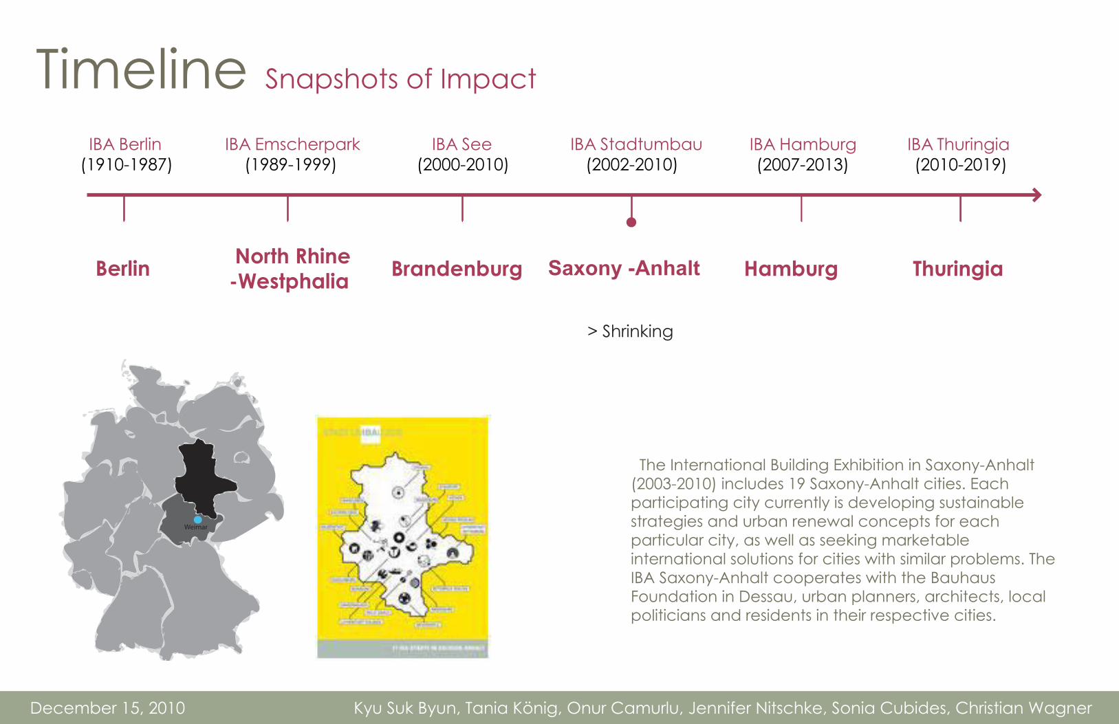
Timeline Snapshots of Impact
http://de.wikipedia.org/w/index.php?title=Datei:Berlin-Tegel-IBA-2-2007.jpg&filetimestamp=20090512091105
December 15, 2010 Kyu Suk Byun, Tania König, Onur Camurlu, Jennifer Nitschke, Sonia Cubides, Christian Wagner

IBA Emscherpark (1989-1999)
IBA Stadtumbau (2002-2010)
IBA Hamburg (2007-2013)
IBA See (2000-2010)
IBA Thuringia (2010-2019)
Saxony -Anhalt Hamburg North Rhine-Westphalia Brandenburg Thuringia
IBA Berlin (1910-1987)
Berlin
The International Building Exhibition Emscherpark (IBA Emscherpark) was a ten-year project to envision the future and redevelop the North Rhine-Westphalia region; an old, heavily industrial and unwelcoming zone. The task at hand of the International Building Exhibition was to envision ideas and projects for urban, social, cultural and ecological innovation, with hopes to obtain economic results to revitalize the area.
>Urban conversion of an old industrial region project
Timeline Snapshots of Impact
December 15, 2010 Kyu Suk Byun, Tania König, Onur Camurlu, Jennifer Nitschke, Sonia Cubides, Christian Wagner
http://deu.archinform.net/projekte/6228.htm

IBA Emscherpark (1989-1999)
IBA Stadtumbau (2002-2010)
IBA Hamburg (2007-2013)
IBA See (2000-2010)
IBA Thuringia (2010-2019)
Saxony -Anhalt Hamburg North Rhine-Westphalia Brandenburg Thuringia
IBA Berlin (1910-1987)
Berlin
>Transformation of structures and landscape
This former coal mine site was redeveloped within seven primary themes: industrial heritage, waterscapes, energy landscapes, new territory, border landscapes, urban landscapes, transitional landscapes.
Timeline Snapshots of Impact
December 15, 2010 Kyu Suk Byun, Tania König, Onur Camurlu, Jennifer Nitschke, Sonia Cubides, Christian Wagner
http://www.iba-see2010.de/en/projekte/projekt3.html
IBA Emscherpark (1989-1999)
IBA Stadtumbau (2002-2010)
IBA Hamburg (2007-2013)
IBA See (2000-2010)
IBA Thuringia (2010-2019)
Saxony -Anhalt Hamburg North Rhine-Westphalia Brandenburg Thuringia
IBA Berlin (1910-1987)
Berlin
> Shrinking
The International Building Exhibition in Saxony-Anhalt (2003-2010) includes 19 Saxony-Anhalt cities. Each participating city currently is developing sustainable strategies and urban renewal concepts for each particular city, as well as seeking marketable international solutions for cities with similar problems. The IBA Saxony-Anhalt cooperates with the Bauhaus Foundation in Dessau, urban planners, architects, local politicians and residents in their respective cities.
Timeline Snapshots of Impact
December 15, 2010 Kyu Suk Byun, Tania König, Onur Camurlu, Jennifer Nitschke, Sonia Cubides, Christian Wagner
Weimar

IBA Emscherpark (1989-1999)
IBA Stadtumbau (2002-2010)
IBA Hamburg (2007-2013)
IBA See (2000-2010)
IBA Thuringia (2010-2019)
Saxony -Anhalt Hamburg North Rhine-Westphalia Brandenburg Thuringia
IBA Berlin (1910-1987)
Berlin
> Cities and climate change> Cosmopolis> Metrozones
The focus of the IBA Hamburg integrates the ENERGY ATLAS into its mission. The IBA Hamburg presents the strategic implementations and methodologies for a future where 100% of the energy supplied to the Elbe Islands come from renewable resources.
Timeline Snapshots of Impact
December 15, 2010 Kyu Suk Byun, Tania König, Onur Camurlu, Jennifer Nitschke, Sonia Cubides, Christian Wagner
http://deu.archinform.net/projekte/6228.htm

IBA Emscherpark (1989-1999)
IBA Stadtumbau (2002-2010)
IBA Hamburg (2007-2013)
IBA See (2000-2010)
IBA Thuringia (2010-2019)
Saxony -Anhalt Hamburg North Rhine-Westphalia Brandenburg Thuringia
IBA Berlin (1910-1987)
Berlin
Timeline Snapshots of Impact
December 15, 2010 Kyu Suk Byun, Tania König, Onur Camurlu, Jennifer Nitschke, Sonia Cubides, Christian Wagner
http://deu.archinform.net/projekte/6228.htm
1. Reconstruction of infrastructure 2. Protecting cultural heritage/background 3. Upgrading / developing living conditions
3 Objectives: Thuringen 2019:
Historically, the IBA has been a catalyst for improving existing infrastructures, buildings, cities and regions. All the regions the IBA has previously selected had specific challenges. Weimar Nord is situated in a prime location, and could potentially host the future growth of the city of Weimar. Bringing the IBA to Weimar Nord could serve as a tool to revitalize the local area of Weimar Nord.
Weimar Nord - Class Map
December 1, 2010 Kyu Suk Byun, Tania König, Onur Camurlu, Jennifer Nitschke, Sonia Cubides, Christian Wagner December 15, 2010 Kyu Suk Byun, Tania König, Onur Camurlu, Jennifer Nitschke, Sonia Cubides, Christian Wagner
Thank You!Questions?
Next StepsMarket Factors:
Define Key Market Factors for Region based on conflict and quality mapping
Expand on Quality and Conflict Mapping
Develop urban visions, ideas and preliminary design
Real Estate Project Development
spaces, costs and profitability

http://deu.archinform.net/stich/2210.htm
http://de.wikipedia.org/wiki/Internationale_Bauausstellung_1984
http://translate.google.com/translate?js=n&prev=_t&hl=es&ie=UTF-8&layout=2&eotf=1&sl=de&tl=en&u=http%3A%2F%2Fwww.iba-see2010.de%2F
ht tp ://www.google .com/ imgres? imgur l=ht tp ://www.r ibabookshops .com/static/00000071/00000071000/182/0/plain/international-building-exhibition-ba-hamburg.jpg&imgrefurl=http://www.ribabookshops.com/item/international-building-exhibition-ba-hamburg-interim-presentation-2010/71000/&usg=__BnqOPl4RdkZ7eTY-ZLfvqTOYjdc=&h=346&w=182&sz=18&hl=es&start=0&sig2=vfyW2bmwyB35jU2pQ3o4CQ&zoom=1&tbnid=iSaH9syuJu7lkM:&tbnh=149&tbnw=78&ei=cGXuTOeQGoaFswbamcj1CQ&prev=/images%3Fq%3DInternational%2BBuilding%2BExhibition%2BHamburg%26um%3D1%26hl%3Des%26lr%3D%26sa%3DN%26rlz%3D1I7SKPB_es%26biw%3D1345%26bih%3D568%26tbs%3Disch:1&um=1&itbs=1&iact=hc&vpx=125&vpy=42&dur=1438&hovh=276&hovw=145&tx=132&ty=148&oei=cGXuTOeQGoaFswbamcj1CQ&esq=1&page=1&ndsp=20&ved=1t:429,r:0,s:0
http://de.wikipedia.org/wiki/Internationale_Baufach-Ausstellung_1913
Sources - IBADecember 1, 2010 Kyu Suk Byun, Tania König, Onur Camurlu, Jennifer Nitschke, Sonia Cubides, Christian Wagner