Embed Size (px)
Citation preview
Information Classification: CONTROLLED
Proposed Access onto Telegraph Road, St Mary’s Statement of Highway Impact
CORMAC Consultancy Radnor Road, Scorrier, Redruth, Cornwall, TR16 5EH


Information Classification: CONTROLLED
This document has been prepared for the titled project or named part thereof and should not be relied upon or used for any other project without an independent check being carried out as to its suitability and prior written authority of
Cormac Solutions Ltd being obtained. Cormac Solutions Ltd accepts no responsibility or liability for the consequences of this document being used for a purpose other than the purposes for which it was commissioned. Any person using or
relying on the document for such other purposes agrees, and will by such use or reliance be taken to confirm his agreement to indemnify Cormac Solutions Ltd for all loss or damage resulting therefrom. Cormac Solutions Ltd accepts
no responsibility or liability for this document to any party other than the person by whom it was commissioned.
Prepared by
Engineering Design Group
CORMAC Solutions Ltd Head Office, Higher Trenant Road, Wadebridge, Cornwall PL27 6TW
If you would like this information in another format please contact:
Cormac Solutions, Higher Trenant, Wadebridge, PL27 6TW Email: [email protected] Telephone: 01872 323313 www.cormacltd.co.uk

Information Classification: CONTROLLED
‐ Page Left Intentionally Blank ‐
Information Classification: CONTROLLED
1 INTRODUCTION
1.1.1 Cormac Solutions Ltd has been commissioned by the Council of the Isles of Scilly to assess the highway impact of a development proposal adjacent to Telegraph Road, St Mary’s. The proposal (included in planning application number P/19/064/FUL) is to replace the existing access onto Telegraph Road with a new access and to construct a new parking area. Comprising 7 spaces for cars and three bicycle bays, the parking area would serve as a customer car park for a new/expanded retail unit.
1.1.2 The local authority’s concerns primarily centre around the visibility distances which the site conditions appear to restricted, and the somewhat cramped nature of the proposed car park. The officers fear that if the development goes ahead, it might create dangerous highway conditions. On the other hand, to refuse planning consent without demonstrable evidence of more dangerous highway conditions could result in having to defend the refusal at an appeal.
1.1.3 Against that background, the brief for Cormac Solutions Ltd is to provide independent highways advice, which the council can take into account before determining the application.
2 APPLICATION SITE
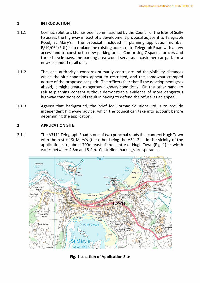
2.1.1 The A3111 Telegraph Road is one of two principal roads that connect Hugh Town with the rest of St Mary’s (the other being the A3112). In the vicinity of the application site, about 700m east of the centre of Hugh Town (Fig. 1) its width varies between 4.8m and 5.4m. Centreline markings are sporadic.
Fig. 1 Location of Application Site
Information Classification: CONTROLLED
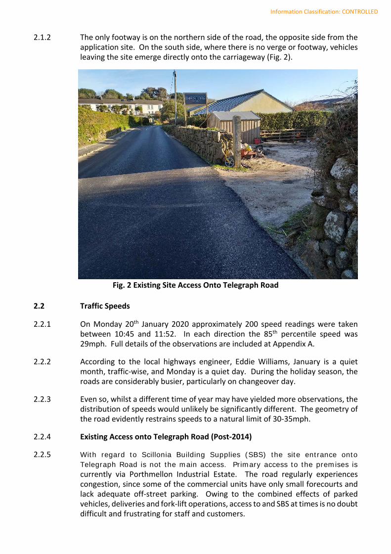
2.1.2 The only footway is on the northern side of the road, the opposite side from the application site. On the south side, where there is no verge or footway, vehicles leaving the site emerge directly onto the carriageway (Fig. 2).
Fig. 2 Existing Site Access Onto Telegraph Road
2.2 Traffic Speeds
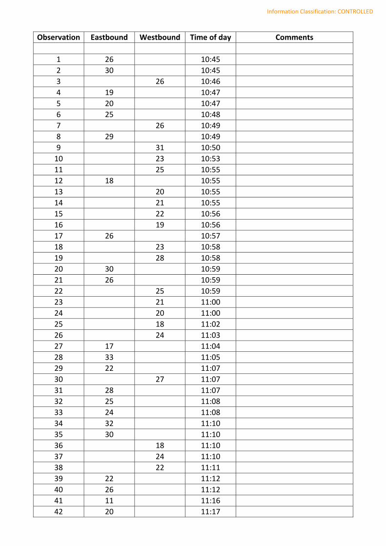
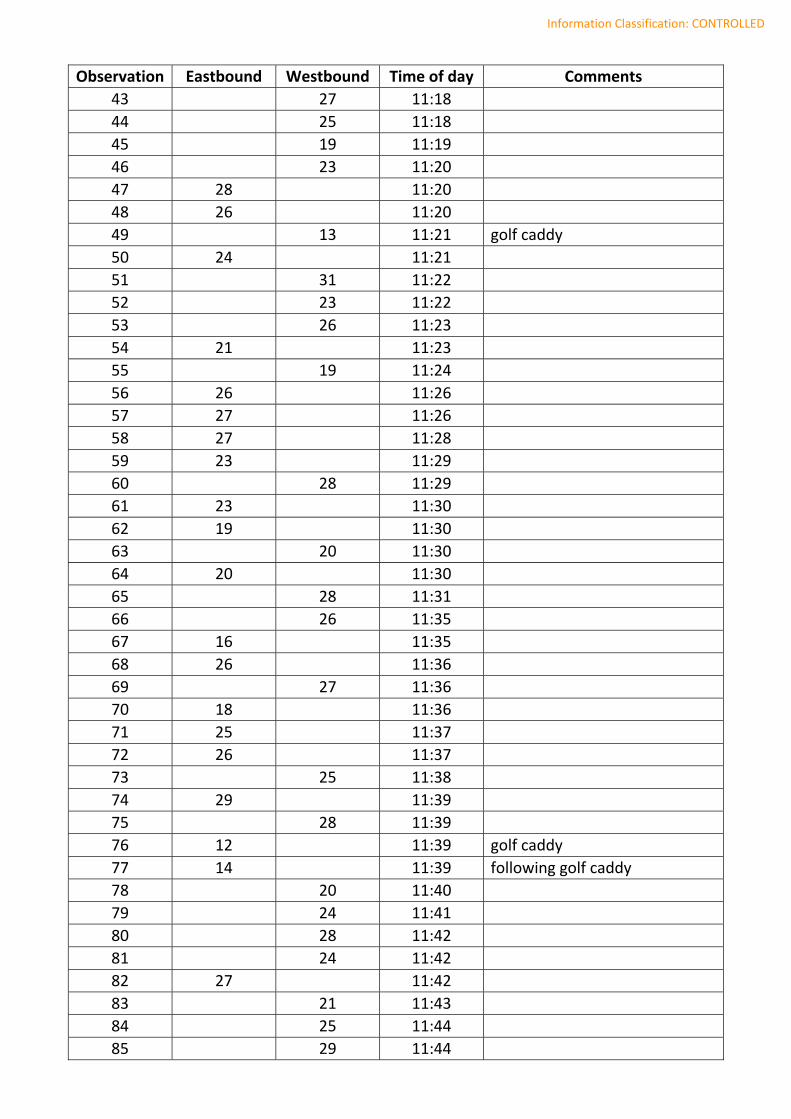
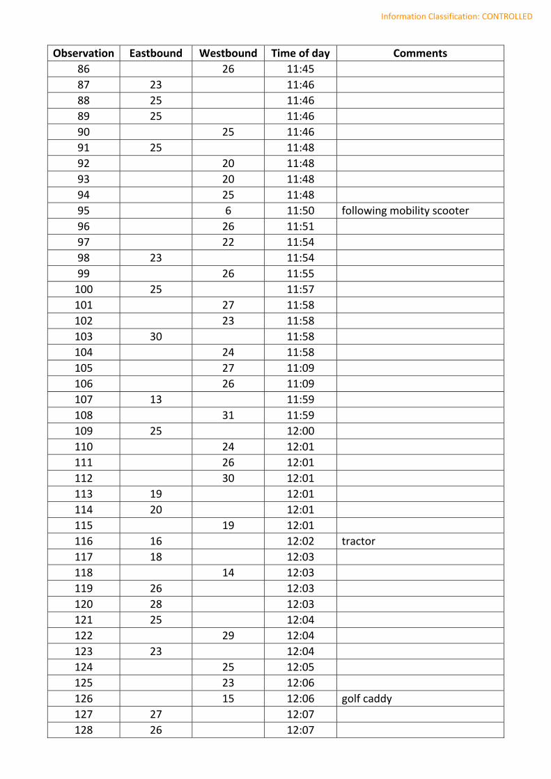
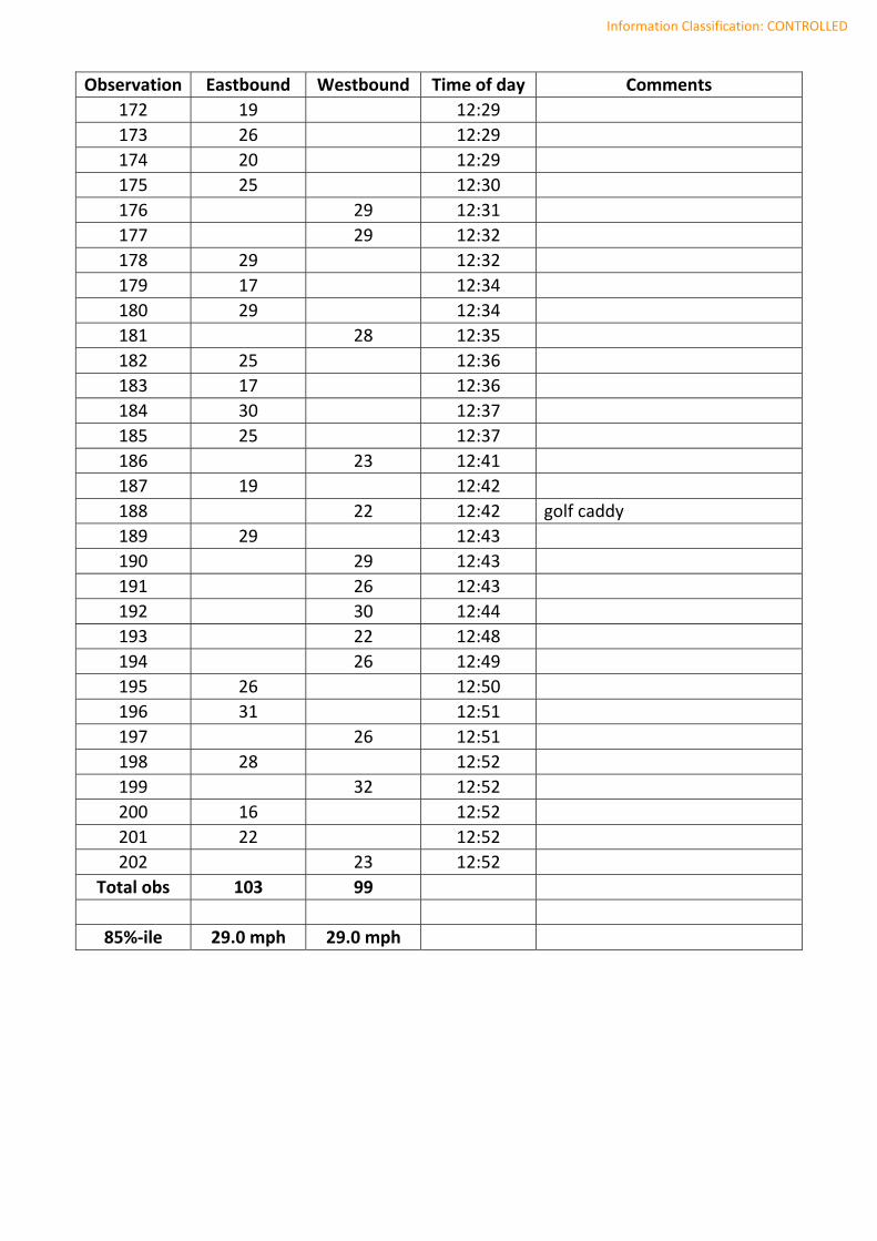
2.2.1 On Monday 20th January 2020 approximately 200 speed readings were taken between 10:45 and 11:52. In each direction the 85th percentile speed was 29mph. Full details of the observations are included at Appendix A.
2.2.2 According to the local highways engineer, Eddie Williams, January is a quiet month, traffic‐wise, and Monday is a quiet day. During the holiday season, the roads are considerably busier, particularly on changeover day.
2.2.3 Even so, whilst a different time of year may have yielded more observations, the distribution of speeds would unlikely be significantly different. The geometry of the road evidently restrains speeds to a natural limit of 30‐35mph.
2.2.4 Existing Access onto Telegraph Road (Post‐2014)
2.2.5 With regard to Scillonia Building Supplies (SBS) the site entrance onto Telegraph Road is not the main access. Primary access to the premises is currently via Porthmellon Industrial Estate. The road regularly experiences congestion, since some of the commercial units have only small forecourts and lack adequate off‐street parking. Owing to the combined effects of parked vehicles, deliveries and fork‐lift operations, access to and SBS at times is no doubt difficult and frustrating for staff and customers.
Information Classification: CONTROLLED
2.2.6 In 2014 the owner of SBS, Mr Mark Wright, obtained planning permission for a new access at the rear of the premises, i.e. off Telegraph Road (planning reference number P/14/032/FUL). The new access would be used for deliveries only, thus reducing congestion in the industrial estate and freeing up an area of forecourt at the front for customer parking.
2.2.7 That this access was to be of limited use is confirmed by Condition No 6, which reads as follows: “The access hereby approved shall only be used by commercial vehicles to off‐load/load materials to and from the site and not for any other vehicles, including customers using the premises.”
2.2.8 The existing entrance provides access to a rear yard which comprises approximately 170m² of unsurfaced but usable area. After an initial drop of about 0.3m from the highway, the ground continues to fall gently away from the road.
2.2.9 The boundary with Telegraph Road is about 18m long. It is demarcated with a random rubble wall, approximately 1.2m high, and a 4.5m wide gateway in the south‐western corner of the site which provides access to the yard from the road.
3 PROPOSED LAYOUT
3.1.1 The proposed layout of the yard, included at Appendix B, shows 7 parking spaces, divided into two rows. Their dimensions of 4.8m x 2.4m comply with design guidance, and at 7.6m the width of the aisle between the two rows provides adequate manoeuvring room.
3.1.2 The proposed access is shown at the midpoint along the boundary, thus maximising the available visibility in each direction. Whilst the proposed opening of 5.5m might, in theory, offer sufficient width for cars to enter and leave simultaneously and independently, the reality may be somewhat different.
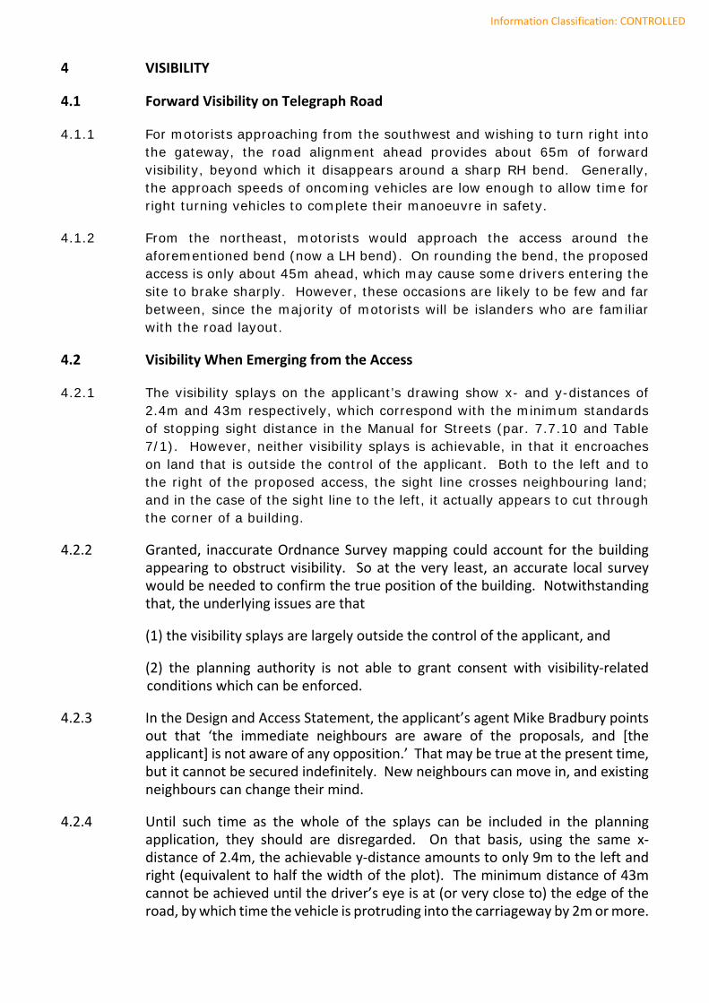
3.1.3 By maximising the available room on site, the end spaces – nos 4 and 7 on the application drawing (Fig. 3) – are barely 3m from the edge of the road. The distance is too short for vehicles leaving these spaces (particularly in forward gear) to straighten up before they reach the road. Their angled exit onto the road could:
(a) require a three point turn within the carriageway, and
(b) cause vehicles entering the site to wait until the car park entrance is clear.
3.1.4 Either of these scenarios could be prejudicial to highway safety. Users of the A3111 can reasonably expect traffic to flow freely. So whilst these scenarios could describe typical everyday manoeuvres within a built‐up area, they are not typical of a site that is on a main road, the edge of the town.
3.1.5 An additional concern with the potential difficulty in using the car park is that it could encourage customers instead to park on the road; or half on the road, half on the footway.
Information Classification: CONTROLLED
4 VISIBILITY
4.1 Forward Visibility on Telegraph Road
4.1.1 For motorists approaching from the southwest and wishing to turn right into the gateway, the road alignment ahead provides about 65m of forward visibility, beyond which it disappears around a sharp RH bend. Generally, the approach speeds of oncoming vehicles are low enough to allow time for right turning vehicles to complete their manoeuvre in safety.
4.1.2 From the northeast, motorists would approach the access around the aforementioned bend (now a LH bend). On rounding the bend, the proposed access is only about 45m ahead, which may cause some drivers entering the site to brake sharply. However, these occasions are likely to be few and far between, since the majority of motorists will be islanders who are familiar with the road layout.
4.2 Visibility When Emerging from the Access
4.2.1 The visibility splays on the applicant’s drawing show x- and y-distances of 2.4m and 43m respectively, which correspond with the minimum standards of stopping sight distance in the Manual for Streets (par. 7.7.10 and Table 7/1). However, neither visibility splays is achievable, in that it encroaches on land that is outside the control of the applicant. Both to the left and to the right of the proposed access, the sight line crosses neighbouring land; and in the case of the sight line to the left, it actually appears to cut through the corner of a building.
4.2.2 Granted, inaccurate Ordnance Survey mapping could account for the building appearing to obstruct visibility. So at the very least, an accurate local survey would be needed to confirm the true position of the building. Notwithstanding that, the underlying issues are that
(1) the visibility splays are largely outside the control of the applicant, and
(2) the planning authority is not able to grant consent with visibility‐related conditions which can be enforced.
4.2.3 In the Design and Access Statement, the applicant’s agent Mike Bradbury points out that ‘the immediate neighbours are aware of the proposals, and [the applicant] is not aware of any opposition.’ That may be true at the present time, but it cannot be secured indefinitely. New neighbours can move in, and existing neighbours can change their mind.
4.2.4 Until such time as the whole of the splays can be included in the planning application, they should are disregarded. On that basis, using the same x‐distance of 2.4m, the achievable y‐distance amounts to only 9m to the left and right (equivalent to half the width of the plot). The minimum distance of 43m cannot be achieved until the driver’s eye is at (or very close to) the edge of the road, by which time the vehicle is protruding into the carriageway by 2m or more.
Information Classification: CONTROLLED
Fig. 3 Extract from Applicant’s Drawing 1977‐P08 rev. D (Visibility Splay Highlighted) 4.2.5 True, oncoming motorists may well see a vehicle slowly emerging from the
access, with enough time to slow down or pass around it. Indeed, many such accesses already exist, including the current access to the yard. Nevertheless, a new access should meet appropriate standards, and its safe operation should not be dependent on other motorists being able to take evasive action.
4.2.6 In his Transport Advisory Note in support of the application, Jon Pearson asserts that the “closure of an existing, highly substandard access and replacement with much improved access is considered a major highway safety gain”. This is disputed. Without the essential visibility splays, the level of improvement offered by the proposed access over the existing one is minimal.
Information Classification: CONTROLLED
5 SUMMARY AND CONCLUSIONS
5.1.1 The free movement into the site is likely to be hindered by vehicles manoeuvring in and out of parking spaces immediately inside the site entrance. Unable to straighten up fully before leaving the site, vehicles may need to carry out a three point turn within the carriageway, or they may force other vehicles to wait in the road until the entrance is clear.
5.1.2 Some customers could choose to park on the road rather than use the car park.
5.1.3 The proposed access is close to a sharp bend. Only after rounding the bend will westbound drivers be able to see the access, which may lead to sharp braking if they wish to enter the site.
5.1.4 The visibility splays shown on the application drawing cross over land which is outside the control of the applicant. Accordingly adequate sight lines can neither be guaranteed nor made the subject of suitable planning conditions.
5.1.5 When taking into account the dimensions of the site, the true sight lines measure only 9m to the left and right of the proposed access.
5.1.6 Although the 85th percentile speed on Telegraph Road is less than 30mph, the application has not provided sufficient evidence that a safe and satisfactory access can be provided. In the interests of highway safety it is recommended that the application be refused.
Alistair Uglow BEng (Hons) CEng MICE

Information Classification: CONTROLLED
APPENDIX A – ON‐SITE SPEED OBSERVATIONS
Information Classification: CONTROLLED
Observation Eastbound Westbound Time of day Comments
1 26
10:45
2 30
10:45
3
26 10:46
4 19
10:47
5 20
10:47
6 25
10:48
7
26 10:49
8 29
10:49
9
31 10:50
10
23 10:53
11
25 10:55
12 18
10:55
13
20 10:55
14
21 10:55
15
22 10:56
16
19 10:56
17 26
10:57
18
23 10:58
19
28 10:58
20 30
10:59
21 26
10:59
22
25 10:59
23
21 11:00
24
20 11:00
25
18 11:02
26
24 11:03
27 17
11:04
28 33
11:05
29 22
11:07
30
27 11:07
31 28
11:07
32 25
11:08
33 24
11:08
34 32
11:10
35 30
11:10
36
18 11:10
37
24 11:10
38
22 11:11
39 22
11:12
40 26
11:12
41 11
11:16
42 20
11:17
Information Classification: CONTROLLED
Observation Eastbound Westbound Time of day Comments
43
27 11:18
44
25 11:18
45
19 11:19
46
23 11:20
47 28
11:20
48 26
11:20
49
13 11:21 golf caddy
50 24
11:21
51
31 11:22
52
23 11:22
53
26 11:23
54 21
11:23
55
19 11:24
56 26
11:26
57 27
11:26
58 27
11:28
59 23
11:29
60
28 11:29
61 23
11:30
62 19
11:30
63
20 11:30
64 20
11:30
65
28 11:31
66
26 11:35
67 16
11:35
68 26
11:36
69
27 11:36
70 18
11:36
71 25
11:37
72 26
11:37
73
25 11:38
74 29
11:39
75
28 11:39
76 12
11:39 golf caddy
77 14
11:39 following golf caddy
78
20 11:40
79
24 11:41
80
28 11:42
81
24 11:42
82 27
11:42
83
21 11:43
84
25 11:44
85
29 11:44
Information Classification: CONTROLLED
Observation Eastbound Westbound Time of day Comments
86
26 11:45
87 23
11:46
88 25
11:46
89 25
11:46
90
25 11:46
91 25
11:48
92
20 11:48
93
20 11:48
94
25 11:48
95
6 11:50 following mobility scooter
96
26 11:51
97
22 11:54
98 23
11:54
99
26 11:55
100 25
11:57
101
27 11:58
102
23 11:58
103 30
11:58
104
24 11:58
105
27 11:09
106
26 11:09
107 13
11:59
108
31 11:59
109 25
12:00
110
24 12:01
111
26 12:01
112
30 12:01
113 19
12:01
114 20
12:01
115
19 12:01
116 16
12:02 tractor
117 18
12:03
118
14 12:03
119 26
12:03
120 28
12:03
121 25
12:04
122
29 12:04
123 23
12:04
124
25 12:05
125
23 12:06
126
15 12:06 golf caddy
127 27
12:07
128 26
12:07

Information Classification: CONTROLLED
Observation Eastbound Westbound Time of day Comments
129
26 12:08
130 29
12:10
131 28
12:10
132
25 12:10
133 20
12:10
134
29 12:10
135
27 12:11
136 20
12:11
137
21 12:11
138 23
12:12
139
24 12:12
140 19
12:12
141 34
12:13
142 28
12:13
143 28
12:13
144
24 12:13
145 22
12:14
146
29 12:15
147 20
12:15
148
27 12:16
149 19
12:16
150
29 12:16
151
28 12:16
152
26 12:17
153
28 12:17
154 26
12:18
155 32
12:18
156
29 12:18
157
30 12:20
158 25
12:20
159
26 12:20
160
26 12:20
161
34 12:21
162 31
12:24
163 28
12:00
164 32
00:00
165 24
12:25
166 16
12:25
167 13
12:26 golf caddy
168 25
12:26
169 29
12:27
170 29
12:28
171
13 12:28
Information Classification: CONTROLLED
Observation Eastbound Westbound Time of day Comments
172 19
12:29
173 26
12:29
174 20
12:29
175 25
12:30
176
29 12:31
177
29 12:32
178 29
12:32
179 17
12:34
180 29
12:34
181
28 12:35
182 25
12:36
183 17
12:36
184 30
12:37
185 25
12:37
186
23 12:41
187 19
12:42
188
22 12:42 golf caddy
189 29
12:43
190
29 12:43
191
26 12:43
192
30 12:44
193
22 12:48
194
26 12:49
195 26
12:50
196 31
12:51
197
26 12:51
198 28
12:52
199
32 12:52
200 16
12:52
201 22
12:52
202
23 12:52
Total obs 103 99
85%‐ile 29.0 mph 29.0 mph

Information Classification: CONTROLLED
APPENDIX B – APPLICATION DRAWING NO 1977‐P08 REV. D

Studio St Ives4 Gabriel StreetSt IvesTR26 2LU01736 798427
NOTES
THIS DRAWING IS THE COPYRIGHT OF THE ARCHITECT AND MAY NOT BE REPRODUCED WITHOUT LICENCE
DO NOT SCALE OFF THIS DRAWING
ALL DIMENSIONS AND LEVELS ARE TO BE CHECKED ON SITE BY THE CONTRACTOR BEFORE COMMENCEMENT OF WORK AND ANY DISCREPENCIES REPORTED TO THE ARCHITECT
NO RESPONSIBILITY CAN BE ACCEPTED FOR ERRORS ARISING ON SITE DUE TO UNAUTHORISED VARIATIONS FROM THE ARCHITECTS DRAWINGS.
AMENDMENTS
1
2
3
4
JOB
TITLE
DRNG. NO. REVISION
SCALE DATE
OFFICE USE / PRE-ISSUE
1:100@A11:200@A3 Sept 2019
1977-P08 D
Proposed Site Plan
Alterations to Scillonia Building Supplies, St Mary's, The Isles of Scilly
forWright Construction
A Alterations to parking access,pedestrian access and visbilitysplays.AKB 161019
B Scale bar added. Disabled parking bay introduced. Parking space dimensions added and surface finish key.AKB 271119
C Steps added from parking area to entrance MB 281119
D Parking spaces reduced andreconfigured. Bicycle parkingintroduced. AKB 041219
0m 5m 10m
N
Proposed Site Plan
PLANNING
Walkway
Footpath
5 7
New Canopy
New Storage Shed
Existing shed to be removed
Parking
Porth
mel
lon
Indu
stria
l Est
ate
Phoenix Art Studio
Tele
grap
h R
oad
Existing balcony to be regularised by new application
5,50
0mm
ram
p
43m
4,80
0mm
2,400mm
Key
Permeable surface finish 'Aco Groundguard'
6
1 4
4,80
0mm
2,400mm
32
7,60
0mm
2,400mm
Bike bays