Embed Size (px)
Citation preview

MICHIGAN GEOLOGICAL AND BIOLOGICAL SURVEY.
Publication 9. Geological Series 7.
SURFACE GEOLOGY AND AGRICULTURAL CONDITIONS OF THE SOUTHERN PENINSULA
OF MICHIGAN.
BY FRANK LEVERETT
WITH A CHAPTER ON CLIMATE BY C. F. SCHNEIDER.
PUBLISHED AS A PART OF THE ANNUAL REPORT OF THE
BOARD OF GEOLOGICAL AND BIOLOGICAL SURVEY FOR 1911.
LANSING, MICHIGAN
WYNKOOP HALLENBECK CRAWFORD CO., STATE PRINTERS 1912
BOARD OF GEOLICAL AND BIOLOGICAL SURVEY. 1911.
EX OFFICIO:
THE GOVERNOR OF THE STATE, HON. CHASE S, OSBORN, President,
THE SUPERINTENDENT OF PUBLIC INSTRUCTION, HON. L. L. WRIGHT, Secretary.
THE PRESIDENT OF THE STATE BOARD OF EDUCATION, HON. D. M. FEERY, JUNIOR.
DIRECTOR, R. C. ALLEN.
SCIENTIFIC ADVISERS.
Geologists.—Dr. L. L. Hubbard, Houghton; Prof. W. H. Hobbs, Ann Arbor; Prof. Wm. H. Sherzer, Ypsilanti.
Botanists.—Prof. E. A. Bessey, East Lansing; Prof. F. C. Newcombe, Ann Arbor.
Zoologists.—Prof. W. B. Barrows, East Lansing; Prof. J. Reighard, Ann Arbor, Mr. Bryant Walker, Detroit.
CONTENTS Introduction. By R. C. Allen. ............................................. 3 CHAPTER I. Physiography of the Southern Peninsula. .. 5
General geological features and geologic terms. .......... 5
Altitude. ..........................................................................8 Drainage systems. .........................................................9
CHAPTER II. Climatic Conditions. By C. F. Schneider .10 Temperature.................................................................12 Frosts. ..........................................................................14 Precipitation..................................................................14 Drought.........................................................................16 Sunshine. .....................................................................16 Winds. ..........................................................................16 Relative Humidity. ........................................................16
CHAPTER III. Glacial Features. .....................................17 Features due to early stages of glaciation. ..................17 Moraines and their outwash. ........................................18
Outermost moraines in Michigan........................... 18 Kalamazoo Jackson morainic system ................... 19 Valparaiso-Charlotte morainic system................... 19 The series of slender moraines ............................. 19 Glacial drainage between the Saginaw and Michigan lobes....................................................... 20 Glacial drainage and lakes in the Huron-Erie basin ...................................................................... 20 Port Huron morainic system and Lake Whittlesey 20 Relation of the Port Huron morainic system to Lake Chicago.................................................................. 21 The Cheboygan moraine....................................... 22
Features between the moraines. .................................22 Till plains................................................................ 22 Eskers and kames ................................................. 22 Drumlins................................................................. 23
CHAPTER IV. Lake features. .........................................24 Introductory statement. ................................................24 Lake Chicago. ..............................................................24
Outlet and beaches ............................................... 24 Lake bed deposits ................................................. 25 Tilting of the Michigan basin.................................. 25
Lake Maumee...............................................................25 Outlets, beaches and delta deposits ..................... 25
First Lake Saginaw.......................................................26 Lake Arkona. ................................................................26 Later Lake Saginaw. ....................................................26 Lake Whittlesey. ...........................................................26 Lake Warren.................................................................27 Lake Wayne. ................................................................27 Lake Elkton (Grassmere and Elkton Beaches). ...........27 Beginnings of Lake Erie and Lake St. Clair. ................28 Lake Algonquin. ...........................................................28 Nipissing Great Lakes. .................................................29
CHAPTER V. Agricultural conditions. .............................29 General notes on the agricultural conditions................29
Condition by counties (counties in alphabetical order) ....33
Publication 9, Geological Series 7 – Page 1 of 44

Publication 9, Geological Series 7 – Page 2 of 44
LIST OF ILLUSTRATIONS.
PLATES. Plate III. A. Boulevard Hill, north of Huron river, Ann Arbor,
showing morainic topography. Photo by Frank Leverett..6
B. Gravel in inclined beds in the outwash apron north of University dampus, Ann arbor. Photo by Frank Leverett. 7
Plate IV. A. Road on top of Mason esker three miles south of Holt, Ingham county, looking north. Photo by F. B. Taylor. ..............................................................................7
B. East end of large kame north of Waterford, Oakland county, looking south. Photo by F. B. Taylor................................7
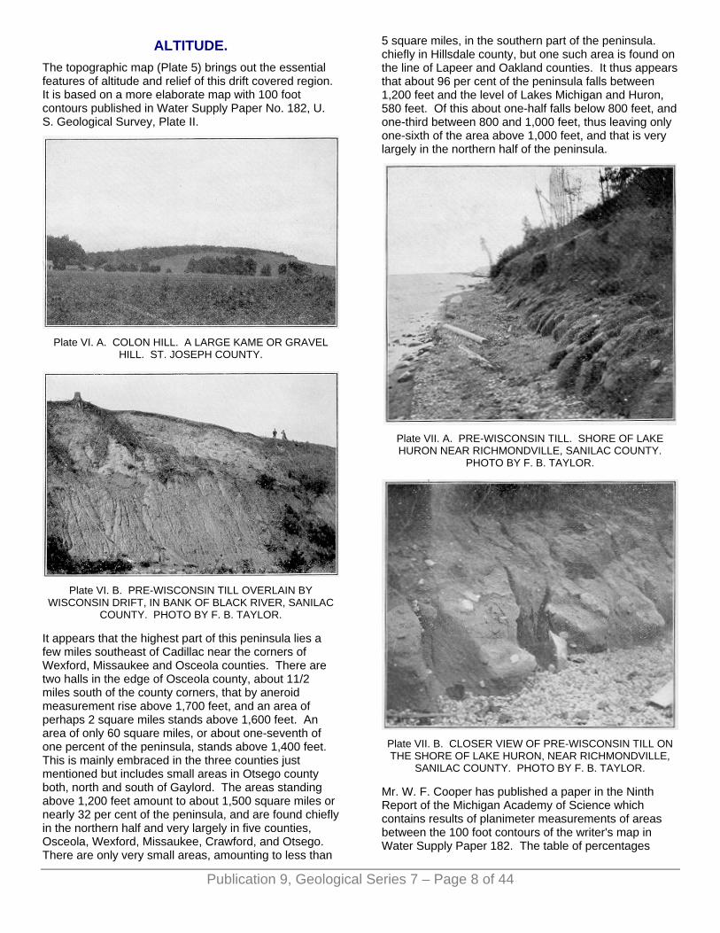
Plate VI. A. Colon Hill. A large kame or gravel hill. St. Joseph county...............................................................................8
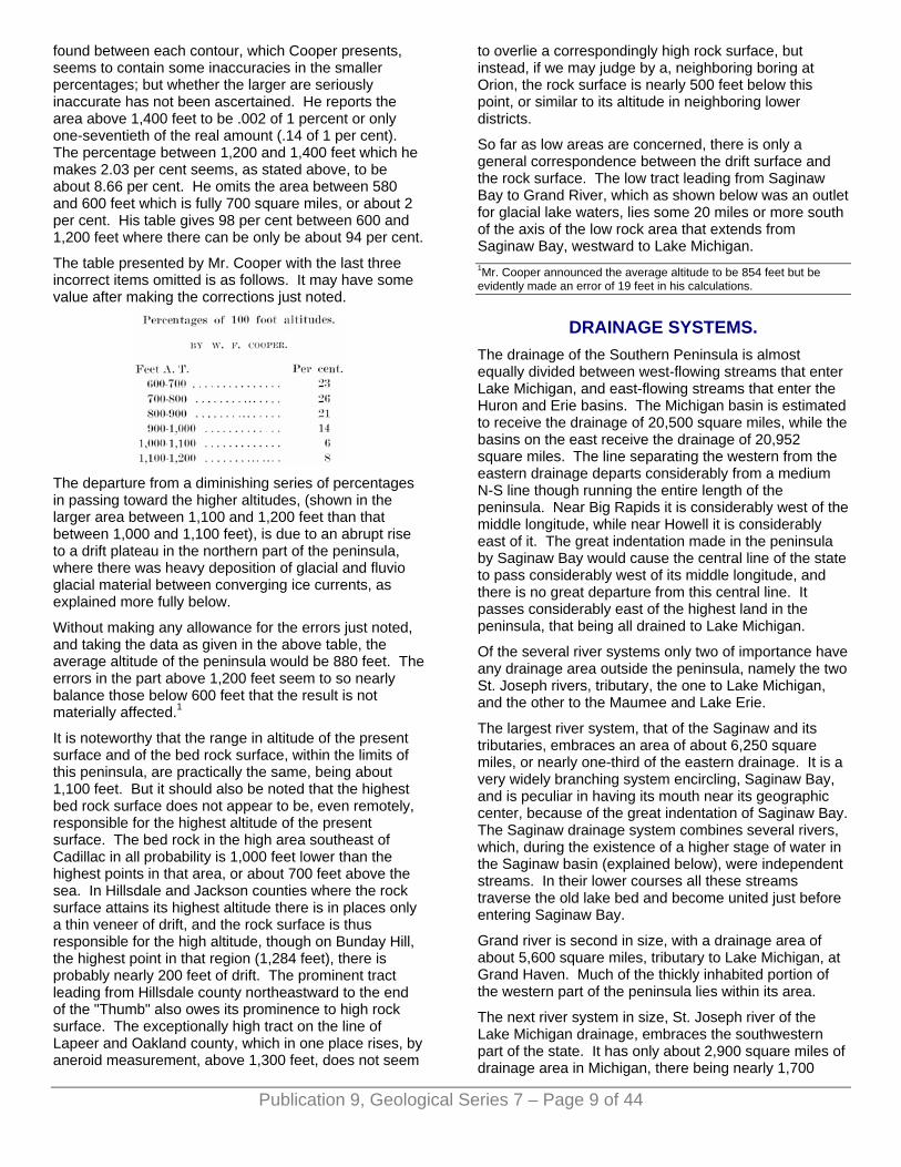
B. Pre-Wisconsin till overlain by Wisconsin drift, in bank of Black river, Sanilac county. Photo by F. B. Taylor. ..........8
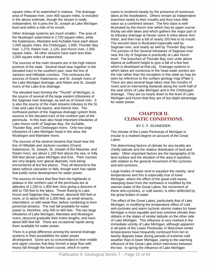
Plate VII. A. Pre-Wisconsin till. Shore of Lake Huron near Richmondville, Sanilac county. Photo by F. B. Taylor. ....8
B. Closer view of Pre-Wisconsin till on the shore of Lake Huron, near Richmondville, Sanilac county. Photo by F. B. Taylor. ..........................................................................8
Plate VIII. A. Looking south across Imlay outlet, near Deanville, Lapeer county. Photo by F. B. Taylor. ...........22
B. Pre-Wisconsin till below Wisconsin drift above, separated by old soil zone shown in dark band, Sanilac county. Photo by F. B. Taylor......................................................23
Plate IX. A. Beach of Lake Warren from lakeward side. Buildings stand on the beach. One mile north of Charleston, Sanilac county. Photo by F. B. Taylor. .......23
B. Highest beach on short target range, Mackinac Island. Photo by J. W. Goldthwait. .............................................23
Plate X. Mackinac Island from Round Island spit, one mile north. The hump in the middle of the ancient island in Lake Algonquin and its base marks the Algonquin beach. The fort is about at the level of the Battlefield beach. The village is on the Nipissing beach and the slope below it. Base of overhanging cliff on the right marks level of this beach. Photo by F. B. Taylor. ........................................23
Plate XI. Ridge on Battlefield beach on Mackinac Island battlefield. Rear view looking north. Photo by H. J. Rossiter. .........................................................................23
Plate XII. Front view of Algonquin beach in Petoskey, west of Bear creek. The two houses in the middle of the view are on the ridge. Photo by F. B. Taylor. ...............................30
Plate XIII. Wave cut terrace and bluff. Algonquin beach west of Black river, Alcona county. Photo by F. B. Taylor......30
Plate XIV. Algonquin and Nipissing terraces where the stream entered these predecessors of Lake Huron near Forestville, Sanilac county. Two trees in the middle foreground are on the nipissing fluvial plain, while the higher terrace beyond is Algonquin and the stream bed to the left and lower is in harmony with Lake Huron level...30
Plate XV. A. Looking up wind gully in dunes in High Island, Lake Michigan. Photo by F. B. Taylor............................30
B. Bronson lake, Lapeer county. A typical moraine lake. Photo by F. B. Taylor. ....................................................30
FIGURES. Fig. 1. January mean temperature, 1886 to 1911. ................11
Fig. 2. July mean temperature, 1886 to 1911........................11
Fig. 3. Annual mean temperature, 1886 to 1911. ..................13
Fig. 4. Average annual precipitation, 1886 to 1911. ..............13
Fig. 5. Highest known temperatures, 1886-1911...................13
Fig. 6. Lowest known temperatures, 1886 to 1911................13
Fig. 7. Average date of last killing frost in spring. ..................14
Fig. 8. Average date of first killing frost in autumn.................14
Fig. 9. Average length of crop growing season, days............15
Fig. 10. Counties in the various sections, viz. Northern, Central and Southern. ....................................................15
Fig. 11. Average monthly precipitation by sections. ..............15
Fig. 12. Monthly mean temperature, Northern section. .........15
Fig. 13. Monthly mean temperature, Central section.............15
Fig. 14. Monthly mean temperature, Southern section..........16
Fig. 15. Per cent of land area in farms, 1910 .........................31
Fig. 16. Average value of farm land per acre, 1910. .............32
LETTER OF TRANSMITTAL. To the Honorable the Board of Geological and Biological
Survey of the State of Michigan:
Gov. Chase S. Osborn, President. Hon. D. M. Ferry, Jr., Vice-President. Hon. L. L. Wright, Secretary.
Gentlemen:—I beg to present herewith for printing as part of the report of the Board of Geological and Biological Survey for 1911, Publication 9, Geological Series 7, a report by Mr. Frank Leverett on Surface Geology and Agricultural Conditions, of the Southern Peninsula of Michigan, with a chapter on climate by C. F. Schneider.
Very respectfully, R. C. ALLEN, Director.

Publication 9, Geological Series 7 – Page 3 of 44
INTRODUCTION. BY R. C. ALLEN.
In the Annual Report of the Michigan Geological Survey for 1907, there was published a large scale colored map of the surface or soil formations of the Southern Peninsula of Michigan. This map is accompanied by an explanatory text by Dr. A. C. Lane. This text is mainly an interpretation of the map. The map and text were published with the end in view of setting forth in a manner easily comprehended, an orderly narrative of the causes and effects of the several continental glaciations of the Pleistocene or glacial period ("Great Ice Age") with detailed application to the Southern Peninsula of Michigan.
The demand for the work has; been so large that the limited edition is now exhausted. The necessity of a new edition brings with it the opportunity of a thorough revision of the map. Additional information has been incorporated and new subdivisions of the glacial or soil formations have been made. This may be seen by comparative examination of the legend on the map of 1907 with the legend accompanying the new map. (Plate I.) The former bears only eight different colors, and smybols, the latter sixteen. A new and more pleasing color scheme has been adopted, a new black base has been used and a superior grade of lithographing has been accomplished.1
The text which follows has been entirely rewritten by Mr. Frank Leverett and a chapter on climate by Mr. C. F. Schneider has been added. The reader is first introduced to a knowledge of the general physiographic and climatic conditions of the peninsula with special emphasis of the bearing of these on agriculture. There follows a history of the glacial period in Michigan in which is developed the character, distribution, mode of origin and topographic expression of the various surface or soil formations. A general inventory of the various soil formations is then taken and the results are tabulated with other related statistical data in convenient form by counties and townships. 1The black base is a part of the new international map of the world on a scale of 1.1,000,000.
HOW TO USE THIS MAP AND VOLUME. This publication is an attempt to adapt the results of a careful scientific study of the surface formations of the state to a distinctly utilitarian purpose. Were we concerned merely with elucidation of a chapter in earth history from a purely scientific point of view, stress would be laid on many facts and conditions which are here only mentioned or entirely ignored. Such treatment will be given by Messrs. Frank Leverett and F. B. Taylor in a forthcoming monograph to be published by the United States Geological Survey. But in this volume the emphasis is placed on the economic features, in other words the surface formations are treated from the view-point of their relative extent, character and value from
the standpoint of industry,—the chief industry being of course agriculture.
This map (Plate I) and the text will be found useful to persons interested in obtaining a knowledge of the physiographic, climatic and soil conditions of the Southern Peninsula or of any part of it. The subject matter is well adapted to the needs of students and teachers but more especially to farmers, land buyers or dealers, and the development bureaus, of citizens, railroads and other organizations concerned with the agricultural progress of the state and the settlement and development of thinly populated areas adapted to farming.
Prospective purchasers of land and prospective settlers should be guided only by a personal knowledge of the particular description of land of which purchase is considered and accurate information regarding local conditions. No map and no amount of printed matter can take the place of a personal examination on the ground. In the mapping and discussion of the soil formations we have made no attempt to measure general fertility or crop growing capacity of the soil formations or particular crop adaptations to particular soils. Soil fertility is dependent on many factors not considered in this text. Local conditions of temperature, moisture and topography, physical and chemical composition of the soil, the property of supporting bacterial life, the character of the subsoil, etc., are all important determinants of crop growing capacity. Particular kinds of soil under certain combinations of the above factors will grow excellent crops of particular kinds when other crops will fail wholly or partially. In these days of specialized farming practically every kind of soil can be managed in such manner as to grow remunerative crops and good soil management is a factor in crop growing of importance equal to that of the soil itself.
It is known by everyone who has only a slight familiarity with soils that maps which show details of soil composition and texture do not exist and in the very nature of the case can not be made. There is no limitation of subdivision that might be made were soils to be classified on slight differences, of physical and chemical composition. On a single quarter section may be found one, two, six or a dozen different soils depending on the basis of classification and the degree of importance attaching to minor variations in character. It is, however, inadvisable to carry in a soil classification a large number of subdivisions based on slight variations. On the map which accompanies this volume (Plate I) there is shown in color and symbol fourteen types and subtypes of soil formations. It is thought that this degree of subdivision expresses admirably the general facts. The character and relations of these types and subtypes may be readily understood and the number is not so great as to be confusing to the general reader.
It should be understood that the boundaries between surface formations of unlike character can rarely be

Publication 9, Geological Series 7 – Page 4 of 44
represented by a line or a plane. Ordinarily one formation gives place to another through gradational phases and the boundary between them is at the surface a zone or belt of varying width. The formation boundaries which are represented by lines on the map are in reality in most cases zones of gradation between adjacent formations.
While a given small area may show wide variations of soil character, the number of variations depending as stated above on the importance attached to slight variations in the classification, it is not less true that the same area may have a great predominance of soil of a particular character and composition depending on origin and manner of formation, and the general soil conditions in such an area could be properly represented on a small scale map by a single color or symbol. The colors and symbols express on Plate I dominance in the various areas covered by them of a particular formation of the general character set forth in the legend and not entire exclusion of other types.
Soil Classification. Any soil classification, which is carried to an extreme degree of differentiation is confusing to those who are not students or specialists in the subject and thus fails of maximum usefulness. A satisfactory classification can not be based on several factors especially if these factors are not closely related. For instance it would not be satisfactory to attempt a classification based on the following factors: (1) origin, (2) chemical composition, for physical composition, for these factors are not necessarily closely related. Any one of these factors could be used and in fact are each used as a main basis for soil classification and each classification is useful.
The classification which is based on origin seems preferable for glacial and fluvio-glacial soils. The names of the various subdivisions such as moraines, till plains, kames, lake plains, etc., carry with them a general idea regarding constitution, topography, etc. In other words, if the mode of origin of a glacial formation be given, a slight knowledge of the subject will enable one to make in many cases a close approximation to physical constitution, general composition and general topographic expression of the formation. Furthermore, when origin is the controlling factor in classification the soil map brings out at a glance much of the geologic significance and topographic relations of the various formations. This significance is entirely lost or greatly obscured on maps which express a classification based on physical constitution or chemical compositiaon despite the usually evident relation of these factors to mode of origin. A soil map of a glaciated area which expresses a classification on the basis of origin can be properly made only by a trained and experienced glaciologist such as the author of this volume.
Land Values. The value of farm land varies with locality and with all of the above factors governing soil fertility. Average values of Michigan farm land by counties as determined by the Thirteenth Census are given in Chapter V. In making reference to these tables one
should consider the values there given by counties in connection with the total acreage of developed farm land in the same counties, population, and situation with reference to localization of industries. For instance, the percentge of land area in farms in Wayne county is small when considered with the degree of development of the county but this is explained by the fact that considerable part of the county is embraced within the limits of the City of Detroit and its suburbs. Again, Gogebic county has the appearance of being the most valuable county, agriculturally, in the Northern Peninsula if one were to judge merely by the average value of farm land per acre, but a glance at the map (Fig. 16) shows that only 1.8 per cent of the county has been agriculturally developed. This department is not in position to advise prospective settlers on land values on particular sections and when such requests are made it is our custom to refer the inquiry to trustworthy local parties.
How to procure extra copies of Plate I. Extra copies of the map of the surface or soil formations may be obtained on application to this department and may also be obtained from Hon. A. C. Carton Secretary of the Public Domain Commission and Commissioner of Immigration. A similar map of the Northern Peninsula may also be obtained on application to either of the .above offices.
ACKNOWLEDGMENTS. Mr. Frank Leverett, United States Geologist, the author of this volume has spent a number of years in the study and mapping of the surface formations of Michigan. He has had from time to time the assistance of the geologists of the Michigan Geological Survey and others, chief among whom are F. B. Taylor and A. C. Lane. To Dr. George Otis Smith, Director of the United States Geological Survey, we are deeply indebted. He made the publication of this volume possible by granting free of charge the services of Mr. Leverett in preparation of the map and manuscript. To Mr. C. F. Schneider, Director of the Michigan Section of the United States Weather Bureau, we are indebted for the chapter-on Climate. Thanks and appreciation are tendered, to the authors for their gratuitous painstaking labor and to the United States Geological Survey and the United States Weather Bureau for their cordial cooperation.
R. C. ALLEN, Director. Lansing, Michigan, August 10, 1912.
Publication 9, Geological Series 7 – Page 5 of 44
CHAPTER I. PHYSIOGRAPHY OF THE SOUTHERN PENINSULA.
GENERAL GEOLOGICAL FEATURES AND GEOLOGIC TERMS.
In the Southern Peninsula of Michigan the rock formations present less variety of features than in the Northern Peninsula., and are much less open to view, because of the greater thickness of the glacial deposits. None of the rock formations in the Southern Peninsula have been subjected to such upheaval and folding as characterize the formations in the western part of the Northern Peninsula. They all lie in nearly horizontal position with a gentle dip toward the center of the peninsula. The beds of shale, sandstone, and limestone which outcrop in the eastern part of the Northern Peninsula, also dip toward the center of the Southern Peninsula, and pass beneath the beds which form, the surface of that peninsula.
The rock formations of the Southern Peninsula range in age from the upper part of the Silurian, through the Devonian, to the lower part of the Carboniferous, and consist of a series of limestone, shale, and sandstone beds with which are associated deposits of coal, gypsum, and salt, each in its own particular horizons. The arrangement of the several formations has been likened to the piling up of plates or saucers in a series of diminishing size, arid diminishing amount of dishing, from bottom to top. The uppermost and youngest formation though resting on those which precede it in age does not stand above some of their outlying parts.
The highest bed rock surface in the Southern Peninsula is found in the area of outcrop of the Marshall sandstone of early Carboniferous age in Hillsdale and neighboring parts of Jackson and Calhoun counties, (Plate II) where an altitude of 1,000 to 1,100 feet is reached. The lowest altitude of the rock surface is on the borders of Lake Michigan, in the vicinity of Manistee and Ludington, where it falls below sea level. It is in the area where shales of late Devonian, and of early Carboniferous age, form the uppermost beds of rock. In the midst of Lake Michigan immediately west from there, the rock surface, over an area 30 miles in length and 2 to 8 miles in width, has an altitude more than 300 feet below sea level. There is thus a range of about 1,400 feet in the altitude of the bed rock of this region.
There are, in the Southern Peninsula, two large areas in which the rock surface has a marked relief above bordering districts. One of these, in the southern part of the state, extends from near Kalamazoo and Coldwater northeastward to the terminus of the "Thumb" of Michigan, which lies between Saginaw Hay and the southern part of Lake Huron. From an altitude of 1,100 feet in northern Hillsdale county it drops off somewhat rapidly to about 900 feet in central Jackson county, and then more gradually to 700 feet or less at the end of the
"Thumb." There is also a rapid decrease in altitude southward in Hillsdale county, and adjacent parts of Indiana and Ohio, to an altitude of only 600 feet, and this low altitude of the rock surface is maintained over much of northwestern Ohio and northern Indiana.
The other area with relatively high rock surface is found in the northern part of the peninsula, north of latitude 44°. That region is so heavily covered with drift that few borings have reached the rock. These indicate that the rock surface may not reach an altitude of more than 250 feet above Lakes Michigan and Huron, or but little more than 800 feet above the sea. In southern Cheboygan and southwestern Presque Isle counties the rock is either exposed, or struck in borings, at an altitude about 800 feet above sea level, and no borings in neighboring districts to the south have reached it at a higher altitude. From this relatively high rock area there is but little descent to the northeast and east until one reaches the immediate border of Lake Huron. There is also comparatively little descent in passing westward to Lake Michigan over the district immediately smith of Little Traverse Hay. But from the vicinity of Bellaire southward there is a very low rock surface for some distance inland from the Lake Michigan shore, portions of it being about at sea level. The altitude is also very low in a strip running westward through the center of the peninsula from the southern end of Saginaw Bay to Lake Michigan, the general altitude of the rock surface being only 800 to 500 feet. This low area lies about midway between the two relatively high areas just noted, and there is a gradual rise from it toward these areas. In the south-western and the southeastern parts of the peninsula, there are extensive areas with an altitude about 500 to 600 feet above sea level.
From preceding statements it appears that the relations of the rock surface to the level of Lakes Huron and Michigan are such that, were the drift removed, and these lakes held at their present level, there would be two large islands within the area of the present peninsula; one 100 to 250 feet above the lake, lying north of latitude 44° and occupying perhaps half the present land surface north of that parallel, the other in the southeastern part, with an altitude 100 to 500 feet above the lake. The latter area would he bordered by broad stretches of very shallow water, interspersed perhaps with low islands in the district adjacent to Lakes Erie and St. Clair, and across the northern part of Indiana and northwestern Ohio and the southwestern part of Michigan. There would be relatively deep water in what is now the central part of the peninsula from Saginaw Bay westward, and exceptionally deep water on the western side of the northern island from the head of Grand Traverse Bay to Ludington.
A series of planimeter measurements made by Mr. W. F. Cooper from a map of bed rock contours prepared by Dr. A. C. Lane (See Plate II) show the average elevation of the rock surface to be about 554 feet above the sea. It thus appears that if the drift were removed, and the rock
brought to a uniform level; its surface would stand about 25 feet lower than Lakes Huron and Michigan.
In the preceding discussion of the bed rock surface no account was taken of the preglacial valleys. No doubt the preglacial drainage had been developed into a mature system whose valleys greatly dissected the rock surface. Where the drift is thin as in Hillsdale, Jackson and Calhoun counties the courses of some of the valleys are still visible for they were not filled to the level of their rock bluffs. In other places where the rock is concealed by drift, borings have thrown some light on the position of deep valleys. This is especially true of the district west from the head of Saginaw Bay, where borings indicate the presence of a valley in the rock along a line leading from near Bay City to Alma. This drainage line apparently was discharging westward, or in the reverse direction from the present drainage, for the rock bottom at Alma is lower than at any place to the east, being 350 feet below the level of Saginaw Bay, or only 230 feet above the sea. It seems probable that this valley continued westward into Newaygo county, and thence northwestward to the part of the Michigan shore near Ludington in which the rock surface is below sea level. A valley with rock bottom only 400 feet above sea, level, was struck in a boring at Saranac, a few miles west of Ionia, which may be a southern tributary of the one leading westward from Alma. There are some indications from borings, that a valley came to the present St. Clair valley from the northwest a few miles south of Port Huron, whose rock bottom at the crossing of the St. Clair River is about 200 feet below the present stream, or less than 400 feet above the sea. But aside from these few instances of deep valleys struck by borings, very little has been obtained to show the distribution of the preglacial valleys and direction of drainage. In fully nine-tenths of the state practically nothing is known concerning the old drainage.
The fact that the rock surface in part of the western side of the peninsula is below sea level is rather surprising, but perhaps no more so than that the neighboring part of the bed of Lake Michigan has a small area that is more than 300 feet below that datum. It is evident that considerable change in level of the rock surface has been effected here, either by ice erosion, or by depression of the earth, since the time when this region had a discharge to the ocean. Such changes have so complicated the conditions as to render almost hopeless any attempt, in our present state of knowledge, to map out a connected system of preglacial drainage.
The glacial drift, which covers so deeply much of the rock surface of the Southern Peninsula, consists of a more or less commingled mass of boulders and small stones in a sandy or clayey matrix, though it differs greatly in constitution and in texture from place to place. It was brought in largely, if not wholly, by an ice sheet or continental glacier which moved southwestward from the highlands of Canada across the several Great Lakes basing, carrying in it the earthy and stony material gathered from the loose surface material of the districts
over which it was moving. The Canadian highlands were thus extensively denuded of soil and subsoil, while the district south of the Great Lakes was correspondingly enriched by the glacial action. As indicated below, the average thickness of the drift in the Southern Peninsula is about 300 feet. There are places near the border of Lake Michigan where the drift is known to exceed 600 feet. Places in the high interior of the north part of the peninsula may have over 1,000 feet.
There is evidence that the drift of this peninsula is not the product of a single ice invasion, but instead, of two or more invasions, between which were long periods of warm climate such as prevails today. Between the deposits of glacial material are soils, and peat beds, and other indications of the presence of vegetation such as would thrive under a genial climate.
Certain terms have been applied by geologists and geographers to the various deposits, and the forms or topographic features of the drift, and also to deposits produced by waters issuing from the ice. Among the most prominent of the topographic features are the belts of rolling or hummocky surfaced drift termed moraines. These belts have been followed in some cases for scores and even hundreds of miles in their broad sweep around the basins of our Great Lakes, and across other districts. They were formed at places where the edge of the ice held a nearly constant position for a long period, and, by a continual advance to this line, brought in the material which furnished the irregular surfaced moraines. The uneven surface of the moraines is probably due largely to differences in the dirtiness of the ice. The dirtiest parts upon melting would furnish the material for the hummocks, while the cleanest parts would fall short of building up the surface and leave corresponding depressions. It is probable also that some inequality of surface is due to disturbance of the material by ice movement. The map of the surface formations (Plate I) represents the moraines of this peninsula and these will be discussed more fully farther on.
Plate III. A. BOULEVARD HILL, NORTH OF HURON RIVER,
ANN ARBOR, SHOWING MORAINIC TOPOGRAPHY. PHOTO BY FRANK LEVERETT.
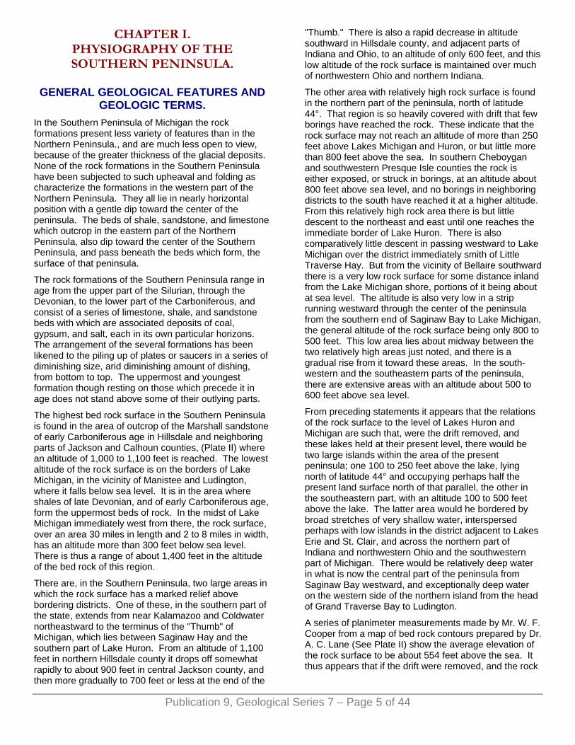
While the ice was forming a given moraine, the water escaping from it is found to have spread out broad plains of sand and gravel on ground immediately outside over which the water escaped. These plains are known as outwash aprons and are notably prominent features of the Southern Peninsula. There are other sandy plains
Publication 9, Geological Series 7 – Page 6 of 44
less definitely related to the ice border, to which a special symbol has been applied in the glacial map. These were probably formed in some cases as an outwash during rapid recession of the ice from one moraine to another. In other cases the sandy deposits may have been made under the margin of the ice. In all cases they indicate the influence of water (See Plate III B). It is perhaps more remarkable that in the course of melting the ice, over large areas, failed to make such deposits, than that they should occur to the extent shown on the glacial map.
Plate III. B. GRAVEL IN INCLINED BEDS IN THE OUTWASH APRON NORTH OF UNIVERSITY DAMPUS, ANN ARBOR.
PHOTO BY FRANK LEVERETT.
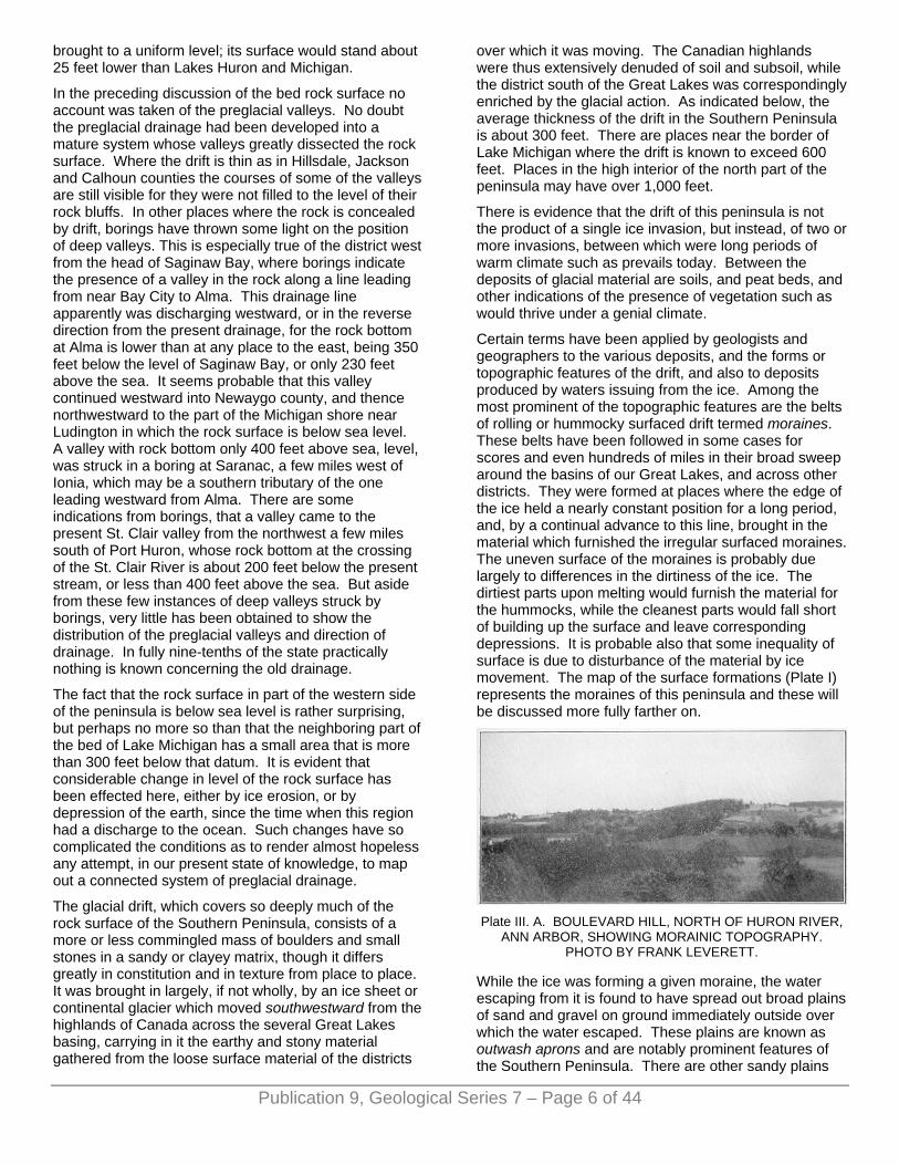
Plate IV. A. ROAD ON TOP OF MASON ESKER THREE MILES SOUTH OF HOLT, INGHAM COUNTY, LOOKING
NORTH. PHOTO BY F. B. TAYLOR.
Over wide areas lying between moraines, there are plains with boulder clay at surface, and with scarcely any coating of sandy material such as might be left along the receding ice border. These are known as till plains, till being a technical name for boulder clay. Their extent is
set forth on the glacial map. They are exceptionally broad in the district southwest of Saginaw Bay.
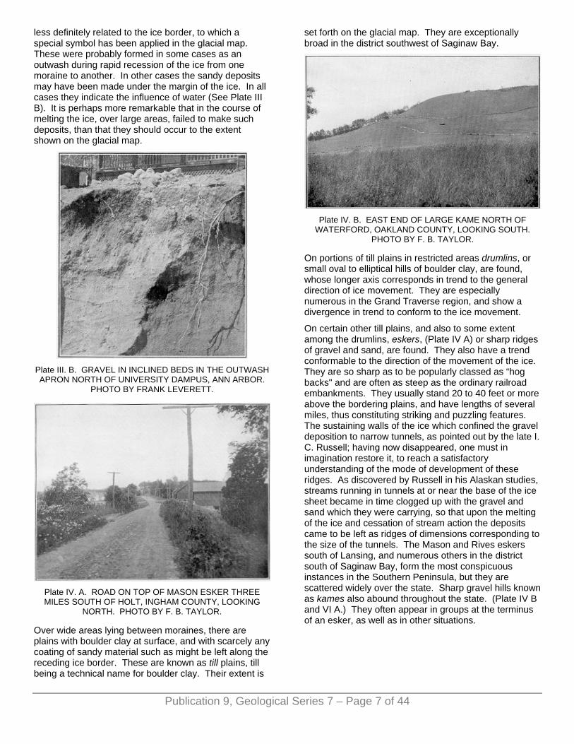
Plate IV. B. EAST END OF LARGE KAME NORTH OF
WATERFORD, OAKLAND COUNTY, LOOKING SOUTH. PHOTO BY F. B. TAYLOR.
On portions of till plains in restricted areas drumlins, or small oval to elliptical hills of boulder clay, are found, whose longer axis corresponds in trend to the general direction of ice movement. They are especially numerous in the Grand Traverse region, and show a divergence in trend to conform to the ice movement.
On certain other till plains, and also to some extent among the drumlins, eskers, (Plate IV A) or sharp ridges of gravel and sand, are found. They also have a trend conformable to the direction of the movement of the ice. They are so sharp as to be popularly classed as “hog backs" and are often as steep as the ordinary railroad embankments. They usually stand 20 to 40 feet or more above the bordering plains, and have lengths of several miles, thus constituting striking and puzzling features. The sustaining walls of the ice which confined the gravel deposition to narrow tunnels, as pointed out by the late I. C. Russell; having now disappeared, one must in imagination restore it, to reach a satisfactory understanding of the mode of development of these ridges. As discovered by Russell in his Alaskan studies, streams running in tunnels at or near the base of the ice sheet became in time clogged up with the gravel and sand which they were carrying, so that upon the melting of the ice and cessation of stream action the deposits came to be left as ridges of dimensions corresponding to the size of the tunnels. The Mason and Rives eskers south of Lansing, and numerous others in the district south of Saginaw Bay, form the most conspicuous instances in the Southern Peninsula, but they are scattered widely over the state. Sharp gravel hills known as kames also abound throughout the state. (Plate IV B and VI A.) They often appear in groups at the terminus of an esker, as well as in other situations.
Publication 9, Geological Series 7 – Page 7 of 44
ALTITUDE. The topographic map (Plate 5) brings out the essential features of altitude and relief of this drift covered region. It is based on a more elaborate map with 100 foot contours published in Water Supply Paper No. 182, U. S. Geological Survey, Plate II.
Plate VI. A. COLON HILL. A LARGE KAME OR GRAVEL
HILL. ST. JOSEPH COUNTY.
Plate VI. B. PRE-WISCONSIN TILL OVERLAIN BY
WISCONSIN DRIFT, IN BANK OF BLACK RIVER, SANILAC COUNTY. PHOTO BY F. B. TAYLOR.
It appears that the highest part of this peninsula lies a few miles southeast of Cadillac near the corners of Wexford, Missaukee and Osceola counties. There are two halls in the edge of Osceola county, about 11/2 miles south of the county corners, that by aneroid measurement rise above 1,700 feet, and an area of perhaps 2 square miles stands above 1,600 feet. An area of only 60 square miles, or about one-seventh of one percent of the peninsula, stands above 1,400 feet. This is mainly embraced in the three counties just mentioned but includes small areas in Otsego county both, north and south of Gaylord. The areas standing above 1,200 feet amount to about 1,500 square miles or nearly 32 per cent of the peninsula, and are found chiefly in the northern half and very largely in five counties, Osceola, Wexford, Missaukee, Crawford, and Otsego. There are only very small areas, amounting to less than
5 square miles, in the southern part of the peninsula. chiefly in Hillsdale county, but one such area is found on the line of Lapeer and Oakland counties. It thus appears that about 96 per cent of the peninsula falls between 1,200 feet and the level of Lakes Michigan and Huron, 580 feet. Of this about one-half falls below 800 feet, and one-third between 800 and 1,000 feet, thus leaving only one-sixth of the area above 1,000 feet, and that is very largely in the northern half of the peninsula.
Plate VII. A. PRE-WISCONSIN TILL. SHORE OF LAKE HURON NEAR RICHMONDVILLE, SANILAC COUNTY.
PHOTO BY F. B. TAYLOR.
Plate VII. B. CLOSER VIEW OF PRE-WISCONSIN TILL ON THE SHORE OF LAKE HURON, NEAR RICHMONDVILLE,
SANILAC COUNTY. PHOTO BY F. B. TAYLOR.
Mr. W. F. Cooper has published a paper in the Ninth Report of the Michigan Academy of Science which contains results of planimeter measurements of areas between the 100 foot contours of the writer's map in Water Supply Paper 182. The table of percentages
Publication 9, Geological Series 7 – Page 8 of 44
found between each contour, which Cooper presents, seems to contain some inaccuracies in the smaller percentages; but whether the larger are seriously inaccurate has not been ascertained. He reports the area above 1,400 feet to be .002 of 1 percent or only one-seventieth of the real amount (.14 of 1 per cent). The percentage between 1,200 and 1,400 feet which he makes 2.03 per cent seems, as stated above, to be about 8.66 per cent. He omits the area between 580 and 600 feet which is fully 700 square miles, or about 2 per cent. His table gives 98 per cent between 600 and 1,200 feet where there can be only be about 94 per cent.
The table presented by Mr. Cooper with the last three incorrect items omitted is as follows. It may have some value after making the corrections just noted.
Publication 9, Geological Series 7 – Page 9 of 44
The departure from a diminishing series of percentages in passing toward the higher altitudes, (shown in the larger area between 1,100 and 1,200 feet than that between 1,000 and 1,100 feet), is due to an abrupt rise to a drift plateau in the northern part of the peninsula, where there was heavy deposition of glacial and fluvio glacial material between converging ice currents, as explained more fully below.
Without making any allowance for the errors just noted, and taking the data as given in the above table, the average altitude of the peninsula would be 880 feet. The errors in the part above 1,200 feet seem to so nearly balance those below 600 feet that the result is not materially affected.1
It is noteworthy that the range in altitude of the present surface and of the bed rock surface, within the limits of this peninsula, are practically the same, being about 1,100 feet. But it should also be noted that the highest bed rock surface does not appear to be, even remotely, responsible for the highest altitude of the present surface. The bed rock in the high area southeast of Cadillac in all probability is 1,000 feet lower than the highest points in that area, or about 700 feet above the sea. In Hillsdale and Jackson counties where the rock surface attains its highest altitude there is in places only a thin veneer of drift, and the rock surface is thus responsible for the high altitude, though on Bunday Hill, the highest point in that region (1,284 feet), there is probably nearly 200 feet of drift. The prominent tract leading from Hillsdale county northeastward to the end of the "Thumb" also owes its prominence to high rock surface. The exceptionally high tract on the line of Lapeer and Oakland county, which in one place rises, by aneroid measurement, above 1,300 feet, does not seem
to overlie a correspondingly high rock surface, but instead, if we may judge by a, neighboring boring at Orion, the rock surface is nearly 500 feet below this point, or similar to its altitude in neighboring lower districts.
So far as low areas are concerned, there is only a general correspondence between the drift surface and the rock surface. The low tract leading from Saginaw Bay to Grand River, which as shown below was an outlet for glacial lake waters, lies some 20 miles or more south of the axis of the low rock area that extends from Saginaw Bay, westward to Lake Michigan. 1Mr. Cooper announced the average altitude to be 854 feet but be evidently made an error of 19 feet in his calculations.
DRAINAGE SYSTEMS. The drainage of the Southern Peninsula is almost equally divided between west-flowing streams that enter Lake Michigan, and east-flowing streams that enter the Huron and Erie basins. The Michigan basin is estimated to receive the drainage of 20,500 square miles, while the basins on the east receive the drainage of 20,952 square miles. The line separating the western from the eastern drainage departs considerably from a medium N-S line though running the entire length of the peninsula. Near Big Rapids it is considerably west of the middle longitude, while near Howell it is considerably east of it. The great indentation made in the peninsula by Saginaw Bay would cause the central line of the state to pass considerably west of its middle longitude, and there is no great departure from this central line. It passes considerably east of the highest land in the peninsula, that being all drained to Lake Michigan.
Of the several river systems only two of importance have any drainage area outside the peninsula, namely the two St. Joseph rivers, tributary, the one to Lake Michigan, and the other to the Maumee and Lake Erie.
The largest river system, that of the Saginaw and its tributaries, embraces an area of about 6,250 square miles, or nearly one-third of the eastern drainage. It is a very widely branching system encircling, Saginaw Bay, and is peculiar in having its mouth near its geographic center, because of the great indentation of Saginaw Bay. The Saginaw drainage system combines several rivers, which, during the existence of a higher stage of water in the Saginaw basin (explained below), were independent streams. In their lower courses all these streams traverse the old lake bed and become united just before entering Saginaw Bay.
Grand river is second in size, with a drainage area of about 5,600 square miles, tributary to Lake Michigan, at Grand Haven. Much of the thickly inhabited portion of the western part of the peninsula lies within its area.
The next river system in size, St. Joseph river of the Lake Michigan drainage, embraces the southwestern part of the state. It has only about 2,900 square miles of drainage area in Michigan, there being nearly 1,700
Publication 9, Geological Series 7 – Page 10 of 44
square miles of its watershed in Indiana. The drainage area of Pawpaw river, over 400 square miles, is included in the above estimate, though the stream is really independent, for it joins the St. Joseph at Lake Michigan level and within a mile of its mouth.
Other drainage systems are much smaller. The area of the Muskegon watershed is 2,700 square miles, while the Kalamazoo, Manistee and AuSable have each about 1,000 square miles, the Cheboygan, 1,600; Thunder Bay river, 1,275; Raisin river, 1,125, and Huron river, 1,050 square miles. All other streams have each less than 1,000 square miles of watershed.
The sources of the main streams are in the high interior portions of the state. Several head near together in the elevated tract In the southern part, near the line of Jackson and Hillsdale counties. This embraces the sources of Grand, Kalamazoo, and St. Joseph rivers of the Lake Michigan drainage, and Raisin and St. Joseph rivers of the Lake Erie drainage.
The elevated tract forming the "Thumb" of Michigan, is the source of several of the large eastern tributaries of the Saginaw river drainage, as well as of Grand river. It is also the source of the main streams tributary to the St. Clair and Lake Erie basins, and Detroit river. The northwest portion of the Saginaw drainage system finds sources in the elevated tract of the northern part of the peninsula. In this tract also head important tributaries of Lake Huron north of Saginaw Bay, the AuSable, Thunder Bay, and Cheboygan rivers. Only two large tributaries of Lake Michigan head in the area, the Muskegon and Manistee rivers.
The sources of the several streams that head near the line of Hillsdale and Jackson counties (Grand, Kalamazoo, St. Joseph, St. Joseph of the Maumee, and Raisin river), are about 1,100 feet above the sea, or fully 500 feet above Lakes Michigan and Erie. Their courses are very largely over glacial deposits, rock being encountered at but few places. They all descend to the lakes without cascades or falls, though each has rapids that justify some development for water power.
The sources of rivers that flow from the highlands or plateau in the northern part of the peninsula are at altitudes of 1,200 to 1,800 feet, thus giving a descent of 600 to 700 feet to the lakes. Those flowing to Lake Huron and Saginaw Bay, however, descend 300 feet or more, or to about 900 or 1,000 feet, as small streams, intermittent, or with weak flow, before combining to form perennial streams. The real fall available for water power is, therefore, only 300 to 400 feet. The two large tributaries of Lake Michigan, Manistee and Muskegon rivers, descend gradually their entire lengths, and have about 600 feet fall. There are occasional rapids along them available for water power.
There is a great difference among the several drainage systems in their possibilities for water power development. Some are so concentrated in their middle and upper courses that they furnish a large flow with heavy fall through the lower course, which in some
cases is rendered steady by the presence of numerous lakes at the headwaters. Others remain as independent branches nearly to their mouths and thus have little value as a combined stream. The first class is well illustrated by the Huron river which has its upper course thickly set with lakes and which gathers the major part of its tributary drainage at Dexter some 9 miles above Ann Arbor, and then has a fall of nearly 250 feet to its mouth. The second class is illustrated especially well by Saginaw river, and nearly as well by Thunder Bay river. The junction of the Several tributaries of Saginaw river near the city of Saginaw is practically at Lake Huron level. The branches of Thunder Bay river unite above Alpena at sufficient height to give a fall of a few feet which is developed at that city. Drainage systems in which lakes are numerous in the head water portion are the rule rather than the exception in this state as may be seen by reference to the surface geology map (Plate I). There are also several large lakes near the mouths of rivers and on intervening lowlands along the north half of the east shore of Lake Michigan and in the Cheboygan drainage. They are so nearly down to the level of Lake Michigan and Huron that they are of but slight advantage for water power.
CHAPTER II. CLIMATIC CONDITIONS.
BY C. F. SCHNEIDER.
The climate of the Lower Peninsula of Michigan is insular to a marked degree on account of the Great Lakes.
The determining factors of climate for any locality are chiefly latitude and the relative distribution of land and water. Other important factors are the topography of its land surface and the situation of the area in question, with relation to the general movement of the cyclones and anti-cyclones.
Large bodies of water tend to equalize the nearby, land temperatures and this is especially true of lower Michigan, where the effect of the great cold waves sweeping down from the northwest is modified by the warmer water of the Great Lakes; the movement of these anti-cyclones, or cold waves, is often deflected by the great bodies of water.
The effect of the Great Lakes, particularly that of Lake Michigan, in modifying the temperature effect of cold anti-cyclones and warm cyclonic storms makes for lower Michigan a more equable and less extreme climate than obtains in the states of similar latitude on the other side of Lake Michigan. This influence is very marked in the immediate vicinity of Lake Michigan, although apparent in all parts of the Lower Peninsula; in Wisconsin winter temperatures have frequently continued from ten to twenty degrees lower during periods of extreme cold weather than in lower Michigan, owing to the warming influence of the Great Lake which intervenes between the two. In spring the influence of Lake Michigan

particularly, and all of the Great Lakes in general, is of untold value in modifying the eastward sweep of early hot waves and late cold waves. In summer the refreshing southwest to west winds are making the entire shore bordering on Lake Michigan one continuous summer resort.
The effect of this large water area is graphically shown by Figs. 1 and 2, which delineate the location of the January and July isotherms. The charts also show the insular character of the Lower Peninsula; there is a greater range in mean monthly temperatures in the northerly interior counties than in the shore counties; while the isotherms are drawn far to the south along both the Lake Michigan and Lake Huron shore in the summer and correspondingly far to the north in winter.
The modifying effect of the Great Lakes is quite markedly shown by comparing the seasonal average temperatures of Milwaukee and Grand Haven, whose latitude is almost identical and both of which are situated immediately on the shore of Lake Michigan. It is still further illustrated by comparison of like data of Green Bay, Wisconsin, and Ivan, Michigan, the former being near the shore of Lake Michigan and the latter being far inland in Kalkaska county, Michigan.
The interesting point in a comparison of these figures is that the winter temperature at the two Michigan points is not as severe as the Wisconsin data, while the summer temperatures are not as high.
A feature of Michigan climate in connection with its soil productivity, is the comparatively long days and short nights due to latitude. In lower Michigan the longest day of the year at the summer equinox is nearly fifteen and one-half hours while at New Orleans the longest clay of the year is only a little more than fourteen hours in length. These long days and short nights during the crop season are climatic factors; the daylight promotes all vegetable growth, while the short nights often prevent late frosts in spring and early frosts in autumn. On the other hand, the frosting of the soil during the late fall and early spring greatly adds to its vitality and fertility.
The topography of the peninsula is not so marked that it exerts a general effect upon its climate, but it has some features that exert marked local effects. The high lands of Osceola, Wexford, Missaukee, Kalkaska and Antrim counties are noted for their great snow depth, because the moisture laden westerly winds from Lake Michigan are deflected upward and the relatively colder temperature of the higher altitude condenses the moisture front aqueous vapor; the precipitation formed is deposited as heavy snow from early fall to early spring. Another marked snow belt, due to similar conditions of a less marked altitude, extends from northern Kent county
to St. Joseph county. Almost invariably there is more snowfall in these sections than in counties to the eastward.
Fig. 1. January mean temperature, 1886 to 1911.
Fig. 2. July mean temperature, 1886 to 1911.
The comparatively warm water surface of the Great Lakes during the winter season, with its ascending
Publication 9, Geological Series 7 – Page 11 of 44

Publication 9, Geological Series 7 – Page 12 of 44
currents of warm, moist air also produces an excessively great amount of snow immediately along all of the lake shores.
Another marked feature of Michigan climate is the fact that it is directly in the path of greatest storm frequency. A large majority of the great cyclones and anti-cyclones that cross the United States, or a part of them, move across the Lake region. Some of these storms originate in the Canadian Northwest and move eastward across the Lake Superior district to the St. Lawrence Valley. Another class move from the Canadian Northwest to the middle western portion of the United States and then northeastward across the Lake region to the St. Lawrence Valley. A third class either forms over the middle western portion of the United States or moves from the far southwest to that locality and then across the Lake region to the St. Lawrence Valley.
The cyclonic storms vary in size, their average width being about a thousand miles. Their advance is marked by comparatively higher temperatures, increasing cloudiness and precipitation. The anti-cyclonic storms, which are areas of high barometric pressure, are characterized in their advance by colder, clearing weather.
The circulation of the wind in a cyclone is spirally inward and in the direction opposite to the movement of the hands of a watch. The circulation of the air about an area of high barometric pressure, or an anti-cyclone, is outward, circulatory and in the same direction as the movement of the hands of a watch. The intensity of these storms is largely dependent on the intensity of barometric gradient, which in turn is modified or increased by the proximity of other cyclones and anti-cyclones.
In this connection, it may be proper to define the difference between the cyclone and the tornado, the latter differing from the cyclone in being very much smaller in area, more intense in action and of shorter duration. The tornado is really a part of the cyclone, but a large majority of North American cyclones are not accompanied by tornadoes. Cyclones, or large areas of barometric depression, cross the state on an average of once every three or four days, while the tornado is of rather unusual occurrence. Tornadoes usually occur during the afternoon and are of the most violent of all atmospheric disturbances. They are characterized by a pendant, funnel shaped cloud and their path is usually not more than two hundred feet wide, never more than one mile, and their track rarely exceeds ten miles in length; the funnel shaped cloud has a violent rotary motion in the direction opposite to the hands of a watch and the power of demolishing buildings, uprooting trees and otherwise doing great damage.
Michigan is seldom visited by tornadoes. The most destructive storms of this character occurred on May 25, 1896, in Oakland county and at Omer, Arenac county, on May 24, 1897. In recent years the most destructive
tornado occurred at Owosso on November 11, 1911, and at the very unusual hour of about 11 p. m.
TEMPERATURE. The mean annual temperature of lower Michigan as a whole, is about forty-six degrees, ranging from forty-nine degrees in the extreme southwestern part to forty-two degrees in the extreme northeasterly portion. The average maximum, or day temperature, ranges from about eighty-two degrees in summer to twenty-eight degrees in winter, while the average minimum, or night temperature in summer, is approximately fifty-seven degrees and twelve degrees in winter. Extreme temperatures of one hundred degrees or more are not of frequent occurrence, although they have been recorded at some place on one or two days during a majority of the summers in the past twenty-five years. Zero temperatures are an invariable rule during most months in the winter in the northern half of the peninsula; in the southern half of the peninsula zero temperatures usually occur, although there have been some winters in the extreme southern counties when there has been an entire absence of zero temperature; great extremes of temperature are shown by Figs. 5 and 6, which cover an observation period of twenty-five years.
Long heated spells in summer or abnormally protracted cold ones in winter are very unusual. Historical ones occurred in the summer of 1911 and the winter of 1899. The continued high temperatures prevailing during the latter part of June and the early half of July in 1911 were phenomenal and had never before been equalled as far as length of time is concerned. On the other hand, the phenomenal cold weather which occurred during the second and third decades of February, 1899, marked the longest period of low temperatures known. A strong factor of determining the continued cold of February, 1899, was the freezing over, or rather the covering with fields of rubble ice, of Lake Michigan, thus forming a bridge instead of a barrier for the advance of the northwestern cold wave that crossed the northern states that month.
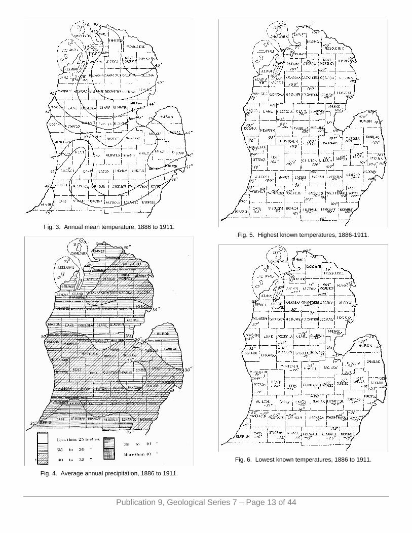
Fig. 3. Annual mean temperature, 1886 to 1911.
Fig. 4. Average annual precipitation, 1886 to 1911.
Fig. 5. Highest known temperatures, 1886-1911.
Fig. 6. Lowest known temperatures, 1886 to 1911.
Publication 9, Geological Series 7 – Page 13 of 44
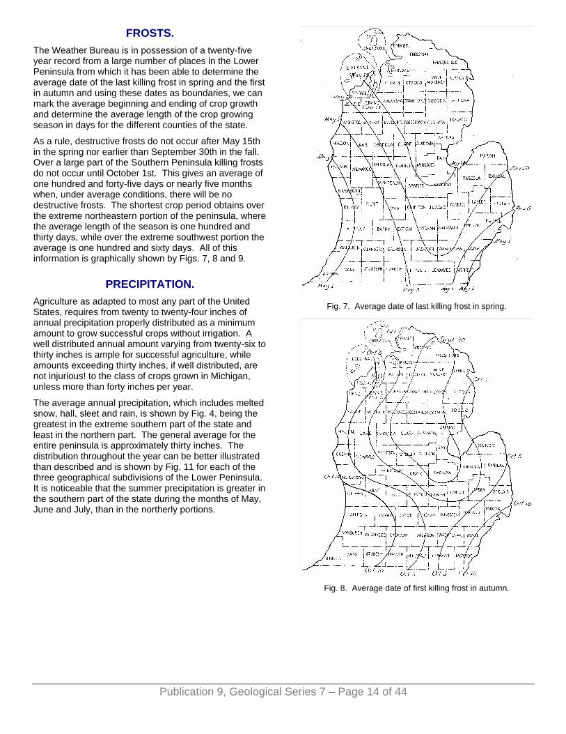
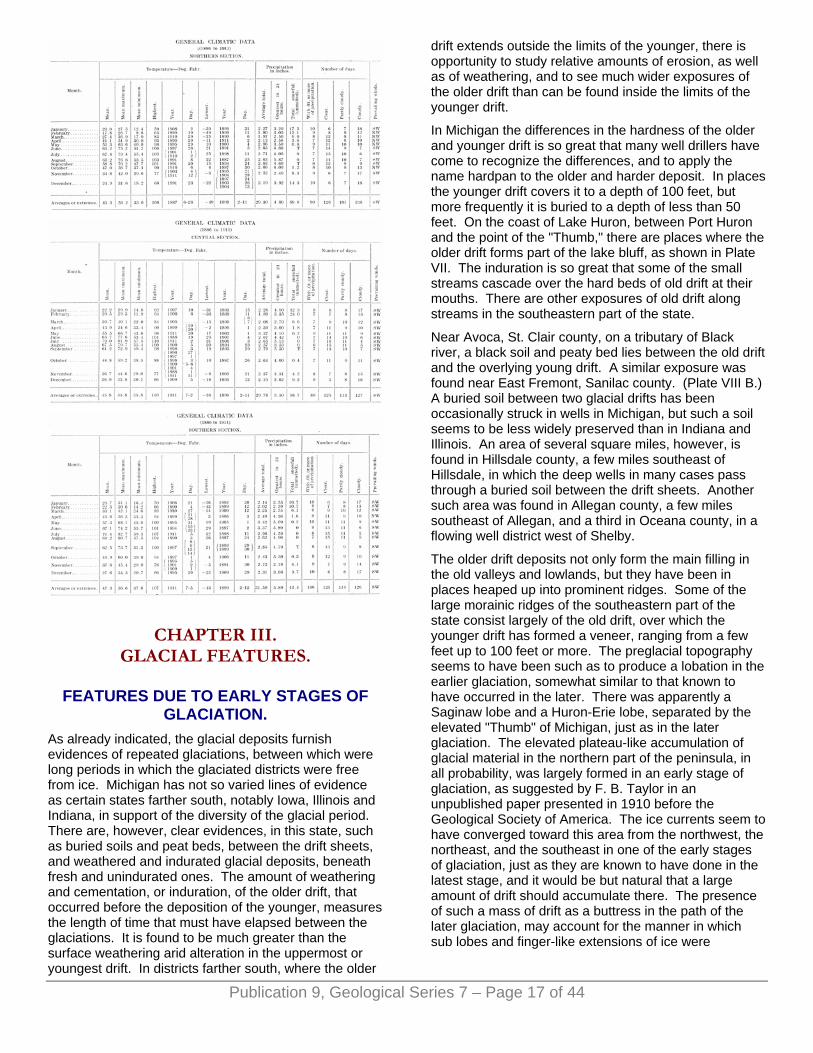
FROSTS. The Weather Bureau is in possession of a twenty-five year record from a large number of places in the Lower Peninsula from which it has been able to determine the average date of the last killing frost in spring and the first in autumn and using these dates as boundaries, we can mark the average beginning and ending of crop growth and determine the average length of the crop growing season in days for the different counties of the state.
As a rule, destructive frosts do not occur after May 15th in the spring nor earlier than September 30th in the fall. Over a large part of the Southern Peninsula killing frosts do not occur until October 1st. This gives an average of one hundred and forty-five days or nearly five months when, under average conditions, there will be no destructive frosts. The shortest crop period obtains over the extreme northeastern portion of the peninsula, where the average length of the season is one hundred and thirty days, while over the extreme southwest portion the average is one hundred and sixty days. All of this information is graphically shown by Figs. 7, 8 and 9.
PRECIPITATION. Agriculture as adapted to most any part of the United States, requires from twenty to twenty-four inches of annual precipitation properly distributed as a minimum amount to grow successful crops without irrigation. A well distributed annual amount varying from twenty-six to thirty inches is ample for successful agriculture, while amounts exceeding thirty inches, if well distributed, are not injurious! to the class of crops grown in Michigan, unless more than forty inches per year.
The average annual precipitation, which includes melted snow, hall, sleet and rain, is shown by Fig. 4, being the greatest in the extreme southern part of the state and least in the northern part. The general average for the entire peninsula is approximately thirty inches. The distribution throughout the year can be better illustrated than described and is shown by Fig. 11 for each of the three geographical subdivisions of the Lower Peninsula. It is noticeable that the summer precipitation is greater in the southern part of the state during the months of May, June and July, than in the northerly portions.
Fig. 7. Average date of last killing frost in spring.
Fig. 8. Average date of first killing frost in autumn.
Publication 9, Geological Series 7 – Page 14 of 44

Fig. 9. Average length of crop growing season, days.
Fig. 10. Counties in the various sections, viz. Northern,
Central and Southern.
Fig. 11. Average monthly precipitation by sections.
Fig. 12. Monthly mean temperature, Northern section.
Fig. 13. Monthly mean temperature, Central section.
Publication 9, Geological Series 7 – Page 15 of 44

Fig. 14. Monthly mean temperature, Southern section.
The average depth of snowfall for each of the three sections can be found in tables on following pages. It will be noted that snow has never been known to occur in July and August, rarely in June and September, but that it usually occurs first during October, increasing in amount to the end of January, after which there is a decrease in amount, which practically ends in April. Light falls are quite usual during May. Nearly sixty inches of snow falls annually in all counties of the Lower Peninsula.
DROUGHT. Short and irregular periods of drought over limited portions of the state have occurred from time to time, but long periods of deficient precipitation are rare. An exact statement of the conditions which actually constitute a severe drought are hard to make, because much depends not only upon the length of time that there is an absence of rainfall, but upon the condition of the soil when deficient periods of rainfall begin, the time of year when the deficiency actually occurs and from an agricultural standpoint, the texture of the soil and other physical conditions also have a bearing. Professor Henry in his Climatology of the United States, notes that the greatest drought this country has ever experienced in the last one hundred years, both as to intensity and extent of territory covered, extended over the middle Mississippi and Missouri valleys, the Lake region and Atlantic Coast districts from early summer of 1894 until about the first of August, 1895, the precipitation deficiency being about ten inches. Since then there has been no general serious drought in Michigan.
Previous to 1894 moderately severe droughts had occurred in Michigan in 1881 and 1887.
SUNSHINE. The sunshine annually will average somewhat over fifty per cent, of the possible amount, the percentage being much higher during the period extending from May to the middle of October, than during the winter months. During December, January and February it some times falls as low as twenty per cent, of the possible amount, while during June, July, August and September it exceeds sixty and some times seventy per cent, of the
possible amount. As a rule, July is the sunniest month and December the cloudiest.
WINDS. The prevailing winds for the greater part of the year are from the west and the average hourly velocity ranges from twelve and one-half miles per hour in March and April to a minimum of about nine miles per hour in August and September. The wind is mostly from the west and southwest during the first three months of the year and from June to December; while the prevailing direction is mostly southwesterly during the months of April and May, quite a large period but less than a majority of the time, the surface movement of the air is from the east and northeast.
Maximum velocities of short duration ranging from twenty-five to forty miles per hour, occur during most months of the year and velocities from forty to sixty miles an hour are not uncommon but rather infrequent. Extreme velocities of sixty miles and over are of comparatively rare occurrence; at Grand Rapids the wind velocity has not exceeded sixty miles but twice in the past nine years.
Winds are more variable during the cooler half of the year. At all seasons the southerly winds are usually warm and moist, the northerly winds cold and dry. The easterly winds usually herald unsettled weather, the westerly winds fair and settled conditions.
Owing to the fact that the prevailing summer winds are southwesterly, the shore of Lake Michigan from the southern limits of the state northward is rapidly becoming one continuous summer resort, where much relief can be found during the hot months; the water breezes are refreshing, especially at night, and insure greater comfort than can be obtained at any point inland.
RELATIVE HUMIDITY. There is both an annual and a diurnal variation in relative humidity, which is the reverse of the temperature. The relative humidity is the greatest in winter and the least in summer; diurnally it is the greatest just before sunrise, and the least at about the time that the maximum temperature occurs in the afternoon.
The average relative humidity for the year as deduced from observations taken at 7 a. m. and 7 p. m., is approximately seventy-two per cent., the average at 7 a. m. being seventy-eight per cent., and at 7 p. m., sixty-six per cent. Annually the relative humidity is the least during July, sixty-two per cent., and the greatest during January, eighty-eight per cent.
Publication 9, Geological Series 7 – Page 16 of 44
CHAPTER III. GLACIAL FEATURES.
FEATURES DUE TO EARLY STAGES OF GLACIATION.
As already indicated, the glacial deposits furnish evidences of repeated glaciations, between which were long periods in which the glaciated districts were free from ice. Michigan has not so varied lines of evidence as certain states farther south, notably Iowa, Illinois and Indiana, in support of the diversity of the glacial period. There are, however, clear evidences, in this state, such as buried soils and peat beds, between the drift sheets, and weathered and indurated glacial deposits, beneath fresh and unindurated ones. The amount of weathering and cementation, or induration, of the older drift, that occurred before the deposition of the younger, measures the length of time that must have elapsed between the glaciations. It is found to be much greater than the surface weathering arid alteration in the uppermost or youngest drift. In districts farther south, where the older
drift extends outside the limits of the younger, there is opportunity to study relative amounts of erosion, as well as of weathering, and to see much wider exposures of the older drift than can be found inside the limits of the younger drift.
In Michigan the differences in the hardness of the older and younger drift is so great that many well drillers have come to recognize the differences, and to apply the name hardpan to the older and harder deposit. In places the younger drift covers it to a depth of 100 feet, but more frequently it is buried to a depth of less than 50 feet. On the coast of Lake Huron, between Port Huron and the point of the "Thumb," there are places where the older drift forms part of the lake bluff, as shown in Plate VII. The induration is so great that some of the small streams cascade over the hard beds of old drift at their mouths. There are other exposures of old drift along streams in the southeastern part of the state.
Near Avoca, St. Clair county, on a tributary of Black river, a black soil and peaty bed lies between the old drift and the overlying young drift. A similar exposure was found near East Fremont, Sanilac county. (Plate VIII B.) A buried soil between two glacial drifts has been occasionally struck in wells in Michigan, but such a soil seems to be less widely preserved than in Indiana and Illinois. An area of several square miles, however, is found in Hillsdale county, a few miles southeast of Hillsdale, in which the deep wells in many cases pass through a buried soil between the drift sheets. Another such area was found in Allegan county, a few miles southeast of Allegan, and a third in Oceana county, in a flowing well district west of Shelby.
The older drift deposits not only form the main filling in the old valleys and lowlands, but they have been in places heaped up into prominent ridges. Some of the large morainic ridges of the southeastern part of the state consist largely of the old drift, over which the younger drift has formed a veneer, ranging from a few feet up to 100 feet or more. The preglacial topography seems to have been such as to produce a lobation in the earlier glaciation, somewhat similar to that known to have occurred in the later. There was apparently a Saginaw lobe and a Huron-Erie lobe, separated by the elevated "Thumb" of Michigan, just as in the later glaciation. The elevated plateau-like accumulation of glacial material in the northern part of the peninsula, in all probability, was largely formed in an early stage of glaciation, as suggested by F. B. Taylor in an unpublished paper presented in 1910 before the Geological Society of America. The ice currents seem to have converged toward this area from the northwest, the northeast, and the southeast in one of the early stages of glaciation, just as they are known to have done in the latest stage, and it would be but natural that a large amount of drift should accumulate there. The presence of such a mass of drift as a buttress in the path of the later glaciation, may account for the manner in which sub lobes and finger-like extensions of ice were
Publication 9, Geological Series 7 – Page 17 of 44
Publication 9, Geological Series 7 – Page 18 of 44
developed on the edge of the peninsula, between the lakes and this plateau.
So far as the present discussion is concerned, there seems little need for using the full list of names applied to the several drift sheets of America, and their intervening soils and weathered zones. Suffice it to say, that there are found clear evidences of four distinct glaciations, known as the pre-Kansan or Nebraskan, the Kansan, the Illinoian, and the Wisconsin, each named from geographic localities in which it has most characteristic development.
The pre-Kansan and Kansan drifts are well defined and extensive deposits occur in the region west of the Mississippi river. But it is not certainly known that they are represented in the Southern Peninsula of Michigan. The fact that copper is present in this peninsula, and southeastward from it in western Ohio, seems best explained as the result of a southward ice movement from the Lake Superior region. Such a movement is not easily referred either to the Illinoian or the Wisconsin glaciation, for each of these glaciations was by a southwestward ice movement into this region from the highlands east and south of Hudson Bay, by which only the Lake Michigan basin would seem likely to have received ice from the direction of copper bearing formations in the Superior basin. In these earlier stages, glaciation seems to have been more vigorous in the central part of Canada than in the eastern, and it may have extended southeastward from the Superior basin through the Huron into Ohio, and thus carried the copper and associated rocks into that state. The main body of drift in Michigan seems, however, to have been deposited in the Illinoian and Wisconsin stages of glaciation. The old moraines in the southeastern part of the state, and the old drift exposed in stream bluffs and along the shore of Lake Huron, appear to be of Illinoian age, and to have been brought in from the northeast rather than from the direction of Lake Superior. The great accumulation of drift in the northern part of the peninsula seems also best explained as a result of the converging ice currents from the northeastern field in the Illinoian stage of glaciation.
The rock striations in the southeastern part of the state all seem referable to the movement from the northeast. In the northern part of the peninsula are striae bearing southeastward, but these seem better explained as the result of a local deflection of ice currents in the closing part of the last or Wisconsin glaciation than as the product of a pre-Illinoian glaciation. The case is not similar to that noted at Calumet, and discussed in the Northern Peninsula report. There the southeastward bearing striae are preserved only on the northwest face of a sloping rock surface, where the later movement from the east could not touch them. They seem likely, therefore, to pertain to an early movement, probably Kansan if not pre-Kansan. But the exposures of striated ledges in the north part of the Southern Peninsula are such as to be in the line of attack of ice from the
northeast. So their preservation seems best explained as the result of a local deflection of the latest glaciation.
MORAINES AND THEIR OUTWASH. The moraines as shown by the glacial map are related to several rather distinct ice lobes which varied greatly in outline from time to time. Those on the western side of the peninsula pertain to an ice lobe in the Lake Michigan basin which at certain times in the earlier and later part of the ice invasion had small projections, or sub lobes, in Grand Traverse Bay, and in Little Traverse Bay, and the lakes along the northern part of the east coast of Lake Michigan. The moraines on the eastern side are especially well developed on the borders of a lobe that extended southwestward from Saginaw Bay. Moraines farther south on the eastern slope of the "Thumb" pertain to a lobe, known as the Huron-Erie, that covered the southern part of Lake Huron, the basin of Lake Erie, and the intervening Ontario peninsula. Those north of Saginaw Bay in certain early and late stages of the ice invasion had small sub lobes, like those in the bays and lakes on the east coast of Lake Michigan, that extended southward and southwestward to the elevated plateau lying northwest of Saginaw Bay.
The moraines show several successive positions of the ice border formed at halting places or in some cases at positions of readvance in the final stage of ice melting. When the ice had its greatest extent, and its border was far to the south in Ohio, Indiana, and Illinois, the lobes just noted were all merged together into a single great ice field. The lobes were a conspicuous feature only at particular stages in the oncoming of the ice and in its disappearance. The small sub lobes of the northern part of the peninsula apparently preceded the large Lake Michigan and Saginaw Bay lobes to the south in being merged into a confluent ice mass, and were not differentiated in the final stage of melting until a somewhat later time than these larger lobes.
On the outer border of many of the moraines are found extensive plains of sand and gravel, formed as an outwash from the ice border during the development of the adjacent moraines. These plains extend out to valleys which offered lines of discharge from the waters of the melting ice sheet through the country from which the ice had disappeared. These outwash plains and lines of glacial drainage form as interesting a field of study as the moraines themselves, for there were remarkable shiftings in the discharge of the waters, due to the opening of outlets which in the earlier part of the ice melting had been covered arid blocked by the ice sheet.
Outermost moraines in Michigan. An inspection of the moraines and outwash plains, shown on the glacial map, will make clear the recession of the ice in the last or Wisconsin glacial stage. The earliest part of this peninsula to become free from the Wisconsin ice sheet lies just west of the place where St. Joseph river passes into Indiana. The outermost moraines in this state are

Publication 9, Geological Series 7 – Page 19 of 44
those of eastern Cass and southern St. Joseph counties, east of Cassopolis and south of Centerville. They were formed chiefly by ice moving southwestward from the Saginaw basin, but their western ends seem to have been covered by the Lake Michigan ice lobe.
After forming these moraines, the ice border seems to have melted back somewhat rapidly northeastward, to a system of moraines that lies south of Kalamazoo river, in eastern Kalamazoo and southern Calhoun and northeastern Branch counties. This morainic system also was formed chiefly by the Saginaw lobe, but the portion trending southwest in eastern Kalamazoo county seems to have been covered and formed by the Lake Michigan ice lobe, while moraines in southeastern Branch county, which also trend southwest, are referred to the Huron-Erie ice lobe. At the time this system of moraines was forming, the escaping glacial waters were flowing through and forming the long strips of sandy land leading southwestward from southern Calhoun county across Branch and St. Joseph counties into Indiana.
Kalamazoo Jackson Morainic System. The next position of halting of the ice border is marked by one of the strongest morainic systems in the state, known as the Kalamazoo-Jackson system. A double moraine leading southwestward from southern Barry county between Kalamazoo and Lawton and passing just west of Cassopolis and Edwardsburg was formed by the Lake Michigan ice lobe and is known as the Kalamazoo morainic system. A continuation of the same system but formed by the Saginaw lobe and known as the Jackson system leads southeastward across southern Barry, northeastern Calhoun and southwestern Jackson county, into connection with a system trending southwestward across Hillsdale county, which was formed by the Huron-Erie ice lobe. From this system of moraines an interesting net work of glacial drainage lines leads westward and southwestward from Hillsdale and Jackson counties across Branch and Calhoun into St. Joseph county, and also southward from Barry across Kalamazoo county near the edge of the Lake Michigan lobe.
Valparaiso-Charlotte Morainic System. From the Kalamazoo-Jackson morainic system the ice border receded slightly westward to the Valparaiso morainic system, which encircles the head of Lake Michigan a short distance outside the present limits of the lake, and which receives its name from Valparaiso, Indiana. It receded slightly northeastward toward the Saginaw basin into northeastern Barry county and the edge of Eaton, Ingham and Livingston counties, and there formed what has been termed the Charlotte morainic system. Its position in the Huron-Erie lobe was shifted but slightly to the southeast in Hillsdale county and neighboring parts of Lenawee, Jackson, and Washtenaw county.
The drainage conditions were, however, materially altered by the slight recession of the ice border. The ice border for a considerable portion of its course in Michigan was now shrinking to lower levels and the
escaping waters instead of flowing directly away were held for long distances between the ice border and the outlying Kalamazoo-Jackson morainic system. The drainage on the edge of the Saginaw lobe was westward at first to Charlotte, and thence down Battle Creek through the Jackson moraine to the Kalamazoo valley. This it then followed westward past Kalamazoo and back to the inner edge of the Kalamazoo morainic system near Plainwell. From this place it followed the edge of the Lake Michigan lobe southwestward past Niles into Indiana, much of its course being a narrow lake called Lake Dowagiac. Somewhat later the drainage on the edge of the Saginaw lobe followed Thornapple valley past Hastings to Middleville, and there turned down Gun river to Plain well. The drainage from the Huron-Erie lobe seems also to have followed somewhat closely along the edge of the ice southwestward into northeastern Indiana.
The Series of Slender Moraines. Following the development of the Valparaiso-Charlotte morainic system comes a series of slender moraines, formed apparently in close succession, by each of the three great lobes. The Lake Michigan series is known as the Lake Border morainic system, for it lies close to the lake border not only in southwestern Michigan but also in northwestern Indiana, northeastern Illinois and southeastern Wisconsin. The series in the Saginaw basin is exceptionally full, there being no less than ten members of sufficient strength and continuity to be traced for considerable distances. They are distributed over a tract nearly 50 miles wide at the southwest end of the Saginaw lobe, and show with exceptional clearness how that ice lobe shrank toward the limits of Saginaw Bay. The corresponding moraines of the Huron-Erie lobe are irregular and disjointed and in places weak, so that the recession of the ice into the Erie basin is not well shown in southeastern Michigan. It is, however, clearly shown in neighboring parts of Indiana and Ohio near the axis of the lobe. In the course of the development of these moraines the ice vacated a large part of the Southern Peninsula, and exposed the high tableland northwest of Saginaw Bay, as well as low tracts bordering the Bay. On the borders of this tableland, however, this series is massed into a single large moraine.
The glacial drainage in connection with the series of moraines of the Lake Border morainic system and its correlatives is exceptionally interesting in the amount of shifting shown, and in the adjustment to the ice border and the outlying topographic conditions.
The drainage from the southern end of the Lake Michigan lobe, and eventually from much of that lobe, was through a lake at the head of the present Lake Michigan, known as Lake Chicago, and thence southwestward to the Illinois and Mississippi, through what has been termed the Chicago outlet. Drainage from the Wisconsin side as well as the Michigan side was southward along the edge of the ice lobe. The courses of drainage were, however, shifted two or more

Publication 9, Geological Series 7 – Page 20 of 44
times to positions nearer the edge of Lake Michigan to course along successive moraines.
The same conditions prevailed at the end of the Saginaw lobe, the waters in the later stages being all brought to Grand river from the western and southern edge of the ice lobe in a succession of courses controlled by moraines that follow one another in narrower and narrower circuits in the Saginaw basin. In the earlier stages there was considerable complexity which we will attempt to briefly outline.
Glacial Drainage Between the Saginaw and Michigan Lobes. As the Lake Michigan and Saginaw Bay lobes became separated in the district north of Grand Rapids, a line of glacial drainage was developed between the ice lobes, which at first had its head near the junction of Little Muskegon with the Muskegon river east of Newaygo. The glacial drainage from the Saginaw lobe was then lengthened northward, first along Muskegon river, and later along Little Muskegon river, while that from the Michigan lobe was forming the great outwash plain west of Cadillac and a plexus of gravel plains in Newaygo and Lake counties. Then for some time the Muskegon valley served as a line of discharge for waters that came in from the Saginaw lobe near the sources of the present Muskegon and of the south branch of the AuSable river in Roscommon county. The Manistee valley served as the line of discharge for waters from the Lake Michigan lobe as they entered its headwaters and the headwaters of AuSable river. From the bend of the Manistee river in southeastern Manistee county the waters continued southward through the plexus of gravel plains in Lake, Newaygo and Oceana counties to enter Lake Chicago in Muskegon county. As the Saginaw lobe shrank away from the great morainic belt of Clare, Roscommon, and Ogemaw counties and formed the slender moraines that lie between it and Saginaw Bay the glacial drainage kept close to the ice border and discharged southward to Grand river in lines that were shifted as the ice shrank eastward and lower passages were opened. Eventually the ice border shrank to a position so far east that waters accumulated in front of it to form Lake Saginaw whose discharge was westward through the Grand river outlet to Lake Chicago. At the same time the Lake Michigan lobe had receded to the north so that Lake Chicago occupied much of the Lake Michigan basin and received direct drainage from the major part of the border of that lake.
Glacial Drainage, and Lakes in the Huron-Erie Basin. The conditions on the southeast side of the Saginaw basin and in the Huron-Erie basin were somewhat simpler than in the district between the Saginaw and Lake Michigan lobes. There was merely a shifting of drainage to lower and lower courses along the edge of the shrinking ice lobes on each side of the "Thumb." The drainage from the Huron-Erie lobe led southwestward into a glacial lake, known as Lake Maumee, which at first discharged past Fort Wayne, Indiana, to the Wabash river, but later by the opening of a lower passage across the northern part of the
"Thumb," through the recession of the ice, it discharged westward to Grand river along what is termed the Imlay outlet, from a city of that name in Lapeer county standing at the head of the outlet. Eventually the ice had receded so far that this lake became confluent with Lake Saginaw, noted above. For this stage the names Lake Maumee and Lake Saignaw were dropped and a new name, Lake Arkona substituted.
Port Huron Morainic System and Lake Whittlesey. The next morainic system after the series of slender moraines just described is known as the Port Huron system. This marks the limits of distinct readvance of the ice border as distinguished from a mere halt in the course of the recession of the border. By this it should not be understood that all the moraines previously described mark mere halting places in the recession, for evidences of slight readvance have been found in connection with some of them. The Port Huron morainic system seems, however, to mark a more pronounced readvance than any of the moraines outside it in this peninsula. This readvance appears also to have affected the ice border over a very wide area extending from the Adirondack Mountains westward past all the Great Lakes basins and across Minnesota into Canada.
On the borders of the south part of Lake Huron and in the Saginaw basin the readvance of the ice was across part of the area occupied by Lake Arkona, and was sufficient to dismember the lake, and make separate the part in the Saginaw basin from the main body in the Erie basin and contiguous lowlands. The small lake is called the Later Lake Saginaw, while the main lake is called Lake Whittlesey. This large lake had a different outlet from that of Lake Maumee and stood a few feet lower than the lowest beach of that lake. From near Port Huron its waters flowed northward along the west edge of the ice lobe to Ubly in Huron county, and there turned westward along the edge of the Saginaw lobe into the Later Lake Saginaw.
Turning now to the distribution of the Port Huron morainic system, it is found to follow closely the southern end of Lake Huron, lying south of Saginaw Bay. It also lies but a few miles back from the shore of Saginaw Bay around the entire coast of that body of water. The portion in the Saginaw basin is largely waterlaid and inconspicuous, yet a ridge of sufficient strength was formed to govern the courses of Cass and Tittibawassee rivers and cause them to flow for long distances on its outer border nearly parallel with the shore of Saginaw Bay before breaking through the moraine at the city of Saginaw. The portion of the moraine bordering the south part of Lake Huron is also waterlaid for a few miles in the vicinity of Port Huron, but elsewhere was formed above lake level and is of considerable strength. It is separable in places into two or more moraines in its landlaid portion.
In the northern part of the peninsula the Port Huron morainic system barely reaches to the northern edge of the plateau which overlooks the northern part of Lake Huron and Lake Michigan. It leads from the AuSable
Publication 9, Geological Series 7 – Page 21 of 44
river east of Mio in a northwestward course past Gaylord to the corners of Charlevoix, Cheboygan, and Otsego counties as a massive belt 2 to 8 miles in width, from which spurs extend out toward Lake Huron, in some cases to distances of several miles. There are several disjointed or interrupted moraines between this large ridge and the shore of Lake Huron in the district north of Saginaw Bay which should perhaps be included in this Port Huron system.
On passing from the Lake Huron to the Lake Michigan basin this morainic system makes an abrupt turn to the southwest and presents even greater complexity than in the Port Huron basin. There is an outermoraine which follows the border of the plateau through Antrim, Kalkaska, Grand Traverse, and Manistee counties as far as the bend of the Manistee river in southeastern Manistee county, being throughout this distance a ridge about 1 to 2 miles in width with great relief on the inner or western border but very little relief on the outer or eastern border. From southeastern Manistee county southward across Mason county there are only weak disjointed ridges to mark the continuation of this moraine, and its identification is difficult. It may extend only to Pentwater before passing into Lake Michigan. It seems not unlikely, however, that a ridge which is traceable as far south as Muskegon is to be included in the Port Huron morainic system.
A second well defined moraine of the Port Huron system runs parallel to the outer moraine from Charlevoix county southwest-ward to the head of Grand Traverse Bay, being separated from it only by a narrow outwash plain, traversed in part by the Boardman river. This moraine has spurs on its inner border which extend out several miles toward the Lake Michigan coast, and especially toward Grand Traverse Bay. There seems to have been a sub lobe of the Lake Michigan glacier occupying Grand Traverse Bay which had several projections into lowlands lying between the morainic spurs just mentioned. At the south it divided into two lobes, occupied now by the two arms of Grand Traverse Bay, between which was formed the prominent ridge known locally as "the peninsula.” In the district west of Grand Traverse Bay, on the peninsula known as "the Horn," an interlobate moraine was developed between the Grand Traverse sub lobe and the main Lake Michigan glacier. From the part of the Lake Michigan coast west of Grand Traverse Bay, south westward to Manistee, the Lake Michigan glacier seems to have had slight finger-like protrusions extending a few miles inland from the present shore, between which were developed the prominent headlands which characterize this portion of the coast. After developing these headlands, the glacier, before shrinking within the limits of the lake, formed a weak moraine which wraps around the western end of these headlands and forms slight loops in the lowlands between them, and which is traceable as far south as the line of Manistee and Mason counties. There it passes inside the limits of Lake Michigan. The glacial drainage from this inner part of the Port Huron morainic system is clearly traceable from the reentrant angle
between the Lake Michigan and Lake Huron lobes, in Charlevoix county, southwestward to where the waters entered Lake Chicago, a few miles south of Manistee, though in doing so it traverses a district which is now drained to Lake Michigan by several different streams, as may be seen by reference to the glacial map of the surface formations. (Plate I.)
There are, in the northern part of the peninsula, nearly pebbleless clay deposits under the boulder clay and other glacial material of the Port Huron morainic system, which seem to have been deposited in lake waters that occupied the area prior to the readvance of the ice. They are exposed chiefly on the slopes of the prominent ridges that lie between the bays and the lowland areas that project inland from the present coast nearly to the second moraine of the Port Huron system, and have been noted in nearly every ridge between Frankfort and Cheboygan. They may be present also in the district southeast of Cheboygan but exposures were not found. These clay deposits are known to have great thickness, exposures of over 100 feet thickness having been seen, while borings are reported to penetrate even greater amounts. The clays reach in places an altitude of 250 to 300 feet above Lake Michigan, or nearly 100 feet higher than that of any beaches formed by lake waters after the Anal melting away of the ice from that region. The altitude, may, however, be no greater than would have been reached by lake waters at a, time prior to the development of the Port Huron morainic system, for a northward differential uplift was in progress in the northern part of the Great Lakes region near the close of the Wisconsin stage of glaciation. The method of deposition of such a thick body of clay is somewhat problematical, but there seems no question that the clay was laid down in lake waters prior to the readvance of ice marked by this morainic system.
Relation of the Port Huron Morainic System to Lake Chicago. The Port Huron morainic system seems to have been developed at a critical time in the history of Lake Chicago, during the lowering of that lake from the highest beach to lower ones. Before the ice border melted away from the small Manistee moraine, that passes inside the limits of Lake Michigan near Manistee, the lake had been lowered to the level of the third or Toleston beach. The first and second beaches of Lake Chicago are traceable northward along the east side of the Michigan basin nearly to the southern end of the Manistee moraine, but they do not occur on that moraine. The lowering of the lake depended, of course, upon the cutting down of the Chicago outlet, and not upon any relation to the ice border. The lowering to the level of the second beach seems likely to have occurred near the middle of the development of this morainic system, for the highest beach is so weak as to be traced with some difficulty on the slopes of the outer ridges of the system from near Muskegon northward. The lowering from the second to the third beach in all probability took place near the end of the development of the Port Huron morainic system. The strength of the second beach is such as to demand a length of time

somewhere near as long as that needed for the development of the later ridges of the Port Huron morainic system. This relation of the beaches of Lake Chicago to ridges of the Port Huron morainic system renders it feasible to make a correlation with the moraines of this system on the Wisconsin side of the lake. The correlative of the Manistee ridge sets in on the Wisconsin side at Three Rivers and runs northward along the west coast into the peninsula between Green Bay and Lake Michigan, as the latest ridge of a definite series on that side of the lake, and it has only the third beach of Lake Chicago on its slopes. There is a ridge outside it that is traceable southward to Port Washington, Wisconsin, that seems likely to correlate with one on the Michigan side which is traceable southward as far as Pentwater, Michigan. A still earlier ridge, apparently of this series, extends south to Milwaukee, and this seems likely to be a correlative of one on the Michigan side that extends to Muskegon. The highest Chicago beach is faintly developed on its slope, just as on the ridge that terminates near Muskegon.
The Cheboygan Moraine. The latest stand of the ice border on the Southern Peninsula of Michigan seems to have been at a small moraine that lies close to the Lake Huron shore from the Straits of Mackinac southeastward to Cheboygan and which is represented for some miles farther east by a bouldery strip without definite morainic ridging. West of Cheboygan it is sufficiently well defined to be easily traced, though it is a very slender ridge, only one-fourth to one-half mile in width and 20 feet or less in average height above the land back of it.
FEATURES BETWEEN THE MORAINES. Till Plains. Till plains embrace the wide areas between moraines over which the ice front appears to have made a rapid recession. The drift is somewhat diverse in constitution and texture, being in places sandy and in places clayey, according to the relation to the drainage from the receding ice border. There is usually, however, a thorough commingling of clay, sand, and stones. The surface is flat to gently undulating, but, as a rule, with sufficient slope to permit of easy drainage. These plains are in general well suited for agriculture, though the sandier portions are rather light and need careful management. A special convention has been applied to these sandy areas on the glacial map. The till plains are in places diversified by as sharp ridges and knolls as are found in moraines. These are classed according to form or constitution as eskers, kames, or drumlins, and are taken up separately below.
Eskers and Kames. The gravel ridges termed eskers and "hog backs,” as already indicated, radiate toward the ice border and thus have a trend nearly at a right angle to that of the moraines. They are distributed from the southern to the northern end of the peninsula, as may be seen by reference to the glacial map. They are, however, most numerous in the area covered by the
Saginaw lobe, and especially in connection with the Charlotte morainic system.
Eskers are ordinarily very narrow, steep sided ridges ranging in height from a few feet up to 75 feet or more. While composed chiefly of gravel and sand there is in some cases a thin veneer of boulder clay and in others a bouldery surface without a notable boulder clay deposit.
In Sanilac county are ridges of considerable breath up to nearly one-fourth mile that have a trend toward the ice border, like the eskers, but are far more bulky than the ordinary esker. They are composed largely of sand and gravel, but have a general veneer of boulder clay. It is probable that they were formed under conditions somewhat similar to those for ordinary eskers, so there seems no need to class them separately.
The eskers, though having a soil of rather an inferior quality, and being too steep for easy cultivation, are yet of high commercial value, since they are an important source of road material.
Kames are commonly known as gravel knolls. They range from low swells of gentle slope to very steep hills (Plate VI A). They contain gravelly and sandy glacial material in which there is more or less boulder clay interbedded. They are disposd in clusters and isolated hills instead of in the form of a long ridge characteristic of the esker. They abound in many of the moraines, and are scattered widely over the plains between the moraines. No attempt has been made to show their distribution on the glacial map, since they are so widespread and abundant that time was taken to map only a part of them in the course of the field studies. Already much use has been made of them for road material in almost every county of the state, and for that purpose they are in no way inferior to the eskers.
Plate VIII. A. LOOKING SOUTH ACROSS IMLAY OUTLET, NEAR DEANVILLE, LAPEER COUNTY. PHOTO BY F. B.
TAYLOR.
Publication 9, Geological Series 7 – Page 22 of 44

Plate VIII. B. PRE-WISCONSIN TILL BELOW WISCONSIN DRIFT ABOVE, SEPARATED BY OLD SOIL ZONE SHOWN IN DARK BAND, SANILAC COUNTY. PHOTO BY F. B. TAYLOR.
Plate IX. A. BEACH OF LAKE WARREN FROM LAKEWARD SIDE. BUILDINGS STAND ON THE BEACH. ONE MILE NORTH OF CHARLESTON, SANILAC COUNTY. PHOTO BY F. B. TAYLOR.
Plate IX. B. HIGHEST BEACH ON SHORT TARGET RANGE,
MACKINAC ISLAND. PHOTO BY J. W. GOLDTHWAIT.
Plate X. MACKINAC ISLAND FROM ROUND ISLAND SPIT, ONE MILE NORTH. THE HUMP IN THE MIDDLE OF THE ANCIENT ISLAND IN LAKE ALGONQUIN AND ITS BASE MARKS THE ALGONQUIN BEACH. THE FORT IS ABOUT AT THE LEVEL OF THE BATTLEFIELD BEACH. THE VILLAGE IS ON THE NIPISSING BEACH AND THE SLOPE BELOW IT. BASE OF OVERHANGING CLIFF ON THE RIGHT MARKS LEVEL OF THIS BEACH. PHOTO BY F. B. TAYLOR.
Plate XI. RIDGE ON BATTLEFIELD BEACH ON MACKINAC ISLAND BATTLEFIELD. REAR VIEW LOOKING NORTH. PHOTO BY H. J. ROSSITER.
Drumlins. Drumlins are not so widely distributed in this peninsula as eskers and kames, for they are restricted to the northern end of the peninsula and to even to the inner border of the Port Huron morainic system. The main area lies between Little Traverse and Grand Traverse Bay, but there are a few drumlinoidal hills on the peninsula between the arms of Grand Traverse Bay, and in the district west of the Bay. There are also a few near Levering in northern Emmet county and north and east of Douglass Lake in Cheboygan county. There are several small drumlins east of Mullet Lake in Cheboygan county, and also a small drumlin district a few miles west of Alpena. The drumlins near Alpena, in keeping with the striae bear southward or southeastward in a course nearly parallel with neighboring moraines instead of toward them. This trend, as was noted, in discussing the striae, seems due to some local defection of the ice currents, the cause for which is not yet apparent. The drumlins east of Mullet Lake also trend southeastward, though in a district where the moraines have a nearly parallel course. In the Grand Traverse region the drumlins show an interesting divergence in trend to correspond with the spreading of the ice in the Grand Traverse lobe, and are directed toward the moraines.
The drumlins range in height from 75 feet or more down to 10 or 15 feet, and in length from fully a mile down to one-fourth mile or less. They have slopes sufficiently
Publication 9, Geological Series 7 – Page 23 of 44

Publication 9, Geological Series 7 – Page 24 of 44
regular to be easily brought under cultivation, though in some cases they are rather steep. The quality of soil is usually of a high order because of the clayey constitution and the well drained surface. No matter how steep sided, these hills show remarkable resistance to gullying by the storm waters. Whether this resistance is due to constitution or to a peculiarity of the bedding is not determined. The drumlins under discussion seem to have been formed by slow accretion through a plastering process as to the ice sheet moved over them with its coating of dirty material. The bedding planes in the upper portion of the drumlins are not horizontal, but are nearly concentric with the curved surface. So far as those of this particular region are concerned there seems little question that they were built up by the ice at the time it was forming the neighboring moraine of the Port Huron system. In certain other localities, as for example the Menominee county district in the Northern Peninsula, there is some question as to whether they were built up at the time of the neighboring moraine toward which their longer axes are directed, or were merely shaped into drumlin form at that time from an earlier deposit over which the ice sheet was spreading,
CHAPTER IV. LAKE FEATURES.
INTRODUCTORY STATEMENT. It has been known from the earliest days of settlement that the Great Lakes have covered wider areas than they now occupy. The beaches are so conspicuous as to be widely recognized and the flat lake beds are in strong contrast to the neighboring glacial features. The expanded lakes are found to have had southwestward discharges into the Mississippi drainage, and that too by different outlets. One outlet, past Fort Wayne, Indiana, was a fine of discharge from the Erie basin to the Wabash river, while another, at the south end of the Lake Michigan basin, conveyed water to the Illinois. The Lake Superior basin also had an outlet from its southwestern end to the St. Croix, a tributary of the Mississippi. The fact that these outlets are at widely different altitudes gave the suggestion that the lakes in the Erie, the Michigan and the Superior basins were at one time independent bodies of water, and it was later shown that these lakes were held in on the northeast by the great ice sheet. In the course of their studies the old shore lines were found to be tilted, and already considerable data are at hand on the extent of areas of uplift, and the amount of earth movement that has occurred since the lakes stood at these high levels.
In a somewhat voluminous report on this region, by Mr. F. B. Taylor and the present writer, to appear as a Monograph of the United States Geological Survey, the literature of the subject is given due consideration and the lake history is presented in some detail. It seems unnecessary, therefore, in the present discussion to do more than give a brief outline.
LAKE CHICAGO. Outlet and Beaches. Lake Chicago was a body of water held in the southern part of the Lake Michigan basin by the Lake Michigan ice lobe, and its name is taken from the city whose site it once covered. Its area increased as that of the ice lobe diminished and decreased with any advance of the ice lobe which may have occurred.
Lake Chicago had an outlet southwestward through the Des-Plaines valley to the Illinois river and thence to the Mississippi and Gulf of Mexico. The highest or Glenwood beach stands 55 to 60 feet above the present level of Lake Michigan, and about 45 feet above the head of the outlet. There are two lower beaches, the Calumet about 35 to 40 feet, and the Toleston 20 to 25 feet above Lake Michigan, each of which opens into the southwestward outlet. There are still lower beaches that seem to have been formed after this outlet had been abandoned, by the opening of some lower one to the north and east. The name Lake Chicago is applied to the lake only so long as it held to its southwestward discharge.
The outlet is a broad channel averaging more than a mile in width, cut largely in glacial deposits but with some excavation in rock near its head. It is probable that the dropping from higher to lower levels, shown by the presence of distinct beaches, has been due to giving way of a rock barrier that had been holding the lake to the level of a given beach. Had there been a steady lowering of the head of the outlet the beaches would be likely to occur at less definite and less restricted levels. Prof. T. C. Chamberlin has suggested the removal of the rock barrier by a sloping process. By this process rapids may have worked back head wards to the upper end of the rock barrier which then suddenly gave way and produced a lower lake level.
In the Michigan portion of the beaches of Lake Chicago the highest beach is the one that has suffered least from encroachments by the cutting back of the shore of Lake Michigan, yet there are wide stretches on the coast in which it also has been removed. The second and third beaches are preserved chiefly in recesses at bays or mouths of rivers, for elsewhere the bluffs of Lake Michigan commonly rise 35 feet or more above its water surface.
As noted in the discussion of the Port Huron morainic system the highest beach is only faintly developed from Muskegon northward to the vicinity of Manistee, while, because of the persistence of the ice sheet, neither it nor the second beach are found north from Manistee;
The pebbleless clays beneath glacial deposits of the Port Huron readvance, as noted above, may prove to be the deposits of Lake Chicago in a stage of great expansion prior to that readvance.
The third or Toleston beach may have been only partly developed by Lake Chicago. It seems to have been completed by the waters of Lake Algonquin, whose area embraced the Michigan as well as Huron basins, after a

Publication 9, Geological Series 7 – Page 25 of 44
passage was opened between these basins by the melting away of the ice from the Straits of Mackinac.
Lake Bed Deposits. Lake Chicago covered a very narrow strip on the east side of Lake Michigan, usually but one to two miles or less. But from Holland northward across Ottawa and Muskegon counties it extended 10 to 25 miles beyond the limits of Lake Michigan. In this widest expansion its bed is almost entirely of fine sand. There is also more sand than clay in the narrow strips along the shore. The clayey portions have till at only a few inches depth, there being very little lake sediment over it. Should the pebbleless clays beneath the till of the Port Huron morainic system prove to be the product of Lake Chicago, they would form its most conspicuous clay deposits. The east coast of Lake Michigan has suffered greatly from the encroachment of dune sand brought in by wind from the shore of the present lake. In places near the mouths of the principal rivers it has been heaped to a height of 150 to 200 feet above lake Michigan level. The high dunes, however, are confined to within one to two miles of the shore of Lake Michigan.
Tilting of the Michigan Basin. The beaches of Lake Chicago are practically horizontal from the south end of the lake northward at least to the latitude of Grand Haven, Michigan, and Milwaukee, Wisconsin. A gradual rise in altitude is found in passing farther north, so that the highest beach which is about 645 feet near Grand Haven becomes 670 to 675 feet in the vicinity of Ludington where its northernmost exposures are found. The Algonquin beach is found to continue the northward ascent past the northern end of the basin. It rises from about 605 feet near Ludington to 812 feet on Mackinac Island. The rise of 25 feet in the highest Lake Chicago beach, shown by levels at Ludington, is perhaps to be attributed in part to the gravitative effect of the ice sheet that was persisting in the northern part of the Lake Michigan basin, but certain irregularities in the slope seem to call for earth movement. The Algonquin beach is practically horizontal from the southern end of Lake Michigan to the latitude of Ludington so any earth movement in districts south from this parallel is likely to have been over with by the time the ice had vacated the Straits of Mackinac, and allowed the merging of Huron and Michigan waters which gave rise to Lake Algonquin.
LAKE MAUMEE. Outlets, Beaches and Delta Deposits. Lake Maumee, named from its great extent in the Maumee basin, of northwestern Ohio and neighboring parts of Indiana, was the first large lake formed as the ice border shrank into the Erie-Maumee basin.
The outlet of the lake past Fort Wayne, Indiana, was across the lowest available place on the border of the basin. Its altitude seems to have been at first about 785 feet, or 212 feet above Lake Erie, but during the operation of the outlet it was cut down to about 760 feet. The lake at its highest stage seems to have made use of this outlet alone. During the recession of the ice
northward past the head of the Imlay outlet on the "Thumb," the Fort Wayne outlet had been cut down sufficiently to cause a lower level of the lake.
The highest beach is only 785 to 790 feet in the vicinity of the Fort Wayne outlet, but is about 800 feet in the southern part of Michigan, and nearly 850 feet in Lapeer county near the head of the Imlay outlet. (Plate VIII A.) The present altitude of the head of this outlet is 805 to 810 feet, or about 50 feet above the bed of the Fort Wayne outlet. Of this, several feet increase is due to peaty growth, so the floor as swept by the lake outlet is not far from 800 feet. If 50 feet be deducted to correct the differential uplift, it leaves the altitude at about 750 feet at the close of the discharge through it, or about 10 feet lower than the bed of the Fort Wayne outlet. The Imlay outlet opened into a small lake east and south of Flint, as indicated on the glacial map. This lake extended to Swartz Creek. Thence westward there was a stream of gradual descent across Shiawassee and Clinton counties to the Grand river channel a few miles northwest of St. Johns.
The mapping of the beaches and deltas of Lake Maumee has brought to light interesting differences in their strength at the different lake levels which suggest a rather complicated lake history. The highest beach is very irregular, probably because of the irregularities in the coast, some places being more exposed than others to wave action. The second beach is more regular, and on the whole somewhat stronger than the highest. There is a third beach which is generally weak and in places difficult to trace. Yet it connects with deltas of greater strength than those of the higher levels of the lake. The extent of the deltas is shown on the glacial map. They are notably large where Raisin and Huron rivers entered the lake. It seems not improbable that the third beach was partially effaced by a rise of the lake. Indeed in the present state of investigation it appears likely that the second beach was largely formed after a rise from the level of the third beach. The third beach is 20 feet below it and seems a little too low to open into the Imaly outlet, though almost up to the level of its floor. The outlet at the time the third beach was developed may, therefore, have been across the "Thumb” in a lower passage a few miles farther north, which became filled by a readvance of the ice to a moraine that closely borders the Imlay outlet.
The lake beaches, because of their sandy or gravelly constitution, form better lines for highways than neighboring clayey tracts and have been so utilized from an early day. In recent years, however, the tendency to put roads on north and south and east and west lines has led to the abandonment of parts of the old roads on the beaches. The beaches also, when gravelly, are of much value for road ballast.
The old river deltas are in part of mixed loam, gravel, and sand that gives a productive soil of loose texture. They seldom contain much coarse rubble or cobble and have only a small admixture of pebbly material.

Publication 9, Geological Series 7 – Page 26 of 44
The extent of the Michigan portion of the bed of Lake Maumee outside the limits of Lake Whittlesey is very limited and is all that will be considered at this point, though the deposition of lake silts, in all probability, was going on at this time over the deep lying part of the lake bed as far back as the edge of the ice sheet. The narrow strip outside the beach of Lake Whittlesey is generally underlain by boulder clay at the depth of but a few inches, so the lake deposits, except in the beaches, and river deltas, are of slight amount.
FIRST LAKE SAGINAW. When the ice sheet had melted back into the Saginaw basin far enough to expose a land surface sloping toward it, conditions became favorable for lake waters to accumulate and form the First Lake Saginaw. The outlet of the lake was through Grand river to Lake Chicago, this being a line already opened by the glacial drainage from the end of the Saginaw lobe. The limits of the lake on the western and southern borders of the basin are marked by a well defined beach that opens into this outlet at an altitude about 700 feet above sea level, but which becomes somewhat higher as one passes north or east from the outlet, because of differential uplift. The bed of the lake is nearly equally divided between a sandy and a clayey soil as shown in Plate I. The distribution of the sand was probably determined in part by outwash from the receding ice border and in part by lake action. The sand due to lake waves and currents is restricted to the border of the lake, while that from glacial outwash may be present where there was a considerable depth of water, since the water escaping from the ice was liable to have had strong hydrostatic pressure.
LAKE ARKONA. Lake Arkona represents a stage of water in the Erie-Maumee basin that corresponds closely to the level of the First Lake Saginaw, and it is probable that it was for a time merged with that lake. The altitude (where differential uplift has not affected it) is about 700 feet above sea level. It has three beaches separated by intervals of less than 10 feet, one being slightly less than 710 feet, another a little above 700 feet, and a third a little below 700 feet. In the early part of the lake's history there was probably a discharge into Lake Saginaw through a channel across the northern end of the "Thumb." But with the recession of the ice border there came a merging of the two lakes at the level of Lake Saginaw. This seems to more closely correspond to the second of the three beaches than to the first, so there was perhaps a drop to this beach because of the merging with Lake Saginaw. If so the drop to the third beach is likely to be referable to a cutting down at the head of the outlet.
Lake Arkona was later separated from Lake Saginaw by a re-advance of the ice to the Port Huron morainic system. This caused a rise of the lake waters to a level
about 30 feet above the highest Arkona beach, and as a result of this rise the beaches were nearly obliterated. They are traceable as a rule merely as gravelly or sandy strips with scarcely a perceptible ridging. There are places, however, where the beaches stand close by the outer border of the Port Huron morainic system, in which the original strength is preserved. On the map (Plate I) such places are represented by continuous lines to distinguish them from the washed down portions (represented by broken lines).
The higher lake level that was produced in tine Huron-Erie basin is termed Lake Whittlesey, while the small lake that persisted in the Saginaw basin is termed the Later Lake Saginaw, the name Arkona being dropped.
The most conspicuous parts of the Lake Arkona shore are the large deltas formed where the streams entered the lake. As shown on the glacial map they are conspicuous at the Raisin, Saline, Huron; West Rouge, and Clinton rivers. These deltas are of fine gravelly sand.
LATER LAKE SAGINAW. The Later Lake Saginaw extended about to the limits of the First Lake Saginaw on the west and south, for its outlet was through the same channel, along Grand river to Lake Chicago, and at but a few feet lower level. The limits on the northeast or ice-ward side were at the Port Huron moraine, and are thus more definitely fixed than the limits of the Earlier Lake Saginaw. The lake extended up the Cass river valley about to Cass City and up the Tittibawassee valley at least to northeastern Gladwin and possibly into southeastern Ogemaw county.
LAKE WHITTLESEY. This large glacial lake stood at about 735 to 740 feet in the part of its basin where the beach is horizontal. This embraces what lies southwest of a line running from Ashtabula, Ohio, in a west-northwest course across the basin of Lake Erie, the Ontario Peninsula, and the middle part of Lake St. Clair. From this line there is a rise of fully 60 feet northward in Michigan to the Ubly outlet, the present altitude at the head of the outlet being about 800 feet. It is not unlikely that the gravitative effect of the ice will account for a small part of the rise, but the larger part seems due to differential uplift. Where the Ubly outlet opened into the Later Lake Saginaw at Cass City the present altitude is about 740 feet, making a fall (by including the differential uplift) of 60 feet along the outlet. But at the time the outlet was in operation there was only 40 to 45 feet. This is known from the fact that in portions of Lake Saginaw and Lake Whittlesey, unaffected by uplift, the levels of the two lakes differ only that amount.
The beach of Lake Whittlesey is a remarkably strong feature throughout its extent in Michigan and was the first to be recognized and mapped. Under the first Geological Survey of Michigan in 1838 to 1840 it was
Publication 9, Geological Series 7 – Page 27 of 44
traced for over 60 miles by Bela Hubbard in districts back of Detroit where settlements had been started. The beach is a gravel ridge 10 to 15 feet in height and with a breadth of nearly one-eighth mile. It is a valuable resource for road ballast for the clayey districts through which it passes. Lake Whittlesey was maintained at the level of the Ubly outlet only until the ice melted back on the "Thumb" far enough to open a lower outlet. This ice recession went far enough to allow the lake to drop about 20 feet below the lowest of the Arkona beaches, to the bead) of Lake Warren.
The strip of Lake bottom between the Whittlesey and Warren beaches in southeastern Michigan is largely a clayey plain, the principal exceptions being at deltas of Lake Arkona. The deltas of streams entering Lake Whittlesey are less conspicuous than of the same streams in connection with its predecessor, Lake Arkona. One reason for this is the fact that the rise of water caused estuarine conditions for some distance up the valleys beyond the Whittlesey beach, and it was necessary to fill these estuaries from their heads down-stream past the beach before the lake bed proper would receive a coating of delta material. The duration of the Lake Whittlesey stage may be fully as long as that of the Arkona.
LAKE WARREN. Lake Warren, like the most expanded stage of Lake Arkona, included the lake in the Saginaw basin as well as the larger body of water in the Huron-Erie basin, and discharged directly through the Grand river outlet to Lake Chicago. In the part unaffected by uplift its beach stands about 680 feet above sea level and is barely high enough to open into the head of the outlet, whose bed there is about 670 feet. As indicated in the discussion of Lake Wayne, Lake Warren was preceded by a lower stage of water, with an eastward discharge to the Mohawk valley.
The beach when traced northward from the outlet rises at the rate of about 2 feet to the mile and reaches 800 feet near Gladwin, and on the part of the Port Huron moraine directly east, near the corner of Gladwin, Bay and Arenac counties. It is also nearly 800 feet on the point of the "Thumb" in Huron county north of Bad Axe. The beach is practically horizontal from near the vicinity of Lenox, in northern St. Clair county, south and east through southeastern Michigan and northern Ohio about to the Ohio-Pennsylvania line, a distance of nearly 300 miles. Between there and Batavia, New York, a rise of about 200 feet is made in a distance of 150 miles.
The beach is of medium strength (Plate IX A) and seems to mark a lake level of considerable duration, though probably somewhat shorter than either the Arkona or the Whittlesey. The delta deposits are not so extensive as those of Lake Arkona. Its shore deposits vary in accordance with those of the lake beds on which it was developed. Where there was till or gravelly material at the surface a gravelly beach was formed, but where
there were sandy sediments we find merely a sandy ridge. The glacial map sets forth the extent of sand and clay along this shore and on the bed of the lake. It will be observed that the portion in the Saginaw Basin has much more sand west of the bay than east of it. The sand on the east slope of the "Thumb" is largely in Monroe, Wayne, and southeastern Washtenaw counties.
LAKE WAYNE. About 20 feet below the Lake Warren beach is a beach of less average strength, known as the Wayne beach, from its early recognition in Wayne county, and especially near the village of Wayne. This beach was for some time regarded as merely a lower stage of Lake Warren and has been described as a lower Warren beach. But F. B. Taylor has found evidence that Lake Wayne succeeded Lake Whittlesey and antedated Lake Warren just as Lake Arkona antedated Lake Whittlesey. His studies in the Saginaw Basin have led him also to to the opinion that this lake was a few feet too low to find a discharge through the Grand river outlet. It seems, instead, to have discharged eastward along the edge of the ice past Syracuse, New York, into the Mohawk valley. Such a wide shifting of the outlet seemed to him a sufficient reason for applying the new name, Lake Wayne.
The Wayne beach lies but a short distance inside the limits of the Warren beach. Its character is not greatly different when taken throughout its length in Michigan, Ohio, Pennsylvania and New York. At the type locality in Wayne county, Michigan, it is developed on a sandy tract and is consequently a sandy ridge, but on the till tracts farther north, and also in most of Ohio and farther east, it has a gravelly constitution, and like the Arkona beaches it is greatly washed down. In fact along much of its course it can be identified only by painstaking search.
The amount of uplift and the area of uplift are closely similar to what has been shown to characterize the Lake Warren beach.
LAKE ELKTON (GRASSMERE AND ELKTON BEACHES).
These names are applied to two lower levels of the large lake in the Huron-Erie basin which had, like Lake Wayne, a discharge eastward to the Mohawk. Lake Elkton, however, is a direct successor of Lake Warren, and not of Lake Wayne, hence the need for a separate name. The type localities from which the beach names, Grassmere and Elkton are taken are in Huron county, Michigan, near the north end of the "Thumb," and the names were introduced by Dr. A. C. Lane in his Huron county report.1
The Grassmere beach, where unaffected by uplift, is about 640 feet, and the Elkton 620 feet above sea level. They have suffered considerable uplift in the eastern end of the Erie basin, but scarcely so much as the Warren

Publication 9, Geological Series 7 – Page 28 of 44
shore. The uplift, therefore, began before the Grassmere and Elkton beaches were formed. These beaches are fainter features than those of the higher lake stages already considered, and seem to mark short-lived lake levels. They are marked usually merely as sandy strips with indefinite ridging. The level of the water was controlled by the relation of the ice border to channels near Syracuse, New York. 1Geological Survey of Michigan, Vol. VII, Part 2.
BEGINNINGS OF LAKE ERIE AND LAKE ST. CLAIR.
Lake Elkton seems to have persisted until the ice had so completely withdrawn from the lowland south of Lake Ontario, and eastward, that the waters were drawn down there to the level of the lowest or Rome outlet to the Mohawk. Niagara Falls then came into operation, and the country bordering Lake Erie was drained down, to the level of its outlet at the head of Niagara river, so Lake Erie became a distinct water body. There were two small water bodies between Lake Erie and the lake in the Huron basin. One in the St. Clair basin is known as the Early St. Clair. Another in the basin south of Detroit, through which Rouge river enters Detroit river is called Lake Rouge.
The Early St. Clair stood about 20 feet above the present lake or 595 feet above the sea, and discharged into Lake Rouge across a low ridge on which Detroit and Windsor stand. The level of Lake Rouge was 589 feet above sea level or about 15 feet above the Detroit river. It discharged southward with considerable descent to Lake Erie, for that lake seems to have been below its present level. Lake Erie has been brought up to its present level by an uplift of the eastern end of the basin which has caused a rise throughout the basin.
The shores of the Early St. Clair and of Lake Rouge are rather faint features, yet sufficiently distinct to be traceable along much of their length in each basin. Lake Rouge had considerable extent on the Canadian side south of Windsor as well as in the lower part of the Rouge and Ecorse river drainage in Michigan.
The early beach of Lake Erie lies inside the limits of the lake. It was so low that Sandusky river flowed through Sandusky Bay at a level 25 feet or more below the present level of the lake and bay, as shown by soundings in the bay made by Mr. E. L. Mosely. The western end of the Erie basin has so shallow a body, of water now, that it is probable that Lake Erie had little extent west of the Marblehead Peninsula and neighboring islands.
LAKE ALGONQUIN. The name Algonquin is applied to the earliest body of water in the Huron basin, after lowering occurred which made Lake Erie and Lake St. Clair separate water bodies. This early Algonquin lake seems to have begun
with a southward discharge through Lakes St. Clair, and Rouge to Lake Erie for it was the successor of Lake Elkton. An outlet from Georgian Bay through the Trent valley to the Ontario basin was, however, soon opened through recession of the ice front in Ontario. Then as a result of differentia] uplift in the northeastern part of the lake, including this outlet, the water level was raised in the southern part to a height sufficient to divert the discharge from the Trent to the St. Clair valley, and reestablish the roundabout course through Lake Erie and over Niagara Falls to the Ontario basin. Evidence in support of this succession of events is offered by the character of the Niagara gorge above Lewiston. Its lower end was excavated only to a shallow depth because of the small amount of water derived from the St. Clair and Erie basins, which passed over the falls prior to this diversion. But farther up, the gorge becomes abruptly much deeper, and this is thought to be the result of the increase in volume in the falls after this diversion.
The opening of the Straits of Mackinac and bordering low lands, by the melting away of the ice, caused this early Lake Algonquin to become merged with Lake Chicago. If this opening occurred before the uplift of the Trent outlet had raised the water to the level of the Chicago outlet, there would have been a lowering of the water in the Michigan basin as a result of this connection with the Early Lake Algonquin. Evidences of such a lowering have been noted on the borders, of the Michigan basin, there being at the mouths of certain valleys an excavation to levels 50 feet or more below Lake Michigan level. An uplift sufficient to bring the water level up to a discharge into the St. Clair valley would have Ailed the Michigan basin about to the height of the Toleston or third beach of Lake Chicago, for the altitude of the Angonquin beach, where unaffected by subsequent differential uplift, is found to be about 25 feet above Lake Huron. It is possible, therefore, that the expanded lake had for a time an outlet southwest from the Michigan basin, the same as Lake Chicago, and also south from Lake Huron through the St. Clair. The latter had an advantage over the former, in being over drift deposits that are easily removed, while the Chicago outlet is over a rock floor of considerable resistance. At any rate the outlet seems to have been rapidly lowered about 10 feet or to 596 feet above sea level, that being the altitude of a strong beach in the southern ends of the Huron and Michigan basins where stable conditions have prevailed.
The Algonquin beach becomes split into several members on passing northward into the region of uplift, a feature which shows the uplift to have been in rapid progress in this part of the lake history. The highest member on Mackinac Island (Plate IX B) is 812 feet above sea level, and on the Canadian highlands north of Sault Ste. Marie, Ontario, it is 1,015 feet. It probably reaches still greater altitude on the north border of the Superior basin, but its full identification there has not yet been made.

Publication 9, Geological Series 7 – Page 29 of 44
Lake Algonquin covered a considerable area in the northern end of the Southern Peninsula in Alpena, Presque Isle, Cheboygan, Emmet, Charlevoix and Antrim counties, but elsewhere its shore was very close to the present shore of Lake Huron (including Saginaw Bay) and Lake Michigan. Several islands stood in it in Emmet and Cheboygan counties, and there were deep bays in Charlevoix, Antrim, Grand Traverse, and Leelanau counties, as shown on the map (Plate I). Its beach forms a strong feature on the borders of Saginaw Bay and Lake Huron. There are places in Alpena and Alcona counties, and in northwestern Presque Isle county, where bluffs fully 50 feet high stand back of its shore, so that it compares favorably in strength with the modern shore of Lake Huron. Around Saginaw Bay it has a strong sandy beach lying from 1 to 5 miles or less from the edge of the bay.
In the northern part of the peninsula the bed of Lake Algonquin is in places very bouldery. It is probable that the bouldery strips were laid down at the ice border and represent feeble moraines whose clayey and fine ingredients were carried away by wave action. Boulder laden masses of lake ice may also have made some contribution of stones in places where the ice grounded.
Lake Algonquin was maintained at a level high enough to discharge through the St. Clair, down to the time when the ice sheet was melting from a lowland that connects the Ottawa valley with Georgian Bay. As soon as this lowland became free from ice, the lake began discharging to the Ottawa valley, for at that time this lowland was not so high as the St. Clair outlet. With this change in discharge the name Algonquin is dropped, and the name Nipissing introduced.
NIPISSING GREAT LAKES. The Nipissing Great Lakes occupied the basins of Lakes Huron, Michigan and Superior, but were not precisely coincident in area with the modern lakes, because of a different attitude of the land. The opening of an eastward line of discharge from Georgian Bay to the Ottawa valley drew down the water level to an undetermined amount. But differential uplift was still in progress, and the water level rose in the districts south of the isobase of the outlet until outflow was resumed through the St. Clair valley. This rise of waters submerged the beaches formed at the low water level, except perhaps in a small district at the north edge of Lake Superior which lies north of the outlet isobase. As a consequence the beach known as the Nipissing is one formed after the level of the lake was high enough to open into the St. Clair valley. The beach has considerable strength at a definite upper level around the eastern shore which seems to indicate a stable condition for the time when the change in outlet was being made. Afterward there was a continuation of northward uplift so that the Nipissing shore is now 120 feet higher on the north side of Lake Superior and near the head of the eastern outlet than at the St. Clair outlet,
and the beach is split up into several members in this uplifted area.
Lake Nipissing, like Lake Algonquin, has its history reflected in the character of the channel in the Niagara gorge. There is a part of the gorge embracing the whirlpool and a small section above and below it in which the excavation was not so deep as it is on either side, and this shallow excavation is thought to have been made by the weak waterfall when the Erie basin was the main part of the watershed tributary to the falls. Near the suspension bridges a very deeply excavated section begins which extends up to the present cataract. This seems to have been excavated since the flow from Lake Nipissing was turned into the present line of discharge. At the present rate of recession the falls would require somewhere between 2,700 and 3,500 years to make the deep part of the gorge above the suspension bridges. In this comparatively short period there seems to have been a rise of 120 feet in the district north of Georgian Bay and the northeast part of Lake Superior, or from 3 to 4 feet per century. There is some question if the uplift is still in progress. Possibly there has been a stable condition for some time past that would make necessary a more rapid rate than that just indicated during the time it was in progress.
From the transfer of the Nipissing waters to the St. Clair outlet there has been continuous flow in the present direction, and the outlet has suffered a slight deepening which has lowered the lake level perhaps 14 feet. The beach at 596 feet in the southern end of the Huron basin seems to have been occupied by Lake Nipissing as well as by the late stage of Lake Algonquin, so the lowering of the lake is from that height to the present. The present beach is 582 to 584 feet with a mean stage of water about 580 feet. (Plate XIV.)
CHAPTER V. AGRICULTURAL CONDITIONS.
NOTES ON THE AGRICULTURAL CONDITIONS.
Inasmuch as the investigation of the surface formations of the Southern Peninsula of Michigan has been for the purpose of interpreting the glacial and lake history, the observations upon soils came in only incidentally, and this should be borne in mind in consulting the tables below. It seems inadvisable to attempt such a definite classification as that of the Bureau of Soils merely on the basis of incidental notes. Such a classification demands a careful measurement of the constituent grains of each kind of soil, and also tests of the subsoil by means of borings. For example, a complete series of glacial soils under the classification adopted by the U. S. Bureau of Soils embraces the following in order of grade from coarse to fine: (1) Stony loam, (2) gravel, (3) gravelly loam, (4) sand, (5) fine sand, (6) sandy loan, (7) fine sandy loam, (8) loam, (9) silt loam, (10) clay loam. In all

these soils there is a loamy constituent, except perhaps in recently formed dunes, which by the way are given a class by themselves outside the regular series. Whether the word loam should be used in a particular soil may only be determined by careful analysis; so also would be the question whether soil should be classed as sand or fine sand, loam, silt loam, or clay loam. In general it may be stated that the sandy till of our glacial deposits embraces the classes denominated stony loam, gravel, gravelly loam, and to some extent the sand, fine sand, and sandy loam. The clayey till in general embraces the loam, silt loam, clay loam, and in some cases the fine sandy loam. The sandy soils of the glacial series are perhaps the easiest to interpret in terms of the classification by the Bureau of Soils, since they are almost wholly confined to sand and fine sand; but as stated above it is found that the Bureau of Soils has in some cases classed the till as sand. Such is notably the case in the Wexford county area where almost the entire county is classed as Miami sand. It is true that three phases of the sand are noted, the pine hills phase, the pine plain phase, and the hardwood land phase. The pine plain phase alone would be ordinarily classed by a glacialist as sand, the other two phases being a sandy till, of which the pine hills phase contains less fine material than the hardwood land phase.
Plate XII. FRONT VIEW OF ALGONQUIN BEACH IN
PETOSKEY, WEST OF BEAR CREEK. THE TWO HOUSES IN THE MIDDLE OF THE VIEW ARE ON THE RIDGE.
PHOTO BY F. B. TAYLOR.
Plate XIII. WAVE CUT TERRACE AND BLUFF. ALGONQUIN
BEACH WEST OF BLACK RIVER, ALCONA COUNTY. PHOTO BY F. B. TAYLOR.
Plate XIV. ALGONQUIN AND NIPISSING TERRACES
WHERE THE STREAM ENTERED THESE PREDECESSORS OF LAKE HURON NEAR FORESTVILLE, SANILAC COUNTY. TWO TREES IN THE MIDDLE FOREGROUND ARE ON THE NIPISSING FLUVIAL PLAIN, WHILE THE HIGHER TERRACE BEYOND IS ALGONQUIN AND THE STREAM BED TO THE LEFT AND LOWER IS IN HARMONY WITH LAKE HURON
LEVEL.
Plate XV. A. LOOKING UP WIND GULLY IN DUNES IN HIGH
ISLAND, LAKE MICHIGAN. PHOTO BY F. B. TAYLOR.
Plate XV. B. BRONSON LAKE, LAPEER COUNTY. A
TYPICAL MORAINE LAKE. PHOTO BY F. B. TAYLOR.
Publication 9, Geological Series 7 – Page 30 of 44

The classification of soils here presented merely sets forth the general classes of glacial deposits such as are evident to any one without the pains necessary for a close analysis. The classification is conformable to the mapping of the surface formations given in the general glacial map, and that makes the map an indispensable accompaniment of the table. The map does not, however, set forth the two classes of till nor distinguish the sandy portions of an outwash plain from the gravelly for the reason that the work was not sufficiently detailed to fix the precise boundaries. Observations have seemed sufficiently complete, however, to form a basis for the estimates for the relative amounts of sandy and gravelly land given in the tables. Notes given beneath each of the counties will serve to make clear certain points not otherwise shown clearly in the table or map.
As indicated in the description of the soil types the stony loam is found ordinarily in moraines, while the gravelly loam appears in river terraces and has been reworked by streams. The sand is found in both glacial areas and alluvial tracts. The sandy loam is in some cases glacial and in other cases alluvial, but in Michigan it is ordinarily glacial and more or less pebbly. The fine sandy and silty loam is widely represented in the ordinary till plain, the silty phase being classed as clayey till.
The maps of Michigan areas issued by the Bureau of Soils are as follows:
Allegan county, issued in 1901, supply exhausted.
Alma area, in Gratiot county, issued in 1904.
Cass county, issued in 1906.
Oxford area in Oakland county, issued in 1905.
Owosso area in Shiawassee county, issued in 1904.
Pontiac area in Oakland county, issued in 1903.
Saginaw area, parts of Saginaw, Bay, Tuscola and Huron counties, issued in 1904.
Wexford county, issued in 1908.
Munising area, in Northern Peninsula, issued in 1904, supply exhausted.
The data concerning the number of farms, the percentage of land in farms (with map), the percentage of improved land, the average value of the land in each county (with map), and the principal crops in each county, have been obtained from the 13th Census Bulletin on Agriculture. It is not possible with the data at hand to indicate the percentage of land now in farms under each class of soil in the accompanying tables, except in a few southern counties where practically all the land is now under cultivation. In those counties the average price of land given in the Census Bulletin represents a combination of all the classes. In the northern part of the state, where a large part of the land has not yet been converted into farms the clayey and sandy till areas are occupied more extensively than the other classes of land. Insofar as these classes have a value above other classes the extra occupancy for farms
gives farm prices a higher rate than would be the average for all classes, such as is given in the southern counties. In this connection, however, it should be noted that a class of land which is inferior for general farming may be made highly profitable for certain crops. Thus considerable land of Kalamazoo, Van Buren, and other counties in the southwestern part of the state, which was inferior for general farming has been planted extensively to vineyards, and made to yield even better returns than the better classes of farm land. It should be borne in mind that the price of land here given is exclusive of farm buildings which are separately estimated in the Census Bulletin, and is accordingly a fair representation of relative land values. The land value is 56.5 per cent .of the total value of farm property (including buildings, implements, machinery and stock) in Michigan.
Fig. 15.
The kinds of crops grown in each county are arranged in order of importance as given in the Census Bulletin. Where hay, corn, oats, wheat, barley, rye, beans, and peas are compared the acreage forms the main basis for comparison, though products are reckoned at a general relative value. Thus beans are given four times the value per bushel that is given to corn, while barley, wheat, rye and peas are given twice the value of corn. Potatoes are reckoned by value of crop since the acreage is low, and are given the same value per bushel as corn.
From the statistics given in the Census Bulletin it appears that hay and forage (93.65 per cent being timothy and clover), form the leading crop in 56 of the 68 counties of the Southern Peninsula, distributed over its
Publication 9, Geological Series 7 – Page 31 of 44

entire length. Corn leads in 6 counties in the southern part of the state, namely, Berrien, Cass, St. Joseph, Calhoun, Branch and Monroe. Potatoes lead in 6 of the northern counties, Benzie, Leelanau, Manistee, Wexford, Otsego, and Charlevoix. Corn stands second in 18 counties in the central and southern part of the peninsula, while potatoes stand second in 17 of the northern counties. Oats stand second in 12 of the central and northern counties. Beans stand second in 5 of the central counties, Shiawassee, Genesee, Tuscola, Saginaw, and Isabella. Wheat stands second in Cass county only, and third in but 7 counties, Berrien, St. Joseph, Kalamazoo, Allegan, Barry, Ionia, and Huron counties.
Fig. 16.
The Census Bulletin furnishes no data on orchards and truck farming^ though these are of high importance in the southern and western parts of the peninsula and have great possibilities for further development. The orchards and truck farming are largely developed in the gravelly and sandy areas and areas with a light sandy till, and in many cases yield better returns than could be obtained from general farming. Many of the bogs have proved highly profitable in the growth of onions and celery. The growth of sugar beets is already an important industry in the southern half of the peninsula on land which is sufficiently fertile and which has a loose texture and damp soil.
As a result of the estimates given in the tables it is found that the several classes of land have the following percentages:
It thus appears that about one-third of the peninsula is embraced in the sand and gravel areas, one-ninth in lakes and swamps, and five-ninths in the sandy and clayey tills.
The moraines are largely of sandy till except in the central and south central parts, southwest of Saginaw Bay, where they have a clayey constitution. The till plains are largely of clayey till, those which are not being designated by a special device on the map. The water-deposited clay in the areas of glacial lakes is a relatively thin deposit, so that the subsoil at a depth of one to live feet from the surface is usually a clayey till.
There is a relatively small part of the Southern Peninsula in which the underlying rock has much influence on the character of the soil. In Alpena, Presque Isle, and on the immediate border of the lake in parts of Cheboygan, Emmet, and Charlevoix counties, limestone is sufficiently near the surface, and is incorporated to such an extent in the till as to make it classifiable as a limestone till. There are also very limited areas in Wayne and Monroe counties where the limestone is sufficiently near the surface to affect the character of the soil. In parts of Jackson, Calhoun, Branch and Hillsdale counties the Marshall sandstone lies very near the surface and the till owes its sandiness to some extent to the incorporation of this local rock.
The dunes, which form such a conspicuous topographic feature along the east coast of Lake Michigan, and which give such an impression of desolation when viewed from the lake vessels (Plate XV A), really occupy but a narrow strip averaging less than a mile in width along this coast. The sandy parts of the glacial lake beds show only a slight amount of drifting into dunes, much of the sand being capped with a loamy soil.
In a large part of the glaciated area of the United States the glacial deposits have been covered to considerable depth by the fine silt known as loess, so that soil and subsoil are entirely in that deposit. But in Michigan the loess deposit is practically wanting. The soil, however, throughout the state carries a small amount of material that has been deposited by the wind, and this has rendered somewhat loamy extensive districts that would otherwise! be sandy. This is especially true of the glacial lake sands.
The extensive areas of pine plains of the western and northern parts of the peninsula furnish a problem as to methods of management and development and especially since parts of them have been devastated by fires. It is a question whether forestry may not be more profitable than farming. The outwash plains of the northern part of the state have on the whole a lighter soil than those of the southern part, and have the
Publication 9, Geological Series 7 – Page 32 of 44
disadvantage of about three weeks shorter period between the spring and autumn frosts.
In the tables which follow the lake clay has been included in the clayey till but with the affix Lc. Where lakes are of-considerable extent their area has been given separately from that of swamps and indicated by the affix L, swamps being indicated by the affix S. It will be noted that in the column for area, sections instead of square miles have been designated, for the reason that sections often overrun or fall short of a square mile. Beneath the table for each county an area in square miles is given which has been obtained from Farmer's Handbook of Michigan, and which apparently does not include the areas within the larger lakes.
[Condition by counties (counties in alphabetical order)]
Publication 9, Geological Series 7 – Page 33 of 44
Publication 9, Geological Series 7 – Page 34 of 44

Publication 9, Geological Series 7 – Page 35 of 44
Publication 9, Geological Series 7 – Page 36 of 44

Publication 9, Geological Series 7 – Page 37 of 44
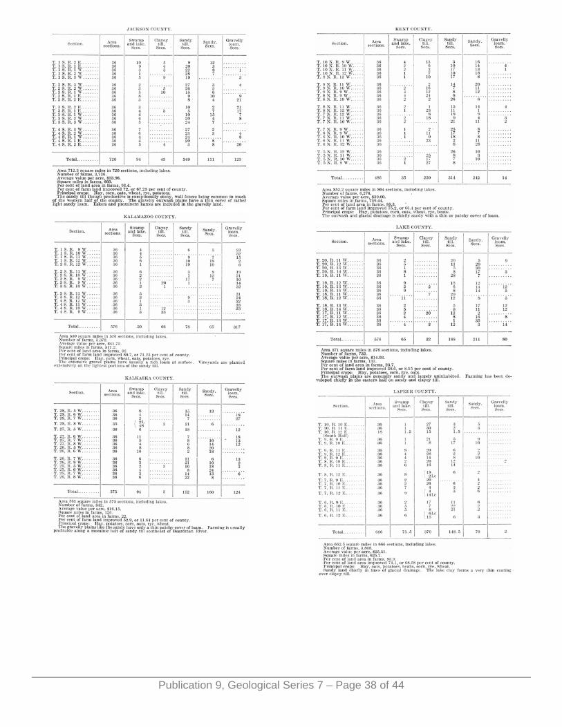
Publication 9, Geological Series 7 – Page 38 of 44
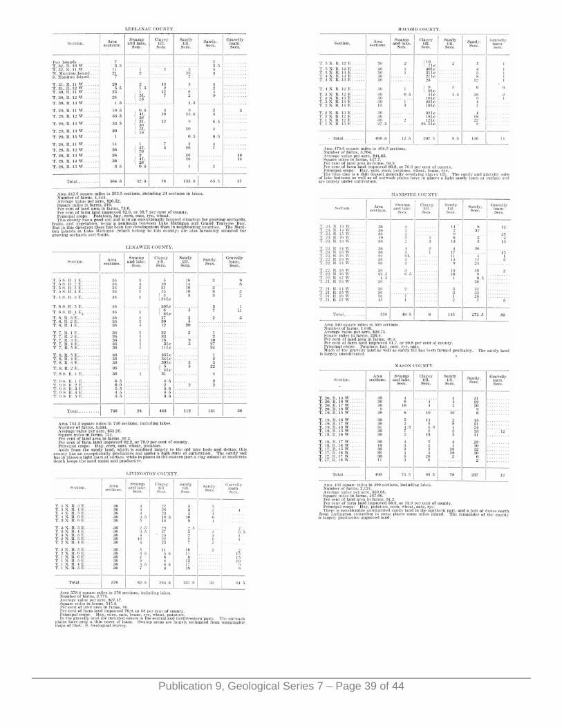
Publication 9, Geological Series 7 – Page 39 of 44
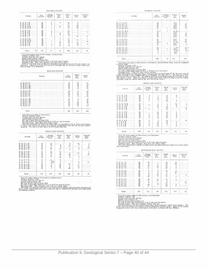
Publication 9, Geological Series 7 – Page 40 of 44

Publication 9, Geological Series 7 – Page 41 of 44
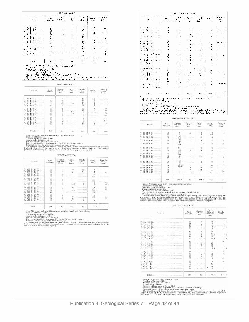
Publication 9, Geological Series 7 – Page 42 of 44
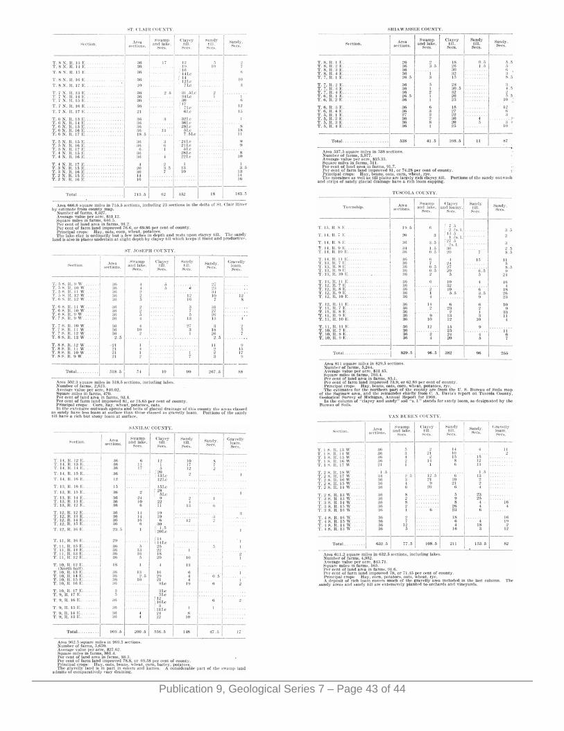
Publication 9, Geological Series 7 – Page 43 of 44

ERRATA.
Page 22. Fourth line from bottom read 3.66 for 32.
Publication 9, Geological Series 7 – Page 44 of 44