Embed Size (px)
Citation preview
SCA Proceedings, Volume 24 (2010) Musser-Lopez and Miller, p. 1
ARCHAEOLOGICAL TRAILS AND ETHNOGRAPHIC TRAILS: CAN THEY MEET?
RUTH ARLENE MUSSER-LOPEZ ARCHAEOLOGICAL HERITAGE ASSOCIATES (RIVER AHA)
STEVE MILLER
BUREAU OF LAND MANAGEMENT, LAKE HAVASU FIELD OFFICE Compliance archaeology has tended to focus on specific locations of sites, while the broader landscape of traditional use areas, travel corridors, and places named in tradition is often overlooked. An opportunity for landscape-level analysis presented itself in a proposed large Off Highway Vehicle (OHV) open area adjacent to the Colorado River. While a continuous Salt Song Trail may not be physically manifest, researchers found evidence of a corridor including trail segments, stacked rock features (“prayer shrines”), and short-term camps. When taken into consideration with prehistoric events and places named in ethnographies and current traditional practices, these fragmented segments may be components of the Salt Song Trail. The Salt Song Trail and other ethnographic trails in the Mojave Desert are elements of very large-scale ethnographic landscapes. These landscapes include the land, its springs, passes, and notable peaks; the fossil traces of human behavior ranging from stone tool manufacture, sheltering, and ceremony; and the empirically observable tread or alignment of the trail itself (Figure 1). The difficulty lies in linking, or attempting to link, archaeological observations characterized by very specific locations to named ethnographic trails, which in most cases have only generalized provenience and which, in some cases, may not have an actual physical referent. The purpose of this paper is to share tentative findings of recent fieldwork in Standard Basin, Arizona, a large drainage situated on the eastern side of the Colorado River south of Lake Havasu City. In 2008, Ruth Lopez, Steve Miller, and Stephen Horne, Bureau of Land Management (BLM) Archaeologists from the Lake Havasu Field Office, inventoried over 3,000 acres of a proposed 6,240-acre Off Highway Vehicle (OHV) Open Area in Standard Basin, Arizona (Figure 2). Our research design (Musser-Lopez 2008) incorporated the objective of carefully documenting trails and their associated features.
ETHNOGRAPHIC “SALT SONG TRAIL” AND THE STORYSCAPE PROJECT
The impetus for the present study came from Cara McCoy, Director of the Chemehuevi Cultural Center, who related the belief, shared by some Nuwuvi (Southern Paiute) elders and traditional practitioners, that the Salt Song Trail was not only a cultural idea expressed in a ritual song cycle but also had an actual physical imprint. Matthew Leivas, Sr., a Nuwuvi (Chemehuevi) native scholar and “salt singer,” elaborated that the Salt Song Trail, its associated shrines, and the sacred landscape along its route exist in dreams and the spirit world and also in the natural world—a cultural landscape linked by a network of connected physical trails. Richard W. Stoffle of the Bureau of Applied Research in Anthropology, University of Arizona, Tucson, and Richard Arnold, Chair of the Pahrump Nevada Paiute Tribe also documented this:
Southern Paiutes have a Salt Song Trail—a Puha Path or Spiritual Trail—established at Creation to the afterlife, which is a concept like Heaven. This path to the afterlife traverses about a thousand miles through their traditional territory and that of the Hualapai people to the east across the Colorado River. When a person passes away his friends and relatives move him along this Puha Path by singing over a period of days a
SCA Proceedings, Volume 24 (2010) Musser-Lopez and Miller, p. 2
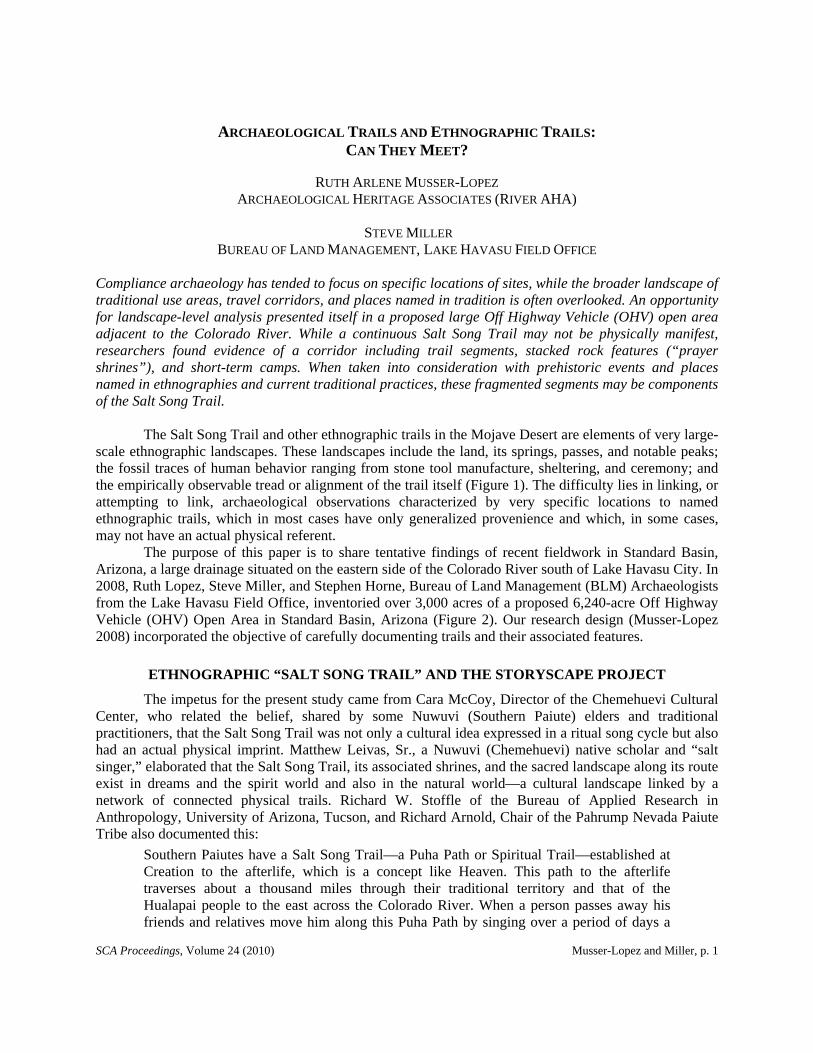
Figure 1. Mike Lerch and Chuck Lamb (ca. 1981) looking at a physical trail segment bearing east from Moapa Spring in the Turtle Mountains (background) at a point approximately one-third of the distance down the mountain toward the Colorado River. (Photo courtesy of Ruth Musser-Lopez)
series of Salt Songs and Bird Songs. Each set of songs moves the departed person along the trail to a specified physical or spiritual place. The departed person only moves along the Salt Song Trail and movement is directly tied to the singing of Salt Songs . . . there are numerous specific places mentioned in the Salt Songs...[Stoffle and Arnold 2008].
Viviane Jake, a Kaibab Paiute, conveyed, “the Salt Songs are a cultural and spiritual bond between the Nuwuvi and the land, and represent a renewal and a healing spiritual journey” (Klasky 2009:1). These places exist in dreams and the spirit world, and also exist in the conscious, natural world of the living Nuwuvi who sing the many stanzas of the song to help those who passed into the afterlife find their way. McCoy suggested that Standard Basin might be part of the route taken by the Salt Song Trail and that places named in the trail are typically linked to natural landscape features toward which the Nuwuvi salt singers would ritually guide the spirits of the departed. That landmarks are described in the Nuwuvi Salt Songs sung at memorial ceremonies is also supported by Kelly and Laird as synthesized in Fowler:
The songs and stories contain numerous place names for mountains, water sources, valleys, and other geographic points of interest, many of which are also physical points

SCA Proceedings, Volume 24 (2010) Musser-Lopez and Miller, p. 3
Figure 2. An adaptation of the Salt Song Trail Map designed by Dana F. Smith and Philip M. Klasky (copyrighted by the Salt Song Trail Project in 2009, the portion illustrated by permission but the complete version may be obtained through The Cultural Conservancy at www.nativeland.org). The white arrows in the Storyscape Map illustrate a loosely defined circuit around the lower Colorado River region, beginning and terminating near the confluence of the Bill Williams and Colorado rivers at the south edge of the black circle defining the vicinity of the project study area, Standard Basin. The existence of the trail through the region within the red square is examined.
on known trails. In a few ancient stories, the places and the place names are actually first established in the distant time, by various beings....One of the versions of the Salt Song recorded by Kelly (1933[1932-1934]:18:106f) tells of the grand journey of two birds on the eastern side of the Colorado River from roughly the Blythe area to the salt caves beyond the great bend of the river to the north and then back south through the Las Vegas Valley and Ash Meadows, ultimately returning to their point of origin. They then follow the Bill Williams River, ultimately ending their journey...[Fowler 2009:88].
The song inherited by George Laird (Chemehuevi) tells of a wandering flock of a great variety of birds, consisting of many different species, each searching for its proper home:
This flock was comprised of every sort of land bird that inhabits the Colorado River Valley. The song starts up Bill Williams Fork, perhaps forty-five miles from the

SCA Proceedings, Volume 24 (2010) Musser-Lopez and Miller, p. 4
Colorado, follows the Bill Williams down to the River, then goes upstream to a point above Fort Mohave, thence it goes east across the mountains, reaches the vicinity of Mineral Park, and proceeds on into Walapai Valley; then travels north again to cross the Colorado River and start out southwest on the Nevada side, coming down to Las Vegas. The Salt Song then follows the valley of the Dry Lakes on down by New York Mountain, thence down through the hills till it strikes the valley where Danby is situated, then goes across from Danby behind the hill where there is a rock salt mine and proceeds southeast from that point until it reaches the Palo Verde Wash below Blythe. It goes north again on the California side, crossing the River about three miles from Blythe intake and so into Parker Valley in Arizona, then it goes up through that valley to within some three miles of Parker, up the wash (Tihiya?igatiah, Deer Entrance) that runs from Parker to Bouse for about ten miles, then northeast over rolling hills until it strikes the Bill Williams, and continues up Bill Williams to the starting point…[Laird 1976:16, 17].
While George Laird located the starting point on the Bill Williams River, in an endnote, Laird mentions, “Wendell Goodman, Sr. says it started ‘at the Salton Sea’ – probably at that low point on the desert now occupied by the Salton Sea.” Laird recognized that the song may be divided into two or more branches and that the existence of various versions was reasonable considering the length of the song and its importance. She noted that the Cahuilla and the Mohave sing their respective “Bird Song,” but that “it seems unlikely (though it is possible) that the present Bird Song is actually identical with or a part of the Salt Song as George Laird knew it” (Laird 1976:242, note 19).
Leivas and Vivian Caron Jake (Kaibab Paiute), as native scholars, brought to our attention the “Storyscape Project” under the direction of Philip M. Klasky, assisted by Melissa Nelson, both of the Cultural Conservancy, San Francisco State University, Department of American Indian Studies, assisted by Salt Song Trail directors Leivas and Jake, other Nuwuvi cultural consultants including tribal elders, and other members of 14 bands including Cedar City, Chemehuevi, Colorado River Indian Tribes, Indian Peak, Kaibab, Kanosh, Kawaiisu, Kaiparowits, Las Vegas, Moapa, Koosharem, Pahrump, San Juan, Shivwits, and Twentynine Palms Band of Mission Indians. Other references and sources of assistance were from the Center for Applied Spatial Analysis (CASA), University of Arizona, and Carobeth Laird’s publications The Chemehuevis (1976) and Mirror and Pattern (1984) (Cultural Conservancy 2009; Klasky 2009).
A map of the general “route” of the Salt Song Trail was created by the Storyscape Project (Figure 2) illustrating the “Nuwuvi holy lands spanning ocean and desert, mountain and rivers and across four states” (Cultural Conservancy 2009:map). The white arrows in the Storyscape map illustrate a loosely defined circuit around the lower Colorado River region, beginning and terminating at Avi Nava/Ting-ai-ay (Rock House), the sacred cave near the confluence of the Bill Williams and Colorado rivers, then “north to the Colorado Plateau, west to Nuva Kaiv (Mt. Charleston), through mountain passes to the Pacific Ocean and then back east through the desert to the Colorado River and to its place of origin” (Klasky 2009:1-3). While general flow, direction, and point of origin of the bird flight path are known, specific physical trails mirroring this route, to the extent that they may actually exist, have yet to be determined.
While Salt Song place name locations in the Standard Basin (if any) are unknown to us, seeing the Storyscape map and witnessing tribal member’s convictions about its physical reality encouraged us to look closer for a potential physical trail referent, particularly since the route north from the confluence is so loosely defined and because our project location in Standard Basin is also north of the confluence adjacent to the Colorado River.
We examined the idea of an actual physical trail along several lines of inquiry that included constraints and opportunities of physiographic features and natural resources, toponymy, intertribal sociopolitical factors, and the archaeology of Standard Basin. While following these threads, we fully acknowledged that the Salt Song bird route may not ever have existed as a connected foot trail, that it may have existed solely as songs, dreams, and a corridor of movement for the spirits of the deceased.

SCA Proceedings, Volume 24 (2010) Musser-Lopez and Miller, p. 5
A PHYSICAL “SALT SONG TRAIL”?
A Premise
Testing the Leivas’ concept of the Salt Song being a description of a cultural landscape linked by a network of trails, our premise, then, is that the sung Salt Song was utilized as an aerial, landscape-perspective map, a memory device to mentally envision relative location. Controverting opinion has been expressed by current members of the tribe as to whether the flight pattern of the Salt Song is mirrored by a precise physical, on-the-ground trail. Consistent, however, is the view that the Salt Song reflects the identity of the Chemehuevi people, in particular by describing their subsistence territory, their seasonal travels, what was permitted, and what was forbidden (David Chavez, personal communication to Harry Swanson 2010). Within this framework, we submit that the song could also have been referred to for the purpose of remembering places to be intentionally avoided. Given this premise, a physical Salt Song referent used for the purpose of resource procurement, trade, seasonal migration, travel, etc., may generally mirror the flight pattern of the bird’s large, circular route; however, out of necessity and pure expedience, a physical trail network would diverge from the actual corridors used by the birds in flight, just as one would not and could not go everywhere named on a AAA map to get to a single destination point. Particularly in the desert, with limited water, we should expect physical “Salt Trails” to be direct, “straight-through” trails linked by watering places or springs. In looking for physical referents, we also took into consideration the possibility that the Salt Song may provide directions to places not intended to be on the physical trail.
In 1976, a general route of the Salt Song owned by George Laird was mapped by Carobeth Laird (cf. Laird 1976 frontispiece). This route is distinguished from the Chemehuevi physical trails that Laird described, which are linked by detailed place names, leaving the impression that the bird flight corridor had no physical, on-the-ground trail referent, though Laird qualified this by saying, “many of the old routes and old place names had passed into oblivion.” Thus, because it is a perspective of one’s world from above, as in flight, the song becomes an oral aerial perspective, a regional topographic map showing where places are in respect to each other, but leaving specific physical footpaths up to interpretation and innovation.
When a Chemehuevi asked, “how does that song go?” he did not refer exclusively to its words and tune; primarily he meant, “What is the route it travels?” Each landmark and watering place was mentioned in order, by recognizable allusion or description if not by name, so that a man’s song constituted an oral map of his territory…[Laird 1976:10].
With respect to our project area, as shown on the Laird map, the route of the Salt Song makes an aerial clockwise loop north up the Colorado River on the west side of Standard Basin, through the Mohave Valley, then to “Mineral Hill” northeast of Fort Mojave and south down to the Dutch Flat area on the east side of our project area (Figure 3) before it again turns north toward Utah and counterclockwise back to the river. In the Salt Song, the area of Mohave Valley above Fort Mojave is referred to as “the place of many ants” (Betty Cornelius, personal communication 2010), perhaps a clue to an area to avoid. A physical trail through Standard Basin could potentially have directly linked an actual physical Chemehuevi trail from the west on the California side, described by Laird, with the “turn about” portion of the Salt Song route in the vicinity of Dutch Flat on the east in Arizona (Figure 3). Such a route through Standard Basin would be a short cut across the south end of the loop up and around Mohave Valley, avoiding political and physiographic barriers.
The existence of both a straight-through, east-west physical trail and a north-south river corridor that was circumvented by the Chemehuevi is supported by Laird, who reported
trails along the River leading from settlement to settlement. But during the long series of wars between the Yuman tribes, when these lowlands became Enemy Territory, the Chemehuevis came to rely whenever possible on routes traversing arid territory, well
SCA Proceedings, Volume 24 (2010) Musser-Lopez and Miller, p. 6
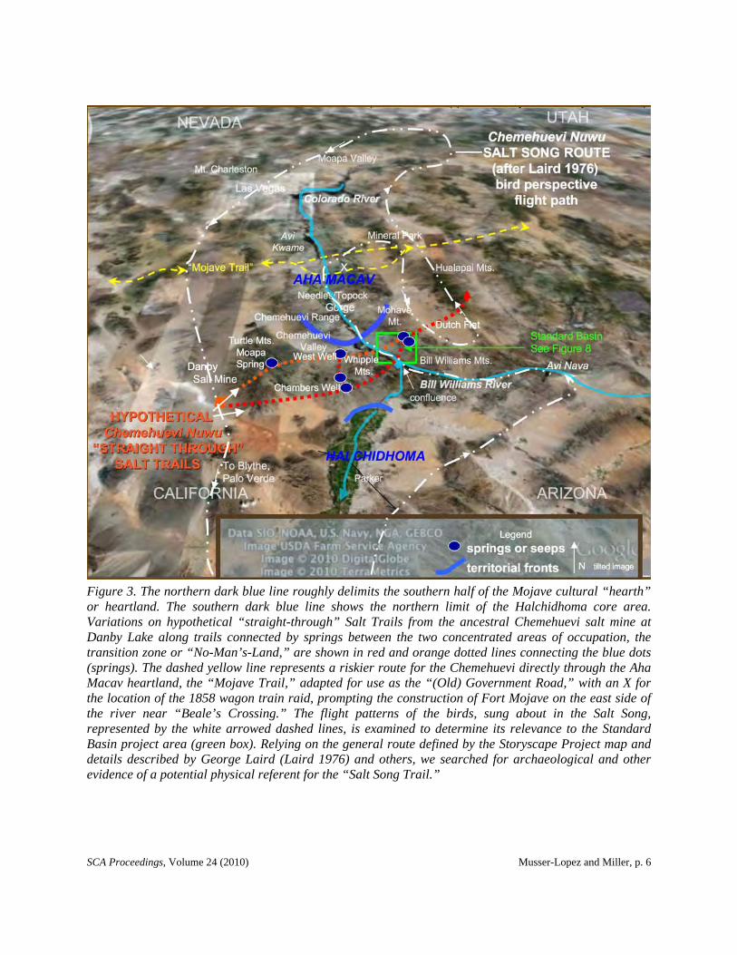
Figure 3. The northern dark blue line roughly delimits the southern half of the Mojave cultural “hearth” or heartland. The southern dark blue line shows the northern limit of the Halchidhoma core area. Variations on hypothetical “straight-through” Salt Trails from the ancestral Chemehuevi salt mine at Danby Lake along trails connected by springs between the two concentrated areas of occupation, the transition zone or “No-Man’s-Land,” are shown in red and orange dotted lines connecting the blue dots (springs). The dashed yellow line represents a riskier route for the Chemehuevi directly through the Aha Macav heartland, the “Mojave Trail,” adapted for use as the “(Old) Government Road,” with an X for the location of the 1858 wagon train raid, prompting the construction of Fort Mojave on the east side of the river near “Beale’s Crossing.” The flight patterns of the birds, sung about in the Salt Song, represented by the white arrowed dashed lines, is examined to determine its relevance to the Standard Basin project area (green box). Relying on the general route defined by the Storyscape Project map and details described by George Laird (Laird 1976) and others, we searched for archaeological and other evidence of a potential physical referent for the “Salt Song Trail.”
SCA Proceedings, Volume 24 (2010) Musser-Lopez and Miller, p. 7
back from the River…leading from watering place to watering place…for the most part established trails were followed -- except, of course, by hunters in pursuit of game [Laird 1976:135].
Further, as discussed in more detail below, Laird (1976) describes specific physical east-west trails adjacent to the river in the Whipple Mountains and in the Chemehuevi Valley west of Standard Basin.
In the Area of Tuhugwantɨtɨvipɨ -- Enemy Territory, No-Man’s-Land
In the region of the Colorado River nearest to Standard Basin and Avi Nava, the historic evidence of the Numic-speaking Nuwuvi presence is in documented encounters after 1776 with the band referred to as the “Chemehuevi.” History tells us that the river bottom in this region was occupied and closely guarded by ancestors of the Yuman-speaking Mojave, or as they call themselves, “Pipa Aha Macav,” which they often abbreviate to “Aha Macav,” meaning “people by the river.”
In 1604, Oñate made contact with the “Amacava” (Aha Macav/Mojave), reporting them to be in the area of what is now called “Mohave Valley” and to some extent in the river bottom to the south, now called “Chemehuevi Valley,” but there was no mention of the Chemehuevi being encountered (Bolton 1919). In 1776, as Garcés traveled up the river in the area between what are now called Yuma and Needles, he reported Halchidhoma (“Jalchedun”) and thereafter encountered 80 “Jamajabs” (Aha Macav/Mojave) en route south, who were at war with the Halchidhoma, but he did not report Chemehuevis being on the river. Garcés was then instructed by the Jamajabs that his pack mules could not proceed on a direct course up the river, so he went rodeando, or round about, avoiding the perilous Topock Gorge, but also to avoid the war zone apparently in the rich bottom lands of the Chemehuevi Valley. He then encountered “Chemebets” (Chemehuevis) at small springs before passing through the Chemehuevi (also called Mohave) Mountain Range and entering the valley of Jamajab rancherias (see Coues 1900:1:200-234). As stated by Castetter and Bell (1951:44), the Mojave
...regarded only the river bottom as their territory and made claim to little adjacent upland. After the Mohave drove the Halchidhoma from the vicinity of and below Parker, the Chemehuevi (S. Paiute/Nuwuvi), a desert people whose home was northwest of the Mohave, began to drift into the valley named after them.
The long-term relationship between the Aha Macav (also Mojave or Mohave; for place and band names, generally “j” is used in California, “h” is used in Arizona, and those living in the Mohave Valley prefer to be referred to as Aha Macav or “Mojave” with a “j”) and Chemehuevi was generally amicable but guarded and ambivalent, as demonstrated in ethnography and the Aha Macav oral history. Pipa Aha Macav’s “spirit mentor, Mutavilya, created the Colorado River, its plants and animals and instructed the Pipa in the art of civilization” (Fort Mojave Tribe 2010). Following Mutavilya, creator Mastamho made additional helpful innovations for the Pipa, taught the Pipa how to make pottery, and also provided for the Chemehuevi, giving to them “White Spring” (to the northwest), four seed foods, and a language (Kroeber 1948). The provision for the Chemehuevi in Mojave traditional religious teachings is strong evidence of the Mojave attitude of toleration toward the Chemehuevi with their separate language, food, and territory -- but keeping in mind that the river was for Aha Macav people.
Laird identified a place name specifically designating the lowlands on both sides of the Colorado River from Fort Mojave to the Palo Verde Valley below Blythe as the Chemehuevi “Tuhugwantɨtɨvipɨ” meaning “has been made or has become enemy territory,” saying that “in this sense it came into general use during the wars which resulted in the expulsion of the Halchidhomas,” because at the time it was a sort of “no-man’s-land” (Laird 1976:134). The duration or time span of these wars is unknown. However, during the period of 1820 to 1840, the Halchidhoma proper, distant cousins, under pressure of the Mojave and Yuma/Quechan, were exiled from the Colorado to join the Maricopa (Spier 1933); thereafter, Ives found Chemehuevi camped beside the Mojave on both sides of the river in Chemehuevi Valley in 1857 (Ives 1861; Miller and Miller 1967). Growing American occupation of the region and the river, including

SCA Proceedings, Volume 24 (2010) Musser-Lopez and Miller, p. 8
mining in the district surrounding what is now Lake Havasu (Paher 1990), with the potential for trade and employment of locals at the new mines, may account for the stronger alliance between the Mojaves and Chemehuevis during the period following the initial Gold Rush, particularly at what Lingenfelter (1978) calls the peak of the steamboat “river rush” in mid 1860s. Nevertheless, the Nuwuvi (“the people”) occupation of Chemehuevi Valley historically justified their formal reinstatement as the Chemehuevi Tribe on June 5, 1970, with a reservation comprising approximately 32,000 acres of trust land and 50 km of Colorado River on the shore of Lake Havasu at Havasu Landing, California (Chemehuevi Indian Tribe 2010).
A Theory: “Straight-Through” Salt Trail in Standard Basin
To avoid traveling over enemy territory along the river, the Chemehuevis had recourse to foothill trails where precious watering places were few and far between (Laird 1976:134). For desert travelers on foot, temporary camps near water were a necessity. Laird (1976:136, 274) describes a north-south Chemehuevi trail on the California side of the river linking Cottonwood Island and Yuma, connected by a series of springs dotting the desert landscape. The trail forks, and in the area of Chemehuevi Valley, on the west side of our project area, one branch bears north-south through Moapa Spring and another branch bears north-south through West Well. Our inquiry begins by examining the potential for physical counterclockwise easterly-bearing trails directly linking the salt source, described in the Salt Song and referred to as the Danby Salt Mine, with Dutch Flat and the Hualapais Mountains, where the Salt Song flight path turns northeasterly, bypassing extraneous portions of the bird flight path and resulting in a physical “straight-through” Salt Trail as illustrated in Figure 3.
The hyopthetical northern branch of the straight-through trail would be connected by springs, Moapa and West Well, crossing over the river in Chemehuevi Valley, and bearing east to Screwbean and Gold springs in the Manitowoc Mine Pass area. There it would connect with the south variant leaving Danby east around the south end of the Turtles Mountains, passing through the Chambers Well area then through or south around the Whipple Mountains. Crossing the river near the confluence, the south branch would then turn northeast through Standard Basin, where it merges in the mountain pass with the north variant trail. These merged trails then bear toward the Dutch Flat, crossing over the clockwise, southbound portion of the bird flight path, then picking up the counterclockwise portion of the bird flight path somewhere around the Hualapais.
Avoiding risky territory along the river, such a route would be a straight shot from the salt source at Danby, east to the Hualapai Mountains, with the potential for deer hunting and pinyon harvesting. It is asserted, then, that the actual trails used by Nuwuvi were more direct and linked watering places, with the flight path of the birds being a sort of mental map as a referent of relative location, places to move towards or to avoid and bypass.
Straight-Through Route from Danby Salt Mine
When Laird describes the Salt Mine at Danby as being “across from Danby,” the reference is as if one is moving on the counterclockwise bird path, at this point, southeasterly; thus across from Danby would be at the base of the range in which Moapa is located, the Turtle Mountains. Danby (Dry) Lake is approximately 30 km west, within a day’s walk downhill from Moapa Spring. Intermittently filled with water after a rain, the southeast end of this “dry lake” is thick with salt deposits, and when the lake is dry, wind-blown salt deposits build up behind hills at the base of the Turtle Mountains. It is roughly another 30 km from Moapa Spring to West Well.
On the hypothetical north branch, trails both east and west out of Moapa have been recorded, and segments of trails or access washes can be seen in aerial photographs -- all evidence that Danby was being accessed via these springs. The archaeological record provides evidence that the trails are prehistoric, bordered with petroglyphs and patinated stacked rock features; the latter are generally referred to as "prayer stacks" and locally as "trail shrines,” these being composed of local cobbles and pebbles. Also

SCA Proceedings, Volume 24 (2010) Musser-Lopez and Miller, p. 9
Figure 4. Moapa Spring with palms reportedly planted by Chemehuevi who traveled on foot by way of the Turtle Mountains. The salt mine described in the Salt Song is located down the mountain from the pass above the spring. Petroglyphs and stacked rock features, said to be “prayer stacks” or “trail shrines,” border the trail. Landscape-level features in the Salt Song, such as the volcanic peak near the spring (right), provide a pictorial map of ancient desert sojourns. Mac and Maggie McShan (r-l, left photo) revisited the site with BLM archaeologist Ruth Musser ca. 1981.
intermittently dispersed along area trails such as this one are small scatters of reflective white quartz crystal flakes reported to be for night travel to avoid heat (Fowler 2009; Kroeber 1925, 1951; Charles Lamb and Donald Smith, personal communication ca. 1981; Sample 1950).
Moapa Spring (CA-SBR-165; Figure 4) was first formally recorded in the archaeological record as M-124 in the 1930s by Malcolm Rogers, who described it as a San Dieguito I period site with Malpais flakes and choppers, Playa knives and planes, and the “Mohave War Trail” passing through it. However, a Santa Fe Magazine article (Battye 1934) reports that Charles Battye and William Hutt were escorted to it by a Chemehuevi named Hikorum in 1886, where they saw sheep horn and tortoise shells.
The Nuwuvi of the Chemehuevi Reservation have for generations passed down their knowledge and respect for this important desert oasis, a place of refuge in the event of famine, war, or other need for retreat (Donald Smith, personal communication ca. 1981). That the Chemehuevi occupied this site, at least intermittently, as a stopover campsite on a travel corridor, is also reported by Matthew Leivas (2010), whose late mother Gertrude Hanks Leivas, when she was a young girl, was told by her aunt that she (the aunt) was the one who planted the palm trees at Moapa Spring. Wild stands of the California

SCA Proceedings, Volume 24 (2010) Musser-Lopez and Miller, p. 10
Palm (Washingtonia filifera) variety are also present at other spring locations used by Nuwuvi, including those at the similarly named Moapa Spring in Nevada near Las Vegas and at Twentynine Palms, California. The similar palms Washingtonia sonorae and Neowashingtonia spp. are described as native to Sonora and Baja California and were planted at springs by the Cocopa, with their fruit used for food (Castetter and Bell 1951; Kniffen 1932; Palmer 1878; Standley 1920-1926).
Moapa Spring is located close to the two cone-shaped peaks in the background of Figure 1, looking toward the west at the Turtle Mountains from a point approximately one-third of the way between Moapa Spring and the Colorado River. This photograph illustrates a landscape perspective, where a trail leads in the direction of distinctive features on the horizon. The perspective illustrated in Figure 1 supports our premise that a physical trail would be used in conjunction with a mental map of landscape-level features, for instance as described in the Salt Song.
Sociopolitical and Physiographic Constraints and Opportunities -- Where to Cross the Colorado River
Crossing the lower Colorado River would not only have been physically exhausting for Paiute desert travelers, it also would have been an exercise in sociopolitical and physiographic strategy. A fortress-like palisade of mountain ranges and volcanic formations with few passes surrounds the Mojave heartland, the fertile and venerable river bottom known as the Mohave Valley, which contained the Aha Macav settlements. On the north end of the valley are the Newberry Mountains, with their highest peak at Avi-Kwame or Spirit Mountain (Figure 5a), from which the Aha Macav trace their earthly origins (Fort Mojave Tribe 2010; Kroeber 1948) and which is regarded as sacred.
Prehistorically, the Mohave Valley was an area of concentrated Aha Macav power with a landscape of protected and revered locations. Pre-contact population is likely underestimated, but a figure larger than 3,000 as suggested by Garcé (Coues 1900:2:450) and Kroeber (1925:883) would not be unreasonable, given the expanse and wealth of resources in the valley. Significant physical and sociopolitical obstacles may have constituted a barrier to Southern Paiute trails through Mohave Valley, and that barrier may be reflected in a Salt Song Trail corridor farther south, skirting the Mojave cultural hearth. As witness to the cultural bond the Aha Macav have with this valley, despite strong efforts by the U.S. government during and after the 1860s to remove them to Parker, Arizona, many of the Aha Macav held tightly and refused to leave their heartland. After 100 long years of struggle and peaceful resistance, the Indian Claims Commission finally ruled in 1959 that the Mojave had traditionally owned and used Cottonwood and Mohave Valley to the Bill Williams confluence. Today, the Fort Mojave Indian Tribe controls roughly 42,000 acres (Fort Mojave Tribe 2010) of “checkerboard” sections of land in Mohave Valley covering three states, Arizona, Nevada, and California.
To both the east and west of the Mohave Valley is a palisade of desert mountain ranges made of rocky volcanic formations. To the west of central Mohave Valley is Manchester Peak (Figure 5b) and Boundary Point on the east (Figure 5c). Photographs in Figures 5b and 5c and the dashed yellow line on the map in Figure 3 illustrate one of the most important ancient east/west trade routes; the trans-Mojave Desert “Mojave Trail” connected areas east of the Colorado River with the Pacific Ocean. It was later adapted for use as a wagon road, becoming a route variously known as the “Old Government Road,” “Beale’s Wagon Road,” and the “Mojave Road,” used by mid-nineteenth-century pioneers in traveling directly through the Mojave heartland. A location near Oatman Peak, seen in the background of Figure 5c and as an “X” on the map in Figure 3, is the site of a raid on the Rose Party in the late 1850s after Mojave crops were trampled by herded cows and important large cottonwood trees were cut down. No matter the message being sent, the aftermath was government military action and the construction of Fort Mojave on a mesa along the river in the area of the center of Figure 5c (Sherer 1994). Foreign travel through the Mojave heartland historically was considered risky.
To the south, down the river at the lower end of the Mohave Valley, is Topock Gorge (Figure 5d), a constriction in the river with steep rocky precipices and volcanic walls that make accessibility into the

SCA Proceedings, Volume 24 (2010) Musser-Lopez and Miller, p. 11
Figure 5. Landscape perspective of the Mohave Valley, with its formidable natural landscape features. Foreign travel through the Mojave heartland historically was considered risky for sociopolitical reasons. (a) Avi-kwame or “Spirit Mountain” to the north. (b) Manchester Peak and the west-bearing “Old Government Road.” (c) Fort Mojave mesa, boundary point at Oatman to the east and eastbound “Old Government Road.” (d) Topock Gorge with its needle-like volcanic formations presents a perilous up-river challenge both on foot and by vessel; the dunes are traditionally revered and protected, being associated with the spirits of the Aha Macav departed.
Mojave heartland from the south difficult to negotiate on foot. The dunes within the gorge were and continue to be a protected, revered location associated with the spirits of the Aha Macav deceased. The Chemehuevi (also called the Mohave) Mountain Range rises up on both sides of the gorge forming an east-west barrier across the south end of the valley. On the east side of the range is the sacred Mohave Mountain, the ancestral Aha Macav sanctuary to which they escaped during the Great Flood (Kroeber 1951), towering above the Mohave Valley to the northwest, Chemehuevi Valley to the southwest, Standard Basin and the confluence to the south, and Dutch Flat to the east.
Historically, prior to channeling, crossing the Colorado River with its huge flows, deep water, and flood cycles was a significant natural obstacle. Below Topock Gorge was the transition zone between the Mojave and Haldchidhoma, a riparian area that the Mojave utilized for resource procurement, with the lower end at the Bill Williams confluence, the delta perhaps shallow enough, prehistorically, to have allowed for foot crossing. Apparently never getting past the confluence to the Mojave settlements, Alarcón in 1540 was probably the first European to encounter Halchidhoma. They were reported to be
SCA Proceedings, Volume 24 (2010) Musser-Lopez and Miller, p. 12
generally situated in river bottomland south of the confluence in the Parker, Arizona area (refer to notes and translation of the Mendoza report in Elsasser 1979); the ethnographic group territories were likely similar to what is shown on the map in Figure 3.
The Hualapai, Yavapai, Halchidhoma, and Aha Macav spoke languages within the Yuman branch of the Hokan linguistic group. The Nuwuvi or Southern Paiute (also called Chemehuevi in this region) spoke a dialect of the Numic branch of the Uto-Aztecan linguistic group. The Aha Macav were the politically and militarily predominant tribe on this portion of the river, with the Halchidhoma sandwiched between the Aha Macav and the Yuma/Quechan further south, all engaging in incipient agriculture and struggling for control of suitable river bottomland, while the Paiute, Hualapai, and Yavapai generally occupied the outlying hills and mountains as hunter-gatherers with perhaps small gardens at “a few isolated springs” (Wilke and Lawton 1975).
The area between the Halchidhoma and Mojave was transitional, separating the two powerful, related, but warring river tribes. The competition for resources in this transition zone may have been at the root of the legendary feud between the two tribes. River tribes to the south of the Halchidhoma joined forces with the Mojave and were reportedly engaged in ongoing conflict throughout the late prehistoric/early protohistoric period, often ending in physical confrontations and war, eventually culminating in the Haldchidhoma’s displacement (Castetter and Bell 1951; Kroeber 1925; Spier 1933). The cultural transition zone, which Laird (1976) refers to as a “no-man’s-zone,” left open a potential passageway between these two powerful groups. The replacement with Chemehuevis of the area vacated by the Halchidhoma is further evidence of the Nuwuvi frequenting the area on a regular and timely basis, perhaps for the purpose of trade, including the trade of salt.
The northern blue ellipse in Figure 3 roughly outlines the bottom half of the Mojave cultural “hearth” in the mountains surrounding the Mohave Valley and the valley itself. (It does not include the entirety of Mojave territory, but simply the core area.) The ellipse near the lower edge in Figure 3 shows the Halchidhoma core area (but not their entire territory). Use of a route east through the transition zone between the Topock Gorge and the confluence, as shown in Figure 3, may have been a calculated strategic effort to avoid the river tribes (Hokan/Yuman-speaking) to both the north and the south. Hypothetical routes between to concentrated areas of occupation are shown in red and orange dots. These routes connect blue dots, representing springs, and illustrate the potential for “straight-through” routes from the Danby Salt Mine referred to in the Salt Song, east of the Hualapais, to connect with the northeast sweep of the counterclockwise portion of the Salt Song route. The springs are typically no more than 30 km apart, thus making it possible to be at the next destination spring for replenishment of water supplies within a day’s journey.
The hypothesized north branch of a “Salt Trail” between the two concentrated areas of occupation is represented by the orange dotted line in Figures 3 and 7: from Danby to Moapa Spring, West Well, the Colorado River, Screwbean Spring, and Gold Spring, and then meeting up with the south branch in the Manitowoc Mine pass before crossing Dutch Flat. Typical of the lower Colorado River region, distinctive trail segments end at natural drainages, leaving the archaeological posse in a quandary. The situation is no different with regard to the trail east from Moapa Spring. Significantly, West Well spring and petroglyphs are located downhill east of Moapa Spring, at least three-quarters of the way to the Colorado River, and can be reached by following an obvious large drainage cutting through the Chemehuevi Valley. Even more significant is the importance of West Well as the “key” to the “straight-through” theory, because in Chemehuevi myth it is described as “the first spring or group of springs made by Southern Fox as he traveled towards the north” (Laird 1976:130). In the counterclockwise circular route scheme, traveling north would first require one to travel east, and if through West Well from Danby, the entire extraneous loop around Blythe would cleverly be eliminated.
Bearing east out of West Well is a large wash draining into the Colorado River, now Lake Havasu. Laird (1976) provided Chemehuevi names for places on both the west and east banks of the river in this area. Stylized representational petroglyphs over more highly patinated abstract designs at “Body

SCA Proceedings, Volume 24 (2010) Musser-Lopez and Miller, p. 13
Beach,” on the Arizona side of the lake, approximately east of West Well, in the area of the east bank location that Laird referred to as “Kwayantuwatɨ,” stand as evidence of a prehistoric travel corridor crossing the river there. Such a crossing of the river would be roughly 25 km north of the confluence and may have presented greater risk, with heightened potential for direct conflict with Aha Macav and a possibly wider and deeper river with unknown seasonal flooding on the natural side of the risk equation. Nevertheless, a hypothetical north branch of a straight-through route from this crossing on the river directly east to Screwbean and Gold Spring is worth future examination, particularly since political barriers change through time and present-day roads (potentially historic ones) may follow or parallel prehistoric foot trail segments.
An “easy” route east from West Well down the Chemehuevi Wash to the river, then down the river, possibly to a landing south of the Aubrey Hills where the south branch trail, now represented by Dutch Flat Road, through the Standard Basin and our project area could potentially have been picked up (see below), is supported by observations made by Ives in 1858:
...we met two Chemehuevis, with their wives and children, and household effects, paddling towards the valley below on rafts made by tying together bundles of reeds…they drew their rafts into a little cave when they saw us coming, and peered out at the steamboat as it went puffing by, with an amusing expression of bewilderment and awe [Ives 1861].
A potential southern branch of the hypothesized Salt Trail that is also important for future examination may have come from Danby Salt Mine south around the Turtle Mountains, through the Chambers Well area of the Whipples, to the confluence, then up through our project area in Standard Basin along the Dutch Flat Road corridor, and merging with the north branch in the area of the Manitowoc Mine pass. The red dotted line in Figures 3 and 7 represents this hypothesized south branch of the Salt Trail. Since early roads often follow the routs of prehistoric trails, the historic mine wagon road bearing southward from West Well around the west side of the Whipple Mountains to Whipple and Chamber’s Well is a potential trail variant linking the hypothesized north and south branches of the Salt Trail.
This prehistoric trail route is supported by ethnographic evidence collected by Isabel Kelly during interviews with Charlie Pete ca. 1933 and by Carobeth Laird ca. 1976 who recorded the knowledge of her husband George Laird (Chemehuevi), as synthesized in Fowler (2009). The synthesis describes at least four routes through and around the Whipples to the confluence after leaving the Turtle Mountains. At least two routes went directly through the Whipples to the river, taken by those not in a hurry or hunting. During the early 1980s, Robert Laidlaw also collected ethnographic evidence of two dozen prehistoric trails ramifying in all directions through the Whipple Mountains, as reported in unpublished data (USDI Bureau of Land Management n.d.). The trail described by Laird (1976) appears to be the precursor of the historic road, south around the west side of the Whipples by way of “Hawayawi” (West Well), then to “Guatamote” (probably Whipple Well), then to “Sohorah” (Chambers Well), and then east.
All of these important springs, places, confluences, and mountains, have Chemehuevi or Mojave names, some of which have been provided and translated in Laird (1976). It must be noted here that George Laird, who spoke both Chemehuevi and Mojave, related to Carobeth Laird that
the entire song is composed of Mohave words, pronounced and combined in such a manner as to be unintelligible to Mohaves. This playing with words, especially with foreign words, and the fact that the song ranged boldly into enemy territory delighted the Chemehuevi sense of humor [Laird 1976:16].
The narrative of the song “starts up Bill Williams Fork, perhaps forty-five miles from the Colorado” (Laird 1976:17) at Avi Nava “Rock House.” In the Mojave language, “rock” also means money, because Europeans wanted “gold avi” but the use of the term avi in ancestral place names apparently does not have anything to do with gold, money, material wealth, or the power that may come

SCA Proceedings, Volume 24 (2010) Musser-Lopez and Miller, p. 14
with it. This particular beginning point along the Bill Williams may have had its origin partially in the limits and opportunities contained within complex sociopolitical and natural environments. It may be of some significance that at no time does the song route go upstream against the flow of the Bill Williams; in returning to Avi Nava, the flight path is overland from the south.
Chemehuevi elder Betty Eddy Cornelius (personal communication 2010) kindly explained that the portion of the song coming down the Bill Williams is very serious, hushed, reverent, “as if you are in church,” sung in low voices by men only. The seriousness of the song and the beat changes, picking up and becoming more exciting after passing the confluence and going up the Colorado, where everyone can join in. It seems relevant that this change in the seriousness and beat coincides with the location of the apparent break in the political boundaries of the Aha Macav and Halchidhoma, and strengthens the argument in support of a “straight-through” corridor above the confluence. Further research could potentially confirm what may be subtle cautions in the song, that the Bill Williams is “taboo, only for men, stay out and don’t go that way.” Similarly, singing about the “many ants” associated with the area above Fort Mojave may be the sounding of an alarm to avoid that area, again distancing a straight-through route away from that northernmost portion of the clockwise route.
Given that the song is composed of many words from the Yuman linguistic group, it does not seem unreasonable to assume that its original form was from the Aha Macav as the “Bird Song,” with its name changed to “Salt Song" by Numic speakers. Also, it is of great interest that another southern California desert tribe in the Takic branch of the Uto-Aztecan linguistic group, the Cahuilla, sing the “Bird Song." Laird indicated that she witnessed a group singing, when one woman admonished another, “Don’t sing Bird, sing Salt.” Franklin and Bunte (1996:192) determined that the song is clearly derived from the Mojaves via the Chemehuevis and “adapted to fit its new cultural home, shifting its home territory into South Paiute country” and changing the rotation of the route from clockwise to counterclockwise. If so, further analysis of Aha Macav physical trails, their potential for mirroring the flight pattern of the birds in their version of the song and the similarities of both the Chemehuevi and the Aha Macav place names in the song and their associated physical referents would clearly be very informative. A useful study, but beyond the scope of our present research, is a comparison of known Mojave physical trails with those described by Chemehuevi; a separate set of Mojave physical trails may more closely mirror the pattern of the bird flight as sung by the Mojave in the Bird Song. A comparison between the bird song flight and the actual physical trails in the Aha Macav cultural hearth would no doubt provide evidence that the river corridor trails in that area more closely correspond with or mirror the pattern of at least the clockwise segment around the Aha Macav cultural hearth as sung in the Salt Song by the Chemehuevi.
Merging Trails in the Standard Basin: Natural Resources, History, Other Considerations, and the Archaeology
While the flight of the birds in the song is said to go north from the confluence, the sociopolitical and physical barriers were formidable for a route any farther north along the Colorado River than Topock Gorge. Less resistance would have been encountered on a path around the south side of Mohave Mountain, which is situated to the east of the Gorge (Figure 3). The pass, between Mohave Mountain, east of the Gorge and Bill Williams Mountain north of the Bill Williams River, is situated at the upper end of Standard Basin and Wash.
Further evidence of Standard Basin being in the “path of least resistance” is its location in the “transition zone” between the Mojave and the Halchidhoma, as discussed above. The lower ends of the many Standard Basin intermittent washes terminate at the Colorado River (Lake Havasu). One of the major wash termini occurs at an historic river port, Aubrey Landing. The landing also appears to be the terminus for historic Dutch Flat Road (AZ L:12:2 [Arizona State Museum]). As shown on Government Land Office maps, Dutch Flat Road was in use at the turn of the twentieth century and provided access to the Manitowoc mine located in the low pass between Mohave Mountain on the north and the Bill

SCA Proceedings, Volume 24 (2010) Musser-Lopez and Miller, p. 15
Williams Mountains to the south. Dutch Flat Road also connected Kingman, Arizona and Hualapai territory with the Colorado River via Mohave Wash and Dutch Flats east of the pass and Standard Basin west of the pass. Segments of the historic unpaved dirt road are intact and traceable in the Standard Basin (Breen 2003a, 2003b; Musser-Lopez et al. 2008; Phifer 1994a, 1994b).
Such historic roads as the Dutch Flat Road tend to follow Native American trails. The famous freighter François Xavier Aubrey, who twice drove thousands of sheep for market from New Mexico to the coast in the period between 1852 and 1854, may have been following an ancient travel corridor that eventually became Dutch Flat Road. Which route Aubrey used is unknown, however. Aubrey advocated a 35th parallel route to Lt. Amiel W. Whipple, who in 1854 surveyed parallel routes in the area (Casebier 1981; Rogers 1966). The rail route selected, roughly the modern alignment of the Burlington Northern Santa Fe Railroad, is a northwest route on the north side of Mohave Mountain through Mohave Valley, rather than to the south of Mohave Mountain where Dutch Flat Road is located, and which would have avoided the Mojave heartland. Aubrey Landing was so named because Aubrey forded the river at that point (Lingenfelter 1978). Physiographic evidence supports the possibility that the landing is the terminus of Dutch Flat Road at the Colorado River. North of the landing are the low-lying Aubrey Hills, presenting a barrier for travel through Standard Basin from the Colorado River. The landing was significant between 1864 and 1886 as a smelter and transshipment point for interior mining districts (WESTEC Services 1980). It is reasonable to assume that miners in the interior Chemehuevi Mining District, which included the Manitowoc and others in the Dutch Flat Road area, would have hauled ore down the hill to this landing via Dutch Flat Road. Thus Aubrey Landing is a likely location for overland travel away the Colorado River as well.
As shown in Figures 6 and 7, multiple, roughly parallel trail segments were found to be located in the southwest quadrant of the Standard Basin project area, bearing northeast from the Colorado River below the Aubrey Hills and across the river from the Whipple Mountains (Musser-Lopez et al. 2008). From a landscape perspective, as shown in Figure 6a, trail segments in Standard Basin appear to be leading from the direction of Monument Peak, a pinnacle in the Whipple Mountains, very near to (within 8-10 km) and almost directly west of the confluence of the Bill Williams and Colorado rivers at Avi Nava. These trails bear northeast toward the pass at the Manitowoc Mine and were found to closely parallel or to have been replaced by the Dutch Flat Road; their associated features are described more fully below.
The upper end of the proposed Standard Basin OHV Open Area terminates at the Manitowoc Mine pass. The area east of the pass, Dutch Flat, was a relatively vacant corridor prehistorically, situated between the Hualapai and the Aha Macav, considered to be the western edge of Hualapai territory and likely a path of least resistance for the Nuwuvi to travel north, a route that avoids the Mojave heartland and at least the peripheral edges of the Hualapai, Yavapai, and Halchidhoma. Dutch Flat is an important junction, because it is where the clockwise direction of the song route around Mojave territory makes a wide “U” turn, heading back northeasterly on its counterclockwise sweep. This is also the location where our hypothetical “straight-through” trail potentially connects with the Salt Song corridor in two places: the segment going south, and the segment going northeast. Given the premise of the straight-through trail, the first crossing of the southbound song corridor is important, perhaps as a memory devise, alerting the traveler not to turn up that corridor but to continue on to where the landscape looks like where the birds were flying north -- the Hualapais.
An important Chemehuevi ancestor, the grandfather of many Chemehuevis living today in the Havasu-Parker area, was William Eddy, nicknamed “Dutch Eddy.” His granddaughter, Betty Eddy Cornelius, now an elder, related that her grandfather acquired the name of “Dutch” because, although his mother was a full-blooded Chemehuevi raised in Chemehuevi Valley, his father was a European fur trader from Holland (Betty Eddy Cornelius, personal communication 2010). Although Mrs. Cornelius insists that there is no connection between the names, the curious “Dutch” label adds to the case for a Nuwuvi association with a trail through the Dutch Flat area.

SCA Proceedings, Volume 24 (2010) Musser-Lopez and Miller, p. 16
Figure 6. (a) Standard Basin trail segment bearing northwest from the Colorado River’s confluence with the Bill Williams, with the Whipple Mountains and Monument Peak (arrow) in background; stacked rock feature (“prayer stack”?) on left of trail. (b) One of the numerous segregated reduction localities that include anvil stones, near trail segments in Standard Basin. (c) Collapsed stacked rock feature, possibly a shrine or “prayer stack,” surrounded by site furniture (five “sitting rocks,” upon one of which Steve Miller sits) adjacent to a trail on a low natural terrace above and adjacent to Dutch Flat Road. (d) Closer view of a trail and stacked rock feature (“prayer stack”?) in Standard Basin.
Previous to our study of Standard Basin, the over 6,000 acres in the project area had been dismissed by many as a wasteland: dry, sandy, and lumpy, with low sensitivity for cultural resources, thus with great potential for OHV open area use. But even though our results are provisional and preliminary, with less than half the basin being inventoried, we found over 200 locations of prehistoric cultural activity (Musser-Lopez et al. 2008).
Standard Basin is not a dry, desolate wash. Instead, it is a magnificent basin containing ancient river terraces covered with many unscarred, pristine desert pavements dissected by numerous intermittent natural drainages. It contains great biological diversity where elements of the Sonoran, Mojave, and Colorado deserts overlap in a plant community described as the Lower Colorado River Valley and Arizona Upland subdivisions of the Sonoran Desert (Shreve and Wiggins 1964). Here, the Lower Colorado River Valley foothill palo verde (Cercidium microphyllum) combines with the Creosote Scrub Community characterizing lower elevations of the Mojave Desert. The ocotillo characterizing the Colorado Desert and the saguaro characterizing the Sonoran Desert provided ancient travelers with access to varied food and material resources. The Manitowoc Mine pass at the upper end of the Standard Basin is

SCA Proceedings, Volume 24 (2010) Musser-Lopez and Miller, p. 17
Figure 7. North/south- to northwest/southwest-trending trail segments parallel to historic Dutch Flat Road (red dashed lines) in the Standard Basin study area indicate a general directional route funneling into the Manitowoc Mine Pass, where the road merges with another route (now a dirt road shown as dashed orange lines) from the west. Both roads may have evolved from physical trail segments linked to the east-bearing portion of a hypothetical wide-sweeping, ancestral physical trail through the area of the Danby salt mine, straight across the river east through the proposed Standard Basin OHV Open Area (green polygon) around Nuwuvi territory, following the counterclockwise portion of the general route laid out in the Salt Song. The blue arrows show the clockwise portion of the song route through the Mojave heartland. Toolstone debitage associated with rock-rimmed and rimless circular clearings, sometimes called “sleeping circles,” are evidence of resting areas along the way.
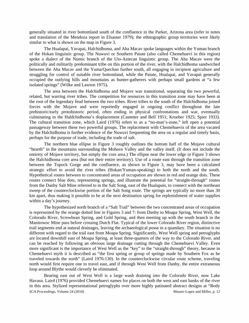
a gap between the ranges and a constriction that contains water and a relatively dense resource patch. Attracting nomadic hunters and gatherers are stands of saguaro (Cereus giganteus, aka Carnegiea gigantea) with seasonal fruit found in the upper elevations, along with Agave, Opuntia, Yucca, Lupinus, Ephedra, Eriogonum, Castilleja, Bromus and a recently discovered wild onion (Allium nevadense) (data on file with Northern Arizona University, Deaver Herbarium, 4/8/2005)). Bighorn sheep, antelope, and other smaller game frequented the springs in the higher elevations also near the Manitowoc Mine pass, Mohave Mesa, and Mohave Wash area. Beyond Mohave Mesa and Dutch Flat are the Hualapai Mountains, with the potential for piñon nut harvesting and deer hunting.
SCA Proceedings, Volume 24 (2010) Musser-Lopez and Miller, p. 18
Figure 8. Resting points in a travel corridor are evidenced by rock-rimmed and rimless circular clearings adjacent to prehistoric trail segments paralleling the historic Dutch Flat Road. (a) Seen in landscape perspective background is Crossman Peak of Mohave Mountain. (b) Down Standard Wash to the Aubrey Hills and Whipple Mountains. (c) Flat “mesa” area is behind the Bill Williams Bridge and the Whipples/Monument Peak. (d) Dutch Flat Pass.
Although it has been reported that the fruit of the saguaro was not available to the Mojave (Castetter and Bell 1951), the Standard Basin/Mohave Mesa/Dutch Flat patch invites revisiting the issue of localized exploitation of the prized fruit (perhaps by the Nuwuvi) and competition over it. The stand in Standard Basin is the northernmost known extent of this resource along the Colorado River. The fruit and seeds of the saguaro were known to have been utilized and highly valued by the neighboring Mojave relatives, the Yavapai, who, north of the Salt River, competed for the resource with the Maricopa and “descended from their highlands to camp and gather fruit in the same region” (Castetter and Bell 1951:44). Perhaps similar competition for the Standard Basin saguaro patch added to the conflict between the Mojave and Haldchidhoma, which might provide one explanation why the latter eventually left the Colorado River and took up residence with the Maricopa. The great importance of the fruit for celebration and the methods of harvesting have been described elsewhere (Spier 1933); the Yuman-speaking tribes evidently borrowed the trait from the Pima-Papago (Castetter and Bell 1951; Spier 1933) and exploited the resource in a similar fashion as the Pima, Papago, and O’odham speakers of the Western Papaguería, south of the Gila, as described by Palacios-Fest and Rankin (2008).

SCA Proceedings, Volume 24 (2010) Musser-Lopez and Miller, p. 19
THE ARCHAEOLOGY OF STANDARD BASIN
The most secure piece of evidence that Standard Wash was used as a prehistoric travel corridor is the archaeological record (Musser-Lopez et al. 2008). Roughly half, or 3,000 acres, of the 6,240-acre proposed OHV Open area was inventoried. We found two broad classes of sites. The first consists of sites that indicate a repeated use of the area for subsistence and resource procurement activities. The evidence included a large number of segregated reduction localities, lithic assay loci, and bipolar percussion loci with anvil stones (Figure 6b). These findings have been treated in more depth elsewhere (Musser-Lopez et al. 2009)
The other large class of sites was trails and features associated with trails, stacked rock features (“prayer stacks” or “trail shrines”), and rock alignments near trails (Figure 6). These sites lacked the range of artifacts expected at long-term camps; they included simple and rock-rimmed circular clearings (Figure 8) with associated formed artifacts, chert debitage, and site furniture.
Figure 7 provides the generalized location of springs at the upper end of the basin, the general alignment of the Dutch Flat Road trending northeast toward the springs in the mountain pass and the roughly parallel corridor in which we found numerous parallel trail segments (oval defined by dashed line), and the location of cleared and/or rock-rimmed circles. Figure 6a illustrates the northeast/southwest trail segment alignment with Monument Peak and the river confluence. An example of one of the prehistoric temporary campsites in the corridor is located adjacent to a historic isolated relic segment of Dutch Flat Road. This site, Sitting Rocks II (AZ L:12:60), illustrated in Figure 8c, is intersected by a trail, and the site includes “furniture” or “sitting rocks” surrounding a collapsed stacked rock feature (possible shrine or “prayer stack”), associated formed stone tools, chert debitage, a terrace-top trail, and two rock-rimmed circular clearings sometimes referred to as “dance circles” (Battye 1934) but more typically as “sleeping circles” because they are thought to mark the location of temporary sleeping enclosures or shelters (Rogers 1939), a theory that is supported by the observations of the eighteenth-century missionary Barco (1981) in Baja California.
Trail segments in the area typically vary from 30 to 40 cm wide and are of a generally straight pattern incised into the desert pavement along the crests of northeast/southwest-trending dissected river terraces. Trails on desert pavement are not worn deeply into the ground but generally are devoid of larger stones; they also appear slightly incised, with trampled and compacted redeveloped pebbles and gravels less patinated than surrounding naturally varnished pebbles and gravels. We located (roughly) 20 stacked rock features situated near the trails.
As shown in Figures 7 and 8, seven sites in the corridor included simple circular clearings roughly 2.5 to 3 m in diameter (Musser-Lopez et al. 2009; see also Bellatti 1979; Mann and Bellatti 1979). One site included two clearings with rock alignments along the rim. Unverified sites near Gold and Screwbean Springs, on the unexamined, hypothetical “straight-through” route, were reported by Mann and Ballatti (1979) and said to include a concentration of nine circles and/or rings, 3-7 m in diameter, near each of the springs, for a total of 18 additional circles or rings at the two springs alone. One of the cleared circles at Screwbean is bounded by an external triangular rock alignment that the recorders said was similar in appearance to one located in the Whipple Mountain range and which, if verified, would strengthen the case for a “straight-through” trail. Clearings we examined are typically slightly concave and vary in degree of surface patination from thin light to thick dark. Red soil staining and/or iron oxidation, varying in degree, is typically on the underside of the cleared circle gravels and the rim ring rocks. The deep and varied thickness of the patina and soil stain is evidence of extended use of the route through time. The soil stain on the surface of the embedded portion of the rim stones and the depth to which the rim stones are embedded in the soil (Figure 8d inset) also indicate longevity in place. Redeveloped compaction of soils was present within the interior of the rock rings, so that if they were “cleared circles” at one time, the compacted pavement had reformed.

SCA Proceedings, Volume 24 (2010) Musser-Lopez and Miller, p. 20
Site furniture or “sitting rocks” were also found to be associated with lithic tool reduction and assay sites not associated with trails or cleared circles inside the corridor. In more than one instance, flaked stone obviously radiated away from one side of a chair-size boulder. Bipolar percussion flaking using anvil stones is the predominate reduction technique, and evidence is found in roughly 125 segregated reduction localities (SRLs) and/or pavement quarries throughout the Standard Basin. These isolated or single-episode occurrences suggest transitory events of tool production and not a destination quarry. The numerous disconnected or segregated bipolar reduction localities are very common in the area and represent sporadic, opportunistic, expedient events and the exploitation of a random useful stone as needed during travel or short-term residence. Random, naturally occurring toolstone being utilized as it occurred while on route adds to the evidence of a prehistoric foot travel corridor through the Standard Basin.
Significantly, we also found one isolated occurrence of ground stone: a mano fragment near one small sherd of undecorated brown pottery in the southeastern quadrant of the Basin, not within the Dutch Flat Road Corridor but rather on a more direct route to a more southerly pass through the Bill Williams range to Mohave Spring located roughly 8 km south of Dutch Flat Road pass. The artifacts on the route to Mohave Spring and the artifacts and features at the spring itself are associated with and indicate predominant use by Yuman-speaking tribes. More evidence of a Salt Song Trail corridor paralleling Dutch Flat Road is that it would bypass and avoid this more southerly pass route connecting to Mohave Spring and potential hostile encounters.
The present study was not exhaustive, and our project area did not include the higher-elevation areas where we noted native agave (similar in appearance to Agave deserti or A. utahensis), potentially with nearby agave roasting pits, along with associated, culturally distinct artifacts and features, which could enlighten us with regard to cultural affiliation of the identified physical trails. Recently, pottery associated with agave roasting pits was found on the northwest side of Mohave Mountain (George Shannon, personal communication 2010); we had just a glance of a photograph and believe the sherds to be a local ancestral Aha Macav variety. We have no doubt that ancestral Aha Macav used these trails in their own traditional territory; we now have some indirect evidence of Nuwuvi use as well.
In what may link ancestral inhabitants of the Aha Macav cultural hearth with those occupying Pleistocene Lake Mojave (Soda Lake), BLM archaeologists collected projectile points in 1979 from a site (AZ L:12:6) in the Manitowoc Pass vicinity, situated on the northern periphery of the study area. In the interim, the site deposit has been obliterated and the collection cannot be relocated. However, the 1979 site record contains illustrations of classic Lake Mojave points typical of the Western Pluvial Lakes Tradition (WPLT). The presence of Lake Mojave points in spatial association with a segment of prehistoric trail in the study area suggests that use of the trail may date to the terminal Pleistocene and almost certainly predates the Numic expansion into Chemehuevi Valley. The similarity of these points to those found on the terminal Pleistocene shorelines of Lake Mojave (Soda Lake) is consistent with the Aha Macav’s own beliefs regarding the longevity and physical extent of their ancestral occupation. Of further significance is that the Mojave Trail and the Salt Song Trail likely cross or overlap in the vicinity of Soda Spring (Zzyzx) on the west side of Soda Lake and the Providence Mountains to the east.
The close proximity of AZ L:12:6 to two of the cleared circle sites is consistent with the description of Rogers that WPLT-period cleared circles have an average diameter of 6 ft., some rimed with gravel, some with low walls of rocks, some situated near water, some found in arid regions, with few artifacts in association (Rogers 1939:7, 8). This is both in support of Rogers and of the antiquity of the trail. Half of the project area remains to be intensively inventoried, and, of course, the intensive archeological survey of the hypothesized "straight-through" trails, along with further ethnographic research, is critical to validation of the premise of such trails’ existence. An inquiry into the Mojave version of the Bird Song would clearly illuminate our limited understanding, as it seems likely that the map of the bird flight was carried down by the descendents of the Aha Macav through the tradition of song for perhaps thousands of years.

SCA Proceedings, Volume 24 (2010) Musser-Lopez and Miller, p. 21
DISCUSSION AND CONCLUSIONS
In conclusion, we have found that it is not as easy as we initially thought to make archaeological trails and ethnographic trails meet. However, we did find what Native American scholar Matthew Leivas, Sr., termed “a cultural landscape connected by a network of physical trails,” with the landscape being represented in the Salt Song. In the process of analyzing our data in an effort to report our archaeological findings to the Society, we identified trails and potential trail routes that likely represent a direct east-west travel corridor used by people since the end of the Pleistocene. An inherited mental map of the landscape surrounding this corridor is veiled in the guise of an ancient song. Adapted for use over time by a variety of tribes and bands along the shores of the Colorado River and in the California deserts and the Great Basin, clearly, the importance of the evolution of the Bird and Salt songs goes far beyond the potential for physical trail referents mirroring the bird flight. The study of the songs’ lexicostatistics, transfer, borrowing, and variations in the lexicon from tribe to tribe over time, including branching lexical variants referring to localized physical features, flora, and fauna, could potentially inform the controversy of the Takic and Numic population expansion debated to have occurred anywhere between 700 and 3,700 years ago.
Archaeological evidence indicates that Standard Basin was a prehistoric travel corridor that paralleled or was subsequently overlapped by Dutch Flat Road. The proximity of Standard Basin to named places in the Salt Song and the sociopolitical barriers for Southern Numic speakers to travel by such other corridors as the Colorado River bottom suggest that a Salt Trail “straight through” or perpendicular to the river corridor was likely and that further work with native scholars concerning Standard Basin is warranted.
While we do not suggest that the trail segments are evidence of a physical manifestation of the Salt Song bird flight corridor, we do believe that our study provides evidence of a network of “Salt Trails,” perhaps used for trade, exchange, resource procurement (not exclusively limited to salt), seasonal migration, territorial expansion and/or transfer, or other sociocultural purposes, with at least some of those using it relying upon the singing of the Salt Song as a sort of mental aerial topographic map providing landscapes, places, and things to move toward and to avoid. It is doubtful that we would have made this connection without the body of ethnographic literature made available to us. We hope to encourage other archaeologists to think about the possibility of a larger picture, a landscape perspective, when they find trail segments and associated short-term habitation sites. Inclusion of the oral history of place, including trail names and place names in traditional songs, stories and metaphors, in future regional overviews is recommended.
Previously we reported the possibility of examining, as evidence of cultural affiliation and/or technological transfer, a type of stone tool production technique, bipolar percussion, demonstrated by the presence of anvil stones associated with toolstone debitage (Musser-Lopez et al. 2009). For future study, we are interested in extending the archaeological examination of the potential route beyond Standard Basin, to examine the possibility of similar stone tool manufacturing technology and also rock art styles, motifs, and techniques that may be found along potential trail routes indicating tribal affiliation and linking the Salt Song route. Linkages of these sites with those that include datable stratified deposits such as the one in the Whipple Mountains proposed for study by the University of California and the University of Arizona (Wilke 1978) would provide the much-needed archaeological evidence of the thousands of years of occupations of river tribes in eastern California, the beginning of agriculture, paleo-environments and climate change, biodiversity, cultural adaptation and innovations, art, diet, and much more.
ACKNOWLEDGEMENTS
The authors would like to acknowledge the followsing who contributed to the inspiration for this work and the success of the 2010 Ethnographic Trails symposium at the annual SCA meeting: Lowell

SCA Proceedings, Volume 24 (2010) Musser-Lopez and Miller, p. 22
Bean; Cara McCoy; Matthew Leivas, Chemehuevi Indian Reservation; Phil Klasky; James Snead; Dan McCarthy; Jamie Cleland and Tanya Wahoff; Linda Otero and Nora McDowell-Antone, Ft. Mojave Indian Tribe for stimulating the landscape perspective of the Pipa Aha Macav in their presentations at the 2009 Three Corners Conference; Bill Gibson (BLM) and Amy Racki (Arizona State Parks), for coordinating BLM- and ASP-leveraged funding for the inventory; Steve Politsch (the highly insightful BLM Field Office Manager who assigned the task of taking a “Native American Landscape Perspective” in our analysis of the Standard Region), Patricia K. Taylor, Patrick Putnam, Mike Henderson, Myron McCoy, Cindy Barnes, David O. Hanson, James Priest, Christine Bates, Jim Miller, Dan and Laura Kolding, Marcelo Perez, Gina Trafton, Kirk Koch, Charles D. Adams, Kathy Wolff-White, Cory Bodman, Maria Rosalez, Amanda and Mike Dodson, Britt Bowen, Samantha Carrasco, Lisa and Bobby Stapp, Paul S. Hoyt, Habiba Turner, Bill Parry, Al Morelli, Karen Reichhardt, Jason Powell, and Frederico Marcell at the BLM office in Lake Havasu, and Wendy Smith and Allison Manwaring at Desert Refuge for technical support and professional assistance; Sally Cunkleman-Murray, Mike Riddle, and George Shannon, BLM archaeologists/historians for their friendly and professional assistance and for providing access to research documents at the Needles and Lake Havasu BLM field offices; Don Laylander, for excellence, generous patience, and high velocity in final edits; Stephen P. Horne, for guidance, advice, encouragement, fostering of progress, fieldwork, lithic analysis and editorial assistance; the kindness of Chemehuevis, particularly Matthew Leivas and Betty Eddy Cornelius, for providing insight into the beauty of the song and the complexity of the subject matter -- there is so much more to know and enjoy; and Philip J. Wilke and Harry Lawton whose early passion for the prehistory of agriculture continues to inspire.
REFERENCES CITED
Barco, Miguel del 1981 Ethnology and Linguistics of Baja California. Translated by Froylán Tiscareño with
Introduction and Notes by Miguel León-Portilla. Dawson Book Shop, Los Angeles.
Battye, Charles 1934 An Episode of the Early Days at Needles, California. Santa Fe Magazine 28(12).
Bellatti, J. 1979 Cultural Resource Site Record BLM-AZ-MO-264. Cultural Resource File No. AZ
L:12:17(BLM), on file with Bureau of Land Management, Lake Havasu, Arizona.
Bolton, Herbert E. 1919 Father Escobar’s Relation of the Oñate Expedition to California. Catholic Historical Review
5(1):19-41.
Breen, Judith 2003a A Reevaluation of Cultural Resources along State Route 95 between Mileposts 168.10 and
171.41, South of Lake Havasu City, Mohave County Arizona. Logan Simpson Design, Tempe, Arizona.
2003b Report on AZ L:12:2 (ASM) Dutch Flat Road at the Intersection with State Route 95 for Documentation of the Information Potential Associated with the Historic Road. Logan Simpson Design, Tempe, Arizona.
Casebier, Dennis G. 1981 Historical Sketch of the East Mojave Planning Unit. In Background to Historic and
Prehistoric Resources of the East Mojave Desert Region, by Chester King and Dennis G. Casebier, Part 2. Bureau of Land Management, California Desert District, Riverside.
Castetter, Edward F., and Willis H. Bell 1951 Yuman Indian Agriculture: Primitive Subsistence on the Lower Colorado and Gila Rivers.
University of New Mexico Press, Albuquerque.

SCA Proceedings, Volume 24 (2010) Musser-Lopez and Miller, p. 23
Chemehuevi Indian Tribe 2010 Chemehuevi History. Electronic document, http://www.chemehuevi.net/history.php.
Coues, Elliot 1900 On the Trail of a Spanish Pioneer: The Diary and Itinerary of Francisco Garcés (Missionary
Priest) in His Travels Through Sonora, Arizona, and California, 1775-1776. 2 vols. Francis P. Harper, New York.
Cultural Conservancy 2009 Salt Song Trail Map of Nuwuvi (Southern Paiute) Sacred Landscapes, Culture Areas and
Bands. M. Leivas, Sr., V. Jake, M. Nelson, and P. Klasky; designed by Dana F. Smith and Philip M. Klasky. Department of American Indian Studies, San Francisco State University.
Elsasser, Albert B. 1979 Explorations of Hernando Alarcón in the Lower Colorado River Region, 1540. Journal of
California and Great Basin Anthropology 1:8-37.
Fowler, Catherine S. 2009 Reconstructing Southern Paiute-Chemehuevi Trails in the Mojave Desert of Southern Nevada
and California: Ethnographic Perspectives from the 1930s. In Landscapes of Movement: Trails, Paths, and Roads in Anthropological Perspective, edited by James E. Snead, Clark L. Erickson, and J. Andrew Darling, pp. 84-105. University of Pennsylvania Museum of Archaeology and Anthropology, Philadelphia.
Franklin, Robert, and Pamela Bunte 1996 Animals and Humans, Sex and Death: Toward a Symbolic Analysis of Four Southern Numic
Rituals. Journal of California and Great Basin Anthropology 18:178-203.
Ives, Joseph C. 1861 Report Upon the Colorado River of the West, Explored in 1857 and 1858. Government
Printing Office, Washington, D.C.
Kelly, Isabel T. 1932-1934 Southern Paiute Field Notes. Copies in possession of Catherine S. Fowler, University of
Nevada, Reno.
Klasky, Philip M. 2009 Salt Song Trail Map: The Sacred Landscape of the Nuwuvi People. The Storyscape Project of
The Cultural Conservancy, Department of American Indian Studies, San Francisco State University.
Kniffen, Fred B. 1932 The Natural Landscape of the Colorado Delta. University of California Publication in
Geography 5:149-244.
Kroeber, Alfred L. 1925 Handbook of the Indians of California. Bureau of American Ethnology Bulletin No. 78.
Washington, D.C. 1948 Seven Mohave Myths. Anthropological Records 11:1-70. University of California Press,
Berkeley. 1951 A Mojave Historical Epic. Anthropological Records 11:71-176. University of California
Press, Berkeley.
Laird, Carobeth 1976 The Chemehuevis. Malki Museum Press, Banning, California. 1984 Mirror and Pattern: George Laird’s World of Chemehuevi Mythology. Malki Museum Press,
Banning, California.
SCA Proceedings, Volume 24 (2010) Musser-Lopez and Miller, p. 24
Leivas, Matthew 2010 Cultural Perspectives on the Salt Song Trail and its Associated Natural Features and
Landmarks. Paper presented at the 44th annual meeting of the Society for California Archaeology, Riverside.
Lingenfelter, Richard E. 1978 Steamboats on the Colorado River. University of Arizona Press, Tucson.
Mann, T., and J. Bellatti 1979 Cultural Resource Site Record BLM-AZ-MO-265, 273, and 274. Cultural Resource File No.
AZ L:12:06, (BLM), on file with Bureau of Land Management, Lake Havasu, Arizona.
Miller, Ronald Dean, and Peggy Jeanne Miller 1967 The Chemehuevi Indians of Southern California. Malki Museum Press, Banning, California.
Musser-Lopez, Ruth Arlene 2008 Proposed Class III Cultural Resource Assessment, Standard Wash Recreation Management
Zone (RMZ). Ms. on file at the Lake Havasu Field Office of the USDI Bureau of Land Management, Lake Havasu City, Arizona.
Musser-Lopez, Ruth Arlene, Stephen P. Horne, and Steve Miller 2008 Layers of Landscapes: A Cultural Resource Inventory and Evaluation of the Standard Wash,
AZ Off-Highway Vehicle Open Area. Draft in progress, with field notes and GPS data, on file with Bureau of Land Management, Lake Havasu, Arizona.
2009 Layers of Landscapes II: Standard Wash Basin, Arizona. Paper presented at the annual Three Corners Conference, Las Vegas, Nevada.
Paher, Stanley W. 1990 Western Arizona Ghost Towns. Nevada Publications, Las Vegas, Nevada.
Palacios-Fest, Manuel R., and Adrianne G. Rankin 2008 Environmental Change in the Western Portion of the Papagueria. P. 123-137 in Fragile
Patterns: The Archaeology of the Western Papagueria, edited by Jeffrey H. Altschul and Adrianne G. Rankin, pp. 123-137. SRI Press, Tucson, Arizona.
Palmer, Edward 1878 Plants Used by the Indians of the United States. American Naturalist 12:593-606, 646-655.
Phifer, Paige G. 1994a A Cultural Resources Survey for Improvements and Maintenance along State Route 95 from
the La Paz County Line to Interstate 40, Mohave County, Arizona. Archaeological Research Services, Tempe, Arizona.
1994b Arizona State Museum Archaeological Site Card for AZ L:12:2 (ASM) Historic Dutch Flat Road. Archaeological Research Services, Tempe, Arizona.
Rogers, Malcolm J. 1939 Early Lithic Industries of the Lower Basin of the Colorado River and Adjacent Desert Areas.
San Diego Museum Papers No. 3. 1966 Ancient Hunters of the Far West. Union-Tribune, San Diego. Sample, L. L. 1950 Trade and Trails in Aboriginal California. University of California Archaeological Survey
Reports No. 8. Berkeley.
Sherer, Lorraine 1994 Bitterness Road: The Mojave, 1604 to 1860. With comments by Frances Stillman, a Mojave
Elder. Ballena Press, Menlo Park, California.
Shreve, Forrest, and Ira L. Wiggins 1964 Vegetation and Flora of the Sonoran Desert. Stanford University Press, Stanford, California.

SCA Proceedings, Volume 24 (2010) Musser-Lopez and Miller, p. 25
Spier, Leslie 1933 Yuman Tribes of the Gila River. University of Chicago.
Standley, Paul C. 1920-1926 Trees and Shrubs of Mexico. Smithsonian Institution, Washington, D.C.
Stoffle, Richard W., and Richard Arnold 2008 Facing the Unimaginable: The Limits of Resilience and the Risk Society. Paper presented at
the First International Sociology Association Forum on Sociology and Public Debate, Barcelona.
USDI Bureau of Land Management n.d. Ethnographic notes on file. Bureau of Land Management, Needles, California.
WESTEC Services 1980 Historical and Architectural Resources with the Lower Colorado River System, Final Report,
Volume II: Arizona Historic Property Inventory Forms. WESTEC Services, San Diego. Prepared for USDI Water and Power Resources Service.
Wilke, Philip J. 1978 Prehistory and Paleoecology of the Eastern California Desert. University of California,
Riverside.
Wilke, Philip J., and Harry Lawton 1975 Early Observations on the Cultural Geography of Coachella Valley. In The Cahuilla Indians
of the Colorado Desert: Ethnohistory and Prehistory, pp. 9-43. Ballena Press Anthropological Papers No. 3. Ramona, California.