Embed Size (px)
Citation preview
REAL TIME INVENTORY MANAGEMENT
VISUAL SURVEY OF INTERIOR ARCHITECTURE ELEMENTS AND SPACE MAKING
CRAFTS OF GUJARAT, INDIA
Rajdeep Routh a, *, Neha Singh b, Piyush Shah c
a Researcher, Design Innovation and Craft Resource Centre, CEPT University, Ahmedabad, India
[email protected] b Researcher, Design Innovation and Craft Resource Centre, CEPT University, Ahmedabad, India
[email protected] c Geospatial Specialist, TARU Leading Edge Pvt. Ltd., Gandhinagar, India
KEY WORDS: Interior Architecture Elements, Space Making Crafts (SMC), Space Surface Crafts (SSC), Crafts inventory,
Visual survey, Open Data Kit
ABSTRACT:
In India, most of the inventories and documentations conducted for built heritage have been very nominal in nature and completely
overlook the rich and opulent characters of the built form. This creates an imperative need of identifying and creating a detailed
inventory of Interior Architecture (I.A.) Elements together with the SMCs and SSCs. This paper presents the process and the
technique developed and termed as Real Time Visual Mapping (RTVM). RTVM is a procedure that incorporates the tablet survey,
developed using open source tools, and is the first of its kind visual survey technique in India. The procedure comprises of an
interactive form for mapping and helps manage the inventory generated from semi-urban and urban areas. The technique allows the
user to transfer the mapped data in real time from the field, which can be produced through an interactive catalogue and map
application. The recorded inputs reveal data ranging from type of elements to materials used, along with the various levels of
traditional building crafts and expressions involved.
1. INTRODUCTION
India is a country rich in built heritage, and its documentation
forms an integral part of understanding it. The documentation of
built heritage, until recently, focused only the architectural
aspects of the building and was customarily used for the
conservation of the same. Because of these reasons, the focus
has never been towards the mapping and documentation of the
interior architectural elements, along with a spectrum SMCs and
SSCs.
India has always had a varied range of traditional and
vernacular building types. These buildings have always been
defined by the Interior Architecture (I.A.) Elements along with
the Space Making Crafts (SMC) and Surface making Crafts
(SSC). According to the research undertaken at Design
Innovation and Craft Resource Centre (DICRC), Space Making
Craft (SMC) is the craft that is directly or indirectly related to
the making of buildings, elements, furniture and its details.
These coupled with the Space Surface Crafts (SSC), the crafts
that are applied to the buildings, elements, furniture and its
details; form a large repository of building craft techniques.
To understand and conserve our traditional and vernacular built
forms, it is imperative to identify and create a detailed inventory
of the numerous I.A elements and associated craft techniques
which provide the cultural character to our built heritage. With
this intention at the forefront, DICRC has initiated the process
of mapping of the Interior Architecture Elements and the
SMC/SSC. This process involves the process of on-site survey
undertaken through the technique termed as Real Time Visual
Mapping (RTVM).
RTVM has been developed specifically for the survey of
Interior Architecture Elements and SMCs/SSCs involved and
use an open source tool named Open Data Kit (ODK) for
mapping, collecting and managing the information. The use of
tablet survey is also done in exploring and identifying the prime
specimens of our traditional buildings. The system involves
extensive survey and involves public participation to develop an
exhaustive inventory. The findings can be immediately
uploaded to dedicated server in real time from the field and later
be processed using Google Fusion Tables or KML files for
cataloguing and further research. It is taken further in preparing
an in-depth Traditional Building Portfolio (TBP) and
Traditional Building Elements Catalogue (TBEC).
2. TRADITIONAL AND VERNACULAR BUILDINGS
India has always been a land of extreme geographical
diversities. These varieties in the land features have thrown up a
range of construction materials which have subsequently
reflected on the built form and the construction techniques.
Apart from the material availability and climatic constraints, the
physical environment of a place is also effected by the rituals
and culture of a civilization and its people. These cultural
symbols and representations are very much evident in our
traditional built forms, and distinguish them from one society to
another. Right from the Himalayan settlements to the coastal
International Archives of the Photogrammetry, Remote Sensing and Spatial Information Sciences, Volume XL-5/W2, 2013XXIV International CIPA Symposium, 2 – 6 September 2013, Strasbourg, France
This contribution has been peer-reviewed. The peer-review was conducted on the basis of the abstract. 537
house on the southern tip, India showcases a wide array of
vernacular built forms which make the maximum use of native
material. These materials range from stone to bamboo to mud,
and helps create a region responsive architecture. These
structures are also designed to withstand the effects of natural
disasters like earthquakes and floods. Though the vernacular
house types highlight the best use of the materials and
construction techniques, they remain as an individual entity and
underlines the ethnic believes in a primitive way. Gradually
when the human race started settling in large groups, which we
call urban centres, it gave rise to the various traditional dwelling
typologies which are still visible in the numerous historic cities
across the country.
The traditional house typologies found in the historic
settlements have continually been developed through the years
and it is the physical compendium of the construction and
societal system. Along with the use of the locally available
materials in a highly refined style, the traditional architecture at
a place is also an embodiment of the social systems. Whereas
the vernacular dwellings show a simplistic construction system
with minimal expressions of the society, the traditional house
form has gone through the evolutionary process. Gradually they
ceased to be just buildings and also highlighted the community
lifestyle and the belief systems along with various other aspects.
These built forms thus serve a base for understanding the
traditional systems of a society and its beliefs, along with its
expressions.
The best mediums of expressing these cultural beliefs within a
built form are through the SMCs/SSCs which can be seen on
the space making elements. The SMCs and SSCs can be
categorised into two sections respectively. There are two types
of SMC, form-based and surface- integrated. Form-based SMC
are the one those that make the different elements of the space
(like stone masonry wall or wood turned table) and surface-
integrated are those that give character to the surface of the
elements of space through process of addition or subtraction
(like wood carving or inlay). Similarly SSCs are categorised
into Surface-clad and surface-finish. Surface-clad SSC are those
which are cladded to any surface of elements of space (like tiles,
flooring, fretwork) and Surface-finish SSC are the various types
of finishes that are applied to any surface of elements of space
(like gilding, painting).
2.1 Traditional and Vernacular Buildings of Gujarat
Gujarat lies on the western region of India, and is home to
diverse beliefs and ethnicities. The state represents a microcosm
of the Indian subcontinent, both in terms of geographical
features and cultural traditions. The present location of Gujarat
has been inhabited since earliest of civilisations and has
imbibed several cultural influences starting from 300 years
before Christ, which continued through the medieval times up
to the British colonization of India. These numerous invasions
and diverse influences have left a distinct mark, of each, on the
society and its belief systems. Such effects, coupled with the
geographic conditions, have steadily trickled onto the built
forms seen within the state.
From having the longest coastline to the mountain ranges, from
salt desert to dense rainforests, the state presents various
climatic zones which shows on the built form. These varied
physical conditions are visible on the built forms which have
developed in different regions of the state and range from the
bamboo houses in South Gujarat to the circular earth
construction houses at Kutch. The domestic vernacular
architecture of Gujarat showcases the paramount use of native
materials under harsh climatic conditions, also making the best
possible use of the construction knowledge. The best instance of
this dwelling typology could be seen in the Bhunga houses at
Banni, Kutch. These huts are constructed by the local
craftspeople and constitute mud walls and thatch roofs. Though
they lack visual charm from the exterior, they have elaborate
mud and mirror work coupled with the murals and frescos on
the interiors. They also vary from one locale to another, both in
construction and expression, and form the identity of a
community. These structures form the knowledge base for the
development of the traditional house forms seen at the
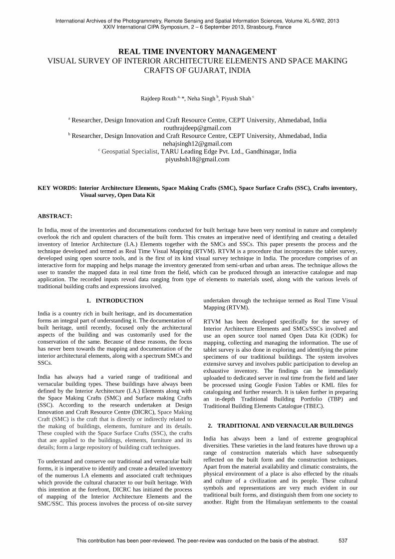
numerous places around the state (Figure 1).
Figure 1. A traditional street from Sidhpur, Gujarat
The genesis of the traditional dwellings lie within the vernacular
architecture and similarly have been hugely defined by the
availability of the construction material. Endowed with such
influences, we can today see the different traditional
architecture spread across many historic settlements. These
typologies range from the shared walled system of North and
Central Gujarat to the individual house typology found in
Saurashtra. They also underline a refined use of an array of
locally available material, and vary from brick and timber to
stone. Amongst all the typologies, the most common is that of
the timber bonding with brick infill, and has been adapted all
across Gujarat with minor alterations according to the climatic
conditions and knowledge systems.
These cultural identities are conveyed through the spatial
configuration of the house and the I.A. elements, and are
considered as the symbol for the prevalent socio-economic
condition of the era. The traditional house type has a substantial
number of components which constitutes elements such as
doors, columns, balcony, wall, ceilings, floors, staircases and
windows amongst many. Apart from these I.A. elements, the
furniture elements also lend to the character of the house. The
furniture elements are probably the best source of gathering
information about the inhabitants; the social status and way of
life. The furniture elements are visible in numerous forms and
according to the use can be categorised under wall units,
seating, tables, beds, storage, light fixtures and many more.
These elements highlight exquisite craft techniques and were
regularly being adapted according to the need and cultural
characters. The I.A. and furniture elements also highlight the
high level of expertise the craftspeople achieved in their trade.
A single façade door can possess varied materials and extreme
heights of artisanship. An individual element can express
International Archives of the Photogrammetry, Remote Sensing and Spatial Information Sciences, Volume XL-5/W2, 2013XXIV International CIPA Symposium, 2 – 6 September 2013, Strasbourg, France
This contribution has been peer-reviewed. The peer-review was conducted on the basis of the abstract. 538
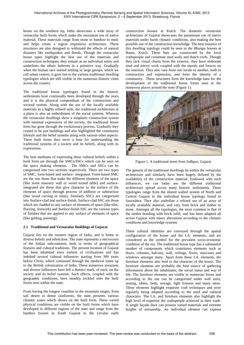
different SMCs such as turning, carving, inlay and joinery at the
same instance (Figure 2).
Figure 2. Space showing numerous craft techniques
These building elements have also undergone a lot of
adaptations and alterations to develop a unique express of their
own, and today is an amalgamation of various architectural
styles. These styles can be broadly segregated into three eras,
namely the Pre-Mughal, Mughal and Colonial, and covers a
span of 400 years. During these eras, the styles range from the
Hindu-Jaina, Mughal, Indo-Islamic to the Composite, Eclectic
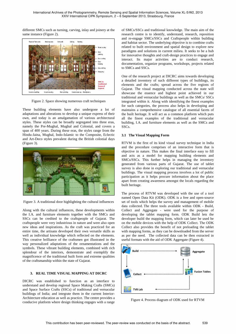
and Art-Deco styles prevalent during the British colonial days
(Figure 3).
Figure 3. A traditional door highlighting the cultural influences
Along with the cultural influences, these developments within
the I.A. and furniture elements together with the SMCs and
SSCs can be credited to the craftspeople of Gujarat. The
craftspeople were very industrious in nature and were also open
new ideas and inspirations. As the craft was practiced for an
entire time, the artisans developed their own versatile skills as
well as individual knowledge which reflected on the elements.
This creative brilliance of the craftsmen got illustrated in the
way personalized adaptations of the ornamentations and the
symbols. These vibrant building elements, combined with rich
splendour of the interiors, demonstrate and exemplify the
magnificence of the traditional built form and extreme qualities
of the craftsmanship within the state of Gujarat.
3. REAL TIME VISUAL MAPPING AT DICRC
DICRC was established to function as an interface to
understand and develop regional Space Making Crafts (SMCs)
and Space Surface Crafts (SSCs) of traditional and vernacular
buildings of India; and integrate them in the current Interior-
Architecture education as well as practice. The centre provides a
conducive platform where design thinking engages with a range
of SMCs/SSCs and traditional knowledge. The main aim of the
research centre is to identify, understand, research, reposition
and re-engage SMCs/SSCs and Craftspeople within building
and habitat sector. The underlying objective is to combine crafts
related to built environment and spatial design to explore new
paradigms and solutions in current milieu. It seeks to be a hub
for innovative thoughts and craft-design practices to engage and
interact. Its major activities are to conduct research,
documentation, organize programs, workshops, projects related
to SMCs and SSCs.
One of the research project at DICRC aims towards developing
a detailed inventory of such different types of buildings, its
elements and the crafts; spread across the five regions of
Gujarat. The visual mapping conducted across the state will
showcase the essence and highest point achieved in our
traditional and vernacular buildings as well as the SMCs/ SSCs
integrated within it. Along with identifying the finest examples
for such categories, the process also helps in developing and
maintains a comprehensive catalogue of all essential facets of
the built heritage. It will act as a common platform which puts
all the finest examples of the traditional and vernacular
building, I.A. and furniture elements as well as the SMCs and
SSCs.
3.1 The Visual Mapping Form
RTVM is the first of its kind visual survey technique in India
and the procedure comprises of an interactive form that is
objective in nature. This makes the final interface easy to fill
and acts as a model for mapping building elements and
SMCs/SSCs. This further helps in managing the inventory
generated from various parts of Gujarat. The use of tablet
survey is also done in exploring our traditional and vernacular
buildings. The visual mapping process involves a lot of public
participation as it helps procure information about the place
apart from creating awareness amongst the locals regarding the
built heritage.
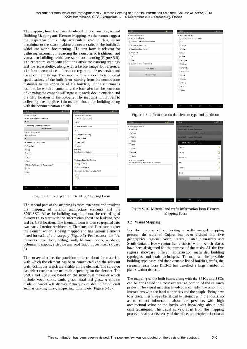
The process of RTVM was developed with the use of a tool
named Open Data Kit (ODK). ODK is a free and open-source
set of tools which helps the survey and management of mobile
data collected. The three tools available within ODK - Build,
Collect and Aggregate - were used for the purpose of
developing the tablet mapping form. ODK Build lets the
developer build the mapping form, which can later be used be
on the mobile devices with the help of ODK Collect. The ODK
Collect also provides the benefit of not preloading the tablet
with mapping forms, as they can be downloaded from the server
as per the need. The collected data can be then extracted in
useful formats with the aid of ODK Aggregate (Figure 4).
Figure 4. Process diagram of ODK used for RTVM
International Archives of the Photogrammetry, Remote Sensing and Spatial Information Sciences, Volume XL-5/W2, 2013XXIV International CIPA Symposium, 2 – 6 September 2013, Strasbourg, France
This contribution has been peer-reviewed. The peer-review was conducted on the basis of the abstract. 539
The mapping form has been developed in two versions, named
Building Mapping and Element Mapping. As the names suggest
the respective forms help accumulate specific data, either
pertaining to the space making elements crafts or the buildings
which are worth documenting. The first form is relevant for
gathering information regarding the examples of traditional and
vernacular buildings which are worth documenting (Figure 5-6).
The procedure starts with enquiring about the building typology
and the accessibility, along with a façade image for reference.
The form then collects information regarding the ownership and
usage of the building. The mapping form also collects physical
specifications of the built form; starting from the construction
materials to the condition of the building. If the structure is
found to be worth documenting, the form also has the provision
of knowing the owner’s willingness towards documentation and
the GPS location of the property. The mapping limits itself to
collecting the tangible information about the building along
with the communication details.
Figure 5-6. Excerpts from Building Mapping Form
The second part of the mapping is more extensive and involves
the mapping of interior architecture elements and the
SMC/SSC. Alike the building mapping form, the recording of
elements also start with the information about the building type
and its GPS location. The Element form is then segregated into
two parts, Interior Architecture Elements and Furniture, as per
the element which is being mapped and has various elements
listed for each of the category (Figure 7). For instance, the I.A.
elements have floor, ceiling, wall, balcony, doors, windows,
columns, parapets, staircase and roof listed under itself (Figure
8).
The survey also has the provision to learn about the materials
with which the element has been constructed and the relevant
craft techniques which are visible on the element. The surveyor
can select one or many materials depending on the element. The
SMCs and SSCs are based on the individual materials which
include wood, stone, earth, grass, metal and glass. A column
made of wood will display techniques related to wood craft
such as carving, inlay, lacquering, turning etc (Figure 9-10).
Figure 7-8. Information on the element type and condition
Figure 9-10. Material and crafts information from Element
Mapping Form
3.2 Visual Mapping
For the purpose of conducting a well-managed mapping
process, the state of Gujarat has been divided into five
geographical regions; North, Central, Kutch, Saurashtra and
South Gujarat. Every region has districts, within which places
have been designated for the purpose of the study. All the five
regions showcase different construction materials, building
typologies and craft techniques. To map all the possible
building typologies and the extensive list of building crafts, the
research team form DICRC has travelled a large number of
places within the state.
The mapping of the built forms along with the SMCs and SSCs
can be considered the most exhaustive portion of the research
project. The visual mapping involves a considerable amount of
interactions with the local authorities and the people. Being new
to a place, it is always beneficial to interact with the locals, so
as to collect information about the precincts with high
architectural value or the locals with knowledge about local
craft techniques. The visual survey, apart from the mapping
process, is also a discovery of the place, its people and cultural
International Archives of the Photogrammetry, Remote Sensing and Spatial Information Sciences, Volume XL-5/W2, 2013XXIV International CIPA Symposium, 2 – 6 September 2013, Strasbourg, France
This contribution has been peer-reviewed. The peer-review was conducted on the basis of the abstract. 540
ethos. These findings also help in understanding the mapped
elements, and the involved crafts and articulations in a better
way.
The survey process is usually confined to the documentation of
traditional and vernacular buildings, and involves covering the
area on foot. The visual mapping involves two major processes,
the survey form and the photography. The photographs are
meant to click the individual elements in details along with
capturing the images of the settlement. The images of the
surrounding include the street photographs and the facades of
houses with interesting features. The building elements which
are elaborately crafted or show interesting use of materials are
selected for the tablet survey. Such elements are mapped using
the Element Mapping form and highlight the pinnacle achieved
in the building trade and the craftsmanship. The buildings,
mostly residential, which have highly fenestrated or remarkable
facades with a few elements worth mapping, are selected to be
mapped as a whole with the use of Building Mapping form.
These houses may be classified as worth documenting, and has
many Interior Architecture and Furniture elements mapped. The
building survey process apart from mapping the elements and
the house details, also involves interaction with the owner to
investigate the history of the family and facts about the structure
(Figure 11).
Figure 11. Researchers interacting with residents
Apart from taking the locations of the mapped elements and
buildings, the area travelled within a particular place can also be
marked using various tracking applications on the tablet. This
shows all the streets and roads covered within the survey using
GPS locations, thus indicating the areas covered and how much
is left to mapped (Figure 12).
Figure 12. Route maps via Google Tracks
The technique allows the user to upload the findings
immediately to dedicated server in real time from the field, and
can be processed according to the usage.
4. DATA OUTPUT AND MANAGEMENT
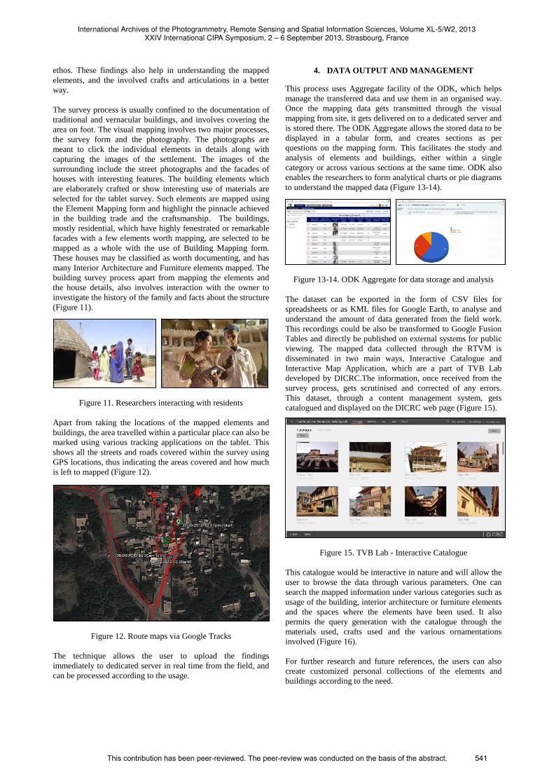
This process uses Aggregate facility of the ODK, which helps
manage the transferred data and use them in an organised way.
Once the mapping data gets transmitted through the visual
mapping from site, it gets delivered on to a dedicated server and
is stored there. The ODK Aggregate allows the stored data to be
displayed in a tabular form, and creates sections as per
questions on the mapping form. This facilitates the study and
analysis of elements and buildings, either within a single
category or across various sections at the same time. ODK also
enables the researchers to form analytical charts or pie diagrams
to understand the mapped data (Figure 13-14).
Figure 13-14. ODK Aggregate for data storage and analysis
The dataset can be exported in the form of CSV files for
spreadsheets or as KML files for Google Earth, to analyse and
understand the amount of data generated from the field work.
This recordings could be also be transformed to Google Fusion
Tables and directly be published on external systems for public
viewing. The mapped data collected through the RTVM is
disseminated in two main ways, Interactive Catalogue and
Interactive Map Application, which are a part of TVB Lab
developed by DICRC.The information, once received from the
survey process, gets scrutinised and corrected of any errors.
This dataset, through a content management system, gets
catalogued and displayed on the DICRC web page (Figure 15).
Figure 15. TVB Lab - Interactive Catalogue
This catalogue would be interactive in nature and will allow the
user to browse the data through various parameters. One can
search the mapped information under various categories such as
usage of the building, interior architecture or furniture elements
and the spaces where the elements have been used. It also
permits the query generation with the catalogue through the
materials used, crafts used and the various ornamentations
involved (Figure 16).
For further research and future references, the users can also
create customized personal collections of the elements and
buildings according to the need.
International Archives of the Photogrammetry, Remote Sensing and Spatial Information Sciences, Volume XL-5/W2, 2013XXIV International CIPA Symposium, 2 – 6 September 2013, Strasbourg, France
This contribution has been peer-reviewed. The peer-review was conducted on the basis of the abstract. 541
Figure 16. Search filters for the catalogue
For further research and future references, the users can also
create customized personal collections of the elements and
buildings according to the need.
The Interactive Map provides the geographical locations to all
the surveyed buildings and its elements. For a certain location,
the app along with the mapped information also provides the
routes travelled during the mapping process. The app is
segregated into two major categories, buildings and elements,
using which a person can manoeuvre through the map. It
provides the facility of generating a query in a similar way to
the catalogue, and uses certain parameters for filtering the
search. These query generators are similar to the ones used for
the catalogue and range from element category to the materials
and crafts involved. All the mapped data is represented through
icons, which on clicking display information card of each. This
information card shares information pertaining to the element
selected, including the craft techniques and the use of materials
for constructing it (Figure 17-18).
Figure 17-18. Map Application displaying mapped Interior
Architecture elements
The information about the buildings worth documenting, from
the visual survey, is further carried to formulate another
research project undertaken at the DICRC. This work involves
the documentation of traditional and vernacular houses, which
highlight the traditional building knowledge along with
remarkable use of localized construction materials.
5. CONCLUSION
In countries like India, which has a wide array of built forms
and craft techniques, it is imperative to discover, analyse and
manage all of them. This understanding is not rendered
complete until there is detailed inventory generated which
showcase the interior architecture elements, furniture and the
craft techniques practiced. The process of Real Time Visual
Mapping forms a first but significant step towards creating such
a catalogue and managing it through various systems.
The RTVM involves the local participation in gathering the data
and the process being mobile based makes itself user friendly,
swift and inexpensive in nature. The simple interface allows
many more users from various fields to get involved and
contribute to the data collection, which can be validated by the
experts. The form can also be easily adapted for survey in
different regions of the country, even though the building and
elements may differ in the making and expressions. Thus,
RTVM produces comprehensive and meticulously catalogued
information of the Space Making Crafts, related to Interior
Architecture, of Traditional and Vernacular Buildings of India
can be later integrated into the current Interior-Architecture
practice as well as education. The information can also be used
as a database towards crafts research and also for appropriate
building conservation practices.
Since the development of Real Time Visual Mapping, it has
been used to cover 26 of the 33 districts of Gujarat. Amongst
these 26 districts, 76 settlements have been mapped to identify a
total 110 building worth-documenting along with 4851 building
and furniture elements.
ACKNOWLEDGEMENT
We want to register our acknowledgements to everyone who has
contributed towards the research paper. We would like to
especially thank Asst. Prof. Jay Thakkar, Head of Research at
DICRC, for the constant ideas, discussions and support towards
the development of RTVM. We would also appreciative of all
the researchers at DICRC who have been part of the visual
mapping process and have contributed towards it. We shall also
extend our gratitude towards all the locals and property owners
who have graciously helped developed the elaborate catalogue
of buildings and craft techniques.
REFERENCES
Desai, M., 2003. Traditional House Type and the Building Craft
of Gujarat. In: Traditional and Vernacular Architecture.
Madras Craft Foundation, Chennai, India, pp. 53-63.
Thakkar, J., 2004. Naqsh-The Art of Wood Carving in
Traditional Houses of Gujarat-A Focus on Ornamentation.
Research Cell, School of Interior Design, CEPT, Ahmedabad,
India.
International Archives of the Photogrammetry, Remote Sensing and Spatial Information Sciences, Volume XL-5/W2, 2013XXIV International CIPA Symposium, 2 – 6 September 2013, Strasbourg, France
This contribution has been peer-reviewed. The peer-review was conducted on the basis of the abstract. 542