Embed Size (px)
DESCRIPTION
Remote Sensing Platforms. Remote Sensing Platforms - Introduction. Allow observer and/or sensor to be above the target/phenomena of interest Two primary categories Aircraft Spacecraft - PowerPoint PPT Presentation
Citation preview

Remote Sensing Platforms

Remote Sensing Platforms - Introduction
• Allow observer and/or sensor to be above the target/phenomena of interest
• Two primary categories– Aircraft– Spacecraft
• Each type offers different characteristics, advantages & disadvantages in terms of range, cost, stability, frequency, and scale
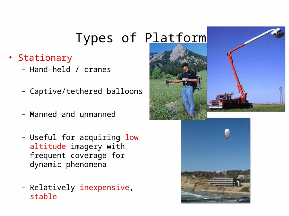
Types of Platforms
• Stationary– Hand-held / cranes
– Captive/tethered balloons
– Manned and unmanned
– Useful for acquiring low altitude imagery with frequent coverage for dynamic phenomena
– Relatively inexpensive, stable

Types of Platforms
• Lighter-than-air
– Free floating balloons• Restricted by atmospheric conditions• Used to acquire meteorological/atmospheric
data
– Blimps/dirigibles• Major role - news media/advertisers
• Helicopters– Can pin-point locations
– Lack stability and vibrate

Unmanned Vehicles

Low Altitude Aircraft
• Generally operate below 30,000 ft
• Most widely used are single engine or light twin engine
• Imagery can be obtained by shooting out the window or placing camera mount on window or base of aircraft
• Suitable for obtaining image data for small areas (large scale)

High Altitude Aircraft• Operate above 30,000 ft
• Includes jet aircraft with good rate of climb, maximum speed, and high operating ceiling
• Stable
• Acquire imagery for large areas (smaller scale)

U-2/ER-2U-2/ER-2
• Lockheed U-2 high altitude reconnaissance aircraft. Many U-2s are still in service as earth resource observation aircraft.
• Lockheed U-2 high altitude reconnaissance aircraft. Many U-2s are still in service as earth resource observation aircraft.
Jensen, 2000Jensen, 2000
70,000 feet (21,000 m)

Advantages/Disadvantages of Aircraft
• Advantages– Acquire imagery under suitable weather conditions– Control platform variables such as altitude – Time of coverage can be controlled -- flexibility– Easy to mobilize
• Disadvantages– Expensive – primarily cost of aircraft– Less stable than spacecraft
• Drift off course
• Random attitude changes (turbulent motions)
• Motion blurring

Spacecraft
• Numerous programs
• Manned and unmanned systems

Range• Range for spacecraft is
determined by orbit, which is fixed in altitude and inclinationhttp://www.youtube.com/watch?v=E4k3kEA3pmo
–Sun synchronous – near polar; cross equator at approximately same local time each day
–Geostationary – fixed orbit over equator; primarily meteorological systems
More Information: http://earthobservatory.nasa.gov/Features/OrbitsCatalog/page2.php

Aerial Photographic Systems

Aerial Support Hardware
• Used to improve quality of imagery by– Reducing effect of platform motion– Keeping attitude constant
• Image motion compensator– Moves film in same direction as aircraft at
speed proportional to aircraft velocity
• Gyro Stabilization– Stabilizes camera within plane to keep it
pointing – Adjusts orientation of camera if attitude of
plane shifts

Aerial Cameras - Digital• Uses area array of
solid-state charge-coupled-device (CCD) detectors in place of film
• During exposure lens focuses light on bank of detectors
• Exposure causes an electrical charge that is related to amount of incident energy
• Electrical signal (analog) is converted to a digital brightness value

Aerial Cameras – Digital (cont)
• Single chip camera– Uses single full-frame CCD– Filter is placed over each pixel to
capture red/green/blue or NIR/red/green wavelengths
• Three or Four camera system– Use 3 or 4 separate full-frame
camera/CCDs– Each sensitive to different
wavelength

Natural Color
• Primary colors– Red– Blue– Green
• Color characteristics– Hue – dominant color
– Saturation – purity of color
– Intensity (value) – light/dark
Saturation
Hue
Intensity
Color Theory

http://missionscience.nasa.gov/ems/emsVideo_04infraredwaves.html


http://map.sdsu.edu/aerial-photos.htm
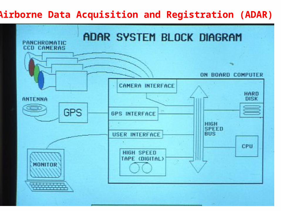
Airborne Data Acquisition and Registration (ADAR)

ADAR 5500 SystemADAR 5500 System

Satellite-based Systems:LANDSAT & SPOT

Landsat
http://www.youtube.com/watch?v=BPbHDKgBBxA

Landsat System - History

Landsat – Satellite
• Weight ~ 2200 kg (5000 lbs)• Length ~ 4.5 m (14 ft)• Width ~ 3 m (9 ft)

Landsat – Orbit • Sun synchronous, near polar• ~ 705 km altitude• 9:42 am equator crossing

Landsat Worldwide Reference System• Location over earth catalogued by WRS path/row• Each scene covers 185 km (wide) by 170 km (long)

70’s
90’s
80’s

Deforestation in Bolivia from 1975 to 2000Source: http://www.satimagingcorp.com/gallery/landsat-deforestation-
bolivia.html

Landsat - Thematic Mapper (TM)• Introduced on Landsat 4 (1982)
• Improvement over MSS on Landsat 1-3
– Spectral – extended spectral region – visible, NIR, mid-IR and thermal
– Spatial – 30m vs. 80m (120m for thermal)
– Radiometric – 8-bit vs. 6-bit
– Temporal – 16 day (Landsat 1-3, 18 day)
– *note* MSS continued on Landsat 4 & 5

Landsat 4 & 5

SPOT Satellite System
• Satellite Pour l’Observation de la Terre (SPOT)
• French Space Agency & other European countries

SPOT – Launch Vehicle
• Ariane rocket – European design & manufacture
• Launch site – French Guiana

http://www.astrium-geo.com/en/143-spot-satellite-imagery

Landsat-TM
SPOT-XS

SPOT HRV Design & Operation• HRV (High Resolution Visible)• Linear array ‘pushbroom’ system
– Mirror focuses reflected energy on bank of detectors arranged side-by-side and perpendicular to satellite orbit track
– A line of data is obtained by sampling detectors along the array
1st dimension
2nd dimension

SPOT Sensors• SPOT 1 – 3
– two HRV sensors
• SPOT 4 & 5– two HRV sensors– Vegetation sensor
• HRV sensor (High Resolution Visible)– panchromatic– multi-spectral
• VEGETATION sensor– multi-spectral

SPOT HRV - Panchromatic
• Panchromatic (PAN)
• Spatial resolution: 10 m
• Spectral resolution: 0.51 – 0.73 m

SPOT HRV – Multispectral
• Multispectral (XS)
• Spatial resolution: 20 m
• Spectral resolution– 0.50-0.59 m– 0.61-0.68 m– 0.79-0.89 m– 1.58-1.75 m (SWIR band added to SPOT 4)

SPOT - Pointability• Increased imaging frequency
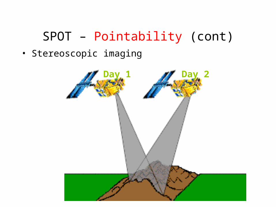
SPOT – Pointability (cont)• Stereoscopic imaging
Day 1 Day 2

SPOT Pointability (cont)

NASA EOS – Earth Observing System
• Integrated experiment to study earth as a system• Planned as imaging and non-imaging instruments on
series of satellites to study different science objectives
• EOS AM-1, renamed Terra launched in 1999• EOS PM-1, renamed Aqua launched in 2002• Sensors include MODIS, ASTER, MISR, CERES,
MOPITT

Other Satellite Systems

Remote Sensing Data available Remote Sensing Data available in San Diego 2007 Wildfires in San Diego 2007 Wildfires
• Areal Photos (NEOS – a light weighted aircraft), • UAV (NASA’s Ikhana unmanned aircraft )
• MODIS (NASA)• FORMOSAT-2 (Taiwan’s NSPO)
• EO-1 (NASA) • IKONOS (commercial)
• SPOT (commercial)• QuickBird (commercial)
• GOES-W (NASA)

NASA Unmanned Aerial NASA Unmanned Aerial Vehicles (UAVs) -- Vehicles (UAVs) -- IkhanaIkhana
http://www.nasa.gov/centers/dryden/news/Features/2007/wildfire_socal_10_07.html

MODIS (Terra and Aqua) 250m, 500m(daily)
EO-1 (30m) – 16 days (not daily)
Ikhana (UAV) (small coverage)NASA GOES-W
(b/w, very low resolution)

FORMOSAT-2 Imagery (high resolution, daily, large coverage, nature-
color composites)
November 8-19, 2007, FORMOSAT-2

MODIS TERRA MODIS AQUA FORMOSAT2
NEOS EO-1 IKONOS
UAV

High Resolution Systems
• Commercial
– Space Imaging – IKONOS – EarthWatch – QuickBird– OrbImage – OrbView3
– Linear array pushbroom– 0.6 - 4 m spatial resolution– ~ 10 x 10 km coverage per image– Visible, NIR, and Pan bands– High revisit (pointable)– Stereo coverage

On-screen Display

On-screen Display (cont.)True Color
False Color IR
False Color

Landsat 7 Image of Landsat 7 Image of Palm Spring, CA Palm Spring, CA
30 x 30 m 30 x 30 m (bands 4,3,2 = RGB)(bands 4,3,2 = RGB)
Landsat 7 Image of Landsat 7 Image of Palm Spring, CA Palm Spring, CA
30 x 30 m 30 x 30 m (bands 4,3,2 = RGB)(bands 4,3,2 = RGB)
Jensen, 2000Jensen, 2000Jensen, 2000Jensen, 2000
Landsat 7 Image of Landsat 7 Image of Palm Spring, CA Palm Spring, CA
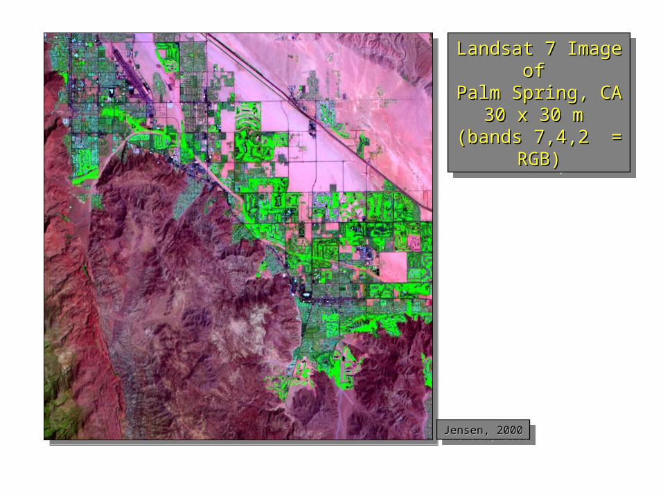
30 x 30 m 30 x 30 m (bands 7,4,2 = RGB)(bands 7,4,2 = RGB)
Landsat 7 Image of Landsat 7 Image of Palm Spring, CA Palm Spring, CA
30 x 30 m 30 x 30 m (bands 7,4,2 = RGB)(bands 7,4,2 = RGB)
Jensen, 2000Jensen, 2000Jensen, 2000Jensen, 2000

QuickBird Panchromatic Satellite Imagery (0.6 m)
0.6 m

QuickBird Pan-Sharpened Satellite Imagery (0.6 m)
0.6 m
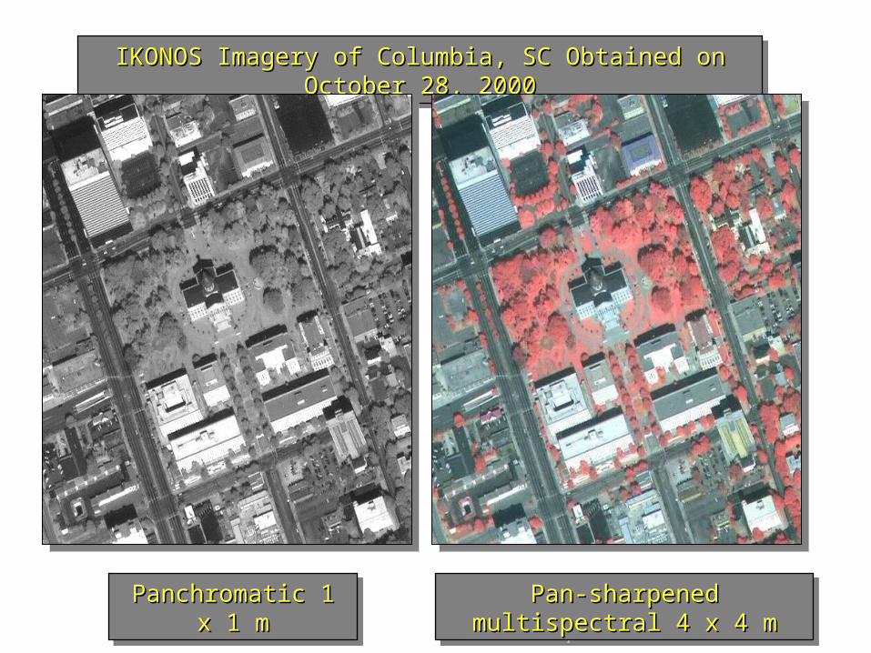
IKONOS Imagery of Columbia, SC Obtained on October 28, 2000IKONOS Imagery of Columbia, SC Obtained on October 28, 2000IKONOS Imagery of Columbia, SC Obtained on October 28, 2000IKONOS Imagery of Columbia, SC Obtained on October 28, 2000
Panchromatic 1 x 1 mPanchromatic 1 x 1 mPanchromatic 1 x 1 mPanchromatic 1 x 1 m Pan-sharpened multispectral 4 x 4 mPan-sharpened multispectral 4 x 4 mPan-sharpened multispectral 4 x 4 mPan-sharpened multispectral 4 x 4 m


![[REMOTE SENSING] 3-PM Remote Sensing](https://img.pdfslide.net/doc/110x75/61f2bbb282fa78206228d9e2/remote-sensing-3-pm-remote-sensing.jpg)
