Embed Size (px)
Citation preview
Humber Estuary High Tide Roost Review 2013-2014
Final Report
Report to the RSPB & Natural England
Institute of Estuarine and Coastal StudiesUniversity of Hull
8th December 2015
Author(s): N Cutts, K Hemingway & S Thomson
Report: YBB200/219-F-2015
Institute of Estuarine & Coastal Studies(IECS)
The University of HullCottingham Road
HullHU6 7RX
UK
Tel: +44 (0)1482 466771Fax: +44 (0)1482 466772
E-mail: [email protected]
Web site: http://www.hull.ac.uk/iecs


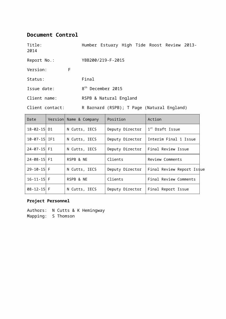
Document ControlTitle: Humber Estuary High Tide Roost Review 2013-2014
Report No.: YBB200/219-F-2015
Version: F
Status: Final
Issue date: 8th December 2015
Client name: RSPB & Natural England
Client contact: R Barnard (RSPB); T Page (Natural England)
Date Version Name & Company Position Action
18-02-15 D1 N Cutts, IECS Deputy Director 1st Draft Issue
10-07-15 IF1 N Cutts, IECS Deputy Director Interim Final 1 Issue
24-07-15 F1 N Cutts, IECS Deputy Director Final Review Issue
24-08-15 F1 RSPB & NE Clients Review Comments
29-10-15 F N Cutts, IECS Deputy Director Final Review Report Issue
16-11-15 F RSPB & NE Clients Final Review Comments
08-12-15 F N Cutts, IECS Deputy Director Final Report Issue
Project Personnel
Authors: N Cutts & K HemingwayMapping: S Thomson
Acknowledgements
The authors wish to thank the invaluable contribution of the WeBS counters for the Humber Estuary, who have provided considerable essential information to this report.
Suggested Citation
Cutts, N, Hemingway, K & S. Thomson. 2015. Humber Estuary High Tide Roost Review 2013-2014. Report to RSPB & Natural England. Institute of Estuarine & Coastal Studies, University of Hull.
Disclaimer
This report has been prepared by the Institute of Estuarine and Coastal Studies, with all reasonable care, skill and attention to detail as set within the terms of the Contract with the client. We disclaim any responsibility to the client and others in respect of any matters outside the scope of the above.
This is a confidential report to the client and we accept no responsibility of whatsoever nature to third parties to whom this report, or any part thereof, is made known. Any such parties rely on the report at their own risk.
Humber High Tide Roost Review 2014-2015Final Report to RSPB & Natural England
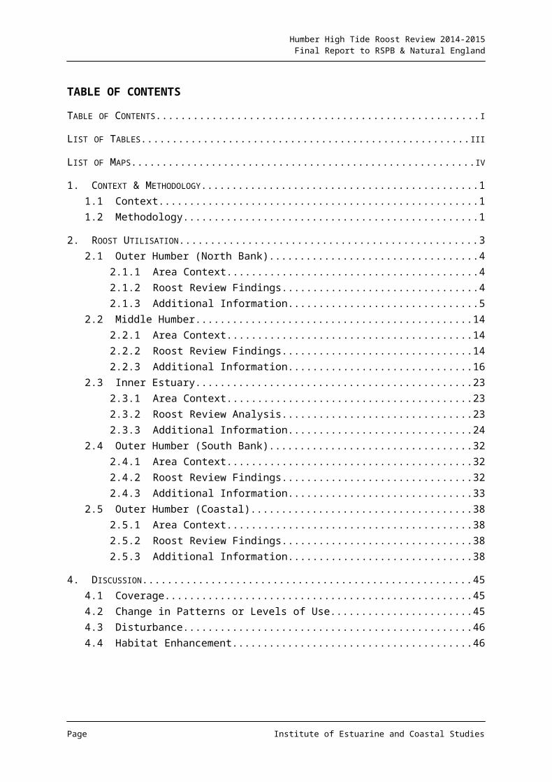
TABLE OF CONTENTS
TABLE OF CONTENTS.................................................................................................................. I
LIST OF TABLES.........................................................................................................................III
LIST OF MAPS...........................................................................................................................IV
1. CONTEXT & METHODOLOGY..................................................................................................11.1 Context.......................................................................................................................11.2 Methodology...............................................................................................................1
2. ROOST UTILISATION..............................................................................................................32.1 Outer Humber (North Bank).......................................................................................4
2.1.1 Area Context...................................................................................................42.1.2 Roost Review Findings...................................................................................42.1.3 Additional Information.....................................................................................5
2.2 Middle Humber.........................................................................................................142.2.1 Area Context.................................................................................................142.2.2 Roost Review Findings.................................................................................142.2.3 Additional Information...................................................................................16
2.3 Inner Estuary............................................................................................................232.3.1 Area Context.................................................................................................232.3.2 Roost Review Analysis.................................................................................232.3.3 Additional Information...................................................................................24
2.4 Outer Humber (South Bank).....................................................................................322.4.1 Area Context.................................................................................................322.4.2 Roost Review Findings.................................................................................322.4.3 Additional Information...................................................................................33
2.5 Outer Humber (Coastal)...........................................................................................382.5.1 Area Context.................................................................................................382.5.2 Roost Review Findings.................................................................................382.5.3 Additional Information...................................................................................38
4. DISCUSSION........................................................................................................................454.1 Coverage..................................................................................................................454.2 Change in Patterns or Levels of Use........................................................................454.3 Disturbance...............................................................................................................464.4 Habitat Enhancement...............................................................................................46
5. REFERENCES......................................................................................................................47
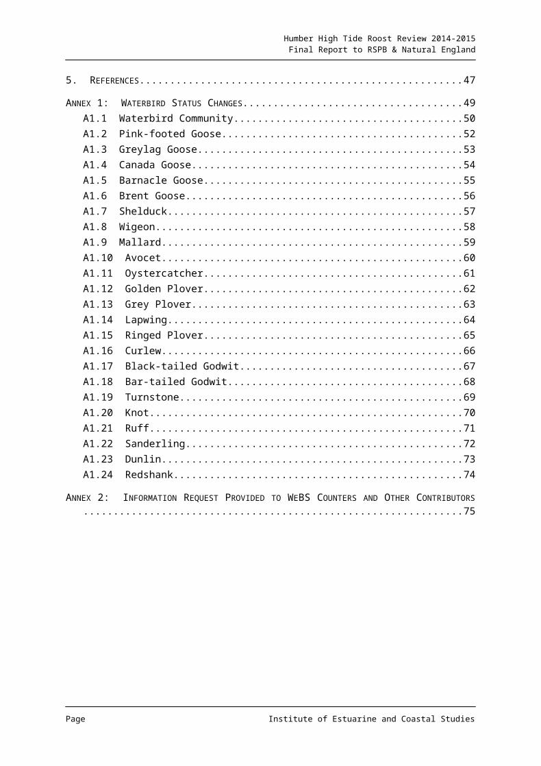
ANNEX 1: WATERBIRD STATUS CHANGES................................................................................49A1.1 Waterbird Community.............................................................................................50A1.2 Pink-footed Goose..................................................................................................52A1.3 Greylag Goose.......................................................................................................53
Page Institute of Estuarine and Coastal Studies
Humber High Tide Roost Review 2014-2015Final Report to RSPB & Natural England
A1.4 Canada Goose.......................................................................................................54A1.5 Barnacle Goose......................................................................................................55A1.6 Brent Goose...........................................................................................................56A1.7 Shelduck.................................................................................................................57A1.8 Wigeon...................................................................................................................58A1.9 Mallard....................................................................................................................59A1.10 Avocet..................................................................................................................60A1.11 Oystercatcher.......................................................................................................61A1.12 Golden Plover.......................................................................................................62A1.13 Grey Plover..........................................................................................................63A1.14 Lapwing................................................................................................................64A1.15 Ringed Plover.......................................................................................................65A1.16 Curlew..................................................................................................................66A1.17 Black-tailed Godwit...............................................................................................67A1.18 Bar-tailed Godwit..................................................................................................68A1.19 Turnstone.............................................................................................................69A1.20 Knot......................................................................................................................70A1.21 Ruff.......................................................................................................................71A1.22 Sanderling............................................................................................................72A1.23 Dunlin...................................................................................................................73A1.24 Redshank.............................................................................................................74
ANNEX 2: INFORMATION REQUEST PROVIDED TO WEBS COUNTERS AND OTHER CONTRIBUTORS.........................................................................................................................................75
Page Institute of Estuarine and Coastal Studies
Humber High Tide Roost Review 2014-2015Final Report to RSPB & Natural England
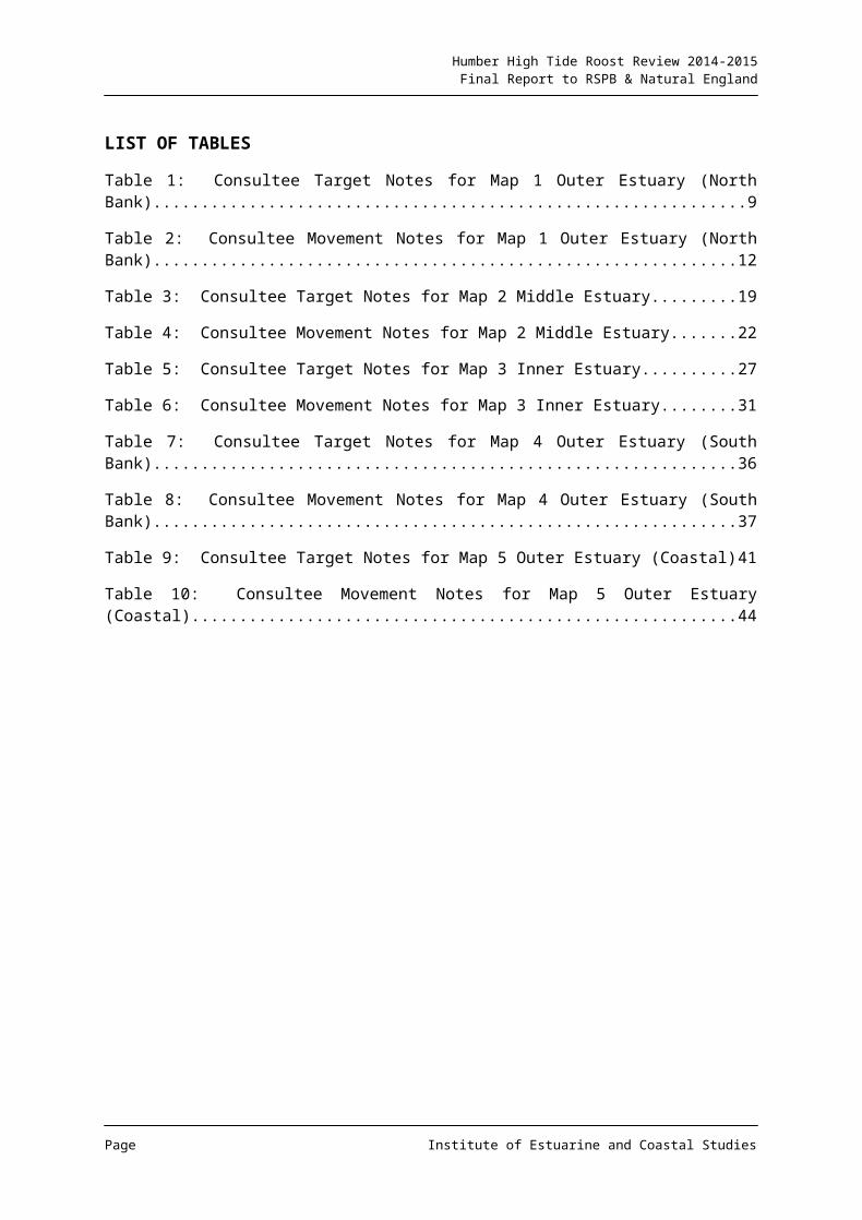
LIST OF TABLES
Table 1: Consultee Target Notes for Map 1 Outer Estuary (North Bank)...............................9
Table 2: Consultee Movement Notes for Map 1 Outer Estuary (North Bank)......................12
Table 3: Consultee Target Notes for Map 2 Middle Estuary.................................................19
Table 4: Consultee Movement Notes for Map 2 Middle Estuary..........................................22
Table 5: Consultee Target Notes for Map 3 Inner Estuary...................................................27
Table 6: Consultee Movement Notes for Map 3 Inner Estuary.............................................31
Table 7: Consultee Target Notes for Map 4 Outer Estuary (South Bank)............................36
Table 8: Consultee Movement Notes for Map 4 Outer Estuary (South Bank)......................37
Table 9: Consultee Target Notes for Map 5 Outer Estuary (Coastal)...................................41
Table 10: Consultee Movement Notes for Map 5 Outer Estuary (Coastal)..........................44
Page Institute of Estuarine and Coastal Studies
Humber High Tide Roost Review 2014-2015Final Report to RSPB & Natural England
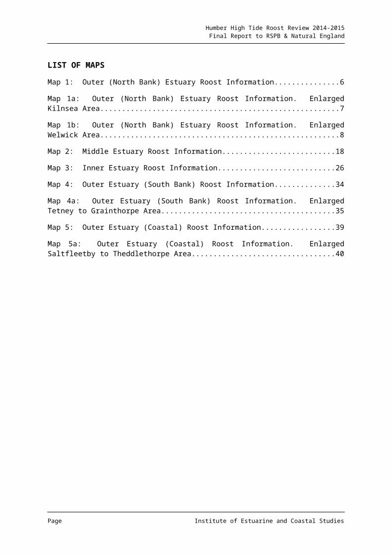
LIST OF MAPS
Map 1: Outer (North Bank) Estuary Roost Information...........................................................6
Map 1a: Outer (North Bank) Estuary Roost Information. Enlarged Kilnsea Area..................7
Map 1b: Outer (North Bank) Estuary Roost Information. Enlarged Welwick Area................8
Map 2: Middle Estuary Roost Information.............................................................................18
Map 3: Inner Estuary Roost Information...............................................................................26
Map 4: Outer Estuary (South Bank) Roost Information........................................................34
Map 4a: Outer Estuary (South Bank) Roost Information. Enlarged Tetney to Grainthorpe Area.......................................................................................................................................35
Map 5: Outer Estuary (Coastal) Roost Information..............................................................39
Map 5a: Outer Estuary (Coastal) Roost Information. Enlarged Saltfleetby to Theddlethorpe Area.......................................................................................................................................40
Page Institute of Estuarine and Coastal Studies
Humber High Tide Roost Review 2014-2015Final Report to RSPB & Natural England
This page is intentionally blank.
Page Institute of Estuarine and Coastal Studies

Humber High Tide Roost Review 2014-2015Final Report to RSPB & Natural England
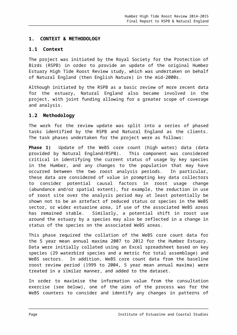
1. CONTEXT & METHODOLOGY
1.1 Context
The project was initiated by the Royal Society for the Protection of Birds (RSPB) in order to provide an update of the original Humber Estuary High Tide Roost Review study, which was undertaken on behalf of Natural England (then English Nature) in the mid-2000s.
Although initiated by the RSPB as a basic review of more recent data for the estuary, Natural England also became involved in the project, with joint funding allowing for a greater scope of coverage and analysis.
1.2 Methodology
The work for the review update was split into a series of phased tasks identified by the RSPB and Natural England as the clients. The task phases undertaken for the project were as follows:
Phase 1) Update of the WeBS core count (high water) data (data provided by Natural England/RSPB). This component was considered critical in identifying the current status of usage by key species in the Humber, and any changes to the population that may have occurred between the two roost analysis periods. In particular, these data are considered of value in prompting key data collectors to consider potential causal factors in roost usage change (abundance and/or spatial extent), for example, the reduction in use of roost site over the analysis period may at least potentially be shown not to be an artefact of reduced status or species in the WeBS sector, or wider estuarine area, if use of the associated WeBS areas has remained stable. Similarly, a potential shift in roost use around the estuary by a species may also be reflected in a change in status of the species on the associated WeBS areas.
This phase required the collation of the WeBS core count data for the 5 year mean annual maxima 2007 to 2012 for the Humber Estuary. Data were initially collated using an Excel spreadsheet based on key species (29 waterbird species and a metric for total assemblage) and WeBS sectors. In addition, WeBS core count data from the baseline roost review period (1999 to 2004, 5 year mean annual maxima) were treated in a similar manner, and added to the dataset.
In order to maximise the information value from the consultation exercise (see below), one of the aims of the process was for the WeBS counters to consider and identify any changes in patterns of roost use since the previous High Tide Roost Review c. 10 years previously.
As such, basic statistical analysis of the data was then undertaken to generate information on net change in abundance between the two analysis periods for the key species and WeBS sectors, using a series of change thresholds. These thresholds were then ascribed colours and a series of maps for the Humber were then generated using the change status metrics for key species and the assemblage as a whole, on a WeBS core count sector basis.
These maps were then provided as part of the consultation package sent to the WeBS counters to help stimulate thought and comment. They have been appended to this document (Appendix 1), as they also provide a useful indication of trends in waterbird usage
Page Institute of Estuarine and Coastal Studies
Humber High Tide Roost Review 2014-2015Final Report to RSPB & Natural England
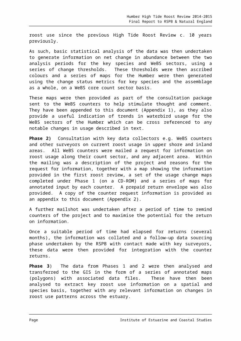
for the WeBS sectors of the Humber which can be cross referenced to any notable changes in usage described in text.
Phase 2) Consultation with key data collectors e.g. WeBS counters and other surveyors on current roost usage in upper shore and inland areas. All WeBS counters were mailed a request for information on roost usage along their count sector, and any adjacent area. Within the mailing was a description of the project and reasons for the request for information, together with a map showing the information provided in the first roost review, a set of the usage change maps completed under Phase 1 (on a CD-ROM) and a series of maps for annotated input by each counter. A prepaid return envelope was also provided. A copy of the counter request information is provided as an appendix to this document (Appendix 2).
A further mailshot was undertaken after a period of time to remind counters of the project and to maximise the potential for the return on information.
Once a suitable period of time had elapsed for returns (several months), the information was collated and a follow-up data sourcing phase undertaken by the RSPB with contact made with key surveyors, these data were then provided for integration with the counter returns.
Phase 3) The data from Phases 1 and 2 were then analysed and transferred to the GIS in the form of a series of annotated maps (polygons) with associated data files. These have then been analysed to extract key roost use information on a spatial and species basis, together with any relevant information on changes in roost use patterns across the estuary.
Where data are absent or equivocal, additional information sources have been used e.g. from Environmental Statements, Technical Reports etc.
Phase 4) Reporting and mapping of the findings from the above Phases.
Page Institute of Estuarine and Coastal Studies
Humber High Tide Roost Review 2014-2015Final Report to RSPB & Natural England
2. ROOST UTILISATION
The text content of this report regarding roost utilisation on the Humber estuary is based primarily on the returns from the WeBS counter and professional surveyor consultation exercise undertaken as Phase 2 of the project. Analysis of additional published and grey material to gap fill and clarify/re-enforce information from the consultation exercise has also been undertaken and incorporated in the text where applicable.
The following section divides the estuary into a series of areas and examines the information regarding key areas of roost (and other) use, together with any important movements, provided during the consultation process.
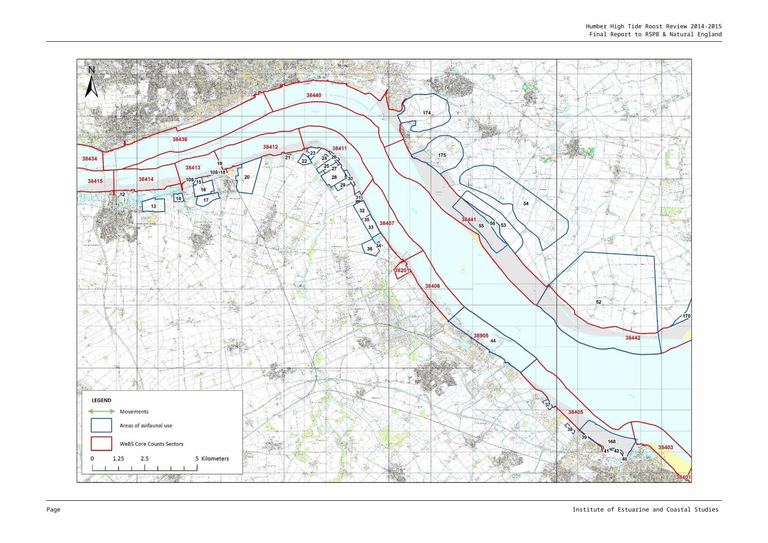
The notes on site usage by waterbird species provided from the consultation responses are shown on the following maps as a series of areas delineated by a blue boundary and with an associated Target Note (TN) number for reference. Each of the TNs are summarised in the associated Target Note table and information from these and other sources are interpreted and discussed in text1.
Movements by species identified from the consultation are also mapped (in green) again with a Movement Note attached that is summarised in the associated Movement Note table, and where these are complex an expanded map of movements is inset within the main map.
The focus of the report is on high tide roosting; however, where information has been provided on other high tide uses (i.e. foraging or loafing) then this has also been included for completeness.
It is important to emphasise that the absence of recorded usage in a given area should not be interpreted as evidence of actual absence of usage. This is particularly important for a study of this nature, which relies on information obtained via consultation and is therefore subject to the associated methodological limitations.
1 The Target Note tables utilise standard BTO two letter species codes. These individual species codes together with the full species names can be found at http://www.bto.org/about-birds/birdfacts/british-list
Page Institute of Estuarine and Coastal Studies
Humber High Tide Roost Review 2014-2015Final Report to RSPB & Natural England
2.1 Outer Humber (North Bank)
2.1.1 AREA CONTEXT
The extensive intertidal area of Spurn Bight can support a large number and range of waterbird species, with foraging and loafing dispersed across the area around low water. The area is largely backed by man-made flood defences, although with some areas of fronting saltmarsh and the natural sand spit of Spurn Head also present.
The largest area of saltmarsh within the Bight is located at the Welwick embayment, with a managed realignment area immediately to the west of this. The immediate hinterland is primarily comprised of low-lying arable land under a mix of crop types and rotation. Small areas of upper shore mud remain exposed on neap tides, and only on large springs is the majority of saltmarsh inundated.
To the west (upstream) from Welwick the intertidal mud and sand flat decreases in width to Hawkins Point, where only a relatively narrow fronting intertidal zone is present.
2.1.2 ROOST REVIEW FINDINGS
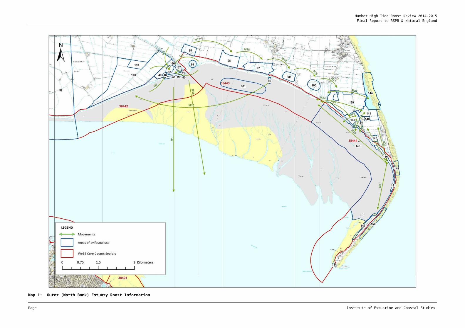
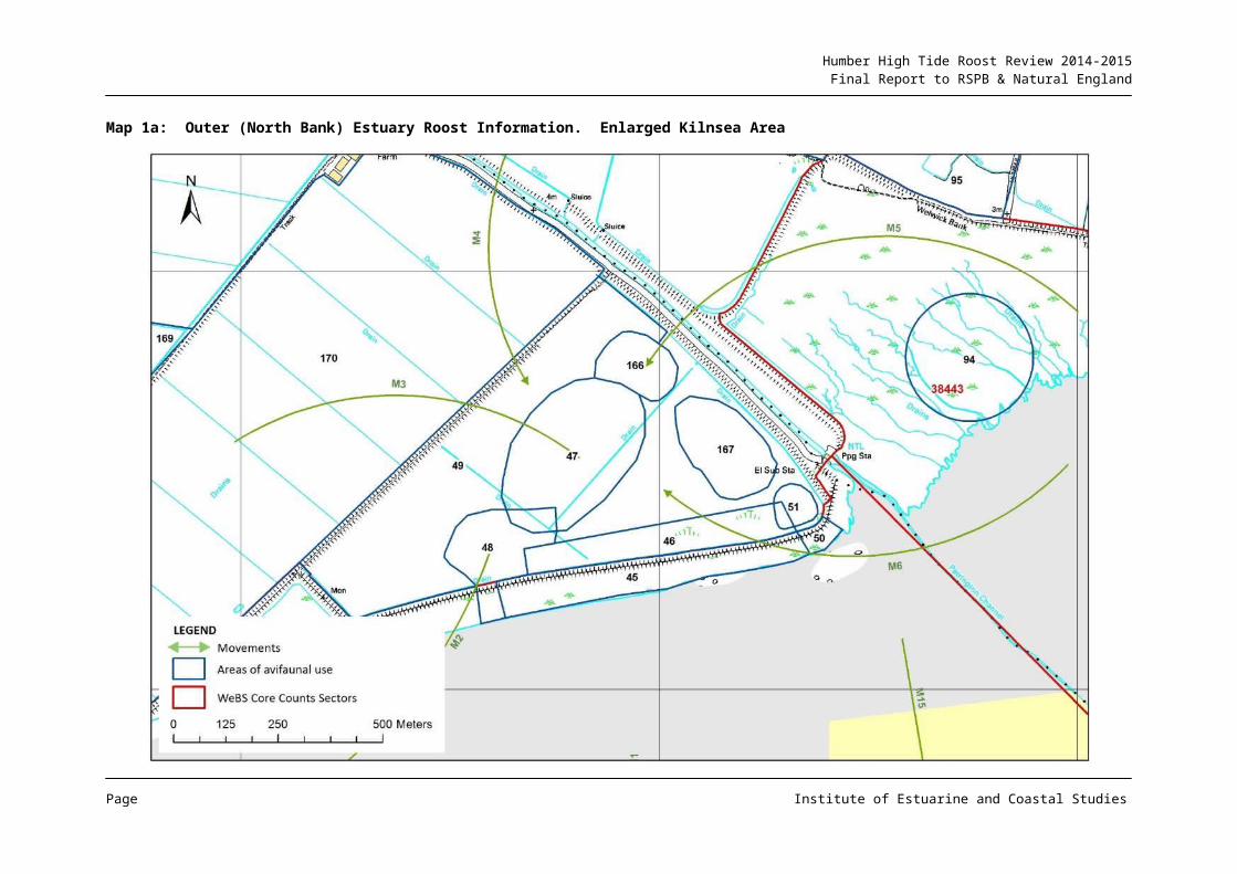
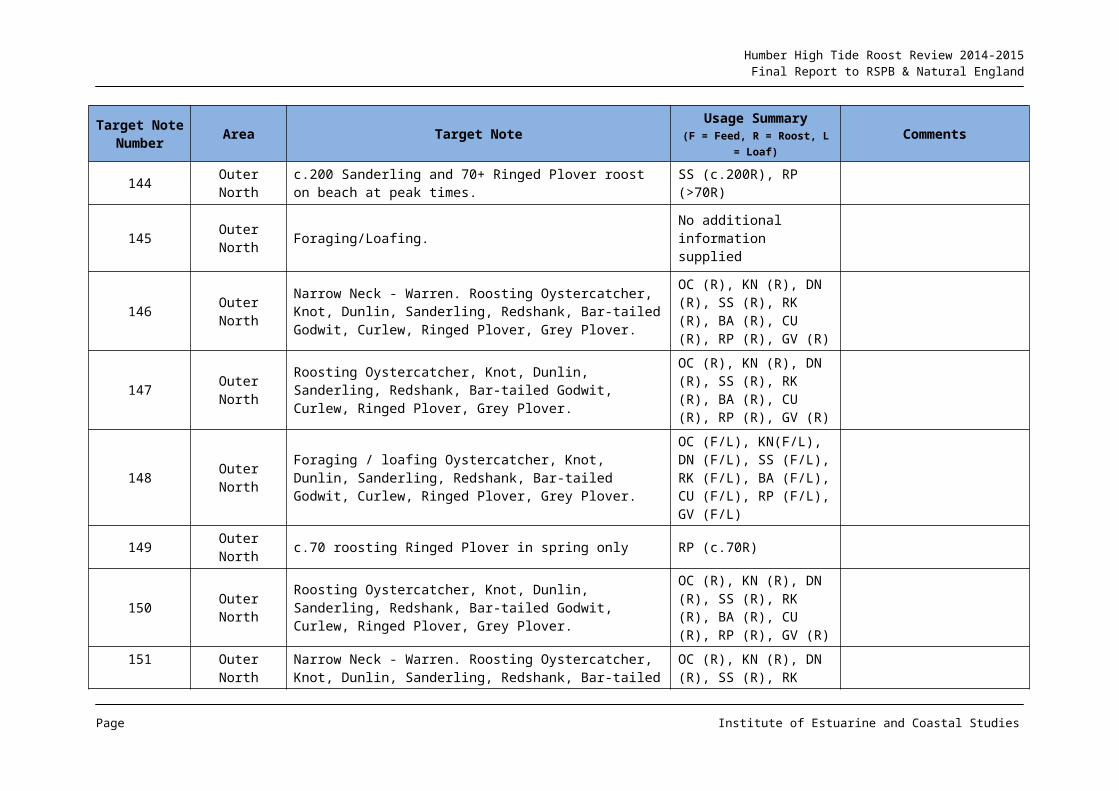
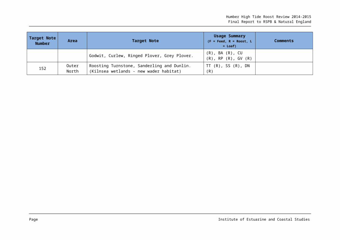
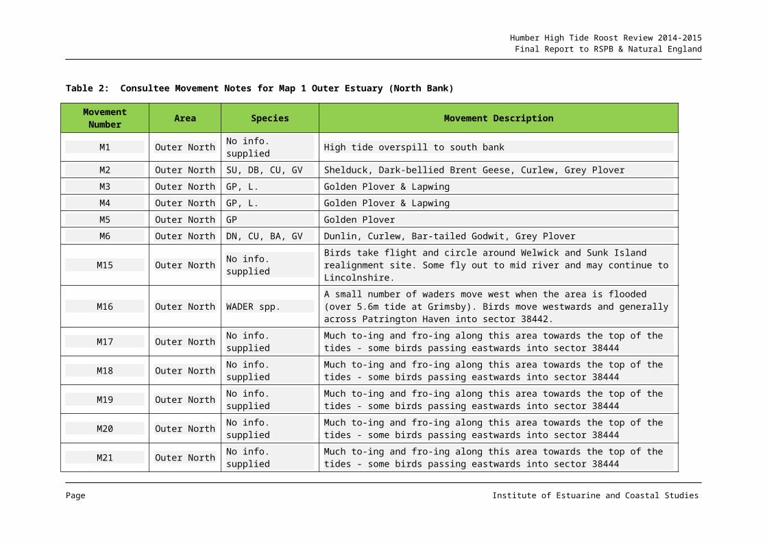
Map 1 and Tables 1 & 2 summarise the roost information provided from the consultation process. The target notes e.g. TNs 146-152 (Table 1) indicate that both the estuarine and seaward upper shores of Spurn peninsula are used by a range of wader species including Knot (Calidris canutus), Oystercatcher (Haematopus ostralegus), Dunlin (C. alpina), Sanderling (C. alba), Bar-tailed Godwit (Limosa lapponica), Ringed Plover (Charadrius hiaticula), Grey Plover (Pluvialis squatarola) and Redshank (Tringa totanus). Roost movements are quite complex in this area, with both along-estuary flights as well as longer distance movements across the estuary identified (Map1 & Table 2).
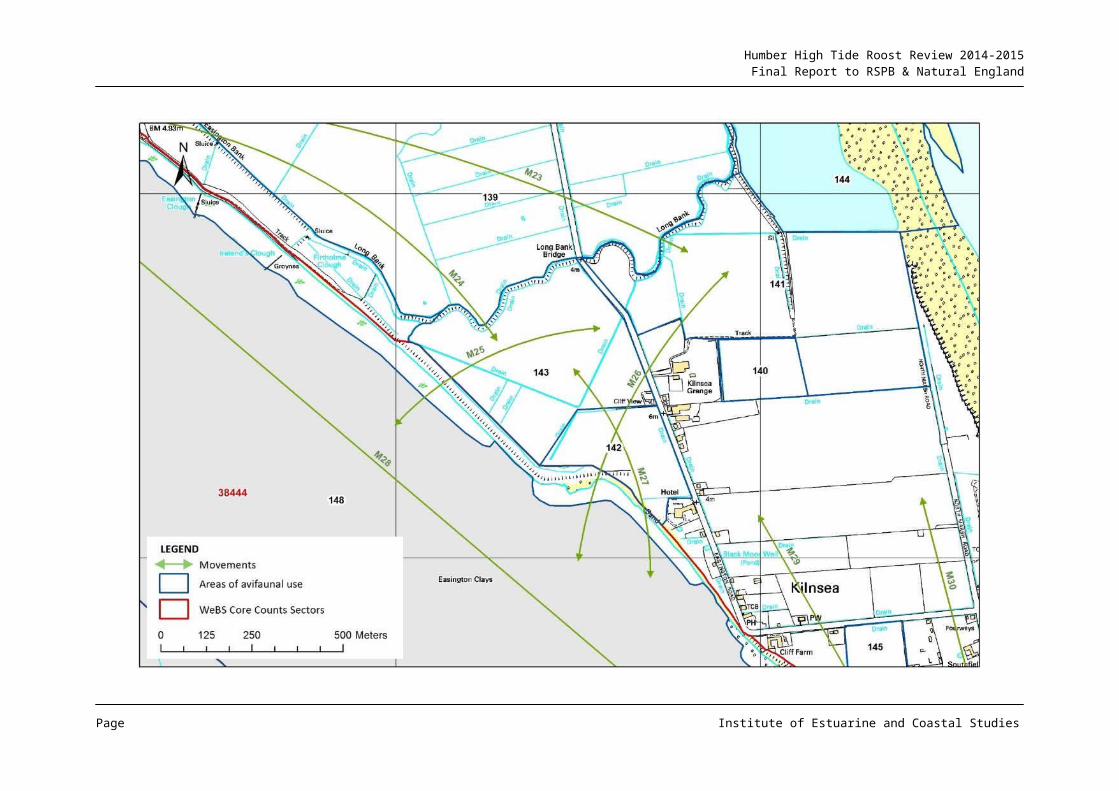
Maps 1a and 1b provide enlarged views of the more complex areas of usage (Map 1a covering Kilnsea area and Map 1b the Welwick complex).
It is of note that the newly created Kilnsea Wetlands have been identified as supporting both roosting and foraging habitat (Map 1 & 1a), with the area routinely utilised by Golden Plover (P. apricaria), Grey Plover, Dunlin, Knot, Redshank, Curlew (Numenius arquata), Greenshank (T. nebularia) and Bar-tailed Godwit, and with Oystercatcher using the area in winter only (TN 140 & 141). The WeBS counter consultation also identified other fields around Kilnsea as being utilised by waterbirds, both as a roost area, but also for foraging and loafing e.g. by Brent Geese (Branta bernicla), Curlew, Redshank and Golden Plover (TN 139).
The beach around the Easington Lagoons and adjacent seaward shore were identified as supporting c. 200 roosting Sanderling and over 70 Ringed Plover (TN 144).
A series of fields within c. 1km of the flood defences (between Welwick and Humber Side Lane) were also identified as being used as a roost resource by waterbirds using Spurn Bight (TNs 98-100; Map 1). Species using these fields included Brent Geese, Oystercatcher, Dunlin, Curlew and Redshank in relatively low number, but with up to 4,500 Golden Plover on large spring tides (TN 99). Use of these fields was described as variable depending on crop type and water-logging, with movement often observed between these
Page Institute of Estuarine and Coastal Studies
Humber High Tide Roost Review 2014-2015Final Report to RSPB & Natural England
sites around high water, with a movement of birds between fields in an easterly direction towards the Long Bank/Kilnsea Wetlands area (MNs M17-M21) (Map 1 & Table 2).
The upper shore intertidal area around Skeffling Clough (TN 96) was also noted as being used by c. 100 Oystercatcher and 50 Redshank.
On neap tides (less than 5.6m Grimsby (datum not supplied)), the upper shore intertidal area (TN 101) is used around high water as a roost/loaf site by the assemblage using the general fronting area, this area have been historically identified as a neap roost (e.g. Tasker & Milson, 1978/9).
The extensive fronting saltmarsh at Welwick was identified as supporting the assemblage using the fronting intertidal mudflats across all tides to springs. However on higher springs (7.7m (Grimsby) datum not supplied), birds are pushed off the area and are reported as moving in a westerly direction onto the Welwick realignment site (MNs M5 & M6) (Map 1 & Table 2).
A detailed account of how waterbirds utilise the Welwick realignment site and environs was provided from the consultation and these are shown in a series of TNs on Map 1, on the enlarged Map 1b (TNs 45-51; 94-95;166-170) and in notes given in Tables 1 & 2. The area is certainly used by a number of species, with movement into the site from adjacent intertidal and marsh areas, as well as from fields in the area. Species using the area include Brent Geese, Shelduck (Tadorna tadorna), Grey Plover, Golden Plover, Lapwing (Vanellus vanellus), Knot, Dunlin, Black-tailed Godwit (L. limosa), Bar-tailed Godwit, Curlew and Redshank, with species usage levels depending on the level of tidal inundation.
In addition to the realignment site and adjacent fields, the flood protection bank fronting the realignment site was also identified as being used by Oystercatcher, Bar-tailed Godwit, Curlew, Redshank and Turnstone (Arenaria interpres), particularly around high water (TN 45). However depending on the level of use and the height of the tide, there can be movements around the Welwick realignment area (MNs M2-M6), as well as across the estuary (MNs M1 & M15) (Maps 1 & 1b & Table 2).
2.1.3 ADDITIONAL INFORMATION
No additional information sources were identified to provide relevant gap filling, although information broadly consolidating the extent and pattern of inland roost use around the Kilnsea to Skeffling area was identified (e.g. Environment Agency, 2008). These latter data were considered to be more generic than the information provided from the consultation phase, and therefore not included here in detail, but did indicate the potential for roost utilisation across much of the base of the Spurn peninsula almost as far north as Easington, as well as an extension inland by perhaps 500m in the roost area around Winsetts Road, east of Skeffling.
Page Institute of Estuarine and Coastal Studies
Humber High Tide Roost Review 2014-2015Final Report to RSPB & Natural England
Map 1: Outer (North Bank) Estuary Roost Information
Page Institute of Estuarine and Coastal Studies
Humber High Tide Roost Review 2014-2015Final Report to RSPB & Natural England
Page Institute of Estuarine and Coastal Studies
Humber High Tide Roost Review 2014-2015Final Report to RSPB & Natural England
Map 1a: Outer (North Bank) Estuary Roost Information. Enlarged Kilnsea Area
Page Institute of Estuarine and Coastal Studies
Humber High Tide Roost Review 2014-2015Final Report to RSPB & Natural England
Map 1b: Outer (North Bank) Estuary Roost Information. Enlarged Welwick Area
Page Institute of Estuarine and Coastal Studies
Humber High Tide Roost Review 2014-2015Final Report to RSPB & Natural England
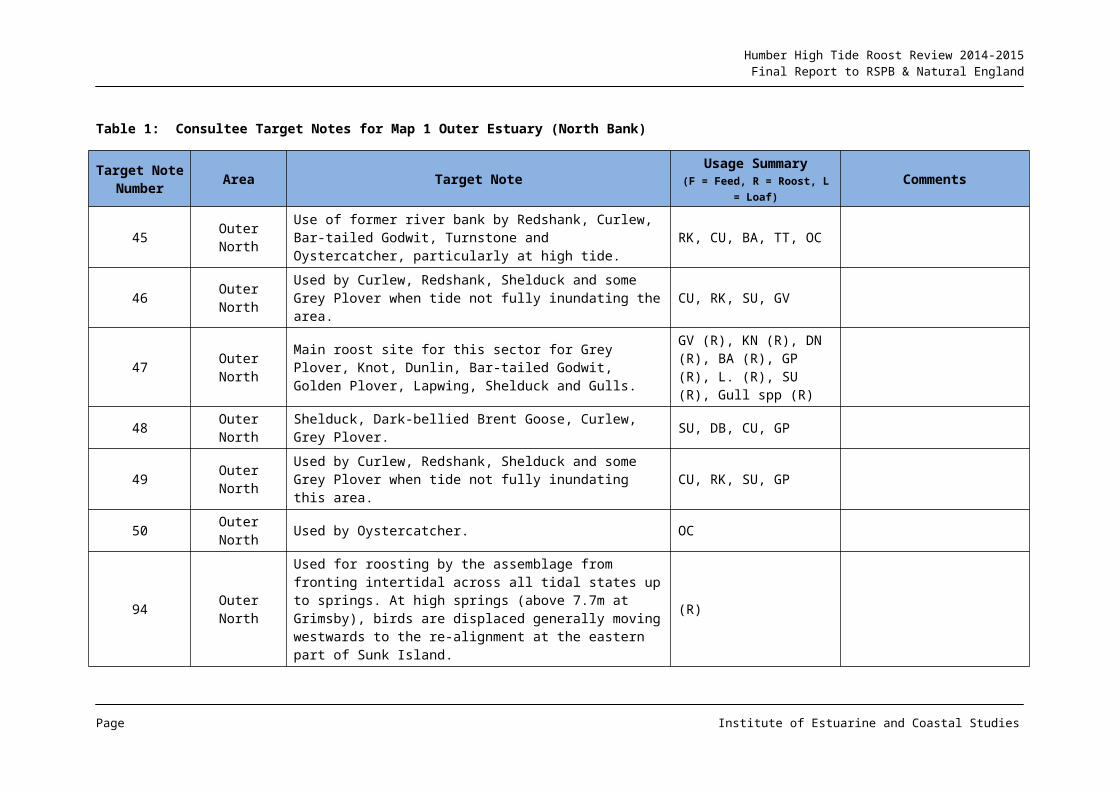
Table 1: Consultee Target Notes for Map 1 Outer Estuary (North Bank)
Target Note Number Area Target Note Usage Summary
(F = Feed, R = Roost, L = Loaf)Comments
45 Outer North Use of former river bank by Redshank, Curlew, Bar-tailed Godwit, Turnstone and Oystercatcher, particularly at high tide. RK, CU, BA, TT, OC
46 Outer North Used by Curlew, Redshank, Shelduck and some Grey Plover when tide not fully inundating the area. CU, RK, SU, GV
47 Outer NorthMain roost site for this sector for Grey Plover, Knot, Dunlin, Bar-tailed Godwit, Golden Plover, Lapwing, Shelduck and Gulls.
GV (R), KN (R), DN (R), BA (R), GP (R), L. (R), SU (R), Gull spp (R)
48 Outer North Shelduck, Dark-bellied Brent Goose, Curlew, Grey Plover. SU, DB, CU, GP
49 Outer North Used by Curlew, Redshank, Shelduck and some Grey Plover when tide not fully inundating this area. CU, RK, SU, GP
50 Outer North Used by Oystercatcher. OC
94 Outer North
Used for roosting by the assemblage from fronting intertidal across all tidal states up to springs. At high springs (above 7.7m at Grimsby), birds are displaced generally moving westwards to the re-alignment at the eastern part of Sunk Island.
(R)
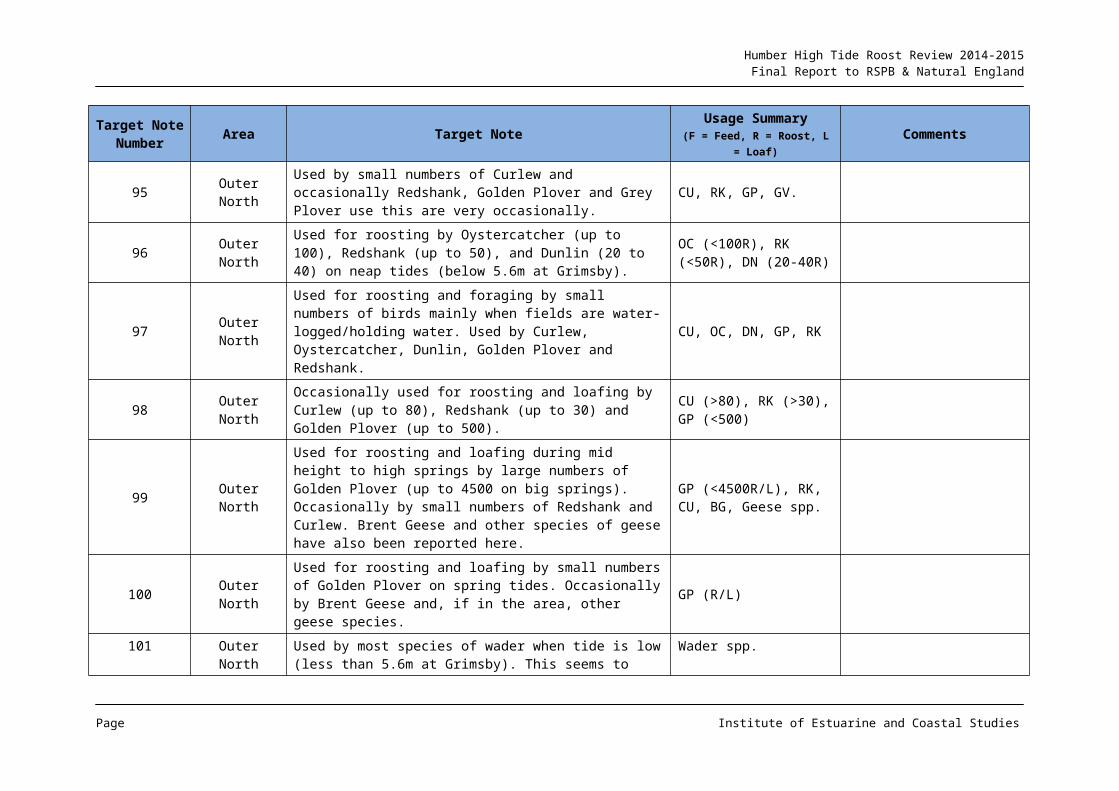
95 Outer North Used by small numbers of Curlew and occasionally Redshank, Golden Plover and Grey Plover use this are very occasionally. CU, RK, GP, GV.
96 Outer NorthUsed for roosting by Oystercatcher (up to 100), Redshank (up to 50), and Dunlin (20 to 40) on neap tides (below 5.6m at Grimsby).
OC (<100R), RK (<50R), DN (20-40R)
97 Outer NorthUsed for roosting and foraging by small numbers of birds mainly when fields are water-logged/holding water. Used by Curlew, Oystercatcher, Dunlin, Golden Plover and Redshank.
CU, OC, DN, GP, RK
98 Outer North Occasionally used for roosting and loafing by Curlew (up to 80), Redshank (up to 30) and Golden Plover (up to 500).
CU (>80), RK (>30), GP (<500)
Page Institute of Estuarine and Coastal Studies
Humber High Tide Roost Review 2014-2015Final Report to RSPB & Natural England
Target Note Number Area Target Note Usage Summary
(F = Feed, R = Roost, L = Loaf)Comments
99 Outer North
Used for roosting and loafing during mid height to high springs by large numbers of Golden Plover (up to 4500 on big springs). Occasionally by small numbers of Redshank and Curlew. Brent Geese and other species of geese have also been reported here.
GP (<4500R/L), RK, CU, BG, Geese spp.
100 Outer NorthUsed for roosting and loafing by small numbers of Golden Plover on spring tides. Occasionally by Brent Geese and, if in the area, other geese species.
GP (R/L)
101 Outer NorthUsed by most species of wader when tide is low (less than 5.6m at Grimsby). This seems to have altered little since the survey carried out by Milson & Tasker 1978/9.
Wader spp.
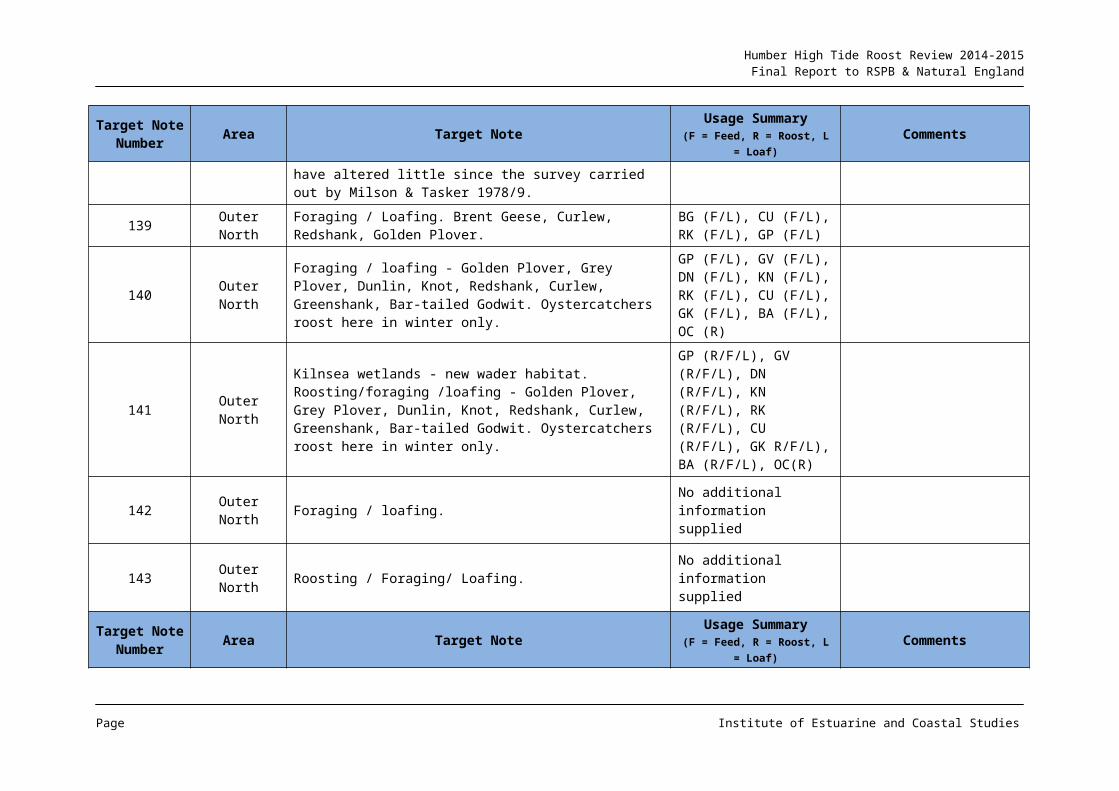
139 Outer North Foraging / Loafing. Brent Geese, Curlew, Redshank, Golden Plover.
BG (F/L), CU (F/L), RK (F/L), GP (F/L)
140 Outer NorthForaging / loafing - Golden Plover, Grey Plover, Dunlin, Knot, Redshank, Curlew, Greenshank, Bar-tailed Godwit. Oystercatchers roost here in winter only.
GP (F/L), GV (F/L), DN (F/L), KN (F/L), RK (F/L), CU (F/L), GK (F/L), BA (F/L), OC (R)
141 Outer North
Kilnsea wetlands - new wader habitat. Roosting/foraging /loafing - Golden Plover, Grey Plover, Dunlin, Knot, Redshank, Curlew, Greenshank, Bar-tailed Godwit. Oystercatchers roost here in winter only.
GP (R/F/L), GV (R/F/L), DN (R/F/L), KN (R/F/L), RK (R/F/L), CU (R/F/L), GK R/F/L), BA (R/F/L), OC(R)
142 Outer North Foraging / loafing. No additional information supplied
143 Outer North Roosting / Foraging/ Loafing. No additional information supplied
Target Note Area Target Note Usage Summary Comments
Page Institute of Estuarine and Coastal Studies
Humber High Tide Roost Review 2014-2015Final Report to RSPB & Natural England
Target Note Number Area Target Note Usage Summary
(F = Feed, R = Roost, L = Loaf)Comments
Number (F = Feed, R = Roost, L = Loaf)
144 Outer North c.200 Sanderling and 70+ Ringed Plover roost on beach at peak times. SS (c.200R), RP (>70R)
145 Outer North Foraging/Loafing. No additional information supplied
146 Outer NorthNarrow Neck - Warren. Roosting Oystercatcher, Knot, Dunlin, Sanderling, Redshank, Bar-tailed Godwit, Curlew, Ringed Plover, Grey Plover.
OC (R), KN (R), DN (R), SS (R), RK (R), BA (R), CU (R), RP (R), GV (R)
147 Outer North Roosting Oystercatcher, Knot, Dunlin, Sanderling, Redshank, Bar-tailed Godwit, Curlew, Ringed Plover, Grey Plover.
OC (R), KN (R), DN (R), SS (R), RK (R), BA (R), CU (R), RP (R), GV (R)
148 Outer NorthForaging / loafing Oystercatcher, Knot, Dunlin, Sanderling, Redshank, Bar-tailed Godwit, Curlew, Ringed Plover, Grey Plover.
OC (F/L), KN(F/L), DN (F/L), SS (F/L), RK (F/L), BA (F/L), CU (F/L), RP (F/L), GV (F/L)
149 Outer North c.70 roosting Ringed Plover in spring only RP (c.70R)
150 Outer North Roosting Oystercatcher, Knot, Dunlin, Sanderling, Redshank, Bar-tailed Godwit, Curlew, Ringed Plover, Grey Plover.
OC (R), KN (R), DN (R), SS (R), RK (R), BA (R), CU (R), RP (R), GV (R)
151 Outer NorthNarrow Neck - Warren. Roosting Oystercatcher, Knot, Dunlin, Sanderling, Redshank, Bar-tailed Godwit, Curlew, Ringed Plover, Grey Plover.
OC (R), KN (R), DN (R), SS (R), RK (R), BA (R), CU (R), RP (R), GV (R)
152 Outer North Roosting Turnstone, Sanderling and Dunlin. (Kilnsea wetlands - new wader habitat) TT (R), SS (R), DN (R)
Page Institute of Estuarine and Coastal Studies
Humber High Tide Roost Review 2014-2015Final Report to RSPB & Natural England
Table 2: Consultee Movement Notes for Map 1 Outer Estuary (North Bank)
Movement Number Area Species Movement Description
M1 Outer North No info. supplied High tide overspill to south bank
M2 Outer North SU, DB, CU, GV Shelduck, Dark-bellied Brent Geese, Curlew, Grey Plover
M3 Outer North GP, L. Golden Plover & Lapwing
M4 Outer North GP, L. Golden Plover & Lapwing
M5 Outer North GP Golden Plover
M6 Outer North DN, CU, BA, GV Dunlin, Curlew, Bar-tailed Godwit, Grey Plover
M15 Outer North No info. supplied Birds take flight and circle around Welwick and Sunk Island realignment site. Some fly out to mid river and may continue to Lincolnshire.
M16 Outer North WADER spp.A small number of waders move west when the area is flooded (over 5.6m tide at Grimsby). Birds move westwards and generally across Patrington Haven into sector 38442.
M17 Outer North No info. supplied Much to-ing and fro-ing along this area towards the top of the tides - some birds passing eastwards into sector 38444
M18 Outer North No info. supplied Much to-ing and fro-ing along this area towards the top of the tides - some birds passing eastwards into sector 38444
M19 Outer North No info. supplied Much to-ing and fro-ing along this area towards the top of the tides - some birds passing eastwards into sector 38444
M20 Outer North No info. supplied Much to-ing and fro-ing along this area towards the top of the tides - some birds passing eastwards into sector 38444
M21 Outer North No info. supplied Much to-ing and fro-ing along this area towards the top of the tides - some birds passing eastwards into sector 38444
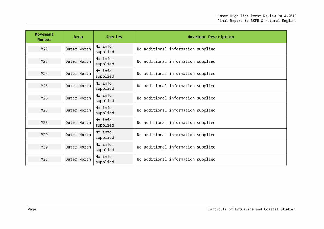
M22 Outer North No info. supplied No additional information supplied
M23 Outer North No info. supplied No additional information supplied
M24 Outer North No info. supplied No additional information supplied
Page Institute of Estuarine and Coastal Studies
Humber High Tide Roost Review 2014-2015Final Report to RSPB & Natural England
Movement Number Area Species Movement Description
M25 Outer North No info. supplied No additional information supplied
M26 Outer North No info. supplied No additional information supplied
M27 Outer North No info. supplied No additional information supplied
M28 Outer North No info. supplied No additional information supplied
M29 Outer North No info. supplied No additional information supplied
M30 Outer North No info. supplied No additional information supplied
M31 Outer North No info. supplied No additional information supplied
Page Institute of Estuarine and Coastal Studies
Humber High Tide Roost Review 2014-2015Final Report to RSPB & Natural England
2.2 Middle Humber
2.2.1 AREA CONTEXT
This area features a wide intertidal area on the north bank (c. 1km width), which narrows along the Hull frontage, and is reduced on the south bank to usually a few hundred metres. The intertidal mudflats are backed by hard flood defences, and whilst the majority of the north bank features low lying arable land behind the defences, on the south bank there is a mix of land uses from agricultural land to car storage and other industries associated with the ports complexes present along the reach.
2.2.2 ROOST REVIEW FINDINGS
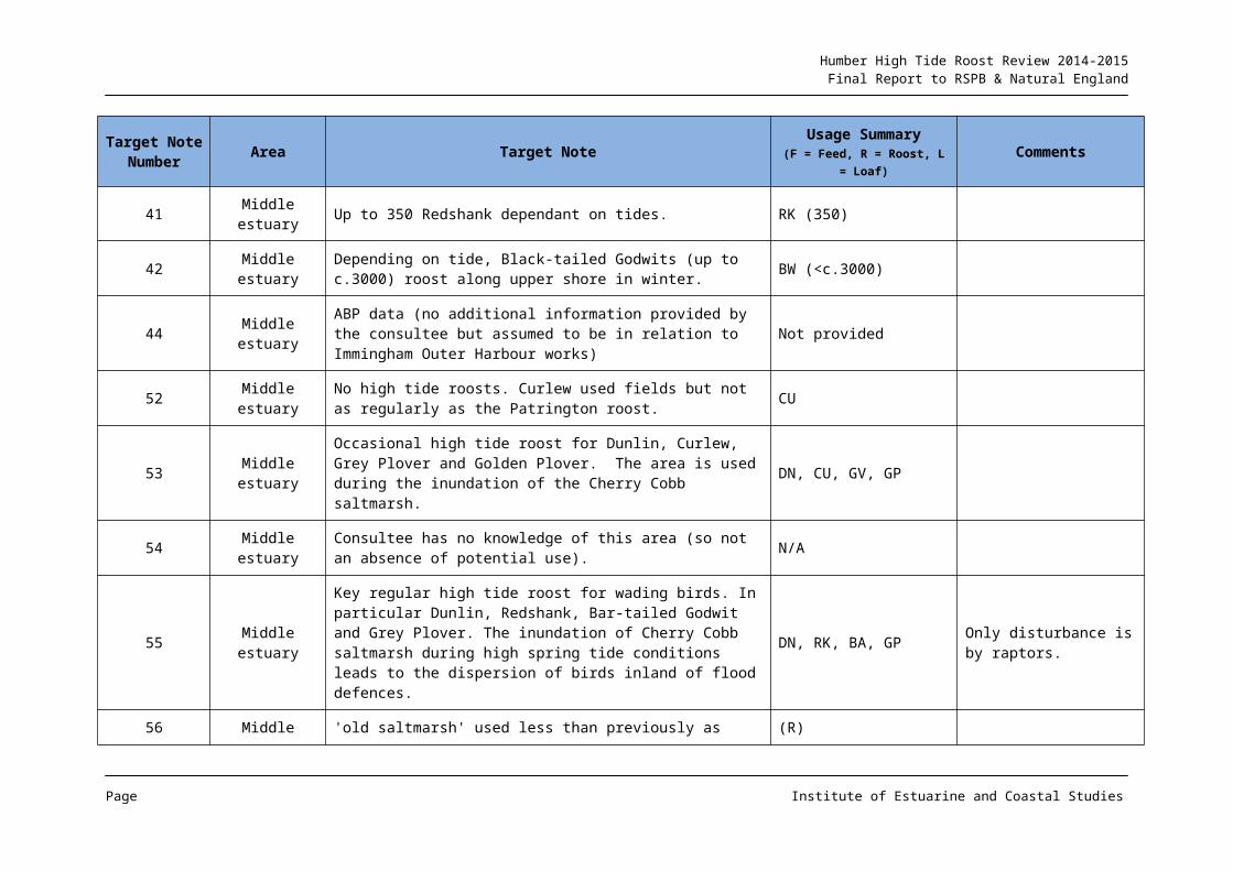
Map 2 provides information from the consultation exercise for the middle estuary. Consultation responses for the north bank included one of the few where evidence of no roost usage was provided, this for the frontage and inland fields running west from Hawkins Point to Stone Creek (TN 52). On Cherry Cobb Sands a regular wader roost was identified on the mid to upper shore (TN 55), this area noted as being used by Grey Plover, Bar-tailed Godwit, Dunlin and Redshank. This general area has undergone a process of vegetation colonisation over recent years, with a large fronting marsh developing in some areas. The consultee comment regarding a reduction in the roost status of the ‘old marsh’ (TN 56) therefore possibly suggests that with the extension of vegetation across the upper shore mudflat area, function has changed with roost activity developing on the newly evolving elevated marsh areas.
Although no consultee response was provided for the Paull Home Strays managed realignment area, author observations (N. Cutts pers. obs.) (TN 175) are that on neap tides, areas of the Paull Holme Strays managed realignment site are used as a roost by Golden Plover and Black-tailed Godwit and the arable fields inland to the north-west around Boreas Hill continue to be used by Curlew, predominantly for feeding but with some loafing apparently related to tidal inundation on adjacent mudflats. Some fields are occasionally utilised as a roost/loaf by Golden Plover and Lapwing (TN 175).
The arable fields between Paull and Saltend (TN 174) continue to support roost/loafing flocks of Golden Plover and Lapwing, although in reduced numbers compared to the 1990s to early 2000s, possibly reflecting a reduced presence of the species on the fronting Saltend mudflats. Curlew and Redshank can also use these fields for roosting and foraging.
The man-made hard sub-stratum along the Hull frontage is used by a limited avifauna, but with Turnstone present at a number of locations in regionally important numbers. There has been a historic roost of the species on derelict structures to the east of the mouth of the River Hull, however the continued use of this area is uncertain due to ports industry related development. Compensatory roost habitat has been provided but its efficacy is at the time of this report understood to be unknown (location not mapped due to uncertainty in roost use). There are additional ad hoc records for Turnstone roost concentrations along the west Hull frontage (not shown on the map, see 2.2.3).
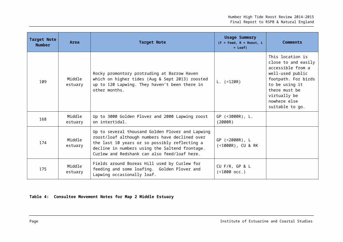
On the south bank, the Pyewipe mudflat, immediately west of Grimsby Dock entrance is reported to support roosts of up to 3,000 Golden Plover and 2,000 Lapwing (TN 168), whilst up to 3,000 Black-tailed Godwit can roost on the upper shore together with 350 Redshank
Page Institute of Estuarine and Coastal Studies
Humber High Tide Roost Review 2014-2015Final Report to RSPB & Natural England
and 2,500 Dunlin (TNs 40-42). Fields around the Novartis site (TNs 38 & 39) support 300 Ringed Plover when field is uncropped) and 200 Curlew respectively.
There are limited data on roost use in the outer part of the area running between Pyewipe and Immingham, and additional information has been utilised to gap fill from a range of published and grey sources (see 2.2.3). However TN 37 identifies the field immediately adjacent to the South Humber Bank power station as being used by more than 3,500 Golden Plover and 1,000 Lapwing when crop conditions are suitable. This level of use is broadly consistent with observations for the area from the initial roost review.
The western part of the area, upstream from north Killingholme, features a greater level of roost utilisation based on consultee responses. This area features predominantly agricultural land behind the man-made flood defences, although many of the fields have in recent years been developed for car storage associated with the port complexes in the area. TNs 32-36 inclusive identify a series of fields between North Killingholme haven and East Halton Skitter as being used by waders, with TNs 32, 33 and 36 used by Golden Plover and Lapwing with TN 32 a particularly important roost area for the species, and TN 35 as being used by Ruff.
The marsh fronting the flood defences on the northern bank of East Halton Skitter (TN 31) is identified as being an important roost for Snipe (Gallinago gallinago) (up to 80 individuals) and Jack Snipe (Lymnocryptes minimus) (12 individuals). The field system immediately behind the flood defences on the north-eastern side of Skitterness is identified as supporting roosts by a range of species including Golden Plover (e.g. 2,000 in TN 22) and Lapwing (2,500 in TN 25), with birds both using the fields in the area to roost and feed depending on crop. Fields in this area were recorded as being of value for roosting Golden Plover and Lapwing in the initial roost review. TN 24 is noted as supporting up to 90 Curlew and 200 Black-tailed Godwit, with Curlew also utilising the wider area, presumably both as a roost and foraging resource, and with up to 350 Pink-footed Geese (Anser brachyrhynchus) recorded feeding here (TN 27). The fronting marsh has been identified as reducing in value in some areas due to vegetation cover, but TN 26 is used by Dunlin and Redshank as well as Black-tailed Godwit.
The consultee responses indicate that the network of fields around East Halton Skitter and on Skitterness (e.g. TNs 28 & 29), together with areas of the fronting saltmarsh (TNs 30 & 31) continue to provide a valuable roost resource for a number of wader species in substantial numbers, this area having also been identified as an important roost from the initial roost review. In fact some species are present in numbers of regional importance (e.g. Golden Plover and Snipe).
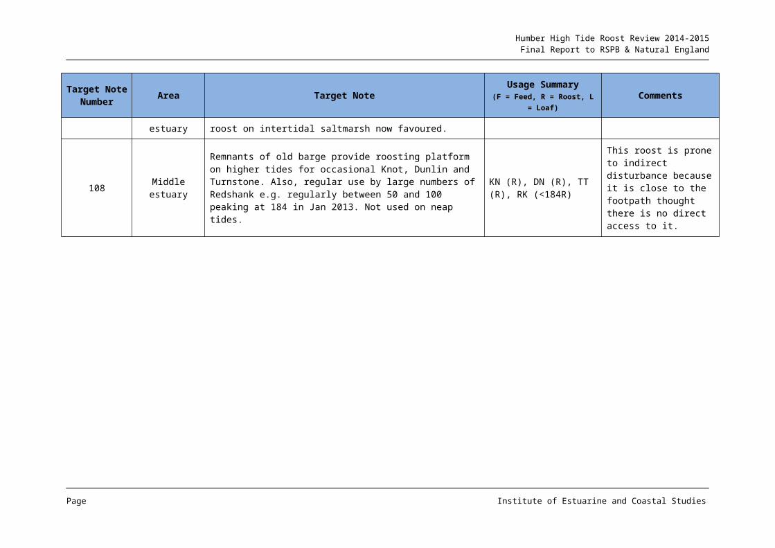
The consultation also identified a series of fields being utilised between Goxhill Haven and Barton upon Humber. Up to 6,000 Golden Plover and 4,500 Lapwing are shown on TN 20 to the east of New Holland, although with a reduction in numbers noted from recent years. Interestingly, structures in the intertidal (derelict barge TN 108) and subtidal (pier TN 19) are recorded as being used by concentrations of Turnstone with 450 recorded on TN 19 and regularly between 50 and 100 Redshank on TN 108, together with other species.
The inland fields to the west of New Holland (TN 16 and TN 17) are shown to support up to 2,000 Lapwing and 1,500 Curlew, this latter figure representing a substantial proportion of
Page Institute of Estuarine and Coastal Studies
Humber High Tide Roost Review 2014-2015Final Report to RSPB & Natural England
the middle estuary population. However field TN 13 which has historically been an important Curlew area is reported to have declined in value, this being attributed to drainage.
2.2.3 ADDITIONAL INFORMATION
Information on ornithological usage collected by studies relating to the Able compensation scheme (immediately north-west of Stone Creek) (Environmental Resources Management, 2011) provides additional information on roost use in fields immediately to the north-east of TN 52, with Curlew foraging undertaken in fields around Salthaugh Sands farm and roosting activity in the fields north-west of Stone Creek House, with up to 640 Curlew recorded roosting in these fields during the autumn/early winter, as well as some Lapwing utilisation and occasional roost use by Golden Plover, Grey Plover, Ruff (C. pugnax) and Dunlin. Survey work undertaken as part of the proposed Far Marsh Farm windfarm (e.g. Food and Environmental Research Agency, undated) also identified usage by Curlew and Golden Plover in fields within the Salthaugh Sands area, although Golden Plover were recorded as being in relatively small flocks in the fields, whilst Curlew were also recorded. Use of fields by waders to the east, north and west of the windfarm site was also noted. In addition to field usage, the Far Marsh Farm survey work recorded considerable movement of waders around the general area. This includes Golden Plover flight-lines originating from the Salthaugh Sands to Stone Creek Farm area and moving in most directions (including a series of flights between this area and the estuary) as well as further flight activity around Far Marsh Farm (inland by c. 2-3km) on occasion. A similar but more compact flight-line pattern was recorded for Curlew with a concentration of usage around the fields of Salthaugh Sands and the estuary, with additional but less frequent movement further inland, north of Far Marsh Farm (Food and Environmental Research Agency, undated).
Ornithological survey work undertaken in recent years as part of the Green Port Hull project (e.g. URS, 2011) has recorded the presence of several hundred Turnstone roosting on the derelict jetty structure fronting the mudflat immediately to the east of the Alexandra Dock lock entrance. Similar roost usage by the species was been recorded in the spring of 2014 (K Hemingway pers. obs.), with additional occasional roost utilisation on the flood protection structures to the west of the mouth of the River Hull.
On the south bank, survey work undertaken as part of the ABP Immingham Western Deepwater Jetty development proposal in 2012-2013 recorded small numbers of Curlew (maximum of 22) roosting on the ‘Triangle Site Field’, a field located on Killingholme Marshes (URS, 2013). Foraging was also recorded from this field by the species, with greater numbers using the field for this function. Loafing/roosting activity in this field was also recorded for Curlew and Lapwing in the summer/autumn of 2014, but with limited tidal dependency (N Cutts pers. obs.) and for limited numbers, and with sward height observed to have a significant effect on take-up (e.g. the field was down as a grass ley and was only used by waders when a crop had been taken. This cropping across the field was only partial, with roost (and foraging) activity restricted to areas which had been cut. However, these observations are contrary to those reported by ABP from surveys undertaken in 2012-2013, which recorded a more consistent usage of the field independent of its crop condition (URS, 2013).
Other fields in this area (e.g. between the estuary and Rosper Road) have been reported as being used by Curlew e.g. as part of the ABP Immingham Western Jetty development (URS, 2013), although with function not identified. N Cutts pers. obs. of use in this area has
Page Institute of Estuarine and Coastal Studies
Humber High Tide Roost Review 2014-2015Final Report to RSPB & Natural England
similarly seen Curlew utilisation, including on the grassed tank farms, but with the majority of use apparently for foraging individuals with relatively limited loafing and roosting use.
The ABP Immingham Western Deepwater Jetty programme (URS, 2013) also recorded utilisation of the Triangle Site Field by Black-tailed Godwit, albeit for foraging, with occasional Lapwing use also recorded including small numbers of roosting individuals on a small number of occasions. However survey work (N Cutts pers. obs.) for this field from 2014 did not record any Black-tailed Godwit, use, but did identify additional occasional flock use by Lapwing, these birds primarily roosting/loafing.
Further to the east, as part of the ABP Grimsby RO-RO development (ABPmer, 2009) surveys reported utilisation of the upper shore and adjacent flood defences in the south-eastern part of the Pyewipe mudflat by roosting Redshank, with Dunlin using the green shore on all but spring tides. Curlew were reported as primarily roosting on the former Huntsman Tioxide site (currently derelict) and adjacent playing fields.
In addition to the above development specific works, a programme of wintering and migratory bird surveys has been undertaken between Skitter Ness and Grimsby (the South Humber Gateway (SHG)) over the period 2007 to 2011. This study has covered the hinterland of the reach inland to between 1km and 5km, an area of approximately 1000ha, and whilst the specific reports should be used to derive key usage details from this comprehensive survey programme, the SHG supports regionally important (>1% of the Humber population) of Golden Plover, Lapwing, Curlew, Whimbrel (N. phaeopus) and Ruff. Areas of high use include fields to the south of East Halton Skitter down towards North Killingholme and north-west from Pyewipe to Immingham for a number of species, including Golden Plover, Lapwing and Curlew e.g. Cutts et al, 2009.
Page Institute of Estuarine and Coastal Studies
Humber High Tide Roost Review 2014-2015Final Report to RSPB & Natural England
Page Institute of Estuarine and Coastal Studies

Humber High Tide Roost Review 2014-2015Final Report to RSPB & Natural England
Map 2: Middle Estuary Roost Information
Page Institute of Estuarine and Coastal Studies
Humber High Tide Roost Review 2014-2015Final Report to RSPB & Natural England
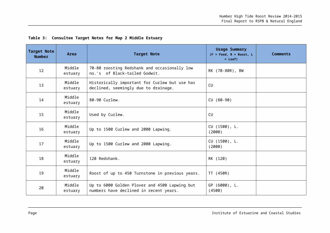
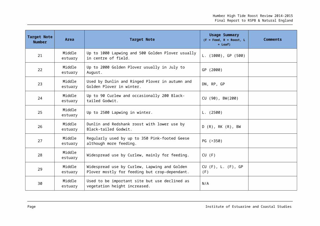
Table 3: Consultee Target Notes for Map 2 Middle Estuary
Target Note Number Area Target Note Usage Summary
(F = Feed, R = Roost, L = Loaf)Comments
12 Middle estuary 70-80 roosting Redshank and occasionally low no.'s of Black-tailed Godwit. RK (70-80R), BW
13 Middle estuary Historically important for Curlew but use has declined, seemingly due to drainage. CU
14 Middle estuary 80-90 Curlew. CU (80-90)
15 Middle estuary Used by Curlew. CU
16 Middle estuary Up to 1500 Curlew and 2000 Lapwing. CU (1500), L. (2000)
17 Middle estuary Up to 1500 Curlew and 2000 Lapwing. CU (1500), L. (2000)
18 Middle estuary 120 Redshank. RK (120)
19 Middle estuary Roost of up to 450 Turnstone in previous years. TT (450R)
20 Middle estuary Up to 6000 Golden Plover and 4500 Lapwing but numbers have declined in recent years. GP (6000), L. (4500)
21 Middle estuary Up to 1000 Lapwing and 500 Golden Plover usually in centre of field. L. (1000), GP (500)
22 Middle estuary Up to 2000 Golden Plover usually in July to August. GP (2000)
23 Middle estuary Used by Dunlin and Ringed Plover in autumn and Golden Plover in winter. DN, RP, GP
24 Middle estuary Up to 90 Curlew and occasionally 200 Black-tailed Godwit. CU (90), BW(200)
25 Middle estuary Up to 2500 Lapwing in winter. L. (2500)
Page Institute of Estuarine and Coastal Studies
Humber High Tide Roost Review 2014-2015Final Report to RSPB & Natural England
Target Note Number Area Target Note Usage Summary
(F = Feed, R = Roost, L = Loaf)Comments
26 Middle estuary Dunlin and Redshank roost with lower use by Black-tailed Godwit. D (R), RK (R), BW
27 Middle estuary Regularly used by up to 350 Pink-footed Geese although more feeding. PG (>350)
28 Middle estuary Widespread use by Curlew, mainly for feeding. CU (F)
29 Middle estuary Widespread use by Curlew, Lapwing and Golden Plover mostly for feeding but crop-dependant. CU (F), L. (F), GP (F)
30 Middle estuary Used to be important site but use declined as vegetation height increased. N/A
31 Middle estuary Important site for up to 80 Snipe and 12 Jack Snipe. SN (80) JS (12)
32 Middle estuary Key Golden Plover and Lapwing roost. GP (R), L.(R)
33 Middle estuary Golden Plover and Lapwing roost (lower use) GP (R), L (R)
34 Middle estuary Curlew with lower numbers of Lapwing. CU, L.
35 Middle estuary 10-20 Ruff use various fields. RU (10-20)
36 Middle estuary Golden Plover and Lapwing. GP, L.
37 Middle estuary Used by >1000 Lapwing and >3500 Golden Plover during favourable cropping conditions. L. (>1000), GP(>3500)
38 Middle estuary Up to 300 Ringed Plover on autumn passage when field uncropped. RP (300)
39 Middle estuary Up to 200 Curlew. CU (200)
40 Middle estuary Up to 2500 Dunlin in winter. DN (2500)
Page Institute of Estuarine and Coastal Studies
Humber High Tide Roost Review 2014-2015Final Report to RSPB & Natural England
Target Note Number Area Target Note Usage Summary
(F = Feed, R = Roost, L = Loaf)Comments
41 Middle estuary Up to 350 Redshank dependant on tides. RK (350)
42 Middle estuary Depending on tide, Black-tailed Godwits (up to c.3000) roost along upper shore in winter. BW (<c.3000)
44 Middle estuary ABP data (no additional information provided by the consultee but assumed to be in relation to Immingham Outer Harbour works) Not provided
52 Middle estuary No high tide roosts. Curlew used fields but not as regularly as the Patrington roost. CU
53 Middle estuaryOccasional high tide roost for Dunlin, Curlew, Grey Plover and Golden Plover. The area is used during the inundation of the Cherry Cobb saltmarsh.
DN, CU, GV, GP
54 Middle estuary Consultee has no knowledge of this area (so not an absence of potential use). N/A
55 Middle estuary
Key regular high tide roost for wading birds. In particular Dunlin, Redshank, Bar-tailed Godwit and Grey Plover. The inundation of Cherry Cobb saltmarsh during high spring tide conditions leads to the dispersion of birds inland of flood defences.
DN, RK, BA, GP Only disturbance is by raptors.
56 Middle estuary 'old saltmarsh' used less than previously as roost on intertidal saltmarsh now favoured. (R)
108 Middle estuary
Remnants of old barge provide roosting platform on higher tides for occasional Knot, Dunlin and Turnstone. Also, regular use by large numbers of Redshank e.g. regularly between 50 and 100 peaking at 184 in Jan 2013. Not used on neap tides.
KN (R), DN (R), TT (R), RK (<184R)
This roost is prone to indirect disturbance because it is close to the footpath thought there is no direct access to it.
Page Institute of Estuarine and Coastal Studies
Humber High Tide Roost Review 2014-2015Final Report to RSPB & Natural England
Target Note Number Area Target Note Usage Summary
(F = Feed, R = Roost, L = Loaf)Comments
109 Middle estuaryRocky promontory protruding at Barrow Haven which on higher tides (Aug & Sept 2013) roosted up to 120 Lapwing. They haven’t been there in other months.
L. (<120R)
This location is close to and easily accessible from a well-used public footpath. For birds to be using it there must be virtually be nowhere else suitable to go.
168 Middle estuary Up to 3000 Golden Plover and 2000 Lapwing roost on intertidal. GP (<3000R), L. (2000R)
174 Middle estuary
Up to several thousand Golden Plover and Lapwing roost/loaf although numbers have declined over the last 10 years or so possibly reflecting a decline in numbers using the Saltend frontage. Curlew and Redshank can also feed/loaf here.
GP (<2000R), L (<1000R), CU & RK
175 Middle estuary Fields around Boreas Hill used by Curlew for feeding and some loafing. Golden Plover and Lapwing occasionally loaf.
CU F/R, GP & L (<1000 occ.)
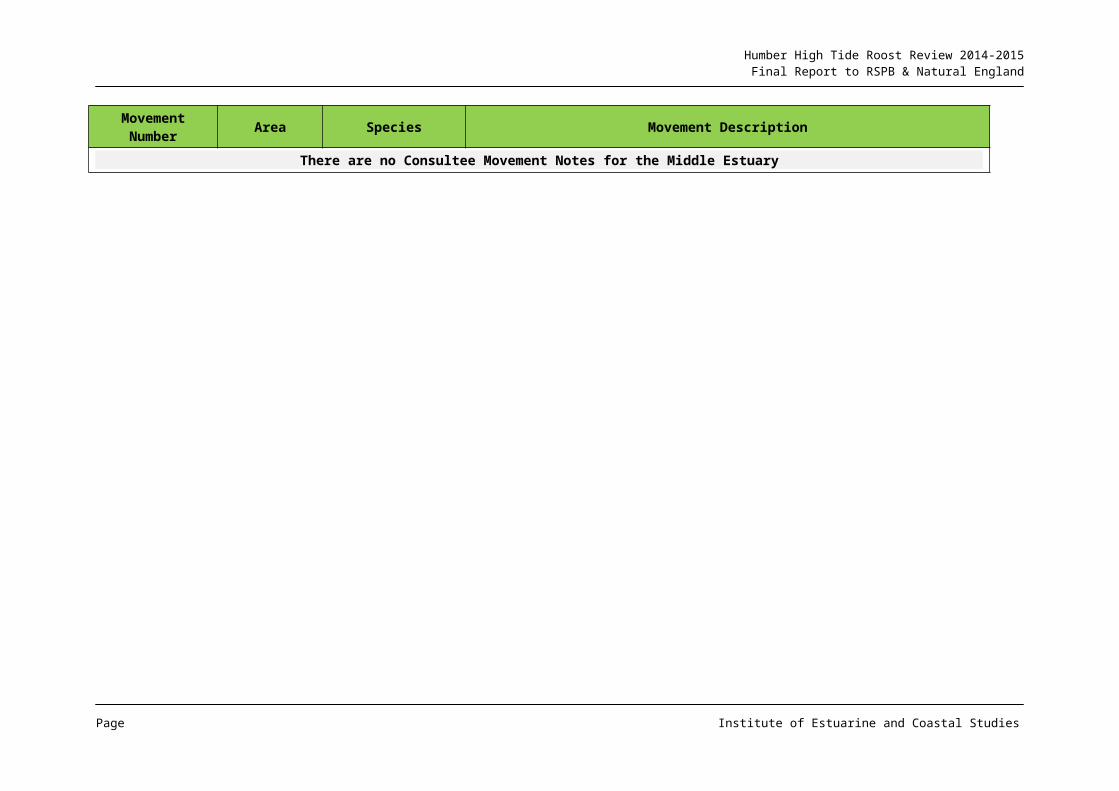
Table 4: Consultee Movement Notes for Map 2 Middle Estuary
Movement Number Area Species Movement Description
There are no Consultee Movement Notes for the Middle Estuary
Page Institute of Estuarine and Coastal Studies
Humber High Tide Roost Review 2014-2015Final Report to RSPB & Natural England
2.3 Inner Estuary
2.3.1 AREA CONTEXT
The eastern part of this section of the estuary is characterised by more narrow fringing intertidal areas, although with cobble habitat present as well as mud. There are also several large mid channel banks including the vegetated Read’s Island, although this has undergone erosion and loss of area in recent years. Waterbird abundance levels tend to be lower in this area, reflecting both reduced habitat area and for some species, reduced prey abundance.
The upper (western) part of the inner estuary is characterised by moderately wide mudflats together with several mid channel banks. In recent years the intertidal area has been subject to considerable colonisation by saltmarsh and reedbed, with Whitton Sand now a well-established vegetated island. At Alkborough a large managed realignment site has been developed, and data from the 2014 bird report for the Alkborough site indicates often high levels of usage by wildfowl and wader species, including roost/loafing utilisation. An additional area of mixed wetland habitat is present at the Blacktoft Sands reserve.
The River Ouse features a narrow steeply shelving channel and the area in general is constrained by man-made flood defence banks. For the most part the immediate hinterland consists of arable fields.
2.3.2 ROOST REVIEW ANALYSIS
Roost activity for the eastern part of the inner north bank is centred around Brough Airfield and Welton Waters (TNs 102-105). The eastern side of Brough Airfield has been historically used by Golden Plover, Lapwing and Curlew, and the recent consultee comments indicate that this continues. A further area of arable field between North Ferriby and Brickyard Lane (TN 106) is used by Curlew both for feeding and loafing when crop conditions are suitable.
The western part of the inner north bank section between Brough and Weighton Lock features an extensive marsh and reedbed habitat fronting the flood bank and areas of this are used by Shelduck and Curlew (TNs 157-159; 163), with the fronting high mudflat also used on neap tides (TN 162). Only extreme spring tides cover the vegetated areas and when this occurs, then fields adjacent to the frontage are used by Curlew (TN 161). An area of grass fronting reedbed (TN 154) has been used as a Wigeon (Anas penelope) and wader roost, although use has declined in recent years with vegetation developing in front of the ‘lawn’. A further ‘lawn’ area has however developed on Whitton Sand (TNs 155 & 124) and is used on occasion by Wigeon for foraging, but also as a loafing area. This habitat can also support large numbers of loafing geese (Greylag (A. anser), Canada (B. canadensis) and Barnacle (B. leucopsis)), as well as waders, primarily Lapwing, with over 1,000 roosting here on occasion.
To the east of the vegetated Whitton island (TN 125), the mid channel bank is used as a loaf/roost by a large number of mixed gulls and Shelduck across most tides, with birds only pushed off around high water. This area can also be used by Pink-footed Geese, Golden Plover (>1,000) and Lapwing (>1,000) on occasion although numbers using the area have declined in recent years. Fields inland of this area on the north bank can be used by Pink-footed Geese, primarily for foraging (e.g. TN 165 & 172), with considerably longer distance
Page Institute of Estuarine and Coastal Studies

Humber High Tide Roost Review 2014-2015Final Report to RSPB & Natural England
foraging movements occurring from this area of the Humber onto the Yorkshire Wolds in the autumn of 2014 & 2015 (N Cutts pers. obs.).
The mixed wetland habitat of Blacktoft Sands (e.g. TN 118) supports a range of wildfowl, as well as Lapwing and Golden Plover, with the fields inland from the reserve (TN 122) also used by these, together with foraging Ruff and Pink-footed Geese. The wider inland area (TN 123) has supported up to 8,000 Pink-footed Geese in recent years, although as noted above, large flocks were also observed moving onto the Yorkshire Wolds to feed in autumn 2014 and 2015 (N Cutts pers. obs.).
The River Ouse can support large concentrations of Mallard (A. platyrhynchos), with 150 reported by consultees, but over 350 observed roosting on the channel banks at Swinefleet (K Hemingway pers. obs.) and 250 reported from off Whitgift (TN 115). Fields adjacent to the river are often used by Golden Plover and Lapwing e.g. TN 113, with Howdendyke Lee and adjacent fields also utilised (N Cutts pers. obs.).
The inland arable land between the Rivers Ouse and Trent (TN 123) was identified as supporting Pink-footed Geese in large numbers (8000), although the consultee response did not identify whether this was for roosting or foraging.
As noted above, the relatively new habitat within the Alkborough managed realignment site has been seen to support a number of wildfowl and wader species in large numbers, including flocks of over 10,000 Golden Plover and 6,000 Lapwing.
The upper estuary south bank includes several inland fields behind the Alkborough escarpment identified as being used by Curlew (TNs 1 & 43), with fields to the east of Whitton used both by Curlew and other species. In particular, TN 4 was reported by the consultee as being able to support up to 4,000 Golden Plover and Lapwing, together with 2,000 Dunlin on spring tides during the early autumn.
Fields to the west of South Ferriby (TNs 8 & 9) support usage by Curlew, Golden Plover and Lapwing, together with occasional Redshank and Dunlin.
2.3.3 ADDITIONAL INFORMATION
Ornithological survey work relating to a development of fields adjacent to the estuary and between North Ferriby and Brickyard Lane recorded a reasonable level of usage by Curlew (maxima of 130 individuals) during the winter of 2009/2010, with a small number of other waders e.g. Golden Plover, also present on occasion. From the available information, it would appear however that the Curlew utilisation was for foraging, rather than as a roost site (FPCR, 2013).
Surveys for development plans on Brough Airfield over the 2008 to 2009 and 2010 to 2011 periods have indicated that the site is utilised by flocks of Golden Plover and Lapwing (Brooks Ecological 2011 & 2012). Utilisation by these species was up to a maximum of 475 Golden Plover and 484 Lapwing, as well as 21 Black-tailed Godwit and around 50 Curlew also regularly recorded. Although the information presented does not identify whether these birds were roosting or foraging, as the majority of maxima were for around the high water period this would suggest roost/loaf activity (albeit with smaller flocks also present around low water on some surveys). Small numbers of other waders e.g. Snipe, Curlew and Redshank were also present on a number of occasions, together with waterfowl, the latter
Page Institute of Estuarine and Coastal Studies
Humber High Tide Roost Review 2014-2015Final Report to RSPB & Natural England
presumably primarily utilising the wetland areas of the site. Lapwing and Golden Plover utilise the airfield regularly in flocks of over 100 individuals as a loafing/roost site (N Cutts pers. obs.) and may also undertake nocturnal foraging in this area. Other wader species can be present on occasion.
An ornithological survey programme relating to a proposed wind turbine development to the west of Ellerker (north bank) (ECUS, 2014) recorded a number of movements to and from the estuary by Pink-footed Goose, Golden Plover and Lapwing (see Map 3 and Table 6). However the Pink-footed Goose movements were considered to be foraging activity rather than in relation to roosting requirements, whilst for Golden Plover and Lapwing, a degree of flight movement will occur between inland foraging sites and loafing/roosting areas on the estuary (N Cutts pers. obs.).
Bird survey work at the Alkborough managed realignment site has recorded peak numbers (from the 2014 report) of around 1,000 Pink-footed Geese, 1,500 Wigeon, 3,500 Teal and 200 Mallard together with 1,000 Avocet, between 10,000 and 12,000 Golden Plover, 6,000 to 8,000 Lapwing, 1,000 Dunlin, 80 Ruff, 800 Black-tailed Godwits and 400 Curlew, including some roost utilisation.
Page Institute of Estuarine and Coastal Studies
Humber High Tide Roost Review 2014-2015Final Report to RSPB & Natural England
Page Institute of Estuarine and Coastal Studies
Humber High Tide Roost Review 2014-2015Final Report to RSPB & Natural England
Map 3: Inner Estuary Roost Information
Page Institute of Estuarine and Coastal Studies
Humber High Tide Roost Review 2014-2015Final Report to RSPB & Natural England
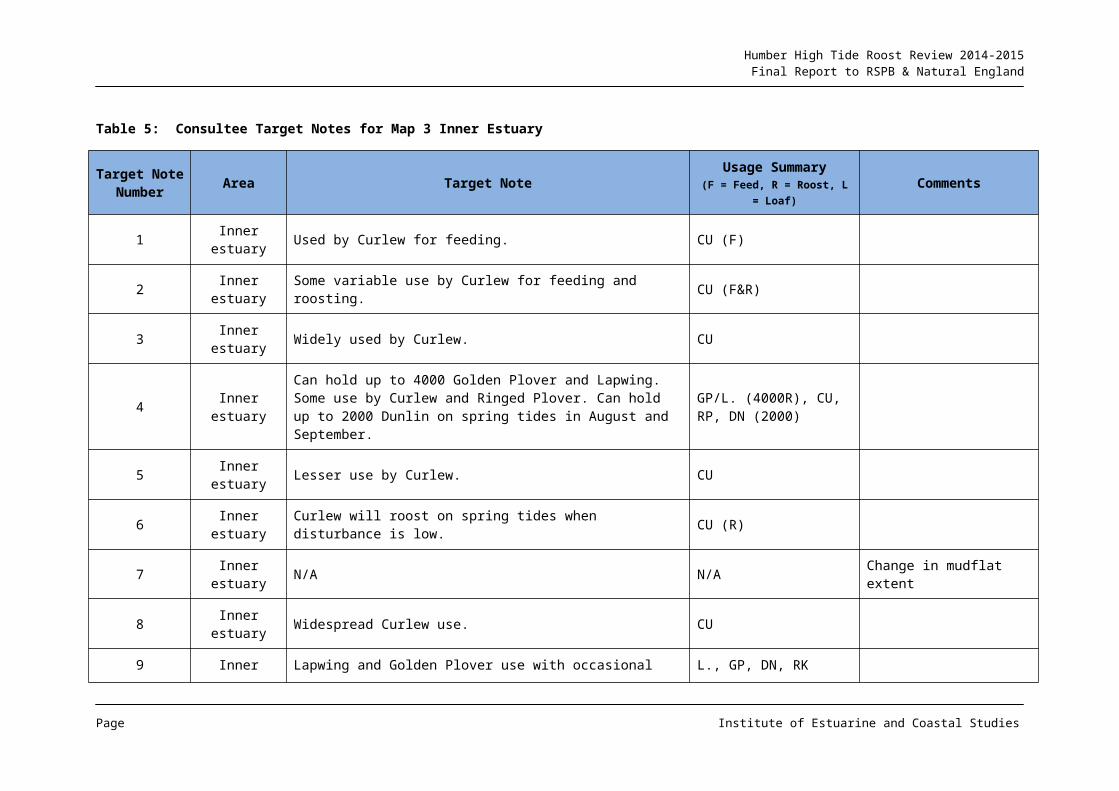
Table 5: Consultee Target Notes for Map 3 Inner Estuary
Target Note Number Area Target Note Usage Summary
(F = Feed, R = Roost, L = Loaf)Comments
1 Inner estuary Used by Curlew for feeding. CU (F)
2 Inner estuary Some variable use by Curlew for feeding and roosting. CU (F&R)
3 Inner estuary Widely used by Curlew. CU
4 Inner estuaryCan hold up to 4000 Golden Plover and Lapwing. Some use by Curlew and Ringed Plover. Can hold up to 2000 Dunlin on spring tides in August and September.
GP/L. (4000R), CU, RP, DN (2000)
5 Inner estuary Lesser use by Curlew. CU
6 Inner estuary Curlew will roost on spring tides when disturbance is low. CU (R)
7 Inner estuary N/A N/A Change in mudflat extent
8 Inner estuary Widespread Curlew use. CU
9 Inner estuary Lapwing and Golden Plover use with occasional Dunlin and Redshank. L., GP, DN, RK
10 Inner estuary Historically this roost held up to 400 Ringed Plover and Dunlin (August and September). Harder to view now. RP/DN (400R),
11 Inner estuary Curlew use c.40. CU (40)
43 Inner estuary Whole area used widely by feeding Curlew. CU (F)
102 Inner estuary N/A N/ARarely/ never used (adjacent to a public footpath)
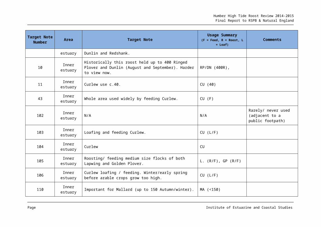
Page Institute of Estuarine and Coastal Studies
Humber High Tide Roost Review 2014-2015Final Report to RSPB & Natural England
Target Note Number Area Target Note Usage Summary
(F = Feed, R = Roost, L = Loaf)Comments
103 Inner estuary Loafing and feeding Curlew. CU (L/F)
104 Inner estuary Curlew CU
105 Inner estuary Roosting/ feeding medium size flocks of both Lapwing and Golden Plover. L. (R/F), GP (R/F)
106 Inner estuary Curlew loafing / feeding. Winter/early spring before arable crops grow too high. CU (L/F)
110 Inner estuary Important for Mallard (up to 150 Autumn/winter). MA (<150)
111 Inner estuary Important for Mallard (up to 150 Autumn/winter). MA (<150)
112 Inner estuary N/A N/A Breeding utilisation noted
113 Inner estuary Fields for Golden Plover <1000 and Lapwing <500. GP (<1000), L. (<500)
114 Inner estuary Fields hold Lapwing, Golden Plover, up to several 100 Greylag Geese and small numbers of Pink-footed Geese.
L., GP, GJ (c.200-300), PG
115 Inner estuary Most important area on this stretch for Mallard up to 250. MA (<250)
116 Inner estuary Lapwing and Golden Plover loaf in this area at low tide. Mallard loaf at high tide. L. (L), GP (L), MA (L)
117 Inner estuary Loafing flocks of Golden Plovers and Lapwing at low tide. Wildfowl also particularly include Wigeon, Teal and Mallard. GP (L), L. (L), WN, T., MA
118 Inner estuary Roosting Hen Harriers and Marsh Harriers HH (R), MR (R)
119 Inner estuary
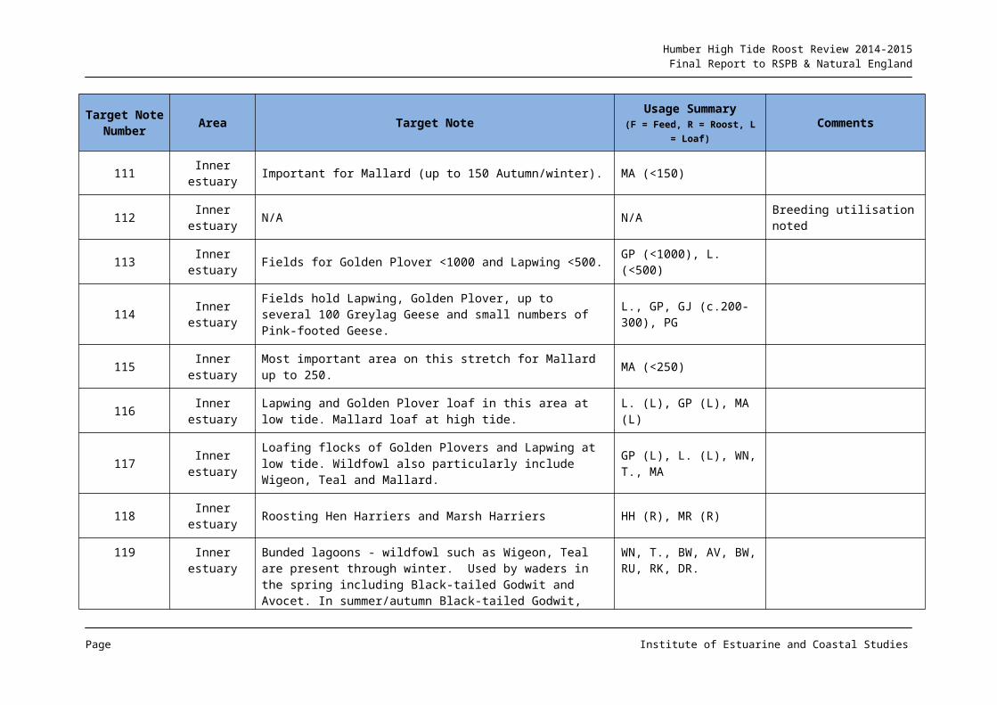
Bunded lagoons - wildfowl such as Wigeon, Teal are present through winter. Used by waders in the spring including Black-tailed Godwit and Avocet. In summer/autumn Black-tailed Godwit, Ruff, Redshank, Spotted Redshank etc and wildfowl are present.
WN, T., BW, AV, BW, RU, RK, DR.
Page Institute of Estuarine and Coastal Studies
Humber High Tide Roost Review 2014-2015Final Report to RSPB & Natural England
Target Note Number Area Target Note Usage Summary
(F = Feed, R = Roost, L = Loaf)Comments
Target Note Number Area Target Note Usage Summary
(F = Feed, R = Roost, L = Loaf)Comments
120 Inner estuaryGrazing marsh and seasonal pools. Autumn/winter - used by wildfowl such as Teal, Wigeon and Mallard and waders such as Lapwing, Golden Plover and Curlew.
T., WN, MA, L., GP, CU.
121 Inner estuary River Ouse - Wildfowl - especially Wigeon and Teal. The river is important during cold weather. WN, T.
122 Inner estuary Flocks of Golden Plover, Lapwing, foraging Ruff and Pink-footed Geese. GP, L., RU (F), PG
123 Inner estuary Area regularly used by up to 8000 Pink-footed Geese in the last three winters. PG (8000)
124 Inner estuary Short 'turf' Wigeon, waders, Avocets. WN, WADERS spp, AV
125 Inner estuary Pink-footed Geese roosting, large numbers of Golden Plovers, Lapwing, Dunlin and Wigeon. PG (R), GP, L., DN, WG.
153 Inner estuary Greylag Goose - roosting/ feeding. GJ (R/F)
154 Inner estuary Wigeon & Barnacle Geese feeding on 'lawn' & occasional wader roost.
WN (F), BY (F), WADERS spp. (R)
155 Inner estuary Grass area. Wigeon & Lapwing roost. Greylag, Barnacle, Canada Goose roost/feed/breed.
WN (R), L. (R), GJ (R/F/B), BY (R/F/B), CG (R/F/B)
156 Inner estuary N/A N/A Rank vegetation noted as affecting roost use.
157 Inner estuary Limited use by Shelduck and Curlew for roosting and loafing. SU (R/L), CU (R/L)
Page Institute of Estuarine and Coastal Studies
Humber High Tide Roost Review 2014-2015Final Report to RSPB & Natural England
Target Note Number Area Target Note Usage Summary
(F = Feed, R = Roost, L = Loaf)Comments
158 Inner estuary Shelduck and Curlew loaf at high water. SU (L), CU (L)
Target Note Number Area Target Note Usage Summary
(F = Feed, R = Roost, L = Loaf)Comments
159 Inner estuary Area of high shore used by Curlew, Golden Plover, Lapwing, and Shelduck on neap tides but reducing in quality due to vegetation. CU, GP, L., SU
160 Inner estuary Teal and Mallard roost. T. (R), MA (R)
161 Inner estuary Area of Curlew roosting at high water but movement and location unknown. CU (R)
162 Inner estuary Area of high shore used by Curlew, Golden Plover, Lapwing, and Shelduck on neap tides but reducing in quality due to vegetation. CU, GP, L., SU
163 Inner estuary Curlew sub-roost. CU
164 Inner estuary Occasional use by Greylag Geese. GJ
165 Inner estuary Pink-footed Geese feed occasionally. PG (F)
166 Inner estuary Redshank and Black-tailed Godwit RK, BW
167 Inner estuary Knot, Bar-tailed Godwit, Dunlin, Curlew, KN, BA, DN, CU
170 Inner estuary Lapwing and Golden Plover feed on autumn crops. Usage dependant on cropping. L. (F), GP (F)
172 Inner estuary Pink-footed Geese (120) PG (120)
Page Institute of Estuarine and Coastal Studies
Humber High Tide Roost Review 2014-2015Final Report to RSPB & Natural England
Table 6: Consultee Movement Notes for Map 3 Inner Estuary
Movement Number Area Species Movement Description
M32 Inner estuary CU Movement of Curlew from unknown adjacent inland location. Movement not always related to tidal state.
M33 Inner estuary CU Movement of Curlew from unknown adjacent inland location. Movement not always related to tidal state.
M34 Inner estuary CU Movement of Curlew from unknown adjacent inland location. Movement not always related to tidal state.
M35 Inner estuary PG Flight lines for Pink-footed Geese
M36 Inner estuary PG Flight lines for Pink-footed Geese
M37 Inner estuary PG Flight lines for Pink-footed Geese
M38 Inner estuary PG Flight lines for Pink-footed Geese
Page Institute of Estuarine and Coastal Studies
Humber High Tide Roost Review 2014-2015Final Report to RSPB & Natural England
2.4 Outer Humber (South Bank)
2.4.1 AREA CONTEXT
In the northern part of the outer estuary, the amenity beach fronts man-made defences and the urban areas of Cleethorpes and Grimsby. This area features an extensive intertidal frontage of variable muddy sand to find sand with relatively high disturbance and relatively low ornithological value, although flocks of some wader species are known to utilise the Cleethorpes frontage on occasion in high numbers. However immediately to the west of the Grimsby Dock entrance a moderately wide area of mudflat (Pyewipe) has a high ornithological importance (see Section 2.2 for additional information).
The outer south bank of the estuary includes areas that are almost fully marine, with extensive sand and muddy sand intertidal areas backed by marsh and grey dune. Several large creeks are present and these, together with dune, marsh and mid shore sandbank features, create a series of more muddy basins (Map 4). There is a considerable area of marsh and dune community fronting this part of the section, with arable agricultural land immediately behind.
2.4.2 ROOST REVIEW FINDINGS
From the consultee responses, the Cleethorpes frontage does not appear to be an important foraging area, potentially given the relatively clean fine sands having a reduced feeding potential together with possible recreational disturbance events. However the southern part of the amenity beach can support loafing flocks of waders including Golden Plover, Knot, Dunlin and Redshank (N Cutts pers. obs.). This observation is broadly consistent with the findings from the initial High Tide Roost report (Mander et al, 2006) which stated: an area just south-east of the leisure centre is regularly used by roosting Knot, Dunlin, Bar-tailed Godwit, Oystercatcher, Grey Plover and Sanderling. Despite the very high level of disturbance, it can support large numbers of waterfowl (up to 15,000), with Knot often the most abundant species during the winter months (up to 10,000).
The Tetney Basin area (TNs 134-137) is identified as supporting flocks of roosting Knot, Grey Plover, Bar-tailed Godwit and Dunlin on spring tides, as well as Teal (A. crecca), Wigeon, Brent Geese and Shelduck along the Haven (Map 4 & 4a). Inland fields (TN 133) are important for Golden Plover, Lapwing and Brent Geese.
An extensive inland arable area of fields south of this (TN 132) supports large numbers of Golden Plover, Lapwing and Brent Geese, although utilisation depends on the cropping regime. The intertidal upper shore and adjacent marsh from Northcoates Point to Horse Shoe Point (Map 4a) is identified as being used by Oystercatcher, Knot, Bar-tailed Godwit, Grey Plover and Dunlin on high tides, with Sanderling and Ringed Plover using the area on passage. A large Common Tern (Sterna hirundo) roost is also identified on the fringing upper shore/marsh in this area.
It was noted from the consultee responses that whilst the above areas were used as roosts on most tides, larger springs (greater than 7.0m at Grimsby (no datum provided)) create sufficient inundation to force flocks either to move inland and disperse widely across the area or onto more elevated areas of saltmarsh and sandbanks. The consultation also identified that as with the initial roost review undertaken in 2005/6, on very large tides (e.g.
Page Institute of Estuarine and Coastal Studies
Humber High Tide Roost Review 2014-2015Final Report to RSPB & Natural England
7.8m and above at Grimsby (no datum provided)), flocks can move onto the south bank of the estuary from Spurn Bight.
2.4.3 ADDITIONAL INFORMATION
Additional information on waterbird composition in the Grainthorpe Haven area is available as part of the cable landfall studies for the Hornsea One offshore wind farm. Smart Wind (2014) addresses aspects of the cable landfall on the ornithology of the Grainthorpe Haven area, identifying use of the upper shore by a number of wader species around high water including Dunlin, Knot, Grey Plover, Bar-tailed Godwit and Ringed Plover.
However the data and text do not appear to differentiate usage types and thus it is not clear from the associated report whether these records are specifically for roosting birds or for continued foraging on some tides. However the species and location data do appear to correlate to some of the consultee comments on roost utilisation in the area.
Page Institute of Estuarine and Coastal Studies
Humber High Tide Roost Review 2014-2015Final Report to RSPB & Natural England
Page Institute of Estuarine and Coastal Studies

Humber High Tide Roost Review 2014-2015Final Report to RSPB & Natural England
Map 4: Outer Estuary (South Bank) Roost Information
Page Institute of Estuarine and Coastal Studies

Humber High Tide Roost Review 2014-2015Final Report to RSPB & Natural England
Page Institute of Estuarine and Coastal Studies
Humber High Tide Roost Review 2014-2015Final Report to RSPB & Natural England
Map 4a: Outer Estuary (South Bank) Roost Information. Enlarged Tetney to Grainthorpe Area
Table 7: Consultee Target Notes for Map 4 Outer Estuary (South Bank)
Target Note Number Area Target Note Usage Summary
(F = Feed, R = Roost, L = Loaf)Comments
126 Outer South Can hold large numbers of Oystercatcher, Grey Plover, Knot, Bar-tailed Godwit and Dunlin.
OC, GP, KN, BA, DN
127 Outer South Important at high tides particularly for Oystercatcher, Bar-tailed Godwit, Grey Plover and sometimes large numbers of Knot.
OC, BA, GV, KN
128 Outer South Roost area on spring tides usually several 100 Oystercatchers, and lesser numbers of Knot, Dunlin etc.
OC (>100), KN, DN
129 Outer South Roost for spring passage of Sanderling and Ringed Plover. SS, RP
130 Outer South Variable numbers of waders across the whole of this area on tides less than 7.8m.
WADERS spp
131 Outer South Irregular night time roost for 1000s of Terns (mostly Common Tern) between Horseshoe Point and Northcoates Point during August and September.
T. (1000R)
132 Outer South Fields inland from Horseshoe Point to Tetney Haven can hold large numbers of Lapwing, Golden Plover and Brent Goose depending on cropping regime.
L., GP, BG
133 Outer South Fields from Fitties to Haven important for Brent Geese, Golden Plover and Lapwing.
BG, GP, L.
134 Outer South Grey plover, Knot, Bar-tailed Godwit, Dunlin and Knot on spring tides.
GV, KN, BA, DN, KN
135 Outer South Wildfowl, Teal, Wigeon, Brent Geese, and Shelduck along the haven.
WILDFOWL spp, WN, BG, SU
Page Institute of Estuarine and Coastal Studies
Humber High Tide Roost Review 2014-2015Final Report to RSPB & Natural England
Page Institute of Estuarine and Coastal Studies
Humber High Tide Roost Review 2014-2015Final Report to RSPB & Natural England
Target Note Number Area Target Note Usage Summary
(F = Feed, R = Roost, L = Loaf)Comments
136 Outer South Whale back ridge can have good numbers of Oystercatchers, Sanderling and Knot etc.
OC, SS, KN
137 Outer South Area particularly important on rising and falling tides for all wader species and Brent Geese.
WADER spp, BG
138 Outer South Site usage (see detailed notes) - similar to 2005/2006. Area is of most importance at tides between 7.8m and 8.5m (Grimsby). Large movements of waders between Feeding at Spurn Blight and roosts at Tetney.
WADERS spp. (R)
Table 8: Consultee Movement Notes for Map 4 Outer Estuary (South Bank)
Movement Number Area Species Movement Description
There are no Consultee Movement Notes for the Outer Estuary (South Bank)
Page Institute of Estuarine and Coastal Studies
Humber High Tide Roost Review 2014-2015Final Report to RSPB & Natural England
2.5 Outer Humber (Coastal)
2.5.1 AREA CONTEXT
The coastal south bank of the Humber includes areas that are effectively fully marine, with extensive areas of intertidal sand and muddy sand backed by marsh and grey dune. Several large creeks, together with dune, marsh and mid shore sandbank features create deltaic muddy pans with greater foraging function for many species of waterbirds.
There is a considerable area of coastal marsh and dune community fronting this reach, with arable agricultural land immediately in the hinterland, and little urban development. However an MOD bombing range is present in the intertidal zone at Donna Nook, this area also used as an extensive Grey Seal (Halichoerus grypus) breeding colony during the winter months, with a correspondingly high visitor pressure along this section of the coast.
2.5.2 ROOST REVIEW FINDINGS
The consultation returns identified roost use in the Grainthorpe Haven to Donna Nook area to be primarily on the upper shore, but with TN 72 supporting 120 Curlew (Map 5). The upper shore area north of Donna Nook (TN 78) was identified as supporting flocks of up to 2,000 Golden Plover, 2,000 Lapwing, 450 Shelduck and 800 Dark-bellied Brent Goose, whilst Grainthorpe Haven marsh c. 2km to the north (TN 71) was identified as holding roosts of 2,500 Golden Plover, 1,500 Lapwing, 800 Knot, 150 Redshank and 250 Shelduck. Adjacent to TN 71, TN 76 (Map 5) identified the saltmarsh as being used by around 40 Little Egret (Egretta garzetta) and 170 Redshank.
Between Donna Nook and Saltfleet (e.g. TNs 73 & 74) the mid shore can be used by a number of species, including c. 270 Curlew, 50 Bar-tailed Godwit, 350 Dunlin and 500 Knot. A flock of up to 700 Dark-bellied Brent Geese use TN 68, moving up shore with the tide to TN 64 and TN 67. However the most notable area in the mid shore of this section is TN 63 with records of usage by flocks of up to 1,000 Oystercatcher, 750 Dunlin, 6,000 Knot, 200 Ringed Plover and 250 Shelduck.
The consultation identified the Mablethorpe to Saltfleetby area as being used by a number of wader species, with Ringed Plover and Sanderling moving between TN 61 and TN 60 during autumn passage, and with a large gull roost mid shore (TN 59).
Around Saltfleet Haven (Map 5a) a series of roost/loaf areas are utilised in the saltmarsh by flocks of up to 250 Teal, 350 Wigeon, 50 Snipe, 100 Knot, 500 Curlew and 150 Redshank, with Pink-footed Geese using the adjacent fields in this general area. A seasonal lagoon (TN 92) supports a peak of 450 Curlew together with Whooper Swan (Cygnus cygnus) (20), Mallard (80) and Shoveler (A. clypeata) (35).
2.5.3 ADDITIONAL INFORMATION
No additional information covering this area for gap filling was identified.
Page Institute of Estuarine and Coastal Studies
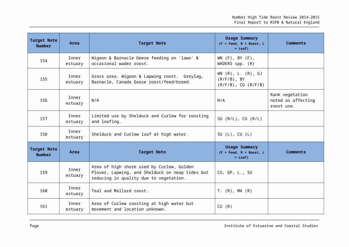
Humber High Tide Roost Review 2014-2015Final Report to RSPB & Natural England
Map 5: Outer Estuary (Coastal) Roost Information
Page Institute of Estuarine and Coastal Studies
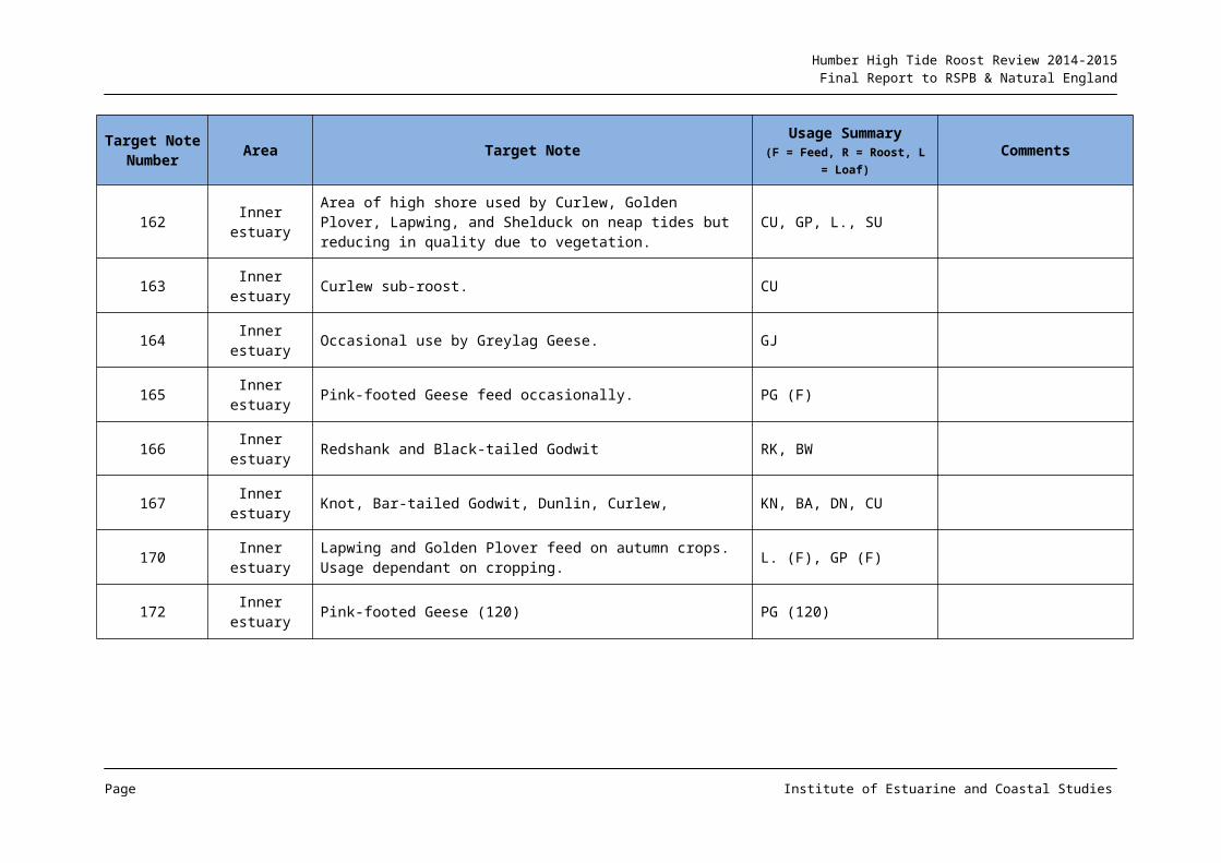
Humber High Tide Roost Review 2014-2015Final Report to RSPB & Natural England
Map 5a: Outer Estuary (Coastal) Roost Information. Enlarged Saltfleetby to Theddlethorpe Area
Page Institute of Estuarine and Coastal Studies
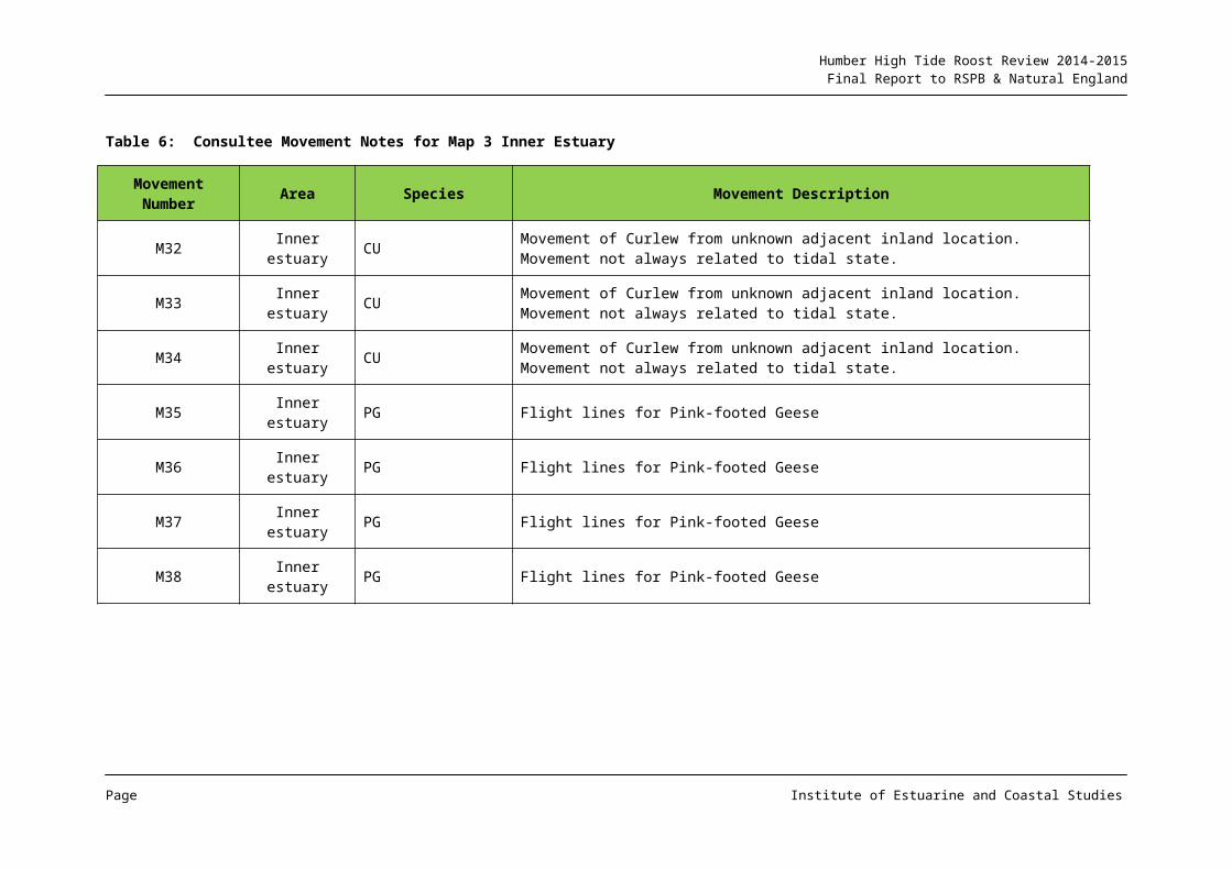
Humber High Tide Roost Review 2014-2015Final Report to RSPB & Natural England
Table 9: Consultee Target Notes for Map 5 Outer Estuary (Coastal)
Target Note Number Area Target Note Usage Summary
(F = Feed, R = Roost, L = Loaf)Comments
57 Outer Coastal Curlew peak at 450 in winter. These move in with rising tide. CU (450)
58 Outer Coastal In the winter Twite (TW) peak at 170, Snow Bunting peak at 200, Shore Lark peak at 16 and Carrion Crow peak at 250.
TW (170), SB (200), SX (16), C. (250)
59 Outer Coastal
Black-headed Gull peak in August and September at c.7000, Common Gull peak at 8000 between October and December, Herring Gull peak at 2500 in winter (migration) and Great Black-backed Gull peak at 100 in winter.
BH (C7000), CM (8000, HG (2500), GB (100)
Dog walkers are a major disturbance to these roosts and horse riders and motorbikes are also occasionally causing disturbance.
60 Outer Coastal Ringed Plover peak at 150 in spring, and Sanderling peak at 100 and Dunlin peak at 200 in later summer/autumn at migration.
RP (150), SS (100), DN (200)
61 Outer Coastal Ringed Plover peak at 150 in spring, and Sanderling peak at 100 and Dunlin peak at 200 in later summer/autumn at migration.
RP (150), SS (100), DN (200)
62 Outer Coastal Curlew 150. CU (150)
63 Outer CoastalOystercatcher peak at 1000, Dunlin peak at 750, Knot peak at 6000, Shelduck peak at 250, Ringed Plover peak at 200, Bar-tailed Godwit peak at 50 and Golden Plover peak at 50.
OC (1000), DN (750), KN (6000), SU (250), RP (200), BA (50), GP (50)
64 Outer Coastal Dark-bellied Brent Goose 350. DB (350)
65 Outer Coastal Twite 100. TW (100)
66 Outer Coastal Twite 100. TW (100)
67 Outer Coastal Dark-bellied Brent Goose 350. DB (350)
Page Institute of Estuarine and Coastal Studies
Humber High Tide Roost Review 2014-2015Final Report to RSPB & Natural England
Target Note Number Area Target Note Usage Summary
(F = Feed, R = Roost, L = Loaf)Comments
68 Outer Coastal Dark-bellied Brent Goose peak at 700. DB (700)
69 Outer Coastal The saltmarsh supports winter feeding flocks of Skylark (500), Twite (120) and Rock Pipit (60).
S. (500), TW (120), RC (60)
70 Outer Coastal Twite 120. TW (120)
71 Outer Coastal Redshank (120), Golden plover (2500), Lapwing (1500), Dark-bellied Brent Goose (500), Shelduck (250), Knot (800).
RK (120), GP (2500), L. (1500), DB (500), SU (250), KN (800)
72 Outer Coastal Curlew (120) CU (120)
73 Outer Coastal Curlew (120) CU (120)
74 Outer Coastal Bar-tailed godwit (50), Dunlin (350), Knot (500). BA (50), DN (350), KN (500)
75 Outer Coastal Saltmarsh supports c.150 Skylark, 20 Rock Pipit, 25 Twite and 100 Linnet.
S. (C.150), RC (20), TW (25), LI (100)
76 Outer Coastal Little Egret (40) and Redshank (170). ET (40), RK (170)
77 Outer Coastal Saltmarsh valuable for breeding Redshank. RK (B)
78 Outer Coastal Golden Plover (2000), Lapwing (2000), Dark-bellied Brent Goose (800), Shelduck (450)
GP (2000), L. (2000), DB (800), SU (450)
79 Outer Coastal Snow Bunting peak at 400, Shore Lark peak at 20, Twite peak at 80 and Linnet peak at 150.
SB (400), SX (20), TW (80), LI (150)
80 Outer Coastal Lapwing (300) Roost. L. (300R)
81 Outer Coastal Twite 130. TW (130)
Page Institute of Estuarine and Coastal Studies
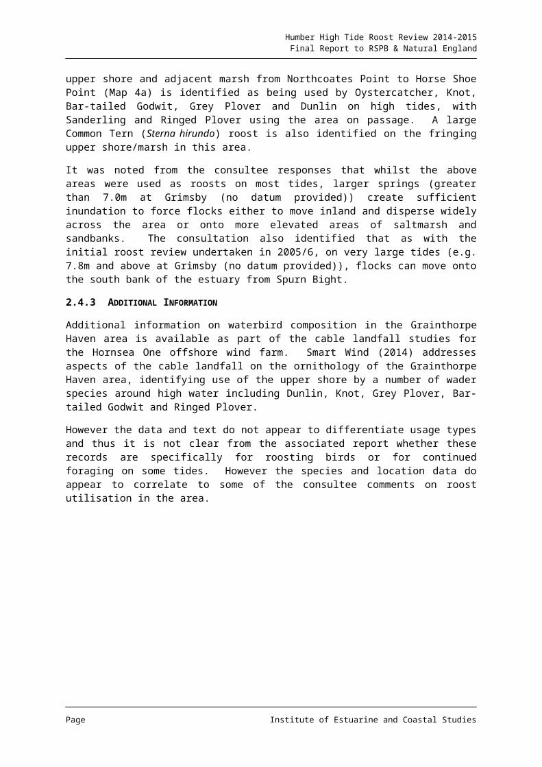
Humber High Tide Roost Review 2014-2015Final Report to RSPB & Natural England
Target Note Number Area Target Note Usage Summary
(F = Feed, R = Roost, L = Loaf)Comments
82 Outer Coastal Skylark (120), Rock Pipit (30). S. (120), RC (30)
83 Outer Coastal Teal (600), Mallard (180) and Wigeon (120). T. (600), MA (180), WN (120)
84 Outer Coastal Curlew peak at 250. CU (250)
85 Outer Coastal Shelduck peak at 200. SU (200)
86 Outer Coastal Teal peak at 250 and Wigeon peak at 350. T. (250), WN (350)
87 Outer Coastal Snipe (20) SN (20)
88 Outer Coastal Redshank (150) and Knot (100) RK (150), KN (100)
89 Outer CoastalLapwing (200), Ringed Plover peak at 100, Dunlin peak at 100, Oystercatcher (80), Bar-tailed Godwit (20), Grey Plover (25) and Knot (100).
L. (200), RP (100), DN (100), OC (80), BA (20), GV (25), KN (100)
90 Outer Coastal Curlew peak at 250 CU (250)
91 Outer Coastal Snipe (30) SN (30)
92 Outer CoastalSeasonal lagoon supporting a peak of 450 Curlew in winter, occasional Whooper Swan (20), Mallard (80), Shoveler (35), Redshank (75)
CU (450), WS (20), MA (80), SV (35), RK (75)
93 Outer Coastal Saltmarsh supports a regular flock of c.500 Skylark, 100 Rock Pipit, 80 Linnet and raptor roost
S. (c.500), RC (100), LI (80)
Dog walkers cause disturbance along upper saltmarsh
173 Outer Coastal No information provided but locations linked to TN 86 & TN 92 via MN 10 & MN 8
No additional information supplied
Target Note Area Target Note Usage Summary Comments
Page Institute of Estuarine and Coastal Studies

Humber High Tide Roost Review 2014-2015Final Report to RSPB & Natural England
Target Note Number Area Target Note Usage Summary
(F = Feed, R = Roost, L = Loaf)Comments
Number (F = Feed, R = Roost, L = Loaf)
171 Outer Coastal No information provided but locations linked to TN 86 via MN 8 No additional information supplied
Table 10: Consultee Movement Notes for Map 5 Outer Estuary (Coastal)
Movement Number Area Species Movement Description
M7 Outer Coastal CU CurlewM8 Outer Coastal No info. supplied No additional information supplied
M9 Outer Coastal No info. supplied No additional information supplied
M10 Outer Coastal No info. supplied No additional information suppliedM11 Outer Coastal DB Dark-bellied Brent gooseM12 Outer Coastal DB Dark-bellied Brent gooseM13 Outer Coastal TW TwiteM14 Outer Coastal RP, SS, DN Ringed Plover, Sanderling, Dunlin
Page Institute of Estuarine and Coastal Studies

Humber High Tide Roost Review 2014-2015Final Report to RSPB & Natural England
4. DISCUSSION
4.1 Coverage
The consultation exercise produced a reasonable response in terms of area coverage and, in conjunction with information from other professional counters and a range of grey and published literature sources, it is therefore considered that the results of the exercise as presented are a fair representation of current knowledge on key roost areas around the estuary.
4.2 Change in Patterns or Levels of Use
As part of the consultation exercise, a request was made to consultees to describe any alterations in usage patterns or levels that they may have observed between the current assessment period and that of the early 2000s. This aspect of the data collection process was perhaps less successful with relatively few comments received, and it remains uncertain whether an absence of comment indicates no change in use levels or patterns or is simply an absence of sufficient information for the counter to expand upon. Indeed it is fully acknowledged that the WeBS process does not require such a level of recording either in terms of function or historical comparison and as such, any information on potential changes over time is considered a bonus of the consultation exercise rather than a failing.
Although no detailed direct comparison in roost extent, composition and level of utilisation between the two assessment periods has been undertaken as part of this review, there remain a number of areas that were identified as roost sites for some species in the mid-2000s that continue to deliver that function for the more recent reporting period. Indeed the consultee response identified TN 101 as continuing to be used in a similar way to that described by Tasker and Milson in the late 1970s.
However, the consultation process did record a number of instances where a roost area was identified as having declined in use over time. Primarily the cause for this decline was attributed to vegetation changes, and in particular, increased growth/sward height e.g. TN 30. Improved drainage was also identified as having a potentially detrimental effect on roost use e.g. TN 13 for Curlew.
However, primarily, alterations in use were attributed to crop height and type. Many of these comments were not necessarily linked to an absolute decline in use, but rather a modification in use within the area depending on cropping (e.g. TN 37 & TN 38). Such a conclusion would appear reasonable although has implications for ongoing management of the estuary in terms of maintaining and/or enhancing roost potential.
Disturbance was identified as affecting roosts, although not necessarily causing a decline in take-up compared to the previous review period (see Section 4.3).
Given the apparent decline in the status of a number of key species across much of the estuary (e.g. Golden Plover and Lapwing) shown in Appendix 1, the absence of a large body of consultee response relating to roost status change is perhaps unexpected. However, as noted above, given that roost utilisation is not a primary recording aim of the WeBS process, the absence of many definitive comments relating to roost utilisation declines might be expected as an artefact of the wider WeBS process.
Page Institute of Estuarine and Coastal Studies
Humber High Tide Roost Review 2014-2015Final Report to RSPB & Natural England
It is however interesting that for the most part, where declines have been recorded, these are ascribed to either vegetation growth, land drainage and changes in agricultural practice. Whilst components of such change cannot be readily managed (e.g. large scale vegetation change in the estuary), there is the potential for management of land use to address some aspects, and, given the variation in take-up currently identified as a result of cropping, then the potential for roost provision enhancements to be introduced.
4.3 Disturbance
As noted above, the consultation process included several responses that indicated that disturbance stimuli were affecting roost utilisation and potential e.g. TN 108 and TN 59. Detailed disturbance sources and responses were not provided, but were primarily relating to public right of way access adjacent to the roost site e.g. walkers, dog walkers, horse riders and motor bikes.
It is emphasised that these responses do not represent a statistically robust disturbance cause and effect study, but do indicate the potential problem that disturbance can create, in particular one respondent for TN 109 commented that given the level of access and disturbance around this roost site, the continued use of the location potentially indicates an absence of any alternative, less disturbed roost sites.
The issue of public disturbance to high tide roosts certainly requires consideration when considering the wider management of the estuary, and again, the relatively low number of respondent comments regarding this issue, whilst initially perhaps surprising, may simply be an artefact of a functional shift by waterbirds to less disturbed roost areas e.g. an ongoing disturbance potential means that most habitual roosts sites are chosen because of an absence of disturbance, and as such, only where no alternatives are available, or that disturbance is more ad hoc, are the effects readily noted. Information gathering relating to waterbird disturbance responses from primarily recreational activity on the Humber has been undertaken in recent years by the Humber Nature Partnership (e.g. Ross & Liley, 2014), with a wider review of activities including construction work responses described by Cutts et al (2009) and Environment Agency (2012).
4.4 Habitat Enhancement
Whilst many of the consultee comments were for aspects detrimentally affecting roost provision, there were some comments regarding new roost use from habitat enhancement. For instance the managed realignment site at Paull Holme Strays was identified as supporting several species of roosting waders, whilst the Kilnsea Wetlands (TN141) were noted as being used by a range of roosting and foraging birds including Golden Plover, Grey Plover, Knot, Redshank, Curlew and Oystercatcher.
As such, there is evidence to indicate that new roost habitat can be successfully delivered on the Humber, and there is the potential for additional roost capacity to be designed into managed realignment sites and other habitat creation projects. In particular, given the potential difficulties in delivering sustainable mudflat habitat across all of a compensatory site, then the delivery of roost function in areas unsuitable for mudflat would be of value.
Page Institute of Estuarine and Coastal Studies
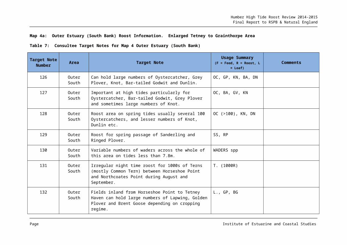
Humber High Tide Roost Review 2014-2015Final Report to RSPB & Natural England
5. REFERENCES
ABPmer. 2009. Grimsby RO-RO Berth Environmental Statement, R1506. Report to Associated British Ports.
Brooks Ecological. 2011. Ecology – Technical Appendices. Land at and adjacent to Brough Airfield, Brough, East Riding of Yorkshire.
Brooks Ecological. 2012. Winter/Passage Bird Update Survey and Assessment 2011-2-12. Land adjacent to Brough Airfield, Brough, East Riding of Yorkshire. Report Number BE-R-1348-01.
Cutts N, Phelps A & Burdon D. 2009. Construction and Waterfowl: Defining Sensitivity, Response Impacts and Guidance. Report to Humber INCA. University of Hull.
Cutts N, Thomson S & L Mander. 2009. SHBZ Functional Capacity Study: Results of the Mapping and Analysis of Avifaunal Usage. Report to Mott MacDonald.
ECUS Environmental Consultants. 2014. Bagletts Wind Farm: Habitat Regulations Assessment Report. Report to Lantanier UK.
Environment Agency. 2008. The Implications of Coastal Change on Natura 2000 Features of the Lagoons at Easington. Environment Agency.
Environment Agency. 2012. Avian Disturbance and Flood and Coastal Risk Management Construction Activities. University of Hull.
Environmental Resources Management. 2011. Effect of the Loss of Farmland on Waterfowl from the Humber Estuary SPA/Ramsar Site due to the Creation of the Proposed AMEP Intertidal Compensation Site. Report to Able UK Ltd.
FPCR Environment and Design Ltd. 2013. Melton Park, North Ferriby. Habitat Regulations Assessment. Report to St Modwen Properties.
Mander, L, Cutts N & Thomson S. 2006. Review of High Tide Waterfowl Roosting and Foraging Sites on the Humber Estuary. Report to Natural England.
Ross K & Liley D. 2014. Humber Winter Disturbance Study. Report to the Humber Management Scheme by Footprint Ecology.
Smart Wind. 2014. Clarification Note Relating to the Impacts of the Export Cable Installation on Intertidal Birds and the Humber Estuary SPA and Ramsar Site.
Tasker M & Milsom T. 1979 Birds of the Humber Estuary. University of Hull.
The Food and Environment Research Agency. Undated. Ornithological Briefing Report, Far Marsh Farm 2008/9. Autumn Passage and Wintering Bird Surveys. Report to A & K Wielkopolski.
URS Infrastructure & Environment UK Ltd. 2011. Green Port Hull Environmental Statement Volume 1. Report to Associated British Ports.
Page Institute of Estuarine and Coastal Studies
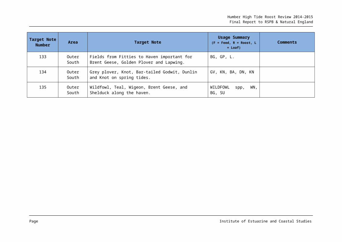
Humber High Tide Roost Review 2014-2015Final Report to RSPB & Natural England
URS Infrastructure & Environment UK Ltd. 2013. Immingham Western Deepwater Jetty Environmental Statement Volumes 1 and 2. Report to Associated British Ports.
Page Institute of Estuarine and Coastal Studies
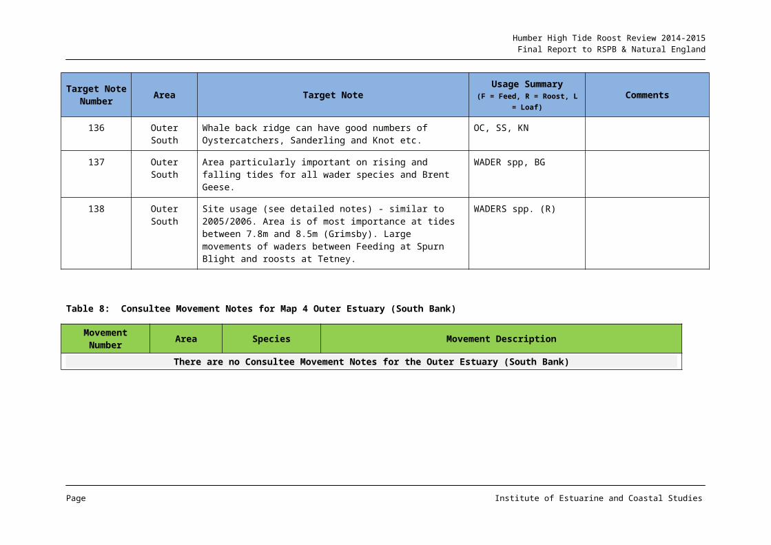
Humber High Tide Roost Review 2014-2015Final Report to RSPB & Natural England
ANNEX 1: WATERBIRD STATUS CHANGES
As described in Section 1.2, analysis of WeBS 5 year annual mean maxima data has been performed for the periods 1999-2004 and 2007-2012.
It is emphasised that whilst it was not a primary aim of the project to provide bird population trend analysis, this analysis was carried out in order to provide context for the consultees and to encourage consideration and comment on any changes in usage which may have been observed, especially since the previous high tide roost mapping exercise carried out in 2006.
In similar vein, this analysis is reproduced here as useful contextual information for interpretation of the main text.
Page Institute of Estuarine and Coastal Studies
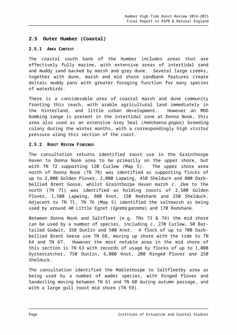
Humber High Tide Roost Review 2014-2015Final Report to RSPB & Natural England
A1.1 Waterbird Community
Figure A1 provides a summary of population change for all WeBS sectors on the Humber and for all waterbirds. The Figure suggests that there has been a considerable reduction in waterbird numbers (e.g. a decrease of over 25%) on around 50% of the WeBS sectors, and an increase in excess of 25% on only 6 sectors for which comparable data are available.
Figure A1: Population Change: All Waterbirds
There is little spatial pattern to the areas of reduction, with this occurring on both banks and from inner, middle and outer estuary sectors. Sectors having seen a decrease of over 50% in total waterbird numbers are:
35478, 35480, 35481, 35487, 38401, 38407, 38411, 38412, 38417, 38419, 38432, 38436 and 38905, with the greatest single decrease of 87% from sector 38487 on the south bank of the outer estuary.
The largest numerical reduction in 5 year annual mean values between the two analysis periods was in excess of 13,000 birds in sector 38401 in the outer estuary, with the adjacent sector 38407 recording a reduction of over 10,000 individuals. Additional reductions in excess of 10,000 birds were also recorded from sectors in the inner and middle estuary.
Increases in usage of over 50% have been recorded from sectors 38409, 38424 and 38430, the latter from the inner estuary featuring an increase of 838%. The greatest numerical increase of over 9,000 individuals was recorded from sector 38443 in the outer estuary north bank, but with an increase of over 5,000 birds also recorded from the inner estuary.
Page Institute of Estuarine and Coastal Studies
Humber High Tide Roost Review 2014-2015Final Report to RSPB & Natural England
However, given the potential for more abundant species such as Knot, Golden Plover and Lapwing to mask patterns of use by other species, an analysis of change for key species is of value to potentially identify more specific trends for species, areas or functions.
The following Annex section provides a series of population change maps for individual species, together with a short review text. The species selection covers most birds covered by counter responses described in the main report text.
Page Institute of Estuarine and Coastal Studies
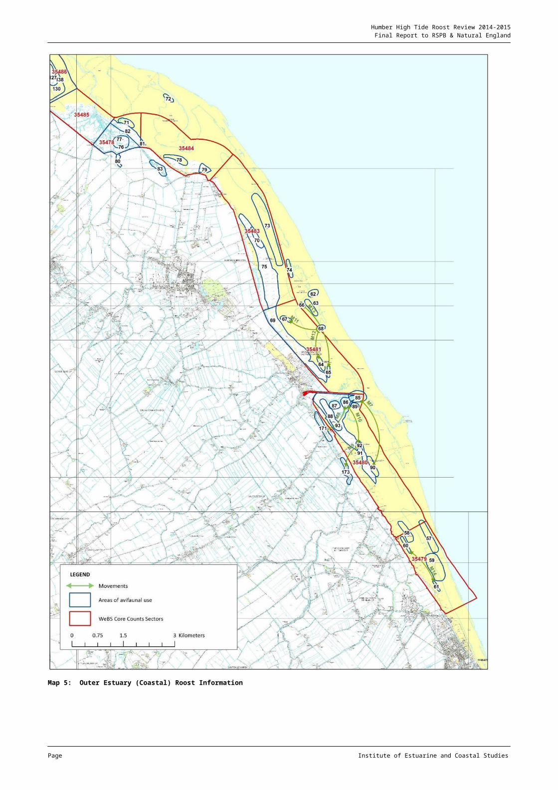
Humber High Tide Roost Review 2014-2015Final Report to RSPB & Natural England
A1.2 Pink-footed Goose
Figure A2: Population Change: Pink-footed Goose
Primarily a species of the inner estuary, the Pink-footed Goose has shown a decline in usage between the two analysis periods in this area. However, given the ecology of the species, including inland feeding and loafing activity, then small changes between sections are likely within the region.
In fact the data indicate that a net increase has occurred for the species across the Humber, with an increase of over 1,500 birds on the main sector of importance (38418), and relatively small numerical, albeit large percentage reductions having occurred on adjacent areas.
Page Institute of Estuarine and Coastal Studies
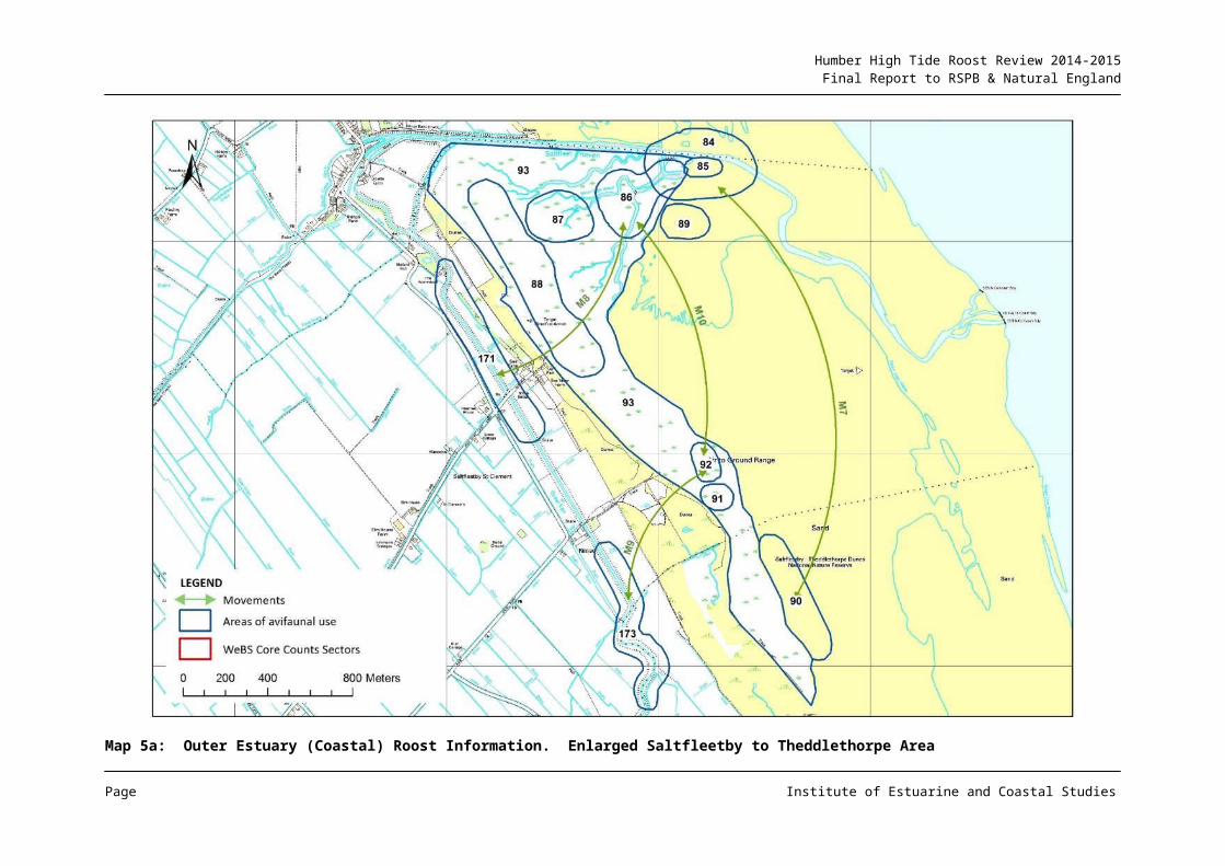
Humber High Tide Roost Review 2014-2015Final Report to RSPB & Natural England
A1.3 Greylag Goose
Figure A3: Population Change: Greylag Goose
The population of the species on the Humber has continued to increase, with the species resident in many areas of the estuary, and in particular, present in large numbers on the upper Humber where a breeding population is established on Whitton Sand.
Page Institute of Estuarine and Coastal Studies
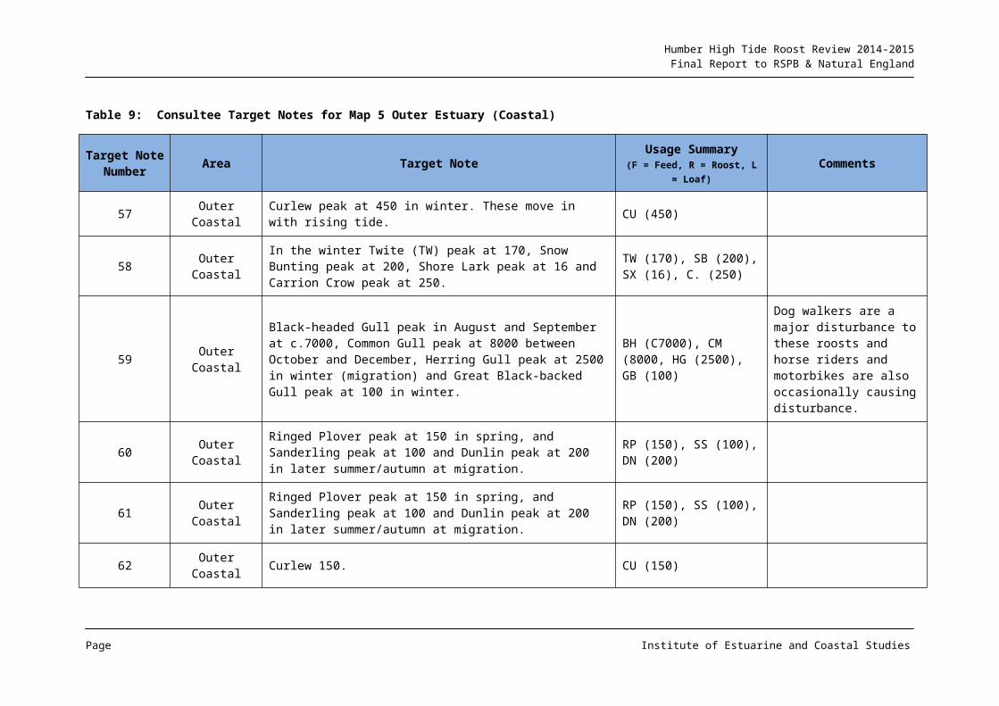
Humber High Tide Roost Review 2014-2015Final Report to RSPB & Natural England
A1.4 Canada Goose
Figure A4: Population Change: Canada Goose
As with the Greylag, a large naturalised population is now present on the Humber, with vegetated areas of the upper estuary used in particular. However, the figure indicates that whilst some areas have seen a continued increase in numbers, this has not been uniform, with declines observed in a number of sectors, and the population across the estuary being relatively stable.
Page Institute of Estuarine and Coastal Studies
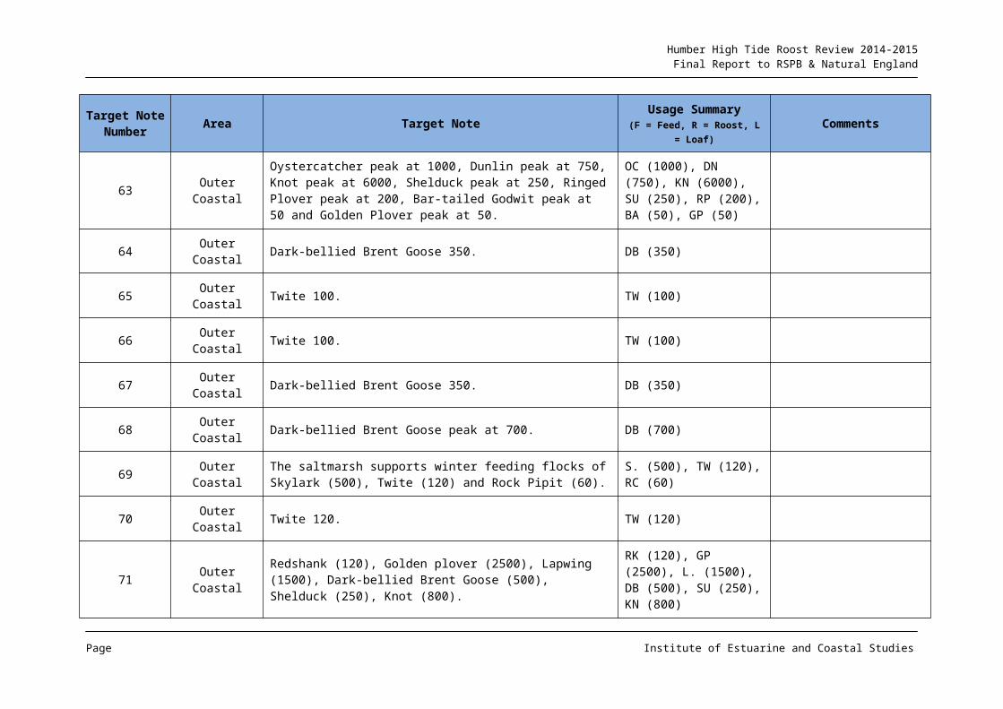
Humber High Tide Roost Review 2014-2015Final Report to RSPB & Natural England
A1.5 Barnacle Goose
Figure A5: Population Change: Barnacle Goose
The species is less well distributed across the estuary compared to other naturalised species, but has a concentrated distribution on the upper estuary. This population has risen considerably in recent years from a few birds, and a large resident breeding flock is now present.
The increase in the status of the species in the outer estuary north bank is of some note, given that it could lead to a rapid expansion of the population as seen in the upper estuary.
Page Institute of Estuarine and Coastal Studies
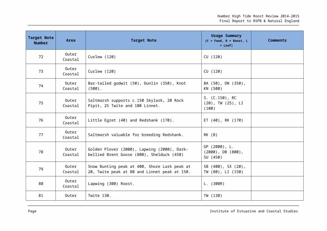
Humber High Tide Roost Review 2014-2015Final Report to RSPB & Natural England
A1.6 Brent Goose
Dark-bellied Brent Goose
Figure A6: Population Change: Dark-bellied Brent Goose
There appears to have been a net gain in overall maxima across the periods, but with shifts in usage.
The species is primarily associated with the outer estuary and there would appear to have been a series of movements between sectors such that Spurn Bight has increased in importance and with similar shifts in the outer estuary south bank. Within the context of the Humber population, the increases in numbers seen from inner estuary sectors are of low importance.
Light-bellied Brent Goose
The Svalbard race is relatively uncommonly recorded on the Humber but its status has increased in the outer estuary (population change not mapped due to low numbers).
Page Institute of Estuarine and Coastal Studies
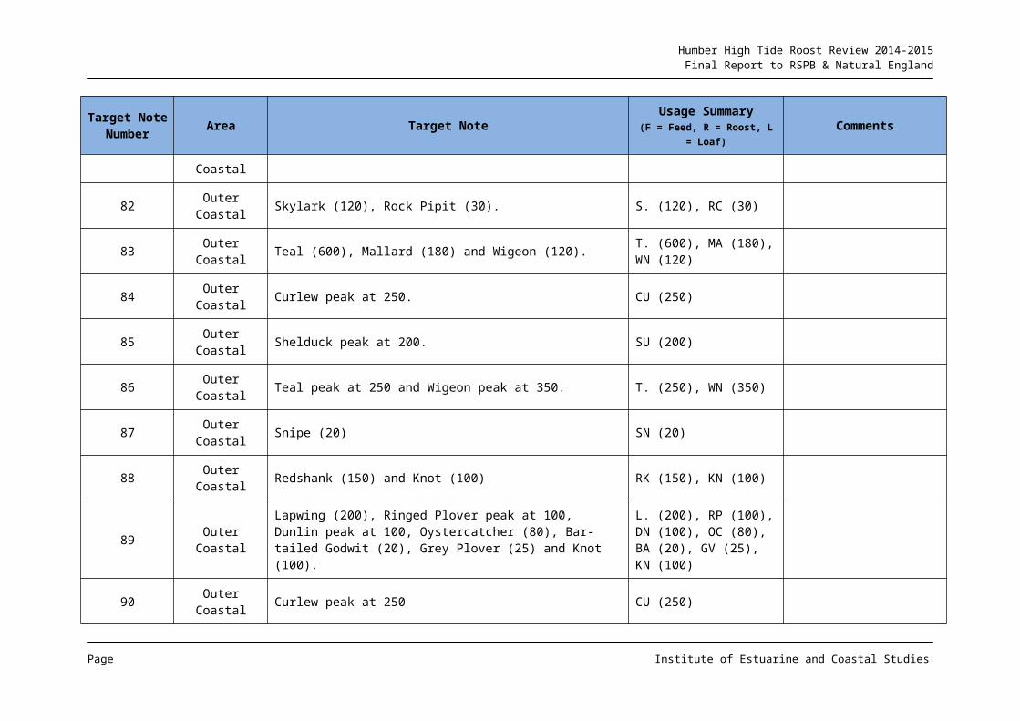
Humber High Tide Roost Review 2014-2015Final Report to RSPB & Natural England
A1.7 Shelduck
Figure A7: Population Change: Shelduck
From the figure it would appear that there has been considerable change to the importance of many count sectors for the species, with the inner and outer estuary still remaining of key importance but with shifts in use from north to south bank and vice versa.
There would appear to have been a considerable increase in the use of sectors 38441 to 38443 by c. 1,750 individuals, despite there being areas of vegetation growth on the intertidal area of parts of these sections.
Page Institute of Estuarine and Coastal Studies
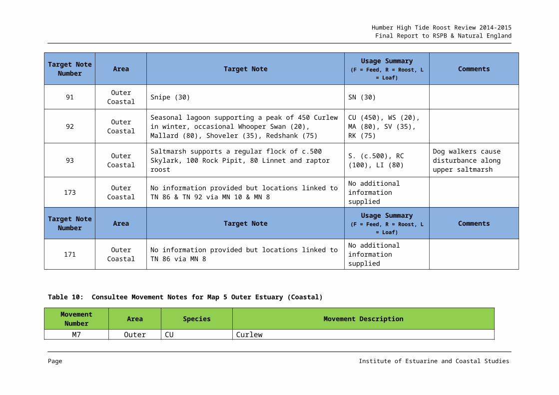
Humber High Tide Roost Review 2014-2015Final Report to RSPB & Natural England
A1.8 Wigeon
Figure A8: Population Change: Wigeon
The main area for the species (upper estuary north bank and Whitton Sand) has shown a reduction in usage by c. 1,500 individuals over the analysis periods.
There have been localised changes elsewhere in the estuary, but despite declines in numbers, the upper Humber remains the main area for the species.
Page Institute of Estuarine and Coastal Studies
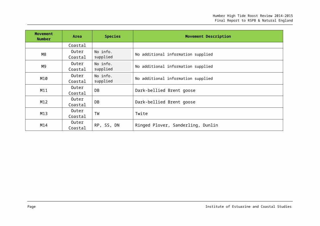
Humber High Tide Roost Review 2014-2015Final Report to RSPB & Natural England
A1.9 Mallard
Figure A9: Population Change: Mallard
Historically the inner estuary has supported the greatest numbers of Mallard, but this has declined in recent decades, with a shift in key area to the outer middle/outer estuary north bank. However the figure shows that this area has seen a substantial reduction in numbers by around 900 individuals, and a reduction in the population from Hull to Spurn declining by around a half, although with a net reduction in numbers across the estuary.
The lower Ouse/Blacktoft Sands area has not followed this trend, with a considerable increase in the numbers recorded. Whether this is an artefact of recording variation between the analysis periods or an actual increase in the population here is uncertain.
Page Institute of Estuarine and Coastal Studies
Humber High Tide Roost Review 2014-2015Final Report to RSPB & Natural England
A1.10 Avocet
Figure A10: Population Change: Avocet
The species has undergone a range expansion in recent decades and has become an established breeder on the Humber.
Whilst usage tends to be concentrated around breeding sites e.g. Read’s Island and Blacktoft Sands, there is a pre and post breeding dispersal to adjacent sectors, with other breeding sites also being developed (e.g. Whitton Sand) as well as inland areas.
Page Institute of Estuarine and Coastal Studies
Humber High Tide Roost Review 2014-2015Final Report to RSPB & Natural England
A1.11 Oystercatcher
Figure A11: Population Change: Oystercatcher
Primarily a species of the outer estuary, there would appear to have been a reduction in numbers at the key sectors, with a decline of over 1,000 individuals recorded.
Whilst on the south bank it would seem that there has simply been a localised shift in the key sectors, there would appear to have been a net loss in use on the north bank in Spurn Bight (over 1,500 birds). The data suggest a possible shift in utilisation from this outer north bank area to the outer south bank with coastal sectors showing a net increase of over 1,000 birds albeit with some localised loss:gains between sectors.
Page Institute of Estuarine and Coastal Studies
Humber High Tide Roost Review 2014-2015Final Report to RSPB & Natural England
A1.12 Golden Plover
Figure A12: Population Change: Golden Plover
Apart from primarily the Welwick section on the north bank, which has seen a considerable increase in usage by around 8,000 individuals, most key sectors for the species have undergone a decline in numbers between the two analysis periods.
Page Institute of Estuarine and Coastal Studies
Humber High Tide Roost Review 2014-2015Final Report to RSPB & Natural England
A1.13 Grey Plover
Figure A13: Population Change: Grey Plover
Primarily a species of the middle to outer estuary in terms of distribution on the Humber, there has been an increase in sector importance on the north bank middle estuary and a reduction in north and south bank outer utilisation.
Page Institute of Estuarine and Coastal Studies
Humber High Tide Roost Review 2014-2015Final Report to RSPB & Natural England
A1.14 Lapwing
Figure A14: Population Change: Lapwing
The species is often associated with Golden Plover, both in fields adjacent to the estuary and on the intertidal mudflats used primarily as a loaf/roost when no inundated during daylight hours.
As with Golden Plover, the area around Blacktoft Sands has shown an increase in utilisation, although with a corresponding (if not greater) reduction in adjacent sectors. The middle and outer estuary (both banks) has shown a fairly consistent reduction with the reach from Hull to Spurn which has historically supported some of the largest concentrations of the species, seeing a reduction of over 10,000 individuals.
Page Institute of Estuarine and Coastal Studies
Humber High Tide Roost Review 2014-2015Final Report to RSPB & Natural England
A1.15 Ringed Plover
Figure A15: Population Change: Ringed Plover
The species tends to be present in greatest numbers in the outer estuary, but with some middle estuary sectors also being used by sizeable flocks. The figure indicates that whilst there have been reductions in usage in some sectors, these have largely been offset by increases on adjacent sectors.
Page Institute of Estuarine and Coastal Studies
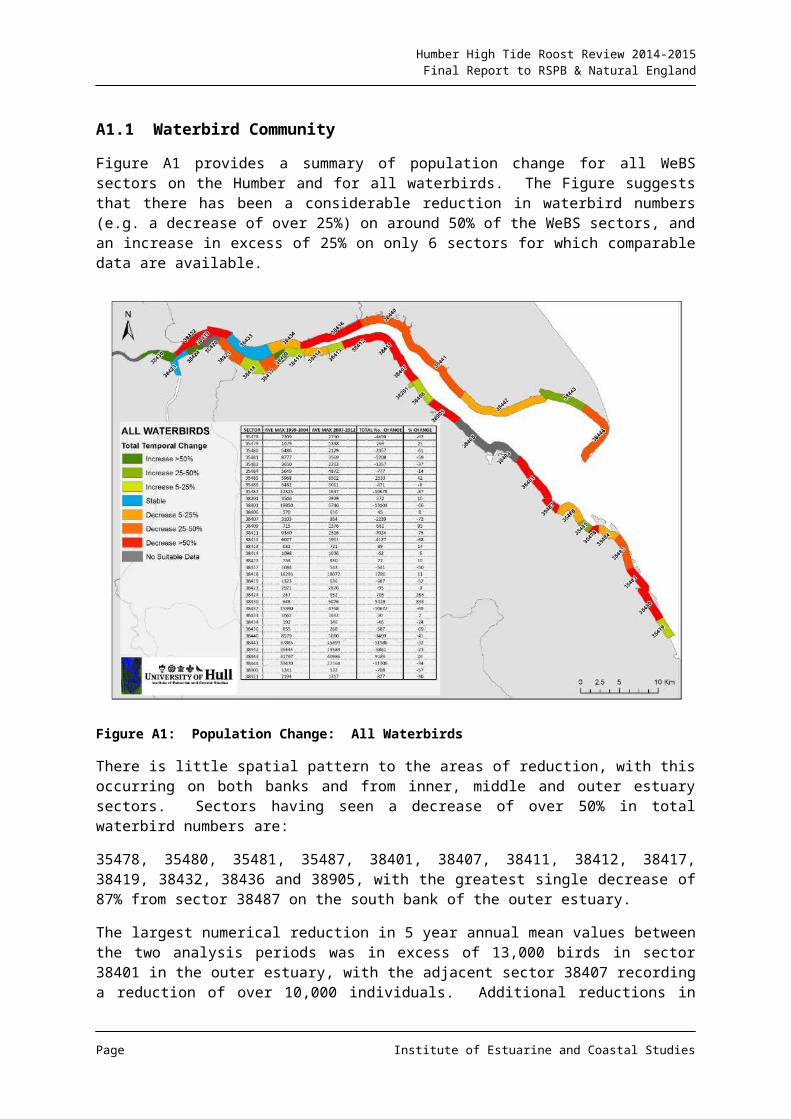
Humber High Tide Roost Review 2014-2015Final Report to RSPB & Natural England
A1.16 Curlew
Figure A16: Population Change: Curlew
Interestingly, the shift between sectors 38443 and 38442 seen for Bar-tailed Godwit (see A1.18), is reversed for Curlew, although with Spurn again seeing a reduction in numbers. Elsewhere there is little pattern to change, although again the area around Read’s Island has shown a large rise in use.
Page Institute of Estuarine and Coastal Studies
Humber High Tide Roost Review 2014-2015Final Report to RSPB & Natural England
A1.17 Black-tailed Godwit
Figure A17: Population Change: Black-tailed Godwit
The species has increased in status on the Humber in recent decades and whilst initially fairly dynamic in sector utilisation, usage is now primarily centred around the roost on North Killingholme Pits, this area featuring an increase of over 2000 individuals between years. However it is also noted that the sector including Paull Home Strays has also featured an increase in use post breach.
Page Institute of Estuarine and Coastal Studies
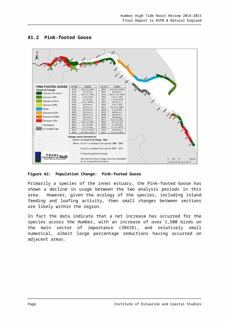
Humber High Tide Roost Review 2014-2015Final Report to RSPB & Natural England
A1.18 Bar-tailed Godwit
Figure A18: Population Change: Bar-tailed Godwit
A species present in greatest numbers in the outer middle to outer estuary, the figure indicates that there has been a shift in use from what was the core area east of Welwick, to the sector to the west. Spurn also saw a reduction, but with an increase on the opposite bank.
Page Institute of Estuarine and Coastal Studies
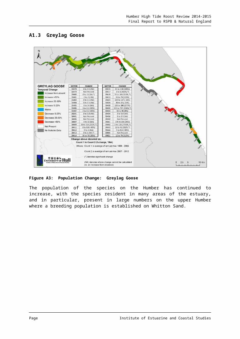
Humber High Tide Roost Review 2014-2015Final Report to RSPB & Natural England
A1.19 Turnstone
Figure A19: Population Change: Turnstone
Often associated with areas of harder substratum, whilst the figure indicates that there have been areas of loss and gain for the species, analysis of the data suggests that in the key sectors for the species, there has been a substantial reduction in numbers.
Page Institute of Estuarine and Coastal Studies
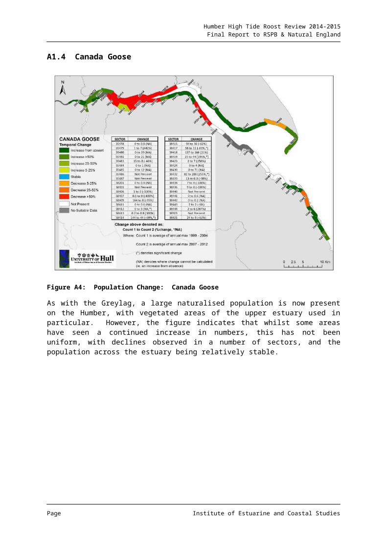
Humber High Tide Roost Review 2014-2015Final Report to RSPB & Natural England
A1.20 Knot
Figure A20: Population Change: Knot
The Knot tends to occur in large numbers in the outer estuary, and in particular, there have been records of very large flocks from the Lincolnshire coast and Spurn Bight. The figure indicates that there has been however, a reduction in flock sizes in many outer estuary areas, with an increase in usage being seen further into the estuary on both banks, although the data suggest that there has been a net loss in abundance of the species across the system as a whole.
Page Institute of Estuarine and Coastal Studies
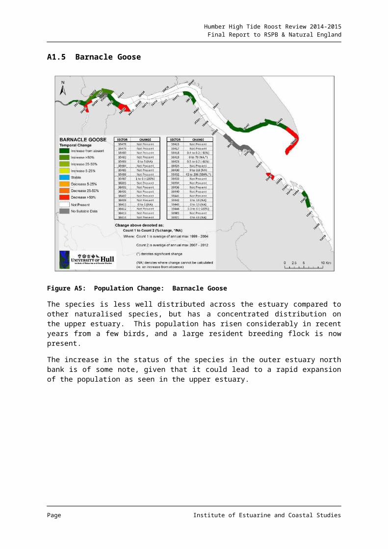
Humber High Tide Roost Review 2014-2015Final Report to RSPB & Natural England
A1.21 Ruff
Figure A21: Population Change: Ruff
Only present in small numbers, changes in sector usage are probably of a low statistical and ecological significance.
Page Institute of Estuarine and Coastal Studies
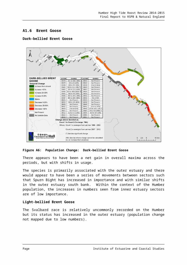
Humber High Tide Roost Review 2014-2015Final Report to RSPB & Natural England
A1.22 Sanderling
Figure A22: Population Change: Sanderling
A species with an outer estuary and coastal distribution, whilst abundance levels appear to have altered between sectors, overall numbers have remained relatively stable.
Page Institute of Estuarine and Coastal Studies
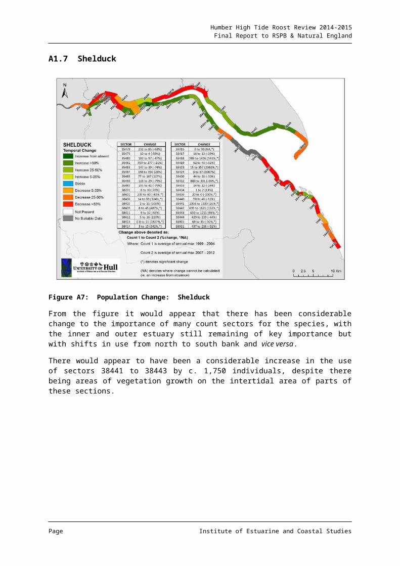
Humber High Tide Roost Review 2014-2015Final Report to RSPB & Natural England
A1.23 Dunlin
Figure A23: Population Change: Dunlin
A species characteristic of estuarine environments, declines have been noted at a national level. The figure shows that a general decline has also occurred on the Humber. The sectors where the species has been most abundant tend to be on the north bank middle to outer zone, where the loss, although less in percentage terms, has been greater numerically.
Page Institute of Estuarine and Coastal Studies
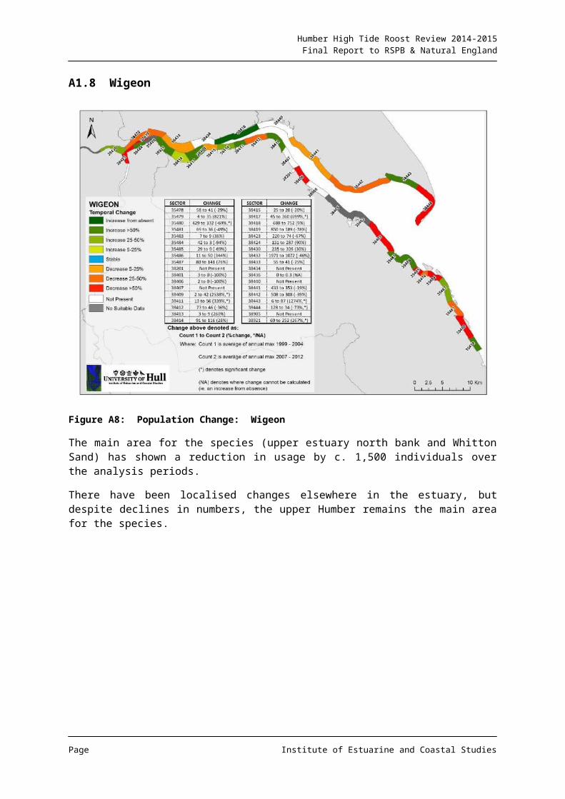
Humber High Tide Roost Review 2014-2015Final Report to RSPB & Natural England
A1.24 Redshank
Figure A24: Population Change: Redshank
The above figure indicates that there has been a fairly significant decline in the status of the Redshank in most sectors between the two analysis periods, although in numerical terms, this is perhaps most of note in the outer estuary north bank, where the largest numbers have been recorded historically. In particular, the Spurn Bight sector has seen a loss of around 3,000 individuals between the periods, this sector previously having supported a considerable percentage of the Humber population of the species.
Page Institute of Estuarine and Coastal Studies
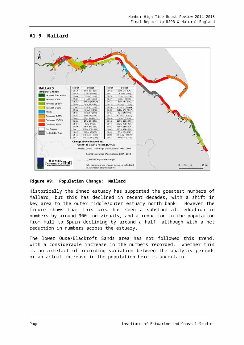
Humber High Tide Roost Review 2014-2015Final Report to RSPB & Natural England
ANNEX 2: INFORMATION REQUEST PROVIDED TO WEBS COUNTERS AND OTHER CONTRIBUTORS
The WeBS consultation exercise utilised the following instructions with a mailing including several information documents and a blank map of the relevant count sector.
Page Institute of Estuarine and Coastal Studies
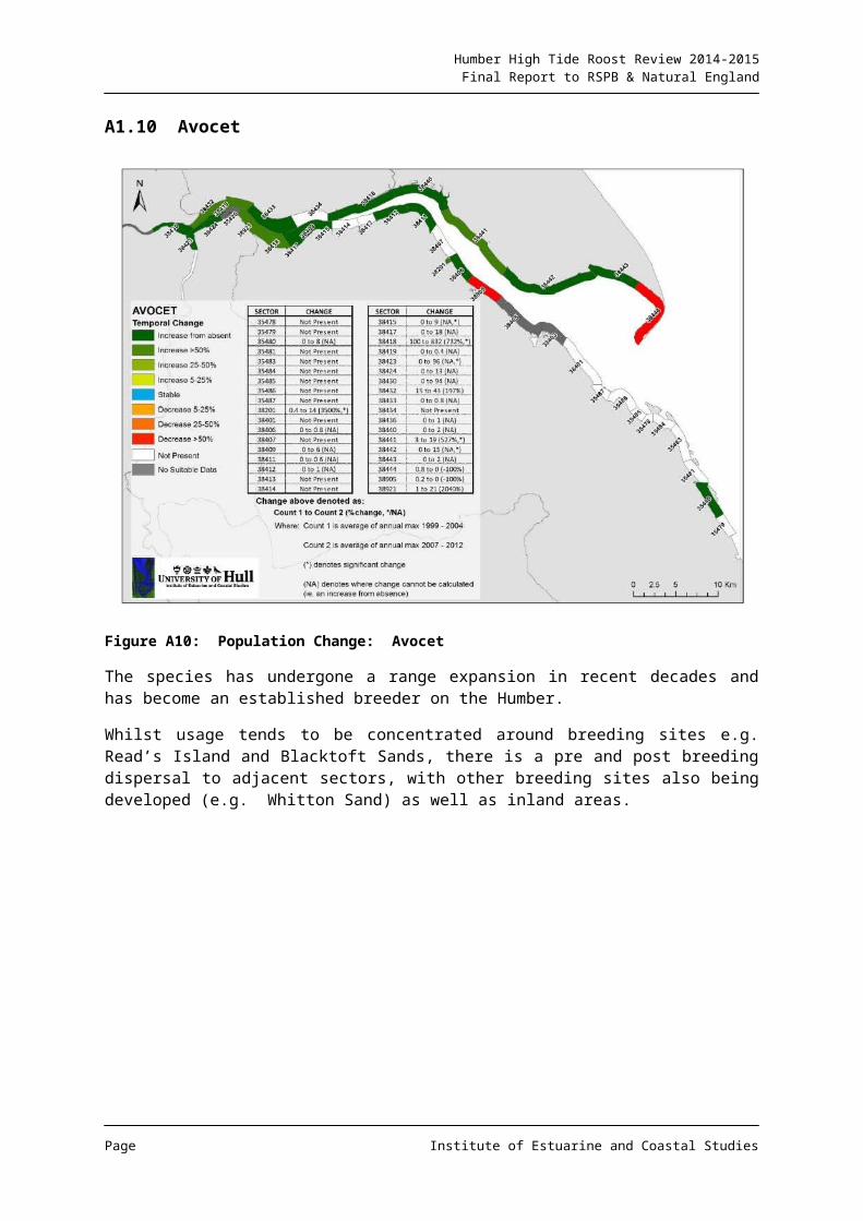
Humber High Tide Roost Review 2014-2015Final Report to RSPB & Natural England
Page Institute of Estuarine and Coastal Studies
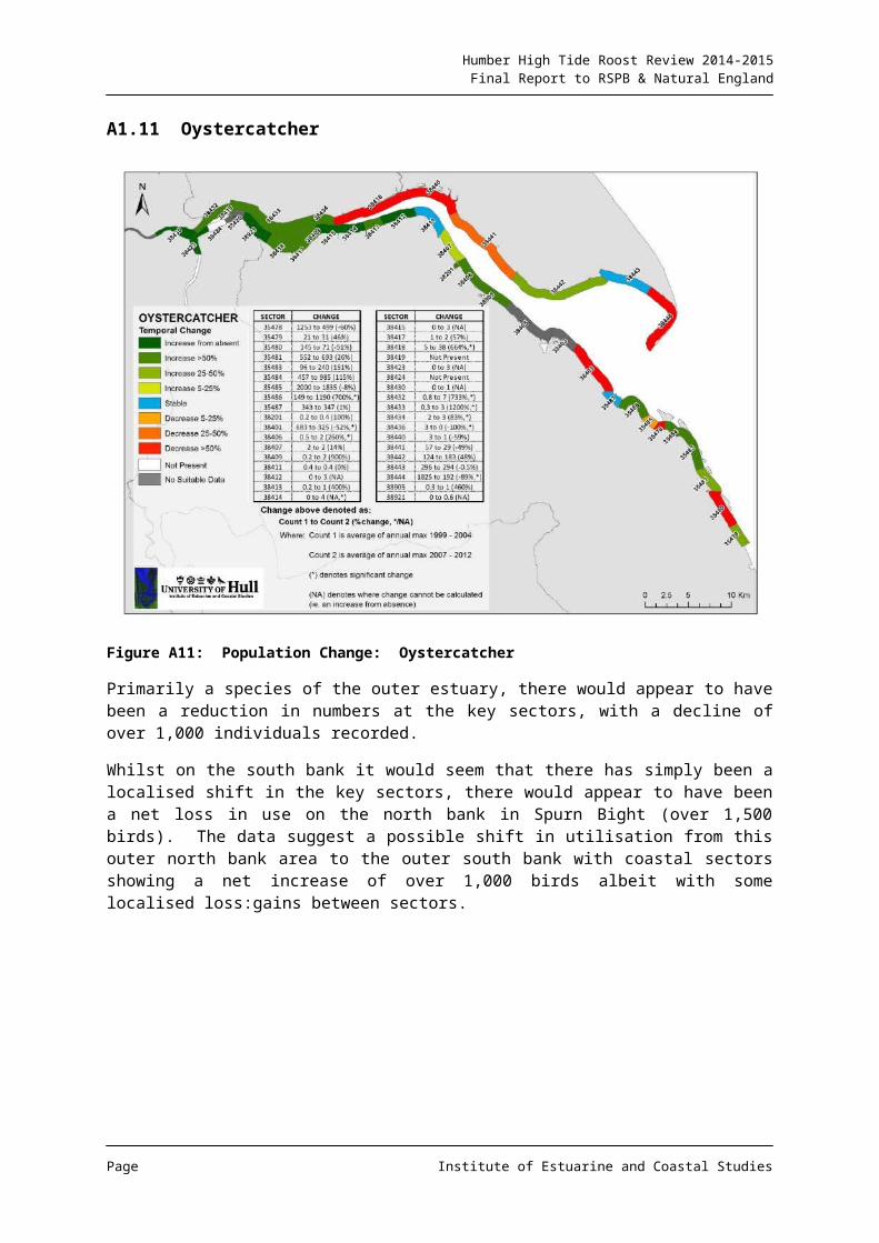
Humber High Tide Roost Review 2014-2015Final Report to RSPB & Natural England
Page Institute of Estuarine and Coastal Studies