Embed Size (px)
DESCRIPTION
The coastal sub-region of South Asia including Bangladesh, India, the Maldives, Pakistan and Sri Lanka harbours some of the world’s most significant coastal and marine ecosystems such as coral reefs, mangroves, seagrass meadows, river deltas and estuaries. They play a crucial role in reducing the effects of natural disasters. The paper reviews the status of coastal and marine ecosystem management in the region to enable adoption of an integrated approach to ecosystem management for effective risk reduction.
Citation preview
United Nations Development Programme55, Lodi EstateNew Delhi - 110003IndiaEmail: [email protected]
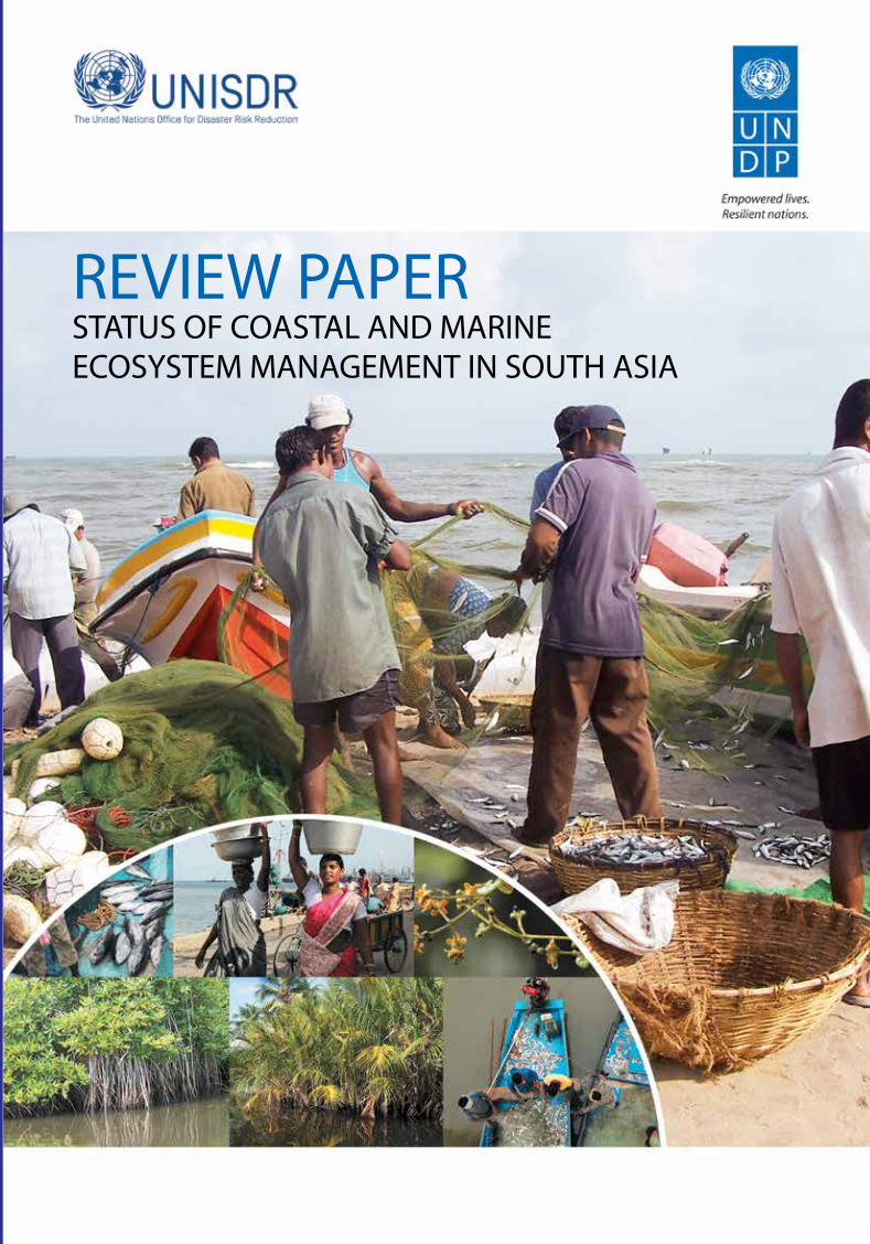
REVIEW PAPERSTATUS OF COASTAL AND MARINE ECOSYSTEM MANAGEMENT IN SOUTH ASIA
REVIEW PA
PER: STATUS O
F COA
STAL A
ND
MA
RINE ECO
SYSTEM M
AN
AG
EMEN
T IN SO
UTH
ASIA
Copyright © 2012 United Nations Office for Disaster Risk Reduction, Asia and Pacific, Thailand and the United Nations Development Programme, India.
All rights reserved. No part of this publication may be reproduced, stored in a retrieval system or transmitted, in any form or by any means, electronic, mechanical, photocopying, recording or otherwise, without prior permission.
The views expressed in this publication are those of the author(s) and do not necessarily represent those of the United Nations, including UNDP, UNISDR and their member states.
Suggested citation: UNISDR/UNDP (2012). Review Paper – Status of Coastal and Marine Ecosystem Management in South Asia. Inputs of the South Asian Consultative Workshop on “ Integration of Disaster Risk Reduction and Climate Change Adaptation into Biodiversity and Ecosystem Management of Coastal and Marine Areas in South Asia” held in New Delhi on 6 and 7 March 2012. New Delhi: UNDP. 173 pages.
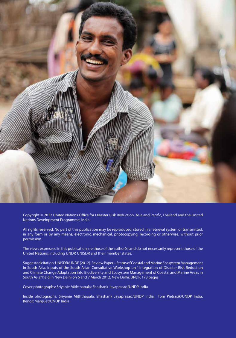
Cover photographs: Sriyanie Miththapala; Shashank Jayaprasad/UNDP India
Inside photographs: Sriyanie Miththapala; Shashank Jayaprasad/UNDP India; Tom Pietrasik/UNDP India; Benoit Marquet/UNDP India
rEVIEW PAPErStAtuS of CoAStAl And MArInEECoSyStEM MAnAgEMEnt In SoutH ASIA
Prepared by: Vishwas Sawarkar, Sriyanie Miththapala, Pramod Krishnan, Madhavi Malalgoda Ariyabandu and C. Sasikumar
Review Paper: Status of Coastal and Marine Ecosystem Management in South Asia
ii
Acknowledgements
The Review Paper is a joint effort by the United Nations Development Programme (UNDP) India and the United Nations Office for Disaster Risk Reduction (UNISDR) Asia Pacific Secretariat. The preparation of the publication was coordinated by Pramod Krishnan UNDP India and Madhavi Malalgoda Ariyabandu, UNISDR, supported by Nishu Nirula, C. Sasikumar, Tarun Kathula under the guidance of Preeti Soni and Srinivasan Iyer, UNDP India; Goulsara Pulatova and Nasikarn Nitiprapathananun under the guidance of Jerry Velasquez, Senior Regional Coordinator, UNISDR Asia Pacific Secretariat.
Lead technical team for developing the Toolkit comprised Vishwas Sawarkar, Sriyanie Miththapala, Pramod Krishnan, Madhavi Malalgoda Ariyabandu and C.Sasikumar.
The Toolkit benefitted immensely from technical inputs from A.K. Sinha, Abha Mishra, Ajai Saxena, Anil Premaratna, Annie George, Anurag Danda, B.C. Choudhury, Balaji, C. M. Muralidharan, D. Nanda Kumar, Deepak Apte, Edward Patterson, G. Padmanabhan, Ibrahim Mohamed, N. Ishwar, Istiak Sobhan, Jai Kumar, James Zacharias, Krishna S. Vatsa, Lianchawii, Mamta Mehra, Manishka De Mel, Max Martin, Mayank, Md. Abul Hashem, Murali K.S., Nameer P.O., Nilmini Ranasinghe, Nishu Nirula, V. Prakash, Ruchi Pant, R. R. Rashmi, R. Ramasubramanian, Raghavendra G. Rao, Ramesh Jaslan, Ranjini Mukherjee, Reshmi Theckethil, Sandhya, Sanjayan Kumar, Sarang Kulkarni, K. Sivakumar, Sudarshan Rodrigues, Sunil Arora, Syed Ajmal Khan, Viswanathan K. R., who participated in the Expert Consultation Meeting, 6-7 March, 2012, New Delhi, India. Ali Raza Rizvi (IUCN) provided valuable inputs as a peer reviewer of the Toolkit.
UNDP India and UNISDR are grateful for the financial support provided by the Global Facility for Disaster Reduction and Recovery (GFDRR).
iii
foreword
Five countries in South Asia - Bangladesh, India, the Maldives, Pakistan and Sri Lanka have extensive mangroves, coral reefs, and sand dunes that harbor some of the world’s most significant coastal and marine biodiversity. The coastal sub-region of South Asia is home to about 400 million people, many are poor and vulnerable. The sub-region also faces increasing occurrence of natural hazards such as cyclones, floods and tidal surges; rapid changes in land-use; and climate variability. Integrated management of coastal and marine environment is crucial to ensure the long-term sustainability of this sub-region.
Against this backdrop, we are delightful to introduce two publications that promote ecosystem approach for effective disaster and climate risk management by strengthening the inter-linkages between Disaster Risk Reduction, Climate Change Adaptation and coastal ecosystems management. These are ‘A Toolkit for Integrating Disaster Risk Reduction and Climate Change Adaptation into Ecosystem Management of Coastal and Marine Areas in South Asia’; and ‘Review Paper-Status of Coastal and Marine Ecosystem Management in South Asia’.
The Toolkit offers a step-by-step guide for integrating Disaster Risk Reduction and Climate Change Adaptation into the coastal and marine ecosystem management that will be quite useful for the field practitioners of coastal areas in the sub-region. The toolkit is accompanied with the publication on current status, providing the context of coastal and marine ecosystem management in South Asia. Both these publications build on UNDP’s new Biodiversity and Ecosystems Global Framework, titled The Future We Want: Biodiversity and Ecosystems – Driving Sustainable Development that calls for a shift in focus towards the positive opportunities provided by biodiversity and natural ecosystems, in terms of harnessing their potential for sustainable development.These publications are outcomes of a South Asian Regional Consultation of Experts held in New Delhi in March 2012 organized jointly by the United Nations Development Programme (UNDP) India, and the United Nations Office for Disaster Risk Reduction (UNISDR), Asia and the Pacific Secretariat.
It is our intention that these publications serve as valuable source material for taking an integrated approach to ecosystem management for effective risk reduction. Equally we hope that they will inform the ongoing consultations on the Post-2015 Development Agenda and Disaster Risk Reduction frameworks.
We believe this is an important step towards building resilience of nations and communities in the South Asian sub-continent to shocks and natural disasters.
Review Paper: Status of Coastal and Marine Ecosystem Management in South Asia
iv
Contents
Acknowledgements iiforeword iiilist of tables viilist of figures viiilist of Acronyms ix1. Introduction 1 Asia 4 South Asia 5 Physical and ecological features 5 Socio-economics 8 Poverty in the region 8 Demography 9 Climate change 10 Impacts of climate change 11 Impacts of climate change on natural disasters 11 Tropical cyclones 12 Earthquakes 13 Floods 13 Tsunamis 14 Impacts of climate change on biodiversity, protected areas and coastal ecosystems 15 Coral reefs 16 Mangroves 17 Seagrasses 18 Coastal wetlands including estuaries, deltas, salt marshes and mudflats 18 Impacts of climate change on wave climates 18 Impacts of climate change on fisheries and aquaculture 19 Impacts of climate change on coastal zone management 19 Impacts of climate change on human well-being 20 Impacts on provisioning services that affect food security and livelihoods 21 Impacts on regulating services, increasing coastal vulnerability 21 Impacts on regulating services, worsening health issues and basic amenities 21 Summary for Chapter 1 22
2. Marine and Coastal Protected Areas in the South Asian Sub-region 25 Bangladesh 25 Background: Physical and biological features 25 Physical features 25 Biological riches 26 Marine and coastal protected areas 27 Sites of international importance 30 Climate change and its impacts 30 India 32 Background: Physical and biological features 32 Physical features 32 Biological riches 33 Marine and coastal protected areas 34 Sites of international importance 38 Climate change and its impacts 40 Coastal zones 40 Water resources 40 Changing ecosystems 41 Biological diversity 41 Ecosystem services 41 the Maldives 42 Background: Physical and biological features 42 Physical features 42 Biological riches 43
v
Contents
Marine and coastal protected areas 43 Sites of international importance 49 Climate change and its impacts 49 Pakistan 50 Physical features 50 Biological riches 51 Marine and coastal protected areas 53 Sites of international importance 54 Climate change and its impacts 54 Sri lanka 55 Background: Physical and biological features 55 Physical features 55 Biological riches 56 Marine and coastal protected areas 57 Sites of international importance 61 Climate change and its impacts 61 Summary for Chapter 2 63
3. Socio-Economic and demographic Profile of the South Asian Sub-region 67 Bangladesh 67 Demography 67 Poverty and health 68 Economy 69 India 70 Demography 70 Poverty and health 71 Economy 72 the Maldives 74 Demography 74 Poverty and health 75 Economy 77 Pakistan 77 Demography 77 Poverty and health 78 Economy 79 Sri lanka 81 Demography 81 Poverty and health 81 Economy 84 Post-war reconstruction 85 Summary for Chapter 3 86
4. Institutional review 90 Introduction 90 Bangladesh 91 General issues 94 India 95 General issues 99 the Maldives 100 General issues 102 Pakistan 103 General issues 105 Sri lanka 106 General Issues 112 Summary for Chapter 4 113
5. Current Status of disaster risk reduction and Climate Change Adaptation In focus Countries 115 Bangladesh 117 India 119 the Maldives 122 Pakistan 124 Sri lanka 126 Summary for Chapter 5 128
Review Paper: Status of Coastal and Marine Ecosystem Management in South Asia
vi
6. Issues 131 Bangladesh 131 Coverage of PAs 131 Protection to mangroves, coral, reefs and seagrasses 132 Mangroves 132 Coral reefs 132 Seagrasses 133 Institutional 133 Laws 133 Organisations 133 Climate change adaptation (CAA) 133 Disaster risk reduction 134 Gaps in ecosystem management 134 India 135 Coverage of PAs 135 Protection to mangroves, coral reefs and seagrasses 135 Mangroves 135 Coral reefs 136 Seagrasses 136 Institutional 136 Laws 136 Organisations 137 Climate change adaptation 138 Gaps in ecosystem management 138 Disaster risk reduction 138 the Maldives 139 Coverage of PAs 139 Mangroves 140 Coral reefs 140 Seagrasses 140 Institutional 140 Laws 140 Organisations 141 Climate change adaptation 141 Disaster risk reduction 142 Main issues of ecosystem management 142 Pakistan 143 Coverage of PAs 143 Mangroves 144 Coral reefs 144 Seagrasses 144 Institutional 144 Laws 144 Organisations 144 Climate change adaptation 145 Disaster risk reduction 145 Main issues of ecosystem management 146 Sri lanka 146 Coverage of PAs 146 Mangroves 146 Coral reefs 147 Seagrasses 147 Institutional 147 Laws 147 Organisations 147 Climate change adaptation 148 Disaster risk reduction 150 Main issues of ecosystem management 150 Summary for Chapter 6 152
references 163
vii
Contents
list of tables
Table 1. The importance of coastal ecosystems in disaster management and in mitigation of climate change 2
Table 2. Flora and fauna of South Asia 7Table 3. Population estimates in the South Asian region (estimates for 2009) 9Table 4. Numbers of Globally Threatened species in the South Asian countries 15Table 5. Employment data for fisheries in South Asia 19Table 6. Potential rise in sea level, consequent land loss and vulnerable populations in South Asia 20Table 7. Plants of Bangladesh 26Table 8. Faunal species of Bangladesh 26Table 9. List of marine and coastal protected areas in Bangladesh 29Table 10. Faunal diversity of India (updated January 2012) 33Table 11. List of marine and coastal PAs in India 38Table 12. Marine and coastal PAs in the Maldives 45Table 13. The biodiversity of Pakistan 52Table 14. Coastal and marine protected areas in Pakistan 54Table 15. Species richness of the fauna in Sri Lanka 56Table 16. Marine and coastal PAs in Sri Lanka 59Table 17. Details of population trends in Bangladesh 68Table 18. Selected development indicators of Bangladesh 69Table 19. Selected development indicators of India 72Table 20. Selected development indicators of the Maldives 76Table 21. Selected development indicators of Pakistan 79Table 22. Selected development indicators of Sri Lanka 83Table 23. Laws and the organisations that implement them in Bangladesh 91Table 24. Policies and the organisations that implement them in Bangladesh 92Table 25. Strategies and action plans and the organisations that implement them in Bangladesh 92Table 26. International conventions and treaties and the organisations that
implement them in Bangladesh 93Table 27. Laws and the organisations that implement them in India 95Table 28. Policies and the organisations that implement them in India 96Table 29. Strategies and action plans and the organisations that implement them in India 96Table 30. Guidelines and the organisations that implement them in India 97Table 31. International conventions and treaties and the organisations that implement them in India 97Table 32. Laws and the organisations that implement them in the Maldives 100Table 33. Strategies and action plans and the organisations that implement them in the Maldives 100Table 34. International conventions and treaties and the organisations that implement them
in the Maldives 101Table 35. Laws and the organisations that implement them in Pakistan 103Table 36. Policies and the organisations that implement them in Pakistan 104Table 37. Strategies and action plans and the organisations that implement them in Pakistan 104Table 38. International conventions and treaties and the organisations that implement them in Pakistan 104Table 39. Laws and the organisations that implement them in Sri Lanka 106Table 40. Policies and the organisations that implement them in Sri Lanka 107Table 41. Strategies and action plans and the organisations that implement them in Sri Lanka 109Table 42. International conventions and treaties and the organisations that implement them in Sri Lanka 110Table 43. Institutional response to climate change adaptation in Bangladesh 117Table 44. The institutional response to disaster risk reduction in Bangladesh 118Table 45. Institutional response to climate change adaptation in India 119Table 46. The institutional response to disaster risk reduction in India 120Table 47. Institutional response to climate change adaptation in the Maldives 122Table 48. The institutional response to disaster risk reduction in the Maldives 123Table 49. Institutional response to climate change adaptation in Pakistan 124Table 50. The institutional response to disaster risk reduction in Pakistan 125Table 51. Institutional response to climate change adaptation in Sri Lanka 126Table 52. The institutional response to disaster risk reduction in Sri Lanka 127
Review Paper: Status of Coastal and Marine Ecosystem Management in South Asia
viii
list of figures
Figure 1. A map of South Asia 5Figure 2. A map of the mangroves of South Asia 7Figure 3. A map of the seagrass meadows of South Asia 8Figure 4. Population density in South Asia 10Figure 5. Trends in natural disasters 11Figure 6. The Indian Ocean tsunami of December 2004: maximum water elevation of waves 14Figure 7. Marine and coastal protected areas of Bangladesh 27Figure 8. Marine and coastal protected areas of India 35Figure 9. Coastal and marine habitats and PAs of the Maldives 44Figure 10. A map of the coastal PAs in Pakistan 53Figure 11. Marine and coastal protected areas of Sri Lanka 58Figure 12. Population trends in Bangladesh 68Figure 13. The trend in GDP of Bangladesh at current prices (US$) 70Figure 14. Trends in Indian population growth 71Figure 15. The trends in GDP of India at current prices (US$) 73Figure 16. Trends in Maldivian population growth 74Figure 17. The trends in the GDP of the Maldives at current prices (US$) 77Figure 18. Trends in Pakistan’s population growth 78Figure 19. The trend in GDP of Pakistan at current prices (US$) 80Figure 20. Trends in Sri Lanka’s population growth 81Figure 21. Trends in Sri Lanka’s GDP at current prices (US$) 84
ix
list of Acronyms
ADB Asian Development BankADPC Asian Disaster Preparedness CentreARI Acute Respiratory InfectionBCCSAP Bangladesh Climate Change Strategy and Action PlanBFDC Bangladesh Fishery Development CorporationBIDS Bangladesh Institute of StudiesBOBLME Bay of Bengal Large Marine EcosystemBR Biosphere ReserveCBD Convention on Biological DiversityCCA Climate Change AdaptationCCC Cash Conversion CycleCCD Coast Conservation DepartmentCCMNC Committee on Management of Natural CalamitiesCCS Climate Change SecretariatCDM Clean Development MechanismCEA Central Environmental AuthorityCITES Convention on International Trade in Endangered SpeciesCMFRI Central Marine Fisheries Research InstituteCMPA Coastal and Marine Protected AreasCMS Convention on the Conservation of Migratory SpeciesCMZ Coastal Management ZoneCRZ Coastal Regulation ZoneCZMP Coastal Zone Management PlanDCSMFP Department of Census and Statistics, Ministry of Finance and PlanningDDMA District Disaster Management AuthorityDFAR Department of Fisheries and Aquatic ResourcesDM Disaster ManagementDMA Disaster Management ActDMC Disaster Management CentreDoE Department of EnvironmentDoF Department of ForestsDRR Disaster Risk ReductionDWLC Department of Wildlife ConservationEEZ Exclusive Economic ZoneERC Emergency Relief CellERRA Earthquake Reconstruction and Rehabilitation AuthorityFAO Food and Agriculture Organization of the United NationsFARA Fisheries and Aquatic Resources Act, 1996FCD Forest Conservation DepartmentFD Forest DepartmentFDI Foreign Direct InvestmentsFFPO Fauna and Flora Protection OrdinanceFHS Faculty of Health SciencesFMA Fishery Managed AreaG-77 Coalition of Developing Countries at the UNGDP Gross Domestic ProductGIS Geographic Information SystemGoB Government of BangladeshGoI Government of IndiaGoP Government of PakistanGoSL Government of Sri LankaGoM Government of MaldivesHDI Human Development IndexHRH Human Resources for Health
Review Paper: Status of Coastal and Marine Ecosystem Management in South Asia
x
ICZMP Integrated Coastal Zone Management PlanISDR International Strategy for Disaster ReductionITC International Training CentreLME Large Marine EcosystemMAB Man and Biosphere ProgrammeMARPOL International Convention for the Prevention of Pollution from ShipsMDM&HR Ministry for Disaster Management and Human RightsMLLD Ministry of Land and Land DevelopmentMMR Maternal Mortality RatioMoEEW Ministry of Environment, Energy and WaterMoEF Ministry of Environment and ForestsMoENR Ministry of Environment and Natural ResourcesMoFDM Ministry of Food and Disaster ManagementMOFL Ministry of Fisheries and LivestockMoHAHE Ministry of Home Affairs, Housing and EnvironmentMoHE Ministry of Home and EnvironmentMPND Maldives’ Plan of National DevelopmentMPPA Marine Pollution Prevention AuthorityNAPA National Action Plan of AdaptationNARESA Natural Resources, Energy and Science Authority of Sri Lanka NSF National Science Foundation (formerly NARESA)NBSAP National Biodiversity Action PlanNCCAS National Climate Change Adaptation StrategyNCDs Non-communicable DiseasesNCMC National Crisis Management CellNCS National Conservation StrategyNDMA National Disaster Management AuthorityNDMC National Disaster Management CouncilNDRF National Disaster Response ForceNDRMF National Disaster Risk Management FrameworkNEAP National Environmental Action PlanNEC National Executive CommitteeNIDM National Institute for Disaster ManagementPDMA Provincial Disaster Management AuthorityPDO Programme Development OfficePEPC Pakistan Environment Protection CouncilPHM Public Health MidwivesPPA Provincial Protection AgenciesPPP Purchasing Power ParityPRI Panchayati Raj InstitutionsPEPC Pakistan Environment Protection CouncilRAMSAR Convention on Wetlands of International ImportanceREDD Reducing Emissions from Deforestation and Forest DegradationS&P Standard and Poor’s Economic IndexSAARC South Asian Association for Regional CooperationSAM Special Area ManagementSDC State Disaster CouncilSDMA State Disaster Management AuthoritySNAP Strategic National Action PlanSUPARCO Space and Upper Atmospheric Research, CommissionTB TuberculosisUNDP United Nations Development ProgrammeUNEP United Nations Environment ProgrammeUNFCCC United Nations Framework Convention on Climate ChangeWAPDA Water and Power Development AuthorityWCS World Conservation StrategyWHC World Heritage ConventionWLPA Wildlife (Protection) Act, 1972
1
1. Introduction
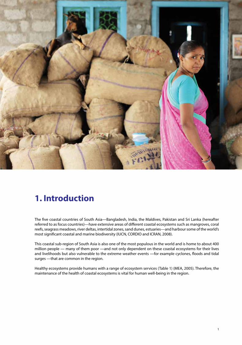
The five coastal countries of South Asia—Bangladesh, India, the Maldives, Pakistan and Sri Lanka (hereafter referred to as focus countries)—have extensive areas of different coastal ecosystems such as mangroves, coral reefs, seagrass meadows, river deltas, intertidal zones, sand dunes, estuaries—and harbour some of the world’s most significant coastal and marine biodiversity (IUCN, CORDIO and ICRAN, 2008).
This coastal sub-region of South Asia is also one of the most populous in the world and is home to about 400 million people — many of them poor —and not only dependent on these coastal ecosystems for their lives and livelihoods but also vulnerable to the extreme weather events —for example cyclones, floods and tidal surges —that are common in the region.
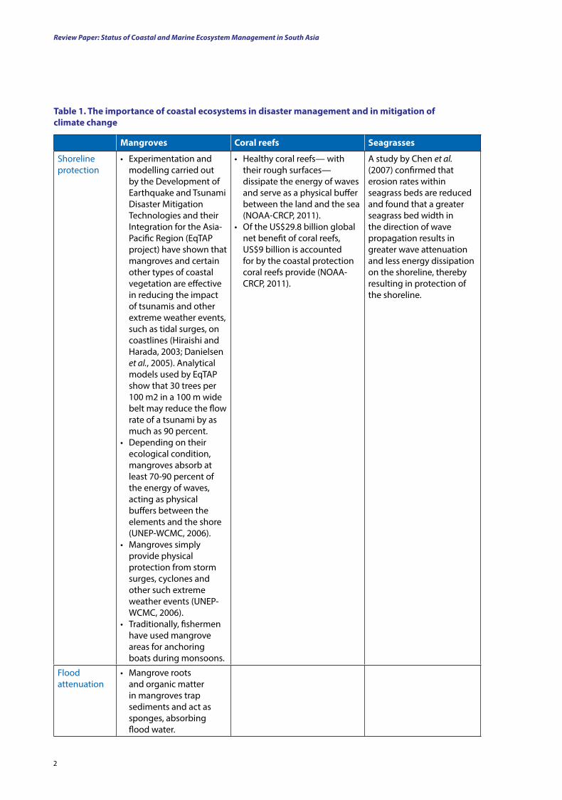
Healthy ecosystems provide humans with a range of ecosystem services (Table 1) (MEA, 2005). Therefore, the maintenance of the health of coastal ecosystems is vital for human well-being in the region.
Review Paper: Status of Coastal and Marine Ecosystem Management in South Asia
2
Mangroves Coral reefs Seagrasses
Shoreline protection
• Experimentation and modelling carried out by the Development of Earthquake and Tsunami Disaster Mitigation Technologies and their Integration for the Asia-Pacific Region (EqTAP project) have shown that mangroves and certain other types of coastal vegetation are effective in reducing the impact of tsunamis and other extreme weather events, such as tidal surges, on coastlines (Hiraishi and Harada, 2003; Danielsen et al., 2005). Analytical models used by EqTAP show that 30 trees per 100 m2 in a 100 m wide belt may reduce the flow rate of a tsunami by as much as 90 percent.
• Depending on their ecological condition, mangroves absorb at least 70-90 percent of the energy of waves, acting as physical buffers between the elements and the shore (UNEP-WCMC, 2006).
• Mangroves simply provide physical protection from storm surges, cyclones and other such extreme weather events (UNEP-WCMC, 2006).
• Traditionally, fishermen have used mangrove areas for anchoring boats during monsoons.
• Healthy coral reefs— with their rough surfaces—dissipate the energy of waves and serve as a physical buffer between the land and the sea (NOAA-CRCP, 2011).
• Of the US$29.8 billion global net benefit of coral reefs, US$9 billion is accounted for by the coastal protection coral reefs provide (NOAA-CRCP, 2011).
A study by Chen et al. (2007) confirmed that erosion rates within seagrass beds are reduced and found that a greater seagrass bed width in the direction of wave propagation results in greater wave attenuationand less energy dissipation on the shoreline, thereby resulting in protection of the shoreline.
Flood attenuation
• Mangrove roots and organic matter in mangroves trap sediments and act as sponges, absorbing flood water.
table 1. the importance of coastal ecosystems in disaster management and in mitigation of climate change
3
Introduction
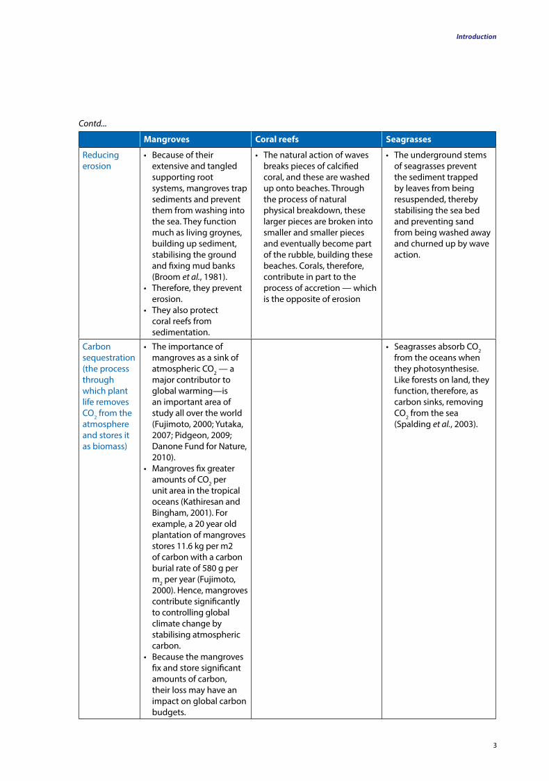
Mangroves Coral reefs Seagrasses
Reducing erosion
• Because of their extensive and tangled supporting root systems, mangroves trap sediments and prevent them from washing into the sea. They function much as living groynes, building up sediment, stabilising the ground and fixing mud banks (Broom et al., 1981).
• Therefore, they prevent erosion.
• They also protect coral reefs from sedimentation.
• The natural action of waves breaks pieces of calcified coral, and these are washed up onto beaches. Through the process of natural physical breakdown, these larger pieces are broken into smaller and smaller pieces and eventually become part of the rubble, building these beaches. Corals, therefore, contribute in part to the process of accretion — which is the opposite of erosion
• The underground stems of seagrasses prevent the sediment trapped by leaves from being resuspended, thereby stabilising the sea bed and preventing sand from being washed away and churned up by wave action.
Carbon sequestration (the process through which plant life removes CO2 from the atmosphere and stores it as biomass)
• The importance of mangroves as a sink of atmospheric CO2 — a major contributor to global warming—is an important area of study all over the world (Fujimoto, 2000; Yutaka, 2007; Pidgeon, 2009; Danone Fund for Nature, 2010).
• Mangroves fix greater amounts of CO2 per unit area in the tropical oceans (Kathiresan and Bingham, 2001). For example, a 20 year old plantation of mangroves stores 11.6 kg per m2 of carbon with a carbon burial rate of 580 g per m2 per year (Fujimoto, 2000). Hence, mangroves contribute significantly to controlling global climate change by stabilising atmospheric carbon.
• Because the mangroves fix and store significant amounts of carbon, their loss may have an impact on global carbon budgets.
• Seagrasses absorb CO2 from the oceans when they photosynthesise. Like forests on land, they function, therefore, as carbon sinks, removing CO2 from the sea (Spalding et al., 2003).
Contd...
Review Paper: Status of Coastal and Marine Ecosystem Management in South Asia
4
Mangroves Coral reefs Seagrasses
Supporting fisheries
• The economic valuation of ecological services provided by mangroves as a support system for the Godavari Estuary in India was valued at US$2,700 per ha, which extrapolates to approximately US$90,000 annually for the entire area (UNDP 2011b) .
• The annual economic value of mangroves, estimated from the cost of the products and services they provide, has been estimated to be US$200,000–900,000 per ha (Wells et al., 2006).
• Coral reefs support human life and livelihoods and are important economically. Nearly 500 million people depend – directly and indirectly – on coral reefs for their livelihoods, food and other resources (Wilkinson, 2004). Further, it is estimated that nearly 30 million of the poorest human people in the world depend entirely on coral reefs for their food (Wilkinson, 2004).
• One kilometre of well-managed coral reef can yield an average of 15 tonnes of fish and other seafood every year (WWF, 2012).
• Many commercially important fish are found living in seagrass meadows.
• Seagrass meadows, like mangroves, are nursery areas for many finfish and shellfish. Because of this, they are critical in coastal fisheries (Heck et al., 2003).
• One hectare of seagrass meadows is worth around US$17,700 per year, for its provision of food and shelter to populations of valuable seafood species such as fish and shrimp (IUCN, 2008).
Asia
Asia is the world’s largest and most populous continent, and it is located primarily in the eastern and northern hemispheres. With an extent of 44,579,000 km2, it covers 8.7 percent of the Earth’s total surface area (or 30 percent of its land area) (http://en.wikipedia.org/wiki/Asia). It has 48 countries, and with approximately 3.8 billion1 people (http://www.worldatlas.com/webimage/countrys/as.htm), it is home to 60 percent of the world’s current human population. China and India are the two most populous countries in the world, with 1.6 billion and 1.2 billion people, respectively (http://en.wikipedia.org/wiki/Asia). Asia displays a great diversity among and within its regions with regard to ethnic groups, cultures, environments, economics, historical ties and government systems.
Asia is bounded on the east by the Pacific Ocean and on the south by the Indian Ocean. To the west, the Ural Mountains mark the boundary between European and Asiatic Russia. The narrow strip of the Red Sea and the Sinai Plateau, to the south-west, marks the boundary between Asia and Africa. The terrain is dominated by mountains and plateaus, and almost two-thirds of Asia is at an elevation greater than 500 m above sea level. All the world’s highest peaks are found in Asia, with 14 of them located within the Himalayan chain of mountains. While there are high-elevation cold deserts in Tibet and Mongolia, a significant portion of the south and east of the continent is drained by some of the longest rivers in the world (http://en.wikipedia.org/wiki/Asia).
Based on broad climatic and geographical features, the Asian region can be divided into four sub-regions: Boreal Asia, Arid and Semi-arid Asia, Temperate Asia and Tropical Asia, but the focus of this paper is largely on tropical Asia.
Tropical Asia extends from 10°S to 28°N and from 50°E to 150°E (Figure 1). It includes several countries of South Asia, which are influenced predominantly by the monsoons.
Source: as listed in the table
1 A billion is taken to be 109, in accordance with the short scale.
Contd...
5
Introduction
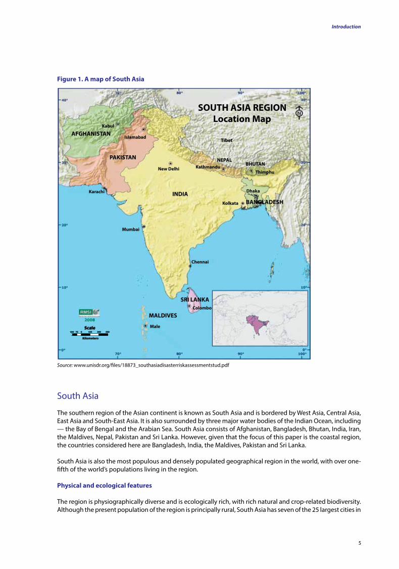
figure 1. A map of South Asia
Source: www.unisdr.org/files/18873_southasiadisasterriskassessmentstud.pdf
SOUTH ASIA REGION
Location Map
Tibet
NEPALBHUTAN
Thimphu
Dhaka
KathmanduNew Delhi
INDIAKarachi
Kabul
PAKISTAN
AFGHANISTAN
Mumbai
Chennai
Kolkata BANGLADESH
Colombo
Male
MALDIVES
Scale
SRI LANKA
150 75 0 150 300 450
Kilometers
Islamabad
South Asia
The southern region of the Asian continent is known as South Asia and is bordered by West Asia, Central Asia, East Asia and South-East Asia. It is also surrounded by three major water bodies of the Indian Ocean, including — the Bay of Bengal and the Arabian Sea. South Asia consists of Afghanistan, Bangladesh, Bhutan, India, Iran, the Maldives, Nepal, Pakistan and Sri Lanka. However, given that the focus of this paper is the coastal region, the countries considered here are Bangladesh, India, the Maldives, Pakistan and Sri Lanka.
South Asia is also the most populous and densely populated geographical region in the world, with over one-fifth of the world’s populations living in the region.
Physical and ecological features
The region is physiographically diverse and is ecologically rich, with rich natural and crop-related biodiversity. Although the present population of the region is principally rural, South Asia has seven of the 25 largest cities in
Review Paper: Status of Coastal and Marine Ecosystem Management in South Asia
6
the world. Agriculture is the main industry in several countries in this region. Exploitation of natural resources, associated with rapid urbanisation, industrialisation and economic development, has led to increasing air and water pollution, land degradation and other environmental problems in the focus countries. Climate change represents a further stress. Over the long period of human occupation in this area, the human use systems have developed some resilience to a range of environmental stresses (IPCC, 1998).
South Asia’s climate varies considerably among its different areas, ranging from a tropical monsoonal climate in the south to a temperate climate in the north. This variation is influenced by altitude, as well as by factors such as proximity to the coast and the monsoons (http://en.wikipedia.org/wiki/Asia).
Much of the climate of South Asia is driven by monsoons and is characterised by wet summers and dry winters. The south-west monsoons (late May to October) bring the maximum rainfall, followed by the north-east monsoons. The precipitation and climate vary significantly from place to place in different countries within the region due to the variations in the landforms. The climate varies from a semi-arid climate in Pakistan, to tropical monsoon, hot-dry and humid-dry climates in the rest of the region (SACEP, 2012). The temperature ranges from as low as -20°C in the cold desert to a scorching 48°C in desert areas in some plains. Much of South Asia is a subcontinent that rests on the Indian Plate. It was formerly a small continent, which collided with the Eurasian Plate approximately 50-55 million years ago, giving rise to the Himalayan Range and the Tibetan Plateau.
South Asia is blessed with several major rivers, which are critical for the economy of the region. Further, there are many services provided by these rivers, especially in communication, transportation and agriculture. Dams built across rivers can also be used to produce hydro-electricity. However, some of the developmental projects in the river valleys have their own negative impacts, especially on the biodiversity and on its ecosystem services.Despite their various benefits, rivers can also destroy properties and cause loss of human life through flooding. They are therefore, critical in climate change adaptation and its effects in the region.
Some of the world’s largest river systems are in South Asia. The Indus River (3,200 km long and with 20 tributaries), originates in Tibet and flows through India and Pakistan, out to the Arabian Sea. The Ganges (2,525 km in length) originates in the western Himalaya, in the Indian state of Uttarakhand, and flows into Bangladesh through north India. Finally, it flows into the Bay of Bengal. The Brahmaputra River (2,900 km long) begins in south-western Tibet (where he is known as the Yarlung Tsangpo River). It flows through Arunachal Pradesh and the Assam Valley (known in these as the Dihang and Brahmaputra, respectively) in India and then through Bangladesh (known there as the Jamuna – not to be confused with the Yamuna of India), where it merges with the Padma, the main distributary of the Ganges, and the Meghna, before meeting the Bay of Bengal (SACEP, 2012).
There are many other rivers in India that flow into either the Arabian Sea, on the western coast, or the Bay of Bengal, on the eastern coast. The Tapti and Narmada rivers are significant on the western coast, and the Godavari, Krishna and Kaveri Rivers are significant on the eastern coast. In Bangladesh, the main rivers are the Ganges, Brahmaputra and Meghna.
There are 103 rivers draining in a radial pattern from the central highland of Sri Lanka, along the coastline, around the island. The longest of these is the Mahaveli River (335 km long), which drains into the Bay of Bengal (SACEP, 2012).
Given that there are significant variations in factors - such as the latitude, altitude, climate and topography across the region—South Asia also exhibits considerable diversity in its vegetation, which ranges from temperate vegetation to tropical and desert vegetation. The forests of the region make up 2.73 percent of the total forest area that remains in the world, with approximately 18.6 percent of the land area of South Asia having forest cover. However, only approximately 5 percent of the region’s land area falls within the network of areas in which wildlife is protected at present (SACEP, 2012).
The region is also home to 15.5 percent of the world’s flora and 12 percent of its fauna (Table 2).
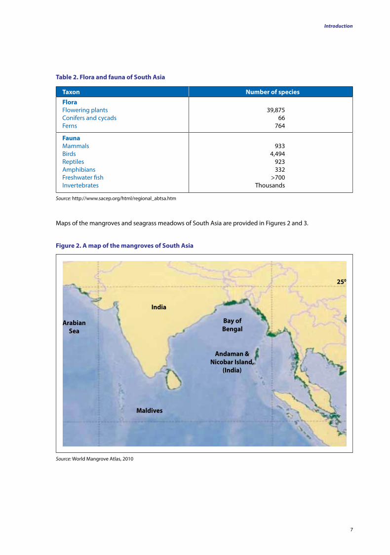
7
Introduction
taxon number of species
floraFlowering plantsConifers and cycadsFerns
39,87566
764
faunaMammalsBirdsReptilesAmphibiansFreshwater fishInvertebrates
9334,494
923332
>700Thousands
table 2. flora and fauna of South Asia
Source: http://www.sacep.org/html/regional_abtsa.htm
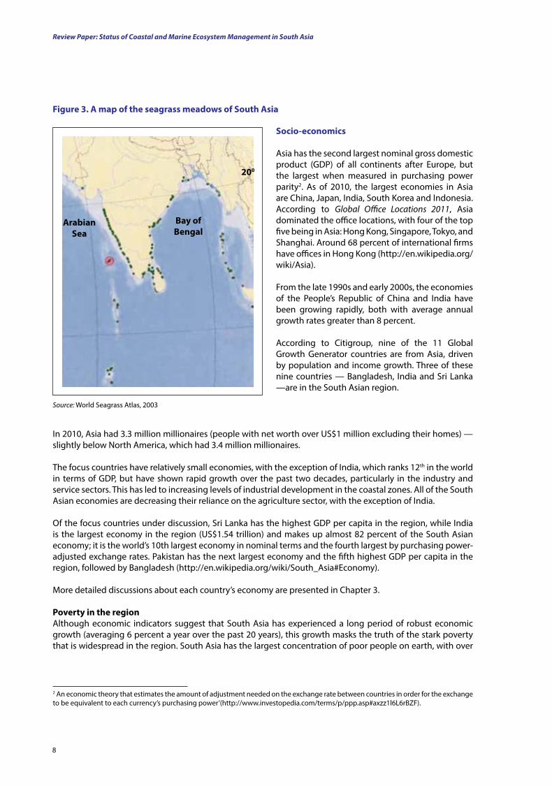
Maps of the mangroves and seagrass meadows of South Asia are provided in Figures 2 and 3.
India
Maldives
Andaman & nicobar Island,
(India)
Bay of Bengal
Arabian Sea
250
figure 2. A map of the mangroves of South Asia
Source: World Mangrove Atlas, 2010
Review Paper: Status of Coastal and Marine Ecosystem Management in South Asia
8
Source: World Seagrass Atlas, 2003
Bay of Bengal
Arabian Sea
200
figure 3. A map of the seagrass meadows of South Asia
Socio-economics
Asia has the second largest nominal gross domestic product (GDP) of all continents after Europe, but the largest when measured in purchasing power parity2. As of 2010, the largest economies in Asia are China, Japan, India, South Korea and Indonesia. According to Global Office Locations 2011, Asia dominated the office locations, with four of the top five being in Asia: Hong Kong, Singapore, Tokyo, and Shanghai. Around 68 percent of international firms have offices in Hong Kong (http://en.wikipedia.org/wiki/Asia).
From the late 1990s and early 2000s, the economies of the People’s Republic of China and India have been growing rapidly, both with average annual growth rates greater than 8 percent.
According to Citigroup, nine of the 11 Global Growth Generator countries are from Asia, driven by population and income growth. Three of these nine countries — Bangladesh, India and Sri Lanka —are in the South Asian region.
In 2010, Asia had 3.3 million millionaires (people with net worth over US$1 million excluding their homes) —slightly below North America, which had 3.4 million millionaires.
The focus countries have relatively small economies, with the exception of India, which ranks 12th in the world in terms of GDP, but have shown rapid growth over the past two decades, particularly in the industry and service sectors. This has led to increasing levels of industrial development in the coastal zones. All of the South Asian economies are decreasing their reliance on the agriculture sector, with the exception of India.
Of the focus countries under discussion, Sri Lanka has the highest GDP per capita in the region, while India is the largest economy in the region (US$1.54 trillion) and makes up almost 82 percent of the South Asian economy; it is the world’s 10th largest economy in nominal terms and the fourth largest by purchasing power-adjusted exchange rates. Pakistan has the next largest economy and the fifth highest GDP per capita in the region, followed by Bangladesh (http://en.wikipedia.org/wiki/South_Asia#Economy).
More detailed discussions about each country’s economy are presented in Chapter 3.
Poverty in the regionAlthough economic indicators suggest that South Asia has experienced a long period of robust economic growth (averaging 6 percent a year over the past 20 years), this growth masks the truth of the stark poverty that is widespread in the region. South Asia has the largest concentration of poor people on earth, with over
2 An economic theory that estimates the amount of adjustment needed on the exchange rate between countries in order for the exchange to be equivalent to each currency’s purchasing power’(http://www.investopedia.com/terms/p/ppp.asp#axzz1l6L6rBZF).
9
Introduction
half of the world’s poor living in the region (http://web.worldbank.org/WBSITE/EXTERNAL/COUNTRIES/SOUTHASIAEXT/0,,contentMDK:21265405~menuPK:2298227~pagePK:146736~piPK:146830~theSitePK:223547,00.html). More than 600 million people (of whom 450 million are in India) live on less than US$1.25 a day (World Bank, 2009). While South Asia is at a far more advanced stage of development compared with sub-Saharan Africa, it has many more poor people. Population growth is also adding to the absolute number of poor people (http://web.worldbank.org/WBSITE/EXTERNAL/COUNTRIES/SOUTHASIAEXT/0,,contentMDK:21265405~menuPK:2298227~pagePK:146736~piPK:146830~theSitePK:223547,00.html).
While economies in the region have grown, they
Poverty is a serious issue in dealing with changes that come in the wake of natural disasters because the poor have a significantly limited ability to deal with such crises. Economic standing is critical in dealing successfully with changes in circumstances, threats in several forms and calamities, including ecological degradation and the attrition of natural resources (Diamond, 2005). Educational deficiencies reduce livelihood and economic opportunities and therefore the capabilities of people to respond to changes in circumstances successfully. In other words, these are factors that contribute to resilience.
show a fractured pattern of progress, with prosperity in sectoral fragments within the large matrix of abject poverty, especially along the coasts. Growing slums represent the interface of this discordance (DESA, 2010). This is supported by the fact that 81 percent, 76 percent and 40 percent of the populations along the coasts of Bangladesh, India and Sri Lanka, respectively, have an income that amounts to less than US$2 per day (UNDP, 2009; BOBLME, 2010). The incidence of poverty in Pakistan is reportedly 17.2 percent (the percentage of the total population below the poverty line).
In addition, human development has not kept up with the pace of income growth. More than 250 million children are undernourished, and more than 30 million children do not go to school in South Asia. More than one-third of the adult women are anaemic. The share of female employment in total employment is among the lowest in the world (http://www.voxeu.org/index.php?q=node/5722). The adult literacy rates in Bangladesh and India are 53.5 percent and 66 percent, respectively (BOBLME, 2010), while in Pakistan it varies from over 80 percent in large cities to less than 20 percent in rural areas (http://ilm.com.pk/Pakistan/). Human health, especially along the coasts, is subject to several risk factors, including poor sanitation and an unsuitable water supply (the quality of which is affected by salt water intrusion in aquifers in some tracts). The coasts are also subjected to cyclones and flooding (BOBLME, 2010).
More detailed discussions about the poverty in each country are presented in Chapter 3.
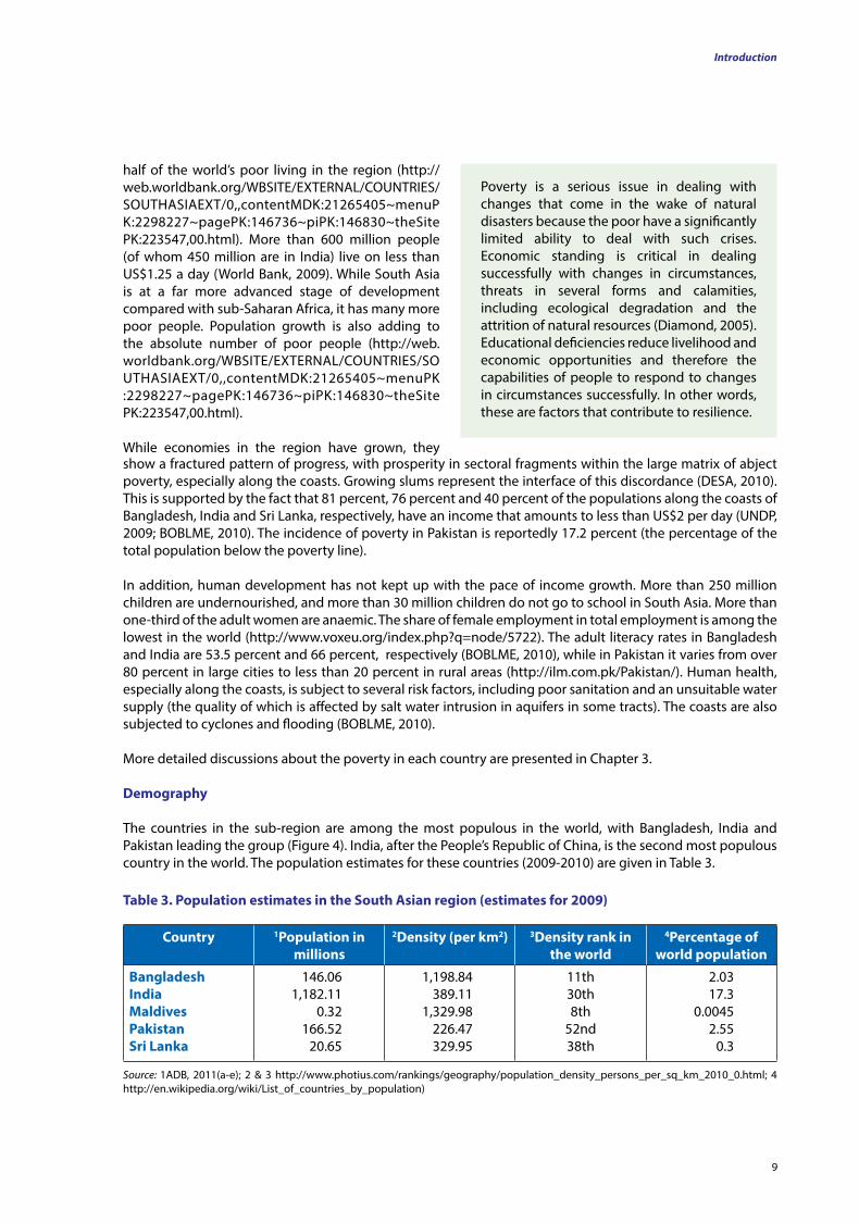
demography
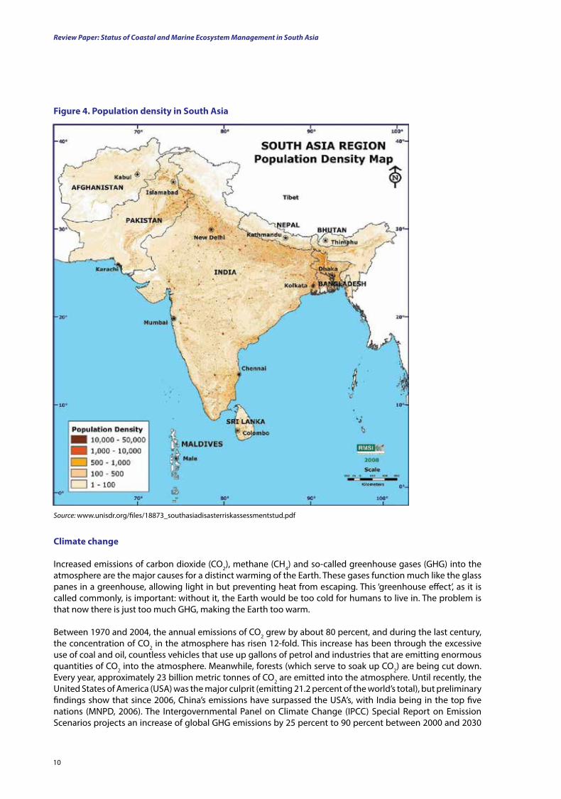
The countries in the sub-region are among the most populous in the world, with Bangladesh, India and Pakistan leading the group (Figure 4). India, after the People’s Republic of China, is the second most populous country in the world. The population estimates for these countries (2009-2010) are given in Table 3.
Country 1Population in millions
2density (per km2) 3density rank in the world
4Percentage of world population
BangladeshIndiaMaldivesPakistanSri lanka
146.061,182.11
0.32166.52
20.65
1,198.84389.11
1,329.98226.47329.95
11th 30th 8th
52nd38th
2.0317.3
0.00452.55
0.3
table 3. Population estimates in the South Asian region (estimates for 2009)
Source: 1ADB, 2011(a-e); 2 & 3 http://www.photius.com/rankings/geography/population_density_persons_per_sq_km_2010_0.html; 4 http://en.wikipedia.org/wiki/List_of_countries_by_population)
Review Paper: Status of Coastal and Marine Ecosystem Management in South Asia
10
figure 4. Population density in South Asia
Source: www.unisdr.org/files/18873_southasiadisasterriskassessmentstud.pdf
Climate change
Increased emissions of carbon dioxide (CO2), methane (CH4) and so-called greenhouse gases (GHG) into the atmosphere are the major causes for a distinct warming of the Earth. These gases function much like the glass panes in a greenhouse, allowing light in but preventing heat from escaping. This ‘greenhouse effect’, as it is called commonly, is important: without it, the Earth would be too cold for humans to live in. The problem is that now there is just too much GHG, making the Earth too warm.
Between 1970 and 2004, the annual emissions of CO2 grew by about 80 percent, and during the last century, the concentration of CO2 in the atmosphere has risen 12-fold. This increase has been through the excessive use of coal and oil, countless vehicles that use up gallons of petrol and industries that are emitting enormous quantities of CO2 into the atmosphere. Meanwhile, forests (which serve to soak up CO2) are being cut down. Every year, approximately 23 billion metric tonnes of CO2 are emitted into the atmosphere. Until recently, the United States of America (USA) was the major culprit (emitting 21.2 percent of the world’s total), but preliminary findings show that since 2006, China’s emissions have surpassed the USA’s, with India being in the top five nations (MNPD, 2006). The Intergovernmental Panel on Climate Change (IPCC) Special Report on Emission Scenarios projects an increase of global GHG emissions by 25 percent to 90 percent between 2000 and 2030
11
Introduction
(IPCC, 2007). In the meantime, trash and garbage are heaped as solid waste, and the livestock industry, which has been rearing millions of cattle and sheep generates huge quantities of CH4.
The result of these emissions and increased greenhouse effects is a distinct warming of the Earth. During the last century, the global temperature increased by about 0.8°C, which represented the largest increase in a thousand years. The records are startling: the five hottest years on record are in the last decade. The 1990s were the warmest decade in a century. The warmest years on record were 2010 and 2005, and their temperatures were 0.64°C above average (IPCC, 2007; NOAA, 2012).
The IPCC predicts that for the next two decades, the Earth will warm by about 0.2°C per decade; even if GHGs are kept constant at the levels of the year 2000, the Earth will still warm about 0.1°C per decade (IPCC, 2007). As a result of this warming, changes are occurring in global weather patterns, resulting in ‘climate change’. Climate change has overarching, seriously damaging and long-terms impacts on Earth ecosystems.
Impacts of climate change
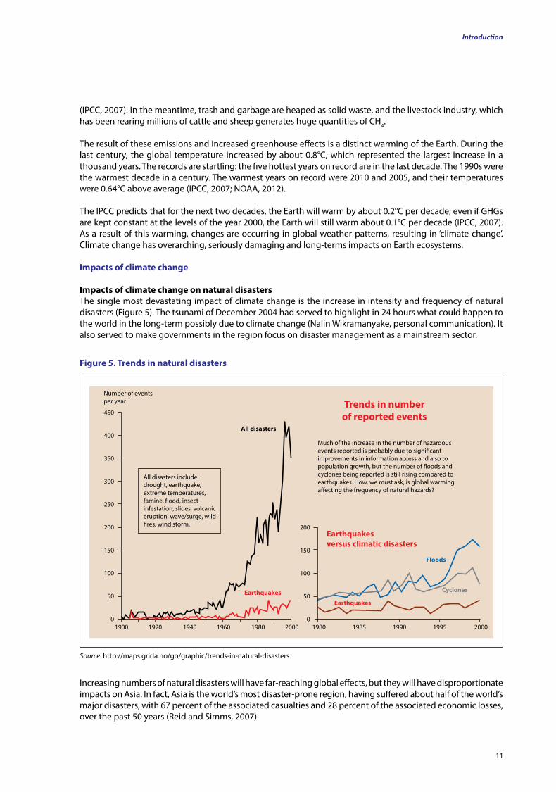
Impacts of climate change on natural disastersThe single most devastating impact of climate change is the increase in intensity and frequency of natural disasters (Figure 5). The tsunami of December 2004 had served to highlight in 24 hours what could happen to the world in the long-term possibly due to climate change (Nalin Wikramanyake, personal communication). It also served to make governments in the region focus on disaster management as a mainstream sector.
Much of the increase in the number of hazardous events reported is probably due to significant improvements in information access and also to population growth, but the number of floods and cyclones being reported is still rising compared to earthquakes. How, we must ask, is global warming affecting the frequency of natural hazards?
trends in number of reported events
All disasters include: drought, earthquake, extreme temperatures, famine, flood, insect infestation, slides, volcanic eruption, wave/surge, wild fires, wind storm.
Number of events per year
All disasters
1900 1920 1940 1960 1980 2000
450
400
350
300
250
200
150
100
50
0
Earthquakes versus climatic disasters
200
150
100
50
0 1980 1985 1990 1995 2000
Earthquakes
Earthquakes
floods
Cyclones
figure 5. trends in natural disasters
Source: http://maps.grida.no/go/graphic/trends-in-natural-disasters
Increasing numbers of natural disasters will have far-reaching global effects, but they will have disproportionate impacts on Asia. In fact, Asia is the world’s most disaster-prone region, having suffered about half of the world’s major disasters, with 67 percent of the associated casualties and 28 percent of the associated economic losses, over the past 50 years (Reid and Simms, 2007).
Review Paper: Status of Coastal and Marine Ecosystem Management in South Asia
12
Each year, natural disasters impoverish millions of people. However, only 0.2 percent of the economic losses are covered by insurance policies because many of those affected are the marginalised and the poor. Asia is also home to over 70 percent of the world’s poor. In developing countries, such as the South Asian countries, the marginalised and poor are already deprived of adequate food, clean drinking water, sanitation and healthcare. In most cases, it is this section of society that is also forced to live in low-lying and other hazard-prone areas and so is usually the first to be hit by floods, landslides and cyclones. These neglected poor people have the fewest resources to deal with these recurrent shocks and stresses. Therefore, the negative consequences of climate change make them less capable of developing any coping, preventing and mitigating mechanisms (IUCN, 2007).
Amongst the poor, it is the women and children who are most vulnerable in any disaster. Out of the 1.4 billion people in the developing world who live below the poverty line, 70 percent are women. After the tsunami of 2004 that affected the South Asian region, a shocking statistic revealed that the numbers of deaths of women and children were significantly greater than those of men. Vulnerability to disasters depends on the control of financial, physical, natural, human and social assets. Compared with men, women in poor developing countries traditionally have limited access to and control over these assets (IUCN, 2007).
An increase in the frequency of natural disasters will have overarching impacts on ecosystem services and the global economy, but it will cripple Asia, which is already stressed with overpopulation, poverty, internal conflicts, resource overuse and the spread of disease (Miththapala, 2008).
Tropical cyclones
A tropical cyclone is a storm system characterised by a low-pressure centre and numerous thunderstorms that produce strong winds and heavy rain. Asia is close to the warm pool of the west equatorial Pacific Ocean, and tropical cyclones and associated storm surges strongly affect the coastal zones of tropical and temperate Asia. The Bay of Bengal is one of seven basins in the world where tropical cyclones occur (http://www.tropicalweather.net/where_do_hurricanes_occur.htm).
Tropical cyclones and storm surges are among the most critical factors affecting the loss of human life in Bangladesh and India (Sato and Mimura, 1997). They also affect the coastal communities of Sri Lanka. Approximately 76 percent of the total loss of human life from cyclonic storms has occurred in Bangladesh and India (Ali, 1999). Several Asian countries face every year cyclones and associated storm surges, which cause serious economic losses and human lives (Ali, 1999; Huang, 1999; Kelly and Adger, 2000).
There are concerns that global warming may affect tropical cyclone characteristics, including their intensity, because the sea surface temperature (SST) plays an important role in determining whether tropical disturbances form and intensify. Several researchers have used modelling techniques to examine the possible effects of global warming on tropical storms (Lighthill et al., 1994; Sugi et al., 1996; Henderson-Sellers and Zhang, 1997; Holland, 1997; Tonkin et al., 1997; Henderson-Sellers et al., 1998; Knutson et al., 1998; Krishnamurti et al., 1998; Royer et al., 1998). Lighthill et al. (1994) conclude that there is no reason to expect any overall change in the global tropical cyclone frequency although substantial regional changes may occur. Recent studies indicate that the maximum potential intensities of cyclones will possibly undergo a modest increase of 10-20 percent in a warmer atmosphere. More recent analyses (Nakagawa et al., 1998; Walsh and Pittock, 1998; Jones et al., 1999) support the possibility of an increase in cyclone intensity. Coastal erosion in Asia is likely to increase with a rise in the sea level, and storm surges could still exacerbate hazards, even if the number and intensity of tropical cyclones do not change (IPCC, 1998; Walsh and Pittock, 1998).
• Bangladesh, due to its unique geographic location, suffers from frequent, devastating tropical cyclones. The funnel-shaped northern portion of the Bay of Bengal causes tidal bores when cyclones make landfall, and thousands of people living in coastal areas are affected. Some of the most devastating natural disasters in recorded history with high casualties were tropical cyclones that hit the region now forming Bangladesh. Among them, the 1970 Bhola cyclone alone claimed more than 500,000 lives. During the period 1991-2007, 10 cyclones hit Bangladesh, with human and livestock casualties numbering in the hundreds
13
of thousands and with severe impacts on the country’s economy, running into hundreds of billions of Taka (http://en.wikipedia.org/wiki/List_of_Bangladesh_tropical_cyclones).
• India was hit by seven cyclones in the period 1990-2011. The most severe was one that struck Odisha (1999), in which 15,000 people lost their lives and the livestock deaths were estimated in the region of 2.5 million. There was severe destruction of infrastructure, crops and other investments. About 10,000 people are reported to have died in the1998 Gujarat cyclone. It created a 4.9 m storm surge that destroyed houses, properties and salt mines.
• While the Maldives are less prone to tropical cyclones than the other coastal countries in the region, when cyclones do strike, they are extremely destructive. Only 11 tropical cyclones have crossed the country in the last 128 years (http://www.saarc-sadkn.org/countries/maldives/hazard_profile.aspx).
• The 1999 Pakistan cyclone killed an estimated 700 people, and 3,500 people were listed missing. Other cyclones that landed in Pakistan were the Gonu in 2007 and the Phet in 2010.
• Between 1992 and 2009, six cyclones affected Sri Lanka. The cyclone of 2000 rendered at least 500,000 people homeless (http://en.wikipedia.org/wiki/2000_Sri_Lanka_cyclone).
Earthquakes
The Indian subcontinent, which includes Bangladesh, India and Pakistan, also has a history of devastating earthquakes. The major reason for the high frequency and intensity of the earthquakes is that India is driving into Asia at a rate of approximately 47 mm per year (http://cires.colorado.edu). The geographical statistics of India show that almost 54 percent of the land is vulnerable to earthquakes. The report titled Natural Hazards and Unnatural Disasters — The Economics of Effective Prevention (World Bank & United Nations, 2010) gives an estimate for the number of city dwellers in India who will be exposed to storms and earthquakes by 2050 of around 200 million (http://www.economicstimes.Indiatimes/news/politics). Between 1994 and 2004, there have been four earthquakes in India, with severe loss of life and property. The last one, in 2004, was felt in the Maldives as well as in Sri Lanka. This was the third largest earthquake ever recorded in the Indian Ocean, at between 9.0 and 9.3 on the Richter scale (wikipedia.org/List of earthquakes in India).
The earthquake and resulting tsunami in the Indian Ocean of 26 December 2004 had a devastating effect on much of the region. The epicentre of the earthquake was off the west coast of Sumatra (Indonesia). The Indian and Eurasian tectonic plates were subducted and caused a 1,200 km section of the Earth’s crust to surge upwards, displacing a large body of water. This particular earthquake triggered off a series of devastating tsunamis along most coastal areas bordering the Indian Ocean, killing over 230,000 people in 14 countries and inundating coastal communities with waves as high as 30 m (http://en.wikipedia.org/wiki/2004_Indian_Ocean_earthquake_and_tsunami). In terms of lives lost, this earthquake was one of the 10 worst earthquakes in recorded history, as well as produced the single worst tsunami in history. This earthquake and resulting tsunami affected many countries in the region, including Sri Lanka, India and the Maldives.
Floods
Nearly 75 percent of the Bangladesh landmass is just 10 m above sea level, and as 80 percent is in the flood plains of the large Gangetic Delta, floods are among the significant disasters that occur here. Each year in Bangladesh, about 26,000 km2, (around 18 percent) of the country is flooded, killing over 5,000 people and destroying 7 million homes. During severe floods, the affected area may exceed 75 percent of the country, as was seen in 1998 (http://www.wikipedia.org/Floods in Bangladesh).
The water levels in the major rivers of Bangladesh fluctuate by up to 9 m from the driest season to the highest flood. The fact that the three major rivers (the Ganges, the Brahmaputra and the Meghna) meet, means that they can affect each other’s flood levels. The worst possible floods occur when the flood peaks of the Ganges and Brahmaputra coincide.
The combination of the three major, easily flooded rivers and the low-lying nature of the terrain makes Bangladesh one of the most flood-prone countries in the world (www.country-studies.com/bangladesh/riversystems.html).
Introduction
Review Paper: Status of Coastal and Marine Ecosystem Management in South Asia
14
In 1998, Bangladesh was hit by the ‘worst flood of the century’, which covered approximately 100,000 km2 (one-third the size of Great Britain and 66 percent of the land area) for two and a half months from July to September. At the height of the floods, 52 out of the 64 administrative districts were flooded. Heavy rainfall in the catchment areas of three major rivers, combined with above-normal melting of ice in the Himalaya, created this enormous flood (Source: Ranjit Galappatti, personal communication).
Tsunamis
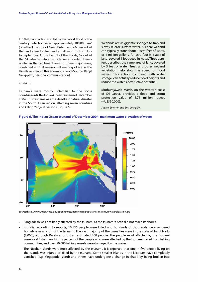
Tsunamis were mostly unfamiliar to the focus countries until the Indian Ocean tsunami of December 2004. This tsunami was the deadliest natural disaster in the South Asian region, affecting seven countries and killing 226,408 persons (Figure 6).
Wetlands act as gigantic sponges to trap and slowly release surface water. A 1 acre wetland can typically store about 3 acre-feet of water, or 1 million gallons. An acre-foot is 1 acre of land, covered 1 foot deep in water. Three acre-feet describes the same area of land, covered by 3 feet of water. Trees and other wetland vegetation help slow the speed of flood waters. This action, combined with water storage, can actually reduce flood heights and reduce the water’s destructive potential.
Muthurajawela Marsh, on the western coast of Sri Lanka, provides a flood and storm protection value of 5.75 million rupees (~US$50,000).
Source: Emerton and Bos, 2004; EPA
figure 6. the Indian ocean tsunami of december 2004: maximum water elevation of waves
Source: http://www.ngdc.noaa.gov/spotlight/tsunami/image/apiatanesimaximumwaterelevation.jpg
20o
10o
0o
-10o
70o 80o 90o 100o
10.00
2.00
1.75
1.50
1.25
1.00
0.75
0.50
0.25
0.00
meters
• Bangladesh was not badly affected by the tsunami as the tsunami’s path did not reach its shores.
• In India, according to reports, 10,136 people were killed and hundreds of thousands were rendered homeless as a result of the tsunami. The vast majority of the casualties were in the state of Tamil Nadu (8,000), although Kerala also lost an estimated 200 people. The people most affected by the tsunami were local fishermen. Eighty percent of the people who were affected by the tsunami hailed from fishing communities, and over 50,000 fishing vessels were damaged by the waves.
The Nicobar Islands were most affected by the tsunami. It is reported that one in five people living on the islands was injured or killed by the tsunami. Some smaller islands in the Nicobars have completely vanished (e.g. Megapode Island) and others have undergone a change in shape by being broken into
15
pieces — an example is Trinket, which split into two parts after the tsunami hit. Salt water intrusion has also occurred on many islands, destroying farmlands and sources of fresh water (http://en.wikipedia.org/wiki/Effect_of_the_2004_Indian_Ocean_earthquake_on_India).
• The Maldives were not affected much by the Indian Ocean tsunami of 2004. About 82 people were killed, and 26 were reported missing and presumed dead after the tsunami. Low-level, outlying atolls, low-level islands and two-thirds of the capital city, Malé, were completely submerged when the waves were at their highest (http://en.wikipedia.org/wiki/Effect_of_the_2004_Indian_Ocean_earthquake_on_the_Maldives).
• Pakistan was not affected by the Indian Ocean tsunami.
• Official statistics for Sri Lanka confirmed that there were 30,196 deaths and that one and a half million were displaced. The eastern coast of Sri Lanka was most severely affected. Paddy land — amounting to an extent of 259 km² — was destroyed all around the coast, and extensive salinisation of other lands has made them unsuitable for paddy cultivation (http://en.wikipedia.org/wiki/Effect_of_the_2004_Indian_Ocean_earthquake_on_Sri_Lanka).
A study carried out in the tsunami-affected districts of Sri Lanka shows clearly that mangroves played an important role in inland protection during the tsunami but that this protection depended on the quality of the mangrove habitat.
Degraded habitats or habitats with mangrove associate species instead of true mangrove species did not provide adequate protection
Source: Dahdouh-Guebas et al., 2005
Impacts of climate change on biodiversity, protected areas and coastal ecosystemsFrontier forests in Asia are home to more than 50 percent of the world’s terrestrial plant and animal species (Rice, 1998). Despite the tremendous ecological and economic importance and the existence of a policy and regulatory framework, all ecosystems in the region, especially coastal and marine ones, are under threat. Numerous direct and indirect pressures arising from different types of economic development and associated activities are having adverse impacts on coastal and marine biodiversity across the region. Threats to this rich array of living species are increasing and include stressors such as over-exploitation, land conversion, habitat loss and pollution. Climate change is likely to act synergistically with these stressors, leading to major impacts on protected areas and species. A number of species in the region are already considered to be Globally Threatened (Table 4).
Country number of species
BangladeshIndiathe MaldivesPakistanSri lanka
12291962
113275
table 4. numbers of globally threatened species in the South Asian countries
Source: http://www.iucnredlist.org/documents/summarystatistics/2011_2_RL_Stats_Table5.pdf
Introduction
These numbers are even higher at the national level: For example, in India, as many as 1,256 higher plant species, of more than 15,000 species, are Nationally Threatened (Sukumar et al., 1995); in Sri Lanka 1,000 species of plant and 380 species of animal are considered Nationally Threatened (IUCN, 2011).
Species are already shifting their territories because of climate change. Currently designated major protected areas in South Asia need to be examined with respect to the ability of their species to shift in range in response to the changing climate, as well as with respect to how much habitat could be lost because many species— especially those in coastal areas—could experience large population declines and changes due to climate change.
Review Paper: Status of Coastal and Marine Ecosystem Management in South Asia
16
Coral reefs
Coral reefs play a crucial role in fisheries and in protecting the coastline from wave action and erosion (Ruddle et al., 1988; Middleton, 1999).
Asia’s coral reefs are undergoing rapid destruction in terms of habitat richness (Cesar et al., 1997; Nie et al., 1997; Pennisi, 1998), with significant declines of corals and heavy damage to entire reefs. This is due to several factors, including the use of destructive fishing techniques, reef mining for calcium carbonate production, siltation as a result of deforestation, sedimentation, marine pollution with contaminants, fresh water dilution, sub-aerial exposure and disease (Glynn, 1996; Middleton, 1999; UNEP, 1999).
With extreme temperatures and solar irradiance, global warming and the resultant climate change, along with their impacts (including sea level rise), are posing an additional emerging and severe threat to already stressed coral reefs (Wilkinson, 2004).
The increased CO2 associated with global warming also dissolves in the oceans, forming a weak acid —carbonic acid (H2CO3). This makes the oceans more acidic and reduces CaCO3 precipitation in coral polyps. It has been estimated that the precipitation of CaCO3 has already fallen by an average of between 6 and 11 percent since the Industrial Revolution. It is predicted that if future atmospheric CO2 levels reach double the level of pre-industrial times, then the calcium precipitation will fall by a further 8 to 17 percent (Caldeira and Wickett, 2003). This affects the availability of carbonate atoms for building coral exoskeletons and reduces reef calcification. This, in turn, slows down a reef’s ability to grow vertically to keep up with the sea level rise and affects its protective function. Furthermore, ocean acidification will likely disrupt marine food webs and affect the services that coral reefs provide to humans.
The rising sea level and changed weather patterns, such as altered El Niño and La Niña events, are already affecting coral reefs. In 1998, the tropical sea surface temperatures (SSTs) were the highest on record (the culmination of a 50 year trend), and coral reefs suffered the most extensive and severe bleaching (loss of symbiotic algae)3 and death on record. As a result of this El Niño event in 1998, 16 percent of the world’s coral reefs and 50 percent of those in the Indian Ocean were destroyed (Wilkinson, 2004).
Managing natural ecosystems as carbon sinks and resources for adaptation is increasingly being recognised as a necessary, efficient and relatively cost-effective strategy. The world’s protected area network already helps mitigate climate change. Protected areas store 15 percent of the terrestrial carbon and provide disaster reduction and public health services. They also supply water and food, all of which services enable community-based adaptation. Many natural and managed ecosystems can help reduce climate change impacts. However, designation of protected areas has advantages over other approaches to natural ecosystem management, in terms of legal and governance clarity, capacity and effectiveness. In many cases, protection is the only way of keeping carbon locked in and ecosystem services running smoothly.
Increases in the frequency of dry spells and local droughts may reduce population sizes. For example, drought-related decreases in the density and persistence of green leaf warblers (Phylloscopus trochiloides) have been recorded on their wintering grounds in the Western Ghats of south India (Katti and Price, 1996). In desert ecosystems, protected areas are often located around oases, which are the basis for the existence of much of the local fauna. Protected oases are often far apart, and so droughts that cause a decline in local forage often cause mass mortality because animals may not be able to move on to adjacent oases. The frequency of these droughts is, therefore, a key component in the viability of populations in such protected areas (Safriel, 1993).
The worst threats stem from total habitat loss due to climate change. The IPCC confirms that the effects of sea level rise are already affecting coastal ecosystems such as coral reefs, mangroves and salt marshes.
3 Because reef building coral species can live only within a small temperature range, even a tiny change in temperature causes seriously detrimental effects, as exemplified by the wide-scale coral bleaching of 1998 as a result of an El Niño event. When reef-building corals are stressed — such as with an increase in temperature — the critical balance that maintains their mutualistic relationship with zooxanthellae is lost. The coral may lose some or most of their zooxanthellae, a major source of nutrition and colour. In this condition, corals are referred to as ‘bleached.’ In some species, their life cycles are disrupted.
17
In addition, mangroves are extremely vulnerable to climate change-induced rises in the sea level rise, which change their salinity distribution and hence productivity and cause a loss in the land occupied by them. For instance, 7,500 ha of mangroves have been inundated due to the rising sea level in Sundarbans National Park (Bangladesh and adjacent areas of India) (http.www//assets.panda.org/downloads/wwfparksbro.pdf ). These coastal mangrove forests are the largest in the world (6,000 km2) (Allison, 1998) and provide a habitat for species such as the Bengal tiger (Panthera tigris tigris), the Eurasian otter (Lutra lutra), the spotted deer (Axis axis), the wild boar (Sus scrofa), the estuarine crocodile (Crocodylus porosus), fiddler crabs (genus Uca), mud crabs (genus Scylla), monitor lizard (Varanus salvator) and five marine turtles (Green, 1990). With a 1 m rise in the sea level, the Sundarbans are likely to disappear, which may result in the extinction of the tiger, as well as other species (Smith et al., 1998).
Changes in precipitation, resulting from climate change, will retard growth, productivity and seedling survival in mangroves. Decreased precipitation, in conjunction with increased salinity due to salt water intrusion, could favour more salt-tolerant species and change the species composition. This could, in turn, affect mangrove provisioning services. Large-scale changes in species composition and zonation in mangrove forests are also expected as a result of changes in sedimentation and organic accumulation (Aksornkaoe and Paphavasit, 1993). Increased numbers of natural disasters will increase physical damage to mangroves, while changing wave climates which increase coastal erosion, will also degrade these habitats.
El Niño is Spanish for ‘the little boy’, referring to the Christ child, because this event is noticed usually around Christmas time. It is a fluctuation of the ocean-atmosphere system in the tropical Pacific Ocean that is important for the world’s climate.
In normal, non-El Niño conditions, trade winds (prevailing tropical winds) blow towards the west, across the tropical Pacific, piling up warm surface water in the west Pacific so that the sea surface is about 0.5 m higher in height and 8°C warmer in Indonesia than in Ecuador.
During the El Niño, the air pressure over the Indian Ocean, Indonesia and Australia rises but drops over Tahiti and the rest of the central and eastern Pacific Ocean. The trade winds in the south Pacific weaken. Warm air rises near Peru, causing rain in its deserts, while warm water spreads from the west Pacific and Indian Ocean to the east Pacific Ocean. When it spreads, it takes the rain with it, causing rainfall in normally dry areas and drought in normally wet areas.
La Niña, means ‘the little girl’ in Spanish, meant to reflect the fact that its effects are the opposite to those of El Niño. Here, the result is a lowering of sea surface temperatures by about 0.5°C. It usually follows an El Niño event.
Source: NOAA, 2007
Although healthy reefs are likely to be able to adapt to projected sea level changes, coral reefs that are already stressed by other human activities and threats will not.
Light is essential for zooxanthellae4 to photosynthesise in coral reefs. Photosynthesis promotes the production of oxygen, which, in turn, stimulates coral polyp growth, increased deposition of CaCO3 and, with it, coral reef growth. Changes in sea levels and associated water depths will change the amount of sunlight reaching coral reefs.
As a result of the changes in environmental conditions, coral reef communities have changed. In the coastal seas around the Andaman Islands of India, the Maldives and Sri Lanka, the reef community structure has switched from one dominated by fast-growing branching species to one monopolised by the more physically rigorous and large slow-growing corals (Wilkinson, 1998).
Mangroves
Mangroves comprise salt-adapted evergreen trees. They are restricted to the intertidal zone along the vast coastlines of tropical countries in Asia and extend landward along tidal rivers. The depletion of mangrove forests due to anthropogenic pressures has become a serious problem (Farnsworth and Ellison, 1997).
Introduction
4 Zooxanthellae are photosynthetic algae that live within corals. The corals and algae have a mutualistic relationship. The coral provides the algae with a protected environment and nutrients for algae to photosynthesise. In return, the algae produce oxygen and sugars for the coral and help the coral to remove wastes.
Review Paper: Status of Coastal and Marine Ecosystem Management in South Asia
18
Seagrasses
Higher water temperatures will directly affect the growth, reproduction and general metabolism of seagrasses (Short and Neckles, 1999; Bjork et al., 2008). As such, given that there is competition between seagrasses and algae when eutrophication occurs, changes in water temperature will have a profound effect on this competition (Short et al., 1995). Increased acidity in the oceans will also alter productivity in seagrasses and may, as a result, have similar impacts.
Increased storms are known to cause physical damage to seagrass meadows (Short and Neckles, 1999). Coastal storms can also cause huge movements of sediments, which last long after the storm ceases.Increased turbidity, associated with such sediments, will cause declines in seagrass growth (Bjork et al., 2008). Increasing water depths due to rising sea levels will alter the amount of light reaching seagrasses and will consequently limit food production through photosynthesis. This will result in a reduced productivity and distribution of seagrasses (Short and Neckles, 1999).
Coastal wetlands including estuaries, deltas, salt marshes and mudflats
Coastal wetlands are frequently associated with deltas, estuaries, lagoons and sheltered bays. In Asia, the tidal flats of the muddy coasts constitute the main part of the coastal wetland (Bird, 1992). Lagoons, which are also important wetlands, are located across the coastal regions of India and Sri Lanka. While large-scale wetland reclamation has taken place in the major deltas during the past few decades (Lang et al., 1998; Liu et al., 1998), a rise in the sea level and a reduction in the quantity of river-borne sediments will decelerate delta progradation and wetland renewal.
The rich biodiversity of wetlands in Asia is seriously threatened by the loss of wetlands due to a rise in the sea level (Nicholls et al., 1999). The Great Rann of Kutch, in Gujarat, is a huge area of seasonal salt lakes that support large populations of various species, including the largest population of the greater flamingo (Phoenicopterus roseus) in Asia (Ali, 1985; Bapat, 1992), and is the only place where Indian wild asses (Equus hemionus khur) may be observed. With a sea level rise, these salt marshes and mudflats are likely to be submerged (Bandyopadhyay, 1993), which will result in a reduced extent of the habitat available for breeding flamingos and lesser floricans (Sypheotides indicus) (Sankaran et al., 1992) and a loss of habitat for wild asses.
River-borne sediments have formed at least 10 deltas in the coastal zones of Asia, with areas of more than 10,000 km2 each (Coleman and Wright, 1975). Delta and estuarine ecosystems are sensitive to the complex responses to agents associated with climate change (Sanchez-Arcilla and Jimenez, 1997). Low-lying deltas are especially vulnerable to a rise in the sea level and increasing shoreline wave action (Walker, 1998). Tidal rivers and estuaries will also become more prone to salt water intrusion as a result of the projected sea level rise (Huang et al., 1982; Li, 1984, 1985; Shi, 1995). Sea level changes associated with global warming will be exacerbated by tectonic submergence, ground subsidence as a result of groundwater withdrawal, rises in the water level created by delta progradation and eustatic sea level rise.
A decrease in river water discharge, as projected under some climate change scenarios, could lead to a hindrance of delta progradation and increase the risk of irreversible change for the ecosystems in estuarine-deltaic areas (Qian, et al., 1993; Shi, 1995). Mudflats in the intertidal zone are habitats of several migratory birds which are also threatened by climate change.
Impacts of climate change on wave climatesOcean currents are being affected significantly by global warming. Usually, heat moves from the equator to the poles, not only through the atmosphere but also through ocean currents, and the cooler water from the poles is circulated back to the equator. Such currents are extremely important in maintaining the climate of continents — especially coastal areas. These currents are driven by both heat and salinity, which together determine
19
the density of the water. When both the heat and salinity of the oceans change as a result of global warming (salinity increases because of increased evaporation or reduces because of increased run-off from large rivers), these currents change, with serious repercussions for weather patterns. Changes in the direction and strength of near-shore currents can also have profound impacts on near-shore ecosystems through alterations of the transport and retention of sediments and nutrients.
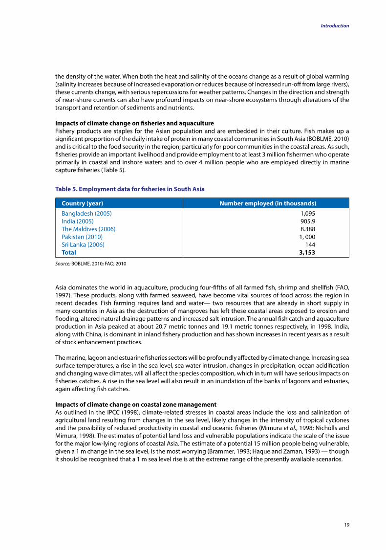
Impacts of climate change on fisheries and aquacultureFishery products are staples for the Asian population and are embedded in their culture. Fish makes up a significant proportion of the daily intake of protein in many coastal communities in South Asia (BOBLME, 2010) and is critical to the food security in the region, particularly for poor communities in the coastal areas. As such, fisheries provide an important livelihood and provide employment to at least 3 million fishermen who operate primarily in coastal and inshore waters and to over 4 million people who are employed directly in marine capture fisheries (Table 5).
Country (year) number employed (in thousands)
Bangladesh (2005)India (2005)The Maldives (2006)Pakistan (2010)Sri Lanka (2006)total
1,095905.98.3881, 000
1443,153
table 5. Employment data for fisheries in South Asia
Source: BOBLME, 2010; FAO, 2010
Asia dominates the world in aquaculture, producing four-fifths of all farmed fish, shrimp and shellfish (FAO, 1997). These products, along with farmed seaweed, have become vital sources of food across the region in recent decades. Fish farming requires land and water— two resources that are already in short supply in many countries in Asia as the destruction of mangroves has left these coastal areas exposed to erosion and flooding, altered natural drainage patterns and increased salt intrusion. The annual fish catch and aquaculture production in Asia peaked at about 20.7 metric tonnes and 19.1 metric tonnes respectively, in 1998. India, along with China, is dominant in inland fishery production and has shown increases in recent years as a result of stock enhancement practices.
The marine, lagoon and estuarine fisheries sectors will be profoundly affected by climate change. Increasing sea surface temperatures, a rise in the sea level, sea water intrusion, changes in precipitation, ocean acidification and changing wave climates, will all affect the species composition, which in turn will have serious impacts on fisheries catches. A rise in the sea level will also result in an inundation of the banks of lagoons and estuaries, again affecting fish catches.
Impacts of climate change on coastal zone managementAs outlined in the IPCC (1998), climate-related stresses in coastal areas include the loss and salinisation of agricultural land resulting from changes in the sea level, likely changes in the intensity of tropical cyclones and the possibility of reduced productivity in coastal and oceanic fisheries (Mimura et al., 1998; Nicholls and Mimura, 1998). The estimates of potential land loss and vulnerable populations indicate the scale of the issue for the major low-lying regions of coastal Asia. The estimate of a potential 15 million people being vulnerable, given a 1 m change in the sea level, is the most worrying (Brammer, 1993; Haque and Zaman, 1993) — though it should be recognised that a 1 m sea level rise is at the extreme range of the presently available scenarios.
Introduction
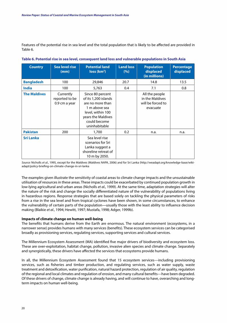
Review Paper: Status of Coastal and Marine Ecosystem Management in South Asia
20
Features of the potential rise in sea level and the total population that is likely to be affected are provided in Table 6.
The examples given illustrate the sensitivity of coastal areas to climate change impacts and the unsustainable utilisation of resources in these areas. These impacts could be exacerbated by continued population growth in low-lying agricultural and urban areas (Nicholls et al., 1999). At the same time, adaptation strategies will alter the nature of the risk and change the socially differentiated nature of the vulnerability of populations living in hazardous regions. Response strategies that are based solely on tackling the physical parameters of risks from a rise in the sea level and from tropical cyclones have been shown, in some circumstances, to enhance the vulnerability of certain parts of the population—usually those with the least ability to influence decision making (Blaikie et al., 1994; Hewitt, 1997; Mustafa, 1998; Adger, 1999b).
Impacts of climate change on human well-beingThe benefits that humans derive from the Earth are enormous. The natural environment (ecosystems, in a narrower sense) provides humans with many services (benefits). These ecosystem services can be categorised broadly as provisioning services, regulating services, supporting services and cultural services.
The Millennium Ecosystem Assessment (MA) identified five major drivers of biodiversity and ecosystem loss. These are over-exploitation, habitat change, pollution, invasive alien species and climate change. Separately and synergistically, these drivers have affected the services that ecosystems provide humans.
In all, the Millennium Ecosystem Assessment found that 15 ecosystem services—including provisioning services, such as fisheries and timber production, and regulating services, such as water supply, waste treatment and detoxification, water purification, natural hazard protection, regulation of air quality, regulation of the regional and local climates and regulation of erosion, and many cultural benefits—have been degraded.Of these drivers of change, climate change is already having, and will continue to have, overarching and long-term impacts on human well-being.
table 6. Potential rise in sea level, consequent land loss and vulnerable populations in South Asia
Source: Nicholls et al., 1995, except for the Maldives (Maldives NAPA, 2006) and for Sri Lanka (http://weadapt.org/knowledge-base/wiki-adapt/policy-briefing-on-climate-change-in-sri-lanka
Country Sea level rise (mm)
Potential land loss (km2)
land loss (%)
Population displaced
(in millions)
Percentage displaced
Bangladesh 100 29,846 20.7 14.8 13.5
India 100 5,763 0.4 7.1 0.8
the Maldives Currently reported to be 0.9 cm a year
Since 80 percent of its 1,200 islands are no more than
1 m above sea level, within 100
years the Maldives could become uninhabitable
All the people in the Maldives will be forced to
evacuate
Pakistan 200 1,700 0.2 n.a. n.a.
Sri lanka Sea level rise scenarios for Sri Lanka suggest a
shoreline retreat of 10 m by 2050.
21
Increased water stress as a result of climate change is also a serious issue.
• In the short term, the run-off from rapidly melting glaciers can cause landslides and intense flooding downstream, but in the long term, the reduced quantity of ice produces less fresh water downstream. The snow melts of the Himalaya feed the Ganges, Indus and Brahmaputra. The Ganges — which alone provides water to 400 million of people — is predicted to lose two-thirds of its water as a result of climate change (Reid and Simms, 2007).
• Coastal flooding and sea water intrusion will also reduce the amount of fresh water available to people.• Regional studies show that a projected 2 percent increase in temperature will cause losses of around
US$1.7 billion to be incurred in the water resources sector and, with a 2-4 percent rise, could leave 7-924 million rural poor people experiencing water stress (http://www.ifad.org/events/apr09/impact/south.pdf ).
Impacts on regulating services, increasing coastal vulnerability
• Tens of millions of people in the low-lying coastal areas of South and South-East Asia will be affected by rising sea levels and an increase in the intensity of tropical cyclones (http://www.unfccc.int/resource/docs/publications/impacts.pdf ).
• The number of reported hydro-meteorological hazards (droughts, floods, wind storms, forest fires and landslides) has increased significantly in recent decades — from 195 per year (average in the period 1987-1998) to 365 per year (average in the period 2000-2006) (http://www.fao.org/climatechange/49376/en/). Asia is the world’s most disaster-prone region, and each year, a phenomenal number of people are displaced as a result of natural disasters.
Impacts on regulating services, worsening health issues and basic amenities
• In Asia, there is also a serious concern about the impacts of climate change on health. It is predicted that epidemics of malaria, dengue and other vector-borne diseases will increase (Martens et al., 1999, in litt.; http://www.unfccc.int/resource/docs/publications/impacts.pdf ).
• Climate change-attributable diarrhoea and malnutrition were already very high in Bangladesh, India and the Maldives in 2000. Diarrhoea and deaths due to diarrhoea, as well as cholera, are predicted to increase as a result of natural disasters such as droughts and floods (http://www.unfccc.int/resource/docs/publications/impacts.pdf ).
• An increase in the frequency of severe heat waves is also predicted to result in death and morbidity, particularly among the urban poor and the elderly (http://www.unfccc.int/resource/docs/publications/impacts.pdf ).
Introduction
At the turn of this century, the then Secretary General of the United Nations, Kofi Anan, called for a global assessment of the state of the Earth. A total of 1,360 scientists from 95 countries participated in this assessment, which was carried out between 2001 and 2005. It focussed on developing and presenting a framework that linked clearly all the services that ecosystems provided to human well-being. It examined relatively untouched ecosystems, as well as intensively managed and highly modified systems. It examined how well-being of an ecosystem affects the services it provides and, therefore, affects human well-being. This framework links clearly ecosystem well-being to human well-being and shows explicitly that humans are integral parts of ecosystems. In its review, the Millennium Ecosystem Assessment also identifies major anthropogenic threats to ecosystems or drivers of ecosystem change (MA, 2005).
Impacts on provisioning services that affect food security and livelihoods
Food security is a serious concern in the region because most of the rural poor depend on agriculture and fisheries for their livelihoods.
• Changes in precipitation, temperature, wave currents and ocean acidification will all affect fish yields and catches, as discussed in a previous section.
• Changes in precipitation and monsoonal rainfall patterns, in combination with increases in atmospheric temperature, could significantly change crop yields. It is predicted that in Central Asia and South Asia there will be a 30 percent drop in crop yields (http://www.unfccc.int/resource/docs/publications/impacts.pdf ).
• As a result, food security will be affected, placing millions of people at risk from hunger.
Review Paper: Status of Coastal and Marine Ecosystem Management in South Asia
2222
Summary for Chapter 1
Asia is the world’s largest and most populous continent. The different regions of Asia exibit diverse political, socio-economic and cultural systems. They also vary significantly in their biogeography and climate.
South Asia: South Asia is one of the most populous regions in the world (having over one-fifth of the global population) and consists of Afghanistan, Bangladesh, Bhutan, India, Iran, the Maldives, Nepal, Pakistan and Sri Lanka. However, only the costal countries (Bangladesh, India, the Maldives, Pakistan and Sri Lanka) are considered here. A number of important coastal ecosystems (coral reefs, mangroves, seagrass meadows, river deltas and estuaries) are found in the region.
Physical and ecological features: South Asia is physiographically diverse and rich in natural and crop-related biodiversity. Urbanisation, industrialisation and economic development in the region have resulted in environmental problems, such as air and water pollution and land degradation. Climate change represents an additional threat in the region. The climate varies considerably within South Asia but is driven primarily by the monsoons. Some of the largest river systems in the world are found in South Asia and play a key role in the economics, transportation, communication and other sectors. They can also be extremely destructive when they flood. There is great diversity in vegetation across South Asia, with approximately 18.6 percent of the land in the region having forest cover (only 5 percent of which is protected). It is home to 15.5 percent of the flora and 12 percent of the fauna in the world.
Economy: Asia has the second largest GDP of any continent (behind Europe). China and India are the largest economies in Asia (with a growth rate of 8 percent each from the early 1990s and 2000s). However, many of the South Asian countries (with the exception of India) have relatively low GDPs but have shown rapid growth in the last two decades – particularly in the industry and service sectors. This has result in the industrial development of coastal zones.
Poverty in the region: Despite the rapid economic growth of South Asia (6 percent per year over the last 20 years), stark poverty is widespread in the region. South Asia has the largest concentration of poor people in the world. These people also have limited access to education and are subject to risk factors that affect their health (e.g. poor water supply, nutrition and sanitation).
demography: The countries in the sub-region are among the most populous in the world (particularly India— the second most populous country—as well as Bangladesh and Pakistan).
Climate change: Greenhouse gas (GHG) emissions (CO2 and CH4) cause a ‘greenhouse effect’. This results in global warming, which in turn, drives climate change. CO2 concentrations in the atmosphere have risen significantly in the last century due to development (the excessive use of oil and coal, transportation and industry), while forests, which absorb CO2, have been destroyed. Similarly, livestock farming and solid waste pollution have resulted in the generation of a large quantity of CH4.
Climate change impacts
Impacts of climate change on natural disasters: The most devastating impact of climate change is the increase in intensity and frequency of natural disasters. While this will have far-reaching global effects, there will be disproportionate impacts on Asia, which is highly prone to natural diasters and is already stressed with other factors (overpopulation, poverty, internal conflict, resource overuse and the spread of disease). Cyclones, earthquakes and floods are the principal natural disasters occurring across the South Asian sub-region. Tsunamis have been infrequent but have had severe impacts in specific regions. Many of those affected by natural diasters in South Asia are the marginalised and poor, who are forced by their circumstances to live in hazard-prone areas (e.g. living in low-lying lands). These people have few resources and so struggle to deal with frequent and recurrent natural diasters.
Review Paper: Status of Coastal and Marine Ecosystem Management in South Asia
23
Introduction
tropical cyclones: Tropical cyclones and storm surges impact the loss of human life in Bangladesh and India significantly, and also affect coastal communities in Sri Lanka. Cyclones occur annually in many South Asian countries (particularly in Bangladesh) and also cause serious economic losses. Tropical cyclones are expected to increase in intensity with climate change.
Earthquakes: The Indian subcontinent (Bangladesh, India and Pakistan) has a history of devastating earthquakes as India is driving into the rest of Asia at a rate of approximately 47 mm per year. Four earthquakes have occurred in India between 1994 and 2004, resulting in considerable damage to property, as well as severe losses of life. The earthquaes.ke and tsunami of December 2004 had a devastating effect (including structural damage and significant losses of life) on much of the region around the Indian Ocean, with India, the Maldives and Sri Lanka being affected badly.
floods: Bangladesh (with most of the country being approximately only 10 m above sea level and lying in the flood plains of the Gangetic delta), is one of the most flood-prone areas in the world. Several thousands of people are killed and millions of homes destoryed each year as a result of floods. The abnormally high melting of ice in the Himalaya has contributed to flooding in the region. The other countries in South Asia are also affected by floods. Wetlands act as sponges to absorb and slowly release water and so provide protection from floods and storms (e.g. the Muthurajawela Marsh in Sri Lanka).
Impacts of climate change on biodiversity, protected areas and coastal ecosystems: While the frontier forests of Asia are home to more than half of the terrestial plant and animals species on Earth, they are becoming increasingly threatened. Climate change is likely to act synergistically with these threats and stressors (including overexploitation, land conversion, habitat loss and pollution), to impact protected areas, with many species being Globally or Nationally Threatened at present. The ranges of many species have already changed due to climate change, and this is a major consideration in the management of protected areas. Rising sea levels are a significant threat to coastal habitats in the South Asian region.
Coral reefs: Coral reefs are critical to the fisheries of South Asia and protect its coasts from wave action and erosion. However, they are undergoing rapid destruction (due to a number of factors including destructive fishing techniques and reef mining for calcium carbonate production), and global warming and climate change are posing an additional emerging and severe threat to already stressed coral reefs (e.g. through rises in sea level and temperature, changed weather patterns and carbonic acid formation). As such, reef communities have been altered in the region. Although healthy reefs are likely to be able to adapt to projected sea level changes, coral reefs that are already stressed by other human activities and threats, will not.
Mangroves: Mangroves are restricted to the intertidal zone in the coasts around Asia and are becoming increasingly depleted due to anthropogentic pressures. They are also extremely vulnerable to the effects of climate change, such as rising sea levels (resulting in loss of habitat and changes in salinity), changes in precipitation and wave climates and an increase in the frequency of natural diasters. Mangrove forests are home to a number of species (e.g. the tiger, the Eurasian otter, marine turtles and crab species), which will be threatened with extinction as mangroves are destoyed.
Seagrasses: Higher water temperatures (resulting from climate change) will affect the growth, reproduction and general metabolism of seagrasses, while increased acidity will affect their productivity. Increased numbers of storms will also result in physical damage to seagrass meadows and increase the turbidity of the water (affecting the availability of light for photosynthesis).
Coastal wetlands, including estuaries, deltas, salt marshes and mudflats: Coastal wetlands (associated with deltas, estuaries, lagoons and sheltered bays) are affected by rising sea levels and sedimentation. Changes in river water discharge (resulting from climate change) may also affect the wetlands associated with deltas. As such, plant and animal species that inhabit these coastal wetlands are also threatened.
23
Review Paper: Status of Coastal and Marine Ecosystem Management in South Asia
2424
Impacts of climate change on wave climates: Ocean currents are driven by heat and salinity (which together determine density) and are, as such, affected significantly by global warming. This will have repercussions for the weather patterns and climates of continents (particularly coastal regions), which are maintained by wave currents. Changes in near-shore currents can also have profound impacts on coastal ecosystems through altered transport and retention of sediments and nutrients, for example.
Impacts of climate change on fisheries and aquaculture: Fishery products are an integral part of Asian culture and an important source of protein for the coast-dwelling poor of South Asia. As such, fisheries (inshore, coastal and marine) are an important source of employment in the region. These fisheries are threatened by chnages in stock status due to the effects of climate change (increased sea surface temperatures, rising sea levels, sea water intrusion, changes in precipitation, ocean acidification and changing wave climates). Aquaculture (farming of fish, shrimp and shellfish) also provides a vital source of food in Asia. However, this requires land and water, which are in short supply (due to rising sea levels and increased salt intrusion associated with climate change).
Impacts of climate change on coastal zone management: Coastal regions are extremely sensitive to climate change, and millions of people are expected to be affected by rising sea levels, with a considerable land loss being predicted in South Asia. These factors may be exacerbated by the continuing population growth in the region. Response strategies based solely on tackling the physical parameters of these risks have been shown in some circumstances to enhance the vulnerability of certain parts of the population (usually those with the least ability to influence decision making).
Impacts of climate change on human well-being: Humans gain numerous benefits and services from ecosystems, which are threatened by over-exploitation, habitat change, pollution, invasive alien species and climate change. Climate change, in particular, is having, and will continue to have, overarching and long-term impacts on human well-being (with benefits and services being affected) as these ecosystems are lost and degraded.
Impacts on provisioning services, affecting food security and livelihoods: Climate change affects food security and water stress, which in turn, have considerable impacts on the lives and livelihoods of people.
Impacts on regulating services, increasing coastal vulnerability: Climate change will exacerbate the vulnerability of coastal communities to natural disasters, which may increase in frequency and intensity.
Impacts on regulating services, increasing health issues and basic amenities: Climate change can act as a catalyst to vector-borne diseases and epidemics, while climate change-attributable diseases and heat-related deaths are also expected to rise.
Review Paper: Status of Coastal and Marine Ecosystem Management in South Asia
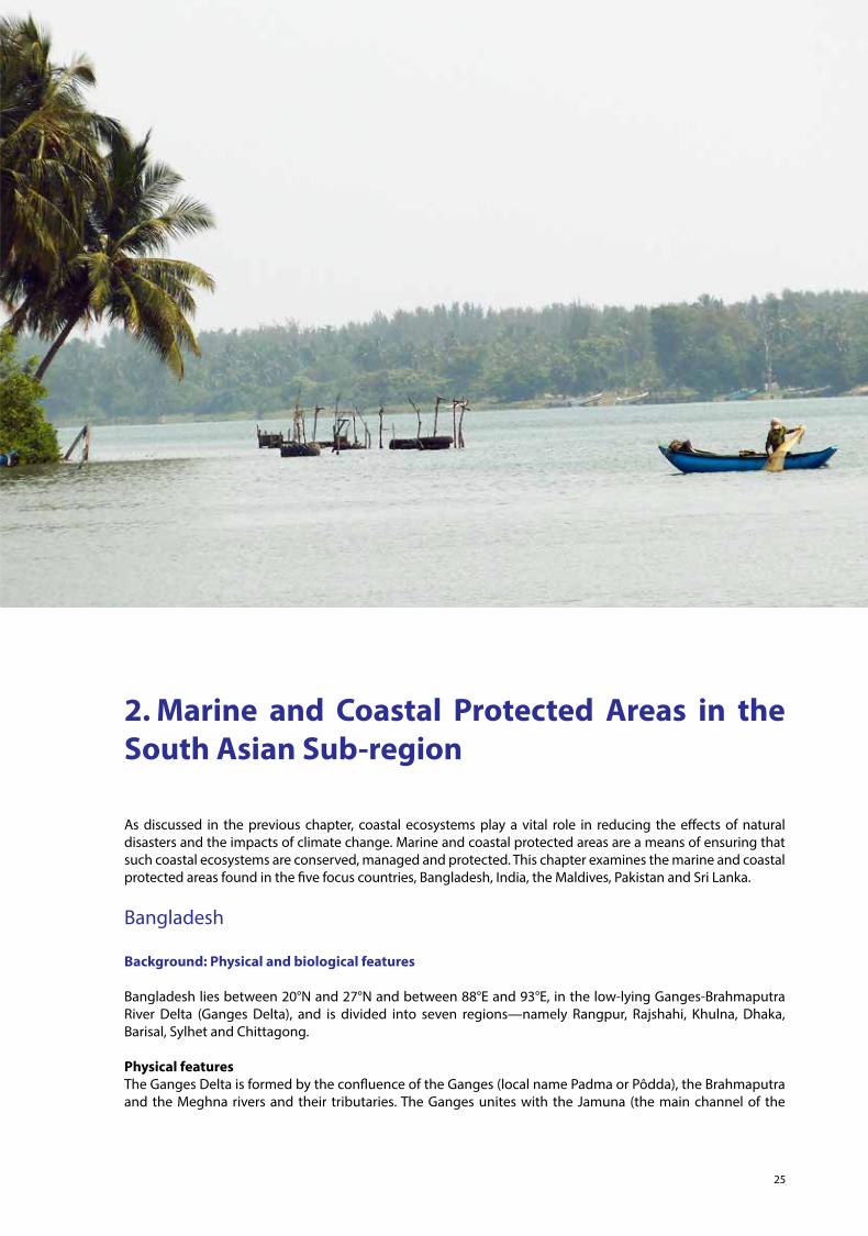
25
2. Marine and Coastal Protected Areas in the South Asian Sub-region
As discussed in the previous chapter, coastal ecosystems play a vital role in reducing the effects of natural disasters and the impacts of climate change. Marine and coastal protected areas are a means of ensuring that such coastal ecosystems are conserved, managed and protected. This chapter examines the marine and coastal protected areas found in the five focus countries, Bangladesh, India, the Maldives, Pakistan and Sri Lanka.
Bangladesh
Background: Physical and biological features
Bangladesh lies between 20°N and 27°N and between 88°E and 93°E, in the low-lying Ganges-Brahmaputra River Delta (Ganges Delta), and is divided into seven regions—namely Rangpur, Rajshahi, Khulna, Dhaka, Barisal, Sylhet and Chittagong.
Physical featuresThe Ganges Delta is formed by the confluence of the Ganges (local name Padma or Pôdda), the Brahmaputra and the Meghna rivers and their tributaries. The Ganges unites with the Jamuna (the main channel of the
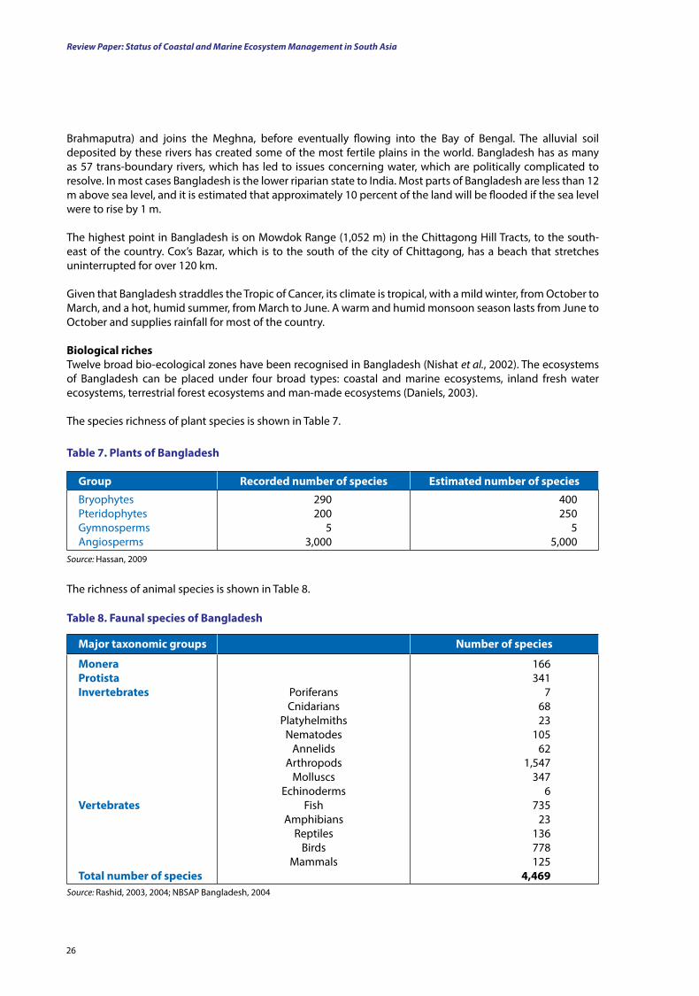
Review Paper: Status of Coastal and Marine Ecosystem Management in South Asia
26
Brahmaputra) and joins the Meghna, before eventually flowing into the Bay of Bengal. The alluvial soil deposited by these rivers has created some of the most fertile plains in the world. Bangladesh has as many as 57 trans-boundary rivers, which has led to issues concerning water, which are politically complicated to resolve. In most cases Bangladesh is the lower riparian state to India. Most parts of Bangladesh are less than 12 m above sea level, and it is estimated that approximately 10 percent of the land will be flooded if the sea level were to rise by 1 m.
The highest point in Bangladesh is on Mowdok Range (1,052 m) in the Chittagong Hill Tracts, to the south-east of the country. Cox’s Bazar, which is to the south of the city of Chittagong, has a beach that stretches uninterrupted for over 120 km.
Given that Bangladesh straddles the Tropic of Cancer, its climate is tropical, with a mild winter, from October to March, and a hot, humid summer, from March to June. A warm and humid monsoon season lasts from June to October and supplies rainfall for most of the country.
Biological richesTwelve broad bio-ecological zones have been recognised in Bangladesh (Nishat et al., 2002). The ecosystems of Bangladesh can be placed under four broad types: coastal and marine ecosystems, inland fresh water ecosystems, terrestrial forest ecosystems and man-made ecosystems (Daniels, 2003).
The species richness of plant species is shown in Table 7.
group recorded number of species Estimated number of species
BryophytesPteridophytesGymnospermsAngiosperms
290200
53,000
400250
55,000
table 7. Plants of Bangladesh
Source: Hassan, 2009
The richness of animal species is shown in Table 8.
Major taxonomic groups number of species
MoneraProtistaInvertebrates
Vertebrates
total number of species
PoriferansCnidarians
PlatyhelmithsNematodes
AnnelidsArthropods
MolluscsEchinoderms
FishAmphibians
ReptilesBirds
Mammals
166341
76823
10562
1,547347
6735
23136778125
4,469
table 8. faunal species of Bangladesh
Source: Rashid, 2003, 2004; NBSAP Bangladesh, 2004
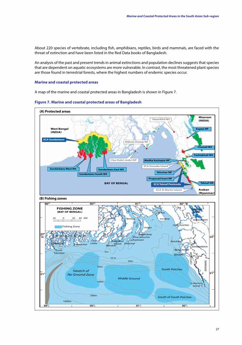
27
Marine and Coastal Protected Areas in the South Asian Sub-region
About 220 species of vertebrate, including fish, amphibians, reptiles, birds and mammals, are faced with the threat of extinction and have been listed in the Red Data books of Bangladesh.
An analysis of the past and present trends in animal extinctions and population declines suggests that species that are dependent on aquatic ecosystems are more vulnerable. In contrast, the most threatened plant species are those found in terrestrial forests, where the highest numbers of endemic species occur.
Marine and coastal protected areas
A map of the marine and coastal protected areas in Bangladesh is shown in Figure 7.
figure 7. Marine and coastal protected areas of Bangladesh
West Bengal (IndIA)
ECA Sundarbans
Sundarbans West WS
Sundarbans South WS
Sundarbans East WS
Medha Kachapia nP
Himchar nP
Proposed Inani nP
fashiakhali WS
Chunati WS
Kaptai nP
Hazarikhil WS
nijhum dweep nP
Char Kukri-mukri nP
ECA Sonadia Island
ECA St Martin Island
ECA teknaf Peninsula teknaf grBAy of BEngAl
Arakan (Myanmar)
Mizoram (IndIA)
NijumdwipChar Sakuchia
Charnizam
Hatiya
DhalcharMoudubi
LaldiaChar
Dublarchar
SandwipBHOLA
Urirchar
CHITTAGONG
RANGAMATI
BANDARBAN
Kutubdia
Maheshkhali
Sonadia
South Talpattya
Swatch of No Ground Zone
Middle Ground
South Patches
South of South Patches
St Martin’s Island
(MYA
NMAR
)
COX’S
BAZA
R
Rabnabad Islands
5m
10 m20m
50m
100m
200m
1000m
fISHIng ZonE(BAy of BEngAl)
20 0 20 40 KM
Fishing Zone
(A) Protected areas
(B) fishing zones
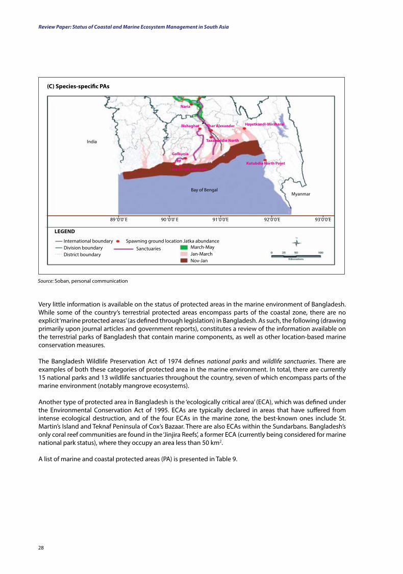
Review Paper: Status of Coastal and Marine Ecosystem Management in South Asia
28
Source: Soban, personal communication
Bay of BengalMyanmar
India
naria
Ilishaghat thar Alexandar
golbunia
rf
Hayetkandi-Mirsharai
Kutubdia north Point
tazanuddin north
lata Chapli-Kalapara
International boundaryDivision boundaryDistrict boundary
lEgEnd
March-MayJan-MarchNov-Jan
Spawning ground location Jatka abundanceSanctuaries
89 ‘0’0’ E 90 ‘0’0’ E 91’0’0’E 92’0’0’E 93’0’0’E
Very little information is available on the status of protected areas in the marine environment of Bangladesh. While some of the country’s terrestrial protected areas encompass parts of the coastal zone, there are no explicit ‘marine protected areas’ (as defined through legislation) in Bangladesh. As such, the following (drawing primarily upon journal articles and government reports), constitutes a review of the information available on the terrestrial parks of Bangladesh that contain marine components, as well as other location-based marine conservation measures.
The Bangladesh Wildlife Preservation Act of 1974 defines national parks and wildlife sanctuaries. There are examples of both these categories of protected area in the marine environment. In total, there are currently 15 national parks and 13 wildlife sanctuaries throughout the country, seven of which encompass parts of the marine environment (notably mangrove ecosystems).
Another type of protected area in Bangladesh is the ‘ecologically critical area’ (ECA), which was defined under the Environmental Conservation Act of 1995. ECAs are typically declared in areas that have suffered from intense ecological destruction, and of the four ECAs in the marine zone, the best-known ones include St. Martin’s Island and Teknaf Peninsula of Cox’s Bazaar. There are also ECAs within the Sundarbans. Bangladesh’s only coral reef communities are found in the ‘Jinjira Reefs’, a former ECA (currently being considered for marine national park status), where they occupy an area less than 50 km2.
A list of marine and coastal protected areas (PA) is presented in Table 9.
(C) Species-specific PAs
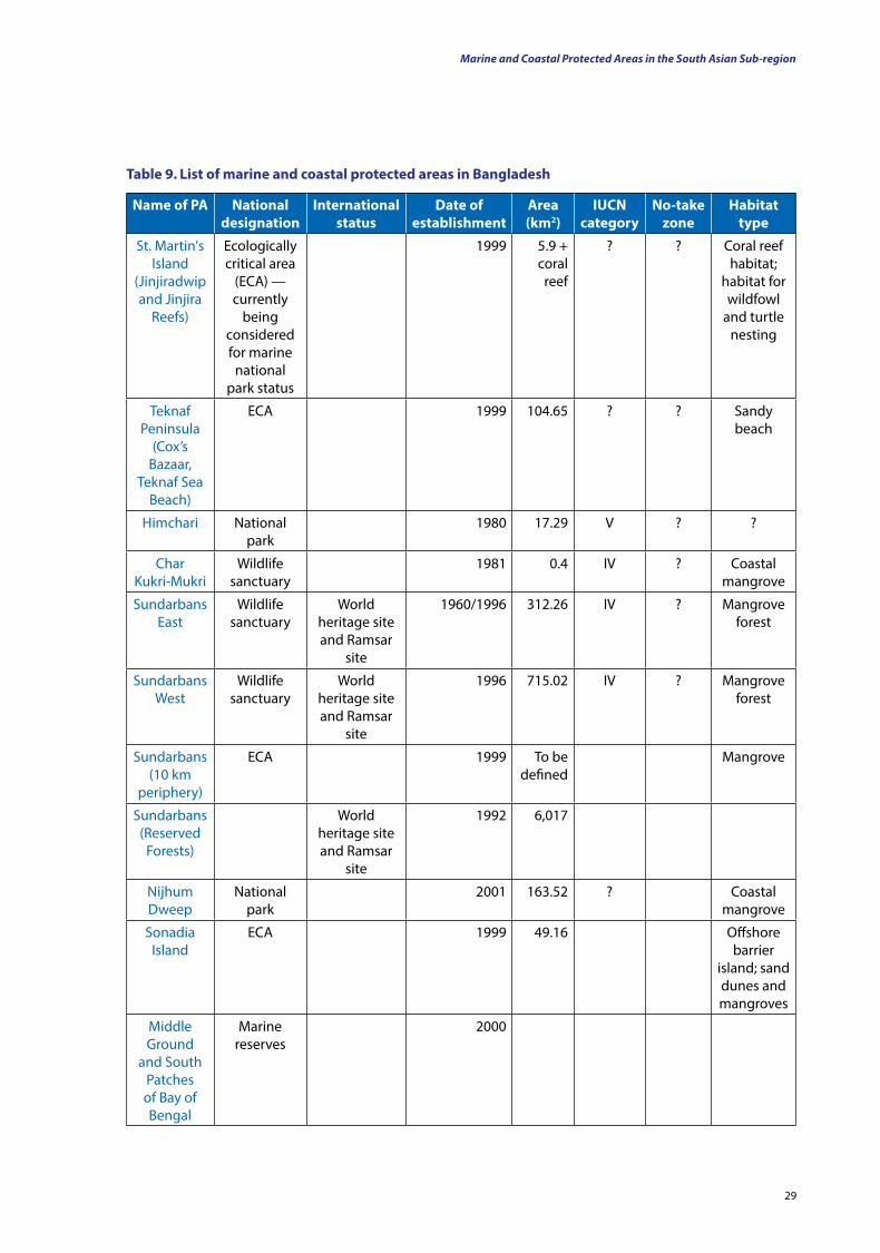
29
table 9. list of marine and coastal protected areas in Bangladesh
name of PA national designation
International status
date of establishment
Area (km2)
IuCn category
no-take zone
Habitat type
St. Martin's Island
(Jinjiradwip and Jinjira
Reefs)
Ecologically critical area
(ECA) — currently
being considered for marine
national park status
1999 5.9 + coral reef
? ? Coral reef habitat;
habitat for wildfowl
and turtle nesting
Teknaf Peninsula
(Cox’s Bazaar,
Teknaf Sea Beach)
ECA 1999 104.65 ? ? Sandy beach
Himchari National park
1980 17.29 V ? ?
Char Kukri-Mukri
Wildlife sanctuary
1981 0.4 IV ? Coastal mangrove
Sundarbans East
Wildlife sanctuary
World heritage site and Ramsar
site
1960/1996 312.26 IV ? Mangrove forest
Sundarbans West
Wildlife sanctuary
World heritage site and Ramsar
site
1996 715.02 IV ? Mangrove forest
Sundarbans (10 km
periphery)
ECA 1999 To be defined
Mangrove
Sundarbans (Reserved
Forests)
World heritage site and Ramsar
site
1992 6,017
Nijhum Dweep
National park
2001 163.52 ? Coastal mangrove
Sonadia Island
ECA 1999 49.16 Offshore barrier
island; sand dunes and mangroves
Middle Ground
and South Patches of Bay of Bengal
Marine reserves
2000
Marine and Coastal Protected Areas in the South Asian Sub-region
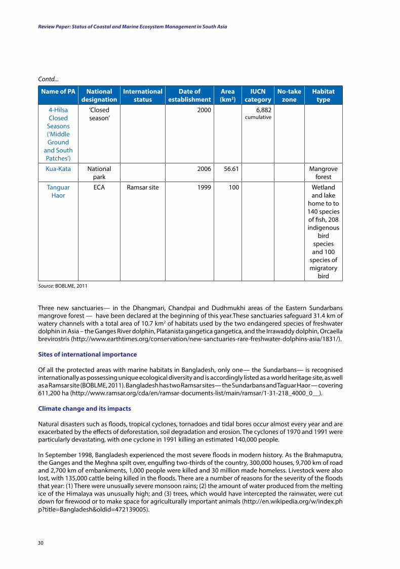
Review Paper: Status of Coastal and Marine Ecosystem Management in South Asia
30
name of PA national designation
International status
date of establishment
Area (km2)
IuCn category
no-take zone
Habitat type
4-Hilsa Closed
Seasons (‘Middle Ground
and South Patches’)
‘Closed season’
2000 6,882cumulative
Kua-Kata National park
2006 56.61 Mangrove forest
Tanguar Haor
ECA Ramsar site 1999 100 Wetland and lake
home to to 140 species of fish, 208 indigenous
bird species and 100
species of migratory
birdSource: BOBLME, 2011
Contd...
Three new sanctuaries— in the Dhangmari, Chandpai and Dudhmukhi areas of the Eastern Sundarbans mangrove forest — have been declared at the beginning of this year.These sanctuaries safeguard 31.4 km of watery channels with a total area of 10.7 km2 of habitats used by the two endangered species of freshwater dolphin in Asia – the Ganges River dolphin, Platanista gangetica gangetica, and the Irrawaddy dolphin, Orcaella brevirostris (http://www.earthtimes.org/conservation/new-sanctuaries-rare-freshwater-dolphins-asia/1831/).
Sites of international importance
Of all the protected areas with marine habitats in Bangladesh, only one— the Sundarbans— is recognised internationally as possessing unique ecological diversity and is accordingly listed as a world heritage site, as well as a Ramsar site (BOBLME, 2011). Bangladesh has two Ramsar sites— the Sundarbans and Taguar Haor — covering 611,200 ha (http://www.ramsar.org/cda/en/ramsar-documents-list/main/ramsar/1-31-218_4000_0__).
Climate change and its impacts
Natural disasters such as floods, tropical cyclones, tornadoes and tidal bores occur almost every year and are exacerbated by the effects of deforestation, soil degradation and erosion. The cyclones of 1970 and 1991 were particularly devastating, with one cyclone in 1991 killing an estimated 140,000 people.
In September 1998, Bangladesh experienced the most severe floods in modern history. As the Brahmaputra, the Ganges and the Meghna spilt over, engulfing two-thirds of the country, 300,000 houses, 9,700 km of road and 2,700 km of embankments, 1,000 people were killed and 30 million made homeless. Livestock were also lost, with 135,000 cattle being killed in the floods. There are a number of reasons for the severity of the floods that year: (1) There were unusually severe monsoon rains; (2) the amount of water produced from the melting ice of the Himalaya was unusually high; and (3) trees, which would have intercepted the rainwater, were cut down for firewood or to make space for agriculturally important animals (http://en.wikipedia.org/w/index.php?title=Bangladesh&oldid=472139005).
31
Bangladesh is among the countries most prone to natural floods, tornadoes and cyclones (Ahmed and Mirza 2000; Mirza et al., 2003) and is now widely recognised as being one of the countries most vulnerable to climate change. Natural hazards that are associated with increased rainfall, rising sea levels and tropical cyclones are expected to increase as the climate changes, with each of these factors having serious effects on the agriculture, the water and food security, human health and shelter. It is believed that in the coming decades the rising sea level alone will create more than 20 million climate refugees (people displaced by climatically induced environmental disasters). There is evidence to suggest that earthquakes pose a threat by inducing natural disasters in Bangladesh through the movement of rivers. Evidence shows that tectonic movements have caused rivers to shift course, suddenly and dramatically. It has been shown that monsoonal flooding in Bangladesh, in the world’s largest river delta, can push the underlying crust down by as much as 6 cm and possibly perturb faults (http://www.adpc.net/v2007/ikm/Country Profiles/Bangladesh/Default-Bangladesh.asp; http://en.wikipedia.org/wiki/Bangladesh).
Bangladeshi water is contaminated frequently due to the high arsenic content of the soil, with up to 77 million people being exposed to toxic arsenic from drinking water (Walker, 2010).
The general cyclonic activity in the Bay of Bengal has become more frequent in recent years, making the seas rougher. This is causing problems for fishermen and making the use of small fishing craft difficult.
A critical climate change variable that influences the vulnerability of Bangladesh is the magnitude of the sea level rise. Rising sea levels and consequent changes in rivers and estuaries can trigger changes in the habitats and breeding grounds of fish. For example, penaeid shrimps breed and develop in brackish water, where salt water and fresh water mix. A rise in the sea level will alter this interface, changing the natural habitat of the shrimp population. There are approximately 60 shrimp hatcheries and 120 shrimp processing plants in the coastal zone of Bangladesh. The hatcheries are located along the sea beach at Cox’s Bazaar. Favourable environmental conditions and brood stock availability are the main reasons for this location. Some hatcheries have also attempted shrimp production on the coasts of Chittagong and Satkhira. Given that these districts are located in coastal zones that are vulnerable to rising sea levels, the shrimp industry is also at risk in these areas. While a rise in the sea level can help shrimp farming through salinisation of the coastal area, flooding caused by this rise can inundate shrimp ponds.
Bangladesh topped the list of 27 low-lying countries produced based on different vulnerability indicators for accelerated sea level rise) by the Woods Hole Oceanographic Institute (WHOI, 1986). The Bay of Bengal acts as a funnel for storm events, creating severe storm surges, which can raise the sea level above the tidal height and devastate low-lying coasts such as that of Bangladesh (UNEP, 2005).
The Sundarbans, the largest tract of mangroves in the world (Rahman, 2000), can be wiped out by a 1 m rise in sea level. The loss of the Sundarbans would be catastrophic as it would involve losses of heritage, biodiversity, fisheries resources, lives and livelihoods, as well as the loss of a highly productive ecosystem (Ali, 1996). Rising sea levels can reduce the availability of light for corals and can, as such, reduce their growth. St. Martin’s Island, the only highly productive coral island in Bangladesh, may, therefore, be destroyed (http://en.wikipedia.org/w/index.php?title=Sundarbans&oldid=470496505).
The alteration of marine ecosystems due to climate change has both direct and indirect effects on fish and their reproduction, migration and survival. Hilsa (Tenualosa ilisha) — the national fish of Bangladesh — accounts for 13 to 14 percent (valued at around US$71.4 million divide — 1.3percent of the GDP) of the total fish produced in Bangladesh. The hilsa is an anadromous5 fish, which has a life cycle that follows the general pattern of breeding upstream in fresh water, with the larvae hatching from free-floating eggs. The immature young grow in river channels and then descend to the sea for a period of feeding and growth before returning to the rivers as mature breeding adults to complete the cycle.
Until about 1972 the hilsa fishery was restricted to the upstream rivers, mainly the Padma, Meghna, Karatoya, Rupsa, Shibsa and Payra. At present, the fishery has severely declined in the upstream areas and is mainly
5 Migrating up rivers from the sea to breed in fresh water.
Marine and Coastal Protected Areas in the South Asian Sub-region
Review Paper: Status of Coastal and Marine Ecosystem Management in South Asia
32
concentrated in the downstream rivers, estuaries and coastal areas, as well as in the sea. A number of factors are thought to be responsible for the decline of the hilsa fishery in Bangladesh. A low water discharge from the Ganges due to the construction of the Farakka Barrage and consequent heavy siltation, indiscriminate exploitation of juveniles, disruption of migration routes, loss of spawning, feeding and nursing grounds, and increased river pollution are considered to be some of the causes behind this decline. Moreover, the uncontrolled use of mechanised hilsa fishing boats in coastal areas is preventing the upward spawning migration of the fish.
Water resource development activities, such as flood control drainage and irrigation projects, have also affected the aquatic ecosystem and hilsa fishery adversely. The closure of the Kumar River has cut off hilsa migration from the sea via Nabaganga, to the Padma. The Chandpur Irrigation and Flood Control Project and the Meghna-Dhanagoda Irrigation and Flood Control Project have also exerted similar negative effects on the hilsa fishery through the destruction of juvenile hilsa nursery grounds (www.banglapedia.org).
Similar conditions may develop for other marine fish and shrimp species, but this is yet to be studied in Bangladesh (http://[email protected]).
India
Background: Physical and biological features
India is the seventh largest country by geographical area, the second most populous country (with over 1.2 billion people) and the most populous democracy in the world. Bounded by the Indian Ocean in the south, the Arabian Sea in the south-west and the Bay of Bengal in the south-east, India shares land borders with Pakistan to the west; China, Nepal, and Bhutan to the north-east; and Burma and Bangladesh to the east. In the Indian Ocean, India is in the vicinity of Sri Lanka and the Maldives. In addition, India’s Andaman and Nicobar Islands share a maritime border with Thailand and Indonesia.
Physical featuresOf India’s 7,517 km long coast, 5,423 km belongs to peninsular India and 2,094 km to the Andaman, Nicobar and Lakshadweep Islands. According to the Indian naval hydrographic charts, the mainland coast consists of the following: 43 percent, sandy beaches; 11 percent, rocky coast including cliffs; and 46 percent, mudflats or marshy coast.
The major Himalayan-origin rivers that flow through India include the Ganges (Ganga) and the Brahmaputra – both of which drain into the Bay of Bengal. Important tributaries of the Ganges include the Yamuna and the Kosi. The latter’s extremely low gradient causes disastrous floods every year. Major peninsular rivers, whose steeper gradients prevent their waters from flooding, include the Godavari, the Mahanadi, the Kaveri and the Krishna, which also drain into the Bay of Bengal, and the Narmada and the Tapti, which drain into the Arabian Sea. Among the notable coastal features of India are the marshy Rann of Kutch, in western India, and the alluvial Sundarbans Delta (which India shares with Bangladesh). India has two archipelagos: (1) the Lakshadweep, coral atolls off India’s south-western coast, and (2) the Andaman and Nicobar Islands, a volcanic chain of islands in the Andaman Sea. The Indian climate is strongly influenced by the Himalaya and the Thar Desert, both of which drive the economically and culturally pivotal summer and winter monsoons. The Himalaya prevent cold Central Asian katabatic winds from blowing in, keeping the bulk of the Indian subcontinent warmer than most locations at similar latitudes. The Thar Desert plays a crucial role in attracting the moisture-laden south-west summer monsoon winds, which provide most of India’s rainfall between June and October. Four major climatic groupings predominate in India: the tropical wet, tropical dry, subtropical humid and montane climates (www.wikipedia.org/India; Sawarkar, 2011. The rainfall varies from a few millimetres to more than 12,700 mm. Likewise, the altitude varies from sea level to more than 8,000m above sea level. India has vast inland flood plains, with a total estimated river length of 28,000 km (Government of India, 1999; Wildlife Institute of India, 2009).
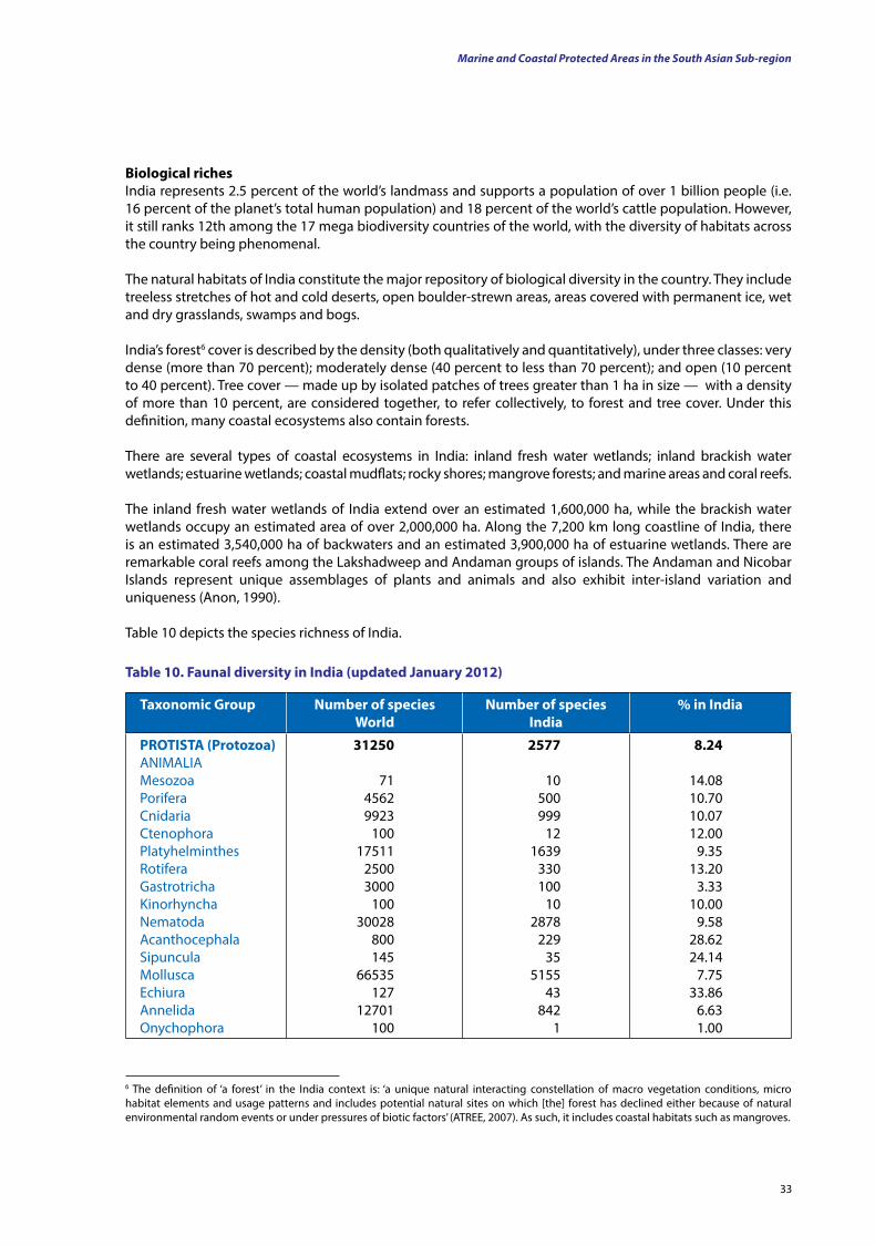
33
Biological richesIndia represents 2.5 percent of the world’s landmass and supports a population of over 1 billion people (i.e. 16 percent of the planet’s total human population) and 18 percent of the world’s cattle population. However, it still ranks 12th among the 17 mega biodiversity countries of the world, with the diversity of habitats across the country being phenomenal.
The natural habitats of India constitute the major repository of biological diversity in the country. They include treeless stretches of hot and cold deserts, open boulder-strewn areas, areas covered with permanent ice, wet and dry grasslands, swamps and bogs.
India’s forest6 cover is described by the density (both qualitatively and quantitatively), under three classes: very dense (more than 70 percent); moderately dense (40 percent to less than 70 percent); and open (10 percent to 40 percent). Tree cover — made up by isolated patches of trees greater than 1 ha in size — with a density of more than 10 percent, are considered together, to refer collectively, to forest and tree cover. Under this definition, many coastal ecosystems also contain forests.
There are several types of coastal ecosystems in India: inland fresh water wetlands; inland brackish water wetlands; estuarine wetlands; coastal mudflats; rocky shores; mangrove forests; and marine areas and coral reefs.
The inland fresh water wetlands of India extend over an estimated 1,600,000 ha, while the brackish water wetlands occupy an estimated area of over 2,000,000 ha. Along the 7,200 km long coastline of India, there is an estimated 3,540,000 ha of backwaters and an estimated 3,900,000 ha of estuarine wetlands. There are remarkable coral reefs among the Lakshadweep and Andaman groups of islands. The Andaman and Nicobar Islands represent unique assemblages of plants and animals and also exhibit inter-island variation and uniqueness (Anon, 1990).
Table 10 depicts the species richness of India.
6 The definition of ‘a forest’ in the India context is: ‘a unique natural interacting constellation of macro vegetation conditions, micro habitat elements and usage patterns and includes potential natural sites on which [the] forest has declined either because of natural environmental random events or under pressures of biotic factors’ (ATREE, 2007). As such, it includes coastal habitats such as mangroves.
taxonomic group number of species World
number of species India
% in India
ProtIStA (Protozoa)ANIMALIAMesozoaPoriferaCnidariaCtenophoraPlatyhelminthesRotiferaGastrotrichaKinorhynchaNematodaAcanthocephalaSipunculaMolluscaEchiuraAnnelidaOnychophora
31250
7145629923
10017511
25003000
10030028
800145
66535127
12701100
2577
10 500999
121639
330100
102878
22935
515543
8421
8.24
14.0810.7010.0712.00
9.3513.20
3.3310.00
9.5828.6224.14
7.7533.86
6.631.00
table 10. faunal diversity in India (updated January 2012)
Marine and Coastal Protected Areas in the South Asian Sub-region
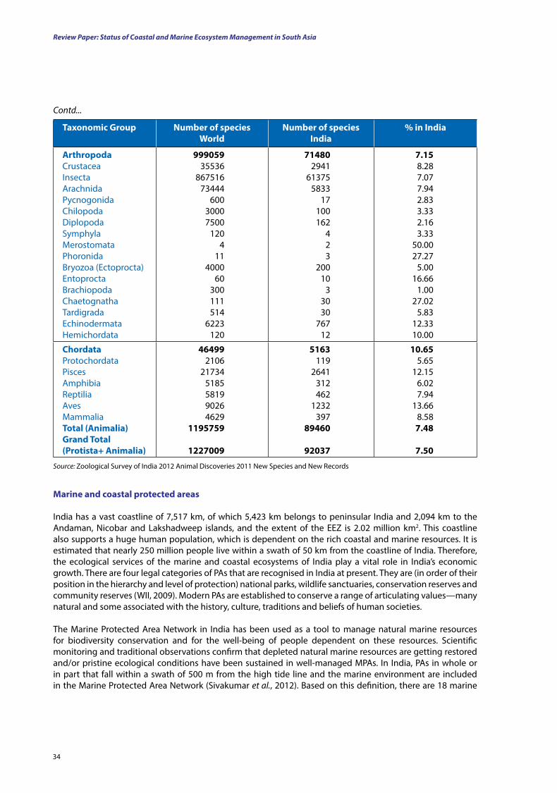
Review Paper: Status of Coastal and Marine Ecosystem Management in South Asia
34
taxonomic group number of species World
number of species India
% in India
ArthropodaCrustaceaInsectaArachnidaPycnogonidaChilopodaDiplopodaSymphylaMerostomata PhoronidaBryozoa (Ectoprocta)EntoproctaBrachiopodaChaetognathaTardigradaEchinodermataHemichordata
99905935536
86751673444
60030007500
1204
114000
60300111514
6223120
714802941
613755833
17100162
4 2 3
20010
33030
76712
7.158.287.077.942.833.332.163.33
50.0027.27
5.0016.66
1.0027.02
5.8312.3310.00
ChordataProtochordataPiscesAmphibiaReptiliaAvesMammaliatotal (Animalia)grand total (Protista+ Animalia)
464992106
217345185581990264629
1195759
1227009
5163119
2641312462
1232397
89460
92037
10.655.65
12.156.027.94
13.668.587.48
7.50
Contd...
Source: Zoological Survey of India 2012 Animal Discoveries 2011 New Species and New Records
Marine and coastal protected areas
India has a vast coastline of 7,517 km, of which 5,423 km belongs to peninsular India and 2,094 km to the Andaman, Nicobar and Lakshadweep islands, and the extent of the EEZ is 2.02 million km2. This coastline also supports a huge human population, which is dependent on the rich coastal and marine resources. It is estimated that nearly 250 million people live within a swath of 50 km from the coastline of India. Therefore, the ecological services of the marine and coastal ecosystems of India play a vital role in India’s economic growth. There are four legal categories of PAs that are recognised in India at present. They are (in order of their position in the hierarchy and level of protection) national parks, wildlife sanctuaries, conservation reserves and community reserves (WII, 2009). Modern PAs are established to conserve a range of articulating values—many natural and some associated with the history, culture, traditions and beliefs of human societies.
The Marine Protected Area Network in India has been used as a tool to manage natural marine resources for biodiversity conservation and for the well-being of people dependent on these resources. Scientific monitoring and traditional observations confirm that depleted natural marine resources are getting restored and/or pristine ecological conditions have been sustained in well-managed MPAs. In India, PAs in whole or in part that fall within a swath of 500 m from the high tide line and the marine environment are included in the Marine Protected Area Network (Sivakumar et al., 2012). Based on this definition, there are 18 marine
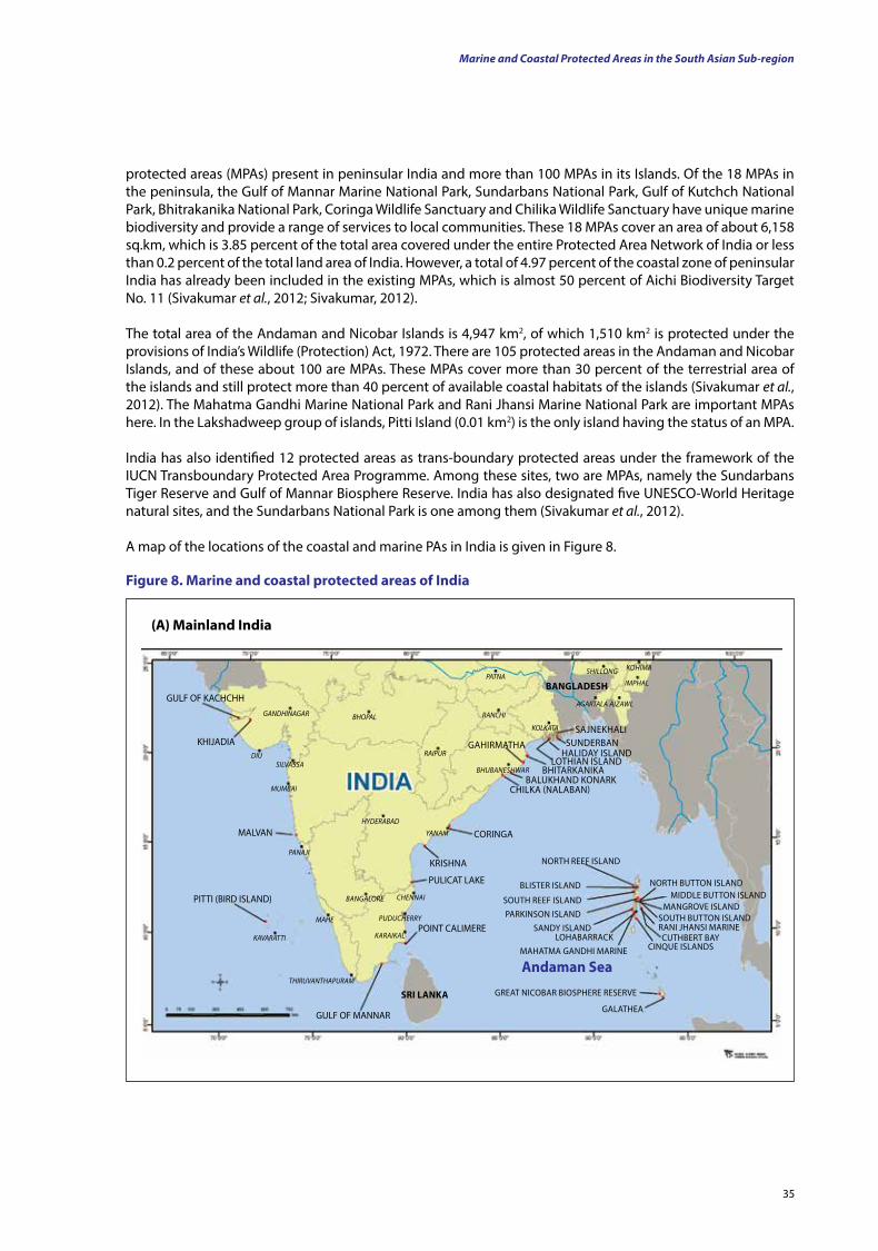
35
protected areas (MPAs) present in peninsular India and more than 100 MPAs in its Islands. Of the 18 MPAs in the peninsula, the Gulf of Mannar Marine National Park, Sundarbans National Park, Gulf of Kutchch National Park, Bhitrakanika National Park, Coringa Wildlife Sanctuary and Chilika Wildlife Sanctuary have unique marine biodiversity and provide a range of services to local communities. These 18 MPAs cover an area of about 6,158 sq.km, which is 3.85 percent of the total area covered under the entire Protected Area Network of India or less than 0.2 percent of the total land area of India. However, a total of 4.97 percent of the coastal zone of peninsular India has already been included in the existing MPAs, which is almost 50 percent of Aichi Biodiversity Target No. 11 (Sivakumar et al., 2012; Sivakumar, 2012).
The total area of the Andaman and Nicobar Islands is 4,947 km2, of which 1,510 km2 is protected under the provisions of India’s Wildlife (Protection) Act, 1972. There are 105 protected areas in the Andaman and Nicobar Islands, and of these about 100 are MPAs. These MPAs cover more than 30 percent of the terrestrial area of the islands and still protect more than 40 percent of available coastal habitats of the islands (Sivakumar et al., 2012). The Mahatma Gandhi Marine National Park and Rani Jhansi Marine National Park are important MPAs here. In the Lakshadweep group of islands, Pitti Island (0.01 km2) is the only island having the status of an MPA.
India has also identified 12 protected areas as trans-boundary protected areas under the framework of the IUCN Transboundary Protected Area Programme. Among these sites, two are MPAs, namely the Sundarbans Tiger Reserve and Gulf of Mannar Biosphere Reserve. India has also designated five UNESCO-World Heritage natural sites, and the Sundarbans National Park is one among them (Sivakumar et al., 2012).
A map of the locations of the coastal and marine PAs in India is given in Figure 8.
figure 8. Marine and coastal protected areas of India
GULF OF KACHCHH
KHIJADIA
MALVAN
PITTI (BIRD ISLAND)
GULF OF MANNAR
POINT CALIMERE
PULICAT LAKE
KRISHNA
CORINGA
CHILKA (NALABAN)BALUKHAND KONARK
SAJNEKHALISUNDERBAN
BHITARKANIKALOTHIAN ISLAND
HALIDAY ISLAND
BAnglAdESH
GAHIRMATHA
NORTH REEF ISLAND
BLISTER ISLAND
SOUTH REEF ISLANDPARKINSON ISLAND
SANDY ISLANDLOHABARRACK
MAHATMA GANDHI MARINE
NORTH BUTTON ISLANDMIDDLE BUTTON ISLAND
MANGROVE ISLANDSOUTH BUTTON ISLANDRANI JHANSI MARINECUTHBERT BAY
CINQUE ISLANDS
GREAT NICOBAR BIOSPHERE RESERVE
GALATHEA
Andaman Sea
SrI lAnKATHIRUVANTHAPURAM
KAVARATTI
MAHE
PANAJI
HYDERABAD
MUMBAI
DIU
GANDHINAGAR BHOPAL
RAIPUR
RANCHI
PATNA
KOLKATA
AGARTALA
IMPHAL
AIZAWL
SHILLONG KOHIMA
YANAM
CHENNAI
PUDUCHERRY
BANGALORE
KARAIKAL
SILVASSABHUBANESHWAR
(A) Mainland India
Marine and Coastal Protected Areas in the South Asian Sub-region
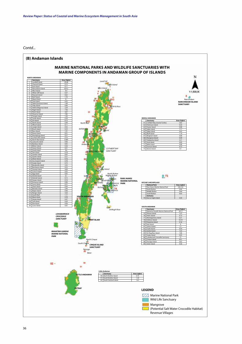
Review Paper: Status of Coastal and Marine Ecosystem Management in South Asia
36
Sanctuary Area (Sqkm)1 Landfall Island 29.482 Channel Island 0.133 East Island 6.114 Narcondum Island 6.8125 West Island 6.46 White Cliff Island 0.477 Peacock Island 0.628 Reef Island 1.749 Mayo Island 0.110 Tree Island 0.0311 Table (Excelsior) Island 1.6912 Triby Island 0.9613 Table (Delgarno) Island 2.2914 Paget Island 7.3615 Point Island 3.0716 Shearme Island 7.8517 Temple Island 1.0418 Turtle Island 0.3919 Ox Island 0.1320 North Island 0.4921 Wharf island 0.1122 Jungle Island 0.5223 Brush Island 0.2324 Ross Island 1.0125 Rowe Island 0.0126 Kwangtung Island 0.5727 Curlew (B.P.) Island 0.1628 North Reef Island 3.48429 Latouche Island 0.0630 Bamboo Island 0.0531 Blister Island 0.2632 Goose Island 0.0133 Snark Island 0.634 Dot Island 0.1835 Gander Island 0.0536 Oyster Island 0.2137 Oliver Island 0.1638 Sea Serpent Island 0.7839 Snake Island 0.7341 Bondoville Island 2.5542 Buchanan island 9.3343 Swamp Island 4.0944 Curlcw Island 0.0345 Egg Island 0.0546 Orchid Island 0.147 Dottrell island 0.1348 Gurjan Island 0.1649 Entrance Island 0.9650 Surat Island 0.3151 Stoat Island 0.4452 Benette Island 3.4653 Roper Island 0.4654 Ranger Island 4.2655 South Reef 1.1756 Mask Island 0.7857 Hump Island 0.4758 Tuft Island 0.2959 Flat Island 9.3660 Cone Island 0.65
nortH AndAMAn
MArInE nAtIonAl PArKS And WIldlIfE SAnCtuArIES WItH MArInE CoMPonEntS In AndAMAn grouP of ISlAndS
Sanctuary Area (Sqkm)61 Cuthbert Bay (marine Turtles) 5.8262 Parkinson Island 0.3463 Oyster Island 0.0864 Spike Island 11.765 Spike Island 0.4266 Bluff Island 1.1467 Bingham Island 0.0868 Mangrove Island 0.39 69 Talabaicha Island 3.2170 Arial Island 0.0571 Belle Island 0.0872 Duncan Island 0.7373 Barren Island 8.1
MIddlE AndAMAn
Sanctuary Area (Sqkm) Mahatma Gandhi Marine National Park 281.575 Pitman Island 1.3776 Petric Island 0.1377 Montogomery Island 0.2178 Defence Island 10.1979 Potanima Island 0.1680 Kyd Island 881 James Island 2.182 Clyde Island 0.5483 Sandy Island 1.5384 Sir Hug Ross Island 1.0685 Snake Island 0.0386 Lohabarrack Crocodile Sanctuary 2187 Cinque Island 9.5188 Passage Island 0.6289 Sister Island 0.36
SoutH AndAMAn
national Park Area (sqkm) Rani Jhansi Marine Natinal Park 256.142 North Button 0.44 Middle Button 0.44 South Button 0.03 Santuary74 East or Inglis Island 3.55
rItCHIE’S ArCHIPElAgo
Sanctuary Area (sqkm)90 North Brother Island 0.7591 South Brother Island 1.2492 South Sentinel Island 1.61
little Andaman
Marine National ParkWild Life Sanctuary
Mangrove (Potential Salt Water Crocodile Habitat)Revenue Villages
lEgEnd
Land Fall
East Island
West Island
Smith & Ross
North Reef
StewenINTERVIEW
Sound
BuchananEpterance
Anderson
MODDLE ANDAMANCUTHBERT BAY SANCTUARY
Long IslandPorbe
SpikeNorth Button
Middle Button
South ButtonCoebroke
BARATANG
Outram rAnI JHAnSI MArInE nAtIonAl PArK
Wison Henn Lowrence
InglisNicholson
PeeJoint Lawrence
Sir Hugh Rose
SoutH AndAMAn
Port BlAIr
Neil
LOHABARRACK CROCODILE SANCTUARY
MAHATMA GANDHI MARINE NATIONAL PARK
CINQUE ISLAND SANCTUARY
LITTLE ANDAMAN
HUTBAY
nArCondAM ISlAnd SAnCtuAry
Passage
Sister
North Cinque
South Cinque
Narcondam
(B) Andaman Islands
Contd...
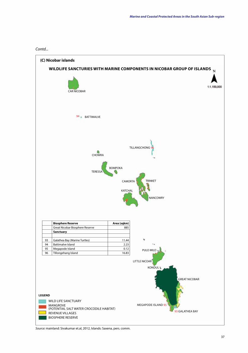
37
CHOWRA
BOMPOKATERESSA
CAMORTA TRINKET
NANCOWRY
KATCHAL
TILLANGCHONG 96
BATTIMALVE
PULO MILO
LITTLE NICOAR
KONDUL
GREAT NICOBAR
93 GALATHEA BAY
MEGAPODE ISLAND 95
94
CAR NICOBAR
WILD LIFE SANCTUARYMANGROVE (POTENTIAL SALT WATER CROCODILE HABITAT)REVENUE VILLAGESBIOSPHERE RESERVE
lEgEnd
Biosphere reserve Area (sqkm) Great Nicobar Biosphere Reserve 885 Sanctuary
93 Galathea Bay (Marine Turtles) 11.4494 Battimalve Island 2.2395 Megapode Island 0.1296 Tillongehang Island 16.83
WIldlIfE SAnCturIES WItH MArInE CoMPonEntS In nICoBAr grouP of ISlAndS
(C) nicobar islands
Source: mainland: Sivakumar et.al, 2012, Islands: Saxena, pers. comm.
Marine and Coastal Protected Areas in the South Asian Sub-region
Contd...
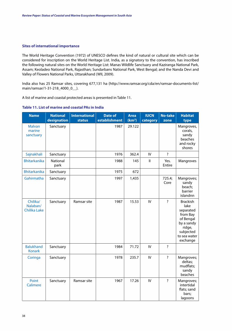
Review Paper: Status of Coastal and Marine Ecosystem Management in South Asia
38
Sites of international importance
The World Heritage Convention (1972) of UNESCO defines the kind of natural or cultural site which can be considered for inscription on the World Heritage List. India, as a signatory to the convention, has inscribed the following natural sites on the World Heritage List: Manas Wildlife Sanctuary and Kaziranga National Park, Assam; Keoladeo National Park, Rajasthan; Sundarbans National Park, West Bengal; and the Nanda Devi and Valley of Flowers National Parks, Uttarakhand (WII, 2009).
India also has 25 Ramsar sites, covering 677,131 ha (http://www.ramsar.org/cda/en/ramsar-documents-list/main/ramsar/1-31-218_4000_0__).
A list of marine and coastal protected areas is presented in Table 11.
table 11. list of marine and coastal PAs in India
name national designation
International status
date of establishment
Area (km2)
IuCn category
no-take zone
Habitat type
Malvan marine
sanctuary
Sanctuary 1987 29.122 Mangroves, corals, sandy
beaches and rocky
shores
Sajnakhali Sanctuary 1976 362.4 IV ?
Bhitarkanika National park
1988 145 II Yes. Entire
Mangroves
Bhitarkanika Sanctuary 1975 672
Gahirmatha Sanctuary 1997 1,435 725.4; Core
Mangroves; sandy beach; barrier
islandnn
Chilika/Nalaban/
Chilika Lake
Sanctuary Ramsar site 1987 15.53 IV ? Brackish lake
separated from Bay of Bengal
by a sandy ridge,
subjected to sea water
exchange
Balukhand Konark
Sanctuary 1984 71.72 IV ?
Coringa Sanctuary 1978 235.7 IV ? Mangroves; deltas;
mudflats; sandy
beaches
Point Calimere
Sanctuary Ramsar site 1967 17.26 IV ? Mangroves; intertidal flats; sand
bars; lagoons
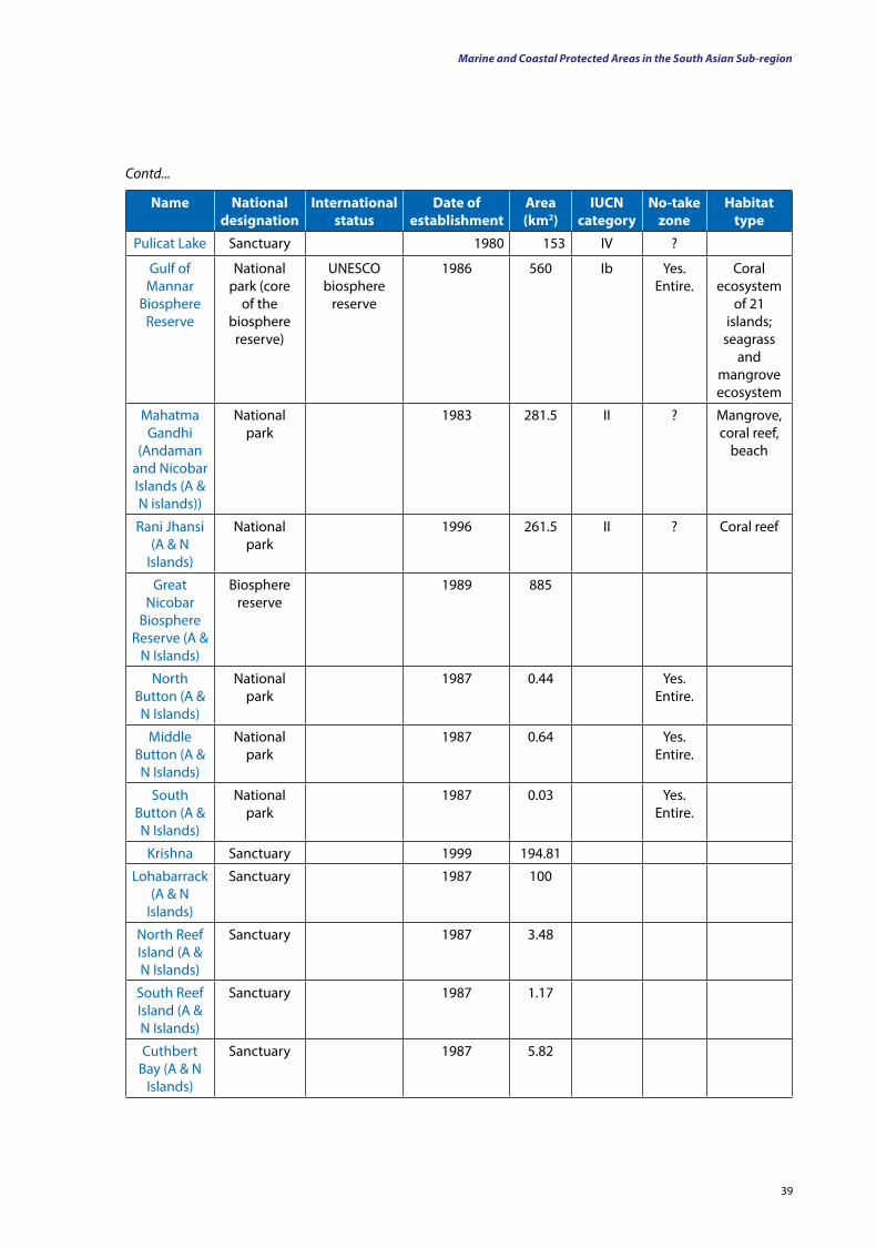
39
name national designation
International status
date of establishment
Area (km2)
IuCn category
no-take zone
Habitat type
Pulicat Lake Sanctuary 1980 153 IV ?
Gulf of Mannar
Biosphere Reserve
National park (core
of the biosphere
reserve)
UNESCO biosphere
reserve
1986 560 Ib Yes. Entire.
Coral ecosystem
of 21 islands;
seagrass and
mangrove ecosystem
Mahatma Gandhi
(Andaman and Nicobar Islands (A & N islands))
National park
1983 281.5 II ? Mangrove, coral reef,
beach
Rani Jhansi (A & N
Islands)
National park
1996 261.5 II ? Coral reef
Great Nicobar
Biosphere Reserve (A &
N Islands)
Biosphere reserve
1989 885
North Button (A & N Islands)
National park
1987 0.44 Yes. Entire.
Middle Button (A & N Islands)
National park
1987 0.64 Yes. Entire.
South Button (A & N Islands)
National park
1987 0.03 Yes. Entire.
Krishna Sanctuary 1999 194.81
Lohabarrack (A & N
Islands)
Sanctuary 1987 100
North Reef Island (A & N Islands)
Sanctuary 1987 3.48
South Reef Island (A & N Islands)
Sanctuary 1987 1.17
Cuthbert Bay (A & N
Islands)
Sanctuary 1987 5.82
Contd...
Marine and Coastal Protected Areas in the South Asian Sub-region
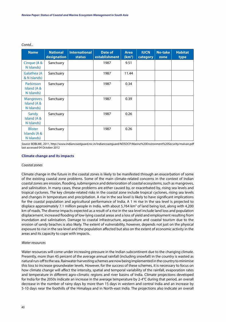
Review Paper: Status of Coastal and Marine Ecosystem Management in South Asia
40
name national designation
International status
date of establishment
Area (km2)
IuCn category
no-take zone
Habitat type
Cinque (A & N Islands)
Sanctuary 1987 9.51
Galathea (A & N Islands)
Sanctuary 1987 11.44
Parkinson Island (A & N Islands)
Sanctuary 1987 0.34
Mangroves Island (A & N Islands)
Sanctuary 1987 0.39
Sandy Island (A & N Islands)
Sanctuary 1987 0.26
Blister Islands (A & N Islands)
Sanctuary 1987 0.26
Contd...
Source: BOBLME, 2011, http://www.indiancoastguard.nic.in/indiancoastguard/NOSDCP/Marine%20Environment%20Security/malvan.pdf last accessed 04 October 2012
Climate change and its impacts
Coastal zones
Climate change in the future in the coastal zones is likely to be manifested through an exacerbation of some of the existing coastal zone problems. Some of the main climate-related concerns in the context of Indian coastal zones are erosion, flooding, submergence and deterioration of coastal ecosystems, such as mangroves, and salinisation. In many cases, these problems are either caused by, or exacerbated by, rising sea levels and tropical cyclones. The key climate-related risks in the coastal zone include tropical cyclones, rising sea levels and changes in temperature and precipitation. A rise in the sea level is likely to have significant implications for the coastal population and agricultural performance of India. A 1 m rise in the sea level is projected to displace approximately 7.1 million people in India, with about 5,764 km2 of land being lost, along with 4,200 km of roads. The diverse impacts expected as a result of a rise in the sea level include land loss and population displacement, increased flooding of low-lying coastal areas and a loss of yield and employment resulting from inundation and salinisation. Damage to coastal infrastructure, aquaculture and coastal tourism due to the erosion of sandy beaches is also likely. The extent of vulnerability, however, depends not just on the physical exposure to rise in the sea level and the population affected but also on the extent of economic activity in the areas and its capacity to cope with impacts.
Water resources
Water resources will come under increasing pressure in the Indian subcontinent due to the changing climate. Presently, more than 45 percent of the average annual rainfall (including snowfall) in the country is wasted as natural run-off to the sea. Rainwater harvesting schemes are now being implemented in the country to minimise this loss to increase groundwater levels. However, for the success of these schemes, it is necessary to focus on how climate change will affect the intensity, spatial and temporal variability of the rainfall, evaporation rates and temperature in different agro-climatic regions and river basins of India. Climate projections developed for India for the 2050s indicate an increase in the average temperature by 2-4°C during that period, an overall decrease in the number of rainy days by more than 15 days in western and central India and an increase by 5-10 days near the foothills of the Himalaya and in North-east India. The projections also indicate an overall
41
increase in the intensity of rainy days by 1-4 mm per day, except for small areas in north-west India, where the rainfall intensities may decrease by 1 mm per day. As many as 99 districts in India, spread over 14 states, were identified by the Central Water Commission (CWC) as drought prone.
Changing ecosystems
Ecosystems will be particularly vulnerable to climate change, with a study estimating that between 15 and 40 per cent of species will face extinction (Stern Review, 2006). The impacts of climate change will be particularly adverse on the forests, wetlands and coastal regions. The decline in precipitation, in conjunction with droughts in most delta regions of India, has resulted in the drying up of wetlands and the severe degradation of ecosystems. In some regions, the remaining natural flood plains are disappearing at a rapid rate, primarily as a result of changes in land use and hydrological cycles (particularly changes in stream-flows due to climatic and human-related factors). According to the IPCC, the most threatened flood plains will be those in South Asia. In addition, around 30 percent of Asia’s coral reefs are likely to be lost in the next 30 years due to the effects of multiple stresses and climate change. The composition of speciesand their dominance could also be altered, and large-scale forest depletion and loss of biodiversity are likely to mark the beginning of the bleak scenario (IPCC, 2007).
Biological diversity
The impact of global warming on biodiversity has emerged as an active area in contemporary conservation biology research, and it is extremely important for a country like India, where community dependence on forests is very high and climate change can have much worse impacts than expected or predicted on the biodiversity of forest ecosystems. In the Indian scenario, the two important measures of climate change which have direct and significant impacts on the biodiversity are the variations in precipitation and temperature.
Climate change poses a threat to the species in the three distinct ecological zones that make up the Sundarbans. If the saline water front moves further inland, many species (including mammals, birds, amphibians, reptiles and crustaceans) could be threatened. These changes are likely to have major economic impacts, given that an estimated 500,000 to 600,000 people are in direct employment through the Sundarbans (for at least half of the year), with many of these people being employed in industries that use raw materials from this ecosystem (Smith et al., 1998).
Ecosystem services
India accounts for less than 0.25 percent of the world’s total coastline. However, 63 million people live along these coasts (approximately 11 percent of the world’s coastal population). The 77 coastal districts (out of the total of 593 in the country) house 17 percent of the total population of India. It is estimated that nearly 250 million people live within a swath of 50 km from the coastline. There are 77 cities along the coasts of India, including some of the largest in the country — Kolkata, Mumbai, Chennai, Kochi and Vishakhapatnam. Large cities and townships also support a large section of poverty ridden people, the section most vulnerable to climate change (World Bank, 2010).
The marine and coastal ecosystems of India provide play a vital role in the nation’s economy by virtue of their resources, rich biological diversity and productive habitats. India is the seventh largest producer in terms of capture fisheries (FAO, 2010). Harbours, aquaculture and the agriculture, tourism and oil and mineral exploration associated with the marine environment account for approximately 10 percent of the country’s GDP (Planning Commission GoI).
The estimates of potential fishery resources from the EEZ of the country are between 3.5 and 4.7 million tonnes (Sudarshan et al., 1990). Recent landings from the coasts reveal that the catches range between 2.2 and 2.8 million tonnes (CMFRI, 1995). Approximately 73 percent of this originates from the west coast of India (UNDP, 2011).
Marine and Coastal Protected Areas in the South Asian Sub-region
Review Paper: Status of Coastal and Marine Ecosystem Management in South Asia
42
Fishing is one big economic activity that has been cited, but given the size of the population living along the coast, the economic dependence, with its intricacies and articulation, is immense. The direct drivers of impacts on ecological systems, habitats and thereby ecological services are (i) habitat destruction; (ii) excessive harvesting of coastal and marine resources; and (iii) pollution from industrial waste, aquaculture, upstream activities along rivers and agglomeration of urban environments.
These need to be appreciated in the context of the predicted impacts of climate change, ecological services and the impacts on human populations.
The Maldives
Background: Physical and biological features
The Maldive Islands are a nation in the Indian Ocean and comprise a double chain of 26 atolls oriented north to south off India’s Lakshadweep Islands, between Minicoy Island and the Chagos Archipelago. This chain stands in the Laccadive Sea, about 700 km south-west of Sri Lanka and 400 km south-west of India, between latitudes 1°S and 8°N and longitudes 72°E and 74°E.
Physical featuresThe archipelago is located on top of the Chagos-Maldives-Laccadive Ridge, a vast submarine mountain range in the Indian Ocean. The Maldives also form a terrestrial ecoregion together with the Chagos and the Lakshadweep. The atolls of the Maldives encompass a territory that spreads over roughly 90,000 km2, making it one of the world’s most dispersed countries in geographic terms. The atolls are composed of live coral reefs and sand bars, situated atop a submarine ridge 960 km long that rises abruptly from the depths of the Indian Ocean and runs north to south. Only near the southern end of this natural coral barricade do two open passages permit safe ship navigation from one side of the Indian Ocean to the other, through the territorial waters of the Maldives. More than 80 percent of the country’s land is composed of coral islands that rise less than 1 m above sea level. The reef is composed of coral debris and living coral. This acts as a natural barrier against the sea, forming lagoons. Other islands set at a distance and parallel to the reef, have their own protective fringe of reef. An opening in the surrounding coral barrier allows access to the calmer lagoon waters. The barrier reefs of the islands protect them from the storms and high waves of the Indian Ocean. A 15 cm thick layer of humus forms the top layer of soil, and 60 cm of sandstone, followed by sand and then fresh water, lie below it (www.nationalgeographic.com).
The population of the Maldives (313,920 as of 2010) inhabits 200 of its 1,192 islands. The capital of the country — Malé — is also its largest city, with a population of 103,693 in 2006.
The Maldives is the smallest Asian country in terms both of population and land area. With an average ground level of 1 m above sea level it is the world’s lowest-lying country. It is also the country with the lowest highest point (2.3 m) in the world. As such, inundation of the islands is a great cause for concern in the Maldives.
The presence of this landmass causes differential heating of the land and water. These factors set off a rush of moisture-rich air from the Indian Ocean over South Asia, resulting in the south-west monsoon. Two seasons dominate the Maldives’ climate: the dry season, associated with the winter north-eastern monsoon, and the rainy season, which brings strong winds and storms. The shift from the moist south-west monsoon to the dry north-east monsoon occurs during April and May. During this period, the north-east winds contribute to the formation of the north-east monsoon, which reaches Maldives in the beginning of June and lasts until the end of August. However, the weather patterns of Maldives do not always conform to the monsoon patterns of South Asia. The annual rainfall averages 254 cm in the north and 381 cm in the south.
The Indian Ocean acts as a heat buffer, absorbing, storing and slowly releasing the tropical heat. The temperature of the Maldives ranges between 24°C and 33°C throughout the year (http://www.en.wikipedia.org/Maldives).
43
Biological richesThe Maldives harbour a rich biodiversity centred around its vast extent of coral reefs (http://www.cbd.int/countries/profile.shtml?country=mv#status). Its atolls are significant because they are by far the largest group of coral reefs in the Indian Ocean (Emerton et al., 2009). The coral reef coverage in the Maldives is 4,513.14 ± 225.65 km2. This includes rim and oceanic reefs (3,701.93 km2, or 82.5 percent of the total reef area), as well as patch reefs within atoll lagoons (791.92 km2, or 17.5 percent of the total reef area) (Naseer and Hatcher, 2004).
The marine species in the Maldives include the following:
• Nearly 200 species of coral, including black coral (Antipatharia)
• Many crustacean species – 120 copepods – 15 amphipods – Over 145 crabs – 48 shrimp species
• 83 species of echinoderm
• 400 species of mollusc, including the giant clam (Tridacna squamosa)
• 1,100 species of fish – Whale sharks (Rhincodon typus) – Reef sharks – Manta rays (Manta birostris) – Sting rays (suborder Myliobatoidei) – Eagle rays (family Myliobatidae) – Napoleon wrasses (Cheilinus undulatus) – Giant groupers (Epinephelus lanceolatus)
• 5 species of marine turtle including the green (Chelonia mydas) and hawksbill (Eretmochelys imbricata) turtles
• Approximately 170 bird species
• At least 21 species of whale and dolphin (Emerton et al., 2009; Maldives CBD Application, 2008).
In addition to coral reefs, the Maldivian atoll ecosystems also have of a variety of other habitats including extensive shallow and deep lagoons, deep slopes, sandy beaches and limited mangrove and seagrass habitats.
Due to high levels of salt in the soil near the beach, the vegetation is limited to a few plants such as shrubs, flowering plants and small hedges. About 583 species of plant have been recorded in the Maldives, 260 of which are believed to be native or naturalised and 323 of which are cultivated plants that were introduced for agriculture and ornamental purposes. The coconut palm — the national tree — is able to grow almost anywhere on the islands and is an integral part of the Maldives and its culture.
Habitat destruction and over-exploitation are the major threats to the Maldives’ biodiversity. In addition, coastal development activities adversely affect the reefs around the islands.
Marine and coastal protected areas
A map of the Maldives showing its coastal and marine PAs is provided in Figure 9.
Marine and Coastal Protected Areas in the South Asian Sub-region

Review Paper: Status of Coastal and Marine Ecosystem Management in South Asia
44
Dheraha Thila
Fushivaru ThilaKuredhu Kanduolhi
Vilingili Thila
Lankan ThilaHanifaruOlhugiri
Makunudhoo Kandu Olhi
Rasfari island, lagoon and the surrounding reef
Dhekunu Thilafalhuge Miyaruvani
Thamburudhoo Thila
Huraa Mangrove AreaGaathugiri
Gulhifalhu Medhuga onna kohlavaanee
Hans Hass Place
Emboodhoo Kanduolhi
Guraidhoo Kanduolhi
Vattaru Kandu
Orimas ThilaKudarah Thila
Lhazikuraadi
Filitheyo Kandu
Karibeyru Thila
Mayaa ThilaMiyaru Kandu
Mushimasmigili ThilaHurasdhoo
Faruhuruvalhibeyru
South Arl Atoll
Devana Kandu (Miyaru kandu)
Kuda Haa
Dhigali Haa
Angifaru
Fushee Kandu
Hithaadhoo (gaafu alifu atoll)
Eidhigali Kilhi and Koattey Area
Addu Thila
MPA sites
MPA area
Cities
BOUNDARY OF BOBLME
River
Coral reefs
Mangroves
Seagrass
0 25 50 100 150 200 Kilometers
lEgEnd
Source: BOBLME, 2011.
figure 9. Coastal and marine habitats and PAs of the Maldives
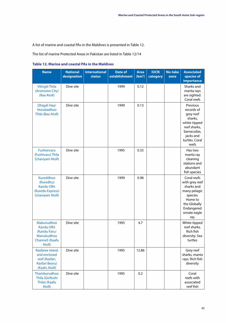
45
table 12. Marine and coastal PAs in the Maldives
name national designation
International status
date of establishment
Area (km2)
IuCn category
no-take zone
Associated species of
importance
Vilingili Thila (Anenome City)
(Raa Atoll)
Dive site 1999 0.12 Sharks and manta rays are sighted. Coral reefs
Dhigali Haa/Horubadhoo
Thila (Baa Atoll)
Dive site 1999 0.13 Previous records of grey reef sharks,
white-tipped reef sharks, barracudas,
jacks and turtles. Coral
reefs
Fusheevaru (Fushivaru) Thila (Lhaviyani Atoll)
Dive site 1995 0.33 Has two manta ray cleaning
stations and abundant
fish species
Kureddhoo (Kuredhu)
Kandu Olhi (Kuredu Express) (Lhaviyani Atoll)
Dive site 1999 0.98 Coral reefs with grey reef
sharks and many pelagic
species. Home to
the Globally Endangered ornate eagle
ray.
Makunudhoo Kandu Olhi
(Kandu Faru/Manukudhoo
Channel) (Kaafu Atoll)
Dive site 1995 4.7 White-tipped reef sharks.
Rich fish diversity. Sea
turtles
Rasfaree Island and enclosed reef (Rasfari,
Rasfari Beyru) (Kaafu Atoll)
Dive site 1995 12.86 Grey reef sharks, manta rays. Rich fish
diversity
Thamburudhoo Thila (Girifushi Thila) (Kaafu
Atoll)
Dive site 1995 0.2 Coral reefs with associated
reef fish
A list of marine and coastal PAs in the Maldives is presented in Table 12.
The list of marine Protected Areas in Pakistan are listed in Table 12/14
Marine and Coastal Protected Areas in the South Asian Sub-region
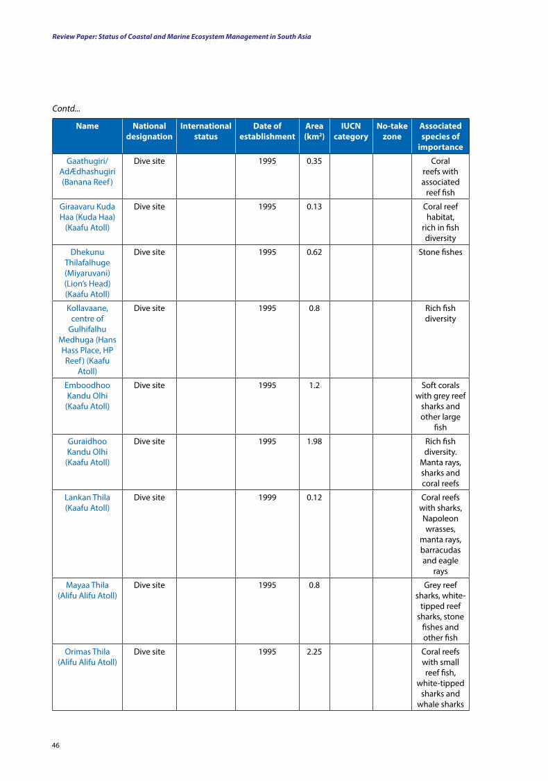
Review Paper: Status of Coastal and Marine Ecosystem Management in South Asia
46
name national designation
International status
date of establishment
Area (km2)
IuCn category
no-take zone
Associated species of
importance
Gaathugiri/AdÆdhashugiri (Banana Reef )
Dive site 1995 0.35 Coral reefs with associated
reef fish
Giraavaru Kuda Haa (Kuda Haa)
(Kaafu Atoll)
Dive site 1995 0.13 Coral reef habitat,
rich in fish diversity
Dhekunu Thilafalhuge (Miyaruvani) (Lion’s Head) (Kaafu Atoll)
Dive site 1995 0.62 Stone fishes
Kollavaane, centre of
Gulhifalhu Medhuga (Hans Hass Place, HP Reef ) (Kaafu
Atoll)
Dive site 1995 0.8 Rich fish diversity
Emboodhoo Kandu Olhi
(Kaafu Atoll)
Dive site 1995 1.2 Soft corals with grey reef
sharks and other large
fish
Guraidhoo Kandu Olhi
(Kaafu Atoll)
Dive site 1995 1.98 Rich fish diversity.
Manta rays, sharks and coral reefs
Lankan Thila (Kaafu Atoll)
Dive site 1999 0.12 Coral reefs with sharks, Napoleon wrasses,
manta rays, barracudas and eagle
rays
Mayaa Thila (Alifu Alifu Atoll)
Dive site 1995 0.8 Grey reef sharks, white-
tipped reef sharks, stone
fishes and other fish
Orimas Thila (Alifu Alifu Atoll)
Dive site 1995 2.25 Coral reefs with small reef fish,
white-tipped sharks and
whale sharks
Contd...
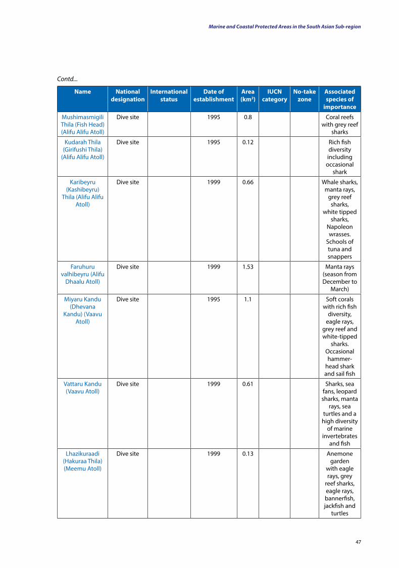
47
name national designation
International status
date of establishment
Area (km2)
IuCn category
no-take zone
Associated species of
importance
Mushimasmigili Thila (Fish Head) (Alifu Alifu Atoll)
Dive site 1995 0.8 Coral reefs with grey reef
sharks
Kudarah Thila (Girifushi Thila)
(Alifu Alifu Atoll)
Dive site 1995 0.12 Rich fish diversity including
occasional shark
Karibeyru (Kashibeyru)
Thila (Alifu Alifu Atoll)
Dive site 1999 0.66 Whale sharks, manta rays,
grey reef sharks,
white tipped sharks,
Napoleon wrasses.
Schools of tuna and snappers
Faruhuru valhibeyru (Alifu
Dhaalu Atoll)
Dive site 1999 1.53 Manta rays (season from December to
March)
Miyaru Kandu (Dhevana
Kandu) (Vaavu Atoll)
Dive site 1995 1.1 Soft corals with rich fish
diversity, eagle rays,
grey reef and white-tipped
sharks. Occasional hammer-
head shark and sail fish
Vattaru Kandu (Vaavu Atoll)
Dive site 1999 0.61 Sharks, sea fans, leopard sharks, manta
rays, sea turtles and a
high diversity of marine
invertebrates and fish
Lhazikuraadi (Hakuraa Thila) (Meemu Atoll)
Dive site 1999 0.13 Anemone garden
with eagle rays, grey
reef sharks, eagle rays, bannerfish, jackfish and
turtles
Contd...
Marine and Coastal Protected Areas in the South Asian Sub-region
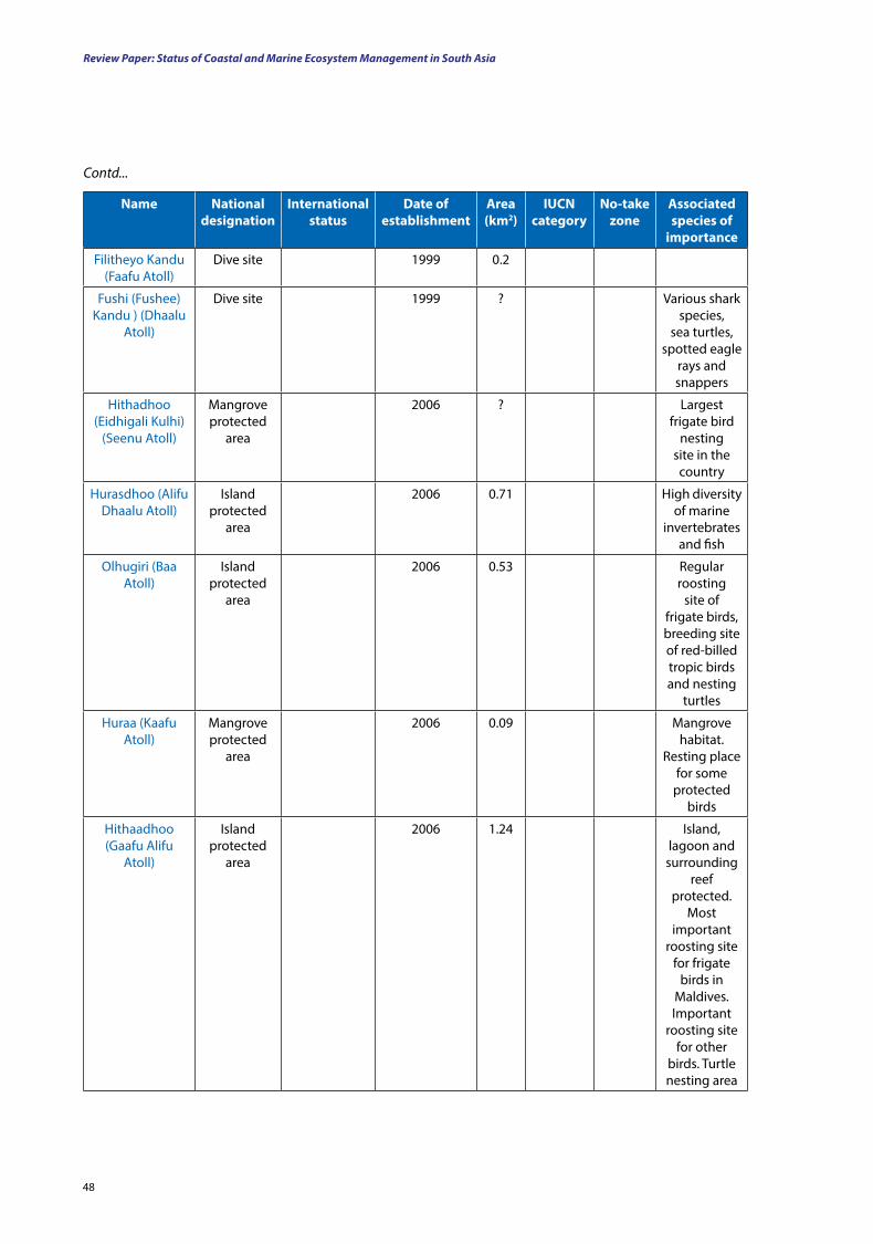
Review Paper: Status of Coastal and Marine Ecosystem Management in South Asia
48
name national designation
International status
date of establishment
Area (km2)
IuCn category
no-take zone
Associated species of
importance
Filitheyo Kandu (Faafu Atoll)
Dive site 1999 0.2
Fushi (Fushee) Kandu ) (Dhaalu
Atoll)
Dive site 1999 ? Various shark species,
sea turtles, spotted eagle
rays and snappers
Hithadhoo (Eidhigali Kulhi)
(Seenu Atoll)
Mangrove protected
area
2006 ? Largest frigate bird
nesting site in the country
Hurasdhoo (Alifu Dhaalu Atoll)
Island protected
area
2006 0.71 High diversity of marine
invertebrates and fish
Olhugiri (Baa Atoll)
Island protected
area
2006 0.53 Regular roosting
site of frigate birds, breeding site of red-billed tropic birds and nesting
turtles
Huraa (Kaafu Atoll)
Mangrove protected
area
2006 0.09 Mangrove habitat.
Resting place for some
protected birds
Hithaadhoo (Gaafu Alifu
Atoll)
Island protected
area
2006 1.24 Island, lagoon and surrounding
reef protected.
Most important
roosting site for frigate
birds in Maldives. Important
roosting site for other
birds. Turtle nesting area
Contd...
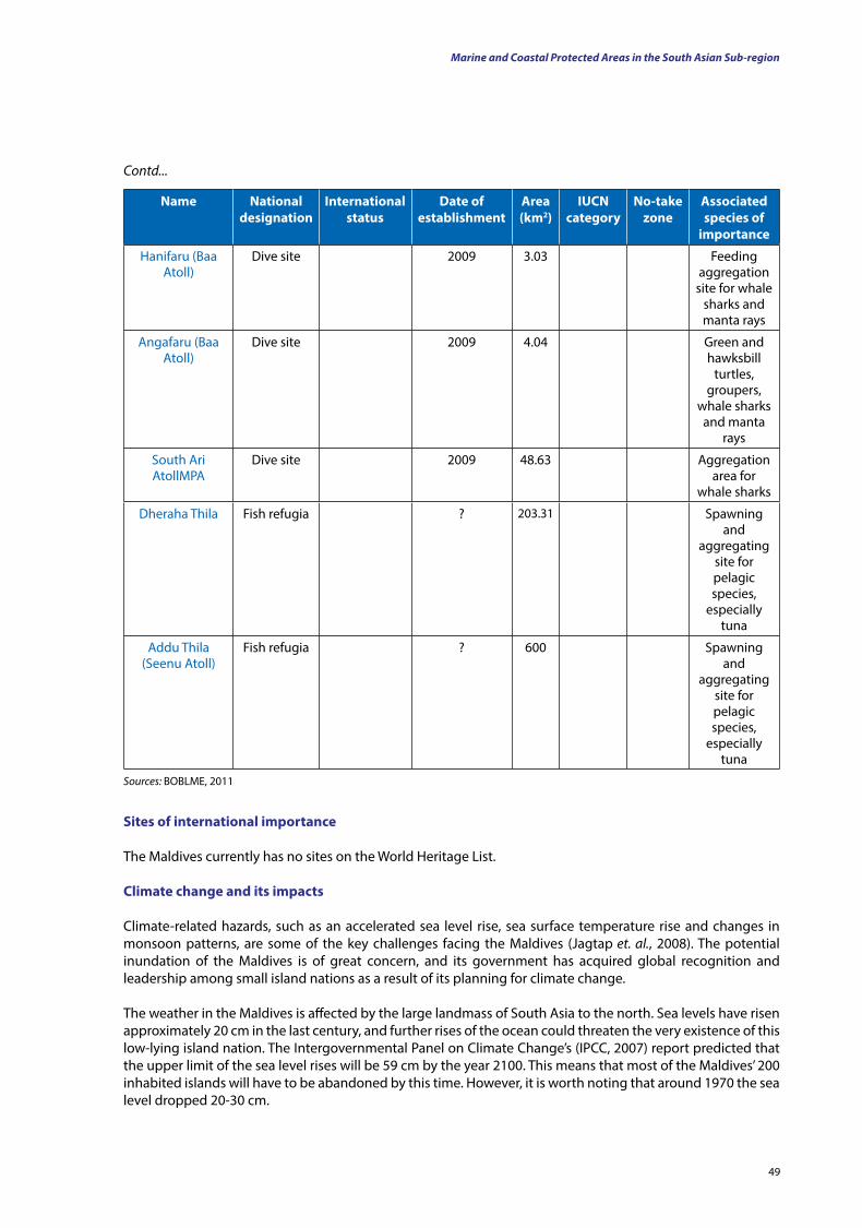
49
name national designation
International status
date of establishment
Area (km2)
IuCn category
no-take zone
Associated species of
importance
Hanifaru (Baa Atoll)
Dive site 2009 3.03 Feeding aggregation
site for whale sharks and manta rays
Angafaru (Baa Atoll)
Dive site 2009 4.04 Green and hawksbill
turtles, groupers,
whale sharks and manta
rays
South Ari AtollMPA
Dive site 2009 48.63 Aggregation area for
whale sharks
Dheraha Thila Fish refugia ? 203.31 Spawning and
aggregating site for pelagic species,
especially tuna
Addu Thila (Seenu Atoll)
Fish refugia ? 600 Spawning and
aggregating site for pelagic species,
especially tuna
Contd...
Sources: BOBLME, 2011
Sites of international importance
The Maldives currently has no sites on the World Heritage List.
Climate change and its impacts
Climate-related hazards, such as an accelerated sea level rise, sea surface temperature rise and changes in monsoon patterns, are some of the key challenges facing the Maldives (Jagtap et. al., 2008). The potential inundation of the Maldives is of great concern, and its government has acquired global recognition and leadership among small island nations as a result of its planning for climate change.
The weather in the Maldives is affected by the large landmass of South Asia to the north. Sea levels have risen approximately 20 cm in the last century, and further rises of the ocean could threaten the very existence of this low-lying island nation. The Intergovernmental Panel on Climate Change’s (IPCC, 2007) report predicted that the upper limit of the sea level rises will be 59 cm by the year 2100. This means that most of the Maldives’ 200 inhabited islands will have to be abandoned by this time. However, it is worth noting that around 1970 the sea level dropped 20-30 cm.
Marine and Coastal Protected Areas in the South Asian Sub-region

Review Paper: Status of Coastal and Marine Ecosystem Management in South Asia
50
The Maldives have been calling for a reduction in global greenhouse gas emissions, warning that rising sea levels could submerge its nation. By 2020, the Maldives aims to eliminate or offset all of its greenhouse gas emissions.
Warming of the sea, as a result of the El Niño phenomenon, killed off two-thirds of the nation’s coral reefs through bleaching in 1998.
The temperature of the water around the Maldives has risen by as much as 5°C. Rising water temperatures can have serious impacts on coral reefs, which remove carbon (CO2) from their environment and serve to protect against tropical storms, floods and tsunamis.
Scientist Azeez Hakim said, ‘Before 1998, we never thought that [our reefs] would die. We had always taken for granted that these animals would be there, that this reef would be there forever. El Niño gave us a wake-up call that these things are not going to be there forever’ (http://en.wikipedia.org/wiki/Maldives).
Pakistan
Pakistan is a sovereign country in South Asia. It is bordered by the Arabian Sea and the Gulf of Oman in the south, by India in the east, Afghanistan and Iran in the west and China in the far north-east. In the north, Tajikistan lies close to Pakistan but is separated by the narrow Wakhan Corridor. In addition, Oman is also located in Pakistan’s maritime vicinity and shares a marine border with the country. Strategically, Pakistan is situated at the crossroads of the important regions of South Asia, Central Asia and the Middle East.
Physical featuresPakistan covers an area of 796,095 km2, approximately the combined land areas of France and the United Kingdom. It is the 36th largest country by total area, although this ranking varies depending on how the disputed territory of Kashmir is considered. It has a 1,046 km coastline along the Arabian Sea and the Gulf of Oman in the south. Pakistan shares a marine border with Oman and is separated from Tajikistan by the frigid, narrow Wakhan Corridor. Located at the crossroads of South Asia, the Middle East and Central Asia, Pakistan has an important geo-political position in the world.
Pakistan is divided into three major geographic areas, the northern highlands, the Indus River Plain and the Balochistan Plateau. In the northern highlands of Pakistan are the Karakoram, Hindu Kush and Pamir mountain ranges, which have some of the world’s highest peaks, including five out of 14 mountain peaks with a height over 8,000 m. that attract adventurers and mountaineers from all over the world. These include notably K2 (8,611 m) and Nanga Parbat (8,126 m). The Balochistan Plateau lies to the west, and the Thar Desert is in the East. An expanse of alluvial plains lies in Punjab and Sindh, along the Indus River. A length of 1609 km of the Indus River and some of its tributaries flow through the country to the Arabian Sea.
Pakistan overlaps with the Indian tectonic plate in its Sindh and Punjab provinces, while Balochistan and most of Khyber Pakhtunkhwa lie within the Eurasian plate, which mainly comprises the Iranian plateau. Because of this, Pakistan is prone to violent earthquakes (http://en.wikipedia.org/wiki/Pakistan#Geography_and_climate). Pakistan’s climate varies from tropical to temperate, with arid conditions existing in the coastal south, characterised by a monsoon season, with frequent flooding rainfall, and a dry season with significantly less to no rainfall. There are four distinct seasons: (1) a cool, dry winter from December to February; (2) a hot, dry spring from March to May; (3) the summer rainy season or south-west monsoon period, from June to September; and (4) the retreating monsoon period of October and November. The rainfall can vary radically from year to year, and successive patterns of flooding and drought are common.
Pakistan has four provinces and four federal territories. With a population exceeding 177 million people, it is the sixth most populous country in the world. It is an ethnically and linguistically diverse country, with as much diversity in its geography and ecosystems (http://www.wikipedia.org).
51
Biological richesPakistan’s ecosystems vary from plains to deserts, forests, hills and plateaus, from the coastal areas of the south to the glaciated mountains of the north.
The mountainous areas around the Himalayan, Karakoram and Hindu Kush ranges, are rich in fauna and flora, as compared with other parts of the country. These areas provide excellent habitat for wildlife — alpine grazing lands, sub-alpine scrub and temperate forests — and support a variety of wild animals. The key species in the region include the snow leopard (Panthera uncia), the black bear (Ursus thibetanus), the brown bear (Ursus arctos), the otter (Lutra perspicillata), the wolf (Canis lupus), the lynx (Lynx lynx), the Himalayan ibex (Capra ibex), the markhor (Capra falconeri) and the blue sheep (Pseudois nayaur). Amongst these, the snow leopard, musk deer, and the brown bear are endangered. The Tibetan wild ass (Equus kiang) and blue sheep populations have been reduced drastically (Roberts, 1997). The cheer pheasant (Catreus wallichii) is reported to be extinct within Pakistan’s boundaries and is included in the IUCN Red List.
The main threats to the population of wild animals in the northern mountainous regions include competition with domestic livestock for the existing natural forage, increasing human interference in the form of cultivation, construction of roads and hunting.
The vast Indus flood plains have been cleared of natural vegetation to grow crops, with very little of the wildlife habitat remaining untouched. Only animals such as the jackal, the mongoose, the jungle cat, civets, pangolins, desert cats and the wild hare occur in these areas. Hog deer are found in riverine tracts. The crop residues support reasonable populations of black and grey partridges.
Scarce vegetative cover, the severity of the climatic conditions and the great numbers of grazing animals in the deserts have left wild animals in a precarious position.
The reed beds and tamarisk bushes along the rivers support hog deer (Hyelaphus porcinus) and black partridge (Melanoperdix niger) populations. However, due to occasional heavy floods, their numbers have also been reduced. The Indus River dolphin (Platanista minor), fishing cat (Prionailurus viverrinus) and smooth coated-otter (Lutrogale perspicillata) are found in the Indus River waters below the Chashma Barrage. The gavial (Gharials gangeticus) has become extinct in Pakistan. The mugger crocodile (Crocodylus palustris) is found in small numbers in lower Sindh. The numbers of the wild boar (Sus scrofa) have increased because of the immunity the animal enjoys in a Muslim society, which forbids its consumption by humans (Roberts, 1997; Mufti et al., 1995).
Pakistan’s coastline, 1,050 km long, has a variety of habitat types supporting a wide range of animals, of which over 1,000 are fish species. Pakistan’s marine flora and fauna have not been studied adequately. As such, detailed information on these species is lacking. Along the shore, there are four species of marine turtle: the Olive Ridley turtle (Lepidochelys olivacea), the green turtle (Chelonia mydas), the leatherback turtle (Dermochelys coriacea) and the hawksbill turtle (Eretmochelys imbricata). Due to loss of habitat and human disturbances, their populations are also decreasing (www.earthtrends.wrl.org).
Large water bodies in the country support a variety of waterfowl — both resident and migratory. The extent of the wetlands of Pakistan is constantly changing. On one hand, swamps and marshes are being drained to reclaim land, whereas on the other hand, new dams (large water bodies) have been created for irrigation purposes. Canal irrigation through seepage has also contributed towards increasing the area of land that is water logged. Such areas support a great number of waterfowl by providing them with excellent habitats.
The wetlands are among the most important wintering areas and ‘green routes’ of Asia. The key waterfowl species in Pakistan include ducks the mallard (Anas platyrhynchos), the pintail (Anas acuta), the shoveller (Anas clypeata), pochards (Aythya spp.), the garganey (Anas querquedula), the ruddy shelduck (Tadorna ferruginea), the Eurasian teal (Anas crecca), the tufted duck (Aythya fuligula) and the gadwall (Anas strepera)); geese the greylag
Marine and Coastal Protected Areas in the South Asian Sub-region
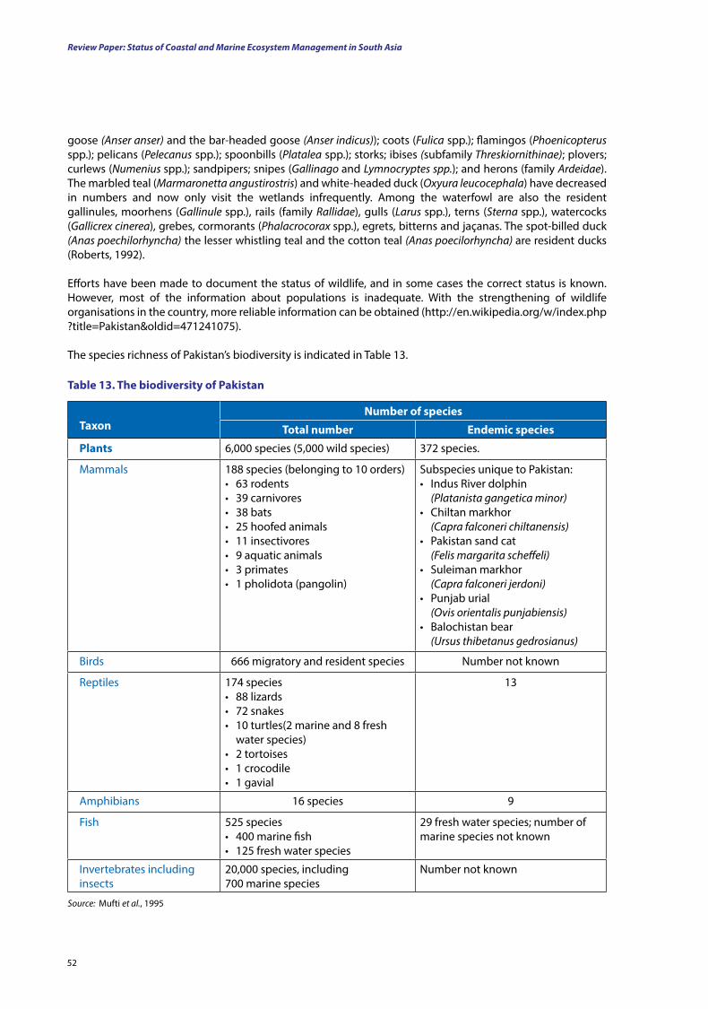
Review Paper: Status of Coastal and Marine Ecosystem Management in South Asia
52
taxon
number of species
total number Endemic species
Plants 6,000 species (5,000 wild species) 372 species.
Mammals 188 species (belonging to 10 orders)• 63 rodents• 39 carnivores• 38 bats• 25 hoofed animals• 11 insectivores• 9 aquatic animals• 3 primates• 1 pholidota (pangolin)
Subspecies unique to Pakistan:• Indus River dolphin
(Platanista gangetica minor)• Chiltan markhor
(Capra falconeri chiltanensis)• Pakistan sand cat
(Felis margarita scheffeli)• Suleiman markhor
(Capra falconeri jerdoni)• Punjab urial
(Ovis orientalis punjabiensis)• Balochistan bear
(Ursus thibetanus gedrosianus)
Birds 666 migratory and resident species Number not known
Reptiles 174 species• 88 lizards• 72 snakes• 10 turtles(2 marine and 8 fresh
water species)• 2 tortoises• 1 crocodile• 1 gavial
13
Amphibians 16 species 9
Fish 525 species• 400 marine fish• 125 fresh water species
29 fresh water species; number of marine species not known
Invertebrates including insects
20,000 species, including 700 marine species
Number not known
goose (Anser anser) and the bar-headed goose (Anser indicus)); coots (Fulica spp.); flamingos (Phoenicopterus spp.); pelicans (Pelecanus spp.); spoonbills (Platalea spp.); storks; ibises (subfamily Threskiornithinae); plovers; curlews (Numenius spp.); sandpipers; snipes (Gallinago and Lymnocryptes spp.); and herons (family Ardeidae). The marbled teal (Marmaronetta angustirostris) and white-headed duck (Oxyura leucocephala) have decreased in numbers and now only visit the wetlands infrequently. Among the waterfowl are also the resident gallinules, moorhens (Gallinule spp.), rails (family Rallidae), gulls (Larus spp.), terns (Sterna spp.), watercocks (Gallicrex cinerea), grebes, cormorants (Phalacrocorax spp.), egrets, bitterns and jaçanas. The spot-billed duck (Anas poechilorhyncha) the lesser whistling teal and the cotton teal (Anas poecilorhyncha) are resident ducks (Roberts, 1992).
Efforts have been made to document the status of wildlife, and in some cases the correct status is known. However, most of the information about populations is inadequate. With the strengthening of wildlife organisations in the country, more reliable information can be obtained (http://en.wikipedia.org/w/index.php?title=Pakistan&oldid=471241075). The species richness of Pakistan’s biodiversity is indicated in Table 13.
table 13. the biodiversity of Pakistan
Source: Mufti et al., 1995
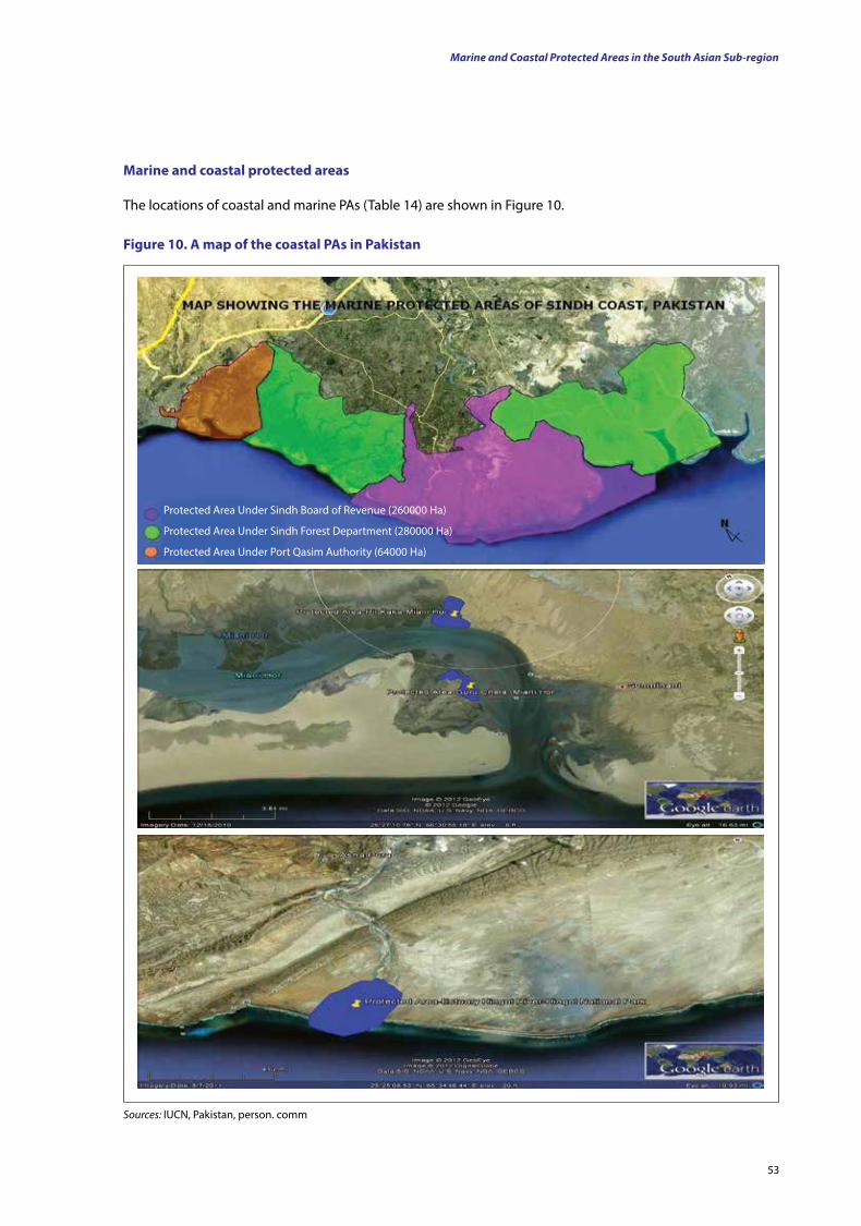
53
Marine and coastal protected areas
The locations of coastal and marine PAs (Table 14) are shown in Figure 10.
figure 10. A map of the coastal PAs in Pakistan
Sources: IUCN, Pakistan, person. comm
Protected Area Under Sindh Board of Revenue (260000 Ha)
Protected Area Under Sindh Forest Department (280000 Ha)
Protected Area Under Port Qasim Authority (64000 Ha)
Marine and Coastal Protected Areas in the South Asian Sub-region
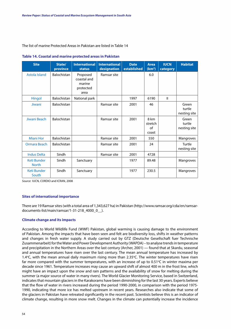
Review Paper: Status of Coastal and Marine Ecosystem Management in South Asia
54
table 14. Coastal and marine protected areas in Pakistan
Site State/province
International status
International designation
date established
Area (km2)
IuCn category
Habitat
Astola Island Balochistan Proposed coastal and
marine protected
area
Ramsar site 6.0
Hingol Balochistan National park 1997 6190 II
Jiwani Balochistan Ramsar site 2001 46 Green turtle
nesting site
Jiwani Beach Balochistan Ramsar site 2001 8 km stretch
of coast
Green turtle
nesting site
Miani Hor Balochistan Ramsar site 2001 550 Mangroves
Ormara Beach Balochistan Ramsar site 2001 24 Turtle nesting site
Indus Delta Sindh Ramsar site 2001 4728
Keti Bunder North
Sindh Sanctuary 1977 89.48 Mangroves
Keti Bunder South
Sindh Sanctuary 1977 230.5 Mangroves
Source: IUCN, CORDIO and ICRAN, 2008
Sites of international importance
There are 19 Ramsar sites (with a total area of 1,343,627 ha) in Pakistan (http://www.ramsar.org/cda/en/ramsar-documents-list/main/ramsar/1-31-218_4000_0__).
Climate change and its impacts
According to World Wildlife Fund (WWF) Pakistan, global warming is causing damage to the environment of Pakistan. Among the impacts that have been seen and felt are biodiversity loss, shifts in weather patterns and changes in fresh water supply. A study carried out by GTZ (Deutsche Gesellschaft fuer Technische Zusammenarbeit) for the Water and Power Development Authority (WAPDA) – to analyse trends in temperature and precipitation in the Northern Areas over the last century (Archer, 2001) — found that at Skardu, seasonal and annual temperatures have risen over the last century. The mean annual temperature has increased by 1.4oC, with the mean annual daily maximum rising more than 2.35oC. The winter temperatures have risen far more compared with the summer temperatures, with an increase of up to 0.51oC in winter maxima per decade since 1961. Temperature increases may cause an upward shift of almost 400 m in the frost line, which might have an impact upon the snow and rain patterns and the availability of snow for melting during the summer (a major source of water in many rivers). The World Glacier Monitoring Service, based in Switzerland, indicates that mountain glaciers in the Karakorams have been diminishing for the last 30 years. Experts believe that the flow of water in rivers increased during the period 1990-2000, in comparison with the period 1975-1990, indicating that more ice has melted upstream in recent years. Researches also indicate that some of the glaciers in Pakistan have retreated significantly in the recent past. Scientists believe this is an indicator of climate change, resulting in more snow melt. Changes in the climate can potentially increase the incidence
The list of marine Protected Areas in Pakistan are listed in Table 14
55
of flash flooding and extreme flooding over the next few decades (ADB, 2008). Studies conducted by the Sustainable Development Policy Institute (SDPI) also indicate that with a doubling of CO2, the average rainfall in South Asia will increase between 17 and 59 percent. This will be associated with a doubling in the frequency of high rainfall events. Variable monsoons are also anticipated and can result in more droughts. Experts also believe that further desiccation of arid areas due to warming will endanger food production in the plains unless a lot of trees are planted there (ADB, 2008).
All these climate change impacts will produce profound changes in the coastal areas. In particular, there is concern that the upstream abstraction of large volumes of water from rivers has, in many cases, left insufficient flows to meet the needs of downstream ecosystems. Coastal and marine regions, because they lie at the ends of rivers, have been affected most heavily by this upstream abstraction. For example, the mangrove ecosystem of the Indus Delta is (perhaps unique because it is the largest area of arid climate mangroves in the world) is almost wholly dependent, because the rainfall is so low in the region, upon fresh water discharges from the river, supplemented by a small quantity of run-off and effluents from Karachi.
Already, as a result of upstream water abstraction, by the time the Indus reaches the Kotri Barrage (some two-thirds of the way into Sindh Province, or 200 km from the Arabian Sea), the flow is inadequate to maintain the natural ecosystems of the Indus Delta.
With the impacts of glacier retreats, increases in temperature and variability of monsoons, these conditions will be exacerbated (IUCN, 2007).
Sri Lanka
Background: Physical and biological features
Sri Lanka (known as Ceylon until 1972) is a country located off the southern coast of the Indian subcontinent in South Asia. It is an island surrounded by the Indian Ocean, the Gulf of Mannar and the Palk Strait and is located in the vicinity of India and the Maldives. It has a total area of approximately 65,610 km2 and a coastline of 1,620 km (Joseph, 2003).
As a result of its location in the path of major sea routes, Sri Lanka is a strategic naval link between West Asia and South-East Asia. It was an important stop on the ancient Silk Road. The island is full of lush tropical forests, golden beaches and diverse landscapes with a rich biodiversity. The country lays a claim to a long and colorful history of over 3,000 years, having one of the longest documented histories in the world. Sri Lanka’s rich culture can be attributed to the many different communities on the island.
Physical featuresAs a consequence of the hill massif that sits in the centre of the country and the monsoonal rains that, twice a year, drench parts of the island, Sri Lanka has distinct climatic zones. South-west of the central hills is the wet zone, which receives an average of 2,000 to 5,000 mm of rain per year and, as a result, has a very wet climate. The area around this wet zone is the intermediate zone, which receives less rain than does the wet zone (1,100 to 2,000 mm per year) but more rain compared with the rest of the country, which is classed as the dry zone and receives approximately 1,000 mm of rain per annum, with a dry spell extending over three to four months of the year. In the north-west of the country, in the district of Mannar, and in the south-east, in the Hambantota District, are two tiny strips of the country — known as the arid zones — which are very dry (receiving less that 600 mm per year).
Squalls occur periodically, and sometimes tropical cyclones occur—these are characterised by overcast skies and rains— in the south-west, north-east and eastern parts of the island. The humidity is typically higher in the south-west and mountainous areas and depends on the seasonal patterns of rainfall.
The hill country, with elevations from 500 m to over 2,500 m above sea level, is surrounded by an area of lower hills called the mid-country, with elevations from 75 to 500 m above sea level. Surrounding the mid-country is a flat area — the lowlands- which ranges in elevation from 0 to 75 m above sea level.
Marine and Coastal Protected Areas in the South Asian Sub-region
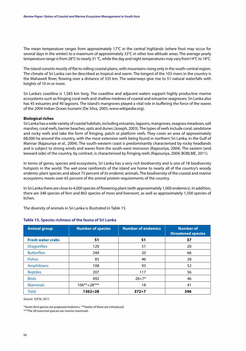
Review Paper: Status of Coastal and Marine Ecosystem Management in South Asia
56
The mean temperature ranges from approximately 17°C in the central highlands (where frost may occur for several days in the winter) to a maximum of approximately 33°C in other low-altitude areas. The average yearly temperature range is from 28°C to nearly 31 °C, while the day and night temperatures may vary from14°C to 18°C.
The island consists mostly of flat to rolling coastal plains, with mountains rising only in the south-central region. The climate of Sri Lanka can be described as tropical and warm. The longest of the 103 rivers in the country is the Mahaweli River, flowing over a distance of 335 km. The waterways give rise to 51 natural waterfalls with heights of 10 m or more.
Sri Lanka’s coastline is 1,585 km long. The coastline and adjacent waters support highly productive marine ecosystems such as fringing coral reefs and shallow medows of coastal and estuarine seagrasses. Sri Lanka also has 45 estuaries and 40 lagoons. The island’s mangroves played a vital role in buffering the force of the waves of the 2004 Indian Ocean tsunami (De Silva, 2005; www.wikipedia.org).
Biological richesSri Lanka has a wide variety of coastal habitats, including estuaries, lagoons, mangroves, seagrass meadows, salt marshes, coral reefs, barrier beaches, spits and dunes (Joseph, 2003). The types of reefs include coral, sandstone and rocky reefs and take the form of fringing, patch or platform reefs. They cover an area of approximately 68,000 ha around the country, with the most extensive reefs being found in northern Sri Lanka, in the Gulf of Mannar (Rajasuriya et al., 2004). The south-western coast is predominantly characterised by rocky headlands and is subject to strong winds and waves from the south-west monsoon (Rajasuriya, 2004). The eastern (and leeward side) of the country, by contrast, is characterised by fringing reefs (Rajasuriya, 2004; BOBLME, 2011).
In terms of genes, species and ecosystems, Sri Lanka has a very rich biodiversity and is one of 18 biodiversity hotspots in the world. The wet-zone rainforests of the island are home to nearly all of the country’s woody endemic plant species and about 75 percent of its endemic animals. The biodiversity of the coastal and marine ecosystems meets over 65 percent of the animal protein requirements of the country.
In Sri Lanka there are close to 4,000 species of flowering plant (with approximately 1,000 endemics). In addition, there are 348 species of fern and 863 species of moss and liverwort, as well as approximately 1,500 species of lichen.
The diversity of animals in Sri Lanka is illustrated in Table 15.
Animal group number of species number of endemics number of threatened species
fresh water crabs 51 51 37
Dragonflies 120 51 20
Butterflies 244 20 66
Fishes 85 46 28
Amphibians 108 93 52
Reptiles 207 117 56
Birds 492 26+7* 46
Mammals 106**+28*** 18 41
Total 1362+28 372+7 346
table 15. Species richness of the fauna of Sri lanka
Source: IUCN, 2011
*Seven bird species are proposed endemics. **Twelve of these are introduced.***The 28 mammal species are marine mammals.
57
Of the mammals of Sri Lanka, 28 species are marine mammals. Among the species of birds recorded, 272 are migrants, and besides the 26 species already classified as endemics, an additional 7 are proposed to be included in the list of endemics.
Sri Lanka is a hotspot of amphibian diversity, with 108 species, of which 92 (85 percent) are endemic. Since the 1990s, exploration for amphibian species has been intensive, with 70 new species being discovered and described in the last 20 years. Of the 34 amphibian species recently recorded, 21 species have gone extinct (IUCN, 2011).
Of the 207 reptile species on the island, 192 species are terrestrial, five are marine turtles and the rest are sea snakes (IUCN, 2011).
Marine and coastal protected areas
Sri Lanka is known for being one of the world’s first island nations to take an integrated approach to coastal management. The country began actively managing its ‘coastal zone’ as a distinct entity as early as 1981, when it established the Coast Conservation Department (CCD) (presently known as the Coast Conservation and Coastal Resources Management Department) and introduced the Coastal Conservation Act to address coastal zone resource degradation.
Sri Lanka’s first marine protected areas (declared in the 1970s) pre-date this movement towards integrated coastal management, with the Pigeon Island Marine Sanctuary and the Hikkaduwa Marine Sanctuary being declared in 1974 and 1978, respectively. A complete list of protected areas in Sri Lanka is provided in Table 16.
In addition to marine protected areas (MPAs), the country also protects marine biodiversity through fishery-managed areas (FMAs) and certain terrestrial protected areas that have marine components. Finally, there are de facto no-take zones in the northern and eastern parts of the country (due to recent conflict), where fishing was only allowed from 6 a.m. to 6 p.m. There is also a de facto no-take zone in Colombo Harbour that has led to increased lobster catches (Perera and de Vos, 2007; BOBLME, 2011).
Also found in Sri Lanka are Special Area Management (SAM) sites, which use local and geographically specific planning and active stakeholder participation in order to plan for optimal sustainable use of natural resources, ensure economic well-being as well as ecological integrity and to practise sound natural resource management. This key concept was introduced in the 1980s as a tool for resource management in the coastal zone and has been an integral part of the Coastal Zone Management Plan of the Coast Conservation Department (now the Coast Conservation and Coastal Resources Management Department) since the 1990s.
Since the late 1990s, nine SAM sites have been chosen based on agreed criteria such as severity of issues relating to resource use, richness of biodiversity, economic significance and the process of participatory management. Work is already going on in these sites. Benefits gained from the SAM process include zoning of sites to maximise ecological protection yet allow sustainable use, poverty alleviation by provision of facilities for the enhancement of livelihoods, social upliftment through various community-based training programmes and improvement of water quality and waste management.
A further 27 sites have been proposed using the same criteria and have been identified as high-priority areas. These SAM sites are managed under the aegis of the Coast Conservation and Coastal Resources Management Department and Coast Conservation Act No. 57 of 1981 and its amendments.
The newest amendment to the Coast Conservation Act (No. 49 of 2011) also allows for declaration by the relevant minister of ‘affected areas’ and ‘conservation areas’ for protection of coastal habitats.
A map of Sri Lanka’s marine and coastal protected areas is given in Figure 11.
Marine and Coastal Protected Areas in the South Asian Sub-region
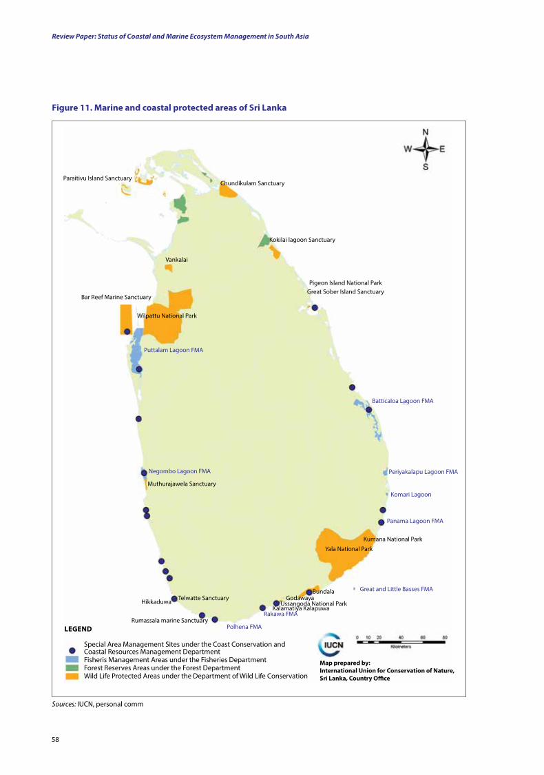
Review Paper: Status of Coastal and Marine Ecosystem Management in South Asia
58
figure 11. Marine and coastal protected areas of Sri lanka
Sources: IUCN, personal comm
Special Area Management Sites under the Coast Conservation and Coastal Resources Management DepartmentFisheris Management Areas under the Fisheries DepartmentForest Reserves Areas under the Forest DepartmentWild Life Protected Areas under the Department of Wild Life Conservation
lEgEnd
Map prepared by:International union for Conservation of nature, Sri lanka, Country office
Chundikulam Sanctuary
Kokilai lagoon Sanctuary
Pigeon Island National ParkGreat Sober Island Sanctuary
Batticaloa Lagoon FMA
Periyakalapu Lagoon FMA
Komari Lagoon
Kumana National Park
Yala National Park
Panama Lagoon FMA
Great and Little Basses FMA
Rakawa FMA
Polhena FMA
Bundala Godawaya
Ussangoda National ParkKalamatiya Kalapuwa
Telwatte SanctuaryHikkaduwa
Rumassala marine Sanctuary
Muthurajawela Sanctuary
Negombo Lagoon FMA
Puttalam Lagoon FMA
Wilpattu National Park
Vankalai
Bar Reef Marine Sanctuary
Paraitivu Island Sanctuary
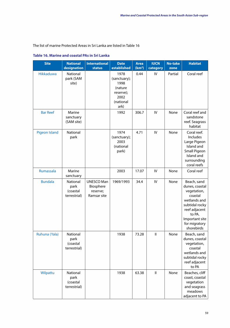
59
table 16. Marine and coastal PAs in Sri lanka
Site national designation
International status
date established
Area (km2)
IuCn category
no-take zone
Habitat
Hikkaduwa National park (SAM
site)
1978 (sanctuary);
1998 (nature
reserve); 2002
(national ark)
0.44 IV Partial Coral reef
Bar Reef Marine sanctuary (SAM site)
1992 306.7 IV None Coral reef and sandstone
reef. Seagrass habitat
Pigeon Island National park
1974 (sanctuary);
2003 (national
park)
4.71 IV None Coral reef. Includes
Large Pigeon Island and
Small Pigeon Island and
surrounding coral reefs
Rumassala Marine sanctuary
2003 17.07 IV None Coral reef
Bundala National park
(coastal terrestrial)
UNESCO Man Biosphere
reserve; Ramsar site
1969/1993 34.4 IV None Beach, sand dunes, coastal
vegetation, coastal
wetlands and subtidal rocky reef adjacent
to PA. Important site for migratory
shorebirds
Ruhuna (Yala) National park
(coastal terrestrial)
1938 73.28 II None Beach, sand dunes, coastal
vegetation, coastal
wetlands and subtidal rocky reef adjacent
to PA
Wilpattu National park
(coastal terrestrial)
1938 63.38 II None Beaches, cliff coast, coastal
vegetation and seagrass
meadows adjacent to PA
Marine and Coastal Protected Areas in the South Asian Sub-region
The list of marine Protected Areas in Sri Lanka are listed in Table 16
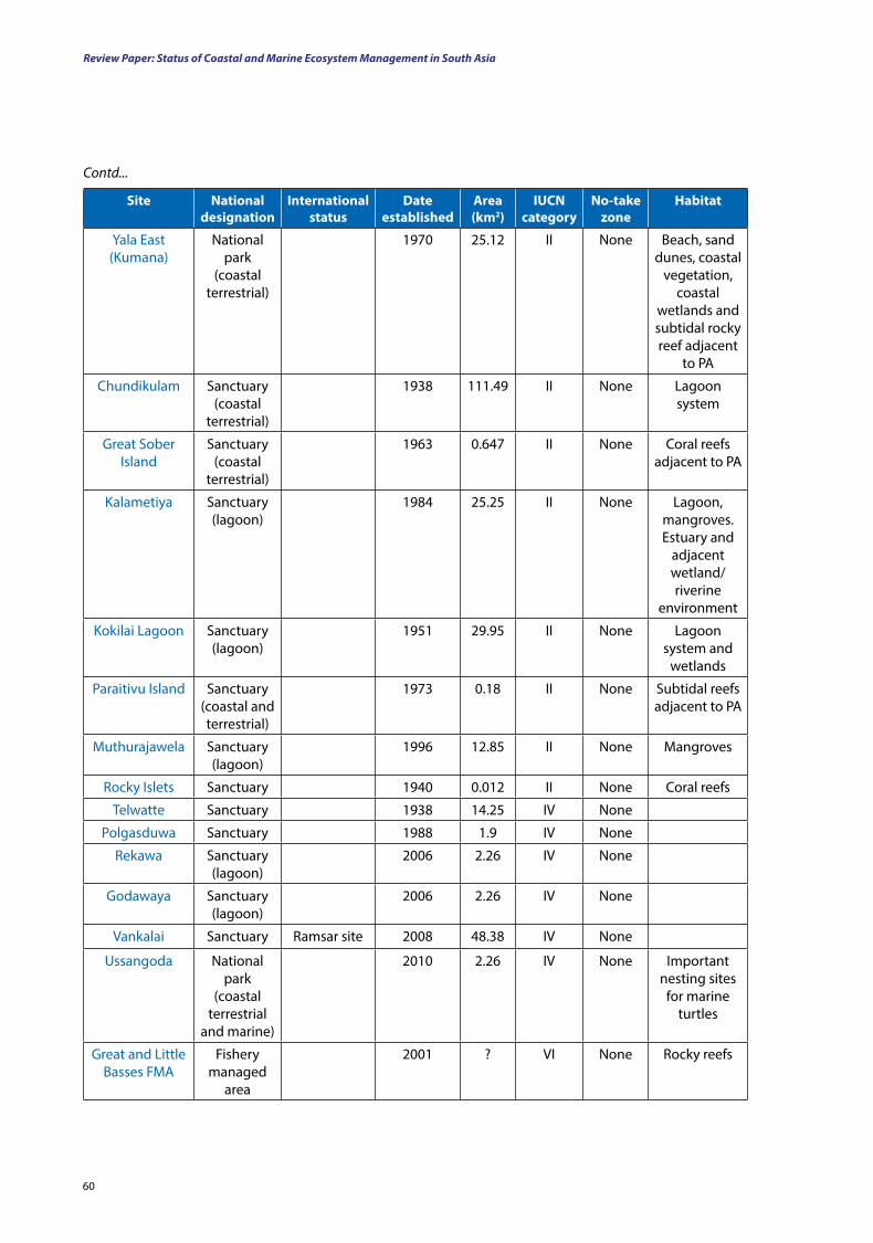
Review Paper: Status of Coastal and Marine Ecosystem Management in South Asia
60
Site national designation
International status
date established
Area (km2)
IuCn category
no-take zone
Habitat
Yala East (Kumana)
National park
(coastal terrestrial)
1970 25.12 II None Beach, sand dunes, coastal
vegetation, coastal
wetlands and subtidal rocky reef adjacent
to PA
Chundikulam Sanctuary (coastal
terrestrial)
1938 111.49 II None Lagoon system
Great Sober Island
Sanctuary (coastal
terrestrial)
1963 0.647 II None Coral reefs adjacent to PA
Kalametiya Sanctuary (lagoon)
1984 25.25 II None Lagoon, mangroves. Estuary and
adjacent wetland/riverine
environment
Kokilai Lagoon Sanctuary (lagoon)
1951 29.95 II None Lagoon system and
wetlands
Paraitivu Island Sanctuary (coastal and terrestrial)
1973 0.18 II None Subtidal reefs adjacent to PA
Muthurajawela Sanctuary (lagoon)
1996 12.85 II None Mangroves
Rocky Islets Sanctuary 1940 0.012 II None Coral reefs
Telwatte Sanctuary 1938 14.25 IV None
Polgasduwa Sanctuary 1988 1.9 IV None
Rekawa Sanctuary (lagoon)
2006 2.26 IV None
Godawaya Sanctuary (lagoon)
2006 2.26 IV None
Vankalai Sanctuary Ramsar site 2008 48.38 IV None
Ussangoda National park
(coastal terrestrial
and marine)
2010 2.26 IV None Important nesting sites
for marine turtles
Great and Little Basses FMA
Fishery managed
area
2001 ? VI None Rocky reefs
Contd...
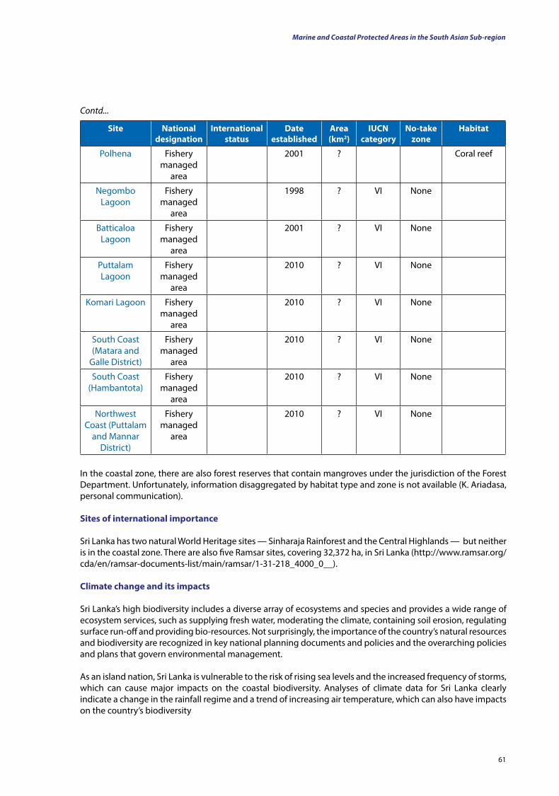
61
Site national designation
International status
date established
Area (km2)
IuCn category
no-take zone
Habitat
Polhena Fishery managed
area
2001 ? Coral reef
Negombo Lagoon
Fishery managed
area
1998 ? VI None
Batticaloa Lagoon
Fishery managed
area
2001 ? VI None
Puttalam Lagoon
Fishery managed
area
2010 ? VI None
Komari Lagoon Fishery managed
area
2010 ? VI None
South Coast (Matara and
Galle District)
Fishery managed
area
2010 ? VI None
South Coast (Hambantota)
Fishery managed
area
2010 ? VI None
Northwest Coast (Puttalam
and Mannar District)
Fishery managed
area
2010 ? VI None
Contd...
In the coastal zone, there are also forest reserves that contain mangroves under the jurisdiction of the Forest Department. Unfortunately, information disaggregated by habitat type and zone is not available (K. Ariadasa, personal communication).
Sites of international importance
Sri Lanka has two natural World Heritage sites — Sinharaja Rainforest and the Central Highlands — but neither is in the coastal zone. There are also five Ramsar sites, covering 32,372 ha, in Sri Lanka (http://www.ramsar.org/cda/en/ramsar-documents-list/main/ramsar/1-31-218_4000_0__).
Climate change and its impacts
Sri Lanka’s high biodiversity includes a diverse array of ecosystems and species and provides a wide range of ecosystem services, such as supplying fresh water, moderating the climate, containing soil erosion, regulating surface run-off and providing bio-resources. Not surprisingly, the importance of the country’s natural resources and biodiversity are recognized in key national planning documents and policies and the overarching policies and plans that govern environmental management.
As an island nation, Sri Lanka is vulnerable to the risk of rising sea levels and the increased frequency of storms, which can cause major impacts on the coastal biodiversity. Analyses of climate data for Sri Lanka clearly indicate a change in the rainfall regime and a trend of increasing air temperature, which can also have impacts on the country’s biodiversity
Marine and Coastal Protected Areas in the South Asian Sub-region
Review Paper: Status of Coastal and Marine Ecosystem Management in South Asia
62
These are possible impacts of a rise in the sea level and flooding:
(i) Salinisation of low-lying areas due to the sea level rise, storm surges and salt water intrusion.
(ii) Loss of coastal land due to the sea level rise and increased coastal erosion due to more frequent and intense storm surges.
(iii) Net loss of wetland area if coastal wetlands are unable to migrate in pace with the sea level rise.
(iv) Adverse impacts of the sea level rise and storm surges on mangroves, coral reefs and seagrass beds could affect marine organisms for which they form important breeding grounds.
(v) Disturbed coastal dynamics and habitats, which could cause an altered species composition and distribution, communities and ecosystem services.
(vi) Landward migration of coastal wetlands, resulting in the loss of fresh water and brackish habitats.
(vii) Changes in the salinity of lagoons and estuaries could affect ecosystem services and the species the systems contain, including the abundance of fish and crustaceans important for the food fishery.
(viii) Changes in current patterns due to climate change may affect the commercial fishery.
(ix) Changes in coastal and marine systems, species and ecosystem services due to global warming and ocean acidification, which will have major impacts on coral reefs, other shell-forming organisms and associated species and fish stocks.
(x) Rising ocean temperatures and El Niño events, which will systematically bleach and impoverish coral reef systems, including reef-dwelling species of commercial and environmental value.
(xi) Increased spread of marine invasive species in areas affected by climate change (Government of Sri Lanka, MoEF; http://www.rrcap.unep.org/pub/soe/srilanka_coastal.pdf ).
The above have implications for ecosystem services. Many coastal ecosystems are degraded due to poor land use, coastal erosion, pollution and over-exploitation of resources. With increasing temperatures and changing weather patterns, coastal ecosystems will inevitably face changes in their physical, chemical and biological functions. Anthropogenic stresses that degrade these systems further need to be minimised. New Special Area Management (SAM) sites could be identified and plans developed.
Biodiversity-based livelihoods and communities are bound to be adversely affected by climate change. A rise in the sea level, for example, will impact fishery processes, livelihoods and life styles of coastal communities. Adapting in such situations requires skill-building to adjust to changes in bio-resources, shifting to alternate means of livelihood, or sometimes relocating to safer places.
Extensive research is needed to better understand climate change impacts on the natural resources and biodiversity of Sri Lanka. Research and monitoring activities addressing a wide range of ecosystems, their species and their interactions need to be carried out. The ecosystems need to be understood and potential adaptive interventions identified.
Raising awareness on the importance of natural resources and biodiversity is crucial in effectively protecting and conserving them. Educating all stakeholders on the current problems, how these are expected to worsen with climate change and how they can help are essential for resolving long-standing problems in ecosystem conservation (National Climate Change Adaptation Strategy for Sri Lanka, 2010).
63
Summary for Chapter 2
Bangladesh: Bangladesh is located between latitudes 20°N and 27°N and longitudes 88°E and 93°E and lies in the low-lying Ganges-Brahmaputra River Delta (Ganges Delta).
• Background: Physical and biological features – Physical features: The plains of Bangladesh are among the most fertile in the world due to the alluvial
soil deposited in the Ganges Delta (formed by the confluence of the Ganges, the Brahmaputra, the Meghna and their tributaries). Most parts of Bangladesh are less than 12 m above the sea level, making it vulnerable to a rise in the sea level. The highest point in the country is Mowdok Range (1,052 m). It has a tropical climate with a mild winter, a hot and humid summer and a warm and humid monsoon season.
– Biological riches: Bangladesh has four main ecosystem types (coastal and marine, inland fresh water, terrestrial forest and man-made). There are estimated to be approximately 3,495 recorded plant species (including bryophytes, pteridophytes, gymnosperms and angiosperms) and 4,469 animal species (including invertebrates, vertebrates, protists and monerans) in Bangladesh. Of the vertebrates, 220 species are faced with the threat of extinction.
• Marine and coastal protected areas: While there are no specific ‘marine protected areas’ in Bangladesh, seven terrestrial protected areas (national parks and wildlife sanctuaries) encompass parts of the coastal zone. There are also ecologically critical areas (ECAs) that cover parts of the marine and coastal zone (including St. Martin’s Island, Teknaf Peninsula and the Sundarbans). Bangladesh’s only coral reefs are the Jinjira Reefs (formally an ECA and being considered for marine national park status).
• Sites of international importance: The Sundarbans is the only marine habitat in Bangladesh that is classed as a World Heritage Site. The Sundarbans and Taguar Haor are considered to be Ramsar sites.
Climate change and its impacts: Bangladesh is already vulnerable to a range of natural disasters (floods, tropical cyclones, tornadoes and tidal bores). As such, it is extremely vulnerable to the effects of climate change. A rise in the sea level is the most significant climate change-related factor as it is believed that a rise in sea level alone will result in 20 million climate refugees in Bangladesh. A sea level rise can also result in the inundation of ecosystems and habitats (e.g. the mangroves of the Sundarbans and the highly productive coral reef of St. Martin’s Island), which will also impact the survival of the species that live there. Climate change is also likely to have serious repercussions for fisheries by affecting the survival and productivity of commercially important species (e.g. penaeid shrimps and the hilsa).
India: India’s coasts are bounded by the Indian Ocean, Arabian Sea and Bay of Bengal, and it either shares a land boundary with, or is in close proximity to, all the focus countries. It is the seventh largest country in the world (by geographical area) and the second most populous one (with over 1.2 billion people).
• Background – physical and biological features – Physical features: India’s coast is 7,517 km long (5,423 km in peninsular India and 2,094 km in the
Andaman, Nicobar and Lakshadweep Islands). The coasts of the mainland consist of mudflats and marshland (46 percent), sandy beaches (43 percent) and cliffs and rocky coasts (11 percent). The Ganges and the Brahmaputra (originating in the Himalaya) flow into the Bay of Bengal and are of great importance to the country. Among the notable coastal features of India are the marshy Rann of Kutch and the alluvial Sundarbans delta. The Indian climate is strongly influenced by the Himalaya and the Thar Desert, which play a pivotal role in maintaining its seasons (which are of cultural and economic importance). There is great variation in the annual rainfall (from a few millimetres to over 12,700 mm) and altitude (from sea level to over 8,000 m above sea level).
- Biological riches: There is a wide variety of natural habitats in India (e.g. hot and cold deserts, wet and dry grasslands and areas covered permanently with ice). The habitats associated with coastal and marine systems include inland fresh and brackish water wetlands, estuarine wetlands, coastal mudflats, rocky shores, mangrove forests, marine areas and coral reefs. India is home to approximately 47,000 plant species (of which 10.96 percent are endemic), approximately 4,884 vertebrate species (including rare and endangered mammals such as the Bengal tiger, Indian rhino and Asiatic lion, as well as various bird, reptile and amphibian species) and over 60,000 insect species.
63
Marine and Coastal Protected Areas in the South Asian Sub-region
Review Paper: Status of Coastal and Marine Ecosystem Management in South Asia
6464
• Marine and coastal protected areas: National parks, wildlife sanctuaries, conservation reserves and community reserves constitute the protected areas (PAs) in India. There are 18 marine and coastal PAs in peninsular India and about 100 MPAs in the Andaman and Nicobar Islands and one in the Lakshdweep Islands. Further, 106 Important Coastal and Marine Biodiversity Areas have been identified, which will likely be managed through local communities.
• Sites of international importance: There are 10 natural World Heritage sites (including Sundarbans National Park) and 25 Ramsar sites in India.
• Climate change and its impacts: Climate change is likely to affect the coastal zones of India significantly. Key issues include rising sea levels, increases in temperature and precipitation and the effects of tropical cyclones. These factors can cause habitat degradation and loss (e.g. from submergence or erosion), as well as altered salinisation in coastal zones. A large number of people (an estimated 7.1 million) are expected to be displaced by a 1 m rise in sea level. Damage to coastal infrastructure, aquaculture and coastal tourism are also likely. Changes to rainfall patterns, temperatures and evaporation rates associated with climate change will also affect other aspects including the availability of water resources.
Ecosystems are highly vulnerable to climate change, and as such, ecosystem benefits and services are also likely to be impacted, affecting the availability of resources and employment opportunities (e.g. those associated with fisheries). India’s biodiversity will also become increasingly threatened due to the effects of climate change.
the Maldives: The Maldive Islands are a nation in the Indian Ocean (located between latitudes 1°S and 8°N and longitudes 72°E and 74°E) and comprises a double chain of 26 atolls, which are in close proximity to India and Sri Lanka.
• Background – physical and biological features – Physical features: The atolls are composed of live coral reefs and sand bars (situated atop a submarine
ridge that rises abruptly from the depths of the Indian Ocean. The reef is composed of coral debris as well as living coral and acts as a buffer against the waves of the sea, forming calmer lagoon areas. Given that more than 80 percent of the country’s land is less 1 m above sea level, it is the world’s lowest-lying country. The Maldives are affected by a dry winter north-east monsoon as well as a moist south-west monsoon. The annual rainfall of the Maldives is an average of 254 cm in the north and 381 cm in the south, while the temperature ranges between 24°C and 33°C throughout the year.
– Biological riches: The biodiversity of the country is immensely rich and is centred around its coral reefs (the most extensive reefs in the Indian Ocean). Marine species present include approximately 200 species of coral, numerous crustacean species (including over 145 species of crab and 48 species of shrimp), 83 echinoderm species, 400 mollusc species, 1,100 species of fish (including sharks, rays, wrasses and groupers), 5 species of marine turtle, approximately 170 species of bird and 21 cetacean species. Other ecosystems in the Maldives include extensive shallow and deep lagoons, deep slopes, sandy beaches and limited mangrove and seagrass habitats. The vegetation is scarce (mainly due to high salinisation), with 583 plant species being recorded in the country (323 of which were introduced for agricultural or ornamental purposes). Coconut palms are commonly found on the islands and are of great importance to the country and its culture. Coastal development, habitat destruction and over-exploitation are the biggest threats facing the biodiversity of the Maldives.
• Marine and coastal protected areas: There are 35 marine and coastal protected areas in the Maldives, with the majority of them being dive sites.
• Sites of international importance: There are currently no natural World Heritage Sites in the Maldives.
• Climate change and its impacts: The main effects of climate change that threaten the Maldives are rising sea levels, changes in monsoonal patterns and an increase in the sea surface temperature. The potential submergence and inundation of the islands (as a result of the rising sea level) is of primary concern, with some estimates suggesting that the 200 inhabited islands of the country will have to be abandoned by 2100. Warming of the sea around the Maldives (as a result of the El Niño phenomenon) in 1998 resulted in the bleaching and death of two-thirds of its coral reefs. As such, the rising temperature of the sea (with
Review Paper: Status of Coastal and Marine Ecosystem Management in South Asia
65
climate change) is likely to lead to further destruction of its reef ecosystems. As these reefs are destroyed, their protective services (e.g. against tropical storms, floods and tsunamis) will also be impacted.
Pakistan: Pakistan is situated at the crossroads of South Asia, Central Asia and the Middle East. It is bordered by the Arabian Sea and the Gulf of Oman and shares terrestrial borders with Afghanistan, China, India and Iran.
• Background – physical and biological features – Physical features: Pakistan’s coast is 1,046 km long. The country is divided into three major geographic
areas: the northern highlands; the Indus River Plain; and the Balochistan Plateau. Pakistan is prone to earthquakes, given its position with regard to the Indian and Eurasian tectonic plates. Its climate varies from tropical to temperate, while it has four distinct seasons (a cool, dry winter, a hot, dry spring, the south-west monsoon period and the retreating monsoon period of October and November). The rainfall can vary radically from year to year, and successive patterns of flooding and drought are common.
– Biological riches: Pakistan’s ecosystems vary considerably (including plains, deserts, forests, hills, plateaus and glaciated mountains). The mountainous regions of Pakistan are particularly high in biodiversity (with species including the the snow leopard and the markhor) as they provide excellent habitats (e.g. alpine grazing lands, sub-alpine scrub and temperate forests) for wildlife. Other habitats which support wildlife include the vast Indus plains and the reed and tamarisk bushes along rivers. Pakistan’s coasts have various habitats and, as such, support a wide range of animals. The large wetlands and water bodies of Pakistan support a variety of water fowl – both migratory and resident (including ducks, geese, flamingos, spoonbills and sandpipers). In total, Pakistan has 188 mammal species, 666 bird species (including migrants and residents), 174 reptile species (including four marine turtles), 16 amphibian species, 525 fish species and over 20,000 invertebrates. There are approximately 6, 000 plant species in Pakistan (5, 000 wild species of which 372 are endemic).
• Marine and coastal protected areas: Pakistan has nine marine and coastal protected areas (including one proposed MCPA) in the form of national parks and sanctuaries.
• Sites of international importance: Pakistan has a total of 19 Ramsar sites.
• Climate change and its impacts: Climate change is causing damage to Pakistan’s natural environment, with biodiversity loss, shifts in weather patterns and changes in fresh water supply. The seasonal and annual temperatures have also risen (resulting in a shift in the frost line). As a result, there is increased snow melt, with an increased risk of flash flooding. Further desiccation of arid areas is also expected with a rise in temperature. The impacts of climate change are likely to be significant is coastal areas. Heavy abstractions of water from rivers (as a consequence of changes in climatic conditions) have resulted in flows that are insufficient to meet the needs of downstream ecosystems (particularly coastal and marine systems). Similarly, fluctuations in temperatures and weather conditions are likely to impact these habitats and the species that are associated with them.
Sri lanka: Sri Lanka is an island located off the southern coast of the Indian subcontinent (close to India and the Maldives) and is surrounded by the Indian Ocean, the Gulf of Mannar and the Palk Strait. It has a total area of approximately 65,610 km2 and a coastline of length 1,620 km.
• Background – physical and biological features - Physical features: There are three grades of altitude in Sri Lanka – the hill country (500-2,500 m above
sea level), the mid-country, with elevations from 75 to 500 m above sea level and the lowlands (0-75 m above sea level). The climate of Sri Lanka is tropical and warm. To the south-west of the hill country (the centre of the island) is the wet zone (2,000 to 5,000 mm of rainfall per year), which is surrounded by the intermediate zone (1,100 to 2,000 mm rainfall per year). The rest of the country is considered to be the dry zone (approximately 1,000 mm of rain per year), with two strips in Mannar and Hambantota being classed as arid zones (less than 600 mm per year). Sri Lanka has two monsoons — the south-west monsoon and the north-east monsoon. Squalls and tropical cyclones occur in the country. The mean temperature ranges from 17°C in the Central Highlands to a maximum of approximately 33°C in other low-altitude areas. Sri Lanka has 103 rivers – the longest of which is the Mahaweli (335 km). The coastline is 1,585 km long and is surrounded by highly productive marine ecosystems (e.g. fringing coral reefs
65
Marine and Coastal Protected Areas in the South Asian Sub-region
Review Paper: Status of Coastal and Marine Ecosystem Management in South Asia
6666
and seagrass meadows). Sri Lanka also has 45 estuaries and 40 lagoons, as well as mangroves, which serve to protect the coast from natural disasters (e.g. the Indian Ocean tsunami of 2004).
– Biological riches: Sri Lanka’s coastal habitats are diverse and include estuaries, lagoons, mangroves, seagrass meadows, salt marshes, coral reefs, barrier beaches, spits and dunes. Coral reefs cover an area of approximately 68,000 ha around the country, with the most extensive reefs being in the Gulf of Mannar. The biodiversity of the country is extremely rich, with over 4,000 species of flowering plant (over 1,000 of which are endemic), 348 species of fern, 863 species of moss and liverwort and approximately 1,500 species of lichen, as well as 134 mammal species (including 28 marine mammals), 492 bird species (migrants and residents), 207 reptile species (including five marine turtles), 108 amphibian species, 85 fish species and numerous invertebrate species (including 51 fresh water crab species, 120 dragonflies and 244 butterflies). The biodiversity of the coastal and marine ecosystems is of particularly great i mportance (meeting over 65 percent of the animal protein requirement of the country).
• Marine and coastal protected areas: There are 30 marine and coastal protected areas in Sri Lanka, including national parks, sanctuaries, marine protected areas (MPAs), Special Area Management (SAM) sites and fishery-managed areas (FMAs), as well as marine components of terrestrial protected areas. There are also a number of de facto no-take zones (in the north and east of the country, as well as in Colombo Harbour).
• Sites of international importance: Sri Lanka has two natural World Heritage sites (the Sinharaja Rainforest and the Central Highlands), but neither is in the coastal zone. Sri Lanka also has five Ramsar sites (covering an area of 32,372 ha).
• Climate change and its impacts: Sri Lanka ecosystems and ecosystem services are threatened by climate change. Given that it is an island, the country (particularly the coast) is vulnerable to the effects of rising sea levels (which are likely to result in losses of land and coastal biodiversity), as well as to increases in the frequency and strength of tropical storms associated with climate change. As temperature and weather patterns change, and factors such as increased salinisation come into play, with the effects of climate change, the country’s biodiversity and the people who depend on it will be impacted (e.g. through the loss of resources, employment opportunities and ecosystem services). The fisheries industry is also likely to be impacted by rising sea temperatures and ocean acidification, which result in the destruction of coral reefs and loss of habitats important for a number of commercially important species.
Review Paper: Status of Coastal and Marine Ecosystem Management in South Asia
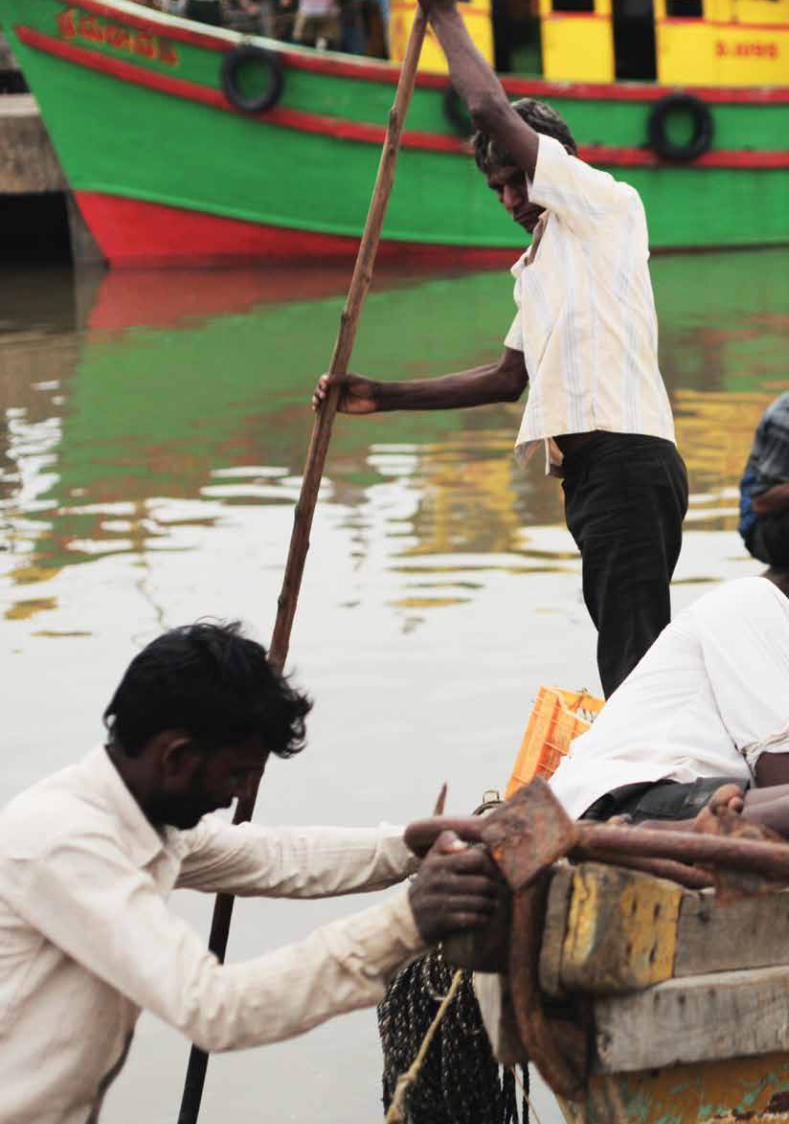
Copyright © 2012 United Nations Office for Disaster Risk Reduction, Asia and Pacific, Thailand and the United Nations Development Programme, India.
All rights reserved. No part of this publication may be reproduced, stored in a retrieval system or transmitted, in any form or by any means, electronic, mechanical, photocopying, recording or otherwise, without prior permission.
The views expressed in this publication are those of the author(s) and do not necessarily represent those of the United Nations, including UNDP, UNISDR and their member states.
Suggested citation: UNISDR/UNDP (2012). Review Paper – Status of Coastal and Marine Ecosystem Management in South Asia. Inputs of the South Asian Consultative Workshop on “ Integration of Disaster Risk Reduction and Climate Change Adaptation into Biodiversity and Ecosystem Management of Coastal and Marine Areas in South Asia” held in New Delhi on 6 and 7 March 2012. New Delhi: UNDP. 173 pages.
Cover photographs: Sriyanie Miththapala; Shashank Jayaprasad/UNDP India
Inside photographs: Sriyanie Miththapala; Shashank Jayaprasad/UNDP India; Tom Pietrasik/UNDP India; Benoit Marquet/UNDP India

United Nations Development Programme55, Lodi EstateNew Delhi - 110003IndiaEmail: [email protected]
REVIEW PAPERSTATUS OF COASTAL AND MARINE ECOSYSTEM MANAGEMENT IN SOUTH ASIA
REVIEW PA
PER: STATUS O
F COA
STAL A
ND
MA
RINE ECO
SYSTEM M
AN
AG
EMEN
T IN SO
UTH
ASIA