Embed Size (px)
Citation preview

ContentsCover page........................................................................................................................................................................................................................Recommended bibliographic reference: ................................................................................................................................................................. iiINTRODUCTION ................................................................................................................................................................ 1ABSTRACT ............................................................................................................................................................................ 1DATA BASE AND PREVIOUS STUDIES ...................................................................................................................... 2ARSENIC IN GEOLOGICAL MATERIALS ................................................................................................................... 2Figure 1. Minnesota and easternmost North Dakota, showing location of counties and geographic features mentioned in text. ...... 3Table 1. Arsenic concentrations in selected Quaternary and Cretaceous geological materials, Minnesota ............................................. 4Table 2. Core intervals sampled for Cretaceous materials (see Table 1) ........................................................................................................... 5ARSENIC IN GROUND WATER ..................................................................................................................................... 5Figure 2. Maps of Minnesota showing surface and subsurface extent of the five regional hydrogeochemical systems discussed in
the text. Extent of each hydrogeochemical system is shown in grey. .......................................................................................................... 6HYDROGEOCHEMICAL SYSTEMS IN MINNESOTA.............................................................................................. 7Quaternary Buried Artesian Aquifer System ......................................................................................................................................................... 8Table 3. Arsenic Concentration in Water in Principal Minnesota Aquifers ..................................................................................................... 8Figure 3. Maps (A-E) for the five regional hydrogeochemical systems of Minnesota, showing the concentrations of arsenic in mg/L
for ground water samples in GWMAP data base (Minnesota Pollution Control Agency, 2000) for each system. ............................. 9Quaternary Water–Table Aquifer System .............................................................................................................................................................. 10Cretaceous Aquifer System ...................................................................................................................................................................................... 10Paleozoic–Mesoproterozoic Artesian Basin Aquifer System............................................................................................................................. 10Precambrian Crystalline Rock Aquifer System .................................................................................................................................................... 10HYDROGEOCHEMICAL MODELING ........................................................................................................................ 11GWMAP Data Base .................................................................................................................................................................................................... 12Figure 4. Variation in total arsenic and iron content of Quaternary sediments obtained from drill cores. See Tables 1 and 4. ......... 12Sorption Modeling ..................................................................................................................................................................................................... 12Figure 5. Location of samples used for arsenic sorption modeling (see Table 4) .......................................................................................... 13Surface Complexation Model ................................................................................................................................................................................... 13Table 4. Input data and results for arsenic sorption-modeling......................................................................................................................... 14MINEQL+..................................................................................................................................................................................................................... 15Results of Modeling ................................................................................................................................................................................................... 15Figure 6. Generalized aqueous environments and control of arsenic species in Minnesota ground water. Adapted from Heath
(1983) and Hounslow (1980). .............................................................................................................................................................................. 16Classification of Aqueous Environments in Minnesota ..................................................................................................................................... 17Oxic zone ...................................................................................................................................................................................................................... 17Suboxic zone ................................................................................................................................................................................................................ 17 Reduced zone ............................................................................................................................................................................................................. 17Application to Minnesota Aquifer Systems .......................................................................................................................................................... 17Quaternary Buried Artesian Aquifer System ....................................................................................................................................................... 17Quaternary Water-Table Aquifer System ............................................................................................................................................................... 18Figure 7. Dissolved arsenic versus total dissolved solids for the buried artesian aquifer system. ........................................................... 18Cretaceous Aquifer System ...................................................................................................................................................................................... 18Paleozoic–Mesoproterozoic Artesian Basin Aquifer System............................................................................................................................. 19Precambrian Crystalline Rock Aquifer System .................................................................................................................................................... 19SUMMARY AND CONCLUSIONS ............................................................................................................................... 19REFERENCES ...................................................................................................................................................................... 20

Arsen
ic in M
inn
esota Grou
nd
Water: H
ydrogeoch
emical M
odelin
g of the
Qu
aternary B
uried
Artes ian
Aq
uifer an
d C
retaceous A
qu
ifer Sys tem
s
ISSN: 0076-9177 Cover: Variation in total arsenic and iron content with depth forQuaternary sediments. Drill core from Cottonwood, Rice and Stearnscounties, Minnesota.
Rep
ort of Inves tigation
s 55 ♦
2000

Arsenic in Minnesota Ground Water:Hydrogeochemical Modeling of the Quaternary BuriedArtesian Aquifer and Cretaceous Aquifer Systems
by R. Kanivetsky
Report of Investigations 55 ♦2000
Minnesota Geological SurveySaint Paul, Minnesota
Fe, total (%)
Arsenic (ppm)
Dep
th (
feet
)
Well no. 249609
0 1.125 2.25 3.375 4.5
0 10 20 30 40 50 60250
200
150
100
50
0
Cottonwood Co., rotosonic no. 1(T. 107 N., R. 38 W., S. 34)
Fe, total (%)
Arsenic (ppm)
Dep
th (
feet
)
Well no. 249055
0 1.5 2.0 2.5 3.0 3.5
2 4 6 8 10 12 14300
250
200
150
100
50
0
Rice Co., rotosonic no. 3(T. 112 N., R. 22 W., S. 26)
Fe, total (%)
Arsenic (ppm)
Dep
th (
feet
)
Well no. 249856
1 2 3 4 5 6 7
0 5 10 15200
150
100
50
0
Stearns Co., rotosonic no. 3(T. 127 N., R. 31 W., S. 5)
Fe, total (%)Arsenic (ppm)

Arsenic in Minnesota Ground Water:
Hydrogeochemical Modeling of the Quaternary
Buried Artesian Aquifer and Cretaceous Aquifer
Systems
R. Kanivetsky
Report of Investigations 55 ♦ 2000Minnesota Geological Survey
D.L. Southwick, Director

Minnesota Geological Survey2642 University Avenue WestSaint Paul, Minnesota 55114-1057
Telephone: 612-627-4780Fax: 612-627-4778E-mail address: [email protected] site: http://www.geo.umn.edu/mgs
©2000 by the Board of Regentsof the University of MinnesotaAll rights reserved.
ISSN 0076-9177
The University of Minnesota is committed to the policy that all persons shall have equal access to itsprograms, facilities, and employment without regard to race, color, creed, religion, national origin, sex, age,marital status, disability, public assistance status, veteran status, or sexual orientation.
Recommended bibliographic reference:Kanivetsky , R., 2000, Arsenic in Minnesota ground water—hydrogeochemicalmodeling of the Quaternary buried artesian aquifer and Cretaceous aquifersystems: Minnesota Geological Survey Report of Investigations 55, 23 p.

Abstract .......................................................................................................................................... 1Introduction ..................................................................................................................................... 1Data base and previous studies ...................................................................................................... 2Arsenic in geological materials ...................................................................................................... 2Arsenic in ground water ................................................................................................................. 5Hydrogeochemical systems in Minnesota ..................................................................................... 7
Quaternary buried artesian aquifer system .......................................................................... 8Quaternary water-table aquifer system ............................................................................... 10Cretaceous aquifer system .................................................................................................... 10Paleoproterozoic-mesoproterozoic artesian basin aquifer system ..................................... 10Precambrian crystalline rock aquifer system ...................................................................... 10
Hydrogeochemical modeling ........................................................................................................ 11GWMAP data base ................................................................................................................ 12Sorption modeling .................................................................................................................. 12Surface complexation model ................................................................................................. 13MINEQL+ ............................................................................................................................... 15Results of modeling ................................................................................................................ 15Classification of aqueous environments in Minnesota ........................................................ 17
Oxic zone ........................................................................................................................ 17Suboxic zone .................................................................................................................. 17Reduced zone ................................................................................................................. 17
Application to Minnesota aquifer systems ........................................................................... 17Quaternary buried artesian aquifer system ............................................................... 17Quaternary water-table aquifer system ...................................................................... 18Cretaceous aquifer system ........................................................................................... 18Paleozoic-Mesoproterozoic artesian basin aquifer system ........................................ 19Precambrian crystalline rock aquifer system ............................................................. 19
Summary and conclusions ............................................................................................................ 19Acknowledgments ......................................................................................................................... 20References ...................................................................................................................................... 20
FIGURES
Figure 1. Minnesota and North Dakota, location of geographic features ................................................. 3Figure 2. Surface and subsurface extent of the five
regional hydrogeochemical systems in Minnesota .............................................. 6Figure 3. Concentration of arsenic (µg/L) in groundwater for each
of the five regional hydrogeochemical systems in Minnesota ............................. 9Figure 4. Arsenic and iron content in Quaternary sediments of
Cottonwood, Rice, and Stearns counties, Minnesota ......................................... 12Figure 5. Location of samples used for sorption modeling ..................................................................... 13Figure 6. Generalized diagram for Minnesota aqueous environments .................................................... 16Figure 7. Dissolved arsenic vs. total dissolved solids, buried artesian aquifer system ........................... 18
Page
TABLE OF CONTENTS

Page
Table 1. Arsenic concentrations in selected Quaternaryand Cretaceous geological materials, Minnesota ................................................. 4
Table 2. Depth intervals sampled for cores and cuttings of Cretaceous geological materials ............. 5Table 3. Arsenic concentration in water in principal Minnesota aquifers ............................................ 8 Table 4. Input data and results for arsenic sorption modeling ........................................................... 14
TABLES

1
INTRODUCTION
Arsenic is one of the elements specificallymentioned in the 1996 Amendments to the SafeDrinking W ater Act as a potential human health hazard.The current federal standard for arsenic in public watersupplies is set at a maximum of 50 ppb (parts perbillion), which equals 50 µ g/L (micrograms per liter).However , the U.S. Environmental Protection Agencyis currently reviewing its arsenic standard in responseto recent research findings that demonstrate adversehealth ef fects at lower arsenic concentrations (Ralof f,1996). In May 2000, the U.S. Environmental Protection
Agency proposed to set the arsenic standard for drinkingwater at a maximum arsenic concentration of 5 µ g/L(U.S. Environmental Protection Agency , Office of W ater ,2000, Proposed revision to Arsenic Drinking W aterStandard: EP A web site at http://www .epa.gov/safewater/ars/proposalfs.html; web site accessed May25, 2000). This proposed ruling will be in review untilJanuary 2001. There is concern statewide in Minnesotaamong citizens and public health of ficials about thepotential arsenic toxicity of the ground water (MinnesotaDepartment of Health, Division of EnvironmentalHealth, 1995). V ery little is known, however , aboutthe concentration and mobility of arsenic in geologic
ARSENIC IN MINNESOTA GROUND WATER:HYDROGEOCHEMICAL MODELING OF THE
QUATERNARY BURIED ARTESIAN AQUIFER ANDCRETACEOUS AQUIFER SYSTEMS
ABSTRACT
Chemical analyses from the Minnesota Pollution Control Agency Ground W ater Monitoringand Assessment Program, together with geochemical data on geological materials from previousstudies were used to assess the concentration and mobility of arsenic in ground water in Minnesota.Concentrations of dissolved arsenic in Minnesota ground water commonly exceed 3 µ g/L (microgramsper liter) and are as much as 157 µ g/L.
Conventionally , Minnesota is divided into five regional hydrogeochemical systems on the basisof aquifer characteristics. The highest concentrations of arsenic in ground water are in the Quaternaryburied artesian aquifer system in the western part of the state. Aquifers in this system are sandand silty sand intercalated with clay-rich till. The till contains substantial quantities of comminutedshale and carbonaceous shale derived from nearby Cretaceous strata. Sediments of this aquifer areoverlain by fine-grained, silty-to-clayey glacial and lacustrine sediments.
A generalized two-layer model was used to study adsorption of arsenic on ferric hydroxides.Results of this modeling suggest that the mobility of arsenic is promoted by the onset of suboxicconditions in aquifer systems where iron hydroxides have sorbed arsenic. The reduction of ferricoxides and hydroxides, together with reduction of As 5+ to the less-strongly adsorbed and more mobileAs 3+, can release adsorbed arsenic to ground water . The source of the arsenic in the QuaternaryBuried Artesian Aquifer System is presumed to be iron oxides and hydroxides that have sorbed arsenic,and form coatings on mineral grains within the silty-clayey till. W aters within the otherhydrogeochemical systems typically have low concentrations of arsenic, possibly because they areassociated with oxic conditions. In all the aquifer systems, higher arsenic concentrations may alsobe associated with geologic units that display sulfide mineralization.
by
Roman Kanivetsky

2
materials and ground water , or about the processes thatcontrol arsenic speciation, concentration, and mobility .There have not been any studies to date that haveexamined the speciation of arsenic in ground water inMinnesota.
Previous studies by the Minnesota GeologicalSurvey (Morey and others, 1990), and samplingprograms by the National Uranium Resource EvaluationProgram (NURE, Oak Ridge Gaseous Dif fusion Plant,1979a,b; 1981a,b,c,d,e), Minnesota Department ofHealth (Center for Disease Control, Jim Nye, writtencommun., 1995), and Minnesota Pollution ControlAgency (Clark and others, 1994, 1995; T om Clark,written commun., 1996; Minnesota Pollution ControlAgency , 2000) identified general areas in which high(i.e. greater than 50 µ g/L) arsenic concentrations arereported for the ground water . The study by Moreyand others (1990) suggested that in western Minnesota,water wells completed in aquifers in Quaternarysediments generally have arsenic concentrations higherthan those completed in aquifers formed in Cretaceousand Precambrian rocks. Arsenic mobility , and theprocesses and conditions associated with, or causingthe high arsenic concentrations, have not previouslybeen examined or modeled within the Minnesotahydrogeologic framework. In this report the term highis used for arsenic concentrations > 50 µ g/L, and theterm elevated is used for concentrations ranging from2 to 50 µ g/L. For arsenic concentrations below 2 µ g/L, the term low is used.
This study presents summary details of the naturalconcentration of arsenic in ground water and geologicalmaterials in Minnesota, with an emphasis on the specifichydrogeochemical and hydrogeologic processes andconditions associated with arsenic mobility andconcentration in the Quaternary buried artesian aquifersystem and Cretaceous aquifer system in westernMinnesota. These data are used in conjunction witha generalized two-layer surface complexation model inorder to assess the probable factors causing, and themechanisms associated with the high arsenicconcentrations in ground water in the Quaternary buriedartesian aquifer system in western Minnesota. Theseresults may have implications for arsenic mobility inground water elsewhere in Minnesota.
DATA BASE AND PREVIOUS STUDIES
The hydrogeological distribution of arsenic wasdetermined using digital data bases from the MinnesotaPollution Control Agency (Clark and others, 1994, 1995;Tom Clark, written commun., 1996; Minnesota PollutionControl Agency , 2000), NURE (Oak Ridge gaseous
Dif fusion Plant, 1979a,b; 1981a,b,c,d,e), and the U.S.Geological Survey (Jesse Anderson, USGS, MinnesotaDistrict, written commun., September 1995). Thelocations of counties within Minnesota and parts ofadjoining North Dakota, as well as other geographicfeatures mentioned in the text are shown in Figure 1.
Based on examination and comparison of thesedata bases, the most useful and accurate one for analysisof arsenic distribution in ground water in relation togeologic control was clearly the MPCA Ground W aterMonitoring and Assessment Program (GWMAP) database, because it includes complete chemical analyses,hydrogeologic control (well-log data), and verifiedlocation data. The GWMAP sampling network iscomposed of 954 locations, at each of whichgroundwater has been sampled; the sampling grid isdesigned to have uniform statewide coverage (Clark andothers, 1994). The other data bases had significantdeficiencies because of the absence or inadequacy ofwell-log information, which resulted in a lack ofgeologic control. Deficiencies in the other data basesalso included incompletely defined chemical parameters,and insuf ficient accuracy in the analytical data. TheGWMAP data base does not include information onthe arsenic concentration in geologic materials.
The concentrations of arsenic in geologicalmaterials were obtained from Minnesota GeologicalSurvey studies (McSwiggen and others, 1995; Melcherand others, 1996; Morey , 1992; Morey and Day , 1992;Morey and McDonald, 1987, 1989; Morey and others,1985, 1994). The major -element chemistry of groundwater in Quaternary , Cretaceous and Paleozoic aquifersin Minnesota is described by Kanivetsky (1986). Astatewide hydrogeological framework already exists,and is depicted on maps by Kanivetsky (1978, 1979);the surface and subsurface extent of the fivehydrogeochemical systems identified for Minnesota isshown in Figure 2. The arsenic concentration in selectedgeologic materials in Minnesota is given in T able 1.
ARSENIC IN GEOLOGICALMATERIALS
Arsenic is widely distributed in geologicalmaterials; it ranks twentieth in natural abundance amongelements in the Earth’ s crust (Sullivan and Aller , 1996).The crustal abundance of arsenic is 1.8 µ g/kg (Hem,1992, Huang Y an-Chu, 1994). More than 368 mineralscontaining arsenic have been identified (Ivanov , 1996),but only a few are common in hydrogeochemicalenvironments. In reduced environments the commonarsenic-bearing minerals are sulfides (arsenopyrite,realgar , and orpiment), and in oxidized environments

3
they are arsenates (arsenolite and claudetite). In ironores and pyrite, arsenic is a trace element that typicallyhas high concentrations. In many aquifer systemsstudied (Sullivan and Aller , 1996, Moncure and others,1992, Belzile and T essier , 1990, Welch and others, 1988,Agett and O’Brien, 1985) arsenic is associated withiron-oxide minerals.
The average arsenic contents of diabase andgranite are 0.8 and 2.2 mg/kg respectively (Robertson,1989). Sandstones and carbonate rocks arecomparatively low in arsenic, averaging about 1.0–1.8mg/kg (Hem, 1992). Arsenic concentrations in shalesand clays are reported to be 13.0 mg/kg (Huang Y an-Chu, 1994), 1 1.8 mg/kg (Korte and Quintus, 1991) and9 mg/kg (Hem, 1992). Arsenic concentrations in shalesand clays are considerably higher than in othergeological materials because arsenic accumulates as aresult of weathering, and during the dissolution andtransport of sedimentary material (Ferguson and Gavis,
1972). Studies confirm that suspended and bottomsediments generally contain higher arsenicconcentrations, and that arsenic is typically associatedwith iron oxides and hydroxides (Sullivan and Aller ,1996; Moncure and others, 1992; Belzile and T essier ,1990; Welch and others, 1988; Aggett and O’Brien,1985).
Data for arsenic concentrations in geologicalmaterials in Minnesota were obtained from MinnesotaGeological Survey studies (Morey and others, 1985,1994, in press; Morey and Lively , 1999; Morey andMcDonald, 1987, 1989; Morey and Day , 1992; Morey ,1992; Melcher and others, 1996; McSwiggen and others,1995) and NURE (Oak Ridge Gaseous Dif fusion Plant,1979a,b; 1981a,b,c,d,e). The concentrations of arsenicin Cretaceous and Quaternary geologic materials (drillcores and stream sediments) is given in T able 1. InQuaternary materials the mean arsenic concentrationsin the western part of the state are as high as 26 mg/
Figure 1. Minnesota and easternmost North Dakota, showing location of counties andgeographic features mentioned in text.
Lake Superior
N.D
.M
INN
.
WIS.
Minnesota
R.
R.M
ississippi
Red
Riv
erof
the
Nor
th
S.D
.
IOWAMINN.
InternationalFalls
CANADAKITTSON ROSEAU LAKE
OF THEWOODS
MARSHALL
POLK
RED LAKE
PENNINGTON
BELTRAMI
CLE
AR
WA
TE
R
NORMAN
KOOCHICHING
CLAYBECKER
HUBBARD
WA
DE
NA
CASS
ITASCA
ST. LOUIS
LAKE
COOK
CARLTON
WILKIN
OTTER TAIL
TRAVERSE
GRANT
STEVENS
DOUGLAS
POPE
TODD
STEARNS
MORRISON
AITKIN
CROWWING
MIL
LE L
AC
S
KA
NA
BE
C
PINE
BIG STONE
SWIFT
CHIPPEWA
LAC QUIPARLE
YELLOW MEDICINE
RENVILLLE
KA
ND
IYO
HI
MEEKER WRIGHT
LIN
CO
LN
LYONREDWOOD
SIBLEY
MCLEOD
NICOLLET
ISANTI CHISAGO
ANOKA
BENTON
SHERBURNE
DAKOTA
CA
RV
ER
WA
SH
ING
TO
N
HENNEPINRAM
SEY
SCOTT
WINONA
FILLMORE
OLMSTED
WABASHAGOODHUE
DO
DG
E
RICELE SUEUR
BROWN
PIP
ES
TO
NE
MURRAY COTTONWOOD WATONWAN BLUE EARTH WA
SE
CA
STEELE
ROCK NOBLES JACKSON MARTIN
FARIBAULT FREEBORN
MOWER
92°
90°
94°
96°
48°
46°
44°
0 50 mi
HOUSTON
MAHNOMEN
RICHLAND
CASS
TRAILL
GRAND FORKS
WALSH
PEMBINA

4
* Samples from Cottonwood County Rotasonic core #1 were used as input data for the arsenic sorption modeling. The arsenic and iron concentrations in this core are shown graphically in Figure 4.† Samples from Murray County Rotasonic core #2 were used as input data for the arsenic sorption modeling.§ The arsenic and iron concentrations in Rice County rotasonic core # 3 and Stearns County rotasonic core #3 are shown graphically in Figure 4.¶ Cuttings samples from Lyon County drill core (K186) were used as input data for the arsenic sorption modeling.
Material Location Sample MN unique well # Range in Mean As Source Author(County/Quadrangle or # of samples As content content or referenceTRS ABCD system) or core / cuttings #
Quaternary—western Minnesotatill Cottonwood Co. * rotasonic core #1 well #249609 <5–54.0 mg/kg 26 mg/kg Setterholm, 1995
107–38–34 bcbctill Murray Co. † rotasonic core #2 well #249610 <5–33.0 mg/kg 17 mg/kg Setterholm, 1995
106–41–23 baaatill Pipestone Co. rotasonic core #3 well #249611 <5–43.0 mg/kg 18 mg/kg Setterholm, 1995
107–46–8 ddddsilt Thief R. Falls Quad. stream sediment 271 samples <0.1–56.0 mg/kg 2.7 mg/kg Oak Ridge, 1981a
North Dakota and Minnesotasilt Watertown Quad. stream sediment 538 samples 0.5–13.2 mg/kg 3.6 mg/kg Oak Ridge, 1981b
North Dakota and Minnesotasilt New Ulm Quad. stream sediment 560 samples <0.1–20.6 mg/kg 3.6 mg/kg Oak Ridge, 1979a
Minnesotasilt St. Cloud Quad. stream sediment 605 samples <0.1–9.2 mg/kg 2.6 mg/kg Oak Ridge, 1979b
Minnesotasilt Milbank Quad. stream sediment 273 samples <0.1–22.7 mg/kg 3 mg/kg Oak Ridge, 1981c
North and South Dakota, and Minnesotasilt Grand Forks Quad. stream sediment 173 samples <0.1–10.0 mg/kg 2 mg/kg Oak Ridge, 1981d
South Dakota and Minnesotasilt Fargo Quad. stream sediment 237 samples <0.3–20.0 mg/kg 2.7 mg/kg Oak Ridge, 1981e
North Dakota and Minnesota
Quaternary—eastern Minnesotatill Rice Co. rotasonic core #1 well # 249053 2.5–20.0 mg/kg 7 mg/kg Howard Hobbs
109–10–36 ddddc (written commun., 1995)till Rice Co. rotasonic core #2 well # 249054 6.0–19.0 mg/kg 11 mg/kg Howard Hobbs
110–21–12 bbbb (written commun., 1995)till Rice Co. § rotasonic core #3 well # 249055 <5–12.0 mg/kg 9 mg/kg Howard Hobbs
112–22–26 bbcc (written commun., 1995)till Stearns Co. § rotasonic core #3 well # 249856 <2–14.0 mg/kg 4 mg/kg Gary Meyer
126–31–5 dbdd (written commun., 1995)till Stearns Co. rotasonic core #5 well # 249858 <2–17.0 mg/kg 4 mg/kg Gary Meyer
123–33–11 aaba (written commun., 1995)
Cretaceous—western Minnesotaclaystone Lac Qui Parle Co. drill core K288, well # 242815 3.0–44.0 mg/kg 22 mg/kg Morey & McDonald, 1989
119–45–29 ccbcshale Lac Qui Parle Co. cuttings KAP 3, KAP 10, K80-12 9.0–26.0 mg/kg 14 mg/kg Morey & McDonald, 1989
[KAP 3, well # 241463, 119–45–29 bccc; KAP 10, well # 241422, 118–43–18 dcdc; K80-12, well # 225 959, 116–46–20 bccc]shale Big Stone Co. cuttings KAP12, KB0 10.0–23.0 mg/kg 16 mg/kg Morey & McDonald, 1989
[KAP12, well # 241463, 124-48-6 abbd; KB0, well # 139188, 123–48–4 cccc]shale Traverse Co. cuttings KLT 3.0–22.0 mg/kg 8 mg/kg Morey & McDonald, 1987
125–49–2 dabashale Lyon Co. ¶ cuttings K186 1.0–9.0 mg/kg 7 mg/kg Morey & McDonald, 1987
111–41–36 dddabshale Lincoln Co. drill core KC-2 1.0–70.0 mg/kg 7 mg/kg Morey & McDonald, 1987
110–44–33 dcacshale Swift Co. cuttings KAP 15, KAP 16, K80–24 3.0–9.0 mg/kg 6 mg/kg Morey & McDonald, 1989
[KAP 15, well # 241478, 120–42–1 bdaa; KAP 16, well # 241 477, 120–40–19 bcbc; K80-24, well # 225 971, 121–38–29 bdab]shale Yellow Medicine Co. drill core K286A, well # 237029 4.0–7.0 mg/kg 5 mg/kg Morey & McDonald, 1987
114–44–24 aaaa
Table 1. Arsenic concentrations in selected Quaternary and Cretaceous geological materials, Minnesota

5
kg, which is higher than in the eastern part of the state,where they range to as high as 1 1 mg/kg). The arsenicconcentrations in Quaternary sediments in the easternpart of the state are comparable to the arsenicconcentrations of 9–13 mg/kg documented for clays andshales in the literature (Huang Y an-Chu, 1994; Hem,1992; Korte and Quintus, 1991). The range in meanarsenic concentrations in stream sediments (2–3.6 mg/kg) reflects the arsenic concentration in the uppermostpart of the local Quaternary materials, and is close tothe concentration of arsenic (5 mg/kg) in natural soils(Voight and Brantley , 1996). The highest arsenicconcentrations documented in geologic materials is 56mg/kg in silts of the Thief River Falls Quadrangle(Tables 1 and 2) in western Minnesota. The arsenicconcentration in Cretaceous deposits ranges widely(Table 1). Samples of Cretaceous sedimentary rockstaken from cores and cuttings in Lac Qui Parle and BigStone Counties have mean arsenic concentrations ashigh as 22 mg/kg. In adjacent Grant County in SouthDakota the mean arsenic concentration in Cretaceousmaterials is high, ranging from 13 to 24 mg/kg (Moreyand others, 1985). High arsenic concentrations (15–32 mg/kg) are also documented (Mark Luther , writtencommun., 1991) for Cretaceous geologic materials inRichland, Cass, and T raill counties in North Dakota.Other areas of Cretaceous sedimentary deposits inMinnesota do not show high arsenic concentrations(Table 1). Arsenic concentrations determined forgeologic materials during the Public Geologic SamplingProgram (Morey and McDonald, 1987) range from 2to 5 mg/kg for southwestern Minnesota, and from 11to 26 mg/kg for Lac Qui Parle, Big Stone, and T raversecounties.
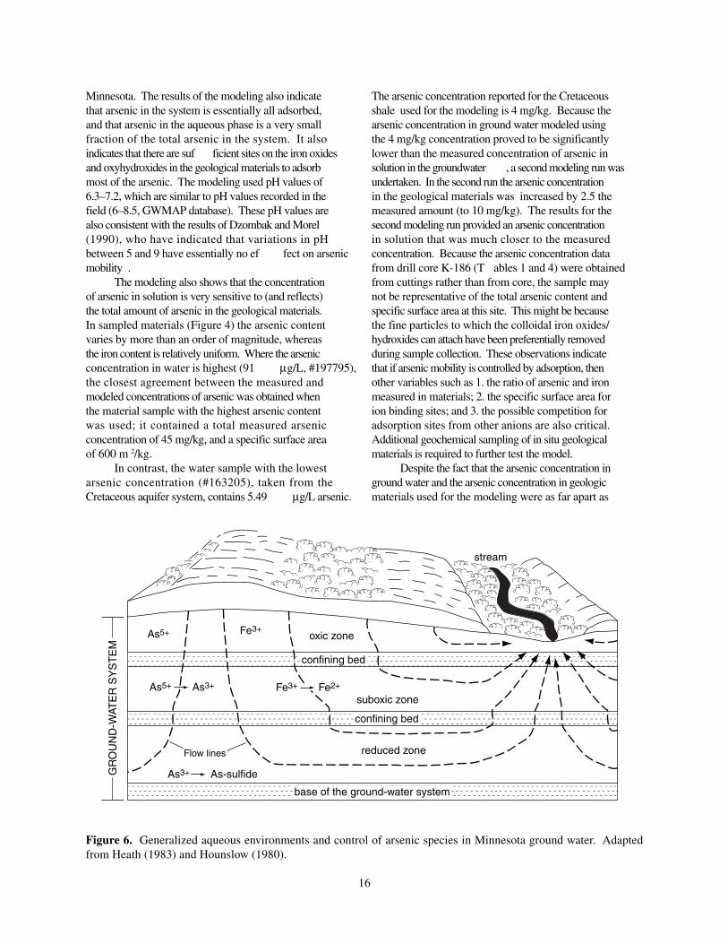
Total arsenic concentrations in geologic materialsrange widely , and show no systematic variation withdepth from the surface (T able 1 and Fig. 4). Theconcentrations of iron and arsenic in the geologicmaterials change in similar manners. This suggests thattheir mobility may be linked, and that the concentrationof iron and arsenic in solution are probably also linked.High arsenic concentrations in Cretaceous depositsappear to be localized, although Cretaceous rocks withhigh arsenic concentrations are also present in Lac QuiParle County and in Big Stone, T raverse, and W ilkincounties to the north (Figs. 1 and 2).
The mean arsenic concentrations in the Paleozoicsedimentary rocks (sandstones and limestones) ofsoutheastern Minnesota were obtained from MinnesotaGeological Survey studies (Morey and others, 1994;Morey and McDonald, 1989), and typically range from1–4 mg/kg. These concentrations are similar to thosedetermined for similar rock types elsewhere in the UpperMidwest (1.1–4.3 mg/kg, Korte and Quintus, 1991), andto the mean arsenic concentrations for sandstones andcarbonates worldwide (1–1.8 mg/kg, Hem, 1992). Thearsenic concentrations in Precambrian igneous andmetamorphic rocks were obtained from the PublicGeologic Sampling Program and other studies (Moreyand others, 1985; Morey and McDonald, 1987; 1989;Morey and Day , 1992; Morey , 1992; Melcher and others,1996; McSwiggen and others, 1995), and are reportedin these publications to range from 1.0–2.0 mg/kg,which is near the average crustal abundance of 1.8 mg/kg (Hem, 1992, and Huang Y an-Chu, 1994). Higharsenic concentrations in ground water near InternationalFalls (T able 3) may reflect the presence of a mineralcontaining anomalously high amounts of arsenic innearby rocks.
ARSENIC IN GROUND WATER
In natural systems arsenic chemistry is verycomplex, and many chemical forms and species ofarsenic are present. Conversion between the dif ferentspecies of arsenic takes place through a variety ofprocesses that include oxidation and reduction (redoxreactions), ligand exchange, precipitation, adsorption,and biologically mediated reactions (Ferguson andGavis, 1972). All five outer shell electrons of the arsenicatom participate in the formation of arsenic-bearingcompounds. Consequently , arsenic may occur as asemimetallic element (As 0), arsenate (As 5+), arsenite(As 3+), or arsine (As 3-).
In natural ground water systems arsenic isgenerally present as an oxyanion as arsenate (As 5+) orarsenite (As 3+), or both. In reducing environments
Table 2. Core intervals sampled for Cretaceousmaterials (see Table 1)
sample # MN unique Well # depth interval(core or cuttings) sampled
K288 242815 116–306 ftKAP3 241417 165–290 ft
KAP10 241422 155–250 ftK80-12 225959 322–480 ftKAP12 241463 300–430 ftKBO 139188 280–365 ftKLT 235562 10–326 ft
K186 237028 25–380 ftKC-2 235582 550–866 ft
KAP15 241478 170–255 ftKAP16 241477 175–280 ftK80-24 225971 230–305 ftK286A 237029 185–187 ft

6
Figure 2. Maps of Minnesota showing surface and subsurface extent of the five regional hydrogeochemical systemsdiscussed in the text. Extent of each hydrogeochemical system is shown in grey.
A. Quaternary buried artesianaquifer system
B. Quaternary water-tableaquifer system
C. Cretaceous aquifersystem
D. Paleozoic-Mesoproterozoic artesian basinaquifer system
E. Precambrian crystalline rockaquifer system

7
arsenic is most common as the ions AsS 2- and As2S3+.
Out of the two species As 5+ and As 3+, which are themost common forms of arsenic in natural waters, As 3+
is the most damaging to human health (Morton andDunnete, 1994). The presence of As 3+ species in groundwater was critically assessed by Korte and Quintus(1991). They concluded that As 3+ species are moreprevalent in ground water than previously assumed,because recent improvements in sampling and analyticaltechniques allow determination of dif ferent arsenicspecies. Anthropogenic arsenic has many forms, andincludes organic arsine species (V ance, 1995), althougharsine is fairly uncommon in natural systems.Methylated forms of arsenic, although uncommon inground water , are probably more common than arsine(Alan W elch, written commun., March 1998).
The following generalized classification of non-organic forms of arsenic in ground water has beenproposed by Krainov and Shvetz (1987):
Oxygenated waters:Redox potential (Eh): >+300 mVDominant species: As 5+ as H
2AsO 4- and HAsO
42-
Suboxic waters:Redox potential (Eh): generally between
+150 mV and -150 mVDominant species: As 3+ as H3AsO
3
Reducing waters:Redox potential (Eh): < -150 mVDominant species: As 3+ as As
2S
3 and AsS 2-
Arsenic concentration and speciation in groundwater can exhibit large temporal variations. Holm andCurtiss (1988) reported changes in total arsenicconcentrations of more than two orders of magnitude(from 10 µ g/L to 2000 µ g/L) in Lane County , Oregon,during one 13 month period, as well as changes inspeciation from As 5+ to As 3+ complexes in the samesystem. A decrease in arsenic concentration from 30to 4 µg/L was documented in pumped water during aone-year period in Bavaria, Germany (Peter Kienast,written commun., February 1997).
Regional characterization of arsenic concentrationand speciation in ground water in the former SovietUnion (Krainov and Shvets, 1987) showed a clearregional pattern of naturally occurring high arsenicconcentrations in ground water . The authors concludedthat high arsenic concentrations are typical of sandstone-shale and sand-clay hydrogeological systems, and thatthe lowest arsenic concentration are typicallydocumented in crystalline and carbonate rock-dominatedhydrogeological systems. They also proposed that
arsenic concentrations in ground water increase as theground water chemistry changes as follows:
less arsenic more arsenicin groundwater in groundwater
HCO3-Ca < HCO
3-Na < HCO
3-Cl-Na
From this discussion and these examples, it isclear that the spatial and temporal variability monitoringshould be part of any comprehensive ground-watersampling and analysis program. Knowledge of thechemical form of arsenic in the water is as importantas the total concentration of soluble arsenic in orderto determine arsenic mobility in the subsurfaceenvironment.
HYDROGEOCHEMICAL SYSTEMS INMINNESOTA
Arsenic concentrations in ground water , like thosein geologic materials, are highly variable in Minnesota.Concentrations of arsenic in Minnesota ground waterobtained from the GWMAP data base (MinnesotaPollution Control Agency , 2000, period 1994–1996) aresummarized in T able 3 and Figure 3. The range inarsenic concentrations for unfiltered ground water isshown (T able 3) for the 14 principal aquifers inMinnesota. These principal aquifers include a varietyof dif ferent stratigraphic units, which are identified bytheir Minnesota Geological Survey classification code(Wahl and T ipping, 1991) in T able 3. Analysis of theavailable hydrogeochemical data indicate that theconcentration of arsenic in ground water in Minnesotais related to the hydrogeochemical environment andregional hydrogeology .
The 14 principal aquifers fall within five regionalhydrogeochemical systems that are conventionallyidentified within Minnesota (Figs. 2 and 3). These arederived from state hydrogeological andhydrogeochemical maps (Kanivetsky , 1978; 1979;1986), and reflect arsenic mobility in ground water .These hydrogeochemical systems are:
I—Quaternary buried artesian aquifer system
II—Quaternary water -table aquifer system
III—Cretaceous aquifer system
IV—Paleozoic-Mesoproterozoic artesian basin aquifersystem
V—Precambrian crystalline rock aquifer system
< >

8
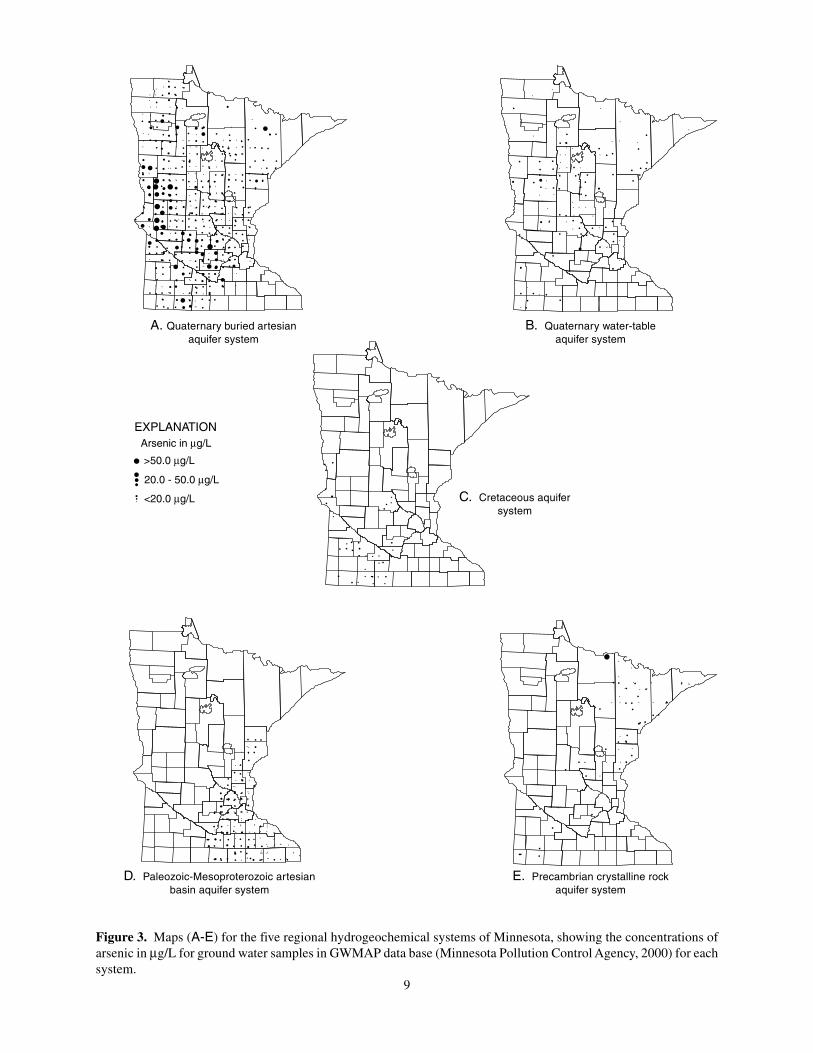
The hydrogeological and hydrogeochemicalattributes of each aquifer af fect arsenic mobility inground water for each aquifer system. In the Quaternaryburied artesian aquifer system (I) and the Precambriancrystalline rock aquifer system (V), arsenic is locallyhighly concentrated in both water and geologicalmaterials. In (I) the localized high arsenicconcentrations in both water and geological materialsare generally confined to western part of the state. In(V), one sample near International Falls provided thehighest-known (157 µg/L) concentration of arsenic inMinnesota ground water .
Quaternary Buried Artesian Aquifer System
High concentrations of arsenic are mostcommonly documented in the Quaternary buried artesianaquifer system (range 0.06–91 µ g/L, mean 6.0 µ g/L).Aquifers in this system are buried bodies of sand, gravel,and silty sand that form discontinuous lenses beneathlake deposits and within till. The highest concentrationof arsenic in geological materials in this system is in
the western part of Minnesota where overlying glacialmaterials are 400–500 ft thick (Olsen and Mossler , 1982;Harris, 1995). I n western Minnesota the aquifers inthis system contain as much as 74 percent comminutedshale and carbonaceous shale, which is derived fromnearby Cretaceous strata.
The highest arsenic concentration measured inground water from the Quaternary Buried AquiferSystem is 91 µ g/L, and is from Ottertail County (well#197795, T. 136 N., R. 44 W ., sec. 25). The water withthis high arsenic concentration is associated with thefine-grained sediments of the Ottertail River group,which is overlain by the Goose River group (Harris,1995). In the areas of high arsenic concentration ingroundwater , details of the Quaternary stratigraphy arepoorly understood. It is possible that laterallycontinuous fine-grained sediments (confining units)similar to Goose River group overlie buried aquifers(Ken Harris, oral commun., 1997). Organic-richmaterial may be present within these fine-grainedsediments, which would af fect the hydrogeochemicalenvironment in this system.
Aquifer name* stratigraphic code† Range in As
concentration (µg/L)
Quaternary buried artesian aquifer system
Buried sand and gravel aquifer QBAA, QBUA, QBUU, QUUU 0.06–91 µg/L
Quaternary water-table aquifer system
Surficial sand and gravel aquifer QWTA 0.06–22 µg/L
Cretaceous aquifer system
Cretaceous aquifer KRET 0.06–21 µg/L
Paleozoic-Mesoproterozoic artesian basin aquifer system
Upper carbonate aquifer DCVA, OMAQ, OGAL, OPVL 0.06–19 µg/L
St. Peter aquifer OSTP 0.06–4 µg/L
Prairie du Chien—Jordan aquifer OPDC, OPCJ, CJDN 0.06–18 µg/L
Franconia—Ironton—Galesville aquifer CFRN, CIRN, CIGL, CFIG, CGSL 0.06–16 µg/L
Mt. Simon—Hinckley aquifer CMTS, CMSH, PMHN 0.06–7 µg/L
Precambrian crystalline rock aquifer system
North shore volcanic aquifer PMNS 0.06–15 µg/L
Sioux Quartzite aquifer PMSX 0.06–4 µg/L
Proterozoic metasedimentary aquifer PMUD 0.06–8 µg/L
Biwabik Iron-Formation aquifer PEBI 0.06–5 µg/L
Precambrian undifferentiated aquifer PCUU, PCCR 0.06–157 µg/L
Table 3. Arsenic Concentration in Water in Principal Minnesota Aquifers[data from the Minnesota Pollution Control Agency GWMAP data base, Minnesota Pollution Control Agency, 2000]
* Names of individual aquifers and aquifers are derived from Wahl and Tipping (1991), and Kanivetsky (1978, 1979, 1986)† Stratigraphic codes are as assigned in Wahl and Tipping, 1991
9
Figure 3. Maps (A-E) for the five regional hydrogeochemical systems of Minnesota, showing the concentrations ofarsenic in µg/L for ground water samples in GWMAP data base (Minnesota Pollution Control Agency, 2000) for eachsystem.
>50.0 µg/L
20.0 - 50.0 µg/L
<20.0 µg/L
Arsenic in µg/L
EXPLANATION
A. Quaternary buried artesianaquifer system
B. Quaternary water-tableaquifer system
C. Cretaceous aquifersystem
D. Paleozoic-Mesoproterozoic artesianbasin aquifer system
E. Precambrian crystalline rockaquifer system

10
In the Quaternary buried artesian aquifer system,calcium-magnesium bicarbonate water that contains lessthan 500 mg/L total dissolved solids (Kanivetsky , 1986)is dominant. T oward the west, however , the groundwater gradually changes from from a calcium-magnesium bicarbonate ground-water to a calcium-magnsium and sodium-potassium sulfate and chlorideground water , with more than 1000 mg/L dissolvedsolids.
Quaternary Water–Table Aquifer System
The arsenic concentration in ground water in thissystem is significantly lower (0.06–22 µg/L, mean 2µ g/L) than in the Quaternary buried artesian aquifersystem. Aquifers in the Quaternary water–table aquifersystem are composed of near -surface, interbedded sandsand gravels that include some silt and clay , that weredeposited in outwash plains and alluvial floodplains ofmajor streams, and at the margins of glacial lakes. Thissystem is continually being recharged by precipitationor by discharge from streams and surface water bodies.In many places, particularly the Red River V alley , siltysands are intercalated with till and organic-richmaterials; this may slow the recharge of the aquifersystem and result in changes in the hydrogeochemicalconditions. The general chemistry of water in thissystem is very similar to that of water from theQuaternary buried artesian aquifer system; calcium-magnesium bicarbonate water predominates in theeastern three-fourths of Minnesota. In westernMinnesota, groundwaters are of calcium-magnesiumbicarbonate type, and of the calcium-magnesium-sodium-potassium sulfate type, as well as calcium-magnesium-sodium-potassium chloride type.
Cretaceous Aquifer System
The arsenic concentration in ground water in theCretaceous aquifer system is lower (range 0.06–21 µ g/L, mean 3 µ g/L) than in the Quaternary buried artesianaquifer system. Studies by Morey and others (1990)have also reported higher arsenic concentrations inQuaternary aquifers when compared to Cretaceousaquifers.
Aquifers in this system include fine- to coarse-grained, well-bedded quartsoze sandstones in the lowerpart of Cretaceous sequence. These sandstones areoverlain by calcareous and noncalcareous shales,together with some siltstones and mudstones. Organic-rich beds and pyritic concretions are present locallywithin the rocks, and may influence the geochemicalconditions that control arsenic mobility . Immediately
north of the Minnesota River , ground water in thissystem is of the calcium-magnesium bicarbonate type.South of the Minnesota River and northward along theRed River valley the water chemistry changes fromcalcium-magnesium bicarbonate to a sodium-potassiumsulfate and sodium-potassium chloride type (Kanivetsky ,1986).
Paleozoic–Mesoproterozoic Artesian BasinAquifer System
The arsenic concentration in groundwater in thePaleozoic–Mesoproterozoic Artesian Basin AquiferSystem is generally low (range 0.06–20 µ g/L, mean2.0 µ g/L). The ground water in the eastern part of thissystem, where the Paleozoic to Mesoproterozoic rocksare either exposed at the surface, or the overlyingQuaternary deposits are thin, and generally have lowerarsenic concentrations (0.06–10 µ g/L). In the westernpart of this system, till can be greater than 100 ft thick(Olsen and Mossler , 1982), and the arsenicconcentrations in groundwater generally increase to 10–20 µ g/L.
Aquifers in this system are a thick sequence ofwell-stratified sedimentary rocks consisting of poroussandstones, as well as fractured and jointed dolomitesand limestones that are separated by shaly beds. Theseaquifers form the largest ground-water resource inMinnesota, and (T able 3) are divided into five regionalaquifers (Kanivetsky , 1978).
Calcium-magnesium bicarbonate ground water istypical of this system (Kanivetsky , 1986). Theproportion of calcium-magnesium bicarbonate and theamount of total dissolved solids are strongly influencedby the type and thickness of the overlying Quaternarydeposits, and the depth to which the aquifer extends.In the east, where rocks of this aquifer system areexposed, or overlain by thin Quaternary deposits, theground water is dominantly a calcium-magnesiumbicarbonate type. T oward the west, the total dissolvedsolids increase as a result of recharge through thickerQuaternary deposits, and the concentration of calcium-magnesium bicarbonate decreases.
Precambrian Crystalline Rock Aquifer System
Rocks forming the Precambrian crystalline rockaquifer system have comparatively low arsenicconcentrations (1–2 mg/kg). The arsenic concentrationsin ground water in this system are also generally low(range 0.06–10 µ g/L, mean 2.0 µ g/L). However , inareas where the geologic materials display iron orsulfide mineralization, the arsenic concentration in

11
ground water may increase markedly . The highestarsenic concentration in ground water (157 µ g/L) inMinnnesota is recorded in ground water in Precambriancrystalline rocks near International Falls (Fig. 3, T able3).
This system is not a major source of ground-water .Available water is confined almost entirely to fracturesand joints. The general hydrogeochemistry of thegroundwater in this system has not been mappedthroughout the state, but is known to vary from calcium-magnesium bicarbonate type with total dissolved solidsof less that 500 mg/L, to salty water of sodium-potassium chloride type with total dissolved solids ofmore than 50,000 mg/L.
HYDROGEOCHEMICAL MODELING
The hydrogeochemical modeling described herewas undertaken to assess the mechanisms controllingarsenic distribution in Minnesota ground water . Becausethe highest concentrations of arsenic in ground watergenerally occur in the western part of the state, thisstudy focuses on the concentration of arsenic in groundwater and geological materials of Quaternary andCretaceous deposits in western Minnesota.
One of the most important reactions determiningthe environmental behavior of arsenic is the reductionof As 5+ to As 3+. Extensive research literature on arsenicmobility in ground water (V ance, 1995; Dzombak andMorel, 1990; Pierce and Moore, 1982; Hounslow , 1980;Holm and others, 1979) suggests that As 3+ is moresoluble than As 5+ in ground water . Mok and W ai (1994)indicate that As 3+ is 10- to 13-times more soluble thanAs 5+. Korte and Quintus (1991), in a critical reviewof arsenic in ground water , have suggested that As 3+
is the prevalent species in ground water . Moreover ,they suggest that the speciation of arsenic inferred fromfield measurements of redox potential (Eh) is rarelyaccurate. It is reasonable, therefore, to assume that theconcentration of As 3+ species in ground water isprobably higher at elevated arsenic concentrations.Where arsenic concentrations are reported to be elevatedin the GWMAP database, the dominant arsenic speciesis probably As 3+.
Studies also reveal that arsenic solubility in groundwater appears to be controlled by sorption mechanismsrather than by dissolution of arsenic-rich minerals(Pierce and Moore, 1982; Dzombak and Morel, 1990;Vance, 1995; Hounslow , 1980; Holm and others, 1979).The adsorption of arsenic onto iron oxyhydroxides(Pierce and Moore, 1982) appears to be the majormechanism controlling the solubility of arsenic in water .A dif ference in adsorption properties allows greater
mobility of As 3+ than As 5+ in heterogeneous systems.The most likely reasons for high arsenic concentrationsin groundwater and geologic materials in subsurfaceenvironments are: the reduction of As 5+ to the lessstrongly adsorbed As 3+, and the reduction of ferricoxides accompanied by the release of adsorbed As 3+
and As 5+ (Holm and Curtiss, 1988).Iron oxides and iron oxyhyroxides are ubiquitous
in the clays and shales of the fine-grained Quaternarysediments, and are present as coatings on mineral grains,and as discrete oxide mineral grains (Drever , 1988).The iron oxides and oxyhydroxides have a very highadsorptive capacity for oxyanionic complexes such asthose that include arsenic. The high background arsenicconcentrations in fine-grained Quaternary sediments inwestern Minnesota mirror arsenic concentrationsreported for similar sediments elsewhere (Sullivan andAller , 1996; Belzile and T essier , 1990; and W elch andothers,1988). The capacity of a sediment to retain andconcentrate arsenic is primarily controlled by the grainsize (W elch and others, 1988). Fine-grained sedimentsprovide a greater surface area, and therefore, a greateradsorption capacity than do coarse sediments (Horowitz,1984).
The arsenic concentration in ground water willthen depend on chemical reactions between arsenic inthe sediments and that in the water that is in contactwith these sediments. The wide ranges in variation inthe total arsenic concentrations in the Quaternarysediments are not linked to depth from the surface (Fig.4). The variations in arsenic concentrations are verydif ficult to predict, and generally depend on thedepositional history , and the grain size of the sediments.In glacial sediments of western Minnesota, where highconcentrations of arsenic are common in ground water ,there is no evidence for arsenic-rich minerals in thesediments. In the absence of arsenic-rich minerals,adsorption of arsenic onto oxides and hydroxides is onlyviable mechanism by which the high concentration ofarsenic in ground water can be achieved.
Sorption modeling was undertaken in order to helpidentify and assess the possible significance of the widerange of factors that may control the naturally ocurringhigh concentrations of arsenic in ground water inwestern Minnesota. The sorption modeling uses fieldmeasurements for ground water from the GWMAP database and data on arsenic and iron concentrations fromMinnesota Geological Survey sources (Fig. 5), andcomputer code (MINEQL+) developed by Schecher andMcAvoy (1994). The results of the modeling arecompared with the measured arsenic concentrations inground water (T able 3), in order to determine whichfactors most influence the arsenic concentration inground water .

12
GWMAP Data Base
For the GWMAP data base, the total arsenicconcentration and the oxidation-reduction (redox)potential were measured for all the ground-watersamples, which were unfiltered; arsenic speciation wasnot determined. Lindberg and Runnels (1984) pointout that ground water is rarely in electrochemicalequilibrium, and that the measured redox potentialscannot be quantitatively interpreted. The redox potential(Eh) measurements in the GWMAP database (Clark andothers, 1994; 1995; Minnesota Pollution ControlAgency , 2000) are reported without adding thereference-electrode potential to the measured potential(Mike T rojan, written commun., January 1998). Redoxpotential values corrected to a standard hydrogenelectrode would be about 200 mV higher than valuesreported in the GWMAP database. Experience withEh measurements (Jim W alsh, written commun.,December , 1997) also shows that instrument readingstypically show a gradual decrease during onemeasurement period. This suggests that ground-watersystems are not in electrochemical equilibrium, and callsinto question whether or not a realistic Eh determinationof a water sample can be made (Jim W alsh, written
commun., December 1997). Because of this, theGWMAP Eh data are not considered reliable. For thisreason speciation and solubility modeling could not beundertaken, but sorption modeling, which does notrequire Eh data, was undertaken.
Sorption Modeling
Because arsenic is present in solution as anoxyanion (arsenate—As 5+, or arsenite—As 3+), it has thecapacity to be sorbed. In natural oxidizing systems,iron oxyhydroxides are the dominant sorbent becauseof their reactivity and large specific surface area. Ironoxyhydroxides have a positive surface charge in mostgeologic environments, and preferentially adsorb anions(Ferguson and Gavis, 1972). Colloidal iron oxides andhydroxides are abundant and ubiquitous in Quaternarydeposits in Minnesota. Both iron and arsenic exist intwo valence states. In oxidizing conditions ferric iron(Fe3+) predominates, and in mildly and strongly reducing(suboxic) conditions ferrous iron (Fe 2+) is dominant.In aqueous systems pentavalent arsenic (arsenate, As 5+)will dominate in oxidizing conditions, and trivalentarsenic (arsenite, As 3+) in suboxic or reducingconditions.
Figure 4. Variation in total arsenic and iron content of Quaternary sediments obtained from drill cores. SeeTables 1 and 4.
Fe, total (%)
Arsenic (ppm)
Dep
th (
feet
)
Well no. 249609
0 1.125 2.25 3.375 4.5
0 10 20 30 40 50 60250
200
150
100
50
0
Cottonwood Co., rotosonic no. 1(T. 107 N., R. 38 W., S. 34)
Fe, total (%)
Arsenic (ppm)
Dep
th (
feet
)
Well no. 249055
0 1.5 2.0 2.5 3.0 3.5
2 4 6 8 10 12 14300
250
200
150
100
50
0
Rice Co., rotosonic no. 3(T. 112 N., R. 22 W., S. 26)
Fe, total (%)
Arsenic (ppm)
Dep
th (
feet
)
Well no. 249856
1 2 3 4 5 6 7
0 5 10 15200
150
100
50
0
Stearns Co., rotosonic no. 3(T. 127 N., R. 31 W., S. 5)
Fe, total (%)Arsenic (ppm)

13
The data for dissolved arsenic concentrations showno significant correlation with dissolved iron(correlation coef ficient, r = 0.18). However , arsenicmobility may be related to the amount of iron in thegeological materials; the correlation coef ficient for theconcentration of Fe and As in geological materials isr = 0.6–0.65. For modeling purposes the arsenic inboth the geologic materials and the ground water wasassumed to all be As 3+. This is because As 3+ is moremobile than As 5+. The wide variation in total arsenicconcentration in the geological materials with depthfrom the surface (Fig. 4) indicates that theconcentrations of arsenic and iron in the geologicalmaterials and in solution may be related. A correlationbetween the concentration of arsenic in solution andthe concentration of iron in geological materials hasbeen documented in geological materials and groundwater in oxidizing environments in other regions(Sullivan and Aller , 1996; Korte and Quintus, 1991;Aggett and O’Brien, 1985; Robertson, 1989). Theresults presented here, together with other studies(Holm, 1995; Moncure and others, 1992; Belzile andTessier , 1990; Matisof f and others, 1982; Pierce and
Moore, 1982) suggest that iron plays a central role inthe mobility and cycling of arsenic in oxidizedenvironments.
Surface Complexation Model
A generalized two-layer surface complexationmodel was developed by Dzombak and Morel (1990)to fit the published data from adsorption experimentsthat involved numerous adsorbates, including arsenateand arsenite. Their model is applicable to any systemwhere iron oxides or oxyhydroxides are present. Inthe Dzombak and Morel (1990) model, the adsorptionof arsenate and arsenite is a ligand exchange reaction.When iron oxides or oxyhydroxides are in contact withwater , the Fe 3+ ions at the surface of the oxide oroxyhydroxide are bound to oxygen atoms in the interiorof the solid, and are also bound to a hydroxide ion atthe oxide or oxyhydroxide-water interface. Whenarsenate is adsorbed, the hydroxide ion is exchangedfor an arsenate ion (equations 1–4). Arsenite is adsorbedin a similar manner (equation 5). In equations 1–5 thesymbol [ ≡] indicates a surface hydroxyl group. The
Figure 5. Location of samples used for arsenic sorption modeling (see Table 4)
Minnesota
R.
R.
Mississippi
S.D
.
IOWAMINN.
CLAYBECKER
WA
DE
NA
CASS
WILKIN
OTTER TAIL
TRAVERSE
GRANT
STEVENS
DOUGLAS
POPE
TODD
STEARNS
MORRISON
CROWWING
MIL
LE L
AC
S
KA
NA
BE
C
BIG STONE
SWIFT
CHIPPEWA
LAC QUIPARLE
YELLOW MEDICINE
RENVILLLE
KA
ND
IYO
HI
MEEKER WRIGHT
LIN
CO
LN
LYONREDWOOD
SIBLEY
MCLEOD
NICOLLET
ISANTI
ANOKA
BENTON
SHERBURNE
DAKOTA
CA
RV
ER
HENNEPIN
RAMSEY
SCOTT
RICELE SUEUR
BROWN
PIP
ES
TO
NE MURRAY COTTON-
WOOD
WATONWAN BLUE EARTH WA
SE
CA
STEELE
ROCK NOBLES JACKSON MARTIN
FARIBAULT FREEBORN
94°96°
46°
44°
+
+ +
197795
3
2138773
1 112844
163205
+ Geological materialssample
197795 Water samplelocation
EXPLANATION
N.D
.
MINN.
LOCATION DIAGRAM
IOWA
S. D.
N. D
.
WISC
.

14
Tabl
e 4.
Inp
ut d
ata
and
resu
lts
for
arse
nic
sorp
tion
-mod
elin
g
Wa
ter
sa
mp
le*
Ma
teri
al
As
in
ma
teri
al
Fe
in
ma
teri
al
Me
as
ure
dM
od
ele
dC
om
pa
ris
on
be
twe
en
AQ
UIF
ER
CO
DE
sa
mp
lem
ole
sm
ole
sa
qu
eo
us
aq
ue
ou
sm
ea
su
red
As
& m
od
ele
d A
sL
oc
ati
on
an
d µ
g/k
ga
nd
pe
rce
nt
As
sp
ec
ies§
As
sp
ec
ies¶
(TR
S/A
BC
D s
ys
tem
)
19
77
95
Til l
, R
ota
son
ic c
ore
#1
3.3
x 1
0-3
mo
les
4.7
mo
les
7.3
0 x
10
-7 m
ole
s1
.21
x 1
0-7
mo
les
sam
e o
rde
r o
f m
ag
nit
ud
eQ
BA
A4
9–
13
0 f
t in
terv
al
23
.5 µ
g/k
g2
.5 w
t %
91
.2 µ
g/L
15
.1 µ
g/L
me
asu
red
As
is 6
x m
ore
th
an
mo
de
led
As
13
6-4
4-2
5 D
BD
CC
DC
ott
on
wo
od
Co
un
ty
19
77
95
Til l
, R
ota
son
ic c
ore
#2
1.9
x 1
0-3
mo
les
4.7
mo
les
7.3
0 x
10
-7 m
ole
s6
.97
x 1
0-8
mo
les
on
e o
rde
r o
f m
ag
nit
ud
e d
iffe
ren
ceQ
BA
A1
04
–2
52
ft
inte
rva
l1
3.2
µg
/kg
2.5
wt
%9
1.2
µg
/L8
.7 µ
g/L
me
asu
red
As
is 1
0x
mo
re t
ha
n m
od
ele
d A
s1
36
-44
-25
DB
DC
CD
Mu
rray
Co
un
ty
19
77
95
Til l
, R
ota
son
ic c
ore
#1
6.3
x 1
0-3
mo
les
4.7
mo
les
7.3
x 1
0-7
mo
les
2.3
0 x
10
-7 m
ole
ssa
me
ord
er
of
ma
gn
itu
de
QB
AA
18
9–
20
5 f
t in
terv
al
45
µg
/kg
2.5
wt
%9
1.2
µg
/L2
8.7
µg
/Lm
ea
sure
d A
s is
3x
mo
re t
ha
n m
od
ele
d A
s1
36
-44
-25
DB
DC
CD
Co
tto
nw
oo
d C
ou
nty
11
28
44
Till
, R
ota
son
ic c
ore
#1
3.5
x 1
0-3
4.7
mo
les
1.5
x 1
0-7
mo
les
9.0
x 1
0-8
mo
les
on
e o
rde
r o
f m
ag
nit
ud
e d
iffe
ren
ceQ
BA
A7
8-1
30
ft
inte
rva
l2
5 µ
g/k
g2
.5 w
t %
19
.27
µg
/L1
1/5
6 µ
g/L
me
asu
red
As
is 1
.6x
mo
re t
ha
n m
od
ele
d A
s1
07
-38
-26
CA
AD
AD
Co
tto
nw
oo
d C
ou
nty
13
87
73
Till
, R
ota
son
ic c
ore
#1
3.5
x 1
0-3
mo
les
4.7
mo
les
1.2
2 x
10
-7 m
ole
s1
.11
x 1
0-7
mo
les
sam
e o
rde
r o
f m
ag
nit
ud
eQ
BA
A7
8–
13
0 f
t in
terv
al
25
µg
/kg
2.5
wt
%1
5.3
8 µ
g/L
14
.0 µ
g/L
me
asu
red
an
d m
od
ele
d A
s si
mila
r1
07
-38
-23
CC
CC
CA
Co
tto
nw
oo
d C
ou
nty
13
87
73
Till
, R
ota
son
ic c
ore
#2
1.9
x 1
0-3
mo
les
4.7
mo
les
1.2
2 x
10
-7 m
ole
s6
.04
x 1
0-8
mo
les
on
e o
rde
r o
f m
ag
nit
ud
e d
iffe
ren
ceQ
BA
A1
04
–2
52
ft
inte
rva
l1
3 µ
g/k
g2
.5 w
t %
15
.38
µg
/L7
.6 µ
g/L
me
asu
red
As
is 2
x m
ore
th
an
me
asu
red
As
10
7-3
8-2
3 C
CC
CC
AC
ott
on
wo
od
Co
un
ty
16
32
05
Sh
ale
, cu
ttin
gs
sam
ple
K-1
86
5.6
x 1
0-4
mo
les
8.5
mo
les
4.3
6 x
10
-8 m
ole
s8
.66
x 1
0-9
mo
les
on
e o
rde
r o
f m
ag
nit
ud
e d
iffe
ren
ceK
RE
T2
5–
38
0 f
t in
terv
al
4 µ
g/k
g4
.5 w
t %
5.4
9 µ
g/L
1.0
9 µ
g/L
me
asu
red
As
is 5
x m
ore
th
an
mo
de
led
As
10
7-3
8-2
3 C
CC
CC
ALy
on
Co
un
ty
16
32
05
Sh
ale
, cu
ttin
gs
sam
ple
K-1
86
1.4
x 1
0-3
mo
les@
8.5
mo
les
4.3
6 x
10
-8 m
ole
s2
.17
x 1
0-8
mo
les
sam
e o
rde
r o
f m
ag
nit
ud
eK
RE
T2
5–
38
0 f
t in
terv
al
10
µg
/kg
4.5
wt
%5
.49
µg
/L2
.73
µg
/Lm
ea
sure
d A
s is
2x
mo
re t
ha
n m
od
ele
d A
s1
07
-38
-23
CC
CC
CA
Lyo
n C
ou
nty
* S
am
ple
nu
mb
ers
are
un
iqu
e w
ell
nu
mb
ers
fro
m G
WM
AP
da
ta b
ase
; a
qu
ifer
cod
es
are
fro
m W
ah
l a
nd
Tip
pin
g,
19
91
.§
Fro
m G
WM
AP
da
tab
ase
; m
ea
sure
d i
n µ
g/L
an
d c
on
vert
ed
to
mo
les
of
As3
+
¶
Ca
lcu
late
d u
sin
g M
INE
QL
+ c
od
e,
liste
d i
n m
ole
s a
nd
µg
/L o
f A
s3+
@ T
his
co
nce
nt r
at i
on
is
no
t t h
e m
ea
sure
d a
rse
nic
co
nce
nt r
at i
on
. I t
is
t he
me
asu
red
co
nce
nt r
at i
on
mu
ltip
lied
by
2. 5
. Th
is a
ims
t o d
up
lica
t e t
he
ef f
ect
of
pre
f ere
nt i
al
rem
ova
l o
f a
rse
nic
an
d f
ine
ma
t eri
al.

15
reactants and products of equation 1 are related byequation (6).
≡FeOH + HAsO4 2- = ≡FeAsO4
2- + H2O (equation 1)
≡FeOH + H2AsO 4- = ≡FeHAsO4- + H2O (equation 2)
≡FeOH + H3AsO4 = ≡FeH2AsO4 + H2O (equation 3)
≡FeOH + AsO4 3- = ≡FeOHAsO4
3- (equation 4)
≡FeOH + H3AsO3 = ≡FeH2AsO3 + H2O (equation 5)
K = [≡FeAsO4 2-] exp(-F Psi/RT)
[≡FeOH] [HAsO42-] γ (equation 6)
F = faraday constant (96.485 C/mol)Psi = surface potential (in volts)R = molar gas constant (8.314 J/mol*K)T = absolute temperature (oK)
In equation (6), K is the equilibrium constant, andγ is the activity coef ficient of the of the HAsO
42- ion,
and exp(-F Psi/R T) is the electrostatic correction factor ,which is essentially the activity coef ficient of the≡FeAsO
42- surface complex, which is a function of the
pH (Dzombak and Morel, 1990). Similar equations canbe written corresponding to the reactions in equations2–5.
Dzombak and Morel (1990) derived sorptionconstants for hydrous ferric oxides for their two-layersurface complexation model from their ownexperimental data, and from a critical review of allavailable adsorption constants. They calculated thespecific surface area of iron oxide (600m 2/g) and thenumber of binding sites (0.2 mol/mol Fe). Schecherand McA voy (1994) developed a computer code(MINEQL+) using sorption parameters from Dzombakand Morel (1990) to model adsorption on hydrous ferricoxides.
MINEQL+
In order to model surface sorption processes, thefollowing data are required: pH, concentration of totalarsenic and iron in the system, major anions and cations(to calculate the ionic strength (I) of the solution). Thesorption modeling was undertaken using MINEQL+code, and data from water samples collected from foursites in western Minnesota (T able 4 and Fig. 5), whichrange in arsenic concentration from 91.2 µ g/L to 5.49µ g/L. The ground water samples with the maximum(#197795, 91.2 µ g/L) and intermediate arsenicconcentrations (#112844—19.27 µ g/L, and #138773—
15.38 µ g/L) are from the Quaternary buried artesianaquifer system, and the sample with the lowest dissolvedarsenic concentration (#163205—5.49 µ g/L) is fromthe Cretaceous aquifer system. The data forconcentrations of arsenic and iron in geologicalmaterials (T able 4, Figs. 4 and 5) are not from the wellsthat the ground-water data were collected from. Thegeological materials chosen for modeling the Asconcentration in the buried aquifer system are collectedfrom areas of northwestern-provenance till (Lively andMorey , 1996), so as to replicate the materials presentat the groundwater sampling site as best as possible.The geological materials chosen for modeling arsenicconcentrations in waters of the Cretaceous aquifersystem are cuttings from the closest available drill core(Morey and MacDonald, 1987). The conversion ofarsenic and iron concentrations in geological materialsto concentrations in solution was made using a densityof 2.65 g/cm 3, and a porosity of 20 percent.
For MINEQL+ it is important to know the correctoxidation state of total arsenic. The input data consistsof concentration of total arsenic and iron in solution,derived from the arsenic and iron concentrations ingeological materials. For modeling purposes the arsenicin both the geological materials and the ground waterwas assumed to all be As 3+. This is because As 3+ ismore mobile than As 5+. The MINEQL+ code is thenused to calculate the equilibrium conditions in theaquifer , and to model the distribution of arsenic—eitheradsorbed to the surface of iron oxyhydroxides, or intothe aqueous phase as a surface species H
3AsO
3.
Results of Modeling
The results of the MINEQL+ computations areshown in T able 4. For each of the four water samples,the concentrations of arsenic in solution were modeled,using either one, two, or three of the sampled geologicalmaterials. The geological materials samples werechosen so that they replicate the materials present atthe groundwater sampling site as best as possible. Whenthe modeled As 3+ concentrations in ground water arecompared with the measured As 3+ concentrations, theconcentrations are of similar orders of magnitude,although the concentrations of measured arsenic aretypically greater than those of the modeled arsenic. Themeasured arsenic ranges in concentration from beingsimilar to the modeled arsenic, to being 1.6 times greaterto as much as 10 times greater than the modeled arsenicconcentration (T able 4).
The similarities between the modeled andmeasured As 3+ concentrations suggest that the sorptionmodel provides a viable mechanism for providingarsenic to groundwater in the aquifers of western
16
Minnesota. The results of the modeling also indicatethat arsenic in the system is essentially all adsorbed,and that arsenic in the aqueous phase is a very smallfraction of the total arsenic in the system. It alsoindicates that there are suf ficient sites on the iron oxidesand oxyhydroxides in the geological materials to adsorbmost of the arsenic. The modeling used pH values of6.3–7.2, which are similar to pH values recorded in thefield (6–8.5, GWMAP database). These pH values arealso consistent with the results of Dzombak and Morel(1990), who have indicated that variations in pHbetween 5 and 9 have essentially no ef fect on arsenicmobility .
The modeling also shows that the concentrationof arsenic in solution is very sensitive to (and reflects)the total amount of arsenic in the geological materials.In sampled materials (Figure 4) the arsenic contentvaries by more than an order of magnitude, whereasthe iron content is relatively uniform. Where the arsenicconcentration in water is highest (91 µg/L, #197795),the closest agreement between the measured andmodeled concentrations of arsenic was obtained whenthe material sample with the highest arsenic contentwas used; it contained a total measured arsenicconcentration of 45 mg/kg, and a specific surface areaof 600 m 2/kg.
In contrast, the water sample with the lowestarsenic concentration (#163205), taken from theCretaceous aquifer system, contains 5.49 µg/L arsenic.
Figure 6. Generalized aqueous environments and control of arsenic species in Minnesota ground water. Adaptedfrom Heath (1983) and Hounslow (1980).
The arsenic concentration reported for the Cretaceousshale used for the modeling is 4 mg/kg. Because thearsenic concentration in ground water modeled usingthe 4 mg/kg concentration proved to be significantlylower than the measured concentration of arsenic insolution in the groundwater , a second modeling run wasundertaken. In the second run the arsenic concentrationin the geological materials was increased by 2.5 themeasured amount (to 10 mg/kg). The results for thesecond modeling run provided an arsenic concentrationin solution that was much closer to the measuredconcentration. Because the arsenic concentration datafrom drill core K-186 (T ables 1 and 4) were obtainedfrom cuttings rather than from core, the sample maynot be representative of the total arsenic content andspecific surface area at this site. This might be becausethe fine particles to which the colloidal iron oxides/hydroxides can attach have been preferentially removedduring sample collection. These observations indicatethat if arsenic mobility is controlled by adsorption, thenother variables such as 1. the ratio of arsenic and ironmeasured in materials; 2. the specific surface area forion binding sites; and 3. the possible competition foradsorption sites from other anions are also critical.Additional geochemical sampling of in situ geologicalmaterials is required to further test the model.
Despite the fact that the arsenic concentration inground water and the arsenic concentration in geologicmaterials used for the modeling were as far apart as
�������������yyyyyyyyyyyyy
��������������������������yyyyyyyyyyyyyyyyyyyyyyyyyy
��������������������������yyyyyyyyyyyyyyyyyyyyyyyyyy
stream
As5+ Fe3+oxic zone
suboxic zone
reduced zone
As3+ As-sulfide
As5+ As3+ Fe3+ Fe2+
GR
OU
ND
-WAT
ER
SY
ST
EM
confining bed
confining bed
base of the ground-water system
Flow lines

17
170 miles, the modeling illustrates that adsorption ofarsenic on iron oxides and hydroxides probably doescontrol arsenic mobility .
Classification of Aqueous Environments inMinnesota
Based on the surface complexation model ofDzombak and Morel (1990), and the classification ofthe non-organic forms of arsenic in ground water(Krainov and Shvetz, 1987), the following classificationof aqueous environments (Fig. 6, adapted from Heath,1983 and Hounslow , 1980) can be used to explain thedistribution of arsenic in ground water .
Oxic zone The oxic zone is characterized by the presence
of oxygen and absence of hydrogen sulfide. Theessential feature of this zone is that arsenic and ironare accumulated in sediments during the intensechemical weathering (production of oxides) ofgeological materials. The pentavalent arsenate (As 5+)is the dominant soluble form of arsenic in this zone.It has better sorbtive tendencies compared to trivalentarsenite (As 3+), thus the concentration of arsenic in wateris usually low . Dzombak and Morel (1990) found thatat a low concentration of As 5+ in the system, the arsenicis almost 100 percent sorbed in the pH 5–9 range, whichis typical of Minnesota ground water . The aquifersystems in Minnesota that are in the oxic zone are theQuaternary water -table aquifer system, the Paleozoic-Mesoproterozoic artesian basin aquifer system, and thePrecambrian crystalline rock aquifer system. Despitethe substantial thickness of the bedrock aquifers (asthick as 1000 ft) in Minnesota, the aqueous environmentin these ground-water systems is probably oxic. Studieshave shown that oxic environments can be present indeep ground-water systems. Investigations conductedin the southwestern United States have detecteddissolved oxygen at a depth of 2,000 ft in waters olderthan 10, 000 years (Robertson, 1989).
Suboxic zoneThe suboxic zone is characterized by the absence
of oxygen and hydrogen sulfides. In this zone theaquifer material becomes mildly reducing as aconsequence of its isolation from the land surface, andthe presence of organic material, and arsenic enterssolution when ferric iron (Fe 3+) is reduced to ferrousiron (Fe 2+). Arsenite ( As 3+) will be the dominant formof arsenic, and shows the greatest degree of mobility .In Minnesota, the aquifer systems that display thesecharacteristics are the Quaternary buried artesian aquifersystem, and locally the Cretaceous aquifer system.
These aquifers are isolated from the surface by a thicklayer of Pleistocene till of low permeability , or by otherorganic-rich layers that provide the conditions requiredfor the suboxic zone.
Reduced zoneThe reduced zone is characterized by the absence
of oxygen and the presence of hydrogen sulfides. Theseconditions are typical of isolated ground-water systems.At the interface with the reduced zone, arsenic changesfrom being associated with oxyhydroxide phases tobeing associated with sulfide phases. High arsenicconcentrations in this zone may indicate the dissolutionof arsenic-bearing sulfide minerals. Low arsenicconcentrations in the ground water could be explainedby the migration of dissolved arsenic species in solution,and their precipitation with iron sulfides. Only a veryfew water samples from buried Quaternary andCretaceous aquifers in western Minnesota representthese conditions .
Application to Minnesota Aquifer Systems
The variations in arsenic concentrations andspeciation in Minnesota ground water are discussed foreach hydrogeochemical system, based on the resultsof the sorption modeling performed for the Quaternaryburied artesian aquifer and Cretaceous aquifer systems.For hydrogeochemical systems where modeling was notdone, other hypotheses are possible.
Quaternary Buried Artesian Aquifer SystemThe thick, silty-clayey , glacial and lacustrine
sediments that cover these buried aquifers serve as ageochemical transition zone associated with thetransformation from oxic to suboxic conditions.Because of this shift from oxic to suboxic conditions,arsenic is released to ground water from the surfacesof fine-grained materials. Some tills (Lively and Morey ,1996) may provide locally suboxic conditionsresponsible for high arsenic concentrations in groundwater . These tills contain very fine silty-clayey layersas thick as 100 ft, with high arsenic concentrations (17–26 mg/kg) relative to the normal background arsenicconcentrations (4–1 1 mg/kg). Arsenic content variesmarkedly in this system (range 0.06–91 µ g/L). Thevariability in arsenic concentrations in this system mayindicate that either suboxic conditions do not exist inthe sediments in the locations sampled, or that thearsenic content in the matrix of parent materials is low .
The high arsenic concentrations in the QuaternaryBuried Artesian Aquifer System may also be relatedto the major -element chemical composition of the water .

18
Krainov and Shvetz (1987) studied arsenic concentrationin ground water in the former Soviet Union, and foundthat sodium-type water has high arsenic concentrations.High arsenic concentrations in sodium-type waters maybe explained by the age of the water . Sodium-type wateris usually older and more highly mineralized thancalcium-type water . Because of this, the sodium-typewater has had a longer time to dissolve arsenic, eitherby oxidizing sulfide minerals, or by reducing ironoxides/hydroxides (T om Holm, oral commun., 1997).
In western Minnesota the ground water is ofsodium-potassium-calcium-magnesium bicarbonate-sulfate type, with total dissolved solids of more than500 µ g/L (Kanivetsky , 1986). The correlation trendbetween dissolved arsenic (GWMAP data) atconcentrations above 20 µ g/L and total dissolved solids(r = 0.44, Fig. 7) suggests a possible association betweenhigh arsenic concentrations and sodium-type water inthis system, similar to that reported by Krainov andShvetz (1987) and by other investigators (Alan W elch,oral commun., 1998).
Quaternary Water-Table Aquifer SystemArsenic concentrations in oxic conditions, such
as are present in this system, are usually low . This isbecause arsenic is typically adsorbed to fine-grainedmaterials present in the matrix. The abundance ofarsenic in the geological materials may also be low .The arsenic concentration in sand and gravel materialis close to the crustal abundance of 2.0 mg/kg in water -
table aquifers (Huang Y an-Chu, 1994). Some locallyelevated concentrations of arsenic (10–22 µ g/L) inground waters in this system may indicate suboxicconditions that result from the presence of fine claymaterials overlying the aquifer . The presence of fineclay materials with organic rich layers may cause thislocal shift from oxic to suboxic conditions similar tothose of the Quaternary buried artesian aquifer system.
The generally low concentration of arsenic in thissystem may also be related to the calcium-dominatedtype water (Krainov and Shvetz, 1987). The calcium-type water usually has shorter residence time (youngerwater), and is less mineralized than sodium-type water ,and therefore may not have had suf ficient time todissolve arsenic, either by oxidizing available sulfideminerals, or by reducing iron oxides/oxyhydroxides.Ground water in Quaternary water -table aquifers ofMinnesota is generally of the calcium-magnesiumbicarbonate type (Kanivetsky , 1986). This type of waterdoes not have suf ficient residence time for arsenicconcentrations to increase, and the Quaternary surficialdeposits may not have enough sulfides or organic richmaterials to reduce the iron oxides and oxyhydroxides.
Cretaceous Aquifer SystemAll three aqueous environments (oxic, suboxic,
and reduced) are represented in this system, and arsenicconcentrations are highly variable. Arsenicconcentrations as high as 10–21 µ g/L are documentedin groundwater from the Cretaceous aquifer system.
Figure 7. Dissolved arsenic versus total dissolved solids for the buried artesian aquifer system.
20
30
40
50
60
70
0
500
1000
1500
2000
2500
3000
3500
Total dissolved solids, µg/L
Dis
solv
ed A
s, µ
g/L
y = 28.8 + 0.0067 x R = 0.44

19
These locally elevated arsenic concentrations probablydevelop in suboxic and reduced zones (similar to thosedescribed for the Quaternary buried artesian aquifersystem), when adsorbed arsenic is released into thegroundwater from the sediments. Data indicate thatthe total dissolved solids and the sodium concentrationsin this aquifer system generally increase toward the west(Kanivetsky , 1986), although there are not suf ficientdata on arsenic concentration in ground water of thissystem to examine the impact of ground-water type onarsenic mobility . However , the increase in the sodiumconcentration in the Cretaceous aquifer system may berelated to higher arsenic concentrations.
Paleozoic–Mesoproterozoic Artesian Basin AquiferSystem
Ground water in this system is in the oxic zone.The lowest arsenic concentrations (0.06–10 µ g/L) inground water in this system are in eastern Minnesota,where the bedrock geological units are exposed at thesurface, or the overlying Quaternary deposits are thin.In the western part of this system, arsenic concentrationsincrease abruptly to 10–20 µ g/L. This increase isprobably the result of arsenic being released to groundwater from the more-than-100-ft thick overlying tills(Olsen and Mossler , 1982), which contain ferric oxidesand hydroxides. In the western part of this aquifersystem, arsenic in solution is probably sourced in theoverlying fine-grained till that contains ferric oxides/hydroxides. As the water migrates downward from theoxic to the suboxic zone (Fig. 6), pentavalent arsenate(As5+) is reduced to the less strongly adsorbed and moremobile trivalent arsenite (As 3+). At the same time, ferrichydroxides (Fe 3+) are reduced to ferrous hydroxide(Fe2+), and sorbed arsenic will be released to the water .Low arsenic concentrations are recorded in this systemmay also be related to water type. Calcium-magnesiumbicarbonate water typifies this system (Kanivetsky ,1986). High concentrations of calcium and magnesiumindicate younger water , which would have had less timefor arsenic concentration to increase, similar to thesituation described for the Quaternary water -tableaquifer system.
Precambrian Crystalline Rock Aquifer SystemGround water in this system is in the oxic zone,
and arsenic concentrations are generally low . However ,anomalously high arsenic concentrations aredocumented locally . At one site, near InternationalFalls, the arsenic concentration in ground water reachesthe highest documented in Minnesota, at 157 µ g/L. Thishigh arsenic concentration is presumably associated withsulfide mineralization in the metasedimentary rocks(oral commun., Dave Southwick, June 2000). Oxidation
of arsenic-bearing compounds is a possible mechanismby which high arsenic concentrations could develop inthe ground water . The high concentration of iron (39.6µ g/L) and sulfate (403 µ g/L) in these waters supportthis hypothesis.
SUMMARY AND CONCLUSIONS
Minnesota can be divided into five majorhydrogeochemical systems that reflect arsenicdistribution in ground water (Figs. 2 and 3). Statewide,high concentrations of arsenic are most common in theQuaternary buried artesian aquifer system. In westcentral Minnesota, where high arsenic concentrationsin ground water are more common than in the rest ofthe state, the high arsenic concentrations are restrictedto regions where aquifers are overlain by continuousthick clayey till. These layers of clayey till probablyallow development of the hydrogeochemical conditionsrequired for the transition from an oxic to a suboxicenvironment. In areas where the till is more sandy ,suboxic conditions may not exist. V ariability in arsenicconcentrations in water of the Quaternary buried artesianaquifer system can thus be explained either by thechanges in geochemical conditions, or by the variabilityin the arsenic content in the sediments.
The sorption modeling suggests that one of themechanisms controlling arsenic mobility in groundwater is the onset of suboxic conditions. Under suboxicconditions ferric oxyhydroxides release arsenic toground water . The most likely explanation for this isthe reduction of As 5+ to the less strongly adsorbed andmore mobile As 3+, and the reduction of FeOH - (ferricoxyhydroxides), accompanied by the release of As 3+.The results of the modeling indicate that the sorptionmodel and the aqueous environments can be integratedas a working model that explains the mechanismscontrolling distribution of arsenic in ground water inMinnesota. Because the arsenic concentrations usedfor ground water and geological materials are fromseparate localities, further work is needed to validatethe sorption model. The geochemistry of the geologicalmaterials should be obtained from vertical core collectedat the same site as the ground water samples. Thevertical position of both sample types may be critical.
High arsenic concentrations in ground waters areprobably associated with high concentrations of ferricoxyhydroxides in fine-grained sediments. Adsorptionand desorption of arsenic, and the variability of theseprocesses, may be af fected by the concentration ofavailable arsenic and iron in the sediments, and thesurface area of iron oxides or hydroxides that arepresent, as well as the size fraction of the sediments,
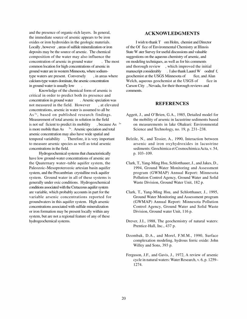
20
and the presence of organic-rich layers. In general,the immediate source of arsenic appears to be ironoxides or iron hydroxides in the geologic materials.Locally , however , areas of sulfide mineralization or irondeposits may be the source of arsenic. The chemicalcomposition of the water may also influence theconcentration of arsenic in ground water . The mostcommon location for high concentrations of arsenic inground water are in western Minnesota, where sodium-type waters are present. Conversely , in areas wherecalcium-type waters dominate, the arsenic concentrationin ground water is usually low .
Knowledge of the chemical form of arsenic iscritical in order to predict both its presence andconcentration in ground water . Arsenic speciation wasnot measured in the field. However , at elevatedconcentrations, arsenic in water is assumed to all beAs 3+, based on published research findings.Measurement of total arsenic in solution in the fieldis not suf ficient to predict its mobility , because As 3+
is more mobile than As 5+. Arsenic speciation and totalarsenic concentration may also have wide spatial andtemporal variability . Therefore, it is very importantto measure arsenic species as well as total arsenicconcentrations in the field.
Hydrogeochemical systems that characteristicallyhave low ground-water concentrations of arsenic arethe Quaternary water–table aquifer system, thePaleozoic–Mesoproterozoic artesian basin aquifersystem, and the Precambrian crystalline rock aquifersystem. Ground water in all of these systems isgenerally under oxic conditions. Hydrogeochemicalconditions associated with the Cretaceous aquifer systemare variable, which probably accounts in part for thevariable arsenic concentrations reported forgroundwaters in this aquifer system. High arsenicconcentrations associated with sulfide mineralizationor iron formation may be present locally within anysystem, but are not a regional feature of any of thesehydrogeochemical systems.
ACKNOWLEDGMENTS
I wish to thank T om Holm, chemist and Directorof the Of fice of Environmental Chemistry at IllinoisState W ater Survey for useful discussions and valuablesuggestions on the aqueous chemistry of arsenic, andon modeling techniques, as well as for his commentsand thorough review , which improved the initialmanuscript considerably . I also thank Laurel W oodruf f,geochemist at the USGS Minnesota of fice, and AlanWelch, aqueous geochemist at the USGS of fice inCarson City , Nevada, for their thorough reviews andcomments.
REFERENCES
Aggett, J., and O’Brien, G.A., 1985, Detailed model forthe mobility of arsenic in lacustrine sediments basedon measurements in lake Ohakuri: EnvironmentalScience and Technology, no. 19, p. 231–238.
Belzile, N., and Tessier, A., 1990, Interaction betweenarsenic and iron oxyhydroxides in lacustrinesediments: Geochimica et Cosmochimica Acta, v. 54,p. 103–109.
Clark, T., Yang-Ming Hsu, Schlotthauer, J., and Jakes, D.,1994, Ground Water Monitoring and Assessmentprogram (GWMAP) Annual Report: MinnesotaPollution Control Agency, Ground Water and SolidWaste Division, Ground Water Unit, 182 p.
Clark, T., Yang-Ming Hsu, and Schlotthauer, J., 1995,Ground Water Monitoring and Assessment program(GWMAP) Annual Report: Minnesota PollutionControl Agency, Ground Water and Solid WasteDivision, Ground water Unit, 116 p.
Drever, J.I., 1988, The geochemistry of natural waters:Prentice-Hall, Inc., 437 p.
Dzombak, D.A., and Morel, F.M.M., 1990, Surfacecomplexation modeling, hydrous ferric oxide: JohnWilley and Sons, 393 p.
Ferguson, J.F., and Gavis, J., 1972, A review of arseniccycle in natural waters: Water Research, v. 6, p. 1259–1274.

21
Harris, K.L., 1995, Regional HydrogeologicalAssessment, Quaternary Geology—southeastern RedRiver Valley, Minnesota: Minnesota GeologicalSurvey Regional Hydrogeological Assessment SeriesRHA-3, part A, scale 1: 200 000, 2 pls.
Hem, J.D., 1992, Study and interpretation of the chemicalcharacteristics of natural water (3d. ed.): U.S.Geological Survey Water-Supply Paper 2254, 263 p.
Holm, T.R., 1995, Ground-Water Quality in the MahometAquifer, McLean, Logan, and Tazewell Counties:Illinois State Water Survey, 42 p.
Holm, T.R., Anderson, M.A., Iverson, D.G., and Stanforth,R.S., 1979, Heterogeneous interaction of arsenic inaquatic systems, in Jenne, E.A., ed., Chemicalmodeling in aqueous systems, American ChemicalSociety Symposium Series 93: American ChemicalSociety, p. 711–736.
Holm, T.R., and Curtiss, C.D., 1988, Arseniccontamination in east-central Illinois ground waters:Illinois State Water Survey, Aquatic ChemistrySection, Open- File Final Report ILENR/RE-W-88/16, 63 p.
Horowitz, A.J., 1984, A primer on trace metal-sedimentchemistry: US Geological Survey Open-File Report84-709, 82 p.
Hounslow, A.W., 1980, Ground-water geochemistry—Arsenic in landfills: Ground Water, v. 18, no. 4, p.331–333.
Huang Yan-Chu, 1994, Arsenic distribution in soils, inNriagu, J.O., ed., Arsenic in the Environment, PartI—Cycling and Characterization: John Wiley andSons, p. 17–49.
Ivanov, V.V., 1996, Ecological geochemistry ofelements—Handbook: Moscow, Nedra, book no. 3,p. 161–197 [in Russian].
Kanivetsky, R., 1978, Hydrogeologic map of Minnesota,bedrock hydrogeology: Minnesota Geological SurveyState Map Series S-2, scale 1: 500 000.
Kanivetsky, R., 1979, Hydrogeologic map of Minnesota,Quaternary hydrogeology: Minnesota GeologicalSurvey State Map Series S-3, scale 1: 500 000.
Kanivetsky, R., 1986, Major constituent chemistry ofselected Phanerozoic aquifers in Minnesota:Minnesota Geological Survey Miscellaneous MapSeries M-61, 2 pls. scales 1:1, 000 000 and 1: 2, 000000.
Korte, N.E., and Quintus, F., 1991, A review of Arsenic(III) in ground water: Critical Reviews inEnvironmental Control, v. 21, no. 1, p. 1–39.
Krainov, S.P., and Shvetz, V.M., 1987, Geochemistry ofground water for drinking purposes: Moscow, Nedra,237 p. [in Russian].
Lindberg, R.D., and Runnels, D.D., 1984, Ground waterredox reactions—An analysis of equilibrium stateapplied to Eh measurements and geochemicalmodeling: Science, 225, p. 925–927.
Lively, R.S., and Morey, G.B., 1996, Aerial gammaradiation in Minnesota and adjacent areas of NorthDakota and South Dakota: Minnesota GeologicalSurvey Miscellaneous Map Series M-83, scale1:3,168 000.
Matisoff, G., Khourey, C.J., Hall, J.F., Varnes, A.W., andStrain, W.H., 1982, The nature and source of arsenicin northeastern Ohio ground water: Ground Water, v.20, no. 4, p. 446–456.
McSwiggen, P.L., Morey, G.B., and Cleland, J.M., 1995,Iron-formation protolith and genesis, Cuyuna Range,Minnesota: Minnesota Geological Survey Report ofInvestigations 45, 54 p.
Melcher, F., Morey, G.B., Mcswiggen, P.L., Cleland, J.M.,and Brink, S.E., 1996, Hydrothermal systems inmanganese-rich iron-formation of the Cuyuna NorthRange, Minnesota: Minnesota Geological SurveyReport of Investigations 46, 59 p.
Minnesota Department of Health, Division ofEnvironmental Health, 1995: Arsenic in DrinkingWater, 8 p. [pamphlet]
Minnesota Pollution Control Agency, 2000, Ground watermonitoring and assessment program (GWMAP):http://www.pca.state.mn.us/water/groundwater/gwmap/index.html (accessed June 5, 2000).

22
Mok, W.M., and Wai, C.M., 1994, Mobilization of arsenicin contaminated river waters, in Nriagu, J.O. ed.,Arsenic in the Environment, Part I—Cycling andCharacterization: John Wiley and Sons, p. 99–117.
Moncure, G, Jankowski, P.A., and Drever, J.I., 1992, Thehydrogeochemistry of arsenic in reservoir sediments,Milltown, Montana, USA, in Kharaca Y.K., and MaestA.S., eds., Water-Rock Interaction: Rotterdam, A.A.Balkema, p. 513–516.
Morey, G.B., 1992, Chemical composition of the easternBiwabik Iron-Formation (Early Proterozoic), MesabiRange, Minnesota: Economic Geology, v. 87, p.1649–1658.
Morey, G.B., and Day, L.S., 1992, Analytical results ofthe Public Geologic Sample Program, 1989–1991biennium: Minnesota Geological Survey InformationCircular 38, 79 p.
Morey, G.B., and Lively, R.S. 1999, Background levelsof mercury and arsenic in Paleoproterozoic rocks ofthe mesabi Iron range, Northern Minnesota:Minnesota Geological Survey Information Circular43, 15 p.
Morey, G.B., Lively, R.S., and Meyer, G.N., in press,Utility of elemental geochemical data in correlationand provenance studies of Pleistocene materials—Acase study in Stearns County, central Minnesota:Minnesota Geological Survey Information Circular45.
Morey, G.B., Lively, R.S., Mossler, J.H., and Hauck, S.A.,1994, Geochemical Investigation of minor and traceelements in the acid-insoluble residue of LowerPaleozoic carbonate and related strata, southeasternMinnesota—The data base: Minnesota GeologicalSurvey Information Circular 41, 78 p.
Morey, G.B., and McDonald, L.L., 1987, Analytical resultsof the Public Geologic Sample Program, 1985–1987biennium: Minnesota Geological Survey InformationCircular 25, 59 p.
Morey, G.B., and McDonald, L.L., 1989, Analytical resultsof the Public Geologic Sample Program, 1987–1989biennium: Minnesota Geological Survey InformationCircular 29, 66 p.
Morey, G.B., McSwiggen, P.L., Kuhns, M.J.P., and Jirsa,M.A., 1985, Analytical results of the Public GeologicSample Program, 1983–1985 biennium: MinnesotaGeological Survey Information Circular 22, 56 p.
Morey, G.B., Setterholm, D.R., and Kanivetsky, R., 1990,Distribution of arsenic in ground water and rocks,Southwestern Minnesota: Minnesota GeologicalSurvey Miscellaneous Map Series M-70, scale 1 inchequals 7.5 miles.
Morton, W.E., and Dunette, D.A., 1994, Health effectsof environmental arsenic, in Nriagu, J.O., ed. Arsenicin the Environment Part II—Human Health andEcosystem Effects: John Wiley and Sons, p. 17–34.
Oak Ridge Gaseous Diffusion Plant, 1979a,Hydrogeochemical and stream sedimentreconnaissance basic data for New Ulm NTMSQuadrangle, Minnesota: U.S. Department of EnergyOpen-File Report GJBX-120 (79), 43 p., appendices.
Oak Ridge Gaseous Diffusion Plant, 1979b,Hydrogeochemical and stream sedimentreconnaissance basic data for St. Cloud NTMSQuadrangle, Minnesota: U.S. Department of EnergyOpen-File Report GJBX-55 (79), 43 p., appendices.
Oak Ridge Gaseous Diffusion Plant, 1981a,Hydrogeochemical and stream sedimentreconnaissance basic data for Thief River Falls NTMSQuadrangle, Minnesota; North Dakota: U.S.Department of Energy Open-File Report GJBX-168(81), 132 p., 8 pls., 2 fiche.
Oak Ridge Gaseous Diffusion Plant, 1981b,Hydrogeochemical and stream sedimentreconnaissance basic data for Watertown NTMSQuadrangle, South Dakota; Minnesota: U.S.Department of Energy Open-File Report GJBX-219(81), 150 p., 9 pls., 2 fiche.
Oak Ridge Gaseous Diffusion Plant, 1981c,Hydrogeochemical and stream sedimentreconnaissance basic data for Milbank NTMSQuadrangle, Minnesota; North Dakota; SouthDakota: U.S. Department of Energy Open-File ReportGJBX-271(81), 114 p., 9 pls., 2 fiche.

23
Oak Ridge Gaseous Diffusion Plant, 1981d,Hydrogeochemical and stream sedimentreconnaissance basic data for Grand Forks NTMSQuadrangle, North Dakota; Minnesota: U.S.Department of Energy Open-File Report GJBX-169(81), 130 p., 8 pls., 2 fiche.
Oak Ridge Gaseous Diffusion Plant, 1981e,Hydrogeochemical and stream sedimentreconnaissance basic data for Fargo NTMSQuadrangle, North Dakota; Minnesota: U.S.Department of Energy Open-File Report GJBX-167(81), 132 p., 8 pls., 2 fiche.
Olsen, B., and Mossler, J.H., 1982, Geologic Map ofMinnesota, depth to bedrock: Minnesota GeologicalSurvey State Map Series S-14, scale 1:1,000 000.
Pierce, M.L., and Moore, C.B., 1982, Adsorption ofarsenite and arsenate on amorphous iron hydroxide:Water Research, v. 16, p. 1247–1253.
Raloff, J., 1996, Waterborne arsenic poses a cancer risk:Science News, February 24, 1996, v. 149, no. 8, p.119.
Robertson, F.N., 1989, Arsenic in ground-water underoxidized conditions, south-west United States:Environmental Geochemistry and Health, no. 11, p.171–185.
Schecher, W.D. and McAvoy, D.C., 1994, MINEQL+—A chemical equilibrium program for personalcomputers, version 3.0: Environmental ResearchSoftware.
Setterholm, D.R., 1995, Regional HydrogeologicalAssessment, Quaternary Geology—southwesternMinnesota: Minnesota Geological Survey RegionalHydrogeological Assessment Series, RHA-2, Part A,scale 1:200 000, 2 pls.
Sullivan, K.A., and Aller, R.C., 1996, Diagenetic cyclingof arsenic in Amazon shelf sediments: Geochimicaet Cosmochimica Acta, v. 60, no. 9, p. 1465–1477.
Vance, D.B., 1995, Arsenic—Chemical behavior andtreatment: The National Environmental Journal, May/June, p. 60–64.
Voight, D.E., and Brantley, S.L., 1996, Chemical fixationof arsenic in contaminated soils: AppliedGeochemistry, v. 11, p. 633–643.
Wahl, T.E., and Tipping, R.G., 1991, Ground-water datamanagement—The County Well Index: MinnesotaGeological Survey, variously paged in 3-ring binder.
Welch, A.H., Lico, M.S., and Hughes, J.L., 1988, Arsenicin ground water of the western United States: GroundWater, v. 26, no. 3, p. 333–347.

24