Embed Size (px)
Citation preview
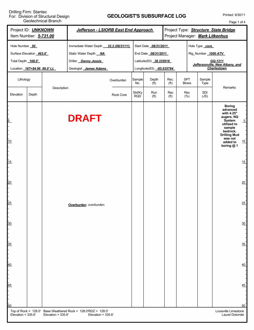
Boringadvancedwith 4.25"augers, NQ
Systemutilized to
samplebedrock,
Drilling Mudwas notadded to
boring @ 1
Overburden: overburden.
Elevation Depth Std/KyRQD
Lithology
5
10
15
20
25
30
35
40
45
50
5
10
15
20
25
30
35
40
45
50
Depth(ft)
SPTBlows
SampleType
Rec(ft)
Geologist James Adams
Hole Type core
Rec(%)
Rec.(ft)
SampleNo.
Run(ft)
Description
Overburden
Rock CoreSDI(JS)
Remarks
Rig_Number 1050 ATV
Hole Number 50
Surface Elevation 463.6'
Total Depth 168.0'
End Date 08/31/2011
Latitude(83) 38.335918
Longitude(83) -85.635784
Start Date 08/31/2011
Driller Danny Jessie
GEOLOGIST'S SUBSURFACE LOG
GQ-1211Jeffersonville, New Albany, and
Charlestown
Static Water Depth NA
Louisville LimestoneLaurel Dolomite
Immediate Water Depth 32.2 (08/31/11)
Location 167+84.96 86.0' Lt.
Base Weathered Rock = 128.0'Elevation = 335.6'
Top of Rock = 128.0'Elevation = 335.6'
RDZ = 128.0'Elevation = 335.6'
Printed: 9/30/11
Page 1 of 4
Drilling Firm: StantecFor: Division of Structural Design
Geotechnical Branch
Project Type: Structure State BridgeProject Manager: Mark Litkenhus
Project ID: UNKNOWNItem Number: 5-731.00
Jefferson - LSIORB East End Approach
DRAFT
Overburden: overburden.
Elevation Depth Std/KyRQD
Lithology
55
60
65
70
75
80
85
90
95
100
55
60
65
70
75
80
85
90
95
100
Depth(ft)
SPTBlows
SampleType
Rec(ft)
Geologist James Adams
Hole Type core
Rec(%)
Rec.(ft)
SampleNo.
Run(ft)
Description
Overburden
Rock CoreSDI(JS)
Remarks
Rig_Number 1050 ATV
Hole Number 50
Surface Elevation 463.6'
Total Depth 168.0'
End Date 08/31/2011
Latitude(83) 38.335918
Longitude(83) -85.635784
Start Date 08/31/2011
Driller Danny Jessie
GEOLOGIST'S SUBSURFACE LOG
GQ-1211Jeffersonville, New Albany, and
Charlestown
Static Water Depth NA
Louisville LimestoneLaurel Dolomite
Immediate Water Depth 32.2 (08/31/11)
Location 167+84.96 86.0' Lt.
Base Weathered Rock = 128.0'Elevation = 335.6'
Top of Rock = 128.0'Elevation = 335.6'
RDZ = 128.0'Elevation = 335.6'
Printed: 9/30/11
Page 2 of 4
Drilling Firm: StantecFor: Division of Structural Design
Geotechnical Branch
Project Type: Structure State BridgeProject Manager: Mark Litkenhus
Project ID: UNKNOWNItem Number: 5-731.00
Jefferson - LSIORB East End Approach
DRAFT
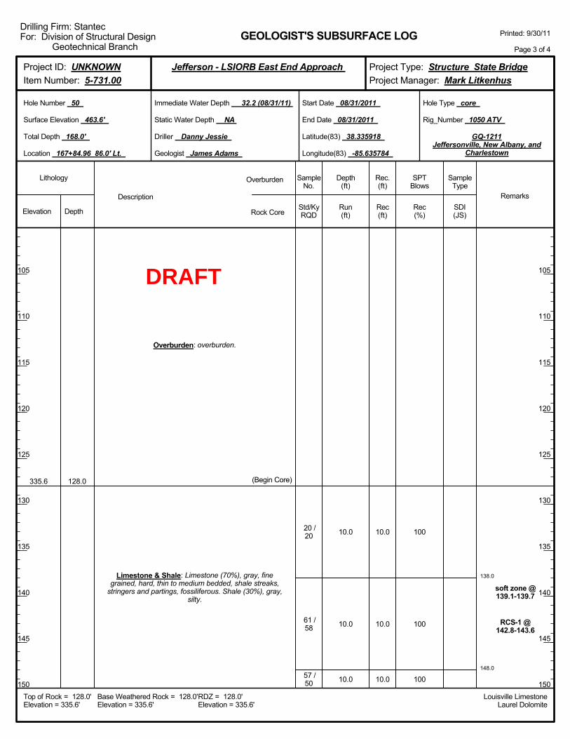
138.0
148.0
10.0
10.0
10.0
100
100
100
soft zone @139.1-139.7
RCS-1 @142.8-143.6
335.6 128.0
Overburden: overburden.
Limestone & Shale: Limestone (70%), gray, finegrained, hard, thin to medium bedded, shale streaks,
stringers and partings, fossiliferous. Shale (30%), gray,silty.
(Begin Core)
20 /20
61 /58
57 /50
10.0
10.0
10.0
Elevation Depth Std/KyRQD
Lithology
105
110
115
120
125
130
135
140
145
150
105
110
115
120
125
130
135
140
145
150
Depth(ft)
SPTBlows
SampleType
Rec(ft)
Geologist James Adams
Hole Type core
Rec(%)
Rec.(ft)
SampleNo.
Run(ft)
Description
Overburden
Rock CoreSDI(JS)
Remarks
Rig_Number 1050 ATV
Hole Number 50
Surface Elevation 463.6'
Total Depth 168.0'
End Date 08/31/2011
Latitude(83) 38.335918
Longitude(83) -85.635784
Start Date 08/31/2011
Driller Danny Jessie
GEOLOGIST'S SUBSURFACE LOG
GQ-1211Jeffersonville, New Albany, and
Charlestown
Static Water Depth NA
Louisville LimestoneLaurel Dolomite
Immediate Water Depth 32.2 (08/31/11)
Location 167+84.96 86.0' Lt.
Base Weathered Rock = 128.0'Elevation = 335.6'
Top of Rock = 128.0'Elevation = 335.6'
RDZ = 128.0'Elevation = 335.6'
Printed: 9/30/11
Page 3 of 4
Drilling Firm: StantecFor: Division of Structural Design
Geotechnical Branch
Project Type: Structure State BridgeProject Manager: Mark Litkenhus
Project ID: UNKNOWNItem Number: 5-731.00
Jefferson - LSIORB East End Approach
DRAFT
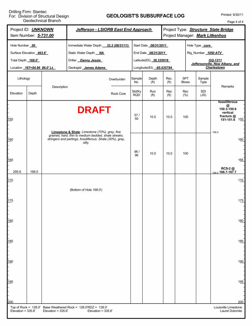
158.0
168.0
10.0
10.0
100
100
fossiliferous@
150.3-150.6vertical
fracture @151-151.6
RCS-2 @166.7-167.7295.6 168.0
Limestone & Shale: Limestone (70%), gray, finegrained, hard, thin to medium bedded, shale streaks,
stringers and partings, fossiliferous. Shale (30%), gray,silty.
57 /50
96 /96
(Bottom of Hole 168.0')
10.0
10.0
Elevation Depth Std/KyRQD
Lithology
155
160
165
170
175
180
185
190
195
200
155
160
165
170
175
180
185
190
195
200
Depth(ft)
SPTBlows
SampleType
Rec(ft)
Geologist James Adams
Hole Type core
Rec(%)
Rec.(ft)
SampleNo.
Run(ft)
Description
Overburden
Rock CoreSDI(JS)
Remarks
Rig_Number 1050 ATV
Hole Number 50
Surface Elevation 463.6'
Total Depth 168.0'
End Date 08/31/2011
Latitude(83) 38.335918
Longitude(83) -85.635784
Start Date 08/31/2011
Driller Danny Jessie
GEOLOGIST'S SUBSURFACE LOG
GQ-1211Jeffersonville, New Albany, and
Charlestown
Static Water Depth NA
Louisville LimestoneLaurel Dolomite
Immediate Water Depth 32.2 (08/31/11)
Location 167+84.96 86.0' Lt.
Base Weathered Rock = 128.0'Elevation = 335.6'
Top of Rock = 128.0'Elevation = 335.6'
RDZ = 128.0'Elevation = 335.6'
Printed: 9/30/11
Page 4 of 4
Drilling Firm: StantecFor: Division of Structural Design
Geotechnical Branch
Project Type: Structure State BridgeProject Manager: Mark Litkenhus
Project ID: UNKNOWNItem Number: 5-731.00
Jefferson - LSIORB East End Approach
DRAFT
2.0-4.0
5.0-7.0
10.0-12.0
15.0-16.5
20.0-21.5
25.0-26.5
30.0-31.5
35.0-36.5
40.0-41.5
45.0-46.5
3-3-1
1-2-1
2-3-3
3-3-2
1-2-1
0-0-0
1-2-4
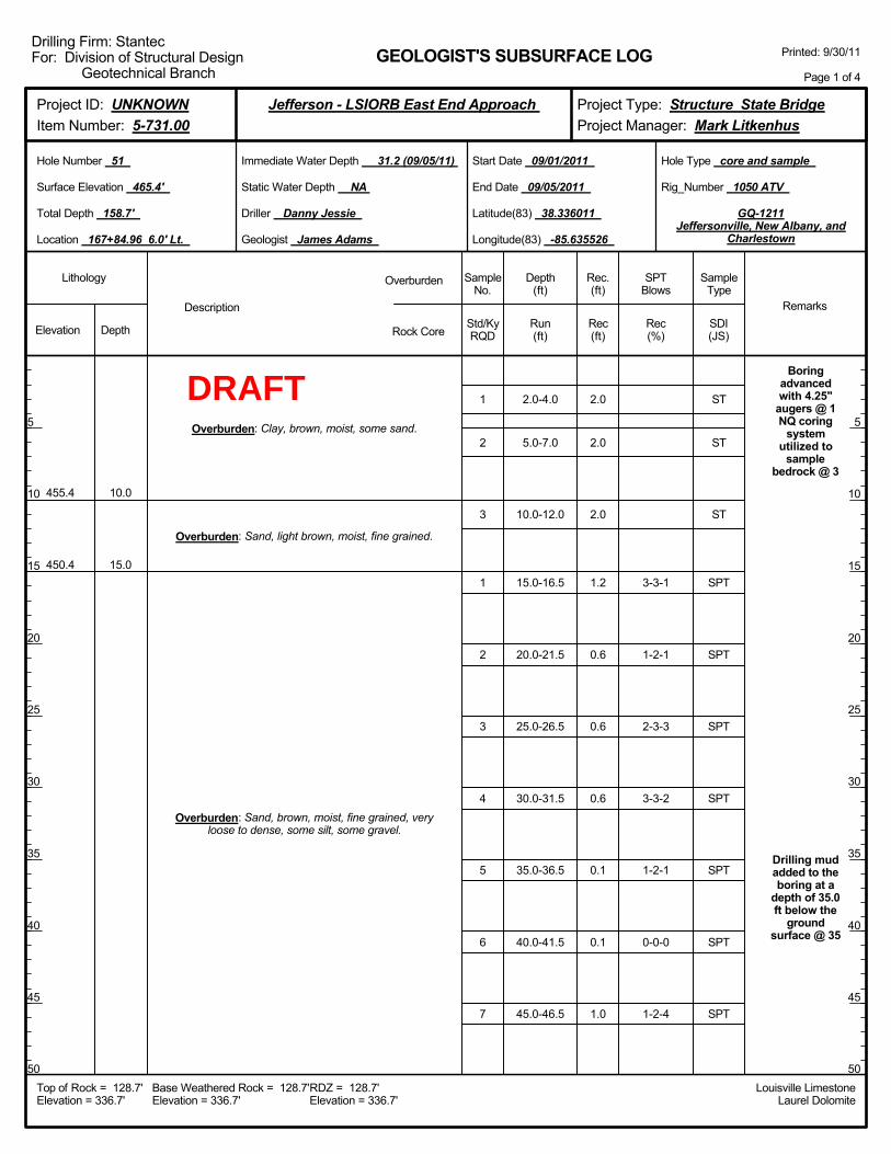
Boringadvancedwith 4.25"
augers @ 1NQ coring
systemutilized to
samplebedrock @ 3
Drilling mudadded to theboring at a
depth of 35.0ft below the
groundsurface @ 35
455.4
450.4
10.0
15.0
Overburden: Clay, brown, moist, some sand.
Overburden: Sand, light brown, moist, fine grained.
Overburden: Sand, brown, moist, fine grained, veryloose to dense, some silt, some gravel.
1
2
3
1
2
3
4
5
6
7
2.0
2.0
2.0
1.2
0.6
0.6
0.6
0.1
0.1
1.0
Elevation Depth Std/KyRQD
Lithology
5
10
15
20
25
30
35
40
45
50
5
10
15
20
25
30
35
40
45
50
Depth(ft)
SPTBlows
SampleType
Rec(ft)
Geologist James Adams
Hole Type core and sample
Rec(%)
Rec.(ft)
SampleNo.
Run(ft)
Description
Overburden
Rock CoreSDI(JS)
Remarks
Rig_Number 1050 ATV
Hole Number 51
Surface Elevation 465.4'
Total Depth 158.7'
End Date 09/05/2011
Latitude(83) 38.336011
Longitude(83) -85.635526
Start Date 09/01/2011
Driller Danny Jessie
GEOLOGIST'S SUBSURFACE LOG
GQ-1211Jeffersonville, New Albany, and
Charlestown
Static Water Depth NA
Louisville LimestoneLaurel Dolomite
Immediate Water Depth 31.2 (09/05/11)
Location 167+84.96 6.0' Lt.
Base Weathered Rock = 128.7'Elevation = 336.7'
Top of Rock = 128.7'Elevation = 336.7'
RDZ = 128.7'Elevation = 336.7'
Printed: 9/30/11
Page 1 of 4
Drilling Firm: StantecFor: Division of Structural Design
Geotechnical Branch
Project Type: Structure State BridgeProject Manager: Mark Litkenhus
Project ID: UNKNOWNItem Number: 5-731.00
Jefferson - LSIORB East End Approach
ST
ST
ST
SPT
SPT
SPT
SPT
SPT
SPT
SPT
DRAFT

50.0-51.5
55.0-56.5
60.0-61.5
65.0-66.5
70.0-71.5
75.0-76.5
80.0-81.5
85.0-86.5
90.0-91.5
95.0-96.5
0-1-3
5-4-9
6-7-12
8-8-13
8-13-24
14-17-22
8-9-12
6-10-17
15-13-15
9-10-10
410.4 55.0
Overburden: Sand, brown, moist, fine grained, veryloose to dense, some silt, some gravel.
Overburden: Sand, brown to gray, wet, fine tomedium grained, medium dense to dense, poorly
graded, some gravel.
8
9
10
11
12
13
14
15
16
17
1.5
1.2
1.5
1.5
1.5
1.5
1.2
1.5
1.5
1.5
Elevation Depth Std/KyRQD
Lithology
55
60
65
70
75
80
85
90
95
100
55
60
65
70
75
80
85
90
95
100
Depth(ft)
SPTBlows
SampleType
Rec(ft)
Geologist James Adams
Hole Type core and sample
Rec(%)
Rec.(ft)
SampleNo.
Run(ft)
Description
Overburden
Rock CoreSDI(JS)
Remarks
Rig_Number 1050 ATV
Hole Number 51
Surface Elevation 465.4'
Total Depth 158.7'
End Date 09/05/2011
Latitude(83) 38.336011
Longitude(83) -85.635526
Start Date 09/01/2011
Driller Danny Jessie
GEOLOGIST'S SUBSURFACE LOG
GQ-1211Jeffersonville, New Albany, and
Charlestown
Static Water Depth NA
Louisville LimestoneLaurel Dolomite
Immediate Water Depth 31.2 (09/05/11)
Location 167+84.96 6.0' Lt.
Base Weathered Rock = 128.7'Elevation = 336.7'
Top of Rock = 128.7'Elevation = 336.7'
RDZ = 128.7'Elevation = 336.7'
Printed: 9/30/11
Page 2 of 4
Drilling Firm: StantecFor: Division of Structural Design
Geotechnical Branch
Project Type: Structure State BridgeProject Manager: Mark Litkenhus
Project ID: UNKNOWNItem Number: 5-731.00
Jefferson - LSIORB East End Approach
SPT
SPT
SPT
SPT
SPT
SPT
SPT
SPT
SPT
SPT
DRAFT
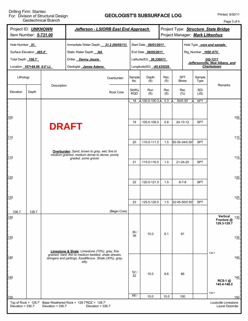
138.7
148.7
100.0-100.3
105.0-106.5
110.0-111.5
115.0-116.5
120.0-121.5
125.0-126.5
10.0
10.0
10.0
50/0.30'
24-13-12
50-35-34/0.50'
21-24-25
8-7-8
32-45-50/0.50'
81
86
100
VerticalFracture @129.3-129.7
RCS-1 @145.4-146.2
336.7 128.7
Overburden: Sand, brown to gray, wet, fine tomedium grained, medium dense to dense, poorly
graded, some gravel.
Limestone & Shale: Limestone (70%), gray, finegrained, hard, thin to medium bedded, shale streaks,
stringers and partings, fossiliferous. Shale (30%), gray,silty.
(Begin Core)
18
19
20
21
22
23
36 /36
52 /52
68 /
0.3
0.8
1.5
1.5
1.5
1.5
8.1
8.6
10.0
Elevation Depth Std/KyRQD
Lithology
105
110
115
120
125
130
135
140
145
150
105
110
115
120
125
130
135
140
145
150
Depth(ft)
SPTBlows
SampleType
Rec(ft)
Geologist James Adams
Hole Type core and sample
Rec(%)
Rec.(ft)
SampleNo.
Run(ft)
Description
Overburden
Rock CoreSDI(JS)
Remarks
Rig_Number 1050 ATV
Hole Number 51
Surface Elevation 465.4'
Total Depth 158.7'
End Date 09/05/2011
Latitude(83) 38.336011
Longitude(83) -85.635526
Start Date 09/01/2011
Driller Danny Jessie
GEOLOGIST'S SUBSURFACE LOG
GQ-1211Jeffersonville, New Albany, and
Charlestown
Static Water Depth NA
Louisville LimestoneLaurel Dolomite
Immediate Water Depth 31.2 (09/05/11)
Location 167+84.96 6.0' Lt.
Base Weathered Rock = 128.7'Elevation = 336.7'
Top of Rock = 128.7'Elevation = 336.7'
RDZ = 128.7'Elevation = 336.7'
Printed: 9/30/11
Page 3 of 4
Drilling Firm: StantecFor: Division of Structural Design
Geotechnical Branch
Project Type: Structure State BridgeProject Manager: Mark Litkenhus
Project ID: UNKNOWNItem Number: 5-731.00
Jefferson - LSIORB East End Approach
SPT
SPT
SPT
SPT
SPT
SPT
DRAFT
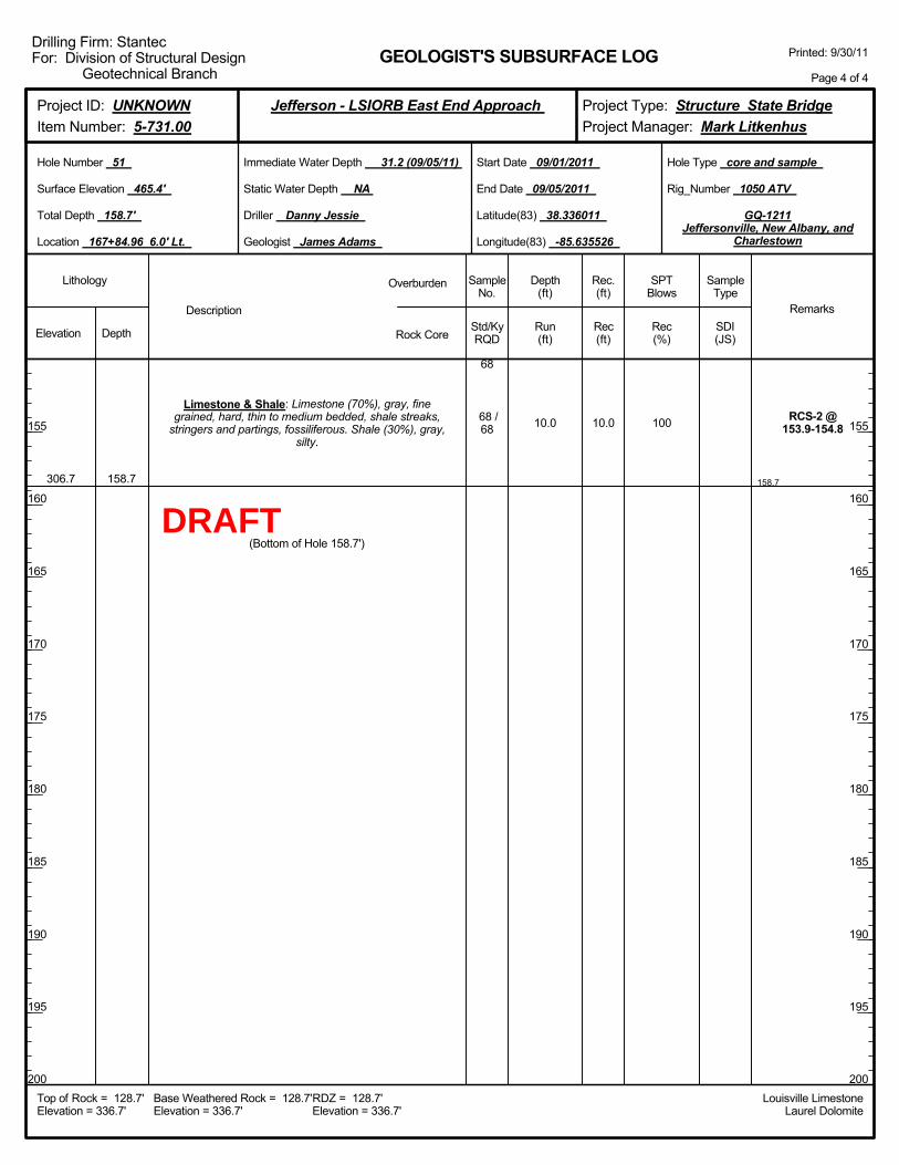
158.7
10.0 100 RCS-2 @153.9-154.8
306.7 158.7
Limestone & Shale: Limestone (70%), gray, finegrained, hard, thin to medium bedded, shale streaks,
stringers and partings, fossiliferous. Shale (30%), gray,silty.
68
68 /68
(Bottom of Hole 158.7')
10.0
Elevation Depth Std/KyRQD
Lithology
155
160
165
170
175
180
185
190
195
200
155
160
165
170
175
180
185
190
195
200
Depth(ft)
SPTBlows
SampleType
Rec(ft)
Geologist James Adams
Hole Type core and sample
Rec(%)
Rec.(ft)
SampleNo.
Run(ft)
Description
Overburden
Rock CoreSDI(JS)
Remarks
Rig_Number 1050 ATV
Hole Number 51
Surface Elevation 465.4'
Total Depth 158.7'
End Date 09/05/2011
Latitude(83) 38.336011
Longitude(83) -85.635526
Start Date 09/01/2011
Driller Danny Jessie
GEOLOGIST'S SUBSURFACE LOG
GQ-1211Jeffersonville, New Albany, and
Charlestown
Static Water Depth NA
Louisville LimestoneLaurel Dolomite
Immediate Water Depth 31.2 (09/05/11)
Location 167+84.96 6.0' Lt.
Base Weathered Rock = 128.7'Elevation = 336.7'
Top of Rock = 128.7'Elevation = 336.7'
RDZ = 128.7'Elevation = 336.7'
Printed: 9/30/11
Page 4 of 4
Drilling Firm: StantecFor: Division of Structural Design
Geotechnical Branch
Project Type: Structure State BridgeProject Manager: Mark Litkenhus
Project ID: UNKNOWNItem Number: 5-731.00
Jefferson - LSIORB East End Approach
DRAFT

Boringadvancedwith 4.25"
augers @ 1NQ coring
systemutilized to
samplebedrock @ 3
Drilling mudadded to theboring at a
depth of 40.0ft below the
groundsurface @ 40
Overburden: overburden.
Elevation Depth Std/KyRQD
Lithology
5
10
15
20
25
30
35
40
45
50
5
10
15
20
25
30
35
40
45
50
Depth(ft)
SPTBlows
SampleType
Rec(ft)
Geologist James Adams
Hole Type core
Rec(%)
Rec.(ft)
SampleNo.
Run(ft)
Description
Overburden
Rock CoreSDI(JS)
Remarks
Rig_Number 1050 ATV
Hole Number 52
Surface Elevation 465.5'
Total Depth 159.3'
End Date 09/07/2011
Latitude(83) 38.336060
Longitude(83) -85.635503
Start Date 09/06/2011
Driller Danny Jessie
GEOLOGIST'S SUBSURFACE LOG
GQ-1211Jeffersonville, New Albany, and
Charlestown
Static Water Depth NA
Louisville LimestoneLaurel Dolomite
Immediate Water Depth 35.6 (09/07/11)
Location 167+84.96 6.0' Rt.
Base Weathered Rock = 131.2'Elevation = 334.3'
Top of Rock = 128.6'Elevation = 336.9'
RDZ = 131.2'Elevation = 334.3'
Printed: 9/30/11
Page 1 of 4
Drilling Firm: StantecFor: Division of Structural Design
Geotechnical Branch
Project Type: Structure State BridgeProject Manager: Mark Litkenhus
Project ID: UNKNOWNItem Number: 5-731.00
Jefferson - LSIORB East End Approach
DRAFT
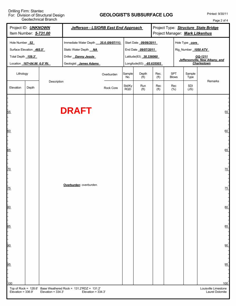
Overburden: overburden.
Elevation Depth Std/KyRQD
Lithology
55
60
65
70
75
80
85
90
95
100
55
60
65
70
75
80
85
90
95
100
Depth(ft)
SPTBlows
SampleType
Rec(ft)
Geologist James Adams
Hole Type core
Rec(%)
Rec.(ft)
SampleNo.
Run(ft)
Description
Overburden
Rock CoreSDI(JS)
Remarks
Rig_Number 1050 ATV
Hole Number 52
Surface Elevation 465.5'
Total Depth 159.3'
End Date 09/07/2011
Latitude(83) 38.336060
Longitude(83) -85.635503
Start Date 09/06/2011
Driller Danny Jessie
GEOLOGIST'S SUBSURFACE LOG
GQ-1211Jeffersonville, New Albany, and
Charlestown
Static Water Depth NA
Louisville LimestoneLaurel Dolomite
Immediate Water Depth 35.6 (09/07/11)
Location 167+84.96 6.0' Rt.
Base Weathered Rock = 131.2'Elevation = 334.3'
Top of Rock = 128.6'Elevation = 336.9'
RDZ = 131.2'Elevation = 334.3'
Printed: 9/30/11
Page 2 of 4
Drilling Firm: StantecFor: Division of Structural Design
Geotechnical Branch
Project Type: Structure State BridgeProject Manager: Mark Litkenhus
Project ID: UNKNOWNItem Number: 5-731.00
Jefferson - LSIORB East End Approach
DRAFT
138.0
148.0
9.4
10.0
11.3
90
100
100
RCS-1 @146.1-146.7
336.9 128.6
Overburden: overburden.
Limestone & Shale: Limestone (60%), gray, finegrained, hard, thin to medium bedded, shale streaks,
stringers and partings, fossiliferous. Shale (40%), gray,silty.
(Begin Core)
12 /12
42 /35
46 /46
8.5
10.0
11.3
Elevation Depth Std/KyRQD
Lithology
105
110
115
120
125
130
135
140
145
150
105
110
115
120
125
130
135
140
145
150
Depth(ft)
SPTBlows
SampleType
Rec(ft)
Geologist James Adams
Hole Type core
Rec(%)
Rec.(ft)
SampleNo.
Run(ft)
Description
Overburden
Rock CoreSDI(JS)
Remarks
Rig_Number 1050 ATV
Hole Number 52
Surface Elevation 465.5'
Total Depth 159.3'
End Date 09/07/2011
Latitude(83) 38.336060
Longitude(83) -85.635503
Start Date 09/06/2011
Driller Danny Jessie
GEOLOGIST'S SUBSURFACE LOG
GQ-1211Jeffersonville, New Albany, and
Charlestown
Static Water Depth NA
Louisville LimestoneLaurel Dolomite
Immediate Water Depth 35.6 (09/07/11)
Location 167+84.96 6.0' Rt.
Base Weathered Rock = 131.2'Elevation = 334.3'
Top of Rock = 128.6'Elevation = 336.9'
RDZ = 131.2'Elevation = 334.3'
Printed: 9/30/11
Page 3 of 4
Drilling Firm: StantecFor: Division of Structural Design
Geotechnical Branch
Project Type: Structure State BridgeProject Manager: Mark Litkenhus
Project ID: UNKNOWNItem Number: 5-731.00
Jefferson - LSIORB East End Approach
DRAFT
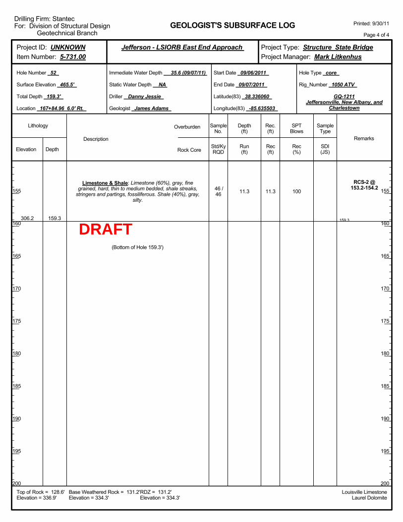
159.3
11.3 100
RCS-2 @153.2-154.2
306.2 159.3
Limestone & Shale: Limestone (60%), gray, finegrained, hard, thin to medium bedded, shale streaks,
stringers and partings, fossiliferous. Shale (40%), gray,silty.
46 /46
(Bottom of Hole 159.3')
11.3
Elevation Depth Std/KyRQD
Lithology
155
160
165
170
175
180
185
190
195
200
155
160
165
170
175
180
185
190
195
200
Depth(ft)
SPTBlows
SampleType
Rec(ft)
Geologist James Adams
Hole Type core
Rec(%)
Rec.(ft)
SampleNo.
Run(ft)
Description
Overburden
Rock CoreSDI(JS)
Remarks
Rig_Number 1050 ATV
Hole Number 52
Surface Elevation 465.5'
Total Depth 159.3'
End Date 09/07/2011
Latitude(83) 38.336060
Longitude(83) -85.635503
Start Date 09/06/2011
Driller Danny Jessie
GEOLOGIST'S SUBSURFACE LOG
GQ-1211Jeffersonville, New Albany, and
Charlestown
Static Water Depth NA
Louisville LimestoneLaurel Dolomite
Immediate Water Depth 35.6 (09/07/11)
Location 167+84.96 6.0' Rt.
Base Weathered Rock = 131.2'Elevation = 334.3'
Top of Rock = 128.6'Elevation = 336.9'
RDZ = 131.2'Elevation = 334.3'
Printed: 9/30/11
Page 4 of 4
Drilling Firm: StantecFor: Division of Structural Design
Geotechnical Branch
Project Type: Structure State BridgeProject Manager: Mark Litkenhus
Project ID: UNKNOWNItem Number: 5-731.00
Jefferson - LSIORB East End Approach
DRAFT
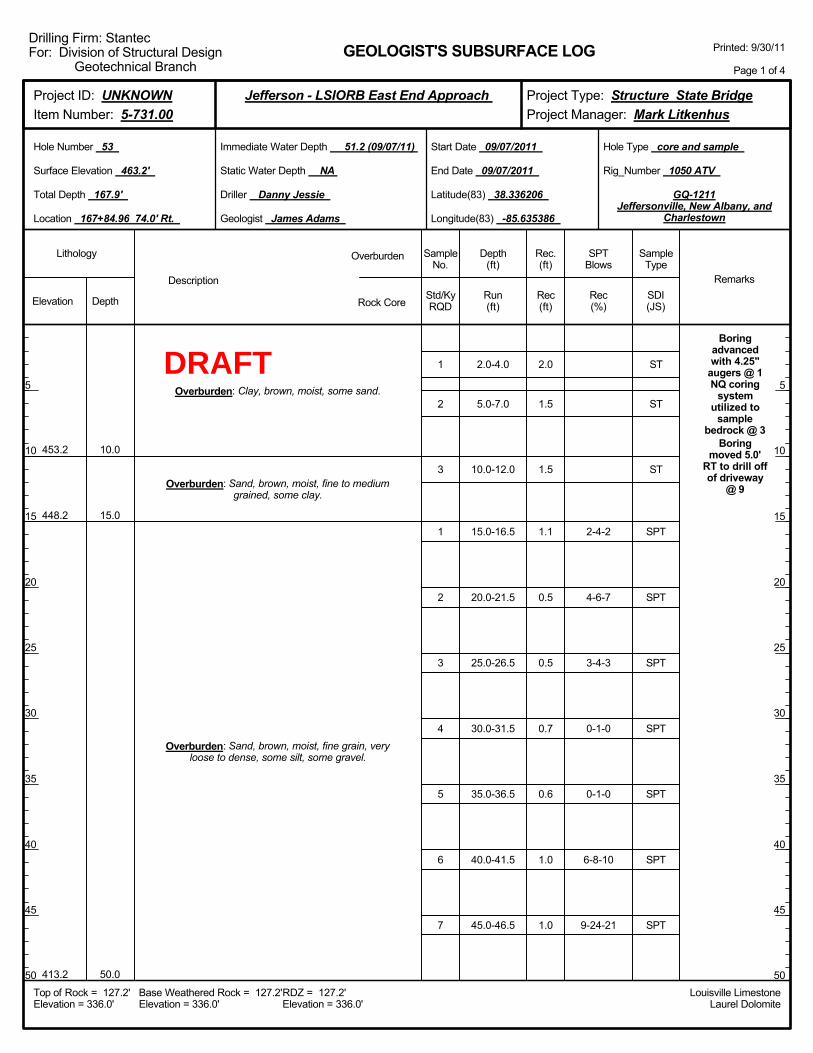
2.0-4.0
5.0-7.0
10.0-12.0
15.0-16.5
20.0-21.5
25.0-26.5
30.0-31.5
35.0-36.5
40.0-41.5
45.0-46.5
2-4-2
4-6-7
3-4-3
0-1-0
0-1-0
6-8-10
9-24-21
Boringadvancedwith 4.25"
augers @ 1NQ coring
systemutilized to
samplebedrock @ 3
Boringmoved 5.0'
RT to drill offof driveway
@ 9
453.2
448.2
413.2
10.0
15.0
50.0
Overburden: Clay, brown, moist, some sand.
Overburden: Sand, brown, moist, fine to mediumgrained, some clay.
Overburden: Sand, brown, moist, fine grain, veryloose to dense, some silt, some gravel.
1
2
3
1
2
3
4
5
6
7
2.0
1.5
1.5
1.1
0.5
0.5
0.7
0.6
1.0
1.0
Elevation Depth Std/KyRQD
Lithology
5
10
15
20
25
30
35
40
45
50
5
10
15
20
25
30
35
40
45
50
Depth(ft)
SPTBlows
SampleType
Rec(ft)
Geologist James Adams
Hole Type core and sample
Rec(%)
Rec.(ft)
SampleNo.
Run(ft)
Description
Overburden
Rock CoreSDI(JS)
Remarks
Rig_Number 1050 ATV
Hole Number 53
Surface Elevation 463.2'
Total Depth 167.9'
End Date 09/07/2011
Latitude(83) 38.336206
Longitude(83) -85.635386
Start Date 09/07/2011
Driller Danny Jessie
GEOLOGIST'S SUBSURFACE LOG
GQ-1211Jeffersonville, New Albany, and
Charlestown
Static Water Depth NA
Louisville LimestoneLaurel Dolomite
Immediate Water Depth 51.2 (09/07/11)
Location 167+84.96 74.0' Rt.
Base Weathered Rock = 127.2'Elevation = 336.0'
Top of Rock = 127.2'Elevation = 336.0'
RDZ = 127.2'Elevation = 336.0'
Printed: 9/30/11
Page 1 of 4
Drilling Firm: StantecFor: Division of Structural Design
Geotechnical Branch
Project Type: Structure State BridgeProject Manager: Mark Litkenhus
Project ID: UNKNOWNItem Number: 5-731.00
Jefferson - LSIORB East End Approach
ST
ST
ST
SPT
SPT
SPT
SPT
SPT
SPT
SPT
DRAFT
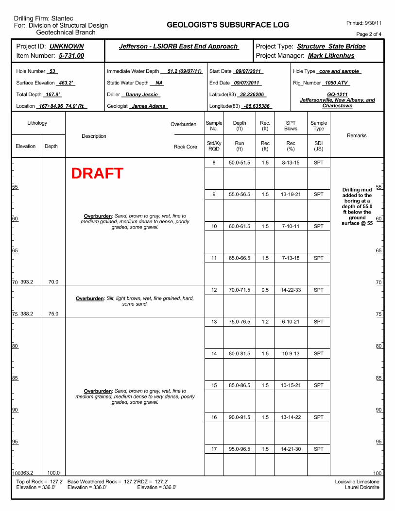
50.0-51.5
55.0-56.5
60.0-61.5
65.0-66.5
70.0-71.5
75.0-76.5
80.0-81.5
85.0-86.5
90.0-91.5
95.0-96.5
8-13-15
13-19-21
7-10-11
7-13-18
14-22-33
6-10-21
10-9-13
10-15-21
13-14-22
14-21-30
Drilling mudadded to theboring at a
depth of 55.0ft below the
groundsurface @ 55
393.2
388.2
363.2
70.0
75.0
100.0
Overburden: Sand, brown to gray, wet, fine tomedium grained, medium dense to dense, poorly
graded, some gravel.
Overburden: Silt, light brown, wet, fine grained, hard,some sand.
Overburden: Sand, brown to gray, wet, fine tomedium grained, medium dense to very dense, poorly
graded, some gravel.
8
9
10
11
12
13
14
15
16
17
1.5
1.5
1.5
1.5
0.5
1.2
1.5
1.5
1.5
1.5
Elevation Depth Std/KyRQD
Lithology
55
60
65
70
75
80
85
90
95
100
55
60
65
70
75
80
85
90
95
100
Depth(ft)
SPTBlows
SampleType
Rec(ft)
Geologist James Adams
Hole Type core and sample
Rec(%)
Rec.(ft)
SampleNo.
Run(ft)
Description
Overburden
Rock CoreSDI(JS)
Remarks
Rig_Number 1050 ATV
Hole Number 53
Surface Elevation 463.2'
Total Depth 167.9'
End Date 09/07/2011
Latitude(83) 38.336206
Longitude(83) -85.635386
Start Date 09/07/2011
Driller Danny Jessie
GEOLOGIST'S SUBSURFACE LOG
GQ-1211Jeffersonville, New Albany, and
Charlestown
Static Water Depth NA
Louisville LimestoneLaurel Dolomite
Immediate Water Depth 51.2 (09/07/11)
Location 167+84.96 74.0' Rt.
Base Weathered Rock = 127.2'Elevation = 336.0'
Top of Rock = 127.2'Elevation = 336.0'
RDZ = 127.2'Elevation = 336.0'
Printed: 9/30/11
Page 2 of 4
Drilling Firm: StantecFor: Division of Structural Design
Geotechnical Branch
Project Type: Structure State BridgeProject Manager: Mark Litkenhus
Project ID: UNKNOWNItem Number: 5-731.00
Jefferson - LSIORB East End Approach
SPT
SPT
SPT
SPT
SPT
SPT
SPT
SPT
SPT
SPT
DRAFT
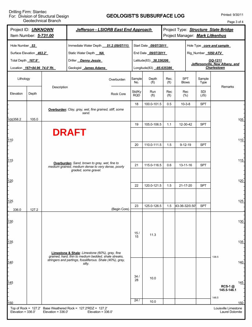
138.5
148.5
100.0-101.5
105.0-106.5
110.0-111.5
115.0-116.5
120.0-121.5
125.0-126.5
11.3
10.0
10.0
10-3-8
12-30-42
9-12-19
13-11-16
21-17-20
43-36-32/0.50'
RCS-1 @145.5-146.1
358.2
336.0
105.0
127.2
Overburden: Clay, gray, wet, fine grained, stiff, somesand.
Overburden: Sand, brown to gray, wet, fine tomedium grained, medium dense to very dense, poorly
graded, some gravel.
Limestone & Shale: Limestone (60%), gray, finegrained, hard, thin to medium bedded, shale streaks,
stringers and partings, fossiliferous. Shale (40%), gray,silty.
(Begin Core)
18
19
20
21
22
23
15 /15
34 /28
24 /
0.5
1.1
1.5
0.6
1.5
1.5
Elevation Depth Std/KyRQD
Lithology
105
110
115
120
125
130
135
140
145
150
105
110
115
120
125
130
135
140
145
150
Depth(ft)
SPTBlows
SampleType
Rec(ft)
Geologist James Adams
Hole Type core and sample
Rec(%)
Rec.(ft)
SampleNo.
Run(ft)
Description
Overburden
Rock CoreSDI(JS)
Remarks
Rig_Number 1050 ATV
Hole Number 53
Surface Elevation 463.2'
Total Depth 167.9'
End Date 09/07/2011
Latitude(83) 38.336206
Longitude(83) -85.635386
Start Date 09/07/2011
Driller Danny Jessie
GEOLOGIST'S SUBSURFACE LOG
GQ-1211Jeffersonville, New Albany, and
Charlestown
Static Water Depth NA
Louisville LimestoneLaurel Dolomite
Immediate Water Depth 51.2 (09/07/11)
Location 167+84.96 74.0' Rt.
Base Weathered Rock = 127.2'Elevation = 336.0'
Top of Rock = 127.2'Elevation = 336.0'
RDZ = 127.2'Elevation = 336.0'
Printed: 9/30/11
Page 3 of 4
Drilling Firm: StantecFor: Division of Structural Design
Geotechnical Branch
Project Type: Structure State BridgeProject Manager: Mark Litkenhus
Project ID: UNKNOWNItem Number: 5-731.00
Jefferson - LSIORB East End Approach
SPT
SPT
SPT
SPT
SPT
SPT
DRAFT

158.5
167.9
10.0
9.4
fossiliferous@
150.6-150.9
RCS-2 @167-167.6295.3 167.9
Limestone & Shale: Limestone (60%), gray, finegrained, hard, thin to medium bedded, shale streaks,
stringers and partings, fossiliferous. Shale (40%), gray,silty.
20
24 /20
32 /32
(Bottom of Hole 167.9')
Elevation Depth Std/KyRQD
Lithology
155
160
165
170
175
180
185
190
195
200
155
160
165
170
175
180
185
190
195
200
Depth(ft)
SPTBlows
SampleType
Rec(ft)
Geologist James Adams
Hole Type core and sample
Rec(%)
Rec.(ft)
SampleNo.
Run(ft)
Description
Overburden
Rock CoreSDI(JS)
Remarks
Rig_Number 1050 ATV
Hole Number 53
Surface Elevation 463.2'
Total Depth 167.9'
End Date 09/07/2011
Latitude(83) 38.336206
Longitude(83) -85.635386
Start Date 09/07/2011
Driller Danny Jessie
GEOLOGIST'S SUBSURFACE LOG
GQ-1211Jeffersonville, New Albany, and
Charlestown
Static Water Depth NA
Louisville LimestoneLaurel Dolomite
Immediate Water Depth 51.2 (09/07/11)
Location 167+84.96 74.0' Rt.
Base Weathered Rock = 127.2'Elevation = 336.0'
Top of Rock = 127.2'Elevation = 336.0'
RDZ = 127.2'Elevation = 336.0'
Printed: 9/30/11
Page 4 of 4
Drilling Firm: StantecFor: Division of Structural Design
Geotechnical Branch
Project Type: Structure State BridgeProject Manager: Mark Litkenhus
Project ID: UNKNOWNItem Number: 5-731.00
Jefferson - LSIORB East End Approach
DRAFT
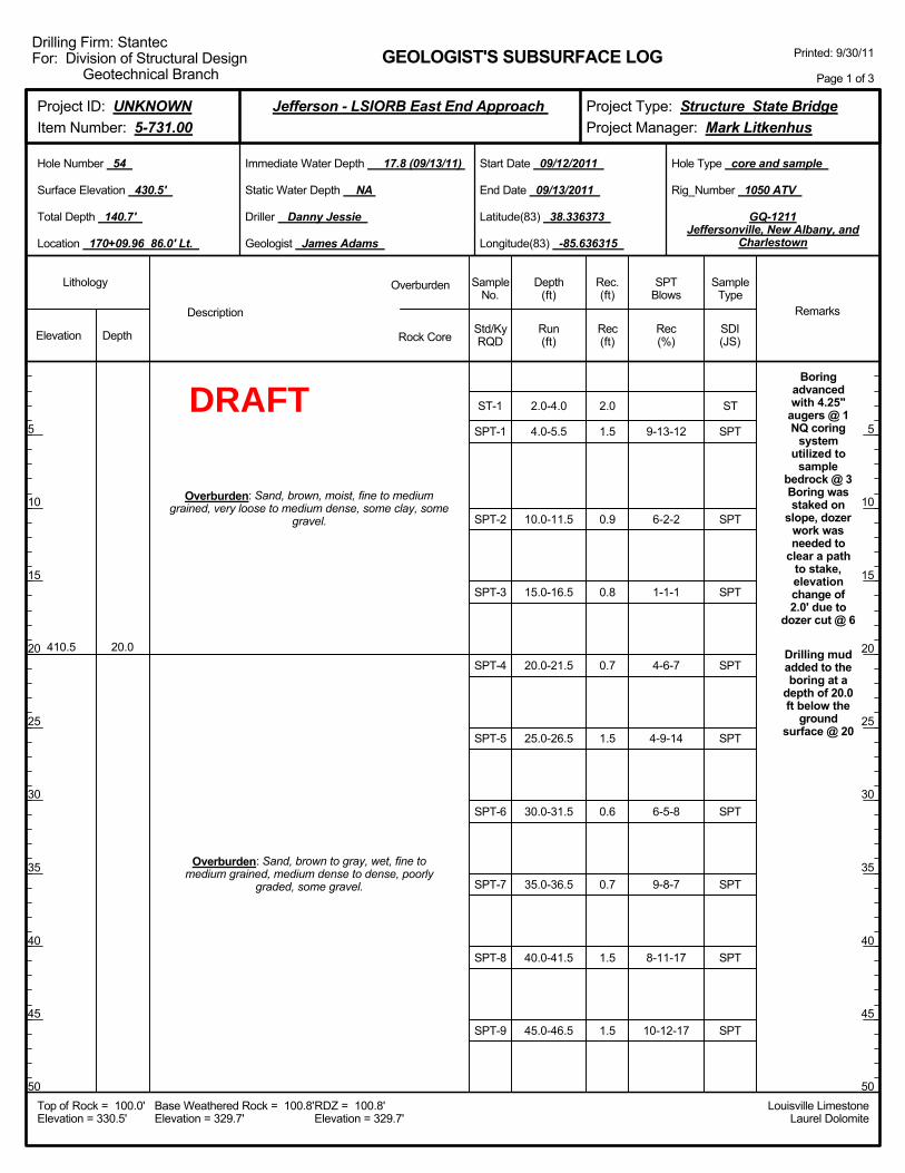
2.0-4.0
4.0-5.5
10.0-11.5
15.0-16.5
20.0-21.5
25.0-26.5
30.0-31.5
35.0-36.5
40.0-41.5
45.0-46.5
9-13-12
6-2-2
1-1-1
4-6-7
4-9-14
6-5-8
9-8-7
8-11-17
10-12-17
Boringadvancedwith 4.25"
augers @ 1NQ coring
systemutilized to
samplebedrock @ 3Boring wasstaked on
slope, dozerwork wasneeded to
clear a pathto stake,elevationchange of2.0' due to
dozer cut @ 6
Drilling mudadded to theboring at a
depth of 20.0ft below the
groundsurface @ 20
410.5 20.0
Overburden: Sand, brown, moist, fine to mediumgrained, very loose to medium dense, some clay, some
gravel.
Overburden: Sand, brown to gray, wet, fine tomedium grained, medium dense to dense, poorly
graded, some gravel.
ST-1
SPT-1
SPT-2
SPT-3
SPT-4
SPT-5
SPT-6
SPT-7
SPT-8
SPT-9
2.0
1.5
0.9
0.8
0.7
1.5
0.6
0.7
1.5
1.5
Elevation Depth Std/KyRQD
Lithology
5
10
15
20
25
30
35
40
45
50
5
10
15
20
25
30
35
40
45
50
Depth(ft)
SPTBlows
SampleType
Rec(ft)
Geologist James Adams
Hole Type core and sample
Rec(%)
Rec.(ft)
SampleNo.
Run(ft)
Description
Overburden
Rock CoreSDI(JS)
Remarks
Rig_Number 1050 ATV
Hole Number 54
Surface Elevation 430.5'
Total Depth 140.7'
End Date 09/13/2011
Latitude(83) 38.336373
Longitude(83) -85.636315
Start Date 09/12/2011
Driller Danny Jessie
GEOLOGIST'S SUBSURFACE LOG
GQ-1211Jeffersonville, New Albany, and
Charlestown
Static Water Depth NA
Louisville LimestoneLaurel Dolomite
Immediate Water Depth 17.8 (09/13/11)
Location 170+09.96 86.0' Lt.
Base Weathered Rock = 100.8'Elevation = 329.7'
Top of Rock = 100.0'Elevation = 330.5'
RDZ = 100.8'Elevation = 329.7'
Printed: 9/30/11
Page 1 of 3
Drilling Firm: StantecFor: Division of Structural Design
Geotechnical Branch
Project Type: Structure State BridgeProject Manager: Mark Litkenhus
Project ID: UNKNOWNItem Number: 5-731.00
Jefferson - LSIORB East End Approach
ST
SPT
SPT
SPT
SPT
SPT
SPT
SPT
SPT
SPT
DRAFT

50.0-51.5
55.0-56.5
60.0-61.5
65.0-66.5
70.0-71.5
75.0-76.5
80.0-81.5
85.0-86.5
90.0-91.5
95.0-96.5
9-18-15
16-18-18
10-8-13
17-8-13
18-30-31
15-18-27
13-15-15
12-13-13
17-8-8
10-8-20
330.5 100.0
Overburden: Sand, brown to gray, wet, fine tomedium grained, medium dense to dense, poorly
graded, some gravel.
(Begin Core)
SPT-10
SPT-11
SPT-12
SPT-13
SPT-14
SPT-15
SPT-16
SPT-17
SPT-18
SPT-19
1.5
1.5
1.5
1.5
1.5
1.0
1.2
1.5
1.5
1.5
Elevation Depth Std/KyRQD
Lithology
55
60
65
70
75
80
85
90
95
100
55
60
65
70
75
80
85
90
95
100
Depth(ft)
SPTBlows
SampleType
Rec(ft)
Geologist James Adams
Hole Type core and sample
Rec(%)
Rec.(ft)
SampleNo.
Run(ft)
Description
Overburden
Rock CoreSDI(JS)
Remarks
Rig_Number 1050 ATV
Hole Number 54
Surface Elevation 430.5'
Total Depth 140.7'
End Date 09/13/2011
Latitude(83) 38.336373
Longitude(83) -85.636315
Start Date 09/12/2011
Driller Danny Jessie
GEOLOGIST'S SUBSURFACE LOG
GQ-1211Jeffersonville, New Albany, and
Charlestown
Static Water Depth NA
Louisville LimestoneLaurel Dolomite
Immediate Water Depth 17.8 (09/13/11)
Location 170+09.96 86.0' Lt.
Base Weathered Rock = 100.8'Elevation = 329.7'
Top of Rock = 100.0'Elevation = 330.5'
RDZ = 100.8'Elevation = 329.7'
Printed: 9/30/11
Page 2 of 3
Drilling Firm: StantecFor: Division of Structural Design
Geotechnical Branch
Project Type: Structure State BridgeProject Manager: Mark Litkenhus
Project ID: UNKNOWNItem Number: 5-731.00
Jefferson - LSIORB East End Approach
SPT
SPT
SPT
SPT
SPT
SPT
SPT
SPT
SPT
SPT
DRAFT
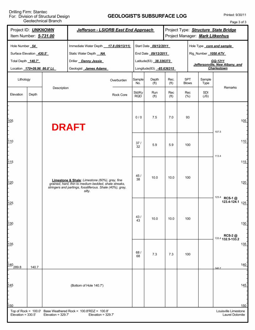
107.5
113.4
123.4
133.4
140.7
7.5
5.9
10.0
10.0
7.3
93
100
100
100
100
RCS-1 @123.4-124.1
RCS-2 @132.5-133.2
289.8 140.7
Limestone & Shale: Limestone (60%), gray, finegrained, hard, thin to medium bedded, shale streaks,
stringers and partings, fossiliferous. Shale (40%), gray,silty.
0 / 0
37 /32
45 /38
43 /43
68 /68
(Bottom of Hole 140.7')
7.0
5.9
10.0
10.0
7.3
Elevation Depth Std/KyRQD
Lithology
105
110
115
120
125
130
135
140
145
150
105
110
115
120
125
130
135
140
145
150
Depth(ft)
SPTBlows
SampleType
Rec(ft)
Geologist James Adams
Hole Type core and sample
Rec(%)
Rec.(ft)
SampleNo.
Run(ft)
Description
Overburden
Rock CoreSDI(JS)
Remarks
Rig_Number 1050 ATV
Hole Number 54
Surface Elevation 430.5'
Total Depth 140.7'
End Date 09/13/2011
Latitude(83) 38.336373
Longitude(83) -85.636315
Start Date 09/12/2011
Driller Danny Jessie
GEOLOGIST'S SUBSURFACE LOG
GQ-1211Jeffersonville, New Albany, and
Charlestown
Static Water Depth NA
Louisville LimestoneLaurel Dolomite
Immediate Water Depth 17.8 (09/13/11)
Location 170+09.96 86.0' Lt.
Base Weathered Rock = 100.8'Elevation = 329.7'
Top of Rock = 100.0'Elevation = 330.5'
RDZ = 100.8'Elevation = 329.7'
Printed: 9/30/11
Page 3 of 3
Drilling Firm: StantecFor: Division of Structural Design
Geotechnical Branch
Project Type: Structure State BridgeProject Manager: Mark Litkenhus
Project ID: UNKNOWNItem Number: 5-731.00
Jefferson - LSIORB East End Approach
DRAFT
Boringadvancedwith 4.25"
augers @ 1NQ coring
systemutilized to
samplebedrock @ 3Boring wasstaked on
slope, dozerwork wasneeded to
clear a pathto stake,
boring movedahead station
8.0' fromstake toprovide
working area,elevationchange of3.0' due to
dozer cut @ 6
Drilling mudadded to theboring at a
depth of 30.0ft below the
groundsurface @ 30
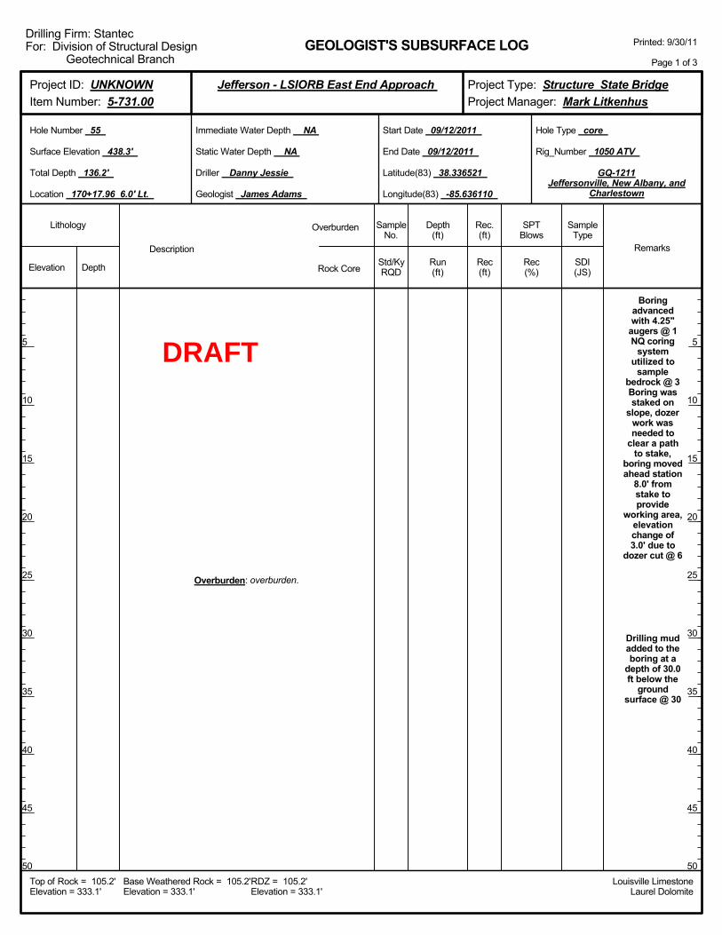
Overburden: overburden.
Elevation Depth Std/KyRQD
Lithology
5
10
15
20
25
30
35
40
45
50
5
10
15
20
25
30
35
40
45
50
Depth(ft)
SPTBlows
SampleType
Rec(ft)
Geologist James Adams
Hole Type core
Rec(%)
Rec.(ft)
SampleNo.
Run(ft)
Description
Overburden
Rock CoreSDI(JS)
Remarks
Rig_Number 1050 ATV
Hole Number 55
Surface Elevation 438.3'
Total Depth 136.2'
End Date 09/12/2011
Latitude(83) 38.336521
Longitude(83) -85.636110
Start Date 09/12/2011
Driller Danny Jessie
GEOLOGIST'S SUBSURFACE LOG
GQ-1211Jeffersonville, New Albany, and
Charlestown
Static Water Depth NA
Louisville LimestoneLaurel Dolomite
Immediate Water Depth NA
Location 170+17.96 6.0' Lt.
Base Weathered Rock = 105.2'Elevation = 333.1'
Top of Rock = 105.2'Elevation = 333.1'
RDZ = 105.2'Elevation = 333.1'
Printed: 9/30/11
Page 1 of 3
Drilling Firm: StantecFor: Division of Structural Design
Geotechnical Branch
Project Type: Structure State BridgeProject Manager: Mark Litkenhus
Project ID: UNKNOWNItem Number: 5-731.00
Jefferson - LSIORB East End Approach
DRAFT

Overburden: overburden.
Elevation Depth Std/KyRQD
Lithology
55
60
65
70
75
80
85
90
95
100
55
60
65
70
75
80
85
90
95
100
Depth(ft)
SPTBlows
SampleType
Rec(ft)
Geologist James Adams
Hole Type core
Rec(%)
Rec.(ft)
SampleNo.
Run(ft)
Description
Overburden
Rock CoreSDI(JS)
Remarks
Rig_Number 1050 ATV
Hole Number 55
Surface Elevation 438.3'
Total Depth 136.2'
End Date 09/12/2011
Latitude(83) 38.336521
Longitude(83) -85.636110
Start Date 09/12/2011
Driller Danny Jessie
GEOLOGIST'S SUBSURFACE LOG
GQ-1211Jeffersonville, New Albany, and
Charlestown
Static Water Depth NA
Louisville LimestoneLaurel Dolomite
Immediate Water Depth NA
Location 170+17.96 6.0' Lt.
Base Weathered Rock = 105.2'Elevation = 333.1'
Top of Rock = 105.2'Elevation = 333.1'
RDZ = 105.2'Elevation = 333.1'
Printed: 9/30/11
Page 2 of 3
Drilling Firm: StantecFor: Division of Structural Design
Geotechnical Branch
Project Type: Structure State BridgeProject Manager: Mark Litkenhus
Project ID: UNKNOWNItem Number: 5-731.00
Jefferson - LSIORB East End Approach
DRAFT
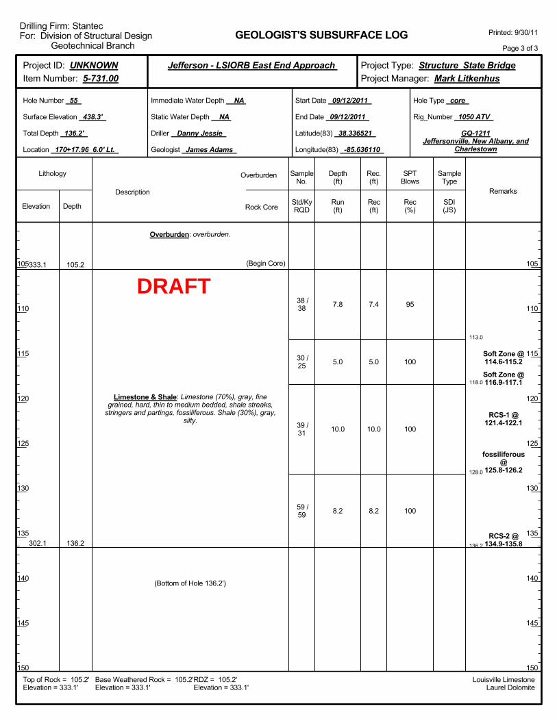
113.0
118.0
128.0
136.2
7.8
5.0
10.0
8.2
95
100
100
100
Soft Zone @114.6-115.2
Soft Zone @116.9-117.1
RCS-1 @121.4-122.1
fossiliferous@
125.8-126.2
RCS-2 @134.9-135.8
333.1
302.1
105.2
136.2
Overburden: overburden.
Limestone & Shale: Limestone (70%), gray, finegrained, hard, thin to medium bedded, shale streaks,
stringers and partings, fossiliferous. Shale (30%), gray,silty.
(Begin Core)
38 /38
30 /25
39 /31
59 /59
(Bottom of Hole 136.2')
7.4
5.0
10.0
8.2
Elevation Depth Std/KyRQD
Lithology
105
110
115
120
125
130
135
140
145
150
105
110
115
120
125
130
135
140
145
150
Depth(ft)
SPTBlows
SampleType
Rec(ft)
Geologist James Adams
Hole Type core
Rec(%)
Rec.(ft)
SampleNo.
Run(ft)
Description
Overburden
Rock CoreSDI(JS)
Remarks
Rig_Number 1050 ATV
Hole Number 55
Surface Elevation 438.3'
Total Depth 136.2'
End Date 09/12/2011
Latitude(83) 38.336521
Longitude(83) -85.636110
Start Date 09/12/2011
Driller Danny Jessie
GEOLOGIST'S SUBSURFACE LOG
GQ-1211Jeffersonville, New Albany, and
Charlestown
Static Water Depth NA
Louisville LimestoneLaurel Dolomite
Immediate Water Depth NA
Location 170+17.96 6.0' Lt.
Base Weathered Rock = 105.2'Elevation = 333.1'
Top of Rock = 105.2'Elevation = 333.1'
RDZ = 105.2'Elevation = 333.1'
Printed: 9/30/11
Page 3 of 3
Drilling Firm: StantecFor: Division of Structural Design
Geotechnical Branch
Project Type: Structure State BridgeProject Manager: Mark Litkenhus
Project ID: UNKNOWNItem Number: 5-731.00
Jefferson - LSIORB East End Approach
DRAFT
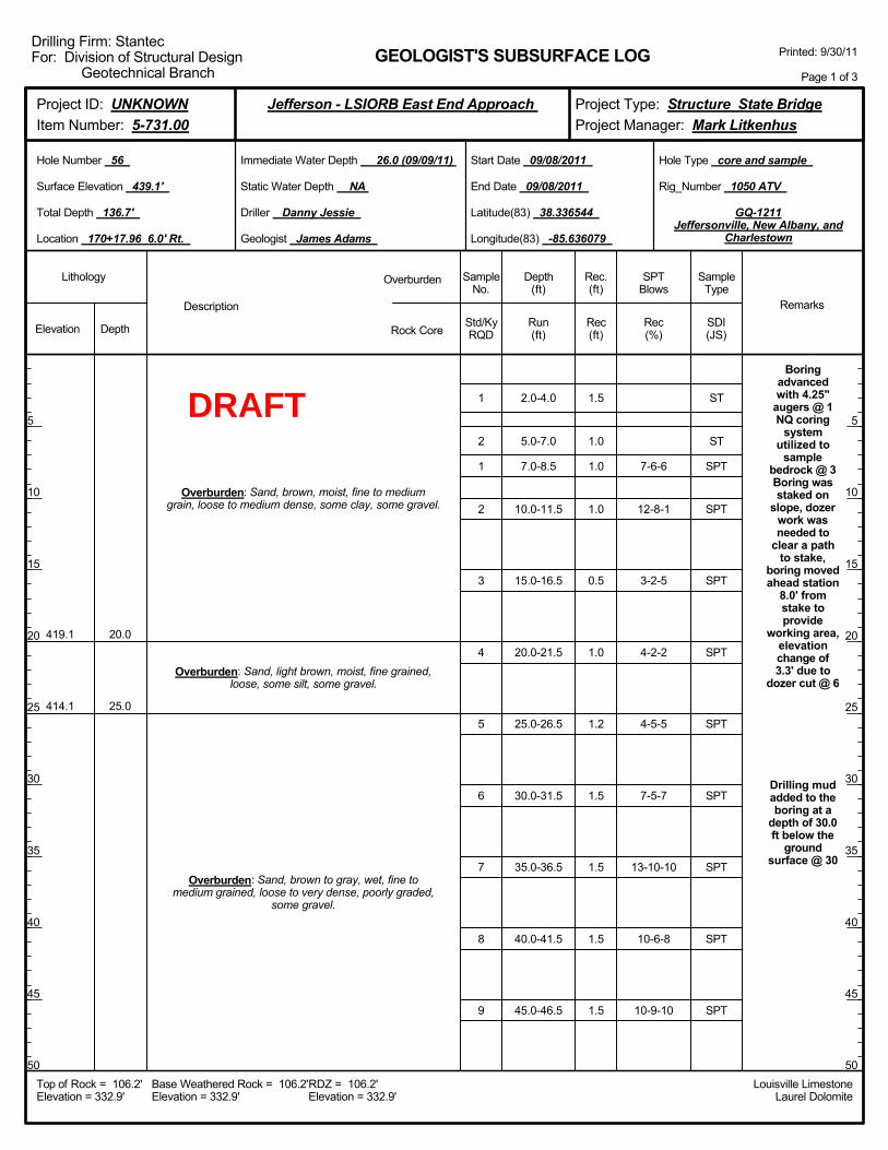
2.0-4.0
5.0-7.0
7.0-8.5
10.0-11.5
15.0-16.5
20.0-21.5
25.0-26.5
30.0-31.5
35.0-36.5
40.0-41.5
45.0-46.5
7-6-6
12-8-1
3-2-5
4-2-2
4-5-5
7-5-7
13-10-10
10-6-8
10-9-10
Boringadvancedwith 4.25"
augers @ 1NQ coring
systemutilized to
samplebedrock @ 3Boring wasstaked on
slope, dozerwork wasneeded to
clear a pathto stake,
boring movedahead station
8.0' fromstake toprovide
working area,elevationchange of3.3' due to
dozer cut @ 6
Drilling mudadded to theboring at a
depth of 30.0ft below the
groundsurface @ 30
419.1
414.1
20.0
25.0
Overburden: Sand, brown, moist, fine to mediumgrain, loose to medium dense, some clay, some gravel.
Overburden: Sand, light brown, moist, fine grained,loose, some silt, some gravel.
Overburden: Sand, brown to gray, wet, fine tomedium grained, loose to very dense, poorly graded,
some gravel.
1
2
1
2
3
4
5
6
7
8
9
1.5
1.0
1.0
1.0
0.5
1.0
1.2
1.5
1.5
1.5
1.5
Elevation Depth Std/KyRQD
Lithology
5
10
15
20
25
30
35
40
45
50
5
10
15
20
25
30
35
40
45
50
Depth(ft)
SPTBlows
SampleType
Rec(ft)
Geologist James Adams
Hole Type core and sample
Rec(%)
Rec.(ft)
SampleNo.
Run(ft)
Description
Overburden
Rock CoreSDI(JS)
Remarks
Rig_Number 1050 ATV
Hole Number 56
Surface Elevation 439.1'
Total Depth 136.7'
End Date 09/08/2011
Latitude(83) 38.336544
Longitude(83) -85.636079
Start Date 09/08/2011
Driller Danny Jessie
GEOLOGIST'S SUBSURFACE LOG
GQ-1211Jeffersonville, New Albany, and
Charlestown
Static Water Depth NA
Louisville LimestoneLaurel Dolomite
Immediate Water Depth 26.0 (09/09/11)
Location 170+17.96 6.0' Rt.
Base Weathered Rock = 106.2'Elevation = 332.9'
Top of Rock = 106.2'Elevation = 332.9'
RDZ = 106.2'Elevation = 332.9'
Printed: 9/30/11
Page 1 of 3
Drilling Firm: StantecFor: Division of Structural Design
Geotechnical Branch
Project Type: Structure State BridgeProject Manager: Mark Litkenhus
Project ID: UNKNOWNItem Number: 5-731.00
Jefferson - LSIORB East End Approach
ST
ST
SPT
SPT
SPT
SPT
SPT
SPT
SPT
SPT
SPT
DRAFT
50.0-51.5
55.0-56.5
60.0-61.5
65.0-66.5
70.0-71.5
75.0-76.5
80.0-81.5
85.0-86.5
90.0-91.5
95.0-96.5
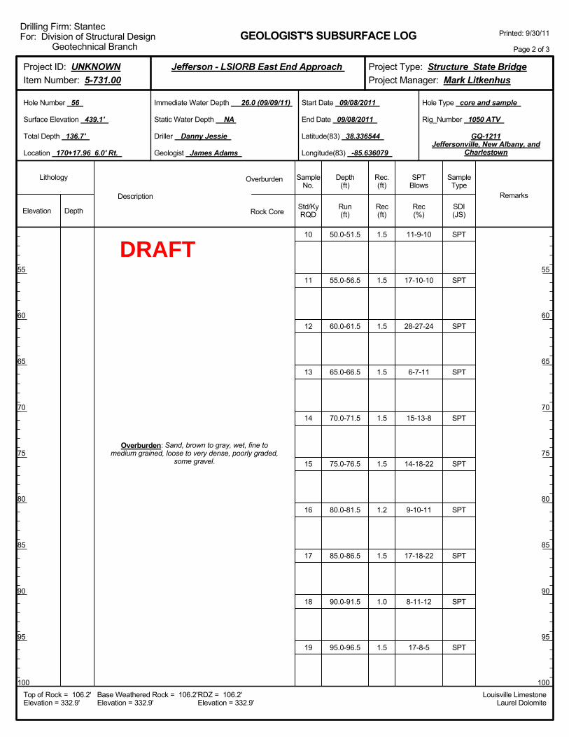
11-9-10
17-10-10
28-27-24
6-7-11
15-13-8
14-18-22
9-10-11
17-18-22
8-11-12
17-8-5
Overburden: Sand, brown to gray, wet, fine tomedium grained, loose to very dense, poorly graded,
some gravel.
10
11
12
13
14
15
16
17
18
19
1.5
1.5
1.5
1.5
1.5
1.5
1.2
1.5
1.0
1.5
Elevation Depth Std/KyRQD
Lithology
55
60
65
70
75
80
85
90
95
100
55
60
65
70
75
80
85
90
95
100
Depth(ft)
SPTBlows
SampleType
Rec(ft)
Geologist James Adams
Hole Type core and sample
Rec(%)
Rec.(ft)
SampleNo.
Run(ft)
Description
Overburden
Rock CoreSDI(JS)
Remarks
Rig_Number 1050 ATV
Hole Number 56
Surface Elevation 439.1'
Total Depth 136.7'
End Date 09/08/2011
Latitude(83) 38.336544
Longitude(83) -85.636079
Start Date 09/08/2011
Driller Danny Jessie
GEOLOGIST'S SUBSURFACE LOG
GQ-1211Jeffersonville, New Albany, and
Charlestown
Static Water Depth NA
Louisville LimestoneLaurel Dolomite
Immediate Water Depth 26.0 (09/09/11)
Location 170+17.96 6.0' Rt.
Base Weathered Rock = 106.2'Elevation = 332.9'
Top of Rock = 106.2'Elevation = 332.9'
RDZ = 106.2'Elevation = 332.9'
Printed: 9/30/11
Page 2 of 3
Drilling Firm: StantecFor: Division of Structural Design
Geotechnical Branch
Project Type: Structure State BridgeProject Manager: Mark Litkenhus
Project ID: UNKNOWNItem Number: 5-731.00
Jefferson - LSIORB East End Approach
SPT
SPT
SPT
SPT
SPT
SPT
SPT
SPT
SPT
SPT
DRAFT
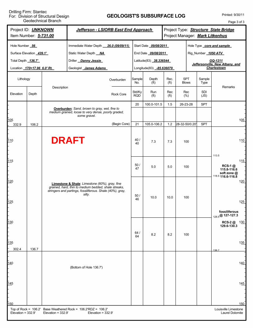
113.5
118.5
128.5
136.7
100.0-101.5
105.0-106.2
7.3
5.0
10.0
8.2
26-23-28
28-32-50/0.20'
100
100
100
100
RCS-1 @115.8-116.6soft zone @116.6-116.8
fossiliferous@ 127-127.3
RCS-2 @129.6-130.3
332.9
302.4
106.2
136.7
Overburden: Sand, brown to gray, wet, fine tomedium grained, loose to very dense, poorly graded,
some gravel.
Limestone & Shale: Limestone (60%), gray, finegrained, hard, thin to medium bedded, shale streaks,
stringers and partings, fossiliferous. Shale (40%), gray,silty.
(Begin Core)
20
21
40 /40
50 /47
50 /46
64 /64
(Bottom of Hole 136.7')
1.5
1.2
7.3
5.0
10.0
8.2
Elevation Depth Std/KyRQD
Lithology
105
110
115
120
125
130
135
140
145
150
105
110
115
120
125
130
135
140
145
150
Depth(ft)
SPTBlows
SampleType
Rec(ft)
Geologist James Adams
Hole Type core and sample
Rec(%)
Rec.(ft)
SampleNo.
Run(ft)
Description
Overburden
Rock CoreSDI(JS)
Remarks
Rig_Number 1050 ATV
Hole Number 56
Surface Elevation 439.1'
Total Depth 136.7'
End Date 09/08/2011
Latitude(83) 38.336544
Longitude(83) -85.636079
Start Date 09/08/2011
Driller Danny Jessie
GEOLOGIST'S SUBSURFACE LOG
GQ-1211Jeffersonville, New Albany, and
Charlestown
Static Water Depth NA
Louisville LimestoneLaurel Dolomite
Immediate Water Depth 26.0 (09/09/11)
Location 170+17.96 6.0' Rt.
Base Weathered Rock = 106.2'Elevation = 332.9'
Top of Rock = 106.2'Elevation = 332.9'
RDZ = 106.2'Elevation = 332.9'
Printed: 9/30/11
Page 3 of 3
Drilling Firm: StantecFor: Division of Structural Design
Geotechnical Branch
Project Type: Structure State BridgeProject Manager: Mark Litkenhus
Project ID: UNKNOWNItem Number: 5-731.00
Jefferson - LSIORB East End Approach
SPT
SPT
DRAFT
Boringadvancedwith 4.25"
augers @ 1NQ coring
systemutilized to
samplebedrock @ 3Boring wasdrilled on
slope, dozerwork wasneeded to
clear a pathto stake,
boring offset8.5' fromstake toprovide
working area,elevation
change 3.0'due to dozer
cut @ 6
Drilling mudadded to theboring at a
depth of 45.0ft below the
ground
Overburden: overburden.
Elevation Depth Std/KyRQD
Lithology
5
10
15
20
25
30
35
40
45
50
5
10
15
20
25
30
35
40
45
50
Depth(ft)
SPTBlows
SampleType
Rec(ft)
Geologist James Adams
Hole Type core
Rec(%)
Rec.(ft)
SampleNo.
Run(ft)
Description
Overburden
Rock CoreSDI(JS)
Remarks
Rig_Number 1050 ATV
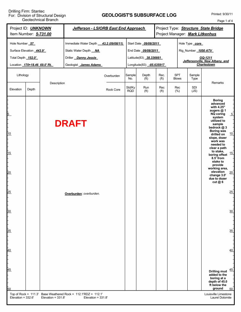
Hole Number 57
Surface Elevation 443.9'
Total Depth 152.0'
End Date 09/08/2011
Latitude(83) 38.336661
Longitude(83) -85.635917
Start Date 09/08/2011
Driller Danny Jessie
GEOLOGIST'S SUBSURFACE LOG
GQ-1211Jeffersonville, New Albany, and
Charlestown
Static Water Depth NA
Louisville LimestoneLaurel Dolomite
Immediate Water Depth 43.2 (09/08/11)
Location 170+18.46 69.0' Rt.
Base Weathered Rock = 112.1'Elevation = 331.8'
Top of Rock = 111.3'Elevation = 332.6'
RDZ = 112.1'Elevation = 331.8'
Printed: 9/30/11
Page 1 of 4
Drilling Firm: StantecFor: Division of Structural Design
Geotechnical Branch
Project Type: Structure State BridgeProject Manager: Mark Litkenhus
Project ID: UNKNOWNItem Number: 5-731.00
Jefferson - LSIORB East End Approach
DRAFT
surface @ 45
Overburden: overburden.
Elevation Depth Std/KyRQD
Lithology
55
60
65
70
75
80
85
90
95
100
55
60
65
70
75
80
85
90
95
100
Depth(ft)
SPTBlows
SampleType
Rec(ft)
Geologist James Adams
Hole Type core
Rec(%)
Rec.(ft)
SampleNo.
Run(ft)
Description
Overburden
Rock CoreSDI(JS)
Remarks
Rig_Number 1050 ATV
Hole Number 57
Surface Elevation 443.9'
Total Depth 152.0'
End Date 09/08/2011
Latitude(83) 38.336661
Longitude(83) -85.635917
Start Date 09/08/2011
Driller Danny Jessie
GEOLOGIST'S SUBSURFACE LOG
GQ-1211Jeffersonville, New Albany, and
Charlestown
Static Water Depth NA
Louisville LimestoneLaurel Dolomite
Immediate Water Depth 43.2 (09/08/11)
Location 170+18.46 69.0' Rt.
Base Weathered Rock = 112.1'Elevation = 331.8'
Top of Rock = 111.3'Elevation = 332.6'
RDZ = 112.1'Elevation = 331.8'
Printed: 9/30/11
Page 2 of 4
Drilling Firm: StantecFor: Division of Structural Design
Geotechnical Branch
Project Type: Structure State BridgeProject Manager: Mark Litkenhus
Project ID: UNKNOWNItem Number: 5-731.00
Jefferson - LSIORB East End Approach
DRAFT
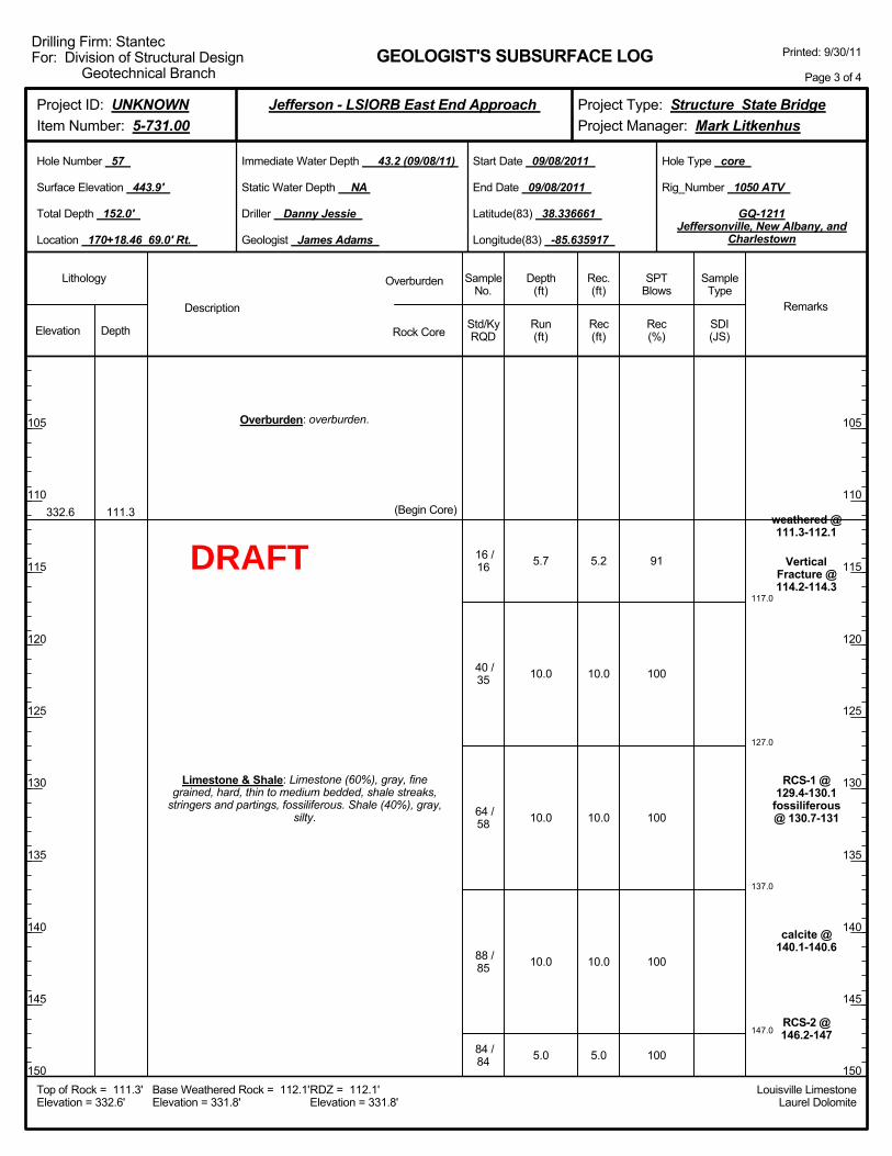
117.0
127.0
137.0
147.0
5.7
10.0
10.0
10.0
5.0
91
100
100
100
100
weathered @111.3-112.1
VerticalFracture @114.2-114.3
RCS-1 @129.4-130.1
fossiliferous@ 130.7-131
calcite @140.1-140.6
RCS-2 @146.2-147
332.6 111.3
Overburden: overburden.
Limestone & Shale: Limestone (60%), gray, finegrained, hard, thin to medium bedded, shale streaks,
stringers and partings, fossiliferous. Shale (40%), gray,silty.
(Begin Core)
16 /16
40 /35
64 /58
88 /85
84 /84
5.2
10.0
10.0
10.0
5.0
Elevation Depth Std/KyRQD
Lithology
105
110
115
120
125
130
135
140
145
150
105
110
115
120
125
130
135
140
145
150
Depth(ft)
SPTBlows
SampleType
Rec(ft)
Geologist James Adams
Hole Type core
Rec(%)
Rec.(ft)
SampleNo.
Run(ft)
Description
Overburden
Rock CoreSDI(JS)
Remarks
Rig_Number 1050 ATV
Hole Number 57
Surface Elevation 443.9'
Total Depth 152.0'
End Date 09/08/2011
Latitude(83) 38.336661
Longitude(83) -85.635917
Start Date 09/08/2011
Driller Danny Jessie
GEOLOGIST'S SUBSURFACE LOG
GQ-1211Jeffersonville, New Albany, and
Charlestown
Static Water Depth NA
Louisville LimestoneLaurel Dolomite
Immediate Water Depth 43.2 (09/08/11)
Location 170+18.46 69.0' Rt.
Base Weathered Rock = 112.1'Elevation = 331.8'
Top of Rock = 111.3'Elevation = 332.6'
RDZ = 112.1'Elevation = 331.8'
Printed: 9/30/11
Page 3 of 4
Drilling Firm: StantecFor: Division of Structural Design
Geotechnical Branch
Project Type: Structure State BridgeProject Manager: Mark Litkenhus
Project ID: UNKNOWNItem Number: 5-731.00
Jefferson - LSIORB East End Approach
DRAFT
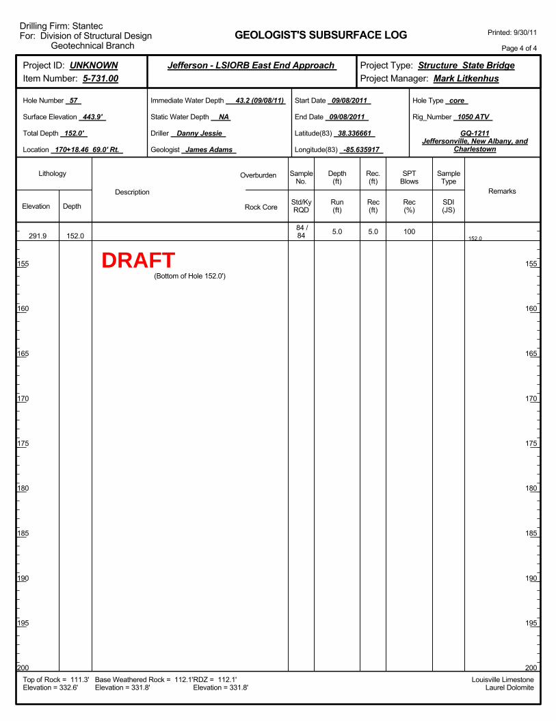
152.05.0 100291.9 152.0
84 /84
(Bottom of Hole 152.0')
5.0
Elevation Depth Std/KyRQD
Lithology
155
160
165
170
175
180
185
190
195
200
155
160
165
170
175
180
185
190
195
200
Depth(ft)
SPTBlows
SampleType
Rec(ft)
Geologist James Adams
Hole Type core
Rec(%)
Rec.(ft)
SampleNo.
Run(ft)
Description
Overburden
Rock CoreSDI(JS)
Remarks
Rig_Number 1050 ATV
Hole Number 57
Surface Elevation 443.9'
Total Depth 152.0'
End Date 09/08/2011
Latitude(83) 38.336661
Longitude(83) -85.635917
Start Date 09/08/2011
Driller Danny Jessie
GEOLOGIST'S SUBSURFACE LOG
GQ-1211Jeffersonville, New Albany, and
Charlestown
Static Water Depth NA
Louisville LimestoneLaurel Dolomite
Immediate Water Depth 43.2 (09/08/11)
Location 170+18.46 69.0' Rt.
Base Weathered Rock = 112.1'Elevation = 331.8'
Top of Rock = 111.3'Elevation = 332.6'
RDZ = 112.1'Elevation = 331.8'
Printed: 9/30/11
Page 4 of 4
Drilling Firm: StantecFor: Division of Structural Design
Geotechnical Branch
Project Type: Structure State BridgeProject Manager: Mark Litkenhus
Project ID: UNKNOWNItem Number: 5-731.00
Jefferson - LSIORB East End Approach
DRAFT
Boringadvancedwith 4.25"
augers @ 1NQ coring
systemutilized to
samplebedrock @ 3
Drilling mudadded to theboring at a
depth of 20.0ft below the
groundsurface @ 20Overburden: overburden.
Elevation Depth Std/KyRQD
Lithology
5
10
15
20
25
30
35
40
45
50
5
10
15
20
25
30
35
40
45
50
Depth(ft)
SPTBlows
SampleType
Rec(ft)
Geologist James Adams
Hole Type core
Rec(%)
Rec.(ft)
SampleNo.
Run(ft)
Description
Overburden
Rock CoreSDI(JS)
Remarks
Rig_Number 1050 ATV
Hole Number 58
Surface Elevation 429.0'
Total Depth 136.0'
End Date 08/29/2011
Latitude(83) 38.336929
Longitude(83) -85.636964
Start Date 08/26/2011
Driller Danny Jessie
GEOLOGIST'S SUBSURFACE LOG
GQ-1211Jeffersonville, New Albany, and
Charlestown
Static Water Depth NA
Louisville LimestoneLaurel Dolomite
Immediate Water Depth 15.3 (08/29/11)
Location 172+84.96 86.0' Lt.
Base Weathered Rock = 97.2'Elevation = 331.8'
Top of Rock = 96.0'Elevation = 333.0'
RDZ = 97.2'Elevation = 331.8'
Printed: 9/30/11
Page 1 of 3
Drilling Firm: StantecFor: Division of Structural Design
Geotechnical Branch
Project Type: Structure State BridgeProject Manager: Mark Litkenhus
Project ID: UNKNOWNItem Number: 5-731.00
Jefferson - LSIORB East End Approach
DRAFT
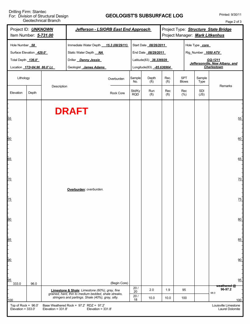
98.02.0
10.0
95
100
weathered @96-97.2
333.0 96.0
Overburden: overburden.
Limestone & Shale: Limestone (60%), gray, finegrained, hard, thin to medium bedded, shale streaks,
stringers and partings. Shale (40%), gray, silty.
(Begin Core)20 /2020 /18
1.9
10.0
Elevation Depth Std/KyRQD
Lithology
55
60
65
70
75
80
85
90
95
100
55
60
65
70
75
80
85
90
95
100
Depth(ft)
SPTBlows
SampleType
Rec(ft)
Geologist James Adams
Hole Type core
Rec(%)
Rec.(ft)
SampleNo.
Run(ft)
Description
Overburden
Rock CoreSDI(JS)
Remarks
Rig_Number 1050 ATV
Hole Number 58
Surface Elevation 429.0'
Total Depth 136.0'
End Date 08/29/2011
Latitude(83) 38.336929
Longitude(83) -85.636964
Start Date 08/26/2011
Driller Danny Jessie
GEOLOGIST'S SUBSURFACE LOG
GQ-1211Jeffersonville, New Albany, and
Charlestown
Static Water Depth NA
Louisville LimestoneLaurel Dolomite
Immediate Water Depth 15.3 (08/29/11)
Location 172+84.96 86.0' Lt.
Base Weathered Rock = 97.2'Elevation = 331.8'
Top of Rock = 96.0'Elevation = 333.0'
RDZ = 97.2'Elevation = 331.8'
Printed: 9/30/11
Page 2 of 3
Drilling Firm: StantecFor: Division of Structural Design
Geotechnical Branch
Project Type: Structure State BridgeProject Manager: Mark Litkenhus
Project ID: UNKNOWNItem Number: 5-731.00
Jefferson - LSIORB East End Approach
DRAFT

108.0
118.0
128.0
136.0
10.0
10.0
10.0
8.0
100
100
97
100
Soft Zone @106.1-106.2
RCS-1 @112-112.8
RCS-2 @128.6-129.6
293.0 136.0
Limestone & Shale: Limestone (60%), gray, finegrained, hard, thin to medium bedded, shale streaks,
stringers and partings. Shale (40%), gray, silty.
20 /18
42 /34
75 /70
86 /86
(Bottom of Hole 136.0')
10.0
10.0
9.7
8.0
Elevation Depth Std/KyRQD
Lithology
105
110
115
120
125
130
135
140
145
150
105
110
115
120
125
130
135
140
145
150
Depth(ft)
SPTBlows
SampleType
Rec(ft)
Geologist James Adams
Hole Type core
Rec(%)
Rec.(ft)
SampleNo.
Run(ft)
Description
Overburden
Rock CoreSDI(JS)
Remarks
Rig_Number 1050 ATV
Hole Number 58
Surface Elevation 429.0'
Total Depth 136.0'
End Date 08/29/2011
Latitude(83) 38.336929
Longitude(83) -85.636964
Start Date 08/26/2011
Driller Danny Jessie
GEOLOGIST'S SUBSURFACE LOG
GQ-1211Jeffersonville, New Albany, and
Charlestown
Static Water Depth NA
Louisville LimestoneLaurel Dolomite
Immediate Water Depth 15.3 (08/29/11)
Location 172+84.96 86.0' Lt.
Base Weathered Rock = 97.2'Elevation = 331.8'
Top of Rock = 96.0'Elevation = 333.0'
RDZ = 97.2'Elevation = 331.8'
Printed: 9/30/11
Page 3 of 3
Drilling Firm: StantecFor: Division of Structural Design
Geotechnical Branch
Project Type: Structure State BridgeProject Manager: Mark Litkenhus
Project ID: UNKNOWNItem Number: 5-731.00
Jefferson - LSIORB East End Approach
DRAFT
2.0-4.0
5.0-7.0
10.0-12.0
15.0-17.0
17.0-18.5
20.0-21.5
25.0-26.5
30.0-31.5
35.0-36.5
40.0-41.5
45.0-46.5
0-0-0
2-4-6
2-5-9
5-9-11
7-11-12
6-8-10
7-5-7
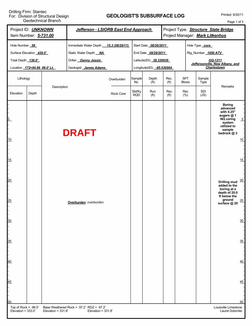
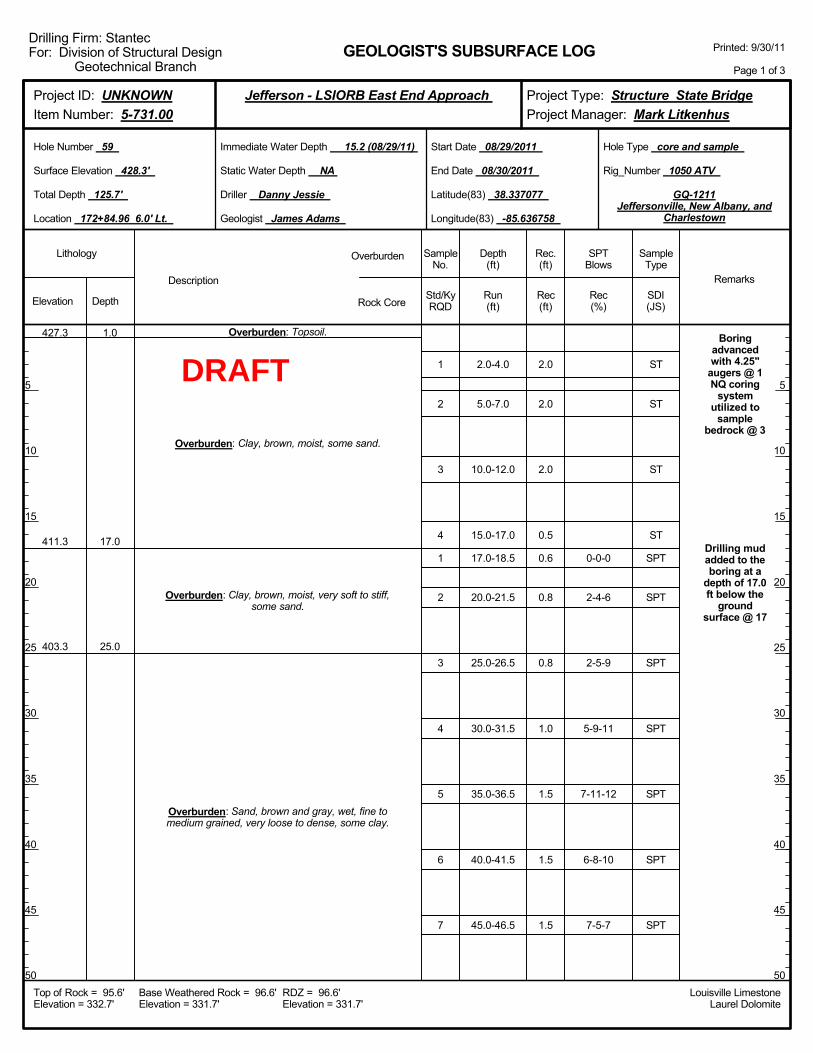
Boringadvancedwith 4.25"
augers @ 1NQ coring
systemutilized to
samplebedrock @ 3
Drilling mudadded to theboring at a
depth of 17.0ft below the
groundsurface @ 17
427.3
411.3
403.3
1.0
17.0
25.0
Overburden: Topsoil.
Overburden: Clay, brown, moist, some sand.
Overburden: Clay, brown, moist, very soft to stiff,some sand.
Overburden: Sand, brown and gray, wet, fine tomedium grained, very loose to dense, some clay.
1
2
3
4
1
2
3
4
5
6
7
2.0
2.0
2.0
0.5
0.6
0.8
0.8
1.0
1.5
1.5
1.5
Elevation Depth Std/KyRQD
Lithology
5
10
15
20
25
30
35
40
45
50
5
10
15
20
25
30
35
40
45
50
Depth(ft)
SPTBlows
SampleType
Rec(ft)
Geologist James Adams
Hole Type core and sample
Rec(%)
Rec.(ft)
SampleNo.
Run(ft)
Description
Overburden
Rock CoreSDI(JS)
Remarks
Rig_Number 1050 ATV
Hole Number 59
Surface Elevation 428.3'
Total Depth 125.7'
End Date 08/30/2011
Latitude(83) 38.337077
Longitude(83) -85.636758
Start Date 08/29/2011
Driller Danny Jessie
GEOLOGIST'S SUBSURFACE LOG
GQ-1211Jeffersonville, New Albany, and
Charlestown
Static Water Depth NA
Louisville LimestoneLaurel Dolomite
Immediate Water Depth 15.2 (08/29/11)
Location 172+84.96 6.0' Lt.
Base Weathered Rock = 96.6'Elevation = 331.7'
Top of Rock = 95.6'Elevation = 332.7'
RDZ = 96.6'Elevation = 331.7'
Printed: 9/30/11
Page 1 of 3
Drilling Firm: StantecFor: Division of Structural Design
Geotechnical Branch
Project Type: Structure State BridgeProject Manager: Mark Litkenhus
Project ID: UNKNOWNItem Number: 5-731.00
Jefferson - LSIORB East End Approach
ST
ST
ST
ST
SPT
SPT
SPT
SPT
SPT
SPT
SPT
DRAFT
98.2
50.0-51.5
55.0-56.5
60.0-61.5
65.0-66.5
70.0-71.5
75.0-76.5
80.0-81.5
85.0-86.5
90.0-91.5
95.0-95.6
2.6
10.0
10-17-15
7-8-10
15-13-14
16-11-8
0-0-4
5-17-17
8-12-13
8-8-11
7-11-19
15-50/0.10'
100
100
Rock inbottom of
split-spoon@ 95-96
weathered @95.6-96.6
358.3
348.3
332.7
70.0
80.0
95.6
Overburden: Sand, brown and gray, wet, fine tomedium grained, very loose to dense, some clay.
Overburden: Clay, dark gray, wet, soft to hard, somesilt.
Overburden: Sand, brown to gray, wet, fine tomedium grained, medium dense to very dense, poorly
graded, some gravel.
Limestone & Shale: Limestone (60%), gray, finegrained, hard, thin to medium bedded, shale streaks,
stringers and partings, fossiliferous. Shale (40%), gray,silty.
(Begin Core)
8
9
10
11
12
13
14
15
16
17
0 / 0
24 /22
1.5
1.5
1.5
1.5
1.5
1.5
1.5
1.2
0.8
0.6
2.6
10.0
Elevation Depth Std/KyRQD
Lithology
55
60
65
70
75
80
85
90
95
100
55
60
65
70
75
80
85
90
95
100
Depth(ft)
SPTBlows
SampleType
Rec(ft)
Geologist James Adams
Hole Type core and sample
Rec(%)
Rec.(ft)
SampleNo.
Run(ft)
Description
Overburden
Rock CoreSDI(JS)
Remarks
Rig_Number 1050 ATV
Hole Number 59
Surface Elevation 428.3'
Total Depth 125.7'
End Date 08/30/2011
Latitude(83) 38.337077
Longitude(83) -85.636758
Start Date 08/29/2011
Driller Danny Jessie
GEOLOGIST'S SUBSURFACE LOG
GQ-1211Jeffersonville, New Albany, and
Charlestown
Static Water Depth NA
Louisville LimestoneLaurel Dolomite
Immediate Water Depth 15.2 (08/29/11)
Location 172+84.96 6.0' Lt.
Base Weathered Rock = 96.6'Elevation = 331.7'
Top of Rock = 95.6'Elevation = 332.7'
RDZ = 96.6'Elevation = 331.7'
Printed: 9/30/11
Page 2 of 3
Drilling Firm: StantecFor: Division of Structural Design
Geotechnical Branch
Project Type: Structure State BridgeProject Manager: Mark Litkenhus
Project ID: UNKNOWNItem Number: 5-731.00
Jefferson - LSIORB East End Approach
SPT
SPT
SPT
SPT
SPT
SPT
SPT
SPT
SPT
SPT
DRAFT
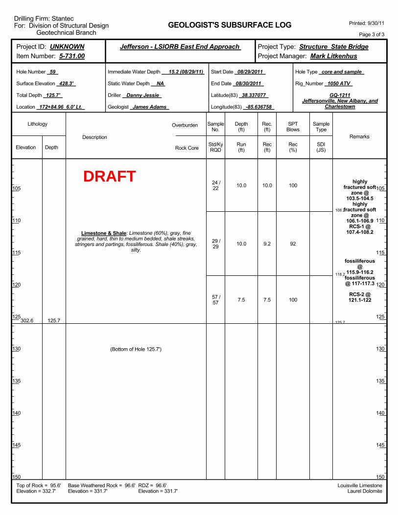
108.2
118.2
125.7
10.0
10.0
7.5
100
92
100
highlyfractured soft
zone @103.5-104.5
highlyfractured soft
zone @106.1-106.9
RCS-1 @107.4-108.2
fossiliferous@
115.9-116.2fossiliferous@ 117-117.3
RCS-2 @121.1-122
302.6 125.7
Limestone & Shale: Limestone (60%), gray, finegrained, hard, thin to medium bedded, shale streaks,
stringers and partings, fossiliferous. Shale (40%), gray,silty.
24 /22
29 /29
57 /57
(Bottom of Hole 125.7')
10.0
9.2
7.5
Elevation Depth Std/KyRQD
Lithology
105
110
115
120
125
130
135
140
145
150
105
110
115
120
125
130
135
140
145
150
Depth(ft)
SPTBlows
SampleType
Rec(ft)
Geologist James Adams
Hole Type core and sample
Rec(%)
Rec.(ft)
SampleNo.
Run(ft)
Description
Overburden
Rock CoreSDI(JS)
Remarks
Rig_Number 1050 ATV
Hole Number 59
Surface Elevation 428.3'
Total Depth 125.7'
End Date 08/30/2011
Latitude(83) 38.337077
Longitude(83) -85.636758
Start Date 08/29/2011
Driller Danny Jessie
GEOLOGIST'S SUBSURFACE LOG
GQ-1211Jeffersonville, New Albany, and
Charlestown
Static Water Depth NA
Louisville LimestoneLaurel Dolomite
Immediate Water Depth 15.2 (08/29/11)
Location 172+84.96 6.0' Lt.
Base Weathered Rock = 96.6'Elevation = 331.7'
Top of Rock = 95.6'Elevation = 332.7'
RDZ = 96.6'Elevation = 331.7'
Printed: 9/30/11
Page 3 of 3
Drilling Firm: StantecFor: Division of Structural Design
Geotechnical Branch
Project Type: Structure State BridgeProject Manager: Mark Litkenhus
Project ID: UNKNOWNItem Number: 5-731.00
Jefferson - LSIORB East End Approach
DRAFT

Boringadvancedwith 4.25"
augers @ 1NQ coring
systemutilized to
samplebedrock @ 3
Drilling mudadded to theboring at a
depth of 17.0ft below the
groundsurface @ 17
Overburden: overburden.
Elevation Depth Std/KyRQD
Lithology
5
10
15
20
25
30
35
40
45
50
5
10
15
20
25
30
35
40
45
50
Depth(ft)
SPTBlows
SampleType
Rec(ft)
Geologist James Adams
Hole Type core
Rec(%)
Rec.(ft)
SampleNo.
Run(ft)
Description
Overburden
Rock CoreSDI(JS)
Remarks
Rig_Number 1050 ATV
Hole Number 60
Surface Elevation 427.9'
Total Depth 125.6'
End Date 08/30/2011
Latitude(83) 38.337100
Longitude(83) -85.636728
Start Date 08/30/2011
Driller Danny Jessie
GEOLOGIST'S SUBSURFACE LOG
GQ-1211Jeffersonville, New Albany, and
Charlestown
Static Water Depth NA
Louisville LimestoneLaurel Dolomite
Immediate Water Depth 16.4 (08/30/11)
Location 172+84.96 6.0' Rt.
Base Weathered Rock = 96.2'Elevation = 331.7'
Top of Rock = 95.2'Elevation = 332.7'
RDZ = 96.2'Elevation = 331.7'
Printed: 9/30/11
Page 1 of 3
Drilling Firm: StantecFor: Division of Structural Design
Geotechnical Branch
Project Type: Structure State BridgeProject Manager: Mark Litkenhus
Project ID: UNKNOWNItem Number: 5-731.00
Jefferson - LSIORB East End Approach
DRAFT

98.0
2.8
10.0
93
91
332.7 95.2
Overburden: overburden.
Limestone & Shale: Limestone (70%), gray, finegrained, hard, thin to medium bedded, shale streaks,
stringers and partings, fossiliferous. Shale (30%), gray,silty.
(Begin Core)
29 /29
10 /10
2.6
9.1
Elevation Depth Std/KyRQD
Lithology
55
60
65
70
75
80
85
90
95
100
55
60
65
70
75
80
85
90
95
100
Depth(ft)
SPTBlows
SampleType
Rec(ft)
Geologist James Adams
Hole Type core
Rec(%)
Rec.(ft)
SampleNo.
Run(ft)
Description
Overburden
Rock CoreSDI(JS)
Remarks
Rig_Number 1050 ATV
Hole Number 60
Surface Elevation 427.9'
Total Depth 125.6'
End Date 08/30/2011
Latitude(83) 38.337100
Longitude(83) -85.636728
Start Date 08/30/2011
Driller Danny Jessie
GEOLOGIST'S SUBSURFACE LOG
GQ-1211Jeffersonville, New Albany, and
Charlestown
Static Water Depth NA
Louisville LimestoneLaurel Dolomite
Immediate Water Depth 16.4 (08/30/11)
Location 172+84.96 6.0' Rt.
Base Weathered Rock = 96.2'Elevation = 331.7'
Top of Rock = 95.2'Elevation = 332.7'
RDZ = 96.2'Elevation = 331.7'
Printed: 9/30/11
Page 2 of 3
Drilling Firm: StantecFor: Division of Structural Design
Geotechnical Branch
Project Type: Structure State BridgeProject Manager: Mark Litkenhus
Project ID: UNKNOWNItem Number: 5-731.00
Jefferson - LSIORB East End Approach
DRAFT
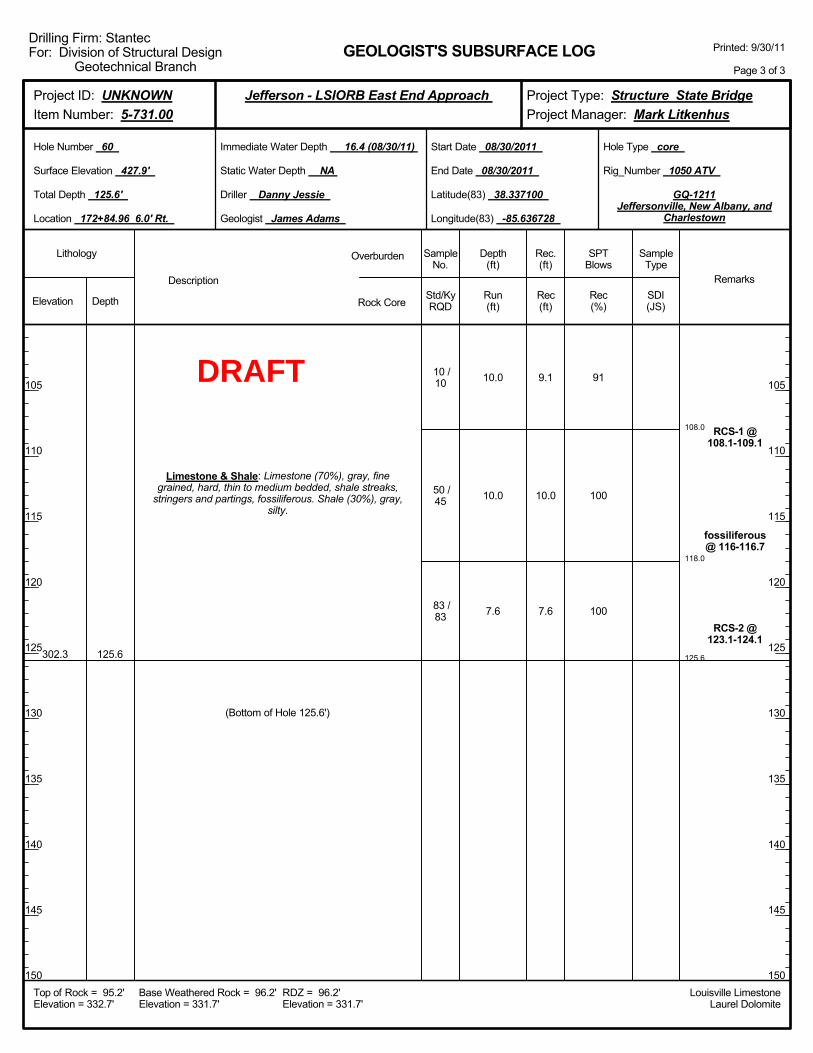
108.0
118.0
125.6
10.0
10.0
7.6
91
100
100
RCS-1 @108.1-109.1
fossiliferous@ 116-116.7
RCS-2 @123.1-124.1
302.3 125.6
Limestone & Shale: Limestone (70%), gray, finegrained, hard, thin to medium bedded, shale streaks,
stringers and partings, fossiliferous. Shale (30%), gray,silty.
10 /10
50 /45
83 /83
(Bottom of Hole 125.6')
9.1
10.0
7.6
Elevation Depth Std/KyRQD
Lithology
105
110
115
120
125
130
135
140
145
150
105
110
115
120
125
130
135
140
145
150
Depth(ft)
SPTBlows
SampleType
Rec(ft)
Geologist James Adams
Hole Type core
Rec(%)
Rec.(ft)
SampleNo.
Run(ft)
Description
Overburden
Rock CoreSDI(JS)
Remarks
Rig_Number 1050 ATV
Hole Number 60
Surface Elevation 427.9'
Total Depth 125.6'
End Date 08/30/2011
Latitude(83) 38.337100
Longitude(83) -85.636728
Start Date 08/30/2011
Driller Danny Jessie
GEOLOGIST'S SUBSURFACE LOG
GQ-1211Jeffersonville, New Albany, and
Charlestown
Static Water Depth NA
Louisville LimestoneLaurel Dolomite
Immediate Water Depth 16.4 (08/30/11)
Location 172+84.96 6.0' Rt.
Base Weathered Rock = 96.2'Elevation = 331.7'
Top of Rock = 95.2'Elevation = 332.7'
RDZ = 96.2'Elevation = 331.7'
Printed: 9/30/11
Page 3 of 3
Drilling Firm: StantecFor: Division of Structural Design
Geotechnical Branch
Project Type: Structure State BridgeProject Manager: Mark Litkenhus
Project ID: UNKNOWNItem Number: 5-731.00
Jefferson - LSIORB East End Approach
DRAFT

2.0-4.0
5.0-7.0
10.0-12.0
15.0-17.0
20.0-21.5
25.0-26.5
30.0-31.5
35.0-36.5
40.0-41.5
45.0-46.5
0-0-1
4-5-7
7-10-12
5-6-7
4-5-8
5-10-8
Boringadvancedwith 4.25"
augers @ 1NQ coring
systemutilized to
samplebedrock @ 3
Drilling mudadded to theboring at a
depth of 20.0ft below the
groundsurface @ 20
426.9
412.9
402.9
382.9
1.0
15.0
25.0
45.0
Overburden: topsoil.
Overburden: Clay, brown, moist, sandy.
Overburden: Sand, brown, wet, fine to mediumgrained, very loose, clayey.
Overburden: Sand, brown to gray, wet, fine tomedium grained, medium dense, poorly graded, some
gravel.
Overburden: Sand, brown, wet, fine grained, loose tomedium dense.
1
2
3
4
1
2
3
4
5
6
2.0
2.0
2.0
0.5
0.7
0.8
0.7
1.3
1.5
1.5
Elevation Depth Std/KyRQD
Lithology
5
10
15
20
25
30
35
40
45
50
5
10
15
20
25
30
35
40
45
50
Depth(ft)
SPTBlows
SampleType
Rec(ft)
Geologist James Adams
Hole Type core and sample
Rec(%)
Rec.(ft)
SampleNo.
Run(ft)
Description
Overburden
Rock CoreSDI(JS)
Remarks
Rig_Number 1050 ATV
Hole Number 61
Surface Elevation 427.9'
Total Depth 137.0'
End Date 08/31/2011
Latitude(83) 38.337217
Longitude(83) -85.636566
Start Date 08/30/2011
Driller Danny Jessie
GEOLOGIST'S SUBSURFACE LOG
GQ-1211Jeffersonville, New Albany, and
Charlestown
Static Water Depth NA
Louisville LimestoneLaurel Dolomite
Immediate Water Depth 18.3 (08/30/11)
Location 172+84.96 69.0' Rt.
Base Weathered Rock = 96.5'Elevation = 331.4'
Top of Rock = 96.5'Elevation = 331.4'
RDZ = 96.5'Elevation = 331.4'
Printed: 9/30/11
Page 1 of 3
Drilling Firm: StantecFor: Division of Structural Design
Geotechnical Branch
Project Type: Structure State BridgeProject Manager: Mark Litkenhus
Project ID: UNKNOWNItem Number: 5-731.00
Jefferson - LSIORB East End Approach
ST
ST
ST
ST
SPT
SPT
SPT
SPT
SPT
SPT
DRAFT
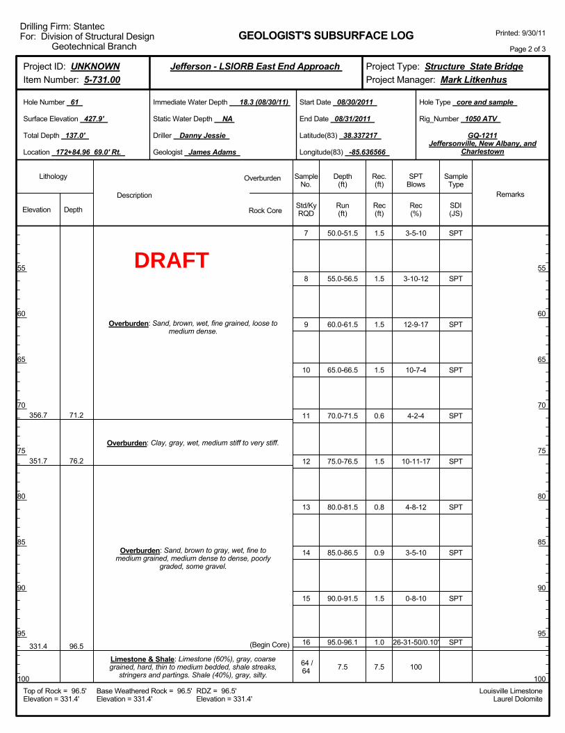
50.0-51.5
55.0-56.5
60.0-61.5
65.0-66.5
70.0-71.5
75.0-76.5
80.0-81.5
85.0-86.5
90.0-91.5
95.0-96.1
7.5
3-5-10
3-10-12
12-9-17
10-7-4
4-2-4
10-11-17
4-8-12
3-5-10
0-8-10
26-31-50/0.10'
100
356.7
351.7
331.4
71.2
76.2
96.5
Overburden: Sand, brown, wet, fine grained, loose tomedium dense.
Overburden: Clay, gray, wet, medium stiff to very stiff.
Overburden: Sand, brown to gray, wet, fine tomedium grained, medium dense to dense, poorly
graded, some gravel.
Limestone & Shale: Limestone (60%), gray, coarsegrained, hard, thin to medium bedded, shale streaks,
stringers and partings. Shale (40%), gray, silty.
(Begin Core)
7
8
9
10
11
12
13
14
15
16
64 /64
1.5
1.5
1.5
1.5
0.6
1.5
0.8
0.9
1.5
1.0
7.5
Elevation Depth Std/KyRQD
Lithology
55
60
65
70
75
80
85
90
95
100
55
60
65
70
75
80
85
90
95
100
Depth(ft)
SPTBlows
SampleType
Rec(ft)
Geologist James Adams
Hole Type core and sample
Rec(%)
Rec.(ft)
SampleNo.
Run(ft)
Description
Overburden
Rock CoreSDI(JS)
Remarks
Rig_Number 1050 ATV
Hole Number 61
Surface Elevation 427.9'
Total Depth 137.0'
End Date 08/31/2011
Latitude(83) 38.337217
Longitude(83) -85.636566
Start Date 08/30/2011
Driller Danny Jessie
GEOLOGIST'S SUBSURFACE LOG
GQ-1211Jeffersonville, New Albany, and
Charlestown
Static Water Depth NA
Louisville LimestoneLaurel Dolomite
Immediate Water Depth 18.3 (08/30/11)
Location 172+84.96 69.0' Rt.
Base Weathered Rock = 96.5'Elevation = 331.4'
Top of Rock = 96.5'Elevation = 331.4'
RDZ = 96.5'Elevation = 331.4'
Printed: 9/30/11
Page 2 of 3
Drilling Firm: StantecFor: Division of Structural Design
Geotechnical Branch
Project Type: Structure State BridgeProject Manager: Mark Litkenhus
Project ID: UNKNOWNItem Number: 5-731.00
Jefferson - LSIORB East End Approach
SPT
SPT
SPT
SPT
SPT
SPT
SPT
SPT
SPT
SPT
DRAFT
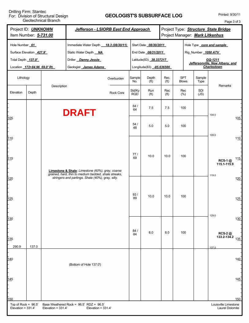
104.0
109.0
119.0
129.0
137.0
7.5
5.0
10.0
10.0
8.0
100
100
100
100
100
RCS-1 @115.1-115.9
RCS-2 @133.2-134.2
290.9 137.0
Limestone & Shale: Limestone (60%), gray, coarsegrained, hard, thin to medium bedded, shale streaks,
stringers and partings. Shale (40%), gray, silty.
64 /64
54 /48
77 /69
93 /89
84 /84
(Bottom of Hole 137.0')
7.5
5.0
10.0
10.0
8.0
Elevation Depth Std/KyRQD
Lithology
105
110
115
120
125
130
135
140
145
150
105
110
115
120
125
130
135
140
145
150
Depth(ft)
SPTBlows
SampleType
Rec(ft)
Geologist James Adams
Hole Type core and sample
Rec(%)
Rec.(ft)
SampleNo.
Run(ft)
Description
Overburden
Rock CoreSDI(JS)
Remarks
Rig_Number 1050 ATV
Hole Number 61
Surface Elevation 427.9'
Total Depth 137.0'
End Date 08/31/2011
Latitude(83) 38.337217
Longitude(83) -85.636566
Start Date 08/30/2011
Driller Danny Jessie
GEOLOGIST'S SUBSURFACE LOG
GQ-1211Jeffersonville, New Albany, and
Charlestown
Static Water Depth NA
Louisville LimestoneLaurel Dolomite
Immediate Water Depth 18.3 (08/30/11)
Location 172+84.96 69.0' Rt.
Base Weathered Rock = 96.5'Elevation = 331.4'
Top of Rock = 96.5'Elevation = 331.4'
RDZ = 96.5'Elevation = 331.4'
Printed: 9/30/11
Page 3 of 3
Drilling Firm: StantecFor: Division of Structural Design
Geotechnical Branch
Project Type: Structure State BridgeProject Manager: Mark Litkenhus
Project ID: UNKNOWNItem Number: 5-731.00
Jefferson - LSIORB East End Approach
DRAFT
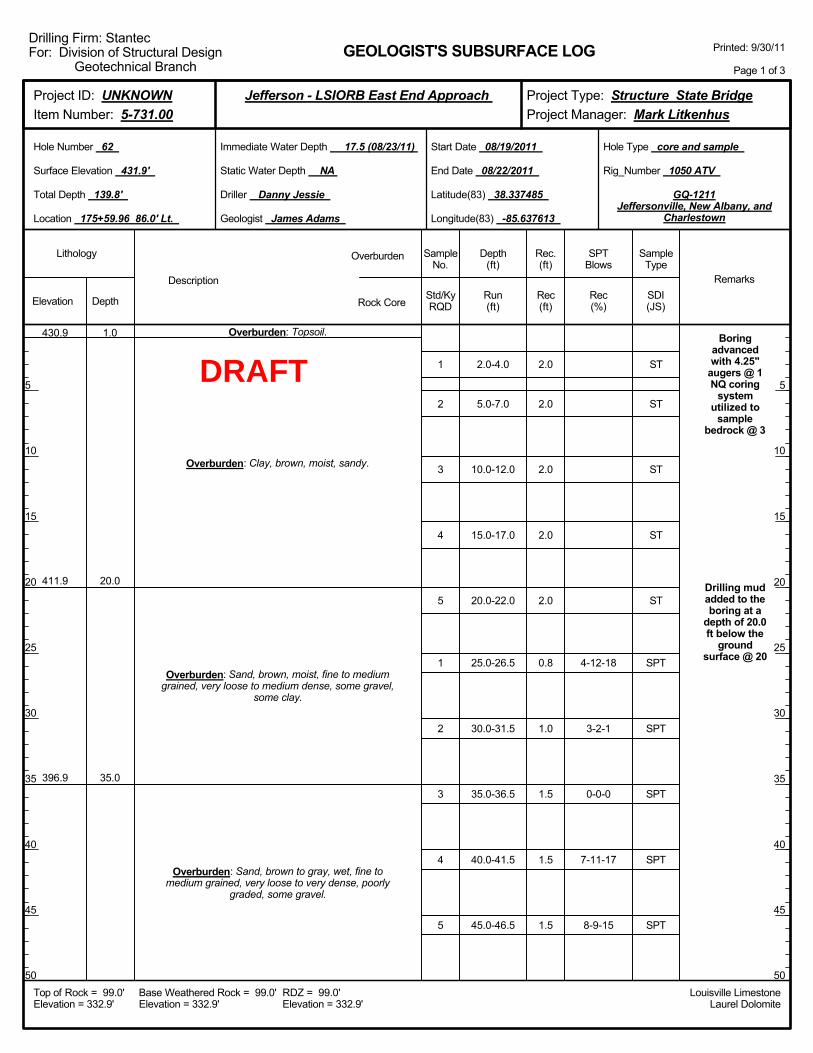
2.0-4.0
5.0-7.0
10.0-12.0
15.0-17.0
20.0-22.0
25.0-26.5
30.0-31.5
35.0-36.5
40.0-41.5
45.0-46.5
4-12-18
3-2-1
0-0-0
7-11-17
8-9-15
Boringadvancedwith 4.25"
augers @ 1NQ coring
systemutilized to
samplebedrock @ 3
Drilling mudadded to theboring at a
depth of 20.0ft below the
groundsurface @ 20
430.9
411.9
396.9
1.0
20.0
35.0
Overburden: Topsoil.
Overburden: Clay, brown, moist, sandy.
Overburden: Sand, brown, moist, fine to mediumgrained, very loose to medium dense, some gravel,
some clay.
Overburden: Sand, brown to gray, wet, fine tomedium grained, very loose to very dense, poorly
graded, some gravel.
1
2
3
4
5
1
2
3
4
5
2.0
2.0
2.0
2.0
2.0
0.8
1.0
1.5
1.5
1.5
Elevation Depth Std/KyRQD
Lithology
5
10
15
20
25
30
35
40
45
50
5
10
15
20
25
30
35
40
45
50
Depth(ft)
SPTBlows
SampleType
Rec(ft)
Geologist James Adams
Hole Type core and sample
Rec(%)
Rec.(ft)
SampleNo.
Run(ft)
Description
Overburden
Rock CoreSDI(JS)
Remarks
Rig_Number 1050 ATV
Hole Number 62
Surface Elevation 431.9'
Total Depth 139.8'
End Date 08/22/2011
Latitude(83) 38.337485
Longitude(83) -85.637613
Start Date 08/19/2011
Driller Danny Jessie
GEOLOGIST'S SUBSURFACE LOG
GQ-1211Jeffersonville, New Albany, and
Charlestown
Static Water Depth NA
Louisville LimestoneLaurel Dolomite
Immediate Water Depth 17.5 (08/23/11)
Location 175+59.96 86.0' Lt.
Base Weathered Rock = 99.0'Elevation = 332.9'
Top of Rock = 99.0'Elevation = 332.9'
RDZ = 99.0'Elevation = 332.9'
Printed: 9/30/11
Page 1 of 3
Drilling Firm: StantecFor: Division of Structural Design
Geotechnical Branch
Project Type: Structure State BridgeProject Manager: Mark Litkenhus
Project ID: UNKNOWNItem Number: 5-731.00
Jefferson - LSIORB East End Approach
ST
ST
ST
ST
ST
SPT
SPT
SPT
SPT
SPT
DRAFT
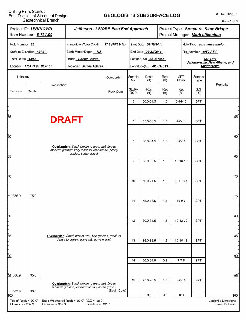
50.0-51.5
55.0-56.5
60.0-61.5
65.0-66.5
70.0-71.5
75.0-76.5
80.0-81.5
85.0-86.5
90.0-91.5
95.0-96.5
9.0
8-14-15
4-8-11
6-8-10
13-18-15
25-27-34
10-9-6
10-12-22
12-15-13
7-7-8
3-6-10
100
356.9
336.9
332.9
75.0
95.0
99.0
Overburden: Sand, brown to gray, wet, fine tomedium grained, very loose to very dense, poorly
graded, some gravel.
Overburden: Sand, brown, wet, fine grained, mediumdense to dense, some silt, some gravel.
Overburden: Sand, brown to gray, wet, fine tomedium grained, medium dense, some gravel.
(Begin Core)
6
7
8
9
10
11
12
13
14
15
1.5
1.5
1.5
1.5
1.5
1.5
1.5
1.5
0.8
1.0
9.0
Elevation Depth Std/KyRQD
Lithology
55
60
65
70
75
80
85
90
95
100
55
60
65
70
75
80
85
90
95
100
Depth(ft)
SPTBlows
SampleType
Rec(ft)
Geologist James Adams
Hole Type core and sample
Rec(%)
Rec.(ft)
SampleNo.
Run(ft)
Description
Overburden
Rock CoreSDI(JS)
Remarks
Rig_Number 1050 ATV
Hole Number 62
Surface Elevation 431.9'
Total Depth 139.8'
End Date 08/22/2011
Latitude(83) 38.337485
Longitude(83) -85.637613
Start Date 08/19/2011
Driller Danny Jessie
GEOLOGIST'S SUBSURFACE LOG
GQ-1211Jeffersonville, New Albany, and
Charlestown
Static Water Depth NA
Louisville LimestoneLaurel Dolomite
Immediate Water Depth 17.5 (08/23/11)
Location 175+59.96 86.0' Lt.
Base Weathered Rock = 99.0'Elevation = 332.9'
Top of Rock = 99.0'Elevation = 332.9'
RDZ = 99.0'Elevation = 332.9'
Printed: 9/30/11
Page 2 of 3
Drilling Firm: StantecFor: Division of Structural Design
Geotechnical Branch
Project Type: Structure State BridgeProject Manager: Mark Litkenhus
Project ID: UNKNOWNItem Number: 5-731.00
Jefferson - LSIORB East End Approach
SPT
SPT
SPT
SPT
SPT
SPT
SPT
SPT
SPT
SPT
DRAFT
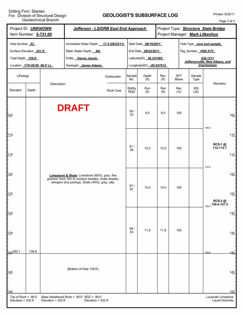
108.0
118.0
128.0
139.8
9.0
10.0
10.0
11.8
100
100
100
100
RCS-1 @112-112.7
RCS-2 @126.4-127.2
292.1 139.8
Limestone & Shale: Limestone (60%), gray, finegrained, hard, thin to medium bedded, shale streaks,
stringers and partings. Shale (40%), gray, silty.
59 /53
61 /58
87 /87
68 /63
(Bottom of Hole 139.8')
9.0
10.0
10.0
11.8
Elevation Depth Std/KyRQD
Lithology
105
110
115
120
125
130
135
140
145
150
105
110
115
120
125
130
135
140
145
150
Depth(ft)
SPTBlows
SampleType
Rec(ft)
Geologist James Adams
Hole Type core and sample
Rec(%)
Rec.(ft)
SampleNo.
Run(ft)
Description
Overburden
Rock CoreSDI(JS)
Remarks
Rig_Number 1050 ATV
Hole Number 62
Surface Elevation 431.9'
Total Depth 139.8'
End Date 08/22/2011
Latitude(83) 38.337485
Longitude(83) -85.637613
Start Date 08/19/2011
Driller Danny Jessie
GEOLOGIST'S SUBSURFACE LOG
GQ-1211Jeffersonville, New Albany, and
Charlestown
Static Water Depth NA
Louisville LimestoneLaurel Dolomite
Immediate Water Depth 17.5 (08/23/11)
Location 175+59.96 86.0' Lt.
Base Weathered Rock = 99.0'Elevation = 332.9'
Top of Rock = 99.0'Elevation = 332.9'
RDZ = 99.0'Elevation = 332.9'
Printed: 9/30/11
Page 3 of 3
Drilling Firm: StantecFor: Division of Structural Design
Geotechnical Branch
Project Type: Structure State BridgeProject Manager: Mark Litkenhus
Project ID: UNKNOWNItem Number: 5-731.00
Jefferson - LSIORB East End Approach
DRAFT

Boringadvancedwith 4.25"
augers @ 1NQ coring
systemutilized to
samplebedrock @ 3
Drilling mudadded to theboring at a
depth of 20.0ft below the
groundsurface @ 20Overburden: Overburden.
Elevation Depth Std/KyRQD
Lithology
5
10
15
20
25
30
35
40
45
50
5
10
15
20
25
30
35
40
45
50
Depth(ft)
SPTBlows
SampleType
Rec(ft)
Geologist James Adams
Hole Type core
Rec(%)
Rec.(ft)
SampleNo.
Run(ft)
Description
Overburden
Rock CoreSDI(JS)
Remarks
Rig_Number 1050 ATV
Hole Number 63
Surface Elevation 432.2'
Total Depth 129.1'
End Date 08/23/2011
Latitude(83) 38.337633
Longitude(83) -85.637407
Start Date 08/22/2011
Driller Danny Jessie
GEOLOGIST'S SUBSURFACE LOG
GQ-1211Jeffersonville, New Albany, and
Charlestown
Static Water Depth NA
Louisville LimestoneLaurel Dolomite
Immediate Water Depth 19.3 (08/22/11)
Location 175+59.96 6.0' Lt.
Base Weathered Rock = 99.6'Elevation = 332.6'
Top of Rock = 98.6'Elevation = 333.6'
RDZ = 99.6'Elevation = 332.6'
Printed: 9/30/11
Page 1 of 3
Drilling Firm: StantecFor: Division of Structural Design
Geotechnical Branch
Project Type: Structure State BridgeProject Manager: Mark Litkenhus
Project ID: UNKNOWNItem Number: 5-731.00
Jefferson - LSIORB East End Approach
DRAFT
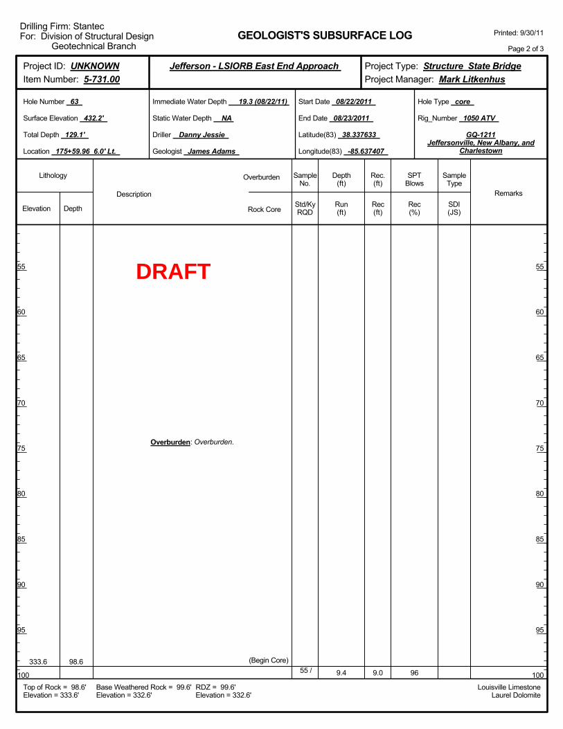
9.4 96333.6 98.6
Overburden: Overburden.
(Begin Core)55 / 9.0
Elevation Depth Std/KyRQD
Lithology
55
60
65
70
75
80
85
90
95
100
55
60
65
70
75
80
85
90
95
100
Depth(ft)
SPTBlows
SampleType
Rec(ft)
Geologist James Adams
Hole Type core
Rec(%)
Rec.(ft)
SampleNo.
Run(ft)
Description
Overburden
Rock CoreSDI(JS)
Remarks
Rig_Number 1050 ATV
Hole Number 63
Surface Elevation 432.2'
Total Depth 129.1'
End Date 08/23/2011
Latitude(83) 38.337633
Longitude(83) -85.637407
Start Date 08/22/2011
Driller Danny Jessie
GEOLOGIST'S SUBSURFACE LOG
GQ-1211Jeffersonville, New Albany, and
Charlestown
Static Water Depth NA
Louisville LimestoneLaurel Dolomite
Immediate Water Depth 19.3 (08/22/11)
Location 175+59.96 6.0' Lt.
Base Weathered Rock = 99.6'Elevation = 332.6'
Top of Rock = 98.6'Elevation = 333.6'
RDZ = 99.6'Elevation = 332.6'
Printed: 9/30/11
Page 2 of 3
Drilling Firm: StantecFor: Division of Structural Design
Geotechnical Branch
Project Type: Structure State BridgeProject Manager: Mark Litkenhus
Project ID: UNKNOWNItem Number: 5-731.00
Jefferson - LSIORB East End Approach
DRAFT
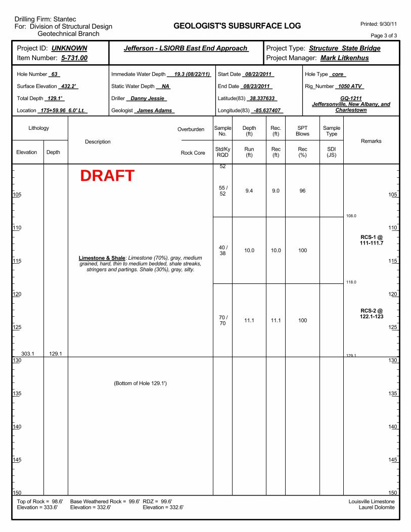
108.0
118.0
129.1
9.4
10.0
11.1
96
100
100
RCS-1 @111-111.7
RCS-2 @122.1-123
303.1 129.1
Limestone & Shale: Limestone (70%), gray, mediumgrained, hard, thin to medium bedded, shale streaks,
stringers and partings. Shale (30%), gray, silty.
52
55 /52
40 /38
70 /70
(Bottom of Hole 129.1')
9.0
10.0
11.1
Elevation Depth Std/KyRQD
Lithology
105
110
115
120
125
130
135
140
145
150
105
110
115
120
125
130
135
140
145
150
Depth(ft)
SPTBlows
SampleType
Rec(ft)
Geologist James Adams
Hole Type core
Rec(%)
Rec.(ft)
SampleNo.
Run(ft)
Description
Overburden
Rock CoreSDI(JS)
Remarks
Rig_Number 1050 ATV
Hole Number 63
Surface Elevation 432.2'
Total Depth 129.1'
End Date 08/23/2011
Latitude(83) 38.337633
Longitude(83) -85.637407
Start Date 08/22/2011
Driller Danny Jessie
GEOLOGIST'S SUBSURFACE LOG
GQ-1211Jeffersonville, New Albany, and
Charlestown
Static Water Depth NA
Louisville LimestoneLaurel Dolomite
Immediate Water Depth 19.3 (08/22/11)
Location 175+59.96 6.0' Lt.
Base Weathered Rock = 99.6'Elevation = 332.6'
Top of Rock = 98.6'Elevation = 333.6'
RDZ = 99.6'Elevation = 332.6'
Printed: 9/30/11
Page 3 of 3
Drilling Firm: StantecFor: Division of Structural Design
Geotechnical Branch
Project Type: Structure State BridgeProject Manager: Mark Litkenhus
Project ID: UNKNOWNItem Number: 5-731.00
Jefferson - LSIORB East End Approach
DRAFT

2.0-4.0
5.0-7.0
10.0-12.0
15.0-17.0
20.0-21.5
25.0-26.5
30.0-31.5
35.0-36.5
40.0-41.5
45.0-46.5
0-1-0
3-3-4
0-0-0
3-6-7
0-2-3
8-12-15
Boringadvancedwith 4.25"
augers @ 1NQ coring
systemutilized to
samplebedrock @ 3
Drilling mudadded to theboring at a
depth of 20.0ft below the
groundsurface @ 20
431.3
412.3
407.3
402.3
1.0
20.0
25.0
30.0
Overburden: Topsoil.
Overburden: Clay, brown, moist, sandy.
Overburden: Sand, brown, wet, medium to finegrained, very loose, some clay.
Overburden: Sand, brown, wet, fine to mediumgrained, loose, some gravel.
Overburden: Sand, brown to gray, wet, fine tomedium grained, very loose to very dense, poorly
graded, some gravel.
1
2
3
4
1
2
3
4
5
6
2.0
2.0
2.0
2.0
1.5
1.5
0.5
1.5
1.5
1.5
Elevation Depth Std/KyRQD
Lithology
5
10
15
20
25
30
35
40
45
50
5
10
15
20
25
30
35
40
45
50
Depth(ft)
SPTBlows
SampleType
Rec(ft)
Geologist James Adams
Hole Type core and sample
Rec(%)
Rec.(ft)
SampleNo.
Run(ft)
Description
Overburden
Rock CoreSDI(JS)
Remarks
Rig_Number 1050 ATV
Hole Number 64
Surface Elevation 432.3'
Total Depth 128.5'
End Date 08/24/2011
Latitude(83) 38.337656
Longitude(83) -85.637376
Start Date 08/23/2011
Driller Danny Jessie
GEOLOGIST'S SUBSURFACE LOG
GQ-1211Jeffersonville, New Albany, and
Charlestown
Static Water Depth NA
Louisville LimestoneLaurel Dolomite
Immediate Water Depth 19.6 (08/24/11)
Location 175+59.96 6.0' Rt.
Base Weathered Rock = 101.2'Elevation = 331.1'
Top of Rock = 98.5'Elevation = 333.8'
RDZ = 101.2'Elevation = 331.1'
Printed: 9/30/11
Page 1 of 3
Drilling Firm: StantecFor: Division of Structural Design
Geotechnical Branch
Project Type: Structure State BridgeProject Manager: Mark Litkenhus
Project ID: UNKNOWNItem Number: 5-731.00
Jefferson - LSIORB East End Approach
ST
ST
ST
ST
SPT
SPT
SPT
SPT
SPT
SPT
DRAFT
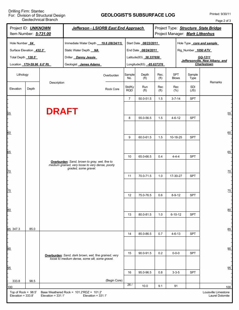
50.0-51.5
55.0-56.5
60.0-61.5
65.0-66.5
70.0-71.5
75.0-76.5
80.0-81.5
85.0-86.5
90.0-91.5
95.0-96.5
10.0
3-7-14
4-6-12
10-18-25
4-4-4
17-30-27
8-9-12
6-10-12
4-6-13
0-0-0
3-3-5
91
347.3
333.8
85.0
98.5
Overburden: Sand, brown to gray, wet, fine tomedium grained, very loose to very dense, poorly
graded, some gravel.
Overburden: Sand, dark brown, wet, fine grained, veryloose to medium dense, some silt, some gravel.
(Begin Core)
7
8
9
10
11
12
13
14
15
16
26 /
1.5
1.5
1.5
0.4
1.0
0.6
1.0
0.7
0.2
0.8
9.1
Elevation Depth Std/KyRQD
Lithology
55
60
65
70
75
80
85
90
95
100
55
60
65
70
75
80
85
90
95
100
Depth(ft)
SPTBlows
SampleType
Rec(ft)
Geologist James Adams
Hole Type core and sample
Rec(%)
Rec.(ft)
SampleNo.
Run(ft)
Description
Overburden
Rock CoreSDI(JS)
Remarks
Rig_Number 1050 ATV
Hole Number 64
Surface Elevation 432.3'
Total Depth 128.5'
End Date 08/24/2011
Latitude(83) 38.337656
Longitude(83) -85.637376
Start Date 08/23/2011
Driller Danny Jessie
GEOLOGIST'S SUBSURFACE LOG
GQ-1211Jeffersonville, New Albany, and
Charlestown
Static Water Depth NA
Louisville LimestoneLaurel Dolomite
Immediate Water Depth 19.6 (08/24/11)
Location 175+59.96 6.0' Rt.
Base Weathered Rock = 101.2'Elevation = 331.1'
Top of Rock = 98.5'Elevation = 333.8'
RDZ = 101.2'Elevation = 331.1'
Printed: 9/30/11
Page 2 of 3
Drilling Firm: StantecFor: Division of Structural Design
Geotechnical Branch
Project Type: Structure State BridgeProject Manager: Mark Litkenhus
Project ID: UNKNOWNItem Number: 5-731.00
Jefferson - LSIORB East End Approach
SPT
SPT
SPT
SPT
SPT
SPT
SPT
SPT
SPT
SPT
DRAFT

108.5
118.5
128.5
10.0
10.0
10.0
91
100
100
highlyfracturedzone @
100.2-101.2
Clay seamsand shale
partings @110.3-112.8
RCS-1 @116.7-117.5
vuggy zone@
121.7-122.5
RCS-2 @124.9-125.7
303.8 128.5
Limestone & Shale: Limestone (60%), gray, mediumgrained, hard, thin to medium bedded, shale streaks,
stringers and partings. Shale (40%), gray, silty.
20
26 /20
56 /45
78 /76
(Bottom of Hole 128.5')
9.1
10.0
10.0
Elevation Depth Std/KyRQD
Lithology
105
110
115
120
125
130
135
140
145
150
105
110
115
120
125
130
135
140
145
150
Depth(ft)
SPTBlows
SampleType
Rec(ft)
Geologist James Adams
Hole Type core and sample
Rec(%)
Rec.(ft)
SampleNo.
Run(ft)
Description
Overburden
Rock CoreSDI(JS)
Remarks
Rig_Number 1050 ATV
Hole Number 64
Surface Elevation 432.3'
Total Depth 128.5'
End Date 08/24/2011
Latitude(83) 38.337656
Longitude(83) -85.637376
Start Date 08/23/2011
Driller Danny Jessie
GEOLOGIST'S SUBSURFACE LOG
GQ-1211Jeffersonville, New Albany, and
Charlestown
Static Water Depth NA
Louisville LimestoneLaurel Dolomite
Immediate Water Depth 19.6 (08/24/11)
Location 175+59.96 6.0' Rt.
Base Weathered Rock = 101.2'Elevation = 331.1'
Top of Rock = 98.5'Elevation = 333.8'
RDZ = 101.2'Elevation = 331.1'
Printed: 9/30/11
Page 3 of 3
Drilling Firm: StantecFor: Division of Structural Design
Geotechnical Branch
Project Type: Structure State BridgeProject Manager: Mark Litkenhus
Project ID: UNKNOWNItem Number: 5-731.00
Jefferson - LSIORB East End Approach
DRAFT
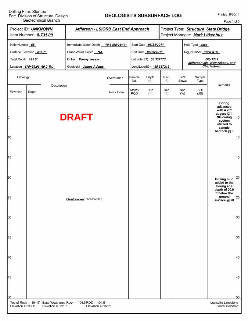
Boringadvancedwith 4.25"
augers @ 1NQ coring
systemutilized to
samplebedrock @ 3
Drilling mudadded to theboring at a
depth of 20.0ft below the
groundsurface @ 20Overburden: Overburden.
Elevation Depth Std/KyRQD
Lithology
5
10
15
20
25
30
35
40
45
50
5
10
15
20
25
30
35
40
45
50
Depth(ft)
SPTBlows
SampleType
Rec(ft)
Geologist James Adams
Hole Type core
Rec(%)
Rec.(ft)
SampleNo.
Run(ft)
Description
Overburden
Rock CoreSDI(JS)
Remarks
Rig_Number 1050 ATV
Hole Number 65
Surface Elevation 437.7'
Total Depth 145.6'
End Date 08/25/2011
Latitude(83) 38.337773
Longitude(83) -85.637215
Start Date 08/24/2011
Driller Danny Jessie
GEOLOGIST'S SUBSURFACE LOG
GQ-1211Jeffersonville, New Albany, and
Charlestown
Static Water Depth NA
Louisville LimestoneLaurel Dolomite
Immediate Water Depth 19.8 (08/25/11)
Location 175+59.96 69.0' Rt.
Base Weathered Rock = 104.9'Elevation = 332.8'
Top of Rock = 104.6'Elevation = 333.1'
RDZ = 104.9'Elevation = 332.8'
Printed: 9/30/11
Page 1 of 3
Drilling Firm: StantecFor: Division of Structural Design
Geotechnical Branch
Project Type: Structure State BridgeProject Manager: Mark Litkenhus
Project ID: UNKNOWNItem Number: 5-731.00
Jefferson - LSIORB East End Approach
DRAFT

Overburden: Overburden.
Elevation Depth Std/KyRQD
Lithology
55
60
65
70
75
80
85
90
95
100
55
60
65
70
75
80
85
90
95
100
Depth(ft)
SPTBlows
SampleType
Rec(ft)
Geologist James Adams
Hole Type core
Rec(%)
Rec.(ft)
SampleNo.
Run(ft)
Description
Overburden
Rock CoreSDI(JS)
Remarks
Rig_Number 1050 ATV
Hole Number 65
Surface Elevation 437.7'
Total Depth 145.6'
End Date 08/25/2011
Latitude(83) 38.337773
Longitude(83) -85.637215
Start Date 08/24/2011
Driller Danny Jessie
GEOLOGIST'S SUBSURFACE LOG
GQ-1211Jeffersonville, New Albany, and
Charlestown
Static Water Depth NA
Louisville LimestoneLaurel Dolomite
Immediate Water Depth 19.8 (08/25/11)
Location 175+59.96 69.0' Rt.
Base Weathered Rock = 104.9'Elevation = 332.8'
Top of Rock = 104.6'Elevation = 333.1'
RDZ = 104.9'Elevation = 332.8'
Printed: 9/30/11
Page 2 of 3
Drilling Firm: StantecFor: Division of Structural Design
Geotechnical Branch
Project Type: Structure State BridgeProject Manager: Mark Litkenhus
Project ID: UNKNOWNItem Number: 5-731.00
Jefferson - LSIORB East End Approach
DRAFT
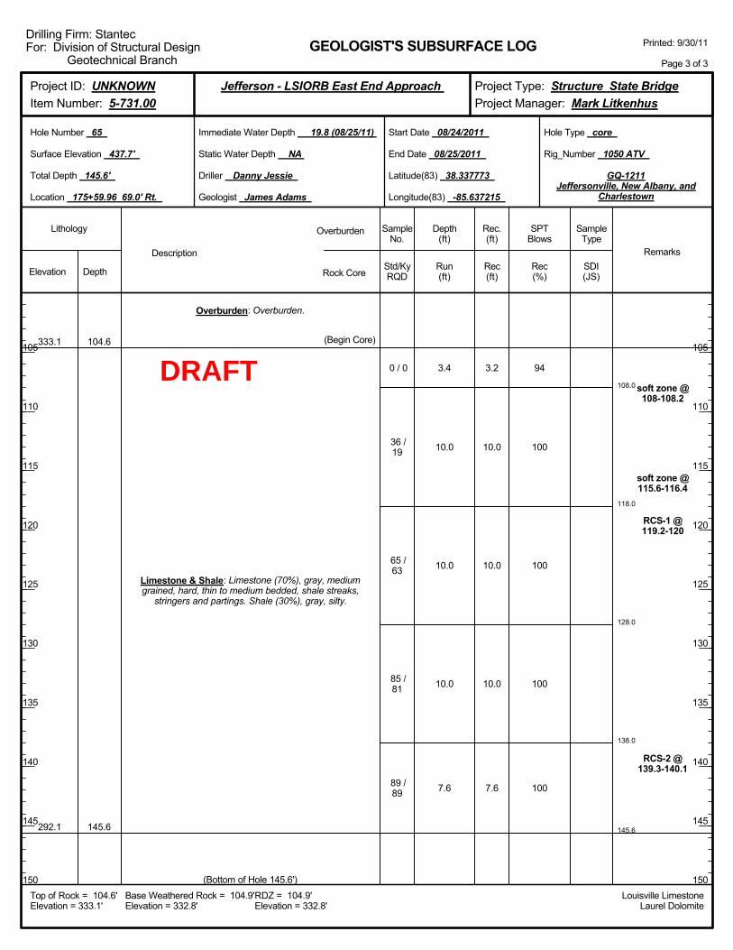
108.0
118.0
128.0
138.0
145.6
3.4
10.0
10.0
10.0
7.6
94
100
100
100
100
soft zone @108-108.2
soft zone @115.6-116.4
RCS-1 @119.2-120
RCS-2 @139.3-140.1
333.1
292.1
104.6
145.6
Overburden: Overburden.
Limestone & Shale: Limestone (70%), gray, mediumgrained, hard, thin to medium bedded, shale streaks,
stringers and partings. Shale (30%), gray, silty.
(Begin Core)
0 / 0
36 /19
65 /63
85 /81
89 /89
(Bottom of Hole 145.6')
3.2
10.0
10.0
10.0
7.6
Elevation Depth Std/KyRQD
Lithology
105
110
115
120
125
130
135
140
145
150
105
110
115
120
125
130
135
140
145
150
Depth(ft)
SPTBlows
SampleType
Rec(ft)
Geologist James Adams
Hole Type core
Rec(%)
Rec.(ft)
SampleNo.
Run(ft)
Description
Overburden
Rock CoreSDI(JS)
Remarks
Rig_Number 1050 ATV
Hole Number 65
Surface Elevation 437.7'
Total Depth 145.6'
End Date 08/25/2011
Latitude(83) 38.337773
Longitude(83) -85.637215
Start Date 08/24/2011
Driller Danny Jessie
GEOLOGIST'S SUBSURFACE LOG
GQ-1211Jeffersonville, New Albany, and
Charlestown
Static Water Depth NA
Louisville LimestoneLaurel Dolomite
Immediate Water Depth 19.8 (08/25/11)
Location 175+59.96 69.0' Rt.
Base Weathered Rock = 104.9'Elevation = 332.8'
Top of Rock = 104.6'Elevation = 333.1'
RDZ = 104.9'Elevation = 332.8'
Printed: 9/30/11
Page 3 of 3
Drilling Firm: StantecFor: Division of Structural Design
Geotechnical Branch
Project Type: Structure State BridgeProject Manager: Mark Litkenhus
Project ID: UNKNOWNItem Number: 5-731.00
Jefferson - LSIORB East End Approach
DRAFT
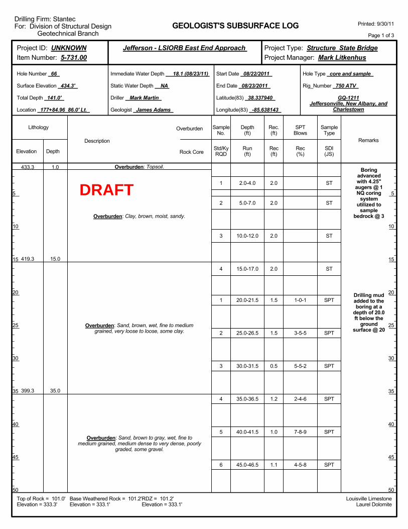
2.0-4.0
5.0-7.0
10.0-12.0
15.0-17.0
20.0-21.5
25.0-26.5
30.0-31.5
35.0-36.5
40.0-41.5
45.0-46.5
1-0-1
3-5-5
5-5-2
2-4-6
7-8-9
4-5-8
Boringadvancedwith 4.25"
augers @ 1NQ coring
systemutilized to
samplebedrock @ 3
Drilling mudadded to theboring at a
depth of 20.0ft below the
groundsurface @ 20
433.3
419.3
399.3
1.0
15.0
35.0
Overburden: Topsoil.
Overburden: Clay, brown, moist, sandy.
Overburden: Sand, brown, wet, fine to mediumgrained, very loose to loose, some clay.
Overburden: Sand, brown to gray, wet, fine tomedium grained, medium dense to very dense, poorly
graded, some gravel.
1
2
3
4
1
2
3
4
5
6
2.0
2.0
2.0
2.0
1.5
1.5
0.5
1.2
1.0
1.1
Elevation Depth Std/KyRQD
Lithology
5
10
15
20
25
30
35
40
45
50
5
10
15
20
25
30
35
40
45
50
Depth(ft)
SPTBlows
SampleType
Rec(ft)
Geologist James Adams
Hole Type core and sample
Rec(%)
Rec.(ft)
SampleNo.
Run(ft)
Description
Overburden
Rock CoreSDI(JS)
Remarks
Rig_Number 750 ATV
Hole Number 66
Surface Elevation 434.3'
Total Depth 141.0'
End Date 08/23/2011
Latitude(83) 38.337940
Longitude(83) -85.638143
Start Date 08/22/2011
Driller Mark Martin
GEOLOGIST'S SUBSURFACE LOG
GQ-1211Jeffersonville, New Albany, and
Charlestown
Static Water Depth NA
Louisville LimestoneLaurel Dolomite
Immediate Water Depth 18.1 (08/23/11)
Location 177+84.96 86.0' Lt.
Base Weathered Rock = 101.2'Elevation = 333.1'
Top of Rock = 101.0'Elevation = 333.3'
RDZ = 101.2'Elevation = 333.1'
Printed: 9/30/11
Page 1 of 3
Drilling Firm: StantecFor: Division of Structural Design
Geotechnical Branch
Project Type: Structure State BridgeProject Manager: Mark Litkenhus
Project ID: UNKNOWNItem Number: 5-731.00
Jefferson - LSIORB East End Approach
ST
ST
ST
ST
SPT
SPT
SPT
SPT
SPT
SPT
DRAFT
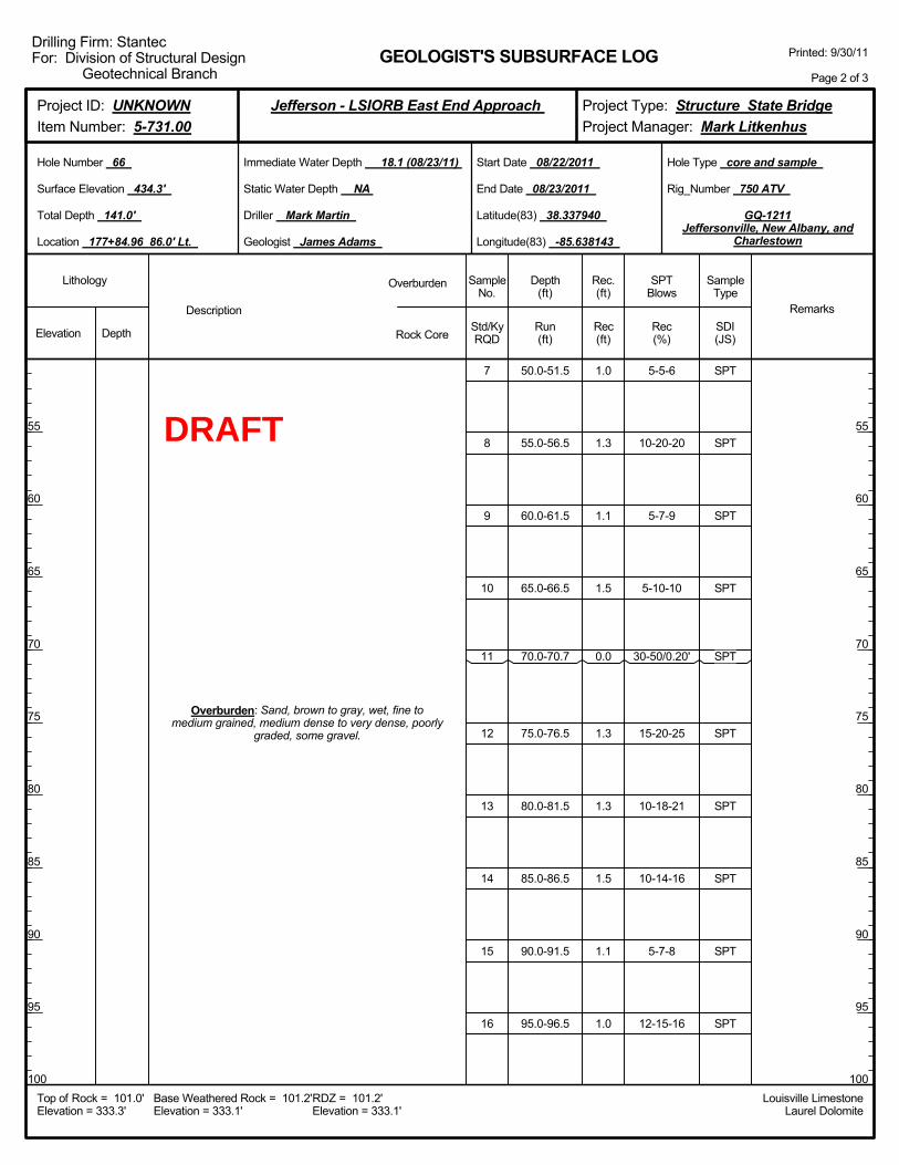
50.0-51.5
55.0-56.5
60.0-61.5
65.0-66.5
70.0-70.7
75.0-76.5
80.0-81.5
85.0-86.5
90.0-91.5
95.0-96.5
5-5-6
10-20-20
5-7-9
5-10-10
30-50/0.20'
15-20-25
10-18-21
10-14-16
5-7-8
12-15-16
Overburden: Sand, brown to gray, wet, fine tomedium grained, medium dense to very dense, poorly
graded, some gravel.
7
8
9
10
11
12
13
14
15
16
1.0
1.3
1.1
1.5
0.0
1.3
1.3
1.5
1.1
1.0
Elevation Depth Std/KyRQD
Lithology
55
60
65
70
75
80
85
90
95
100
55
60
65
70
75
80
85
90
95
100
Depth(ft)
SPTBlows
SampleType
Rec(ft)
Geologist James Adams
Hole Type core and sample
Rec(%)
Rec.(ft)
SampleNo.
Run(ft)
Description
Overburden
Rock CoreSDI(JS)
Remarks
Rig_Number 750 ATV
Hole Number 66
Surface Elevation 434.3'
Total Depth 141.0'
End Date 08/23/2011
Latitude(83) 38.337940
Longitude(83) -85.638143
Start Date 08/22/2011
Driller Mark Martin
GEOLOGIST'S SUBSURFACE LOG
GQ-1211Jeffersonville, New Albany, and
Charlestown
Static Water Depth NA
Louisville LimestoneLaurel Dolomite
Immediate Water Depth 18.1 (08/23/11)
Location 177+84.96 86.0' Lt.
Base Weathered Rock = 101.2'Elevation = 333.1'
Top of Rock = 101.0'Elevation = 333.3'
RDZ = 101.2'Elevation = 333.1'
Printed: 9/30/11
Page 2 of 3
Drilling Firm: StantecFor: Division of Structural Design
Geotechnical Branch
Project Type: Structure State BridgeProject Manager: Mark Litkenhus
Project ID: UNKNOWNItem Number: 5-731.00
Jefferson - LSIORB East End Approach
SPT
SPT
SPT
SPT
SPT
SPT
SPT
SPT
SPT
SPT
DRAFT
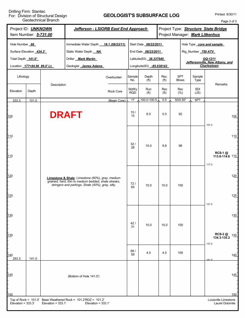
107.0
117.0
127.0
137.0
141.0
100.0-100.5
6.0
10.0
10.0
10.0
4.0
50/0.50'
92
98
100
100
100
RCS-1 @113.8-114.6
RCS-2 @134.3-135.2
333.3
293.3
101.0
141.0
Limestone & Shale: Limestone (60%), gray, mediumgrained, hard, thin to medium bedded, shale streaks,
stringers and partings. Shale (40%), gray, silty.
(Begin Core) 17
15 /15
32 /28
72 /65
42 /31
68 /59
(Bottom of Hole 141.0')
0.5
5.5
9.8
10.0
10.0
4.0
Elevation Depth Std/KyRQD
Lithology
105
110
115
120
125
130
135
140
145
150
105
110
115
120
125
130
135
140
145
150
Depth(ft)
SPTBlows
SampleType
Rec(ft)
Geologist James Adams
Hole Type core and sample
Rec(%)
Rec.(ft)
SampleNo.
Run(ft)
Description
Overburden
Rock CoreSDI(JS)
Remarks
Rig_Number 750 ATV
Hole Number 66
Surface Elevation 434.3'
Total Depth 141.0'
End Date 08/23/2011
Latitude(83) 38.337940
Longitude(83) -85.638143
Start Date 08/22/2011
Driller Mark Martin
GEOLOGIST'S SUBSURFACE LOG
GQ-1211Jeffersonville, New Albany, and
Charlestown
Static Water Depth NA
Louisville LimestoneLaurel Dolomite
Immediate Water Depth 18.1 (08/23/11)
Location 177+84.96 86.0' Lt.
Base Weathered Rock = 101.2'Elevation = 333.1'
Top of Rock = 101.0'Elevation = 333.3'
RDZ = 101.2'Elevation = 333.1'
Printed: 9/30/11
Page 3 of 3
Drilling Firm: StantecFor: Division of Structural Design
Geotechnical Branch
Project Type: Structure State BridgeProject Manager: Mark Litkenhus
Project ID: UNKNOWNItem Number: 5-731.00
Jefferson - LSIORB East End Approach
SPT
DRAFT
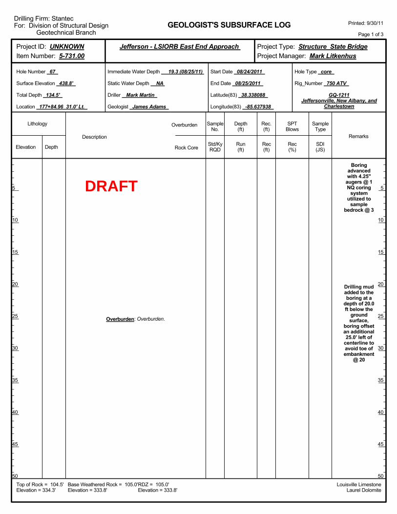
Boringadvancedwith 4.25"
augers @ 1NQ coring
systemutilized to
samplebedrock @ 3
Drilling mudadded to theboring at a
depth of 20.0ft below the
groundsurface,
boring offsetan additional25.0' left of
centerline toavoid toe ofembankment
@ 20
Overburden: Overburden.
Elevation Depth Std/KyRQD
Lithology
5
10
15
20
25
30
35
40
45
50
5
10
15
20
25
30
35
40
45
50
Depth(ft)
SPTBlows
SampleType
Rec(ft)
Geologist James Adams
Hole Type core
Rec(%)
Rec.(ft)
SampleNo.
Run(ft)
Description
Overburden
Rock CoreSDI(JS)
Remarks
Rig_Number 750 ATV
Hole Number 67
Surface Elevation 438.8'
Total Depth 134.5'
End Date 08/25/2011
Latitude(83) 38.338088
Longitude(83) -85.637938
Start Date 08/24/2011
Driller Mark Martin
GEOLOGIST'S SUBSURFACE LOG
GQ-1211Jeffersonville, New Albany, and
Charlestown
Static Water Depth NA
Louisville LimestoneLaurel Dolomite
Immediate Water Depth 19.3 (08/25/11)
Location 177+84.96 31.0' Lt.
Base Weathered Rock = 105.0'Elevation = 333.8'
Top of Rock = 104.5'Elevation = 334.3'
RDZ = 105.0'Elevation = 333.8'
Printed: 9/30/11
Page 1 of 3
Drilling Firm: StantecFor: Division of Structural Design
Geotechnical Branch
Project Type: Structure State BridgeProject Manager: Mark Litkenhus
Project ID: UNKNOWNItem Number: 5-731.00
Jefferson - LSIORB East End Approach
DRAFT
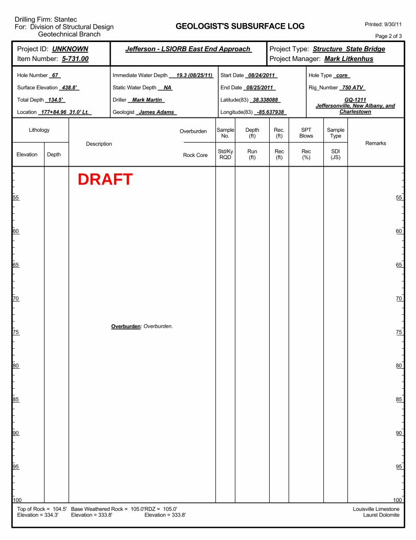
Overburden: Overburden.
Elevation Depth Std/KyRQD
Lithology
55
60
65
70
75
80
85
90
95
100
55
60
65
70
75
80
85
90
95
100
Depth(ft)
SPTBlows
SampleType
Rec(ft)
Geologist James Adams
Hole Type core
Rec(%)
Rec.(ft)
SampleNo.
Run(ft)
Description
Overburden
Rock CoreSDI(JS)
Remarks
Rig_Number 750 ATV
Hole Number 67
Surface Elevation 438.8'
Total Depth 134.5'
End Date 08/25/2011
Latitude(83) 38.338088
Longitude(83) -85.637938
Start Date 08/24/2011
Driller Mark Martin
GEOLOGIST'S SUBSURFACE LOG
GQ-1211Jeffersonville, New Albany, and
Charlestown
Static Water Depth NA
Louisville LimestoneLaurel Dolomite
Immediate Water Depth 19.3 (08/25/11)
Location 177+84.96 31.0' Lt.
Base Weathered Rock = 105.0'Elevation = 333.8'
Top of Rock = 104.5'Elevation = 334.3'
RDZ = 105.0'Elevation = 333.8'
Printed: 9/30/11
Page 2 of 3
Drilling Firm: StantecFor: Division of Structural Design
Geotechnical Branch
Project Type: Structure State BridgeProject Manager: Mark Litkenhus
Project ID: UNKNOWNItem Number: 5-731.00
Jefferson - LSIORB East End Approach
DRAFT
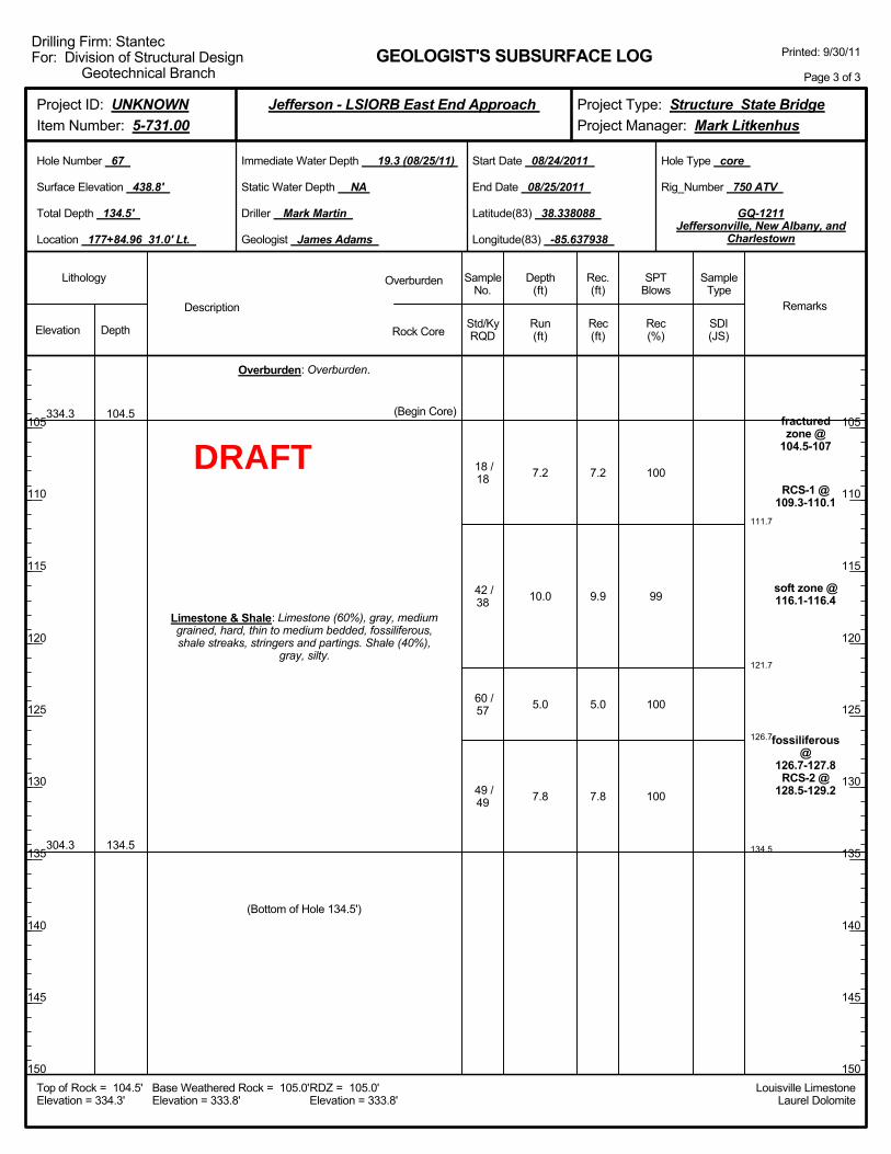
111.7
121.7
126.7
134.5
7.2
10.0
5.0
7.8
100
99
100
100
fracturedzone @
104.5-107
RCS-1 @109.3-110.1
soft zone @116.1-116.4
fossiliferous@
126.7-127.8RCS-2 @
128.5-129.2
334.3
304.3
104.5
134.5
Overburden: Overburden.
Limestone & Shale: Limestone (60%), gray, mediumgrained, hard, thin to medium bedded, fossiliferous,shale streaks, stringers and partings. Shale (40%),
gray, silty.
(Begin Core)
18 /18
42 /38
60 /57
49 /49
(Bottom of Hole 134.5')
7.2
9.9
5.0
7.8
Elevation Depth Std/KyRQD
Lithology
105
110
115
120
125
130
135
140
145
150
105
110
115
120
125
130
135
140
145
150
Depth(ft)
SPTBlows
SampleType
Rec(ft)
Geologist James Adams
Hole Type core
Rec(%)
Rec.(ft)
SampleNo.
Run(ft)
Description
Overburden
Rock CoreSDI(JS)
Remarks
Rig_Number 750 ATV
Hole Number 67
Surface Elevation 438.8'
Total Depth 134.5'
End Date 08/25/2011
Latitude(83) 38.338088
Longitude(83) -85.637938
Start Date 08/24/2011
Driller Mark Martin
GEOLOGIST'S SUBSURFACE LOG
GQ-1211Jeffersonville, New Albany, and
Charlestown
Static Water Depth NA
Louisville LimestoneLaurel Dolomite
Immediate Water Depth 19.3 (08/25/11)
Location 177+84.96 31.0' Lt.
Base Weathered Rock = 105.0'Elevation = 333.8'
Top of Rock = 104.5'Elevation = 334.3'
RDZ = 105.0'Elevation = 333.8'
Printed: 9/30/11
Page 3 of 3
Drilling Firm: StantecFor: Division of Structural Design
Geotechnical Branch
Project Type: Structure State BridgeProject Manager: Mark Litkenhus
Project ID: UNKNOWNItem Number: 5-731.00
Jefferson - LSIORB East End Approach
DRAFT

2.0-4.0
5.0-7.0
10.0-12.0
15.0-17.0
17.0-18.5
20.0-21.5
25.0-26.5
30.0-31.5
35.0-36.5
40.0-41.5
45.0-46.5
0-1-1
0-1-0
1-1-0
18-22-28
5-8-12
5-11-18
6-8-13
Boringadvancedwith 4.25"
augers @ 1NQ coring
systemutilized to
samplebedrock @ 3
Drilling mudadded to theboring at a
depth of 25.0ft below the
groundsurface @ 25
436.6
422.6
412.6
407.6
1.0
15.0
25.0
30.0
Overburden: Topsoil.
Overburden: Clay, brown, moist, sandy.
Overburden: Sand, brown, wet, medium to finegrained, very loose, some clay.
Overburden: Sand, brown, wet, medium grained, veryloose, some gravel.
Overburden: Sand, brown to gray, wet, fine tomedium grained, medium dense to very dense, poorly
graded, some gravel.
1
2
3
4
1
2
3
4
5
6
7
2.0
2.0
2.0
0.5
1.5
1.5
1.5
1.0
1.5
1.5
1.5
Elevation Depth Std/KyRQD
Lithology
5
10
15
20
25
30
35
40
45
50
5
10
15
20
25
30
35
40
45
50
Depth(ft)
SPTBlows
SampleType
Rec(ft)
Geologist James Adams
Hole Type core and sample
Rec(%)
Rec.(ft)
SampleNo.
Run(ft)
Description
Overburden
Rock CoreSDI(JS)
Remarks
Rig_Number 1050 ATV
Hole Number 70
Surface Elevation 437.6'
Total Depth 138.0'
End Date 08/18/2011
Latitude(83) 38.338376
Longitude(83) -85.638653
Start Date 08/17/2011
Driller Danny Jessie
GEOLOGIST'S SUBSURFACE LOG
GQ-1211Jeffersonville, New Albany, and
Charlestown
Static Water Depth NA
Louisville LimestoneLaurel Dolomite
Immediate Water Depth 21.0 (08/18/11)
Location 180+00.96 86.0' Lt.
Base Weathered Rock = 103.3'Elevation = 334.3'
Top of Rock = 103.3'Elevation = 334.3'
RDZ = 103.3'Elevation = 334.3'
Printed: 9/30/11
Page 1 of 3
Drilling Firm: StantecFor: Division of Structural Design
Geotechnical Branch
Project Type: Structure State BridgeProject Manager: Mark Litkenhus
Project ID: UNKNOWNItem Number: 5-731.00
Jefferson - LSIORB East End Approach
ST
ST
ST
ST
SPT
SPT
SPT
SPT
SPT
SPT
SPT
DRAFT

50.0-51.5
55.0-56.5
60.0-61.5
65.0-66.5
70.0-71.5
75.0-76.5
80.0-81.5
85.0-86.5
90.0-91.5
95.0-96.5
5-9-12
7-10-14
5-4-12
6-10-18
4-8-10
4-5-9
14-19-34
7-6-7
6-11-14
12-14-15
Overburden: Sand, brown to gray, wet, fine tomedium grained, medium dense to very dense, poorly
graded, some gravel.
8
9
10
11
12
13
14
15
16
17
1.5
1.5
0.5
1.5
1.5
1.1
0.9
1.2
1.5
1.5
Elevation Depth Std/KyRQD
Lithology
55
60
65
70
75
80
85
90
95
100
55
60
65
70
75
80
85
90
95
100
Depth(ft)
SPTBlows
SampleType
Rec(ft)
Geologist James Adams
Hole Type core and sample
Rec(%)
Rec.(ft)
SampleNo.
Run(ft)
Description
Overburden
Rock CoreSDI(JS)
Remarks
Rig_Number 1050 ATV
Hole Number 70
Surface Elevation 437.6'
Total Depth 138.0'
End Date 08/18/2011
Latitude(83) 38.338376
Longitude(83) -85.638653
Start Date 08/17/2011
Driller Danny Jessie
GEOLOGIST'S SUBSURFACE LOG
GQ-1211Jeffersonville, New Albany, and
Charlestown
Static Water Depth NA
Louisville LimestoneLaurel Dolomite
Immediate Water Depth 21.0 (08/18/11)
Location 180+00.96 86.0' Lt.
Base Weathered Rock = 103.3'Elevation = 334.3'
Top of Rock = 103.3'Elevation = 334.3'
RDZ = 103.3'Elevation = 334.3'
Printed: 9/30/11
Page 2 of 3
Drilling Firm: StantecFor: Division of Structural Design
Geotechnical Branch
Project Type: Structure State BridgeProject Manager: Mark Litkenhus
Project ID: UNKNOWNItem Number: 5-731.00
Jefferson - LSIORB East End Approach
SPT
SPT
SPT
SPT
SPT
SPT
SPT
SPT
SPT
SPT
DRAFT
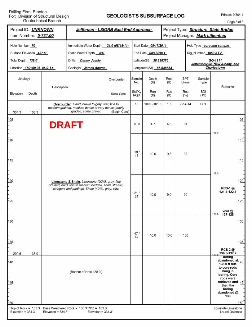
108.0
118.0
128.0
138.0
100.0-101.5
4.7
10.0
10.0
10.0
7-14-14
91
98
90
100
RCS-1 @121.4-122.1
void @127-128
RCS-2 @136.5-137.2
Boringabandoned at138.0 ft dueto core rods
hung inboring. Core
rods wereretrieved and
then theboring
abandoned @138
334.3
299.6
103.3
138.0
Overburden: Sand, brown to gray, wet, fine tomedium grained, medium dense to very dense, poorly
graded, some gravel.
Limestone & Shale: Limestone (60%), gray, finegrained, hard, thin to medium bedded, shale streaks,
stringers and partings. Shale (40%), gray, silty.
(Begin Core)
18
8 / 8
18 /18
21 /21
47 /47
(Bottom of Hole 138.0')
1.5
4.3
9.8
9.0
10.0
Elevation Depth Std/KyRQD
Lithology
105
110
115
120
125
130
135
140
145
150
105
110
115
120
125
130
135
140
145
150
Depth(ft)
SPTBlows
SampleType
Rec(ft)
Geologist James Adams
Hole Type core and sample
Rec(%)
Rec.(ft)
SampleNo.
Run(ft)
Description
Overburden
Rock CoreSDI(JS)
Remarks
Rig_Number 1050 ATV
Hole Number 70
Surface Elevation 437.6'
Total Depth 138.0'
End Date 08/18/2011
Latitude(83) 38.338376
Longitude(83) -85.638653
Start Date 08/17/2011
Driller Danny Jessie
GEOLOGIST'S SUBSURFACE LOG
GQ-1211Jeffersonville, New Albany, and
Charlestown
Static Water Depth NA
Louisville LimestoneLaurel Dolomite
Immediate Water Depth 21.0 (08/18/11)
Location 180+00.96 86.0' Lt.
Base Weathered Rock = 103.3'Elevation = 334.3'
Top of Rock = 103.3'Elevation = 334.3'
RDZ = 103.3'Elevation = 334.3'
Printed: 9/30/11
Page 3 of 3
Drilling Firm: StantecFor: Division of Structural Design
Geotechnical Branch
Project Type: Structure State BridgeProject Manager: Mark Litkenhus
Project ID: UNKNOWNItem Number: 5-731.00
Jefferson - LSIORB East End Approach
SPT
DRAFT

Boringadvancedwith 4.25"
augers @ 1NQ coring
systemutilized to
samplebedrock @ 3boring movedan additional18.0' left of
centerline toavoid toe of
embankment,approximate
elevationchange of5.0' @ 6
Drilling mudadded to theboring at a
depth of 20.0ft below the
groundsurface @ 20Overburden: Overburden.
Elevation Depth Std/KyRQD
Lithology
5
10
15
20
25
30
35
40
45
50
5
10
15
20
25
30
35
40
45
50
Depth(ft)
SPTBlows
SampleType
Rec(ft)
Geologist James Adams
Hole Type core
Rec(%)
Rec.(ft)
SampleNo.
Run(ft)
Description
Overburden
Rock CoreSDI(JS)
Remarks
Rig_Number 750 ATV
Hole Number 71
Surface Elevation 439.2'
Total Depth 137.1'
End Date 08/18/2011
Latitude(83) 38.338525
Longitude(83) -85.638448
Start Date 08/18/2011
Driller Muriell Wethington
GEOLOGIST'S SUBSURFACE LOG
GQ-1211Jeffersonville, New Albany, and
Charlestown
Static Water Depth NA
Louisville LimestoneLaurel Dolomite
Immediate Water Depth 18.0 (08/18/11)
Location 180+00.96 24.0' Lt.
Base Weathered Rock = 107.6'Elevation = 331.6'
Top of Rock = 107.1'Elevation = 332.1'
RDZ = 107.6'Elevation = 331.6'
Printed: 9/30/11
Page 1 of 3
Drilling Firm: StantecFor: Division of Structural Design
Geotechnical Branch
Project Type: Structure State BridgeProject Manager: Mark Litkenhus
Project ID: UNKNOWNItem Number: 5-731.00
Jefferson - LSIORB East End Approach
DRAFT
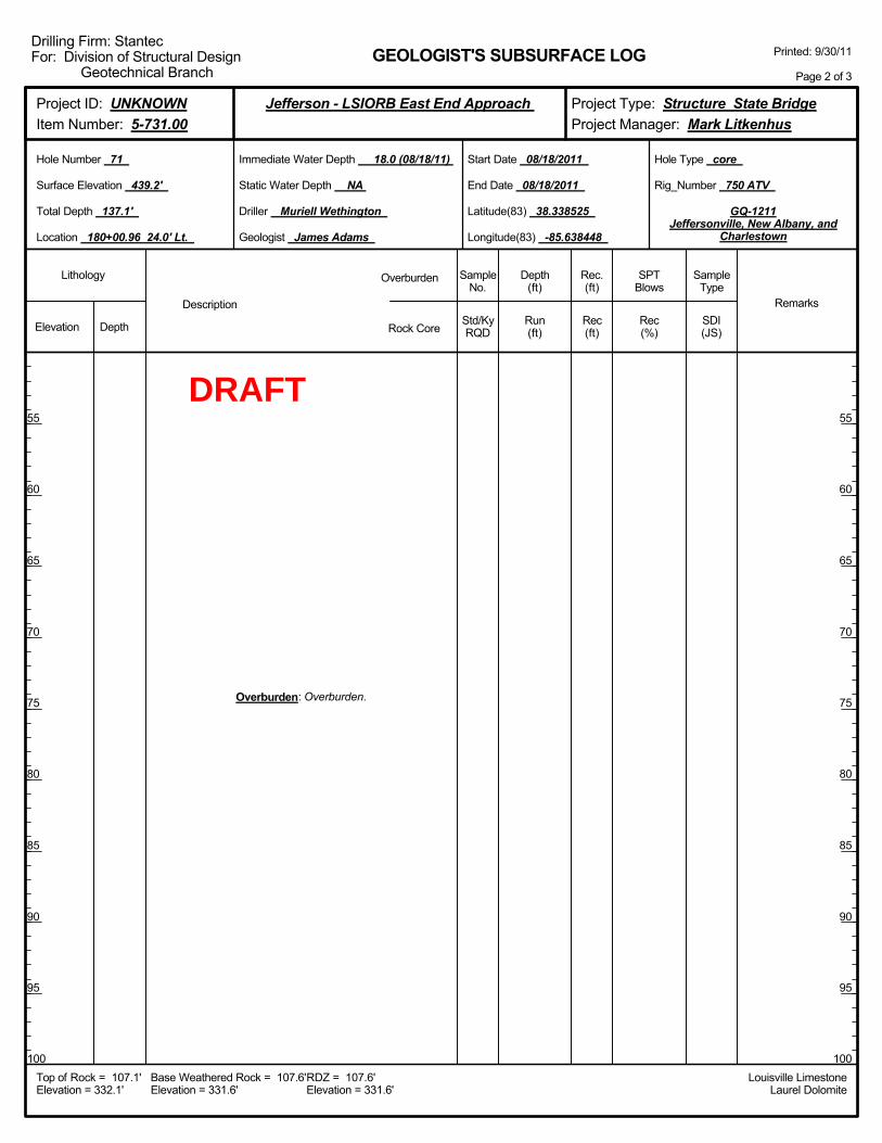
Overburden: Overburden.
Elevation Depth Std/KyRQD
Lithology
55
60
65
70
75
80
85
90
95
100
55
60
65
70
75
80
85
90
95
100
Depth(ft)
SPTBlows
SampleType
Rec(ft)
Geologist James Adams
Hole Type core
Rec(%)
Rec.(ft)
SampleNo.
Run(ft)
Description
Overburden
Rock CoreSDI(JS)
Remarks
Rig_Number 750 ATV
Hole Number 71
Surface Elevation 439.2'
Total Depth 137.1'
End Date 08/18/2011
Latitude(83) 38.338525
Longitude(83) -85.638448
Start Date 08/18/2011
Driller Muriell Wethington
GEOLOGIST'S SUBSURFACE LOG
GQ-1211Jeffersonville, New Albany, and
Charlestown
Static Water Depth NA
Louisville LimestoneLaurel Dolomite
Immediate Water Depth 18.0 (08/18/11)
Location 180+00.96 24.0' Lt.
Base Weathered Rock = 107.6'Elevation = 331.6'
Top of Rock = 107.1'Elevation = 332.1'
RDZ = 107.6'Elevation = 331.6'
Printed: 9/30/11
Page 2 of 3
Drilling Firm: StantecFor: Division of Structural Design
Geotechnical Branch
Project Type: Structure State BridgeProject Manager: Mark Litkenhus
Project ID: UNKNOWNItem Number: 5-731.00
Jefferson - LSIORB East End Approach
DRAFT
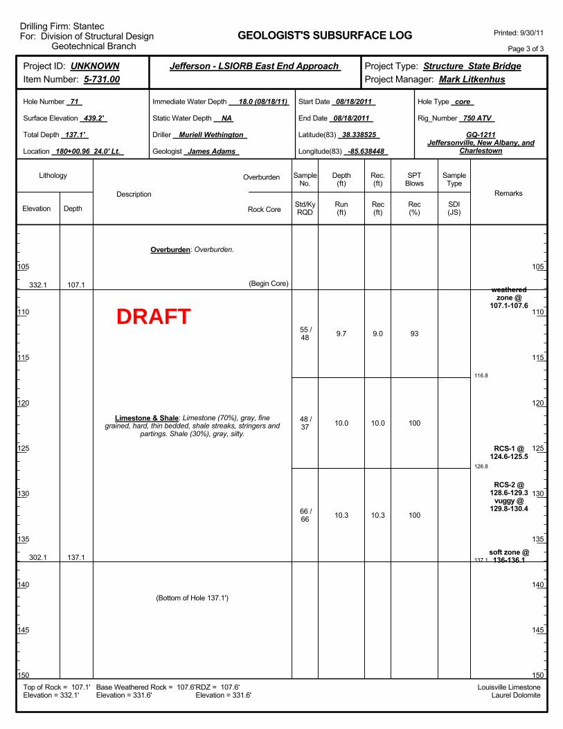
116.8
126.8
137.1
9.7
10.0
10.3
93
100
100
weatheredzone @
107.1-107.6
RCS-1 @124.6-125.5
RCS-2 @128.6-129.3
vuggy @129.8-130.4
soft zone @136-136.1
332.1
302.1
107.1
137.1
Overburden: Overburden.
Limestone & Shale: Limestone (70%), gray, finegrained, hard, thin bedded, shale streaks, stringers and
partings. Shale (30%), gray, silty.
(Begin Core)
55 /48
48 /37
66 /66
(Bottom of Hole 137.1')
9.0
10.0
10.3
Elevation Depth Std/KyRQD
Lithology
105
110
115
120
125
130
135
140
145
150
105
110
115
120
125
130
135
140
145
150
Depth(ft)
SPTBlows
SampleType
Rec(ft)
Geologist James Adams
Hole Type core
Rec(%)
Rec.(ft)
SampleNo.
Run(ft)
Description
Overburden
Rock CoreSDI(JS)
Remarks
Rig_Number 750 ATV
Hole Number 71
Surface Elevation 439.2'
Total Depth 137.1'
End Date 08/18/2011
Latitude(83) 38.338525
Longitude(83) -85.638448
Start Date 08/18/2011
Driller Muriell Wethington
GEOLOGIST'S SUBSURFACE LOG
GQ-1211Jeffersonville, New Albany, and
Charlestown
Static Water Depth NA
Louisville LimestoneLaurel Dolomite
Immediate Water Depth 18.0 (08/18/11)
Location 180+00.96 24.0' Lt.
Base Weathered Rock = 107.6'Elevation = 331.6'
Top of Rock = 107.1'Elevation = 332.1'
RDZ = 107.6'Elevation = 331.6'
Printed: 9/30/11
Page 3 of 3
Drilling Firm: StantecFor: Division of Structural Design
Geotechnical Branch
Project Type: Structure State BridgeProject Manager: Mark Litkenhus
Project ID: UNKNOWNItem Number: 5-731.00
Jefferson - LSIORB East End Approach
DRAFT

Boringadvancedwith 4.25"
augers @ 1NQ coring
systemutilized to
samplebedrock @ 3Boring wasoriginally
drilled with3.25" auger,Boring wasre-drilled anadditional4.0' LT oforiginal
boring with4.25" due tothe previous
augersdrilling an
off-centeredboring @ 6
Drilling mudadded to theboring at a
depth of 15.0ft below the
groundsurface, @ 15
Overburden: overburden.
Elevation Depth Std/KyRQD
Lithology
5
10
15
20
25
30
35
40
45
50
5
10
15
20
25
30
35
40
45
50
Depth(ft)
SPTBlows
SampleType
Rec(ft)
Geologist James Adams
Hole Type core
Rec(%)
Rec.(ft)
SampleNo.
Run(ft)
Description
Overburden
Rock CoreSDI(JS)
Remarks
Rig_Number 750 ATV
Hole Number 74
Surface Elevation 432.7'
Total Depth 138.2'
End Date 08/17/2011
Latitude(83) 38.338922
Longitude(83) -85.639290
Start Date 08/16/2011
Driller Muriell Wethington
GEOLOGIST'S SUBSURFACE LOG
GQ-1211Jeffersonville, New Albany, and
Charlestown
Static Water Depth NA
Louisville LimestoneLaurel Dolomite
Immediate Water Depth 12.9 (08/17/11)
Location 182+70.96 90.0' Lt.
Base Weathered Rock = 99.2'Elevation = 333.5'
Top of Rock = 98.2'Elevation = 334.5'
RDZ = 99.2'Elevation = 333.5'
Printed: 9/30/11
Page 1 of 3
Drilling Firm: StantecFor: Division of Structural Design
Geotechnical Branch
Project Type: Structure State BridgeProject Manager: Mark Litkenhus
Project ID: UNKNOWNItem Number: 5-731.00
Jefferson - LSIORB East End Approach
DRAFT
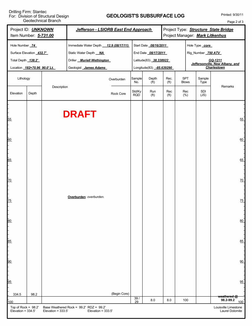
8.0 100weathered @
98.2-99.2334.5 98.2
Overburden: overburden.
(Begin Core)39 /29 8.0
Elevation Depth Std/KyRQD
Lithology
55
60
65
70
75
80
85
90
95
100
55
60
65
70
75
80
85
90
95
100
Depth(ft)
SPTBlows
SampleType
Rec(ft)
Geologist James Adams
Hole Type core
Rec(%)
Rec.(ft)
SampleNo.
Run(ft)
Description
Overburden
Rock CoreSDI(JS)
Remarks
Rig_Number 750 ATV
Hole Number 74
Surface Elevation 432.7'
Total Depth 138.2'
End Date 08/17/2011
Latitude(83) 38.338922
Longitude(83) -85.639290
Start Date 08/16/2011
Driller Muriell Wethington
GEOLOGIST'S SUBSURFACE LOG
GQ-1211Jeffersonville, New Albany, and
Charlestown
Static Water Depth NA
Louisville LimestoneLaurel Dolomite
Immediate Water Depth 12.9 (08/17/11)
Location 182+70.96 90.0' Lt.
Base Weathered Rock = 99.2'Elevation = 333.5'
Top of Rock = 98.2'Elevation = 334.5'
RDZ = 99.2'Elevation = 333.5'
Printed: 9/30/11
Page 2 of 3
Drilling Firm: StantecFor: Division of Structural Design
Geotechnical Branch
Project Type: Structure State BridgeProject Manager: Mark Litkenhus
Project ID: UNKNOWNItem Number: 5-731.00
Jefferson - LSIORB East End Approach
DRAFT
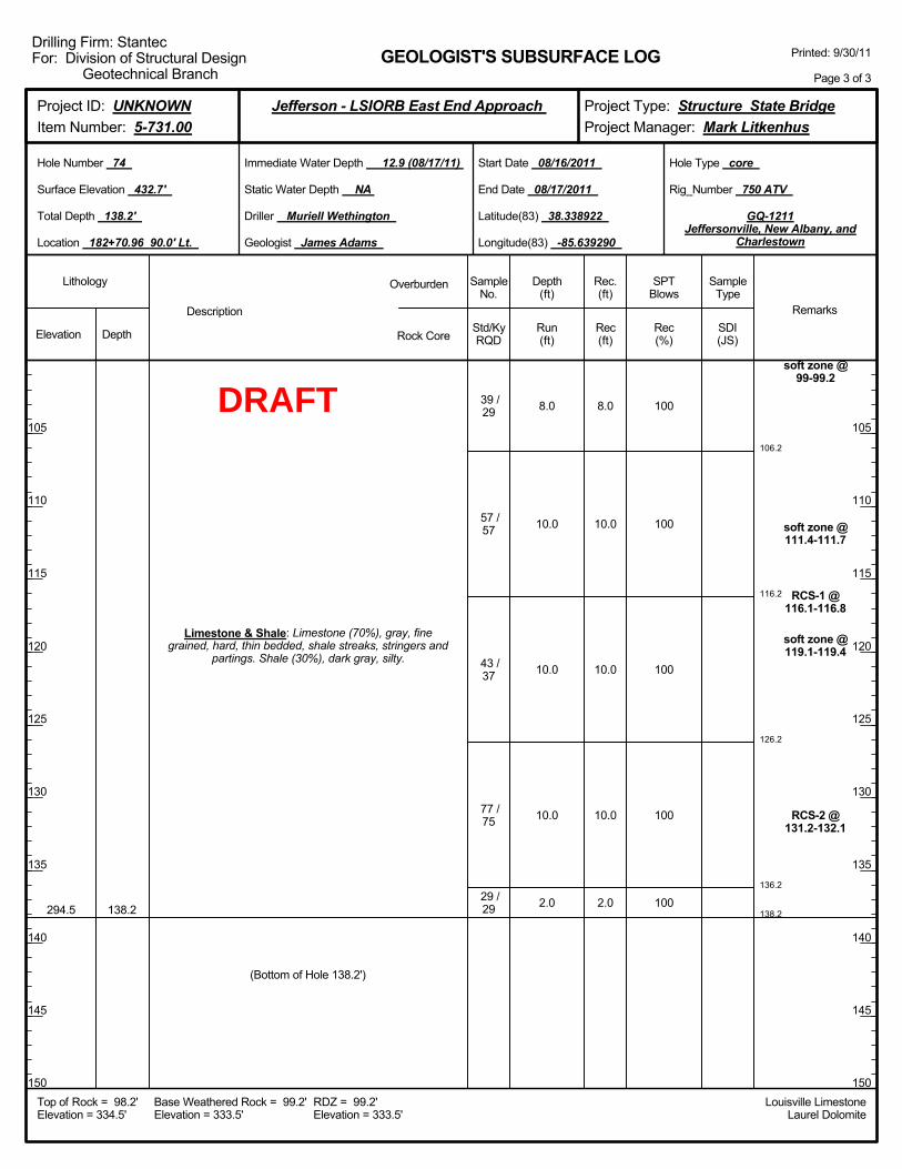
106.2
116.2
126.2
136.2
138.2
8.0
10.0
10.0
10.0
2.0
100
100
100
100
100
soft zone @99-99.2
soft zone @111.4-111.7
RCS-1 @116.1-116.8
soft zone @119.1-119.4
RCS-2 @131.2-132.1
294.5 138.2
Limestone & Shale: Limestone (70%), gray, finegrained, hard, thin bedded, shale streaks, stringers and
partings. Shale (30%), dark gray, silty.
39 /29
57 /57
43 /37
77 /75
29 /29
(Bottom of Hole 138.2')
8.0
10.0
10.0
10.0
2.0
Elevation Depth Std/KyRQD
Lithology
105
110
115
120
125
130
135
140
145
150
105
110
115
120
125
130
135
140
145
150
Depth(ft)
SPTBlows
SampleType
Rec(ft)
Geologist James Adams
Hole Type core
Rec(%)
Rec.(ft)
SampleNo.
Run(ft)
Description
Overburden
Rock CoreSDI(JS)
Remarks
Rig_Number 750 ATV
Hole Number 74
Surface Elevation 432.7'
Total Depth 138.2'
End Date 08/17/2011
Latitude(83) 38.338922
Longitude(83) -85.639290
Start Date 08/16/2011
Driller Muriell Wethington
GEOLOGIST'S SUBSURFACE LOG
GQ-1211Jeffersonville, New Albany, and
Charlestown
Static Water Depth NA
Louisville LimestoneLaurel Dolomite
Immediate Water Depth 12.9 (08/17/11)
Location 182+70.96 90.0' Lt.
Base Weathered Rock = 99.2'Elevation = 333.5'
Top of Rock = 98.2'Elevation = 334.5'
RDZ = 99.2'Elevation = 333.5'
Printed: 9/30/11
Page 3 of 3
Drilling Firm: StantecFor: Division of Structural Design
Geotechnical Branch
Project Type: Structure State BridgeProject Manager: Mark Litkenhus
Project ID: UNKNOWNItem Number: 5-731.00
Jefferson - LSIORB East End Approach
DRAFT
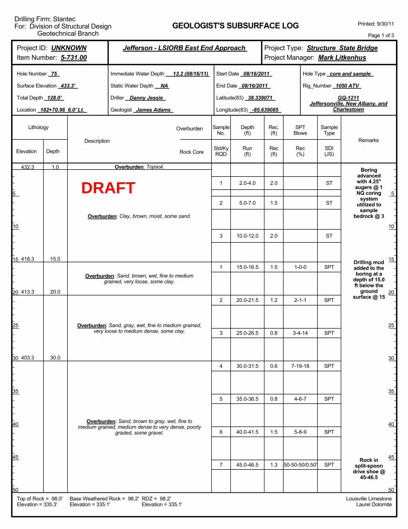
2.0-4.0
5.0-7.0
10.0-12.0
15.0-16.5
20.0-21.5
25.0-26.5
30.0-31.5
35.0-36.5
40.0-41.5
45.0-46.5
1-0-0
2-1-1
3-4-14
7-19-18
4-6-7
5-8-9
50-50-50/0.50'
Boringadvancedwith 4.25"
augers @ 1NQ coring
systemutilized to
samplebedrock @ 3
Drilling mudadded to theboring at a
depth of 15.0ft below the
groundsurface @ 15
Rock insplit-spoon
drive shoe @45-46.5
432.3
418.3
413.3
403.3
1.0
15.0
20.0
30.0
Overburden: Topsoil.
Overburden: Clay, brown, moist, some sand.
Overburden: Sand, brown, wet, fine to mediumgrained, very loose, some clay.
Overburden: Sand, gray, wet, fine to medium grained,very loose to medium dense, some clay.
Overburden: Sand, brown to gray, wet, fine tomedium grained, medium dense to very dense, poorly
graded, some gravel.
1
2
3
1
2
3
4
5
6
7
2.0
1.5
2.0
1.5
1.2
0.8
0.6
0.8
1.5
1.3
Elevation Depth Std/KyRQD
Lithology
5
10
15
20
25
30
35
40
45
50
5
10
15
20
25
30
35
40
45
50
Depth(ft)
SPTBlows
SampleType
Rec(ft)
Geologist James Adams
Hole Type core and sample
Rec(%)
Rec.(ft)
SampleNo.
Run(ft)
Description
Overburden
Rock CoreSDI(JS)
Remarks
Rig_Number 1050 ATV
Hole Number 75
Surface Elevation 433.3'
Total Depth 128.0'
End Date 08/16/2011
Latitude(83) 38.339071
Longitude(83) -85.639085
Start Date 08/16/2011
Driller Danny Jessie
GEOLOGIST'S SUBSURFACE LOG
GQ-1211Jeffersonville, New Albany, and
Charlestown
Static Water Depth NA
Louisville LimestoneLaurel Dolomite
Immediate Water Depth 13.2 (08/16/11)
Location 182+70.96 6.0' Lt.
Base Weathered Rock = 98.2'Elevation = 335.1'
Top of Rock = 98.0'Elevation = 335.3'
RDZ = 98.2'Elevation = 335.1'
Printed: 9/30/11
Page 1 of 3
Drilling Firm: StantecFor: Division of Structural Design
Geotechnical Branch
Project Type: Structure State BridgeProject Manager: Mark Litkenhus
Project ID: UNKNOWNItem Number: 5-731.00
Jefferson - LSIORB East End Approach
ST
ST
ST
SPT
SPT
SPT
SPT
SPT
SPT
SPT
DRAFT
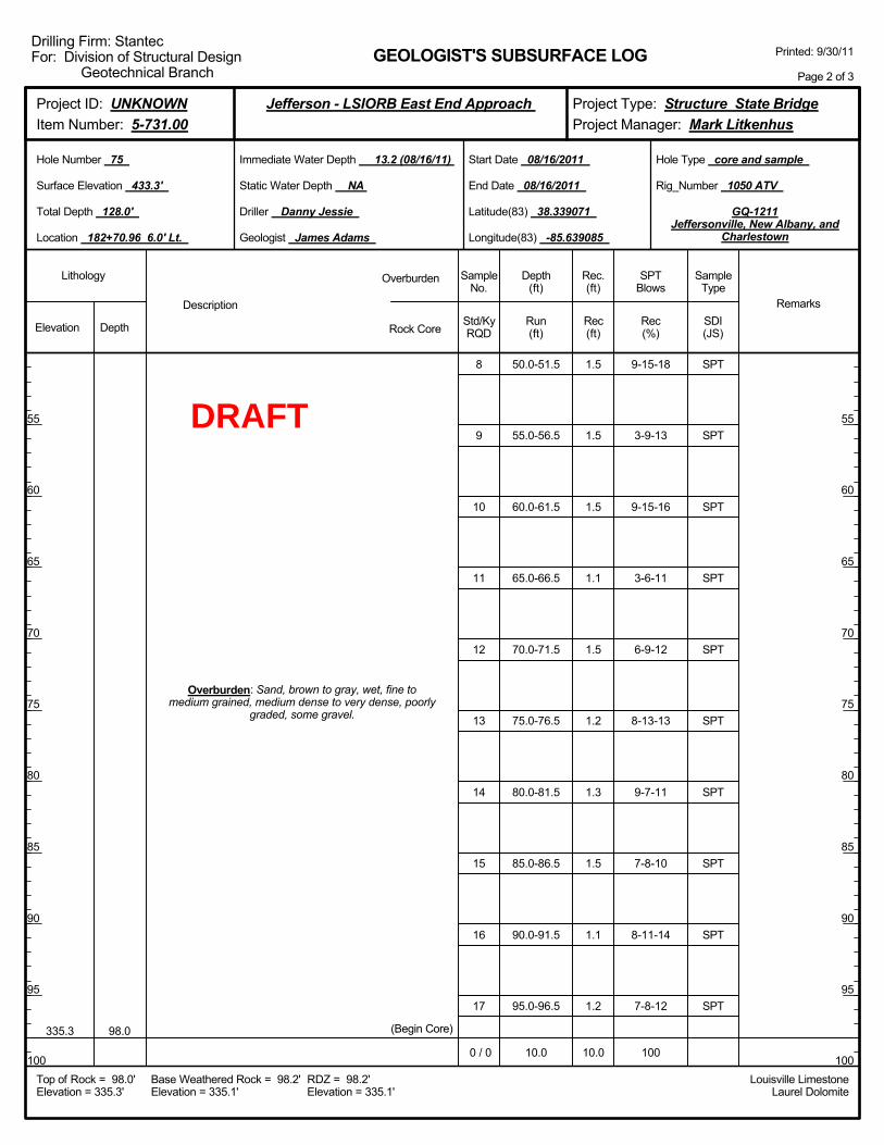
50.0-51.5
55.0-56.5
60.0-61.5
65.0-66.5
70.0-71.5
75.0-76.5
80.0-81.5
85.0-86.5
90.0-91.5
95.0-96.5
10.0
9-15-18
3-9-13
9-15-16
3-6-11
6-9-12
8-13-13
9-7-11
7-8-10
8-11-14
7-8-12
100
335.3 98.0
Overburden: Sand, brown to gray, wet, fine tomedium grained, medium dense to very dense, poorly
graded, some gravel.
(Begin Core)
8
9
10
11
12
13
14
15
16
17
0 / 0
1.5
1.5
1.5
1.1
1.5
1.2
1.3
1.5
1.1
1.2
10.0
Elevation Depth Std/KyRQD
Lithology
55
60
65
70
75
80
85
90
95
100
55
60
65
70
75
80
85
90
95
100
Depth(ft)
SPTBlows
SampleType
Rec(ft)
Geologist James Adams
Hole Type core and sample
Rec(%)
Rec.(ft)
SampleNo.
Run(ft)
Description
Overburden
Rock CoreSDI(JS)
Remarks
Rig_Number 1050 ATV
Hole Number 75
Surface Elevation 433.3'
Total Depth 128.0'
End Date 08/16/2011
Latitude(83) 38.339071
Longitude(83) -85.639085
Start Date 08/16/2011
Driller Danny Jessie
GEOLOGIST'S SUBSURFACE LOG
GQ-1211Jeffersonville, New Albany, and
Charlestown
Static Water Depth NA
Louisville LimestoneLaurel Dolomite
Immediate Water Depth 13.2 (08/16/11)
Location 182+70.96 6.0' Lt.
Base Weathered Rock = 98.2'Elevation = 335.1'
Top of Rock = 98.0'Elevation = 335.3'
RDZ = 98.2'Elevation = 335.1'
Printed: 9/30/11
Page 2 of 3
Drilling Firm: StantecFor: Division of Structural Design
Geotechnical Branch
Project Type: Structure State BridgeProject Manager: Mark Litkenhus
Project ID: UNKNOWNItem Number: 5-731.00
Jefferson - LSIORB East End Approach
SPT
SPT
SPT
SPT
SPT
SPT
SPT
SPT
SPT
SPT
DRAFT
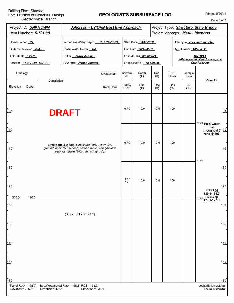
108.0
118.0
128.0
10.0
10.0
10.0
100
100
100
100% waterloss
throughout 3runs @ 108
RCS-1 @125.6-126.5
RCS-2 @127.1-127.8
305.3 128.0
Limestone & Shale: Limestone (60%), gray, finegrained, hard, thin bedded, shale streaks, stringers and
partings. Shale (40%), dark gray, silty.
0 / 0
0 / 0
17 /17
(Bottom of Hole 128.0')
10.0
10.0
10.0
Elevation Depth Std/KyRQD
Lithology
105
110
115
120
125
130
135
140
145
150
105
110
115
120
125
130
135
140
145
150
Depth(ft)
SPTBlows
SampleType
Rec(ft)
Geologist James Adams
Hole Type core and sample
Rec(%)
Rec.(ft)
SampleNo.
Run(ft)
Description
Overburden
Rock CoreSDI(JS)
Remarks
Rig_Number 1050 ATV
Hole Number 75
Surface Elevation 433.3'
Total Depth 128.0'
End Date 08/16/2011
Latitude(83) 38.339071
Longitude(83) -85.639085
Start Date 08/16/2011
Driller Danny Jessie
GEOLOGIST'S SUBSURFACE LOG
GQ-1211Jeffersonville, New Albany, and
Charlestown
Static Water Depth NA
Louisville LimestoneLaurel Dolomite
Immediate Water Depth 13.2 (08/16/11)
Location 182+70.96 6.0' Lt.
Base Weathered Rock = 98.2'Elevation = 335.1'
Top of Rock = 98.0'Elevation = 335.3'
RDZ = 98.2'Elevation = 335.1'
Printed: 9/30/11
Page 3 of 3
Drilling Firm: StantecFor: Division of Structural Design
Geotechnical Branch
Project Type: Structure State BridgeProject Manager: Mark Litkenhus
Project ID: UNKNOWNItem Number: 5-731.00
Jefferson - LSIORB East End Approach
DRAFT
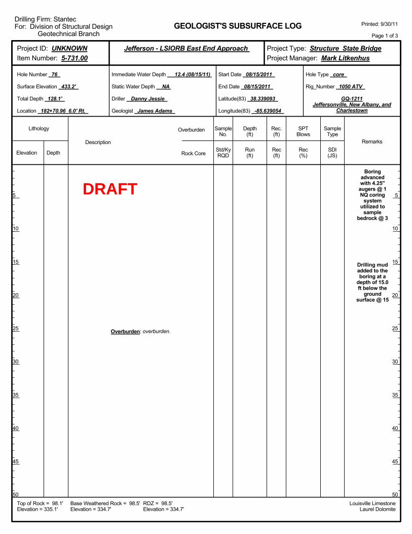
Boringadvancedwith 4.25"
augers @ 1NQ coring
systemutilized to
samplebedrock @ 3
Drilling mudadded to theboring at a
depth of 15.0ft below the
groundsurface @ 15
Overburden: overburden.
Elevation Depth Std/KyRQD
Lithology
5
10
15
20
25
30
35
40
45
50
5
10
15
20
25
30
35
40
45
50
Depth(ft)
SPTBlows
SampleType
Rec(ft)
Geologist James Adams
Hole Type core
Rec(%)
Rec.(ft)
SampleNo.
Run(ft)
Description
Overburden
Rock CoreSDI(JS)
Remarks
Rig_Number 1050 ATV
Hole Number 76
Surface Elevation 433.2'
Total Depth 128.1'
End Date 08/15/2011
Latitude(83) 38.339093
Longitude(83) -85.639054
Start Date 08/15/2011
Driller Danny Jessie
GEOLOGIST'S SUBSURFACE LOG
GQ-1211Jeffersonville, New Albany, and
Charlestown
Static Water Depth NA
Louisville LimestoneLaurel Dolomite
Immediate Water Depth 12.4 (08/15/11)
Location 182+70.96 6.0' Rt.
Base Weathered Rock = 98.5'Elevation = 334.7'
Top of Rock = 98.1'Elevation = 335.1'
RDZ = 98.5'Elevation = 334.7'
Printed: 9/30/11
Page 1 of 3
Drilling Firm: StantecFor: Division of Structural Design
Geotechnical Branch
Project Type: Structure State BridgeProject Manager: Mark Litkenhus
Project ID: UNKNOWNItem Number: 5-731.00
Jefferson - LSIORB East End Approach
DRAFT
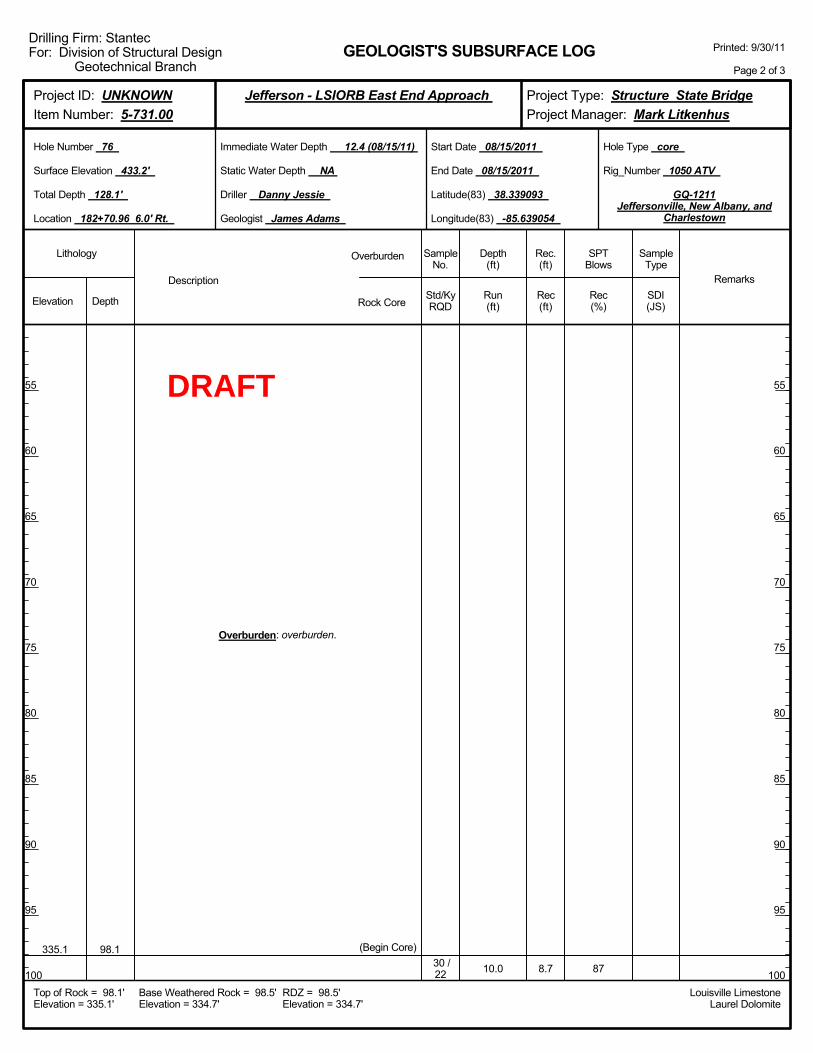
10.0 87
335.1 98.1
Overburden: overburden.
(Begin Core)30 /22 8.7
Elevation Depth Std/KyRQD
Lithology
55
60
65
70
75
80
85
90
95
100
55
60
65
70
75
80
85
90
95
100
Depth(ft)
SPTBlows
SampleType
Rec(ft)
Geologist James Adams
Hole Type core
Rec(%)
Rec.(ft)
SampleNo.
Run(ft)
Description
Overburden
Rock CoreSDI(JS)
Remarks
Rig_Number 1050 ATV
Hole Number 76
Surface Elevation 433.2'
Total Depth 128.1'
End Date 08/15/2011
Latitude(83) 38.339093
Longitude(83) -85.639054
Start Date 08/15/2011
Driller Danny Jessie
GEOLOGIST'S SUBSURFACE LOG
GQ-1211Jeffersonville, New Albany, and
Charlestown
Static Water Depth NA
Louisville LimestoneLaurel Dolomite
Immediate Water Depth 12.4 (08/15/11)
Location 182+70.96 6.0' Rt.
Base Weathered Rock = 98.5'Elevation = 334.7'
Top of Rock = 98.1'Elevation = 335.1'
RDZ = 98.5'Elevation = 334.7'
Printed: 9/30/11
Page 2 of 3
Drilling Firm: StantecFor: Division of Structural Design
Geotechnical Branch
Project Type: Structure State BridgeProject Manager: Mark Litkenhus
Project ID: UNKNOWNItem Number: 5-731.00
Jefferson - LSIORB East End Approach
DRAFT
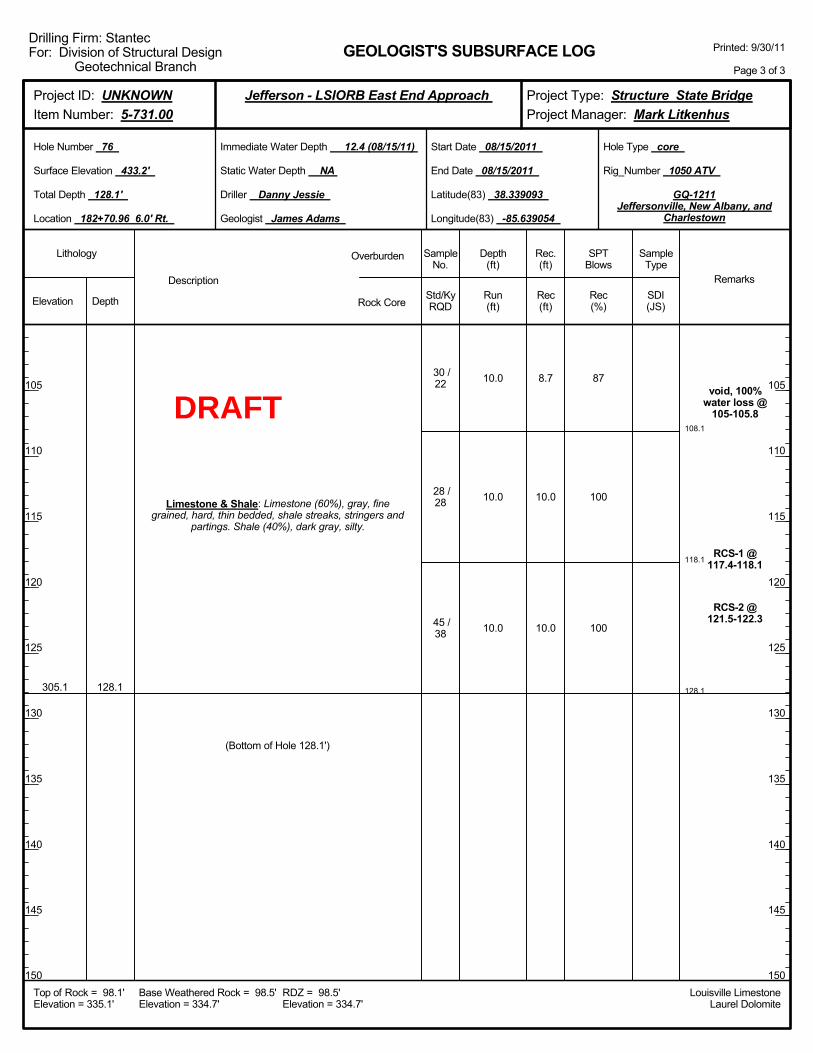
108.1
118.1
128.1
10.0
10.0
10.0
87
100
100
void, 100%water loss @
105-105.8
RCS-1 @117.4-118.1
RCS-2 @121.5-122.3
305.1 128.1
Limestone & Shale: Limestone (60%), gray, finegrained, hard, thin bedded, shale streaks, stringers and
partings. Shale (40%), dark gray, silty.
30 /22
28 /28
45 /38
(Bottom of Hole 128.1')
8.7
10.0
10.0
Elevation Depth Std/KyRQD
Lithology
105
110
115
120
125
130
135
140
145
150
105
110
115
120
125
130
135
140
145
150
Depth(ft)
SPTBlows
SampleType
Rec(ft)
Geologist James Adams
Hole Type core
Rec(%)
Rec.(ft)
SampleNo.
Run(ft)
Description
Overburden
Rock CoreSDI(JS)
Remarks
Rig_Number 1050 ATV
Hole Number 76
Surface Elevation 433.2'
Total Depth 128.1'
End Date 08/15/2011
Latitude(83) 38.339093
Longitude(83) -85.639054
Start Date 08/15/2011
Driller Danny Jessie
GEOLOGIST'S SUBSURFACE LOG
GQ-1211Jeffersonville, New Albany, and
Charlestown
Static Water Depth NA
Louisville LimestoneLaurel Dolomite
Immediate Water Depth 12.4 (08/15/11)
Location 182+70.96 6.0' Rt.
Base Weathered Rock = 98.5'Elevation = 334.7'
Top of Rock = 98.1'Elevation = 335.1'
RDZ = 98.5'Elevation = 334.7'
Printed: 9/30/11
Page 3 of 3
Drilling Firm: StantecFor: Division of Structural Design
Geotechnical Branch
Project Type: Structure State BridgeProject Manager: Mark Litkenhus
Project ID: UNKNOWNItem Number: 5-731.00
Jefferson - LSIORB East End Approach
DRAFT
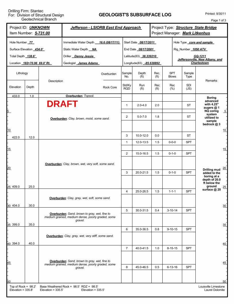
2.0-4.0
5.0-7.0
10.0-12.0
12.0-13.5
15.0-16.5
20.0-21.5
25.0-26.5
30.0-31.5
35.0-36.5
40.0-41.5
45.0-46.5
0-0-0
0-1-0
0-1-0
1-1-1
3-10-14
9-10-15
8-15-15
6-13-16
Boringadvancedwith 4.25"
augers @ 1NQ coring
systemutilized to
samplebedrock @ 3
Drilling mudadded to theboring at a
depth of 20.0ft below the
groundsurface @ 20
433.0
422.0
409.0
404.0
399.0
394.0
1.0
12.0
25.0
30.0
35.0
40.0
Overburden: Topsoil.
Overburden: Clay, brown, moist, some sand.
Overburden: Clay, brown, wet, very soft, some sand.
Overburden: Clay, gray, wet, soft, some sand.
Overburden: Sand, brown to gray, wet, fine tomedium grained, medium dense, poorly graded, some
gravel.
Overburden: Clay, gray, wet, very stiff, some sand.
Overburden: Sand, brown to gray, wet, fine tomedium grained, medium dense, poorly graded, some
gravel.
1
2
3
1
2
3
4
5
6
7
8
2.0
1.8
0.0
1.5
1.5
1.5
1.5
0.4
0.8
1.0
0.5
Elevation Depth Std/KyRQD
Lithology
5
10
15
20
25
30
35
40
45
50
5
10
15
20
25
30
35
40
45
50
Depth(ft)
SPTBlows
SampleType
Rec(ft)
Geologist James Adams
Hole Type core and sample
Rec(%)
Rec.(ft)
SampleNo.
Run(ft)
Description
Overburden
Rock CoreSDI(JS)
Remarks
Rig_Number 1050 ATV
Hole Number 77
Surface Elevation 434.0'
Total Depth 138.6'
End Date 08/17/2001
Latitude(83) 38.339210
Longitude(83) -85.638892
Start Date 08/17/2011
Driller Danny Jessie
GEOLOGIST'S SUBSURFACE LOG
GQ-1211Jeffersonville, New Albany, and
Charlestown
Static Water Depth NA
Louisville LimestoneLaurel Dolomite
Immediate Water Depth 16.6 (08/17/11)
Location 182+70.96 69.0' Rt.
Base Weathered Rock = 98.5'Elevation = 335.5'
Top of Rock = 98.2'Elevation = 335.8'
RDZ = 98.5'Elevation = 335.5'
Printed: 9/30/11
Page 1 of 3
Drilling Firm: StantecFor: Division of Structural Design
Geotechnical Branch
Project Type: Structure State BridgeProject Manager: Mark Litkenhus
Project ID: UNKNOWNItem Number: 5-731.00
Jefferson - LSIORB East End Approach
ST
ST
ST
SPT
SPT
SPT
SPT
SPT
SPT
SPT
SPT
DRAFT
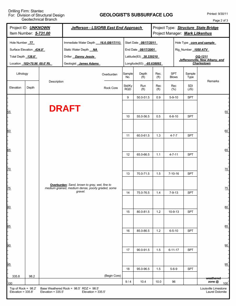
50.0-51.5
55.0-56.5
60.0-61.5
65.0-66.5
70.0-71.5
75.0-76.5
80.0-81.5
85.0-86.5
90.0-91.5
95.0-96.5
10.4
5-9-10
6-8-10
4-7-7
4-7-11
7-10-16
7-9-13
10-9-13
6-5-10
6-11-17
5-6-9
96weathered
zone @335.8 98.2
Overburden: Sand, brown to gray, wet, fine tomedium grained, medium dense, poorly graded, some
gravel.
(Begin Core)
9
10
11
12
13
14
15
16
17
18
9 / 4
0.9
0.5
1.3
1.1
1.5
1.4
1.2
1.2
1.5
1.5
10.0
Elevation Depth Std/KyRQD
Lithology
55
60
65
70
75
80
85
90
95
100
55
60
65
70
75
80
85
90
95
100
Depth(ft)
SPTBlows
SampleType
Rec(ft)
Geologist James Adams
Hole Type core and sample
Rec(%)
Rec.(ft)
SampleNo.
Run(ft)
Description
Overburden
Rock CoreSDI(JS)
Remarks
Rig_Number 1050 ATV
Hole Number 77
Surface Elevation 434.0'
Total Depth 138.6'
End Date 08/17/2001
Latitude(83) 38.339210
Longitude(83) -85.638892
Start Date 08/17/2011
Driller Danny Jessie
GEOLOGIST'S SUBSURFACE LOG
GQ-1211Jeffersonville, New Albany, and
Charlestown
Static Water Depth NA
Louisville LimestoneLaurel Dolomite
Immediate Water Depth 16.6 (08/17/11)
Location 182+70.96 69.0' Rt.
Base Weathered Rock = 98.5'Elevation = 335.5'
Top of Rock = 98.2'Elevation = 335.8'
RDZ = 98.5'Elevation = 335.5'
Printed: 9/30/11
Page 2 of 3
Drilling Firm: StantecFor: Division of Structural Design
Geotechnical Branch
Project Type: Structure State BridgeProject Manager: Mark Litkenhus
Project ID: UNKNOWNItem Number: 5-731.00
Jefferson - LSIORB East End Approach
SPT
SPT
SPT
SPT
SPT
SPT
SPT
SPT
SPT
SPT
DRAFT
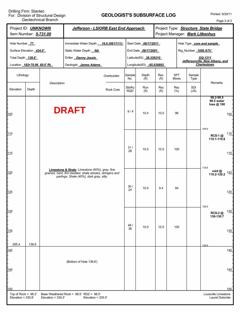
108.6
118.6
128.6
138.6
10.4
10.0
10.0
10.0
96
100
94
100
98.2-98.598.5 waterloss @ 100
RCS-1 @110.1-110.8
void @119.2-120.2
RCS-2 @130-130.7
295.4 138.6
Limestone & Shale: Limestone (60%), gray, finegrained, hard, thin bedded, shale streaks, stringers and
partings. Shale (40%), dark gray, silty.
9 / 4
31 /28
30 /24
48 /36
(Bottom of Hole 138.6')
10.0
10.0
9.4
10.0
Elevation Depth Std/KyRQD
Lithology
105
110
115
120
125
130
135
140
145
150
105
110
115
120
125
130
135
140
145
150
Depth(ft)
SPTBlows
SampleType
Rec(ft)
Geologist James Adams
Hole Type core and sample
Rec(%)
Rec.(ft)
SampleNo.
Run(ft)
Description
Overburden
Rock CoreSDI(JS)
Remarks
Rig_Number 1050 ATV
Hole Number 77
Surface Elevation 434.0'
Total Depth 138.6'
End Date 08/17/2001
Latitude(83) 38.339210
Longitude(83) -85.638892
Start Date 08/17/2011
Driller Danny Jessie
GEOLOGIST'S SUBSURFACE LOG
GQ-1211Jeffersonville, New Albany, and
Charlestown
Static Water Depth NA
Louisville LimestoneLaurel Dolomite
Immediate Water Depth 16.6 (08/17/11)
Location 182+70.96 69.0' Rt.
Base Weathered Rock = 98.5'Elevation = 335.5'
Top of Rock = 98.2'Elevation = 335.8'
RDZ = 98.5'Elevation = 335.5'
Printed: 9/30/11
Page 3 of 3
Drilling Firm: StantecFor: Division of Structural Design
Geotechnical Branch
Project Type: Structure State BridgeProject Manager: Mark Litkenhus
Project ID: UNKNOWNItem Number: 5-731.00
Jefferson - LSIORB East End Approach
DRAFT

2.0-4.0
5.0-7.0
10.0-12.0
15.0-17.0
20.0-21.5
25.0-26.5
30.0-31.5
35.0-36.5
40.0-41.5
45.0-46.5
2-1-2
5-7-9
6-9-14
5-6-8
9-10-11
7-10-17
Boringadvancedwith 3.25"
augers @ 1NQ coring
systemutilized to
samplebedrock @ 3
Drilling mudadded to theboring at a
depth of 20.0ft below the
groundsurface @ 20
428.1
409.1
404.1
399.1
394.1
1.0
20.0
25.0
30.0
35.0
Overburden: Topsoil.
Overburden: Clay, brown, moist, some sand.
Overburden: Clay, brown, wet, soft, some sand.
Overburden: Clay, gray, wet, very stiff, some sand.
Overburden: Sand, brown, wet, fine to mediumgrained, medium dense, poorly graded, some gravel.
Overburden: Sand, brown to gray, fine to mediumgrained, medium dense to dense, poorly graded, some
gravel.
1
2
3
4
1
2
3
4
5
6
2.0
1.8
2.0
1.8
1.5
0.8
0.8
1.5
1.2
0.2
Elevation Depth Std/KyRQD
Lithology
5
10
15
20
25
30
35
40
45
50
5
10
15
20
25
30
35
40
45
50
Depth(ft)
SPTBlows
SampleType
Rec(ft)
Geologist James Adams
Hole Type core and sample
Rec(%)
Rec.(ft)
SampleNo.
Run(ft)
Description
Overburden
Rock CoreSDI(JS)
Remarks
Rig_Number 750 ATV
Hole Number 78
Surface Elevation 429.1'
Total Depth 136.0'
End Date 08/15/2011
Latitude(83) 38.339359
Longitude(83) -85.639800
Start Date 08/12/2011
Driller Muriell Wethington
GEOLOGIST'S SUBSURFACE LOG
GQ-1211Jeffersonville, New Albany, and
Charlestown
Static Water Depth NA
Louisville LimestoneLaurel Dolomite
Immediate Water Depth 13.2 (08/15/11)
Location 184+86.96 86.0' Lt.
Base Weathered Rock = 95.0'Elevation = 334.1'
Top of Rock = 95.0'Elevation = 334.1'
RDZ = 95.0'Elevation = 334.1'
Printed: 9/30/11
Page 1 of 3
Drilling Firm: StantecFor: Division of Structural Design
Geotechnical Branch
Project Type: Structure State BridgeProject Manager: Mark Litkenhus
Project ID: UNKNOWNItem Number: 5-731.00
Jefferson - LSIORB East End Approach
ST
ST
ST
ST
SPT
SPT
SPT
SPT
SPT
SPT
DRAFT

97.8
50.0-51.5
55.0-56.5
60.0-61.5
65.0-66.5
70.0-71.5
75.0-76.5
80.0-81.5
85.0-86.5
90.0-91.5
2.8
10.0
6-10-12
3-7-13
4-6-10
11-14-11
9-21-22
4-5-7
4-6-13
5-7-9
7-9-14
100
100
45 degreefracture @
96-96.2Vertical
Fracture @
334.1 95.0
Overburden: Sand, brown to gray, fine to mediumgrained, medium dense to dense, poorly graded, some
gravel.
Limestone & Shale: Limestone (70%), gray, finegrained, hard, thin bedded, fossiliferous shale streaks,stringers and partings. Shale (30%), dark gray, silty.
(Begin Core)
7
8
9
10
11
12
13
14
15
43 /18
73 /52
1.5
1.0
1.5
0.0
1.5
1.2
1.2
1.2
1.5
2.8
10.0
Elevation Depth Std/KyRQD
Lithology
55
60
65
70
75
80
85
90
95
100
55
60
65
70
75
80
85
90
95
100
Depth(ft)
SPTBlows
SampleType
Rec(ft)
Geologist James Adams
Hole Type core and sample
Rec(%)
Rec.(ft)
SampleNo.
Run(ft)
Description
Overburden
Rock CoreSDI(JS)
Remarks
Rig_Number 750 ATV
Hole Number 78
Surface Elevation 429.1'
Total Depth 136.0'
End Date 08/15/2011
Latitude(83) 38.339359
Longitude(83) -85.639800
Start Date 08/12/2011
Driller Muriell Wethington
GEOLOGIST'S SUBSURFACE LOG
GQ-1211Jeffersonville, New Albany, and
Charlestown
Static Water Depth NA
Louisville LimestoneLaurel Dolomite
Immediate Water Depth 13.2 (08/15/11)
Location 184+86.96 86.0' Lt.
Base Weathered Rock = 95.0'Elevation = 334.1'
Top of Rock = 95.0'Elevation = 334.1'
RDZ = 95.0'Elevation = 334.1'
Printed: 9/30/11
Page 2 of 3
Drilling Firm: StantecFor: Division of Structural Design
Geotechnical Branch
Project Type: Structure State BridgeProject Manager: Mark Litkenhus
Project ID: UNKNOWNItem Number: 5-731.00
Jefferson - LSIORB East End Approach
SPT
SPT
SPT
SPT
SPT
SPT
SPT
SPT
SPT
DRAFT

107.8
117.8
127.8
136.0
10.0
10.0
10.0
8.2
100
100
100
100
97.2-97.4RCS-1 @98.7-99.6
verticalfracture @115.4-115.7
fossiliferous@
117.3-117.8
RCS-2 @124.7-125.9
293.1 136.0
Limestone & Shale: Limestone (70%), gray, finegrained, hard, thin bedded, fossiliferous shale streaks,stringers and partings. Shale (30%), dark gray, silty.
73 /52
52 /52
85 /78
94 /94
(Bottom of Hole 136.0')
10.0
10.0
10.0
8.2
Elevation Depth Std/KyRQD
Lithology
105
110
115
120
125
130
135
140
145
150
105
110
115
120
125
130
135
140
145
150
Depth(ft)
SPTBlows
SampleType
Rec(ft)
Geologist James Adams
Hole Type core and sample
Rec(%)
Rec.(ft)
SampleNo.
Run(ft)
Description
Overburden
Rock CoreSDI(JS)
Remarks
Rig_Number 750 ATV
Hole Number 78
Surface Elevation 429.1'
Total Depth 136.0'
End Date 08/15/2011
Latitude(83) 38.339359
Longitude(83) -85.639800
Start Date 08/12/2011
Driller Muriell Wethington
GEOLOGIST'S SUBSURFACE LOG
GQ-1211Jeffersonville, New Albany, and
Charlestown
Static Water Depth NA
Louisville LimestoneLaurel Dolomite
Immediate Water Depth 13.2 (08/15/11)
Location 184+86.96 86.0' Lt.
Base Weathered Rock = 95.0'Elevation = 334.1'
Top of Rock = 95.0'Elevation = 334.1'
RDZ = 95.0'Elevation = 334.1'
Printed: 9/30/11
Page 3 of 3
Drilling Firm: StantecFor: Division of Structural Design
Geotechnical Branch
Project Type: Structure State BridgeProject Manager: Mark Litkenhus
Project ID: UNKNOWNItem Number: 5-731.00
Jefferson - LSIORB East End Approach
DRAFT

2.0-4.0
5.0-7.0
10.0-12.0
15.0-16.5
20.0-21.5
25.0-26.5
30.0-31.5
35.0-36.5
40.0-41.5
45.0-46.5
3-2-3
0-1-2
2-5-12
12-12-13
5-6-6
7-7-11
10-12-19
Boringadvancedwith 3.25"
augers @ 1NQ coring
systemutilized to
samplebedrock @ 3
Drilling mudadded to theboring at a
depth of 15.0ft below the
groundsurface @ 15
429.2
420.2
399.5
1.0
10.0
30.7
Overburden: Topsoil.
Overburden: Clay, brown, moist, some sand.
Overburden: Sand, brown, wet, fine to mediumgrained, very loose to medium dense, poorly graded,
some clay.
Overburden: Sand, brown to dark gray, wet, fine tomedium grained, medium dense to very dense, poorly
graded, some gravel.
1
2
3
1
2
3
4
5
6
7
2.0
1.6
1.0
1.5
0.8
1.5
0.8
0.8
1.5
1.5
Elevation Depth Std/KyRQD
Lithology
5
10
15
20
25
30
35
40
45
50
5
10
15
20
25
30
35
40
45
50
Depth(ft)
SPTBlows
SampleType
Rec(ft)
Geologist James Adams
Hole Type core and sample
Rec(%)
Rec.(ft)
SampleNo.
Run(ft)
Description
Overburden
Rock CoreSDI(JS)
Remarks
Rig_Number 750 ATV
Hole Number 79
Surface Elevation 430.2'
Total Depth 126.1'
End Date 08/11/2011
Latitude(83) 38.339507
Longitude(83) -85.639594
Start Date 08/10/2011
Driller Muriell Wethington
GEOLOGIST'S SUBSURFACE LOG
GQ-1211Jeffersonville, New Albany, and
Charlestown
Static Water Depth NA
Louisville LimestoneLaurel Dolomite
Immediate Water Depth 12.8 (08/11/11)
Location 184+86.96 6.0' Lt.
Base Weathered Rock = 95.7'Elevation = 334.5'
Top of Rock = 95.5'Elevation = 334.7'
RDZ = 95.7'Elevation = 334.5'
Printed: 9/30/11
Page 1 of 3
Drilling Firm: StantecFor: Division of Structural Design
Geotechnical Branch
Project Type: Structure State BridgeProject Manager: Mark Litkenhus
Project ID: UNKNOWNItem Number: 5-731.00
Jefferson - LSIORB East End Approach
ST
ST
ST
SPT
SPT
SPT
SPT
SPT
SPT
SPT
DRAFT

98.1
50.0-51.5
55.0-56.5
60.0-61.5
65.0-66.5
70.0-71.5
75.0-76.5
80.0-81.5
85.0-86.5
90.0-91.5
95.0-95.52.6
10.0
12-20-20
5-6-10
12-16-18
7-7-10
8-8-10
23-17-15
4-5-8
4-6-7
8-8-8
50/0.50'100
100
weathered @95.5-95.7vertical
fracture @97.3-97.5
334.7 95.5
Overburden: Sand, brown to dark gray, wet, fine tomedium grained, medium dense to very dense, poorly
graded, some gravel.
Limestone & Shale: Limestone (70%), gray, finegrained, hard, thin bedded, fossiliferous shale streaks,
stringers and partings. Shale (30%), gray, silty.
(Begin Core)
8
9
10
11
12
13
14
15
16
1788 /42
63 /39
1.5
1.5
1.0
1.5
1.5
1.2
1.3
1.4
1.1
0.32.6
10.0
Elevation Depth Std/KyRQD
Lithology
55
60
65
70
75
80
85
90
95
100
55
60
65
70
75
80
85
90
95
100
Depth(ft)
SPTBlows
SampleType
Rec(ft)
Geologist James Adams
Hole Type core and sample
Rec(%)
Rec.(ft)
SampleNo.
Run(ft)
Description
Overburden
Rock CoreSDI(JS)
Remarks
Rig_Number 750 ATV
Hole Number 79
Surface Elevation 430.2'
Total Depth 126.1'
End Date 08/11/2011
Latitude(83) 38.339507
Longitude(83) -85.639594
Start Date 08/10/2011
Driller Muriell Wethington
GEOLOGIST'S SUBSURFACE LOG
GQ-1211Jeffersonville, New Albany, and
Charlestown
Static Water Depth NA
Louisville LimestoneLaurel Dolomite
Immediate Water Depth 12.8 (08/11/11)
Location 184+86.96 6.0' Lt.
Base Weathered Rock = 95.7'Elevation = 334.5'
Top of Rock = 95.5'Elevation = 334.7'
RDZ = 95.7'Elevation = 334.5'
Printed: 9/30/11
Page 2 of 3
Drilling Firm: StantecFor: Division of Structural Design
Geotechnical Branch
Project Type: Structure State BridgeProject Manager: Mark Litkenhus
Project ID: UNKNOWNItem Number: 5-731.00
Jefferson - LSIORB East End Approach
SPT
SPT
SPT
SPT
SPT
SPT
SPT
SPT
SPT
SPT
DRAFT

108.1
118.1
126.1
10.0
10.0
8.0
100
100
100
RCS-1 @100.8-101.8
fossilferous@ 117-118.3100% water
loss @117.01
RCS-2 @122.5-123.3
304.1 126.1
Limestone & Shale: Limestone (70%), gray, finegrained, hard, thin bedded, fossiliferous shale streaks,
stringers and partings. Shale (30%), gray, silty.
63 /39
60 /52
61 /65
(Bottom of Hole 126.1')
10.0
10.0
8.0
Elevation Depth Std/KyRQD
Lithology
105
110
115
120
125
130
135
140
145
150
105
110
115
120
125
130
135
140
145
150
Depth(ft)
SPTBlows
SampleType
Rec(ft)
Geologist James Adams
Hole Type core and sample
Rec(%)
Rec.(ft)
SampleNo.
Run(ft)
Description
Overburden
Rock CoreSDI(JS)
Remarks
Rig_Number 750 ATV
Hole Number 79
Surface Elevation 430.2'
Total Depth 126.1'
End Date 08/11/2011
Latitude(83) 38.339507
Longitude(83) -85.639594
Start Date 08/10/2011
Driller Muriell Wethington
GEOLOGIST'S SUBSURFACE LOG
GQ-1211Jeffersonville, New Albany, and
Charlestown
Static Water Depth NA
Louisville LimestoneLaurel Dolomite
Immediate Water Depth 12.8 (08/11/11)
Location 184+86.96 6.0' Lt.
Base Weathered Rock = 95.7'Elevation = 334.5'
Top of Rock = 95.5'Elevation = 334.7'
RDZ = 95.7'Elevation = 334.5'
Printed: 9/30/11
Page 3 of 3
Drilling Firm: StantecFor: Division of Structural Design
Geotechnical Branch
Project Type: Structure State BridgeProject Manager: Mark Litkenhus
Project ID: UNKNOWNItem Number: 5-731.00
Jefferson - LSIORB East End Approach
DRAFT
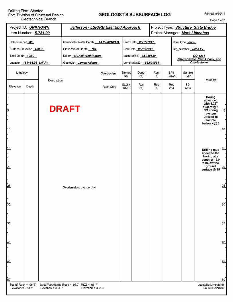
Boringadvancedwith 3.25"
augers @ 1NQ coring
systemutilized to
samplebedrock @ 3
Drilling mudadded to theboring at a
depth of 15.0ft below the
groundsurface @ 15
Overburden: overburden.
Elevation Depth Std/KyRQD
Lithology
5
10
15
20
25
30
35
40
45
50
5
10
15
20
25
30
35
40
45
50
Depth(ft)
SPTBlows
SampleType
Rec(ft)
Geologist James Adams
Hole Type core
Rec(%)
Rec.(ft)
SampleNo.
Run(ft)
Description
Overburden
Rock CoreSDI(JS)
Remarks
Rig_Number 750 ATV
Hole Number 80
Surface Elevation 430.2'
Total Depth 125.9'
End Date 08/10/2011
Latitude(83) 38.339530
Longitude(83) -85.639564
Start Date 08/10/2011
Driller Muriell Wethington
GEOLOGIST'S SUBSURFACE LOG
GQ-1211Jeffersonville, New Albany, and
Charlestown
Static Water Depth NA
Louisville LimestoneLaurel Dolomite
Immediate Water Depth 14.0 (08/10/11)
Location 184+86.96 6.0' Rt.
Base Weathered Rock = 96.7'Elevation = 333.5'
Top of Rock = 96.5'Elevation = 333.7'
RDZ = 96.7'Elevation = 333.5'
Printed: 9/30/11
Page 1 of 3
Drilling Firm: StantecFor: Division of Structural Design
Geotechnical Branch
Project Type: Structure State BridgeProject Manager: Mark Litkenhus
Project ID: UNKNOWNItem Number: 5-731.00
Jefferson - LSIORB East End Approach
DRAFT

9.4 100
333.7 96.5
Overburden: overburden.
Limestone & Shale: Limestone (60%), gray, finegrained, hard, thin bedded, shale streaks, stringers and
partings. Shale (40%), gray, silty.
(Begin Core)
87 /73 9.4
Elevation Depth Std/KyRQD
Lithology
55
60
65
70
75
80
85
90
95
100
55
60
65
70
75
80
85
90
95
100
Depth(ft)
SPTBlows
SampleType
Rec(ft)
Geologist James Adams
Hole Type core
Rec(%)
Rec.(ft)
SampleNo.
Run(ft)
Description
Overburden
Rock CoreSDI(JS)
Remarks
Rig_Number 750 ATV
Hole Number 80
Surface Elevation 430.2'
Total Depth 125.9'
End Date 08/10/2011
Latitude(83) 38.339530
Longitude(83) -85.639564
Start Date 08/10/2011
Driller Muriell Wethington
GEOLOGIST'S SUBSURFACE LOG
GQ-1211Jeffersonville, New Albany, and
Charlestown
Static Water Depth NA
Louisville LimestoneLaurel Dolomite
Immediate Water Depth 14.0 (08/10/11)
Location 184+86.96 6.0' Rt.
Base Weathered Rock = 96.7'Elevation = 333.5'
Top of Rock = 96.5'Elevation = 333.7'
RDZ = 96.7'Elevation = 333.5'
Printed: 9/30/11
Page 2 of 3
Drilling Firm: StantecFor: Division of Structural Design
Geotechnical Branch
Project Type: Structure State BridgeProject Manager: Mark Litkenhus
Project ID: UNKNOWNItem Number: 5-731.00
Jefferson - LSIORB East End Approach
DRAFT

105.9
115.9
125.9
9.4
10.0
10.0
100
96
100
RCS-1 @101.2-102.2
RCS-2 @122.1-123.1
304.3 125.9
Limestone & Shale: Limestone (60%), gray, finegrained, hard, thin bedded, shale streaks, stringers and
partings. Shale (40%), gray, silty.
87 /73
79 /64
82 /76
(Bottom of Hole 125.9')
9.4
9.6
10.0
Elevation Depth Std/KyRQD
Lithology
105
110
115
120
125
130
135
140
145
150
105
110
115
120
125
130
135
140
145
150
Depth(ft)
SPTBlows
SampleType
Rec(ft)
Geologist James Adams
Hole Type core
Rec(%)
Rec.(ft)
SampleNo.
Run(ft)
Description
Overburden
Rock CoreSDI(JS)
Remarks
Rig_Number 750 ATV
Hole Number 80
Surface Elevation 430.2'
Total Depth 125.9'
End Date 08/10/2011
Latitude(83) 38.339530
Longitude(83) -85.639564
Start Date 08/10/2011
Driller Muriell Wethington
GEOLOGIST'S SUBSURFACE LOG
GQ-1211Jeffersonville, New Albany, and
Charlestown
Static Water Depth NA
Louisville LimestoneLaurel Dolomite
Immediate Water Depth 14.0 (08/10/11)
Location 184+86.96 6.0' Rt.
Base Weathered Rock = 96.7'Elevation = 333.5'
Top of Rock = 96.5'Elevation = 333.7'
RDZ = 96.7'Elevation = 333.5'
Printed: 9/30/11
Page 3 of 3
Drilling Firm: StantecFor: Division of Structural Design
Geotechnical Branch
Project Type: Structure State BridgeProject Manager: Mark Litkenhus
Project ID: UNKNOWNItem Number: 5-731.00
Jefferson - LSIORB East End Approach
DRAFT
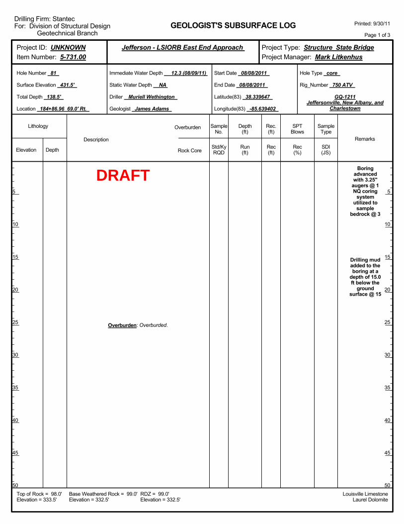
Boringadvancedwith 3.25"
augers @ 1NQ coring
systemutilized to
samplebedrock @ 3
Drilling mudadded to theboring at a
depth of 15.0ft below the
groundsurface @ 15
Overburden: Overburded.
Elevation Depth Std/KyRQD
Lithology
5
10
15
20
25
30
35
40
45
50
5
10
15
20
25
30
35
40
45
50
Depth(ft)
SPTBlows
SampleType
Rec(ft)
Geologist James Adams
Hole Type core
Rec(%)
Rec.(ft)
SampleNo.
Run(ft)
Description
Overburden
Rock CoreSDI(JS)
Remarks
Rig_Number 750 ATV
Hole Number 81
Surface Elevation 431.5'
Total Depth 138.5'
End Date 08/08/2011
Latitude(83) 38.339647
Longitude(83) -85.639402
Start Date 08/08/2011
Driller Muriell Wethington
GEOLOGIST'S SUBSURFACE LOG
GQ-1211Jeffersonville, New Albany, and
Charlestown
Static Water Depth NA
Louisville LimestoneLaurel Dolomite
Immediate Water Depth 12.3 (08/09/11)
Location 184+86.96 69.0' Rt.
Base Weathered Rock = 99.0'Elevation = 332.5'
Top of Rock = 98.0'Elevation = 333.5'
RDZ = 99.0'Elevation = 332.5'
Printed: 9/30/11
Page 1 of 3
Drilling Firm: StantecFor: Division of Structural Design
Geotechnical Branch
Project Type: Structure State BridgeProject Manager: Mark Litkenhus
Project ID: UNKNOWNItem Number: 5-731.00
Jefferson - LSIORB East End Approach
DRAFT
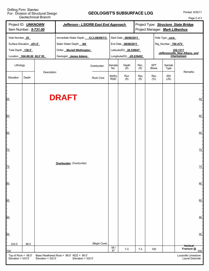
7.4 100Vertical
Fracture @333.5 98.0
Overburden: Overburded.
(Begin Core)58 /47 7.4
Elevation Depth Std/KyRQD
Lithology
55
60
65
70
75
80
85
90
95
100
55
60
65
70
75
80
85
90
95
100
Depth(ft)
SPTBlows
SampleType
Rec(ft)
Geologist James Adams
Hole Type core
Rec(%)
Rec.(ft)
SampleNo.
Run(ft)
Description
Overburden
Rock CoreSDI(JS)
Remarks
Rig_Number 750 ATV
Hole Number 81
Surface Elevation 431.5'
Total Depth 138.5'
End Date 08/08/2011
Latitude(83) 38.339647
Longitude(83) -85.639402
Start Date 08/08/2011
Driller Muriell Wethington
GEOLOGIST'S SUBSURFACE LOG
GQ-1211Jeffersonville, New Albany, and
Charlestown
Static Water Depth NA
Louisville LimestoneLaurel Dolomite
Immediate Water Depth 12.3 (08/09/11)
Location 184+86.96 69.0' Rt.
Base Weathered Rock = 99.0'Elevation = 332.5'
Top of Rock = 98.0'Elevation = 333.5'
RDZ = 99.0'Elevation = 332.5'
Printed: 9/30/11
Page 2 of 3
Drilling Firm: StantecFor: Division of Structural Design
Geotechnical Branch
Project Type: Structure State BridgeProject Manager: Mark Litkenhus
Project ID: UNKNOWNItem Number: 5-731.00
Jefferson - LSIORB East End Approach
DRAFT

105.4
115.4
120.4
125.4
135.4
138.5
7.4
10.0
5.0
5.0
10.0
3.1
100
28
100
100
100
52
98-98.3
rock notrecovered,
ground up bycore barrel @108.1-115.4
RCS-1 @116.8-117.5
RCS-2 @128.1-129
rock notrecovered,
ground up bycore barrel @
137-138.5
293.0 138.5
Limestone & Shale: Limestone (60%), gray, finegrained, hard, thin bedded, shale streaks, stringers and
partings. Shale (40%), gray, silty.
58 /47
11 /11
73 /64
100 /90
92 /84
0 / 0
(Bottom of Hole 138.5')
7.4
2.8
5.0
5.0
10.0
1.6
Elevation Depth Std/KyRQD
Lithology
105
110
115
120
125
130
135
140
145
150
105
110
115
120
125
130
135
140
145
150
Depth(ft)
SPTBlows
SampleType
Rec(ft)
Geologist James Adams
Hole Type core
Rec(%)
Rec.(ft)
SampleNo.
Run(ft)
Description
Overburden
Rock CoreSDI(JS)
Remarks
Rig_Number 750 ATV
Hole Number 81
Surface Elevation 431.5'
Total Depth 138.5'
End Date 08/08/2011
Latitude(83) 38.339647
Longitude(83) -85.639402
Start Date 08/08/2011
Driller Muriell Wethington
GEOLOGIST'S SUBSURFACE LOG
GQ-1211Jeffersonville, New Albany, and
Charlestown
Static Water Depth NA
Louisville LimestoneLaurel Dolomite
Immediate Water Depth 12.3 (08/09/11)
Location 184+86.96 69.0' Rt.
Base Weathered Rock = 99.0'Elevation = 332.5'
Top of Rock = 98.0'Elevation = 333.5'
RDZ = 99.0'Elevation = 332.5'
Printed: 9/30/11
Page 3 of 3
Drilling Firm: StantecFor: Division of Structural Design
Geotechnical Branch
Project Type: Structure State BridgeProject Manager: Mark Litkenhus
Project ID: UNKNOWNItem Number: 5-731.00
Jefferson - LSIORB East End Approach
DRAFT