Embed Size (px)
Citation preview
2.285 87
REPORT ON
GEOLOGICAL MAPPING
BIG PEARL LAKE AMETHYST MINE,
THUNDER BAY MINING DIVISION
NTS 52 A/10
Balmertown, Ontario September 27, 2004
Timothy J. Twomey H.BSc. Geology
52A10NE2020 2.28537 MCTAVISH 010
TABLE OF CONTENTS
Page INTRODUCTION.............................................................................................. l
LOCATION AND ACCESS............................................................................... l
PROPERTY DESCRIPTION.............................................................................. l
GENERAL GEOLOGY................................................................................ l
GEOLOGICAL MAPPING............................................................................ 7
CONCLUSIONS AND RECOMMENDATIONS............................................... 8
CERTIFICATE OF QUALIFICATIONS.............................................................. 9
REFERENCES CITED......................................................................................... 10
LIST OF FIGURES
1) GENERAL GEOLOGY MAP OF McTAVISH TWP..................................... 2
2) CLAIM MAP OF PROPERTY (l" = 1/4 mi.)................................................. 3
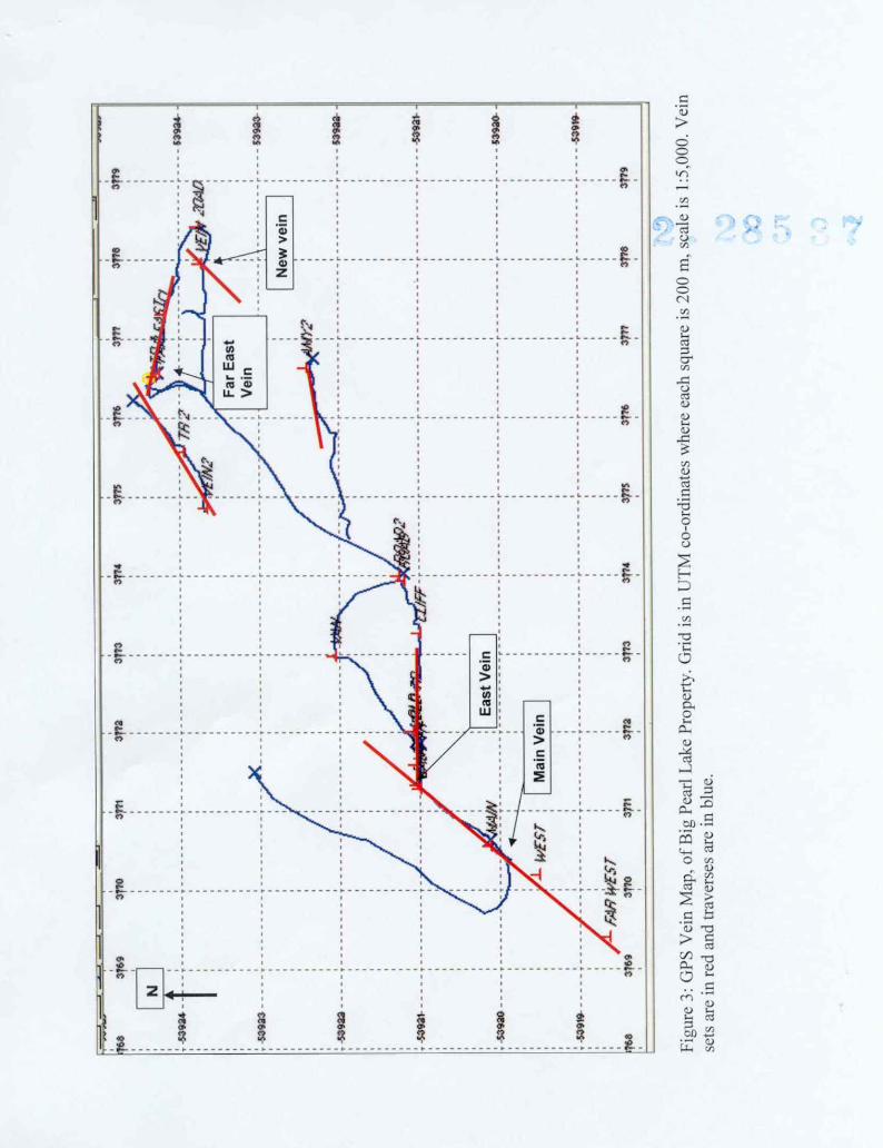
3) OPS Vein MAP OF PROPERTY (l :5,000)...................................................... 4
4) GEOLOGY MAP McTAVISH TWP (l" = 1/2 mi.)............................................. 5
5) GEOLOGY SURVEY (1:2,000)............................................................................ 6
INTRODUCTION
The property contains an amethyst deposit nearby to Big Pearl Lake, south of and parallel to the Detroit-Algoma mine trend. It is within the prolific amethyst belt of the north half of McTavish Township in Northern Ontario. The deposit contains good-grade amethyst in a quartz vein up to 2 m wide (6 feet) readily amenable to mine. The author prospected the area of the Far East showing on May 15th and August 4th, 2004.
LOCATION AND ACCESS
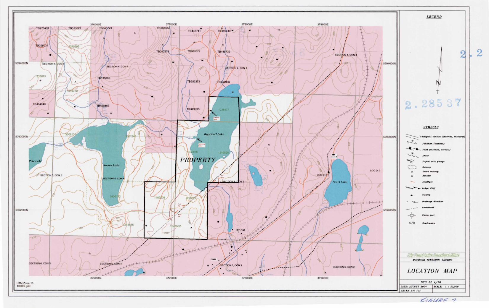
The property is located within McTavish Township, claim map G-175, latitude 48 0 40' 45", longitude 88 0 40' 37". It is approximately 50 km (30 miles) east of the City of Thunder Bay, Ontario. The property is located l km (0.6 miles) north of Highway 11-17 via No. 5 Road North at Pearl, Ontario. Access to the property is provided by an all-weather gravel road, the Diamond Willow Mine/Blue Points Mine road, which connects five amethyst mines with Highway 11-17, for l km (0.6 miles). Then, one proceeds on a narrow bush road, controlled by the property for 250 m (800 feet) to the mine-site.
PROPERTY DESCRIPTION
The property consists of six contiguous unpatented mining claims containing nine units within Lot 5, Concession III and IV, in McTavish Township, Thunder Bay Mining Division. It contains approximately 144 hectares (360 acres). The original amethyst occurrence was staked in 1985, and unpatented mining claims require S400 assessment work per unit per year to remain in good standing. No other taxes are applicable. The assessment work due are listed below: TB.830425 40 acres l unit assessment S400 due February 8, 2007 TB. 1165209 40 acres l unit assessment S400 due October 15, 2006 TB.1238077 40 acres l unit assessment S400 due August 21, 2005 TB.1238078 80 acres 2 units assessment S800 due August 6, 2005 TB.1249528 80 acres 2 units assessment S800 due March 7, 2005 TB.1249532 80 acres 2 units assessment S800 due July 12, 2004 Over S20,000 has been spent to date on the property since 1985.
GENERAL GEOLOGY
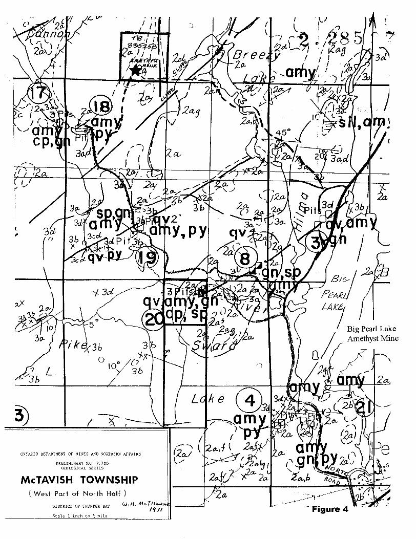
Tanton (1931) published Map 214A and described the veins and prospects in the area which experienced a minor exploration resurgence at that time. The township was most recently mapped by Mcilwaine (1971) at a scale of l inch to 1/4 mile. It was released as an uncoloured preliminary map. Mcilwaine mapped Archean-aged basement rocks of migmatitic metasediments and four phases of granitoids (see Figure 4). These basement rocks are unconformably overlain by Sibley Group sedimentary rocks consisting of near flat-lying
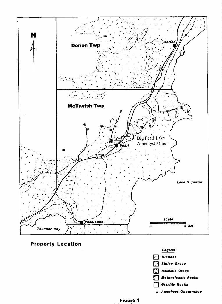
Property LocationLegend
[77) Diabase
pT-j Sibley Group
[y-| Animikie Group
[fTl Metavolcanlc Rocks
[ l Granitic Rocks
^c Amethyst Occurrence
Fiaure 1
16276*88376OOOE
TB513827 TB84^723
37700CE TB38337
378000E 379OOOE
S394000N
S393000N
&392OQON
1,18076
rROPER J
5394000*4
S393000K
5392000N
37B0006 3TWOOC
UTM Zone 16 1000m grnJ
LEGEND
2
J mn t (\nclinwit. I'trt
t -foid u-ilA plun
A BauUfr
Ltift. fttjf
O/B
MCTAVISH TOWNSHIP. ONTARIO
LOCATION MAP
; AUGUST 2004
DRAWN BY: TJT
SCALf: l : 20.000
f ! l .j*™^A
Big Pearl Lake Amethyst Mine
gmv)ONTARIO DEPARTMENT OF MINES AND NORTHERN AFFAIRS
MCTAVISH TOWNSHIPWest Part of North Half )
DISTRICT OF THUNDER BAY
Scale l inch Co \ mileFigure 4
conglomerates, sandstones and limestones. These were deposited in a shallow sea in Proterozoic times. All of the rocks were then intruded by dikes and sheets of diabase.
The north half of McTavish Township contains numerous normal faults derived from basinal downwarping of the Sibley sedimentary rocks. Thus, the faults often define granite/sedimentary rock contacts and strike at 060 to 090. The faults are variably occupied by amethystine quartz veins containing minor amounts of galena, sphalerite and chalcopyrite. The exposed unconformity between the granites and the Sibley sediments in this area is the reason it is an amethyst district.
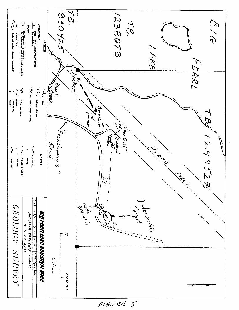
GEOLOGICAL MAPPING
Mapping was conducted on TB. 1249532 nearby an old trench designated the "Far East Pit". It occurs 80 m (260 ft) at azimuth 055 0 from an old pit in the hydro field on an amethyst vein. The trench is l m wide by 10 m long (3 ft by 30 ft) perpendicular to the vein strike. It is badly overgrown and exposed a quartz vein between 0.3 m to 0.5 m wide, striking at 1000 and dipping vertically, containing amethyst lined vugs and galena. The galena is euhedral and coarse-grained and comprises about 1 0A of the vein in the trench. The amethyst is druzy and deep purple, black and white in color. There is no documentation of this old work in assessment files but the property was described in Tanton, 1931, and originates from the 1920's.
All of the veins on the property were revisited and marked by OPS. Each vein orientation was measured by compass. These are displayed in Figure 3 which shows two vein patterns. This pattern was recoginized in the Far east area as well. The vein east of the Far East pit is exposed for 15 m where it enters thin cover of overburden. It strikes at an azimuth of 1000 . The area around this showing was mapped for a radius of 200 m. The geological mapping of the outcrops were plotted by OPS and drafted into a local grid parallel to the south claim line cut in 2002 (see Figure 4). Locations by UTM co-ordinates 16U (NAD 27 Canada) are as follows:
"Far East Pit" old pit, quartz vein azimuth of 1000 : 0377658m E, 5392425m NNew rusty Vein outcrop, quartz vein azimuth of 045 0 : 0377795m E, 5392371m NOld trench in hydro field, quartz vein azimuth of 0490 : 0377558m E, 5392394m NGranite outcrop, barren: 0377843m E, 5392375m N
The granite that hosts the veins is similar to that throughout the property. It is coarse-grained to medium-grained granite containing l to 2'Yo black biotite, 2 to 407o clear quartz phenocrysts and 94^o red and white feldspars (rock code 6a in Figure 5). There is a set of relatively vertical joints at 03 O0 and 1400 respectively. The granite also contains a minor amout of migmatized biotitic metasediments and are Archean in age. The new vein found is rusty quartz about 0.3 m wide, striking at 048 0 and dipping vertically. It occurs in massive granite. On-strike along this vein to the northeast in about 50 m will intersect the east trend of the vein at the Far East pit.
CONCLUSIONS AND RECOMMENDATIONS
The vein system that hosts the amethyst is more complex than originally observed. Two sets of veining were mapped in both the Main Pit and East Pit area as well as the new "Far East" area. 1) Parallel to the regional trend at 045 0, defining the margins of the Sibley Basin and, 2) minor set at an azimuth of 0700 to 1000 . This vein system is at least l km (0.6 miles) in strike length parallel to the regional trend. These trends continue past the mined areas and their intersections constitute excellent targets to host amethyst in more dilatant portions of the vein sets (see Figure 3). These observations agree with the regional geology map of the north half of McTavish Township, mapped by Mcilwaine (1971) as seen in Figure 4.
Good quality purple amethyst is seen east of the Far East Pit extending up to the overburden. This trend leads towards a rusty quartz vein about 50 m further northeast where they would intersect (see Figure 5). Therefore, it is recommended that the area be stripped with a rubber-tired backhoe, using the "Frenchman's" road for access, in order to evaluate this new area.
CERTIFICATE OF QUALIFICATIONS 2 * ^ ^ ^
I, Timothy J. Twomey, of Box 88, Balmertown, Ontario, POV ICO, do hereby certify as follows concerning my Report on Prospecting, Big Pearl Lake Amethyst Mine, dated September 27, 2004:
1. I am a 1983 graduate of Lakehead University, Thunder Bay, Ontario, holding a Bachelor of Science (Honours) degree in Geology.
2. Breezy Mountain Amethyst Mines Ltd., of which I am sole owner, has a 10007o interest in the Big Pearl Lake Amethyst Mine.
3. This report is based on my own work on the property as well as literature review of Assessment Files, Resident Geologists Office, Ministry of Northern Development and Mines, Thunder Bay, Ontario.
September 27, 2004 Timothy J. Twomey Balmertown, Ontario B.Se (Hons) Geology
REFERENCES
Assessment Files, Resident Geologists Office, MNDM, Thunder Bay, Ontario.
Mcilwaine, W.H.1971: McTavish Township (North Half), District of Thunder Bay; Ontario Dept. of Mines
and Northern Affairs, Prelim. Geol. Ser. Map P.720, scale l inch to 1/4 mile.
Tanton, T.L.1931: Fort William and Port Arthur, and Thunder Cape Map Areas, Thunder Bay District,
Ontario; Canada Department of Mines, Memoir 167.
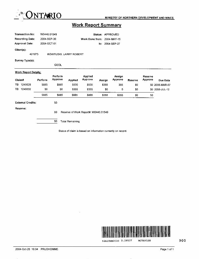
MINISTRY OF NORTHERN DEVELOPMENT AND MINES
Transaction No:
Recording Date:
Approval Date:
Client(s):
401973
Survey Type(s):
W0440.01549
2004-SEP-30
2004-OCT-01
Work Report Summary
Status: APPROVED
Work Done from: 2004-MAY-15
to: 2004-SEP-27
KOWTUSKI, LARRY ROBERT
GEOL
Work Report Details:
Claim* Perform
TB 1249528 S885
TB 1249532 SO
S885
External Credits:
Reserve:
Perform Applied Assign Reserve Approve Applied Approve Assign Approve Reserve Approve Due Date
S885 S530 S530 S355 355 SO
SO 5355 S355 SO 0 SO
S885 5885 S885 S355 S355 SO
SO
SO Reserve of Work Report*: W0440.01549
SO Total Remaining
Status of claim is based on information currently on record.
SO 2006-MAR-07
SO 2005-JUL-12
SO
52A10NE2020 2.28537 MCTAVISH 900
2004-Oct-26 16:04 PRUDHOMME! Page 1 of 1
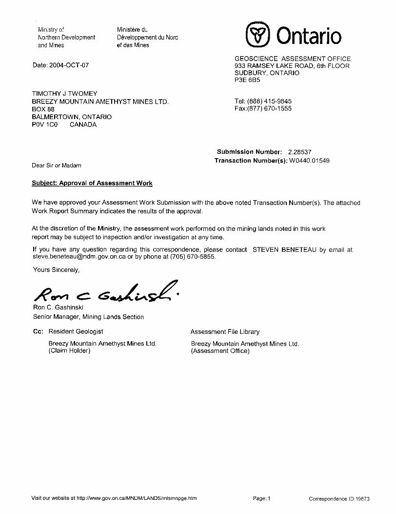
Ministry ofNorthern Developmentand Mines
Date: 2004-OCT-07
Ministers du Developpement du Nord et des Mines
TIMOTHY J TWOMEYBREEZY MOUNTAIN AMETHYST MINES LTD.BOX 88BALMERTOWN, ONTARIOPOV1CO CANADA
OntarioGEOSCIENCE ASSESSMENT OFFICE 933 RAMSEY LAKE ROAD, 6th FLOOR SUDBURY, ONTARIO P3E 6B5
Tel: (888) 415-9845 Fax:(877)670-1555
Dear Sir or Madam
Submission Number: 2.28537 Transaction Number(s): W0440.01549
Subject: Approval of Assessment Work
We have approved your Assessment Work Submission with the above noted Transaction Number(s). The attached Work Report Summary indicates the results of the approval.
At the discretion of the Ministry, the assessment work performed on the mining lands noted in this work report may be subject to inspection and/or investigation at any time.
If you have any question regarding this correspondence, please contact STEVEN BENETEAU by email at [email protected] or by phone at (705) 670-5855.
Yours Sincerely,
o-^l fc CRon C. Gashinski
Senior Manager, Mining Lands Section
Gc: Resident Geologist
Breezy Mountain Amethyst Mines Ltd. (Claim Holder)
Assessment File Library
Breezy Mountain Amethyst Mines Ltd. (Assessment Office)
Visit our website at http://www.gov.on.ca/MNDM/LANDS/mlsmnpge.htm Page: 1 Correspondence 10:19873
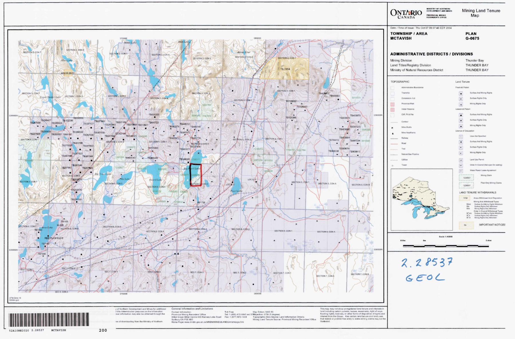
ONTARIOCANADA
vi*(.iiu WHIHOKULH'B OfFICC
Mining Land Tenure Map
3 TOOK
l'MOO* MOOODf
Of 4owftkM(nnQ T0(ft Hw Mini wry of ff
General Information and LimiiaiionsCooUrJ k.fctmatx.1Provincial Mmng RBOontorC OftlaiWIIM GrMn UVMr C*nf* 933 Ram oy Lik* How*Sudbury ON P3E 66SHorn* Pag*: www mndn .(jov.or
To* Fnw M.? DMum NAD 83 Tri: 1 (SM) 415-8*45 Md VM^wten UTM (6 d^)TM|F**: 1 (1771*70-1444 Toeoeraphw Mt* faunw: L*n(t MfomilKxi Onlaro
Mkilnn l wtrl TWHM* Soiinr* (Vnwnn*! Mining R*.nn
^o^ We* unr*))nlBrefl lnnfl '*-ure fl"rt '"t*'e)(S"-in patent*. l**i** OBMmvit* tiqht of ways
flooding nghU, Monoai, or otfv*t farm* Of AtpoHlion MfigrH**m)intVMl ftwn m* Crown Ai*o certain Mnd l*our* ana land UM*th*l mtrtd or pfrtilhH ft** nlry to Mik* mining claim* nwv ntX b*
TOWNSHIP 7 AREA MCTAVISH
PLAN G-0675
ADMINISTRATIVE DISTRICTS l DIVISIONS
Mining Division
L.and Titles/Registry DivisionMinistry of Natural Resources District
Thunder Bay
THUNDER BAY
THUNDER BAY
'OROGRAPHIC Land T c nut*
L*
SiffK* AM Mnr* AtfiM
B
OnHr fr- CnW (M* oovi
LAMD TENURE WITHDRAWALS
Mfwg ACM W*WM* TTPM
O^ f Coni WMw*
IMPORTANT KOT^CEJ
Id!* 1 4i*(t
52A10NE2020 2 .28537 MCTAVISH 200