Embed Size (px)
Citation preview
Rural Legacy Program (RLP) Information Purpose of Program: RLP seeks to protect farmland and open space which contains significant agricultural, environmental and cultural/historic features. The Maryland Department of Natural Resources (DNR) funds the program and protects land mainly with the use of permanent easements. However, the Board of County Commissioners (BOCC) of Washington County is the holder of RLP easements. Easement Valuations: The price paid for permanent easements is determined using a valuation worksheet. The more of the above listed features on the property, the higher the easement values. Priority of Properties: As with most programs of this sort, there is a chronic shortage of funds available. Therefore, properties that are contiguous to existing permanently protected land are given priority. Other priorities include: prime agricultural lands; prime woodland (CREP is encouraged); land with environmental features needing protection such as endangered species, streams, sinkholes, and properties with historic value such as Antietam Battlefield area. Processing of Applications: Each year, Washington County applies to DNR for RLP funding. Negotiations then begin with landowners who have expressed interest in the program. There are many steps until easement settlement occurs and the process takes about a year to complete once properties are chosen for processing. After the BOCC approves the applications, the Board of Public Works in Annapolis makes final selections for funding. For More Information: Contact Eric Seifarth using information in the above letterhead or by E-mail: [email protected] I:LandPreservation/RuralLegacy/basicinformation.doc
MOND
ELL R
D
DoIT, MD iMAP, MDP
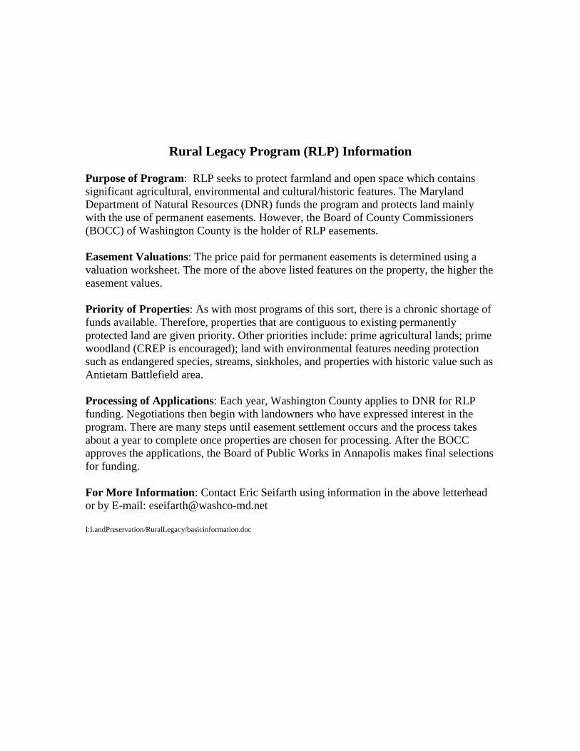
Price, 6208 Mondell Road, Sharpsburg
0 0.035 0.07 0.105Miles
The parcel lines shown on this map are derived from a variety of sources which have their own accuracystandards. The parcel lines are approximate and for informational purposes ONLY. They are not guaranteed
by Washington County Maryland or the Maryland Department of Assessments and Taxations to be free oferrors including errors of omission, commission, positional accuracy or any attributes associated with real
property. They shall not be copied, reproduced or scaled in any way without the express prior writtenapproval of Washington County Maryland Planning and Zoning Department. This data DOES NOT replacean accurate survey by a licensed professional and information shall be verified using the relevant deeds,
plats and other recorded legal documents by the user.
0 150 300 450 600 750Feet
Printed: Thursday, November 10, 2016Printed by: cboggs
®
FLOOK, JOHN DAVID
DEATRICH, GOLDIE
RITCHIE, FLORENE AND CHARLES
HALL, SHARON
MORGAN, PEGGY AND BONNARD
WILSON, LILLI A.
FORD, CYRIL
ANTIETAM MEADOWS FARMS LLC
WILSON, ALLEN AND C. LEONA
POTOMAC VALLEY HOMES
DOWNEY, LAWRENCE
CALLAS, MARGARET ROULETTE AND CORA ROULETTE DOVE
RITCHIE, FLORENE AND CHARLES
BLUMBERG, BARUCH AND JEAN
POWERS, HARRY
PRICE, RUTH AND TERRY
POTOMAC VALLEY HOMES HERSHEY, RICHARD AND JANE
DALY, JOHN AND FRANCES
HORNER, GENE
MYERS, MARY
GRAYSON, WILFRED AND LILLY
SWAIN, RAYMOND AND ANNA
GATRELL, FLOYD AND DORIS
WOODWARD, BERLEN
SPIELMAN, GUYROMSBURG, ROY
SEIDEL, WILLIAM AND RAYMOND
YATES, TRAVIS AND JEANMORGAN, ROLAND AND GEORGETTA
MARTIN, DELBERT EUGENE
Price
Price
Poffenberger
Shaw
Bonnet
Shaw
ROBBINS
MORGAN
MORGAN
SHAR
PSBU
RG PI
KE
MONDELL RD
POWELL RD
MANSFIELD AVE
CORNFIELD AVE
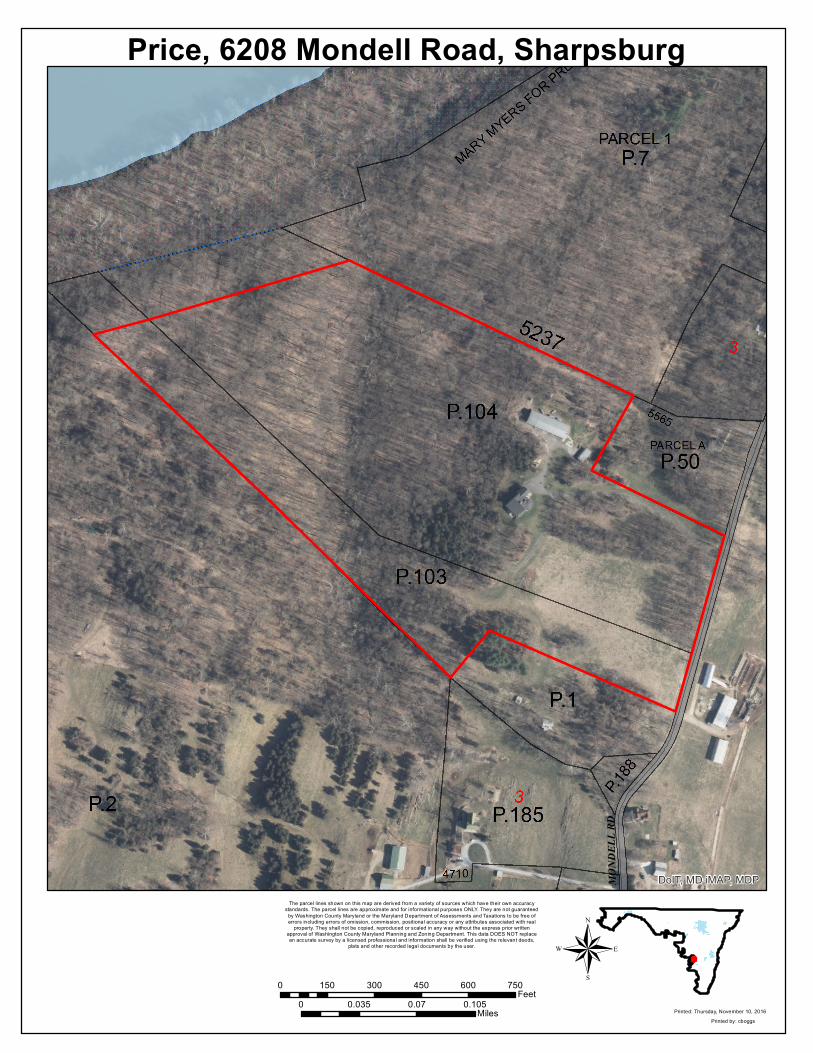
Price, 6208 Mondell Road, Sharpsburg
0 0.25 0.5 0.75Miles
The parcel lines shown on this map are derived from a variety of sources which have their own accuracystandards. The parcel lines are approximate and for informational purposes ONLY. They are not guaranteed
by Washington County Maryland or the Maryland Department of Assessments and Taxations to be free oferrors including errors of omission, commission, positional accuracy or any attributes associated with real
property. They shall not be copied, reproduced or scaled in any way without the express prior writtenapproval of Washington County Maryland Planning and Zoning Department. This data DOES NOT replacean accurate survey by a licensed professional and information shall be verified using the relevant deeds,
plats and other recorded legal documents by the user.
0 990 1,980 2,970 3,960 4,950Feet
Printed: Tuesday, November 15, 2016Printed by: cboggs
®
_̂
LegendAG DistrictMALPF AG EasementRural Legacy Area PropertiesOther Permanent Easements
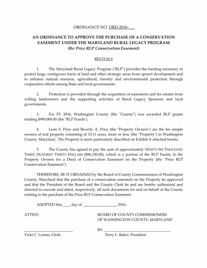
ORDINANCE NO. ORD-2016-___
AN ORDINANCE TO APPROVE THE PURCHASE OF A CONSERVATION EASEMENT UNDER THE MARYLAND RURAL LEGACY PROGRAM
(Re: Price RLP Conservation Easement)
RECITALS
1. The Maryland Rural Legacy Program ("RLP") provides the funding necessary to protect large, contiguous tracts of land and other strategic areas from sprawl development and to enhance natural resource, agricultural, forestry and environmental protection through cooperative efforts among State and local governments.
2. Protection is provided through the acquisition of easements and fee estates from
willing landowners and the supporting activities of Rural Legacy Sponsors and local governments.
3. For FY 2016, Washington County (the "County") was awarded RLP grants
totaling $990,000.00 (the "RLP Funds"). 4. Leon S. Price and Beverly A. Price (the "Property Owners") are the fee simple
owners of real property consisting of 33.11 acres, more or less, (the "Property") in Washington County, Maryland. The Property is more particularly described on Exhibit A attached hereto.
5. The County has agreed to pay the sum of approximately NINETY-SIX THOUSAND
THREE HUNDRED THIRTY DOLLARS ($96,330.00), which is a portion of the RLP Funds, to the Property Owners for a Deed of Conservation Easement on the Property (the "Price RLP Conservation Easement").
THEREFORE, BE IT ORDAINED by the Board of County Commissioners of Washington County, Maryland that the purchase of a conservation easement on the Property be approved and that the President of the Board and the County Clerk be and are hereby authorized and directed to execute and attest, respectively, all such documents for and on behalf of the County relating to the purchase of the Price RLP Conservation Easement. ADOPTED this ____ day of __________________, 2016. ATTEST: BOARD OF COUNTY COMMISSIONERS OF WASHINGTON COUNTY, MARYLAND __________________________ BY: Vicki C. Lumm, Clerk Terry L. Baker, President
Approved as to legal sufficiency: Mail to: _____________________________ Office of the County Attorney John M. Martirano 100 W. Washington Street County Attorney Hagerstown, MD 21740
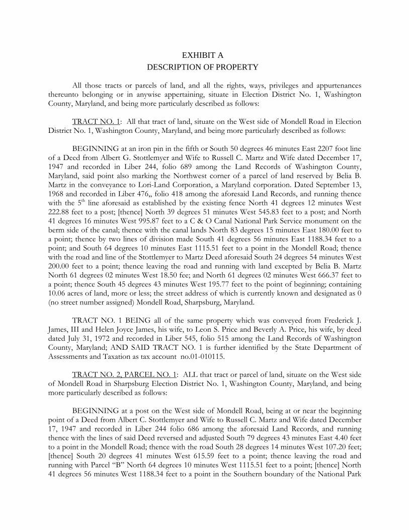
EXHIBIT A DESCRIPTION OF PROPERTY
All those tracts or parcels of land, and all the rights, ways, privileges and appurtenances thereunto belonging or in anywise appertaining, situate in Election District No. 1, Washington County, Maryland, and being more particularly described as follows: TRACT NO. 1: All that tract of land, situate on the West side of Mondell Road in Election District No. 1, Washington County, Maryland, and being more particularly described as follows: BEGINNING at an iron pin in the fifth or South 50 degrees 46 minutes East 2207 foot line of a Deed from Albert G. Stottlemyer and Wife to Russell C. Martz and Wife dated December 17, 1947 and recorded in Liber 244, folio 689 among the Land Records of Washington County, Maryland, said point also marking the Northwest corner of a parcel of land reserved by Belia B. Martz in the conveyance to Lori-Land Corporation, a Maryland corporation. Dated September 13, 1968 and recorded in Liber 476,, folio 418 among the aforesaid Land Records, and running thence with the 5th line aforesaid as established by the existing fence North 41 degrees 12 minutes West 222.88 feet to a post; [thence] North 39 degrees 51 minutes West 545.83 feet to a post; and North 41 degrees 16 minutes West 995.87 feet to a C & O Canal National Park Service monument on the berm side of the canal; thence with the canal lands North 83 degrees 15 minutes East 180.00 feet to a point; thence by two lines of division made South 41 degrees 56 minutes East 1188.34 feet to a point; and South 64 degrees 10 minutes East 1115.51 feet to a point in the Mondell Road; thence with the road and line of the Stottlemyer to Martz Deed aforesaid South 24 degrees 54 minutes West 200.00 feet to a point; thence leaving the road and running with land excepted by Belia B. Martz North 61 degrees 02 minutes West 18.50 fee; and North 61 degrees 02 minutes West 666.37 feet to a point; thence South 45 degrees 43 minutes West 195.77 feet to the point of beginning; containing 10.06 acres of land, more or less; the street address of which is currently known and designated as 0 (no street number assigned) Mondell Road, Sharpsburg, Maryland. TRACT NO. 1 BEING all of the same property which was conveyed from Frederick J. James, III and Helen Joyce James, his wife, to Leon S. Price and Beverly A. Price, his wife, by deed dated July 31, 1972 and recorded in Liber 545, folio 515 among the Land Records of Washington County, Maryland; AND SAID TRACT NO. 1 is further identified by the State Department of Assessments and Taxation as tax account no.01-010115. TRACT NO. 2, PARCEL NO. 1: ALL that tract or parcel of land, situate on the West side of Mondell Road in Sharpsburg Election District No. 1, Washington County, Maryland, and being more particularly described as follows: BEGINNING at a post on the West side of Mondell Road, being at or near the beginning point of a Deed from Albert C. Stottlemyer and Wife to Russell C. Martz and Wife dated December 17, 1947 and recorded in Liber 244 folio 686 among the aforesaid Land Records, and running thence with the lines of said Deed reversed and adjusted South 79 degrees 43 minutes East 4.40 feet to a point in the Mondell Road; thence with the road South 28 degrees 14 minutes West 107.20 feet; [thence] South 20 degrees 41 minutes West 615.59 feet to a point; thence leaving the road and running with Parcel “B” North 64 degrees 10 minutes West 1115.51 feet to a point; [thence] North 41 degrees 56 minutes West 1188.34 feet to a point in the Southern boundary of the National Park
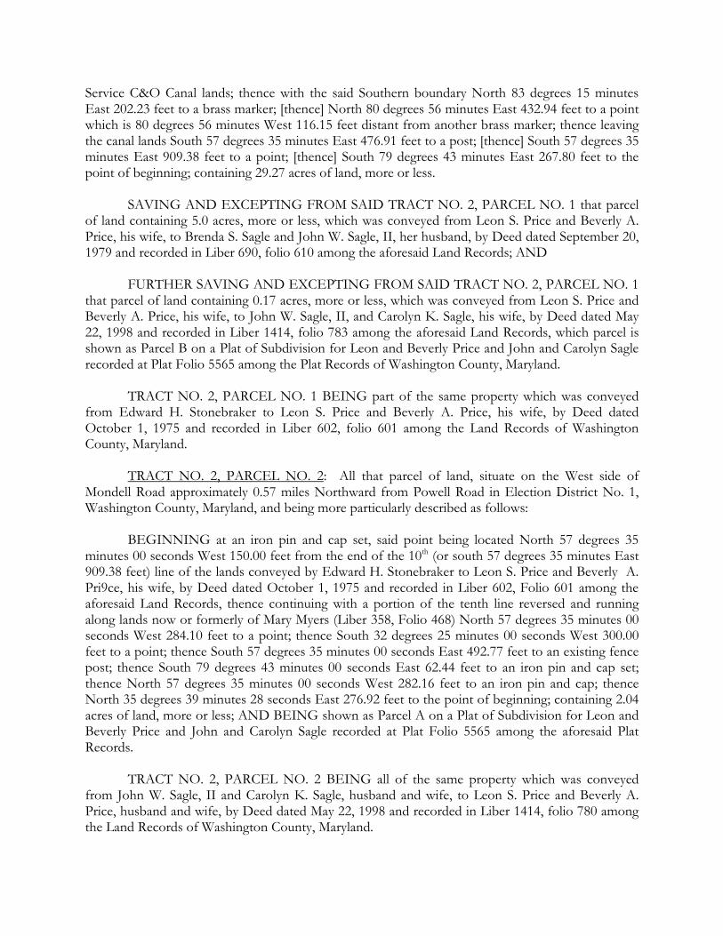
Service C&O Canal lands; thence with the said Southern boundary North 83 degrees 15 minutes East 202.23 feet to a brass marker; [thence] North 80 degrees 56 minutes East 432.94 feet to a point which is 80 degrees 56 minutes West 116.15 feet distant from another brass marker; thence leaving the canal lands South 57 degrees 35 minutes East 476.91 feet to a post; [thence] South 57 degrees 35 minutes East 909.38 feet to a point; [thence] South 79 degrees 43 minutes East 267.80 feet to the point of beginning; containing 29.27 acres of land, more or less. SAVING AND EXCEPTING FROM SAID TRACT NO. 2, PARCEL NO. 1 that parcel of land containing 5.0 acres, more or less, which was conveyed from Leon S. Price and Beverly A. Price, his wife, to Brenda S. Sagle and John W. Sagle, II, her husband, by Deed dated September 20, 1979 and recorded in Liber 690, folio 610 among the aforesaid Land Records; AND FURTHER SAVING AND EXCEPTING FROM SAID TRACT NO. 2, PARCEL NO. 1 that parcel of land containing 0.17 acres, more or less, which was conveyed from Leon S. Price and Beverly A. Price, his wife, to John W. Sagle, II, and Carolyn K. Sagle, his wife, by Deed dated May 22, 1998 and recorded in Liber 1414, folio 783 among the aforesaid Land Records, which parcel is shown as Parcel B on a Plat of Subdivision for Leon and Beverly Price and John and Carolyn Sagle recorded at Plat Folio 5565 among the Plat Records of Washington County, Maryland. TRACT NO. 2, PARCEL NO. 1 BEING part of the same property which was conveyed from Edward H. Stonebraker to Leon S. Price and Beverly A. Price, his wife, by Deed dated October 1, 1975 and recorded in Liber 602, folio 601 among the Land Records of Washington County, Maryland. TRACT NO. 2, PARCEL NO. 2: All that parcel of land, situate on the West side of Mondell Road approximately 0.57 miles Northward from Powell Road in Election District No. 1, Washington County, Maryland, and being more particularly described as follows: BEGINNING at an iron pin and cap set, said point being located North 57 degrees 35 minutes 00 seconds West 150.00 feet from the end of the 10th (or south 57 degrees 35 minutes East 909.38 feet) line of the lands conveyed by Edward H. Stonebraker to Leon S. Price and Beverly A. Pri9ce, his wife, by Deed dated October 1, 1975 and recorded in Liber 602, Folio 601 among the aforesaid Land Records, thence continuing with a portion of the tenth line reversed and running along lands now or formerly of Mary Myers (Liber 358, Folio 468) North 57 degrees 35 minutes 00 seconds West 284.10 feet to a point; thence South 32 degrees 25 minutes 00 seconds West 300.00 feet to a point; thence South 57 degrees 35 minutes 00 seconds East 492.77 feet to an existing fence post; thence South 79 degrees 43 minutes 00 seconds East 62.44 feet to an iron pin and cap set; thence North 57 degrees 35 minutes 00 seconds West 282.16 feet to an iron pin and cap; thence North 35 degrees 39 minutes 28 seconds East 276.92 feet to the point of beginning; containing 2.04 acres of land, more or less; AND BEING shown as Parcel A on a Plat of Subdivision for Leon and Beverly Price and John and Carolyn Sagle recorded at Plat Folio 5565 among the aforesaid Plat Records. TRACT NO. 2, PARCEL NO. 2 BEING all of the same property which was conveyed from John W. Sagle, II and Carolyn K. Sagle, husband and wife, to Leon S. Price and Beverly A. Price, husband and wife, by Deed dated May 22, 1998 and recorded in Liber 1414, folio 780 among the Land Records of Washington County, Maryland.
SAID TRACT NO. 2, PARCELS NOS. 1 AND 2 are collectively further identified by the State Department of Assessments and Taxation as tax account no. 01-010123. SUBJECT TO a Scenic Easement granted by Edward H. Stonebraker to the United States of America by Deed of Easement dated November 12, 1973 and recorded in Liber 570, folio 536, and a Scenic Easement granted by Leon S. Price and Beverly A. Price, his wife, to the United States of America dated June 7, 1974 and recorded in Liber 580, folio 505 among the aforesaid Land Records; and SUBJECT TO a Forestry Declaration of Intent made by Leon Price dated October 6, 2015 and recorded in Liber 5081, folio 34 among the aforesaid Land Records. THE street address of Tract No. 2, Parcel Nos. 1 and 2 is currently known and designated as 6208 Mondell Road, Sharpsburg, Maryland.