Embed Size (px)
Citation preview

8 92
761 3 54
14 15
27
1620
1321
28
1210
292630
18
31
1117
22
32
1925
23 24
I1
I2
B3 T1RM1
RM1B2R3
RM1
T2VP
RM2 T2
RM2
OS
RM2 RT1RT2
VPRM2
R3 T1T2
RT2 B2
RM2I1
T2
RM2
T1T1
T1
B2
T1
T2
RT2
RT2
U OF MN -ST PAULCAMPUS
GROVEPARKLAUDERDALE
NATURE AREA
COLLEGEPARK
LANGFORDPARK
Valentine Ave
Energy Park Dr
Como Ave
Kasota Ave
Gibbs
Ave
Cleve
land A
ve N
Gordon AveHillsid
e Ave
Keston St
Hoyt Ave W
Hendon Ave
BlakeAve
Doswell Ave
Carter Ave
Scudde
r StCommonw
ealth Ave
Gove
Pl
Knapp Pl
Bromp
ton St
Dudley Ave
Buford Ave
Knapp St
Highway 280
Chilcombe Ave
Fulha
m St
Hythe
St
Gordon Pl
Standish St
Raleig
h St
Luther P
l
Cathl
in St
Priscilla St
Bourne Ave
Hunti
ngVa
lleyR
d
Gra n
t ham
St
Eusti
s St
Raym
ond A
ve
Fifield
St
Chelm
sford
St
Lang
ford Par
k
Stella
St
Branst
onSt
Brewster St
Section LineWaterRL One-Family Large LotR1 One-FamilyR2 One-FamilyR3 One-FamilyR4 One-FamilyRT1 Two-FamilyRT2 TownhouseRM1 Multiple-FamilyRM2 Multiple-FamilyRM3 Multiple-FamilyT1 Traditional NeighborhoodT2 Traditional NeighborhoodT3 Traditional NeighborhoodT3M T3 with Master PlanT4 Traditional NeighborhoodOS Office-ServiceB1 Local BusinessBC Community Business (converted)B2 Community BusinessB3 General BusinessB4 Central BusinessB5 Central Business ServiceIT Transitional IndustrialI1 Light IndustrialI2 General IndustrialI3 Heavy IndustrialVP Vehicular ParkingPD Planned DevelopmentCA Capitol Area Jurisdiction
SAINT PAUL ZONING DISTRICTS
ZONING LAST UPDATED MAY 8, 2014P A N E L 1
0 660 1,320330Feet
1" = 1/8 mile (660 feet)

8 92
761 3 54
14 15
27
1620
1321
28
1210
292630
18
31
1117
22
32
1925
23 24
RM3
I1
B2
RM2
R4
RT1
B2RM2 RM2
B2
B1
RM2RM2
VP
RM2
R4
RT1B3 RM2
R3
B2
CURTISSFIELD
COMO GOLFCOURSE
STATEFAIRGROUNDS
LAKECOMO
TILDENPARK
Lexington PkwyN
Oxfor
d St N
Horton Ave
Pasca
l St N
Holto
n St
Almond Ave
Midway Pkwy Service Rd N
Como Lake Dr E
Frankson Ave
California Ave W
Iowa Ave W
Idaho Ave W
Hoyt Ave W
Montana Ave W
Nevada Ave W
Snelling ServiceRdW
Van Slyke Ave
Como Ave
Argyle
St
Snell
ing Av
e N
Como Blv dE
Milto
n St N
Nebraska Ave W
Arlington Ave W
Fair Pl
Wins
ton St
Kilbu
rn St
Bison Ave
Huron
St
Estabrook Dr
Chels
ea St
Breda Ave
Mary Ln
Albany Ave
Wynne Ave
Simps
on St
Canfield Ave
Nason Pl
Fernw
ood S
t
Midway Pkwy Service Rd SSh
eldon
St
Merril
l St
Grigg
s St N
Como Blvd W
Brewster St
Gateway Dr
Arona
St
Haml
ine Av
e N
Chats
worth
St N
Asbu
ry St
Churc
hill S
t
Midway Pkwy
Dunla
p St N
Aida P
l
Albert
St N
Kaufman Dr
Mckinley St
Beula
hLn
Nusbaum
er Dr
Larpenteur Ave W Section LineWaterRL One-Family Large LotR1 One-FamilyR2 One-FamilyR3 One-FamilyR4 One-FamilyRT1 Two-FamilyRT2 TownhouseRM1 Multiple-FamilyRM2 Multiple-FamilyRM3 Multiple-FamilyT1 Traditional NeighborhoodT2 Traditional NeighborhoodT3 Traditional NeighborhoodT3M T3 with Master PlanT4 Traditional NeighborhoodOS Office-ServiceB1 Local BusinessBC Community Business (converted)B2 Community BusinessB3 General BusinessB4 Central BusinessB5 Central Business ServiceIT Transitional IndustrialI1 Light IndustrialI2 General IndustrialI3 Heavy IndustrialVP Vehicular ParkingPD Planned DevelopmentCA Capitol Area Jurisdiction
SAINT PAUL ZONING DISTRICTS
ZONING LAST UPDATED MAY 8, 2014P A N E L 2
0 660 1,320330Feet
1" = 1/8 mile (660 feet)

8 92
761 3 54
14 15
27
1620
1321
28
1210
292630
18
31
1117
22
32
1925
23 24
I
I
II165.41'
175'
R4R4
RM2B1
RM2
RT1
RT1
T2
RM2
RM2
RT1
RM2
VPB1
OS
R4
B2RM2
VP
RM1
RM2
R3
B3
B3
RT1
B1 B3
RM2
R4
RM2
OS
R4
R2
RT2
RM1RM2
RM1
B3B2
T2
B3T2
T2
B2
RT1R3
B3
RM2
B1
B3
B3
R4
B2
I1
ELMHURSTCEMETERY
MARYDALEPARK
LOEBLAKE
Arlington Ave W
Lakeview Ave
Nebraska Ave W
Nevada Ave W
Hoyt Ave W
Idaho Ave W
Iowa Ave W
California Ave W
Como Ave
Dale
St N
Ivy Ave W
Maryland Ave W
Rose Ave W
Grott
o St N
Larpenteur Ave W
Mario
n St
Folso
m St
Virgin
ia St
Farrin
gton S
t
Matild
a St
Jessamine Ave W
Milto
n St N
Orange Ave W
Geranium Ave W
Cottage Ave W
Avon St N
Fisk S
t
Colne
St
Ryde
St
Osage St
Com o Bl vd E
Alame
da St
Montana Ave W
ComoLake Dr E
Coha
nsey
St
Arund
el St
Albem
arle S
t
Mayw
ood S
t
Schle
tti St
Macku
bin St
Danfo
rth St
Weste
rn Av
e N
Parkview Ave
Cons
e rvat o
ryC t
Gateway Dr Norto
n St
Cumb
erlan
d St
Rice S
t
Wheelock Pkwy W
Wood
bridg
e St
Galtie
r St
Saint
Alba
ns St
N
Victoria St N
Kent
St
Section LineWaterRL One-Family Large LotR1 One-FamilyR2 One-FamilyR3 One-FamilyR4 One-FamilyRT1 Two-FamilyRT2 TownhouseRM1 Multiple-FamilyRM2 Multiple-FamilyRM3 Multiple-FamilyT1 Traditional NeighborhoodT2 Traditional NeighborhoodT3 Traditional NeighborhoodT3M T3 with Master PlanT4 Traditional NeighborhoodOS Office-ServiceB1 Local BusinessBC Community Business (converted)B2 Community BusinessB3 General BusinessB4 Central BusinessB5 Central Business ServiceIT Transitional IndustrialI1 Light IndustrialI2 General IndustrialI3 Heavy IndustrialVP Vehicular ParkingPD Planned DevelopmentCA Capitol Area Jurisdiction
SAINT PAUL ZONING DISTRICTS
ZONING LAST UPDATED MAY 8, 2014P A N E L 3
0 660 1,320330Feet
1" = 1/8 mile (660 feet)

8 92
761 3 54
14 15
27
1620
1321
28
1210
292630
18
31
1117
22
32
1925
23 24
I I
I IIII
I109'
134.12'
150.15'
RT1
B3B2
T2
B3T2
T2
B2 B1
RT1
RM2
B3
B3
RM2
R4
B2
RM2
R4
RM2
RM2
I1
B3
I2B2
I1
RM2
R1
R1
R2B3
RM2
RM1
RT1
RT2
R3
RT1
RT1
RM2
RM2
RM1
RM2
RT1R3
RM1
R2
RM2
B1
R3
B1
R4
B3
RM1
B1
RT1
RM2B3
B3
VP
RT1I1
B2
RM2 RT2
RM2
B2
VP
ARLINGTON/ARKWRIGHTPARK
Westm
inster
St
Larpenteur Ave E
Arkwr
ight S
t
Agate
St
Jackso
n St
Brainerd Ave
Bradle
y St
Edge
rton S
t
Payn
e Ave
Hoyt Ave E
Larpenteur Ave W
Wheelock Pkwy W
Hoyt Ave W
Rose Ave W
Maryland Ave W
Cottage Ave W
Orange Ave W
Ivy Ave W
Maryland Ave E
Arlington Ave W
Parkway
Dr
Wheelock Pkwy E
Arlington Ave E
Iowa Ave E
Geranium Ave E
Montana Ave E
Old Maryland Ave
Sherwood Ave
Ivy Ave E
Nebraska Ave E
Cottage Ave E
Magnolia Ave E
Jessamine Ave E
Abell
St Rose Ave E
Deso
to St
KlainertSt
Iowa Ave W
Edge
mont
St
Nevada Ave E
Wand
a St
Hawthorne Ave E
Orange Ave E
Hyacinth Ave E
Clear Ave
Montana Ave W
Hyacinth Ave W
Geranium Ave W
Idaho Ave E
Hawthorne Ave W
Jessamine Ave W
California Ave E
Sloan
St
Mayre
St
Trout
Brook
Cir
Norpac Rd
Searl
e St
Interstate 35E
Rice S
t
Sylva
n St
Park
St
Burr
St Jessie
St
Timbe
rlake
Rd
Clark
St
Missi
ssipp
i St
Biglow Ln
Lorient St
Section LineWaterRL One-Family Large LotR1 One-FamilyR2 One-FamilyR3 One-FamilyR4 One-FamilyRT1 Two-FamilyRT2 TownhouseRM1 Multiple-FamilyRM2 Multiple-FamilyRM3 Multiple-FamilyT1 Traditional NeighborhoodT2 Traditional NeighborhoodT3 Traditional NeighborhoodT3M T3 with Master PlanT4 Traditional NeighborhoodOS Office-ServiceB1 Local BusinessBC Community Business (converted)B2 Community BusinessB3 General BusinessB4 Central BusinessB5 Central Business ServiceIT Transitional IndustrialI1 Light IndustrialI2 General IndustrialI3 Heavy IndustrialVP Vehicular ParkingPD Planned DevelopmentCA Capitol Area Jurisdiction
SAINT PAUL ZONING DISTRICTS
ZONING LAST UPDATED MAY 8, 2014P A N E L 4
0 660 1,320330Feet
1" = 1/8 mile (660 feet)

8 92
761 3 54
14 15
27
1620
1321
28
1210
292630
18
31
1117
22
32
1925
23 24
I I
I I
R3
R4
T2
RM2
B2 B2B2
VP
RM2T2 RT2B3
T2
VPRT1
RT1
RT1
RM2
RM2
RM2
RM1
B2
T2
RT1
B1
RT1
RM1 RT2
RM1RT1
RT1RT2
RT1
RM1RM2
IT RM1R2
PHALEN -KELLER
REGIONAL PARK
LAKEPHALEN
PHALENGOLF
COURSE
ISLAND
FROSTLAKEPARK
FROSTLAKE
SUEPARK
Larpenteur Ave E
Arlington Ave E
Iowa Ave E
Idaho Ave E
Orange Ave E
Parkway D
r
Wheelock Pkwy E
Johnson Pkwy
Walsh
St
Gree
nbrie
rSt
Weide
St
Mend
ota St
Fores
t St Prospe
rity Av
e
Hoyt Ave E
Frank
St
Jessamine Ave E
Magnolia Ave E
Maryland Ave E
Ivy Ave E
Montana Ave E
Nebraska Ave E
Sherwood Ave
Cottage Ave E
Hyacinth Ave E
Hawthorne Ave E
Rose Ave E
Geranium Ave E
Burnquist St
Claren
ce St
Lane
Pl
Nevada Ave E
Topic Ln
Magn
ol ia
Ln
Brighton Pl
California Ave E
Wheelock Ave
Cham
ber S
t
Clear Ave
Engli
sh St
Birmi
ngha
m St
Manto
n St
Winc
hell S
t
East Shore Dr
Arcad
e St
Cypre
ss St
Earl S
t
Mcafe
e St
Dulut
h St
Barcl
ay St
Atlan
tic St
Etna S
t
Phalen Dr
Phalen Blvd
Section LineWaterRL One-Family Large LotR1 One-FamilyR2 One-FamilyR3 One-FamilyR4 One-FamilyRT1 Two-FamilyRT2 TownhouseRM1 Multiple-FamilyRM2 Multiple-FamilyRM3 Multiple-FamilyT1 Traditional NeighborhoodT2 Traditional NeighborhoodT3 Traditional NeighborhoodT3M T3 with Master PlanT4 Traditional NeighborhoodOS Office-ServiceB1 Local BusinessBC Community Business (converted)B2 Community BusinessB3 General BusinessB4 Central BusinessB5 Central Business ServiceIT Transitional IndustrialI1 Light IndustrialI2 General IndustrialI3 Heavy IndustrialVP Vehicular ParkingPD Planned DevelopmentCA Capitol Area Jurisdiction
SAINT PAUL ZONING DISTRICTS
ZONING LAST UPDATED MAY 8, 2014P A N E L 5
0 660 1,320330Feet
1" = 1/8 mile (660 feet)

8 92
761 3 54
14 15
27
1620
1321
28
1210
292630
18
31
1117
22
32
1925
23 24
I I
I I
I
I
I
I
I II
I
125'
125'
150'
150'
150'
150'
R3
I1
OSB2
B2
B1
T2
B2
B2
OS
B2
OSB3
B2OS
B3
RM1
RM1
RM1
RT1
RT2
RT1RT2
RM3
RM2VP
RM2VP
R4
RM1
RM1
RM1
RT2 RM2
RM2
VP
RT2
R3
R2
RM2
RT1
R3
R3
RT1RT2
RT1
R3
VP
T2HILLCRESTCOUNTRY
CLUB
PROSPERITYHEIGHTS
PARK
HEBREWCEMETERY
BEAVERLAKE PARK
Prospe
rity Av
e
Idaho Ave EPro
sperity
Rd
Arlington Ave E
Larpenteur Ave E
Ivy Ave E
Maryland Ave E
Geranium Ave E
Kenn
ard St
Ruth
St N
Cottage Ave E
Clear Ave
Hazel
St N
Sherwood Ave
Nebraska Ave E
Ames Ave
Pedersen St
Edge
water
Blvd
Fland
rau St
Hoyt Ave E
White
Bear
Ave N
Jessamine Ave E
Germ
ain St
Rose Ave E
Luell
a St N
Mckn
ight R
d N
Gary
Pl
Dieter
St
Furne
ssPk
wy
Iowa Ave E
Kings
ford S
t
California Ave E
Hawthorne Ave E
Montana Ave E
Nevada Ave E
Darle
ne St
Craig
Pl
David
St
Magnolia Ave E
Jessamine Ln
Christie Pl
Herbe
rt St
Breen
St
Hazel
wood
St
Van D
yke S
t
Hyacinth Ave E
Nokom
is Ave
Hazel
St
Barcl
ay St
Winth
rop St
N
Orange Ave E Tilsen Ave
SupornickLn
Section LineWaterRL One-Family Large LotR1 One-FamilyR2 One-FamilyR3 One-FamilyR4 One-FamilyRT1 Two-FamilyRT2 TownhouseRM1 Multiple-FamilyRM2 Multiple-FamilyRM3 Multiple-FamilyT1 Traditional NeighborhoodT2 Traditional NeighborhoodT3 Traditional NeighborhoodT3M T3 with Master PlanT4 Traditional NeighborhoodOS Office-ServiceB1 Local BusinessBC Community Business (converted)B2 Community BusinessB3 General BusinessB4 Central BusinessB5 Central Business ServiceIT Transitional IndustrialI1 Light IndustrialI2 General IndustrialI3 Heavy IndustrialVP Vehicular ParkingPD Planned DevelopmentCA Capitol Area Jurisdiction
SAINT PAUL ZONING DISTRICTS
ZONING LAST UPDATED MAY 8, 2014P A N E L 6
0 660 1,320330Feet
1" = 1/8 mile (660 feet)

8 92
761 3 54
14 15
27
1620
1321
28
1210
292630
18
31
1117
22
32
1925
23 24
I I0'
I2 RM2
R4I2
T3
RM2
I2
IT
T3
I1VPRM3B2VP
RM2
RM2
RM2
RM2
B2
R4
RM2T2
I2
RM2
T4
VP
R4
RT1
R4
RM2
R3
R3
RM2I1
I1
T3
I1
T4
T3 I1
T3
T3
T3
NEWELLPARK
CLAYLANDPARK
IRISPARK
Fairv
iew Av
e N
Territorial Rd
Doane AveBeverly Rd
Manvel St
Cromw
ellAv
e
Franklin Ave
Saint Anthony Ave
Bayless Pl
Curfe
w St
Pearl St
Pierce Butler Rte
Thomas Ave
Lafond Ave
Blair Ave
Carleto
n St
Minnehaha Ave W
Van Buren Ave
Hubbard Ave
Englewood Ave
Glend
ale St
Herse
y St
Energy Park Dr
CheltonAve
Hewitt Ave
Wabash Ave
Pennock Ave
Taylor Ave
Whee
ler St
N
Frontenac Pl
Prior
Ave N
Endicott St
Hunt
Pl
Evere
tt Ct
Desnoyer Ave
Lasalle
St
Montg
omery
St
Bradfo
rd St
Highway 280
Charles Ave
Oakley Ave
Cliffo
rd St
Myrtle Ave
Long Ave
Howe
ll St N
Pillsbury St
Robbins St
Emera
ld St
Berry
St
Trans
fer Rd
Ellis Ave
Capp Rd
Interstate 94
Westg
ateDr
Clayla
nd St
Pelha
m Blv
d
Raym
ond A
ve
Hampden Ave
Bayless Ave
Tatum
St
Eusti
sSt
Vand
alia St
Cleve
land A
ve N
Wycliff St
JeffersonCommons Cir
Seal
St
University Ave W
University Ave W
University Ave W
Section LineWaterRL One-Family Large LotR1 One-FamilyR2 One-FamilyR3 One-FamilyR4 One-FamilyRT1 Two-FamilyRT2 TownhouseRM1 Multiple-FamilyRM2 Multiple-FamilyRM3 Multiple-FamilyT1 Traditional NeighborhoodT2 Traditional NeighborhoodT3 Traditional NeighborhoodT3M T3 with Master PlanT4 Traditional NeighborhoodOS Office-ServiceB1 Local BusinessBC Community Business (converted)B2 Community BusinessB3 General BusinessB4 Central BusinessB5 Central Business ServiceIT Transitional IndustrialI1 Light IndustrialI2 General IndustrialI3 Heavy IndustrialVP Vehicular ParkingPD Planned DevelopmentCA Capitol Area Jurisdiction
SAINT PAUL ZONING DISTRICTS
ZONING LAST UPDATED MAY 8, 2014P A N E L 7
0 660 1,320330Feet
1" = 1/8 mile (660 feet)

8 92
761 3 54
14 15
27
1620
1321
28
1210
292630
18
31
1117
22
32
1925
23 24
T4
R4
RT1
R4RM2
B3
RM1
RM3OS
RT1
RM2
B2
RM2
B1
RT1 B2
B1
RM2RM2
RT2
RM2
B1B2
RM2
RM2
T4 T4T4
R4
RM2
B1RM2B3
RM2
I1
B2
RM3
I1
B2RM2
OS
RT1
T2
B2 B2 B2RT1 B2
R4
R4
RT1RT1
R3
T2
B3
T3
T2
T3
T1
STINSONPARK
HORTONPARK
HAMLINEPARK
Pierce Butler Rte
Hatch Ave
Minnehaha Ave W
Synd
icate
St N
Band
ana B
lvd W
Front Ave
Orchard Ave
Grigg
s St N
Snell
ing Av
e N
Oxfor
d St NAld
ine St
Asbu
ry St
Fry St
Albert
St N
Pasca
l St N
Churc
hill S
t
Dunla
p St N
Argyle
St
Kilbu
rn St
Youn
g St
Charl
otte S
t
Holto
n St
Norris
Cir
Taylor Ave
Hewitt Ave
Gree
n St
Sherburne Ave
Van Buren Ave
Lafond Ave
Thomas Ave
Blair Ave
Charles Ave
Edmund Ave
Band
ana B
lvd EBandana Blvd N
Jessamine Ave W
Stinson St
Burgess St
Seminary Ave
Englewood Ave
Topping St
Hubbard Ave
Coach Rd
Spencer Rd W
Haml
ine Av
e N
Chats
worth
St N
Simps
on St
Carling Dr
Energy Ln
Cushing Cir
Energy Park Dr
University Ave W
Lexin
gton P
kwy N
Energy Park Dr
Lexin
gton P
kwy N
Energy Park Dr
Lexin
gton P
kwy N
Section LineWaterRL One-Family Large LotR1 One-FamilyR2 One-FamilyR3 One-FamilyR4 One-FamilyRT1 Two-FamilyRT2 TownhouseRM1 Multiple-FamilyRM2 Multiple-FamilyRM3 Multiple-FamilyT1 Traditional NeighborhoodT2 Traditional NeighborhoodT3 Traditional NeighborhoodT3M T3 with Master PlanT4 Traditional NeighborhoodOS Office-ServiceB1 Local BusinessBC Community Business (converted)B2 Community BusinessB3 General BusinessB4 Central BusinessB5 Central Business ServiceIT Transitional IndustrialI1 Light IndustrialI2 General IndustrialI3 Heavy IndustrialVP Vehicular ParkingPD Planned DevelopmentCA Capitol Area Jurisdiction
SAINT PAUL ZONING DISTRICTS
ZONING LAST UPDATED MAY 8, 2014P A N E L 8
0 660 1,320330Feet
1" = 1/8 mile (660 feet)

8 92
761 3 54
14 15
27
1620
1321
28
1210
292630
18
31
1117
22
32
1925
23 24
I
I
II 66.5'
200.5'
RM2 RM2
RM2
RM2
B2
I1
RT1
T2
RM2
RT2
RM2
B2 RM2B2
B2
R4
VP
R4
B2
RT1
RM2B2B1 RM2 B2
RT1
RM2RM3
RM3
T3
VPRT1
R4
T2
B2B2B3
B2RM2 VP
I2
I1
B3
RM1
OS
RT2
RT2
RM2
B1
RM2
RM2
B3
B1
RM2 B3
B1
RM3RT2
OS B2 B2
RT1
B2
T2
B2
CA
RT1RM2
R4
T2
B3
B2B3
B2 T2
I1
T2
B3
T2
T2
T2 T3
RT2
T2
T2
IT
I1
IT
T1
B2
ORCHARD PARK& RECREATION
CENTER
CALVARYCEMETERY
LEWISPARK
RYANPARK
Matild
a St
Farrin
gton S
t
Weste
rn Av
e N
Thomas Ave
Atwater St
Pennsylvania Ave W
Como Ave
Sycamore St W
Lawson Ave W
Burgess St
Minnehaha Ave W
James
on St
Wayzata St
Milford StGr
otto S
t N
Orchard Ave
Jessamine Ave W
Virgin
ia St
Saint
Alba
ns St
N
Como Ln
Avon
St N
Arund
el St
Kent
St
Milto
n St N
Macku
bin St
Mario
n St
Wood
bridg
e St
Albem
arle S
t
Cook Ave W
Charles Ave
Sherburne Ave
Edmund Ave
Front Ave
Hatch Ave
Dale
St N
Lafond Ave
Ryde
St
Larch St
Colne
St
Barre
tt St
Simco
e St
Norto
n St
Cumb
erlan
d St
Topping St
Hubbard Ave
Van Buren Ave
Edgar Ave
Blair Ave
Stinson St
Englewood Ave
Atwater Cir
Rice S
t
Galtie
r St
Como
Pl
Pierce Butler Rte
Victor
ia St
N
Elfelt
St
Loeb
StSimon Ave
University Ave W University Ave W University Ave W
Section LineWaterRL One-Family Large LotR1 One-FamilyR2 One-FamilyR3 One-FamilyR4 One-FamilyRT1 Two-FamilyRT2 TownhouseRM1 Multiple-FamilyRM2 Multiple-FamilyRM3 Multiple-FamilyT1 Traditional NeighborhoodT2 Traditional NeighborhoodT3 Traditional NeighborhoodT3M T3 with Master PlanT4 Traditional NeighborhoodOS Office-ServiceB1 Local BusinessBC Community Business (converted)B2 Community BusinessB3 General BusinessB4 Central BusinessB5 Central Business ServiceIT Transitional IndustrialI1 Light IndustrialI2 General IndustrialI3 Heavy IndustrialVP Vehicular ParkingPD Planned DevelopmentCA Capitol Area Jurisdiction
SAINT PAUL ZONING DISTRICTS
ZONING LAST UPDATED MAY 8, 2014P A N E L 9
0 660 1,320330Feet
1" = 1/8 mile (660 feet)

8 92
761 3 54
14 15
27
1620
1321
28
1210
292630
18
31
1117
22
32
1925
23 24
I I
I
I
275'
500'
I2I1
RT1
T2
B2
CA
B5
RM3
RM2
T2
VPB3
B2B3
B2T2
I1
RT1
B2
VPI1
I1VP
RM2
R1
R4RM1
RT1
T2
RT1
I2
B3
B2
I1
RT1
B3
B2
T1
B2
B3
B3
RT2B2B3
B2
B2
T2 RT2
B2
B3
B2
T2
RM2
RT1
RM3
VPVP
RM2
VP
VP
RT2
R4
R4
RM2
RT1
R4
RT2
RT2
RT1
R4
B1
RM2
RT1VP
R4
RT2
RT1
RT1R1
RT2RM2
RM2 RT2RT1
RM3
B3
I1
VP
B2
OAKLANDCEMETERY
CAYUGAPARK
SWEDEHOLLOW
PARK
Sycamore St W
Minnehaha Ave E
5th St E
Maria Ave7th St E
Phalen Blvd
Lawson Ave W
12th
StE
Atwater St
North St
Empire Dr
Clark
St
Jackso
n St
Edge
rton S
t
Como Ave
Cortla
nd Pl
Hopkins St
Beaumont St
Acker St E
University Ave E
Pennsylvania Ave
Mount Ida St
Kenny Rd
Case Ave
Bruns
on St
Lightn
er Pl
Jessie
St
Bradle
y St
Winter St
Bush Ave
Burr
St
Deso
to St
Bates Ave
Granite St
Westm
inster
St
RivoliSt
Lyton Pl
BuffaloSt
13th St E
Cayuga St
Reaney Ave
John S
t
Olive
St
Pine S
t
6th St ESherburne Ave
Mount Airy St 8th St E
Lawson Ave E
Magnolia Ave E
Charles Ave
Jenks Ave
Cook Ave E
York Ave
Whitall St
Petit St
Elk St
Stella
r St
Sycamore St E
Arch St E
Aguirre Ave
Acker St W
Wales
St
Old Cayuga St
Genesee St
Wells St
Sims Ave
Terra
ce Ct
Robe
rt St
Fred St
Litchfield St
Wayzata St
Manitoba Ave
Tedesco St
Winnipeg Ave
Front Ave
Hatch Ave
Cook Ave W
Magnolia Ave W
Otse
go St
Rice S
t
University Ave W
Bedfo
rd St
Lorie
nt St
Grove St
Payn
e Ave
Lafayett
e Rd
Preble
St
Capitol Heights
Sylva
n St
Park
St
Agate
St
Arkwr
ight S
t
Missi
ssipp
i St
Capit
ol Blv
d
Ceda
r St
Inters
t ate3
5E
Linde
n St
University Ave W
Section LineWaterRL One-Family Large LotR1 One-FamilyR2 One-FamilyR3 One-FamilyR4 One-FamilyRT1 Two-FamilyRT2 TownhouseRM1 Multiple-FamilyRM2 Multiple-FamilyRM3 Multiple-FamilyT1 Traditional NeighborhoodT2 Traditional NeighborhoodT3 Traditional NeighborhoodT3M T3 with Master PlanT4 Traditional NeighborhoodOS Office-ServiceB1 Local BusinessBC Community Business (converted)B2 Community BusinessB3 General BusinessB4 Central BusinessB5 Central Business ServiceIT Transitional IndustrialI1 Light IndustrialI2 General IndustrialI3 Heavy IndustrialVP Vehicular ParkingPD Planned DevelopmentCA Capitol Area Jurisdiction
SAINT PAUL ZONING DISTRICTS
ZONING LAST UPDATED MAY 8, 2014P A N E L 10
0 660 1,320330Feet
1" = 1/8 mile (660 feet)

8 92
761 3 54
14 15
27
1620
1321
28
1210
292630
18
31
1117
22
32
1925
23 24
R4
T2
RT1
I2I1
I2
I1
I1
I1
B2
RT1B2
T2
B3 B2
B1
B2
B1
B1
B1
T2 B2 B1
B1
B3
B2 B2
B2T2
B2
RM1RM2
RM2RT1
RT1
VP
RM2
RM2
RT2
R4 RT2
VP
R4VPRM2
RM2R4IT
RM1
R2
RM1
RT1RM2
R4
RT1
R4
R4
VPRM2
RM1
RM2RM2
VPRM2
T2
RM2RM2
RT2
RM2R3
RM2VPRT2 RM2RM2
RT1PD
RM2
B2T2
I1
IT
T1RT1
B3
T2
T2 T2B3
B3
LOCKWOODPARK
PARK Ames Ave
Earl S
t
Case AveArc
ade S
t
Maria Ave
Atlan
tic St
7thSt E
4th St E
Ross Ave
Neid Ln
Bates Ave
Bush Ave
Minnehaha Ave E
6th St E
Beech St
Reaney Ave
5th St E
Margaret St
Sinnen St
3rd St E
Hope St
Engli
sh St
Gotzian St
Maple St
Fores
t St
Etna S
t
Sims Ave
Griffi
th St
Weide
St
Magnolia Ave E
Ocea
n St
Barcl
ay St
Fremont Ave
Lawson Ave E
Claren
ce St
Cook Ave E
Dulut
h St
Jenks Ave
Birmi
ngha
m St
Maury St
Tell S
t
Stroh
Dr
Mechanic Ave
Conway St
Hancock St
York Ave
Eichenwald St
Newc
ombe
St
Phalen Blvd
Stillwater AveWells St
Prosperity Ave
Johns
on Pk
wy
Frank
St
Mend
ota St
Cypre
ss St
Walsh
St
Gree
nbrie
r St
Johns
on Pk
wy Se
rvice
Rd W
Johns
onPk
wySe
rvice
RdE
Duch
ess St Ru
ssell S
t
Section LineWaterRL One-Family Large LotR1 One-FamilyR2 One-FamilyR3 One-FamilyR4 One-FamilyRT1 Two-FamilyRT2 TownhouseRM1 Multiple-FamilyRM2 Multiple-FamilyRM3 Multiple-FamilyT1 Traditional NeighborhoodT2 Traditional NeighborhoodT3 Traditional NeighborhoodT3M T3 with Master PlanT4 Traditional NeighborhoodOS Office-ServiceB1 Local BusinessBC Community Business (converted)B2 Community BusinessB3 General BusinessB4 Central BusinessB5 Central Business ServiceIT Transitional IndustrialI1 Light IndustrialI2 General IndustrialI3 Heavy IndustrialVP Vehicular ParkingPD Planned DevelopmentCA Capitol Area Jurisdiction
SAINT PAUL ZONING DISTRICTS
ZONING LAST UPDATED MAY 8, 2014P A N E L 11
0 660 1,320330Feet
1" = 1/8 mile (660 feet)

8 92
761 3 54
14 15
27
1620
1321
28
1210
292630
18
31
1117
22
32
1925
23 24
I II
I
II
R3
I1
I1
I1
B1
OS
OS
B2
OSVP
B2B1
B2
OS
B1
B2B3
B2
B2
B2
R4
RM1
RM2
R3
R2
RM2
RT1
R4VPRM2
RM1
RT1
RM2RM2 RM2
RT1
RM2RT1
RM2
RM2RT2
RM2
RT1VP
RT2
R3
RM2
R2R3RM2
RM1RM1
RT1
BEAVERLAKE
Barcl
ay St
White
Bear
Ave N
Ruth
St N
Stillwater Ave
Magnolia Ave E
Lacrosse Ave
PedersenSt
Conway St
Echo Ave
Hazel
St N
Nokomis Ave
Manitou Ave
Kenn
ard St
Minnehaha Ave E
Margaret St
6th St E
Ames Ave
3rd St E
Case Ave
Tewanna Pl
Jorda
nAv
e
Nortonia Ave
Van D
yke S
t
Hazel
wood
St
Bush Ave
Escanaba Ave
Germ
ain St
Winth
rop St
NWauk
onAve
Utica Ave
Mechanic Ave
4th St E
Reaney Ave
5th St E
7th St E
York Ave
Sims Ave
Mohaw
k Ave
Ross Ave
Beech St
Fremont Ave
Ames Pl
Algonquin Ave
Mckn
ight R
d N
Iroq u
o isAv
e
Fland
rau St
Howa
rdS t
N
Edgewater B lvd
Breen
St
Lake
St
Germain Landing
Section LineWaterRL One-Family Large LotR1 One-FamilyR2 One-FamilyR3 One-FamilyR4 One-FamilyRT1 Two-FamilyRT2 TownhouseRM1 Multiple-FamilyRM2 Multiple-FamilyRM3 Multiple-FamilyT1 Traditional NeighborhoodT2 Traditional NeighborhoodT3 Traditional NeighborhoodT3M T3 with Master PlanT4 Traditional NeighborhoodOS Office-ServiceB1 Local BusinessBC Community Business (converted)B2 Community BusinessB3 General BusinessB4 Central BusinessB5 Central Business ServiceIT Transitional IndustrialI1 Light IndustrialI2 General IndustrialI3 Heavy IndustrialVP Vehicular ParkingPD Planned DevelopmentCA Capitol Area Jurisdiction
SAINT PAUL ZONING DISTRICTS
ZONING LAST UPDATED MAY 8, 2014P A N E L 12
0 660 1,320330Feet
1" = 1/8 mile (660 feet)

8 92
761 3 54
14 15
27
1620
1321
28
1210
292630
18
31
1117
22
32
1925
23 24
R4I2 I2 T4VP
OSRM2
OS
B3B2
RM2T2
RT2
RM2RM2OS
R4
T2
RM2 T2
R2
R2
RM2 B1B1
RT1
R3
RM2
R3
RT1
RM2BC
T2 B2BC B2
RM2
R3
R3
RT1
B2 RM2 RM2B2B2
RM2
RT1
I1
RM2
I1
B2T2
B2B2
T3 T3
T2
B2
IRIS PARK
TOWN &COUNTRY
CLUB MERRIAMPARK
SEVENOAKSPARK
Lincoln Ave
Fairv
iew Av
e N
Summit Ave
Cretin
Ave N
Gilbert Ave
Iglehart Ave
Cretin
Ave S
Howe
ll St N
Fairv
iew Av
e S
Lynnh
urst A
veW
Howe
ll St S
Prior
Ave S
Feronia AveEmera
ldSt
Grand Ave
Beverly Rd
Otis Ave
Marshall Ave
Hague Ave
Ashland Ave
Portland Ave
Saint Anthony Ave
Shields Ave
Riverwood Pl
Lynnhurst Ave EEustis
St
Exeter Pl
Roblyn Ave
Dayton Ave
Laurel Ave
Selby Ave
Goodrich Ave
Merriam LnCarroll Ave
Desnoyer Ave
Cretin
Hall
Beac
on Av
e
Montro se Pl
Temple CtAnn Arbor St
Interstate 94
Prior
Ave N
Whee
ler St
S
Cleve
land A
ve N
Wilde
r St N
Moore
St
Finn S
t S
Cleve
land A
ve S
Dewe
y St
Missi
ssipp
i Ri ve
rBlvd
S
Mississippi River Blvd N
Whee
ler St
N
Finn S
t N
Pelha
m Blv
d
Frontenac Pl
Otis L
n
University Ave W Section LineWaterRL One-Family Large LotR1 One-FamilyR2 One-FamilyR3 One-FamilyR4 One-FamilyRT1 Two-FamilyRT2 TownhouseRM1 Multiple-FamilyRM2 Multiple-FamilyRM3 Multiple-FamilyT1 Traditional NeighborhoodT2 Traditional NeighborhoodT3 Traditional NeighborhoodT3M T3 with Master PlanT4 Traditional NeighborhoodOS Office-ServiceB1 Local BusinessBC Community Business (converted)B2 Community BusinessB3 General BusinessB4 Central BusinessB5 Central Business ServiceIT Transitional IndustrialI1 Light IndustrialI2 General IndustrialI3 Heavy IndustrialVP Vehicular ParkingPD Planned DevelopmentCA Capitol Area Jurisdiction
SAINT PAUL ZONING DISTRICTS
ZONING LAST UPDATED MAY 8, 2014P A N E L 13
0 660 1,320330Feet
1" = 1/8 mile (660 feet)

8 92
761 3 54
14 15
27
1620
1321
28
1210
292630
18
31
1117
22
32
1925
23 24
T4
BCB2
R3
RT1
RM2B2B2
R4R4
RM2RM2
T4
OSRM2
RT1
RT1 RM2
R4 R4 R4
RT1I1
B3
RM2RM2
B2RM2
BCB2 RM2
RT1RT1
RT1
T2
B2VP
T2
RM2OS B2 B2
RT1OS
BCVPB1B2
RM2
OSRM2 RM2
B2
OSRM2
B3B2
RT2
RT1
B2
T3 T2R4
RM2
RT1
B1 B3RM2B2
RT1
R4RM2
RM2
RM1
RM2
RT1
B2 RM2
RT1
OS RM2B1
OSRM2 B2 OS
RM2 B2
RT1
B3BCB2
RM2RM2
BCRM2B2
BC B2RM2
BCRM2B2
OSBC
B1RM2VPB3
BCB2
B1 B2BCRM2
RM2
T1
I1
B2
R2
OS
VP
RM2
T3T2
T3
T3
T1
B2
VPB3
T3
RM2
DUNNINGFIELD
ALDINEPARK
HAMLINE ANDHAGUE PARK
Pasca
l St N
Grand Ave
University Ave W
Portland Ave
Selby Ave
Haml
ine Av
e N
Maca
lester
St
Camb
ridge
St
Snell
ing Av
e N
Interstate 94
Grigg
s St N
Summit Ave
Saint Anthony Ave
Al bert
StN
Sarat
oga S
t N
Lexin
gton P
kwy S
Oxfor
d St S
Chats
worth
St S
Synd
icate
St S
Concordia Ave
Haml
ine Av
e S
Albert
St S
Sarat
oga S
t S
Snell
ing Av
e S
Asbu
ry St
Marshall Ave
Iglehart Ave
Carroll Ave
Hersc
hel S
t
Aurora Ave
Hague Ave
Laurel Ave
Ashland Ave
Roy S
t N
Oxfor
d St N
Chats
worth
St N
Spruce Tree Ave
Shields Ave
Dunla
p St S
Lincoln Ave
Lexin
gton P
kwy N
Central Ave W
Fuller Ave
Goodrich Ave
Dayton Ave
Bigelow Ave
Ayd Mill Rd
Whee
ler St
S
Fry St
Pierce
St
Dunla
p St N
Pasca
l St S
A mh erst St
Aldine
St
Synd
icate
St N
University Ave WUniversity Ave W
Lexin
gton P
kwy N
University Ave WUniversity Ave WUniversity Ave W Section Line
WaterRL One-Family Large LotR1 One-FamilyR2 One-FamilyR3 One-FamilyR4 One-FamilyRT1 Two-FamilyRT2 TownhouseRM1 Multiple-FamilyRM2 Multiple-FamilyRM3 Multiple-FamilyT1 Traditional NeighborhoodT2 Traditional NeighborhoodT3 Traditional NeighborhoodT3M T3 with Master PlanT4 Traditional NeighborhoodOS Office-ServiceB1 Local BusinessBC Community Business (converted)B2 Community BusinessB3 General BusinessB4 Central BusinessB5 Central Business ServiceIT Transitional IndustrialI1 Light IndustrialI2 General IndustrialI3 Heavy IndustrialVP Vehicular ParkingPD Planned DevelopmentCA Capitol Area Jurisdiction
SAINT PAUL ZONING DISTRICTS
ZONING LAST UPDATED MAY 8, 2014P A N E L 14
0 660 1,320330Feet
1" = 1/8 mile (660 feet)

8 92
761 3 54
14 15
27
1620
1321
28
1210
292630
18
31
1117
22
32
1925
23 24
I I
I
I I
I
I
I
93'
150'
150'
150'
R4R4
RT1
RT1
T2R4R4
R4
RM2
B2
RM2B2
RM3
R4
RM2
RT2
RT1
B1
RM2
RT2
B2
VP
B2
VP
OST1
VP
B3B2B2RM2B2RM2
VPB3
B2RM2
RT2
RT1
RT2
RT1
RT1
T3
RM1
RM3
RT2
RM3
OS B2
VPOS
RT2
OS
RM3
RM3
RM2
RM3
RM3
T2
B2B2
VP
RT1 RT1 RT1
RM2RT2
RM2
R2
RT1
B2RM2
R3RT2
RM2B5
R4 R4R4
CA
RM2
VP
VPT2
I1
B2BC
B2 BCRM2
RM2BC B2 BC
RM2BCB3
RM2B2 B3
BCRM2B2
B3BCRM2
BCRM2 B3B2 RM2
B2RM2B2 B3
RM2 B2OS
RM2
B2
B2
T3M
RT1R2
RT1
R4VP
RM1RT1
RM1
RM2
T1
R2
T1
RM2
VP
VP
R2
T2
B2
T2
T2
T2T3
T1
RT1RT2
RT1RT1
RT1
RT2
RM2RT1RT2
R4RT1
T1T1
RT2
B3
VP
T2
CENTRALVILLAGE
PARKWESTERN
PARK
CARTYPARK
CATHEDRALHILLPARK
BOYDPARK
MCQUILLANPARK
WEBSTERPLAYGROUND
COCHRANPARK
NATHANHALE PARK
Marshall Ave
Dale
St N
University Ave W
Victor
ia St
N
Kellogg Blvd W
Dayton Ave
Forbes AveGrand Ave
Saint Anthony Ave
Summit Ave
Concordia Ave
Dale
St S
Saint
Alba
ns St
S
Avon
St S
Milto
n St S
Victor
ia St
S
NinaSt
Doug
las St
Smith
AveN
Weste
rn Av
e S
Grand Hl Lawt
on St
Ramsey St
Thompso
n St
7th St
W
Aurora Ave
Goodrich Ave
Mcboal St
Arund
el St
Heath
er Dr
Virgin
ia St
Saint
Alba
ns St
N
Farrin
gton S
t
Wilkin
St
Summit
Ct
Interstate 94
Milto
n St N
Ravoux St
Kent
St
Macku
bin St
Fisk S
t
Avon
St N
Louis
St
Rice S
t
Galtie
r St
Fuller Ave
Central Ave W
Carroll Ave
Laurel Ave
Iglehart Ave
Selby Ave
Hague Ave
Lincoln Ave
Maiden Ln
Leec
h St
Sherman St
He ather P l
Mulberry
St
Sturgis St
Ashland Ave
Harrison Ave
Interstate
35E
Holly Ave
Portland Ave
Weste
rn Av
e N
John I
reland
Blvd
Oakl and Ave
Grott
o St S
Pleasan
t Ave
Grott
o St N
Garfie
ld St
Summit Ln
Crocus Hl
University Ave W
Mario
n St
D ale
StN
University Ave W University Ave WSection LineWaterRL One-Family Large LotR1 One-FamilyR2 One-FamilyR3 One-FamilyR4 One-FamilyRT1 Two-FamilyRT2 TownhouseRM1 Multiple-FamilyRM2 Multiple-FamilyRM3 Multiple-FamilyT1 Traditional NeighborhoodT2 Traditional NeighborhoodT3 Traditional NeighborhoodT3M T3 with Master PlanT4 Traditional NeighborhoodOS Office-ServiceB1 Local BusinessBC Community Business (converted)B2 Community BusinessB3 General BusinessB4 Central BusinessB5 Central Business ServiceIT Transitional IndustrialI1 Light IndustrialI2 General IndustrialI3 Heavy IndustrialVP Vehicular ParkingPD Planned DevelopmentCA Capitol Area Jurisdiction
SAINT PAUL ZONING DISTRICTS
ZONING LAST UPDATED MAY 8, 2014P A N E L 15
0 660 1,320330Feet
1" = 1/8 mile (660 feet)

8 92
761 3 54
14 15
27
1620
1321
28
1210
292630
18
31
1117
22
32
1925
23 24
RT2
B5
CA
RM2
B5
B4
VP
VP
RM2RM1
RT2RT1
B2VP
T2
R4
T3
T3M
ITT3
B3
I2
B2
I1
I1
I1
T3M
RT1
RT1
RM2
RM1
R1
RT2
RT2
T2
MEARSPARK
LANDMARKPLAZA
CULTUREPARK
KELLOGGMALL
RICEPARK
NAVYISLAND
8th St E
7thSt W
Rice S
t
Rid
der Cir
12th St W10th
St E
7th St E
14th St
Kellogg Blvd E
9th St E
Central Park Pl
Robert St N
Robert St S
12th St E
Wabasha St N
Fillmore A
ve E
Old 6th St
Kittson St
Columbus Ave
Cedar St
11th St E
Minnesota St
Highway 52
Sherman St
Wall St
6th St W
Broadway St
River Park Plz
Interstate 94
Pine St
State St
6th St E
5th St W
Saint Peter St
Water St E
Lafayette Rd
Wabasha St S
Wash
ington
St
Walnut St
5th St E
4thSt E
Wilkin
St
Lafayette Rd W
Prince St
Exchan
ge St S
EaglePkwy
Wacouta St
Warner Rd
2nd St
Mill St
Sibley St
4th St W
Main
St
Chestnut St
Elm St
Temperance St
11th St W
Exchange S
t W10th
St W
Exchan
ge St N
Smith
Ave N
Livingston Ave
9th St W
Levee Rd
Ryan A
ve
College
Ave
Alabama St E
Inters
tate 3
5E
Aurora Ave
Commercial St
John St
Eva St
Harriet Island Rd
Ches
ter S
t
WaterSt W
Grove StJoh
n Irel
andBlv
d
Lafayette Rd E
Jackson St
Shepard Rd
Spring S
t
Mulberry St
Market St
Willius St
Irvine
Park
Ontario St
4th St
Plato Blvd E
Mounds Blvd
7thSt W
Kellogg Blvd W
7th Pl E
University Ave WSection LineWaterRL One-Family Large LotR1 One-FamilyR2 One-FamilyR3 One-FamilyR4 One-FamilyRT1 Two-FamilyRT2 TownhouseRM1 Multiple-FamilyRM2 Multiple-FamilyRM3 Multiple-FamilyT1 Traditional NeighborhoodT2 Traditional NeighborhoodT3 Traditional NeighborhoodT3M T3 with Master PlanT4 Traditional NeighborhoodOS Office-ServiceB1 Local BusinessBC Community Business (converted)B2 Community BusinessB3 General BusinessB4 Central BusinessB5 Central Business ServiceIT Transitional IndustrialI1 Light IndustrialI2 General IndustrialI3 Heavy IndustrialVP Vehicular ParkingPD Planned DevelopmentCA Capitol Area Jurisdiction
SAINT PAUL ZONING DISTRICTS
ZONING LAST UPDATED MAY 8, 2014P A N E L 16
0 660 1,320330Feet
1" = 1/8 mile (660 feet)

8 92
761 3 54
14 15
27
1620
1321
28
1210
292630
18
31
1117
22
32
1925
23 24
I I
I
I
I I
I I
I
I
I I
50'
90'
153.25
'
225'
398'
750'
I2
I1
I1 I2
R1
R2
B2
B2
B2 OSB2OS
B2
B3
B3
B2
RT1
R4
R3
R3
R1
RM2VPRT2
RT2
RM2
RM2
VP
RT1
RM2
RM2
RM2
RM2
RT1
RM2
RM3
PD
RM2
RT1
B2
Maria Ave
Pacific St
Mounds Blvd
Mclean Ave
Etna St
Hudson Rd
Maple St
3rd St E
Burns Ave
Engli
sh St
Griffi
th St
Johnso
n Pkw
y Serv
ice Rd
W
Earl S
t
Cypre
ss St
Fores
t StMe
ndota
St
Old Hudson Rd
Bayfield St
Euclid St
Wilson Ave
Mound St
Point Douglas Rd N
Claren
ce St
Surrey A
ve
Frank
St
Urban
Pl
Childs Rd
Short S
t
Warner Rd
Suburban Ave
Conway St
Wilsh
ire Pl
4th St E
Elliot Pl
Clermont
StThorn St
Plum St
Wakefield Ave
Upper A fton Rd
Ches
ter St
Pigs Eye Lake Rd
Ridder Cir
4th St Interstate 94
Shop Rd
Overlook DrHighway 61
Bates Ave
Johnso
n Pkw
y Serv
ice Rd
E
Johnson PkwyCherry St
Birmi
ngha
mSt
Airpo
rt Rd
Fish Hatchery Rd
Overlo o k
Dr
Section LineWaterRL One-Family Large LotR1 One-FamilyR2 One-FamilyR3 One-FamilyR4 One-FamilyRT1 Two-FamilyRT2 TownhouseRM1 Multiple-FamilyRM2 Multiple-FamilyRM3 Multiple-FamilyT1 Traditional NeighborhoodT2 Traditional NeighborhoodT3 Traditional NeighborhoodT3M T3 with Master PlanT4 Traditional NeighborhoodOS Office-ServiceB1 Local BusinessBC Community Business (converted)B2 Community BusinessB3 General BusinessB4 Central BusinessB5 Central Business ServiceIT Transitional IndustrialI1 Light IndustrialI2 General IndustrialI3 Heavy IndustrialVP Vehicular ParkingPD Planned DevelopmentCA Capitol Area Jurisdiction
SAINT PAUL ZONING DISTRICTS
ZONING LAST UPDATED MAY 8, 2014P A N E L 17
0 660 1,320330Feet
1" = 1/8 mile (660 feet)

8 92
761 3 54
14 15
27
1620
1321
28
1210
292630
18
31
1117
22
32
1925
23 24
I I
II135.15'
163.73'
I2
R1
R2
B3
OS
B2
B2
T2
B3
B2OS
B2
B3
B2
R3
R3
RT2
RM2
RT1
RT2
RM2
VP
R3RT2VP
RM2 RM2
R2R3
RM2
RM1
RM1
RM2
RM3
RM3
RT2
RT1
RM2
R3 RT1B3
CONWAYPARK
BATTLECREEKPOND
Upper Afton Rd
Hazel
St N
Ruth
St N
White
Bear
Ave N
Kenn
ard St
Van D
yke S
t
Mckn
ightR
dN
Conway St
Leone Ave
Bridle
wood
Dr
Hazel
wood
St
Wilson Ave
Suburban Ave
Ruth
St S
Mckn
ight R
d S
Kiplin
g St
Pacific St
Parkside Dr
Luell
a St S
Kim PlWinthrop St N
Woodcrest Dr
Old Hudson Rd
Mich
ael S
t
Winth
rop St
S
Louise Ave
Germ
ain St
Burns Ave
C St
Larry Ho Dr
North Park Dr
Howa
rdSt
N
Foxridge RdLyon S
t Warbler Ln
Hudson Rd
Parkland Ct
Edgebrook Ave
Berland Pl
Morni
ngsid
e Dr
Cardinal Pl
Fland
rau P
l
Pathways Dr
Rowe Pl
Longfellow Ave
Hilding Ave
Warre
n St
Uppe
rAfto
n Ter
Darle
neSt
Cutle
r St
Interstate 94
Grace Ln
Dora Ln
Jayne
St
Euclid St
White
Bear
AveS
Dellridge Ave
Luell
a St N
Mclean Ave
Sand
ralee
DrE
Nelso
n St
Towe
rSt
Scenic Pl
Pede
rsen S
t
Fish Hatchery Rd
Mitchell Ave
Powers Ave
Highway 61
Fland
rau St
Barc l
aySt
B att le Cr e ek Pl
Hazel
St
Battle
Cree
k Rd
Valleyside Dr
Faye
St
Sand
ralee
Dr W
B St
Sunra
yService Rd
Point Douglas Rd S
A St
Section LineWaterRL One-Family Large LotR1 One-FamilyR2 One-FamilyR3 One-FamilyR4 One-FamilyRT1 Two-FamilyRT2 TownhouseRM1 Multiple-FamilyRM2 Multiple-FamilyRM3 Multiple-FamilyT1 Traditional NeighborhoodT2 Traditional NeighborhoodT3 Traditional NeighborhoodT3M T3 with Master PlanT4 Traditional NeighborhoodOS Office-ServiceB1 Local BusinessBC Community Business (converted)B2 Community BusinessB3 General BusinessB4 Central BusinessB5 Central Business ServiceIT Transitional IndustrialI1 Light IndustrialI2 General IndustrialI3 Heavy IndustrialVP Vehicular ParkingPD Planned DevelopmentCA Capitol Area Jurisdiction
SAINT PAUL ZONING DISTRICTS
ZONING LAST UPDATED MAY 8, 2014P A N E L 18
0 660 1,320330Feet
1" = 1/8 mile (660 feet)

8 92
761 3 54
14 15
27
1620
1321
28
1210
292630
18
31
1117
22
32
1925
23 24
R2
R3
RT1B2 RM2 B1 RM2 B2 RM2
RT1 B2 RM2
RM2
RM2
R3
OS
OS
RM3RM2
T2
RM2
B2
R4
R4
RM2
R4
T2
RIVERSIDEPARK
Cleve
land A
ve S
Wilde
r St S
Scheffer Ave
Eleanor Ave
Hartford Ave
Jefferson Ave
Saint Clair Ave
Howe
ll St S
Mississippi River Blv d S
Finn S
t S
Goodrich Ave
Highland Pkwy
Randolph Ave
James Ave
Palace Ave
Juliet Ave
Wellesley Ave
Stanford Ave
Berkeley Ave
Bayard Ave
Princeton Ave
Stanford Ct
Fairmount Ave
Josep
hine P
l
Sue P
l
Sargent Ave
Niles Ave
Juno Ave
Watson Ave
Montr
ose L
n
Woodlawn Ave
Cretin
Ave S
Moun
tCur v
e Blvd
Fairv
iew Av
e S
Sumn
er St
S tone
bridg
e Blv d
Prior
Ave S
Whee
ler St
S
Kenn
eth St
Section LineWaterRL One-Family Large LotR1 One-FamilyR2 One-FamilyR3 One-FamilyR4 One-FamilyRT1 Two-FamilyRT2 TownhouseRM1 Multiple-FamilyRM2 Multiple-FamilyRM3 Multiple-FamilyT1 Traditional NeighborhoodT2 Traditional NeighborhoodT3 Traditional NeighborhoodT3M T3 with Master PlanT4 Traditional NeighborhoodOS Office-ServiceB1 Local BusinessBC Community Business (converted)B2 Community BusinessB3 General BusinessB4 Central BusinessB5 Central Business ServiceIT Transitional IndustrialI1 Light IndustrialI2 General IndustrialI3 Heavy IndustrialVP Vehicular ParkingPD Planned DevelopmentCA Capitol Area Jurisdiction
SAINT PAUL ZONING DISTRICTS
ZONING LAST UPDATED MAY 8, 2014P A N E L 19
0 660 1,320330Feet
1" = 1/8 mile (660 feet)

8 92
761 3 54
14 15
27
1620
1321
28
1210
292630
18
31
1117
22
32
1925
23 24
I I
II
99.99'
150'
R3
R3
R4
R4
R4
RM2B1
R1R1
RT1RT1
OS
B3
B1
OS
B2 B1 B2
B1
B2
B2 B1B1 B1 B2 B1 B1
B2RM2
B3
B2
RM2
RM2
R4
RM2
R2
RM3
R3
RM2
RM2RM3
RM2
RM2
RT1
R1 R2
RM2
RT1
RM2
RM2RT1RT1RT1RM2
RM2
RT1
RT1RT1
RM2
RM2
RM2
RM2
RM2
RM2RM2
T2T2
MATTOCKSPARK Alb
ert St
S
Saint Clair Ave
Maca
lester
St
Roy S
t S
Watson Ave
Hartford Ave
Bayard Ave
Juliet Ave
Scheffer Ave
James Ave
Eleanor Ave
Highland Pkwy
Randolph Ave
Palace Ave
Juno Ave
Sarat
oga S
t S
Synd
icate
St S
Roge
rs St
Chats
worth
St S
Oxfor
d St S
Ed gc umbe Rd
Jefferson Ave
Otto Ave
Grigg
s St S
Niles Ave
Stanford Ave
Fairmount Ave
Dunla
p St S
Armstrong Ave
Tuscarora Ave
Goodrich Ave
Oak G
rove P
l
Berkeley Ave
Osceola Ave
Ayd Mill Rd
Cece
lia Pl
Sargent Ave
Warw
ick St
Brimh
all St
Wellesley Ave
Linwood Ave
Lombard Ave
Verno
n St
Dave
rn St Ha
mline
Ave SSnell
ing Av
e S
Lexin
gton P
kwy S
Benhill Rd
Pasca
l St S
Pleas
ant A
ve
MontcalmPl
Amher
st St
Cambri
dge S
t
Intersta
te 35E
Randolph Ave
Section LineWaterRL One-Family Large LotR1 One-FamilyR2 One-FamilyR3 One-FamilyR4 One-FamilyRT1 Two-FamilyRT2 TownhouseRM1 Multiple-FamilyRM2 Multiple-FamilyRM3 Multiple-FamilyT1 Traditional NeighborhoodT2 Traditional NeighborhoodT3 Traditional NeighborhoodT3M T3 with Master PlanT4 Traditional NeighborhoodOS Office-ServiceB1 Local BusinessBC Community Business (converted)B2 Community BusinessB3 General BusinessB4 Central BusinessB5 Central Business ServiceIT Transitional IndustrialI1 Light IndustrialI2 General IndustrialI3 Heavy IndustrialVP Vehicular ParkingPD Planned DevelopmentCA Capitol Area Jurisdiction
SAINT PAUL ZONING DISTRICTS
ZONING LAST UPDATED MAY 8, 2014P A N E L 20
0 660 1,320330Feet
1" = 1/8 mile (660 feet)
8 92
761 3 54
14 15
27
1620
1321
28
1210
292630
18
31
1117
22
32
1925
23 24
R4
RT1
R4
I1
I1
I2
I2I2
I3
I1
T3M
B2 T2
B2 BC B1B1
B3 B2B3 B1
B2 B1 B2
B2
RM2
B3
OSB3
T3
T2
T3
T2
OS
B1
B1B3
B2
T3M
T3M
B2 B1
RT1RM2
RM2
RT1
RT2
RM1RT1
RM1RM1RM2
R4
RM2
VP
RT2
R2
RT1
VP
R4
RT1
RM2
RM2
RM2
RM2
RM3
VPVP
RT1 RM1RT1RT1
RM2RT1
RT1RT1
T1
T1
RT2
RT1RT2
RT1
RT2
RT1
RT1
RT1RT1
T1T1
RT1RM2RT1T1
RM1RT1RT1
RT1T2
RT1
RT1RM2
B3
RT2
T3
LILYDALE-HARRIETIS-CHEROKEE PARK
LINWOODPARK
PICKERELLAKE
Shepar
d Rd
Baker St W
Saint Clair Ave
Osceola Ave
Randolph Ave
Grott
o St S
James Ave
7th St
W
CliffSt
Otto Ave
Benhill Rd
Stewart
Ave
Fairmount Ave Dous
man S
t
Jefferson Ave
Avon
St S
Richm
ond S
t
Grace St
Bay S
t
Canto
n St
Eleanor Ave
Erie S
t
View
St
Superior St
Oneid
a St
Scheffer Ave
Goodrich Ave
Smith Ave N
Ann S
t
Vance
St
Palace Ave
Palmer P
l
Chipp
ewa A
ve
Duke
St
Clifto
n St
Annapolis St W
Goodhue St
Clay St
Drak
e St
Sumac St
Emma St
Juno Ave
Armstrong Ave
Watson Ave
Tuscarora Ave
Bayard Ave
Orrin
St
Webs
ter St
Monroe Ct Daly
St
Linwood Ave
Banfil St
Deub
ener
Pl
Buttern
ut Ave
Forster St
Intersta
te 35E
WaterSt W
Pleasant Ave
Cherokee Hei ghts
Blvd
Osce
ola Av
e S
Weste
rn Av
e S
Victor
ia St
S
Saint Albans St S
Dale
St S
Fulto
n St
Milto
n St S
Michigan St
Toron
to St
Crocus Pl
Arbor
St
Colbo
rne St
Crocus Hl
Nuge
nt St
JoyAve
Section LineWaterRL One-Family Large LotR1 One-FamilyR2 One-FamilyR3 One-FamilyR4 One-FamilyRT1 Two-FamilyRT2 TownhouseRM1 Multiple-FamilyRM2 Multiple-FamilyRM3 Multiple-FamilyT1 Traditional NeighborhoodT2 Traditional NeighborhoodT3 Traditional NeighborhoodT3M T3 with Master PlanT4 Traditional NeighborhoodOS Office-ServiceB1 Local BusinessBC Community Business (converted)B2 Community BusinessB3 General BusinessB4 Central BusinessB5 Central Business ServiceIT Transitional IndustrialI1 Light IndustrialI2 General IndustrialI3 Heavy IndustrialVP Vehicular ParkingPD Planned DevelopmentCA Capitol Area Jurisdiction
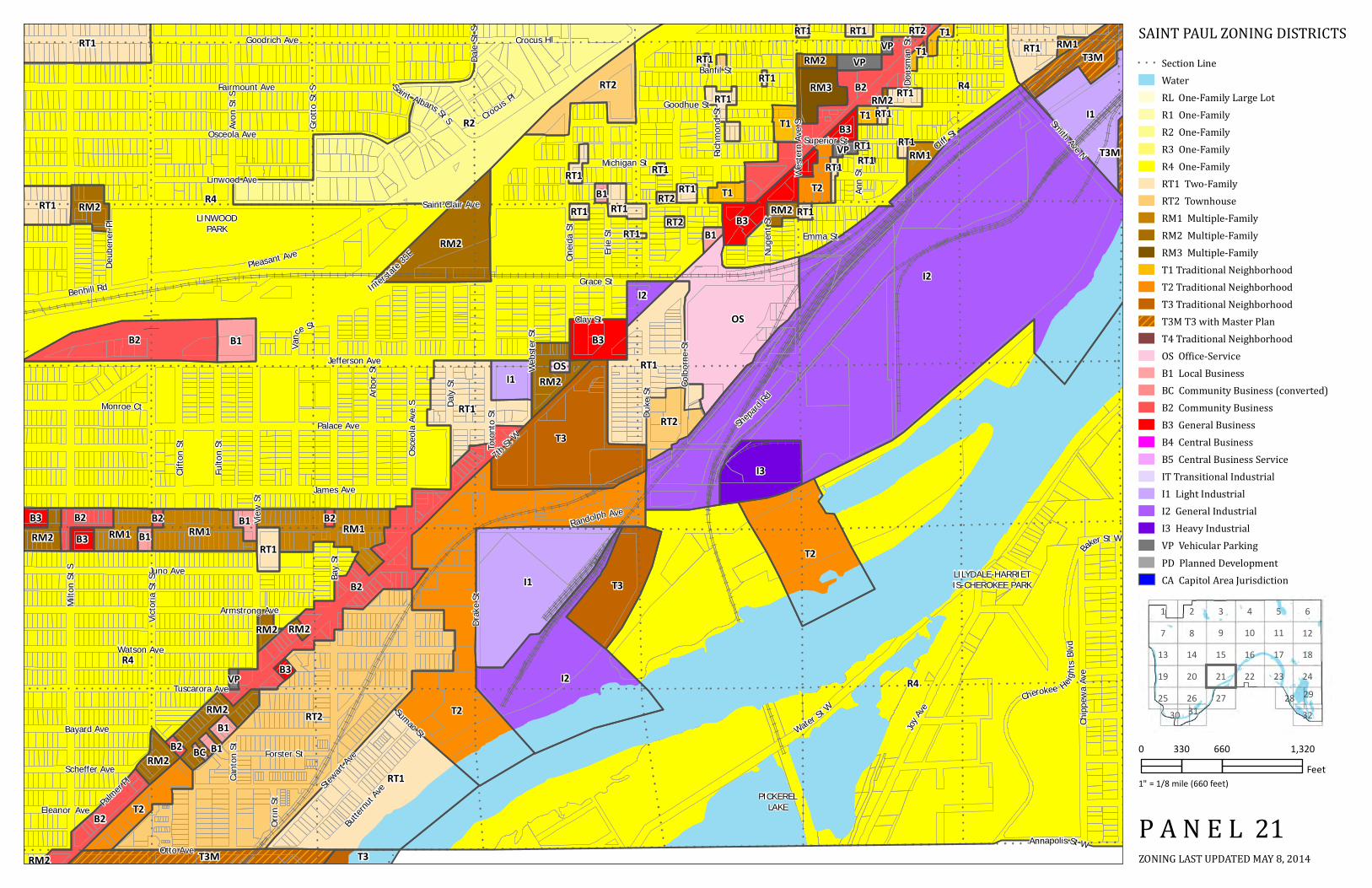
SAINT PAUL ZONING DISTRICTS
ZONING LAST UPDATED MAY 8, 2014P A N E L 21
0 660 1,320330Feet
1" = 1/8 mile (660 feet)

8 92
761 3 54
14 15
27
1620
1321
28
1210
292630
18
31
1117
22
32
1925
23 24
I I128'
R4
T3M
IT
T3
I1
B3
I1
I2
I1
RT2
RT1RT1
RT1
RT1
R4
B1
RT1
RM1
RM2
RM2
RM3
RT1
RM1
RM2
RM1
B1 B2
T2
RM2
RT1
RM2 B2
RT1
RT2
R4
RT1B2
B3
B3OS B1
B2 OS
RM2
RM2
B1
B2
RM2B2
RM2
B3
B3
RM2
RM2
B2RT2
RT1
RM2
RM2
B2
B3 VP
B2
RM2B1
B2
B2
VPRM2B1
T3M
RT1
RT2
B3B2
RT2
RM1
B3
B3
RM1
TERRACEPARK
EL RIOVISTA
PARQUE DECASTILLO
DOUGLASPARK
KENNEDYPARK
Curtice St E
Annapolis St E
Hall A
ve
Cesar Chavez St
Stryk
er Av
e
George St EGeorge St W
Dodd Rd
Annapolis St WRo
bert
St S
Colorado St ESm
ith Av
e S
Winifred St E
Lafayette Rd E
Delos St E
Oakdale Ave
Page St E
Morton St W
Robie St W
Baker St W
Sidney St W
Page St W
Congress St W
Delos St W
Curtice St W
Winona St W
Humb
oldt A
ve
Wyoming St W
Wins
low Av
e
Stevens St W
King St W
Spring
St
Bancr
oft Av
e
Belvidere St W
Sidney St E
Prescott St
WaterSt W
Robie St E
Baker St E
Eaton St
Anita
St
Clinto
n Ave
Gorm
an Av
e
Mill St
Robe
rt St
Servi
ce Rd
ERo
bert
St Se
rvice
Rd W
Ada S
t
Wyoming St E
Moun
t Hop
e Ave
Harva
rd St
Plato Blvd W
Mano
min A
ve
Morton St E
Bello
ws St
Stevens St E
Highway 52
King St E
Orlea
ns St
Ottaw
a Ave
Semi
nole
Ave
Belvidere St E
Winona St E
Isabel St W
Elizabeth St E
Winifred St W
Isabel St E
Colorado St W
Elizabeth St W
Prospect Blvd
Congress St E
City View LnStarkeySt
Mount HopeDr
Florida St
Hall
Ln
Shepard
Rd
Wood St
Smith Ave N
Ohio
St
Lafayette Rd W
Plato Blvd E
Charl
ton St
Bidwe
ll St
Living
ston A
ve
Gree
nwoo
d Ave
Wabasha St S
Wood
bury
St
Chero
kee A
ve
Delaw
are Av
e
Wasec
a St
A l i ce St
Ches
ter St
Dunedin Terrace
Eva St
State
St
Section LineWaterRL One-Family Large LotR1 One-FamilyR2 One-FamilyR3 One-FamilyR4 One-FamilyRT1 Two-FamilyRT2 TownhouseRM1 Multiple-FamilyRM2 Multiple-FamilyRM3 Multiple-FamilyT1 Traditional NeighborhoodT2 Traditional NeighborhoodT3 Traditional NeighborhoodT3M T3 with Master PlanT4 Traditional NeighborhoodOS Office-ServiceB1 Local BusinessBC Community Business (converted)B2 Community BusinessB3 General BusinessB4 Central BusinessB5 Central Business ServiceIT Transitional IndustrialI1 Light IndustrialI2 General IndustrialI3 Heavy IndustrialVP Vehicular ParkingPD Planned DevelopmentCA Capitol Area Jurisdiction
SAINT PAUL ZONING DISTRICTS
ZONING LAST UPDATED MAY 8, 2014P A N E L 22
0 660 1,320330Feet
1" = 1/8 mile (660 feet)

8 92
761 3 54
14 15
27
1620
1321
28
1210
292630
18
31
1117
22
32
1925
23 24
I
I
600'
I1
I2
PD
OSRT1
R4
RT1
RT1
RM1
RM2
RM1
R1
ST PAULDOWNTOWN
AIRPORT
ST PAULDOWNTOWN
AIRPORT
ST PAULDOWNTOWN
AIRPORT
BLUFFPARK
Kans
as Av
e
Curtice St E
Barge Channel Rd
Annapolis St E
Lafayette Rd E
Winona St E
Concord St
Wyoming St E
Belvidere St E
Stickn
ey St
Andre
w StSidney St E
Eaton St
Highway 52
Bravo
Ln
Shop Rd
Alpha
Ln
Robie St E
Tower Rd
ChildsRd
Winifred St E
Brown
Ave
Bayfield StChes
ter St
Airpo
rt Rd
Pigs Eye Lake Rd
Page St E
Section LineWaterRL One-Family Large LotR1 One-FamilyR2 One-FamilyR3 One-FamilyR4 One-FamilyRT1 Two-FamilyRT2 TownhouseRM1 Multiple-FamilyRM2 Multiple-FamilyRM3 Multiple-FamilyT1 Traditional NeighborhoodT2 Traditional NeighborhoodT3 Traditional NeighborhoodT3M T3 with Master PlanT4 Traditional NeighborhoodOS Office-ServiceB1 Local BusinessBC Community Business (converted)B2 Community BusinessB3 General BusinessB4 Central BusinessB5 Central Business ServiceIT Transitional IndustrialI1 Light IndustrialI2 General IndustrialI3 Heavy IndustrialVP Vehicular ParkingPD Planned DevelopmentCA Capitol Area Jurisdiction
SAINT PAUL ZONING DISTRICTS
ZONING LAST UPDATED MAY 8, 2014P A N E L 23
0 660 1,320330Feet
1" = 1/8 mile (660 feet)
8 92
761 3 54
14 15
27
1620
1321
28
1210
292630
18
31
1117
22
32
1925
23 24
I I II
I
I
80.59' 277.52'
616.3'
I2
R1
R2
RT1
RM2
RT1
R2
RM2
PD
B2 B2R1
RM2
PD
BATTLE CREEK- INDIAN
MOUNDS PARK
Mckn
ight R
d S
Lower A
fton Rd
Winth ro
p Ln
Oakridge St
Point Douglas Rd S
Wigg
ins R
d
Londin Ln
Winth
rop St
S
Howard St S
Hillwo
odCt
Kiplin
g St
Hillsdale Ave
Springs
ideDr
Highway 61
Edgebrook Ave
Shop Rd
Mailand Rd
Glenridge Ave
Falcon AveFish Hatchery Rd
Battle Creek Rd
Battle Creek Park En Rd Morni
ngsid
eCir
B url ington Rd
Fir St
Mystic
St
Totem Rd
Section LineWaterRL One-Family Large LotR1 One-FamilyR2 One-FamilyR3 One-FamilyR4 One-FamilyRT1 Two-FamilyRT2 TownhouseRM1 Multiple-FamilyRM2 Multiple-FamilyRM3 Multiple-FamilyT1 Traditional NeighborhoodT2 Traditional NeighborhoodT3 Traditional NeighborhoodT3M T3 with Master PlanT4 Traditional NeighborhoodOS Office-ServiceB1 Local BusinessBC Community Business (converted)B2 Community BusinessB3 General BusinessB4 Central BusinessB5 Central Business ServiceIT Transitional IndustrialI1 Light IndustrialI2 General IndustrialI3 Heavy IndustrialVP Vehicular ParkingPD Planned DevelopmentCA Capitol Area Jurisdiction
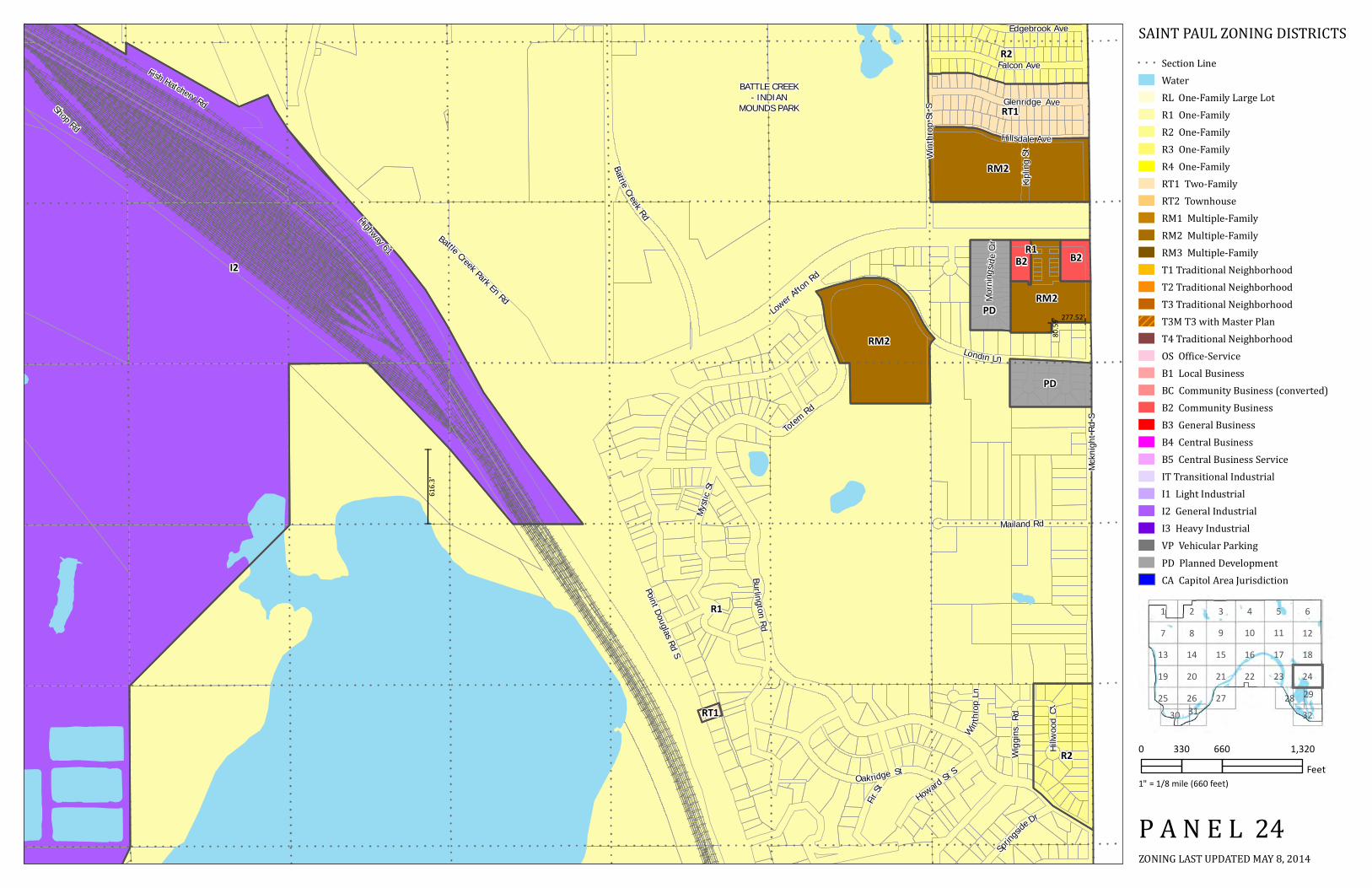
SAINT PAUL ZONING DISTRICTS
ZONING LAST UPDATED MAY 8, 2014P A N E L 24
0 660 1,320330Feet
1" = 1/8 mile (660 feet)

8 92
761 3 54
14 15
27
1620
1321
28
1210
292630
18
31
1117
22
32
1925
23 24
II 200'
R2R3RM3
RM2
RM2
T2
I1
R4 R4
RM2 RT1 RM2
R1
RM2
OSRM3
R4
R2
R2
RT1
RM2
RT2RT1
R2
R3
R1
B1
VPB2T2B2T2
MINNEHAHAPARK
HIDDEN FALLSPARK (NORTH
GATE)
Wood
lawn A
ve
Moun
t Curv
e Blvd
Wilder St S
Ford Pkwy
Pinehurst Ave
Quirnia Ave
Magoffin Ave
Bohland Ave
Murra
y St
Whee
ler St
S
Mississippi River Blvd S
Yorkshire Ct
Inner
Dr
Highland Pkwy
Hampshire Ave
Kenneth StDelano Pl
Saunders Ave
Sheridan Ave
Montreal Ave
Villard Ave
Worcester Ave
Bowd
oin St
Yorkshire Ave
Hillcrest Ave
Dorothea Ave
Elsie Ln
Susan Ave
Colby Ave
Colby
St
Finn S
t S
Village Ln
Hillto
p Ln
Thure Ave
Bordner Pl
Itasca Ave
Ramlow Pl
Beechwood Ave
Rome Ave
Prior
Ave S
Field Ave
Morgan Ave
Cretin
Ave S
Howe
llStS
Retur
n Ct
Fairv
iew Av
e S
Cleve
land A
ve S
Orme Ct
Colet
tePl Colvin Ave
Norbert Ln
Orme Ln
Hidden Falls Dr
Edgc
umbe
Rd
Saint Paul Ave
Ford Pkwy
Section LineWaterRL One-Family Large LotR1 One-FamilyR2 One-FamilyR3 One-FamilyR4 One-FamilyRT1 Two-FamilyRT2 TownhouseRM1 Multiple-FamilyRM2 Multiple-FamilyRM3 Multiple-FamilyT1 Traditional NeighborhoodT2 Traditional NeighborhoodT3 Traditional NeighborhoodT3M T3 with Master PlanT4 Traditional NeighborhoodOS Office-ServiceB1 Local BusinessBC Community Business (converted)B2 Community BusinessB3 General BusinessB4 Central BusinessB5 Central Business ServiceIT Transitional IndustrialI1 Light IndustrialI2 General IndustrialI3 Heavy IndustrialVP Vehicular ParkingPD Planned DevelopmentCA Capitol Area Jurisdiction
SAINT PAUL ZONING DISTRICTS
ZONING LAST UPDATED MAY 8, 2014P A N E L 25
0 660 1,320330Feet
1" = 1/8 mile (660 feet)

8 92
761 3 54
14 15
27
1620
1321
28
1210
292630
18
31
1117
22
32
1925
23 24
R3R4
RM2B2B3RT1
R1
R2
RM2
RT2
R3
R1I1
T3M
I1
RM2
B2RM2
RM2
B3B2
OS
OS
T2
B2
B1
B3
OSB3
B2
OS
OS
RM2
R4
R2R3
R4
RM3
RM2RM2
R1
R2
RM2
VP
RM3
RM1
RM3RM2
RM2
RM2RM2
T2
T3
HIGHLANDNATIONAL
GOLF COURSE
HIGHLANDPARK
HIGHLANDPARK GOLF
COURSE
CROSBYLAKE
Bohland Ave
Dave
rn St
Maca
lester
St
Benson
Ave
Glen Ter
Rankin St
Crosby Lake Rd
Homer St
7th St W
Bohland Pl
Adrian
St
Highland Pkwy
Low
er Saint Denni s Rd
Hampshire Ave
Vista Ave
Synd
icate
St S
Upper Saint Dennis Rd
Chats
worth
St S
Rogers St
Youngman Ave
Ridge
St
Ivan Way
EdgcumbeRd
Rockwood
Ave
Otto Ave
Elway
St
Albion Ave
Alton St
Madison St
Selm
a Ln
Shepard
Rd
May St
Stewart A
ve
Interstate 35E
Pinehurst Ave
Ford Pkwy
Hillcrest Ave
Beechwood Ave
Rome Ave
Yorkshire Ave
Saunders Ave
Field Ave
Colvin Ave
Morgan Ave
Saint Paul Ave
Palmer P
l
Sheridan Ave
SnellingAve S
Beechwood Pl
Edgcumbe Pl
Lexin
gton P
kwy S
Haml
ine Av
e S
Montreal Ave
Montrea l Way
Race St
Alaska
Ave
Section LineWaterRL One-Family Large LotR1 One-FamilyR2 One-FamilyR3 One-FamilyR4 One-FamilyRT1 Two-FamilyRT2 TownhouseRM1 Multiple-FamilyRM2 Multiple-FamilyRM3 Multiple-FamilyT1 Traditional NeighborhoodT2 Traditional NeighborhoodT3 Traditional NeighborhoodT3M T3 with Master PlanT4 Traditional NeighborhoodOS Office-ServiceB1 Local BusinessBC Community Business (converted)B2 Community BusinessB3 General BusinessB4 Central BusinessB5 Central Business ServiceIT Transitional IndustrialI1 Light IndustrialI2 General IndustrialI3 Heavy IndustrialVP Vehicular ParkingPD Planned DevelopmentCA Capitol Area Jurisdiction
SAINT PAUL ZONING DISTRICTS
ZONING LAST UPDATED MAY 8, 2014P A N E L 26
0 660 1,320330Feet
1" = 1/8 mile (660 feet)

8 92
761 3 54
14 15
27
1620
1321
28
1210
292630
18
31
1117
22
32
1925
23 24
R1
R4
I1
T3M
B2T2R4 RT2 RT1
RM2
T3
T3
LILYDALE-HARRIETIS-CHEROKEE PARK
PICKERELLAKE
IVY HILLSPARK
SOMERSETCOUNTRY
CLUB
Otto Ave
Merce
rSt
7th St
W
Madson St
Kay Ave
Annapolis St W
Shepard
Rd
Interstate 35E
Victori
a St S Section Line
WaterRL One-Family Large LotR1 One-FamilyR2 One-FamilyR3 One-FamilyR4 One-FamilyRT1 Two-FamilyRT2 TownhouseRM1 Multiple-FamilyRM2 Multiple-FamilyRM3 Multiple-FamilyT1 Traditional NeighborhoodT2 Traditional NeighborhoodT3 Traditional NeighborhoodT3M T3 with Master PlanT4 Traditional NeighborhoodOS Office-ServiceB1 Local BusinessBC Community Business (converted)B2 Community BusinessB3 General BusinessB4 Central BusinessB5 Central Business ServiceIT Transitional IndustrialI1 Light IndustrialI2 General IndustrialI3 Heavy IndustrialVP Vehicular ParkingPD Planned DevelopmentCA Capitol Area Jurisdiction
SAINT PAUL ZONING DISTRICTS
ZONING LAST UPDATED MAY 8, 2014P A N E L 27
0 660 1,320330Feet
1" = 1/8 mile (660 feet)

8 92
761 3 54
14 15
27
1620
1321
28
1210
292630
18
31
1117
22
32
1925
23 24
I
I II
I I
III
I
100'
420'
450'
500'
1170'
I2
I2
R1
R4
R1
I2
PIGS EYELAKE
PIGS EYEISLAND
SUMMITPARK
Section LineWaterRL One-Family Large LotR1 One-FamilyR2 One-FamilyR3 One-FamilyR4 One-FamilyRT1 Two-FamilyRT2 TownhouseRM1 Multiple-FamilyRM2 Multiple-FamilyRM3 Multiple-FamilyT1 Traditional NeighborhoodT2 Traditional NeighborhoodT3 Traditional NeighborhoodT3M T3 with Master PlanT4 Traditional NeighborhoodOS Office-ServiceB1 Local BusinessBC Community Business (converted)B2 Community BusinessB3 General BusinessB4 Central BusinessB5 Central Business ServiceIT Transitional IndustrialI1 Light IndustrialI2 General IndustrialI3 Heavy IndustrialVP Vehicular ParkingPD Planned DevelopmentCA Capitol Area Jurisdiction
SAINT PAUL ZONING DISTRICTS
ZONING LAST UPDATED MAY 8, 2014P A N E L 28
0 660 1,320330Feet
1" = 1/8 mile (660 feet)

8 92
761 3 54
14 15
27
1620
1321
28
1210
292630
18
31
1117
22
32
1925
23 24
II
I I
II
II 250'
1170'
I2
I3
I2
R1
RL
RT1
B3
B2
R1
I2
I2 PIGS EYELAKE
Mckn
ight R
d S
Springside Dr
Bonnie Ln
Wil dview Ave
Dahl Ave
Valley View Pl
Douglynn Ln
Carver Ave
Highwood Ave
Boxwood Ave
Highway 61
OgdenAve
Emerald Ln
Matterhorn Ln
OakBlu ff Ci r
Ogden Ct
Marillac Ln
Vivian Ln
Snowshoe Ln
GabrielRd
Point Douglas Rd SWinthrop St S
Howard St S
Brookline St
Skyway Dr
Red Rock Rd
Section LineWaterRL One-Family Large LotR1 One-FamilyR2 One-FamilyR3 One-FamilyR4 One-FamilyRT1 Two-FamilyRT2 TownhouseRM1 Multiple-FamilyRM2 Multiple-FamilyRM3 Multiple-FamilyT1 Traditional NeighborhoodT2 Traditional NeighborhoodT3 Traditional NeighborhoodT3M T3 with Master PlanT4 Traditional NeighborhoodOS Office-ServiceB1 Local BusinessBC Community Business (converted)B2 Community BusinessB3 General BusinessB4 Central BusinessB5 Central Business ServiceIT Transitional IndustrialI1 Light IndustrialI2 General IndustrialI3 Heavy IndustrialVP Vehicular ParkingPD Planned DevelopmentCA Capitol Area Jurisdiction
SAINT PAUL ZONING DISTRICTS
ZONING LAST UPDATED MAY 8, 2014P A N E L 29
0 660 1,320330Feet
1" = 1/8 mile (660 feet)

8 92
761 3 54
14 15
27
1620
1321
28
1210
292630
18
31
1117
22
32
1925
23 24
R1
R2
PD
RT1
RM2
RM2
RT2RT1
R2
R3
R1R1
I1
B2
RM2
RM2B3
B3B2
RM2RM2
VP
RM3
RM1
HOMECROFTPARK
HIDDEN FALLSPARK (SOUTH
GATE)
FORTSNELLING
STATE PARK
FORT SNELLINGATHLETICFIELDS
Shepard Rd
Dave
rn St
Gann
on Rd
Alton St
Munster Ave
7th St W
Quirnia AveMorgan Ave
Saint Paul Ave
Rockwood
Ave
Stewart A
ve
Murra
y St
Prior
Ave S
Madison St
Sheridan Ave
Sue S
t
Norfolk Ave
Norfo
lk Ln
Worcester Ave
Dorothea Ave
Snell
ing Pl
Elsie Ln
Benson Ave
Youngman Ave
Graham Ave
Highw
ay5
Field Ave
Wordsworth Ave
Ramlow Pl
Maynard Dr W
Sumn
er St
Return Ct
Cleve
land A
ve S
Colette Pl
Mississippi River Blvd S
Whee
ler St
S
Kenn
eth St
Mayn
ardDr
E
Hidden
Fa lls Dr
Watergate MarinaCrosby Far
m Rd
Edgc
umbe
Rd
Section LineWaterRL One-Family Large LotR1 One-FamilyR2 One-FamilyR3 One-FamilyR4 One-FamilyRT1 Two-FamilyRT2 TownhouseRM1 Multiple-FamilyRM2 Multiple-FamilyRM3 Multiple-FamilyT1 Traditional NeighborhoodT2 Traditional NeighborhoodT3 Traditional NeighborhoodT3M T3 with Master PlanT4 Traditional NeighborhoodOS Office-ServiceB1 Local BusinessBC Community Business (converted)B2 Community BusinessB3 General BusinessB4 Central BusinessB5 Central Business ServiceIT Transitional IndustrialI1 Light IndustrialI2 General IndustrialI3 Heavy IndustrialVP Vehicular ParkingPD Planned DevelopmentCA Capitol Area Jurisdiction
SAINT PAUL ZONING DISTRICTS
ZONING LAST UPDATED MAY 8, 2014P A N E L 30
0 660 1,320330Feet
1" = 1/8 mile (660 feet)

8 92
761 3 54
14 15
27
1620
1321
28
1210
292630
18
31
1117
22
32
1925
23 24
R1
RM2
RT2
R3
R1 I1
B2
RM2B3
B3B2
OS
RM2RM2
RM2
VP
RM3
RM1
CROSBYNATURE
AREA
CROSBYLAKE
UPPERLAKE
FORTSNELLING
STATE PARK
Rankin St
Dave
rn St
Alton St
Homer St
7th St W
Rockwood
Ave
Stewart A
ve
Madison St
Shepard Rd
Snell
ing Pl
Munster Ave
Youngman Ave
Field Ave
Morgan Ave
Saint Paul Ave
Norfolk Ave
Sheridan Ave
Graham Ave
Benson Ave
Maynard Dr W
Snel lingAve S
Crosby Farm Rd
Mayn
ardDr
E
WatergateMarina
Section LineWaterRL One-Family Large LotR1 One-FamilyR2 One-FamilyR3 One-FamilyR4 One-FamilyRT1 Two-FamilyRT2 TownhouseRM1 Multiple-FamilyRM2 Multiple-FamilyRM3 Multiple-FamilyT1 Traditional NeighborhoodT2 Traditional NeighborhoodT3 Traditional NeighborhoodT3M T3 with Master PlanT4 Traditional NeighborhoodOS Office-ServiceB1 Local BusinessBC Community Business (converted)B2 Community BusinessB3 General BusinessB4 Central BusinessB5 Central Business ServiceIT Transitional IndustrialI1 Light IndustrialI2 General IndustrialI3 Heavy IndustrialVP Vehicular ParkingPD Planned DevelopmentCA Capitol Area Jurisdiction
SAINT PAUL ZONING DISTRICTS
ZONING LAST UPDATED MAY 8, 2014P A N E L 31
0 660 1,320330Feet
1" = 1/8 mile (660 feet)

8 92
761 3 54
14 15
27
1620
1321
28
1210
292630
18
31
1117
22
32
1925
23 24
II 250'
I2
I3R1
RL
B3
B2
LAWSHEPARK
ISLAND
ISLAND
Bonnie Ln
Mckn
ight R
d S
Carver Ave
Boxwood Ave
Marillac Ln
Burg Ave
Red Rock Rd
Hig hway 61Point Douglas Rd S
Bailey Rd
Section LineWaterRL One-Family Large LotR1 One-FamilyR2 One-FamilyR3 One-FamilyR4 One-FamilyRT1 Two-FamilyRT2 TownhouseRM1 Multiple-FamilyRM2 Multiple-FamilyRM3 Multiple-FamilyT1 Traditional NeighborhoodT2 Traditional NeighborhoodT3 Traditional NeighborhoodT3M T3 with Master PlanT4 Traditional NeighborhoodOS Office-ServiceB1 Local BusinessBC Community Business (converted)B2 Community BusinessB3 General BusinessB4 Central BusinessB5 Central Business ServiceIT Transitional IndustrialI1 Light IndustrialI2 General IndustrialI3 Heavy IndustrialVP Vehicular ParkingPD Planned DevelopmentCA Capitol Area Jurisdiction
SAINT PAUL ZONING DISTRICTS
ZONING LAST UPDATED MAY 8, 2014P A N E L 32
0 660 1,320330Feet
1" = 1/8 mile (660 feet)