1
167 1400 1320 1280 1200 1200 1240 1280 1320 1360 1160 1360 1600 1800 1720 1680 1640 1600 1560 1520 1480 1440 1400 1360 1320 1760 1640 1760 1720 1680 1600 1560 1520 1480 1440 1400 1360 1320 1280 1440 1480 1520 1240 1280 1320 1360 1400 1440 1480 1560 1520 1480 1440 1400 1360 1280 1320 1360 1400 1440 1240 1240 1280 1240 1280 1320 1360 1400 1440 1480 1560 1600 1200 1200 1480 1160 1280 1240 1200 Frog Pond Si lver Cre e k S ilv e r C r e e k Sil ver C r e e k F a ll B r o o k F a l l B r o o k Silver Creek R o a d Silver Cre e k Road Salt Springs R d. Salt Sprin g s R o a d Buckley R oad B uc k l e y R o a d B u c kley R o a d Logging Rd. Silver Creek and Bord e r T r a i l ( R ed a n d B lu e ) S i l v e r C r e e k T r . ( R e d ) M e a d o w T r . ( Y e l l o w ) Spru c e T ra il ( W h i t e ) H a r d w o o d T r. H e m l o c k T r a i l ( W h i t e ) F a l l B r o ok T r a i l ( R e d ) F a l l Brook T r . ( R e d ) W e t l a n d Tr a il ( B l u e ) O v e rlo ok Trai l ( B l u e ) F r i e n d s T r . ( W hite) B u n n y T rail ( O r a n g e) S u m m i t T r a i l ( R e d ) B u n n y T r ai l ( O r a n g e) C l i f f a n d S u m m i t T r a i l s B o r d e r T r a i l ( B l u e ) B o r d e r Tra il ( B l ue) G o r g e Tr a i l ( B l u e ) S u m m i t T r . ( R e d ) B u n n y T rai l ( O r a n g e ) N o r t h C reek Tr a i l ( R e d) L o g g i ng R o a d Fri e n d s Trail ( W h it e ) Friends Tra i l ( White ) C l i T r a i l ( B l u e ) C liTr a i l ( B l u e ) Border Trail Spur M e a d o w T r a i l ( Y e l l o w F a ll Brook H a r d w o o d T r. ( Y e ll o w ) U p l a n d T r a i l ( R e d ) O v e r l o o k - F r i e n d s C o n n e c t o r Spruce Trail Spur W o o d la n d T r . ( B lu e) ( Y e l l o w ) G o r g e Tr. S p u r Private Residence Wheaton House (Office) West Meadow Area Bunny Trail Parking Friends Land Parking To PA 167, 1.5 Mi. To Franklin Forks, PA 29, 1.0 Mile To PA 29, 0.2 Mi. SALT SPRINGS STATE PARK SUSQUEHANNA COUNTY Rev. 1/28/21 400 400 800 1200 1600 FEET 0 100 100 200 300 400 METERS 0 1200 1180 1160 1160 1200 1180 1220 1160 1260 1260 1180 1240 1220 1260 1300 1280 1320 FALL BROOK NATURAL AREA Silver Creek F all B r o o k Salt Spring Salt S p r i n g s R d . Private Residence 1 2 3 1. Barn 2. Carriage Barn 3. Wheaton House (Office) Williams Penny Rock Hemlock Tr. H e m l o c k Tr a i l Silv e r C r eek T r . G o r g e T r a i l G o r g e T r . H a rd w o o d T r a i l G o r g e T r . S p u r W o o d l a n d T r a i l CONTOURS ARE ON 20 FT. INTERVALS 100 100 300 200 400 FEET 0 ENLARGEMENT See Enlargement 7 7 7A 706 848 171 706 167 167 167 29 29 29 11 11 11 81 81 81 81 e Fisk Mill Montrose Tiffany Heart Lake Franklin Forks Lawsville Center Upsonville New Milford Fairdale nut Laurel Lake Brackney Brookdale Great Bend Hallstead SUSQUEHANNA COUNTY Exit 223 Exit 230 NEW YORK PENNSYLVANIA S u s q u eh a n n a R . S n a k e C r e e k S n a k e C r e e k F a ll Broo k Silv e r C r e e k N e w Y o r k A v e . S i l v er C r. Ro a d L a u r e l L a ke Road Liberty Park R d . D u b o i s R o a d S t e a m H o llow Rd. F r a n k l i n H ill R d. B o o t h R d . P A 1 0 18 C h e n ango St. N o rth R o ad F o r k s H i l l Rd. Pratt Rd. P A 1 0 3 9 S c h o ol R o a d M e l h u i s h R d . L a k e R o y R d . E bbs Cor n e r R d . Bronson Hill Rd. PA 1026 S n o w h o l l o w R d . J o h n C . M c Na m a r a D r . Q u aker L a k e R d . SALT SPRINGS To I-86, Binghamton To Scranto n To US 6, Factoryville To Tunkhannock, US 6 To En dicott N Y 1360 1320 Blue Symbols Mean ADA Accessible Public Phone Kiosk/Bulletin Board Scenic View Non-flush Restrooms Water Building Picnicking Picnic Pavilion Campground: Tent and Camper Campground: Tent Only Organized Group Tenting Camping Cottage Hiking Trail Waterfall Unpaved Road Gate Parking Unpaved State Park Hunting State Park No Hunting (Fall Brook Natural Area) Hunting—Friends of Salt Springs Park Property Fall Brook Natural Area CONTOURS ARE ON 40 FT. INTERVALS Hiking 14.2 miles of trails Border Trail: 1.9 miles, blue blazes, more difficult hiking Because of its elevation changes, this is a challenging hike. From the north, it is accessed from the West Meadow. Together with Silver Creek Trail, it runs parallel to a ridge while overlooking Silver Creek. It splits from Silver Creek Trail, proceeds up a steep climb through the western part of the park, crosses Buckley Road, goes up another steep climb, then descends to Salt Springs Road. Bunny Trail: 1.5 miles, orange blazes, more difficult hiking This loop is best accessed from a small parking lot on Buckley Road, east of where Fall Brook crosses the road. The trail ascends gently along Fall Brook to a small clearing which was once a log landing. It then climbs steeply for a short distance and continues through hardwood forest and old fields with some excellent views. It briefly joins and leaves Cliff Trail, passes a delightful spring, and then descends through a forest back to the parking lot. Cliff Trail: 1.5 miles, blue blazes, more difficult hiking This trail starts at the Friends Land Parking Lot and climbs steadily up an old logging road, briefly joins then leaves Bunny Trail, and heads toward the southwest corner of the property. After joining Summit Trail, it reaches an interesting spring area and Frog Pond. At the pond, the trail turns northeast and follows the contours of the land, descending to where it ends at Bunny Trail. All along this section are boulders and cliffs worth exploring for ferns and wildflowers. Fall Brook Trail: 0.8 mile, red blazes, more difficult hiking Access this trail from the end of Hemlock Trail above the waterfalls. It follows Fall Brook south across Buckley Road, joining and then leaving Bunny Trail until it ends at another intersection with Bunny Trail. Friends Trail: 1.7 miles, white blazes, more difficult hiking The trail starts at Hardwood Trail and heads south out of the forest and through a meadow to cross Buckley Road. From there, it meanders through another meadow before reentering the forest. It eventually heads west and ends at Summit Trail near the highest point in the park. It can also be accessed from the Friends Lands Parking Lot on Buckley Road. Gorge Trail Spur: 0.2 mile, blue blazes, easiest hiking This trail allows hikers to avoid the steep ascent at the start of the Gorge Trail. It begins on Salt Springs Road just west of the Wheaton House and heads southwest up a moderate hill to the edge of a meadow. There it turns east and runs along the edge of a grassy swale until entering the woods and ending at the Gorge Trail. Gorge Trail: 0.4 mile, blue blazes, more difficult hiking The trail runs south from the Wheaton House. After a steep but short ascent, it levels out and parallels the gorge. It goes through remnants of an old flagstone quarry and along a meadow’s edge before returning to the woods and ending at Buckley Road. To avoid the steep ascent, an alternative starting point is located a short distance up Salt Springs Road. Hardwood Trail: 0.5 mile, yellow blazes, more difficult hiking Access this trail at the northeast end of the picnic area, past the salt spring. After ascending the moderate slope along the edge of the hill, the trail swings south and climbs through mixed hardwoods before leveling out and turning west to intersect Overlook Trail. Hemlock Trail: 0.4 mile, white blazes, more difficult hiking Access this trail at the northeast end of the picnic area, past the salt spring. Follow right, and climb steeply up the hill into the old growth hemlock forest. Just past the intersection with Woodland Trail, Hemlock Trail becomes a raised boardwalk. It follows the east rim of the gorge past Penny Rock to where a right spur leads to an observation platform overlooking the falls. Use extreme caution near cliffs and steep drop-offs. The trail continues, passing Overlook Trail and eventually ending at Fall Brook Trail. Meadow Trail: 1 mile, yellow blazes, easiest hiking Accessed from either Buckley Road or Silver Creek Trail, this largely flat trail passes by meadows, old foundations, stone walls, and an interesting shale outcropping. Picnicking is encouraged at a mid-point rock formation that resembles chairs and tables. North Creek Trail: 0.6 mile, red blazes, easiest hiking The trail begins behind the Williams Picnic Pavilion, crosses Silver Creek (no bridge), and runs west through meadows and wild apple trees along the meandering creek, which creates scenic views. On the north side of the creek, the trail is marked with metal posts. After re-crossing Silver Creek (no bridge), it joins Silver Creek Trail and Border Trail. Overlook Trail: 0.2 mile, blue blazes, easiest hiking Designed specifically for ADA accessibility, this short, wide trail begins at the parking lot on the north side of Buckley Road. The trail winds through light and dense forest on level land and connects to Hemlock Trail near the falls observation platform. Silver Creek Trail: 1 mile, red blazes, more difficult hiking This trail is accessed from behind the barn or from Meadow Trail, near where it meets Border Trail Spur. From the barn access point, it follows the creek, climbing gradually through mixed hardwoods, then continues up a steep climb before joining Meadow Trail. Two old stone walls along the path provide interesting rest stops. Spruce Trail: 0.4 mile, white blazes, easiest hiking This trail begins on Border Trail at the far western edge of the park, south of where Border Trail crosses Buckley Road. The trail follows an easy grade through a magnificent grove of towering spruce trees planted during a reforestation project. It ends at Border Trail just north of Salt Springs Road. The trail can also be accessed from Salt Springs Road or via the Spruce Trail Spur on Buckley Road. Summit Trail: 1 mile, red blazes, more difficult hiking This loop starts with a short climb of about 0.3 mile from Frog Pond to the highest point on the Friends of Salt Springs’ property. The summit is a relatively flat area, with large, widely spaced trees. Here the trail turns north to intersect Cliff Trail. It then turns southwest, along with Cliff Trail, returning to Frog Pond. Upland Trail: 0.5 mile, red blazes, more difficult hiking This trail extends the loop of Hardwood Trail, climbing steadily up the mountain through mixed hardwoods, before circling back down. Wetland Trail: 0.6 mile, blue blazes, easiest hiking This trail starts just west of the Buckley Road bridge and traverses the wetlands on the northwest bank of Fall Brook. Signs of beaver activity and wetland plants and shrubs can be seen along this trail. It ends at Salt Springs Road just after passing an old homestead foundation. Woodland Trail: 0.2 mile, blue blazes, easiest hiking Reached from Hemlock Trail, this trail circles around the east side of the old growth stand. Explore an Eastern hemlock almost 300 years old that has fallen across the path. The trail ends at Hardwood Trail.

SALT SPRINGS STATE PARK - PA.Gov

  • Upload
    others

  • View
    1

  • Download
    0

Embed Size (px)

Citation preview

167

1400

13201280

1200

1200

1240

1280

1320

1360

1160

1360

1600

1800

1720

1680

1640

1600

1560

1520

1480

1440

1400

1360

1320

1760

164017

60

1720

1680

160015

60

1520

1480

1440

1400

1360

1320

1280

1440

1480

1520

1240

12801320

13601400

14401480

1560

1520

1480

1440

1400

1360

12801320

13601400

1440

1240

1240

1280

1240

1280

1320

1360

1400

1440

1480

1560

1600

1200

1200

1480

1160

1280

1240

1200

FrogPond

Silver

Cree

k

Silver Creek

Silver Creek

Fall

B

rook

Fall

Bro

ok

Silver Creek Road

Silver Creek

Road

Salt Springs

Rd.

Salt

Spr

ings

Road

Buckley Road

Buckley Road

Buckley Road

Logging

Rd.Silver Creek and Border Trail ( Red and Blue)

Silver Creek Tr.

(Red)

Meadow

Tr. (Yellow)

Spruce Trail (Whit e)

Hardwood Tr.

Hem

lock

T

rail

(W

hite)

Fall

Brook T

rail (Red)

Fall Brook Tr.

(Red

)

Wetlan d T

rail

(Blue)

Overlook Trail (Blue)

Friends Tr. (White)

Bunny Trail (Orange)

Summit Trail (Red)

Bunny Trail (Orange)

Cliff

and Summit

Trails

Border Trail (Blue)

Border Trail (Blue)

Gor

ge

Tra

il

(Bl

ue)

Sum

mi t Tr. (Red)

Bunn

y

Trai

l (

Ora

nge)

North Creek Trail (Red)

L o gging Road

Friends Trail (White)

Friends Trail (White)

Cli�

T

rail

(Blu

e)

Cli�

Trail

(Blue)

BorderTrailSpur

Meadow Trail (Yellow

Fall

Brook

Hardwood T

r.

(Ye

llow)

Upland T

rail

(R

ed)

Ove

rlook-

Frie

ndsCo

nnecto

rSpruce Trail

Spur

Woo

dlan

d

Tr

. (B

lue)

(Yellow)Gorge Tr.

Spur

PrivateResidence

Wheaton House(Office)West

MeadowArea

Bunny TrailParking

FriendsLandParking

To PA 167,1.5 Mi.

To Franklin Forks, PA 29,1.0 Mile

ToPA 29,

0.2 Mi.

SALT SPRINGS STATE PARKSUSQUEHANNA COUNTY

Rev. 1/28/21

400 400 800 1200 1600 FEET0

100 100 200 300 400 METERS0

1. Barn 2. Carriage Barn 3. Wheaton House (Office)

1200

11801160

1160

1200

1180

1220

1160

1260

1260

1180

1240

1220

1260

1300

1280

1320

FALL BROOK NATURAL AREA

Silver Creek

Fall

B

rook

SaltSpring

Salt

Spr

ings

R

d.

PrivateResidence

1 2

3

1. Barn 2. Carriage Barn 3. Wheaton House (Office)

Williams

Penny Rock

Hemlock

Tr.

Hem

lock

Trail

Silver Creek Tr.

Gor

ge

Tra

il

Gorge Tr.

HardwoodTrail

Gorge Tr.Spur

Woodland Trail

CONTOURSARE ON 20 FT.

INTERVALS

100 100 300200 400 FEET0

ENLARGEMENT

See Enlargement

7

7

7A

706 848

171

706

167

167

167

29

29

29

11

11

11

8181

8181

Birchardville

Fisk Mill

MontroseTi�any

HeartLake

FranklinForks

Lawsville Center

Upsonville

New Milford

Fairdale

Choconut

Laurel Lake

Brackney

Brookdale

Great Bend

Hallstead

SUSQUEHANNACOUNT Y

Exit223

Exit230

NEW YORKPENNSYLVANIA

Susqueha n n a R.

Snake

Cree

k

Snak

e Creek

Fall

Brook

Silver Creek

New York A

ve.

Silver Cr. Road

Laurel Lake Road

Liberty Park Rd.

Dub

ois

Road

Steam H

ollow Rd.

Franklin Hill Rd.

Booth

Rd.

PA 1018

Chenango St.

North Road

Forks Hill Rd.

PrattRd.

PA 1

039

School

Road

MelhuishRd.

Lake

Roy

Rd.

Ebbs Corner Rd.

Bronson HillRd.

PA1026

Snowhollow Rd.

John

C. M

cNam

ara

Dr.

Quaker Lake Rd.

SALTSPRINGS

To I-86, Binghamton

To Sc

rant

on

To US 6, FactoryvilleTo Tunkhannock, US 6

To E

ndico

tt NY

13601320

Blue Symbols MeanADA Accessible

Public Phone

Kiosk/Bulletin Board

Scenic View

Non-�ush Restrooms

Water

Building

Picnicking

Picnic Pavilion

Campground: Tent and Camper

Campground: Tent Only

Organized Group Tenting

Camping Cottage

Hiking Trail

Waterfall

Unpaved Road

Gate

Parking Unpaved

State Park Hunting

State Park No Hunting(Fall Brook Natural Area)

Hunting—Friends ofSalt Springs Park Property

Fall Brook Natural Area

CONTOURS ARE ON40 FT. INTERVALS

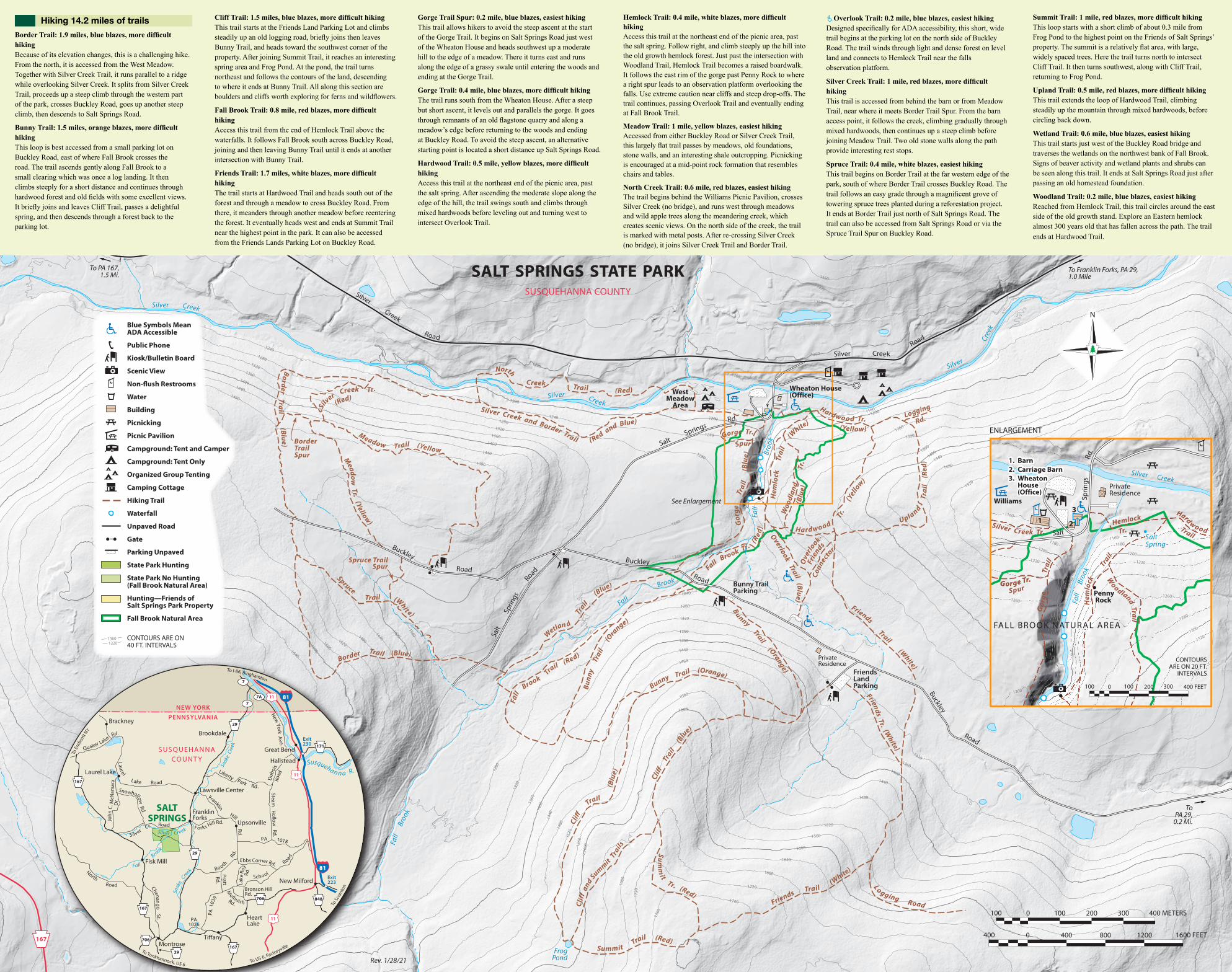
Hiking 14.2 miles of trailsBorder Trail: 1.9 miles, blue blazes, more difficult hikingBecause of its elevation changes, this is a challenging hike. From the north, it is accessed from the West Meadow. Together with Silver Creek Trail, it runs parallel to a ridge while overlooking Silver Creek. It splits from Silver Creek Trail, proceeds up a steep climb through the western part of the park, crosses Buckley Road, goes up another steep climb, then descends to Salt Springs Road.

Bunny Trail: 1.5 miles, orange blazes, more difficult hikingThis loop is best accessed from a small parking lot on Buckley Road, east of where Fall Brook crosses the road. The trail ascends gently along Fall Brook to a small clearing which was once a log landing. It then climbs steeply for a short distance and continues through hardwood forest and old fields with some excellent views. It briefly joins and leaves Cliff Trail, passes a delightful spring, and then descends through a forest back to the parking lot.

Cliff Trail: 1.5 miles, blue blazes, more difficult hikingThis trail starts at the Friends Land Parking Lot and climbs steadily up an old logging road, briefly joins then leaves Bunny Trail, and heads toward the southwest corner of the property. After joining Summit Trail, it reaches an interesting spring area and Frog Pond. At the pond, the trail turns northeast and follows the contours of the land, descending to where it ends at Bunny Trail. All along this section are boulders and cliffs worth exploring for ferns and wildflowers.

Fall Brook Trail: 0.8 mile, red blazes, more difficult hikingAccess this trail from the end of Hemlock Trail above the waterfalls. It follows Fall Brook south across Buckley Road, joining and then leaving Bunny Trail until it ends at another intersection with Bunny Trail.

Friends Trail: 1.7 miles, white blazes, more difficult hikingThe trail starts at Hardwood Trail and heads south out of the forest and through a meadow to cross Buckley Road. From there, it meanders through another meadow before reentering the forest. It eventually heads west and ends at Summit Trail near the highest point in the park. It can also be accessed from the Friends Lands Parking Lot on Buckley Road.

Gorge Trail Spur: 0.2 mile, blue blazes, easiest hikingThis trail allows hikers to avoid the steep ascent at the start of the Gorge Trail. It begins on Salt Springs Road just west of the Wheaton House and heads southwest up a moderate hill to the edge of a meadow. There it turns east and runs along the edge of a grassy swale until entering the woods and ending at the Gorge Trail.

Gorge Trail: 0.4 mile, blue blazes, more difficult hikingThe trail runs south from the Wheaton House. After a steep but short ascent, it levels out and parallels the gorge. It goes through remnants of an old flagstone quarry and along a meadow’s edge before returning to the woods and ending at Buckley Road. To avoid the steep ascent, an alternative starting point is located a short distance up Salt Springs Road.

Hardwood Trail: 0.5 mile, yellow blazes, more difficult hikingAccess this trail at the northeast end of the picnic area, past the salt spring. After ascending the moderate slope along the edge of the hill, the trail swings south and climbs through mixed hardwoods before leveling out and turning west to intersect Overlook Trail.

Hemlock Trail: 0.4 mile, white blazes, more difficult hikingAccess this trail at the northeast end of the picnic area, past the salt spring. Follow right, and climb steeply up the hill into the old growth hemlock forest. Just past the intersection with Woodland Trail, Hemlock Trail becomes a raised boardwalk. It follows the east rim of the gorge past Penny Rock to where a right spur leads to an observation platform overlooking the falls. Use extreme caution near cliffs and steep drop-offs. The trail continues, passing Overlook Trail and eventually ending at Fall Brook Trail.

Meadow Trail: 1 mile, yellow blazes, easiest hikingAccessed from either Buckley Road or Silver Creek Trail, this largely flat trail passes by meadows, old foundations, stone walls, and an interesting shale outcropping. Picnicking is encouraged at a mid-point rock formation that resembles chairs and tables.

North Creek Trail: 0.6 mile, red blazes, easiest hikingThe trail begins behind the Williams Picnic Pavilion, crosses Silver Creek (no bridge), and runs west through meadows and wild apple trees along the meandering creek, which creates scenic views. On the north side of the creek, the trail is marked with metal posts. After re-crossing Silver Creek (no bridge), it joins Silver Creek Trail and Border Trail.

Overlook Trail: 0.2 mile, blue blazes, easiest hikingDesigned specifically for ADA accessibility, this short, wide trail begins at the parking lot on the north side of Buckley Road. The trail winds through light and dense forest on level land and connects to Hemlock Trail near the fallsobservation platform.

Silver Creek Trail: 1 mile, red blazes, more difficult hikingThis trail is accessed from behind the barn or from Meadow Trail, near where it meets Border Trail Spur. From the barn access point, it follows the creek, climbing gradually through mixed hardwoods, then continues up a steep climb before joining Meadow Trail. Two old stone walls along the path provide interesting rest stops.

Spruce Trail: 0.4 mile, white blazes, easiest hikingThis trail begins on Border Trail at the far western edge of the park, south of where Border Trail crosses Buckley Road. The trail follows an easy grade through a magnificent grove of towering spruce trees planted during a reforestation project. It ends at Border Trail just north of Salt Springs Road. The trail can also be accessed from Salt Springs Road or via the Spruce Trail Spur on Buckley Road.

Summit Trail: 1 mile, red blazes, more difficult hikingThis loop starts with a short climb of about 0.3 mile from Frog Pond to the highest point on the Friends of Salt Springs’ property. The summit is a relatively flat area, with large, widely spaced trees. Here the trail turns north to intersect Cliff Trail. It then turns southwest, along with Cliff Trail, returning to Frog Pond.

Upland Trail: 0.5 mile, red blazes, more difficult hikingThis trail extends the loop of Hardwood Trail, climbing steadily up the mountain through mixed hardwoods, before circling back down.

Wetland Trail: 0.6 mile, blue blazes, easiest hikingThis trail starts just west of the Buckley Road bridge and traverses the wetlands on the northwest bank of Fall Brook. Signs of beaver activity and wetland plants and shrubs can be seen along this trail. It ends at Salt Springs Road just after passing an old homestead foundation.

Woodland Trail: 0.2 mile, blue blazes, easiest hikingReached from Hemlock Trail, this trail circles around the east side of the old growth stand. Explore an Eastern hemlock almost 300 years old that has fallen across the path. The trail ends at Hardwood Trail.