Embed Size (px)
Citation preview

VOL. 27, NO.1

COMMONWEALTH OF PENNSYLVANIA Thomas J. Ridge, Governor
DEPARTMENT OF CONSERVATION AND NATURAL RESOURCES John C. Oliver, Secretary
OFFICE OF CONSERVATION AND ENGINEERING SERVICES Richard G. Sprenkle, Deputy Secretary
BUREAU OF TOPOGRAPHIC AND GEOLOGIC SURVEY Donald M. Hoskins, Director
DtNR CONTENTS
Living with the available earth .. .. .. .. .. ... . . . . . . . . . ... . . .. . .. . . .. .. . .. . . . . . .. . .. . . . . .. .. . . .. . .. 1 Geology-Past, present, and future. ............................ .. ...... ..................... 2 Earth science teachers' corner-New booklet explains the important rela-
tionship between geology and everyday life.......... ....... ... ..... ................. 6 Almost (but not quite) heaven-Fall Run Park........... ..... .... ..... ................. 8 New releases ... .. ....... .. .. .. ...... ................. .. .. .. ..... .... .... ................................ 15
Geological research in Pennsylvania, 1994-95 .... .. .................... ..... .. .. . 15 Westmoreland and Indiana Counties identified as prime areas for dev-
elopment of methane energy resources ...................... : .......... ......... .. 15 Coal-quality dataset available on CD-ROM .......................................... 16
ON THE COVER
The main wateriall on Fall Run, Fall Run Park, Shaler Township, Allegheny County (see article on page 8) . The wateriall is developed on the Buffalo sandstone, a unit in the Glenshaw Formation of Pennsylvanian age. Photograph by J. A. Harper.
PENNSYLVANIA GEOLOGY
PENNSYLVANIA GEOLOGY is published quarterly by the Bureau of Topographic and Geologic Survey, Pennsylvania Department of Conservation and Natural Resources, P. 0. Box 8453, Harrisburg , PA 17105-8453. Editors: Christine E. Miles and Donald M. Hoskins. Contributed articles are welcome; for further information and guidelines for manuscript preparation, contact D. M. Hoskins at the address listed above. Articles may be reprinted from this magazine if credit is given to the Bureau of Topographic and Geologic Survey.
VOL. 27, NO. 1 SPRING 1996

STATE GEOLOGIST'S EDITORIAL
Living With the Available Earth
For geologists and others who daily deal with investigation or management of earth or land resources, Earth Day is Every Day. This slogan, from an earlier year, is intended to express the important concept that all people need to care for the earth every day, so as to keep it a hospitable place to live. Yet we find it advantageous to focus on a single day of the year to emphasize our need to act and to implement our care. One of the three special focuses for the 1996 celebration of Earth Day is planning for the future. Geologic knowledge is crucial to such planning.
We all live with the available earth, the earth that is here and now. Geologists interpret the history of the earth from its inception, over 4 billion years ago. We also describe our available earth and, from our interpretations and description, forecast changes that will occur. The geologic features we describe now are only a moment in a geologic picture that changes through time.
We formerly thought that the impact of people on natural geologic processes was negligible and that future changes would occur in similar geologic measure as in the past. Now we know that the continued growth of population, combined with expanded use of the earth's surface, is having rapid, direct, and measurable effects that formerly were the result of long-term natural geologic processes.
To adequately plan for the future, people must understand geologic processes that continually change our available earth. Some of these processes are described in the article "Geology-Past, Present, and Future." As a specific example of good planning, the geologic and modern development features described in the article about Fall Run Park provide insights for understanding available earth areas that are not suitable for modern development and should be preserved as natural areas. However, for all of this good planning, unless such sites are protected from the effects of adjoining development, they will be degraded.
Our available earth is all we have. Understanding geology will guide us in its care.
Donald M. Hoskins State Geologist

GEOLOGY PAST,PRESENT,andFUTURE
by Robert C. Smith, II, and John H. Barnes Pennsylvania Geological Survey
"The present is the key to the past" has been a key concept used by geologists in interpreting their field observations since it was first proposed by the pioneering Scottish geologist James Hutton in 1785. It is a reminder to geologists that, by studying modern geologic processes, we can understand what went on in the past to create the features that we find preserved in ancient rocks. This concept is not much different than the "history repeats itself" concept of historians, who usually deal with events that occurred hundreds of years rather than hundreds of thousands or hundreds of millions of years ago.
2
An approximately 500-year-old Eastern Hemlock (Tsuga canadensis), Pennsylvania's state tree, awes visitors to the Alan Seeger Natural Area, Huntingdon County, with its beauty, size, and age. Yet its height is only about three tenths of one percent of the depth of the deepest point in the ocean, and its age is one ten-millionth the age of Earth. (Photograph reprinted by permission of Halfred W. Wertz and M. Joy Callender, authors, Penn 's Woods , 1682-1982, Haverford House, Wayne, Pennsylvania.)

Taken together, these concepts suggest that Earth will, at times, be a scary place in the future.
How scary? Not as scary as in its earliest days. Drawing again upon analogy with human history, although basic processes have not changed and are destined to be repeated, many details have changed with time. When the Sun was new, much debris cluttered the space around it. Some of that debris coalesced to form the planets, including Earth, but many thousands, if not millions, of small fragments were left to circle the Sun. In its earliest days, Earth was something of a target, colliding with debris that circled the Sun in orbits that intersected that of Earth. In doing this, Earth swept out a path through space so that giant meteorite impacts should no longer be of immediate concern to us. After all, it has been 65 million years since the last really big collision occurred, perhaps spelling doom for the dinosaurs and clearing the way for mammals. The most significant collision between Earth and another body in recorded history, one that flattened forests around Tunguska, Siberia, in 1908, was very minor by comparison~nly a hit from a cosmic snowball with the energy of 10 million tons of TNT.
As Earth has matured, some other scary things have also become much less of a threat than they were when Earth was younger. About 2 billion years ago, there was enough naturally occurring fissionable uranium on Earth to cause the reactions that take place today only in the controlled environment of nuclear reactors to take place in nature. At Oklo, Gabon, on the west coast of equatorial Africa, the remnants of such a natural reactor can be observed. Thanks to millions of years of radioactive decay, there are no longer natural concentrations of fissionable uranium. Similar radioactive decay has allowed Earth's internal heat engine to run down to the point that volcanic activity has decreased. The destruction of life by volcanoes over an area of more than 1 00 square miles is now unlikely in any given decade, but in the distant past such eruptions were common. Fears of meteorite impacts, natural nuclear reactors, and volcanoes will not interfere with our celebration of Earth Day 1996.
But is all well with our mature "Mother Earth"? Not necessarily. Without any help from man, and despite the over 4 billion years that Earth has had to settle down, earthquakes such as those at New Madrid, Mo. (1811, magnitude greater than 7), and Charleston, S.C. (1886, magnitude greater than 6), will continue to occur. They will be infrequent, but even with present technology there will be no warning. At present, we cannot even do a very good job of predicting where east-coast earthquakes will occur.
3

j . In 1972, the Pennsylvania Geological Survey underwent a soggy but educational experience when its headquarters was flooded.
Floods! You say Pennsylvania has had enough once-in-500-year, once-in-200-year, and once-in-1 00-year floods in the last 25 years? Well , we agree. Our soggy experience at the Pennsylvania Geological Survey's former headquarters on a floodplain during the 1972 flood that accompanied tropical storm Agnes was educational but not satisfying. But more floods will come, and there is nothing sacred about a 200-year-old record book on a 4.5-billion-year-old planet. Do you know if you are living on an area that receives once-in-1 0,000-year floods? Do you know the depth to the water table beneath your property? How much that water table fluctuates? Whether you are in a landslide-prone area? Whether you live in a limestone or dolomite sinkhole-prone area? This is not intended to be a commercial for the Fearmonger Shop, as "advertised" by humorist Garrison Keillor on his radio program, A Prairie Home Companion. It is just a reminder, as we pause to pay respect to our home planet on this Earth Day, that the geological processes that have shaped and modified Earth are guaranteed to continue, and that they will occasionally be destructive.
What does the future hold for an Earth dominated by mankind? There will be more landslides and sinkholes than would otherwise
4

be the case because we have a constant need to rearrange the landscape so that we can construct buildings and highways to accommodate an ever-increasing population. Many of these landslides and sinkholes are preventable, but not all will be prevented. Better news coverage in the electronic era will spread news of sinkhole collapses and call attention to municipalities that employ poor storm-water management plans, thus providing disincentive for further development in such places.
Floods downstream from dikes and levees will be more severe than they would be if there were no dikes or levees, but governmentrun facilities such as the Raystown Dam will ameliorate effects in some basins. Catastrophic dam failure, such as in Johnstown in 1889 and 1977, will become less frequent because generations of horrorstricken visitors to the Johnstown Flood National Memorial will learn from history and will demand independent dam inspections.
Periodic droughts have occurred in the past and are guaranteed to occur again in any part of Pennsylvania except the part under Lake Erie. This should suggest that continued groundwater investigations are in the "essential," not just in the "it would be nice" category.
The composition of the atmosphere and the climate have varied dramatically over Earth's 4.5-billion-year history, but the rate of change has typically been extremely slow. Are we now creating a risk of catastrophic change by burning fossil fuels? We do not know, but we would not want to be living in Pennsylvania without access to such fuels, especially not after the frigid Januarys of '94 and '961 For most of us, the risks of living near well-designed and independently monitored nuclear power plants are acceptable. However, few of us can afford to pay to build more such plants, and fewer still are keen on flooding all of our river valleys to build more hydroelectric dams or covering half of the state with opaque photovoltaic cells to capture solar energy.
A potential risk associated with the burning of fossil fuels comes from the liberation of carbon dioxide into the atmosphere. If the atmosphere contained too much carbon dioxide, heat that normally is radiated into space would become trapped in the atmosphere. With time the heat might build up, resulting in changes in climate and the permanent flooding of coastal areas as the polar ice caps melted. Some scientists suggest that Earth has natural mechanisms that correct for such changes in the composition of the atmosphere. One such mechanism is the removal of excess carbon dioxide through the formation of additional deposits of limestone, which is made up partly of the elements in carbon dioxide. Other scientists maintain
5

that the process of limestone formation could be too slow to protect us from rapid changes in the atmosphere.
Although many studies that scientists undertake sound strictly academic, they can have important practical applications. The study of the process by which limestone forms is clearly one of these. Another, which is related, is a careful worldwide study of the circulation and temperature of the oceans. The oceans, collectively, are the greatest reservoir of heat that drives the weather and affects climate, yet very little is known about their thermal properties. Meanwhile, practical considerations require us to continue to identify sources of fossil fuels and groundwater, and to use existing resources wisely.
On this Earth Day, we pause to think of the many ways in which Earth's natural processes affect us. Geology has taught us that Earth has changed and will continue to change. Through further geological investigations we can learn what the processes of change are, how they have affected life on Earth in the past, and how they are likely to do so in the future. Our studies will always lead to more questions and still more studies, but it is only through this process we can learn to better adapt to the forces that continually act to shape our planet.
EARTH SCIENCE TEACHERS' CORNER
New Booklet Explains the Important Relationship Between Geology and Everyday Life
The Pennsylvania Geological its wide use before it went out of Survey is pleased to announce print. Because the purpose of the printing and availability of a the booklet is to provide stunew edition of Educational Se- dents, teachers, and other internes (ES) 4, The Geological Story ested persons with readable of Pennsylvania. First pub- basic geologic information and lished in 1935 and titled Penn- to explain how it is related to sylvania Geology Summarized, Pennsylvania, ES 4 has been tothis popular booklet was revised tally rewritten in an effort to bring minimally during the 55 years of it up-to-date with current geo-
6

E.duc3tionol Series 4
tinents are not stationary platforms, but are con-tinually moving around
Jfl.HIE GEOLO(GITCAL ~~nroiR Y COF P!ENNSYLVAlNllA
the surface of the earth. Application of this theory to previously poorly understood observations has clarified many aspects of Pennsylvania geology, such as how the rocks of the Ridge and Valley province were folded into anticlines and synclines.
The booklet, ex-panded from 17 to 44 pages, is divided broadly into three sections: an introductory section in which some of the principles of geology are explained, a central narrative section covering the geologic history of Pennsylvania from the
COMMONWEAL Tit OF PENNSVUIANIA
DEPARTMENT OF CONSERVATION AND NATIJIIAI. RESOURCES
BUREAU OF
TOPOGRAPHIC AND Ga>LO<iiC SURVEY
logical concepts and to make it easier to read and understand.
Such a revision was necessary because of the development since 1935 of many new geological concepts. These concepts have led to a better understanding of the geology of Pennsylvania and have improved our ability to apply our knowledge to practical situations, ranging from mineral extraction to environmental cleanup. Probably the most important of these new concepts is the theory of plate tectonics. According to this theory, the con-
origin of the earth to the present, and a concluding section in which the important relationship between geology and everyday life is discussed. Educational Series 4, The Geological Story of Pennsylvania, by John H. Barnes and W. D. Sevon, is available free of charge in classroom quantities to teachers and in single copies to individuals by contacting the Pennsylvania Geological Survey, P. 0 . Box 8453, Harrisburg, PA 17105-8453, telephone 717-787-2169.
7

Almost (but Not Quite) HeavenFALL RUN PARK
by John A. Harper Pennsylvania Geological Survey Judith E. Neelan Pennsylvania Department of Environmental Protection
WILDERNESS IN THE 'BURBS. Urban parks commonly are little slices of near wilderness that refreshingly coexist with skyscrapers and subways, hospitals and hotels, cathedrals and concrete. Some parks are mowed, trimmed, and weeded as immaculately as a golfcourse fairway, whereas others literally allow the citizenry to experience nature in the wild. Central Park in New York City is probably the best known of these in North America, but all major, and many minor, cities have at least one.
Suburban areas also have parks, again ranging from the wellkept garden to the preserved natural ecosystem. One small park in Allegheny County, just north of Pittsburgh, is an interesting amalgam of nature and suburban-sprawl eyesore. The natural aspects of Fall Run Park outweigh the eyesores, creating a fortunate bit of paradise that suffers from the ailments of overdevelopment. In the spring, you can combine recreation with learning as you admire the trillium, jack-in-the-pulpits, and other wildflowers while studying a leaking dump or the effects of poor stormwater management.
Fall Run Park is located in Shaler Township adjacent to Glenshaw (Figure 1 ), 7 miles from downtown Pittsburgh. Besides the requisite sports facilities (ballfields at the upper and lower ends of the valley), this long, narrow park (Figure 2) also boasts a nature trail approximately 1 mile long that weaves back and forth across Fall Run. Much remains of the natural beauty of western Pennsylvania, including the waterfalls that give the main stream, and thus the park, its name. Additionally, visitors will discover a variety of interesting geological features, including rock exposures, stream deposits, fossils, a prehistoric rockfall (site D in Figure 2), several environmental and geotechnical problems and, near the southern end of the park, a small natural gas seep in the bed of Fall Run (site A in Figure 2) where methane often can be seen bubbling up through the water.
8
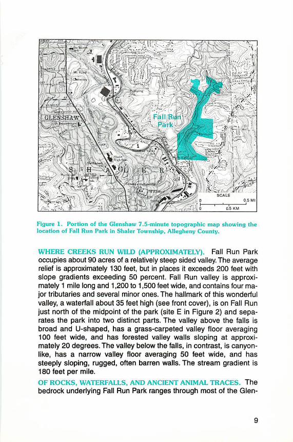
Figure 1. Portion of the Glenshaw 7 .5-minute topographic map showing the location of Fall Run Park in Shaler Township, Allegheny County.
WHERE CREEKS RUN WILD (APPROXIMATELY). Fall Run Park occupies about 90 acres of a relatively steep sided valley. The average relief is approximately 130 feet, but in places it exceeds 200 feet with slope gradients exceeding 50 percent. Fall Run valley is approximately 1 mile long and 1,200 to 1,500 feet wide, and contains four major tributaries and several minor ones. The hallmark of this wonderful valley, a waterfall about 35 feet high (see front cover), is on Fall Run just north of the midpoint of the park (site E in Figure 2) and separates the park into two distinct parts. The valley above the falls is broad and U-shaped, has a grass-carpeted valley floor averaging 1 00 feet wide, and has forested valley walls sloping at approximately 20 degrees. The valley below the falls, in contrast, is canyonlike, has a narrow valley floor averaging 50 feet wide, and has steeply sloping, rugged, often barren walls. The stream gradient is 180 feet per mile.
OF ROCKS, WATERFALLS, AND ANCIENT ANIMAL TRACES. The bedrock underlying Fall Run Park ranges through most of the Glen-
9

N
t SCALE
200 400 600 F'u t
e Point of 1ntere1t
A Co:~ vent
D Lower fe lls
C Brush Creek I imestone
D
E
F
G
ll
Lcq;e s andstone bloc\c J l.!o i n tol ls , deYeloped on the Buffalo sandstone
Pine Creole marino zone
Dump o•posed i n stream bon!(
Oi1<::hcr9e from storm drain ..w i t h erosional channel
Figure 2 . Topographic map of Fall Run Park showing locations of features of interest (modified slightly from Shultz and others, 1995, p . 3-17, Figure 3- 4).
10

GROUP
Conemaugh
INDIVIDUAL BEDS OR MEMBERS
EXPLANATION 00 .. p:::::::r::;:ot ., I f
t::::s:::::sl •• ,, ....
Ds•~'''o'"
'" ~•0 I'IOr ! O"tal ICCI e
Figure 3 . Generalized stratigraphic section of the Conemaugh Group in western Pennsylvania. Fall Run Park spans part of the Glenshaw Formation between the Mahoning coal and the Pittsburgh red beds.
shaw Formation of the Conemaugh Group (Figure 3). Shales and fissile siltstones of the middle to upper part of the Mahoning member crop out in the creek walls at the southern end of the park, and the Pittsburgh red beds, notorious for being the major natural contributor to most of western Pennsylvania's landslide problems, can be seen at the higher elevations. The creek bed itself provides many of the better exposures as Fall Run flows over alternating stretches of stream debris and sections of smooth bedrock, typically either shale or limestone. Because the bedrock layers slope gently to the east-northeast, many of the edges of individual layers form ridgelike obstructions in the stream, creating a string of small rapids. The main waterfall, as well as others seen high on the canyon walls within the tributary channels, developed on the more resistant Buffalo sandstone.
A smaller, 8-foot waterfall (site B), situated downstream from the main falls, is developed on a hard shaly layer of the Mahoning member only a few feet below the Brush Creek limestone. A tributary just below the waterfall occupies a hanging valley. The waterfall, hanging valley, and entrenched aspect of Fall Run downstream from this point suggest the possibility that the waterfall might represent a knickpoint, an abrupt change in the stream profile.
11

Two fossiliferous units, the Brush Creek limestone and the Pine Creek marine zone, crop out in Fall Run Park. The Brush Creek, a dark-colored clay-rich limestone less than 1 foot thick, forms the bed of Fall Run at site C. The Pine Creek marine zone, which occurs above the main waterfall at site F, consists of brown to tan-colored limestone sandwiched between black, limy shales. Only the lower black shale is noticeably fossiliferous at this locality. Shell material, mostly a hash of fossil seashells, is common in some of the float, but it is difficult to tell which unit has the most debris. The primary fossils are trace fossils. Dark-colored Zoophycos, the f~eding trace of a worm that swept the seafloor in a semicircular pattern, is easily distinguished against the buff-colored weathered surface of the rock. Other trace fossils noted were Conostichus, interpreted as the resting trace of a sea anemone, and Beaconites, a wide burrow made by some kind of marine animal plowing through the mud.
HERE COME DE SLUDGE, AND OTHER SUBURBAN NICETIES. One of the more noticeable aspects of Fall Run Park is the impact of humanity on the valley itself. The valley wall is ringed with houses from several stages of development, beginning in the mid- to late 1960's. The following three activities, begun at that time, continue to bedevil the valley today: (1) A sewer line was installed in the valley floor. For several years, the line has been in need of repair, as evidenced by cracks in some of the exposed sections. In addition, the system tends to overflow during thunderstorms, due to the influx of stormwater at some point in the line, leading to flooding and contamination of the creek. (2} A former dump was buried without adequate technological precautions for ensuring environmental safety. Debris can be seen in the northernmost tributary wall (site G) amid oozing patches of rustcolored leachate. (3} Surface stormwater discharges directly into the valley during heavy rainfalls.
Developers building in the area prior to passage of the Stormwater Management Act of 1974 simply funneled stormwater into drainpipes that discharged into the upper reaches of the tributaries to Fall Run. This promoted accelerated headward and lateral erosion of the tributary valleys. Houses sitting at the upper reaches of these tributaries are losing value with each passing year as erosion literally slices the land out from under them. Some effort has been made by landowners to slow the velocity and, therefore, the erosional impact of the discharge by loading the tributaries with trees, brush, rocks, and other debris. Alas, nature will undoubtedly take its course in the end, expanding the valleys into the very properties they were intended to drain.
12

Headward erosion represents the grand opus of overdevelopment around Fall Run Park. Two new tributaries having steep, barren, V-shaped gullies were carved at site H by the discharge of drainpipe stormwater directly onto unprotected colluvium, rather than into existing tributary channels. The larger of the two is an ugly scar roughly 8 feet wide, 5 to 13 feet deep, and 200 feet long. At its source, peeking out from beneath a well-trimmed lawn, is an 18-inch pipe that is protected by a concrete enclosure (Figure 4). The enclosure is still present, unlike other pipe enclosures in other tributaries, but it is being undermined and will eventually collapse into the gully. The discharge from this pipe has been powerful enough not only to erode the gully wall 6 feet beyond the drainpipe opening, but also to erode the gully down to bedrock about 8 feet below.
Developers building in the area after 197 4 have been required by law to install sedimentation ponds that protect streams by (1) trapping sediment behind a dam so that it will not be washed away, and (2) collecting excess runoff and allowing it to drain from the pond to an established tributary at a rate less than or equal to the natural discharge rate for the area. The contrast between the older "piped" tribu-
Figure 4 . Approximately 25 years of man-induced runoff from the local stormdrain system has undermined the concrete enclosure and eroded a deep gully to bedrock. Scale (at arrow) is 1 meter long.
13

taries and the more recent "ponded" ones is remarkable. Tributaries fed with piped stormwater typically exhibit rough, craggy gullies where the bedrock is exposed, vegetation is sparse, and trees on the slopes above the gullies have been undermined. Undisturbed tributaries, or their "ponded" counterparts, appear more natural, and vegetation and forest litter cover the ground. It is unfortunate that the erosion and sedimentation laws are not retroactive-Fall Run Park could use some relief from an abundance of precipitation on too many rooftops, roadways, and residential lawns.
THE FINAL WORD? WE DOUBT IT! Visitors to Fall Run Park tend to return to it because, in spite of its environmental woes, the park offers a salve to soothe bouts of "suburbanitis." It is a place to slow down, relax, and cool the mind and body. One can play there, name the deer, or just kick back and indulge the senses. One big advantage of Fall Run Park is that it is an oft-used natural laboratory, a place to study numerous "ologies" (biology, geology, ecology, and so forth). Because changes occur so rapidly in the park, there is simply no better place in the Pittsburgh area to study the processes that shape the landscape. What may have taken nature tens of centuries to achieve in undeveloped areas is being accomplished in decades as a result of the suburban impact. Creek meanders removed in the late 1960's are reforming, prehistoric alluvial fans are being downcut, and waterfalls and valley walls are retreating at an accelerated rate.
While new-found stewards of the valley (mostly concerned Shaler Township citizens) would like to see Fall Run Park restored to its pristine state, they now battle simply to resist further negative impact. A recent plan to install another ballfield atop one of the natural tributaries has been temporarily thwarted, but yet another developer wants to tap into the already overtaxed sewer line. In spite of the scientific intrigue about how nature will respond to man's maneuvering in Fall Run, there is no doubt that this is a valley in danger of further suburban stress. And, unfortunately, there does not seem to be much to prevent it aside from the faithful efforts of concerned citizens.
REFERENCE
Shultz, C. H., Harper, J . A., and Neelan, J. E., 1995, Bedrock geology and urban geologic problems of northern Allegheny County, Pennsylvania, in Hutchinson, P. J. , ed., Pittsburgh Geological Society Golden Anniversary (1945-1 995) Field Guide Book: Pittsburgh Geological Society, p. 3-1-3- 35.
14

NEW RELEASES
Geological Research in Pennsylvania, 1994-95
The Pennsylvania Geological ports published during the same Survey recently released Geo- time period is also included. For logical Research in Pennsylva- a free copy of the report, contact nia, 1994-95, a 47-page compi- the Pennsylvania Geological Surlation of geological research in vey, P. 0. Box 8453, Harrisburg, Pennsylvania reported for the PA 17105-8453, telephone 717-period July 1, 1994, through June 787-2169. 30, 1995. A listing of geological re-
Westmoreland and Indiana Counties
Identified as Prime Areas for Development
of Methane Energy Resources
Northern Westmoreland and Indiana Counties have been identified in a new report as prime areas for targeting development of methane, a natural gas, from Pennsylvania's bituminous coal. The report is based on geological investigations conducted in seven counties in southwestern Pennsylvania and eight counties in West Virginia between 1991 and 1993 by staff of the Pennsylvania and West Virginia Geological Surveys.
The survey geologists found that some of Pennsylvania's bituminous coal layers (those in-
eluded in the Allegheny Group) have the greatest potential for producing methane because of their higher coal rank.
In the new report, 31 maps, 11 cross sections, and other diagrams illustrate the distribution and thicknesses of coals and associated sandstones. Areas where repeated intervals of coal and intervening sandstone layers are "stacked" are the best target areas for exploratory drilling and production, particularly because the coal rank is higher in these areas than in other areas, and the coals
15

have a higher methane gas content.
The 72-page publication (report number PB96-1 07396) is entitled Geological Aspects of Coalbed Methane in the Northern Appalachian Coal Basin, Southwestern Pennsylvania and North-Central West Virginia and can be ordered from the National Technical Information Service,
5285 Port Royal Road, Springfield, VA 22161, telephone 703-487-4630. The price is $19.50 plus $4.00 for shipping and handling (for international orders, please call the number above for shipping and handling information). Please make checks payable to NTIS. For rush orders, call 1-800-553-6847.
Coal-QuaHty Dataset Avallable on CD-ROM
Coal-quality information useful in addressing air- and waterquality issues is now available on compact disc.
Of the 189 chemicals believed to cause adverse environmental effects-including mercury, selenium, and arsenic-14 are produced by coal combustion. The U.S. Geological Survey coalquality database, derived from the National Coal Resources Data System, is recognized by the Environmental Protection Agency (EPA) as an independent and objective basis for setting standards relating to emission of toxic air substances from coal-combustion facilities. The complete database is made up of almost 13,000 validated samples from every major coalbed in every coal basin in the nation. Information from 7,400 of these samples is contained on the CD-ROM, including more than 800 samples from Pennsylvania. All of the samples have been ana-
16
lyzed for a suite of more than 90 trace elements, including all of the elements listed in the Clean Air Act amendments.
The database has been selected by the EPA for use in a study on hazardous air pollutants required by the 1990 amendments to the Clean Air Act. The utility industry and several coalmining companies have also agreed to use this database for their estimates on hazardous air pollutant emissions.
The Coal Quality Data Base, OFR-205, is available free of charge from the U.S. Geological Survey, Branch of Coal Geology, MS 956, National Center, Reston, VA 22092. To order, please contact Linda Bragg at telephone 703-648-6451, fax 703-648-6419, or E-mail lbragg@ ncrds.er.usgs.gov.
-K. Mitchell Snow, U.S. Geological Survey, Branch of Public Affairs, Office of the Director

PENNSYLVANIA GEOLOGICAL SURVEY STAFF Donald M. Hoskins, Bureau Director
Access no. for the hearing impaired: 1-800-£54-5984 (TOO) Pa. AT&T relay service Bureau staff may be reached by Internet using the following format: [email protected]
FAX: 717- 783-7267
DIRECTOR'S OFACE 717-787-2169
Administra tive Services Shirley J. Barner, Clerical Supervisor Sharon E. Garner, Clerk Typist
Administrative Services (cont.) Geoffrey M. Gooley, Administrative Assistant Jody R. Smith, Clerk Typist
GEOLOGIC AND GEOGRAPHIC INFORMATION SERVICES DMSION 717-787-81 62
Christine E. Miles, Division Chief
Geologic library Richard C. Keen, Librarian
Geologic Drafting Section John G. Kuchinski, Section Chief Lajos J. Balogh, Cartographic Drafter
(Pittsburgh Office) James H. Dolimpio, Cartographic Drafter
Geologic Information Section Anne B. Lutz, Geologist Caron E. O'Neil, Geologist Thomas G. Whitfield, Geologist
Geographic Information Section William H. Stoner, Engineering Technician
GEOLOGIC MAPPING DMSION 717-787-6029
Jon D. lnners, Division Chief Rodger T. Faill, Assistant Division Chief
Helen L. Delano, Geologist Clifford H. Dodge, Geologist William E. Kochanov, Geologist Leonard J. Lentz, Geologist David B. Macl achlan, Geologist
John C. Neubaum, Geologist William D. Sevon, Geologist James R. Shaulis, Geologist Viktoras W. Skema, Geologist
GEOLOGIC RESOURCES DMSJON 717-787-5828
Samue l W. Berkheiser, Division Chief
Groundwater Geology Section Michael E. Moore, Section Chief Gary M. Fleeger, Hydrogeologist Thomas A. McElroy, Hydrogeologist
Mineral Resources Section Robert C. Smith, II, Section Chief John H. Barnes, Geologist Leslie T. Chubb, Laboratory Technician
Water Well Drillers Licensing and Records Section Donna M. Snyder, Section Chief Mari G. Barnhart, Clerk
Subsurface Geology Section 500 Wateriront Drive Pittsburgh, PA 15222-4745 412-442-4235 John A. Harper, Section Chief Cheryl L. Cozart, Descriptive Statistician Kathy J. Flaherty, Geologist Joseph E. Kunz, Clerk Typist Christopher D. Laughrey, Geologist Lynn J. Levino, Clerk Typist Antonette K. Markowski, Geologist
(Harrisburg Office) Joseph R. Tedeski, Geologist
IN COOPERATION WITH THE U.S. GEOLOGICAL SURVEY TOPOGRAPHIC MAPPING
GROUNDWATER-RESOURCE MAPPING

GEOLOGY AND PLANET EARTH (See article on page 2)
From Barnes. J. H .. 1991, Rocks and rrun· erals ol POMsytvan.a: Pomsytvania Goological Survoy, 41h sor .. Educalional Serios 1, p. 11.
Bureau of Topographic and Geologic Survey Department of Conservation and Natural Resources P. 0. Box 8453 Harrisburg, PA 17105-8453
Address Corrections Requested
An Equal Opportunity/ AHirmative Action Employer Recycled Paper ~
Bulk Rate U.S. Postage
PAID Harrisburg. PA Permit No. 747
22<JO.BK·OCNR0103