Embed Size (px)
Citation preview
1
SA
MO
S-G
OS
UD
Meeti
ng
. B
ou
lder
2-4
May 2
00
6
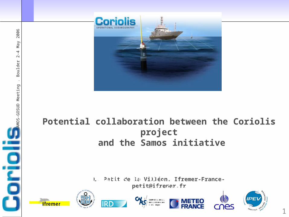
Potential collaboration between the Coriolis project
and the Samos initiative
L. Petit de la Villéon. [email protected]
http://www.coriolis.eu.org [email protected]
2
SA
MO
S-G
OS
UD
Meeti
ng
. B
ou
lder
2-4
May 2
00
6
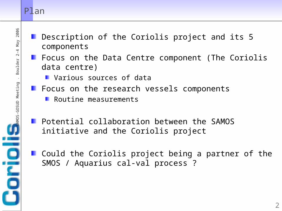
Plan
Description of the Coriolis project and its 5 componentsFocus on the Data Centre component (The Coriolis data centre)
Various sources of data
Focus on the research vessels componentsRoutine measurements
Potential collaboration between the SAMOS initiative and the Coriolis project
Could the Coriolis project being a partner of the SMOS / Aquarius cal-val process ?

3
SA
MO
S-G
OS
UD
Meeti
ng
. B
ou
lder
2-4
May 2
00
6
Coriolis as a part of a global structure for operational oceanography: a french approach in an international
context
4
SA
MO
S-G
OS
UD
Meeti
ng
. B
ou
lder
2-4
May 2
00
6
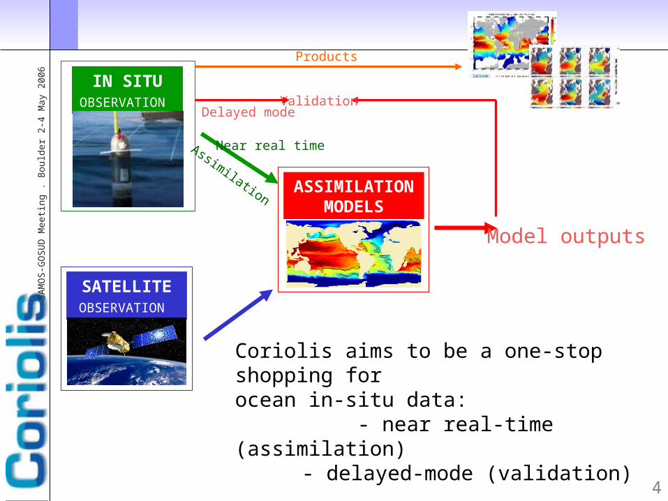
IN SITU OBSERVATION
Coriolis aims to be a one-stop shopping for ocean in-situ data: - near real-time (assimilation)
- delayed-mode (validation)
ValidationDelayed mode
SATELLITE OBSERVATION
ASSIMILATIONMODELS
Model outputs
Near real timeAssimilation
Products
5
SA
MO
S-G
OS
UD
Meeti
ng
. B
ou
lder
2-4
May 2
00
6
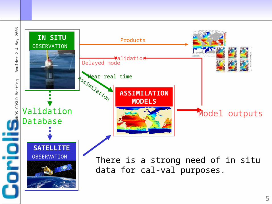
IN SITU OBSERVATION
There is a strong need of in situ data for cal-val purposes.
ValidationDelayed mode
SATELLITE OBSERVATION
ASSIMILATIONMODELS
Model outputs
Near real timeAssimilation
Products
Validation Database

6
SA
MO
S-G
OS
UD
Meeti
ng
. B
ou
lder
2-4
May 2
00
6
How did Coriolis start to work on operational oceanography?
http://www.coriolis.eu.org [email protected]
With a 7 french research institutes partnership
With a 5 components approach
Science
Data centreFloats deployments
Research vessels operations
Instrumentation

7
SA
MO
S-G
OS
UD
Meeti
ng
. B
ou
lder
2-4
May 2
00
6
Coriolis data flow
Coriolis-Database
Quality Controls
Productsanalyses, graphics, maps
current estimatessensor drifts
ArgoDacs Argocoriolis, gyroscope, Mersea,33 projectsProvor, Apex, Nemo
Météo-franceGts dataLagrangian buoys
Research vesselsxbt-ctd, tsgAtalante, thalassa, suroît,Beautemps-Beaupré, Marion-Dufresne, Meteor,
VOS- merchant ships ORE SSS (IRD)T & S surface data
Gtspp- Gosud Meds GTS
US-nodchistorical data
GTS (Météo-France)
argo
web
Clivardelayed mode data sets
Mersea, MercatorGodae
Other modelssoap (Shom-
French Navy)
Gtspp- Gosudreal time flowdelayed mode
12h
12h
1 year
ftp, opendap, las
dynamic
daily
daily
daily
weekly
annual
annual
daily*2
48h
1 year12h
Moorings Tao, Triton, Pirata

Data sources
Argo floats
Moorings
Research vessels
Merchant ships
Sea mamals or sea elephants
Gliders
Drifting buoys
9
SA
MO
S-G
OS
UD
Meeti
ng
. B
ou
lder
2-4
May 2
00
6
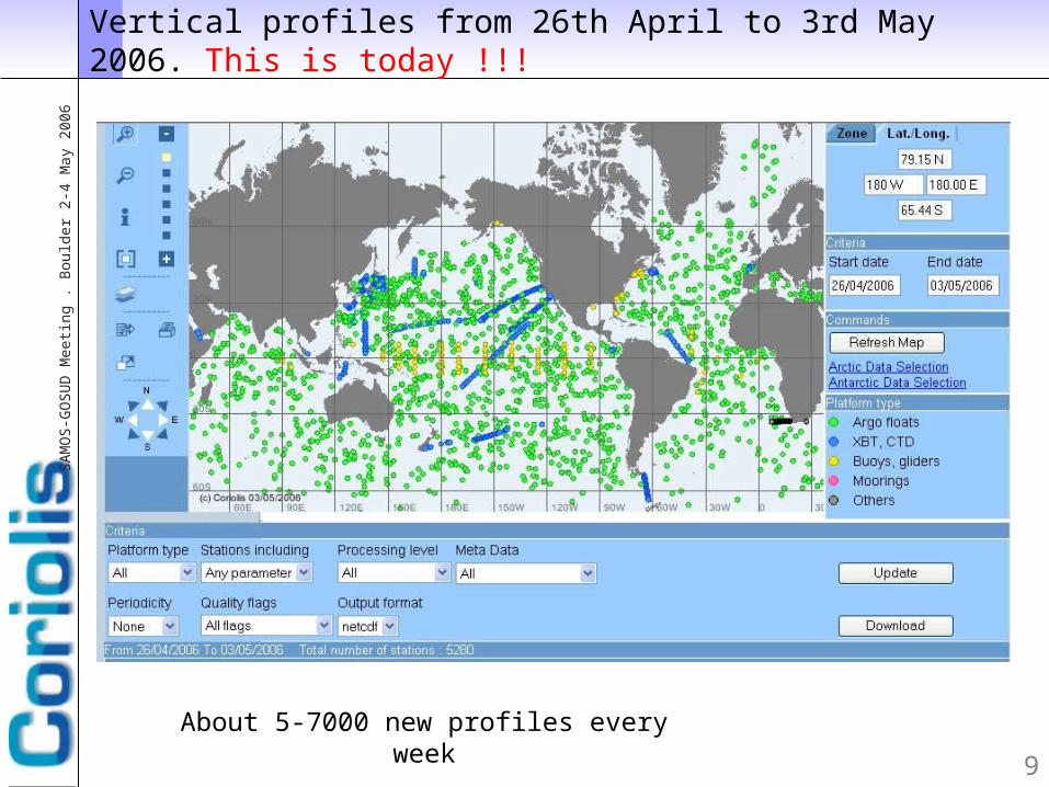
Vertical profiles from 26th April to 3rd May 2006. This is today !!!
About 5-7000 new profiles every week
10
SA
MO
S-G
OS
UD
Meeti
ng
. B
ou
lder
2-4
May 2
00
6
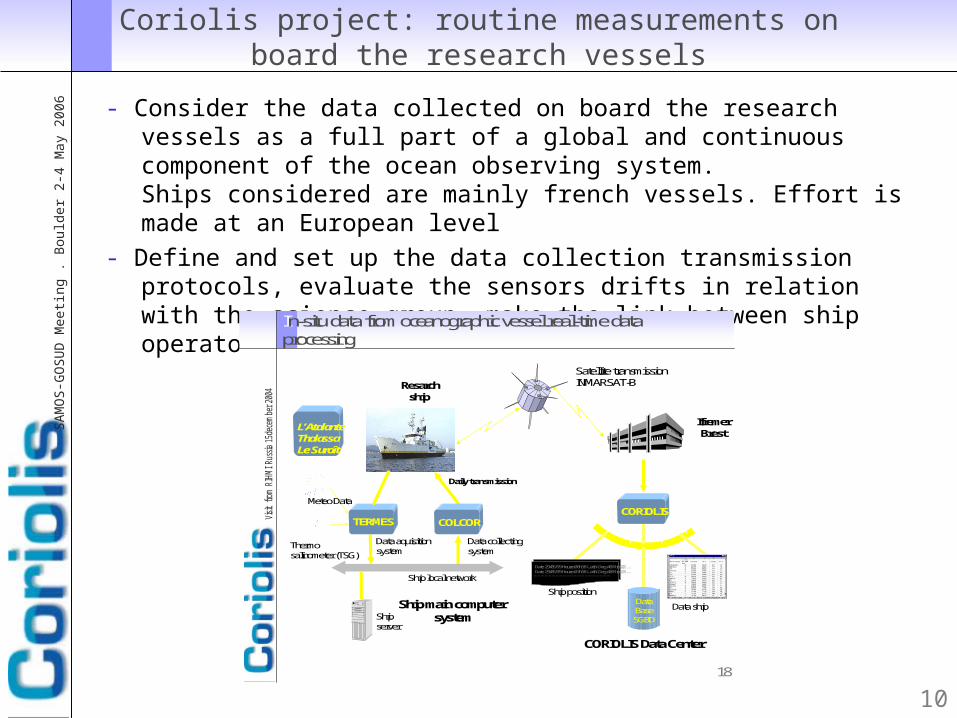
Coriolis project: routine measurements on board the research vessels
- Consider the data collected on board the research vessels as a full part of a global and continuous component of the ocean observing system.Ships considered are mainly french vessels. Effort is made at an European level
- Define and set up the data collection transmission protocols, evaluate the sensors drifts in relation with the science group, make the link between ship operators and data centre
18
Visit from R
IHMI Rus
sia 15
dece
mbe
r 20
04
Ship local network
TERMESCORIOLIS
Satellite transmissionINMARSAT-B
Data aquisition system
Data collectingsystem
Ship server
Ship main computersystem
Daily transmission
COLCOR
IfremerBrest
CORIOLIS Data Center
Data BaseSGBD
Meteo Data
Thermosalinometer (TSG)
Date 29/05/99 Heure:06h58Lat:NDeg:48 Min:22 ...Date 29/05/99 Heure:07h58Lat:NDeg:48 Min:23 ...
Ship position
Data ship
Resarchship
L’AtalanteThalassaLe Suroît
In-situ datafrom oceanographic vesselreal-time dataprocessing

11
SA
MO
S-G
OS
UD
Meeti
ng
. B
ou
lder
2-4
May 2
00
6
Research vessels component
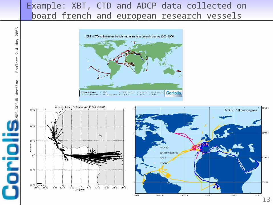
• Data considered:
– T and S vertical profile data from XBT and CTD
– surface T & S Data– Current data from VM-ADCP
• In the frame of :– national projects– european funded projects
• In relationship with international projects:– GOSUD (IODE)

12
SA
MO
S-G
OS
UD
Meeti
ng
. B
ou
lder
2-4
May 2
00
6
Example: T & S surface data collected on board research vessels (thermosalinographs)
13
SA
MO
S-G
OS
UD
Meeti
ng
. B
ou
lder
2-4
May 2
00
6
Example: XBT, CTD and ADCP data collected on board french and european research vessels

14
SA
MO
S-G
OS
UD
Meeti
ng
. B
ou
lder
2-4
May 2
00
6
Directions for potential collaboration (1/5)
Access to new sources of data (1/2)SAMOS collect data from US Research Vessels
Both meteorological and oceanographic data (SST)Main interest on meteorological data
CORIOLIS collect data from french research vessels (objective is to enlarge to european vessels)
oceanographic data (SS-SSS) and meteorological dataMain interest on oceanographic data
– => data exchange between the 2 projects– => an pilot experience could be started on a SAMOS research
vessel and on Atalante
– => Coriolis ‘s Interest is on getting new data, receiving feedback on meteorological data quality
– => Gosud interest is obvioulsly to have access to new data
Meteorological are available for about
half of these locations

15
SA
MO
S-G
OS
UD
Meeti
ng
. B
ou
lder
2-4
May 2
00
6
Directions for potential collaboration (2/5)
Meteorological dataWet bulb temperatureSea Surface temperatureHumidityAtmospheric pressureDew PointPrecipitation rateSolar RadiationTrue wind Speed and direction Apparent Wind Speed and direction
Coriolis has no experience on QC such data and it is not our 1st objective to process them but they are available.Some of these parameters are transmitted on the GTS
Parameters recorded on Coriolis research vessels
Oceanographic dataSea Surface temperatureConductivityWater tank temperature

16
SA
MO
S-G
OS
UD
Meeti
ng
. B
ou
lder
2-4
May 2
00
6
Directions for potential collaboration (3/5)
Access to new sources of data (2/2)Coriolis is involved in the OceanSites project as a GDACOceanSites relates to Open Ocean moorings and long time series and monitoringThey are regular ship cruises planned for moorings maintenanceAccess to data collected by the vessels when they cruise to the moorings could also be an interesting way to investigate for potential collaborationCruises data are full part of the OceanSites Projecthttp://www.oceansites.org/
17
SA
MO
S-G
OS
UD
Meeti
ng
. B
ou
lder
2-4
May 2
00
6
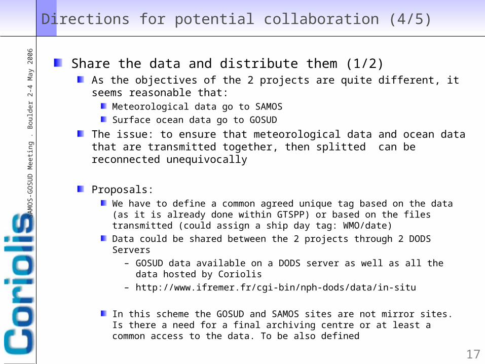
Directions for potential collaboration (4/5)
Share the data and distribute them (1/2)As the objectives of the 2 projects are quite different, it seems reasonable that:
Meteorological data go to SAMOSSurface ocean data go to GOSUD
The issue: to ensure that meteorological data and ocean data that are transmitted together, then splitted can be reconnected unequivocally
Proposals:We have to define a common agreed unique tag based on the data (as it is already done within GTSPP) or based on the files transmitted (could assign a ship day tag: WMO/date) Data could be shared between the 2 projects through 2 DODS Servers
– GOSUD data available on a DODS server as well as all the data hosted by Coriolis
– http://www.ifremer.fr/cgi-bin/nph-dods/data/in-situ
In this scheme the GOSUD and SAMOS sites are not mirror sites. Is there a need for a final archiving centre or at least a common access to the data. To be also defined

18
SA
MO
S-G
OS
UD
Meeti
ng
. B
ou
lder
2-4
May 2
00
6
Directions for potential collaboration (5/5)
Share the data and distribute them (2/2)Coriolis has an experience on ocean data routine insertion on the GTS (Global Transmission NetWork). If we plan to receive the ocean data from SAMOS, Coriolis propose to do that for SAMOS data (if not yet done)

19
SA
MO
S-G
OS
UD
Meeti
ng
. B
ou
lder
2-4
May 2
00
6
Summarizing
Share the data between our 2 projects seems to be the 1st obvious step: Meteorological data « against » Ocean data
Find an easy way to access collocated meteo and ocean data
Define a data structure for thatWhich may include a common format or at least a compatible format
As a conclusion for a SAMOS / CORIOLIS collaborationRoutinely collecting data on research vessels is very valuable because
Ships tracks are far from merchant routes
Data are of high quality (because of being acquired by specialised staff)
Sharing those data is important and using them as much as it is possible is also important. Feedback to the data originators must be done each time it is possible
Another message : Coriolis is open to a collaboration for a centralised in situ ocean data access for satellite validation purposes
20
SA
MO
S-G
OS
UD
Meeti
ng
. B
ou
lder
2-4
May 2
00
6
Contacts: