Embed Size (px)
Citation preview

ECMWFECMWF seminar September 2003 3
Satellite Data Assimilation Overview
Jean-Noël Thépaut
with thanks to:ECMWF Satellite Section
Christina Köpken, Mike Fisher, Alain Ratier, Hal Bloom

ECMWFECMWF seminar September 2003 3
OutlineIntroduction to the Satellite Observing SystemWhat do satellite data measure?
Observing techniquesInversion techniques
Importance of satellite data in current NWP data assimilation systems
Data volumeInformation contentImpact studies
Assimilation of satellite data: current issuesFuture evolution and challenges
ECMWFECMWF seminar September 2003 3
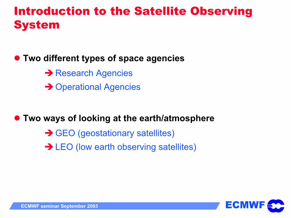
Introduction to the Satellite Observing System
Two different types of space agenciesResearch AgenciesOperational Agencies
Two ways of looking at the earth/atmosphereGEO (geostationary satellites)LEO (low earth observing satellites)
ECMWFECMWF seminar September 2003 3
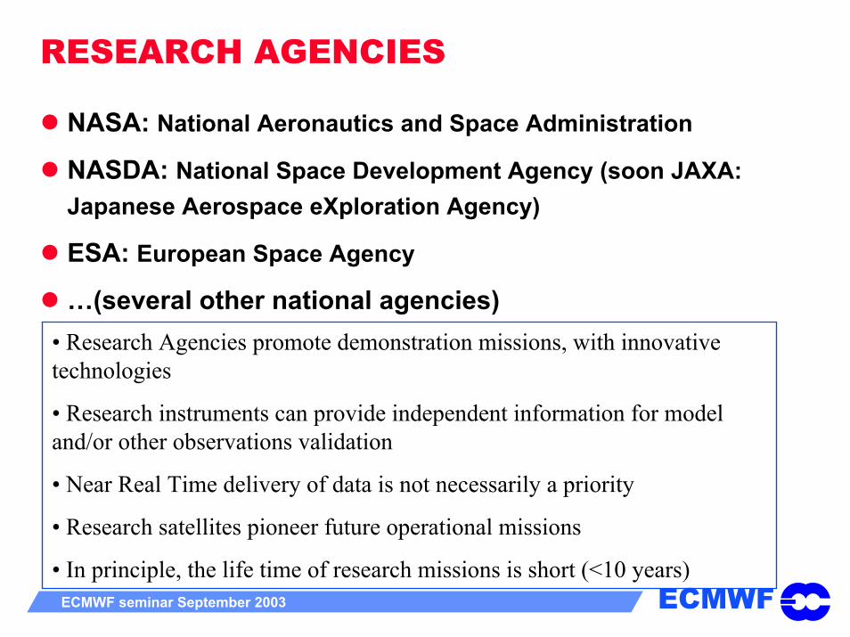
RESEARCH AGENCIES
NASA: National Aeronautics and Space Administration
NASDA: National Space Development Agency (soon JAXA: Japanese Aerospace eXploration Agency)
ESA: European Space Agency
…(several other national agencies)• Research Agencies promote demonstration missions, with innovative technologies
• Research instruments can provide independent information for model and/or other observations validation
• Near Real Time delivery of data is not necessarily a priority
• Research satellites pioneer future operational missions
• In principle, the life time of research missions is short (<10 years)

ECMWFECMWF seminar September 2003 3
OPERATIONAL AGENCIES
EUMETSAT: EUrope’s METeorological SATellite organisation
NOAA: National Oceanic and Atmospheric AdministrationNOAA-NESDIS-DMSP
JMA: Japan Meteorological Agency
Russia, China,…
• Operational Systems inherit from Research demonstration missions
• Operational Satellites are committed to Real Time delivery to end-users
• Operational missions ensure a stabilised long-life mission technology (HIRS instrument onboard NOAA satellites has lasted for ~30 years)

ECMWFECMWF seminar September 2003 3
Operational versus Research Agencies
Thanks to a WMO initiative, R&D satellites are now fully considered as part of the Global Observing System
Should ease the transition from research to operations
Has implications on NRT delivery requirements
Operational centres use pragmatically R&D instruments:
for model validation (POLDER, CERES,…)
for data assimilation (ERS, QUIKSCAT, AIRS,…)
ECMWFECMWF seminar September 2003 3
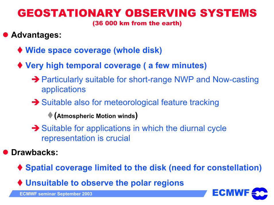
GEOSTATIONARY OBSERVING SYSTEMS(36 000 km from the earth)
Advantages:
Wide space coverage (whole disk)
Very high temporal coverage ( a few minutes)Particularly suitable for short-range NWP and Now-casting applicationsSuitable also for meteorological feature tracking
(Atmospheric Motion winds)Suitable for applications in which the diurnal cycle representation is crucial
Drawbacks:
Spatial coverage limited to the disk (need for constellation)
Unsuitable to observe the polar regions

ECMWFECMWF seminar September 2003 3
Low Earth Orbiting OBSERVING SYSTEMS(400 to 800 km from the Earth)
Advantages:
Cover the whole earth after several cycles (polar orbiting satellites)
More suitable to sound the atmosphere in the microwave spectrum.
Drawbacks:
Moderate temporal sampling (several hours to go back to the same point)
Requires constellation to ensure a reasonable temporal sampling
ECMWFECMWF seminar September 2003 3
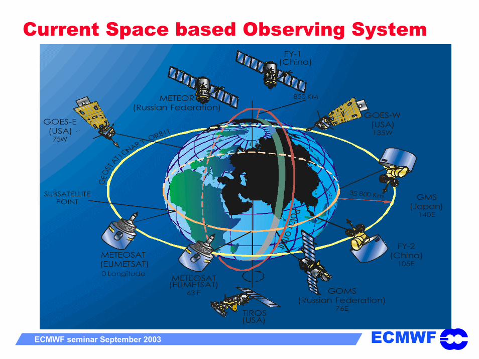
Current Space based Observing System
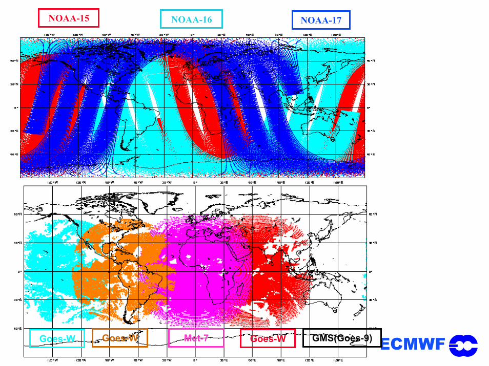
ECMWFECMWF seminar September 2003 3
NOAA-15 NOAA-16 NOAA-17
Goes-W Goes-W Met-7 Goes-W GMS(Goes-9)

ECMWFECMWF seminar September 2003 3
Outline
Introduction to the Satellite Observing System
What do satellite instruments measure?
Importance of satellite data in current NWP data assimilation systems
Assimilation of satellite data: current issues
Future evolution and challenges

ECMWFECMWF seminar September 2003 3
What do satellite instruments measure?Satellite instruments are specific in that they do not measure directly geophysical quantities (temperature, moisture, ozone, wind,…)
Satellite instruments measure the radiation emitted by the Earth/Atmosphere
The conversion of this measurement into a geophysical information is an inverse problem
Data assimilation techniques try to solve this inverse problem as “optimally” as possible
Y )( bb XH= Forward modelling problem (Radiative Transfer Equation)
)( obsI
a YHX −= Inverse problem (need for prior information)

ECMWFECMWF seminar September 2003 3
Depending on the wavelength, the radiation at the top of the atmosphere is sensitive to different atmospheric constituents
HIRS GOES METEOSAT AIRS
Scat, Altimeter
AMSU, SSM/ISBUV

ECMWFECMWF seminar September 2003 3
Three ways of sensing the Earth/AtmospherePassive technologies
Passive instruments sense the:natural radiation emitted by the Earth/Atmospheresolar radiation reflected by the Earth/Atmosphere
Active technologies
Active instruments:Emit radiation towards the Earth/AtmosphereSense how much is scattered (or reflected) back
GPS technologies
GPS receivers:Measure the phase delay of a GPS signal when refracted through the atmosphere

ECMWFECMWF seminar September 2003 3
Passive technologies
“Imaging” instruments
Sense in spectral “window” regions where the atmosphere is close to transparent, therefore sense essentially the surface emission
Provide indirectly information on:VIS/IR: surface temperature, cloud top, wind (through cloud motion), snow/ice, vegetationµW: surface ocean wind speed, sea-ice, total column water vapour, cloud liquid water, rain
Vis/IR instruments: AVHRR on NOAA, MODIS on TERRA/AQUA, GOES+METEOSAT/MSG,…
Microwave instruments: SSM/I on DMSP, TMI on TRMM, AMSR on AQUA and ADEOS-2,…
ECMWFECMWF seminar September 2003 3
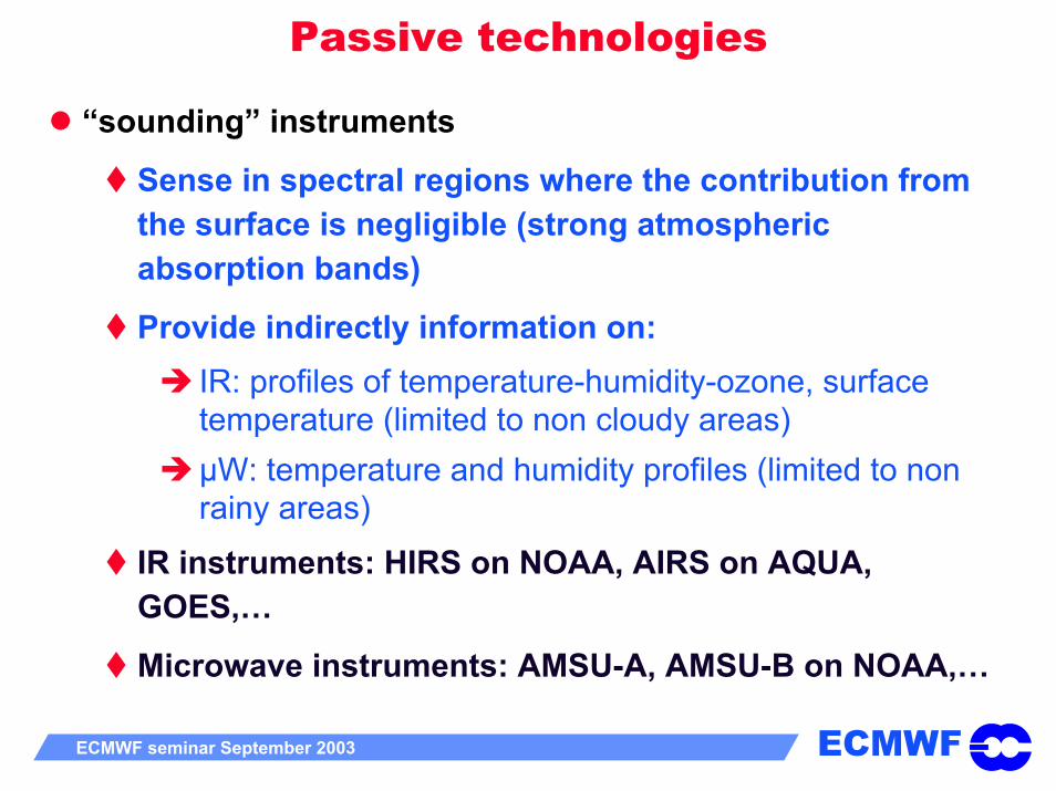
Passive technologies
“sounding” instruments
Sense in spectral regions where the contribution from the surface is negligible (strong atmospheric absorption bands)
Provide indirectly information on:IR: profiles of temperature-humidity-ozone, surface temperature (limited to non cloudy areas)µW: temperature and humidity profiles (limited to non rainy areas)
IR instruments: HIRS on NOAA, AIRS on AQUA, GOES,…
Microwave instruments: AMSU-A, AMSU-B on NOAA,…

ECMWFECMWF seminar September 2003 3
Passive sounding instruments: AMSU-A
• Sense radiation from different atmospheric layers by selecting different absorption bands

ECMWFECMWF seminar September 2003 3
Active technologies
Active instruments
Send radiation to a target (Earth/Atmosphere) and measure what is back reflected/scattered.
Provide indirectly information on:Surface wind (scatterometers, radar altimeter)Sea surface height, wave height and spectra (altimeters, SARs)Rain, cloud and aerosol profiles (radars, lidars)Atmospheric wind profiles (Doppler lidars)Moisture profiles (DIALS)
TRMM-PR, ERS-2 (Scat/RA/SAR), SeaWinds on QuikScat and ADEOS-2, ENVISAT (RA-2, ASAR)
ECMWFECMWF seminar September 2003 3
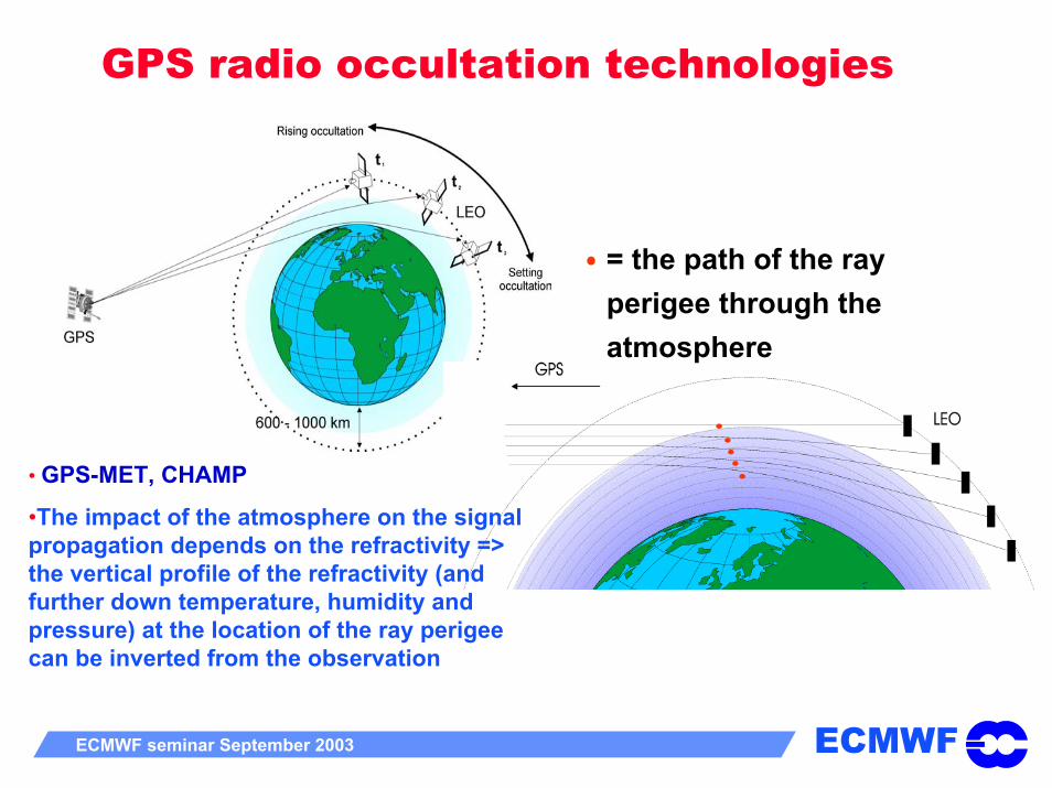
GPS radio occultation technologies
= the path of the ray perigee through the atmosphere
• GPS-MET, CHAMP
•The impact of the atmosphere on the signal propagation depends on the refractivity => the vertical profile of the refractivity (and further down temperature, humidity and pressure) at the location of the ray perigee can be inverted from the observation
ECMWFECMWF seminar September 2003 3
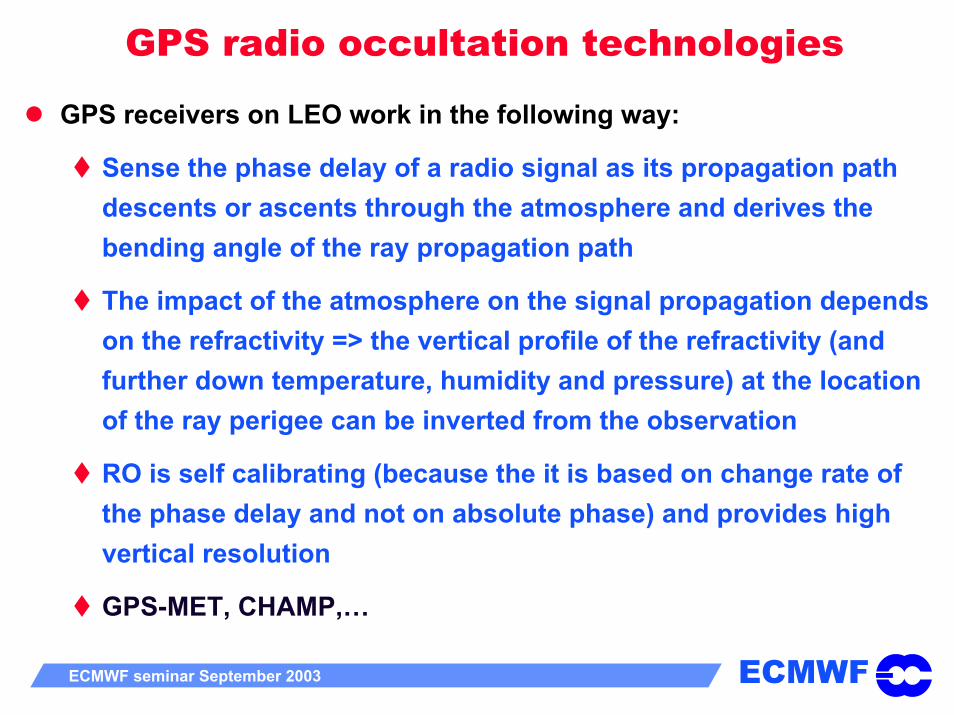
GPS radio occultation technologies
GPS receivers on LEO work in the following way:
Sense the phase delay of a radio signal as its propagation path descents or ascents through the atmosphere and derives the bending angle of the ray propagation path
The impact of the atmosphere on the signal propagation depends on the refractivity => the vertical profile of the refractivity (and further down temperature, humidity and pressure) at the locationof the ray perigee can be inverted from the observation
RO is self calibrating (because the it is based on change rate of the phase delay and not on absolute phase) and provides high vertical resolution
GPS-MET, CHAMP,…
ECMWFECMWF seminar September 2003 3
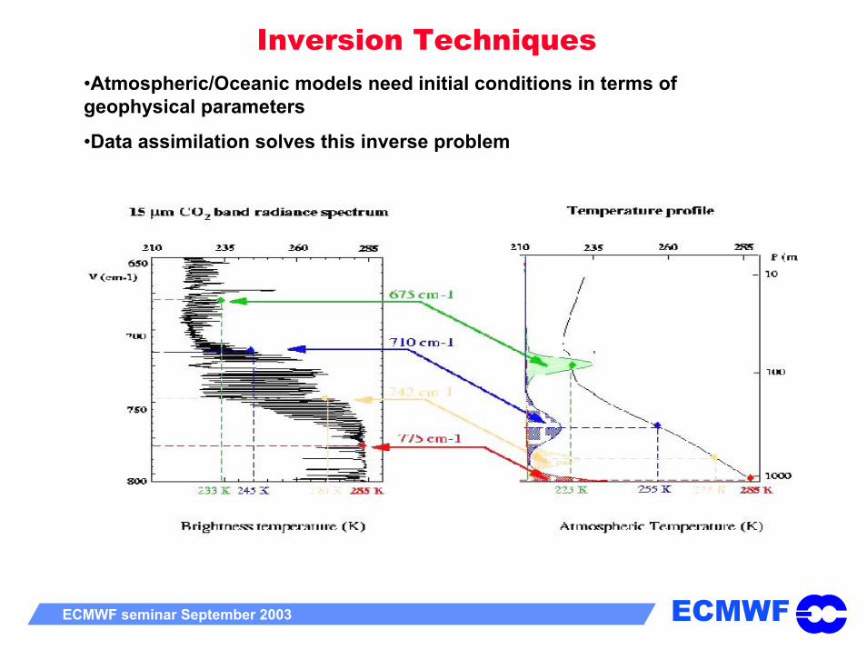
Inversion Techniques•Atmospheric/Oceanic models need initial conditions in terms of geophysical parameters
•Data assimilation solves this inverse problem
ECMWFECMWF seminar September 2003 3
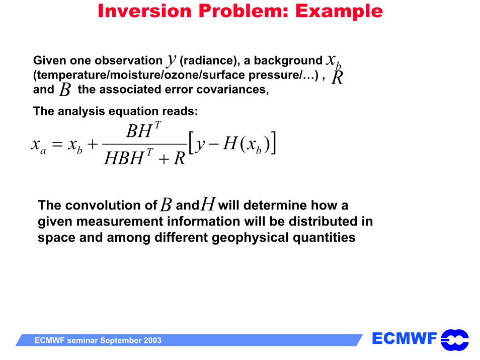
Inversion Problem: Example
[ ])( bT
T
ba xHyRHBH
BHxx −+
+=
Given one observation (radiance), a background (temperature/moisture/ozone/surface pressure/…) , and the associated error covariances,
The analysis equation reads:
y bxRB
The convolution of and will determine how a given measurement information will be distributed in space and among different geophysical quantities
B H

ECMWFECMWF seminar September 2003 3
Inversion Problem: ExampleStraight Dirac increment
If H=B=I
Increment propagated with ECMWF B
ECMWFECMWF seminar September 2003 3
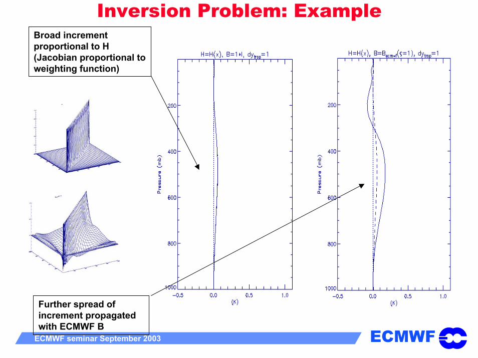
Inversion Problem: ExampleBroad increment proportional to H (Jacobian proportional to weighting function)
Further spread of increment propagated with ECMWF B
ECMWFECMWF seminar September 2003 3
Inversion problem: Importance of BB together with H will propagate the information coming from the satellite radiances that can sense very broad atmospheric layer. Modelling of B is therefore crucial for a proper assimilation of satellite radiances
Problem even more complicated when:radiance information has to be distributed in temperature and moisture
Problem even even more complicated when:Radiance information has to be distributed in temperature, moisture, ozone, CO2, cloud, rain,…
Problem even even even more complicated when:Radiance information has to be distributed in space and time

ECMWFECMWF seminar September 2003 3
Inversion Techniques
Data assimilation in some way or another converts radiance measurements in temperature/moiture/winds,…
Different possibilities
Use of externally generated retrievals
Use of interactive retrievals (e. g. 1D-Var retrievals)
Direct use of radiances (e.g. 3D-Var or 4D-Var)
In NWP at least, the direct assimilation of satellite raw radiances has progressively replaced the assimilation of retrievals

ECMWFECMWF seminar September 2003 3
Inversion TechniquesThe direct assimilation of radiances has several advantages over that of retrievals:
avoid the contamination by external background information for which error characteristics are poorly knownAvoid further complicated errors entailed by the processing of the data providerAvoid vulnerability to changes in the processing of the data providerAllow a faster implementation of new data (no delay due to readiness of pre-processing)3D and 4D-Var allow for some (weak) non linearities in the observation operator Increments further constrained by many other observations/information

ECMWFECMWF seminar September 2003 3
Inversion Techniques
Exceptions exist:
Atmospheric Motion Vectors from geostationary satellites
Poor ability to represent clouds in observation operatorsVery easy to implement in the system (e.g. MODIS polar winds)
Surface Winds from ScatterometersObservation operator highly nonlinearValidation easier with ancillary data
Ozone information from UV instrumentsPoor modelling of the Radiative Transfer in the UV
The approach has to be based on pragmatism
ECMWFECMWF seminar September 2003 3
Outline
Introduction to the Satellite Observing System
What do satellite instruments measure?
Importance of satellite data in current NWP data assimilation systems
Assimilation of satellite data: current issues
Future evolution and challenges
ECMWFECMWF seminar September 2003 3
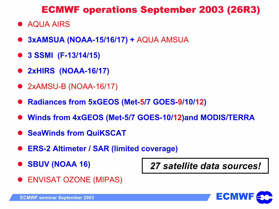
ECMWF operations September 2003 (26R3)AQUA AIRS
3xAMSUA (NOAA-15/16/17) + AQUA AMSUA
3 SSMI (F-13/14/15)
2xHIRS (NOAA-16/17)
2xAMSU-B (NOAA-16/17)
Radiances from 5xGEOS (Met-5/7 GOES-9/10/12)
Winds from 4xGEOS (Met-5/7 GOES-10/12)and MODIS/TERRA
SeaWinds from QuiKSCAT
ERS-2 Altimeter / SAR (limited coverage)
SBUV (NOAA 16)
ENVISAT OZONE (MIPAS)27 satellite data sources!
ECMWFECMWF seminar September 2003 3
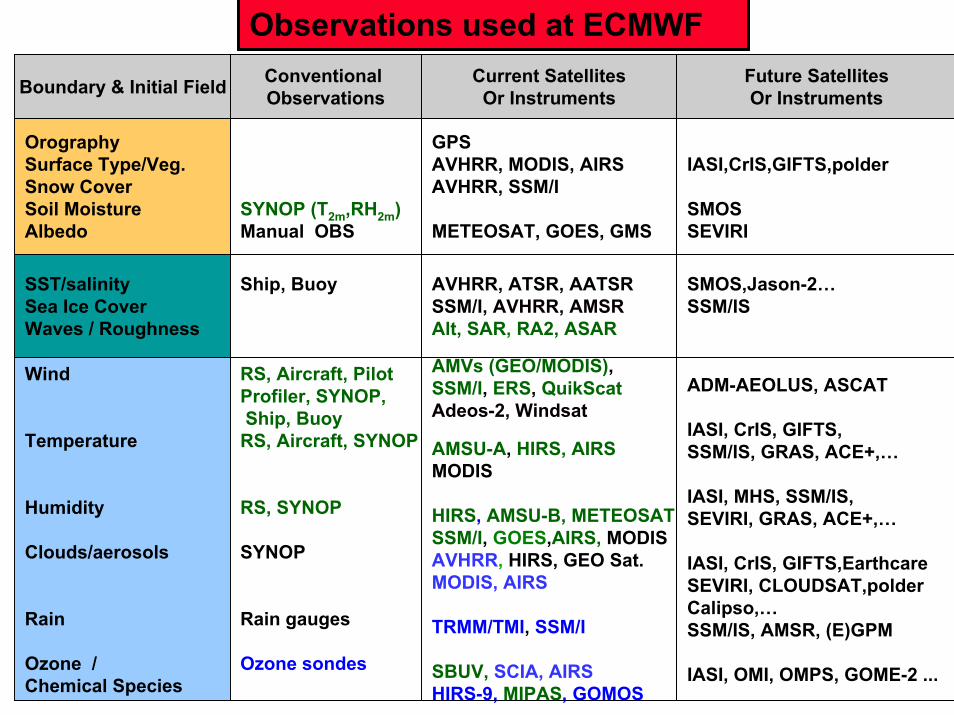
Boundary & Initial Field Conventional Observations
Current SatellitesOr Instruments
Observations used at ECMWFFuture SatellitesOr Instruments
OrographySurface Type/Veg.Snow CoverSoil MoistureAlbedo
SST/salinitySea Ice CoverWaves / Roughness
Wind
Temperature
Humidity
Clouds/aerosols
Rain
Ozone /Chemical Species
Ship, Buoy AVHRR, ATSR, AATSRSSM/I, AVHRR, AMSRAlt, SAR, RA2, ASAR
AMVs (GEO/MODIS),SSM/I, ERS, QuikScatAdeos-2, Windsat
AMSU-A, HIRS, AIRSMODIS
HIRS, AMSU-B, METEOSATSSM/I, GOES,AIRS, MODISAVHRR, HIRS, GEO Sat.MODIS, AIRS
TRMM/TMI, SSM/I
SBUV, SCIA, AIRSHIRS-9, MIPAS, GOMOS
GPSAVHRR, MODIS, AIRSAVHRR, SSM/I
METEOSAT, GOES, GMS
IASI,CrIS,GIFTS,polder
SMOSSEVIRI
SYNOP (T2m,RH2m)Manual OBS
SMOS,Jason-2…SSM/IS
RS, Aircraft, PilotProfiler, SYNOP,Ship, Buoy
RS, Aircraft, SYNOP
RS, SYNOP
SYNOP
Rain gauges
Ozone sondes
ADM-AEOLUS, ASCAT
IASI, CrIS, GIFTS,SSM/IS, GRAS, ACE+,…
IASI, MHS, SSM/IS,SEVIRI, GRAS, ACE+,…
IASI, CrIS, GIFTS,EarthcareSEVIRI, CLOUDSAT,polderCalipso,…SSM/IS, AMSR, (E)GPM
IASI, OMI, OMPS, GOME-2 ...

ECMWFECMWF seminar September 2003 3
Number of observational data used in the ECMWF assimilation system (prior AIRS)
0
0.2
0.4
0.6
0.8
1
1.2
1.4
1.6
1.8
1997 1998 1999 2000 2001 2002 2003
6h 3D6h 4D12h 4D25r4/26r1
millions
ECMWFECMWF seminar September 2003 3
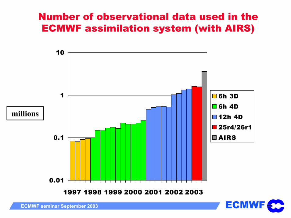
Number of observational data used in the ECMWF assimilation system (with AIRS)
0.01
0.1
1
10
1997 1998 1999 2000 2001 2002 2003
6h 3D6h 4D12h 4D25r4/26r1AIRS
millions
ECMWFECMWF seminar September 2003 3
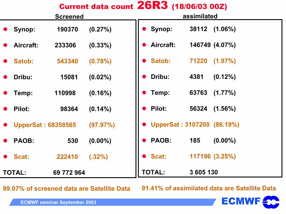
Current data count 26R3 (18/06/03 00Z)assimilatedScreened
Synop: 38112 (1.06%)
Aircraft: 146749 (4.07%)
Satob: 71220 (1.97%)
Dribu: 4381 (0.12%)
Temp: 63763 (1.77%)
Pilot: 56324 (1.56%)
UpperSat : 3107200 (86.19%)
PAOB: 185 (0.00%)
Scat: 117196 (3.25%)
TOTAL: 3 605 130
91.41% of assimilated data are Satellite Data
Synop: 190370 (0.27%)
Aircraft: 233306 (0.33%)
Satob: 543340 (0.78%)
Dribu: 15081 (0.02%)
Temp: 110998 (0.16%)
Pilot: 98364 (0.14%)
UpperSat : 68358565 (97.97%)
PAOB: 530 (0.00%)
Scat: 222410 (.32%)
TOTAL: 69 772 964
99.07% of screened data are Satellite Data
ECMWFECMWF seminar September 2003 3
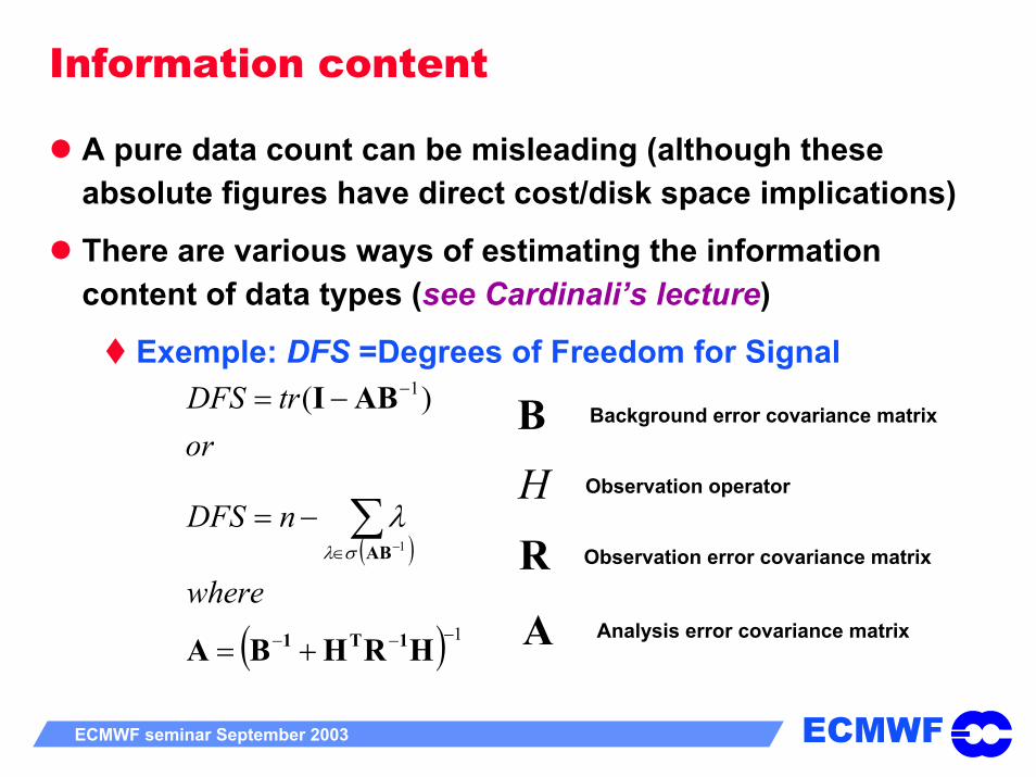
Information content
A pure data count can be misleading (although these absolute figures have direct cost/disk space implications)
There are various ways of estimating the information content of data types (see Cardinali’s lecture)
Exemple: DFS =Degrees of Freedom for Signal
( )
( ) 1
1
1
)(
−−−
∈
−
+=
−=
−=
∑−
HRHBA
ABI
1T1
AB
where
nDFS
ortrDFS
σλ
λ
B Background error covariance matrix
H Observation operator
R Observation error covariance matrix
A Analysis error covariance matrix
ECMWFECMWF seminar September 2003 3
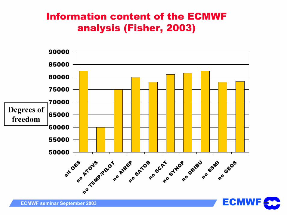
Information content of the ECMWF analysis (Fisher, 2003)
50000
55000
60000
65000
70000
75000
80000
85000
90000
all OBS
no ATOVS
no TEM
P/PIL
OTno
AIREP
no SATOB
no SCAT
no SYNOP
no DRIB
Uno
SSMI
no GEOS
Degrees of freedom
ECMWFECMWF seminar September 2003 3
Impact studies
Observing System Experiments (OSEs) are a very useful sanity check for both the data assimilation and the observing system (see Dumelow’s lecture)
A 120 case OSE has been undertaken at ECMWF (Kelly, 2003) to evaluate the quality of the different major Observing Systems

ECMWFECMWF seminar September 2003 3
120 days500 hPa Zscores
NH
SH
N. Hemisphere
S. Hemisphere

ECMWFECMWF seminar September 2003 3
nosat 12hr normalized error 200hPa Z
nosat 48hr normalized error 200hPa Z

ECMWFECMWF seminar September 2003 3

ECMWFECMWF seminar September 2003 3
Impact of 3 sounding (AMSU-A) instruments
NOAA-15 (07:30 am)
NOAA-16 (13:30 pm)
12Z
NOAA-17 (10:00 am) 06Z
• At any time, NOAA-17 covers large oceanic areas crucial for global NWP forecasts and insufficiently observed by the NOAA-15-16 baseline (e.g. Pacific Ocean at 06 and 12Z)
•A time/space uniform coverage can be fully exploited by the ECMWF 4D-VAR system
18Z
ECMWFECMWF seminar September 2003 3
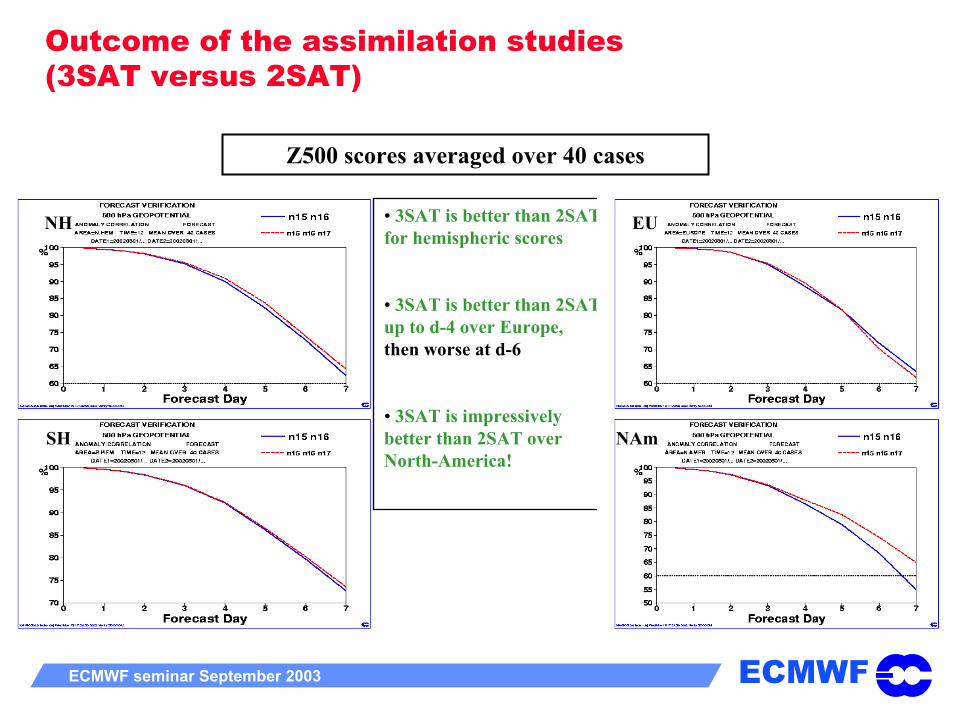
Outcome of the assimilation studies(3SAT versus 2SAT)
Z500 scores averaged over 40 cases
NH
SH
• 3SAT is better than 2SAT for hemispheric scores
• 3SAT is better than 2SAT up to d-4 over Europe, then worse at d-6
• 3SAT is impressively better than 2SAT over North-America!
EU
NAm
ECMWFECMWF seminar September 2003 3
Other (less spectacular?) examples of successful assimilation of satellite data
Assimilation of geostationary clear-sky water vapour radiances
Allow a global control of the Upper Tropospheric Humidity in the Tropics
Assimilation of ozone observations from MIPAS onboard ENVISAT
Allow a reasonable distribution of ozone in the ECMWF analysis

ECMWFECMWF seminar September 2003 3
Assimilation of Meteosat-7 clear-sky water vapour radiances
Impact of the data: Visible with passive HIRS-12 radiances (NOAA-15)
STDV (HIRS-12 – model first guess) STDV (HIRS-12 – model analysis)

ECMWFECMWF seminar September 2003 3
Polar WV winds from MODIS
Source: P. Menzel, 2003
ECMWFECMWF seminar September 2003 3
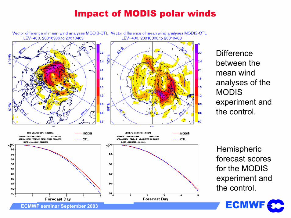
Impact of MODIS polar winds
Difference between the mean wind analyses of the MODIS experiment and the control.
Hemispheric forecast scores for the MODIS experiment and the control.
ECMWFECMWF seminar September 2003 3
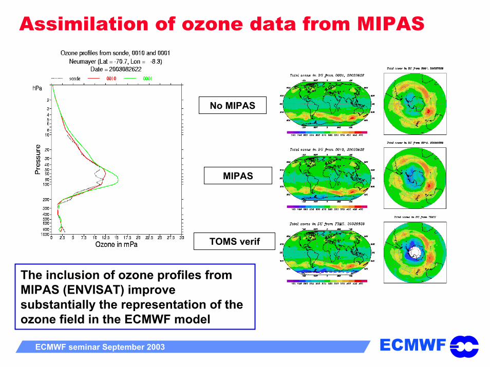
Assimilation of ozone data from MIPAS
No MIPAS
MIPAS
TOMS verif
The inclusion of ozone profiles from MIPAS (ENVISAT) improve substantially the representation of the ozone field in the ECMWF model

ECMWFECMWF seminar September 2003 3
Outline
Introduction to the Satellite Observing System
What do satellite instruments measure?
Importance of satellite data in current NWP data assimilation systems
Assimilation of satellite data: current issues
Future evolution and challenges

ECMWFECMWF seminar September 2003 3
Important issues for the assimilation of satellite radiances
Biases:
Systematic errors must be removed before the assimilation (bias correction)
Various sources of systematic errors:Instrument error (calibration)Radiative transfer errorCloud/rain detection errorBackground model error
Difficult to disentangle between various sources
Importance of MONITORING departures between model background (and analysis) and various observations (see Talagrand and Andersson’s lectures)

ECMWFECMWF seminar September 2003 3
Cross-validation between various instruments (1)
Comparing the model with independent instruments help identifying the source of the bias
HIRS channel 5 (peaking around 600hPa) on NOAA-14 satellite has+2.0K radiance bias against model
HIRS channel 5 (peaking around 600hPa) on NOAA-16 satellite has no radiance bias against model.
Instrument bias likely!

ECMWFECMWF seminar September 2003 3
Cross validation between various instruments
Analysis (+AIRS) minus OPS
MIPAS retrievals (65-90S)(20030217-20030222)minus OPS analysis
MIPAS retrievals (65-90N)(20030217-20030222)minus OPS analysis
Model bias likely!

ECMWFECMWF seminar September 2003 3
Important issues for the assimilation of satellite radiances
Quality control:
To reject data of “bad” quality
To reject data that cannot be simulated properly by the model (or the observation operator)
Clouds, rain, land surface emission,…Thinning:
Discrepancy between satellite resolution and background error covariance horizontal scales
Computational burden of processing high resolution data
Poor representation of observation error correlations

ECMWFECMWF seminar September 2003 3
Important issues for the assimilation of satellite radiances
Observational error characterization:
In principle much easier in radiance space
However,R should represent instrument, radiative transfer and representativeness error (inter channel correlations)
Radiative transfer forward modelling:
To assimilate channels affected by solar reflection
To assimilate radiances over land/ice
To simulate radiances in the UV domain
To properly account for trace gases, clouds, precipitation, aerosols,…

ECMWFECMWF seminar September 2003 3
Outline
Introduction to the Satellite Observing System
What do satellite instruments measure?
Importance of satellite data in current NWP data assimilation systems
Assimilation of satellite data: current issues
Future evolution and challenges
ECMWFECMWF seminar September 2003 3
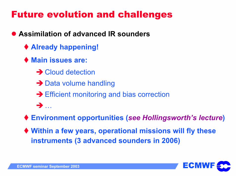
Future evolution and challenges
Assimilation of advanced IR sounders
Already happening!
Main issues are:Cloud detectionData volume handling Efficient monitoring and bias correction…
Environment opportunities (see Hollingsworth’s lecture)
Within a few years, operational missions will fly these instruments (3 advanced sounders in 2006)

ECMWFECMWF seminar September 2003 3
Higher Spectral Resolution from Advanced Sounders
•Higher vertical resolution and better accuracy
• a lot of data to handle
AIRS JacobiansHIRS Jacobians

ECMWFECMWF seminar September 2003 3
Better measure of improved resolution is provided by the averaging kernels
AIRS HIRS

ECMWFECMWF seminar September 2003 3
CLEAR CLOUDY
AIRS channel 145 clear data14.5micron
similar to HIRS channel 3 100hPa
AIRS channel 226 clear data13.5micron
similar to HIRS channel 5 600hPa
AIRS channel 787 clear data11 micron
similar to HIRS channel 8 window

ECMWFECMWF seminar September 2003 3
Data volume handling•Every AIRS FOV provides 2300 radiances
•A channel selection/data compression strategy has to be designed
•Day-1 approach using a frozen set of 300 channels performs reasonably well but SNR performance is lost
•Spectral compression using e.g. truncated EOF’s is a way to ease the data volume issue and optimally retain the original information in the data (to be tested)
ECMWFECMWF seminar September 2003 3
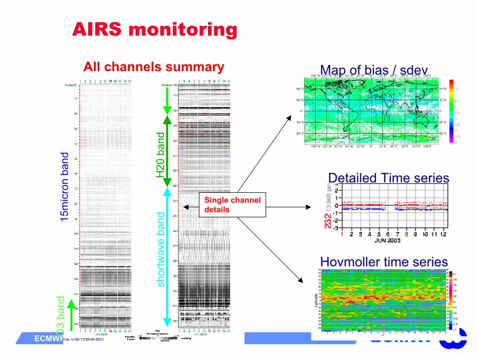
AIRS monitoring
Map of bias / sdev
Detailed Time series
Hovmoller time series
15m
icro
n ba
ndO
3 ba
nd
H20
ban
dsh
ortw
ave
band
Single channeldetails
All channels summary

ECMWFECMWF seminar September 2003 3
AIRS forecast impact
RMS of 500hPa geopotential forecast error averaged over 40 days (Dec 02/ Jan 03)
[AIRS error] minus [CTRL error]
Day-3
The assimilation of AIRS radiances shows a small but consistent positive impact on forecast quality in all areas
Day-5
Day-7

ECMWFECMWF seminar September 2003 3
Satellite Transition Schedulefrom POES era to NPOESS/EPS (source Hal Bloom)
----------------10 Year Mission Life-------------------
02
Loca
l Equ
ator
ial C
ross
ing
Tim
e
S/CDeliveries
FY 99 00 11 12 13 14 15 16 17 1803 08 09 1001 02 0704 05 06
MissionSatisfaction
1330POES
EOS-Aqua
NPOESSC2N’Earliest Need to back-up launch
N16
Earliest Availability
0530 DMSP
WindSat/Coriolis
0730 - 1030
NPOESSC3F20
NPOESSDMSPPOES
NPPEOS-Terra
METOPC1F16
17
F17 F19
F15 F18 C4
C5
C6
NPOESS
CY 99 00 01 03 04 05 06 07 08 09 10 11 12 13 14 15 16 17 18
S/C delivery interval driven by 15 month IAT scheduleAs of: 20 Oct 02 Most probable launch dateLaunch date based on backup need
ECMWFECMWF seminar September 2003 3
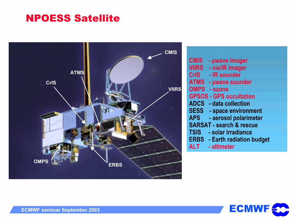
NPOESS Satellite
CMIS
VIIRSCrIS
ATMS
ERBSOMPS
CMIS - µwave imagerVIIRS - vis/IR imagerCrIS - IR sounderATMS - µwave sounder OMPS - ozoneGPSOS - GPS occultationADCS - data collectionSESS - space environmentAPS - aerosol polarimeterSARSAT - search & rescueTSIS - solar irradianceERBS - Earth radiation budgetALT - altimeter
NPOESS 1330 Configuration
ECMWFECMWF seminar September 2003 3
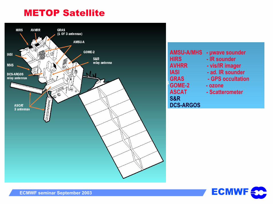
METOP Satellite
AMSU-A/MHS - µwave sounderHIRS - IR sounderAVHRR - vis/IR imagerIASI - ad. IR sounderGRAS - GPS occultationGOME-2 - ozoneASCAT - ScatterometerS&RDCS-ARGOS
VIIRSCrIS
ATMS
ERBSOMPS
NPOESS 1330 Configuration

ECMWFECMWF seminar September 2003 3
The Initial Joint Polar System
CMIS - µwave imagerVIIRS - vis/IR imagerCrIS - IR sounderATMS - µwave sounder
OMPS - ozoneGPSOS - GPS occultation
ADCS - data collectionSESS - space environmentAPS - aerosol polarimeterSARSAT - search & rescueTSIS - solar irradianceERBS - Earth radiation budgetALT - altimeter
AMSU-A/MHS - µwave sounderHIRS - IR sounderAVHRR - vis/IR imagerIASI - ad. IR sounderGRAS - GPS occultation
GOME-2 - ozoneASCAT - ScatterometerS&RDCS-ARGOS
METOPNPOESS

ECMWFECMWF seminar September 2003 3
Future evolution and challengesAssimilation of clouds and precipitation
Currently, the assimilation of satellite information concerns only 20% of the globe
The ability of atmospheric models to describe cloud and precipitation is continuously improving
A number of space missions are already up and major others will come (GPM)
Issues:Non smooth processes (see Janisková’s lecture)Representativeness errorsPredictability of the cloudy/rainy systemsRadiative transfer and background error modelling
ECMWFECMWF seminar September 2003 3
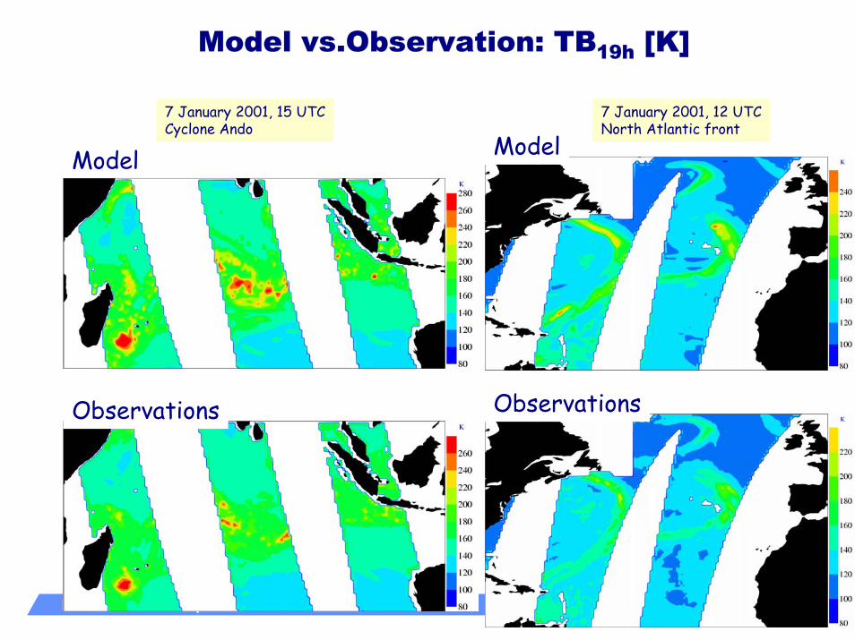
Model vs.Observation: TB19h [K]
Model7 January 2001, 12 UTCNorth Atlantic front
7 January 2001, 15 UTCCyclone Ando
Model
ObservationsObservations

ECMWFECMWF seminar September 2003 3
Exemple: 1D+4D-Var approach to assimilaterain information from satellites
TB’s
1D-Var
Rainfall retrieval algorithm
RT-modelCloud/Convection
MinimizerBG (T,q)
TCWV pseudo obs.
RT-modelMinimizer4D-VarBG, OBS

ECMWFECMWF seminar September 2003 3
1D-Var results
BackgroundPATER obs 1D-Var/RR
1D-Var/BT 1D-Var/BT TCWV incr. 1D-Var/RR TCWV incr.
Case of tropical cyclone ZOE (26 December 2002 @1200 UTC)
Surface rainfall rates (mm hr-1) and TCWV increments (kg m-2)
ECMWFECMWF seminar September 2003 3
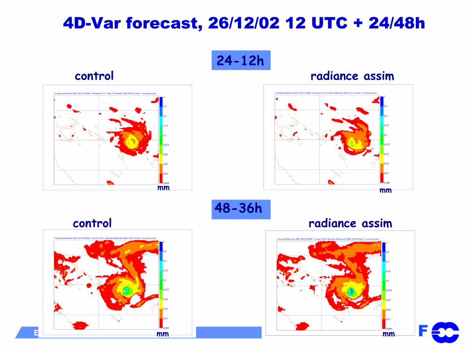
4D-Var forecast, 26/12/02 12 UTC + 24/48h
24-12hcontrol radiance assim
48-36hcontrol radiance assim
mm mm
mm mm

ECMWFECMWF seminar September 2003 3
GPM - Global Precipitation Mission
Core Satellite•Non-sun-synchronous orbit
~ 65° inclination~400 km altitude
•Dual frequency radarKu-Ka Bands (13.6-35 GHz)~ 4 km horizontal resolution~250 m vertical resolution
•Multifrequency radiometer 10.7, 19, 22, 37, 85, (150/183 ?) GHz V&H
Constellation of Satellites•Pre-existing operational-
experimental & dedicated satellites with PMW radiometers
•Revisit time3-hour goal at ~90% of time
•Sun-synch & non-sun- synch orbits600-900 km altitudes
ConstellationCore
Source: NASA

ECMWFECMWF seminar September 2003 3
Future evolution and challengesMore generally, ACTIVE TECHNOLOGIES (radars,lidars) will provide detailed vertical information on hydrometeors (Cloudsat, GPM, …), aerosols (EarthCare), wind (ADM-AEOLUS) that data assimilation schemes should exploit (maybe challenging for variational schemes)
Limb sounding (passive and active) techniques raise new challenges for data assimilation. These instruments will also contribute to improved temperature/moisture/ozone vertical resolution
Satellite data will increasingly be of interest for:
land data assimilation
Surface type, soil moisture,…: MSG, MODIS, AMSR, SMOS,…
Ocean data assimilation
SST, sea state, salinity, gravity, ocean colour..: Topex, Jason(2), ERS,SMOS, GRACE, GOCE, MERIS,…

ECMWFECMWF seminar September 2003 3
Concluding remarksSatellite data have been very succesfully exploited by new data assimilation schemes (DA schemes are such that introducing additional well characterised satellite data improves the system)
The combined availability of new accurate satellite observations and improvement of models will allow an improved extraction of information content from these new data (parallel upgrades of B and Y)
The proliferation of new satellite instruments makes it hard for end-users to keep up (choices will have to be done)
Massive investment in data handling and monitoring should be done (or pursued)
Short-loop dialogue between users and space agencies is vital!
ECMWFECMWF seminar September 2003 3
THE LIST OF ACRONYMS WILL BE
PROVIDED IN THE
PROCEEDINGS!