Embed Size (px)
Citation preview

Schuyler County Hazard Mitigation Plan
May 2008
Prepared with assistance from:
Janet Thigpen, Flood Mitigation Specialist Southern Tier Central Regional Planning and Development Board
8 Dennison Parkway East, Suite 310 Corning, NY 14830
This multijurisdictional plan encompasses the County of Schuyler in the State of New York and the following municipalities: Town of Catharine, Town of Cayuta, Town of Dix, Town of Hector, Town of Montour, Town of Orange, Town of Reading, Town of Tyrone, Village of Burdett, Village of Montour Falls, Village of Odessa, and Village of Watkins Glen Development of this plan was funded, in part, by a Pre-Disaster Mitigation program grant from the New York State Emergency Management Office and Federal Emergency Management Agency.
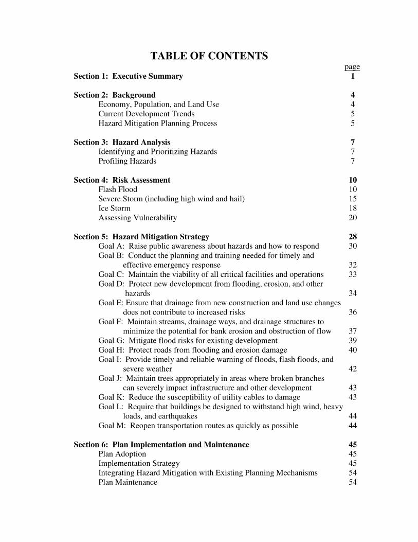
TABLE OF CONTENTS page
Section 1: Executive Summary 1 Section 2: Background 4
Economy, Population, and Land Use 4 Current Development Trends 5 Hazard Mitigation Planning Process 5
Section 3: Hazard Analysis 7
Identifying and Prioritizing Hazards 7 Profiling Hazards 7
Section 4: Risk Assessment 10
Flash Flood 10 Severe Storm (including high wind and hail) 15 Ice Storm 18 Assessing Vulnerability 20
Section 5: Hazard Mitigation Strategy 28
Goal A: Raise public awareness about hazards and how to respond 30 Goal B: Conduct the planning and training needed for timely and
effective emergency response 32 Goal C: Maintain the viability of all critical facilities and operations 33 Goal D: Protect new development from flooding, erosion, and other
hazards 34 Goal E: Ensure that drainage from new construction and land use changes
does not contribute to increased risks 36 Goal F: Maintain streams, drainage ways, and drainage structures to
minimize the potential for bank erosion and obstruction of flow 37 Goal G: Mitigate flood risks for existing development 39 Goal H: Protect roads from flooding and erosion damage 40 Goal I: Provide timely and reliable warning of floods, flash floods, and
severe weather 42 Goal J: Maintain trees appropriately in areas where broken branches
can severely impact infrastructure and other development 43 Goal K: Reduce the susceptibility of utility cables to damage 43 Goal L: Require that buildings be designed to withstand high wind, heavy
loads, and earthquakes 44 Goal M: Reopen transportation routes as quickly as possible 44
Section 6: Plan Implementation and Maintenance 45 Plan Adoption 45 Implementation Strategy 45 Integrating Hazard Mitigation with Existing Planning Mechanisms 54 Plan Maintenance 54

page Attachment A: Data and Maps 56 Attachment B: The Planning Process 74
Flood Mitigation Planning 74 Hazard Mitigation Planning 75 Municipal Involvement 76 Public and Stakeholder Involvement 77 Coordination With Relevant Agencies 78 Review of Plans, Reports, and Studies 79
Attachment C: Hazard Profiles 80
HAZNY Analysis 80 Additional Hazard Analysis 81 Flash Flood 81 Severe Storm (including high wind and hail) 82 Ice Storm 83 Terrorism 83 Hazardous Material Released in Transit 84 Epidemic 84 Water Supply Contamination 85 Tornado 86 Flood 87 Dam Failure 87 Drought 88 Utility Failure 89 Landslide 89 Severe Winter Storm 90 Ice Jam 91 Extreme Temperatures 92 Hurricane 92 Wildfire 93 Earthquake 93 Hazardous Material Released from a Fixed Site 94 Blight 95 Hazards Not Relevant to Schuyler County 95
Attachment D: Evaluation of Hazard Mitigation Options 98
The Process for Identifying Priority Mitigation Actions 98 Flood Mitigation Alternatives 99 Hazard Mitigation Alternatives 106
Attachment E: Adoption Resolutions 111

TABLES page
Table 1-1. Schuyler County Hazards 2 Table 3-1. HAZNY Ratings for Schuyler County 8 Table 4-1. Flash Flood Risks for Each Municipality 14 Table 4-2. Vulnerability of Assets to Priority Hazards 21 Table 4-3. Key Assets Located Within Each Municipality 22 Table 4-4. Schuyler County Assets 23 Table 5-1. Schuyler County Hazard Mitigation Goals 28 Table 5-2. Schuyler County Hazards 29 Table 6-1. Implementation Responsibilities 46 Table A-1. Hazard Events and Federal Disaster Declarations 63 Table A-2. National Flood Insurance Information 64 Table A-3. Assets and Land Use 65 Table A-4. Property with the Highest Assessed Building/Facility Value 68 Table A-5. Critical Facilities 69 Table A-6. Schuyler County Population 72 Table A-7. Facilities with Increased Vulnerability 72 Table A-8. Land Use 73 Table A-9. Distribution of Mobile Homes 73 Table D-1. NYS Hazard Mitigation Project Recommendations 107
FIGURES AND MAPS page
Figure 3-1. Chart of HAZNY Ratings for Schuyler County 8 Map 1: New York State County Boundaries 57 Map 2: Political Boundaries 58 Map 3: Highways and Roads 59 Map 4: Natural Resources 2004 60 Map 5: Agricultural Districts 2004 61 Map 6: Property Class Assessment & Land Use 2004 62

Approved by FEMA May 2008
1
Section 1: Executive Summary The Schuyler County Hazard Mitigation Plan was developed with the overall objective of protecting life and property from natural hazards. Although natural hazards cannot be prevented, steps can be taken to reduce a community’s vulnerability to severe conditions, and thereby reduce the damaging consequences. This plan is not a manual of what to do if a disaster occurs. Instead, it concentrates on actions that can be implemented prior to disaster events in order to reduce the damage to property and potential loss of life. It was developed cooperatively by the county and its municipalities to serve as a road map for future mitigation efforts in Schuyler County. The scope of the Schuyler County Hazard Mitigation Plan is countywide, encompassing the county’s 12 municipalities. It builds on the Flood Mitigation Action Plan, Schuyler County, which was developed in 1998-99. The Hazard Mitigation Plan includes an assessment of the County’s risks and vulnerabilities, a strategy for minimizing those risks, and an action plan that will be implemented to achieve the objectives. This plan is intended to fulfill the planning requirements for state and federal assistance programs. When it has been formally adopted (by each local governing body), this plan will enable the County, Towns, and Villages to apply for hazard mitigation grants that will assist with implementation of the proposed projects identified in this plan. Schuyler County has historically experienced damages from a wide range of natural and manmade hazards. The recommendations in the Schuyler County Hazard Mitigation Plan are based on an assessment of the County’s vulnerability to each of 21 hazards. An analysis of the frequency and potential severity of these events enabled development of priority ranking as indicated in Table 1-1. The three highest priority natural hazards in Schuyler County are:
• Flash flooding
• Severe storm (including high wind and hail)
• Ice storm A review of historic hazard incidents and an assessment of the county’s vulnerabilities enabled development of a hazard mitigation strategy. This strategy presents recommended actions that will reduce the county’s vulnerability to natural hazards. Priority was given to those actions that mitigate multiple hazards, flash flooding, severe storms, and ice storms. The Schuyler County
Hazard Mitigation Plan presents the following long-term goals and identifies specific actions as the immediate steps required toward achieving these goals.

Approved by FEMA May 2008
2
Table 1-1. Schuyler County Hazards (in order of priority)
High Priority Hazards
Flash Flood
Moderately High Priority Hazards
Severe Storm Ice Storm Terrorism Hazardous Material Released in Transit
Moderately Low Priority Hazards Epidemic Water Supply Contamination Tornado Flood Dam Failure Drought Utility Failure Landslide Severe Winter Storm Ice Jam Extreme Temperatures Hurricane Wildfire Earthquake
Low Priority Hazards Hazardous Material Released from a Fixed Site Blight
Goal A: Raise public awareness about hazards and how to respond. Goal B: Conduct the planning and training needed for timely and effective emergency response. Goal C: Maintain the viability of all critical facilities and operations. Goal D: Protect new development from flooding, erosion, and other hazards. Goal E: Ensure that drainage from new construction and land use changes does not contribute to
increased risks. Goal F: Maintain streams, drainage ways, and drainage structures to minimize the potential for
bank erosion and obstruction of flow.

Approved by FEMA May 2008
3
Goal G: Mitigate flood risks for existing development. Goal H: Protect roads from flooding and erosion damage. Goal I: Provide timely and reliable warning of floods, flash floods, and severe weather. Goal J: Maintain trees appropriately in areas where broken branches can severely impact
infrastructure and other development. Goal K: Reduce the susceptibility of utility cables to damage. Goal L: Require that buildings be designed to withstand high wind, heavy loads, and
earthquakes. Goal M: Reopen transportation routes as quickly as possible.

Approved by FEMA May 2008
4
Section 2: Background Schuyler County is a small rural county located in the heart of New York’s Finger Lakes Region (see Map 1, in Attachment A). Schuyler County’s hills, gorges, and marshes comprise the headwaters of Seneca Lake, the largest and deepest Finger Lake, which bisects the county. The County is comprised of eight towns and four villages (Map 2, in Attachment A). It is one of New York’s smallest counties (330 square miles), with one of the lowest populations (19,224 in 2000). The most ‘urban’ areas of the County are the Villages of Watkins Glen and Montour Falls, which are situated in the Seneca inlet valley at either end of the 1.5 square-mile, state-protected Queen Catharine Marsh. This plan documents the approach that the county and twelve municipal governments intend to take to mitigate the adverse impacts of natural hazards. It is not a manual of what to do if a disaster occurs. Instead, it concentrates on actions that can be implemented prior to disaster events in order to reduce the damage to property and potential loss of life. The plan includes an assessment of the county’s risks and vulnerabilities and a strategy for minimizing those risks (goals and actions). Economy, Population, and Land Use Schuyler County is small, sparsely populated, and economically challenged. Tourism is the number one growth industry, attracting two million visitors each year to the county’s lakes, wineries, Watkins Glen State Park, Watkins Glen International Raceway, and other attractions. Agriculture is the most visible business sector in the county, with almost 400 farms and approximately 50,000 acres of highly productive farmland. The county’s winery industry has increased in recent years, with increased vineyard potential along Seneca Lake. The county also has several well-established industries. During the last half of the 20th century, Schuyler County’s population grew slowly, but steadily, rising 28% from 1960 to 2000. From 1990 to 2000, the overall growth rate was 3%, with an 8% increase in housing units. A large number of these houses are seasonal and recreational structures (lakeshore cottages, hunting lodges, etc.), which constitute 14% of all housing units. (Source: US Decennial Census Population and Housing.) This growth has been accompanied by “sprawl” development, with a steady increase in residential lot and house sizes and a rise in second homes. Schuyler County covers approximately 219,000 acres. The land uses break down as follows: 64.6% forested lands, 29.4% agricultural uses, 4.3% open water, 0.8% residential use, 0.6% wetlands, and 0.2% industrial/commercial uses (including gravel mining). Commercial development is concentrated along the Route 14/414 corridor, centered on the Villages of Watkins Glen and Montour Falls. Outlying areas have agribusiness, soft retail and business service operations or residential use. The county is promoting an expansion of economic development beyond these traditional patterns. The core of the Schuyler County Empire Zone is located in the Town of Tyrone. And the county’s first business park is located in the Town of

Approved by FEMA May 2008
5
Dix. Municipal water and sewer service has been extended into the Town of Dix (to the business park and the raceway) and is expected to spur additional development in that area. (Source: Schuyler County Comprehensive Plan 2004.) New York is a home-rule state, so local governments create and administer land use legislation. Almost all Schuyler County municipalities have made use of home-rule authority in some manner. Most have ordinances regarding unsafe buildings, trailer camps, or junkyards. However, fewer than half have land use planning and controls such as zoning, subdivision regulations and site-plan review. Five municipalities have adopted zoning ordinances (V. Watkins Glen, V. Odessa, V. Montour Falls, T. Catharine, and T. Montour) and one is currently reviewing a draft zoning ordinance (T. Dix). Two towns have land-use laws based on the power of site-plan review (T. Reading and T. Tyrone). Five towns are covered by recently completed comprehensive plans (T. Dix, T. Hector, and a three-town plan for Reading, Orange and Tyrone). (Source: Schuyler County Comprehensive Plan 2004.) Current Development Trends It is unlikely that significant population growth or major new development will occur in Schuyler County in the foreseeable future. The County Population Projection by the New York Statistical Information System suggests that the slow population growth of past years may be reversed, with small population losses projected for 2010 and 2015. Even without population growth, 2nd home construction and smaller household size may contribute to some additional sprawl development. Ongoing efforts to attract business and industrial development are focused on the Schuyler County Empire Zone areas (located in the Towns of Tyrone, Reading, and Dix and Villages of Watkins Glen and Montour Falls) and the Schuyler County Business Park in the Town of Dix. The Villages of Montour Falls and Watkins Glen are promoting retail development within existing business districts, particularly those located off of the state highways. A new hotel and conference center is planned near Seneca Lake in Watkins Glen. Because Schuyler County’s economy relies heavily on tourism and agriculture, numerous efforts are underway to preserve the county’s scenic rural character and productive agricultural sector. The county has enacted a Farmland Protection Plan and a number of farmland protection initiatives are underway. It is anticipated that these efforts will limit the conversion of productive forest and farmland for residential or other development. Hazard Mitigation Planning Process The Schuyler County Hazard Mitigation Plan was developed as part of an ongoing hazard mitigation planning process in the county. In 1998, a Flood Mitigation Planning Committee was formed to prepare a Flood Mitigation Action Plan (finalized in October 1999). In 2003, the county initiated an effort to update the flood plan and expand it to incorporate other natural hazards. A Hazard Mitigation Committee was formed, with members representing each municipality, county agencies, citizen groups, and other organizations. Attachment B describes the process by which this plan was developed and the roles of various participants (municipal

Approved by FEMA May 2008
6
governments, county departments, regional/state/federal agencies, the private sector, and county residents). The process of developing this plan enabled the county and each municipality to identify policies, programs, and projects that will reduce the potential losses from future disasters. The Schuyler County Hazard Mitigation Plan is an active document that will be periodically reviewed, updated, and revised. The goals and actions developed by the Hazard Mitigation Committee are guides for future policy formation and program creation. It is recognized that other means may be found to achieve the desired mitigation results. The adoption of this Hazard Mitigation Plan in no way commits the county or municipal governments to implementing every suggested strategy or to approaching opportunities and problems with only the solutions suggested here.

Approved by FEMA May 2008
7
Section 3: Hazard Analysis In order to prepare for and mitigate the consequences of hazardous events, it is necessary to understand the local vulnerability. Vulnerability is based on the natural and man-made factors that determine the probability of an event occurring and community factors that contribute to the severity of the impacts. Identifying and Prioritizing Hazards A quantitative risk assessment for Schuyler County was conducted using the New York State Emergency Management Office (SEMO) HAZNY program. HAZNY is an automated interactive spreadsheet that enables a group of local experts to rank hazards based on a series of questions about the scope (area of impact and potential for a cascade effect), frequency, impact, onset (warning time), and duration of each hazard considered. A hazard profile is developed for each hazard that takes into account local knowledge and documentation of: historic occurrences, probability, magnitude, location, extent, vulnerability, and other local factors. The HAZNY analysis for Schuyler County was conducted by a group of local officials and other experts on January 12, 2005. This analysis was organized and facilitated by the Schuyler County Office of Emergency Management and the NY State Emergency Management Office. Participants selected the hazards applicable to Schuyler County from a comprehensive list of natural, technological, and human caused hazards impacting New York State. They chose to split flooding into two hazards: Flash Flood and Flood. In addition, Oil Spill and Radiological Release in Transit were included in the analysis for Hazardous Material Released in Transit. The HAZNY program was used as a discussion and analysis tool to assess each of 21 hazards. The numerical ranking of the hazards evaluated is provided in Table 3-1 and Figure 3-1. Profiling Hazards Using the results of the HAZNY analysis as a starting point, the Hazard Mitigation Committee conducted additional research to evaluate and profile each of the 21 hazards. These hazard profiles are presented in Attachment C. A list of the hazards not applicable to Schuyler County (and hence not evaluated) is also provided. Based on the HAZNY analysis and the hazard profiles, the Hazard Mitigation Committee chose to conduct a more detailed analysis of the three highest priority natural hazards:
� Flash flood � Severe storm (including high wind and hail) � Ice storm

Approved by FEMA May 2008
8
Table 3-1. HAZNY Ratings for Schuyler County (higher rating numbers denote greater risk)
Hazard Rating Flash Flood 333
Severe Storm 295
Ice Storm 279
Terrorism 279
Hazardous Material Released in Transit 276
Epidemic 240
Water Supply Contamination 231
Tornado 224
Flood 217
Dam Failure 216
Drought 212
Utility Failure 209
Landslide 208
Severe Winter Storm 207
Ice Jam 199
Extreme Temperatures 196
Hurricane 193
Wildfire 173
Earthquake 172
Hazardous Material Released from a Fixed Site 158
Blight 153
Figure 3-1. Chart of HAZNY Ratings for Schuyler County

Approved by FEMA May 2008
9
Each of the three high priority hazards received a high or moderately high HAZNY ranking due to the frequency of occurrence and/or the severity of potential impacts in Schuyler County. Although the county can be affected by other hazards, the Hazard Mitigation Committee concluded that the potential impacts, and hence the appropriate mitigation measures, for the lower ranked hazards are often similar to those from the high priority hazards. For example, the potential impacts of a tornado are similar to those of a severe storm with high winds. Because the historical record only includes 4 tornado events in Schuyler County, it was given a lower priority than severe storm, which occurs more than once a year. However, mitigation actions that reduce the damage from severe storms will also mitigate the damage from a tornado. Likewise, mitigation actions for ice storms are similar to those for heavy snowfall events (severe winter storm), which received a lower ranking because the potential impacts are less severe. A more detailed assessment of the risks associated with the three high priority hazards (flash flood, severe storm, and ice storm) is presented in Section 4. The hazard mitigation strategy in Section 5 includes measures recommended to mitigate the impacts of all hazardous incidents, with priority given to the high priority natural hazards.

Approved by FEMA May 2008
10
Section 4: Risk Assessment Schuyler County is susceptible to numerous hazards, as indicated by the hazard profiles in Attachment C. Table A-1 (in Attachment A) lists those events for which Schuyler County was included in federal disaster declaration and other significant events documented by the NY State Emergency Management Office. The majority of these major disasters involved flooding, which is the highest priority hazard for Schuyler County. The following assessment provides information about past events and future risks for the county’s three highest ranked natural hazards: flash flood, severe storm, and ice storm. This is followed by an assessment of the assets that are vulnerable to these hazards. Flash Flood Flash floods are characterized by a rapid rise in water level, high velocity, and large amounts of debris. They are capable of tearing out trees, undermining buildings, and scouring new channels. Major factors causing flash flooding are the intensity and duration of rainfall, the steepness of the watershed, and stream gradients. The soil types, watershed vegetation, natural and artificial flood storage areas, and the configuration of the streambed and floodplain are also important. The soils and topography of Schuyler County make it very susceptible to flash flooding. When thunderstorms, tropical storm systems, or other weather patterns produce intense rainfall or rapid snowmelt, water rushes down the hillsides into drainage ditches and streams. Streams respond quickly and may overflow onto their floodplains with little or no warning. Flash flood damages result from both inundation by floodwater and erosion of drainage ways and stream channels. All of Schuyler County’s streams have relatively small watersheds, which respond rapidly to heavy rainfall events. As a result flood conditions develop rapidly, with little warning and are classified as flash flooding. Flooding of the county’s lakes, particularly Seneca Lake, develops more slowly, occurs less frequently, and is not included in this discussion of flash flooding. Erosion of streambanks and drainage ways during flash flooding is a major concern. The severity of erosion problems is due, in part, to the widespread occurrence of poorly consolidated glacial deposits, which are particularly susceptible to erosive forces. The high gradients of streams flowing down steep slopes provide the energy needed for erosion and transport of bank materials. In addition, disturbance of natural stream channels and floodplains can lead to adjustments within the stream system that cause increased erosion and/or deposition. Examples of such disturbances are: channel straightening, dredging, bridge/culvert installation, berms along a stream (which limit flow onto the floodplain), removal of stabilizing vegetation along a stream, and filling of floodplains. In addition, land use changes in the watershed can alter the delivery of water and sediment to the stream and thus contribute to imbalances in the stream system. Stream adjustments and the resulting erosion, whether natural or human-caused, are often accelerated during flood events.

Approved by FEMA May 2008
11
Past Occurrences The most severe flooding in Schuyler County occurred during the “Finger Lakes Flood” in July 1935 and the Tropical Storm Agnes Flood in June 1972:
• July 1935, Finger Lakes Flood: A complex of thunderstorms produced flash flooding that washed out numerous roads and bridges. Debris lodged on a railroad trestle in Glen Creek and then broke loose, sending a wall of water through the Village of Watkins Glen. Homes and businesses were destroyed and extensive mud deposits were left in houses and other buildings in the Villages of Watkins Glen and Montour Falls.
• June 1972, Tropical Storm Agnes: The inland remnants of Hurricane Agnes dropped 12 to 18 inches of rain in a three day period across the mid-Atlantic states. The resulting flood caused an estimated $7.2 million in damages in Schuyler County.
The NOAA National Climatic Data Center (NCDC) database lists 12 flood events that impacted Schuyler County in the 13 years of data from 1993 through 2005. Three of these events (January 1996, November 1996, and August 2003) were federally declared disasters. Brief descriptions follow. (Sources: NOAA National Climatic Data Center, Storm Event Database: http://www4.ncdc.noaa.gov/cgi-win/wwcgi.dll?wwevent~storms; local reports)
• February 20, 1994 – A few days of mild temperatures melted the snow pack and caused ice on area creeks and streams to break up. Ice jams formed and some flooding resulted. Estimated property damage: $50,000 over a 4-county area.
• June 13, 1994 – Flash flood. Estimated property damage: $5,000.
• August 18, 1994 – Flash flood. Estimated property damage: $500,000.
• November 12, 1995 – Heavy rain resulted in some localized flooding in Schuyler County and surrounding areas.
• January 19-20, 1996 – Heavy rain melted a deep snow pack (over 3 feet in spots) and produced widespread flash flooding. Flooding and erosion damage to buildings and infrastructure were extensive. Estimated property damage: $1.5 million.
• November 8-9, 1996 – Heavy rain caused countywide flash flooding. Catharine Creek caused considerable damage (particularly in the Town of Montour), due to repeated formation of tree jams, which backed up water, and then ruptured, releasing torrents of water and debris. The Montour Falls sewage treatment plant was flooded. Estimated property damage: $600,000.
• June 13, 1998 – A very slow moving thunderstorm dumped torrential rains across central and eastern sections of the county. Several roads were closed due to high water conditions, including County Route 5 and State Route 414 in the Town of Hector.
• May 10, 2000 – Pine Creek flooded CR 22 in the Town of Orange.
• July 22, 2003 – Nearly stationary thunderstorms dumped between 2 and 3 inches of rain in less than 3 hours across the southern half of Schuyler County. Two-day rainfall totals were 3 and 6 inches. The heaviest rain fell across Monterey, Townsend, Montour Falls, Beaver Dams, Watkins Glen, and Odessa. The heavy rain caused flash flooding that closed many roads, and created several mudslides. In the Town of Dix, just west of Watkins Glen International Speedway, a bridge was washed out on County Route 16. Estimated property damage: $3 million.
• April 2-3, 2005, Beaver Dams – A slow moving storm from the Ohio Valley brought 1 to 4 inches of rain over two days. Before this storm, streams had high flows due to a previous

Approved by FEMA May 2008
12
rainstorm and snowmelt. There were some road closures and flooded basements. A few streams and creeks came out of their banks. Estimated property damage: $50,000.
• June 10, 2005, Monterey – Slow moving thunderstorms with heavy rain caused flash flooding. Several roads were closed. A mobile home was knocked off its foundation from flowing water. Emergency personnel conducted one swift water rescue. One bridge was destroyed and another bridge damaged. Estimated property damage $50,000.
• November 29-30, 2005 – 1 to 3 inches of rain caused urban and minor flooding. Route 14 just north of Watkins Glen was closed when water lifted part of the road surface. Several homes in Watkins Glen, Burdett, and Reading Center had water pumped out of their basements.
In addition to these flood events, additional heavy rainfall events have caused localized drainage problems, ponding, streambank erosion, roadway damage, and other difficulties. Probability of Future Events Flooding can be caused by excessive precipitation, rapid snowmelt, ice jams, beaver dams, or dam failure. Urban or street flooding can result from heavy precipitation, clogged storm sewers, or a ruptured water main. Flooding can occur at any time of year. Based on historic flash flood events, Schuyler County is likely to continue experiencing flash flooding an average of about once a year. National Flood Insurance Data All Schuyler County municipalities participate in the National Flood Insurance Program. Information about National Flood Insurance Policies and claims is provided in Table A-2 (in Attachment A). Of the 61 policies in effect in 2003, 30 were in the mapped 100-year floodplain (Zone A). 47 claims had been filed since 1978, totaling $202,014. No properties in Schuyler County are classified by the National Flood Insurance Program as “repetitive loss properties” (indicating that none have experienced two or more flood insurance claims within any ten year period since 1978). These flood insurance statistics represent only a small fraction of the properties that are at risk of flash flooding. Many property owners do not carry flood insurance and many damages (particularly to basements and basement contents) are not covered. Potential Impact – Location Flood hazard areas are identified on Flood Insurance Rate Maps (FIRMs) for all Schuyler County municipalities except the Town of Reading (for which no hazard areas were identified, despite obvious risks along the shoreline of Seneca Lake). These maps are on file in each municipality and in county offices (Emergency Management Office, Soil and Water Conservation District, and Planning Department). The floodplain areas delineated on the FIRMs do not represent all of the areas threatened by flooding in Schuyler County. Most of the designated floodplains were delineated using approximate methods and are thus subject to inaccuracies. The detailed hydraulic analyses that were conducted for streams in Watkins Glen and Montour Fall were based on the assumption of unobstructed flow and are thus considered valid only if all channels and drainage structures remain unobstructed, operate properly, and do not fail. If these conditions do not exist, the impact of 100-year flooding could be greater. In addition, the potential for flooding from the

Approved by FEMA May 2008
13
numerous smaller streams in the county was not evaluated when the Flood Insurance Rate Maps were prepared. Yet these streams have floodplains and pose flood hazards. Because there is no floodplain designated on the FIRMs, development along these streams is not regulated by the local laws for flood damage prevention. Yet development in these areas is at risk from both flooding and streambank erosion. The Flood Mitigation Action Plan, Schuyler County (October 1999) includes maps and descriptions of areas with previous or anticipated flooding and erosion problems. Based on this information it is estimated that about 240 to 250 buildings are located in the 100-year floodplains in Schuyler County. Most of these are lakeshore houses, which are subject to flooding, but not flash flooding. Approximately 50-60 houses and a couple of businesses are located in floodplains along streams prone to flash flooding. Approximately 50 additional homes and 5 businesses were reported to have experienced flooding problems in recent years. In addition to building damage, there are numerous locations throughout the county where roads have been damaged, bridges have been destroyed, property has been eroded, and buildings threatened by either flooding or erosion. The property that is at risk from flash flooding is much greater than indicated by the above figures. Although past flood events can provide an indication of what to expect, the locations of damage differ depending on the characteristics of each individual storm event, the locations of debris accumulation, and current land use patterns. For example, flood damages have repeatedly occurred downhill of timber harvesting operations, where removal of tree cover, construction of roads and skid trails, and/or disruption of stream channels has altered the local hydrology. Likewise, development activities can increase the risk of flash flooding due to the hydrologic changes associated with removal of natural vegetation, grading (which generally increases the rate of runoff), addition of impervious surfaces (which results in more runoff), and other changes to local drainage pattern. The areas at risk from flash flooding are not limited to floodplains threatened by streams. Significant damages can also occur by rushing water finding its way into streams. Roads are particularly susceptible to erosion damage due to the altered drainage patterns. During flash flood events, buildings located far from the floodplain can be damaged by overland flow. For example, houses in the North Falls Road area in the Town Hector are located above the 100-year floodplain for Seneca Lake, but have been repeatedly damaged by water draining down the steep slope into the lake. Flood damage also occurs when water backs up at storm drains and culverts, either because the capacity of the structure is insufficient or because it is blocked by flood debris. Lakeshore areas are a particular concern due to the steep slopes, shallow soils, and dense development of lakeside cottages, which constrain drainage in many areas. In some locations this is compounded by poor design or inadequate maintenance of access roads, many of which are privately owned. Poor drainage in these areas can contribute to erosion of yards and driveways, flooding of homes, and road damage. The shores of the County’s four major lakes are densely developed: Seneca Lake (Towns of Reading and Hector, Village of Watkins Glen), Waneta Lake (Town of Tyrone), Lamoka Lake (Towns of Orange and Tyrone), and Cayuta Lake (Town of Catharine).

Approved by FEMA May 2008
14
An additional area of concern is Glen Creek within the Village of Watkins Glen. The concrete walls along both banks of Glen Creek (from Franklin Street to Decatur Street) are in poor condition and have been damaged in places. If a section of wall collapses, it could block flow within Glen Creek and cause flooding of an extensive area of residential and commercial development. The Village is seeking funding to repair these walls. The conditions contributing to flash flood risks in each municipality are summarized in Table 4-1. Given the range of localized conditions that can increase susceptibility to flash flooding, it is not possible to delineate, with any level of certainty, the areas within Schuyler County that are at risk from flash flooding. The risks are highest for development located near streams, bridges, ditches, storm drains, and other drainage structures. These risks are increased for streams and drainage structures that are unstable or are not adequately maintained. In addition, indirect damages result from washed out roads/driveways, damaged power lines, and water supply/sewer problems. The flooding, erosion, and infrastructure damages that result from flash floods are, therefore, a countywide concern.
Table 4-1 Flash Flood Risks for Each Municipality
Potential Impact – Severity Flooding is the number one weather related killer, causing an average of three to four deaths per year in New York. Approximately half of those deaths involve people trapped in cars. Although Schuyler County has no history of flood deaths, it does have conditions similar to those in which tragedies have occurred. Bridge damage and washed out roadways can result in cars being swept
Municipality
Reg
ula
ted
flo
od
pla
in (
FIR
M)
Develo
pm
en
t w
ith
in
reg
ula
ted
flo
od
pla
in
Mari
nas
Str
eam
s p
ron
e t
o
flash
flo
od
ing
Str
eam
s p
ron
e t
o
ban
k e
rosio
n
Lakesh
ore
flo
od
ing
/ la
ke s
ide d
rain
ag
e
Ro
ad
sid
e d
rain
ag
e /
sto
rm d
rain
s
Town of Catharine X X X X X X
Town of Cayuta X X X X X
Town of Dix X X X X X
Town of Hector X X X X X X
Town of Montour X X X X X
Town of Orange X X X X X X
Town of Reading X X X X
Town of Tyrone X X X X X X
Village of Burdett X X X X
Village of Montour Falls X X X X X X
Village of Odessa X X X X X
Village of Watkins Glen X X X X X X X

Approved by FEMA May 2008
15
away. In addition, Schuyler County has a number of steep gorges, similar to the one in Steuben County where two people drowned during flash flooding in June 2006. Annual economic losses in New York State due to flooding are estimated to be as high as 100 million dollars. Collateral losses, such as disruption of commerce, unemployment due to flooded workplaces and inundated transportation systems, expenses for disaster relief and cleanup, and other related costs, add millions of additions dollars to this figure. (Source: New York State
Standard Multi-Hazard Mitigation Plan, prepared by the NYS Disaster Preparedness Commission, September 2004) The destructive power of flash floods can damage or destroy buildings, cars, utility poles, gas lines, roads, bridges, etc. Transportation and communication systems can be interrupted. Drinking water can be contaminated. Electric power and sewage treatment can be disrupted. Floodwaters often carry damaging debris, which can pose a risk to both life and property. Erosion of streambanks and road ditches has historically caused significant damage to roads and bridges in Schuyler County. Accelerated streambank erosion also leads to the loss of lawns and agricultural land and may undermine buildings. Eroded sediment is subsequently deposited in stream channels, on floodplains, or in downstream lakes. Sediment and debris accumulation can plug culverts and lodge under bridges, displacing the flow of water. Additional hazards that may be triggered by a flood event include: hazardous material release, transportation accident, power failure, fuel shortage, water supply contamination, food shortage, landslide, disease, and dam failure. The damages and consequent recovery time from widespread flash flooding can be extensive. Severe Storm (including high wind and hail) Severe storms include hailstorms, windstorms, and severe thunderstorms (with associated severe wind events). Although tornadoes grab headlines due to their swift and destructive nature, the more common by-products of thunderstorms are flash floods, lightning, straight-line winds, and hail, which result in many more deaths and millions of dollars in damage each year. A National Weather Service Meteorologist noted that straight-line winds are often more damaging than the tornados we can expect in this area. Because flash flooding was evaluated as a separate hazard, the following assessment focuses on the potential for wind, lightning, and hail damage from severe summer storms. Past Occurrences New York experiences an average of 323 severe thunderstorms each year. Nine to ten people per year die from thunderstorm winds, usually due to trees falling on a house or car. New York State ranks forth in the nation for lightning deaths (an average of 3 per year) and fifth for lightning injuries (an average of 13 per year). (Source training materials prepared by the National Weather Service). National Weather Service records for Schuyler County include 43 severe weather reports in the twenty years from 1983 to 2002. Five of these storms had hail greater than 0.75 inches in
Approved by FEMA May 2008
16
diameter and two had “killer hail” greater than 1.5 inches in diameter (based on severe weather spotter reports). The NOAA National Climatic Data Center (NCDC) has compiled an online database of severe weather events, which includes thunderstorm, high wind, and hail events since 1955. The following information about past severe storms in Schuyler County is derived primarily from this database of storm events. (Source: NOAA National Climatic Data Center, Storm Event Database: http://www4.ncdc.noaa.gov/cgi-win/wwcgi.dll?wwevent~storms) The NCDC database lists 10 hail events in Schuyler County, with hail sizes ranging from 0.75 to 1.75 inches and property damage estimates as high as $50,000. On July 30, 1999, three children suffered head injuries from being struck several times by hail averaging the size of golfballs. One lightning event is reported (May 7, 2000, Reading Center) in which a lightning strike caused a small fire in the woods near County Route 27. The most commonly reported severe storms are those with damaging winds. NCDC Storm Event Database includes 55 high wind events impacting Schuyler County, most of which were associated with systems of severe thunderstorms. A few were remnants of tropical storms. Most of the damage reported is associated with downed trees and downed power lines. Although wind speeds are not consistently provided, there are numerous events with reported wind speeds from 50 to 60 knots. Where property damage estimates are provided for localized Schuyler County storms, reported damage was generally less than $15-20,000. However, the larger multi-county storm systems include property damage estimates as high as $1.1 million for the region. Descriptions of a few of the more significant severe storm events follow.
• May 29, 1998 – A severe thunderstorm toppled several large trees in Tyrone. This line of storms caused a fatality in Syracuse, where a man was struck by a large tree limb while out walking. Wind gusts estimated at close to 90 mph toppled trees and power lines in their path.
• May 31, 1998 – A severe thunderstorm moved through the county during the afternoon. Numerous trees and telephone poles were blown down with damage to roofing and siding occurring in Hector and Mecklenburg. This was part of a large storm system that spawned numerous tornadoes, six of which touched down in central New York causing millions of dollars in property damage. Other high winds included gusts as high as 90-100 mph. One man was killed in Oneonta when hit by a falling tree limb. Hail as large as 3 to 4 inches in diameter accompanied some of the tornadic supercells, smashing windows, severely denting cars, and causing crop losses. New York State Electric and Gas Company estimated that hundreds of thousands of customers were without power during the height of the storms. Some of the more remote locations did not have power restored for the better part of a week.
• August 24, 1998 – Dime sized hail and 70 mph winds were reported in Townsend. Many trees and power lines were downed in Tyrone, Watkins Glen, Montour Falls, and Mecklenburg. Several streets were littered with large tree limbs, fallen wires, and in some cases damaged traffic signals. Estimated property damage: $65,000.
• May 7, 2000 – Thunderstorm winds knocked a tree down on a house in Tyrone. Winds snapped a power pole and brought wires down in Watkins Glen. Estimated wind speed: 52 knots.
Approved by FEMA May 2008
17
• May 18, 2000 – Trees, wires, and utility poles were down due to thunderstorm winds. Some structural damage was reported from trees falling on houses. One trailer was flipped over at Reading Center and one wall of a barn was blown out. Trees 4 to 5 feet in diameter were uprooted at Clute Park. One car was crushed by a large tree. Estimated wind speed: 55 knots.
• August 28, 2001 – A freestanding one-car garage in Hector was lifted and moved approximately 4 feet from its original location. The damage to the garage indicated estimated wind speeds of 60 to 70 mph.
• July 21, 2003 – Strong thunderstorm winds were estimated to be close to 70 mph as they knocked down several large trees in Beaver Dams, Montour Falls, and Odessa. One large limb fell on a car. 19,000 electric customers in the area were without power. The village of Montour Falls declared a state of emergency.
Probability of Future Events Based on historic severe storm occurrences (as documented by the National Weather Service and the National Climatic Data Center) Schuyler County is likely to continue experiencing severe storm events an average of one or two times per year. Damaging hail (greater than 0.75 inches in diameter) is likely to occur every 4 to 5 years. Although Schuyler County has no known history of injuries or significant damage from lightning strikes, lightning poses a risk for people who are outdoors, especially under or near tall trees, in or on water, and on or near hilltops. Most thunderstorms occur during the late afternoon and evening hours of spring and summer, which coincides with the season of outdoor activities. The risk lightning injuries is heightened in Schuyler County due to widespread recreational use of the county’s lakes. Potential Impact – Location and Severity The entire county is vulnerable to damage from thunderstorms, hail, or wind. Severe weather conditions are often highly localized, but can also occur as part of a larger system of severe storms or high winds. Hazardous conditions can develop very quickly, with little or no warning time. The most devastating damages from severe storms (in addition to the potential to trigger tornadoes and floods) are likely to result from high winds. Straight-line thunderstorm winds occasionally exceed 100 mph. Major high-wind events can extend horizontally for hundreds of miles. The duration of the event ranges from about 4 hours up to 2 to 3 days, usually with nocturnal lulls. The dangers of high winds include: roof failure, breaking glass, and flying debris (airborne missiles). Strong winds can knock down trees, utility poles, and power lines. They can damage or destroy buildings, vehicles, and crops. Blowing dust can impair visibility. Debris frequently blocks transportation routes. If the strong wind occurs in conjunction with a winter storm, it can create wind-driven snow, severe drifting, and dangerous wind chill. The New York State Building Code requires construction for a design wind speed of 90 mph. Since 2003, the building code has also included higher wind standards for structures that represent a higher hazard to human life in the event of failure. The “wind zone map” created by the American Society of Civil Engineers provides a general indication of wind hazard by showing suggested design speed zones according to the maximum wind expected. Schuyler County (and the rest of western NY) is located in Wind Zone 3, for which the recommended
Approved by FEMA May 2008
18
design wind speed (3-second gust) is 200 mph. It is thus anticipated that Schuyler County can experience severe storms in which strong winds exceed the design speeds of building codes. The most severe damage from wind would be expected in mobile homes, farm buildings, and other structures that may not have been constructed to withstand high wind speeds. More common than direct damage to structures from high winds are the indirect damages that result from blown down trees and branches. Downed trees and limbs block roadways and cause damage to homes, vehicles, and the utility infrastructure. Highway crews and first responders are put in harms way many times when they respond to one tree down, and another tree comes down with the electric lines tangled in it. Prolonged power outages occur when large storm systems produce widespread damage to the electrical system. This can lead to additional economic damage due to the inability to conduct business, loss of refrigeration, lack of heat/air conditioning, etc. Some essential services, such as public water delivery, may be impacted by prolonged power outages. Emergency services may also be hampered, though efforts are underway to procure backup power for critical facilities. An example of severe storm impacts is the traffic light at Alpine Junction (intersection of State Routes 13 and 224, T. Cayuta), which frequently loses power during storm events. This signal is at a remote location and its loss during storms is a drain on the resources of the local fire department and the NY State Police, who dispatch staff to perform traffic control. Schuyler County’s agricultural industry is particularly susceptible to severe storm damage. In addition to the potential for building damage and indirect damage due to prolonged power outages, crops are susceptible to damage by high winds and hail. Schuyler County’s wine industry relies on local grape production, which could be impacted by widespread vineyard damage. Large hail can impact surfaces at speeds greater than 100 mph, causing injury and property damage. Thunderstorms have the potential to spawn tornadoes or trigger utility failures, transportation accidents, flash flooding, and fires. Ice Storm Although winter storms and heavy snowfall are common in Schuyler County, the winter weather events that pose the greatest risk are ice storms. When freezing rain accumulates as a glaze of ice on roads, trees, and other surfaces, significant damage and serious disruptions can occur. Past Occurrences The NOAA National Climatic Data Center (NCDC) database lists 5 ice storms that impacted Schuyler County in the 13 years of data from 1993 through 2005. In addition, 3 winter storm events during this period involved both snow and ice accumulation. Because these are widespread events that affect broad areas, the specific impacts in Schuyler County are generally

Approved by FEMA May 2008
19
not provided. Brief descriptions follow. (Source: NOAA National Climatic Data Center, Storm Event Database: http://www4.ncdc.noaa.gov/cgi-win/wwcgi.dll?wwevent~storms)
• January 2-3, 1999 – A low-pressure system spread a mixture of snow, sleet, and freezing rain across New York's southern and Finger Lakes region. Freezing rain resulted in a substantial build up of ice. Department of Transportation and State Police officials reported very treacherous travel conditions.
• January 8-9, 1999 – After heavy snowfall across the region, snow changed over to sleet, freezing rain, and even light rain for a time across the southern tier counties of New York. Many areas received a thin glaze of ice on top of already fallen snow. This created very hazardous travel conditions.
• February 13-14, 2000 – Most of central New York experienced a mixed bag of wintry precipitation. Ice accumulations generally between a quarter to a half an inch were observed. There were numerous automobile accidents but no serious injuries reported. Many area schools were closed or delayed.
• February 24-25, 2001 – Light snow and sleet changed to freezing rain overnight and ended by 9 am. Water equivalent amounts of the freezing rain were between a quarter- and a half-inch.
• January 31-February 1, 2002 – The precipitation started as snow then changed over to sleet, then freezing rain, and finally rain. Steady freezing rain during the daytime resulted in ice accumulations up to half an inch. Total water equivalents were over one inch.
• January 1-2, 2003 – Precipitation started as mostly rain, but as colder air moved in the rain began to freeze. The freezing rain was heavy at times. Ice thicknesses were mostly a quarter- to a half-inch, with a few higher amounts reported, particularly at higher elevations. Melted precipitation amounts were an inch or more. The ice caused trees and wires to come down. Around 15,000 customers lost power in the 9-county area. The ice remained on the trees and wires through the January 3rd snowstorm causing more wires to come down. Estimated property damage: $1.1 million (throughout the region affected).
• April 4-5, 2003 – Colder air changed moderate rain to freezing rain, especially at the higher elevations. The Schuyler County Emergency Manager reported an inch of ice across most of the county. Tens of thousands of electricity customers were without power, some for up to a week. States of emergencies were declared for most of these counties. A federal disaster was declared for areas north of Schuyler County. Estimated property damage: $28.5 million (throughout the region affected).
• January 6, 2005 – The storm started with mixed precipitation, changing to snow, which then changed back to freezing rain then rain. Snowfall amounts were mostly 4 to 8 inches with up to a quarter of an inch of ice. This caused isolated power outages. The snow and freezing rain caused numerous traffic accidents and school closings. Estimated property damage: $180,000 (throughout the region affected).
Probability of Future Events The National Weather Service reports that southern New York has one of the highest incidences of ice storms in the U.S., with freezing rain and icing occurring somewhere in this region about 10 days per year. Based on historic winter storm occurrences (as documented by the National Climatic Data Center) Schuyler County is likely to continue experiencing ice storm events about once every two to three years (on average).

Approved by FEMA May 2008
20
Potential Impact – Location and Severity The entire county is vulnerable to damage from ice storms. The National Weather Service is typically able to provide 12 to 24 hours of advanced warning for these events, which typically last for one to two days. The most common impact of ice storms results from hazardous travel conditions. In addition, the weight of the ice can knock down trees and power lines, disrupting power and communication for days. Falling trees and limbs can damage houses and cars. Normal emergency operations, such as police, fire and ambulance service, may also be impeded. Since the same conditions generally occur over a large area, aid from neighboring jurisdictions may not be available. The potential impact of a worst-case ice storm in Schuyler County is evaluated based on the January 1998 ice storm in the North Country region of New York. This ice storm was one of the most severe in the state’s history. It impacted over 17 million acres, with 5 million acres experiencing severe damage. Ice accumulations were generally between one and three inches, exceeding 4 inches in some areas. Trees and power lines snapped due to the weight of the ice. Five people were killed by carbon monoxide poisoning associated with improper use of generators. One death occurred when an individual slipped on accumulated ice and received head injuries. During the peak of the storm, more than 320,000 people were without electricity. Power was not completely restored for 23 days. Damage to the utility companies ran in the millions. Many dairy farmers lost their cows; others were unable to milk without electricity. The region’s hardwood resources (including sugar maples) were severely damaged. Many roads and bridges were closed due to ice, fallen trees, and fallen power lines. There were numerous traffic accidents. Several radio stations were knocked off the air. Additional economic impacts resulted from closed stores, closed banks, ATMs not working due to lack of power, lack of transportation routes, etc. The damages eligible for disaster assistance totaled $68.1 million (does not cover all damages). (Sources: NOAA National Climatic Data Center, Storm Event Database: http://www4.ncdc.noaa.gov/cgi-win/wwcgi.dll?wwevent~storms; New York State
Standard Multi-Hazard Mitigation Plan, prepared by the NYS Disaster Preparedness Commission, September 2004; and New York State Emergency Management Office, personal communication) Assessing Vulnerability The entirety of each municipality within Schuyler County is vulnerable to hazards, particularly severe storms and ice storms. Many assets throughout the county could also be threatened by flash flooding. Because natural disasters can strike anywhere in the county, some degree of risk is borne by the entire population. Because maximum possible wind speeds can exceed the design criteria, all buildings are at risk of sustaining at least some damage. A generalized assessment of the vulnerability of the county’s assets to the priority hazards is provided in Table 4-2.

Approved by FEMA May 2008
21
Table 4-2 Vulnerability of Assets to Priority Hazards
Type of Asset Flash Flood Severe Storm Ice Storm Critical facilities (excluding utilities and transportation routes)
Low Moderate Moderate
Utilities Moderate High High
Population (including tourists) Moderate High (racetrack) Moderate
Transportation infrastructure High Moderate Moderate
Forest resources Low Moderate High
Agricultural Resources High High High
Residential development Moderate Moderate Moderate
Industrial development Low Low Low
Commercial development Moderate Moderate Moderate
Indirect economic impacts High High High
The maps and data in Attachment A provide information about the location and value of vulnerable assets. The key assets in each municipality are identified in Table 4-3. In addition to the facilities located within the municipal boundaries, each town and village relies on emergency services, medical facilities, emergency shelters, communication systems, broadcast media, utilities, transportation systems, and other services originating outside the jurisdiction. The assessed values of buildings and land in each property class are totaled for the county in Table 4-4 and for each municipality in Table A-3 (in Attachment A). These data provide an indication of the number and value of the buildings that are at risk from natural disasters. Some assets are obviously more vulnerable to damage than others due to differences in construction methods/materials, site location, local drainage conditions, proximity to trees, proximity to streams/drainage ways, etc. However, the detailed information that would be required to conduct a meaningful hazard vulnerability assessment is not available. The impacts of natural disasters in Schuyler County are often localized. This is particularly true for storm damage and flash flooding produced by thunderstorms. Ice storms and flooding produced by larger storm systems are more likely to have widespread impacts across the county. Even though an extreme event can result in complete destruction of buildings (due to high winds or undercutting by erosion during a flash flood), this level of destruction is generally localized, with less severe damage to other structures. For a general indication of the potential damage from a worst-case event, one can consider the loss that would be incurred if the most costly structure in the jurisdiction were completely destroyed. Table A-4 (in Attachment A) lists the facility with the highest assessed building value in each municipality. The following is a qualitative description of the county’s vulnerability to flash flooding, severe storms, and ice storms.

Approved by FEMA May 2008
22
Table 4-3 Key Assets Located Within Each Municipality
Municipality
Mu
nic
ipal O
ffic
es
Tra
nsp
ort
ati
on
Infr
astr
uctu
re
Fir
e S
tati
on
Mu
nic
ipal P
olice
Mu
nic
ipal W
ate
r
Mu
nic
ipal S
ew
er
Mu
nic
ipal E
lectr
icit
y
Sch
oo
ls (
Em
erg
en
cy
Sh
elt
ers
)
Ho
sp
ital / A
ssis
ted
Liv
ing
Facilit
y
Co
rrecti
on
al F
acilit
y
Resid
en
tial
Develo
pm
en
t
Mo
bile H
om
e P
ark
s
Co
mm
erc
ial
Develo
pm
en
t
Park
s/R
ecre
ati
on
al
Facilit
ies
Race T
rack
Ind
ustr
ial
Develo
pm
en
t
Ag
ricu
ltu
re
Town of Catharine X X X X X X X X
Town of Cayuta X X X X X X
Town of Dix X X X X X X X X X X
Town of Hector X X X X X X X X X X
Town of Montour X X X X X X X X
Town of Orange X X X X X X X X X X
Town of Reading X X X X X X X
Town of Tyrone X X X X X X X X
Village of Burdett X X X X X X X
Village of Montour Falls X X X X X X X X X X X X
Village of Odessa X X X X X X X X X X
Village of Watkins Glen X X X X X X X X X X X X

Approved by FEMA May 2008
23
Table 4-4 Schuyler County Assets
(based on assessed value and property class codes)
Property Class Number of Parcels
Cumulative Assessed Value (All parcels in class)
Average Assessed Value
Land Buildings* Total Land Buildings* Total Agricultural (100’s) 732 $34,210,373 $20,260,987 $54,471,359 $46,735 $27,679 $74,414
Residential (200’s) 7,469 $176,791,288 $458,080,864 $634,872,152 $23,670 $61,331 $85,001
Vacant Land (300’s) 2,991 $45,892,012 $4,158,577 $50,050,589 $15,343 $1,390 $16,734
Commercial (400’s) 416 $12,273,420 $77,167,273 $89,440,693 $29,503 $185,498 $215,002
Recreation & Entertainment (500’s)
52 $5,575,484 $14,126,967 $19,702,450 $107,221 $271,672 $378,893
Community Services (600’s) 218 $6,255,775 $68,596,361 $74,852,136 $28,696 $314,662 $343,358
Industrial (700’s) 25 $4,415,862 $29,238,363 $33,654,225 $176,634 $1,169,535 $1,346,169
Public Services (800’s) 336 $3,325,223 $107,584,069 $110,909,292 $9,896 $320,191 $330,087
Wild, Forested, Conservation Lands & Public Parks (900’s)
347 $30,986,948 $4,729,363 $35,716,310 $89,300 $13,629 $102,929
Total 12,586 $319,726,384 $783,942,823 $1,103,669,207 $25,403 $62,287 $87,690
*Building/facility assessment is total assessment minus land assessment Source: Schuyler County Real Property Tax Data, 2006, adjusted to equalized market value

Approved by FEMA May 2008
24
Critical Facilities The impacts of a disaster are compounded when damage to a critical facility impedes emergency response or the provision of essential services. The following definition was used to identify the critical facilities for Schuyler County (listed in Table A-5, Attachment A).
A critical facility is any facility that is an integral part of emergency response operations
or one that requires special emergency response due to the potential at the site for
triggering an additional hazardous incident.
Except for the major transportation routes, and sewage treatment plants, none of the critical facilities for Schuyler County are located in mapped 100-year floodplains. However, all are potentially vulnerable to damage from a severe hazard event. For example, the County Public Safety Building is located outside of the mapped floodplain, but Glen Creek flooded the site in 1935. Following that event, the stream was relocated to its present course and concrete retaining walls were constructed. The electric substation in the Town of Montour is also located outside of the mapped 100-year floodplain, but has experienced repeated flooding from Catharine Creek. In 1997, an earthen berm was constructed along the stream to protect the substation and adjacent development. Of the schools that would be used for emergency shelters only Watkins Glen has backup power. Solid building construction reduces, but does not eliminate, the potential for damage from extreme winds or ice. Population Schuyler County is a rural area with a population of 19,224 people living in 7,374 households. 35% of those households include children (under 18 years) and 26% include individuals 65 years and older. (2000 Census data by municipality are provided in Table A-6, Attachment A.) As is true in other areas of the United States, Schuyler County is facing an aging population. The median age is 38.8 and rising. Residential uses occupy only about 1% of the county’s land area. This low population density decreases the number of people who might be impacted by a localized hazard incident. During the summer tourist season, the number of people in Schuyler County increases dramatically. The county attracts about two million visitors each year. The highest density of visitors occurs during major race events at the Watkins Glen International Raceway, which can attract more than 200,000 people, making it the 3rd largest city in New York State for the weekend. A credible worst-case storm event would be one that impacted the racetrack when fully occupied. Facilities that house vulnerable populations, such as schools and nursing facilities, are listed in Table A-7 (in Attachment A). Transportation Infrastructure There are twelve State Highways within the county: Routes 13, 14, 14A, 414, 79, 224, 226, 227, 228, 329, 429, and 409. The Schuyler County Highway Department maintains 121 miles of road including 31 highways and 68 bridges. All municipalities within the county have their own highway departments as well. The network of state, county, and local highways is shown on Map 3 (in Attachment A).

Approved by FEMA May 2008
25
The road system is highly vulnerable to damage from flash flooding. Drainage associated with these roads is managed by a system of ditches and culverts, which may be subject to overtopping and/or erosion damage. Damage to bridges can necessitate costly repairs. The Coon Hollow Road bridge over Meads Creek (Town of Orange) was abandoned after sustaining flood damage, due to the high cost of replacement. All towns in Schuyler County maintain dirt roads, which are more susceptible to flooding and erosion problems. Dangerous driving conditions and impassable roadways can occur throughout the county due to flooding, icing, and debris accumulation. A railroad spur enters Schuyler County from the north, primarily servicing two industrial operations, Cargill, Inc. and U.S. Salt. All other major industries make use of trucks and thus utilize the road system. Although historically used for transport, the waters of Seneca Lake are not part of the commercial transportation system today. There are no public airfields within Schuyler County. Forest Resources Forests cover 65% of the land in Schuyler County (Attachment A, Table A-8). The publicly owned forest resources in Schuyler County are shown on Map 4 (Natural Resources; in Attachment A). In addition, every Town has ample privately owned forest resources. These forests are vulnerable to wind and ice damage. In addition to the economic value for timber and maple sugar production, the beauty and recreational opportunities provided by these resources is critical to the county’s tourist industry. Agricultural Resources Agriculture is an important business sector in Schuyler County, with almost 400 farms selling more than $14 million worth of agriculture products to the world. The most critical agriculture resource is good farm soil in areas with extended growing seasons. These areas, found throughout the county, produce the highest-value crops. Agricultural land uses constitute 29% of Schuyler County. About 35% of the County’s agricultural land is located in the Town of Hector. The total assessed value of agricultural property throughout the county is $54.5 million ($34.2 million for land and $20.3 million for buildings; see Table 4-4 and data for each municipality in Table A-3 in Attachment A). The locations of the Agricultural Districts (Map 5, in Attachment A) and lands assessed as agricultural property (Map 6, Property Class Assessment & Land Use; in Attachment A) show that agriculture is an important land use in every Town. Cayuta and Orange are the only towns in which agricultural land constitutes less than 20% of the land area. Agricultural operations in Schuyler County include various livestock (i.e., dairy, cattle, sheep, pigs, chickens), fruit (i.e., grapes, cherries, peaches), and grain/grass (i.e., hay, corn) production. Agriculture is vulnerable to damage from flooding, erosion, wind, hail, and ice. Potential damages include loss of crops, loss of livestock, damage to orchards and vineyards, and loss of productive soil due to erosion. In addition, agricultural businesses suffer economic losses if they are unable to utilize the infrastructure required to produce and market their products. For example, during the North Country ice storm in 1998, many dairy farmers were unable to milk their cows due to power outages; others had to pour out milk because roads were impassable.
Approved by FEMA May 2008
26
Residential Development The 2000 census data document 9,181 housing units in Schuyler County. The number in each Town is indicated on Table A-6 (in Attachment A). The balance between owner-occupied and rental housing units was 77% to 23%. Schuyler County has many lakeshore cottages and hunting lodges. Although 20% of the housing units are classified as vacant, most of those (69%) are seasonal and recreational structures. The total assessed value of residential buildings (excluding land values) throughout the county is $458 million, with an average residential building assessment (adjusted to equalized market value) of about $61,000 (see Table 4-4 and data for each municipality in Table A-3 in Attachment A). Overall, the population density is low, with residential development constituting only about 1% of the land use in Schuyler County. However, the location and construction techniques for housing often result in increased vulnerability to natural hazards relative to other types of development. The buildings located in the 100-year floodplains and in locations impacted by recent flash flooding are primarily residential structures. Of particular concern are mobile homes, which are more susceptible to wind and debris damage than conventional construction and are more likely to be located on poor building sites, such as near streams and in floodplains. Mobile homes are located on individual lots in rural parts of the county and in 18 mobile home parks. Information about the distribution of mobile homes is provided in Table A-9 (in Attachment A). Commercial/Industrial Development Schuyler County property tax records include 416 commercial properties with a total assessed building value (excluding land) of $77.2 million. 25 industrial properties have a total assessed building value of $29.2 million (see Table 4-4 and data for each municipality in Table A-3 in Attachment A). Commercial and industrial land uses (including mining) constitute a tiny fraction (approximately 0.2%) of the county’s land use. The largest private sector employers are: Schuyler Hospital, Cargill Salt, Wagner Lumber, and U.S. Salt Co. The number one growth industry is tourism. In particular, the number of wineries is increasing. Commercial development in Schuyler County is concentrated along the Route 14/414 corridor, centered on the two villages of Watkins Glen and Montour Falls. A new Wal-Mart store opened in Watkins Glen in 2003. Outlying areas have agribusiness, soft retail and business service operations, or residential uses. The location of the core of the Schuyler County Empire Zone in the Town of Tyrone and a business park in the Town of Dix will promote future economic development in those areas. Indirect Economic Impacts Loss of business and production due to natural disasters can have economic impacts that exceed the direct losses due to damaged facilities and infrastructure. Schuyler County’s tourist industry is particularly vulnerable to conditions that limit recreational opportunities and/or impair the county’s scenic beauty. Many Schuyler County residents work and shop outside of the county. (In 2000, the employed workforce within the county was about 8,400, out of a population of 19,224.) Natural disasters

Approved by FEMA May 2008
27
in neighboring counties can thus have economic impacts for Schuyler County residents employed in the affected areas. The vulnerability of Schuyler County’s agricultural industry and forest resources to natural disasters can result in significant economic impacts when these assets are damaged. Income from agriculture does more for the local economy than any other business sector in Schuyler County. For each $1.00 in farm sales, a multiplier of 1.63 is generated for the county. Lumber and wood products generate a multiplier of 1.71 in economic impact per dollar of sale. The overall economic impact of agriculture in Schuyler County from available data that was collected in 1997 was $44 million, not including agriculture's tourism impact (Source: Schuyler County
Comprehensive Plan 2004). Development Trends The locations currently targeted for new development (Empire Zone, business park, etc.) will not result in a significant increase in the vulnerability to hazards. Efforts in the Villages of Montour Falls and Watkins Glen to promoting retail development away from the state highways are intended to reduce vulnerability to transportation-related incidents. This strategy includes recommendations for accommodating new development without increased vulnerability. In particular, the impacts of future development are addressed under the following goals (in Section 5):
• Goal D: Protect new development from flooding, erosion, and other hazards
• Goal E: Ensure that drainage from new construction and land use changes does not contribute to increased risks
• Goal L: Require that buildings be designed to withstand high wind, heavy loads, and earthquakes

Approved by FEMA May 2008
28
Section 5: Hazard Mitigation Strategy The overall purpose of the Schuyler County Hazard Mitigation Plan is to protect life and property from natural hazards. Natural hazards cannot be eliminated. However steps can be taken to mitigate the damaging effects. After reviewing the hazard analysis and risk assessment information for Schuyler County, the Hazard Mitigation Committee formulated thirteen hazard mitigation goals. These goals build on and are fully consistent with goals previously identified in the following plans:
• Schuyler County Comprehensive Plan 2004,
• Flood Mitigation Action Plan, Schuyler County (1999), and
• New York State Standard Multi-Hazard Mitigation Plan (September 2004). The hazard mitigation goals for Schuyler County are listed in Table 5-1. Each goal is a general statement of what Schuyler County and its municipalities wish to achieve in order to reduce the community’s vulnerability to natural hazards. Some of these goals will reduce the county’s vulnerability to a broad range of hazards. Others are focused more specifically on the three highest ranked hazards for Schuyler County (flash flood, severe storm, and ice storm). The natural hazards that may impact Schuyler County and the goals that address each hazard are listed in 5-2.
Table 5-1. Schuyler County Hazard Mitigation Goals (page 1 of 2)
Goal A: Raise public awareness about hazards and how to respond.
Goal B: Conduct the planning and training needed for timely and effective emergency response.
Goal C: Maintain the viability of all critical facilities and operations.
Goal D: Protect new development from flooding, erosion, and other hazards.
Goal E: Ensure that drainage from new construction and land use changes does not contribute to increased risks.
Goal F: Maintain streams, drainage ways, and drainage structures to minimize the potential for bank erosion and obstruction of flow.
Goal G: Mitigate flood risks for existing development.
Goal H: Protect roads from flooding and erosion damage.
Goal I: Provide timely and reliable warning of floods, flash floods, and severe weather.

Approved by FEMA May 2008
29
Table 5-1. Schuyler County Hazard Mitigation Goals (page 2 of 2)
Goal J: Maintain trees appropriately in areas where broken branches can severely impact infrastructure and other development.
Goal K: Reduce the susceptibility of utility cables to damage.
Goal L: Require that buildings be designed to withstand high wind, heavy loads, and earthquakes.
Goal M: Reopen transportation routes as quickly as possible.
Table 5-2. Natural Hazards Addressed by Hazard Mitigation Goals
Natural Hazard of Concern Goals Addressing Schuyler County’s Vulnerability
Flash Flood A, B, C, D, E, F, G, H, I, M
Severe Storm (including high wind and hail) A, B, C, I, J, K, L, M
Ice Storm A, B, C, I, J, K, L, M
Tornado A, B, C, I, J, K, L, M
Flood A, B, C, D, E, F, G, H, I, M
Drought A, B, C, E
Landslide A, B, C, D, E, F, G, H, M
Severe Winter Storm A, B, C, I, J, K, L, M
Ice Jam A, B, C, D, F, G, H, I, M
Extreme Temperatures A, B, C, I
Hurricane A, B, C, I, J, K, L, M
Wildfire A, B, C, M
Earthquake A, B, C, L, M
For each mitigation goal, the committee assessed the local circumstances and reviewed mitigation alternatives in order to identify activities that are needed to achieve the goal. Information about the mitigation alternatives that were reviewed and the evaluation criteria are presented in Attachment D. The goals and recommended implementation actions presented below document the approach that Schuyler County and its municipalities intend to follow in order to reduce the local vulnerability to the high priority natural hazards. This action plan only includes those items that can be accomplished over the next several years by the county and municipalities if sufficient resources become available. Due to limited local resources, funding is not currently available to implement all of the recommended activities. Fully achieving the goals and objectives set forth in this plan obviously requires an ongoing commitment to hazard

Approved by FEMA May 2008
30
mitigation, with implementation of additional activities in future years and the active participation of additional partners.
Goal A: Raise public awareness about hazards and how to respond Topics to be addressed in public awareness programs include: hazard information (flooding, severe weather, etc.), family disaster planning, emergency supplies, how to respond to warnings, how to obtain current warning information, how to shelter-in-place, evacuation procedures, “good neighbor” policies, the dangers of driving through flooded roadways, stream management, flood insurance, floodproofing techniques, tree maintenance, and other mitigation measures. Action A-1: Literature about hazards and safety Provide brochures and other literature for distribution at each Town and Village Hall, county offices, public libraries, and other public locations. This will include a brochure produced by the Emergency Management Office (EMO) entitled, “Schuyler County Prepare for Emergencies” and one about flood hazards by Environmental Emergency Services, Inc. (which is currently being revised to include Schuyler County). Additional educational materials have been prepared by the American Red Cross, National Weather Service, National Flood Insurance Program, Federal Emergency Management Agency, and NY State Emergency Management Agency.
• Responsible organizations: EMO will periodically review available materials, prepare new information if needed, procure copies of brochures appropriate for Schuyler County, and disseminate in county offices and libraries. Each municipality will be responsible for maintaining information in municipal offices.
• Timeframe: Ongoing efforts will be expanded.
• Funding: Minimal. Action A-2: Emergency Management website The Schuyler County Emergency Management Office (EMO) has a page on the County’s website on which they post public service announcements and training schedules. This site will be maintained and expanded to include the Comprehensive Emergency Plan and additional information (directly or through links) for a general audience.
• Responsible organizations: EMO.
• Timeframe: Ongoing. Existing site will be improved and expanded when time permits.
• Funding: Existing budget. Action A-3: Public Service Announcements Prepare and disseminate public service announcements on a range of safety-related topics.
• Responsible organizations: EMO
• Timeframe: Ongoing. Monthly.
• Funding: Existing budget. Action A-4: Hazard information in local newsletters Periodically include articles about hazards and mitigation measures in county newsletters: Soil and Water Conservation District News Watkins Review & Express, Odessa File (web-based).
• Responsible organizations: Soil and Water Conservation District (SWCD), Cornell

Approved by FEMA May 2008
31
Cooperative Extension (CCE) of Schuyler County.
• Timeframe: Ongoing.
• Funding: Existing budget. Action A-5: State and federal hazard awareness campaigns Coordinate with state and federal hazard awareness and public safety campaigns to promote local dissemination of information. Examples include: “Severe Weather Awareness Week” in March, “Winter Weather Awareness Week” in October (sponsored by the National Weather Service and NY State Emergency Management Office), and the National Weather Service “Turn Around Don’t Drown” campaign (which warns of the dangers of driving on flooded roadways).
• Responsible organizations: EMO.
• Timeframe: Ongoing.
• Funding: Existing budgets. Action A-6: NOAA Weather Radios Encourage greater utilization of NOAA Weather Radios by residents, businesses, and institutions to improve dissemination of emergency warnings and information. Increased access to emergency warnings would provide county residents, community service organizations, and businesses additional time to prepare for severe weather and flash flooding events. If additional funding were to become available, a more aggressive campaign would be implemented.
• Responsible organizations: Environmental Emergency Services (EES), EMO.
• Timeframe: Ongoing.
• Funding: Existing budgets; additional funding desired. Action A-7: Emergency preparedness training Support emergency preparedness training programs sponsored by local community groups. Examples include: the Triad of Schuyler County program that promotes senior safety through information, products, and workshops (sponsored by RSVP of Schuyler and Yates Counties) and the Community Disaster Preparedness workshops and other training provided by the Chemung-Schuyler Chapter of the American Red Cross.
• Responsible organizations: Community groups sponsor training programs. EMO provides assistance and support as needed.
• Timeframe: Ongoing.
• Funding: Existing budgets. Action A-8: Environmental education programs Existing environmental education programs will be periodically evaluated in light of the information provided about flooding, water resource, and slope instability issues. Efforts will be made to incorporate stream dynamics, flooding, drainage, landslide, drought, and water cycle issues into each of these programs, including the annual Envirothon competition, Field Days, and Earth Day Festival.
• Responsible organizations: SWCD provides resources for including flood-related issues in programs sponsored by various local partners.
• Timeframe: Several environmental education programs are conducted each year.
• Funding: Existing resources.
Approved by FEMA May 2008
32
Action A-9: Disseminate mitigation plans Flood Mitigation Action Plan and Hazard Mitigation Plan will be available to the public at municipal offices, public libraries, and online. In addition color copies of the maps prepared for the flood mitigation plan showing floodplains and flood problem areas will be posted in municipal offices.
• Responsible organizations: EMO will make materials available. Each municipality is responsible for maintaining this information.
• Timeframe: When the Hazard Mitigation Plan is approved by FEMA.
• Funding: Existing budgets. Action A-10: Provide real estate agents with flood risk information A color copy of each flood problem map in the Flood Mitigation Action Plan, Schuyler County
will be sent to each real estate agent in the County with a request that this information be shared with potential buyers of property in flood-prone areas of Schuyler County.
• Responsible organizations: The Watershed Protection Department will compile a mailing list of real estate agents located in Schuyler County. EMO will send a set of maps to each.
• Timeframe: 2006-07.
• Funding: Minimal. Goal B: Conduct the planning and training needed for timely and effective emergency response Coordinated implementation of emergency preparedness and response activities requires ongoing participation of all levels of government and the public sector. During an emergency, local government is the lead decision maker. Action B-1: Emergency response planning The Schuyler County Comprehensive Emergency Plan is reviewed annually and updated every other year. Additional information is integrated into this plan as the need and resources permit. Each municipality also has an emergency response plan, which will be reviewed annually to verify that it is current and consistent with the county plan. Annual review is also recommended for emergency response plans for other facilities, such as schools (Safe Schools Against Violence in Education (S.A.V.E.) plans), nursing homes, emergency health care facilities, and businesses that handle hazardous materials.
• Responsible organizations: EMO updates the county plan and provides technical assistance to municipalities to ensure that each plan is adequate and consistent with the county plan. Each municipality is responsible for annual review and update of its plan. The EMO periodically contacts school safety officers and operators of other sensitive facilities regarding the emergency plans for which they are responsible.
• Timeframe: Ongoing procedures.
• Funding: Existing budgets. Action B-2: Emergency response training Provide training for municipal officials in the National Incident Management System (NIMS),
Approved by FEMA May 2008
33
Incident Command System, and emergency operations procedures. Highway department personnel should be familiar with emergency transportation routes.
• Responsible organizations: EMO will provide periodic training. Each municipality is responsible for ensuring that staff and elected officials are informed about emergency responsibilities and procedures.
• Timeframe: Repeat training every 2-3 years.
• Funding: Existing budgets. Action B-3: Hazard Mitigation Coordinator appointment The Schuyler County legislature will re-evaluate their decision to appoint the Director of Emergency Services to also serve as the County Hazard Mitigation Coordinator. Other counties have cultivated effective partnerships by appointing a Hazard Mitigation Coordinator from another department who works closely with the Emergency Management Office on mitigation programs.
• Responsible organizations: County Legislature.
• Timeframe: 2006.
• Funding: None required. Goal C: Maintain the viability of all critical facilities and operations A list of Critical Facilities and Operations Serving Schuyler County is included in Attachment A (Table A-5). Action C-1: Backup power for critical facilities Although some critical facilities have backup electric generators or alternate locations, others would not be able to provide essential services during a power outage. The EMO will develop and implement strategies to provide critical facilities with stationary or portable generators or to identify alternate procedures/locations that can be utilized in the event of a power outage. Facilities needing backup generators include: Bradford Central School, Odessa Montour Central School, and the public sewer and water systems.
• Responsible organizations: EMO will provide assistance identifying funding opportunities and procuring appropriate equipment. Facility operators are responsible for maintenance and routine testing.
• Timeframe: When funding is available.
• Funding: To be determined. Action C-2: Emergency communication system Upgrade the county’s emergency communication equipment, which is more than 30 years old. This system is used by emergency management, police, fire, emergency medical, and public works personnel. A plan for upgrading this countywide system has been developed, but no source of funding has yet been identified.
• Responsible organizations: EMO.
• Timeframe: Upgrade the entire system when funding is available.
• Funding: Explore potential sources of grant funding. Estimated cost $2 million.

Approved by FEMA May 2008
34
Action C-3: Critical facility evaluation Periodically evaluate the ability of each critical facility serving the county to provide essential services. This evaluation should include: structural evaluation, assessment of the facility’s vulnerability to hazard events, assessment of operational consequences of utility loss (power, telephone service, natural gas, municipal water, etc.), identification of safety zones within the structure (areas that offer the greatest protection from roof failure, broken glass, flying debris, etc.), and recommendation of any needed mitigation efforts.
• Responsible organizations: Facility operators.
• Timeframe: Ongoing. Facility evaluations are conducted in conjunction with review and updating of each facility’s emergency response plan.
• Funding: Existing budgets. Action C-4: Maintain and test emergency equipment All equipment required for emergency operations (backup generators, emergency communication equipment, etc.) will be checked to verify that it is available and in good condition. Periodic maintenance and testing will be conducted as needed.
• Responsible organizations: Each facility operator is responsible for his/her equipment. EMO provides assistance, as needed.
• Timeframe: Ongoing.
• Funding: Existing budgets. Goal D: Protect new development from flooding, erosion, and other hazards The best protection against flooding and streambank erosion is to locate development away from high-risk sites. In addition to strict enforcement of existing floodplain development standards, local governments should strongly discourage the construction of any new buildings in flood-prone areas (including sites with known flooding problems that are located outside of the designated 100-year floodplain). Policies and regulations that discourage or prevent development near wetlands, streambanks, and lakeshores support the objectives of preserving existing buffers and keeping development out of harms way. The Schuyler County Comprehensive Plan 2004 states, “Development that ignores or tries to override natural systems does so at its own and the surrounding community’s risk. The consequences of ignoring the environment and existing protections include: flooding…” The need to restrict or manage development in floodplains and stream corridors is included in the strategies for accomplishing both Economic Development goals and Environment, Natural Resources, and Recreation goals. The responsibility for restricting inappropriate new development in at risk areas (floodplains, stream corridors, etc.) is shared by the municipalities and the county. Municipal governments are responsible for enacting and enforcing floodplain management regulations, building codes, zoning, and other land use controls. The county, through its planning functions, can support local governments by providing education, training, and technical assistance. The Schuyler
County Comprehensive Plan 2004 recommends that the county: “Work with local municipalities to promote site plan design and review based on environmental characteristics” (Environment,

Approved by FEMA May 2008
35
Natural Resources, and Recreation Goal II, Objective D) and “Encourage greater use of land use planning to direct land use patterns and ensure quality development” (Government, Public Services and Land Use Goal II, Objective B). Action D-1: Enforce floodplain development standards Schuyler County is in the process of exploring options for improving the cost-effectiveness of code enforcement through consolidation, training, and other mechanisms. Because floodplain development requests are infrequent, many Code Enforcement Officers lack the experience and expertise required to effectively enforce existing floodplain development regulations. The Services Consolidation Commission will be apprised of the need for increased floodplain management expertise. Until alternate procedures are in place, efforts will be made to increase the local availability of floodplain management training.
• Responsible organizations: Each municipality participates in the National Flood Insurance Program and is responsible for enforcing its local law regulating floodplain development. EMO will work with the Services Consolidation Commission and request local training. Watershed Protection Department (which meets routinely with Code Enforcement Officers) will encourage participation in training workshops. Technical assistance is provided by the NYS Department of Environmental Conservation and Southern Tier Central Regional Planning and Development Board.
• Timeframe: Evaluation of Code Enforcement options and provision of technical assistance are ongoing. Training should be offered within the county at least every 3 years.
• Funding: Existing budgets. Action D-2: LIDAR data for updating floodplain maps Effective regulation of floodplain development requires high quality maps delineating flood-prone areas. Unfortunately, Schuyler County is not a high priority area for development of updated digital floodplain maps (Flood Insurance Rate Maps) as part of FEMA’s ongoing Map Modernization program. In order to reduce the cost of floodplain mapping and thus increase the county’s Map Modernization priority, Schuyler County proposes to collect LIDAR (Light Imaging Detection and Ranging) topographic data. LIDAR provides high quality topographic data that can also be used for other purposes, such as wetland design and drainage system improvements.
• Responsible organizations: SWCD.
• Timeframe: When funding is available.
• Funding: Explore potential sources of grant funding; estimated cost $200,000. Action D-3: Stream setbacks for new development Provide technical support for municipal implementation of policies and regulations that discourage or prevent development near wetlands, streambanks, and lakeshores in order to preserve existing buffers and keep development out of harms way.
• Responsible organizations: Each municipality is responsible for evaluating alternative measures and implementing suitable policies that reduce at risk development in stream corridors. CCE / Schuyler County Planning Department will provide technical support and sample regulatory language.

Approved by FEMA May 2008
36
• Timeframe: Ongoing practices consider the proximity of development proposals to streams, lakeshores, and wetlands. Increased attention will be given to this issue in 2007-08.
• Funding: Integrate into ongoing operations. Goal E: Ensure that drainage from new construction and land use changes does not contribute to increased risks Drainage changes from development or other land use changes can contribute to increased risks of flooding, flash flooding, drought, and landslides. An objective in the Schuyler County Comprehensive Plan 2004 is to “Discourage highway maintenance, farming, development and residential activities that lead to unmitigated erosion and storm water run-off” (Environment, Natural Resources, and Recreation Goal I, Objective H). The NYS Department of Environmental Conservation, through the State Pollution Discharge Elimination System (SPDES) regulatory program, regulates stormwater, erosion, and sediment impacts from new construction. An ad hoc Stormwater Management Committee was formed to evaluate how increased local involvement can improve the effectiveness of this program and reduce local impacts from construction activities. The Schuyler County Comprehensive Plan
2004 recommends that this committee “coordinate local approaches to erosion, sediment and stormwater controls” (Environment, Natural Resources, and Recreation Goal I, Objective C, Strategy 5). It also recommends that the county “work with municipalities to enact uniform subdivision ordinances that require…erosion and sediment control plans…for any major subdivision in the county” (Housing, Population and Social Concerns Goal I, Objective A). Other mechanisms are required to reduce runoff and sedimentation impacts from agriculture and timber harvesting operations. Action E-1: Strategy for improving stormwater management and timber harvesting practices Reconvene the ad hoc Storm Water Management Committee (subcommittee of the Schuyler County Water Quality Coordinating Committee) with the objective of developing a strategy for improving the implementation of stormwater management and timber harvesting practices. In addition to addressing stormwater management during project design and construction, the committee will also evaluate mechanisms for ensuring adequate maintenance of privately owned stormwater drainage systems. In evaluating options for reducing the drainage impacts and sediment runoff from logging, the committee will consider registration or regulation of timber harvesting operations, along with education and training.
• Responsible organizations: SWCD and CCE / Schuyler County Planning Department will provide leadership and technical support. Stormwater Management Committee will be responsible for strategy development, with assistance from Southern Tier Central Regional Planning and Development Board.
• Timeframe: Reconvene existing committee beginning in 2007.
• Funding: Existing budgets. Action E-2: Stormwater management training Periodically sponsor contractor workshops and other training on erosion and sediment control

Approved by FEMA May 2008
37
and stormwater management. This will address water quality protection, water quantity control (to reduce flooding), infiltration practices (to recharge groundwater), soil characteristics (erosion and landslide potential), and other topics.
• Responsible organizations: SWCD will coordinate with other organizations. Southern Tier Central Regional Planning and Development Board regularly includes stormwater management displays and workshops in their annual STC Regional Leadership Conference (attended by municipal officials and staff).
• Timeframe: Ongoing. Full-day training should be offered locally once a year.
• Funding: Approximately $500/workshop from various sources. Action E-3: Technical assistance for stormwater management Provide municipalities with technical assistance related to stormwater management, including language for local regulations, review of development proposals, design of highway projects, etc.
• Responsible organizations: CCE / Schuyler County Planning Department provides assistance with local regulations. SWCD provides support for project design and review.
• Timeframe: Ongoing.
• Funding: Existing budgets. Goal F: Maintain streams, drainage ways, and drainage structures to minimize the potential for bank erosion and obstruction of flow Inspection and maintenance procedures are needed to remove excess debris from drainage ways and stream channels in areas where it obstructs flow and causes problems to roads, buildings, or other development (including beavers/beaver dams when necessary). However, care must be taken not to disrupt natural stream processes in a manner that causes instability and increased erosion. Projects that utilize natural stream design or other techniques to stabilize stream channels and streambanks can protect property and reduce ongoing maintenance expenses. In addition to addressing flooding and streambank erosion threats, stream maintenance and restoration efforts can also reduce the risk of landslides in locations where unconsolidated glacial material is incised by streams. The potential for a landslide into a stream is increased when the stream undercuts the unconsolidated slope, some of which are more than 60 feet in height and 250 feet in length. Among the goals of the Schuyler County Comprehensive Plan 2004 is to “Preserve and protect sensitive natural assets” (Environment, Natural Resources, and Recreation Goal I), including riparian areas and watershed functions. Among the proposed strategies are:
• Promote vegetated buffers along streams, within fields, and along field edges to help absorb nutrients and protect stream banks from erosion.
• Identify criteria to prioritize areas in need of protection. Action F-1: Stream management training and technical assistance Provide highway departments and property owners with periodic training and technical assistance with stream management. One resource is the recently completed booklet, Stream

Approved by FEMA May 2008
38
Processes: A Guide to Living in Harmony with Streams, which will be provided to each municipality.
• Responsible organizations: SWCD.
• Timeframe: Ongoing. Full-day training should be offered locally once a year.
• Funding: Approximately $500/workshop from various sources. Action F-2: County Stream Maintenance Program Schuyler County has made a commitment to continue funding the County Stream Maintenance Program. This program was started in 1997 to provide landowners with technical and financial assistance for maintaining and repairing damage to streambanks.
• Responsible organizations: Stream Maintenance Program Committee oversees the program. The SWCD provides technical assistance with project design and implementation. Property owners, municipalities, and the county share responsibility for project funding.
• Timeframe: Ongoing.
• Funding: Project costs are shared by the property owner, the municipality, and the County. Program is currently funded through 2006; will request county funding of $25-30,000 for 2007.
Action F-3: Stream inspection and assessment Conduct routine inspection of streams to identify segments with erosion, debris, or other conditions before severe problems develop. A “triage” assessment of the causes and urgency of each situation enables selection of the appropriate intervention and prioritization of projects.
• Responsible organizations: SWCD will continue ongoing efforts to document streambank erosion throughout the county, conduct “triage” assessment of identified problem areas, recommend remediation strategies, and prioritize proposals. Each municipality and highway department should routinely inspect streams that impact roads and development, working with the SWCD to develop appropriate management strategies.
• Timeframe: Ongoing.
• Funding: Accomplished primarily through existing budgets. 15,000/year would enable hiring of summer interns to conduct additional stream assessments
Action F-4: Stream stabilization projects Implement stream restoration or stabilization projects to address unstable stream conditions, particularly where existing conditions threaten roads, bridges, or development. Natural stream restoration techniques (applied fluvial geomorphology) will be used where appropriate to develop “balanced” systems that dissipate energy and convey sediment. Efforts will be made to replace undersized bridges with structures that accommodate channel and floodplain flows. Current priority watersheds are Meads Creek (T. Orange), Jackson Creek (T. Cayuta), Johns Creek (V. Montour Falls), Tug Hollow Creek (T. Hector), Catharine Creek (T. Montour, T. Dix, V. Montour Falls), and Glen Creek (T. Dix). Additional problem areas are identified in the Flood Mitigation Action Plan, Schuyler County.
• Responsible organizations: SWCD provides technical assistance with design, funding applications, obtaining permits, and project implementation. County and municipal highway departments apply for permits and conduct projects associated with bridge and
Approved by FEMA May 2008
39
road systems. Other projects are implemented by the SWCD, with highway departments providing equipment and support, as appropriate.
• Timeframe: Ongoing. Schuyler County and several municipalities have completed numerous projects to re-establish channels, improve flow capacity, and stabilize stream banks.
• Funding: Seek grant funding for individual projects or watershed areas when costs are not covered by highway department budgets or the County Stream Maintenance Program.
Action F-5: Glen Creek walls in Watkins Glen Repair damaged walls along Glen Creek in the Village of Watkins Glen.
• Responsible organizations: Village of Watkins Glen.
• Timeframe: When funding is available.
• Funding: Initial funding is needed to develop an engineered design. Seek grant funding for implementation. Estimated cost $125,000
Action F-6: Riparian buffers Stabilize areas adjacent to streams and ditches with seeding and vegetated buffer strips. (See also Action #D-3, Stream setbacks for new development.)
• Responsible organizations: Property owners are responsible for managing stream corridors on their property. SWCD encourages vegetated riparian buffers and provides management assistance.
• Timeframe: Ongoing.
• Funding: NRCS provides funding for qualifying projects on agricultural land through the Conservation Reserve Enhancement Program; seek source(s) of funding for non-agricultural buffers.
Goal G: Mitigate flood risks for existing development Existing development in flood-prone areas can be protected with local floodproofing measures, such as elevating utilities. Other beneficial measures are those that restore hydrological functions, such as the water storage provided by wetlands. Structural solutions, such as creation of high flow channels to divert water during floods, can also be effective. Action G-1: Property acquisition, relocation, and elevation Evaluate options for acquiring, relocating, or elevating flood-prone buildings and those threatened by erosion. Removal of structures from high-risk sites (such as the purchase and demolition of a house on Jackson Creek in T. Cayuta) is a permanent solution for threatened development. However, it is only cost-effective if the historical damage or threatened damage is significant.
• Responsible organizations: When buildings are severely damaged or threatened, the EMO and each municipality will evaluate the suitability of acquisition, relocation, or building elevation and will discuss this option with property owners.
• Timeframe: Ongoing.
• Funding: When projects are identified, grant funding will be required for implementation (Hazard Mitigation Grant Program, Pre-Disaster Mitigation, Flood Mitigation
Approved by FEMA May 2008
40
Assistance). Action G-2: Floodproofing Encourage/assist property owners with implementation of measures that will protect existing development from flood risks (elevation of utilities, sewer backup protection, flood-proofing measures, extension of municipal sewer and water, property buyouts, etc.).
• Responsible organizations: Property owners are responsible for maintaining and protecting their property. EMO and Code Enforcement Officers provide information and technical assistance.
• Timeframe: Ongoing.
• Funding: Technical assistance provided with existing resources. May apply for grant funding to implement costly projects at the property-owner’s request. Additional funding would enable more aggressive outreach efforts.
Action G-3: Flood attenuation wetlands Recognizing that wetlands mitigate flooding by retaining water, the county will encourage and support efforts of various agencies to restore and establish wetlands, particularly projects that incorporate additional flood protection capacity.
• Responsible organizations: SWCD, Upper Susquehanna Coalition.
• Timeframe: Ongoing.
• Funding: Possible funding partners include the Natural Resources Conservation Service (through the Wetland Reserve Program) and the U.S. Fish and Wildlife Service.
Action G-4: Dam safety and effectiveness Evaluate the safety of the dams on Glen Creek (above Watkins Glen State Park, Town of Dix) and Johns Creek (V. Montour Falls reservoir in T. Montour). It is no longer possible to adjust flow from the Glen Creek dams due to sediment covering the gates. The feasibility of dredging these reservoirs to increase the flood control benefits will also be evaluated. Existing information about each dam will be reviewed and NYS Department of Environmental Conservation will be asked to conduct a dam safety inspection of the Village of Montour Falls reservoir.
• Responsible organizations: The Schuyler County Water Quality Coordinating Committee will review existing information and assess the need and cost for a technical evaluation. They will request assistance from the NYS Department of Environmental Conservation.
• Timeframe: Begin in 2007.
• Funding: To be determined Goal H: Protect roads from flooding and erosion damage The majority of the damage from flash flooding is typically sustained by the road system. Future damages can be reduced by increased implementation of practices that improve drainage, stabilize slopes, provide erosion protection, and protect bridges. A goal in the Schuyler County
Comprehensive Plan 2004 is to “Improve existing non-paved roadways without increasing road maintenance funding at the town levels” (Transportation Goal VIII). Because the majority of the

Approved by FEMA May 2008
41
problems with non-paved roadways are drainage-related, this can be accomplished through improved maintenance practices and supplemental funding for drainage improvements. Action H-1: Inspect ditches and drainage structures Conduct routine inspection of roadside ditches, culverts, bridges, drainage swales, stormwater ponds, and other drainage structures. A strategy will be developed for addressing identified problems. Debris obstructions likely to contribute to flooding should be removed as soon as possible.
• Responsible organizations: Each highway department is responsible for inspection and maintenance of drainage systems associated with its roads. Although property owners are responsible for privately owned drainage and stormwater facilities, municipalities should also conduct periodic inspections of these facilities. SWCD provides technical assistance, conducts road bank/road ditch assessments, and identifies priority restoration sites.
• Timeframe: Ongoing. Recommend inspection annually and after major runoff events. Sites that have repeatedly had problems should also be inspected during flood events, if possible.
• Funding: Existing budgets. Additional funding would enable hiring interns for additional road ditch surveys.
Action H-2: Road ditch and road bank stabilization Integrate drainage improvements and soil stabilization into routine roadway maintenance, in order to minimize damage from high flows. Stabilize roadway drainage and road banks at high priority problem sites. Replace undersized bridges and culverts.
• Responsible organizations: County and municipal highway departments are responsible for roadway maintenance. SWCD provides periodic training opportunities and technical assistance. Highway departments and the SWCD may provide assistance to property owners, who are responsible for maintenance of private roadways.
• Timeframe: Ongoing. The Towns and County complete numerous projects each year, replacing culverts, pipes and armoring roads and bridges.
• Funding: Each highway department’s budget varies. Additional funding is needed for larger projects.
Action H-3: Drainage improvements on steep lakeshore slopes Improve drainage on steep slopes leading to lakeside cottages. Steep slopes, shallow soils, and dense development constrain drainage in many lakeshore areas. In some locations this is compounded by poor design or inadequate maintenance of access roads, many of which are privately owned. An example is the North Falls Road area where poor drainage patterns and inadequately sized drainage structures contribute to erosion of yards and driveways, flooding of homes, and repeated damage to the road. The estimated cost of correcting drainage along this privately owned road is $81,000.
• Responsible organizations: Property owners or homeowners associations are responsible for maintenance of private drives. Town highway departments (T. Catharine, T. Hector, T. Orange, T. Reading, T. Tyrone, V. Watkins Glen) maintain Town roads and may assist with private roadways as resources permit. SWCD provides design assistance.

Approved by FEMA May 2008
42
• Timeframe: Unknown. Drainage improvements are generally driven by the need to repair damage and constrained by inadequate funding.
• Funding: Unknown Action H-4: Driveway drainage Recognizing that many roadway drainage problems are caused or aggravated by drainage onto the road from developed sites, the county will ask each municipality to consider driveway regulations that require diversion or interception of driveway drainage. The county will consider implementing policies for connections to county roads.
• Responsible organizations: CCE / Schuyler County Planning Department will provide technical support and sample regulatory language. Each municipality is responsible for implementing suitable policies that protect roadways by improved management of driveway drainage. The Schuyler County Highway Department will investigate potential policies for the county road network.
• Timeframe: 2008-10
• Funding: Existing budgets. Goal I: Provide timely and reliable warning of floods, flash floods, and severe weather Early warning is the best defense against loss of life during flooding and severe weather emergencies. Although flash floods and storm events can develop rapidly, current technology (Doppler radar, real-time precipitation gauges, etc.) can provide some warning time, which can be used to activate emergency crews and implement protective measures. Action I-1: Environmental Emergency Services Evaluate the desirability of joining Environmental Emergency Services, Inc. This is a not-for-profit organization is currently funded by Chemung and Steuben Counties (and municipalities) to provide support for flood mitigation and flood warning. Expansion of this organization’s real-time gauging system into Schuyler County would improve the local flood warning capability.
• Responsible organizations: EMO, County Legislature
• Timeframe: Consideration of the proposal to join EES is underway.
• Funding: The financial contribution to be provided by Schuyler County has not yet been determined.
Action I-2: Storm Ready designation Continue activities that fulfill the requirements of the NWS Storm Ready designation.
• Responsible organizations: EMO
• Timeframe: Ongoing. Schuyler County earned the Storm Ready designation in 2006
• Funding: Existing budget.

Approved by FEMA May 2008
43
Goal J: Maintain trees appropriately in areas where broken branches can severely impact infrastructure and other development Schuyler County and its municipalities recognize that the risks associated with both summer and winter storms are increased by inadequate maintenance and removal of trees. The County, municipalities, and utility companies make an effort each year to maintain trees that might impact their infrastructure. However, despite these efforts, the most prevalent issue during summer and winter storms, besides flooding, is still the damage to homes and vehicles, the utility infrastructure and blocked roadways by downed trees or limbs. Action J-1: Tree maintenance along highways and utility lines Support effective tree removal and maintenance programs along road and utility rights-of-way. These efforts should be selective, in order to maintain the soil stabilization functions of roadside vegetation, while removing those branches and trees that threaten the road and utility lines. If funding were to become available, more aggressive efforts could be implemented.
• Responsible organizations: County and municipal highway departments and utility companies are responsible for maintenance of trees in their right-of-ways.
• Timeframe: Ongoing. Limited tree maintenance is done on an as-needed basis.
• Funding: Existing resources. Additional funding is required for increased implementation.
Action J-2: Training and public education about tree maintenance Periodically disseminate educational information about maintenance of trees adjacent to homes and other structures and recommended trees for urban landscaping. Offer workshops for municipal highway personnel and others about effective tree maintenance (selective removal of weaker species, pruning techniques that do not damage the health of the tree, etc.)
• Responsible organizations: County Highway Department.
• Timeframe: Assistance is ongoing. Offer workshop once every 2 years, generally in the fall.
• Funding: Approximately $500/workshop. Action J-3: Brush pickup The Villages of Odessa, Montour Falls, and Watkins Glen will continue to provide brush pickup services and/or designated drop-off locations to encourage residential tree maintenance.
• Responsible organizations: Village of Odessa, Village of Montour Falls, Village of Watkins Glen.
• Timeframe: Ongoing.
• Funding: Existing budgets. Goal K: Reduce the susceptibility of utility cables to damage An alternative to removing trees is to bury utility lines when feasible and appropriate. Although this is cost prohibitive for existing utilities, it is a viable option for some new installations. An objective of the Schuyler County Comprehensive Plan 2004 is to “Reduce the frequency of power outages, which hurt area businesses and can be hazardous to residents” (Infrastructure

Approved by FEMA May 2008
44
Goal IV, Objective A), with a recommended implementation strategy to: “Encourage utility providers to bury transmission lines whenever possible, in order to decrease weather-related outages.” Action K-1: Underground utility lines Recommend and encourage the use of underground utilities in new developments, where feasible.
• Responsible organizations: EMO, utility companies.
• Timeframe: Ongoing.
• Funding: Existing budget. Goal L: Require that buildings be designed to withstand high wind, heavy loads, and earthquakes Action L-1: Structural standards in NYS Building Code Strict enforcement of structural standards in the NYS Building Code will enable new construction to withstand most high wind and heavy snow conditions, as well as low magnitude earthquakes. Schuyler County is in the process of exploring options for improving the cost-effectiveness of code enforcement through consolidation, training, and other mechanisms.
• Responsible organizations: Municipal Code Enforcement Officers are responsible for enforcing the building code. The Services Consolidation Commission is evaluating options for improved code enforcement.
• Timeframe: Ongoing. All municipalities in Schuyler County adhere to the New York State Building Codes and enforce these codes through the municipal Code Enforcement Officers for all new construction.
• Funding: Existing operations. Goal M: Reopen transportation routes as quickly as possible Action M-1: Monitor weather conditions Encourage highway departments to monitor weather conditions and forecasts to enable timely response to wind, snow, ice, and high water conditions. If appropriate they will be encouraged to purchase NOAA weather radios to monitor forecasts.
• Responsible organizations: Each highway department is responsible for monitoring and responding to severe weather conditions. EMO provides assistance, as needed.
• Timeframe: Ongoing.
• Funding: Existing budget.

Approved by FEMA May 2008
45
Section 6: Plan Implementation and Maintenance Implementation of the hazard mitigation strategy presented in this plan is an ongoing process that is already underway. Members of the Hazard Mitigation Committee (which includes at least one representative from each municipality) are responsible for overseeing adoption, implementation, and periodic updating of this plan. Once the plan has been finalized and adopted, it will be included in the Schuyler County Comprehensive Emergency Management Plan.
Plan Adoption Adoption of this plan demonstrates the commitment of local governing bodies to fulfill the objectives of the hazard mitigation strategy. Schuyler County and each municipal governing body will proceed with formal adoption proceedings when FEMA provides conditional approval of this draft plan. The adopting resolutions are in Attachment E. Implementation Strategy Full implementation of this plan requires the active participation of each municipality, several county departments, and other agencies, as well as private sector partners and the public. Although many of the identified actions can be implemented or coordinated at the county level, each municipality is responsible for pursuing the actions that are relevant to that jurisdiction. The actions that will be undertaken by each organization are listed in Table 6-1. Effective hazard mitigation requires integration of mitigation measures into day-to-day operations. This applies to county residents and the private sector, as well as municipal and county governments. In order to facilitate this process, this plan emphasizes public information and training (especially Goal A: Raise public awareness about hazards and how to respond). Many of the actions recommended in this plan are ongoing endeavors that are or should be part of routine operations for local governments and agencies. Because public outreach and other hazard mitigation activities are often less urgent than other demands, these efforts sometimes falter. Local involvement in developing this plan and the board action required to adopt it serve as a reminder of the long-term benefits of these mitigation activities. An example is the enforcement of floodplain development regulations. The mapped floodplains along many of the county’s streams are narrow and requests to develop within these areas are infrequent. As a result, municipal officials may forget to check the floodplain boundaries when reviewing development proposals. The process of assessing the history and risks of flash flooding has served as a reminder of the need for ongoing diligence with regard to local regulation of new development in flood-prone locations.

Approved by FEMA May 2008
46
Table 6-1 (page 1 of 8) Implementation Responsibilities
Responsible Organization Actions Schuyler County:
County Legislature B-3: Hazard Mitigation Coordinator appointment F-2: County Stream Maintenance Program I-1: Environmental Emergency Services
Emergency Management Office (EMO)
A-1: Literature about hazards and safety A-2: Emergency Management website A-3: Public Service Announcements A-5: State and federal hazard awareness campaigns A-6: NOAA Weather Radios A-7: Emergency preparedness training A-9: Disseminate mitigation plans A-10: Provide real estate agents with flood risk
information B-1: Emergency response planning B-2: Emergency response training C-1: Backup power for critical facilities C-2: Emergency communication system C-3: Critical facility evaluation C-4: Maintain and test emergency equipment D-1: Enforce floodplain development standards G-1: Property acquisition, relocation, and elevation G-2: Floodproofing I-1: Environmental Emergency Services I-2: Storm Ready designation K-1: Underground utility lines M-1: Monitor weather conditions
County Highway Department F-3: Stream inspection and assessment F-4: Stream stabilization projects H-1: Inspect ditches and drainage structures H-2: Road ditch and road bank stabilization H-4: Driveway drainage J-1: Tree maintenance along highways and utility lines J-2: Training and public education about tree maintenance M-1: Monitor weather conditions
Watershed Protection Department
A-10: Provide real estate agents with flood risk information
D-1: Enforce floodplain development standards
Stream Maintenance Program Committee
F-2: County Stream Maintenance Program
Services Consolidation Commission
D-1: Enforce floodplain development standards L-1: Structural standards in NYS Building Code
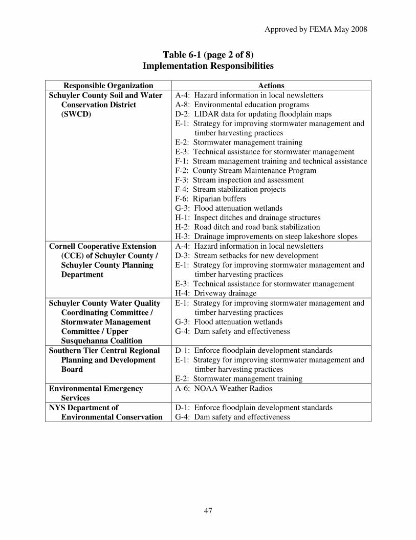
Approved by FEMA May 2008
47
Table 6-1 (page 2 of 8) Implementation Responsibilities
Responsible Organization Actions Schuyler County Soil and Water
Conservation District (SWCD)
A-4: Hazard information in local newsletters A-8: Environmental education programs D-2: LIDAR data for updating floodplain maps E-1: Strategy for improving stormwater management and
timber harvesting practices E-2: Stormwater management training E-3: Technical assistance for stormwater management F-1: Stream management training and technical assistance F-2: County Stream Maintenance Program F-3: Stream inspection and assessment F-4: Stream stabilization projects F-6: Riparian buffers G-3: Flood attenuation wetlands H-1: Inspect ditches and drainage structures H-2: Road ditch and road bank stabilization H-3: Drainage improvements on steep lakeshore slopes
Cornell Cooperative Extension (CCE) of Schuyler County / Schuyler County Planning Department
A-4: Hazard information in local newsletters D-3: Stream setbacks for new development E-1: Strategy for improving stormwater management and
timber harvesting practices E-3: Technical assistance for stormwater management H-4: Driveway drainage
Schuyler County Water Quality Coordinating Committee / Stormwater Management Committee / Upper Susquehanna Coalition
E-1: Strategy for improving stormwater management and timber harvesting practices
G-3: Flood attenuation wetlands G-4: Dam safety and effectiveness
Southern Tier Central Regional Planning and Development Board
D-1: Enforce floodplain development standards E-1: Strategy for improving stormwater management and
timber harvesting practices E-2: Stormwater management training
Environmental Emergency Services
A-6: NOAA Weather Radios
NYS Department of Environmental Conservation
D-1: Enforce floodplain development standards G-4: Dam safety and effectiveness
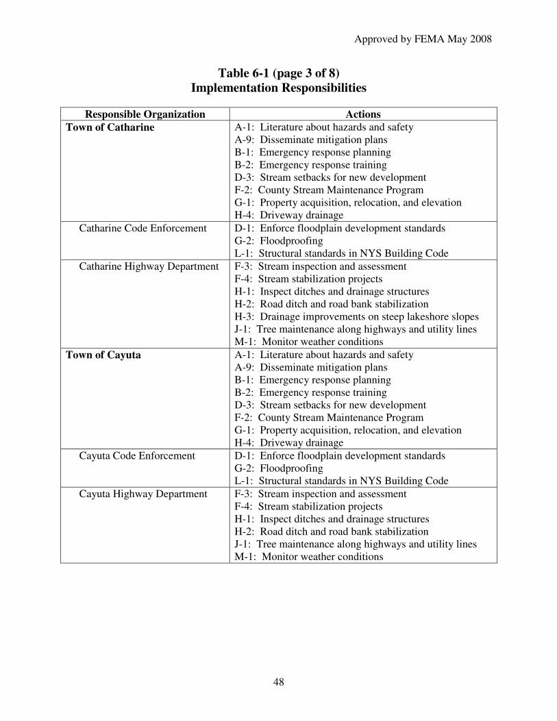
Approved by FEMA May 2008
48
Table 6-1 (page 3 of 8) Implementation Responsibilities
Responsible Organization Actions Town of Catharine A-1: Literature about hazards and safety
A-9: Disseminate mitigation plans B-1: Emergency response planning B-2: Emergency response training D-3: Stream setbacks for new development F-2: County Stream Maintenance Program G-1: Property acquisition, relocation, and elevation H-4: Driveway drainage
Catharine Code Enforcement D-1: Enforce floodplain development standards G-2: Floodproofing L-1: Structural standards in NYS Building Code
Catharine Highway Department F-3: Stream inspection and assessment F-4: Stream stabilization projects H-1: Inspect ditches and drainage structures H-2: Road ditch and road bank stabilization H-3: Drainage improvements on steep lakeshore slopes J-1: Tree maintenance along highways and utility lines M-1: Monitor weather conditions
Town of Cayuta A-1: Literature about hazards and safety A-9: Disseminate mitigation plans B-1: Emergency response planning B-2: Emergency response training D-3: Stream setbacks for new development F-2: County Stream Maintenance Program G-1: Property acquisition, relocation, and elevation H-4: Driveway drainage
Cayuta Code Enforcement D-1: Enforce floodplain development standards G-2: Floodproofing L-1: Structural standards in NYS Building Code
Cayuta Highway Department F-3: Stream inspection and assessment F-4: Stream stabilization projects H-1: Inspect ditches and drainage structures H-2: Road ditch and road bank stabilization J-1: Tree maintenance along highways and utility lines M-1: Monitor weather conditions

Approved by FEMA May 2008
49
Table 6-1 (page 4 of 8) Implementation Responsibilities
Responsible Organization Actions Town of Dix A-1: Literature about hazards and safety
A-9: Disseminate mitigation plans B-1: Emergency response planning B-2: Emergency response training D-3: Stream setbacks for new development F-2: County Stream Maintenance Program G-1: Property acquisition, relocation, and elevation H-4: Driveway drainage
Dix Code Enforcement D-1: Enforce floodplain development standards G-2: Floodproofing L-1: Structural standards in NYS Building Code
Dix Highway Department F-3: Stream inspection and assessment F-4: Stream stabilization projects H-1: Inspect ditches and drainage structures H-2: Road ditch and road bank stabilization J-1: Tree maintenance along highways and utility lines M-1: Monitor weather conditions
Town of Hector A-1: Literature about hazards and safety A-9: Disseminate mitigation plans B-1: Emergency response planning B-2: Emergency response training D-3: Stream setbacks for new development F-2: County Stream Maintenance Program G-1: Property acquisition, relocation, and elevation H-4: Driveway drainage
Hector Code Enforcement D-1: Enforce floodplain development standards G-2: Floodproofing L-1: Structural standards in NYS Building Code
Hector Highway Department F-3: Stream inspection and assessment F-4: Stream stabilization projects H-1: Inspect ditches and drainage structures H-2: Road ditch and road bank stabilization H-3: Drainage improvements on steep lakeshore slopes J-1: Tree maintenance along highways and utility lines M-1: Monitor weather conditions

Approved by FEMA May 2008
50
Table 6-1 (page 5 of 8) Implementation Responsibilities
Responsible Organization Actions Town of Montour A-1: Literature about hazards and safety
A-9: Disseminate mitigation plans B-1: Emergency response planning B-2: Emergency response training D-3: Stream setbacks for new development F-2: County Stream Maintenance Program G-1: Property acquisition, relocation, and elevation H-4: Driveway drainage
Montour Code Enforcement D-1: Enforce floodplain development standards G-2: Floodproofing L-1: Structural standards in NYS Building Code
Montour Highway Department F-3: Stream inspection and assessment F-4: Stream stabilization projects H-1: Inspect ditches and drainage structures H-2: Road ditch and road bank stabilization J-1: Tree maintenance along highways and utility lines M-1: Monitor weather conditions
Town of Orange A-1: Literature about hazards and safety A-9: Disseminate mitigation plans B-1: Emergency response planning B-2: Emergency response training D-3: Stream setbacks for new development F-2: County Stream Maintenance Program G-1: Property acquisition, relocation, and elevation H-4: Driveway drainage
Orange Code Enforcement D-1: Enforce floodplain development standards G-2: Floodproofing L-1: Structural standards in NYS Building Code
Orange Highway Department F-3: Stream inspection and assessment F-4: Stream stabilization projects H-1: Inspect ditches and drainage structures H-2: Road ditch and road bank stabilization H-3: Drainage improvements on steep lakeshore slopes J-1: Tree maintenance along highways and utility lines M-1: Monitor weather conditions
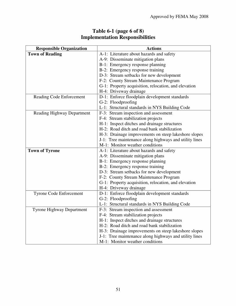
Approved by FEMA May 2008
51
Table 6-1 (page 6 of 8) Implementation Responsibilities
Responsible Organization Actions Town of Reading A-1: Literature about hazards and safety
A-9: Disseminate mitigation plans B-1: Emergency response planning B-2: Emergency response training D-3: Stream setbacks for new development F-2: County Stream Maintenance Program G-1: Property acquisition, relocation, and elevation H-4: Driveway drainage
Reading Code Enforcement D-1: Enforce floodplain development standards G-2: Floodproofing L-1: Structural standards in NYS Building Code
Reading Highway Department F-3: Stream inspection and assessment F-4: Stream stabilization projects H-1: Inspect ditches and drainage structures H-2: Road ditch and road bank stabilization H-3: Drainage improvements on steep lakeshore slopes J-1: Tree maintenance along highways and utility lines M-1: Monitor weather conditions
Town of Tyrone A-1: Literature about hazards and safety A-9: Disseminate mitigation plans B-1: Emergency response planning B-2: Emergency response training D-3: Stream setbacks for new development F-2: County Stream Maintenance Program G-1: Property acquisition, relocation, and elevation H-4: Driveway drainage
Tyrone Code Enforcement D-1: Enforce floodplain development standards G-2: Floodproofing L-1: Structural standards in NYS Building Code
Tyrone Highway Department F-3: Stream inspection and assessment F-4: Stream stabilization projects H-1: Inspect ditches and drainage structures H-2: Road ditch and road bank stabilization H-3: Drainage improvements on steep lakeshore slopes J-1: Tree maintenance along highways and utility lines M-1: Monitor weather conditions

Approved by FEMA May 2008
52
Table 6-1 (page 7 of 8) Implementation Responsibilities
Responsible Organization Actions Village of Burdett A-1: Literature about hazards and safety
A-9: Disseminate mitigation plans B-1: Emergency response planning B-2: Emergency response training D-3: Stream setbacks for new development F-2: County Stream Maintenance Program G-1: Property acquisition, relocation, and elevation H-4: Driveway drainage
Burdette Code Enforcement D-1: Enforce floodplain development standards F-3: Stream inspection and assessment G-2: Floodproofing H-1: Inspect ditches and drainage structures L-1: Structural standards in NYS Building Code
Village of Montour Falls A-1: Literature about hazards and safety A-9: Disseminate mitigation plans B-1: Emergency response planning B-2: Emergency response training D-3: Stream setbacks for new development F-2: County Stream Maintenance Program G-1: Property acquisition, relocation, and elevation H-4: Driveway drainage
Montour Falls Code Enforcement
D-1: Enforce floodplain development standards G-2: Floodproofing L-1: Structural standards in NYS Building Code
Montour Falls Highway Department
F-3: Stream inspection and assessment F-4: Stream stabilization projects H-1: Inspect ditches and drainage structures H-2: Road ditch and road bank stabilization J-1: Tree maintenance along highways and utility lines J-3: Brush pickup M-1: Monitor weather conditions
Village of Odessa A-1: Literature about hazards and safety A-9: Disseminate mitigation plans B-1: Emergency response planning B-2: Emergency response training D-3: Stream setbacks for new development F-2: County Stream Maintenance Program G-1: Property acquisition, relocation, and elevation H-4: Driveway drainage
Odessa Code Enforcement D-1: Enforce floodplain development standards G-2: Floodproofing L-1: Structural standards in NYS Building Code

Approved by FEMA May 2008
53
Table 6-1 (page 8 of 8) Implementation Responsibilities
Responsible Organization Actions Odessa Public Works
Department F-3: Stream inspection and assessment F-4: Stream stabilization projects H-1: Inspect ditches and drainage structures H-2: Road ditch and road bank stabilization J-1: Tree maintenance along highways and utility lines J-3: Brush pickup M-1: Monitor weather conditions
Village of Watkins Glen A-1: Literature about hazards and safety A-9: Disseminate mitigation plans B-1: Emergency response planning B-2: Emergency response training D-3: Stream setbacks for new development F-2: County Stream Maintenance Program F-5: Glen Creek walls in Watkins Glen G-1: Property acquisition, relocation, and elevation H-4: Driveway drainage
Watkins Glen Code Enforcement
D-1: Enforce floodplain development standards G-2: Floodproofing L-1: Structural standards in NYS Building Code
Watkins Glen Public Works Department
F-3: Stream inspection and assessment F-4: Stream stabilization projects H-1: Inspect ditches and drainage structures H-2: Road ditch and road bank stabilization H-3: Drainage improvements on steep lakeshore slopes J-1: Tree maintenance along highways and utility lines J-3: Brush pickup M-1: Monitor weather conditions
Community groups A-7: Emergency preparedness training
Facility operators B-1: Emergency response planning C-1: Backup power for critical facilities C-3: Critical facility evaluation C-4: Maintain and test emergency equipment
Property owners / homeowners associations
F-2: County Stream Maintenance Program F-6: Riparian buffers G-1: Property acquisition, relocation, and elevation G-2: Floodproofing H-1: Inspect ditches and drainage structures H-2: Road ditch and road bank stabilization H-3: Drainage improvements on steep lakeshore slopes
Utility companies J-1: Tree maintenance along highways and utility lines K-1: Underground utility lines

Approved by FEMA May 2008
54
Integrating Hazard Mitigation with Existing Planning Mechanisms The hazard mitigation strategy presented in this plan will be integrated into other county and municipal plans when those documents are updated. This will be facilitated by the Schuyler County Planning Director, who is an active member of the Hazard Mitigation Committee. When appropriate, the goals of this plan will be met through inclusion in capital improvement and economic development plans, master plans, zoning and land use plans and ordinances, and other appropriate planning and regulatory actions.
• The Schuyler County Comprehensive Plan 2004 already includes many mitigation strategies, which will be reviewed and updated based on this hazard mitigation plan during the comprehensive plan revision process (scheduled to be reviewed and fully revised every 5 years, at minimum).
• The Schuyler County Water Quality Coordinating Committee is in the process of updating their water quality strategy, which will be expanded to a Water Resource
Strategy that includes flooding and highway drainage concerns. Overlapping membership between that committee and the Hazard Mitigation Planning Committee will enable development of fully consistent and mutually supportive plans.
• The Director of Emergency Services will ensure that the Schuyler County Comprehensive
Emergency Management Plan and the Hazard Mitigation Plan are consistent.
• The Flood Mitigation Specialist (with Southern Tier Central Regional Planning and Development Board) provides input on flood risks and hazard mitigation in the annual Comprehensive Economic Development Strategy (CEDS), Southern Tier Central Region,
New York.
• The County Planning Director provides direct assistance to municipalities on planning and land use activities. Part of this assistance will include integration of hazard mitigation techniques, as recommended in this Plan.
• The county (Buildings and Grounds Department) and municipalities (Town and Village Boards) will establish provisions for county and municipal capital improvement projects for incorporating hazard resistant construction standards into the design, engineering, and location of the project.
Plan Maintenance The Director of Emergency Services will convene the Hazard Mitigation Committee as needed to monitor, evaluate, and update this Hazard Mitigation Plan. This committee includes a representative of each municipality, several county agencies, and other organizations (indicated in Attachment B). This committee is responsible for monitoring and evaluating the progress for each mitigation action in this plan. Sections of the plan will be reviewed and updated whenever conditions change that may affect the plan. A complete review will be conducted at least every five years to update the plan in light of current and expected conditions (as required to maintain eligibility for state and federal grant funds). In order to ensure adoption of the revised plan within this five year cycle, the Hazard Mitigation Committee will reconvene no later than four years after adoption of the previous version. The Director of Emergency Services continuously monitors hazard conditions and mitigation activities throughout the county and will reconvene the committee sooner if conditions warrant earlier action.

Approved by FEMA May 2008
55
When the committee updates the plan, they will review hazard analysis, risk assessment, and vulnerable asset information and incorporate any additional or updated information. If the nature or magnitude of risks has changed or if additional information is available, these sections of the plan will be revised as appropriate. If possible, additional documentation will be assembled of the ongoing costs associated with flash flooding (to evaluate the cost effectiveness of preventive measures). The committee will review each goal in the mitigation strategy to determine the ongoing relevance to changing situations in the county. The parties responsible for the various implementation actions will report on the status of their efforts and this progress will be documented. After reviewing recommended project types in the current state hazard mitigation plan, the committee will develop revised actions that represent the next steps toward achieving the county’s mitigation goals (using the review procedure described in Attachment D). If other plans applicable to Schuyler County have been updated, they will be reviewed and the information incorporated as appropriate. The Committee will also evaluate the availability of resources for implementing the plan and will seek to identify additional resources or grant programs to facilitate plan implementation. A draft plan with the Hazard Mitigation Committee’s recommended revisions will be distributed to committee members and other interested parties for review. Copies will also be available at municipal offices for review by municipal staff, boards, and the public. This local review process will ensure consistency with municipal planning objectives, community values, and other planning efforts. All comments received during this local review period will be reviewed and analyzed by relevant members of the Hazard Mitigation Committee and appropriate modifications incorporated into the updated plan. The Hazard Mitigation Committee will solicit public input and comments each time this plan is revised. The media that can be used to encourage public involvement include county and municipal websites, newspaper articles, newsletter articles, posting notices in county and municipal offices, and directly contacting potentially interested individuals. The Director of Emergency Services will seek opportunities to increase private sector membership on the mitigation committee. The public will have the opportunity to express opinions and comments to their respective municipal governments or to other committee members. A copy of the most current plan will be available in each public library for year around public access. Once the Hazard Mitigation Plan is updated and comments have been integrated, it will be adopted by all governing bodies and the adoption resolutions included in the plan. The plan will be distributed to each municipality, public libraries, county offices, the NY State Emergency Management Office, and the Federal Emergency Management Agency.

Approved by FEMA May 2008
56
Attachment A: Maps and Data The following maps and data provide supporting information about the population, land uses, and assets in each municipality in Schuyler County.

Schuyler
0 25 50 75 10012.5Miles
Schuyler County Comprehensive Plan 2004Map 1: New York State
County Boundaries
Created by Cornell Cooperative ExtensionData: NYS Counties Tiger
Approved by FEMA May 2008

Hector
DixOrange
Tyrone
Catherine
Reading
Cayuta
Montour
Burdett
Watkins Glen
Odessa
Montour Falls
Schuyler County Comprehensive Plan: 2004
0 2 4 6 81Miles
Map 2: Political Boundries
New York State
Created by: Cornell Cooperative ExtensionMay 2004
Data: Schuyler County Real Property Tax Agency, CUGIR, National Atlas
Approved by FEMA May 2008

Montour Falls
Odessa
Watkins Glen
Burdett
Schuyler County Comprehensive Plan: 2004
0 2 4 6 81 Miles Road Types
State Highway
County Highway
Open Water
Local Road
Map 3: Highways and Roads
Created by Cornell Cooperative ExtensionJune 2004
Data: Schuyler County Real Property Tax Agency, CUGIR, National Atlas
Co. Rte 1
St Rte 228
Co.
Rte
4
St Rte
7
9
St Rte 79
St R
te 2
28
St
Rte
414
Co.
Rte 6
Co. R
te 7
Co.
Rte
10
St Rte 224
Co. Rte 14
Co.
Rte
13
St R
te 1
4
St Rte 4
14C
o. R
te 8
Co. Rte 16
St Rte 409St Rte 329
Co.
Rte
17
Co.
Rte
19
Co. R
te 21
Co. Rte 23
Co.
Rte
22
Co. Rte
16
St R
te 14
St Rte 14A
Co. R
te 28
Co.
Rte
29
Co. R
te 27
St Rte 226
Co. Rte 2
Co. R
te 5
Co. Rte 8
Co. R
te 9
St R t e 2
30
Co. Rte 26
Co. R
te 25
Co. Rte 24
St Rte 13
Approved by FEMA May 2008

Schuyler County Comprehensive Plan: 2004
0 2 4 6 81 Miles
Natural Resources
National Forest Land
Schuyler County Stream
State Wetlands
National Wetlands
New York State Forests & Park
Schuyler County Forest Land
Arnot Forest (Cornell University)
Watkins Glen Village Park
Montour Falls Village Park
Burdett Village Park
Open Water
Map 4: Natural Resources 2004
Created by Cornell Cooperative ExtensionJune 2004
Data: Schuyler County Real Property Tax Agency, CUGIR, National Atlas
DEC Six Nations Unit
Hector National Forest
Watkins GlenState Park Catherine Creek
Area Preserve
Texas HollowWildlife Sactuary
Connecticut Hill State Game
Management Area
Seneca Lake
Waneta Lake
Lamoka Lake
Cayuta Lake
Arnot Forest
Approved by FEMA May 2008

Montour Falls
Odessa
Watkins Glen
Burdett
Schuyler County Comprehensive Plan: 2004
0 1 2 3 40.5 Miles
Agricultural Districts
Ag District 1
Ag District 2
Ag District 3
Open Water
Map 5: Agricultural Districts 2004
Created by Cornell Cooperative ExtensionJune 2004
Data: Schuyler County Real Property Tax Agency, CUGIR, National Atlas
Cayuta
Catharine
Montour
Dix
Hector
Orange
Tyrone
Reading
Approved by FEMA May 2008

Schuyler County Comprehensive Plan: 2004Map 6: Property Class Assesment & Land Use 2004
Land Use Classifications
Agricultural
Residential
Vacant Land
Commercial
Recreation & Entertainment
Communtiy Services
Industrial
Public Services
Conservation Land & Park
Unknown
Open Water
State Highway
Municipal Boundaries
0 2 4 6 81 Miles
Created by Cornell Cooperative ExtensionJune 2004
Data: Schuyler County Real Property Tax Agency, CUGIR, National Atlas
Approved by FEMA May 2008

Approved by FEMA May 2008
63
Table A-1 Hazard Events and Federal Disaster Declarations for Schuyler County
1965 thru 2004
Disaster Number Year Brief Description of Disaster
0290-DR July 1970 Heavy rains and flooding
Undeclared July 1970 Flooding
Undeclared October 1970 Flooding
0338-DR June 1972 Tropical Storm Agnes
Undeclared June 1976 Flooding
3107-EM March 1993 Statewide blizzard
1095-DR January 1996 Severe storms and flooding
1148-DR November 1996 Severe storms, high winds, rain and flooding
3155-EM October 2000 Virus threat
1391-DR September 2001 World Trade Center terrorist attack
1486-DR August 2003 Severe summer storms, flooding and tornadoes
3186-EM August 2003 Power outage
3262-EM September 2005 Hurricane Katrina evacuation
Source: Materials provided by the NY State Emergency Management Office.

Approved by FEMA May 2008
64
Table A-2 National Flood Insurance Information
Municipality Number of Policies
Number of Policies in
Zone A (mapped 100-year
floodplain)
Value of Property
Covered by Flood
Insurance
Number of Claims
Since 1978
Dollar Amount
of Claims Since 1978
Town of Catharine
1 1 $142,000 0 $0
Town of Cayuta 1 1 $53,300 0 $0
Town of Dix 4 2 $251,500 2 $2,076
Town of Hector 13 6 $1,680,500 6 $34,091
Town of Montour
1 0 $120,900 0 $0
Town of Orange 2 0 $403,500 17 $28,543
Town of Reading 2 0 $549,100 2 $6,206
Town of Tyrone 19 15 $1,226,300 1 $233
Village of Burdett
0 0 $0 0 $0
Village of Montour Falls
5 1 $1,153,400 7 $78,097
Village of Odessa
0 0 $0 0 $0
Village of Watkins Glen
13 4 $1,106,000 12 $52,768
SCHUYLER COUNTY
61 30 $6,686,500 47 $202,014

Table A-3 (page 1 of 3)
Assets and Land Use
Land Use To
wn
of
Ca
tha
rin
e
To
wn
of
Ca
yu
ta
To
wn
of
Dix
To
wn
of
Hecto
r
To
wn
of
Mo
nto
ur
To
wn
of
Ora
ng
e
To
wn
of
Rea
din
g
To
wn
of
Ty
ro
ne
Vil
lag
e o
f B
urd
ett
Vil
lag
e o
f M
on
tou
r F
all
s
Vil
lag
e o
f O
dess
a
Vil
lag
e o
f W
atk
ins
Gle
n
SC
HU
YL
ER
CO
UN
TY
Agricultural Acres 4,490 606 5,420 16,686 3,856 3,096 3,821 8,353 151 4 96 0 46,578
% of Land Use 23% 7% 25% 26% 38% 9% 23% 35% 26% 0% 14% 0% 23%
Number of Parcels 82 11 86 263 55 62 53 112 4 1 3 0 732
Total Assessed Value $4,470,705 $444,074 $5,911,667 $21,653,571 $4,511,090 $2,074,545 $4,658,205 $10,537,333 $124,143 $3,077 $82,949 $0 $54,471,359
Value of Buildings $1,375,897 $112,000 $1,761,026 $7,571,286 $1,704,744 $404,091 $1,831,410 $5,500,533 $0 $0 $0 $0 $20,260,987
Value of Land $3,094,808 $332,074 $4,150,641 $14,082,286 $2,806,346 $1,670,455 $2,826,795 $5,036,800 $124,143 $3,077 $82,949 $0 $34,210,373
Residential Acres 6,670 3,278 8,118 23,676 3,168 11,806 6,696 7,406 283 441 228 207 71,976
% of land use 34% 38% 38% 37% 31% 34% 40% 31% 48% 26% 32% 23% 35%
Number of Parcels 491 193 724 1,994 301 639 636 1,055 138 403 200 695 7,469
Total Assessed Value $36,177,885 $13,715,024 $52,765,449 $225,112,571 $23,733,077 $38,444,182 $58,378,333 $78,491,844 $9,369,429 $29,027,308 $14,462,372 $55,194,679 $634,872,152
Value of Buildings $25,381,237 $10,080,941 $39,733,718 $150,537,000 $18,442,949 $25,618,330 $40,771,282 $55,355,351 $7,732,429 $25,692,949 $12,394,295 $46,340,385 $458,080,864
Value of Land $10,796,647 $3,634,082 $13,031,731 $74,575,571 $5,290,128 $12,825,852 $17,607,051 $23,136,493 $1,637,000 $3,334,359 $2,068,077 $8,854,295 $176,791,288
Vacant Land Acres 3,472 3,493 4,622 11,343 2,358 5,259 4,328 6,159 126 591 256 216 42,224
% of Land Use 18% 40% 22% 18% 23% 15% 26% 26% 21% 35% 36% 24% 21%
Number of Parcels 229 111 304 840 149 275 301 423 35 111 56 157 2,991
Total Assessed Value $2,962,859 $2,055,662 $5,279,205 $15,924,571 $1,843,763 $3,917,301 $6,587,308 $5,860,720 $289,571 $1,155,897 $505,974 $3,667,756 $50,050,589
Value of Buildings $242,628 $150,176 $413,333 $1,395,571 $164,147 $85,341 $591,923 $585,867 $82,000 $65,449 $56,500 $325,641 $4,158,577
Value of Land $2,720,231 $1,905,486 $4,865,872 $14,529,000 $1,679,615 $3,831,960 $5,995,385 $5,274,853 $207,571 $1,090,449 $449,474 $3,342,115 $45,892,012
Source: Schuyler County Real Property Tax Data, 2006, adjusted to equalized market value
Approved by FEMA May 2008

Table A-3 (page 2 of 3)
Assets and Land Use
Land Use To
wn
of
Ca
tha
rin
e
To
wn
of
Ca
yu
ta
To
wn
of
Dix
To
wn
of
Hecto
r
To
wn
of
Mo
nto
ur
To
wn
of
Ora
ng
e
To
wn
of
Rea
din
g
To
wn
of
Ty
ro
ne
Vil
lag
e o
f B
urd
ett
Vil
lag
e o
f M
on
tou
r F
all
s
Vil
lag
e o
f O
dess
a
Vil
lag
e o
f W
atk
ins
Gle
n
SC
HU
YL
ER
CO
UN
TY
Commercial Acres 149 35 116 310 148 149 133 174 16 70 45 63 1,408
% of Land Use 1% 0% 1% 0% 1% 0% 1% 1% 3% 4% 6% 7% 1%
Number of Parcels 17 11 28 32 18 3 23 18 11 76 20 159 416
Total Assessed Value $2,529,167 $8,896,724 $5,829,487 $8,239,571 $1,481,250 $371,932 $2,989,936 $2,690,947 $852,000 $9,971,282 $2,708,013 $42,880,385 $89,440,693
Value of Buildings $1,460,833 $8,360,018 $4,898,462 $7,165,286 $1,255,929 $242,159 $2,597,115 $2,026,280 $752,857 $8,316,218 $2,469,936 $37,622,179 $77,167,273
Value of Land $1,068,333 $536,706 $931,026 $1,074,286 $225,321 $129,773 $392,821 $664,667 $99,143 $1,655,064 $238,077 $5,258,205 $12,273,420
Recreation & Entertainment Acres 3 148 1,242 1 18 2 176 419 0 48 40 38 2,135
% of Land Use 0% 2% 6% 0% 0% 0% 1% 2% 0% 3% 6% 4% 1%
Number of Parcels 1 1 6 1 2 1 3 9 0 9 2 17 52
Total Assessed Value $57,692 $75,765 $10,078,590 $63,429 $427,436 $47,955 $820,256 $3,307,867 $0 $495,128 $74,359 $4,253,974 $19,702,450
Value of Buildings $44,231 $5,765 $7,908,077 $51,000 $377,564 $9,545 $405,641 $2,257,067 $0 $419,615 $19,359 $2,629,103 $14,126,967
Value of Land $13,462 $70,000 $2,170,513 $12,429 $49,872 $38,409 $414,615 $1,050,800 $0 $75,513 $55,000 $1,624,872 $5,575,484
Community Services Acres 18 0 77 256 13 247 64 59 7 145 35 98 1,019
% of Land Use 0% 0% 0% 0% 0% 1% 0% 0% 1% 8% 5% 11% 1%
Number of Parcels 8 10 19 35 6 17 13 18 5 31 13 43 218
Total Assessed Value $862,692 $0 $2,284,744 $2,687,714 $287,692 $7,733,182 $1,750,385 $2,041,067 $634,286 $17,858,846 $7,047,692 $31,663,836 $74,852,136
Value of Buildings $673,974 $0 $1,707,821 $1,846,571 $151,282 $7,480,795 $1,177,051 $1,855,067 $582,143 $17,138,590 $6,615,897 $29,367,169 $68,596,361
Value of Land $188,718 $0 $576,923 $841,143 $136,410 $252,386 $573,333 $186,000 $52,143 $720,256 $431,795 $2,296,667 $6,255,775
Source: Schuyler County Real Property Tax Data, 2006, adjusted to equalized market value
Approved by FEMA May 2008

Table A-3 (page 3 of 3)
Assets and Land Use
Land Use To
wn
of
Ca
tha
rin
e
To
wn
of
Ca
yu
ta
To
wn
of
Dix
To
wn
of
Hecto
r
To
wn
of
Mo
nto
ur
To
wn
of
Ora
ng
e
To
wn
of
Rea
din
g
To
wn
of
Ty
ro
ne
Vil
lag
e o
f B
urd
ett
Vil
lag
e o
f M
on
tou
r F
all
s
Vil
lag
e o
f O
dess
a
Vil
lag
e o
f W
atk
ins
Gle
n
SC
HU
YL
ER
CO
UN
TY
Industrial Acres 2 0 0 120 22 0 421 0 0 32 6 21 624
% of Land Use 0% 0% 0% 0% 0% 0% 2% 0% 0% 2% 1% 2% 0%
Number of Parcels 1 0 1 3 1 3 7 0 0 5 1 3 25
Total Assessed Value $10,897 $0 $753,697 $370,857 $33,333 $9,485,841 $10,784,919 $0 $0 $3,918,782 $597,308 $7,698,590 $33,654,225
Value of Buildings $0 $0 $753,697 $242,143 $0 $9,485,841 $8,786,201 $0 $0 $3,767,404 $524,231 $5,678,846 $29,238,363
Value of Land $10,897 $0 $0 $128,714 $33,333 $0 $1,998,718 $0 $0 $151,378 $73,077 $2,019,744 $4,415,862
Public Services Acres 2 0 203 5 18 284 265 753 1 47 1 59 1,638
% of Land Use 0% 0% 1% 0% 0% 1% 2% 3% 0% 3% 0% 6% 1%
Number of Parcels 5 26 38 40 21 19 45 51 6 41 12 32 336
Total Assessed Value $521,195 $3,542,873 $16,893,472 $8,712,569 $3,852,103 $4,607,128 $42,548,585 $16,713,556 $408,659 $3,380,122 $954,450 $8,774,582 $110,909,292
Value of Buildings $518,631 $3,487,932 $16,343,600 $8,655,711 $3,764,154 $4,547,299 $42,061,072 $15,766,489 $329,516 $3,284,929 $939,065 $7,885,671 $107,584,069
Value of Land $2,564 $54,941 $549,872 $56,857 $87,949 $59,830 $487,513 $947,067 $79,143 $95,192 $15,385 $888,912 $3,325,223
Wild, Forested, Conservation Lands, & Public Parks Acres 4,841 1,141 1,686 11,478 545 13,727 972 495 3 333 0 210 35,431
% of Land Use 25% 13% 8% 18% 5% 40% 6% 2% 1% 19% 0% 23% 17%
Number of Parcels 12 50 28 33 10 173 11 8 2 8 0 12 347
Total Assessed Value $3,192,372 $1,724,448 $4,508,974 $8,616,571 $146,731 $10,634,773 $525,513 $526,800 $10,000 $59,615 $0 $5,770,513 $35,716,310
Value of Buildings $2,564 $0 $2,481,667 $1,161,286 $0 $0 $0 $0 $0 $0 $0 $1,083,846 $4,729,363
Value of Land $3,189,808 $1,724,448 $2,027,308 $7,455,286 $146,731 $10,634,773 $525,513 $526,800 $10,000 $59,615 $0 $4,686,667 $30,986,948
Totals Acres 19,646 8,701 21,484 63,876 10,145 34,570 16,876 23,818 587 1,711 707 912 203,033
Number of Parcels 846 413 1,234 3,241 563 1,192 1,092 1,694 201 685 307 1,118 12,586
Total Assessed Value $50,785,464 $30,454,569 $104,305,285 $291,381,426 $36,316,474 $77,316,839 $129,043,440 $120,170,133 $11,688,087 $65,870,058 $26,433,117 $159,904,315 $1,103,669,207
Value of Buildings $29,699,996 $22,196,832 $76,001,400 $178,625,854 $25,860,769 $47,873,401 $98,221,696 $83,346,653 $9,478,944 $58,685,154 $23,019,283 $130,932,840 $783,942,823
Value of Land $21,085,468 $8,257,738 $28,303,885 $112,755,571 $10,455,705 $29,443,438 $30,821,744 $36,823,480 $2,209,143 $7,184,904 $3,413,833 $28,971,476 $319,726,384
Source: Schuyler County Real Property Tax Data, 2006, adjusted to equalized market value
Approved by FEMA May 2008

Approved by FEMA May 2008
68
Table A-4 Property with the Highest Assessed Building/Facility Value
Municipality Property Description/Owner Assessed Value of Buildings/Facilities*
Town of Catharine Private residence $515,128
Town of Cayuta Lumber – Wagner Hardwoods $6,364,782
Town of Dix Racetrack – Watkins Glen $7,258,974
Town of Hector Winery/Restaurant – Logan $2,971,000
Town of Montour Dairy Farm – Wonderview Farms $671,795
Town of Orange Gas Well – Fortuna Energy Inc. $5,923,091
Town of Reading Industrial – US Salt Corporation $6,773,077
Town of Tyrone Campground – Boy Scouts of America $1,086,267
Village of Burdett Convenient/Gas – Dandy Prop Mng LLC $409,571
Village of Montour Falls Hospital – Schuyler Hospital Inc. $4,173,846
Village of Odessa School – Odessa Montour Central $4,805,513
Village of Watkins Glen Retail – Wal-Mart Real Estate Business $15,056,410
*Building/facility assessment is total assessment minus land assessment Source: Schuyler County Real Property Tax Data, 2006, adjusted to equalized market value

Approved by FEMA May 2008
69
Table A-5 (page 1 of 3) Critical Facilities
A critical facility is any facility that is an integral part of emergency response operations or one
that requires special emergency response due to the potential at the site for triggering an
additional hazardous incident.
County Public Safety Building (houses Emergency Management Office, Sheriff’s Department, and 911 Dispatch Center) – 106 10th Street, Watkins Glen
Municipal Offices (used as emergency operations centers): Town of Catharine Town of Cayuta Town of Dix Town of Hector Town of Montour Town of Orange Town of Reading Town of Tyrone Village of Burdett Village of Montour Falls Village of Odessa Village of Watkins Glen
Fire Stations: Beaver Dams (T. Montour) Burdett (V. Burdett) Mecklenburg (T. Hector) Monterey (T. Orange) Montour Falls (V. Montour Falls) Odessa (V. Odessa) Trumansburg (Tompkins County) Tyrone (T. Tyrone) Valois-Logan-Hector (T. Hector) Watkins Glen (V. Watkins Glen)
Police Departments: Schuyler County Sheriff’s Department (located in Public Safety Building) NY State Police (T. Montour) V. Watkins Glen Police Department
Emergency Medical and Ambulance Services: Schuyler County Volunteer Ambulance Corps (V. Watkins Glen)
Hospital: Schuyler Hospital (V. Montour Falls)

Approved by FEMA May 2008
70
Table A-5 (page 2 of 3) Critical Facilities
Highway Departments: NYS Dept. of Transportation (maintenance facility in T. Dix) Schuyler County (located in V. Watkins Glen) Town of Catharine Town of Cayuta Town of Dix Town of Hector Town of Montour Town of Orange Town of Reading Town of Tyrone Village of Montour Falls Village of Odessa Village of Watkins Glen
Emergency Shelters: Bradford Central School (T. Orange) Odessa Montour Central School (V. Odessa) Watkins Glen High School (V. Watkins Glen) Watkins Glen Middle School (V. Watkins Glen) Watkins Glen Elementary School (V. Watkins Glen) NYS Fire Academy (V. Montour Falls)
Communications: Emergency Radio Communications (in Public Safety Building; Terry Hill tower in
Chemung County) Verizon Telephone (switching station in V. Watkins Glen) Trumansburg Telephone (switching Station in T. Hector) Empire Telephone (switching stations in V. Odessa and V. Burdett) Frontier Telephone (switching station in Yates County)
Utilities: NYSEG electric system (substation in T. Montour, maintenance offices in Tompkins and
Chemung Counties) V. Watkins Glen Electrical Department and substation (V. Watkins Glen) T. Hector municipal water wells and storage tanks (T. Hector) V. Odessa municipal wells and storage tanks (V. Odessa) V. Montour Falls municipal well and storage tanks (V. Montour Falls) V. Watkins Glen water filtration plant and storage tanks (V. Watkins Glen, T. Dix) Montour Falls municipal sewage treatment plant Watkins Glen municipal sewage treatment plant Natural gas (all switching facilities in neighboring counties)
Chemung-Schuyler Chapter of the American Red Cross (located in Chemung County)

Approved by FEMA May 2008
71
Table A-5 (page 3 of 3) Critical Facilities
Broadcast media: WENY-TV (studio and broadcast tower in Chemung County) WETM-TV (studio and broadcast tower in Chemung County) FLR Dundee radio station (studio and broadcast tower in Yates County) Time Warner Cable (from Ontario County) Haefle Cable TV (from Tioga County) NOAA Weather Radio (from Binghamton, NY, National Weather Service office; Elmira
transmitter in Chemung County; Ithaca transmitter in Tompkins County; Mount Washington transmitter in Steuben County)
Major transportation routes (see Map of Highways and Roads) State Routes 14, 14A, 414, 79, 224, 226, 227, 228, 329 and 409. Elmira-Corning Regional Airport (located in Chemung County)
Facilities with significant amounts of hazardous materials: 10 facilities in Schuyler County have hazardous material inventories that meet the reporting requirements for SARA Title III (in 2006)

Approved by FEMA May 2008
72
Table A-6 Schuyler County Population
Municipality Total Population
Total Number of Households
Households with
Individuals Under 18
Years
Households with
Individuals 65 Years and Over
Total Number
of Housing
Units Town of Catharine
1,930
755
281
174
865
Town of Cayuta 545 212 75 55 233
Town of Dix 4,197 1,643 576 459 1,797
Town of Hector 4,854 1,872 693 395 2,378
Town of Montour
2,446
1,005
305
325
1,078
Town of Orange 1,752 523 221 112 666
Town of Reading 1,786 700 226 216 868
Town of Tyrone 1,714 664 228 210 1,296
SCHUYLER COUNTY
19,224
7,374
2,605
1,946
9,181
Source: U.S. Census Bureau, Census 2000
Table A-7 Facilities with Increased Vulnerability
Camp Monterey Correctional Facility (T. Orange) Watkins Glen International Raceway (T. Dix) Bradford Central School (T. Orange) Odessa Montour Central School (V. Odessa) Watkins Glen High School (V. Watkins Glen) Watkins Glen Middle School (V. Watkins Glen) Watkins Glen Elementary School (V. Watkins Glen) Schuyler Hospital and Seneca View nursing facility (V. Montour Falls) Falls Home Assisted Living Center (Montour Falls) Facilities with hazardous materials (in 2006, 10 facilities met the reporting requirements for
SARA Title III) Mobile home parks (18 located in T. Catharine, T. Dix, T. Hector, T. Tyrone, V. Montour Falls)

Approved by FEMA May 2008
73
Table A-8 Land Use
Forest – 142,000 acres (65%) Finger Lakes National Forest – 10,873 acres (5% of county) State forests, wildlife management, & recreation areas – 18,450 acres (8% of county)
o Waneta-Lamoka Wildlife Management Area o Catharine Creek Marsh Complex Wildlife Management Area o Connecticut Hill Wildlife Management Area o Texas Hollow State Forest o Six Nations State Forest (including Sugar Hill, Coon Hollow, Cinnamon Lake and
Goundry Hill)
Agricultural Use – 64,000 acres (29%)
Open Water – 8,800 acres (4%)
Residential Use – 2,200 acres (1%)
Wetlands – 1,400 acres (<1%)
Industrial / Commercial Uses (including gravel mining) – 500 acres (<1%)
SCHUYLER COUNTY TOTAL – 219,000 acres Source: Schuyler County Comprehensive Plan 2004
Table A-9 Distribution of Mobile Homes
Municipality Number of Mobile Home Parks
Number of Properties with Mobile Home as Primary Structure*
Town of Catharine 5 62
Town of Cayuta 0 63
Town of Dix 3 131
Town of Hector 3 409
Town of Montour 0 29
Town of Orange 0 140
Town of Reading 0 99
Town of Tyrone 5 212
Village of Burdett 0 17
Village of Montour Falls 2 6
Village of Odessa 0 14
Village of Watkins Glen 0 0
SCHUYLER COUNTY 18 1182 *Source: Schuyler County Real Property Tax Data, 2006

Approved by FEMA May 2008
74
Attachment B: The Planning Process The staff of the Schuyler County Emergency Management Office and the Flood Mitigation Specialist for Southern Tier Central Regional Planning and Development Board were the lead officials in developing this Hazard Mitigation Plan. This effort built on the Flood Mitigation
Action Plan that was completed in 1999. It has been expanded into a multi-hazard mitigation plan based, in part, on the results of a HAZNY (Hazards New York) hazard analysis workshop in January 2005. A Hazard Mitigation Committee was formed to provide recommendations and guidance. Flood Mitigation Planning
The Flood Mitigation Action Plan was prepared by county personnel and representatives from many of the municipalities in Schuyler County. Southern Tier Central Regional Planning and Development Board provided staff support. This involved the following tasks and meetings:
• Organizational meeting with key county participants (6/18/98): Introduction to the flood mitigation planning process. Discuss the level of interest expressed by municipalities and devise a strategy for maximizing municipal involvement in this process. Develop a strategy for involving and coordinating with other agencies. Develop a strategy for involving the public. Identify individuals who will be asked to participate. Define the scope of the planning process.
• Assess hazards and problems: Flood hazard areas were obtained from Flood Insurance Rate Maps, which were digitizing as part of this planning process. Additional hazard areas are recognized along all streams and lakeshores. Information about flood problems was compiled through individual communications and meetings with county personnel and representatives from each municipality. Flood problem areas were marked on maps and digitized.
• Set risk reduction goals (11/10/98): Introduction to flood mitigation planning process. Review the maps indicating flood hazard and problem areas and provide additional information. Identify existing community goals. Discuss the vision of how flooding issues can be addressed and future damages prevented. Compile a list of flood damage reduction goals for Schuyler County.
• Evaluate flood solutions (12/4/98): Review text and maps of flood hazards and problems; provide additional information. Review and revise flood mitigation goals. Complete Flood Solutions Worksheet – a comprehensive list of possible activities for reducing flood damages. Identify and discuss the activities that are applicable to the resolution of flooding problems in Schuyler County.
• Prepare an action plan (1/8/99): Using the flood mitigation goals and the flood solutions worksheet, prepare a list of the action items needed to implement the proposed solutions. Recommend post-disaster mitigation policies and procedures. Develop a strategy for implementation, evaluation, and revision of the plan. Recommendation for public review of the draft Plan.

Approved by FEMA May 2008
75
• Public information meeting (2/3/99): Solicit public input on the draft plan.
• Finalize plan: Following review and approval by the NY State Emergency Management Office and the Federal Emergency Management Office, the Flood Mitigation Action Plan,
Schuyler County, New York was finalized in October 1999.
• Update Flood Mitigation Plan (4/4/02): Review flood hazard and problem information (no revisions needed). Review and revise flood mitigation goals. Document the flood mitigation activities that were implemented after completion of the October 1999 Flood Mitigation
Action Plan. Revise the list of flood mitigation action items to be implemented. Although recommendations from this meeting were documented, the flood mitigation plan was not formally updated.
Hazard Mitigation Planning The Hazard Mitigation Committee was formed to serve as a steering committee for development, implementation and updating of this plan. It is chaired by the Schuyler County Director of Emergency Services and consists of the following members:
County Emergency Management Office: Director, Deputy Director Villages: Mayor of each village Towns: Supervisor of each town County Legislature: Chairman, Chair of Public Safety/Criminal Justice Committee County Administrator Cornell Cooperative Extension / Schuyler County Planning Department: Director of
Planning and Community Development County Soil and Water Conservation District: District Manager County Highway Department: Superintendent County Real Property Tax Agency: Director NYS Department of Transportation NYS Office of Parks, Recreation, and Historic Preservation: Watkins Glen State Park
staff National Weather Service: Warning Coordination Meteorologist, Binghamton Schuyler County Partnership for Economic Development (SCOPED) American Red Cross: Chemung-Schuyler Chapter Southern Tier Central Regional Planning and Development Board: Flood Mitigation
Specialist To initiate the planning process, the Emergency Management Office met with municipalities in September 2003. Because flooding was agreed to be a high priority concern, a copy of the Flood
Mitigation Action Plan was distributed to each municipality with a request for comments or new areas of concern. In January 2005, a Hazard Analysis Workshop was held to analyze additional hazards and develop priorities. Participants in this workshop included municipal Highway Superintendents, Town Supervisors, County Emergency Management Office, County Soil and Water Conservation District, Southern Tier Central Regional Planning and Development Board,

Approved by FEMA May 2008
76
Watkins Glen State Park, NY State Emergency Management Office, NYS Police, NYS Department of Environmental Conservation, and the National Weather Service. In 2006, members of the Hazard Mitigation Committee communicated by email and telephone to develop additional information for inclusion in this plan. Each member was responsible for reviewing relevant plans and policies of his/her organization to ensure consistency and coordination of efforts. Committee members reviewed and commented on draft sections of this document. Municipal Involvement Each municipality in the County participated in the development of this plan, as follows:
• Town of Catharine – provided information for flood mitigation plan, participates in Hazard Mitigation Committee
• Town of Cayuta – participated in 1998/99 flood mitigation planning meetings, provided information for flood mitigation plan, participated in 2002 flood mitigation update meeting, participated in 2003 hazard mitigation meeting, participates in Hazard Mitigation Committee
• Town of Dix – participated in 1998/99 flood mitigation planning meetings, provided information for flood mitigation plan, participated in 2005 HAZNY workshop, participates in Hazard Mitigation Committee
• Town of Hector – participated in 1998/99 flood mitigation planning meetings, provided information for flood mitigation plan, participated in 2002 flood mitigation update meeting, participated in 2005 HAZNY workshop, participates in Hazard Mitigation Committee
• Town of Montour – participated in 1998/99 flood mitigation planning meeting, provided information for flood mitigation plan, participated in 2002 flood mitigation update meeting, participated in 2003 hazard mitigation meeting, participated in 2005 HAZNY workshop, participates in Hazard Mitigation Committee
• Town of Orange – provided information for flood mitigation plan, participates in Hazard Mitigation Committee
• Town of Reading – participated in 1998/99 flood mitigation planning meeting, provided information for flood mitigation plan, participated in 2002 flood mitigation update meeting, participated in 2005 HAZNY workshop, participates in Hazard Mitigation Committee
• Town of Tyrone – provided information for flood mitigation plan, participates in Hazard Mitigation Committee
• Village of Burdett – participated in 2003 hazard mitigation meeting, provided information for flood mitigation plan, participates in Hazard Mitigation Committee
• Village of Montour Falls – participated in 1998/99 flood mitigation planning meeting, provided information for flood mitigation plan, participated in 2003 hazard mitigation meeting, participated in 2005 HAZNY workshop, participates in Hazard Mitigation Committee
• Village of Odessa – provided information for flood mitigation plan, participates in Hazard Mitigation Committee

Approved by FEMA May 2008
77
• Village of Watkins Glen – participated in 1998/99 flood mitigation planning meetings, provided information for flood mitigation plan, participated in 2003 hazard mitigation meeting, participates in Hazard Mitigation Committee
The Schuyler County Hazard Mitigation Plan will be submitted to the Schuyler County legislature and each municipality for adoption after preliminary approval by FEMA. Public and Stakeholder Involvement
Public interest and involvement in mitigating hazardous conditions is most intense immediately after an incident occurs. Problems, concerns, and suggestions are then shared with municipal boards, highway departments, and various county offices. Once recovery efforts are completed and local governments are able to focus on mitigation planning and implementation, the level of public interest is diminished. As a result, the majority of the public input into the development of this plan has come indirectly through the active participation of municipal officials and county agencies. Throughout this process, efforts have been made to both solicit additional public input and to integrate the concerns and suggestions that were previously received. Additional public input was sought throughout the planning process:
• Committee membership – The Hazard Mitigation Committee includes members representing the American Red Cross and the Schuyler County Partnership for Economic Development (SCOPED).
• Public notices – During the development of this Hazard Mitigation Plan, a flier describing this effort and requesting input was posted in municipal and county offices.
• Public information meeting about flood mitigation plan – A draft of the Flood Mitigation
Action Plan was presented at a public information meeting on February 3, 1999. This meeting was publicized in several local newspapers and by a direct mailing. Approximately 30 citizens and local government representatives were in attendance. Those present were supportive of the Plan. In addition, several residents (who saw the announcement in local papers but did not attend) telephoned with questions and comments. Comments were received about specific problem areas, the need for improved road ditch construction/maintenance, program costs, the planning process, and grant funding. All information and comments received were incorporated into the Flood
Mitigation Action Plan.
• Press coverage – A local newspaper published an article about February 3, 1999 public information meeting.
• Environmental Management Council – The Schuyler County Environmental Management Council is a citizen advisory committee appointed by the County Legislature. Several members actively participated in development of the Flood
Mitigation Action Plan by attending meetings, reviewing information, and providing suggestions.
• Comprehensive Planning Committees – Development of the Schuyler County
Comprehensive Plan 2004 included significant public involvement in various committees. The hazard mitigation suggestions developed by those committees were integrated into this plan.

Approved by FEMA May 2008
78
• Water Quality Coordinating Committee – The Schuyler County Water Quality Coordinating Committee includes representatives from watershed organizations/lake associations, in addition to county and regional agencies. Progress on this plan has been reported at committee meetings and input solicited.
• Environmental Emergency Services – Although Schuyler County is not yet a formal member of Environmental Emergency Services (a not-for-profit organization supporting flood warning and mitigation efforts in Chemung and Steuben Counties) progress on the development of this hazard mitigation plan was shared at meetings of this public-private partnership.
The public will be provided additional opportunities to review this Draft Hazard Mitigation Plan prior to development of a final version for adoption. Copies will be made available at municipal and county offices. The hazard mitigation goals and recommended actions will be presented at a public information meeting. Any comments and recommendations will be incorporated into the final plan, as appropriate. Note: Dates and descriptions of future public meetings to be inserted here. Coordination With Relevant Agencies
In order to ensure that the hazard mitigation planning process was consistent with other local initiatives, participation was solicited from numerous organizations and individuals. Active participation by key players from various organizations enabled development of a plan that is consistent with the stated and unwritten goals and objectives of various groups throughout Schuyler County. County, regional, and state agencies were contacted for relevant information and recommendations about the flood mitigation planning effort and the subsequent hazard mitigation planning effort. Personnel from the following agencies attended planning meetings, provided information, answered questions, reviewed minutes, and reviewed draft sections of the documents:
County Emergency Management Office/Hazard Mitigation Coordinator County Soil & Water Conservation District Cornell Cooperative Extension/County Planning Department County Highway Department County Watershed Department County Legislators County Planning Commission Southern Tier Central Regional Planning and Development Board Upper Susquehanna Coalition New York State Emergency Management Office New York State Department of Environmental Conservation New York State Police New York State Department of Transportation Finger Lakes State Parks

Approved by FEMA May 2008
79
National Weather Service Federal Emergency Management Agency
Review of Plans, Reports, and Studies Various sources of information were reviewed during the development of this plan. These documents contain valuable information about flood hazards, history of hazard incidents, community assets, recommended approaches for minimizing risks, and the roles of various organizations in disaster planning, response, and recovery. This review also ensured that the mitigation strategy would not conflict with existing plans. The information reviewed included:
Flood Insurance Rate Maps and Flood Insurance Studies Flood Mitigation Action Plan, Schuyler County (1999) Schuyler County Comprehensive Plan 2004
Schuyler County Comprehensive Emergency Management Plan, including Appendices and Annexes (2003)
Draft Schuyler County Water Resources Strategy (under development by the County Water Quality Coordinating Committee to update Schuyler County’s Water
Quality Strategy Plan (1996) and expand it to incorporate water quantity as well as water quality concerns)
Schuyler County Real Property Tax Data, 2006 Schuyler County, New York, Economic Profile 2006, compiled and distributed by
Southern Tier Central Regional Planning and Development Board Comprehensive Economic Development Strategy (CEDS), Southern Tier Central Region,
New York (October 2005) New York State Standard Multi-Hazard Mitigation Plan, prepared by the NYS Disaster
Preparedness Commission, September 2004 NOAA National Climatic Data Center, Storm Event Database U.S. Census Bureau data U.S. Centers for Disease Control and Prevention website NY Rural Water Association website

Approved by FEMA May 2008
80
Attachment C: Hazard Profiles HAZNY Analysis The NY State Emergency Management Office facilitated a HAZNY assessment for Schuyler County on January 12, 2005. Participants included local professionals and emergency personnel with knowledge and experience relevant to the hazards evaluated. The agencies represented include: Schuyler County Office of Emergency Management, Schuyler County Soil and Water Conservation District, NY State Emergency Management Office, NOAA National Weather Service, NYS Police, NYS Department of Environmental Conservation Flood Control, Watkins Glen State Park, Southern Tier Central Regional Planning and Development Board, two Town Supervisors, and 4 municipal Highway Superintendents. The group evaluated 21 natural, technological, and human caused hazards that can potentially impact Schuyler County. The information reviewed for each hazard included:
� Where could this hazard occur? The options available were: a large region (affecting an area greater than a half of the county), a small region (affecting an area one third to one half the county), several individual locations, or a single location. The answers to this question reflect the area that is vulnerable to a hazard, not just where one instance of the hazard might impact. For example, a large region was chosen for a tornado, because it could occur anywhere in the county, even though a single event is expected to impact a smaller area.
� How often does the hazard occur? Historical and probability data were analyzed to determine how often a hazard has occurred Schuyler County. The options available were a rare event (less than once every fifty years), an infrequent event (once every eight to fifty years), a regular event (once a year to once every seven years), or a frequent event (more than once a year). In addition to statistics provided by the National Weather Service and others, participants discussed their recollections of past events.
� What are the cascade effects? The HAZNY asked, “Could this hazard trigger another hazard?” However, we expanded the discussion to ask what the cascade affects actually were, and how often they occur.
� How might the hazard impact the population? The impact on the population was assessed by the question: Is serious injury or death unlikely, likely but not in large numbers, likely in large numbers, or likely to extremely large numbers. If the potential number of victims could be managed through normal operations of emergency medical and hospital crews, it was considered “not in large numbers.” “Large numbers” would require full activation of the local emergency medical system and/or activation of the hospital’s emergency plan. “Extremely large numbers” would require substantial outside assistance (beyond that provided by normal mutual aid arrangements).
� How might the hazard impact private property? In evaluating the potential impact on private property, the participants considered: structures, belongings, personal income, business income, and agriculture. Damage was assessed in relation to the entire county as: little or no damage, moderate damage, or severe damage. Some hazards have the potential to cause severe structural damage, but are unlikely to impact more than a few structures. From a countywide perspective, these were rated as little or no damage or as moderate damage.

Approved by FEMA May 2008
81
� How might the hazard impact public facilities? Potential damage to the infrastructure includes: key public buildings, roads, bridges, communications, power and water systems, etc. Damage was assessed in relation to the entire county as: little or no structural damage, moderate structural damage, or severe structural damage.
� How much warning will you receive? The options included: no warning, several hours, one day, several days, or more than a week.
� How long does the hazard remain active? The options for hazard duration were: less than one day, one day, two to three days, four days to a week, or more than one week.
� Once inactive, how long do emergency operations continue? The options included: less than one day, one to two days, three days to a week, one to two weeks, or more than two weeks. “Emergency operations” was defined as operations “above and beyond normal work duties.” For instance, emergency operations would include around the clock or special crews that are needed to respond to the hazard or to recover to a point that the hazard does not pose a public threat. Highway crews cleaning up debris after a storm during their normal work hours are not considered emergency operations.
When evaluating the potential impact of a hazard, the review team was asked to consider the “credible worst case event.” Additional Hazard Analysis Building on the results of the HAZNY analysis, the Hazard Mitigation Committee assembled additional information about the historical occurrences and risks associated with each of the 21 hazards assessed. The results of this analysis are combined with the HAZNY results in the following hazard profiles. For each of the 21 hazards assessed, a definition is given, followed by the HAZNY responses (in italics) and additional risk assessment information (such as historical occurrences, vulnerable locations/structures, severity of potential impacts, and loss estimates where available). The following hazard profiles apply to all jurisdictions within Schuyler County. It is a small rural county (330 square miles), with 12 municipalities and no major population centers. Although the following profiles do identify areas or facilities with increased vulnerability to a particular hazard, the Hazard Mitigation Committee concluded that the regional differences within the county are not significant enough to alter the hazard ranking. Additional assessment of the three highest ranked hazards (flash flood, severe storm, and ice storm) is presented in Section 4. Flash Flood: HAZNY Rating 333, High Hazard A flash flood is a sudden transformation of a small stream into a violent waterway after heavy rain and/or rapid snowmelt. In developed areas, a flash flood may be accompanied by urban flooding, in which the drainage system is inadequate to safely convey runoff. Scope/location: Large region is vulnerable – Urban ditches, streams, creeks.

Approved by FEMA May 2008
82
Cascade effects: Highly likely to trigger another hazard – Landslides, dam failure, transportation accidents, power failure.
Frequency: Probability: Frequent event (occurs more than once a year).
Historic occurrences: National Weather Service reports 13 flood events from 1993-2002. 1996 (Catharine Creek), July 2003, August 2004.
Onset: No warning – ½ to 1 hour at best. Hazard duration: One day Recovery time: More than two weeks of overtime emergency operations Potential severity: High velocity flood waters can damage or destroy buildings, cars, utility
poles, gas lines, roads, bridges, etc.
• Serious injury or death is likely, but not in large numbers – Although Schuyler County has no history of flood deaths, it has conditions similar to those in which tragedies have occurred. Flooding is the number one weather related killer, causing an average of three to four deaths per year in New York. Approximately half of those deaths involve people trapped in cars.
• Moderate physical and/or economic damage to private property
• Severe structural damage to community infrastructure – Erosion of streambanks and road ditches has historically caused significant damage to roads, bridges, and culverts in Schuyler County.
Severe Storm (including high wind and hail): HAZNY Rating 295, Moderately High Hazard Severe storms include hailstorms, windstorms, and severe thunderstorms (with associated severe wind events). A thunderstorm is a local storm produced by a cumulonimbus cloud and is accompanied by lightning and thunder. Thunderstorms are often accompanied by gusty winds, heavy rain, and occasionally by hail. Although all thunderstorms are potentially hazardous, the National Weather Service classifies a thunderstorm as severe if it produces winds greater than 57 mph or hail ¾ inch in diameter or larger. (This definition does not include tornadoes, which are evaluated as a separate hazard.) Scope/location: Large region is vulnerable – Countywide. Cascade effects: Some potential to trigger another hazard – Flash flooding, tornados,
utility failures, transportation accidents, fires. Frequency Probability: Frequent event (occurs more than once a year).
Historic occurrences: National Weather Service reports 43 severe weather reports in a 20-year period, including 2 with hail greater than 1.5 inches and 3 more with hail larger than 0.75 inches. Hail, winds, and structural damage occurred in May 2004.
Onset: No warning – Approximately 20 minutes. Hazard duration: Less than one day – 15-30 minutes. Recovery time: One to two weeks of overtime emergency operations Potential severity: Damage from thunderstorms is caused by high winds, hail, and lightning
(as well as the potential to trigger tornados, flash floods and other hazards).
Approved by FEMA May 2008
83
• Serious injury or death is likely, but not in large numbers – Credible worst-case incident is one that impacts Watkins Glen International Racetrack during a race or other event.
• Moderate physical and/or economic damage to private property
• Moderate structural damage to community infrastructure
Ice Storm: HAZNY Rating 279, Moderately High Hazard Freezing rain that accumulates in a substantial glaze layer of ice resulting in serious disruptions of normal transportation and possible downed power lines. Scope/location: Large region is vulnerable – Countywide. Cascade effects: Highly likely to trigger another hazard – Power outage, transportation
accident, explosion, food shortage. Frequency: Probability: Regular event (occurs once every one to seven years).
Historic occurrences: National Weather Service reports 3 events in 10 years.
Onset: One day warning Hazard duration: One day
Recovery time: More than two weeks of overtime emergency operations Potential severity: Impacts are generally widespread and can include hazardous road
conditions, power outages, tree damage, blocked roads, damaged residential and commercial property, business interruption, and deaths. Normal emergency operations, such as police, fire and ambulance service, can be impeded.
• Serious injury or death is likely, but not in large numbers
• Severe physical and/or economic damage to private property
• Severe structural damage to community infrastructure
Terrorism: HAZNY Rating 279, Moderately High Hazard The threat or use of violence to achieve political/social ends usually associated with community disruption and/or multiple injuries or deaths. May involve biological or chemical agents. Scope/location: Small region is vulnerable – Watkins Glen International Racetrack (Town
of Dix), bridges, shopping areas, water supply systems, TEPPCO gas storage facility (Town of Reading).
Cascade effects: Highly likely to trigger another hazard – Terrorists often seek to maximize destruction, so their intent may very well be to trigger other hazards, such as air/water contamination, utility failure, dam failure, civil unrest, fire, hazardous material release, structural collapse, explosion, or epidemic.
Frequency: Probability: Rare event (occurs less than once every 50 years).
Historic occurrences: No historical occurrences.

Approved by FEMA May 2008
84
Onset: No warning Hazard duration: More than one week – Duration of a biological attack could be quite long. Recovery time: More than two weeks of overtime emergency operations Potential severity: A terrorist incident in Schuyler County could have significant human
costs, with community-wide impacts.
• Serious injury or death is likely, to extremely large numbers – Watkins Glen International Racetrack during an event; biological or chemical attack.
• Severe physical and/or economic damage to private property – TEPPCO gas storage.
• Severe structural damage to community infrastructure – Main pipelines, etc. Hazardous Material Released in Transit: HAZNY Rating 276, Moderately High Hazard The uncontrolled release of material during transport, which when released can result in death or injury to people and/or damage to property and the environment through the material’s flammability, toxicity, corrosiveness, chemical instability and/or combustibility. For this analysis, this definition includes an oil spill or radiological release in transit. Scope/location: Large region is vulnerable – Transportation routes throughout the county
are vulnerable. The probability of a significant release is greatest along the state highways, which pass through every municipality in the county.
Cascade effects: Highly likely to trigger another hazard – Fire, water contamination, explosion.
Frequency: Probability: Regular event (occurs once every one to seven years).
Historic occurrences: December 2003. Onset: No warning Hazard duration: One day Recovery time: One to two days of overtime emergency operations Potential severity: The packaging used to ship hazardous material generally prevents
catastrophic releases of highly toxic substances. However, transportation accidents resulting in the release of hazardous materials can result in fire, explosion, toxic fumes, water supply contamination, agricultural damage, or environmental contamination. If an acutely toxic substance is dispersed in the atmosphere, the area of concern can extend as far as 10 miles from the site of the release. The heaviest truck traffic occurs along State Routes 14, 414, and 13, which pass through heavily populated areas.
• Serious injury or death is likely, to large numbers
• Moderate physical and/or economic damage to private property
• Moderate structural damage to community infrastructure
Epidemic: HAZNY Rating 240, Moderately Low Hazard The occurrence or outbreak of disease to an unusual number of individuals or proportion of the population, human or animal. This definition does not include the influenza outbreaks that occur every year.
Approved by FEMA May 2008
85
Scope/location: Large region is vulnerable – Countywide. Cascade effects: Some potential to trigger another hazard
Frequency: Probability: Infrequent event (occurs once every eight to fifty years).
Historic occurrences: Flu pandemics have occurred in the United States in 1918, 1957, and 1968.
Onset: One day warning Hazard duration: More than one week
Recovery time: One to two weeks of overtime emergency operations Potential severity: During the Spanish Influenza pandemic in 1918, it is estimated that
approximately 20-40% of the worldwide population became ill and over 20 million people died (500,000 deaths in the U.S.). The Asian influenza pandemic in 1957-58 and Hong Kong influenza pandemic in 1968 were less devastating, with deaths confined primarily to the elderly and chronically ill. However, both pandemics were associated with high rates of illness and social disruption, with combined economic losses of approximately $32 billion (in 1995 dollars). (Source: U.S. Centers for Disease Control and Prevention: www.cdc.gov.)
• Serious injury or death is likely, to large numbers
• Severe physical and/or economic damage to private property – Economic impacts.
• Little or no structural damage to community infrastructure
Water Supply Contamination: HAZNY Rating 231, Moderately Low Hazard The contamination or potential contamination of surface or subsurface public water supply by chemical or biological materials that results in restricted or diminished ability to use the water source. Scope/location: Several locations are vulnerable – Wells, storage tanks, and distribution
systems Watkins Glen, Montour Falls, and Hector public water supply systems.
Cascade effects: Some potential to trigger another hazard – Epidemic. Frequency: Probability: Rare event (occurs less than once every 50 years)
Historic occurrences: No historical occurrences in Schuyler County. Onset: No warning
Hazard duration: More than one week Recovery time: One to two weeks of overtime emergency operation – Monitoring, treating
the sick. Potential severity: In the 30 years from 1971 to 2001, there were 619 reported waterborne
outbreaks at community and non-transient non-community water systems in the United States. These outbreaks caused over 21,000 cases of illness and resulted in 9 deaths and nearly 500 hospitalizations. Most were attributed to microbial and chemical contamination from cross-connections and backsiphonage. (Source: NY Rural Water Association: www.nyruralwater.org.)
Approved by FEMA May 2008
86
• Serious injury or death is likely, to extremely large numbers
• Severe physical and/or economic damage to private property – Economic impacts.
• Little or no structural damage to community infrastructure
Tornado: HAZNY Rating 224, Moderately Low Hazard A tornado is a violently rotating column of air that extends from the base of a thunderstorm and comes in contact with the ground. The vortex, up to several hundred yards wide, is visible to the observer as a whirlpool-like column of winds rotating about a hollow cavity or funnel. Tornadoes are the most violent storms on earth, with estimated wind speeds as high as 400 miles per hour. Scope/location: Large region is vulnerable – Countywide. Cascade effects: Highly likely to trigger another hazard – Power outage, structural
collapse, fire, hazardous chemical release. Frequency: Probability: Infrequent event (occurs once every eight to fifty years).
Historic occurrences: National Climate Data Center records from 1950 to 2003 include 4 tornado events in Schuyler County:
August 30, 1955, F3, no deaths or injuries, property damage $25,000
June 15, 1964, F1, no deaths or injuries, property damage $25,000 August 28, 1988, F1, 1 death, 1 injury, property damage $250,000 August 28, 1990, F2, no deaths or injuries, property damage
$250,000 (Source: NOAA National Climatic Data Center, Storm Event
Database.) Onset: No warning – Tornados can form quickly and move erratically. When
warning is possible, it rarely exceeds 15-20 minutes. Hazard duration: Less than one day – 15-30 minutes. Recovery time: Three days to one week of overtime emergency operations
Potential severity: Tornadoes are one of nature’s most violent storms. Damage paths can be in excess of one mile wide and 50 miles long. Previous occurrences in NYS have resulted in damages ranging from minor amounts to as great as $50 million per tornado event. (Source: New York State Standard Multi-
Hazard Mitigation Plan, prepared by the NYS Disaster Preparedness Commission, September 2004.)
• Serious injury or death is likely, but not in large numbers – Tourist areas are vulnerable. New York State has experienced 21 fatalities and 289 injuries due to tornados from 1950-2003.
• Moderate physical and/or economic damage to private property – An F-2 tornado in Schuyler County in 1998 caused moderate damage.
• Moderate structural damage to community infrastructure

Approved by FEMA May 2008
87
Flood: 217, Moderately Low Hazard Flooding usually is a natural, cyclic occurrence in existing waterbodies or drainage ways. When a waterbody overflows its “normal” banks, a potentially violent and/or destructive waterway can form. The risk of lakeshore damage from wave action is also increased. (This definition does not include flash flooding, which are evaluated as a separate hazard.) Scope/location: Small region is vulnerable – Seneca Lake, Lamoka Lake, Waneta Lake,
Cayuta Lake (Drainage areas for streams in Schuyler County are so small that stream flooding occurs quickly with little or no warning. The flood hazard from streams is evaluated as Flash Flooding.)
Cascade effects: Highly likely to trigger another hazard – Hazardous material release, power failure, water supply contamination, disease, landslide, dam failure.
Frequency: Probability: Infrequent event (occurs once every eight to fifty years).
Historic occurrences: Finger Lakes Flood, July 1935. Tropical Storm Agnes, June 1972. Flood of record for Seneca Lake at Watkins Glen, April 1993. Most floods impacting Schuyler County are flash floods (which are considered separately).
Onset: One day warning Hazard duration: More than one week Recovery time: More than two weeks of overtime emergency operations Potential severity: Flooding can cause severe damage to floodplain development, due to
inundation, wave action, currents, and damaging debris. In addition to buildings located in the floodplains, numerous docks and boathouses are susceptible to damage when lake levels are high.
• Serious injury or death is unlikely
• Severe physical and/or economic damage to private property
• Little or no structural damage to community infrastructure
Dam Failure: HAZNY Rating 216, Moderately Low Hazard Structural deterioration, either gradual or sudden, resulting in the facility’s inability to control impounded water, resulting in danger to people and/or property in the potential inundation area. Dams may be either man-made or exist because of natural phenomena, such as landslides or beavers. Scope/location: Several locations are vulnerable – There are 19 DEC-permitted dams in
Schuyler County. Most are classified as “low hazard” dams (Class A), meaning that they are located in areas where “failure will damage nothing more than isolated buildings, undeveloped lands, or township or county roads and/or will cause no significant economic loss or serious environmental damage.” The “intermediate hazard” (Class B) and “high hazard” (Class C) dams are:
Montour Falls Reservoir (Class B) Tyrone Power Company Dam on Tobehanna Creek (Class C)

Approved by FEMA May 2008
88
Punch Bowl Dam on Glen Creek (Class C) White Hollow Dam on Glen Creek (Class B) Glen Creek Dam on Glen Creek (Class C)
Cascade effects: Highly likely to trigger another hazard – Flooding, utility failure, transportation accident, hazardous material release.
Frequency: Probability: Rare event (occurs less than once every 50 years).
Historic occurrences: During the 1935 Finger Lakes Flood, debris lodged on a railroad trestle in Glen Creek and then broke loose, sending a wall of water and mud through the Village of Watkins Glen. In 2000, a small privately owned dam on a headwater tributary to Glen Creek failed, damaging a Town road.
Onset: No warning Hazard duration: Less than one day Recovery time: More than two weeks of overtime emergency operations Potential severity: Disastrous floods caused by dam failures can cause loss of life and
significant property damage, due to their unexpected nature, high velocity floodwater, and high sediment loads.
• Serious injury or death is likely, but not in large numbers
• Severe physical and/or economic damage to private property
• Severe structural damage to community infrastructure
Drought: HAZNY Rating 212, Moderately Low Hazard A prolonged period of limited precipitation affecting the supply and quality of water. Scope/location: Large region is vulnerable – Countywide. Cascade effects: Highly likely to trigger another hazard – Wildfire, infestation or blight
(due to increased susceptibility of crops). Frequency: Probability: Regular event (occurs once every one to seven years).
Historic occurrences: 1988, 1995, 1999, 2001. Onset: More than one week warning – NYS monitors drought conditions and
issues water advisories as appropriate. Hazard duration: More than one week Recovery time: Less than one day of overtime emergency operations Potential severity: During previous droughts, private wells have experienced problems, but
public water supplies were not threatened. Agriculture faces major losses when adequate soil moisture cannot be maintained and when sufficient water is not available for livestock. Water quality can also be impacted, due to reduced dilution of pollutants.
• Serious injury or death is unlikely
• Severe physical and/or economic damage to private property – Economic losses, especially for agriculture.
• Little or no structural damage to community infrastructure

Approved by FEMA May 2008
89
Utility Failure: HAZNY Rating 209, Moderately Low Hazard Loss of electric and/or natural gas supply, telephone service, or public water supply as a result of an internal system failure and as a secondary effect of another disaster agent. Scope/location: Large region is vulnerable – Countywide.
Cascade effects: Some potential to trigger another hazard – Food shortage due to spoilage and inability to cook during a power outage, transportation accident due to lack of electric traffic signals, increased fire hazard during water supply failure, disruption of emergency communications.
Frequency: Probability: Infrequent event (occurs once every eight to fifty years).
Historic occurrences: Although Schuyler County as a history of power outages that occur several times a year, most outages are restored within 4 to 6 hours and do not result in emergency conditions. Because these outages are generally the result of another hazard incident (such as a severe storm or ice storm), the impacts are evaluated as part of the triggering hazard. The incidents considered in assigning this frequency are: Brownout incidents in the mid-1960’s impacted the entire northeast. On August 15-16, 2003, a major failure of the electric power grid affected 50 million people in 7 U.S. states and parts of Canada. Power was interrupted for 80% of New York state residents, including Schuyler County, where the power was out for about 15 hours.
Onset: No warning Hazard duration: Two to three days Recovery time: One to two days of overtime emergency operations – Water treatment. Potential severity: Due to our widespread reliance on electricity, telephones, and potable
water, the loss of these services can disrupt many ordinary activities. However, in the absence of a triggering hazard, a utility failure generally does not necessitate emergency response.
• Serious injury or death is unlikely
• Moderate physical and/or economic damage to private property
• Little or no structural damage to community infrastructure Landslide: HAZNY Rating 208, Moderately Low Hazard The downward and outward movement of slope-forming materials reacting to the force of gravity. Slide material may be composed of natural rock, soil, artificial fill, or combinations of these materials. The term landslide is generalized and includes rock-falls, rockslides, creep, block glides, debris slides, earth-flow, mudflow, slump, and other similar terms. Scope/location: Several locations are vulnerable – Glacial formations, stream banks,
Havana Glen, Glen Creek, Catharine Valley. A landslide hazard overview for New York State indicates that most of Schuyler County has both a low incidence of landslides and a low susceptibility. However, areas near Seneca Lake and in the Town of Hector are classified as having a
Approved by FEMA May 2008
90
moderate susceptibility and incidence of landslides. (Source: New York
State Standard Multi-Hazard Mitigation Plan, prepared by the NYS Disaster Preparedness Commission, September 2004.)
Cascade effects: Some potential to trigger another hazard – Flooding, transportation accident.
Frequency: Probability: Regular event (occurs once every one to seven years).
Historic occurrences: 3 in last 10 years: 1999, 2002, 2004. Onset: No warning
Hazard duration: Less than one day Recovery time: Three days to one week of overtime emergency operations
Potential severity: A landslide could destroy buildings and infrastructure in a localized area. A landslide that blocks a stream or drainage way could back up water and cause flood damage.
• Serious injury or death is unlikely
• Little or no physical and/or economic damage to private property
• Little or no structural damage to community infrastructure – Havana Glen Park might be vulnerable.
Severe Winter Storm: HAZNY Rating 207, Moderately Low Hazard A storm system that develops in late fall to early spring and deposits wintry precipitation, such as snow, sleet, or freezing rain, with a significant impact on transportation systems and public safety. Ice storm is included as a separate hazard. For this analysis, the following could meet this definition:
• Heavy snow – Snowfall accumulating to 6 inches in 12 hours or less.
• Blizzard – A winter storm characterized by low temperatures, wind speeds of 35 miles per hour or greater, and sufficient falling and/or blowing snow in the air to frequently reduce visibility to ¼ mile or less for a duration of at least three hours.
• Severe blizzard – A winter storm characterized by temperatures near or below 10 degrees Fahrenheit, winds exceeding 45 mph, and visibility reduced by snow to near zero for a duration of at least three hours.
Scope/location: Large region is vulnerable – Countywide. Cascade effects: Some potential to trigger another hazard – Power failure, transportation
accident, fuel shortage, food shortage, structural collapse. Frequency: Probability: Regular event (occurs once every one to seven years).
Historic occurrences: National Weather Service reports 31 heavy snow events from 1993-2002. Because Schuyler County is accustomed to dealing with winter weather, the review team felt that most of these should not be classified as hazard events and proposed a lower frequency. A major winter storm in March 1993 produced heavy snow and blizzard conditions in Schuyler County, with over three feet of snow accumulating in a two-day period. A snowstorm in the mid-1990’s resulted in scattered power outages in Schuyler County, leaving some people without

Approved by FEMA May 2008
91
electricity for several days. A winter storm with high winds and structural damage occurred in 2004.
Onset: No warning – Although the National Weather Service provides 12 to 24 hours of warning for heavy snow events, blizzard conditions can develop rapidly with less than an hour’s warning.
Hazard duration: One day Recovery time: Three days to one week of overtime emergency operations Potential severity: Heavy snowfall or blizzards that exceed the normal capacity of highway
departments and emergency crews can cause hazardous traffic conditions, disrupted transportation, power outages, and collapsed buildings. Normal emergency operations, such as police, fire and ambulance service, can be impeded.
• Serious injury or death is likely, but not in large numbers
• Little or no physical and/or economic damage to private property
• Little or no structural damage to community infrastructure
Ice Jam: HAZNY Rating 199, Moderately Low Hazard Large accumulation of ice in rivers or streams interrupting the normal flow of water and often leading to flooding conditions and/or damage to structures. Scope/location: Several locations are vulnerable – Ice jams are most likely to occur where
the channel slope naturally decreases, at channel constrictions (such as bends and bridges), and at locations susceptible to freezing solid. Areas thought to be vulnerable include: Catharine Creek, Chequagua Falls, Glen Creek in Watkins Glen, Cayuta Creek near Alpine Junction, and Meads Creek in Monterey.
Cascade effects: Some potential to trigger another hazard – Flooding/flash flooding. Frequency: Probability: Infrequent event (occurs once every eight to fifty years)
Historic occurrences: Although New York ranks second in the nation for total number of ice jam events, few have occurred in Schuyler County. The NYS Multi-Hazard Mitigation Plan indicates that there was an ice jam in Schuyler County in February 1994.
Onset: No warning – Ice jams can form rapidly on small streams causing a rapid rise of water.
Hazard duration: More than one week Recovery time: Three days to one week of overtime emergency operations Potential severity: Ice jam formation causes a rapid rise of water at the jam and extending
upstream. Release of the jam causes sudden flooding downstream. Flooding may exceed the floodplain boundaries indicated on Flood Insurance Rate Maps. In addition, the force of the ice can damage bridges, buildings, or other structures.
• Serious injury or death is unlikely
• Little or no physical and/or economic damage to private property
• Little or no structural damage to community infrastructure

Approved by FEMA May 2008
92
Extreme Temperatures: HAZNY Rating 196, Moderately Low Hazard Extended periods of excessive cold or hot and humid weather with a serious impact on human and/or animal populations particularly elderly and/or persons with respiratory ailments. Scope/location: Large region is vulnerable – Countywide. Cascade effects: Some potential to trigger another hazard – Utility failure, ice jam. Frequency: Probability: Regular event (occurs once every one to seven years).
Historic occurrences: National Weather Service reports 2 extreme cold events (minimum temperature –10F or below) and no extreme heat events (maximum temperature 100F or above) over a 20-year period. Evaluation team proposed that low wind chill events also be including, resulting in a somewhat greater frequency.
Onset: Several days warning Hazard duration: Four days to one week – Generally 1-7 days. Recovery time: Less than one day of overtime emergency operations Potential severity: Freezing temperatures can cause problems with burst pipes, ruptured water
mains, and automobiles that will not start. But the greatest danger of extreme cold or extreme heat is to people, who can suffer from frostbite, hypothermia, or heat-related ailments.
• Serious injury or death is likely, but not in large numbers
• Little or no physical and/or economic damage to private property
• Little or no structural damage to community infrastructure
Hurricane: HAZNY Rating 193, Moderately Low Hazard A hurricane is a tropical cyclone formed in the atmosphere over warm ocean areas, in which wind speeds reach 74 mph or more and blow in a large spiral around a relatively calm center or “eye.” Circulation is counterclockwise in the northern hemisphere and clockwise in the southern hemisphere. Scope/location: Large region is vulnerable – Countywide. Cascade effects: Some potential to trigger another hazard – Flooding, structural collapse,
transportation accident, hazardous material release. Frequency: Probability: Rare event (occurs less than once every 50 years).
Historic occurrences: When a hurricane tracks inland, its wind speeds generally decrease and the cyclone is downgraded to a tropical storm or tropical depression. In Schuyler County, Tropical Storm Isabel (September 2003) had 50 mph winds and Hazel (October 1954) had 70-80 mph gusts.
Onset: Several days warning Hazard duration: One day
Recovery time: More than two weeks of overtime emergency operations Potential severity: The primary hurricane threat in Schuyler County is inland flooding due to
intense rainfalls from tropical systems, which remains a threat when wind

Approved by FEMA May 2008
93
speeds drop below hurricane force. This hazard is considered with Flood and Flash Flood. The following potential impacts are from hurricane force winds.
• Serious injury or death is likely, but not in large numbers
• Severe physical and/or economic damage to private property
• Severe structural damage to community infrastructure
Wildfire: HAZNY Rating 173, Moderately Low Hazard An uncontrollable combustion of trees, brush, or grass involving a substantial land area that may have the potential for threatening human life and property. Scope/location: Large region is vulnerable – Forested areas (including state and federal
land), urban-wildland interface. All of the County’s Towns and Villages have experienced small wildfires and are thus considered vulnerable to a more significant event.
Cascade effects: Some potential to trigger another hazard – Structural fires, explosion, hazardous material release.
Frequency: Probability: Rare event (occurs less than once every 50 years).
Historic occurrences: Although Schuyler County has experienced wildland fires, local fire fighting crews are typically able to control these incidents before developed areas are threatened. On several occasions, sheds or other outbuildings have burned, but the overall losses have been small. The frequency of this type of fire has been reduced since the removal of train traffic in the county. Workshop participants did not consider these historical wildfire incidents to be of sufficient severity to be classified as hazard events, recommending that an “uncontrollable” wildfire be considered a rare event.
Onset: No warning – Although fire danger ratings are available, they indicate the risk of wildfires based on existing conditions and do not provide warning of an actual event.
Hazard duration: Two to three days Recovery time: One to two days of overtime emergency operations Potential severity: Additional development in wooded areas may contribute to an increase in
the urban-wildland interface that is vulnerable to wildfire damage. However, most buildings in rural parts of the county are surrounded by lawns, which protect against the spread of fires from wooded areas.
• Serious injury or death is unlikely
• Moderate physical and/or economic damage to private property
• Little or no structural damage to community infrastructure
Earthquake: HAZNY Rating 172, Moderately Low Hazard A sudden motion of the ground caused by release of subterranean strain energy, due to plate

Approved by FEMA May 2008
94
tectonics, resulting in surface faulting (ground rupture), ground shaking, or ground failure (collapse). Scope/location: Large region is vulnerable – Countywide. Cascade effects: Some potential to trigger another hazard – Landslide, dam failure, utility
failure, hazardous material release. Frequency: Probability: Rare event (occurs less than once every 50 years). Although
the potential for earthquakes exists, the Peak Ground Acceleration (PGA) map for New York, indicates that Schuyler County is located in the lowest seismic risk region of the state, with a PGA of 2% g. Accelerations of this magnitude generally cause little or no damage. (Source: New York State
Standard Multi-Hazard Mitigation Plan, prepared by the NYS Disaster Preparedness Commission, September 2004.) Historic occurrences: No historical occurrences.
Onset: No warning Hazard duration: Less than one day Recovery time: Three days to one week of overtime emergency operations – Cleanup. Potential severity: A vulnerability assessment for NY counties provided earthquake loss
estimates for Schuyler County of $498,000 for an earthquake with a 250-year return period, $1.6 million for a 500-year return period, $4.7 million for a 1000-year return period, and $15.6 million for a 2500-year return period. (Source: New York State Standard Multi-Hazard Mitigation Plan, prepared by the NYS Disaster Preparedness Commission, September 2004.)
• Serious injury or death is unlikely
• Moderate physical and/or economic damage to private property
• Moderate structural damage to community infrastructure
Hazardous Material Released from a Fixed Site: HAZNY Rating 158, Low Hazard The uncontrolled release of material from a stationary facility, which when released can result in death or injury to people and/or damage to property and the environment through the material’s flammability, toxicity, corrosiveness, chemical instability and/or combustibility. Scope/location: Several locations are vulnerable – Gas stations; fuel distribution sites;
TEPPCO storage facility for both natural gas and propane gas under Seneca Lake in the Town of Reading; pipelines that support the TEPPCO facility.
Cascade effects: Some potential to trigger another hazard – Fire, explosion, water supply contamination.
Frequency: Probability: Rare event (occurs less than once every 50 years).
Historic occurrences: No historical occurrences that exceeded “routine” spill incidents.
Onset: No warning Hazard duration: One day
Approved by FEMA May 2008
95
Recovery time: Three days to one week of overtime emergency operations Potential severity: Those facilities that utilize and store hazardous materials are all thought to
be in compliance with reporting and safety requirements, which minimize the potential risks.
• Serious injury or death is likely, but not in large numbers
• Moderate physical and/or economic damage to private property
• Little or no structural damage to community infrastructure
Blight: HAZNY Rating 153, Low Hazard Blight is a disease of agricultural crops or non-agricultural plants resulting in withering, lack of growth, and death of its parts without rotting. Scope/location: Large region is vulnerable – Grape industry, crops, fields. Cascade effects: Highly unlikely to trigger another hazard
Frequency: Probability: Rare event (occurs less than once every 50 years).
Historic occurrences: No historical occurrences. Onset: More than one week warning
Hazard duration: More than one week
Recovery time: More than two weeks of overtime emergency operations – Burning fields, plowing out.
Potential severity:
• Serious injury or death is unlikely
• Severe physical and/or economic damage to private property
• Little or no structural damage to community infrastructure
Hazards Not Relevant to Schuyler County Local participants in the HAZNY workshop determined that the local risk posed by some hazards on the New York State list (provided with the HAZNY program) was so low that they did not warrant a detailed assessment. Some, such as avalanche and tsunami, are clearly not applicable to Schuyler County. Others are so rare or pose such a minor threat that they were omitted. Still others were combined with other hazards for the HAZNY analysis. In addition, some man-made hazards were omitted due to time constraints. The following hazards were not evaluated: Air Contamination: Pollution caused by atmospheric conditions (as opposed to a chemical spill or release), such as a temperature inversion induced smoggy condition sufficiently serious to create some danger to human health. Schuyler County is a rural area, which rarely experiences smog.

Approved by FEMA May 2008
96
Avalanche: An avalanche is a mass of sliding snow, which usually occurs in mountainous terrain where snow is deposited on slopes of 20 degrees or more. Civil Unrest: An individual or collective action causing serious interference with the peace, security, and/or normal functioning of a community (e.g., riot). Explosion: The threat or actual detonation of an explosive device or material with the potential of inflicting serious injury to people or damage to property. Fire: Uncontrolled burning in residential, commercial, industrial, institutional, or other properties in developed areas. Although Schuyler County experiences structural fires, there are no historical instances of the type of uncontrolled burning indicated in the definition. Planning and training for fires is undertaken by local fire departments and does not warrant further mitigation planning. Food Shortage: A situation where the normal distribution pattern and/or the timely delivery of foodstuffs to retail establishments for normal consumer demand is interrupted for a substantial period of time. Schuyler County has not experienced a food shortage. Because the primary risk of such an occurrence is as a cascade effect from another hazard that disrupts transportation, the risk of a food shortage is included in the triggering hazards. Fuel Shortage: A situation in which the normal quantity and/or timely delivery of fuel supplies to distributors and retail establishments is interrupted for a substantial period of time. The limited fuel supplies in the 1970’s were not severe enough to trigger emergency response in Schuyler County. The review committee chose to include the risk of a fuel shortage as a component of the other hazards that might disrupt delivery. Infestation: An excessive population of insects, rodents, or other animals requiring control measures due to their potential to carry diseases, destroy crops, or harm the environment. Although high populations of gypsy moths, mosquitoes, deer, and other animals can cause problems in Schuyler County, the risk of an infestation of a magnitude sufficient to require activation of emergency response personnel is considered to be minimal. Mine Collapse: The folding, caving in or sudden implosion of an underground cavity. There are no mining activities in Schuyler County that involve the excavation of an underground cavity. Oil Spill: The uncontrolled or accidental discharge of petroleum into water and/or onto land or sea.

Approved by FEMA May 2008
97
Schuyler County has no fixed facilities from which a major oil spill could occur. An oil spill in transit was therefore included in the definition for Hazardous Material Released in Transit.
Radiological Release from a Fixed Site: A release or threat of release of radioactive material from a nuclear power generating station, or research reactor, or other stationary source of radioactivity. Schuyler County is located outside of the 50-mile radius of concern for any nuclear power generating stations (Source: Draft New York State Standard All Hazard Mitigation Plan,
prepared by the Mitigation Section, NY State Emergency Management Office, April 2003) and there are no sites in the Schuyler County where radioactive material is used or stored. Radiological Release in Transit: A release or threat of release of radioactive material from a transportation vehicle, including truck, rail, air, and marine vehicle. No event involving radiological material is known to have occurred in Schuyler County. Because it is not known whether radiological material is routinely transported through the County, this hazard was included in the definition for Hazardous Material Released in Transit. Structural Collapse: A sudden structural failing, partially or fully, of buildings, bridges or tunnels, threatening human life and health. Schuyler County has no large structures that pose serious risk of collapse. Because structural collapse can be triggered by other hazards (for example, bridge failure during floods or building failure during a tornado), this hazard is included in the analysis of the triggering hazards. Transportation Accident: A mishap involving one or more conveyances on land, sea, and/or in the air that results in mass casualties and/or substantial loss of property. Tsunami: A large sea wave produced by subocean earth movement, earthquake, or volcanic eruption; historically very rare in the Atlantic Ocean. Wave Action: A continuously driven surge of water with great force causing shoreline erosion and property damage; generally part of a storm system such as a hurricane. The wave action experienced along the shores of Seneca Lake and the smaller lakes in Schuyler County is less severe than the coastal erosion experienced in other parts of New York State. The greatest damage occurs during flood events when waves increase the severity of shoreline inundation and erosion. The impacts of this wave action are included in the analysis of flood hazards.

Approved by FEMA May 2008
98
Attachment D: Evaluation of Hazard Mitigation Options The Process for Identifying Priority Mitigation Actions The priority mitigation actions recommended in Section 5 constitute the immediate steps needed to achieve the county’s hazard mitigation goals. These proposed tasks were selected from a comprehensive range of potential mitigation measures based on the results of the hazard analysis and the specific circumstances in Schuyler County. This enabled identification of actions that will provide Schuyler County with the greatest benefit in hazard reduction. The Hazard Mitigation Committee reviewed the comprehensive list of possible flood mitigation activities used to develop the Flood Mitigation Action Plan and the recommendations in that plan. The committee also considered each of the prioritized project types in the New York State Standard
Multi-Hazard Mitigation Plan applicable to Schuyler County’s priority natural hazards. This information was supplemented by a review of information and mitigation plans from various federal, state, and local sources and discussions with local experts. Implementation options were evaluated in each of the following mitigation categories:
• Prevention: government administrative or regulatory actions or processes that influence the way land and buildings are developed and built.
• Property Protection: actions that involve the modification of existing buildings or structures to protect them from a hazard or remove them from the hazard area.
• Public Education and Awareness: actions to inform and educate the public.
• Natural Resource Protection: actions that preserve or restore the functions of natural systems.
• Emergency Services: actions that protect people and property during and immediately after a disaster.
• Structural Projects: actions that involve the construction of structures to reduce the impact of a hazard.
Alternative mitigation actions for the high priority hazards were evaluated, selected, and prioritized based on the following criteria (STAPLEE criteria):
• Social: Will the action be accepted and supported by the individuals who will be impacted and by the community at large?
• Technical: Is the action a technically feasible, long-term solution with minimal or no adverse secondary impacts?
• Political: Is the action supported by political leaders, local proponents (to help see the action to completion), and the public?
• Legal: Does the Town, Village, or County have the legal authority to implement the proposed action?
• Economic: Is the action a cost-effective means of providing hazard mitigation and community benefits?
• Environmental: Is the action consistent with community environmental goals?
• Administrative: Are the staff and funding available to implement and maintain the action? NOTE: Inadequate resources did not preclude consideration of an action.

Approved by FEMA May 2008
99
Those actions that satisfy the first six criteria are recommended as high priority actions and are presented in Section 5 of this Plan. Sufficient funding is not currently available to implement all of these recommendations. However, a preliminary assessment of each high priority action indicated that it satisfied the other evaluation criteria, including cost-effectiveness. In most cases, additional refinement of the project scope, details, and budget will be necessary prior to implementation. Detailed benefit-cost information will be developed, as necessary, to support applications for mitigation grant funding. Flood Mitigation Alternatives In order to develop the 1999 Flood Mitigation Action Plan, Schuyler County’s Flood Mitigation Planning Committee reviewed and evaluated the measures on a comprehensive list of possible activities for reducing flood damages. The following is a copy of the worksheet used for this analysis. It is completed to identify the techniques that committee members recommended initiating or expanding in Schuyler County. The number of Xs for an action is proportional to the level of interest expressed by committee members, with 4 Xs indicating 100% support. Comments applicable to Schuyler County are indicated in italics.

Approved by FEMA May 2008
100
Name: Flood Mitigation Planning Committee Municipality: Schuyler County_________
FLOOD SOLUTIONS WORKSHEET As you listen to and participate in discussions of alternative techniques for reducing flood damages, record your ideas and thoughts on this worksheet. Check those ideas that might work in your community. Specify the geographic areas for applying these solutions.
Alternative Flood Damage Reduction Techniques PUBLIC INFORMATION Information About Flood Insurance Rate Maps
XXXX Post floodplain maps in municipal buildings with flood problem areas identified XX Map determinations (flood zone for a particular property or structure) XXX Provide information about additional locations with known flood problems (riverine
flooding, shallow water table, bank erosion, etc.) _____ Other:_______________________________________________________________
Flood Information Outreach Projects
XXX Newsletter article in SWCD, CCE, Town of Hector, Watkins Review, and Planning &
Community Development newsletters, and local papers________________________ _____ Enclosure in utility bills ________________________________________________ XXX Direct mailing to flood-prone areas, officials, realtors, stream properties_________ X Special outreach project ________________________________________________ _____ Other:_______________________________________________________________
Real Estate Disclosure
XXXX Education of potential property buyers distribute brochure XXX Education of real estate agents and brokers – provide flood problem maps XXX Mandatory disclosure of flood history by real estate agents or broker _____ Other: ______________________________________________________________
Provide References to Public Library and on the Internet (County Planning Website)
XX Current Flood Insurance Rate Maps XX Flood insurance information X Information about protecting buildings from flooding X Documents on community floodplain management and flood hazard mitigation XX Information about the natural and beneficial functions of floodplains XXX Local accounts of past flood events X Directory of sources for additional information on these topics XX Other: Flood Mitigation Action Plan_____________________________________

Approved by FEMA May 2008
101
Provide Technical Assistance XX Site-specific information about historic flood events X Names of contractors and consultants knowledgeable or experienced in retrofitting
techniques and construction XX Material on how to select a qualified contractor and what recourse people have if
they are dissatisfied with a contractor’s performance XX Site visits to review flooding, drainage, and sewer problems or provide advice on
contemplated development X Advice and assistance on retrofitting techniques _____ Other:_______________________________________________________________
Environmental Education
XXX Education programs for children – Envirothon, Field Days, Environmental Expo XXX Education programs for adults XX Other: Information in school libraries_____________________________________ X Other: Supervisors, legislators, highway superintendents _____________________
PREVENTIVE ACTIVITIES Floodplain Regulations
XXXX Training for local officials (Code Enforcement Officer, Planning Board, etc.) X Adopt updated NYS Model Law X Revise law to require building elevation 2 feet above base flood elevation X Revise law to include additional flood-prone areas XX Update Flood Insurance Rate Maps (restudy, amend, or revise) XXX Require that all new buildings in and out of the designated floodplain be elevated
above historic high water levels X Other: Provide real estate agents and potential buyers with information about
building requirements__________________________________________________ Conventional Zoning / Design Standards
X Low density zoning X Depth restrictions for basements at ________________________________________ XXX Standards for private bridges in zoning or local law XXX Standards for driveways and driveway culverts in zoning or local law X Maximum lot coverage for impervious surfaces XX Other: Require Highway Superintendent approval for roads, drainage structures,
culvert sizing, and culvert installation______________________________________
Subdivision Regulations XXX Require that each lot includes a safe building site at an elevation above selected
flood heights (either by a lot layout that enables out-of-the-floodplain construction or by filling a portion of each lot)
XX Require placement of streets above selected flood protection elevations XX Require placement of public utilities above selected flood protection elevations XX Prohibit encroachment of floodway
Approved by FEMA May 2008
102
Subdivision Regulations (continued) XXX Require that flood hazard areas be shown on plat XX Require adequate drainage facilities _____ Other:_______________________________________________________________
Cluster Development X Cluster development provisions
_____ in zoning ordinance X in subdivision ordinance _____ as a separate ordinance
X Other: Provide incentives (rather than requirements) _________________________
Open Space Preservation XXX Stream setback requirement/performance standard (minimum of 50 feet) XX Lake shore setback elevation requirement/performance standard XX Vegetated buffer strips along road ditches, streams, diversion ditches, highways,
parking lots, holding ponds______________________________________________ X Conservation District or other restrictive development regulations _______________ X Agricultural districts X Parks, preserves, or recreation areas _______________________________________ X Transferable development rights X Land use easements ___________________________________________________ X Apply floodway development standards to wider area along streams_____________ X Other: Land trusts____________________________________________________
Stormwater Management
X Stormwater management plan for all/some_____________________ watershed(s) XX Stormwater management regulations
XX in zoning ordinance (municipalities with zoning) XX in subdivision ordinance (municipalities with subdivision regulations)
XX as a separate ordinance (municipalities without zoning/subdivision regs.) XX Stormwater management regulations for timber harvesting XX Education and technical assistance X Design and construction of regional stormwater management facilities X to address existing problems at _____________________________________ X in anticipation of future development at ______________________________ XX Inspection and maintenance of stormwater management facilities X Other: Computer modeling using DEC digital elevation maps__________________
Drainage System Maintenance
XX Line item in budget for drainage system maintenance – continue County Stream
Program XX Debris removal when problems occur XX Routine inspection and removal of debris one__ times per year – hire interns to walk
the streams and document problem areas
Approved by FEMA May 2008
103
Drainage System Maintenance (continued) X Written drainage system maintenance plan (specifying maintenance needs and
responsibilities) X Establish a drainage district – countywide X Channel/bank stabilization on Glen Creek, etc.______________________________ X Debris basin(s) on ____________________________________________________ X Other: Repair and maintain road ditches, emphasizing sites identified in survey___
NATURAL RESOURCE PROTECTION Wetlands
XX Protect existing wetlands at _____________________________________________ X Enlarge existing wetlands wherever feasible and financially viable_______________ X Create new wetlands wherever feasible and financially viable___________________ X Other: Educate the public about the benefits of wetlands; identify wetlands on___
road signs; educate property owners about wetland regulations_________________ X Other: Remove abandoned house by wetland east of Reynoldsville_______________
Erosion and Sediment Control
XX Channel/bank stabilization of all problem areas (Sawmill Creek at Co. Rt. 4)______ XXX Erosion and sediment control at new development XX through regulation XX through education and technical assistance X Other: Educate Highway Superintendents, Code Enforcement Officers, private road
owners, loggers, etc. about road ditch stabilization (mulching and seeding)________ Best Management Practices
XXX Agriculture XX education and technical assistance X financial incentives XXX Timber harvesting X regulations XX education and technical assistance _____ Other:_______________________________________________________________
PROPERTY PROTECTION Relocation
X Relocation of building(s) from most hazardous areas if cost effective_____________ _____ Other:_______________________________________________________________
Acquisition only if supported by cost/benefit analysis
X Acquisition of undeveloped flood-prone property at __________________________ X Acquisition and demolition of buildings at _________________________________ X Acquisition of development rights or easements at ___________________________ X Other: There is concern about setting a precedent. There are no clear solutions.___

Approved by FEMA May 2008
104
Building Elevation X Elevate existing building(s) at ___________________________________________ _____ Other:_______________________________________________________________
Floodproofing of Buildings and Sewer Backup Protection
X Distribute information about floodproofing techniques XX Technical assistance X Financial assistance ___________________________________________________ _____ Other:_______________________________________________________________
Infrastructure Protection
XX Design standards for new or replaced bridges and culverts already done XX Mitigation of existing problems at Decker Road at Jackson Creek_______________ XXX Debris removal when problems occur (and preferably before problems occur) XXX Routine inspection and maintenance to prevent problems from developing _____ Other:_______________________________________________________________
Insurance
XX Education of property owners XX Education of insurance agents, mortgage lenders, and real estate agents XX Community Rating System (to reduce insurance premiums) _____ Other:_______________________________________________________________
STRUCTURAL PROJECTS as necessary and appropriate Reservoirs
XX New water retention structures in Meads Creek, Glen Creek__________ watershed X Identify and maintain existing ponds and retention structures _____ Other:_______________________________________________________________
Levees and Floodwalls
X New levee along known flood areas_______________________________________ X Increased protection of existing levee along ________________________________ X Maintain existing dike system _____ Other:_______________________________________________________________
Diversions
X High flow diversion channel at Old Catharine Creek N of Diversion Channel______ _____ Other:_______________________________________________________________
Channel Modifications
XX Removal of sand bars or islands from Punch Bowl Lake, Catharine Creek, streams
near culverts and bridges_______________________________________________ X Straightening, widening, or deepening of problem streams_____________________ _____ Channel paving of _____________________________________________________ _____ Other:_______________________________________________________________

Approved by FEMA May 2008
105
Storm Sewers X Storm sewer installation at ______________________________________________ X Increased storm sewer capacity at North Falls Road, Glen Eldridge______________ X Inspection and maintenance of existing storm sewer at ________________________ _____ Other:_______________________________________________________________
EMERGENCY SERVICES Flood Warning
XXX Rain gauges X Automated gauges at _____________________________________________
XX Volunteer reporting by schools, property owners, community associations___ XXX Stream/river/lake level gauges X Automated gauges at Seneca Lake__________________________________ X Staff gauges at Catharine Creek in Chemung County___________________ X Historic information for __________________________________________ X Stage relation information for ______________________________________ X Local flood forecast center X Other: Improve communication with Thruway Authority & Keuka Lake operator.___
Flood Response
X Flood stage forecast maps for ____________________________________________ XXX Emergency plan for municipality (command structure, communication procedures,
emergency flood proofing measures, evacuation procedures, etc.) X Other: Use improved topographic data for emergency operations around lakes.____
Critical Facilities Protection
X Protection or relocation of critical facilities (sites with toxic materials, medical facilities, emergency operation centers, utilities) _____________________________
X Emergency plan for critical facilities ______________________________________ _____ Other:____________________________________________________________

Approved by FEMA May 2008
106
Hazard Mitigation Alternatives The New York State Standard Multi-Hazard Mitigation Plan includes a list of prioritized project types for each of the state’s high priority hazards. The Schuyler County Hazard Mitigation Committee evaluated each of the recommended project types for the following hazards:
• Flooding
• Hurricane/tropical storm/windstorm
• Winter storm/ice storm
• Landslide
• Wildfire
• Drought
• Earthquake After reviewing the recommended project types, the committee assigned to each a Schuyler County priority of low, medium, or high. These results are summarized in Table D-1. Appropriate implementation measures were identified for each high priority category and are included in Section 5 (and listed in Table D-1). Implementation measures were also identified for the medium priority project types, but generally involve evaluation, rather than implementation. For example, property acquisition and relocation were assigned moderate priority for flood mitigation. The committee recognizes that permanent removal of development from flood-prone sites is an ideal long-term solution. However, there are no known sites in Schuyler County where such a project would meet the required benefit-cost criteria and where property owners are interested in participating. Because of these economic and social constraints, acquisition and relocation are not recommended as high priority mitigation measures. However, future floods or other factors may change the local circumstances and the County wishes to remain open to implementation of such projects if warranted. The plan therefore includes recommended Action #G-1, which is to “Evaluate options for acquiring, relocating, or elevating flood-prone buildings and those threatened by erosion.”

Approved by FEMA May 2008
107
Table D-1 (page 1 of 4) NYS Hazard Mitigation Project Recommendations
NYS Prioritized Project Types*
Schuyler County Priority
Proposed Tasks
Comments
Flooding 1. Public awareness High A-1, A-2, A-3,
A-4, A-5, A-6, A-7, A-8, A-9, A-10, B-2, E-2, F-1, G-2, I-2
Extremely cost-effective. Public information. Training for various audiences.
2. Planning and zoning Medium D-1, D-2, D-3, H-4
Enforce floodplain development standards. Evaluate other land use regulation options in light of the political constraints. Fewer than half of the municipalities have land use planning and controls such as zoning, subdivision regulations and site-plan review.
3. Acquisition Medium G-1 No known sites for which this is cost-effective and desired by the owner.
4. Relocation Medium G-1 No known sites for which this is cost-effective and desired by the owner.
5. Protective measures for critical facilities
High C-1, C-2, C-3, C-4
Applicable to all hazards. Backup power needed. Emergency communication system should be upgraded.
6. Stormwater management
Medium E-1, E-2, E-3 Regulated by state permit. Develop strategy for improved local implementation. Training. Technical assistance.
7. Elevation Medium G-1 No known sites for which this is cost-effective and desired by the owner.
8. Wet/dry floodproofing
High G-2 Often cost-effective. Provide technical assistance to property owners. Additional implementation could be accomplished with more funding.
9. Reduce public infrastructure within high hazard areas
High D-3, F-1, F-2, F-3, F-4, F-5, F-6, H-1, H-2, H-3, H-4
New infrastructure should be properly located. Drainage improvements and stream maintenance remove hazardous flow from existing roadways. Relocation of infrastructure is generally cost-prohibitive.

Approved by FEMA May 2008
108
Table D-1 (page 2 of 4) NYS Hazard Mitigation Project Recommendations
NYS Prioritized Project Types*
Schuyler County Priority
Proposed Tasks
Comments
Flooding 10. Transfer
development rights Low
11. Property swap program
Low
Hurricane/Tropical Storm/Windstorm 1. Public awareness High A-1, A-2, A-3,
A-4, A-5, A-6, A-7, A-9, B-2, I-2, J-2
Extremely cost-effective. Public information. Training for various audiences.
2. Tree pruning High J-1, J-2, J-3 Cost-effective. Effective tree maintenance needed.
3. Strengthen/improve/ enforce building codes in hazard areas
High L-1 Schuyler County emphasis is on improved enforcement.
4. Wind resistant design and construction
Medium K-1, L-1 Underground utility lines where economically feasible. Design criteria in the building code are considered adequate, even though localized wind conditions can exceed the design criteria.
5. Structural retrofits Low Generally cost-prohibitive.
6. Evacuation plan Low Technically infeasible. Insufficient warning time for evacuation.
Winter Storm/Ice Storm 1. Public awareness High A-1, A-2, A-3,
A-4, A-5, A-6, A-7, A-9, B-2, I-2, J-2
Extremely cost-effective. Public information. Training for various audiences.
2. Hazard resistant construction
Medium K-1, L-1 Underground utility lines where economically feasible. Design criteria in the building code are considered adequate, even though localized conditions can exceed the design criteria.
3. Tree pruning High J-1, J-2, J-3 Cost-effective. Effective tree maintenance needed.

Approved by FEMA May 2008
109
Table D-1 (page 3 of 4) NYS Hazard Mitigation Project Recommendations
NYS Prioritized Project Types*
Schuyler County Priority
Proposed Tasks
Comments
Winter Storm/Ice Storm 4. Strengthen/improve/
enforce building codes in hazard areas
High L-1 Schuyler County emphasis is on improved enforcement.
5. Retrofit critical structures
Low Generally cost-prohibitive.
6. Redundant utilities/ communications
Low
Landslide 1. Public awareness High A-1, A-2, A-3,
A-4, A-5, A-6, A-7, A-8, A-9, B-2, E-2, F-1
Extremely cost-effective. Public information. Training for various audiences.
2. Planning and zoning Medium D-3, E-1, E-2, E-3, H-4
Stream setbacks. Stormwater management. Steep slope guidelines.
3. Open space preservation
Low Generally cost-prohibitive.
4. Acquisition of structures
Low Generally cost-prohibitive.
5. Relocation of structures
Low Generally cost-prohibitive.
6. Bank stabilization Medium F-1, F-2, F-3, F-4, F-6, H-2, H-3
Road bank stabilization. Protect unconsolidated slopes from undercutting by streams.
Wildfire 1. Public awareness High A-1, A-2, A-3,
A-4, A-5, A-6, A-7, A-9, B-2
Extremely cost-effective. Public information. Training for various audiences.
2. Planning and zoning Low Low priority hazard.
3. Open space preservation
Low Generally cost-prohibitive. Low priority hazard.
Drought 1. Public awareness High A-1, A-2, A-3,
A-4, A-5, A-6, A-7, A-8, A-9, B-2, E-2
Extremely cost-effective. Public information. Training for various audiences.

Approved by FEMA May 2008
110
Table D-1 (page 4 of 4) NYS Hazard Mitigation Project Recommendations
NYS Prioritized Project Types*
Schuyler County Priority
Proposed Tasks
Comments
Drought 2. Drought
preparedness/ planning
Medium B-1
3. Drought resistant vegetation
Low Low priority hazard.
4. Increase water conservation standards
Low Low priority hazard.
5. Retrofit/upgrade irrigation systems
Low Low priority hazard. Minimal irrigation in county.
Earthquake 1. Public awareness High A-1, A-2, A-3,
A-4, A-5, A-6, A-7, A-9, B-2
Extremely cost-effective. Public information. Training for various audiences.
2. Planning and zoning Low Low priority hazard.
3. Strengthen/upgrade/ enforce building codes
Medium L-1 Schuyler County emphasis is on improved enforcement.
4. Retrofit/upgrade critical facilities
Medium C-3 Structural evaluation.
5. Seismic retrofit Low Low priority hazard.
* Prioritized Project Types are taken from Table 4-2 of the New York State Standard Multi-
Hazard Mitigation Plan, prepared by the NYS Disaster Preparedness Commission, September 2004.
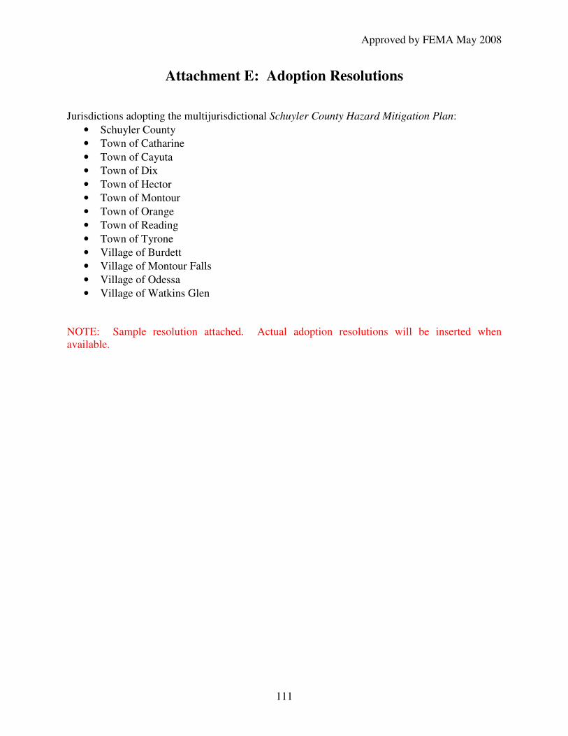
Approved by FEMA May 2008
111
Attachment E: Adoption Resolutions Jurisdictions adopting the multijurisdictional Schuyler County Hazard Mitigation Plan:
• Schuyler County
• Town of Catharine
• Town of Cayuta
• Town of Dix
• Town of Hector
• Town of Montour
• Town of Orange
• Town of Reading
• Town of Tyrone
• Village of Burdett
• Village of Montour Falls
• Village of Odessa
• Village of Watkins Glen NOTE: Sample resolution attached. Actual adoption resolutions will be inserted when available.

Approved by FEMA May 2008
112
RESOLUTION ADOPTING SCHUYLER COUNTY HAZARD MITIGATION PLAN WHEREAS, the Town / Village of ______________________, with assistance from the County of Schuyler, has gathered information and prepared the Schuyler County Hazard Mitigation Plan (the “Plan”); and WHEREAS, the Plan has been prepared in accordance with the Disaster Mitigation Act of 2000; and WHEREAS, the County of Schuyler held a public hearing affording all citizens an opportunity to comment and to provide input regarding the Plan and the actions in the Plan; and WHEREAS, the Town / Village of _____________________ Town / Village Board has reviewed the Plan and affirms that the Plan will be updated no less than every five years; now, therefore, be it RESOLVED, that the Town / Village of ________________________ Town / Village Board adopts the Plan as this jurisdiction’s natural Hazard Mitigation Plan and resolves to execute the actions in the Plan. ADOPTED this ____________________ day of ________________________, 2007.