Embed Size (px)
Citation preview
Search and Rescue TechnologySatellite Aided Search and Rescue
ICAO Global Civil Aviation Search and Rescue Forum – June 2010
Ajay Mehta, Chairman Cospas-Sarsat Council
Program
Program
Purpose
Cospas-Sarsat Overview
Technology Advances User Segment (Beacons)
Space and Ground Segment
Organizational Improvements Membership
Data Distribution
Management
Conclusions
2Satellite Aided Search and Rescue
Purpose
Provide background on Cospas-Sarsat
Discuss efforts by Cospas-Sarsat to improve satellite-aided
search and rescue technology AND efforts by Cospas-Sarsat to
make the technology more useful and reliable Introduce the term “orgware”
Set of tools, policies and procedures needed to make the best
use of technology
Without organizational and operational improvements the
technology cannot deliver the services for which it is designed
3Satellite Aided Search and Rescue

Cospas-Sarsat Overview
Vision To take the “search” out of search and rescue
Mission The International Cospas-Sarsat Programme provides accurate,
timely, and reliable distress alert and location data to help search
and rescue authorities assist persons in distress
Objective Provide distress alert and location information to “support the
objectives of the International Civil Aviation Organization and the
International Maritime Organization concerning search and rescue”
4Satellite Aided Search and Rescue

Cospas-Sarsat Overview
5Satellite Aided Search and Rescue
More than 26,000 persons rescued with the assistance of Cospas-Sarsat
Cospas-Sarsat Overview
6Satellite Aided Search and Rescue
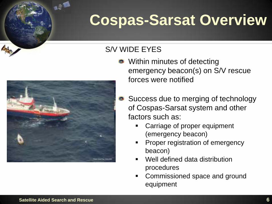
S/V WIDE EYES
Within minutes of detecting
emergency beacon(s) on S/V rescue
forces were notified
Success due to merging of technology
of Cospas-Sarsat system and other
factors such as: Carriage of proper equipment
(emergency beacon)
Proper registration of emergency
beacon)
Well defined data distribution
procedures
Commissioned space and ground
equipment
Cospas-Sarsat Overview
7Satellite Aided Search and Rescue

Cospas-Sarsat Overview
8Satellite Aided Search and Rescue
Participating Countries
Cospas-Sarsat Overview
9Satellite Aided Search and Rescue
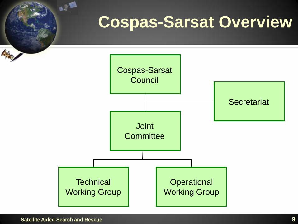
Cospas-Sarsat
Council
Joint
Committee
Operational
Working Group
Technical
Working Group
Secretariat

Technology AdvancesUser Segment (Beacons)
1970s – 121.5 MHz emergency beacons Loose specifications
Low power
No identification
Inaccurate (12-20km error) – Regional coverage
1980s – 406 MHz emergency beacons Rigid specifications
Unique identification
Designed for satellite transmission
More accurate (2-5km error) – Global coverage
1990s – 406 MHz emergency beacons with navigation input Highly accurate (100m error)
Smaller size
2010s – 406 MHz emergency beacons - new specifications10Satellite Aided Search and Rescue
11Satellite Aided Search and Rescue
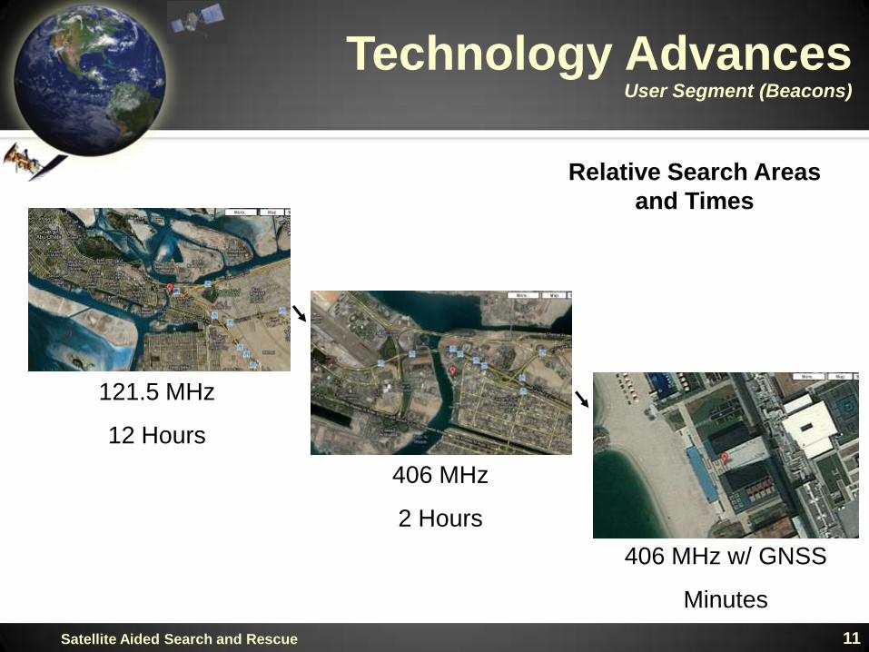
121.5 MHz
12 Hours
406 MHz
2 Hours
406 MHz w/ GNSS
Minutes
Relative Search Areas
and Times
Technology AdvancesUser Segment (Beacons)
12Satellite Aided Search and Rescue
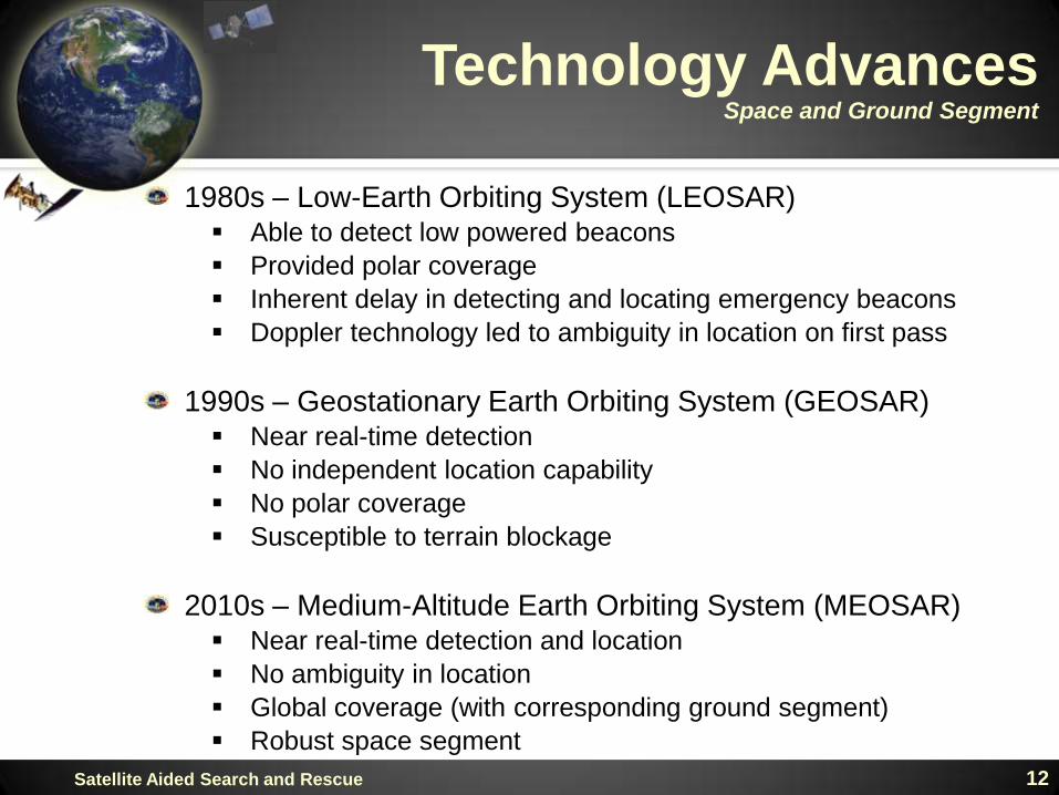
Technology AdvancesSpace and Ground Segment
1980s – Low-Earth Orbiting System (LEOSAR) Able to detect low powered beacons
Provided polar coverage
Inherent delay in detecting and locating emergency beacons
Doppler technology led to ambiguity in location on first pass
1990s – Geostationary Earth Orbiting System (GEOSAR) Near real-time detection
No independent location capability
No polar coverage
Susceptible to terrain blockage
2010s – Medium-Altitude Earth Orbiting System (MEOSAR) Near real-time detection and location
No ambiguity in location
Global coverage (with corresponding ground segment)
Robust space segment
13Satellite Aided Search and Rescue
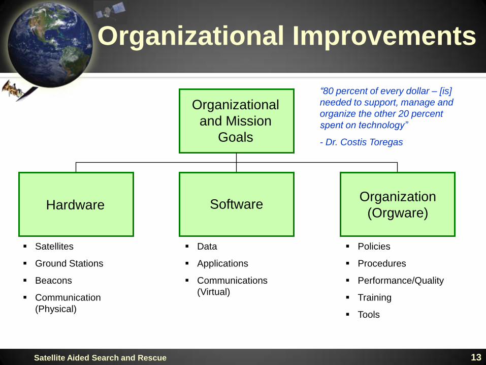
Organizational Improvements
Organizational
and Mission
Goals
SoftwareHardwareOrganization
(Orgware)
Satellites
Ground Stations
Beacons
Communication
(Physical)
Data
Applications
Communications
(Virtual)
Policies
Procedures
Performance/Quality
Training
Tools
“80 percent of every dollar – [is]
needed to support, manage and
organize the other 20 percent
spent on technology”
- Dr. Costis Toregas
14Satellite Aided Search and Rescue
Organizational ImprovementsMembership
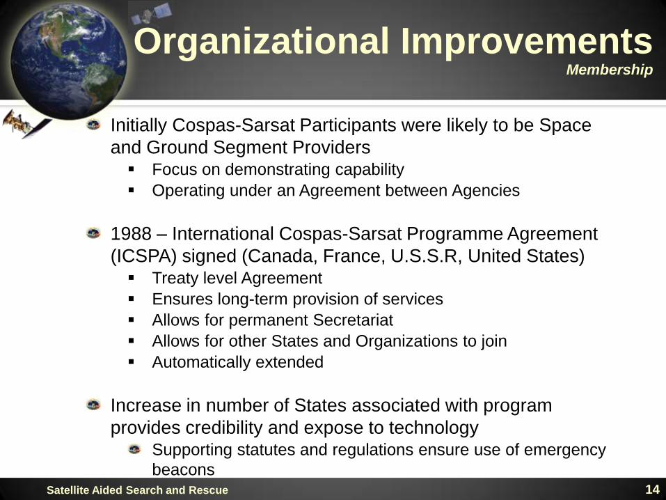
Initially Cospas-Sarsat Participants were likely to be Space
and Ground Segment Providers Focus on demonstrating capability
Operating under an Agreement between Agencies
1988 – International Cospas-Sarsat Programme Agreement
(ICSPA) signed (Canada, France, U.S.S.R, United States) Treaty level Agreement
Ensures long-term provision of services
Allows for permanent Secretariat
Allows for other States and Organizations to join
Automatically extended
Increase in number of States associated with program
provides credibility and expose to technologySupporting statutes and regulations ensure use of emergency
beacons

Number of Participating States
0
5
10
15
20
25
30
35
40
1988
1989
1990
1991
1992
1993
1994
1995
1996
1997
1998
1999
2000
2001
2002
2003
2004
2005
2006
2007
2008
2009
2010
15Satellite Aided Search and Rescue
Organizational ImprovementsMembership

16Satellite Aided Search and Rescue
Organizational ImprovementsData Distribution
Cospas-Sarsat data distribution procedures initially designed
to meet regional and national needs
Global nature of program and system required re-evaluation
of data distribution procedures – New procedures developed
in 1990s Basic principles of data distribution established
Improved validation of alerts in the ground segment
Standard procedures among States Minimizes processing of redundant data while ensuring
appropriate SAR services are informed
Facilitates backup and contingency operations
Expectation of SAR services similar
New procedures will be required for MEOSAR Will take advantage of MEOSAR capabilities
17Satellite Aided Search and Rescue
Organizational ImprovementsData Distribution
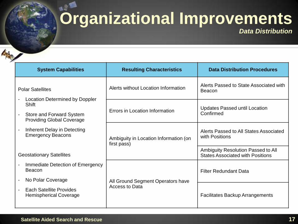
System Capabilities Resulting Characteristics Data Distribution Procedures
Polar Satellites
- Location Determined by Doppler Shift
- Store and Forward System Providing Global Coverage
- Inherent Delay in Detecting Emergency Beacons
Geostationary Satellites
- Immediate Detection of Emergency Beacon
- No Polar Coverage
- Each Satellite Provides Hemispherical Coverage
Alerts without Location InformationAlerts Passed to State Associated with Beacon
Errors in Location InformationUpdates Passed until Location Confirmed
Ambiguity in Location Information (on first pass)
Alerts Passed to All States Associated with Positions
Ambiguity Resolution Passed to All States Associated with Positions
All Ground Segment Operators have Access to Data
Filter Redundant Data
Facilitates Backup Arrangements
18Satellite Aided Search and Rescue
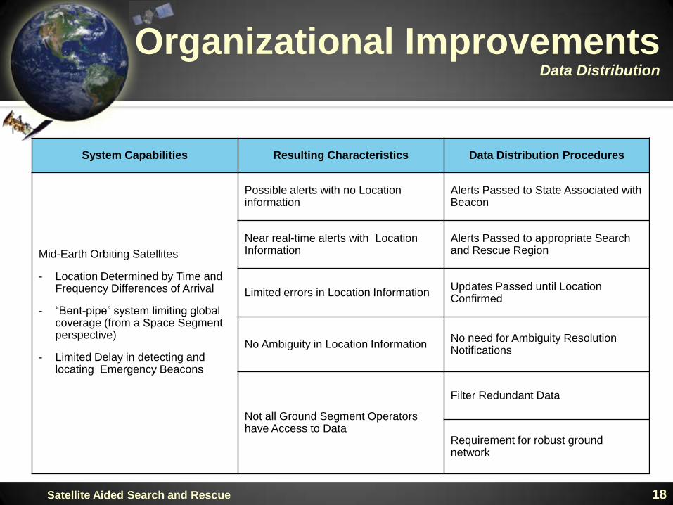
System Capabilities Resulting Characteristics Data Distribution Procedures
Mid-Earth Orbiting Satellites
- Location Determined by Time and Frequency Differences of Arrival
- “Bent-pipe” system limiting global coverage (from a Space Segment perspective)
- Limited Delay in detecting and locating Emergency Beacons
Possible alerts with no Location information
Alerts Passed to State Associated with Beacon
Near real-time alerts with Location Information
Alerts Passed to appropriate Search and Rescue Region
Limited errors in Location InformationUpdates Passed until Location Confirmed
No Ambiguity in Location InformationNo need for Ambiguity Resolution Notifications
Not all Ground Segment Operators have Access to Data
Filter Redundant Data
Requirement for robust ground network
Organizational ImprovementsData Distribution
19Satellite Aided Search and Rescue
Organizational ImprovementsManagement (Strategic Plan)
In order to provide direction for the Programme, Cospas-
Sarsat published its first Strategic Plan in 2008 Identifies key stakeholders, users and customers
Addresses user needs and needs and expectations of SAR
authorities - Performance requirements from ICAO/IMO
Identifies priorities for the program as well as challenges and
opportunities
Five goals the Programme Continuous and effective System operation
Comprehensive management structure to support System
evolution and ensure Programme continuity – Implement a
Quality Management System
Worldwide support for the Programme
Participants, users and customers use and operate the
System to its full potential
A robust industrial base to support System operations
20Satellite Aided Search and Rescue
Organizational ImprovementsManagement (Quality Management)
Quality Manual adopted by Cospas-Sarsat in 2008 Ensures the organization focuses on search and rescue
requirements and applies internationally recognized quality
management principles
Scope of Cospas-Sarsat quality management system broad
– focus on system operations and not on auditing States or
the Secretariat function Includes design, commissioning, operation and monitoring of
ground segment including communications and reference
beacons
Relevant aspects of emergency beacons and type approval as
well as spectrum management
Commissioning and monitoring of the space segment
Framework includes monitoring, measurement, assessment,
analysis, reporting and accountability
21Satellite Aided Search and Rescue
Organizational ImprovementsManagement (Quality Management)
Near real-time monitoring of space and ground segments Availability of ground segment components
Location accuracy of Doppler solutions
Periodic tests of communication links including those
between Mission Control Centers and SAR Points of
Contacts SPOC test highlights issues with delivering data to responders
164 tests with SPOCs between October 2008 and April 2010
11 (6.7%) never acknowledged receipt of test
communication
38 (23.2%) acknowledged receipt less than 50% of the
time
Cospas-Sarsat developing on-line data collection to facilitate
reporting
Working with IMO to address issue

22Satellite Aided Search and Rescue
Organizational ImprovementsManagement (Training)
New training Handbook Handbook on Distress Alert Messages for Rescue
Coordination Centres (RCCs), Search and Rescue Points of
Contact (SPOCs) and IMO Ship Security Competent
Authorities – C/S G.007
Provides an overview of the system Space and ground segment
Beacons
Designed to help improve understanding of types and
contents of distress message
Goal is to make the system more effective
23Satellite Aided Search and Rescue
Organizational ImprovementsManagement (Registration Database)
Cospas-Sarsat maintains an International Registration
Database for 406 MHz emergency beacons Designed for States who do not maintain beacon registries
accessible on a 24x7 basis
Assists States in meeting their ICAO and IMO obligations
Since its inception more than 18,000 406 MHz emergency
beacons have been registered
Provided by 102 different Administrations
Search and rescue personnel access the database an
average of 250 times a month
Cospas-Sarsat to update International Registration Database
based on its success to date
24Satellite Aided Search and Rescue
Conclusions
Technology promises to help take the “search” out of search
and rescue
Technology does not overcome insufficiently trained and
committed human responders
Organizational improvements to improve service delivery are
essential to realize full benefit of technology
Cospas-Sarsat has taken significant steps to improve not
only the technology but to improve its service delivery

25Satellite Aided Search and Rescue
Backup
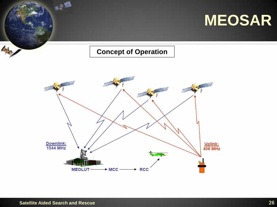
MEOSAR
26Satellite Aided Search and Rescue
Concept of Operation
MEOSAR
27Satellite Aided Search and Rescue
Continuous Earth coverage – no waiting for satellites to come into view Major improvement over current system (three-minute to eight-hour delay depending
on latitude and terrain)
Minimizes signal blockage by terrain features
Location can be derived from single burst Can locate beacon in danger of being destroyed (e.g., fire, sinking ship)
Improved system reliability Failure of one or two system elements will not dramatically affect system performance
Improved location accuracy Average accuracy anticipated to decrease from 3.1 to 1.7 kilometers
Lower life-cycle costs
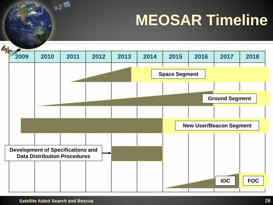
MEOSAR Timeline
28
2009 2010 2011 2012 2013 2014 2015 2016 2017 2018
FOCIOC
Space Segment
Ground Segment
New User/Beacon Segment
Development of Specifications and
Data Distribution Procedures
Satellite Aided Search and Rescue
Orgware
29Satellite Aided Search and Rescue
Policy
International Cospas-Sarsat Programme Agreement High level association from each member State – ensures
individual programs have appropriate visibility, management
attention and resources
Supporting statutes and regulations in member States for
carriage and certification of emergency beacons Ensures that no matter where you buy or use an emergency
beacon, it will meet a certain level of performance and be able
to be processed by the SAR system
Orgware
30Satellite Aided Search and Rescue
Procedures
Data distribution concept evolved to common procedures for
exchange of data Minimizes process of redundant data
Keep appropriate SAR services informed
Allows for easy backup and contingency operations
Expectations of SAR services similar
Minimum performance specifications and design guidelines Ensure interoperability
Ensures minimum level of performance
Assist in integration of technology
Orgware
31Satellite Aided Search and Rescue
Procedures
Commissioning of equipment Ensure interoperability
Ensures minimum level of performance
Beacon specification and type approval Ensures interoperability between space and ground segments
Ensures consistent processing and performance
Ensures users can have similar expectations

Orgware
32Satellite Aided Search and Rescue
Performance/Quality
Performance management Ensures technology is meeting its intended goals
Monitoring and reporting Maintains interoperability
Identifies proper (e.g., most important) system elemetns to
monitor