Embed Size (px)
Citation preview
Construction Programme Board
Diploma in Land Surveying (EG423104P)
21 Definitive Programme Document
SECTION TWO – MODULE SYLLABUSES
1 CON3068X Land Surveying Theory A
2 CON3069X Land Surveying Theory B
3 CON3070X Mapping and Plotting A
4 CON3071X Mapping and Plotting B
5 CON3072X Practical Surveying
6 CON4094X Field Camp
7 CON3074X Mathematics for Engineering Survey
8 Summary of Module Assessment Schemes
Construction Programme Board
Diploma in Land Surveying (EG423104P)
22 Definitive Programme Document
Module Syllabus
Module Title Land Surveying Theory A
Module Code CON3068X
QF Credits 10
QF Level 3
Notional Learning Hours
102
Contact Hours: 30
Lecture: 24; Tutorial: 6
Self-study Hours: 70
Assessment Hours: 2
(Outside Contact/Self-study Hours)
Pre-requisite Nil
Co-requisite Nil
Anti-requisite Nil
Exemption Criteria Nil
Module Intended Learning Outcomes:
On completion of the module, learners are expected to be able to:
1. Explain the basic surveying terms used in current practice.
2. Adopt various correction calculations to illustrate a comprehension of method of direct
linear measurement.
3. Demonstrate a working competence in data acquisition with reference to sources of
vertical control.
4. Measure horizontal and vertical angles using theodolite, compute the recorded data, and
deduce final result of the survey.
Construction Programme Board
Diploma in Land Surveying (EG423104P)
23 Definitive Programme Document
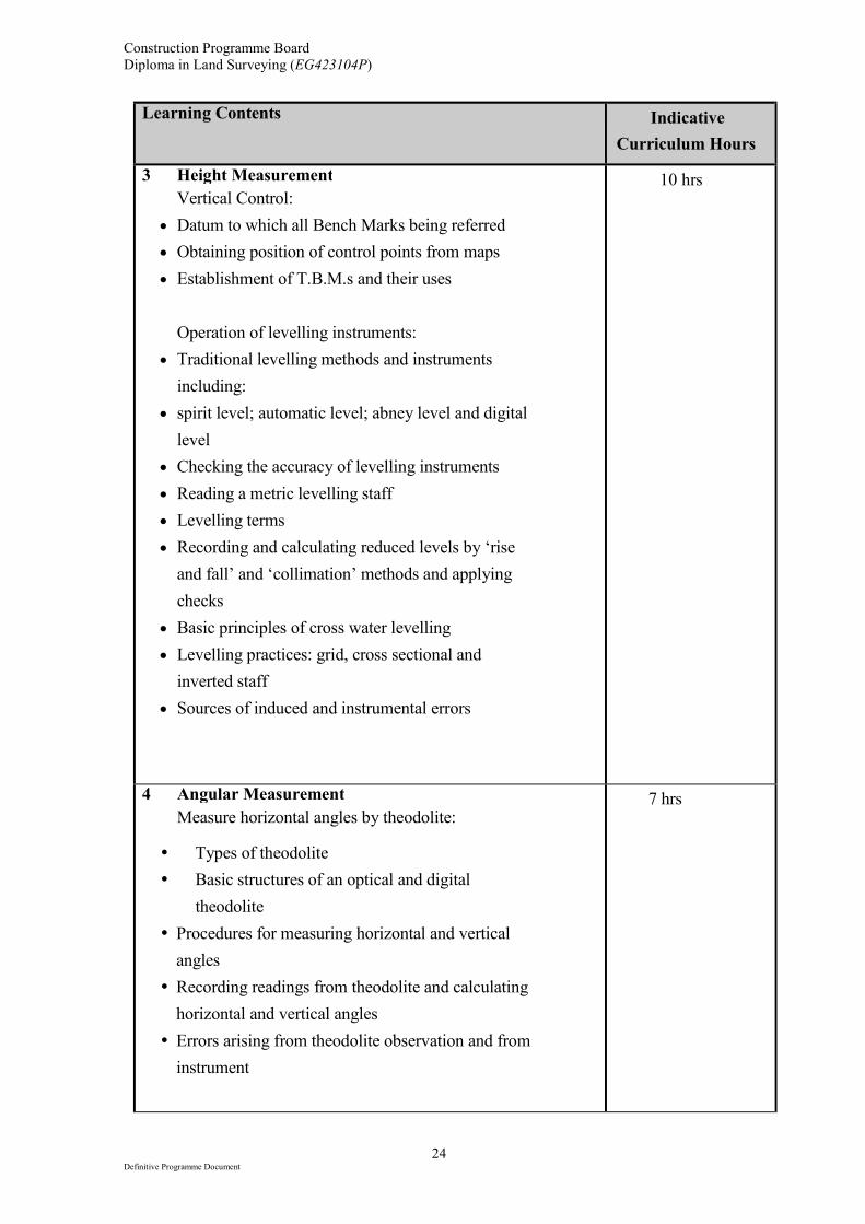
Learning Contents and Indicative Contact Hours:
Learning Contents Indicative
Curriculum Hours
1 Basic Principles
• Surveying, level plane, linear measurement, height,
angular measurement
• Trilateration, triangulation, polar co-ordinates,
control
• Principle of working from the whole to the part
• Accuracy and precision
• Types and characteristics of errors
3 hrs
2 Linear Measurement
• Measuring tools: steel tapes and fibre glass tapes
• Corrections to be applied to steel tape measurement
and measurement of a long line
• Application of wave propagation to electromagnetic
distance measurement (EDM)
• Corrections for EDM, procedures for calibrating
EDM and total stations
• Uses of steel tapes, fibre glass tapes, EDM/total
stations
• Applying basic principles of linear measurement to
locate details using steel tapes and fibre glass tapes
only
• Hand instruments: optical squares, abney levels,
compasses
7 hrs
Construction Programme Board
Diploma in Land Surveying (EG423104P)
24 Definitive Programme Document
Learning Contents Indicative
Curriculum Hours
3 Height Measurement
Vertical Control:
• Datum to which all Bench Marks being referred
• Obtaining position of control points from maps
• Establishment of T.B.M.s and their uses
Operation of levelling instruments:
• Traditional levelling methods and instruments
including:
• spirit level; automatic level; abney level and digital
level
• Checking the accuracy of levelling instruments
• Reading a metric levelling staff
• Levelling terms
• Recording and calculating reduced levels by ‘rise
and fall’ and ‘collimation’ methods and applying
checks
• Basic principles of cross water levelling
• Levelling practices: grid, cross sectional and
inverted staff
• Sources of induced and instrumental errors
10 hrs
4 Angular Measurement
Measure horizontal angles by theodolite:
� Types of theodolite
� Basic structures of an optical and digital
theodolite
� Procedures for measuring horizontal and vertical
angles
� Recording readings from theodolite and calculating
horizontal and vertical angles
� Errors arising from theodolite observation and from
instrument
7 hrs
Construction Programme Board
Diploma in Land Surveying (EG423104P)
25 Definitive Programme Document
Learning Contents Indicative
Curriculum Hours
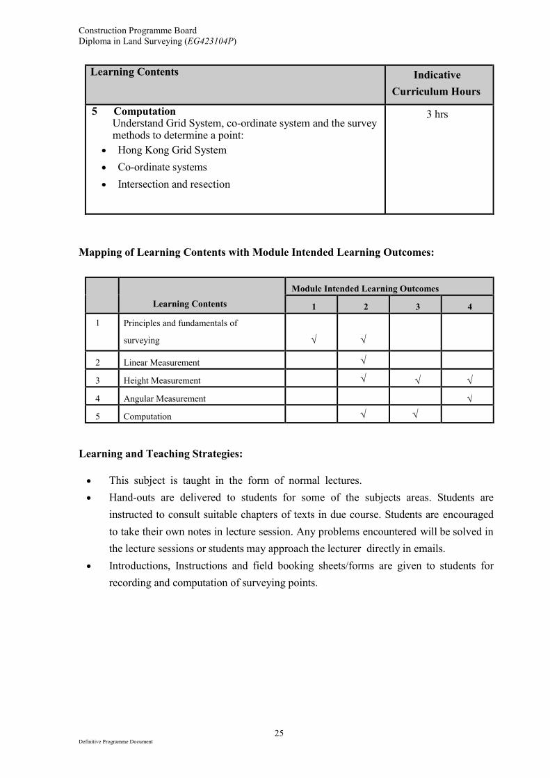
5 Computation Understand Grid System, co-ordinate system and the survey methods to determine a point:
• Hong Kong Grid System
• Co-ordinate systems
• Intersection and resection
3 hrs
Mapping of Learning Contents with Module Intended Learning Outcomes:
Learning Contents
Module Intended Learning Outcomes
1 2 3 4
1 Principles and fundamentals of
surveying
√
√
2 Linear Measurement √
3 Height Measurement √ √ √
4 Angular Measurement √
5 Computation √ √
Learning and Teaching Strategies:
• This subject is taught in the form of normal lectures.
• Hand-outs are delivered to students for some of the subjects areas. Students are
instructed to consult suitable chapters of texts in due course. Students are encouraged
to take their own notes in lecture session. Any problems encountered will be solved in
the lecture sessions or students may approach the lecturer directly in emails.
• Introductions, Instructions and field booking sheets/forms are given to students for
recording and computation of surveying points.
Construction Programme Board
Diploma in Land Surveying (EG423104P)
26 Definitive Programme Document
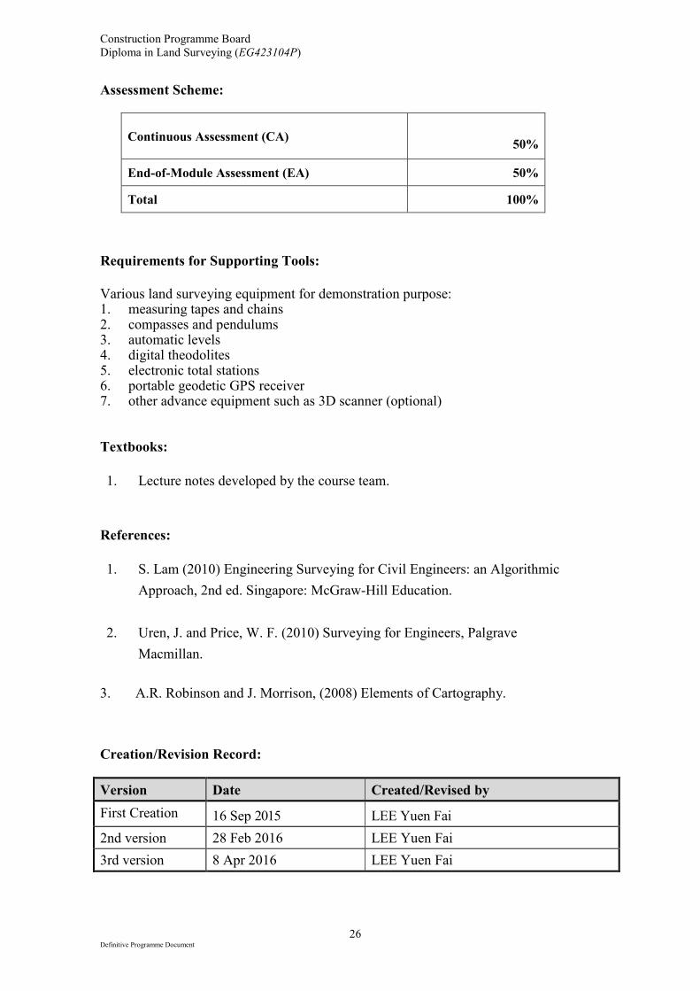
Assessment Scheme:
Continuous Assessment (CA)
50%
End-of-Module Assessment (EA) 50%
Total 100%
Requirements for Supporting Tools:
Various land surveying equipment for demonstration purpose: 1. measuring tapes and chains 2. compasses and pendulums 3. automatic levels 4. digital theodolites 5. electronic total stations 6. portable geodetic GPS receiver 7. other advance equipment such as 3D scanner (optional) Textbooks:
1. Lecture notes developed by the course team.
References:
1. S. Lam (2010) Engineering Surveying for Civil Engineers: an Algorithmic
Approach, 2nd ed. Singapore: McGraw-Hill Education.
2. Uren, J. and Price, W. F. (2010) Surveying for Engineers, Palgrave
Macmillan.
3. A.R. Robinson and J. Morrison, (2008) Elements of Cartography. Creation/Revision Record:
Version Date Created/Revised by
First Creation 16 Sep 2015 LEE Yuen Fai
2nd version 28 Feb 2016 LEE Yuen Fai
3rd version 8 Apr 2016 LEE Yuen Fai
Construction Programme Board
Diploma in Land Surveying (EG423104P)
27 Definitive Programme Document
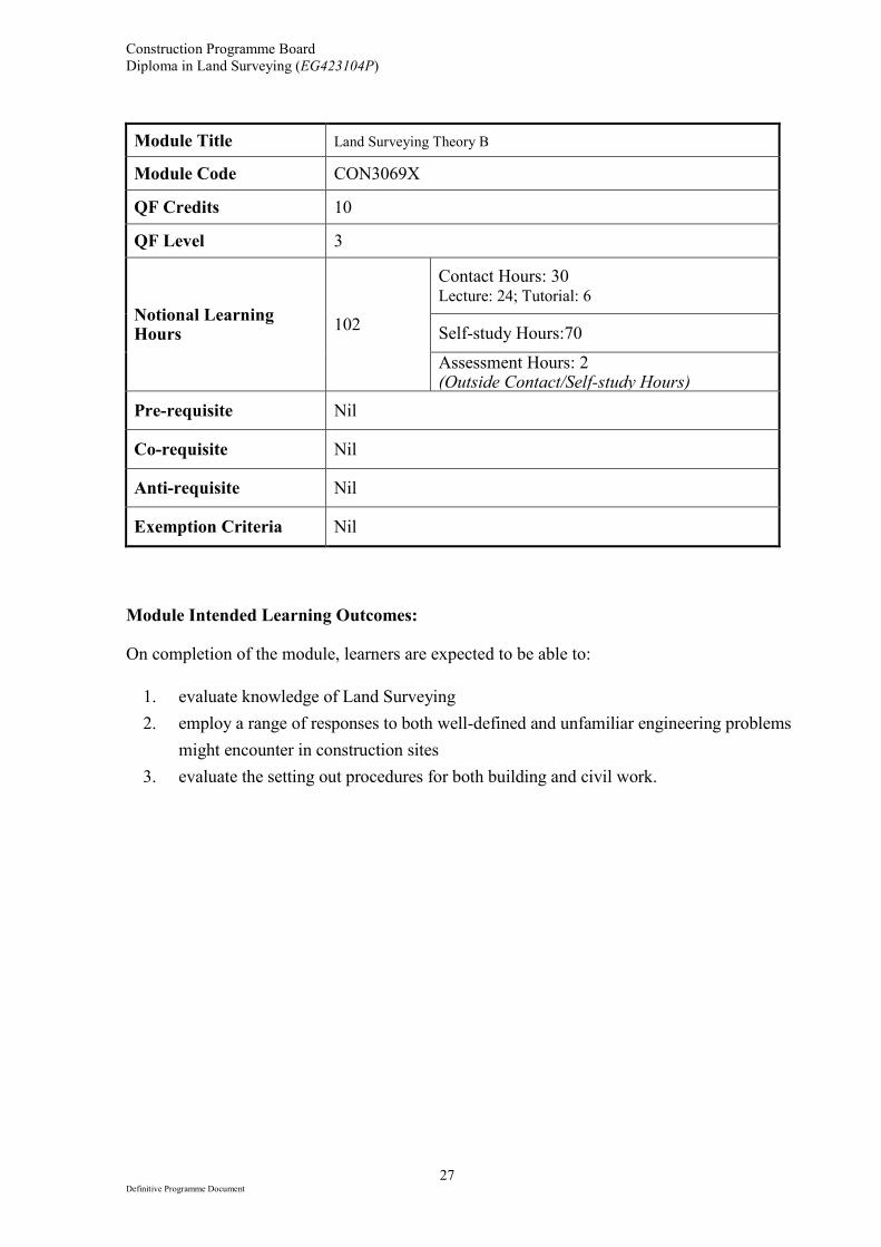
Module Title Land Surveying Theory B
Module Code CON3069X
QF Credits 10
QF Level 3
Notional Learning Hours
102
Contact Hours: 30 Lecture: 24; Tutorial: 6
Self-study Hours:70
Assessment Hours: 2 (Outside Contact/Self-study Hours)
Pre-requisite Nil
Co-requisite Nil
Anti-requisite Nil
Exemption Criteria Nil
Module Intended Learning Outcomes: On completion of the module, learners are expected to be able to:
1. evaluate knowledge of Land Surveying
2. employ a range of responses to both well-defined and unfamiliar engineering problems
might encounter in construction sites
3. evaluate the setting out procedures for both building and civil work.
Construction Programme Board
Diploma in Land Surveying (EG423104P)
28 Definitive Programme Document
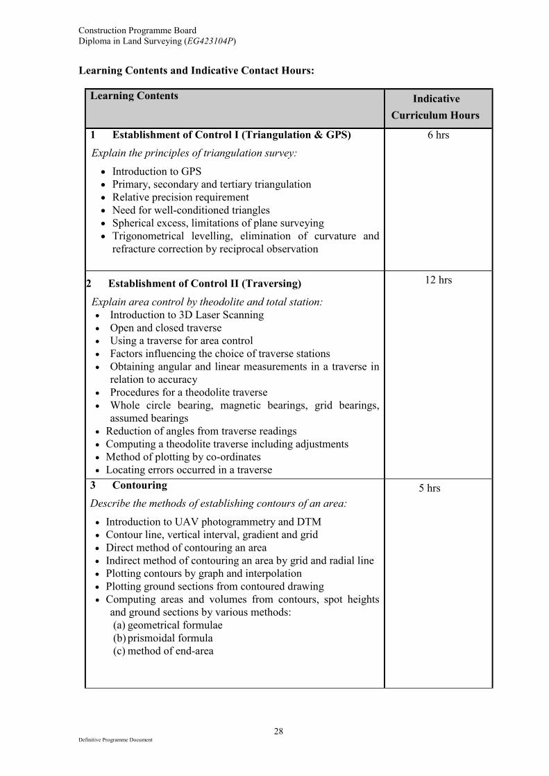
Learning Contents and Indicative Contact Hours:
Learning Contents Indicative
Curriculum Hours
1 Establishment of Control I (Triangulation & GPS)
Explain the principles of triangulation survey:
• Introduction to GPS
• Primary, secondary and tertiary triangulation
• Relative precision requirement
• Need for well-conditioned triangles
• Spherical excess, limitations of plane surveying
• Trigonometrical levelling, elimination of curvature and
refracture correction by reciprocal observation
6 hrs
2 Establishment of Control II (Traversing)
Explain area control by theodolite and total station:
• Introduction to 3D Laser Scanning
• Open and closed traverse
• Using a traverse for area control
• Factors influencing the choice of traverse stations
• Obtaining angular and linear measurements in a traverse in
relation to accuracy
• Procedures for a theodolite traverse
• Whole circle bearing, magnetic bearings, grid bearings,
assumed bearings
• Reduction of angles from traverse readings
• Computing a theodolite traverse including adjustments
• Method of plotting by co-ordinates
• Locating errors occurred in a traverse
12 hrs
3 Contouring
Describe the methods of establishing contours of an area:
• Introduction to UAV photogrammetry and DTM
• Contour line, vertical interval, gradient and grid
• Direct method of contouring an area
• Indirect method of contouring an area by grid and radial line
• Plotting contours by graph and interpolation
• Plotting ground sections from contoured drawing
• Computing areas and volumes from contours, spot heights
and ground sections by various methods:
(a) geometrical formulae
(b) prismoidal formula
(c) method of end-area
5 hrs
Construction Programme Board
Diploma in Land Surveying (EG423104P)
29 Definitive Programme Document
Learning Contents Indicative
Curriculum Hours
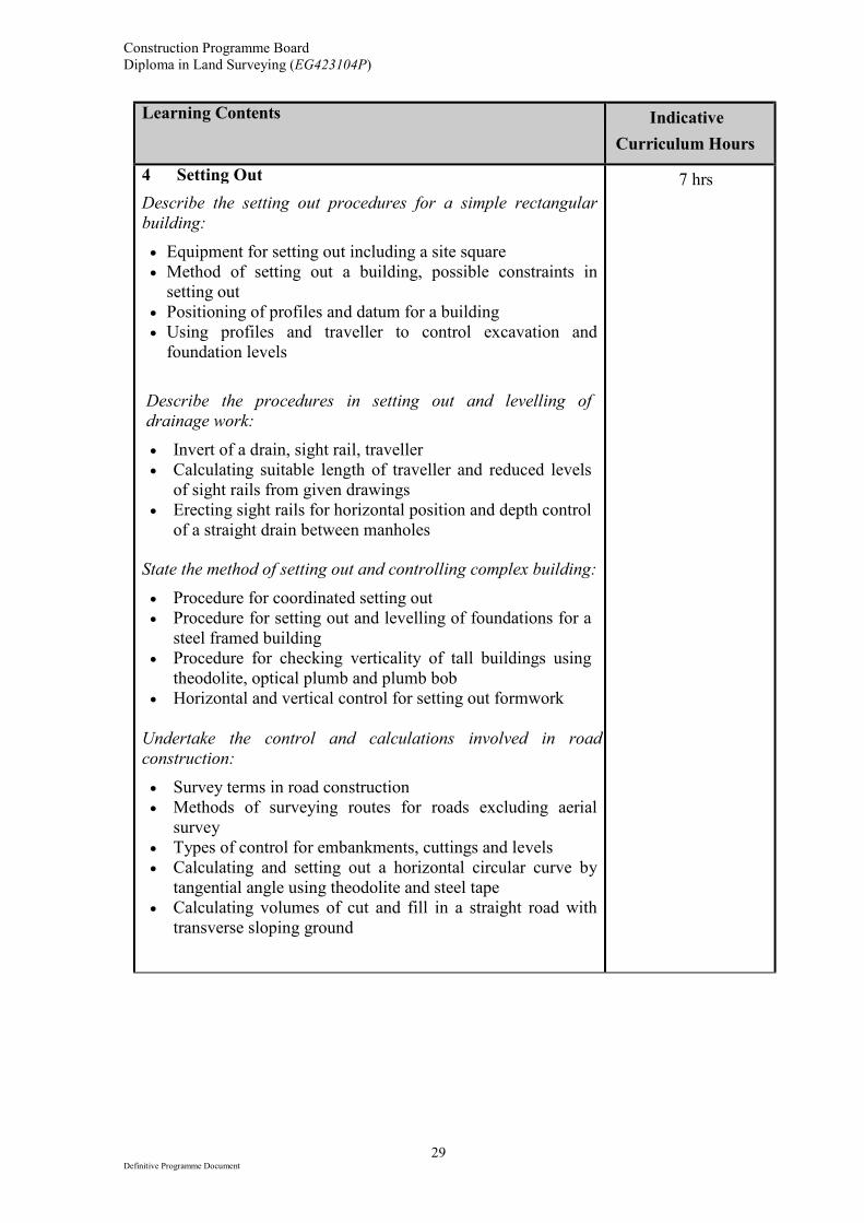
4 Setting Out
Describe the setting out procedures for a simple rectangular
building:
• Equipment for setting out including a site square
• Method of setting out a building, possible constraints in
setting out
• Positioning of profiles and datum for a building
• Using profiles and traveller to control excavation and
foundation levels
Describe the procedures in setting out and levelling of
drainage work:
• Invert of a drain, sight rail, traveller
• Calculating suitable length of traveller and reduced levels
of sight rails from given drawings
• Erecting sight rails for horizontal position and depth control
of a straight drain between manholes
State the method of setting out and controlling complex building:
• Procedure for coordinated setting out
• Procedure for setting out and levelling of foundations for a
steel framed building
• Procedure for checking verticality of tall buildings using
theodolite, optical plumb and plumb bob
• Horizontal and vertical control for setting out formwork
Undertake the control and calculations involved in road
construction:
• Survey terms in road construction
• Methods of surveying routes for roads excluding aerial
survey
• Types of control for embankments, cuttings and levels
• Calculating and setting out a horizontal circular curve by
tangential angle using theodolite and steel tape
• Calculating volumes of cut and fill in a straight road with
transverse sloping ground
7 hrs
Construction Programme Board
Diploma in Land Surveying (EG423104P)
30 Definitive Programme Document
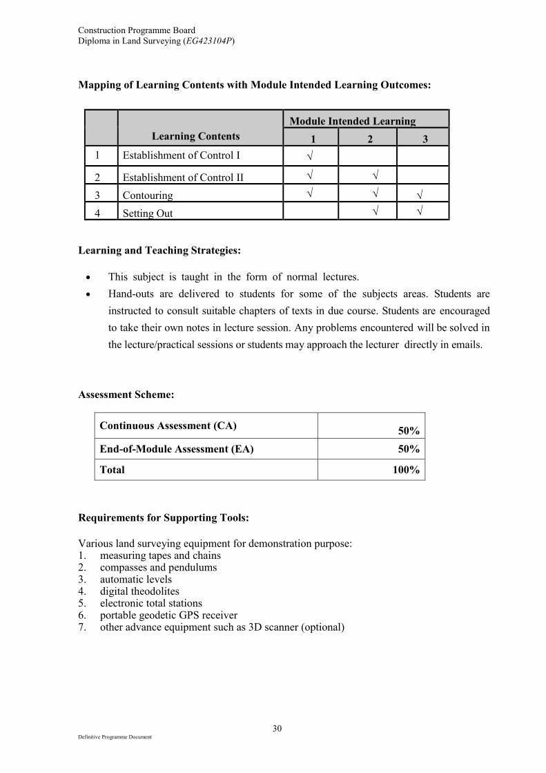
Mapping of Learning Contents with Module Intended Learning Outcomes:
Learning Contents
Module Intended Learning
1 2 3
1 Establishment of Control I √
2 Establishment of Control II √ √
3 Contouring √ √ √
4 Setting Out √ √
Learning and Teaching Strategies:
• This subject is taught in the form of normal lectures.
• Hand-outs are delivered to students for some of the subjects areas. Students are
instructed to consult suitable chapters of texts in due course. Students are encouraged
to take their own notes in lecture session. Any problems encountered will be solved in
the lecture/practical sessions or students may approach the lecturer directly in emails.
Assessment Scheme:
Continuous Assessment (CA)
50%
End-of-Module Assessment (EA) 50%
Total 100%
Requirements for Supporting Tools:
Various land surveying equipment for demonstration purpose: 1. measuring tapes and chains 2. compasses and pendulums 3. automatic levels 4. digital theodolites 5. electronic total stations 6. portable geodetic GPS receiver 7. other advance equipment such as 3D scanner (optional)
Construction Programme Board
Diploma in Land Surveying (EG423104P)
31 Definitive Programme Document
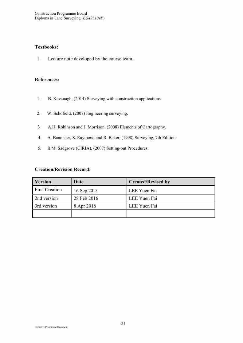
Textbooks:
1. Lecture note developed by the course team.
References:
1.
2.
B. Kavanagh, (2014) Surveying with construction applications
Lam W. Schofield, (2007) Engineering surveying.
3 A.H. Robinson and J. Morrison, (2008) Elements of Cartography.
4. A. Bannister, S. Raymond and R. Baker, (1998) Surveying, 7th Edition.
5. B.M. Sadgrove (CIRIA), (2007) Setting-out Procedures.
Creation/Revision Record:
Version Date Created/Revised by
First Creation 16 Sep 2015 LEE Yuen Fai
2nd version 28 Feb 2016 LEE Yuen Fai
3rd version 8 Apr 2016 LEE Yuen Fai
Construction Programme Board
Diploma in Land Surveying (EG423104P)
32 Definitive Programme Document
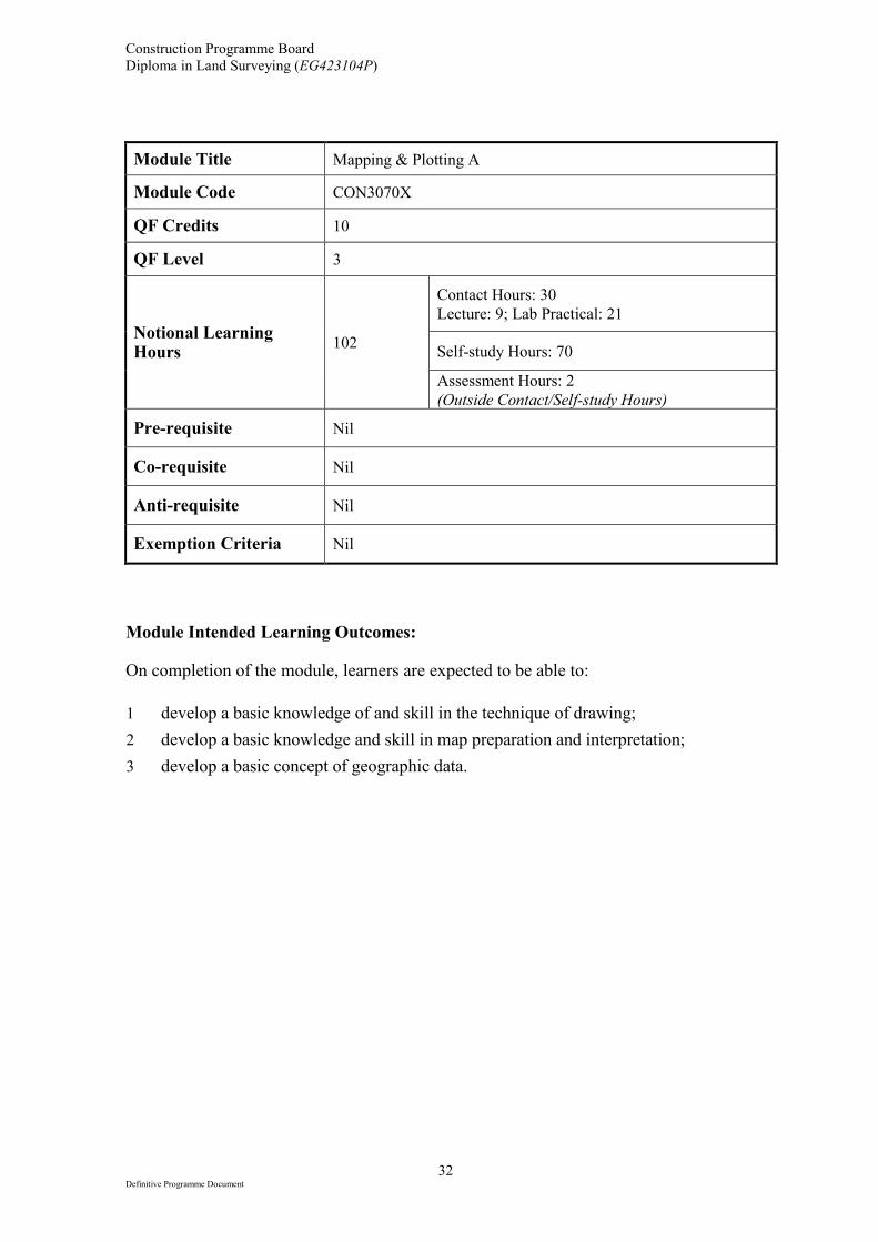
Module Title Mapping & Plotting A
Module Code CON3070X
QF Credits 10
QF Level 3
Notional Learning Hours
102
Contact Hours: 30
Lecture: 9; Lab Practical: 21
Self-study Hours: 70
Assessment Hours: 2
(Outside Contact/Self-study Hours)
Pre-requisite Nil
Co-requisite Nil
Anti-requisite Nil
Exemption Criteria Nil
Module Intended Learning Outcomes: On completion of the module, learners are expected to be able to:
1 develop a basic knowledge of and skill in the technique of drawing;
2 develop a basic knowledge and skill in map preparation and interpretation;
3 develop a basic concept of geographic data.
Construction Programme Board
Diploma in Land Surveying (EG423104P)
33 Definitive Programme Document
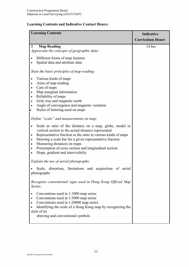
Learning Contents and Indicative Contact Hours:
Learning Contents Indicative
Curriculum Hours
1 Map Reading
Appreciate the concepts of geographic data:
• Different forms of map features
• Spatial data and attribute data
State the basic principles of map reading:
• Various kinds of maps
• Aims of map reading
• Care of maps
• Map marginal information
• Reliability of maps
• Grid, true and magnetic north
• Angle of convergence and magnetic variation
• Styles of lettering used on maps
Define “scale” and measurements on map:
• Scale as ratio of the distance on a map, globe, model or
vertical section to the actual distance represented
• Representative fraction as the ratio in various kinds of maps
• Drawing a scale bar for a given representative fraction
• Measuring distances on maps
• Presentation of cross section and longitudinal section
• Slope, gradient and intervisibiliy
Explain the use of aerial photographs:
• Scale, distortion, limitations and acquisition of aerial
photographs
Recognize conventional signs used in Hong Kong Official Map
Series:
• Conventions used in 1:1000 map series
• Conventions used in 1:5000 map series
• Conventions used in 1:20000 map series
• Identifying the scale of a Hong Kong map by recognizing the
style of its
drawing and conventional symbols
14 hrs
Construction Programme Board
Diploma in Land Surveying (EG423104P)
34 Definitive Programme Document
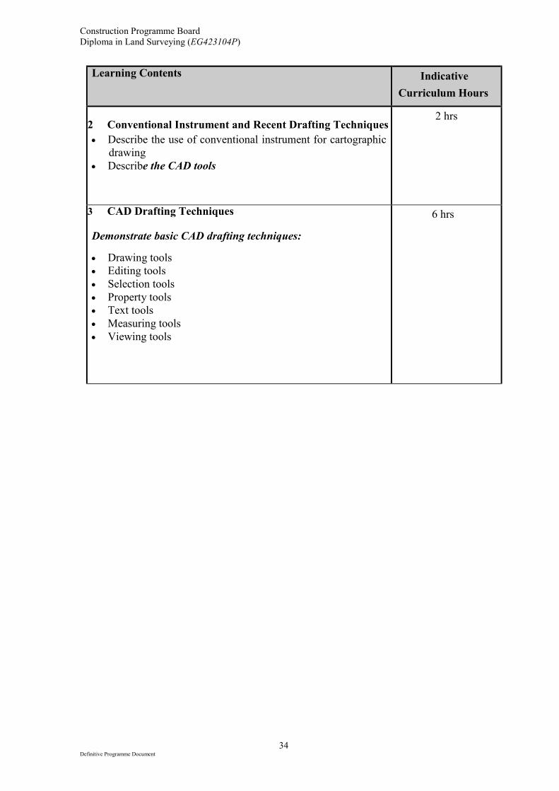
Learning Contents Indicative
Curriculum Hours
2 Conventional Instrument and Recent Drafting Techniques
• Describe the use of conventional instrument for cartographic
drawing
• Describe the CAD tools
2 hrs
3 CAD Drafting Techniques
Demonstrate basic CAD drafting techniques:
• Drawing tools
• Editing tools
• Selection tools
• Property tools
• Text tools
• Measuring tools
• Viewing tools
6 hrs
Construction Programme Board
Diploma in Land Surveying (EG423104P)
35 Definitive Programme Document
Learning Contents Indicative
Curriculum Hours
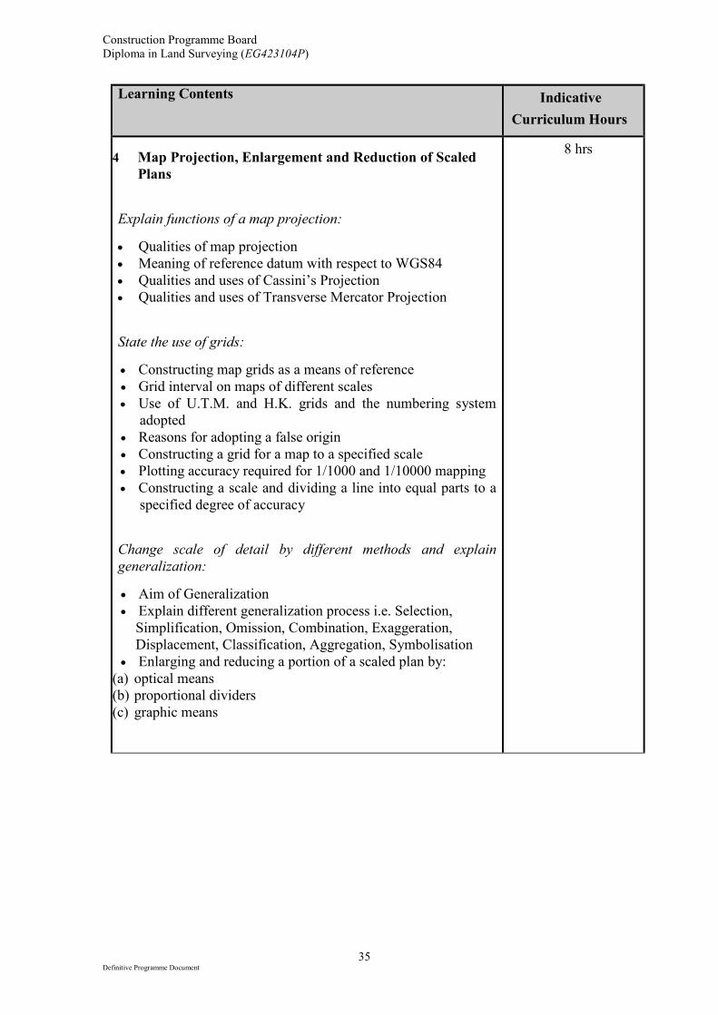
4 Map Projection, Enlargement and Reduction of Scaled
Plans
Explain functions of a map projection:
• Qualities of map projection
• Meaning of reference datum with respect to WGS84
• Qualities and uses of Cassini’s Projection
• Qualities and uses of Transverse Mercator Projection
State the use of grids:
• Constructing map grids as a means of reference
• Grid interval on maps of different scales
• Use of U.T.M. and H.K. grids and the numbering system
adopted
• Reasons for adopting a false origin
• Constructing a grid for a map to a specified scale
• Plotting accuracy required for 1/1000 and 1/10000 mapping
• Constructing a scale and dividing a line into equal parts to a
specified degree of accuracy
Change scale of detail by different methods and explain
generalization:
• Aim of Generalization
• Explain different generalization process i.e. Selection,
Simplification, Omission, Combination, Exaggeration,
Displacement, Classification, Aggregation, Symbolisation
• Enlarging and reducing a portion of a scaled plan by:
(a) optical means
(b) proportional dividers
(c) graphic means
8 hrs

Construction Programme Board
Diploma in Land Surveying (EG423104P)
36 Definitive Programme Document
Mapping of Learning Contents with Module Intended Learning Outcomes:
Learning Contents
Module Intended Learning Outcomes
1 2 3
1 Map Reading √
2 Conventional Instrument and Recent
Drafting Techniques
√
3 CAD Drafting Techniques √ √
4 Map Projection, Enlargement and
Reduction of Scaled Plans
√
Learning and Teaching Strategies:
• This subject is taught in the form of normal lectures which are reinforced with
practical work in the appropriate areas.
• Hand-outs are delivered to students for some of the subjects areas. Students are
instructed to consult suitable chapters of texts in due course. Students are encouraged
to take their own notes in lecture session. Any problems encountered will be solved in
the lecture/practical sessions or students may approach the lecturer directly in emails.
• Introductions, Instructions and software menu are given to students prior to
lab/workshop. Students may prepare for their works in advance.
• Students may have extra laboratory sessions outside the curriculum contact hours.
Assessment Scheme:
Continuous Assessment (CA)
50%
End-of-Module Assessment (EA) 50%
Total 100%
Construction Programme Board
Diploma in Land Surveying (EG423104P)
37 Definitive Programme Document
Requirements for Supporting Tools:
1. Computer installed with AutoCAD Textbooks:
1. In-house notes developed by the course team.
References:
1. Anson, 2nd
Edition, ICA, Basic Cartography for Students and Technicians Vol. I.
2. A.H. Robinson and J. Morrison, (2008) Elements of Cartography.
3. 蔡孟裔等編著 , 高等教育出版社, (2008) 新編地圖學教程.
4. S. Bryant,, Autodesk AutoCAD 2015.
5. H. Munir M, AutoCAD 2015 essentials.
Creation/Revision Record:
Version Date Created/Revised by
First Creation 16 Sep 2015 LEE Yuen Fai
2nd version 28 Feb 2016 LEE Yuen Fai
Construction Programme Board
Diploma in Land Surveying (EG423104P)
38 Definitive Programme Document
Module Title Mapping & Plotting B
Module Code CON3071X
QF Credits 10
QF Level 3
Notional Learning Hours
100
Contact Hours: 30
Lecture: 9; Lab Practical: 21
Self-study Hours: 70
Assessment Hours: NA
(Outside Contact/Self-study Hours)
Pre-requisite Nil
Co-requisite Nil
Anti-requisite Nil
Exemption Criteria Nil
Module Intended Learning Outcomes: On completion of the module, learners are expected to be able to:
1. develop a basic knowledge of and skill in the technique of drawing using computer CAD
programs and CAD based civil engineering software.
2. present survey data by means of Geographic Information System.
Construction Programme Board
Diploma in Land Surveying (EG423104P)
39 Definitive Programme Document
Learning Contents and Indicative Contact Hours:
Learning Contents Indicative
Curriculum Hours
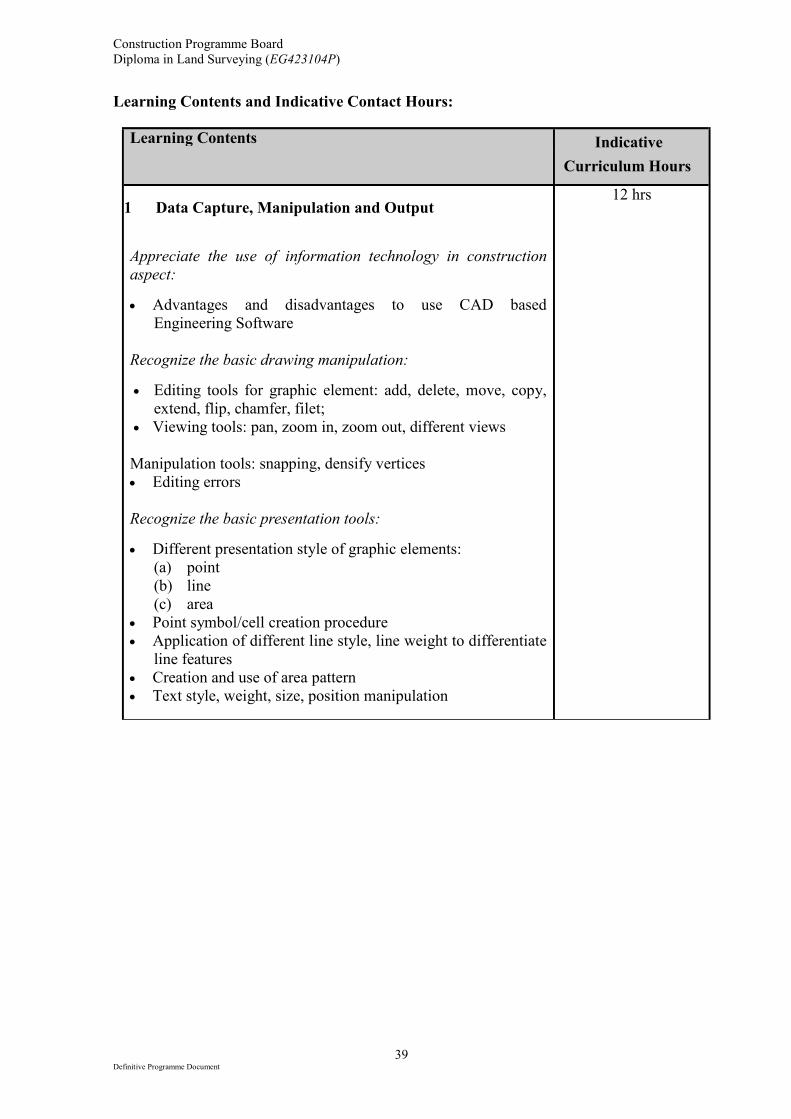
1 Data Capture, Manipulation and Output
Appreciate the use of information technology in construction
aspect:
• Advantages and disadvantages to use CAD based
Engineering Software
Recognize the basic drawing manipulation:
• Editing tools for graphic element: add, delete, move, copy,
extend, flip, chamfer, filet;
• Viewing tools: pan, zoom in, zoom out, different views
Manipulation tools: snapping, densify vertices
• Editing errors
Recognize the basic presentation tools:
• Different presentation style of graphic elements:
(a) point
(b) line
(c) area
• Point symbol/cell creation procedure
• Application of different line style, line weight to differentiate
line features
• Creation and use of area pattern
• Text style, weight, size, position manipulation
12 hrs
Construction Programme Board
Diploma in Land Surveying (EG423104P)
40 Definitive Programme Document
Learning Contents Indicative
Curriculum Hours
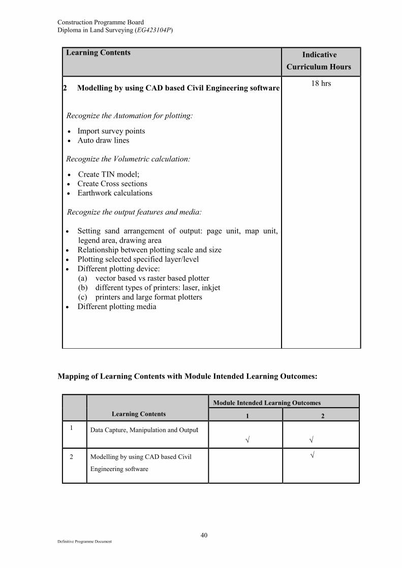
2 Modelling by using CAD based Civil Engineering software
Recognize the Automation for plotting:
• Import survey points
• Auto draw lines
Recognize the Volumetric calculation:
• Create TIN model;
• Create Cross sections
• Earthwork calculations
Recognize the output features and media:
• Setting sand arrangement of output: page unit, map unit,
legend area, drawing area
• Relationship between plotting scale and size
• Plotting selected specified layer/level
• Different plotting device:
(a) vector based vs raster based plotter
(b) different types of printers: laser, inkjet
(c) printers and large format plotters
• Different plotting media
18 hrs
Mapping of Learning Contents with Module Intended Learning Outcomes:
Learning Contents
Module Intended Learning Outcomes
1 2
1 Data Capture, Manipulation and Output
√
√
2 Modelling by using CAD based Civil
Engineering software
√
Construction Programme Board
Diploma in Land Surveying (EG423104P)
41 Definitive Programme Document
Learning and Teaching Strategies:
• This subject is taught in the form of normal lectures which are reinforced with
practical work in the appropriate areas.
• Hand-outs are delivered to students for some of the subjects areas. Students are
instructed to consult suitable chapters of texts in due course. Students are encouraged
to take their own notes in lecture session. Any problems encountered will be solved in
the lecture/practical sessions or students may approach the lecturer directly in emails.
• Introductions, Instructions and software menu are given to students prior to
lab/workshop. Students may prepare for their works in advance.
• Students may have extra laboratory sessions outside the curriculum contact hours.
Assessment Scheme:
Continuous Assessment (CA)
50%
End-of-Module Assessment (EA) 50%
Total 100%
Requirements for Supporting Tools:
1. Computer installed with AutoCAD and CIVIL 3D softwares
2. advanced 3D scanner (optional) and relevant softwares, such as point cloud
3. Computer support: workstation running latest 64-bit with 8GB RAM with Dedicated video
card (Quadro® FX professional graphics display) with hardware support for DirectX 9 (or
later).
Textbooks:
1. In-house notes developed by the course team.
References:
1. S. Bryant,, Autodesk AutoCAD 2015.
2. H. Munir M, AutoCAD 2015 essentials.
3. G. Ralph, The illustrated AutoCAD 2011 quick reference.
4. Cyndy Davenport, Mastering AutoCAD Civil 3D 2016.
Creation/Revision Record:
Version Date Created/Revised by
First Creation 16 Sep 2015 LEE Yuen Fai
2nd version 28 Feb 2016 LEE Yuen Fai
3rd version 8 Apr 2016 LEE Yuen Fai
Construction Programme Board
Diploma in Land Surveying (EG423104P)
42 Definitive Programme Document
Module Title Practical Surveying
Module Code CON3072X
QF Credits 10
QF Level 3
Notional Learning Hours
100
Contact Hours: 30
Practical: 24 ; Tutorial: 6
Self-study Hours: 70
Assessment Hours: NA
(Outside Contact/Self-study Hours)
Pre-requisite Nil
Co-requisite Nil
Anti-requisite Nil
Exemption Criteria
Students with a minimum 6 months of working experience in the
relevant field with proven documented evidence of attainment of
the required module intended learning outcomes and be supported by a
professional, subject to assessment.
Module Intended Learning Outcomes:
On completion of the module, learners are expected to be able to:
1. demonstrate the uses of various common survey instruments.
2. Integrate the knowledge and skills learnt to perform some simple land surveying practices.
3. present survey data in a logical and professional way.
Construction Programme Board
Diploma in Land Surveying (EG423104P)
43 Definitive Programme Document
Learning Contents and Indicative Contact Hours:
Learning Contents Indicative
Curriculum Hours
1 Various instrumenting techniques:
• Linear measurement by tape and EDM
• Angular measurement by theodolite and total station
• Height measurement by optical or digital level
• 3D scanning (optional)
22 hrs
2 Proper field recording and sketching
• Presentation in a systematic format
8 hrs
Mapping of Learning Contents with Module Intended Learning Outcomes:
Learning Contents
Module Intended Learning Outcomes
1 2 3
1 Various instrumenting techniques √ √
2 Proper field recording and sketching √ √
Learning and Teaching Strategies:
• This subject is taught mostly in the form of practical work in the appropriate areas with
a few hours of supporting lectures.
• Hand-outs are delivered to students for some of the subjects areas. Students are
instructed to consult suitable chapters of texts in due course. Students are encouraged
to take their own notes in lecture session. Any problems encountered will be solved in
the lecture/practical sessions or students may approach the lecturer directly in emails.
• Introductions, Instructions and field booking sheets/forms are given to students prior to
field practices. Students may prepare for their field works in advance.
• Students may have extra practical sessions outside the curriculum contact hours.
Construction Programme Board
Diploma in Land Surveying (EG423104P)
44 Definitive Programme Document
Assessment Scheme:
Continuous Assessment (CA)
50%
End-of-Module Assessment (EA) 50%
Total 100%
Requirements for Supporting Tools:
Various land surveying equipment for practical purpose:
1. measuring tapes and chains 2. compasses and pendulums 3. automatic levels 4. digital theodolites 5. electronic total stations 6. portable geodetic GPS receiver 7. other advance equipment such as 3D scanner (optional)
Textbooks:
1. In-house notes developed by the course team.
References:
1. B. Kavanagh, (2014) Surveying with construction applications.
2. W. Schofield, (2007) Engineering surveying.
3. A. Bannister, S. Raymond and R. Baker, (1998) Surveying, 7th Edition.
4. A.H. Robinson and J. Morrison, (2008) Elements of Cartography
5. B.M. Sadgrove (CIRIA), (2007) Setting-out Procedures
Creation/Revision Record:
Version Date Created/Revised by
First Creation 16 Sep 2015 LEE Yuen Fai
2nd version 28 Feb 2016 LEE Yuen Fai
3rd version 8 Apr 2016 LEE Yuen Fai
Construction Programme Board
Diploma in Land Surveying (EG423104P)
45 Definitive Programme Document
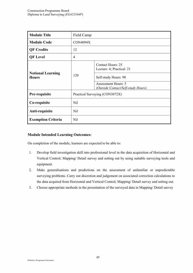
Module Title Field Camp
Module Code CON4094X
QF Credits 12
QF Level 4
Notional Learning Hours
120
Contact Hours: 25
Lecture: 4; Practical: 21
Self-study Hours: 90
Assessment Hours: 5
(Outside Contact/Self-study Hours)
Pre-requisite Practical Surveying (CON3072X)
Co-requisite Nil
Anti-requisite Nil
Exemption Criteria Nil
Module Intended Learning Outcomes:
On completion of the module, learners are expected to be able to:
1. Develop field investigation skill into professional level in the data acquisition of Horizontal and
Vertical Control; Mapping/ Detail survey and setting out by using suitable surveying tools and
equipment.
2. Make generalisations and predictions on the assessment of unfamiliar or unpredictable
surveying problems. Carry out discretion and judgement on associated correction calculations to
the data acquired from Horizontal and Vertical Control; Mapping/ Detail survey and setting out.
3. Choose appropriate methods in the presentation of the surveyed data in Mapping/ Detail survey
Construction Programme Board
Diploma in Land Surveying (EG423104P)
46 Definitive Programme Document
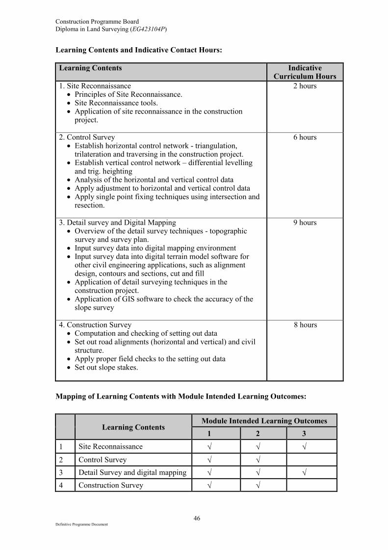
Learning Contents and Indicative Contact Hours:
Learning Contents
Indicative Curriculum Hours
1. Site Reconnaissance • Principles of Site Reconnaissance. • Site Reconnaissance tools. • Application of site reconnaissance in the construction
project.
2 hours
2. Control Survey • Establish horizontal control network - triangulation,
trilateration and traversing in the construction project. • Establish vertical control network – differential levelling
and trig. heighting • Analysis of the horizontal and vertical control data • Apply adjustment to horizontal and vertical control data • Apply single point fixing techniques using intersection and
resection.
6 hours
3. Detail survey and Digital Mapping • Overview of the detail survey techniques - topographic
survey and survey plan. • Input survey data into digital mapping environment • Input survey data into digital terrain model software for
other civil engineering applications, such as alignment design, contours and sections, cut and fill
• Application of detail surveying techniques in the construction project.
• Application of GIS software to check the accuracy of the slope survey
9 hours
4. Construction Survey • Computation and checking of setting out data • Set out road alignments (horizontal and vertical) and civil
structure. • Apply proper field checks to the setting out data • Set out slope stakes.
8 hours
Mapping of Learning Contents with Module Intended Learning Outcomes:
Learning Contents
Module Intended Learning Outcomes
1 2 3
1 Site Reconnaissance √ √ √
2 Control Survey √ √
3 Detail Survey and digital mapping √ √ √
4 Construction Survey √ √
Construction Programme Board
Diploma in Land Surveying (EG423104P)
47 Definitive Programme Document
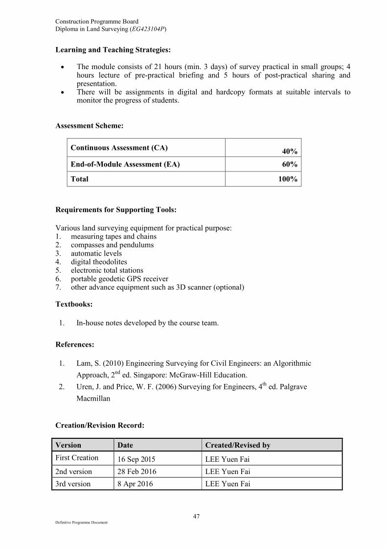
Learning and Teaching Strategies: • The module consists of 21 hours (min. 3 days) of survey practical in small groups; 4
hours lecture of pre-practical briefing and 5 hours of post-practical sharing and presentation.
• There will be assignments in digital and hardcopy formats at suitable intervals to monitor the progress of students.
Assessment Scheme:
Continuous Assessment (CA)
40%
End-of-Module Assessment (EA) 60%
Total 100%
Requirements for Supporting Tools:
Various land surveying equipment for practical purpose: 1. measuring tapes and chains 2. compasses and pendulums 3. automatic levels 4. digital theodolites 5. electronic total stations 6. portable geodetic GPS receiver 7. other advance equipment such as 3D scanner (optional) Textbooks:
1. In-house notes developed by the course team.
References:
1. Lam, S. (2010) Engineering Surveying for Civil Engineers: an Algorithmic
Approach, 2nd
ed. Singapore: McGraw-Hill Education.
2. Uren, J. and Price, W. F. (2006) Surveying for Engineers, 4th ed. Palgrave
Macmillan
Creation/Revision Record:
Version Date Created/Revised by
First Creation 16 Sep 2015 LEE Yuen Fai
2nd version 28 Feb 2016 LEE Yuen Fai
3rd version 8 Apr 2016 LEE Yuen Fai
Construction Programme Board
Diploma in Land Surveying (EG423104P)
48 Definitive Programme Document
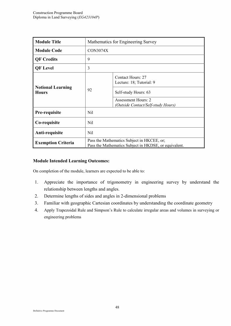
Module Title Mathematics for Engineering Survey
Module Code CON3074X
QF Credits 9
QF Level 3
Notional Learning Hours
92
Contact Hours: 27
Lecture: 18; Tutorial: 9
Self-study Hours: 63
Assessment Hours: 2
(Outside Contact/Self-study Hours)
Pre-requisite Nil
Co-requisite Nil
Anti-requisite Nil
Exemption Criteria Pass the Mathematics Subject in HKCEE, or;
Pass the Mathematics Subject in HKDSE, or equivalent.
Module Intended Learning Outcomes:
On completion of the module, learners are expected to be able to:
1. Appreciate the importance of trigonometry in engineering survey by understand the
relationship between lengths and angles.
2. Determine lengths of sides and angles in 2-dimensional problems
3. Familiar with geographic Cartesian coordinates by understanding the coordinate geometry
4. Apply Trapezoidal Rule and Simpson’s Rule to calculate irregular areas and volumes in surveying or
engineering problems
Construction Programme Board
Diploma in Land Surveying (EG423104P)
49 Definitive Programme Document
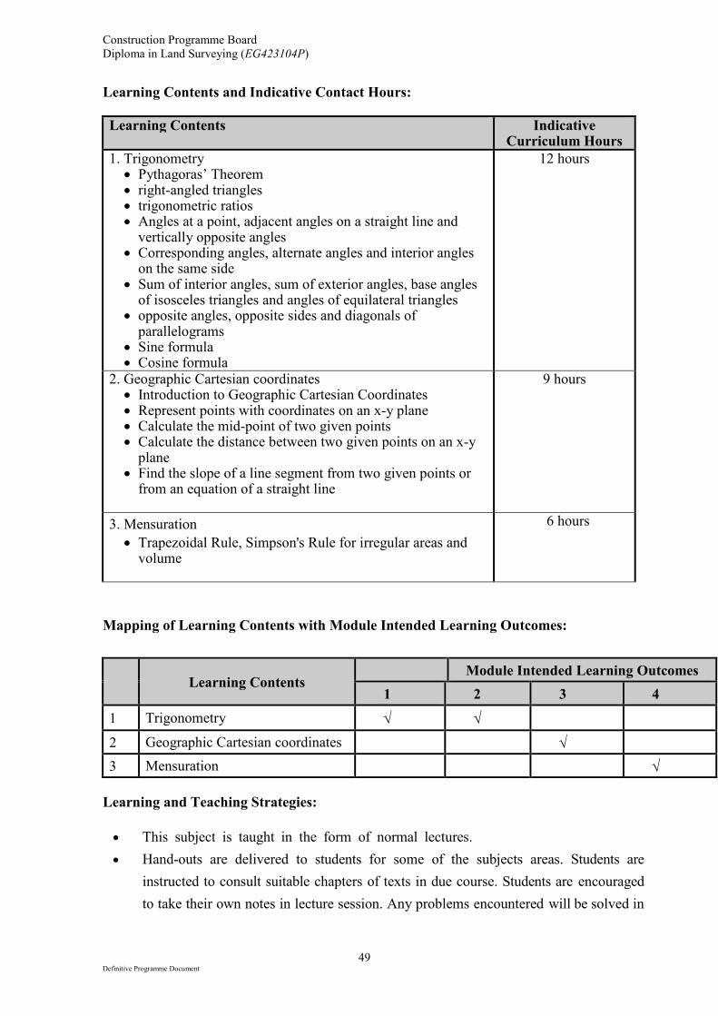
Learning Contents and Indicative Contact Hours:
Learning Contents
Indicative Curriculum Hours
1. Trigonometry • Pythagoras’ Theorem • right-angled triangles • trigonometric ratios • Angles at a point, adjacent angles on a straight line and
vertically opposite angles • Corresponding angles, alternate angles and interior angles
on the same side • Sum of interior angles, sum of exterior angles, base angles
of isosceles triangles and angles of equilateral triangles • opposite angles, opposite sides and diagonals of
parallelograms • Sine formula • Cosine formula
12 hours
2. Geographic Cartesian coordinates • Introduction to Geographic Cartesian Coordinates • Represent points with coordinates on an x-y plane • Calculate the mid-point of two given points • Calculate the distance between two given points on an x-y
plane • Find the slope of a line segment from two given points or
from an equation of a straight line
9 hours
3. Mensuration
• Trapezoidal Rule, Simpson's Rule for irregular areas and volume
6 hours
Mapping of Learning Contents with Module Intended Learning Outcomes:
Learning Contents
Module Intended Learning Outcomes
1 2 3 4
1 Trigonometry √ √
2 Geographic Cartesian coordinates √
3 Mensuration √
Learning and Teaching Strategies:
• This subject is taught in the form of normal lectures.
• Hand-outs are delivered to students for some of the subjects areas. Students are
instructed to consult suitable chapters of texts in due course. Students are encouraged
to take their own notes in lecture session. Any problems encountered will be solved in
Construction Programme Board
Diploma in Land Surveying (EG423104P)
50 Definitive Programme Document
the lecture sessions or students may approach the lecturer directly in emails.
Assessment Scheme:
Continuous Assessment (CA)
40%
End-of-Module Assessment (EA) 60%
Total 100%
Requirements for Supporting Tools:
Nil
Textbooks:
1. In-house notes developed by the course team.
References:
1. Stroud, K.A. (2013), Engineering mathematics, 7th ed. New York : Industrial Press
2. Chan M.H. et al. (2008) New trend mathematics. Hong Kong: Chung Tai
Educational Press.
Creation/Revision Record:
Version Date Created/Revised by
First Creation 16 Sep 2015 LEE Yuen Fai
2nd version 28 Feb 2016 LEE Yuen Fai
3rd version 8 Apr 2016 LEE Yuen Fai


![SYLLABUSES FOR THE DEGREE OF BACHELOR OF ARTS IN … · 2020. 10. 30. · 1 SYLLABUSES FOR THE DEGREE OF BACHELOR OF ARTS IN ARCHITECTURAL STUDIES [BA(ArchStud)] These syllabuses](https://img.pdfslide.net/doc/110x75/60aaff4995c4fc343553ea19/syllabuses-for-the-degree-of-bachelor-of-arts-in-2020-10-30-1-syllabuses-for.jpg)