Embed Size (px)
Citation preview

Forum geografic. Studii şi cercetări de geografie şi protecţia mediului Volume 10, Issue 1 / June 2011, pp. 195-206 (www.forumgeografic.ro) DOI: 10.5775/fg.2067-4635.2011.038.i
Copyright © 2011 Forum geografic. S.C.G.P.M 195
Ecological Status Assessment of the Water Bodies Located in the Lower Sectors of the Jiu and the Motru Rivers (Oltenia, Romania)
Sanda Adina ŞERBAN1, Oana IONUȘ2 1 Jiu River Basin Administration, [email protected].
2 University of Craiova / Geography Department, [email protected].
Received on <January 11, 2011>, revised on <February 10, 2011>, accepted on <April 15, 2011>
Abstract
By means of the Water Framework Directive
methodology, the present study identifies the valid
indicators used for evaluating the ecological status of two
natural water bodies (the first located on the Jiu river
between Bratovoieşti and the Danube confluence, and the
second on the Motru river between the Jirov and the Jiu
confluence): hydromorphological indicators, physico-
chemical indicators and biological indicators.
The quality parameters deviated from the norm are:
Shannon-Wiener Diversity Index – 2.87 for the Motru WB
and Functional groups index – 0.68 for the Jiu WB
(biological Indicators); modified water-cross section
coefficient (depth) (1.22) – the Motru WB, impoundment
coefficient (0.91) – the Motru WB and Coefficient of major
streambed reduction (1.24) – the Jiu WB
(hydromorphological indicators).
The quality parameters (physico-chemical indicators)
of the water drainage systems deviated from the norm are:
Biochemical Oxygen demand BOD5 (40.78 mg/l) and
Ammonium Nitrogen N-NH4 + (6.96 mg N/l) for Strehaia
settlement; Biochemical Oxygen demand BOD5 (33.70
mg/l), Ammonium Nitrogen N-NH4 + (19.66 mg N/l) and
Total Phosphorus PT (8.96 mg/l) for Craiova settlement.
The target is to validate the ecological status for the
two water bodies, respectively „moderate status” for the
lower Jiu and „good status” for the lower Motru, related to
the Class II and Class III of the European process of
intercalibration, ensuring thus the compatibility at
European level.
The relevance of the paper consists in the assessment
of the ecological status of two natural water bodies located
downstream with respect to a major punctiform polluting
source (two major settlements, Craiova on the Jiu,
respectively Strehaia on the Motru), impacting heavily the
achievement of environmental objectives set by the Water
Frame Directive.
Keywords: WFD, water body, reference conditions,
quality elements, urban settlements, ecological status
Rezumat. Evaluarea stării ecologice a corpurilor de apă din cursurile inferioare ale râurilor Jiu şi Motru (Oltenia, România)
Prin folosirea metodologiei propuse în DCA, prezentul
studiu identifică indicatorii valabili pentru definirea stării
ecologice (parametrii hidromorfologici, fizico-chimici şi
biologici) a două corpuri de apă naturale (pe râul Jiu
corpul de apă: localitatea Bratovoieşti - confluenţă Dunăre
şi pe râul Motru corpul de apă: confluenţă Jirov -
confluenţă Jiu).
Valorile parametrilor de calitate înregistrate în
secţiunile de monitorizare sunt: 2,87 pentru Indicele de
diversitate Shannon-Wiener - corpul de apă Motru şi 0,87
pentru Indicele grupe funcţionale - corpul de apă Jiu (în
cazul indicatorilor biologici); 1,22 pentru coeficientul de
modificare a secţiunii transverale (adâncime) – corpul de
apă Motru, 0,1 pentru coeficientul de îndiguire - corpul de
apă Motru şi 1,24 pentru coeficientul de reducere albie
majoră - corpul de apă Jiu (în cazul indicatorilor
hidromorfologici).
Parametrii de calitate (indicatorii fizico-chimici) ai
apelor uzate evacuate sunt: consumul biochimic de oxigen
(40,78 mg/l) şi azotul amoniacal (6,96 mg N/l) – oraşul
Strehaia; consumul biochimic de oxigen (33,70 mg/l),
azotul amoniacal (19,66 mg N/l) şi fosforul total (8,96
mg/l) – oraşul Craiova.
Obiectivul ţintă îl constituie stabilirea stării ecologice
pentru cele două corpuri de apă, respectiv „stare
moderată” pentru cursul inferior al râului Jiu şi „stare
bună” pentru cursul inferior al râului Motru, stări ce
corespund claselor a II-a şi a III-a de calitate conform
procesului european de intercalibrare, ceea ce le conferă
compatibilitate la nivel european.
Importanţa lucrării de faţă constă în determinarea stării
ecologice a două corpuri de apă naturale amplasate aval de
o sursă punctiformă de poluare majoră (aşezările urbane
Craiova pentru Jiu, respectiv Strehaia pentru Motru) cu
impact în neatingerea obiectivelor de mediu prevăzute de
către Directiva Cadru Apă.
Cuvinte-cheie: Directiva Cadru Apă, corp de apă,
condiţii de referinţă, elemente de calitate, aglomerări
urbane, stare ecologică

Ecological Status Assessment of the Water Bodies Located in the Lower Sectors of the Jiu and the Motru Rivers (Oltenia, Romania)
196 Copyright © 2011 Forum geografic. S.C.G.P.M DOI: 10.5775/fg.2067-4635.2011.038.i
INTRODUCTION
The European Parliament and European Council
Directive 2000/60/CE, generally known as the
Water Framework Directive (WFD), defines in
article 2 the ecological status as an expression of the
quality of the structure and functioning of aquatic
ecosystems associated with surface waters, by using
biological, hydromorphological and physical-
chemical quality elements as support functions for
the biological ones.
The same article of the WFD defines a water
body as a discrete and significant element of surface
water such as a lake, a reservoir, a stream, river or
canal, part of a stream, river or canal, transitory
water or a stretch of coastal water. Thus, at
European level, it is introduced a new notion in
hydrology – „water body as a basic unit in water
management, in analysis of human pressure and
human impact on water as well as in risk
assessment of failing to achieve the environmental
objectives” (Şerban and Gălie, 2006).
The new concept of ecological status evaluation
promoted by the WFD differs fundamentally from
the previous approaches in the field of water quality.
In fact, this new approach is based on a principle
stating that biological elements represent the
integrator of all types of pressures and the general
physical-chemical indicators are only elements of
support in determining the ecological status.
The characterization of water body types
proposed by the directive is based on regionalization
(Cohen et al., 1998). Ecological regionalization has
been widely used in the context of river ecology to
study biological communities (Van Sickle et al.,
2006), to define quality goals (Prat and Munné,
2000) or to assign reference conditions (Dawson et
al., 2002; Carballo et al., 2009).
In order to analyze hydromorphological
conditions, the hydrological regime was considered.
The hydrological regime is determined by natural
flow regime, river continuity and WFD
morphological conditions (Leopold and Maddock,
1953, Bizjak and Miko, 2004). The elements used
as indicators for the morphological conditions were
river depth and width variation, structure and
substrate of the river bed and structure of the
riparian zone (Munné et al., 2003, Wattage and
Soussan, 2003). A number of authors (Hewitt, 1991,
Rico et al., 1992, Birk and Hering, 2006, Ocampo-
Duque et al., 2007) have used macro-invertebrates
and fish fauna as bio-indicators to define the
biological conditions of rivers.
Spatial variation of these indicators can be
correlated with the human impact (from settlements)
on the aquatic ecosystem (Naiman and Decamps,
1990): concentration of heavy metals in the
Topciderska river load (one of the most polluted
urban flows in Serbia) (Dragicevic et al., 2010);
transport and transformation of nutrients (nitrogen
compounds and total phosphorous) along the most
polluted reaches of the canal Becej-Bogojevo, Serbia
(Grabic et al., 2011).
From the legal point of view, the WFD was
enforced in the Romanian law by means of the Law
310/2004 which modifies and completes the Water
Law 107/1996. In Romania, beginning with 2004, the
quality assessment of surface waters (according to
WFD) is made at the level of river basins. The River
Basin Management Plan represents the means to
implement the WFD, readjusted through Article 13
and Annex VII, having as main objective the
achievement of “a good status” for the water bodies
corresponding to a balanced management of water
resources.
Study areas
This paper proposes valid indicators for defining
the ecological status of two water bodies, located in
the region of Oltenia, South-Western Romania,
according to the methodology proposed by the
WFD. The physical-geographical framework is the
general support for the evolution of the two water
bodies. Thus, the physical characterization of the
valleys and the administrative-territorial units’
surfaces drained by the two water bodies impose as
the first step in our study.
The Jiu River has a length of 339 km and a basin
surface of 10,080 square km; it is a first degree
tributary of the Danube and flows into it at 692 km
upstream from the Danube’s mouth. The lower
catchment of the Jiu river basin (situated downstream
Craiova settlement) is a space with an exceptional
natural heritage that has been seriously transformed
by man, the natural-human opposition becoming the
key-element of the region (Licurici et al., 2011).
The water body located between Bratovoieşti and
the confluence with the Danube is superposed to a
sector of the lower Jiu (the Livadia stream – a right
tributary, and the Gioroc stream – a left tributary),
having a length of 57.3 km and a surface of the
drained administrative-territorial units of 749.75
square km. The maximum altitude in this area is 59
m (on the right side) and the minimum altitude is
24.1 m at the confluence with the Danube.
Downstream Craiova, the valley of the Jiu River
is asymmetrically developed having a width of 5–8
km, in which the floodplain has an average width of
4–5 km (Savin, 1990). Within this sector, the right
slope remains steep and has a very active dynamics,
Forum geografic. Studii şi cercetări de geografie şi protecţia mediului Volume 10, Issue 1/ June 2011, pp. 195-206
DOI: 10.5775/fg.2067-4635.2011.038.i Copyright © 2011 Forum geografic. S.C.G.P.M 197
while the left slope generally occupies half of the
valley’s width (Fig. 1). On the left slope, in the
Northern sector, five river terraces develop: 70–90
m (Cârcea terrace), 40–60 m (Şimnic terrace), 30–
40 m (Bârza terrace), 15–22 m (Malu Mare terrace)
and 5–12 m (Rojiştea terrace). These generally
present a continuous development and fade into the
Danube terraces downstream the alignment of
Padea-Mârşani settlements (Coteţ, 1957).
The current shape has a historical age, being the
result of climatic variations influencing the hydrologic
regimen of the river, associated with the influence of
neo-tectonic movements (Curcan et al., 2009). Except
for the sectors with old anastomotic branches or
marshland areas and pluvial sand banks, the
geomorphology of the floodplain is rather unvaried.
Downstream Rojiştea, on the left side, it can easily be
observed an old branch of the Jiu – the Jieţ.
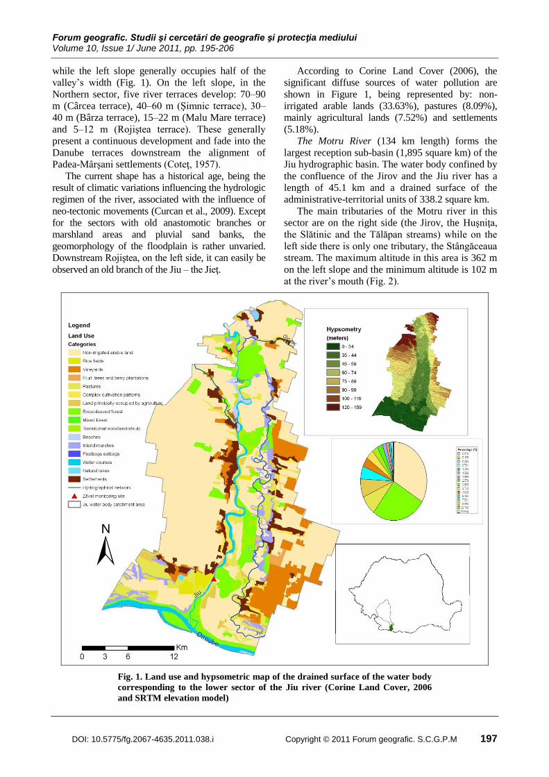
According to Corine Land Cover (2006), the
significant diffuse sources of water pollution are
shown in Figure 1, being represented by: non-
irrigated arable lands (33.63%), pastures (8.09%),
mainly agricultural lands (7.52%) and settlements
(5.18%).
The Motru River (134 km length) forms the
largest reception sub-basin (1,895 square km) of the
Jiu hydrographic basin. The water body confined by
the confluence of the Jirov and the Jiu river has a
length of 45.1 km and a drained surface of the
administrative-territorial units of 338.2 square km.
The main tributaries of the Motru river in this
sector are on the right side (the Jirov, the Huşniţa,
the Slătinic and the Tălăpan streams) while on the
left side there is only one tributary, the Stângăceaua
stream. The maximum altitude in this area is 362 m
on the left slope and the minimum altitude is 102 m
at the river’s mouth (Fig. 2).
Fig. 1. Land use and hypsometric map of the drained surface of the water body
corresponding to the lower sector of the Jiu river (Corine Land Cover, 2006
and SRTM elevation model)

Ecological Status Assessment of the Water Bodies Located in the Lower Sectors of the Jiu and the Motru Rivers (Oltenia, Romania)
198 Copyright © 2011 Forum geografic. S.C.G.P.M DOI: 10.5775/fg.2067-4635.2011.038.i
Fig. 2. Land use and hypsometric map of the drained surface of the water body corresponding to the
lower sector of the Motru river (after Corine Land Cover, 2006 and SRTM elevation model)
The course of the Motru river, generally oriented
on a North Western–South Eastern axis, closely
follows the left slope downstream Faţa Motrului
settlement; after that, it occupies a median setting
within the floodplain, until Eastern Buiceşti
settlement. The course further flows under the right
bank until the confluence with the Jiu river (Ionuş,
2009).
For the lower sector of the Motru, the influence
of the positive neo-tectonic earth movements that
took place in the Southern area of the valley led to a
Northward „shift” of the river. The floodplain of the
Motru river is 1.6–2 km wide between Strehaia and
Buiceşti, and 2 km wide downstream Buiceşti
(Stroe, 2003).
Upstream Strehaia, the sector delimited by the
confluence with the Jirov and the confluence with
the Huşniţa, the Motru terraces on the right side
(towards Coşuşta Hills) are mostly fragmented and
destroyed by numerous tributaries and torrents, this
process being amplified by the low resistance to
erosion of the predominant sand deposits existing in
this area (Şchiopoiu, 1982).
In 1982, Al. Şchiopoiu identified three terraces
downstream Strehaia, having the following extent:
30–40 m (the terrace bridge on the right side shows
a steep forefront), 50–60 m (presented as a step
interrupted here and there by large torrent valleys,
hundred meters wide) and 70–80 m (appearing as a
rock erosion in shape of shoulders). The slopes are
steeper on the left side, beginning with the entrance
of the Motru in the piedmont and downstream the
confluence with the Stângăceaua, where the river
has gullies that are crossing the slope (Tomescu,
2004).
According to Corine Land Cover (2006), the
significant diffuse sources of water pollution are
shown in Figure 2 and are represented by non-
irrigated arable land (34.15%), pastures (8.22%),
mainly agricultural lands (7.64%) and settlements
(5.26%).
DATA AND METHODS
In order to establish the ecological status of the
analyzed water bodies, we took into consideration
the typology and the reference conditions in
conformity with the abiotic parameters of the B
system in the WFD.
Hydromorphological elements for evaluating the
ecological status are represented by the hydrological
regimes and the morphological parameters.
The support physical-chemical elements used for
the ecological status are represented by the nutrients

Forum geografic. Studii şi cercetări de geografie şi protecţia mediului Volume 10, Issue 1/ June 2011, pp. 195-206
DOI: 10.5775/fg.2067-4635.2011.038.i Copyright © 2011 Forum geografic. S.C.G.P.M 199
group (Ammonium Nitrogen N-NH4 +, Nitrites
Nitrogen N-NO2-, Nitrates Nitrogen N-NO3
-,
Phosphates Phosphorus P-PO4 3-
, Total
Phosphorus), by the thermal and oxygenation
conditions (water temperature, dissolved Oxygen,
salinity, pH-acid status) and by the group of specific
synthetic and non-synthetic (Copper-Cu, Zinc-Zn,
Arsenic-As, Chromium-Cr) pollutants group.
In evaluating the ecological status of Romanian
rivers, the biological elements that are taken into
consideration are the phytoplankton, macro-
zoobentos (composition and plenty of the benthic
invertebrate fauna) and fish fauna (composition,
plenty and age distribution).
Starting from a list of species recorded within a
monitoring station, we have reckoned each of the
seven indices proposed for evaluating the status of
the water bodies based on the macro-invertebrate
communities that enter the composition of the
multimetric index for bentic marcro-invertebrates:
Saprobic index (SI), Ephemeroptera, Plecoptera,
Trichoptera insects index (EPT_I), Shannon-Wiener
Diversity Index (ISH), Number of families index
(FAM), Oligochaeta-Chironomidae index OCH
(OCH - IOCH/O), Functional groups index (IGF),
Preference index of flowing water (REO/LIM).
The evaluation of the ecological status is based
on a five-stage classification system (Fig. 3):
Class I – very good status is characterized by
values of the biological, hydromorphological, and
physical-chemical elements associated to untouched
water ecosystems (taken as reference) or areas with
minor anthropic modifications;
Class II – good status is characterized by minor
deviations of the biological, hydromorphological
and physical-chemical elements associated to
untouched water ecosystems (taken as reference) or
areas with minor anthropic modifications;
Class III – moderate status is characterized by
values that differ in a moderate measure from values
of the biological, hydromorphological and physical-
chemical elements associated to untouched water
ecosystems (taken as reference) or areas with minor
anthropic modifications;
Class IV – poor status is characterized by major
alteration of values of the biological,
hydromorphological and physical-chemical
elements associated to untouched water ecosystems
(taken as reference) or areas with minor anthropic
modifications;
Class V – bad status is characterized by severe
alteration of values of the biological,
hydromorphological and physical-chemical
elements associated to untouched water ecosystems
(taken as reference). It is established when a large
number of relevant biologic communities are absent
compared to those present in untouched areas or
areas with minor anthropic modifications.
The transposition of the WFD requirements,
concerning the ecological status and the
establishment of the 5 classes above, is based on a
national study which is related to the European
process of intercalibration, ensuring thus the
compatibility at European level (ICIM, 2008).
The determination of the ecological status is
achieved based on the values of the biological,
hydromorphological and physical-chemical
parameters recorded on two monitoring sites of the
studied water bodies:
Zăval monitoring site (Fig.1) for the water body
Bratovoieşti – the Danube confluence;
Faţa Motrului monitoring site (Fig. 2) for the
water body the Jirov – the Jiu confluence.
RESULTS AND DISCUSSIONS
For the definition of the ecological status of the
lower sectors of the Jiu and the Motru Rivers and
assessment of the quality elements, the WFD
provides assessment tables that classify each
quality element through qualitative assessment
(high, good, moderate, poor and bad).
Characterization of Water Body Types
In order to characterize water body types using
system B, as described in Annex V of the WFD, the
variables defined in the system that was adapted to
the conditions of the Romanian territory were used.
The proposed variables were determined based on
data collected along the complete rivers, according
to data collected during the study – the Jiu River
Basin Management Plan, the study areas falls within
the following categories.
Water body: Bratovoieşti – the Danube
confluence (on the Jiu river) Type: water sector
with wet areas flowing through a field area;
Symbol: RO18; Surface (sq. km): > 5000; Geology:
silicon, limestone, organic; Lithological structure:
sand, ooze, clay; Altitude: < 200 m; Potential
biocoenosis type: barbel and carp.
Water body: the Jirov confluence – the Jiu
confluence (on the Motru river). Type: water sector
with flowing through hilly and piedmont area;
Symbol: RO14; Surface (sq. km): 1000–10000;
Geology: silicon, limestone, organic; Lithological
structure: sand, gravel; Altitude: 200 – 500 m;
Potential biocoenoses type: barbel, Chondrostoma
nasus.

Ecological Status Assessment of the Water Bodies Located in the Lower Sectors of the Jiu and the Motru Rivers (Oltenia, Romania)
200 Copyright © 2011 Forum geografic. S.C.G.P.M DOI: 10.5775/fg.2067-4635.2011.038.i
Establishment of Specific Reference
Conditions
The reference conditions were established in
conformity with the WFD for each type of water
body and represent values of biological,
hydromorphological and physical-chemical
elements untouched or with minor anthropic
influences.
Table 1, 2 and 3 present the limits of the values
for the quality parameters detailed with respect to
the typology of the two water bodies (RO14–the
Motru and RO18–the Jiu).
Fig. 3. Diagram of biological, hydromorphological and physicochemical quality elements in ecological status
classification according the normative definitions in Annex V: 1.2. (WFD)
Types Ecological Status Indicators
Biological Indicators
Evaluation of the ecological status from the
point of view of fish fauna was made only for the
water body on the Motru river: the Jirov confluence
– the Jiu confluence. For the water body on the Jiu
river: Bratovoieşti – the Danube confluence the fish
fauna was not analyzed due to the relatively high
flow of the river in Zăval section (87.7 cubic
meter/second – mean multi-year flow).
The initial analysis method started with the
determination of the biological coefficients presented
in the framework Specific Reference Conditions. Part
of these coefficients recorded pozitive deviations from
the reference values (Shannon-Wiener Diversity Index
– 2.87 for the Motru WB and Functional groups index
– 0.68 for the Jiu WB (Table 1).
After reckoning the multimetric index based on
invertebrates, the ecological status of the two water
bodies was evaluated as good.
YES BIGGER
NO
NO
YES
NO
YES
YES
YES YES
YES
Do the estimated
values for the
biological quality
elements meet
reference conditions?
Do the physico-
chemical conditions
meet high status?
Do the
hydromorphological
conditions meet
high status?
Classify as
high
status
Do the
estimated values
for the biological
quality elements
deviate only
slightly from
reference
conditions values?
Do the physico-
chemical conditions
(a) ensure ecosystem
functioning and (b)
meet the EQSs for
specific polluants?
Classify as
moderate
status
Classify on
the basis of the
biological
deviation from
reference
conditions?
Is the
deviation
moderate? Moderate status
Classify as
poor
status ?
Classify as
bad status
Is the
deviation
major?
NO
NO
BIGGER
YES

Forum geografic. Studii şi cercetări de geografie şi protecţia mediului Volume 10, Issue 1/ June 2011, pp. 195-206
DOI: 10.5775/fg.2067-4635.2011.038.i Copyright © 2011 Forum geografic. S.C.G.P.M 201
Table 1. Results for the reference conditions and biological parameters assessed (2007)
Biological coefficients Reference conditions
R014/RO18 type
Faţa Motrului
monitoring site
(Motru WB)
Zăval
monitoring site
(Jiu WB)
European Fish Index (EFI+) >0,912 (for Salmonicol waters)
>0,94 (for Cyprinicol waters) 0,79 **
Saprobic index 30% 0,921/0,738 2,2 2,05
Ephemeroptera, Plecoptera, Trichoptera insects
index10% 1,55/1,6 0,43 0,34
Shannon-Wiener Diversity Index 20% 0,3/0,3 2,87 1,44
Number of families index10% 1,9/1,9 13,33 5
Oligochaeta-Chironomidae index 10% 14/14 0,31 0,2
Functional groups index 10% 0,25/0,25 0,34 0,68
Preference index of flowing water 10% 0,3/0,3 0,97 1,00
Multimetric index for benthic macroinvertebrates 0,9/0,9 0,929 0,721
Ecological Status - Good Good
** for large rivers sample acquisition is still poor, reason for which on the Jiu river in Zăval section, no samples
were available to determine the fish fauna coefficients.
Source: Scientific study concerning the elaboration of classification systems and global evaluation of surface water
bodies (rivers, lakes, transitory waters, coast waters) in conformity with the requirements of the WFD 2000/60/CE
based on biological, hydromorphological, and physical-chemical elements - National Research and Development
Institute for Environment Protection, Bucharest
Physico-chemical Indicators
The ecological status evaluated only via general
physical-chemical elements and specific pollutants is
determined by the worst-case scenario.
As seen in Table 2, the ecological status of the water
body on the Motru river: the Jirov confluence – the Jiu
confluence is evaluated as good, while the status of the
water body on the Jiu river: Bratovoieşti – the Danube
confluence is evaluated as moderate, the main cause
being the lack of a treatment process for the waste
waters of Craiova.
The interpretation of values corresponding to the
Water Quality Index on the Motru river, on the
basis of the scheme proposed by House and Ellis
(1987) allows for the establishment of the usage
domain for the river water as natural resource.
During the years when values above 90 percent
were registered, the water of the Motru river was
good for all recreation activities and convenient for
all fish species and aquatic fauna, while in the case
of the values comprised between 74 and 90 percent,
the water situation was uncertain for aquatic sports
that imply the direct contact with the water and for
fishing, only supporting the population with sweet
water fish species (Ionuş, 2010).
In what concerns the water body on the Jiu:
Bratovoieşti – the Danube confluence the drained
surface corresponds to the following administrative-
territorial units: Bratovoieşti, Drănic, Valea
Stanciului, Dobreşti, Gângiova, Sadova, Gighera şi
Ostroveni. For the water body on the Motru: the Jirov
confluence – the Jiu confluence the drained surface
corresponds to the following administrative-
territorial units: Văgiuleşti, Corcova, Strehaia,
Butoieşti and Stângăceaua.
From the point of view of anthropic pressure on
the two water bodies, although the administrative
units are characterized by a majority of rural
settlements, the urban population (Strehaia and
Craiova settlements) through their water distribution
and water drainage systems are the main punctiform
polluting sources. Therefore, choosing the two water
bodies as being representative is justified by the fact
that the two urban settlements do not yet have waste
water treatment plants, being thus heavy pollution
sources for the two water systems.
The water drainage system of the city of Strehaia
takes the waste waters of a population of 14098
equivalent inhabitants. The average evacuated flow
is 4.5 litres/second, and the quality parameters
deviated from the norm are: Biochemical Oxygen
demand BOD5 (40.78 mg/l) and Ammonium
Nitrogen N-NH4 + (6.96 mg N/l), thus influencing
the water body analyzed. The evacuation of the
waste waters is carried out in the Huşniţa stream,
with no treatment, and then again in the Motru river
(the distance between the evacuation in the city and
the confluence of the Huşniţa and the Motru being
of 0.9 km).

Ecological Status Assessment of the Water Bodies Located in the Lower Sectors of the Jiu and the Motru Rivers (Oltenia, Romania)
202 Copyright © 2011 Forum geografic. S.C.G.P.M DOI: 10.5775/fg.2067-4635.2011.038.i
Table 2. Results for the reference conditions and the physico-chemical parameters and specific pollutants assessed (2007)
Physico-chemical and specific pollutants Reference conditions
R014/RO18 type
Faţa Motrului
monitoring site
(Motru WB)
Zăval monitoring
site (Jiu WB)
Temperature (oC) 21,5 0C (for Salmonicol waters)
28 0C (for Cyprinicol waters) 13,5 19,8
pH 6,5-8,5 8 7,9
Dissolved Oxygen (mg/l) 8/10 9,9 8,8
Ammonium nitrogen N-NH4 + (mg N/l) 0,66/0,09 0,172 0,33
Nitrites nitrogen N-NO2 - (mg N/l) 0,08/0,011 0,015 0,04
Nitrates nitrogen N-NO3 - (mg N/l) 2,6/0,7 0,708 2,37
Phosphates phosphorus P-PO4 3- (mg P/l) 0,09/0,035 0,0368 0,08
Total Phosphorus (mg P/l) 0,23/0,11 0,0694 0,14
Copper (g/l) 0,75/2/6 3,9 5,92
Zinc (g/l) 7/35/50 5,5 7,55
Arsen (g/l) 49 0,96 1,47
Crom (g/l) 8,8 1,7 1,068
Ecological Status - Good Moderate
Source: Scientific study concerning the elaboration of classification systems and global evaluation of surface water
bodies (rivers, lakes, transitory waters, coast waters) in conformity with the requirements of the WFD 2000/60/CE
based on biological, hydromorphological, and physical-chemical elements - National Research and Development
Institute for Environment Protection, Bucharest
The main punctiform polluting source for the water
body corresponding to the lower Jiu river is the city of
Craiova and its waste waters. The city of Craiova still
does not have a waste water treatment plant. The
Craiova water drainage system serves a population of
385000 equivalent inhabitants, evacuating a mean
flow of waste water of 1320.96 litres/second. The
quality parameters that are deviated from the norm
are: Biochemical Oxygen demand BOD5 (33.70 mg/l),
Ammonium Nitrogen N-NH4 + (19.66 mg N/l) and
Total Phosphorus PT (8.96 mg/l) (Fig. 4).
Hydromorphological Indicators
The ecological status evaluated by means of
hydromorphological elements is considered relevant if
only the ecological status is very good, both for the
biological and the physical-chemical elements and
also for the specific pollutants.
The hydromorphological parameters used to support
the analysis of the ecological status and which record
deviations from the reference values are (Tab. 3):
Modified water-cross section coefficient (depth)
(1.22)–the Motru WB, Impoundment coefficient
(0.91)–the Motru WB and Coefficient of major
streambed reduction (1.24)–the Jiu WB. This is due to
the local physical-geographical conditions, to the
influence of the basic level, to the shape of the valleys,
to the evolution of the waterbeds, and implicitly to the
floodplain dynamics of the two rivers.
Table 3. Results for the reference conditions and for hydromorphological parameters assessed (2007)
Hydrological regime and Morphological
parameters
Reference
conditions
R014/RO18 type
Faţa Motrului
monitoring site
(Motru WB)
Zăval
monitoring site
(Jiu WB)
Coefficient of Average flow variation 0,96-1,04 1,08 1,02
Level variations coefficient (m) 0,90 – 1,10 0,85 1,10
Modified water-cross section coefficient (depth) 0,95 – 1,05 1,22 1,00
Modified water-cross section coefficient (width) 0,95 – 1,05 1,00 1,00
Coefficient of major streambed reduction 1 0,91 1,24
Impoundment coefficient 0 0,91 0,532
River bank consolidation coefficient 0 0,009 0
Ecological Status - Moderate Moderate
Source: Scientific study concerning the elaboration of classification systems and global evaluation of surface water
bodies (rivers, lakes, transitory waters, coast waters) in conformity with the requirements of the WFD 2000/60/CE
based on biological, hydromorphological, and physical-chemical elements - National Research and Development
Institute for Environment Protection, Bucharest

Forum geografic. Studii şi cercetări de geografie şi protecţia mediului Volume 10, Issue 1/ June 2011, pp. 195-206
DOI: 10.5775/fg.2067-4635.2011.038.i Copyright © 2011 Forum geografic. S.C.G.P.M 203
Fig. 4. The human pressure on the Jiu and the Motru water bodies (physical-chemical parameters assessed in
waste waters discharged from urban Craiova and Strehaia settlements in 2007)

Ecological Status Assessment of the Water Bodies Located in the Lower Sectors of the Jiu and the Motru Rivers (Oltenia, Romania)
204 Copyright © 2011 Forum geografic. S.C.G.P.M DOI: 10.5775/fg.2067-4635.2011.038.i
When the ecological status evaluated only
through biological elements is superior to the status
given by the physical-chemical elements, then it
will prevail the status given by the physical-
chemical elements. This rule is applied in the
assessment of the ecological status of the water
body on the Jiu river between Bratovoieşti and the
confluence with the Danube.
CONCLUSION
The ecological status evaluation of the two water
bodies corresponding to the lower parts of the Jiu
and the Motru rivers was made by integrating all
quality elements of flowing waters (biological,
hydromorphological and physical-chemical), by
applying the worst-case principle, except for the
hydromorphological elements.
Therefore, if the evaluated ecological status in
conformity with the hydromorphological elements
is moderate, and the evaluated ecological status in
conformity with the biological elements is good,
then it will prevail the status given by the biological
elements (the pressure of hydromorphological
elements on the water body has no impact). This
case is also met in evaluating the ecological status
of the two water bodies in Table 4.
At the end of this study, the ecological status of the
water body on the Motru river: the Jirov confluence–
the Jiu confluence is evaluated as good, meaning that
in conformity with the WFD, the ecological status of
this sector must be maintained (Vannote et al., 1980).
Table 4. Assessment of the ecological status of the Jiu and the Motru water bodies
Water body
Assessed quality elements Ecological
status Biological Hydro-
morphological
Physico-
chemical
Motru
Jirov confluence –
Jiu confluence
Good
Moderate
Good
Good
Jiu
Bratovoieşti –
Danube confluence
Good
Moderate
Moderate
Moderate
The moderate ecological status of the water
body on the lower sector of the Jiu river:
Bratovoieşti – the Danube confluence reflects an
average degree of pollution, for which immediate
actions must be taken to improve its quality in order
to meet the objectives of the Water Frame
Directive.
Taking into consideration the available set of
analysis, the ecological status can be assessed with
different levels of confidence (Şerban Adina, 2009).
The ecological status of the two water bodies
was established with a medium confidence level,
because less than twelve analysis per site were
analised.
ACKNOWLEDGEMENTS
The research was achieved within the framework
of a grant offered by the Simion Mehedinţi Doctoral
School (Faculty of Geography, University of
Bucharest), project co-financed through the Sectoral
Operational Programme for Human Resources
Development 2007-2013, POSDRU/6/1.5/S/24/7546
Contract.
REFERENCES
Birk, S, Hering, D., (2006). Direct comparison of
assessment methods using benthic
macroinvertebrates: a contribution to the EU
Water Framework Directive intercalibration
exercise, Hydrobiologia 566:401–415,
DOI:10.1007/s10750-006-0081-8.
Bizjak, A, Miko, M., (2004). Synthesis procedure of
assessing the hydromorphological status of river
corridors: the Dragonja river case study, in:
Abstracts of the 5th international symposium on
ecohydraulics, Universidad Politécnica de
Madrid, Madrid, 12–17 September 2004.
Carballo, R., Cancela, J. J., Iglesias, G., Marín, A.,
Neira, X. X., Cuesta, T. S., (2009). WFD
Indicators and Definition of the Ecological Status
of Rivers, Water Resour Manage, 23:2231–2247,
DOI 10.1007/s11269-008-9379-9.
Cohen, P, Andriamahefa, H, Wasson, JG, (1998).
Towards a regionalization of aquatic habitat:
distribution of mesohabitats at the scale of a
large basin, Regul Rivers Res Manage
14(5):391–404, DOI:10.1002/(SICI)1099-
1646(199809/10)14:5<391::AID-
RRR513>3.0.CO;2-W.
Coteţ, P., (1957), Câmpia Olteniei. Studiu
geomorfologic (cu privire specială asupra
cuaternarului), Editura Ştiinţifică, Bucureşti.

Forum geografic. Studii şi cercetări de geografie şi protecţia mediului Volume 10, Issue 1/ June 2011, pp. 195-206
DOI: 10.5775/fg.2067-4635.2011.038.i Copyright © 2011 Forum geografic. S.C.G.P.M 205
Curcan, G., Boengiu, S., Licurici, Mihaela, (2009).
The Reconstitution of the Morphohydrographic
Evolution of the Jiu – the Danube Confluence
Area on the Basis of Cartographic Documents,
Proceedings of the Third International Scientific
Conference–Faculty of Mathematics and Natural
Science, vol. 1, South-West University “Neofit
Rilski”, Blagoevgrad.
Dragicevic, S., Nenadovic S., Jovanovic B.,
Milanovic M., Novkovic I., Pavic D., Ljesevic M.,
(2010). Degradation of Topciderska River Water
Quality (Belgrade), Carpathian Journal of Earth
and Environmental Sciences, 5(2), 177 -184.
Dawson, FH, Hornby, DD, Hilton, J, (2002). A
method for the automated extraction of
environmental variables to help the
classification of rivers in Britain, Aquat Conserv
12:391–340., DOI:10.1002/aqc.534.
Grabic, J. et al., (2011). Spreading and
transformation of nutrients in the reach of the
Becej-Bogojevo Canal, Serbia, Carpathian
Journal of Earth and Environmental Sciences,
6(1), 277 -284.
Hewitt, G., (1991), River quality investigations.
Some diversity and biotic indexes, J. Biol Educ.
25(1):44–52.
Ionuş, Oana, (2009). Drainage Evolution
Determined by the Dynamics of Forest Areas
within the Motru Hydrographic Basin,
Geographical Phorum, No.8, ISSN 1583-1523,
97-104.
Ionuş, Oana, (2010). Water Quality Index -
Assessment method of the Motru river water
quality (Oltenia, Romania), Analele Universităţii
din Craiova. Seria Geografie, Vol. XIII, ISSN
1224-4112, 74-83.
Leopold, M.B., Maddock, T., (1953), The hydraulic
geometry of stream channels and some
physiographic implications, United States
Government Print Office, Washington.
Licurici, Mihaela, Boengiu, S., Ionuş, Oana, (2011).
Natural and man-induced hazards along the
Danube, between Rast and Gighera settlements,
with a special view on the 2006 flood,
Quaestiones Geographicae 30(1), 2011, Poznań,
Poland, p. 57-68, DOI: 10.2478/v10117-011-
0005-1.
Munné, A., Prat, N., Sola, C. et al., (2003). A simple
field method for assessing the ecological quality
of riparian habitat in rivers and streams: QBR
index, Aquat ConservMar Freshwat Ecosyst
13:147–163, DOI: 10.1002/aqc.529.
Naiman, R. J., Decamps, H., (1990). The ecology
and management of aquatic-terrestrial ecotones,
Man and the Biosphere Series, Number 4, Paris:
UNESCO; Carnforth, England: Parthenon.
Ocampo-Duque, W., Schuhmacher, M., Domingo,
J.L., (2007). A neural-fuzzy approach to classify
the ecological status in surface waters, Environ
Pollut 148:634–641, DOI:
10.1016/j.envpol.2006.11.027.
Prat, N., Munné, A., (2000). Water use and quality
and stream flow in a Mediterranean stream,
Water, Res 34(15):3876–3881.
DOI:10.1016/S0043-1354(00)00119-6.
Rico, E., Rallo, A., Sevillano, M.A. et al., (1992).
Comparison of several biological indices based
on river macroinvertebrate benthic community
for assessment of running water quality, Ann
Limnol 28(2):147–156.
Savin, C., (1990). Resursele în apă ale luncii Jiului,
Editura Scrisul Românesc, Craiova.
Stroe, S., (2003), Piemontul Bălăciţei, Edit.
MondoRo, Bucureşti.
Şchiopoiu, Al., (1982). Dealurile piemontane ale
Coşuştei, Editura Scrisul Românesc, Craiova.
Şerban, Sanda Adina, (2009). Physico-chemical
quality indicators, supporting elements in the
assessment of ecological status for lower Jiu,
Analele Universității din Craiova. Seria
Agricultură-Montanologie-Cadastru, Vol.
XXXIX/A 2009, ISSN: 1841-8317, 505-511.
Şerban, P., Gălie, Andreea, (2006). Managementul
apelor. Principii şi reglementări europene,
Editura Tipored, Bucureşti.
Tomescu, Viorica, (2004). Podişul Piemontan al
Motrului – studiu de geografie regională,
Editura Universitaria, Craiova.
Vannote, R. L., Minshall, W. G., Cummins, K. W.,
Sedell, J. R., Cushing, C. E., (1980). The river
continuum concept, Can. J. Fish. Aquat. Sci.,
37(37): 130-137.
Van Sickle, J., Huff, D.D., Hawkins, C.P., (2006).
Selecting discriminant function models for
predicting the expected richness of aquatic
macroinvertebrates, Freshw Biol 51(2):359–
372., DOI:10.1111/j.1365-2427.2005.01487.x.
Wattage, P., Soussan, J., (2003). Incorporating
environmental value and externality in project
Ecological Status Assessment of the Water Bodies Located in the Lower Sectors of the Jiu and the Motru Rivers (Oltenia, Romania)
206 Copyright © 2011 Forum geografic. S.C.G.P.M DOI: 10.5775/fg.2067-4635.2011.038.i
evaluation as a sustainability indicator to
evaluate Bangladesh water development, Water
Resources Management 17(6):429-446,
DOI:10.1023/B:WARM.0000004957.49020.c3.
*** (1969). Geografia Văii Dunării Româneşti,
Editura Academiei, Bucureşti.
*** (2000). Directiva 2000/60/EC a Parlamentului
şi Consiliului European care stabileşte un cadru
de acţiune pentru tarile din Uniunea Europeana
în domeniul politicii apei, Jurnalul Oficial al
Comunităţii Europene.
*** Legea nr. 352/2005 - pentru modificarea şi
completarea Legii nr.188/2002 privind aprobarea
unor norme privind conditiile de descărcare în
mediul acvatic a apelor uzate, publicată în
Monitorul Oficial al României, Partea I, nr.
398/11 mai 2005.
*** (2008). Institutul Naţional de Cercetare-
Dezvoltare pentru Protecţia Mediului – ICIM
Bucureşti - Studiu privind elaborarea sistemelor
de clasificare şi evaluare globală a stării apelor
de suprafaţă (râuri, lacuri, ape tranzitorii, ape
costiere) conform cerinţelor Directivei Cadru a
Apei 2000/60/CEE pe baza elementelor
biologice, chimice şi hidromorfologice
*** (2009). Planul de Management al Bazinului
Hidrografic Jiu, Administraţia Bazinală de Apă Jiu.
*** (2003). Common Implementation Strategy for
the Water Framework Directive (2000/60/EC),
Guidance document no. 10, River and lakes –
Typology, reference conditions and
classification systems, European Communities
http://www.waterframeworkdirective.wdd.moa.g
ov.cy/guidance.html.

![DANSE ROUMAINE [dedicated to my Mother] · Title: ROMANIAN DANCE [dedicated to my Mother] Composer: Nichifor, Serban Copyright: Copyright © Serban Nichifor Publisher: Nichifor, Serban](https://img.pdfslide.net/doc/110x75/6111309aaf95e25a2020f180/danse-roumaine-dedicated-to-my-mother-title-romanian-dance-dedicated-to-my-mother.jpg)