Embed Size (px)
Citation preview
Order Details
Site Details1, Russett Farm, Rainham, GILLINGHAM, ME8 7AT
Order Number:Customer Ref:National Grid Reference:Slice:Site Area (Ha):Search Buffer (m):
178768733_1_144538-3501580420, 168450C51.81000
Tel:Fax:Web:
0844 844 99520844 844 9951www.envirocheck.co.uk
Page 6 of 6A Landmark Information Group Service v15.0 04-Sep-2018
Site Sensitivity Context Map - Slice C
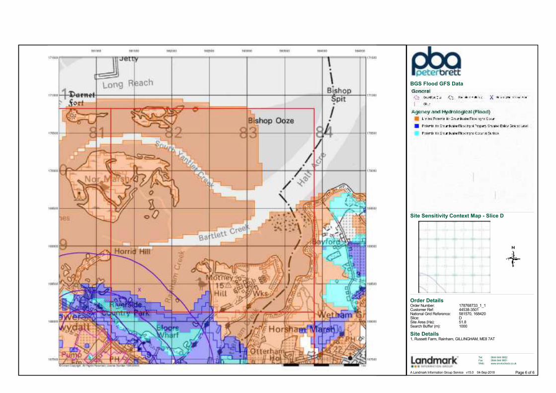
BGS Flood GFS Data
Order Number: 178768733_1_1 Date: 04-Sep-2018 rpr_ec_datasheet v53.0 A Landmark Information Group Service
Datasheet
Order Details:
Order Number:
Customer Reference:
National Grid Reference:
Slice:
Site Area (Ha):
Search Buffer (m):
Site Details:
Client Details:
178768733_1_1
44538-3501
580420, 168450
C
51.8
1000
1, Russett FarmRainhamGILLINGHAMME8 7AT
Ms K RileyPeter Brett Associates LLPCaversham Bridge HouseWaterman PlaceReadingBerkshireRG1 8DN
Report:®Envirocheck
Order Number: 178768733_1_1 Date: 04-Sep-2018 rpr_ec_datasheet v53.0 A Landmark Information Group Service
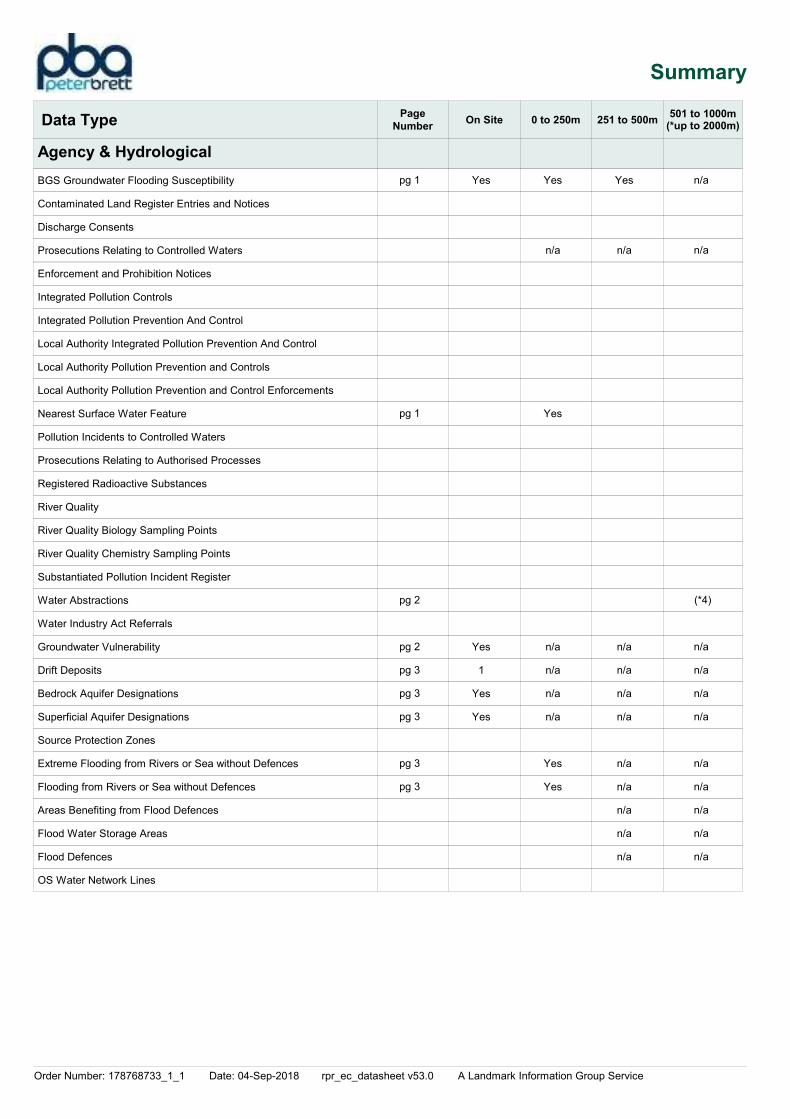
Summary
Agency & Hydrological
Waste
Hazardous Substances
Geological
Industrial Land Use
Sensitive Land Use
Data Currency
Data Suppliers
Useful Contacts
Introduction
Copyright Notice
Natural England Copyright Notice
Scottish Natural Heritage Copyright
Ove Arup Copyright Notice
Peter Brett Associates Copyright Notice
Radon Potential dataset Copyright Notice
Natural Resources Wales Copyright Notice
The Environment Act 1995 has made site sensitivity a key issue, as the legislation pays as much attention to the pathways by which contamination could spread,
and to the vulnerable targets of contamination, as it does the potential sources of contamination.
For this reason, Landmark's Site Sensitivity maps and Datasheet(s) place great emphasis on statutory data provided by the Environment Agency/Natural Resources
Wales and the Scottish Environment Protection Agency; it also incorporates data from Natural England (and the Scottish and Welsh equivalents) and Local
Authorities; and highlights hydrogeological features required by environmental and geotechnical consultants. It does not include any information concerning past
uses of land. The datasheet is produced by querying the Landmark database to a distance defined by the client from a site boundary provided by the client.
In the attached datasheet the National Grid References (NGRs) are rounded to the nearest 10m in accordance with Landmark's agreements with a number of Data Suppliers.
© Landmark Information Group Limited 2018. The Copyright on the information and data and its format as contained in this Envirocheck® Report ("Report") is the
property of Landmark Information Group Limited ("Landmark") and several other Data Providers, including (but not limited to) Ordnance Survey, British Geological
Survey, the Environment Agency/Natural Resources Wales and Natural England, and must not be reproduced in whole or in part by photocopying or any other
method. The Report is supplied under Landmark's Terms and Conditions accepted by the Customer.
A copy of Landmark's Terms and Conditions can be found with the Index Map for this report. Additional copies of the Report may be obtained from Landmark,
subject to Landmark's charges in force from time to time. The Copyright, design rights and any other intellectual rights shall remain the exclusive property of
Landmark and /or other Data providers, whose Copyright material has been included in this Report.
Site of Special Scientific Interest, National Nature Reserve, Ramsar, Special Protection Area, Special Conservation Area, Marine Nature Reserve data (derived from
Ordnance Survey 1:10000 raster) is provided by, and used with the permission of, Natural England who retain the copyright and Intellectual Property Rights for the
data.
Contains SNH information licensed under the Open Government Licence v3.0.
The Mining Instability data was obtained on licence from Ove Arup & Partners Limited (for further information, contact [email protected]). No reproduction or
further use of such Data is to be made without the prior written consent of Ove Arup & Partners Limited. The supplied Mining Instability data is derived from publicly
available records and other third party sources and neither Ove Arup & Partners nor Landmark warrant the accuracy or completeness of such information or data.
The cavity data presented has been extracted from the PBA enhanced version of the original DEFRA national cavity databases. PBA/DEFRA retain the copyright &
intellectual property rights in the data. Whilst all reasonable efforts are made to check that the information contained in the cavity databases is accurate we do not
warrant that the data is complete or error free. The information is based upon our own researches and those collated from a number of external sources and is
continually being augmented and updated by PBA. In no event shall PBA/DEFRA or Landmark be liable for any loss or damage including, without limitation, indirect
or consequential loss or damage arising from the use of this data.
Information supplied from a joint dataset compiled by The British Geological Survey and Public Health England.
Contains Natural Resources Wales information © Natural Resources Wales and Database Right. All rights Reserved. Contains Ordnance Survey Data. Ordnance
Survey Licence number 100019741. Crown Copyright and Database Right.Contains Natural Resources Wales information © Natural Resources Wales and Database Right. All rights Reserved. Some features of this information are based
on digital spatial data licensed from the Centre for Ecology & Hydrology © NERC (CEH). Defra, Met Office and DARD Rivers Agency © Crown copyright. © Cranfield
University. © James Hutton Institute. Contains OS data © Crown copyright and database right 2018. Land & Property Services © Crown copyright and database
right.
Report Section Page Number
Contents
-
1
6
-
7
9
10
11
15
16

Order Number: 178768733_1_1 Date: 04-Sep-2018 rpr_ec_datasheet v53.0 A Landmark Information Group Service
Contents
Report Version v53.0
Order Number: 178768733_1_1 Date: 04-Sep-2018 rpr_ec_datasheet v53.0 A Landmark Information Group Service
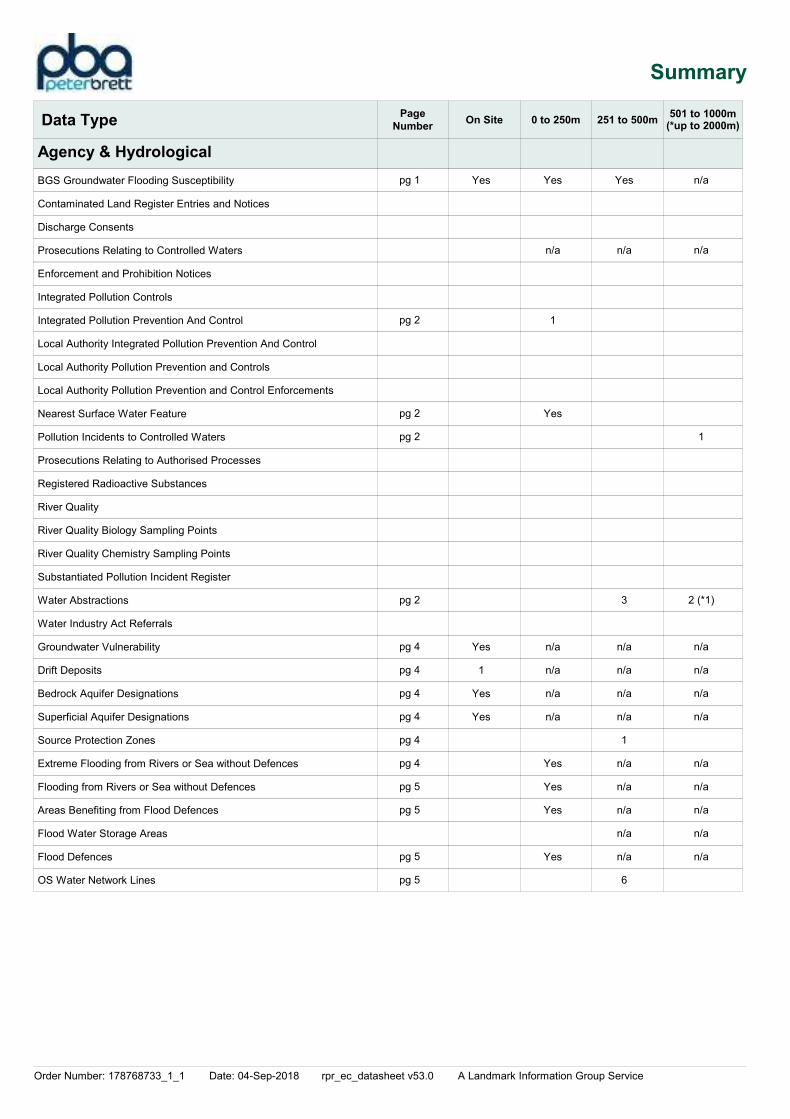
Summary
Data TypePage
NumberOn Site 0 to 250m 251 to 500m
Agency & Hydrological
501 to 1000m
BGS Groundwater Flooding Susceptibility
Contaminated Land Register Entries and Notices
Discharge Consents
Prosecutions Relating to Controlled Waters
Enforcement and Prohibition Notices
Integrated Pollution Controls
Integrated Pollution Prevention And Control
Local Authority Integrated Pollution Prevention And Control
Local Authority Pollution Prevention and Controls
Local Authority Pollution Prevention and Control Enforcements
Nearest Surface Water Feature
Pollution Incidents to Controlled Waters
Prosecutions Relating to Authorised Processes
Registered Radioactive Substances
River Quality
River Quality Biology Sampling Points
River Quality Chemistry Sampling Points
Substantiated Pollution Incident Register
Water Abstractions
Water Industry Act Referrals
Groundwater Vulnerability
Drift Deposits
Bedrock Aquifer Designations
Superficial Aquifer Designations
Source Protection Zones
Extreme Flooding from Rivers or Sea without Defences
Flooding from Rivers or Sea without Defences
Areas Benefiting from Flood Defences
Flood Water Storage Areas
Flood Defences
OS Water Network Lines
Yes
Yes
1
Yes
Yes
Yes
n/a
1
Yes
n/a
n/a
n/a
n/a
Yes
Yes
Yes
Yes
Yes
n/a
3
n/a
n/a
n/a
n/a
1
n/a
n/a
n/a
n/a
n/a
6
n/a
n/a
1
2
n/a
n/a
n/a
n/a
n/a
n/a
n/a
n/a
n/a
(*1)
(*up to 2000m)
pg 1
pg 2
pg 2
pg 2
pg 2
pg 4
pg 4
pg 4
pg 4
pg 4
pg 4
pg 5
pg 5
pg 5
pg 5

Order Number: 178768733_1_1 Date: 04-Sep-2018 rpr_ec_datasheet v53.0 A Landmark Information Group Service
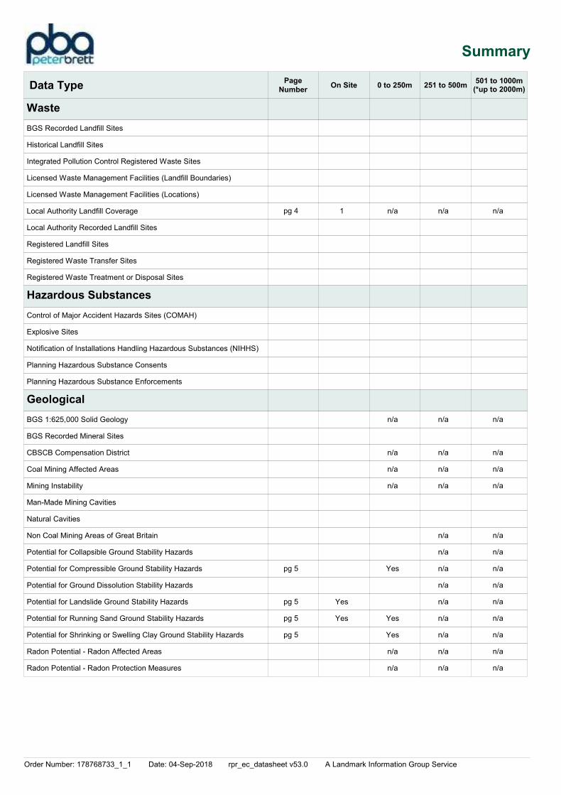
Summary
Data TypePage
NumberOn Site 0 to 250m 251 to 500m
Waste
Hazardous Substances
Geological
501 to 1000m
BGS Recorded Landfill Sites
Historical Landfill Sites
Integrated Pollution Control Registered Waste Sites
Licensed Waste Management Facilities (Landfill Boundaries)
Licensed Waste Management Facilities (Locations)
Local Authority Landfill Coverage
Local Authority Recorded Landfill Sites
Registered Landfill Sites
Registered Waste Transfer Sites
Registered Waste Treatment or Disposal Sites
Control of Major Accident Hazards Sites (COMAH)
Explosive Sites
Notification of Installations Handling Hazardous Substances (NIHHS)
Planning Hazardous Substance Consents
Planning Hazardous Substance Enforcements
BGS 1:625,000 Solid Geology
BGS Recorded Mineral Sites
CBSCB Compensation District
Coal Mining Affected Areas
Mining Instability
Man-Made Mining Cavities
Natural Cavities
Non Coal Mining Areas of Great Britain
Potential for Collapsible Ground Stability Hazards
Potential for Compressible Ground Stability Hazards
Potential for Ground Dissolution Stability Hazards
Potential for Landslide Ground Stability Hazards
Potential for Running Sand Ground Stability Hazards
Potential for Shrinking or Swelling Clay Ground Stability Hazards
Radon Potential - Radon Affected Areas
Radon Potential - Radon Protection Measures
1
Yes
Yes
Yes
Yes
Yes
Yes
Yes
Yes
n/a
n/a
n/a
n/a
n/a
Yes
Yes
Yes
Yes
Yes
Yes
n/a
n/a
n/a
n/a
n/a
n/a
n/a
n/a
n/a
n/a
n/a
n/a
n/a
n/a
n/a
n/a
1
n/a
n/a
1
n/a
n/a
n/a
n/a
n/a
n/a
n/a
n/a
n/a
n/a
n/a
n/a
(*up to 2000m)
pg 6
pg 6
pg 7
pg 7
pg 7
pg 7
pg 7
pg 7
pg 8
pg 8
pg 8
pg 8
Order Number: 178768733_1_1 Date: 04-Sep-2018 rpr_ec_datasheet v53.0 A Landmark Information Group Service
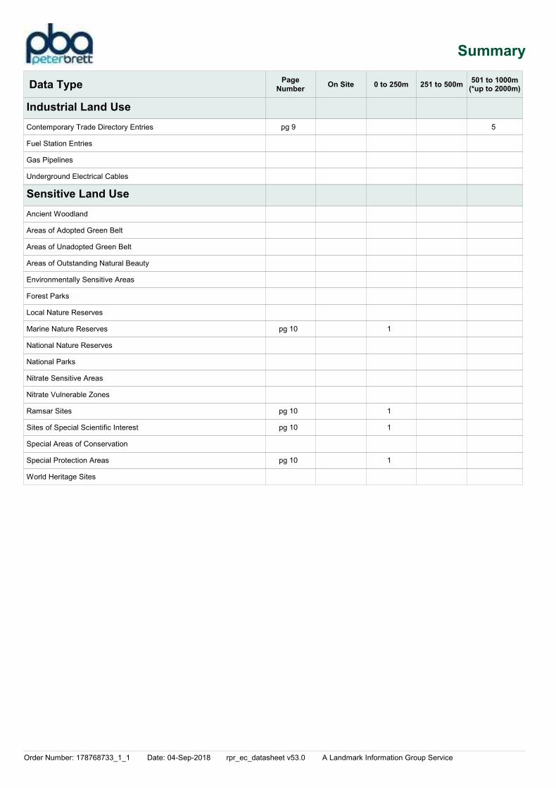
Summary
Data TypePage
NumberOn Site 0 to 250m 251 to 500m
Industrial Land Use
Sensitive Land Use
501 to 1000m
Contemporary Trade Directory Entries
Fuel Station Entries
Gas Pipelines
Underground Electrical Cables
Ancient Woodland
Areas of Adopted Green Belt
Areas of Unadopted Green Belt
Areas of Outstanding Natural Beauty
Environmentally Sensitive Areas
Forest Parks
Local Nature Reserves
Marine Nature Reserves
National Nature Reserves
National Parks
Nitrate Sensitive Areas
Nitrate Vulnerable Zones
Ramsar Sites
Sites of Special Scientific Interest
Special Areas of Conservation
Special Protection Areas
World Heritage Sites
1
1
1
1
5
(*up to 2000m)
pg 9
pg 10
pg 10
pg 10
pg 10
Order Number: 178768733_1_1 Date: 04-Sep-2018 rpr_ec_datasheet v53.0 A Landmark Information Group Service Page 1 of 16
Agency & Hydrological
Map
IDDetails
Quadrant
Reference
(Compass
Direction)
Estimated
Distance
From Site
Contact NGR
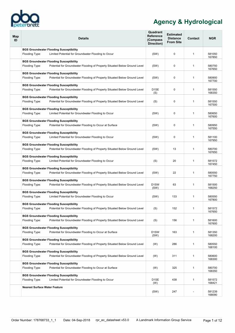
BGS Groundwater Flooding Susceptibility
BGS Groundwater Flooding Susceptibility
BGS Groundwater Flooding Susceptibility
BGS Groundwater Flooding Susceptibility
BGS Groundwater Flooding Susceptibility
BGS Groundwater Flooding Susceptibility
BGS Groundwater Flooding Susceptibility
BGS Groundwater Flooding Susceptibility
BGS Groundwater Flooding Susceptibility
BGS Groundwater Flooding Susceptibility
BGS Groundwater Flooding Susceptibility
BGS Groundwater Flooding Susceptibility
BGS Groundwater Flooding Susceptibility
BGS Groundwater Flooding Susceptibility
BGS Groundwater Flooding Susceptibility
BGS Groundwater Flooding Susceptibility
BGS Groundwater Flooding Susceptibility
BGS Groundwater Flooding Susceptibility
BGS Groundwater Flooding Susceptibility
BGS Groundwater Flooding Susceptibility
BGS Groundwater Flooding Susceptibility
BGS Groundwater Flooding Susceptibility
C3NE(N)
(S)
(SE)
C4SW(E)
(S)
(SE)
(S)
(SE)
C4SW(SE)
(S)
(SE)
(S)
(S)
C4SW(SE)
(S)
(S)
(S)
(S)
C3SW(W)
(SE)
(SE)
C4SE(E)
0
0
0
0
0
0
0
0
0
13
20
22
23
63
64
68
118
133
152
152
156
163
1
1
1
1
1
1
1
1
1
1
1
1
1
1
1
1
1
1
1
1
1
1
Flooding Type:
Flooding Type:
Flooding Type:
Flooding Type:
Flooding Type:
Flooding Type:
Flooding Type:
Flooding Type:
Flooding Type:
Flooding Type:
Flooding Type:
Flooding Type:
Flooding Type:
Flooding Type:
Flooding Type:
Flooding Type:
Flooding Type:
Flooding Type:
Flooding Type:
Flooding Type:
Flooding Type:
Flooding Type:
Limited Potential for Groundwater Flooding to Occur
Potential for Groundwater Flooding of Property Situated Below Ground Level
Potential for Groundwater Flooding of Property Situated Below Ground Level
Potential for Groundwater Flooding of Property Situated Below Ground Level
Limited Potential for Groundwater Flooding to Occur
Potential for Groundwater Flooding of Property Situated Below Ground Level
Limited Potential for Groundwater Flooding to Occur
Potential for Groundwater Flooding to Occur at Surface
Limited Potential for Groundwater Flooding to Occur
Potential for Groundwater Flooding of Property Situated Below Ground Level
Limited Potential for Groundwater Flooding to Occur
Potential for Groundwater Flooding of Property Situated Below Ground Level
Limited Potential for Groundwater Flooding to Occur
Potential for Groundwater Flooding of Property Situated Below Ground Level
Potential for Groundwater Flooding of Property Situated Below Ground Level
Limited Potential for Groundwater Flooding to Occur
Limited Potential for Groundwater Flooding to Occur
Limited Potential for Groundwater Flooding to Occur
Limited Potential for Groundwater Flooding to Occur
Potential for Groundwater Flooding of Property Situated Below Ground Level
Potential for Groundwater Flooding of Property Situated Below Ground Level
Potential for Groundwater Flooding to Occur at Surface
580419168500
580700167650
580850167700
580700168350
580450167600
581500167500
580550167600
580900167550
580600168200
580650167650
581550167450
580500167750
580400167800
580800168250
580450167750
580419167800
580400167900
580500167800
580000168451
581550167650
581600167600
580950168300
Order Number: 178768733_1_1 Date: 04-Sep-2018 rpr_ec_datasheet v53.0 A Landmark Information Group Service Page 2 of 16
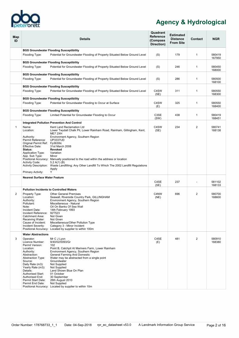
Agency & Hydrological
Map
IDDetails
Quadrant
Reference
(Compass
Direction)
Estimated
Distance
From Site
Contact NGR
1
2
3
BGS Groundwater Flooding Susceptibility
BGS Groundwater Flooding Susceptibility
BGS Groundwater Flooding Susceptibility
BGS Groundwater Flooding Susceptibility
BGS Groundwater Flooding Susceptibility
BGS Groundwater Flooding Susceptibility
Integrated Pollution Prevention And Control
Nearest Surface Water Feature
Pollution Incidents to Controlled Waters
Water Abstractions
(S)
(S)
(S)
C4SW(SE)
C4SW(E)
C3SE(SW)
C4SW(SE)
C4SE(SE)
C4NW(NE)
C4SE(E)
179
246
286
311
325
438
234
237
696
481
1
1
1
1
1
1
2
-
2
2
Flooding Type:
Flooding Type:
Flooding Type:
Flooding Type:
Flooding Type:
Flooding Type:
Name:Location:
Authority:Permit Reference:Original Permit Ref:Effective Date:Status:Application Type:App. Sub Type:Positional Accuracy:Activity Code:Activity Description:
Primary Activity:
Property Type:Location:Authority:Pollutant:Note:Incident Date:Incident Reference:Catchment Area:Receiving Water:Cause of Incident:Incident Severity:Positional Accuracy:
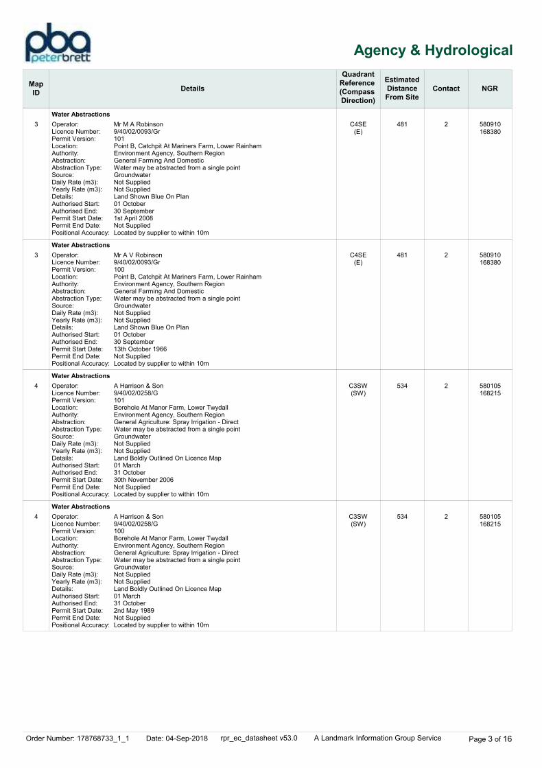
Operator:Licence Number:Permit Version:Location:Authority:Abstraction:Abstraction Type:Source:Daily Rate (m3):Yearly Rate (m3):Details:Authorised Start:Authorised End:Permit Start Date:Permit End Date:Positional Accuracy:
Potential for Groundwater Flooding of Property Situated Below Ground Level
Potential for Groundwater Flooding of Property Situated Below Ground Level
Potential for Groundwater Flooding of Property Situated Below Ground Level
Potential for Groundwater Flooding of Property Situated Below Ground Level
Potential for Groundwater Flooding to Occur at Surface
Limited Potential for Groundwater Flooding to Occur
Kent Land Reclamation LtdLower Twydall Chalk Pit, Lower Rainham Road, Rainham, Gillingham, Kent, ME7 2XHEnvironment Agency, Southern RegionUP3337UDFp3630lc31st March 2008RevokedVariationMinorManually positioned to the road within the address or location5.2 A(1) (B)Waste Landfilling; Any Other Landfill To Which The 2002 Landfill Regulations ApplyY
Other General PremisesSeawall, Riverside Country Park, GILLINGHAMEnvironment Agency, Southern RegionMiscellaneous - NaturalOil On Banks Of Sea Wall14th February 199392T523Not GivenNot GivenMiscellaneous/Other Pollution TypeCategory 3 - Minor IncidentLocated by supplier to within 100m
Mr C J Lyon9/40/02/0093/Gr102Point B, Catchpit At Mariners Farm, Lower RainhamEnvironment Agency, Southern RegionGeneral Farming And DomesticWater may be abstracted from a single pointGroundwaterNot SuppliedNot SuppliedLand Shown Blue On Plan01 October30 September26th August 2010Not SuppliedLocated by supplier to within 10m
580419167950
580450168000
580500168100
580550168300
580550168400
580419168451
580741168138
581102168133
580700168600
580910168380
Order Number: 178768733_1_1 Date: 04-Sep-2018 rpr_ec_datasheet v53.0 A Landmark Information Group Service Page 3 of 16
Agency & Hydrological
Map
IDDetails
Quadrant
Reference
(Compass
Direction)
Estimated
Distance
From Site
Contact NGR
3
3
4
4
Water Abstractions
Water Abstractions
Water Abstractions
Water Abstractions
C4SE(E)
C4SE(E)
C3SW(SW)
C3SW(SW)
481
481
534
534
2
2
2
2
Operator:Licence Number:Permit Version:Location:Authority:Abstraction:Abstraction Type:Source:Daily Rate (m3):Yearly Rate (m3):Details:Authorised Start:Authorised End:Permit Start Date:Permit End Date:Positional Accuracy:
Operator:Licence Number:Permit Version:Location:Authority:Abstraction:Abstraction Type:Source:Daily Rate (m3):Yearly Rate (m3):Details:Authorised Start:Authorised End:Permit Start Date:Permit End Date:Positional Accuracy:
Operator:Licence Number:Permit Version:Location:Authority:Abstraction:Abstraction Type:Source:Daily Rate (m3):Yearly Rate (m3):Details:Authorised Start:Authorised End:Permit Start Date:Permit End Date:Positional Accuracy:
Operator:Licence Number:Permit Version:Location:Authority:Abstraction:Abstraction Type:Source:Daily Rate (m3):Yearly Rate (m3):Details:Authorised Start:Authorised End:Permit Start Date:Permit End Date:Positional Accuracy:
Mr M A Robinson9/40/02/0093/Gr101Point B, Catchpit At Mariners Farm, Lower RainhamEnvironment Agency, Southern RegionGeneral Farming And DomesticWater may be abstracted from a single pointGroundwaterNot SuppliedNot SuppliedLand Shown Blue On Plan01 October30 September1st April 2008Not SuppliedLocated by supplier to within 10m
Mr A V Robinson9/40/02/0093/Gr100Point B, Catchpit At Mariners Farm, Lower RainhamEnvironment Agency, Southern RegionGeneral Farming And DomesticWater may be abstracted from a single pointGroundwaterNot SuppliedNot SuppliedLand Shown Blue On Plan01 October30 September13th October 1966Not SuppliedLocated by supplier to within 10m
A Harrison & Son9/40/02/0258/G101Borehole At Manor Farm, Lower TwydallEnvironment Agency, Southern RegionGeneral Agriculture: Spray Irrigation - DirectWater may be abstracted from a single pointGroundwaterNot SuppliedNot SuppliedLand Boldly Outlined On Licence Map01 March31 October30th November 2006Not SuppliedLocated by supplier to within 10m
A Harrison & Son9/40/02/0258/G100Borehole At Manor Farm, Lower TwydallEnvironment Agency, Southern RegionGeneral Agriculture: Spray Irrigation - DirectWater may be abstracted from a single pointGroundwaterNot SuppliedNot SuppliedLand Boldly Outlined On Licence Map01 March31 October2nd May 1989Not SuppliedLocated by supplier to within 10m
580910168380
580910168380
580105168215
580105168215
Order Number: 178768733_1_1 Date: 04-Sep-2018 rpr_ec_datasheet v53.0 A Landmark Information Group Service Page 4 of 16
Agency & Hydrological
Map
IDDetails
Quadrant
Reference
(Compass
Direction)
Estimated
Distance
From Site
Contact NGR
5
Water Abstractions
Groundwater Vulnerability
Groundwater Vulnerability
Groundwater Vulnerability
Groundwater Vulnerability
Groundwater Vulnerability
Drift Deposits
Bedrock Aquifer Designations
Bedrock Aquifer Designations
Bedrock Aquifer Designations
Superficial Aquifer Designations
Source Protection Zones
Extreme Flooding from Rivers or Sea without Defences
C7SW(NW)
(SW)
C4SW(SE)
(SE)
(S)
(S)
C3SE(SW)
(S)
(SE)
C4SW(SE)
C3SE(NE)
(SW)
C3SE(SW)
1150
0
0
0
0
0
0
0
0
0
0
494
61
2
2
2
2
2
2
2
1
1
1
1
2
2
Operator:Licence Number:Permit Version:Location:Authority:Abstraction:Abstraction Type:Source:Daily Rate (m3):Yearly Rate (m3):Details:Authorised Start:Authorised End:Permit Start Date:Permit End Date:Positional Accuracy:
Soil Classification:
Map Sheet:Scale:
Soil Classification:
Map Sheet:Scale:
Soil Classification:
Map Sheet:Scale:
Soil Classification:
Map Sheet:Scale:
Soil Classification:
Map Sheet:Scale:
Drift Deposit:
Map Sheet:Scale:
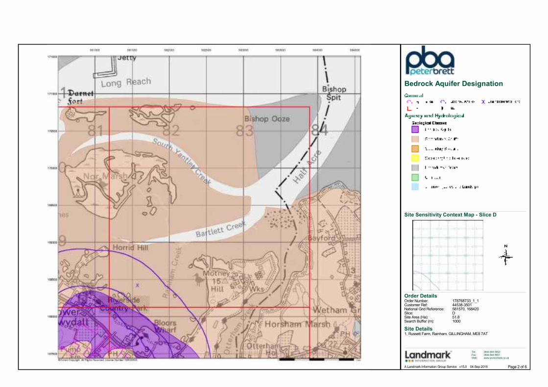
Aquifer Designation:
Aquifer Designation:
Aquifer Designation:
Aquifer Designation:
Name:Source:Reference:Type:
Type:Flood Plain Type:Boundary Accuracy:
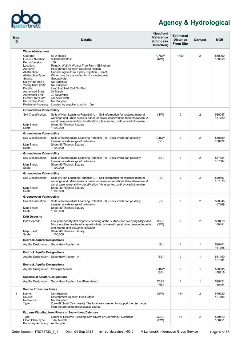
Mr A Rocco9/40/02/0029/Gr100Point X, Well At Walnut Tree Farm, GillinghamEnvironment Agency, Southern RegionGeneral Agriculture: Spray Irrigation - DirectWater may be abstracted from a single pointGroundwaterNot SuppliedNot SuppliedLand Hatched Red On Plan01 March30 November4th April 1979Not SuppliedLocated by supplier to within 10m
Soils of High Leaching Potential (U) - Soil information for restored mineral workings and urban areas is based on fewer observations than elsewhere. A worst case vulnerability classification (H) assumed, until proved otherwiseSheet 40 Thames Estuary1:100,000
Soils of Intermediate Leaching Potential (I1) - Soils which can possibly transmit a wide range of pollutantsSheet 40 Thames Estuary1:100,000
Soils of Intermediate Leaching Potential (I1) - Soils which can possibly transmit a wide range of pollutantsSheet 40 Thames Estuary1:100,000
Soils of High Leaching Potential (U) - Soil information for restored mineral workings and urban areas is based on fewer observations than elsewhere. A worst case vulnerability classification (H) assumed, until proved otherwiseSheet 40 Thames Estuary1:100,000
Soils of Intermediate Leaching Potential (I1) - Soils which can possibly transmit a wide range of pollutantsSheet 40 Thames Estuary1:100,000
Low permeability drift deposits occuring at the surface and overlying Major andMinor Aquifers are head, clay-with-flints, brickearth, peat, river terrace depositsand marine and estuarine alluviumSheet 40 Thames Estuary1:100,000
Secondary Aquifer - A
Secondary Aquifer - A
Principal Aquifer
Secondary Aquifer - Undifferentiated
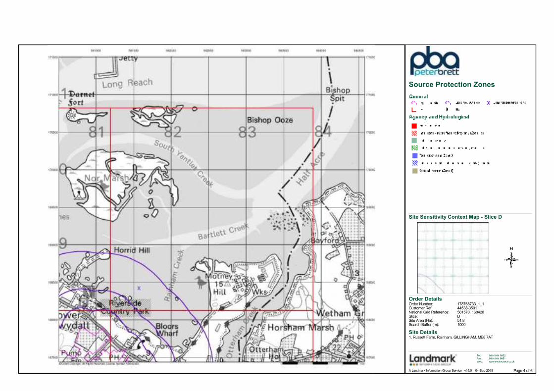
Not SuppliedEnvironment Agency, Head OfficeNot SuppliedZone III (Total Catchment): The total area needed to support the discharge from the protected groundwater source.
Extent of Extreme Flooding from Rivers or Sea without DefencesTidal ModelsAs Supplied
580060168850
580087167729
580689168222
581154167504
580197167678
580345167769
580419168451
580401167798
581150167501
580635168216
580421168454
579320167706
580419168451
Order Number: 178768733_1_1 Date: 04-Sep-2018 rpr_ec_datasheet v53.0 A Landmark Information Group Service Page 5 of 16
Agency & Hydrological
Map
IDDetails
Quadrant
Reference
(Compass
Direction)
Estimated
Distance
From Site
Contact NGR
6
7
8
9
10
11
Flooding from Rivers or Sea without Defences
Areas Benefiting from Flood Defences
Flood Water Storage Areas
Flood Defences
OS Water Network Lines
OS Water Network Lines
OS Water Network Lines
OS Water Network Lines
OS Water Network Lines
OS Water Network Lines
C3SE(SW)
C4SE(SE)
C4NW(E)
C4SE(E)
C4SE(E)
C4SW(E)
C4SE(E)
C4SE(E)
C4SE(E)
89
89
221
428
431
454
465
466
466
2
2
2
3
3
3
3
3
3
Type:Flood Plain Type:Boundary Accuracy:
Type:Boundary Accuracy:
Type:Reference:
Watercourse Form:Watercourse Length:Watercourse Level:Permanent:Watercourse Name:Catchment Name:Primacy:
Watercourse Form:Watercourse Length:Watercourse Level:Permanent:Watercourse Name:Catchment Name:Primacy:
Watercourse Form:Watercourse Length:Watercourse Level:Permanent:Watercourse Name:Catchment Name:Primacy:
Watercourse Form:Watercourse Length:Watercourse Level:Permanent:Watercourse Name:Catchment Name:Primacy:
Watercourse Form:Watercourse Length:Watercourse Level:Permanent:Watercourse Name:Catchment Name:Primacy:
Watercourse Form:Watercourse Length:Watercourse Level:Permanent:Watercourse Name:Catchment Name:Primacy:
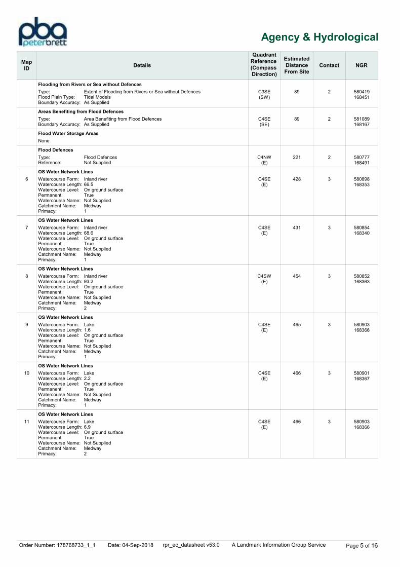
Extent of Flooding from Rivers or Sea without DefencesTidal ModelsAs Supplied
Area Benefiting from Flood DefencesAs Supplied
Flood DefencesNot Supplied
Inland river66.5On ground surfaceTrueNot SuppliedMedway1
Inland river68.6On ground surfaceTrueNot SuppliedMedway1
Inland river93.2On ground surfaceTrueNot SuppliedMedway2
Lake1.6On ground surfaceTrueNot SuppliedMedway1
Lake2.2On ground surfaceTrueNot SuppliedMedway1
Lake6.9On ground surfaceTrueNot SuppliedMedway2
None
580419168451
581089168167
580777168491
580898168353
580854168340
580852168363
580903168366
580901168367
580903168366
Order Number: 178768733_1_1 Date: 04-Sep-2018 rpr_ec_datasheet v53.0 A Landmark Information Group Service Page 6 of 16
Waste
Map
IDDetails
Quadrant
Reference
(Compass
Direction)
Estimated
Distance
From Site
Contact NGR
12
Historical Landfill Sites
Local Authority Landfill Coverage
C3NE(NE)
689
0
2
4
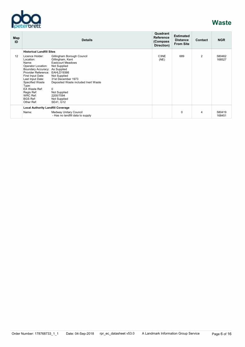
Licence Holder:Location:Name:Operator Location:Boundary Accuracy:Provider Reference:First Input Date:Last Input Date:Specified Waste Type:EA Waste Ref:Regis Ref:WRC Ref:BGS Ref:Other Ref:
Name:
Gillingham Borough CouncilGillingham, KentEastcourt MeadowsNot SuppliedAs SuppliedEAHLD19366Not Supplied31st December 1973Deposited Waste included Inert Waste
0Not Supplied2200/7094Not SuppliedSE41, G12
Medway Unitary Council - Has no landfill data to supply
580462168527
580419168451
Order Number: 178768733_1_1 Date: 04-Sep-2018 rpr_ec_datasheet v53.0 A Landmark Information Group Service Page 7 of 16
Geological
Map
IDDetails
Quadrant
Reference
(Compass
Direction)
Estimated
Distance
From Site
Contact NGR
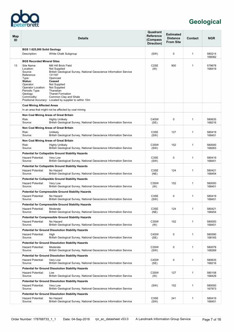
13
BGS 1:625,000 Solid Geology
BGS Recorded Mineral Sites
Coal Mining Affected Areas
Non Coal Mining Areas of Great Britain
Non Coal Mining Areas of Great Britain
Non Coal Mining Areas of Great Britain
Potential for Collapsible Ground Stability Hazards
Potential for Collapsible Ground Stability Hazards
Potential for Collapsible Ground Stability Hazards
Potential for Compressible Ground Stability Hazards
Potential for Compressible Ground Stability Hazards
Potential for Compressible Ground Stability Hazards
Potential for Ground Dissolution Stability Hazards
Potential for Ground Dissolution Stability Hazards
Potential for Ground Dissolution Stability Hazards
Potential for Ground Dissolution Stability Hazards
Potential for Ground Dissolution Stability Hazards
Potential for Ground Dissolution Stability Hazards
(SW)
C2SE(W)
C4SW(SE)
C3SE(SW)
C3SW(SW)
C3SE(SW)
C3SE(NE)
C3SW(W)
C3SE(SW)
C3SE(NE)
C3SW(W)
C4SW(SE)
C3SW(SW)
C4SW(SE)
C3SW(W)
(SW)
C3SE(SW)
0
900
0
127
152
0
124
152
0
124
152
0
0
0
127
152
241
1
1
1
1
1
1
1
1
1
1
1
1
1
1
1
1
1
Description:
Site Name:Location:Source:Reference:Type:Status:Operator:Operator Location:Periodic Type:Geology:Commodity:Positional Accuracy:
Risk:Source:
Risk:Source:
Risk:Source:
Hazard Potential:Source:
Hazard Potential:Source:
Hazard Potential:Source:
Hazard Potential:Source:
Hazard Potential:Source:
Hazard Potential:Source:
Hazard Potential:Source:
Hazard Potential:Source:
Hazard Potential:Source:
Hazard Potential:Source:
Hazard Potential:Source:
Hazard Potential:Source:
White Chalk Subgroup
Mill Hill Brick FieldNot SuppliedBritish Geological Survey, National Geoscience Information Service131187OpencastCeasedNot SuppliedNot SuppliedThanetianThanet FormationCommon Clay and ShaleLocated by supplier to within 10m
Highly UnlikelyBritish Geological Survey, National Geoscience Information Service
UnlikelyBritish Geological Survey, National Geoscience Information Service
Highly UnlikelyBritish Geological Survey, National Geoscience Information Service
Very LowBritish Geological Survey, National Geoscience Information Service
No HazardBritish Geological Survey, National Geoscience Information Service
Very LowBritish Geological Survey, National Geoscience Information Service
No HazardBritish Geological Survey, National Geoscience Information Service
ModerateBritish Geological Survey, National Geoscience Information Service
No HazardBritish Geological Survey, National Geoscience Information Service
HighBritish Geological Survey, National Geoscience Information Service
ModerateBritish Geological Survey, National Geoscience Information Service
Very LowBritish Geological Survey, National Geoscience Information Service
LowBritish Geological Survey, National Geoscience Information Service
Very LowBritish Geological Survey, National Geoscience Information Service
No HazardBritish Geological Survey, National Geoscience Information Service
In an area that might not be affected by coal mining
580214168082
579678168419
580635168216
580419168451
580000168263
580419168451
580421168454
580000168451
580419168451
580421168454
580000168451
580590168165
580078168269
580635168216
580158168429
580000167973
580419168451
Order Number: 178768733_1_1 Date: 04-Sep-2018 rpr_ec_datasheet v53.0 A Landmark Information Group Service Page 8 of 16
Geological
Map
IDDetails
Quadrant
Reference
(Compass
Direction)
Estimated
Distance
From Site
Contact NGR
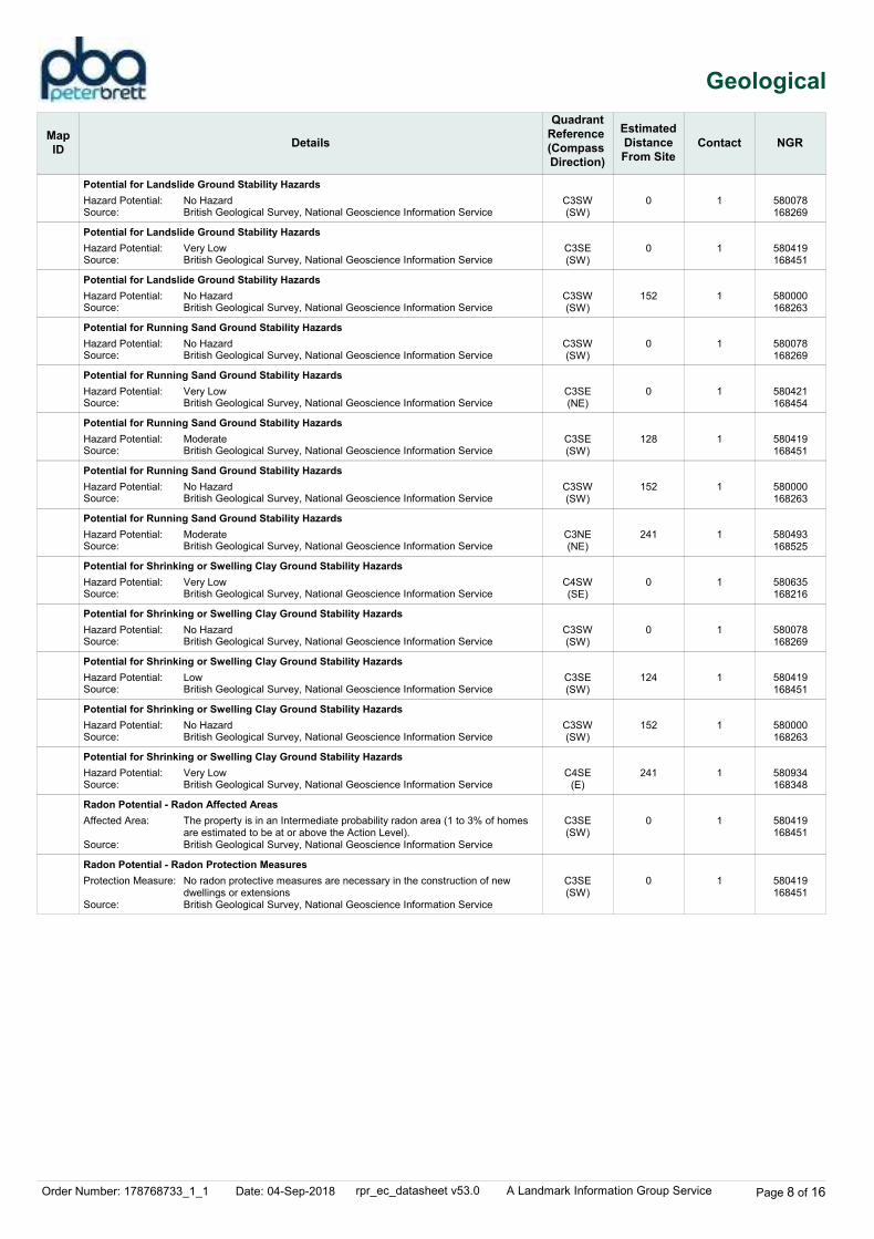
Potential for Landslide Ground Stability Hazards
Potential for Landslide Ground Stability Hazards
Potential for Landslide Ground Stability Hazards
Potential for Running Sand Ground Stability Hazards
Potential for Running Sand Ground Stability Hazards
Potential for Running Sand Ground Stability Hazards
Potential for Running Sand Ground Stability Hazards
Potential for Running Sand Ground Stability Hazards
Potential for Shrinking or Swelling Clay Ground Stability Hazards
Potential for Shrinking or Swelling Clay Ground Stability Hazards
Potential for Shrinking or Swelling Clay Ground Stability Hazards
Potential for Shrinking or Swelling Clay Ground Stability Hazards
Potential for Shrinking or Swelling Clay Ground Stability Hazards
Radon Potential - Radon Affected Areas
Radon Potential - Radon Protection Measures
C3SW(SW)
C3SE(SW)
C3SW(SW)
C3SW(SW)
C3SE(NE)
C3SE(SW)
C3SW(SW)
C3NE(NE)
C4SW(SE)
C3SW(SW)
C3SE(SW)
C3SW(SW)
C4SE(E)
C3SE(SW)
C3SE(SW)
0
0
152
0
0
128
152
241
0
0
124
152
241
0
0
1
1
1
1
1
1
1
1
1
1
1
1
1
1
1
Hazard Potential:Source:
Hazard Potential:Source:
Hazard Potential:Source:
Hazard Potential:Source:
Hazard Potential:Source:
Hazard Potential:Source:
Hazard Potential:Source:
Hazard Potential:Source:
Hazard Potential:Source:
Hazard Potential:Source:
Hazard Potential:Source:
Hazard Potential:Source:
Hazard Potential:Source:
Affected Area:
Source:
Protection Measure:
Source:
No HazardBritish Geological Survey, National Geoscience Information Service
Very LowBritish Geological Survey, National Geoscience Information Service
No HazardBritish Geological Survey, National Geoscience Information Service
No HazardBritish Geological Survey, National Geoscience Information Service
Very LowBritish Geological Survey, National Geoscience Information Service
ModerateBritish Geological Survey, National Geoscience Information Service
No HazardBritish Geological Survey, National Geoscience Information Service
ModerateBritish Geological Survey, National Geoscience Information Service
Very LowBritish Geological Survey, National Geoscience Information Service
No HazardBritish Geological Survey, National Geoscience Information Service
LowBritish Geological Survey, National Geoscience Information Service
No HazardBritish Geological Survey, National Geoscience Information Service
Very LowBritish Geological Survey, National Geoscience Information Service
The property is in an Intermediate probability radon area (1 to 3% of homes are estimated to be at or above the Action Level).British Geological Survey, National Geoscience Information Service
No radon protective measures are necessary in the construction of new dwellings or extensionsBritish Geological Survey, National Geoscience Information Service
580078168269
580419168451
580000168263
580078168269
580421168454
580419168451
580000168263
580493168525
580635168216
580078168269
580419168451
580000168263
580934168348
580419168451
580419168451
Order Number: 178768733_1_1 Date: 04-Sep-2018 rpr_ec_datasheet v53.0 A Landmark Information Group Service Page 9 of 16
Industrial Land Use
Map
IDDetails
Quadrant
Reference
(Compass
Direction)
Estimated
Distance
From Site
Contact NGR
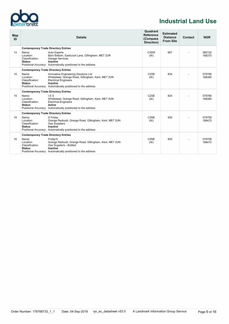
14
15
15
16
16
Contemporary Trade Directory Entries
Contemporary Trade Directory Entries
Contemporary Trade Directory Entries
Contemporary Trade Directory Entries
Contemporary Trade Directory Entries
C3SW(W)
C2SE(W)
C2SE(W)
C2NE(W)
C2NE(W)
667
834
834
930
930
-
-
-
-
-
Name:Location:Classification:Status:Positional Accuracy:
Name:Location:Classification:Status:Positional Accuracy:
Name:Location:Classification:Status:Positional Accuracy:
Name:Location:Classification:Status:Positional Accuracy:
Name:Location:Classification:Status:Positional Accuracy:
Auto ExpertsBarn Bottom, Eastcourt Lane, Gillingham, ME7 2URGarage ServicesInactiveAutomatically positioned to the address
Innovative Engineering Solutions LtdWhetstead, Grange Road, Gillingham, Kent, ME7 2UNElectrical EngineersInactiveAutomatically positioned to the address
I E SWhetstead, Grange Road, Gillingham, Kent, ME7 2UNElectrical EngineersActiveAutomatically positioned to the address
S FridayGrange Redoubt, Grange Road, Gillingham, Kent, ME7 2UNGas SuppliersInactiveAutomatically positioned to the address
Friday'SGrange Redoubt, Grange Road, Gillingham, Kent, ME7 2UNGas Suppliers - BottledInactiveAutomatically positioned to the address
580152168375
579766168395
579766168395
579708168472
579708168472

Order Number: 178768733_1_1 Date: 04-Sep-2018 rpr_ec_datasheet v53.0 A Landmark Information Group Service Page 10 of 16
Sensitive Land Use
Map
IDDetails
Quadrant
Reference
(Compass
Direction)
Estimated
Distance
From Site
Contact NGR
17
18
19
20
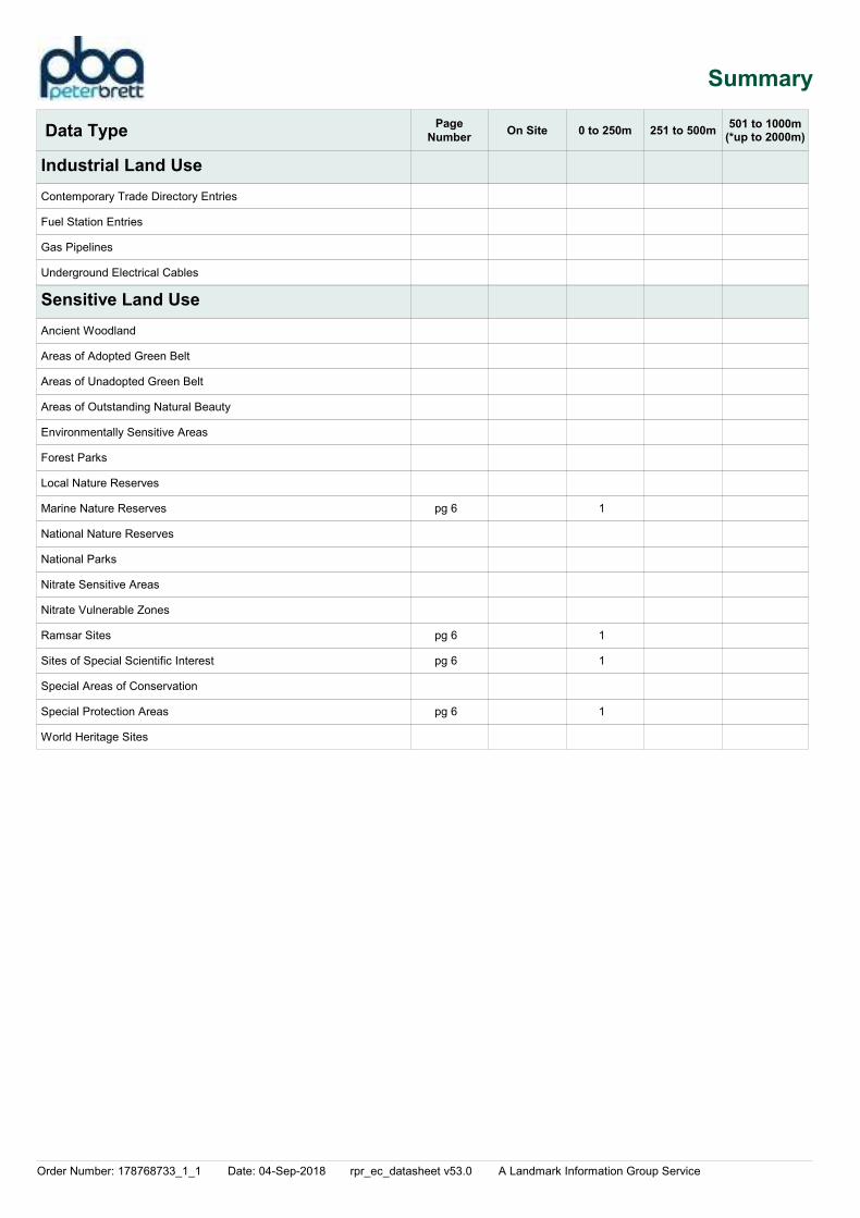
Marine Nature Reserves
Ramsar Sites
Sites of Special Scientific Interest
Special Protection Areas
C4NW(E)
C3NE(NE)
C3NE(NE)
C3NE(NE)
247
191
191
193
5
5
5
5
Name:Multiple Area:Area (m2):Source:
Name:Multiple Areas:Total Area (m2):Source:Reference:Designation Date:
Name:Multiple Areas:Total Area (m2):Source:Reference:Designation Details:Designation Date:Date Type:Designation Details:Designation Date:Date Type:Designation Details:Designation Date:Date Type:Designation Details:Designation Date:Date Type:Designation Details:Designation Date:Date Type:Designation Details:Designation Date:Date Type:Designation Details:Designation Date:Date Type:
Name:Multiple Areas:Total Area (m2):Source:Reference:Designation Date:
Medway EstuaryY59958380.4Natural England
Medway Estuary & MarshesY46979332.14Natural EnglandUK11040Not Supplied
Medway Estuary And MarshesY47488331.11Natural England1000244Environmentally Sensitive Area24th December 1991NotifiedNature Conservation Review24th December 1991NotifiedRamsar Site24th December 1991NotifiedRSPB Reserve24th December 1991NotifiedSpecial Protection Area24th December 1991NotifiedSite Of Special Scientific Interest24th December 1991NotifiedWater Framework Directive (WFD)24th December 1991Notified
Medway Estuary & MarshesY46863204.33Natural EnglandUK9012031Not Supplied
580772168529
580497168527
580497168527
580499168526
Order Number: 178768733_1_1 Date: 04-Sep-2018 rpr_ec_datasheet v53.0 A Landmark Information Group Service Page 11 of 16
Data Currency
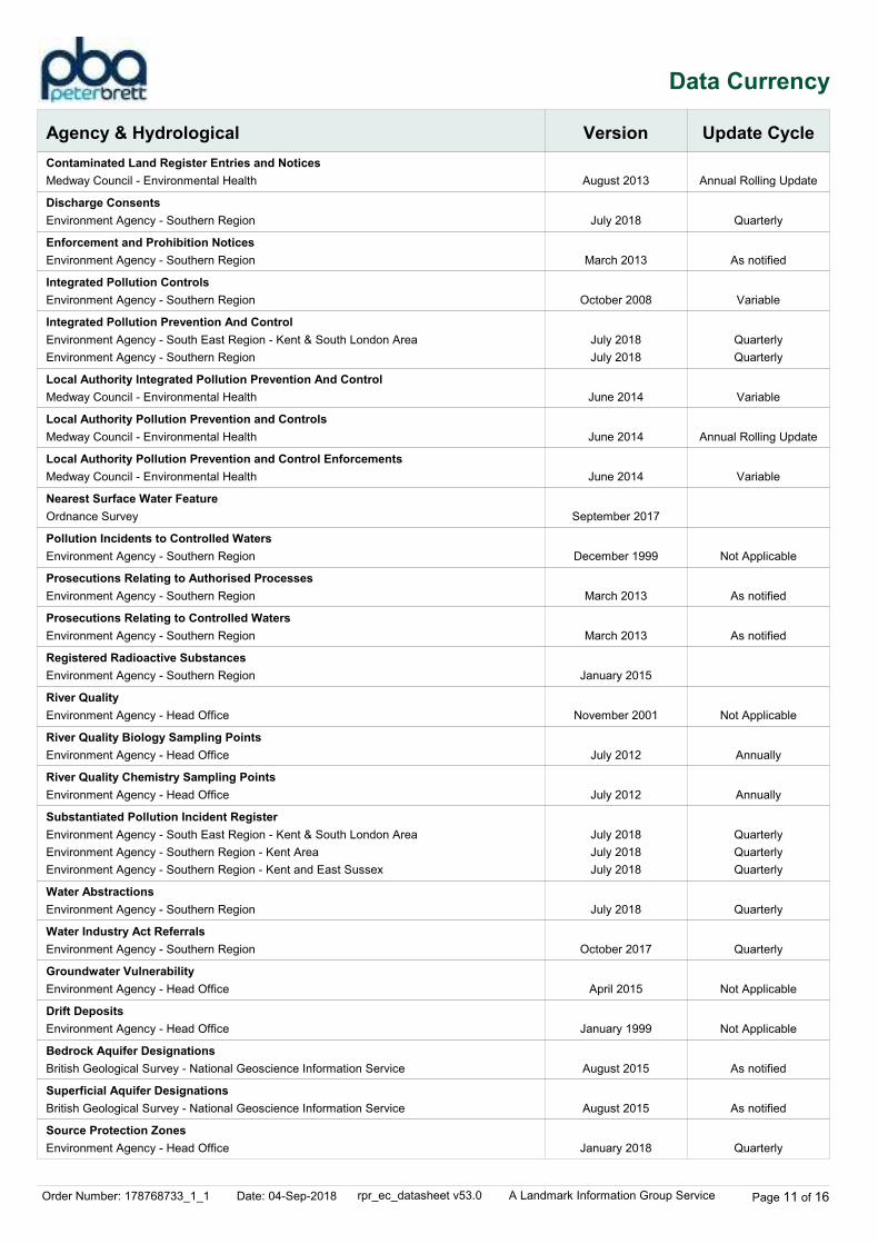
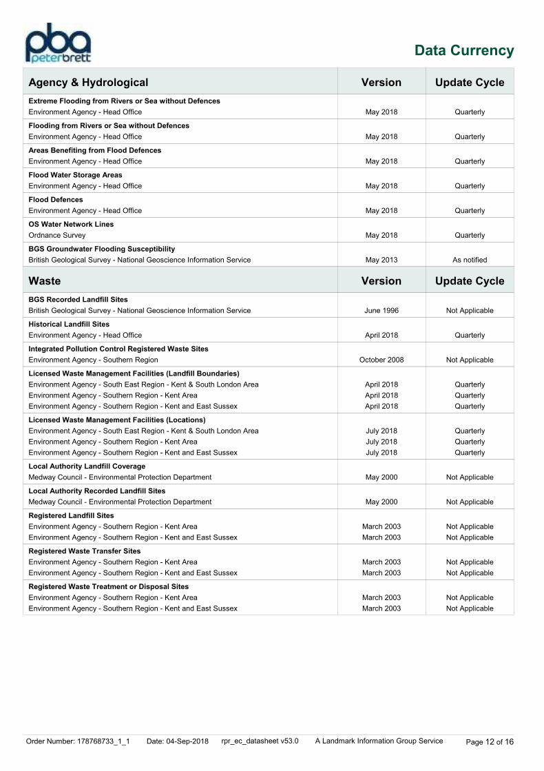
Agency & Hydrological Version Update Cycle
Contaminated Land Register Entries and Notices
Discharge Consents
Enforcement and Prohibition Notices
Integrated Pollution Controls
Integrated Pollution Prevention And Control
Local Authority Integrated Pollution Prevention And Control
Local Authority Pollution Prevention and Controls
Local Authority Pollution Prevention and Control Enforcements
Nearest Surface Water Feature
Pollution Incidents to Controlled Waters
Prosecutions Relating to Authorised Processes
Prosecutions Relating to Controlled Waters
Registered Radioactive Substances
River Quality
River Quality Biology Sampling Points
River Quality Chemistry Sampling Points
Substantiated Pollution Incident Register
Water Abstractions
Water Industry Act Referrals
Groundwater Vulnerability
Drift Deposits
Bedrock Aquifer Designations
Superficial Aquifer Designations
Source Protection Zones
August 2013
July 2018
March 2013
October 2008
July 2018
July 2018
June 2014
June 2014
June 2014
September 2017
December 1999
March 2013
March 2013
January 2015
November 2001
July 2012
July 2012
July 2018
July 2018
July 2018
July 2018
October 2017
April 2015
January 1999
August 2015
August 2015
January 2018
Annual Rolling Update
Quarterly
As notified
Variable
Quarterly
Quarterly
Variable
Annual Rolling Update
Variable
Not Applicable
As notified
As notified
Not Applicable
Annually
Annually
Quarterly
Quarterly
Quarterly
Quarterly
Quarterly
Not Applicable
Not Applicable
As notified
As notified
Quarterly
Medway Council - Environmental Health
Environment Agency - Southern Region
Environment Agency - Southern Region
Environment Agency - Southern Region
Environment Agency - South East Region - Kent & South London Area
Environment Agency - Southern Region
Medway Council - Environmental Health
Medway Council - Environmental Health
Medway Council - Environmental Health
Ordnance Survey
Environment Agency - Southern Region
Environment Agency - Southern Region
Environment Agency - Southern Region
Environment Agency - Southern Region
Environment Agency - Head Office
Environment Agency - Head Office
Environment Agency - Head Office
Environment Agency - South East Region - Kent & South London Area
Environment Agency - Southern Region - Kent Area
Environment Agency - Southern Region - Kent and East Sussex
Environment Agency - Southern Region
Environment Agency - Southern Region
Environment Agency - Head Office
Environment Agency - Head Office
British Geological Survey - National Geoscience Information Service
British Geological Survey - National Geoscience Information Service
Environment Agency - Head Office
Order Number: 178768733_1_1 Date: 04-Sep-2018 rpr_ec_datasheet v53.0 A Landmark Information Group Service Page 12 of 16
Data Currency
Agency & Hydrological
Waste
Version
Version
Update Cycle
Update Cycle
Extreme Flooding from Rivers or Sea without Defences
Flooding from Rivers or Sea without Defences
Areas Benefiting from Flood Defences
Flood Water Storage Areas
Flood Defences
OS Water Network Lines
BGS Groundwater Flooding Susceptibility
BGS Recorded Landfill Sites
Historical Landfill Sites
Integrated Pollution Control Registered Waste Sites
Licensed Waste Management Facilities (Landfill Boundaries)
Licensed Waste Management Facilities (Locations)
Local Authority Landfill Coverage
Local Authority Recorded Landfill Sites
Registered Landfill Sites
Registered Waste Transfer Sites
Registered Waste Treatment or Disposal Sites
May 2018
May 2018
May 2018
May 2018
May 2018
May 2018
May 2013
June 1996
April 2018
October 2008
April 2018
April 2018
April 2018
July 2018
July 2018
July 2018
May 2000
May 2000
March 2003
March 2003
March 2003
March 2003
March 2003
March 2003
Quarterly
Quarterly
Quarterly
Quarterly
Quarterly
Quarterly
As notified
Not Applicable
Quarterly
Not Applicable
Quarterly
Quarterly
Quarterly
Quarterly
Quarterly
Quarterly
Not Applicable
Not Applicable
Not Applicable
Not Applicable
Not Applicable
Not Applicable
Not Applicable
Not Applicable
Environment Agency - Head Office
Environment Agency - Head Office
Environment Agency - Head Office
Environment Agency - Head Office
Environment Agency - Head Office
Ordnance Survey
British Geological Survey - National Geoscience Information Service
British Geological Survey - National Geoscience Information Service
Environment Agency - Head Office
Environment Agency - Southern Region
Environment Agency - South East Region - Kent & South London Area
Environment Agency - Southern Region - Kent Area
Environment Agency - Southern Region - Kent and East Sussex
Environment Agency - South East Region - Kent & South London Area
Environment Agency - Southern Region - Kent Area
Environment Agency - Southern Region - Kent and East Sussex
Medway Council - Environmental Protection Department
Medway Council - Environmental Protection Department
Environment Agency - Southern Region - Kent Area
Environment Agency - Southern Region - Kent and East Sussex
Environment Agency - Southern Region - Kent Area
Environment Agency - Southern Region - Kent and East Sussex
Environment Agency - Southern Region - Kent Area
Environment Agency - Southern Region - Kent and East Sussex

Order Number: 178768733_1_1 Date: 04-Sep-2018 rpr_ec_datasheet v53.0 A Landmark Information Group Service Page 13 of 16
Data Currency
Hazardous Substances
Geological
Industrial Land Use
Version
Version
Version
Update Cycle
Update Cycle
Update Cycle
Control of Major Accident Hazards Sites (COMAH)
Explosive Sites
Notification of Installations Handling Hazardous Substances (NIHHS)
Planning Hazardous Substance Enforcements
Planning Hazardous Substance Consents
BGS 1:625,000 Solid Geology
BGS Recorded Mineral Sites
CBSCB Compensation District
Coal Mining Affected Areas
Mining Instability
Non Coal Mining Areas of Great Britain
Potential for Collapsible Ground Stability Hazards
Potential for Compressible Ground Stability Hazards
Potential for Ground Dissolution Stability Hazards
Potential for Landslide Ground Stability Hazards
Potential for Running Sand Ground Stability Hazards
Potential for Shrinking or Swelling Clay Ground Stability Hazards
Radon Potential - Radon Affected Areas
Radon Potential - Radon Protection Measures
Contemporary Trade Directory Entries
Fuel Station Entries
Gas Pipelines
Underground Electrical Cables
April 2018
March 2017
November 2000
February 2016
February 2016
January 2009
May 2018
August 2011
March 2014
October 2000
May 2015
June 2015
June 2015
June 2015
June 2015
June 2015
June 2015
July 2011
July 2011
May 2018
August 2018
July 2014
December 2015
Bi-Annually
Variable
Not Applicable
Variable
Variable
Not Applicable
Bi-Annually
Not Applicable
As notified
Not Applicable
Not Applicable
As notified
As notified
As notified
As notified
As notified
As notified
As notified
As notified
Quarterly
Quarterly
Health and Safety Executive
Health and Safety Executive
Health and Safety Executive
Medway Council
Medway Council
British Geological Survey - National Geoscience Information Service
British Geological Survey - National Geoscience Information Service
Cheshire Brine Subsidence Compensation Board (CBSCB)
The Coal Authority - Property Searches
Ove Arup & Partners
British Geological Survey - National Geoscience Information Service
British Geological Survey - National Geoscience Information Service
British Geological Survey - National Geoscience Information Service
British Geological Survey - National Geoscience Information Service
British Geological Survey - National Geoscience Information Service
British Geological Survey - National Geoscience Information Service
British Geological Survey - National Geoscience Information Service
British Geological Survey - National Geoscience Information Service
British Geological Survey - National Geoscience Information Service
Thomson Directories
Catalist Ltd - Experian
National Grid
National Grid
Order Number: 178768733_1_1 Date: 04-Sep-2018 rpr_ec_datasheet v53.0 A Landmark Information Group Service Page 14 of 16
Data Currency
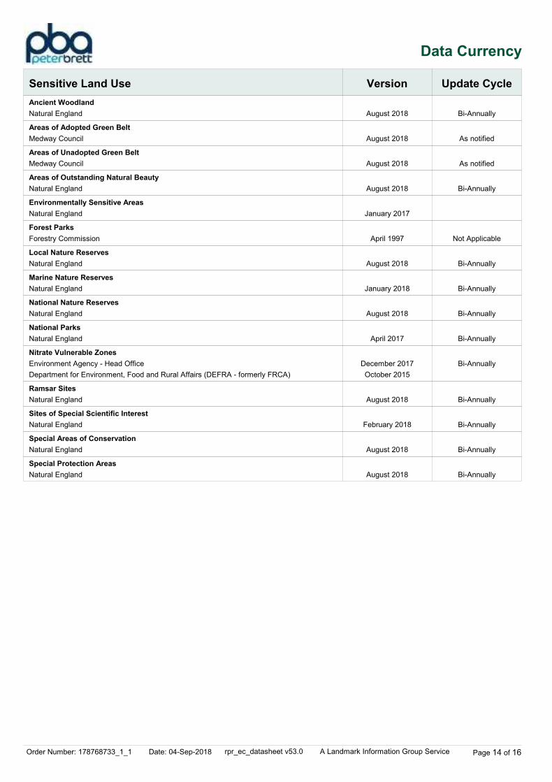
Sensitive Land Use Version Update Cycle
Ancient Woodland
Areas of Adopted Green Belt
Areas of Unadopted Green Belt
Areas of Outstanding Natural Beauty
Environmentally Sensitive Areas
Forest Parks
Local Nature Reserves
Marine Nature Reserves
National Nature Reserves
National Parks
Nitrate Vulnerable Zones
Ramsar Sites
Sites of Special Scientific Interest
Special Areas of Conservation
Special Protection Areas
August 2018
August 2018
August 2018
August 2018
January 2017
April 1997
August 2018
January 2018
August 2018
April 2017
December 2017
October 2015
August 2018
February 2018
August 2018
August 2018
Bi-Annually
As notified
As notified
Bi-Annually
Not Applicable
Bi-Annually
Bi-Annually
Bi-Annually
Bi-Annually
Bi-Annually
Bi-Annually
Bi-Annually
Bi-Annually
Bi-Annually
Natural England
Medway Council
Medway Council
Natural England
Natural England
Forestry Commission
Natural England
Natural England
Natural England
Natural England
Environment Agency - Head Office
Department for Environment, Food and Rural Affairs (DEFRA - formerly FRCA)
Natural England
Natural England
Natural England
Natural England
Order Number: 178768733_1_1 Date: 04-Sep-2018 rpr_ec_datasheet v53.0 A Landmark Information Group Service Page 15 of 16
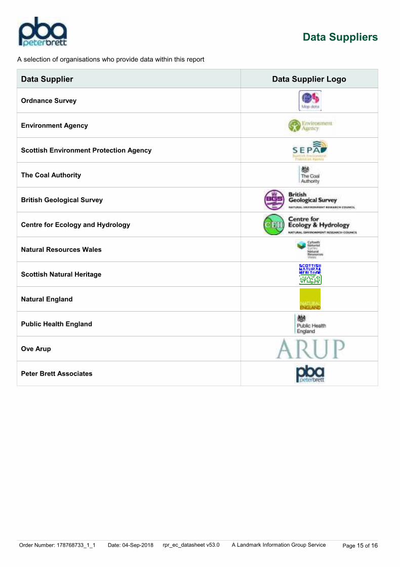
Data Suppliers
Ordnance Survey
Environment Agency
Scottish Environment Protection Agency
The Coal Authority
British Geological Survey
Centre for Ecology and Hydrology
Natural Resources Wales
Scottish Natural Heritage
Natural England
Public Health England
Ove Arup
Peter Brett Associates
Data Supplier Data Supplier Logo
A selection of organisations who provide data within this report
Order Number: 178768733_1_1 Date: 04-Sep-2018 rpr_ec_datasheet v53.0 A Landmark Information Group Service Page 16 of 16
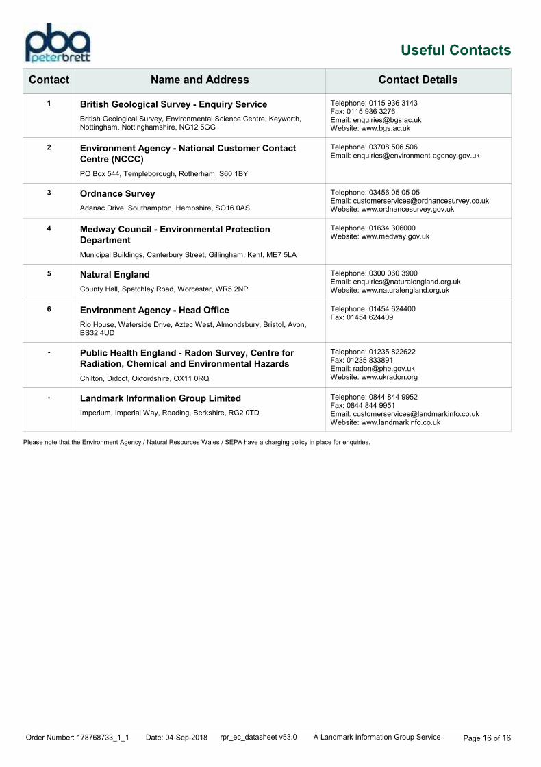
Useful Contacts
Contact Name and Address Contact Details
1
2
3
4
5
6
-
-
British Geological Survey - Enquiry Service
Environment Agency - National Customer Contact
Centre (NCCC)
Ordnance Survey
Medway Council - Environmental Protection
Department
Natural England
Environment Agency - Head Office
Public Health England - Radon Survey, Centre for
Radiation, Chemical and Environmental Hazards
Landmark Information Group Limited
British Geological Survey, Environmental Science Centre, Keyworth, Nottingham, Nottinghamshire, NG12 5GG
PO Box 544, Templeborough, Rotherham, S60 1BY
Adanac Drive, Southampton, Hampshire, SO16 0AS
Municipal Buildings, Canterbury Street, Gillingham, Kent, ME7 5LA
County Hall, Spetchley Road, Worcester, WR5 2NP
Rio House, Waterside Drive, Aztec West, Almondsbury, Bristol, Avon, BS32 4UD
Chilton, Didcot, Oxfordshire, OX11 0RQ
Imperium, Imperial Way, Reading, Berkshire, RG2 0TD
Telephone: 0115 936 3143Fax: 0115 936 3276Email: [email protected]: www.bgs.ac.uk
Telephone: 03708 506 506Email: [email protected]
Telephone: 03456 05 05 05Email: [email protected]: www.ordnancesurvey.gov.uk
Telephone: 01634 306000Website: www.medway.gov.uk
Telephone: 0300 060 3900Email: [email protected]: www.naturalengland.org.uk
Telephone: 01454 624400Fax: 01454 624409
Telephone: 01235 822622Fax: 01235 833891Email: [email protected]: www.ukradon.org
Telephone: 0844 844 9952Fax: 0844 844 9951Email: [email protected]: www.landmarkinfo.co.uk
Please note that the Environment Agency / Natural Resources Wales / SEPA have a charging policy in place for enquiries.

Pump and Bloors Farm, Rainham
Phase 1 Ground Conditions Assessment (Geotechnical and Contamination)
\\pba.int\cbh\Projects\44538 Pump and Bloors Farm\3500 Geo\05 Reports etc\Desk Study\Phase 1 GCA Final for Issue R01.docx
Appendix C4: EnviroCheck Report North-East (Area 4)

Order Details
Site Details1, Russett Farm, Rainham, GILLINGHAM, ME8 7AT
Order Number:Customer Ref:National Grid Reference:Slice:Site Area (Ha):Search Buffer (m):
178768733_1_144538-3501581570, 168420D51.81000
Tel:Fax:Web:
0844 844 99520844 844 9951www.envirocheck.co.uk
Page 1 of 6A Landmark Information Group Service v15.0 04-Sep-2018
Site Sensitivity Context Map - Slice D
Groundwater Vulnerability
Order Details
Site Details1, Russett Farm, Rainham, GILLINGHAM, ME8 7AT
Order Number:Customer Ref:National Grid Reference:Slice:Site Area (Ha):Search Buffer (m):
178768733_1_144538-3501581570, 168420D51.81000
Tel:Fax:Web:
0844 844 99520844 844 9951www.envirocheck.co.uk
Page 2 of 6A Landmark Information Group Service v15.0 04-Sep-2018
Site Sensitivity Context Map - Slice D
Bedrock Aquifer Designation
Order Details
Site Details1, Russett Farm, Rainham, GILLINGHAM, ME8 7AT
Order Number:Customer Ref:National Grid Reference:Slice:Site Area (Ha):Search Buffer (m):
178768733_1_144538-3501581570, 168420D51.81000
Tel:Fax:Web:
0844 844 99520844 844 9951www.envirocheck.co.uk
Page 3 of 6A Landmark Information Group Service v15.0 04-Sep-2018
Site Sensitivity Context Map - Slice D
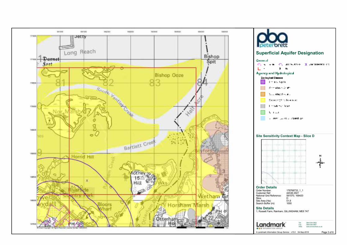
Superficial Aquifer Designation
Order Details
Site Details1, Russett Farm, Rainham, GILLINGHAM, ME8 7AT
Order Number:Customer Ref:National Grid Reference:Slice:Site Area (Ha):Search Buffer (m):
178768733_1_144538-3501581570, 168420D51.81000
Tel:Fax:Web:
0844 844 99520844 844 9951www.envirocheck.co.uk
Page 4 of 6A Landmark Information Group Service v15.0 04-Sep-2018
Site Sensitivity Context Map - Slice D
Source Protection Zones
Order Details
Site Details1, Russett Farm, Rainham, GILLINGHAM, ME8 7AT
Order Number:Customer Ref:National Grid Reference:Slice:Site Area (Ha):Search Buffer (m):
178768733_1_144538-3501581570, 168420D51.81000
Tel:Fax:Web:
0844 844 99520844 844 9951www.envirocheck.co.uk
Page 5 of 6A Landmark Information Group Service v15.0 04-Sep-2018
Site Sensitivity Context Map - Slice D
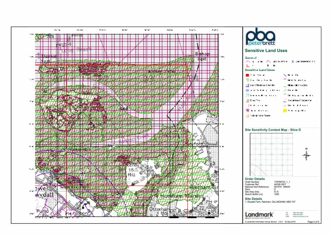
Sensitive Land Uses
Order Details
Site Details1, Russett Farm, Rainham, GILLINGHAM, ME8 7AT
Order Number:Customer Ref:National Grid Reference:Slice:Site Area (Ha):Search Buffer (m):
178768733_1_144538-3501581570, 168420D51.81000
Tel:Fax:Web:
0844 844 99520844 844 9951www.envirocheck.co.uk
Page 6 of 6A Landmark Information Group Service v15.0 04-Sep-2018
Site Sensitivity Context Map - Slice D
BGS Flood GFS Data

Order Number: 178768733_1_1 Date: 04-Sep-2018 rpr_ec_datasheet v53.0 A Landmark Information Group Service
Datasheet
Order Details:
Order Number:
Customer Reference:
National Grid Reference:
Slice:
Site Area (Ha):
Search Buffer (m):
Site Details:
Client Details:
178768733_1_1
44538-3501
581570, 168420
D
51.8
1000
1, Russett FarmRainhamGILLINGHAMME8 7AT
Ms K RileyPeter Brett Associates LLPCaversham Bridge HouseWaterman PlaceReadingBerkshireRG1 8DN
Report:®Envirocheck
Order Number: 178768733_1_1 Date: 04-Sep-2018 rpr_ec_datasheet v53.0 A Landmark Information Group Service
Summary
Agency & Hydrological
Waste
Hazardous Substances
Geological
Industrial Land Use
Sensitive Land Use
Data Currency
Data Suppliers
Useful Contacts
Introduction
Copyright Notice
Natural England Copyright Notice
Scottish Natural Heritage Copyright
Ove Arup Copyright Notice
Peter Brett Associates Copyright Notice
Radon Potential dataset Copyright Notice
Natural Resources Wales Copyright Notice
The Environment Act 1995 has made site sensitivity a key issue, as the legislation pays as much attention to the pathways by which contamination could spread, and to the vulnerable targets of contamination, as it does the potential sources of contamination. For this reason, Landmark's Site Sensitivity maps and Datasheet(s) place great emphasis on statutory data provided by the Environment Agency/Natural Resources Wales and the Scottish Environment Protection Agency; it also incorporates data from Natural England (and the Scottish and Welsh equivalents) and Local Authorities; and highlights hydrogeological features required by environmental and geotechnical consultants. It does not include any information concerning past uses of land. The datasheet is produced by querying the Landmark database to a distance defined by the client from a site boundary provided by the client. In the attached datasheet the National Grid References (NGRs) are rounded to the nearest 10m in accordance with Landmark's agreements with a number of Data Suppliers.
© Landmark Information Group Limited 2018. The Copyright on the information and data and its format as contained in this Envirocheck® Report ("Report") is the property of Landmark Information Group Limited ("Landmark") and several other Data Providers, including (but not limited to) Ordnance Survey, British Geological Survey, the Environment Agency/Natural Resources Wales and Natural England, and must not be reproduced in whole or in part by photocopying or any other method. The Report is supplied under Landmark's Terms and Conditions accepted by the Customer. A copy of Landmark's Terms and Conditions can be found with the Index Map for this report. Additional copies of the Report may be obtained from Landmark, subject to Landmark's charges in force from time to time. The Copyright, design rights and any other intellectual rights shall remain the exclusive property of Landmark and /or other Data providers, whose Copyright material has been included in this Report.
Site of Special Scientific Interest, National Nature Reserve, Ramsar, Special Protection Area, Special Conservation Area, Marine Nature Reserve data (derived from Ordnance Survey 1:10000 raster) is provided by, and used with the permission of, Natural England who retain the copyright and Intellectual Property Rights for the data.
Contains SNH information licensed under the Open Government Licence v3.0.
The Mining Instability data was obtained on licence from Ove Arup & Partners Limited (for further information, contact [email protected]). No reproduction or further use ofsuch Data is to be made without the prior written consent of Ove Arup & Partners Limited. The supplied Mining Instability data is derived from publicly available records and other third party sources and neither Ove Arup & Partners nor Landmark warrant the accuracy or completeness of such information or data.
The cavity data presented has been extracted from the PBA enhanced version of the original DEFRA national cavity databases. PBA/DEFRA retain the copyright & intellectual property rights in the data. Whilst all reasonable efforts are made to check that the information contained in the cavity databases is accurate we do not warrant that the data is complete or error free. The information is based upon our own researches and those collated from a number of external sources and is continually being augmented and updated by PBA. In no event shall PBA/DEFRA or Landmark be liable for any loss or damage including, without limitation, indirect or consequential loss or damage arising from the use of this data.
Information supplied from a joint dataset compiled by The British Geological Survey and Public Health England.
Contains Natural Resources Wales information © Natural Resources Wales and Database Right. All rights Reserved. Contains Ordnance Survey Data. Ordnance Survey Licence number 100019741. Crown Copyright and Database Right.Contains Natural Resources Wales information © Natural Resources Wales and Database Right. All rights Reserved. Some features of this information are based on digital spatial data licensed from the Centre for Ecology & Hydrology © NERC (CEH). Defra, Met Office and DARD Rivers Agency © Crown copyright. © Cranfield University. © James Hutton Institute. Contains OS data © Crown copyright and database right 2018. Land & Property Services © Crown copyright and database right.
Report Section Page Number
Contents
Report Version v53.0
-
1
4
-
5
-
6
7
11
12
Order Number: 178768733_1_1 Date: 04-Sep-2018 rpr_ec_datasheet v53.0 A Landmark Information Group Service
Summary
Data TypePage
NumberOn Site 0 to 250m 251 to 500m
Agency & Hydrological
501 to 1000m
BGS Groundwater Flooding Susceptibility
Contaminated Land Register Entries and Notices
Discharge Consents
Prosecutions Relating to Controlled Waters
Enforcement and Prohibition Notices
Integrated Pollution Controls
Integrated Pollution Prevention And Control
Local Authority Integrated Pollution Prevention And Control
Local Authority Pollution Prevention and Controls
Local Authority Pollution Prevention and Control Enforcements
Nearest Surface Water Feature
Pollution Incidents to Controlled Waters
Prosecutions Relating to Authorised Processes
Registered Radioactive Substances
River Quality
River Quality Biology Sampling Points
River Quality Chemistry Sampling Points
Substantiated Pollution Incident Register
Water Abstractions
Water Industry Act Referrals
Groundwater Vulnerability
Drift Deposits
Bedrock Aquifer Designations
Superficial Aquifer Designations
Source Protection Zones
Extreme Flooding from Rivers or Sea without Defences
Flooding from Rivers or Sea without Defences
Areas Benefiting from Flood Defences
Flood Water Storage Areas
Flood Defences
OS Water Network Lines
Yes
Yes
1
Yes
Yes
Yes
n/a
Yes
n/a
n/a
n/a
n/a
Yes
Yes
Yes
n/a
n/a
n/a
n/a
n/a
n/a
n/a
n/a
n/a
n/a
n/a
n/a
n/a
n/a
n/a
n/a
n/a
n/a
n/a
n/a
n/a
(*4)
(*up to 2000m)
pg 1
pg 1
pg 2
pg 2
pg 3
pg 3
pg 3
pg 3
pg 3
Order Number: 178768733_1_1 Date: 04-Sep-2018 rpr_ec_datasheet v53.0 A Landmark Information Group Service
Summary
Data TypePage
NumberOn Site 0 to 250m 251 to 500m
Waste
Hazardous Substances
Geological
501 to 1000m
BGS Recorded Landfill Sites
Historical Landfill Sites
Integrated Pollution Control Registered Waste Sites
Licensed Waste Management Facilities (Landfill Boundaries)
Licensed Waste Management Facilities (Locations)
Local Authority Landfill Coverage
Local Authority Recorded Landfill Sites
Registered Landfill Sites
Registered Waste Transfer Sites
Registered Waste Treatment or Disposal Sites
Control of Major Accident Hazards Sites (COMAH)
Explosive Sites
Notification of Installations Handling Hazardous Substances (NIHHS)
Planning Hazardous Substance Consents
Planning Hazardous Substance Enforcements
BGS 1:625,000 Solid Geology
BGS Recorded Mineral Sites
CBSCB Compensation District
Coal Mining Affected Areas
Mining Instability
Man-Made Mining Cavities
Natural Cavities
Non Coal Mining Areas of Great Britain
Potential for Collapsible Ground Stability Hazards
Potential for Compressible Ground Stability Hazards
Potential for Ground Dissolution Stability Hazards
Potential for Landslide Ground Stability Hazards
Potential for Running Sand Ground Stability Hazards
Potential for Shrinking or Swelling Clay Ground Stability Hazards
Radon Potential - Radon Affected Areas
Radon Potential - Radon Protection Measures
1
Yes
Yes
n/a
n/a
n/a
n/a
n/a
Yes
Yes
Yes
n/a
n/a
n/a
n/a
n/a
n/a
n/a
n/a
n/a
n/a
n/a
n/a
n/a
n/a
n/a
n/a
n/a
n/a
n/a
n/a
n/a
n/a
n/a
n/a
n/a
n/a
n/a
n/a
n/a
n/a
(*up to 2000m)
pg 4
pg 5
pg 5
pg 5
pg 5
Order Number: 178768733_1_1 Date: 04-Sep-2018 rpr_ec_datasheet v53.0 A Landmark Information Group Service
Summary
Data TypePage
NumberOn Site 0 to 250m 251 to 500m
Industrial Land Use
Sensitive Land Use
501 to 1000m
Contemporary Trade Directory Entries
Fuel Station Entries
Gas Pipelines
Underground Electrical Cables
Ancient Woodland
Areas of Adopted Green Belt
Areas of Unadopted Green Belt
Areas of Outstanding Natural Beauty
Environmentally Sensitive Areas
Forest Parks
Local Nature Reserves
Marine Nature Reserves
National Nature Reserves
National Parks
Nitrate Sensitive Areas
Nitrate Vulnerable Zones
Ramsar Sites
Sites of Special Scientific Interest
Special Areas of Conservation
Special Protection Areas
World Heritage Sites
1
1
1
1
(*up to 2000m)
pg 6
pg 6
pg 6
pg 6
Order Number: 178768733_1_1 Date: 04-Sep-2018 rpr_ec_datasheet v53.0 A Landmark Information Group Service Page 1 of 12
Agency & Hydrological
Map
IDDetails
Quadrant
Reference
(Compass
Direction)
Estimated
Distance
From Site
Contact NGR
BGS Groundwater Flooding Susceptibility
BGS Groundwater Flooding Susceptibility
BGS Groundwater Flooding Susceptibility
BGS Groundwater Flooding Susceptibility
BGS Groundwater Flooding Susceptibility
BGS Groundwater Flooding Susceptibility
BGS Groundwater Flooding Susceptibility
BGS Groundwater Flooding Susceptibility
BGS Groundwater Flooding Susceptibility
BGS Groundwater Flooding Susceptibility
BGS Groundwater Flooding Susceptibility
BGS Groundwater Flooding Susceptibility
BGS Groundwater Flooding Susceptibility
BGS Groundwater Flooding Susceptibility
BGS Groundwater Flooding Susceptibility
BGS Groundwater Flooding Susceptibility
BGS Groundwater Flooding Susceptibility
BGS Groundwater Flooding Susceptibility
BGS Groundwater Flooding Susceptibility
BGS Groundwater Flooding Susceptibility
Nearest Surface Water Feature
(SW)
(SW)
(SW)
D1SE(S)
(S)
(SW)
(SW)
(SW)
(SW)
(S)
(SW)
D1SW(SW)
(SW)
(S)
(S)
D1SW(SW)
(W)
(W)
(W)
D1SE(W)
(SW)
0
0
0
0
0
0
0
0
13
20
22
63
133
152
156
163
286
311
325
438
247
1
1
1
1
1
1
1
1
1
1
1
1
1
1
1
1
1
1
1
1
-
Flooding Type:
Flooding Type:
Flooding Type:
Flooding Type:
Flooding Type:
Flooding Type:
Flooding Type:
Flooding Type:
Flooding Type:
Flooding Type:
Flooding Type:
Flooding Type:
Flooding Type:
Flooding Type:
Flooding Type:
Flooding Type:
Flooding Type:
Flooding Type:
Flooding Type:
Flooding Type:
Limited Potential for Groundwater Flooding to Occur
Potential for Groundwater Flooding of Property Situated Below Ground Level
Potential for Groundwater Flooding of Property Situated Below Ground Level
Potential for Groundwater Flooding of Property Situated Below Ground Level
Potential for Groundwater Flooding of Property Situated Below Ground Level
Limited Potential for Groundwater Flooding to Occur
Potential for Groundwater Flooding to Occur at Surface
Limited Potential for Groundwater Flooding to Occur
Potential for Groundwater Flooding of Property Situated Below Ground Level
Limited Potential for Groundwater Flooding to Occur
Potential for Groundwater Flooding of Property Situated Below Ground Level
Potential for Groundwater Flooding of Property Situated Below Ground Level
Limited Potential for Groundwater Flooding to Occur
Potential for Groundwater Flooding of Property Situated Below Ground Level
Potential for Groundwater Flooding of Property Situated Below Ground Level
Potential for Groundwater Flooding to Occur at Surface
Potential for Groundwater Flooding of Property Situated Below Ground Level
Potential for Groundwater Flooding of Property Situated Below Ground Level
Potential for Groundwater Flooding to Occur at Surface
Limited Potential for Groundwater Flooding to Occur
581050167850
580750167650
580900167700
581550168350
581550167500
580650167600
580950167550
581100167950
580700167650
581572167450
580550167750
581500168250
580550167800
581572167650
581600167600
581350168200
580550168100
580600168300
580700168350
581572168421
581239168090
Order Number: 178768733_1_1 Date: 04-Sep-2018 rpr_ec_datasheet v53.0 A Landmark Information Group Service Page 2 of 12
Agency & Hydrological
Map
IDDetails
Quadrant
Reference
(Compass
Direction)
Estimated
Distance
From Site
Contact NGR
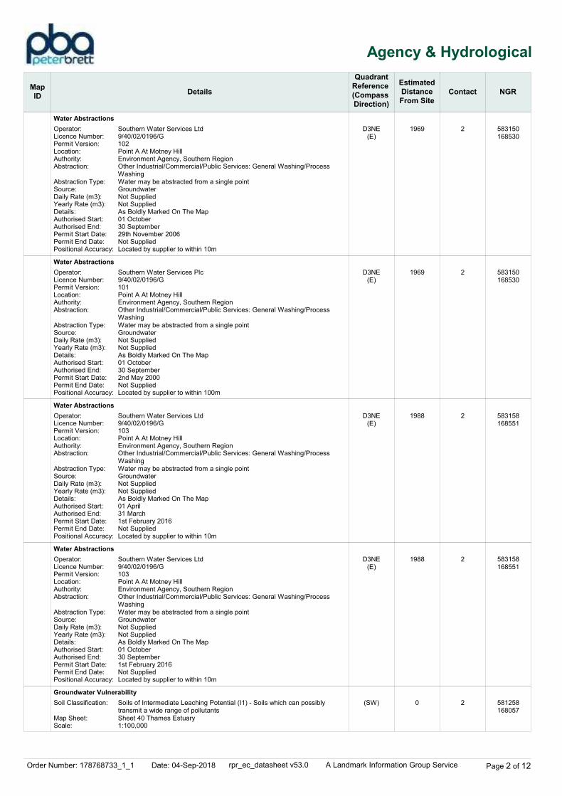
Water Abstractions
Water Abstractions
Water Abstractions
Water Abstractions
Groundwater Vulnerability
D3NE(E)
D3NE(E)
D3NE(E)
D3NE(E)
(SW)
1969
1969
1988
1988
0
2
2
2
2
2
Operator:Licence Number:Permit Version:Location:Authority:Abstraction:
Abstraction Type:Source:Daily Rate (m3):Yearly Rate (m3):Details:Authorised Start:Authorised End:Permit Start Date:Permit End Date:Positional Accuracy:
Operator:Licence Number:Permit Version:Location:Authority:Abstraction:
Abstraction Type:Source:Daily Rate (m3):Yearly Rate (m3):Details:Authorised Start:Authorised End:Permit Start Date:Permit End Date:Positional Accuracy:
Operator:Licence Number:Permit Version:Location:Authority:Abstraction:
Abstraction Type:Source:Daily Rate (m3):Yearly Rate (m3):Details:Authorised Start:Authorised End:Permit Start Date:Permit End Date:Positional Accuracy:
Operator:Licence Number:Permit Version:Location:Authority:Abstraction:
Abstraction Type:Source:Daily Rate (m3):Yearly Rate (m3):Details:Authorised Start:Authorised End:Permit Start Date:Permit End Date:Positional Accuracy:
Soil Classification:
Map Sheet:Scale:
Southern Water Services Ltd9/40/02/0196/G102Point A At Motney HillEnvironment Agency, Southern RegionOther Industrial/Commercial/Public Services: General Washing/Process WashingWater may be abstracted from a single pointGroundwaterNot SuppliedNot SuppliedAs Boldly Marked On The Map01 October30 September29th November 2006Not SuppliedLocated by supplier to within 10m
Southern Water Services Plc9/40/02/0196/G101Point A At Motney HillEnvironment Agency, Southern RegionOther Industrial/Commercial/Public Services: General Washing/Process WashingWater may be abstracted from a single pointGroundwaterNot SuppliedNot SuppliedAs Boldly Marked On The Map01 October30 September2nd May 2000Not SuppliedLocated by supplier to within 100m
Southern Water Services Ltd9/40/02/0196/G103Point A At Motney HillEnvironment Agency, Southern RegionOther Industrial/Commercial/Public Services: General Washing/Process WashingWater may be abstracted from a single pointGroundwaterNot SuppliedNot SuppliedAs Boldly Marked On The Map01 April31 March1st February 2016Not SuppliedLocated by supplier to within 10m
Southern Water Services Ltd9/40/02/0196/G103Point A At Motney HillEnvironment Agency, Southern RegionOther Industrial/Commercial/Public Services: General Washing/Process WashingWater may be abstracted from a single pointGroundwaterNot SuppliedNot SuppliedAs Boldly Marked On The Map01 October30 September1st February 2016Not SuppliedLocated by supplier to within 10m
Soils of Intermediate Leaching Potential (I1) - Soils which can possibly transmit a wide range of pollutantsSheet 40 Thames Estuary1:100,000
583150168530
583150168530
583158168551
583158168551
581258168057
Order Number: 178768733_1_1 Date: 04-Sep-2018 rpr_ec_datasheet v53.0 A Landmark Information Group Service Page 3 of 12
Agency & Hydrological
Map
IDDetails
Quadrant
Reference
(Compass
Direction)
Estimated
Distance
From Site
Contact NGR
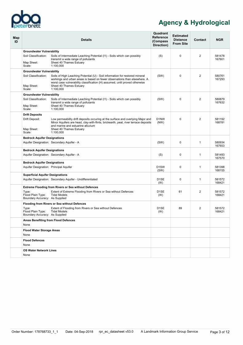
Groundwater Vulnerability
Groundwater Vulnerability
Groundwater Vulnerability
Drift Deposits
Bedrock Aquifer Designations
Bedrock Aquifer Designations
Bedrock Aquifer Designations
Superficial Aquifer Designations
Extreme Flooding from Rivers or Sea without Defences
Flooding from Rivers or Sea without Defences
Areas Benefiting from Flood Defences
Flood Water Storage Areas
Flood Defences
OS Water Network Lines
(S)
(SW)
(SW)
D1NW(NW)
(SW)
(S)
D1SW(SW)
D1SE(W)
D1SE(W)
D1SE(W)
0
0
0
0
0
0
0
0
61
89
2
2
2
2
1
1
1
1
2
2
Soil Classification:
Map Sheet:Scale:
Soil Classification:
Map Sheet:Scale:
Soil Classification:
Map Sheet:Scale:
Drift Deposit:
Map Sheet:Scale:
Aquifer Designation:
Aquifer Designation:
Aquifer Designation:
Aquifer Designation:
Type:Flood Plain Type:Boundary Accuracy:
Type:Flood Plain Type:Boundary Accuracy:
Soils of Intermediate Leaching Potential (I1) - Soils which can possibly transmit a wide range of pollutantsSheet 40 Thames Estuary1:100,000
Soils of High Leaching Potential (U) - Soil information for restored mineral workings and urban areas is based on fewer observations than elsewhere. A worst case vulnerability classification (H) assumed, until proved otherwiseSheet 40 Thames Estuary1:100,000
Soils of Intermediate Leaching Potential (I1) - Soils which can possibly transmit a wide range of pollutantsSheet 40 Thames Estuary1:100,000
Low permeability drift deposits occuring at the surface and overlying Major andMinor Aquifers are head, clay-with-flints, brickearth, peat, river terrace depositsand marine and estuarine alluviumSheet 40 Thames Estuary1:100,000
Secondary Aquifer - A
Secondary Aquifer - A
Principal Aquifer
Secondary Aquifer - Undifferentiated
Extent of Extreme Flooding from Rivers or Sea without DefencesTidal ModelsAs Supplied
Extent of Flooding from Rivers or Sea without DefencesTidal ModelsAs Supplied
None
None
None
None
581478167601
580761167293
580879167632
581192168781
580934167653
581493167570
581398168155
581572168421
581572168421
581572168421

Order Number: 178768733_1_1 Date: 04-Sep-2018 rpr_ec_datasheet v53.0 A Landmark Information Group Service Page 4 of 12
Waste
Map
IDDetails
Quadrant
Reference
(Compass
Direction)
Estimated
Distance
From Site
Contact NGR
Local Authority Landfill Coverage
0 3Name: Medway Unitary Council - Has no landfill data to supply
581572168421
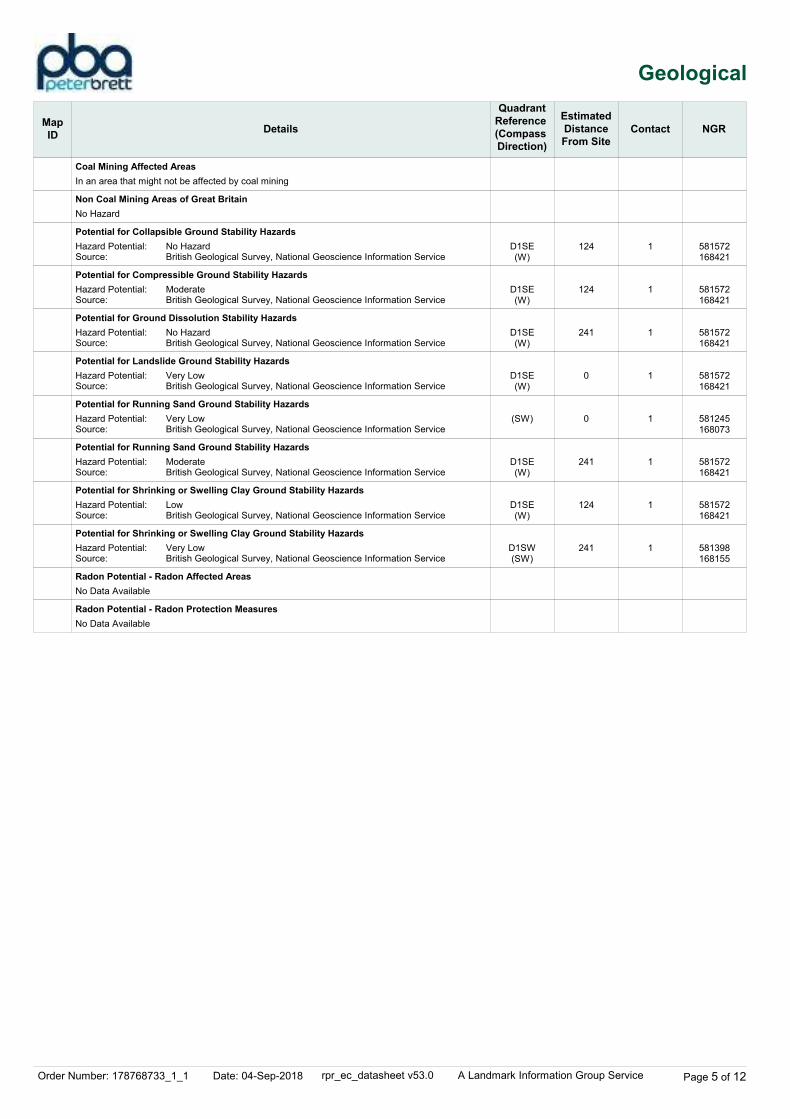
Order Number: 178768733_1_1 Date: 04-Sep-2018 rpr_ec_datasheet v53.0 A Landmark Information Group Service Page 5 of 12
Geological
Map
IDDetails
Quadrant
Reference
(Compass
Direction)
Estimated
Distance
From Site
Contact NGR
Coal Mining Affected Areas
Non Coal Mining Areas of Great Britain
Potential for Collapsible Ground Stability Hazards
Potential for Compressible Ground Stability Hazards
Potential for Ground Dissolution Stability Hazards
Potential for Landslide Ground Stability Hazards
Potential for Running Sand Ground Stability Hazards
Potential for Running Sand Ground Stability Hazards
Potential for Shrinking or Swelling Clay Ground Stability Hazards
Potential for Shrinking or Swelling Clay Ground Stability Hazards
Radon Potential - Radon Affected Areas
Radon Potential - Radon Protection Measures
D1SE(W)
D1SE(W)
D1SE(W)
D1SE(W)
(SW)
D1SE(W)
D1SE(W)
D1SW(SW)
124
124
241
0
0
241
124
241
1
1
1
1
1
1
1
1
Hazard Potential:Source:
Hazard Potential:Source:
Hazard Potential:Source:
Hazard Potential:Source:
Hazard Potential:Source:
Hazard Potential:Source:
Hazard Potential:Source:
Hazard Potential:Source:
No HazardBritish Geological Survey, National Geoscience Information Service
ModerateBritish Geological Survey, National Geoscience Information Service
No HazardBritish Geological Survey, National Geoscience Information Service
Very LowBritish Geological Survey, National Geoscience Information Service
Very LowBritish Geological Survey, National Geoscience Information Service
ModerateBritish Geological Survey, National Geoscience Information Service
LowBritish Geological Survey, National Geoscience Information Service
Very LowBritish Geological Survey, National Geoscience Information Service
In an area that might not be affected by coal mining
No Hazard
No Data Available
No Data Available
581572168421
581572168421
581572168421
581572168421
581245168073
581572168421
581572168421
581398168155
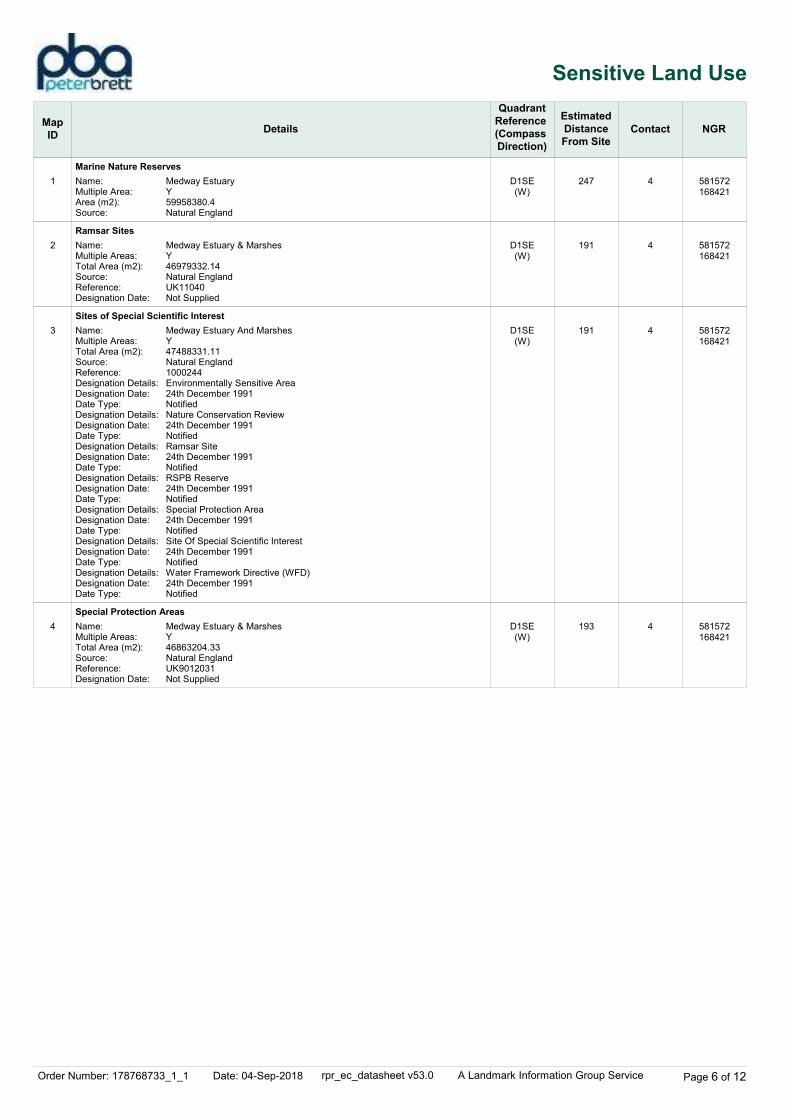
Order Number: 178768733_1_1 Date: 04-Sep-2018 rpr_ec_datasheet v53.0 A Landmark Information Group Service Page 6 of 12
Sensitive Land Use
Map
IDDetails
Quadrant
Reference
(Compass
Direction)
Estimated
Distance
From Site
Contact NGR
1
2
3
4
Marine Nature Reserves
Ramsar Sites
Sites of Special Scientific Interest
Special Protection Areas
D1SE(W)
D1SE(W)
D1SE(W)
D1SE(W)
247
191
191
193
4
4
4
4
Name:Multiple Area:Area (m2):Source:
Name:Multiple Areas:Total Area (m2):Source:Reference:Designation Date:
Name:Multiple Areas:Total Area (m2):Source:Reference:Designation Details:Designation Date:Date Type:Designation Details:Designation Date:Date Type:Designation Details:Designation Date:Date Type:Designation Details:Designation Date:Date Type:Designation Details:Designation Date:Date Type:Designation Details:Designation Date:Date Type:Designation Details:Designation Date:Date Type:
Name:Multiple Areas:Total Area (m2):Source:Reference:Designation Date:
Medway EstuaryY59958380.4Natural England
Medway Estuary & MarshesY46979332.14Natural EnglandUK11040Not Supplied
Medway Estuary And MarshesY47488331.11Natural England1000244Environmentally Sensitive Area24th December 1991NotifiedNature Conservation Review24th December 1991NotifiedRamsar Site24th December 1991NotifiedRSPB Reserve24th December 1991NotifiedSpecial Protection Area24th December 1991NotifiedSite Of Special Scientific Interest24th December 1991NotifiedWater Framework Directive (WFD)24th December 1991Notified
Medway Estuary & MarshesY46863204.33Natural EnglandUK9012031Not Supplied
581572168421
581572168421
581572168421
581572168421
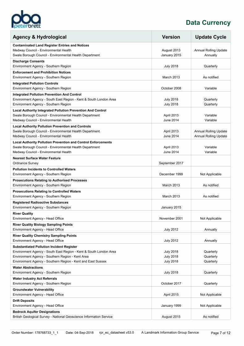
Order Number: 178768733_1_1 Date: 04-Sep-2018 rpr_ec_datasheet v53.0 A Landmark Information Group Service Page 7 of 12
Data Currency
Agency & Hydrological Version Update Cycle
Contaminated Land Register Entries and Notices
Discharge Consents
Enforcement and Prohibition Notices
Integrated Pollution Controls
Integrated Pollution Prevention And Control
Local Authority Integrated Pollution Prevention And Control
Local Authority Pollution Prevention and Controls
Local Authority Pollution Prevention and Control Enforcements
Nearest Surface Water Feature
Pollution Incidents to Controlled Waters
Prosecutions Relating to Authorised Processes
Prosecutions Relating to Controlled Waters
Registered Radioactive Substances
River Quality
River Quality Biology Sampling Points
River Quality Chemistry Sampling Points
Substantiated Pollution Incident Register
Water Abstractions
Water Industry Act Referrals
Groundwater Vulnerability
Drift Deposits
Bedrock Aquifer Designations
August 2013
January 2015
July 2018
March 2013
October 2008
July 2018
July 2018
April 2013
June 2014
April 2013
June 2014
April 2013
June 2014
September 2017
December 1999
March 2013
March 2013
January 2015
November 2001
July 2012
July 2012
July 2018
July 2018
July 2018
July 2018
October 2017
April 2015
January 1999
August 2015
Annual Rolling Update
Annually
Quarterly
As notified
Variable
Quarterly
Quarterly
Variable
Variable
Annual Rolling Update
Annual Rolling Update
Variable
Variable
Not Applicable
As notified
As notified
Not Applicable
Annually
Annually
Quarterly
Quarterly
Quarterly
Quarterly
Quarterly
Not Applicable
Not Applicable
As notified
Medway Council - Environmental Health
Swale Borough Council - Environmental Health Department
Environment Agency - Southern Region
Environment Agency - Southern Region
Environment Agency - Southern Region
Environment Agency - South East Region - Kent & South London Area
Environment Agency - Southern Region
Swale Borough Council - Environmental Health Department
Medway Council - Environmental Health
Swale Borough Council - Environmental Health Department
Medway Council - Environmental Health
Swale Borough Council - Environmental Health Department
Medway Council - Environmental Health
Ordnance Survey
Environment Agency - Southern Region
Environment Agency - Southern Region
Environment Agency - Southern Region
Environment Agency - Southern Region
Environment Agency - Head Office
Environment Agency - Head Office
Environment Agency - Head Office
Environment Agency - South East Region - Kent & South London Area
Environment Agency - Southern Region - Kent Area
Environment Agency - Southern Region - Kent and East Sussex
Environment Agency - Southern Region
Environment Agency - Southern Region
Environment Agency - Head Office
Environment Agency - Head Office
British Geological Survey - National Geoscience Information Service
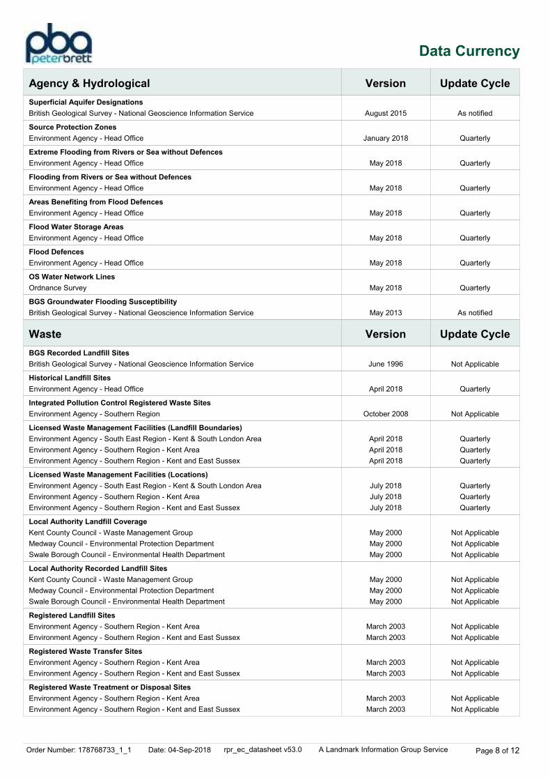
Order Number: 178768733_1_1 Date: 04-Sep-2018 rpr_ec_datasheet v53.0 A Landmark Information Group Service Page 8 of 12
Data Currency
Agency & Hydrological
Waste
Version
Version
Update Cycle
Update Cycle
Superficial Aquifer Designations
Source Protection Zones
Extreme Flooding from Rivers or Sea without Defences
Flooding from Rivers or Sea without Defences
Areas Benefiting from Flood Defences
Flood Water Storage Areas
Flood Defences
OS Water Network Lines
BGS Groundwater Flooding Susceptibility
BGS Recorded Landfill Sites
Historical Landfill Sites
Integrated Pollution Control Registered Waste Sites
Licensed Waste Management Facilities (Landfill Boundaries)
Licensed Waste Management Facilities (Locations)
Local Authority Landfill Coverage
Local Authority Recorded Landfill Sites
Registered Landfill Sites
Registered Waste Transfer Sites
Registered Waste Treatment or Disposal Sites
August 2015
January 2018
May 2018
May 2018
May 2018
May 2018
May 2018
May 2018
May 2013
June 1996
April 2018
October 2008
April 2018
April 2018
April 2018
July 2018
July 2018
July 2018
May 2000
May 2000
May 2000
May 2000
May 2000
May 2000
March 2003
March 2003
March 2003
March 2003
March 2003
March 2003
As notified
Quarterly
Quarterly
Quarterly
Quarterly
Quarterly
Quarterly
Quarterly
As notified
Not Applicable
Quarterly
Not Applicable
Quarterly
Quarterly
Quarterly
Quarterly
Quarterly
Quarterly
Not Applicable
Not Applicable
Not Applicable
Not Applicable
Not Applicable
Not Applicable
Not Applicable
Not Applicable
Not Applicable
Not Applicable
Not Applicable
Not Applicable
British Geological Survey - National Geoscience Information Service
Environment Agency - Head Office
Environment Agency - Head Office
Environment Agency - Head Office
Environment Agency - Head Office
Environment Agency - Head Office
Environment Agency - Head Office
Ordnance Survey
British Geological Survey - National Geoscience Information Service
British Geological Survey - National Geoscience Information Service
Environment Agency - Head Office
Environment Agency - Southern Region
Environment Agency - South East Region - Kent & South London Area
Environment Agency - Southern Region - Kent Area
Environment Agency - Southern Region - Kent and East Sussex
Environment Agency - South East Region - Kent & South London Area
Environment Agency - Southern Region - Kent Area
Environment Agency - Southern Region - Kent and East Sussex
Kent County Council - Waste Management Group
Medway Council - Environmental Protection Department
Swale Borough Council - Environmental Health Department
Kent County Council - Waste Management Group
Medway Council - Environmental Protection Department
Swale Borough Council - Environmental Health Department
Environment Agency - Southern Region - Kent Area
Environment Agency - Southern Region - Kent and East Sussex
Environment Agency - Southern Region - Kent Area
Environment Agency - Southern Region - Kent and East Sussex
Environment Agency - Southern Region - Kent Area
Environment Agency - Southern Region - Kent and East Sussex
Order Number: 178768733_1_1 Date: 04-Sep-2018 rpr_ec_datasheet v53.0 A Landmark Information Group Service Page 9 of 12
Data Currency
Hazardous Substances
Geological
Version
Version
Update Cycle
Update Cycle
Control of Major Accident Hazards Sites (COMAH)
Explosive Sites
Notification of Installations Handling Hazardous Substances (NIHHS)
Planning Hazardous Substance Enforcements
Planning Hazardous Substance Consents
BGS 1:625,000 Solid Geology
BGS Recorded Mineral Sites
CBSCB Compensation District
Coal Mining Affected Areas
Mining Instability
Non Coal Mining Areas of Great Britain
Potential for Collapsible Ground Stability Hazards
Potential for Compressible Ground Stability Hazards
Potential for Ground Dissolution Stability Hazards
Potential for Landslide Ground Stability Hazards
Potential for Running Sand Ground Stability Hazards
Potential for Shrinking or Swelling Clay Ground Stability Hazards
Radon Potential - Radon Affected Areas
Radon Potential - Radon Protection Measures
April 2018
March 2017
November 2000
February 2016
January 2016
October 2015
February 2016
January 2016
October 2015
January 2009
May 2018
August 2011
March 2014
October 2000
May 2015
June 2015
June 2015
June 2015
June 2015
June 2015
June 2015
July 2011
July 2011
Bi-Annually
Variable
Not Applicable
Variable
Variable
Variable
Variable
Variable
Variable
Not Applicable
Bi-Annually
Not Applicable
As notified
Not Applicable
Not Applicable
As notified
As notified
As notified
As notified
As notified
As notified
As notified
As notified
Health and Safety Executive
Health and Safety Executive
Health and Safety Executive
Medway Council
Kent County Council
Swale Borough Council
Medway Council
Kent County Council
Swale Borough Council
British Geological Survey - National Geoscience Information Service
British Geological Survey - National Geoscience Information Service
Cheshire Brine Subsidence Compensation Board (CBSCB)
The Coal Authority - Property Searches
Ove Arup & Partners
British Geological Survey - National Geoscience Information Service
British Geological Survey - National Geoscience Information Service
British Geological Survey - National Geoscience Information Service
British Geological Survey - National Geoscience Information Service
British Geological Survey - National Geoscience Information Service
British Geological Survey - National Geoscience Information Service
British Geological Survey - National Geoscience Information Service
British Geological Survey - National Geoscience Information Service
British Geological Survey - National Geoscience Information Service
Order Number: 178768733_1_1 Date: 04-Sep-2018 rpr_ec_datasheet v53.0 A Landmark Information Group Service Page 10 of 12
Data Currency
Industrial Land Use
Sensitive Land Use
Version
Version
Update Cycle
Update Cycle
Contemporary Trade Directory Entries
Fuel Station Entries
Gas Pipelines
Underground Electrical Cables
Ancient Woodland
Areas of Adopted Green Belt
Areas of Unadopted Green Belt
Areas of Outstanding Natural Beauty
Environmentally Sensitive Areas
Forest Parks
Local Nature Reserves
Marine Nature Reserves
National Nature Reserves
National Parks
Nitrate Vulnerable Zones
Ramsar Sites
Sites of Special Scientific Interest
Special Areas of Conservation
Special Protection Areas
May 2018
August 2018
July 2014
December 2015
August 2018
August 2018
August 2018
August 2018
January 2017
April 1997
August 2018
January 2018
August 2018
April 2017
October 2015
August 2018
February 2018
August 2018
August 2018
Quarterly
Quarterly
Bi-Annually
As notified
As notified
Bi-Annually
Not Applicable
Bi-Annually
Bi-Annually
Bi-Annually
Bi-Annually
Bi-Annually
Bi-Annually
Bi-Annually
Bi-Annually
Thomson Directories
Catalist Ltd - Experian
National Grid
National Grid
Natural England
Medway Council
Medway Council
Natural England
Natural England
Forestry Commission
Natural England
Natural England
Natural England
Natural England
Department for Environment, Food and Rural Affairs (DEFRA - formerly FRCA)
Natural England
Natural England
Natural England
Natural England

Order Number: 178768733_1_1 Date: 04-Sep-2018 rpr_ec_datasheet v53.0 A Landmark Information Group Service Page 11 of 12
Data Suppliers
Ordnance Survey
Environment Agency
Scottish Environment Protection Agency
The Coal Authority
British Geological Survey
Centre for Ecology and Hydrology
Natural Resources Wales
Scottish Natural Heritage
Natural England
Public Health England
Ove Arup
Peter Brett Associates
Data Supplier Data Supplier Logo
A selection of organisations who provide data within this report
Order Number: 178768733_1_1 Date: 04-Sep-2018 rpr_ec_datasheet v53.0 A Landmark Information Group Service Page 12 of 12
Useful Contacts
Contact Name and Address Contact Details
1
2
3
4
-
-
British Geological Survey - Enquiry Service
Environment Agency - National Customer Contact
Centre (NCCC)
Medway Council - Environmental Protection
Department
Natural England
Public Health England - Radon Survey, Centre for
Radiation, Chemical and Environmental Hazards
Landmark Information Group Limited
British Geological Survey, Environmental Science Centre, Keyworth, Nottingham, Nottinghamshire, NG12 5GG
PO Box 544, Templeborough, Rotherham, S60 1BY
Municipal Buildings, Canterbury Street, Gillingham, Kent, ME7 5LA
County Hall, Spetchley Road, Worcester, WR5 2NP
Chilton, Didcot, Oxfordshire, OX11 0RQ
Imperium, Imperial Way, Reading, Berkshire, RG2 0TD
Telephone: 0115 936 3143Fax: 0115 936 3276Email: [email protected]: www.bgs.ac.uk
Telephone: 03708 506 506Email: [email protected]
Telephone: 01634 306000Website: www.medway.gov.uk
Telephone: 0300 060 3900Email: [email protected]: www.naturalengland.org.uk
Telephone: 01235 822622Fax: 01235 833891Email: [email protected]: www.ukradon.org
Telephone: 0844 844 9952Fax: 0844 844 9951Email: [email protected]: www.landmarkinfo.co.uk
Please note that the Environment Agency / Natural Resources Wales / SEPA have a charging policy in place for enquiries.

Pump and Bloors Farm, Rainham
Phase 1 Ground Conditions Assessment (Geotechnical and Contamination)
\\pba.int\cbh\Projects\44538 Pump and Bloors Farm\3500 Geo\05 Reports etc\Desk Study\Phase 1 GCA Final for Issue R01.docx
Appendix D: Walkover Photographic Plates
Plate 1 – Pump Farm Access Road, facing south south-east.
Plate 2 – Pump Farm Forecourt, facing north.
Client
Pump Farm Site
Date 07.09.2018
AC Goatham & Son
Scale -
Drawn WW
Checked
Appendix
D Caversham Bridge House, Waterman Pl, Reading, RG1 8DN Tel 0118 950 0761
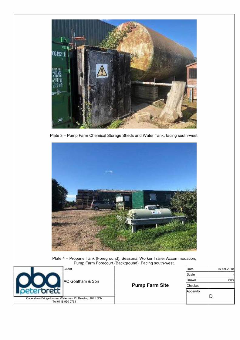
Plate 3 – Pump Farm Chemical Storage Sheds and Water Tank, facing south-west.
Plate 4 – Propane Tank (Foreground), Seasonal Worker Trailer Accommodation, Pump Farm Forecourt (Background). Facing south-west.
Client
Pump Farm Site
Date 07.09.2018
AC Goatham & Son
Scale -
Drawn WW
Checked
Appendix
D Caversham Bridge House, Waterman Pl, Reading, RG1 8DN Tel 0118 950 0761
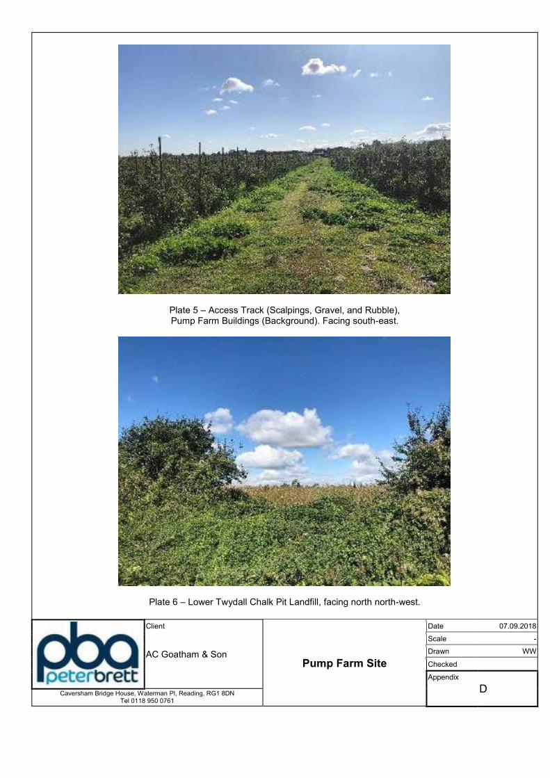
Plate 5 – Access Track (Scalpings, Gravel, and Rubble), Pump Farm Buildings (Background). Facing south-east.
Plate 6 – Lower Twydall Chalk Pit Landfill, facing north north-west.
Client
Pump Farm Site
Date 07.09.2018
AC Goatham & Son
Scale -
Drawn WW
Checked
Appendix
D Caversham Bridge House, Waterman Pl, Reading, RG1 8DN Tel 0118 950 0761
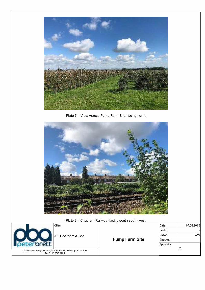
Plate 7 – View Across Pump Farm Site, facing north.
Plate 8 – Chatham Railway, facing south south-west.
Client
Pump Farm Site
Date 07.09.2018
AC Goatham & Son
Scale -
Drawn WW
Checked
Appendix
D Caversham Bridge House, Waterman Pl, Reading, RG1 8DN Tel 0118 950 0761
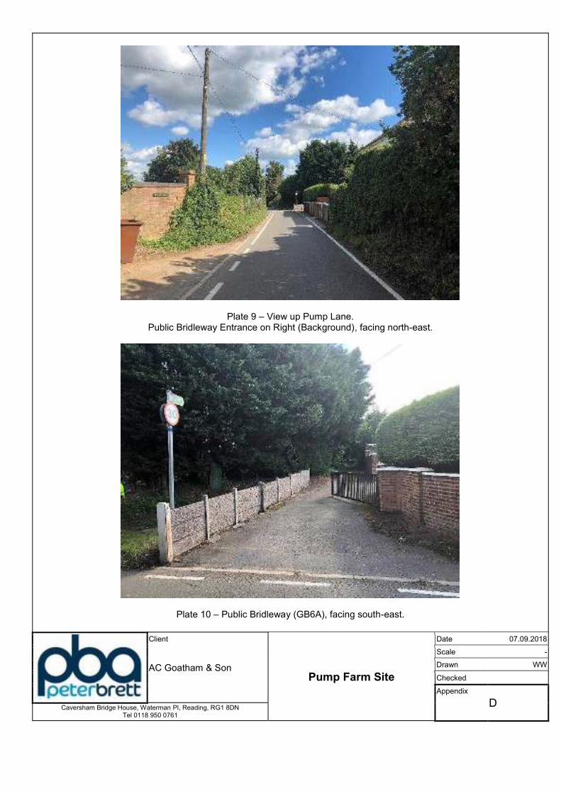
Plate 9 – View up Pump Lane. Public Bridleway Entrance on Right (Background), facing north-east.
Plate 10 – Public Bridleway (GB6A), facing south-east.
Client
Pump Farm Site
Date 07.09.2018
AC Goatham & Son
Scale -
Drawn WW
Checked
Appendix
D Caversham Bridge House, Waterman Pl, Reading, RG1 8DN Tel 0118 950 0761
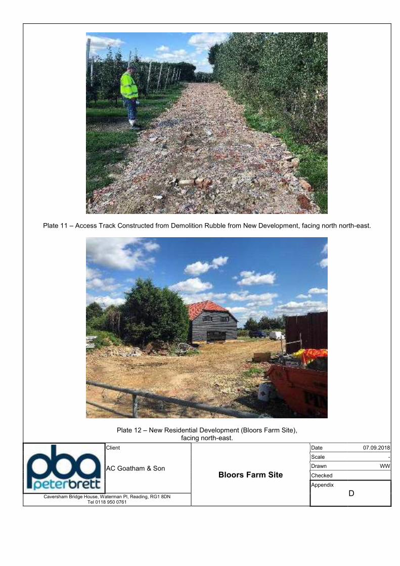
Plate 11 – Access Track Constructed from Demolition Rubble from New Development, facing north north-east.
Plate 12 – New Residential Development (Bloors Farm Site), facing north-east.
Client
Bloors Farm Site
Date 07.09.2018
AC Goatham & Son
Scale -
Drawn WW
Checked
Appendix
D Caversham Bridge House, Waterman Pl, Reading, RG1 8DN Tel 0118 950 0761
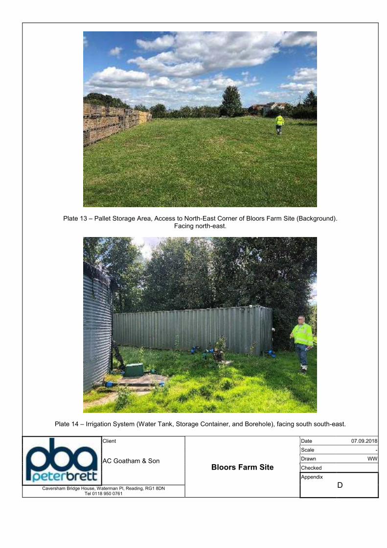
Plate 13 – Pallet Storage Area, Access to North-East Corner of Bloors Farm Site (Background). Facing north-east.
Plate 14 – Irrigation System (Water Tank, Storage Container, and Borehole), facing south south-east.
Client
Bloors Farm Site
Date 07.09.2018
AC Goatham & Son
Scale -
Drawn WW
Checked
Appendix
D Caversham Bridge House, Waterman Pl, Reading, RG1 8DN Tel 0118 950 0761
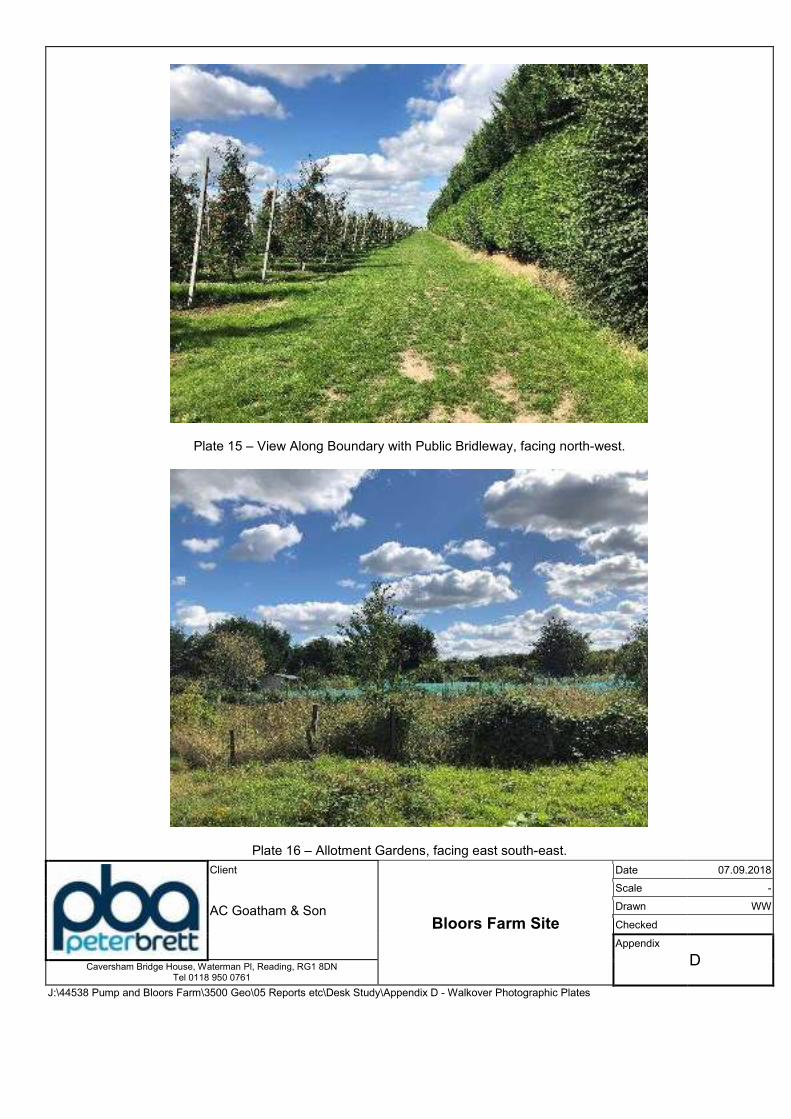
Plate 15 – View Along Boundary with Public Bridleway, facing north-west.
Plate 16 – Allotment Gardens, facing east south-east.
Client
Bloors Farm Site
Date 07.09.2018
AC Goatham & Son
Scale -
Drawn WW
Checked
Appendix
D Caversham Bridge House, Waterman Pl, Reading, RG1 8DN Tel 0118 950 0761
J:\44538 Pump and Bloors Farm\3500 Geo\05 Reports etc\Desk Study\Appendix D - Walkover Photographic Plates
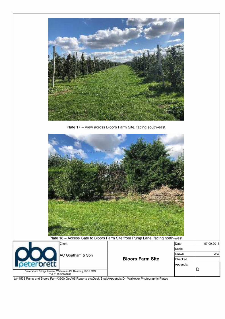
Plate 17 – View across Bloors Farm Site, facing south-east.
Plate 18 – Access Gate to Bloors Farm Site from Pump Lane, facing north-west.
Client
Bloors Farm Site
Date 07.09.2018
AC Goatham & Son
Scale -
Drawn WW
Checked
Appendix
D Caversham Bridge House, Waterman Pl, Reading, RG1 8DN
Tel 0118 950 0761
J:\44538 Pump and Bloors Farm\3500 Geo\05 Reports etc\Desk Study\Appendix D - Walkover Photographic Plates

Pump and Bloors Farm, Rainham
Phase 1 Ground Conditions Assessment (Geotechnical and Contamination)
\\pba.int\cbh\Projects\44538 Pump and Bloors Farm\3500 Geo\05 Reports etc\Desk Study\Phase 1 GCA Final for Issue R01.docx
Appendix E: BGS Records

BGS ID: 637892 : BGS Reference: TQ86NW14
British National Grid (27700) : 580650,168000

BGS ID: 637893 : BGS Reference: TQ86NW15
British National Grid (27700) : 580630,168010
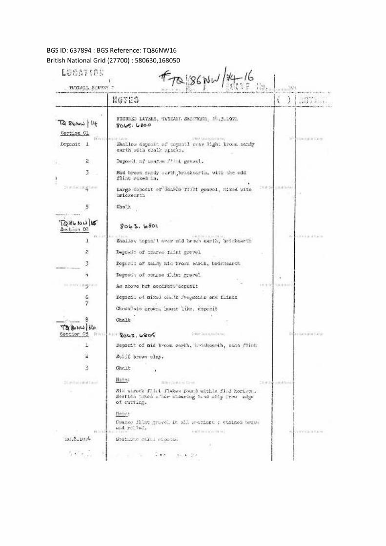
BGS ID: 637894 : BGS Reference: TQ86NW16
British National Grid (27700) : 580630,168050
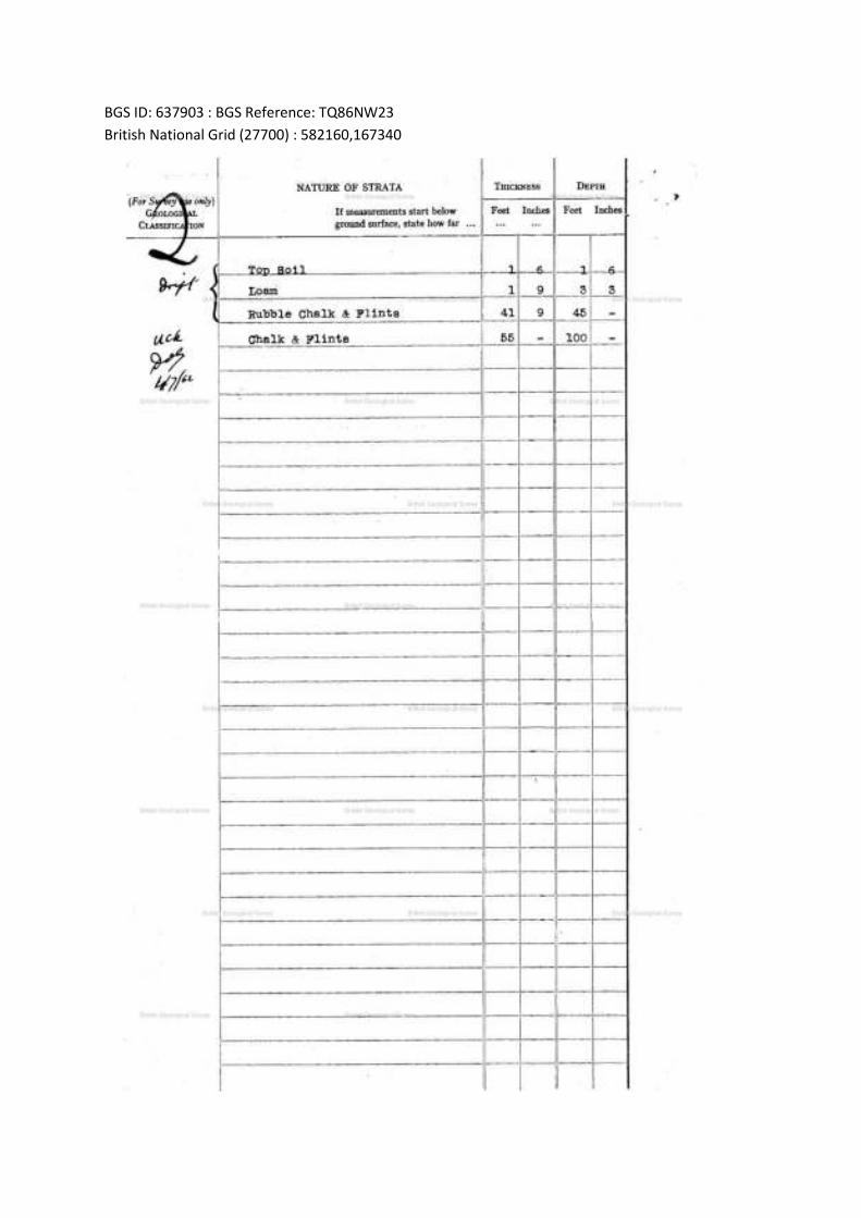
BGS ID: 637903 : BGS Reference: TQ86NW23
British National Grid (27700) : 582160,167340
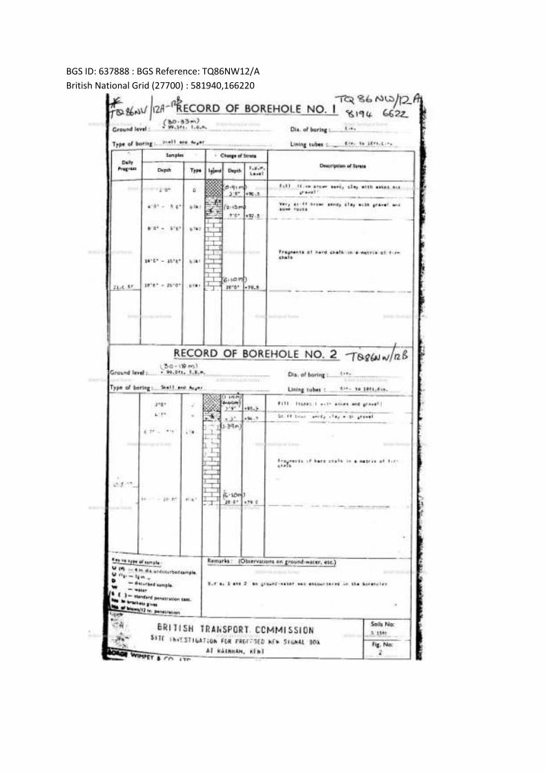
BGS ID: 637888 : BGS Reference: TQ86NW12/A
British National Grid (27700) : 581940,166220
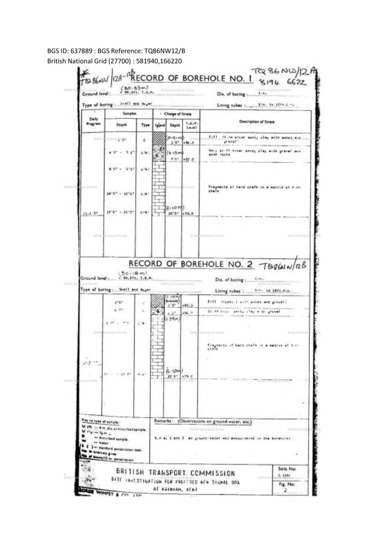
BGS ID: 637889 : BGS Reference: TQ86NW12/B
British National Grid (27700) : 581940,166220
Pump and Bloors Farm, Rainham
Phase 1 Ground Conditions Assessment (Geotechnical and Contamination)
\\pba.int\cbh\Projects\44538 Pump and Bloors Farm\3500 Geo\05 Reports etc\Desk Study\Phase 1 GCA Final for Issue R01.docx
Appendix F1: Extracts from Lower Twydall Chalk Pit Landfill Reports (2014-2015)

Lower Twydall Chalk Pit Annual Interpretive Report Jan – Dec 2015
Ground and Environmental Services Limited a 11373-A1 Co. Registration No: 7567478
Figure 1
Site Layout Plan
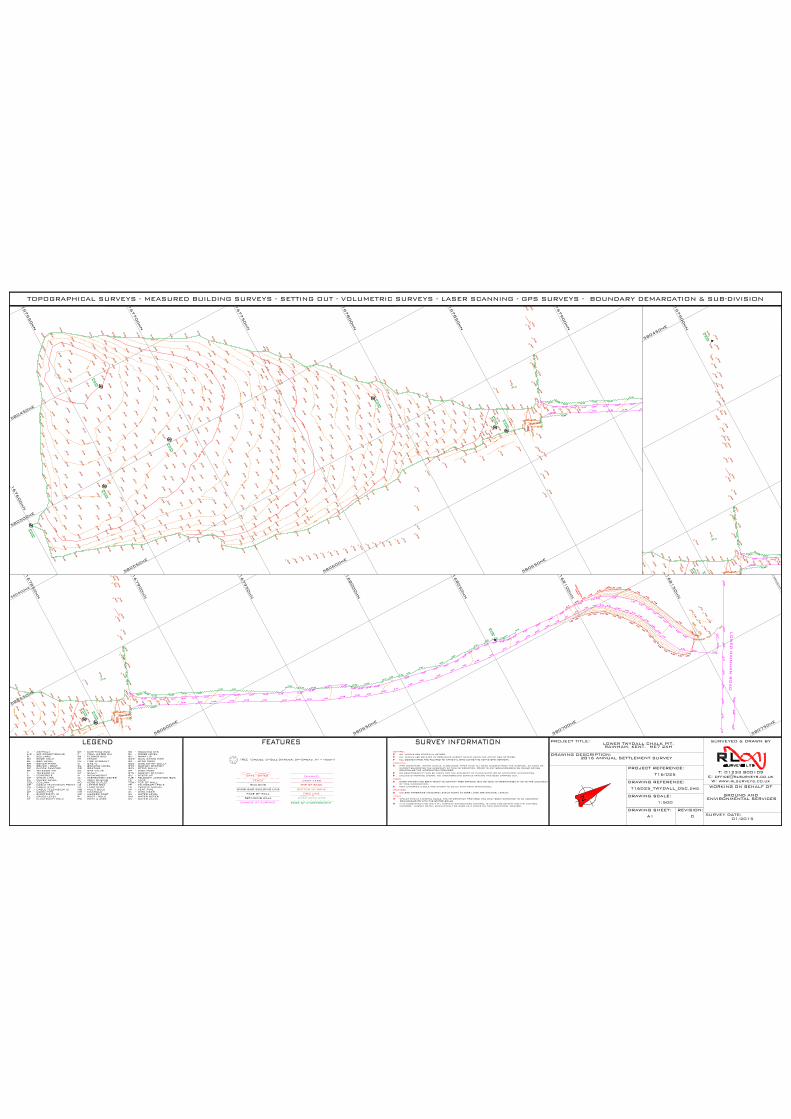
14
.39
5.64
timb
er re
tain
ing
fea
ture
168000mN
168050mN
168100mN
168150mN
168200mN
167950mN
167900mN
167850mN
580500mE
580550mE
580600mE
580650mE
580700mE
580750mE
14
.39
167600mN
167650mN
167700mN
167750mN
167800mN
167850mN
167900mN
580450mE
580500mE
580550mE
580600mE
580650mE
14
.39
167900mN
580450mE
TOPOGRAPHICAL SURVEYS - MEASURED BUILDING SURVEYS - SETTING OUT - VOLUMETRIC SURVEYS - LASER SCANNING - GPS SURVEYS - BOUNDARY DEMARCATION & SUB-DIVISION
TJB
SGY - STRIP GULLY
TELECOM JUNCTION BOX-TK - TANK
GAS IC-G
A
BBH
-
-----
------
--
ASPHALT
BOLLARDBORE HOLE
BLBMBN
BT
BED LEVELBENCH-MARKBENCH / SEAT
TELECOM MHT TELECOM IC
CHCL
C CONCRETECHAIN LINKCOVER LEVEL
COL
FE
COLUMN
FOUL WATER MH
FENCEFH FIRE HYDRANT -
-
-
-
------GL GROUND LEVEL
GR GRATINGGV GAS VALVEGY GULLYHIC
HIGH/HEIGHTINSPECTION COVER
PW POST & WIRE
RL RIDGE LEVEL
SC STOP COCKRWP RAIN WATER PIPE
EARTHING RODER -
ELECTRICITY ICDOWN PIPEDP
TP
E
-
--
CP -
ELECTRICITY POLE
CABLE TELEVISION POINT
POST / POLE
LAMP POSTLETTER BOXKERB OUTLETIRON RAILING
P
MH
LPLB -
-
-
-
MANHOLE
KOIR -
-
WIRE MESHWATER LEVEL
VENT PIPETRAFFIC SIGNALTELEGRAPH POLE
WATER METER
TS
WIWL
VP
WM
-----
TP -
SURVEY STATIONSIGN POST
STN -SP -
CABLE TELEVISION IC-CT
EAVES LEVELEL -
TOP OF WALLTOW -
CABLE STAYCS -
-FB FLOWER BED
-BP BLOCK PAVIORS
-A/C AIR CONDITIONING F -
WATER VALVE-WV
RAMP UPRU -
MARKER POST-MP
SURVEY STATIONSTN -
ALL LEVELS ARE STATED IN METRES.ALL LEVELS ARE RELATED TO ORDNANCE SURVEY DATUM USING THE ACTIVE GPS NETWORK.ALL COORDINATES ARE RELATED TO NATIONAL GRID USING THE ACTIVE GPS NETWORK.
CONTROL
PIPE DIAMETERS, INVERT LEVELS, & DRAINAGE TYPES HAVE ALL BEEN GUAGED FROM THE SURFACE, AS SUCH WECANNOT GUARANTEE THE ACCURACY OF THIS INFORMATION, PRIOR TO ANY GROUNDWORKS WE WOULD ADVISECONFIRMING THE INFORMATION PROVIDED.NO RESPONSIBILITY CAN BE TAKEN FOR THE ACCURACY OF PLANS SUPPLIED BY STATUTORY AUTHORITIES.UNLESS OTHERWISE SHOWN, NO UNDERGROUND SERVICE TRACING HAS BEEN CARRIED OUT.
SERVICES
TREE CANOPIES & BOLE ARE SHOWN TO SCALE WITH MEAN DIMENSIONS.
TREES
EVERY EFFORT HAS BEEN TAKEN TO IDENTIFY TREE SPECIES, BUT WE TAKE NO RESPONSIBILTY AS TO THE ACCURACYOF THIS INFORMATION.
FEATURES
UNLESS OTHERWISE INDICATED LEVELS TAKEN AT KERB LINES ARE CHANNEL LEVELS.
LEGAL
WHILST THIS IS A DIGITAL SCALE, THE INFORMATION PROVIDED HAS ONLY BEEN SURVEYED TO AN ACCURACYCOMMENSURATE WITH THE STATED SCALE.IT IS SUGGESTED THAT ONLY R L SURVEYS ESTABLISHED CONTROL IS USED FOR DENSIFIYING THE CONTROLNETWORK. SURVEY DETAIL SHOULD ONLY BE USED AS A CHECK ON THIS ADDITIONAL CONTROL.
SU STEPS UP-
-RE RODDING EYE
SEG SIDE ENTRY GULLY
MULTI BOLEMB -
FACE OF WALL
CHANGE OF SURFACE
FENCE
TOP OF BANKBUILDING
GATE - GATES
TREE LINE
EDGE OF UNDERGROWTH
OHW E TOVER HEAD WIRERETAINING WALL
OVERHEAD BUILDING LINE
CHANNEL
DROP KERB
BOTTOM OF BANK
N
SURVEYED & DRAWN BY
WORKING ON BEHALF OF
PROJECT TITLE:
DRAWING DESCRIPTION:
DRAWING REFERENCE:
PROJECT REFERENCE:
DRAWING SCALE:
DRAWING SHEET: REVISION:SURVEY DATE:
T: 01233 800109E: [email protected]
W: www.rlsurveys.co.uk
LOWER TWYDALL CHALK PIT,RAINHAM, KENT. ME7 2XH
2016 ANNUAL SETTLEMENT SURVEY
T16/025
T16025_TWYDALL_05C.dwg
1:500
GROUND AND ENVIRONMENTAL SERVICES
01/2015A1 0
TREE (Species, D=Bole Diameter, Sp=Spread, Ht = Height)

Lower Twydall Chalk Pit Annual Interpretive Report Jan – Dec 2015
Ground and Environmental Services Limited b 11373-A1 Co. Registration No: 7567478
Figure 2
Time Series Graphs of Gas Monitoring Data
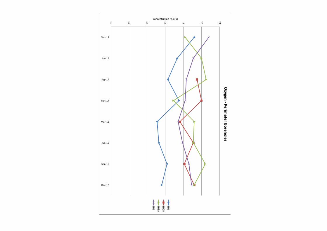
10
12
14
16
18
20
22
Mar-14
Jun-14
Sep-14
Dec-14
Mar-15
Jun-15
Sep-15
Dec-15
Concentration (% v/v)
Ox
yg
en
-P
erim
ete
r Bo
reh
ole
s
BH1
BH2B
BH3A
BH6
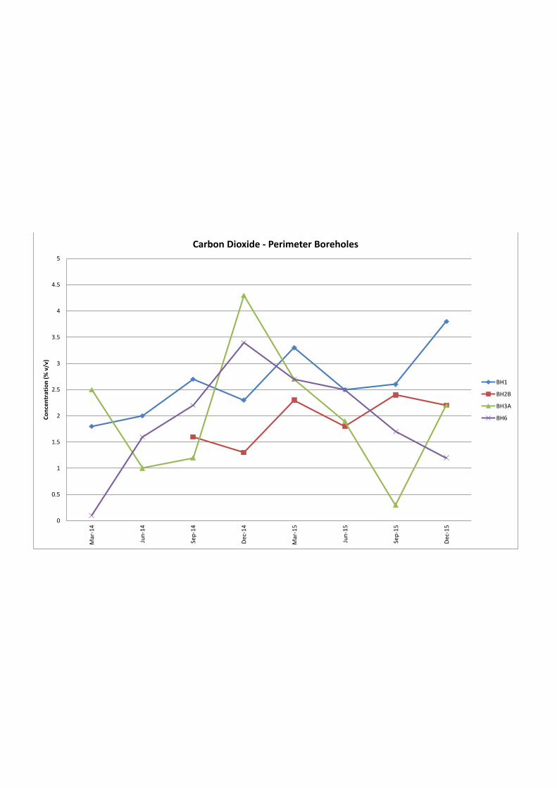
0
0.5
1
1.5
2
2.5
3
3.5
4
4.5
5
Mar-14
Jun-14
Sep-14
Dec-14
Mar-15
Jun-15
Sep-15
Dec-15
Co
nce
ntr
ati
on
(%
v/v
)
Carbon Dioxide - Perimeter Boreholes
BH1
BH2B
BH3A
BH6
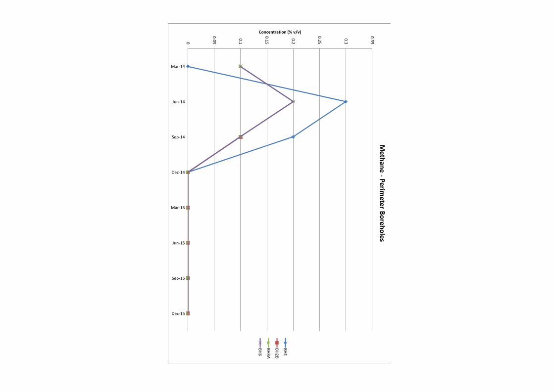
0
0.05
0.1
0.15
0.2
0.25
0.3
0.35
Mar-14
Jun-14
Sep-14
Dec-14
Mar-15
Jun-15
Sep-15
Dec-15
Concentration (% v/v)
Me
tha
ne
-P
erim
ete
r Bo
reh
ole
s
BH1
BH2B
BH3A
BH6
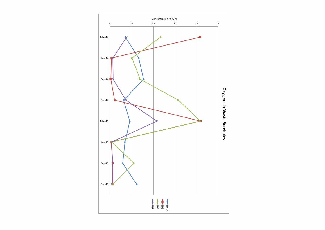
0 5
10
15
20
25
Mar-14
Jun-14
Sep-14
Dec-14
Mar-15
Jun-15
Sep-15
Dec-15
Concentration (% v/v)
Ox
yg
en
-In
-Wa
ste B
ore
ho
les
BH4A
BH5
BH7
BH8
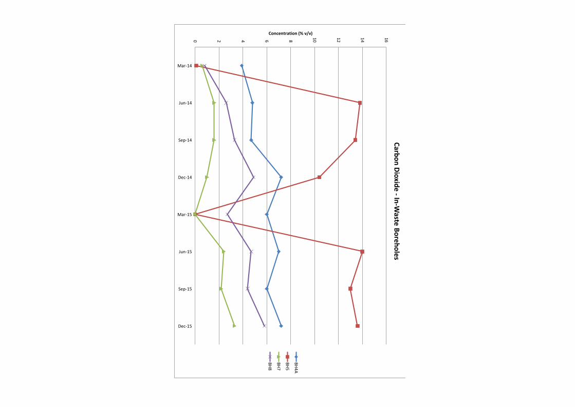
0 2 4 6 8
10
12
14
16
Mar-14
Jun-14
Sep-14
Dec-14
Mar-15
Jun-15
Sep-15
Dec-15
Concentration (% v/v)
Ca
rbo
n D
iox
ide
-In
-Wa
ste B
ore
ho
les
BH4A
BH5
BH7
BH8
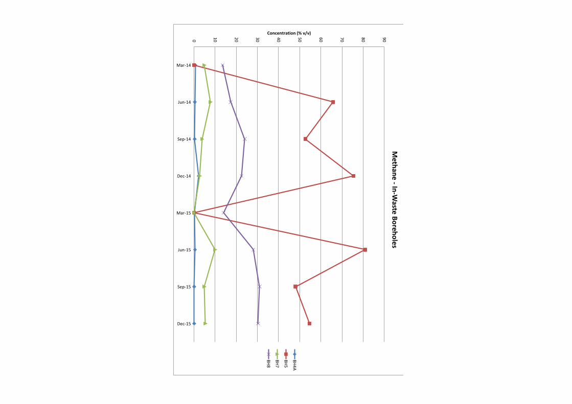
0
10
20
30
40
50
60
70
80
90
Mar-14
Jun-14
Sep-14
Dec-14
Mar-15
Jun-15
Sep-15
Dec-15
Concentration (% v/v)
Me
tha
ne
-In
-Wa
ste B
ore
ho
les
BH4A
BH5
BH7
BH8
Lower Twydall Chalk Pit Annual Interpretive Report Jan – Dec 2015
Ground and Environmental Services Limited c 11373-A1 Co. Registration No: 7567478
Figure 3
Time Series Graph of Groundwater Levels
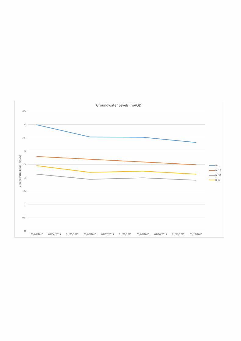
0
0.5
1
1.5
2
2.5
3
3.5
4
4.5
01/03/2015 01/04/2015 01/05/2015 01/06/2015 01/07/2015 01/08/2015 01/09/2015 01/10/2015 01/11/2015 01/12/2015
Gro
un
dw
ate
r Le
ve
l (m
AO
D)
Groundwater Levels (mAOD)
BH1
BH2B
BH3A
BH6

Lower Twydall Chalk Pit Annual Interpretive Report Jan – Dec 2015
Ground and Environmental Services Limited d 11373-A1 Co. Registration No: 7567478
Figure 4
Time Series Graphs of Groundwater Quality Data
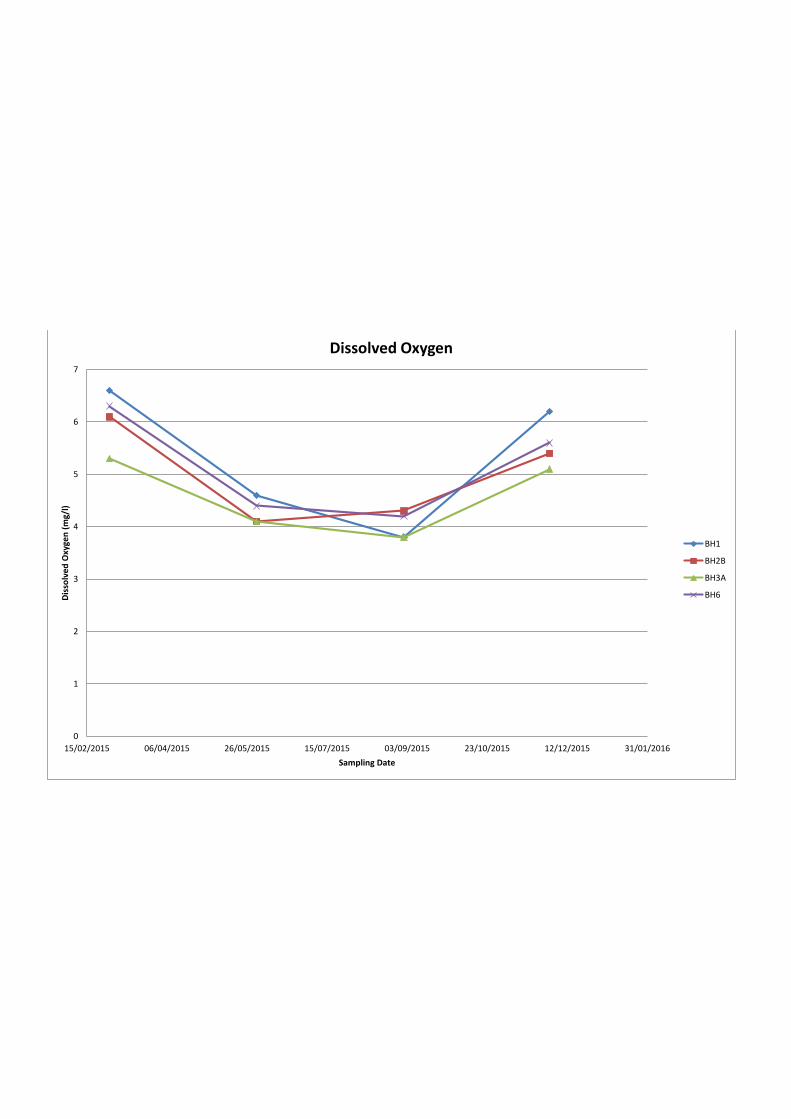
0
1
2
3
4
5
6
7
15/02/2015 06/04/2015 26/05/2015 15/07/2015 03/09/2015 23/10/2015 12/12/2015 31/01/2016
Dis
solv
ed
Ox
yg
en
(m
g/l
)
Sampling Date
Dissolved Oxygen
BH1
BH2B
BH3A
BH6
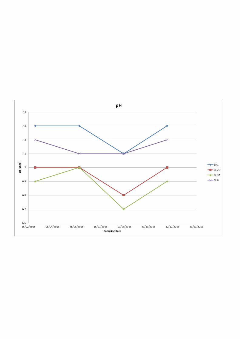
6.6
6.7
6.8
6.9
7
7.1
7.2
7.3
7.4
15/02/2015 06/04/2015 26/05/2015 15/07/2015 03/09/2015 23/10/2015 12/12/2015 31/01/2016
pH
(u
nit
s)
Sampling Date
pH
BH1
BH2B
BH3A
BH6
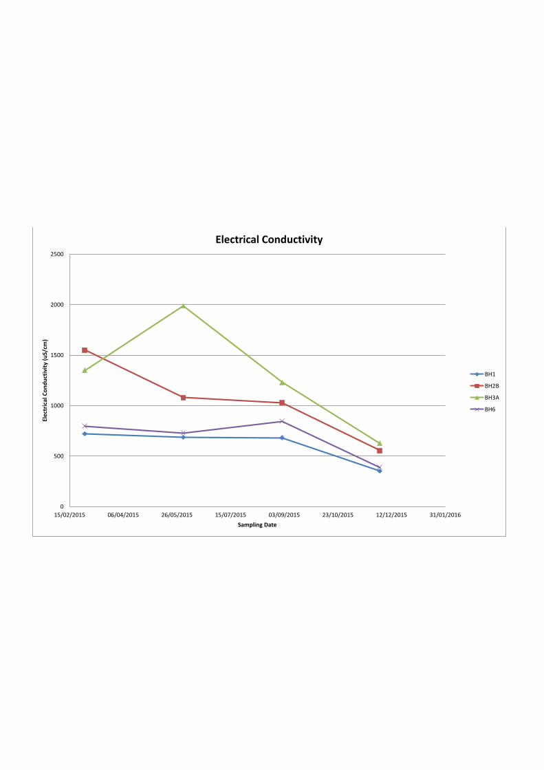
0
500
1000
1500
2000
2500
15/02/2015 06/04/2015 26/05/2015 15/07/2015 03/09/2015 23/10/2015 12/12/2015 31/01/2016
Ele
ctri
cal
Co
nd
uct
ivit
y (
uS
/cm
)
Sampling Date
Electrical Conductivity
BH1
BH2B
BH3A
BH6
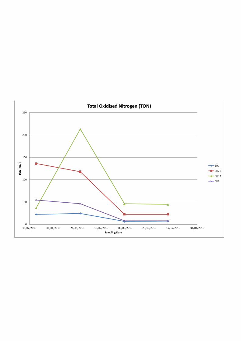
0
50
100
150
200
250
15/02/2015 06/04/2015 26/05/2015 15/07/2015 03/09/2015 23/10/2015 12/12/2015 31/01/2016
TO
N (
mg
/l)
Sampling Date
Total Oxidised Nitrogen (TON)
BH1
BH2B
BH3A
BH6
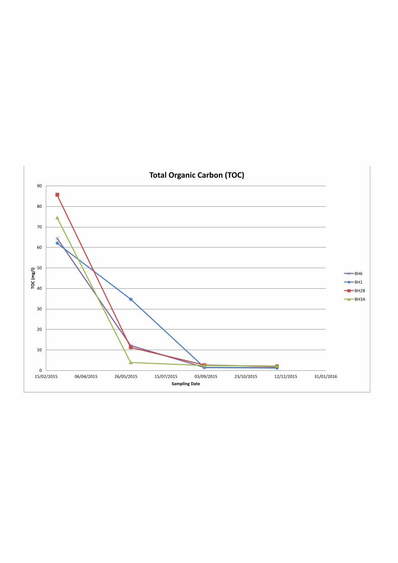
0
10
20
30
40
50
60
70
80
90
15/02/2015 06/04/2015 26/05/2015 15/07/2015 03/09/2015 23/10/2015 12/12/2015 31/01/2016
TO
C (
mg
/l)
Sampling Date
Total Organic Carbon (TOC)
BH6
BH1
BH2B
BH3A
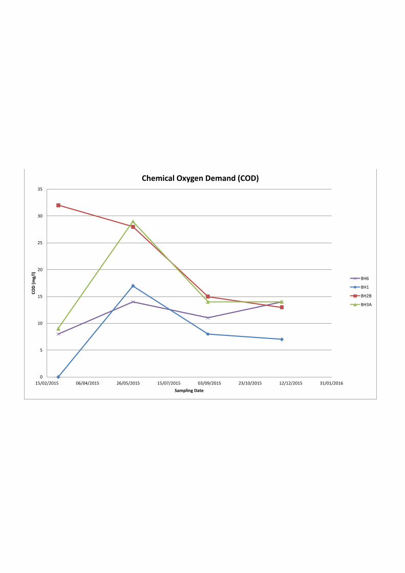
0
5
10
15
20
25
30
35
15/02/2015 06/04/2015 26/05/2015 15/07/2015 03/09/2015 23/10/2015 12/12/2015 31/01/2016
CO
D (
mg
/l)
Sampling Date
Chemical Oxygen Demand (COD)
BH6
BH1
BH2B
BH3A
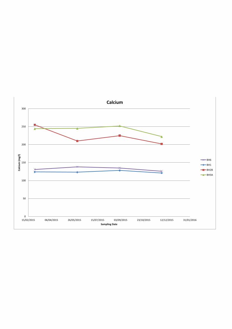
0
50
100
150
200
250
300
15/02/2015 06/04/2015 26/05/2015 15/07/2015 03/09/2015 23/10/2015 12/12/2015 31/01/2016
Ca
lciu
m (
mg
/l)
Sampling Date
Calcium
BH6
BH1
BH2B
BH3A
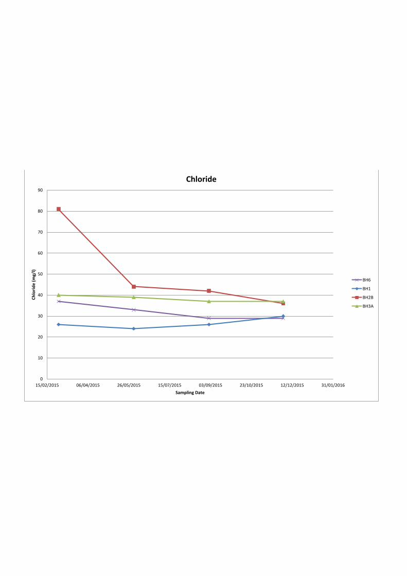
0
10
20
30
40
50
60
70
80
90
15/02/2015 06/04/2015 26/05/2015 15/07/2015 03/09/2015 23/10/2015 12/12/2015 31/01/2016
Ch
lori
de
(m
g/l
)
Sampling Date
Chloride
BH6
BH1
BH2B
BH3A

Lower Twydall Chalk Pit Annual Interpretive Report Jan – Dec 2015
Ground and Environmental Services Limited e 11373-A1 Co. Registration No: 7567478
Table 1
Summary Table of Perimeter Gas Monitoring Data
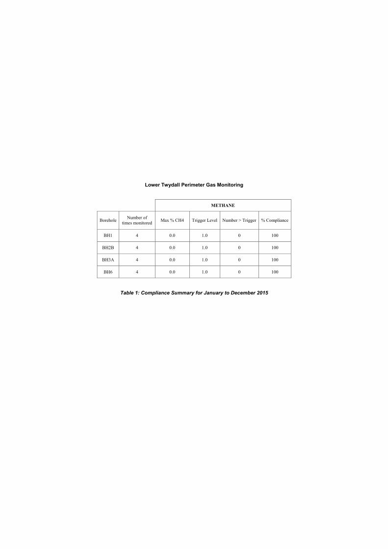
Lower Twydall Perimeter Gas Monitoring
METHANE
Borehole Number of
times monitored Max % CH4 Trigger Level Number > Trigger % Compliance
BH1 4 0.0 1.0 0 100
BH2B 4 0.0 1.0 0 100
BH3A 4 0.0 1.0 0 100
BH6 4 0.0 1.0 0 100
Table 1: Compliance Summary for January to December 2015
Lower Twydall Chalk Pit Annual Interpretive Report Jan – Dec 2015
Ground and Environmental Services Limited f 11373-A1 Co. Registration No: 7567478
Table 2
Summary Table of In-Waste Gas Monitoring Data
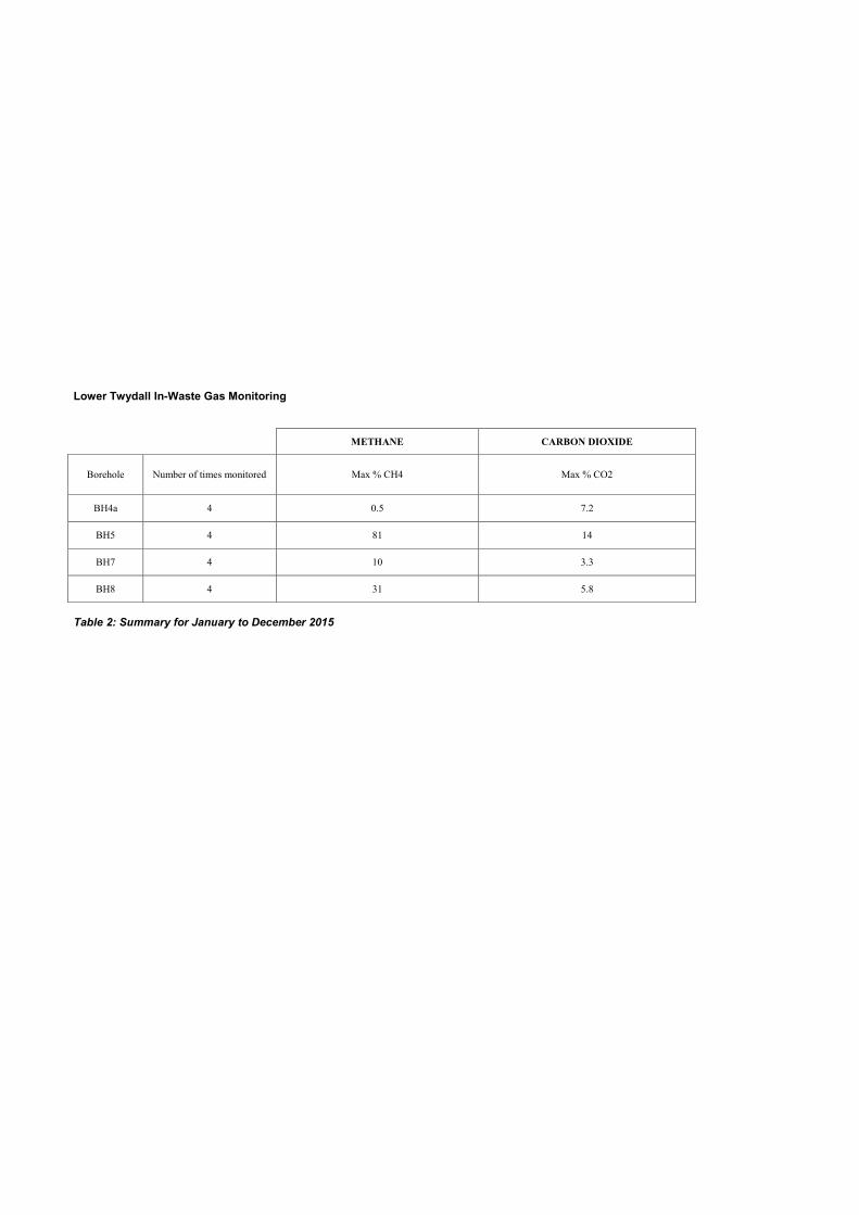
Lower Twydall In-Waste Gas Monitoring
METHANE CARBON DIOXIDE
Borehole Number of times monitored Max % CH4 Max % CO2
BH4a 4 0.5 7.2
BH5 4 81 14
BH7 4 10 3.3
BH8 4 31 5.8
Table 2: Summary for January to December 2015
Lower Twydall Chalk Pit Annual Interpretive Report Jan – Dec 2015
Ground and Environmental Services Limited g 11373-A1 Co. Registration No: 7567478
Table 3
Summary Table of Groundwater Quality Data
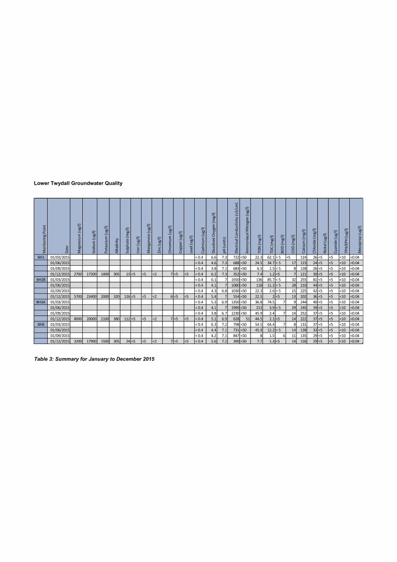
Lower Twydall Groundwater Quality
Table 3: Summary for January to December 2015
Mo
nit
ori
ng
Po
int
Da
te
Ma
gn
esi
um
(u
g/l
)
So
diu
m (
ug
/l)
Po
tass
ium
(u
g/l
)
Alk
alin
ity
Su
lph
ate
(m
g/l
)
Iro
n (
ug
/l)
Ma
ng
an
ese
(u
g/l
)
Zin
c (u
g/l
)
Ch
rom
ium
(u
g/l
)
Co
pp
er
(ug
/l)
Lea
d (
ug
/l)
Ca
dm
ium
(u
g/l
)
Dis
solv
ed
Ox
yg
en
(m
g/l
)
pH
(u
nit
s)
Ele
ctri
cal C
on
du
ctiv
ity
(u
S/c
m)
Am
mo
nia
cal N
itro
ge
n (
ug
/l)
TO
N (
mg
/l)
TO
C (
mg
/l)
BO
D (
mg
/l)
CO
D (
mg
/l)
Ca
lciu
m (
mg
/l)
Ch
lori
de
(m
g/l
)
Nic
ke
l (u
g/l
)
Cy
an
ide
(u
g/l
)
TP
H/E
PH
(u
g/l
)
Me
cop
rop
(u
g/l
)
BH1 01/03/2015 < 0.4 6.6 7.3 722 <50 22.3 62.1 < 5 <5 124 26 <5 <5 <10 <0.04
01/06/2015 < 0.4 4.6 7.3 688 <50 24.5 34.7 < 5 17 123 24 <5 <5 <10 <0.04
01/09/2015 < 0.4 3.8 7.1 683 <50 6.5 1.5 < 5 8 128 26 <5 <5 <10 <0.04
01/12/2015 2700 17200 1400 305 13 <5 <5 <2 7 <5 <5 < 0.4 6.2 7.3 352 <50 7.4 1.2 <5 7 121 30 <5 <5 <10 <0.04
BH2B 01/03/2015 < 0.4 6.1 7 1550 <50 136 85.7 < 5 32 255 81 <5 <5 <10 <0.04
01/06/2015 < 0.4 4.1 7 1080 <50 118 11.2 < 5 28 210 44 <5 <5 <10 <0.04
01/09/2015 < 0.4 4.3 6.8 1030 <50 22.3 2.6 < 5 15 225 42 <5 <5 <10 <0.04
01/12/2015 5700 23400 2000 320 126 <5 <5 <2 6 <5 <5 < 0.4 5.4 7 554 <50 22.5 2 <5 13 202 36 <5 <5 <10 <0.04
BH3A 01/03/2015 < 0.4 5.3 6.9 1350 <50 36.8 74.5 7 9 244 40 <5 <5 <10 <0.04
01/06/2015 < 0.4 4.1 7 1990 <50 213 3.9 < 5 29 245 39 <5 <5 <10 <0.04
01/09/2015 < 0.4 3.8 6.7 1230 <50 45.9 2.4 7 14 252 37 <5 <5 <10 <0.04
01/12/2015 8000 20000 2100 380 112 <5 <5 <2 7 <5 <5 < 0.4 5.1 6.9 628 51 44.5 2.1 <5 14 222 37 <5 <5 <10 <0.04
BH6 01/03/2015 < 0.4 6.3 7.2 798 <50 54.5 64.4 7 8 131 37 <5 <5 <10 <0.04
01/06/2015 < 0.4 4.4 7.1 731 <50 45.9 12.2 < 5 14 138 33 <5 <5 <10 <0.04
01/09/2015 < 0.4 4.2 7.1 847 <50 8 1.5 6 11 135 29 <5 <5 <10 <0.04
01/12/2015 3200 17900 1500 305 24 <5 <5 <2 7 <5 <5 < 0.4 5.6 7.2 390 <50 7.7 1.3 <5 14 126 29 <5 <5 <10 <0.04
Lower Twydall Chalk Pit – Permit number FP3630LC Landfill Closure Report
Ground and Environmental Services Limited 11025-001 Co. Registration No: 7567478
a
APPENDIX A
Groundwater Monitoring Borehole Logs
(BH1, BH2A, BH3A, BH6)
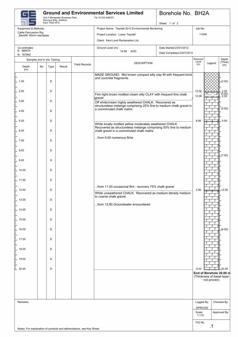
Firm light brown mottled cream silty CLAY with frequent fine chalkgravel
15.00
...from 12.80 Groundwater encountered
White unweathered CHALK. Recovered as medium density mediumto coarse chalk gravel.
...from 11.00 occasional flint - recovery 75% chalk gravel
...from 6.00 numerous flints
Off white/cream highly weathered CHALK. Recovered asstructureless melange comprising 25% fine to medium chalk gravel ina comminuted chalk matrix
MADE GROUND: Mid brown compact silty clay fill with frequent brickand concrete fragments.
D
D
D
D
D
White locally mottled yellow moderately weathered CHALK.Recovered as structureless melange comprising 50% fine to mediumchalk gravel in a comminuted chalk matrix 6.00
14.00
13.00
12.00
11.00
10.00
2.00
D
5.00
4.00
3.00
2.00
1.00
8.00
9.56
(2.00)
D
2.56
(7.00)
12.06
12.56
20.00
12.00
5.00
2.50
-5.44
D
9.00
D
D
D
D
D
(0.50)
D
(2.50)D
D
D
D
End of Borehole 20.00 m(Thickness of basal layer
not proven)
(8.00)
D
D
Unit 2 Montpelier Business Park,Dencora Way, Ashford,Kent TN23 4FG
Ground and Environmental Services Limited
7.00
No.
16.00
1:115
Project Location: Lower Twydall
Type
ReducedLevel(m)DESCRIPTION
Field RecordsResult
Samples and In situ Testing
Depth(m)
Depth(Thick)
(m)Legend
Approved By:
17.00
18.00
19.00
Cable Percussion Rig_Backfill: 50mm standpipe
Ground Level (m):
20.00
Tel: 01233 646237
N: 167842
Job No:
11049
Equipment & Methods. Project Name: Twydall 2012 Environmental Monitoring
Co-ordinates:E: 580574
Logged By:
DPR/CSS
Remarks:
Notes: For explanation of symbols and abbreviations, see Key Sheet.
Date Started:23/01/2012
Equipment & Methods. Cable Percussion Rig
Date Completed:23/01/2012
Checked By:
Client: Kent Land Reclamation Ltd
Borehole No. BH2A
Scale:
.1
Sheet: 1 of 2
FIG No.
14.56 AOD
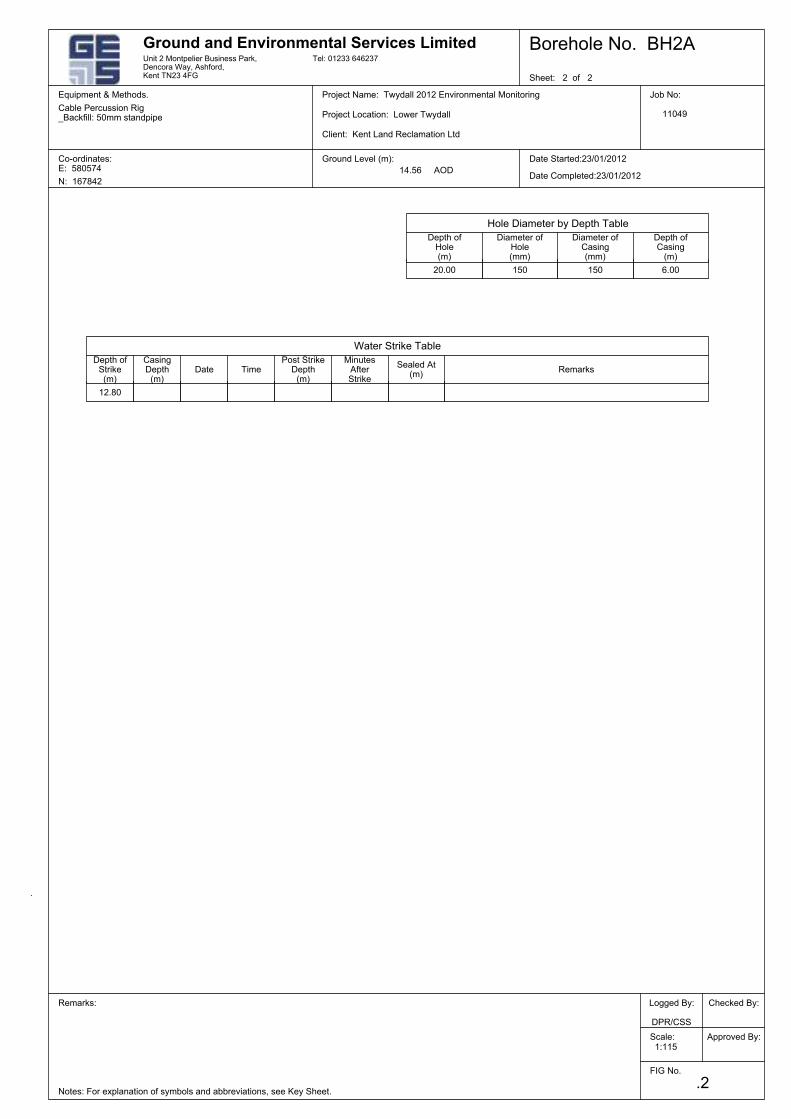
1:115
Date Started:23/01/2012
Project Location: Lower Twydall
Ground and Environmental Services LimitedUnit 2 Montpelier Business Park,Dencora Way, Ashford,Kent TN23 4FG
Ground Level (m):
Depth ofStrike(m)
CasingDepth
(m)
MinutesAfterStrike
Sheet: 2 of 2
Approved By:
Job No:
11049
Equipment & Methods.
Co-ordinates:E: 580574
Logged By:
DPR/CSS
Remarks:
Notes: For explanation of symbols and abbreviations, see Key Sheet.
Project Name: Twydall 2012 Environmental Monitoring
N: 167842
Cable Percussion Rig_Backfill: 50mm standpipe
Client: Kent Land Reclamation Ltd
Tel: 01233 646237
FIG No.
.2
Scale:
Borehole No. BH2A
14.56 AOD
Checked By:
Date Completed:23/01/2012
Equipment & Methods. Cable Percussion Rig
Depth ofCasing
(m)
Diameter ofCasing(mm)
Depth ofHole(m)
Remarks
Hole Diameter by Depth Table
Diameter ofHole(mm)
DatePost Strike
Depth(m)
Sealed At(m)
Water Strike Table
Time
150
12.80
15020.00 6.00
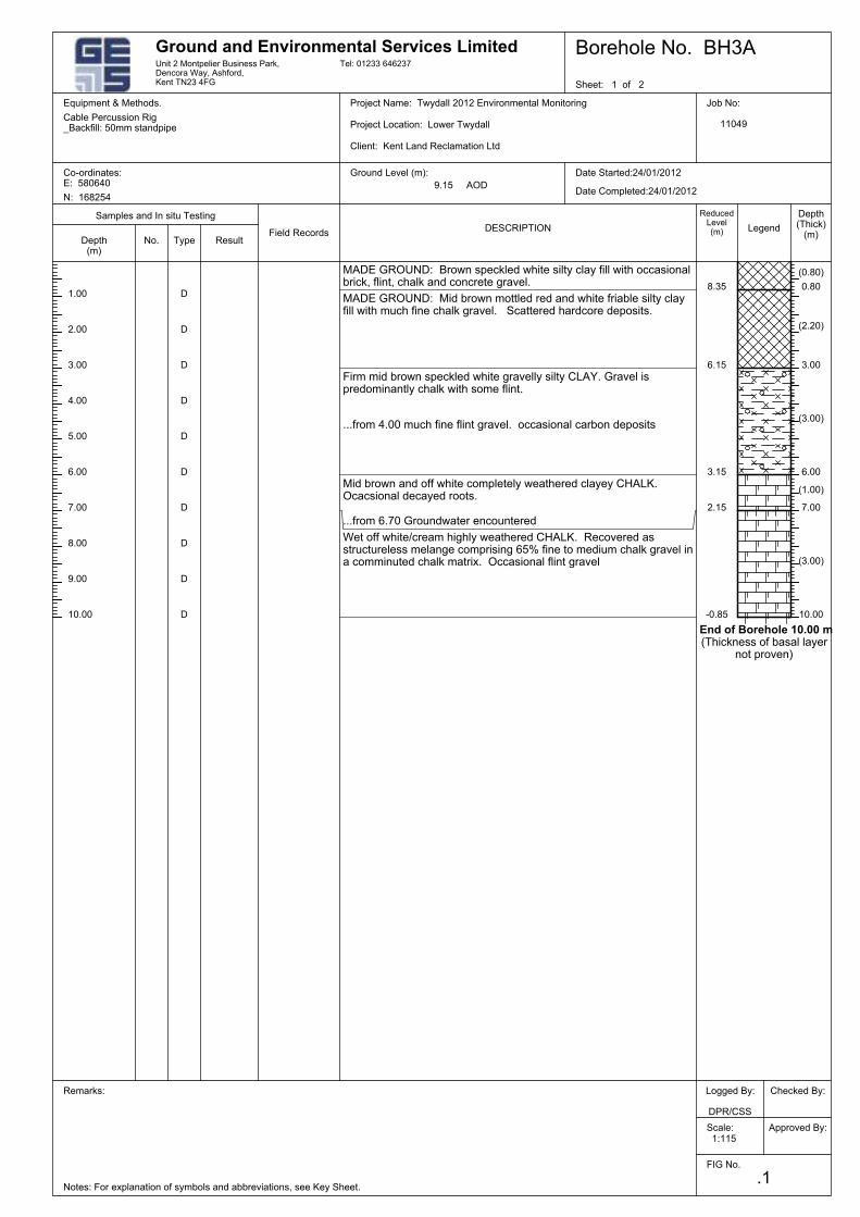
3.00
MADE GROUND: Brown speckled white silty clay fill with occasionalbrick, flint, chalk and concrete gravel.
MADE GROUND: Mid brown mottled red and white friable silty clayfill with much fine chalk gravel. Scattered hardcore deposits.
Firm mid brown speckled white gravelly silty CLAY. Gravel ispredominantly chalk with some flint.
...from 4.00 much fine flint gravel. occasional carbon deposits
Mid brown and off white completely weathered clayey CHALK.Ocacsional decayed roots.
...from 6.70 Groundwater encountered
Wet off white/cream highly weathered CHALK. Recovered asstructureless melange comprising 65% fine to medium chalk gravel ina comminuted chalk matrix. Occasional flint gravel
Remarks:
2.00
D
4.00
5.00
6.00
7.00
0.80
9.00
Approved By:
Job No:
11049
Equipment & Methods.
Co-ordinates:E: 580640
Logged By:
DPR/CSS
1.00
(0.80)
3.00
6.00
7.00
10.00
8.35
6.15
3.15
2.15
-0.85D
D
(2.20)
(3.00)
(1.00)
(3.00)
End of Borehole 10.00 m(Thickness of basal layer
not proven)
D
D
D
D
D
D
D
10.00
Date Started:24/01/2012
Project Location: Lower Twydall
Notes: For explanation of symbols and abbreviations, see Key Sheet.
Ground and Environmental Services Limited
8.00
Depth(m)
No.
Legend
Depth(Thick)
(m)Type
Samples and In situ Testing
ResultField Records
DESCRIPTION
ReducedLevel(m)
Project Name: Twydall 2012 Environmental Monitoring
Scale:
.1
Sheet: 1 of 2
FIG No.
Unit 2 Montpelier Business Park,Dencora Way, Ashford,Kent TN23 4FG
1:115
Tel: 01233 646237
Client: Kent Land Reclamation Ltd
Borehole No. BH3A
N: 168254
Cable Percussion Rig_Backfill: 50mm standpipe
Equipment & Methods. Cable Percussion Rig
9.15 AODDate Completed:24/01/2012
Checked By:
Ground Level (m):
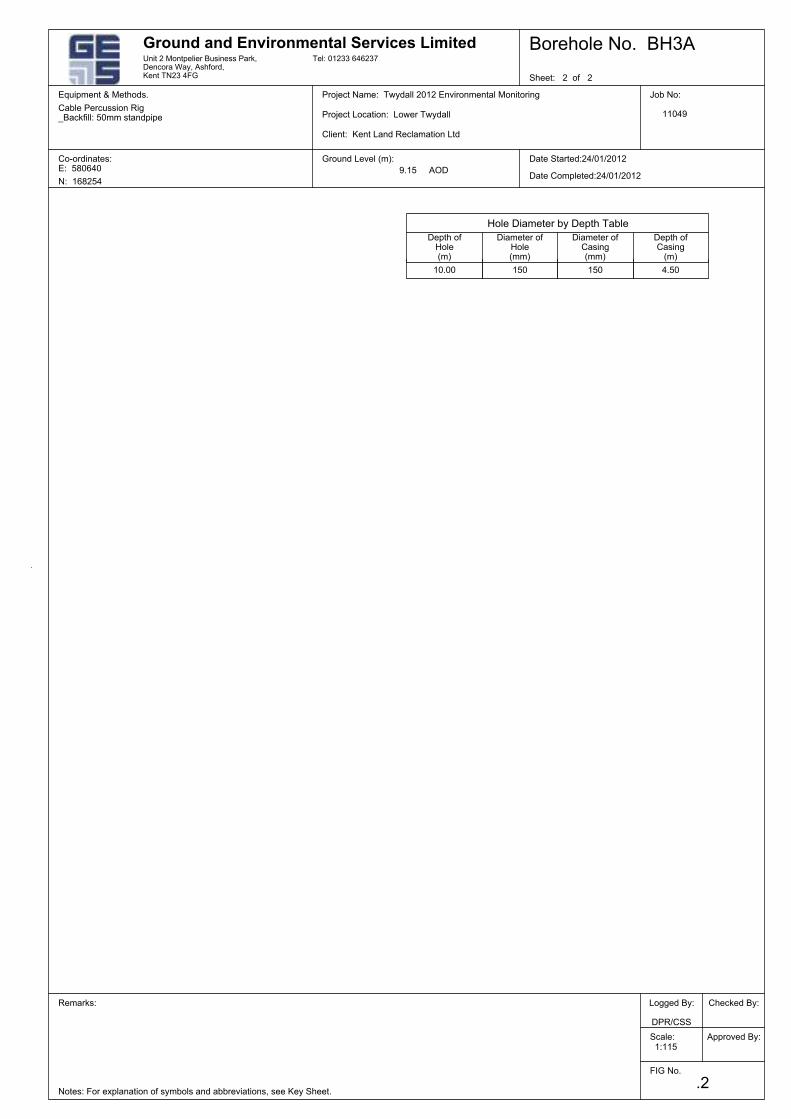
Borehole No. BH3A
9.15 AOD
Scale:
Date Completed:24/01/2012
.2
Equipment & Methods. Cable Percussion Rig
Ground Level (m):
Checked By:
N: 168254
Approved By:
Job No:
11049
Equipment & Methods.
Co-ordinates:E: 580640
Logged By:
DPR/CSS
Remarks:
Project Name: Twydall 2012 Environmental Monitoring
Cable Percussion Rig_Backfill: 50mm standpipe
Client: Kent Land Reclamation Ltd
Tel: 01233 646237
FIG No.
Sheet: 2 of 2
Notes: For explanation of symbols and abbreviations, see Key Sheet.
1:115
Diameter ofHole(mm)
Hole Diameter by Depth Table
Depth ofCasing
(m)
Date Started:24/01/2012
Project Location: Lower Twydall
Unit 2 Montpelier Business Park,Dencora Way, Ashford,Kent TN23 4FG
Diameter ofCasing(mm)
Depth ofHole(m)
Ground and Environmental Services Limited
150 4.5015010.00
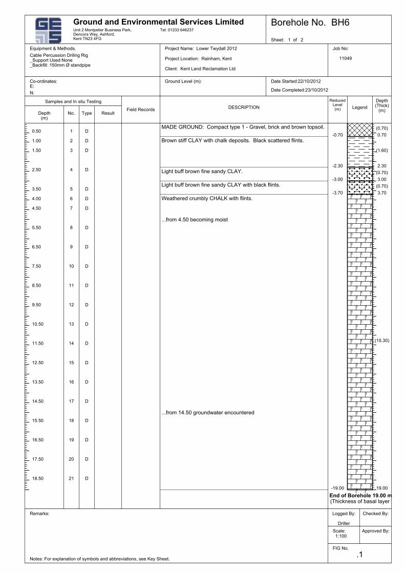
D
(15.30)
D
D
D
D
D
D
D
D
D
D
D
D
D
D
D
D
3.50
D
...from 14.50 groundwater encountered
2.50
1.50
1.00
0.50
D
(0.70)
...from 4.50 becoming moist
Weathered crumbly CHALK with flints.
Light buff brown fine sandy CLAY with black flints.
Light buff brown fine sandy CLAY.
Brown stiff CLAY with chalk deposits. Black scattered flints.
MADE GROUND: Compact type 1 - Gravel, brick and brown topsoil.
D
D
0.70
-19.00
End of Borehole 19.00 m(Thickness of basal layer
8
7
6
5
4
3
10
1
11
-3.70
-3.00
-2.30
-0.70
19.00
3.70
3.00
2.30
2
20
(0.70)
(1.60)
(0.70)
9
21
19
18
17
16
15
14
13
12
Field Records
Checked By:
Depth(Thick)
(m)Type
Samples and In situ Testing
Result
DESCRIPTION
4.00
ReducedLevel(m)
Equipment & Methods. Cable Percussion Driling Rig
Project Location: Rainham, Kent
No.Depth(m)
Unit 2 Montpelier Business Park,Dencora Way, Ashford,Kent TN23 4FG
Ground and Environmental Services Limited
Legend
Date Started:22/10/2012
1:100
12.50
Date Completed:23/10/2012
Job No:
11049
Approved By:
18.50
17.50
16.50
15.50
Co-ordinates:E:
13.50
Logged By:
Driller
11.50
10.50
9.50
8.50
7.50
6.50
5.50
4.50
14.50
Borehole No. BH6
Scale:
.1
Equipment & Methods.
FIG No.
Ground Level (m):
Tel: 01233 646237
Client: Kent Land Reclamation Ltd
Cable Percussion Driling Rig_Support Used:None_Backfill: 150mm Ø standpipe
N:
Project Name: Lower Twydall 2012
Notes: For explanation of symbols and abbreviations, see Key Sheet.
Remarks:
Sheet: 1 of 2
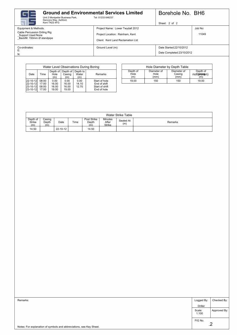
MinutesAfterStrike
CasingDepth
(m)
Depth ofStrike(m)
Unit 2 Montpelier Business Park,Dencora Way, Ashford,Kent TN23 4FG
Ground and Environmental Services Limited
not proven)
Sealed At(m)
Date
Water Strike Table
Notes: For explanation of symbols and abbreviations, see Key Sheet.
Sheet: 2 of 2
FIG No.
Tel: 01233 646237
Client: Kent Land Reclamation Ltd
Cable Percussion Driling Rig_Support Used:None_Backfill: 150mm Ø standpipe
Scale:
Project Name: Lower Twydall 2012
Remarks: Logged By:
Driller
Co-ordinates:E:
Equipment & Methods. Job No:
11049
Approved By:
N:
Equipment & Methods. Cable Percussion Driling Rig
Project Location: Rainham, Kent
Date Started:22/10/2012
1:100
.2
Ground Level (m):
Date Completed:23/10/2012
Checked By:
Borehole No. BH6
Diameter ofCasing(mm)
Depth ofCasing
(m)
Diameter ofHole(mm)
Hole Diameter by Depth Table
Depth ofHole(m)
Depth ofHole(m)
Depth ofCasing
(m)
RemarksPost Strike
Depth(m)
Time
Date
Water Level Observations During Boring
RemarksTimeDepth toWater
(m)
Start of holeEnd of shiftStart of shiftEnd of hole
0.0014.1012.70
150
14.50
0.0016.0016.0019.00
19.00 150
14.50
08:0017:0008:0017:00
19.0022-10-1222-10-1223-10-1223-10-12
0.0016.0016.0019.00
22-10-12

Lower Twydall Chalk Pit – Permit number FP3630LC Landfill Closure Report
Ground and Environmental Services Limited 11025-001 Co. Registration No: 7567478
b
APPENDIX B
Infrastructure Maintenance Programme

Lower Twydall Chalk Pit – Permit number FP3630LC Landfill Closure Report
Ground and Environmental Services Limited 11025-001 Co. Registration No: 7567478
d
APPENDIX D
Landfill Gas In-Waste Monitoring Borehole Logs
(BH4A, BH5, BH7, BH8)
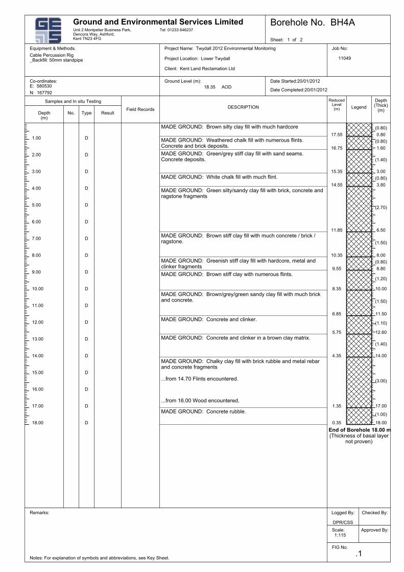
D
D
D
D
D
D
D
D
D
D
D
D
D
D
End of Borehole 18.00 m(Thickness of basal layer
not proven)
(1.00)
(3.00)
(1.40)
(1.10)
(1.50)
D
MADE GROUND: Brown stiff clay with numerous flints.
MADE GROUND: Concrete rubble.
...from 16.00 Wood encountered.
...from 14.70 Flints encountered.
MADE GROUND: Chalky clay fill with brick rubble and metal rebarand concrete fragments
MADE GROUND: Concrete and clinker in a brown clay matrix.
D
MADE GROUND: Brown/grey/green sandy clay fill with much brickand concrete.
D
MADE GROUND: Greenish stiff clay fill with hardcore, metal andclinker fragments
MADE GROUND: Brown stiff clay fill with much concrete / brick /ragstone.
MADE GROUND: Green silty/sandy clay fill with brick, concrete andragstone fragments
MADE GROUND: White chalk fill with much flint.
MADE GROUND: Green/grey stiff clay fill with sand seams.Concrete deposits.
MADE GROUND: Brown silty clay fill with much hardcore
0.80
(1.50)
MADE GROUND: Concrete and clinker.
14.00
(1.20)
8.35
9.55
10.35
11.85
14.55
15.35
16.75
17.55
5.75
17.00
4.35
12.60
11.50
10.00
8.80
8.00
6.50
3.80
3.00
1.60
18.00
MADE GROUND: Weathered chalk fill with numerous flints.Concrete and brick deposits.
(2.70)
(0.80)
(1.40)
(0.80)
(0.80)
6.85
(0.80)
0.35
1.35
Samples and In situ Testing
Legend
Ground Level (m):
D
Depth(Thick)
(m)
Equipment & Methods. Cable Percussion Rig
Type
Borehole No. BH4A
ResultField Records
Date Completed:20/01/2012
DESCRIPTION
ReducedLevel(m)
Checked By:
Unit 2 Montpelier Business Park,Dencora Way, Ashford,Kent TN23 4FG
1:115
Date Started:20/01/2012
Project Location: Lower Twydall
Ground and Environmental Services Limited
Depth(m)
No.
18.35 AOD
4.00
14.00
12.00
11.00
10.00
9.00
8.00
7.00
16.00
5.00
15.00
3.00
2.00
1.00
6.00
Tel: 01233 646237
Scale:
.1
Sheet: 1 of 2
FIG No.
13.00
17.00
Client: Kent Land Reclamation Ltd
Cable Percussion Rig_Backfill: 50mm standpipe
Job No:
11049
Project Name: Twydall 2012 Environmental Monitoring
Notes: For explanation of symbols and abbreviations, see Key Sheet.
Remarks: Logged By:
DPR/CSS
Co-ordinates:E: 580530
Equipment & Methods.
N: 167792
18.00
Approved By:
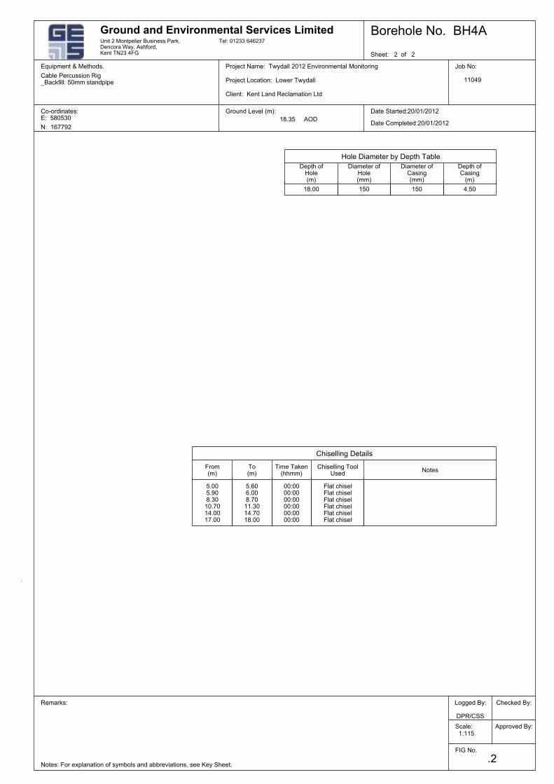
Equipment & Methods. Cable Percussion Rig
Ground Level (m):
1:115
Project Location: Lower Twydall
Ground and Environmental Services LimitedUnit 2 Montpelier Business Park,Dencora Way, Ashford,Kent TN23 4FG
To(m)
Date Started:20/01/2012
Approved By:
Job No:
11049
Equipment & Methods.
Co-ordinates:E: 580530
Logged By:
DPR/CSS
Remarks:
Notes: For explanation of symbols and abbreviations, see Key Sheet.
Project Name: Twydall 2012 Environmental Monitoring
N: 167792
Cable Percussion Rig_Backfill: 50mm standpipe
Date Completed:20/01/2012
Tel: 01233 646237
Checked By:
FIG No.
Sheet: 2 of 2
.2
Scale:
Borehole No. BH4A
18.35 AOD
Client: Kent Land Reclamation Ltd
Depth ofCasing
(m)
Depth ofHole(m)
Chiselling Details
Hole Diameter by Depth Table
Diameter ofHole(mm)
From(m)
Diameter ofCasing(mm)
NotesChiselling Tool
UsedTime Taken
(hhmm)
15018.00
5.005.908.3010.7014.0017.00
Flat chiselFlat chiselFlat chiselFlat chiselFlat chiselFlat chisel
150
00:0000:0000:0000:0000:0000:00
5.606.008.7011.3014.7018.00
4.50
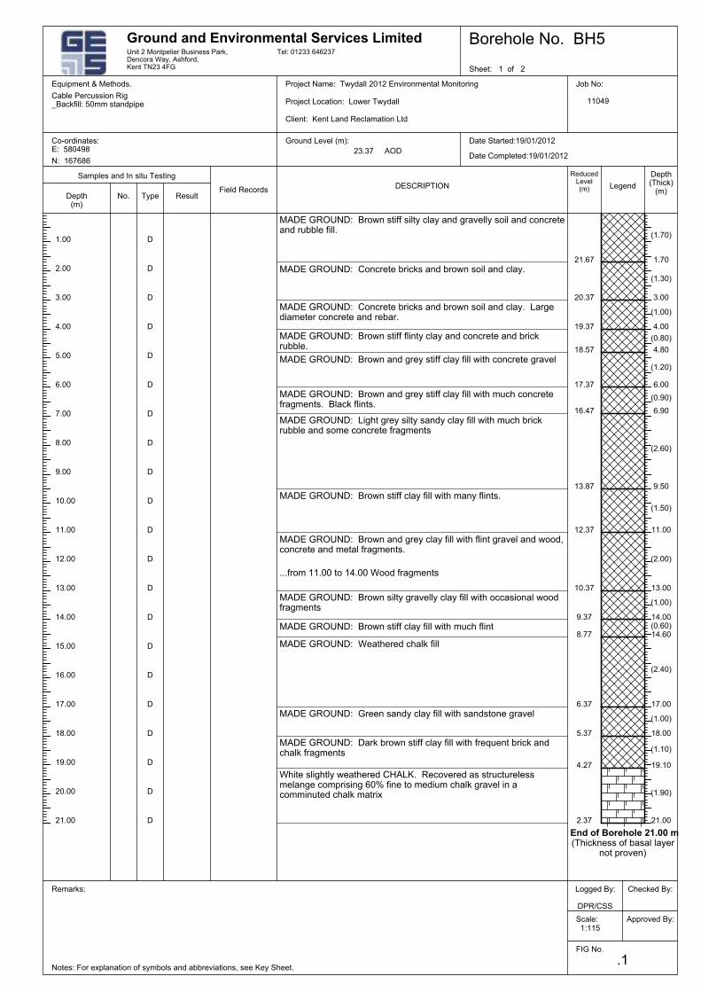
1:115
Borehole No. BH5
23.37 AOD
Checked By:
Scale:
Date Completed:19/01/2012
Equipment & Methods. Cable Percussion Rig
Ground Level (m):
D
(1.50)
17.00
D
D
D
End of Borehole 21.00 m(Thickness of basal layer
not proven)
(1.90)
(1.10)
(1.00)
(2.40)
(0.60)
(2.00)
(2.60)
(0.90)
(1.20)
(0.80)
(1.00)
(1.30)
(1.70)
.1
Sheet: 1 of 2
(1.00)
12.37
13.00
14.00
14.60
2.37
4.27
5.37
6.37
8.77
11.00
10.37
9.5013.87
16.47
17.37
18.57
19.37
20.37
21.67
21.00
19.10
18.00
9.37
Date Started:19/01/2012
Project Location: Lower Twydall
Ground and Environmental Services Limited
D
Depth(m)
1.70
3.00
4.00
4.80
6.00
6.90
Unit 2 Montpelier Business Park,Dencora Way, Ashford,Kent TN23 4FG
15.00
4.00
Logged By:
DPR/CSS
Co-ordinates:E: 580498
Equipment & Methods. Job No:
11049
Approved By:
21.00
20.00
19.00
18.00
Notes: For explanation of symbols and abbreviations, see Key Sheet.
16.00
Project Name: Twydall 2012 Environmental Monitoring
14.00
13.00
12.00
11.00
10.00
9.00
8.00
7.00
6.00
D
17.00
ReducedLevel(m)DESCRIPTION
Field RecordsResult
Samples and In situ Testing
Type
Depth(Thick)
(m)
Remarks:
3.00
No.
FIG No.
Tel: 01233 646237
Client: Kent Land Reclamation Ltd
Cable Percussion Rig_Backfill: 50mm standpipe
N: 167686
Legend
D
5.00
MADE GROUND: Light grey silty sandy clay fill with much brickrubble and some concrete fragments
MADE GROUND: Brown and grey stiff clay fill with much concretefragments. Black flints.
MADE GROUND: Brown and grey stiff clay fill with concrete gravel
MADE GROUND: Brown stiff flinty clay and concrete and brickrubble.
MADE GROUND: Concrete bricks and brown soil and clay. Largediameter concrete and rebar.
MADE GROUND: Concrete bricks and brown soil and clay.
MADE GROUND: Brown stiff silty clay and gravelly soil and concreteand rubble fill.
D
D
MADE GROUND: Brown and grey clay fill with flint gravel and wood,concrete and metal fragments.
D
...from 11.00 to 14.00 Wood fragments
D
D
D
D
D
D
D
D
D
D
D
2.00
1.00
MADE GROUND: Brown stiff clay fill with many flints.
White slightly weathered CHALK. Recovered as structurelessmelange comprising 60% fine to medium chalk gravel in acomminuted chalk matrix
MADE GROUND: Dark brown stiff clay fill with frequent brick andchalk fragments
MADE GROUND: Green sandy clay fill with sandstone gravel
MADE GROUND: Weathered chalk fill
MADE GROUND: Brown stiff clay fill with much flint
MADE GROUND: Brown silty gravelly clay fill with occasional woodfragments
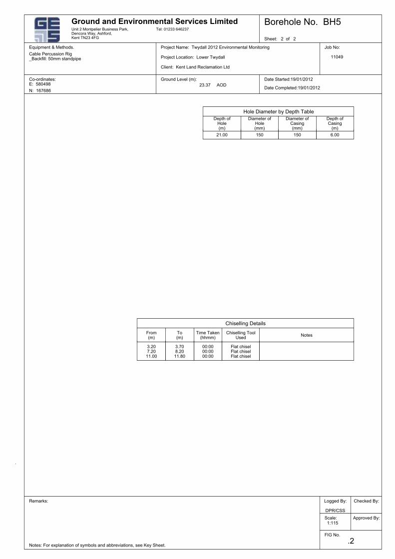
Equipment & Methods. Cable Percussion Rig
Ground Level (m):
1:115
Project Location: Lower Twydall
Ground and Environmental Services LimitedUnit 2 Montpelier Business Park,Dencora Way, Ashford,Kent TN23 4FG
To(m)
Date Started:19/01/2012
Approved By:
Job No:
11049
Equipment & Methods.
Co-ordinates:E: 580498
Logged By:
DPR/CSS
Remarks:
Notes: For explanation of symbols and abbreviations, see Key Sheet.
Project Name: Twydall 2012 Environmental Monitoring
N: 167686
Cable Percussion Rig_Backfill: 50mm standpipe
Date Completed:19/01/2012
Tel: 01233 646237
Checked By:
FIG No.
Sheet: 2 of 2
.2
Scale:
Borehole No. BH5
23.37 AOD
Client: Kent Land Reclamation Ltd
Depth ofCasing
(m)
Depth ofHole(m)
Chiselling Details
Hole Diameter by Depth Table
Diameter ofHole(mm)
From(m)
Diameter ofCasing(mm)
NotesChiselling Tool
UsedTime Taken
(hhmm)
15021.00
3.207.2011.00
3.708.2011.80
150
00:0000:0000:00
Flat chiselFlat chiselFlat chisel
6.00
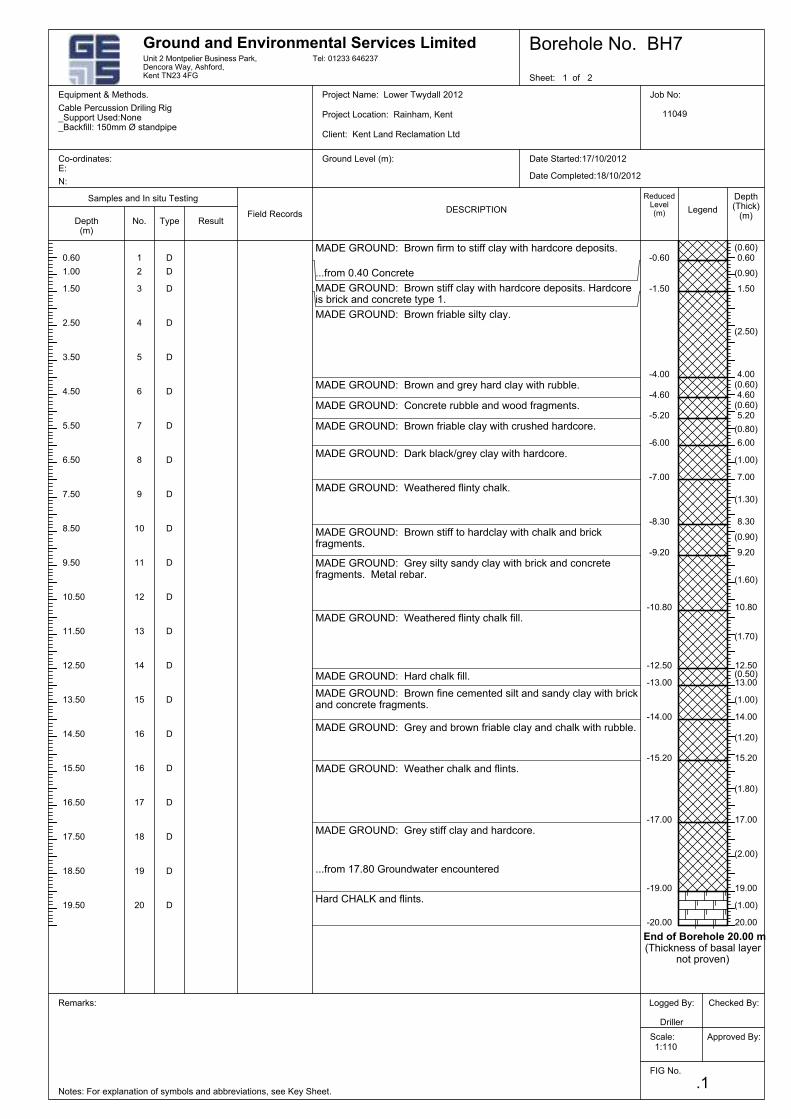
6
-10.80
18
17
16
16
15
14
13
12
11
10
9
20
7
5
4
3
2
1
-20.00
-19.00
-17.00
-15.20
-14.00
-13.00
MADE GROUND: Brown and grey hard clay with rubble.
8
D
MADE GROUND: Brown friable silty clay.
MADE GROUND: Brown stiff clay with hardcore deposits. Hardcoreis brick and concrete type 1.
...from 0.40 Concrete
MADE GROUND: Brown firm to stiff clay with hardcore deposits.
D
D
D
D
D
D
D
D
19
D
-9.20
D
D
D
D
D
D
D
D
D
D
-12.50(0.50)
(1.70)
(1.60)
(0.90)
(1.30)
(1.00)
(0.80)
(0.60)
(0.60)
(2.50)
(0.90)
(1.20)
(1.80)
(0.60)
12.50
-8.30
-7.00
-6.00
-5.20
-4.60
-4.00
-1.50
-0.60
20.00
19.00
17.00
15.20
(1.00)
13.00
D
10.80
9.20
8.30
7.00
6.00
5.20
4.60
4.00
1.50
0.60
(1.00)
(2.00)
14.00
.1
Equipment & Methods.
Ground Level (m):
Equipment & Methods. Cable Percussion Driling Rig
Date Completed:18/10/2012
End of Borehole 20.00 m(Thickness of basal layer
not proven)
MADE GROUND: Concrete rubble and wood fragments.
Borehole No. BH7
Client: Kent Land Reclamation Ltd
Co-ordinates:E:
Logged By:
Driller
Remarks:
Notes: For explanation of symbols and abbreviations, see Key Sheet.
Project Name: Lower Twydall 2012
Cable Percussion Driling Rig_Support Used:None_Backfill: 150mm Ø standpipe
Scale:
Tel: 01233 646237
FIG No.
Sheet: 1 of 2
N:
No.
ReducedLevel(m)DESCRIPTION
Field RecordsResult
Samples and In situ Testing
Type
Depth(Thick)
(m)Legend
1:110
Date Started:17/10/2012
Project Location: Rainham, Kent
Ground and Environmental Services LimitedUnit 2 Montpelier Business Park,Dencora Way, Ashford,Kent TN23 4FG
Depth(m)
Job No:
11049
MADE GROUND: Dark black/grey clay with hardcore.
Checked By:
Hard CHALK and flints.
MADE GROUND: Brown stiff to hardclay with chalk and brickfragments.
...from 17.80 Groundwater encountered
MADE GROUND: Grey silty sandy clay with brick and concretefragments. Metal rebar.
MADE GROUND: Grey stiff clay and hardcore.
MADE GROUND: Weather chalk and flints.
MADE GROUND: Weathered flinty chalk fill.
MADE GROUND: Grey and brown friable clay and chalk with rubble.
MADE GROUND: Hard chalk fill.
MADE GROUND: Brown fine cemented silt and sandy clay with brickand concrete fragments.
MADE GROUND: Weathered flinty chalk.
13.50
6.50
7.50
MADE GROUND: Brown friable clay with crushed hardcore.
9.50
10.50
5.50
12.50
8.50
14.50
15.50
16.50
17.50
18.50
19.50
Approved By:
11.50
0.60
3.50
2.50
1.50
1.00
4.50
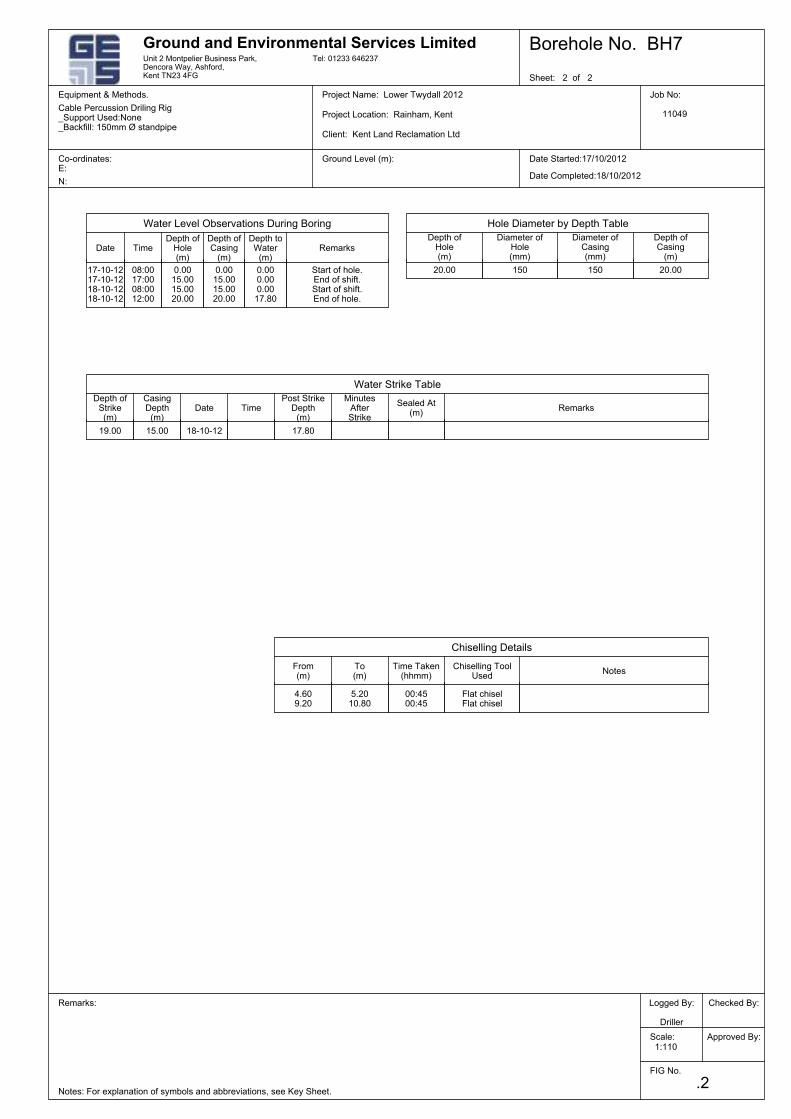
NotesChiselling Tool
UsedTime Taken
(hhmm)From(m)
MinutesAfterStrike
Date
Chiselling Details
CasingDepth
(m)
Depth ofStrike(m)
Cable Percussion Driling Rig_Support Used:None_Backfill: 150mm Ø standpipe
Borehole No. BH7
Scale:
.2
Sheet: 2 of 2
FIG No.
Client: Kent Land Reclamation Ltd
Checked By:
N:
Project Name: Lower Twydall 2012
Notes: For explanation of symbols and abbreviations, see Key Sheet.
Remarks: Logged By:
Driller
Co-ordinates:E:
Equipment & Methods. Job No:
11049
Approved By:
Tel: 01233 646237
To(m)
Unit 2 Montpelier Business Park,Dencora Way, Ashford,Kent TN23 4FG
Ground and Environmental Services Limited
Project Location: Rainham, Kent
1:110
Ground Level (m):
Equipment & Methods. Cable Percussion Driling Rig
Date Completed:18/10/2012
Date Started:17/10/2012
Depth ofCasing
(m)
Water Strike Table
DateDiameter of
Hole(mm)
Hole Diameter by Depth Table
Depth ofHole(m)
Diameter ofCasing(mm)
Water Level Observations During Boring
RemarksPost Strike
Depth(m)
TimeSealed At
(m)
Depth ofHole(m)
RemarksDepth toWater
(m)
Depth ofCasing
(m)Time
150
17.80
4.609.20
19.00
5.2010.80
150 20.00
00:4500:45
17-10-1217-10-1218-10-1218-10-12
20.000.000.000.0017.80
18-10-12
Flat chiselFlat chisel
Start of hole.End of shift.Start of shift.End of hole.
0.0015.0015.0020.00
08:0017:0008:0012:00
0.0015.0015.0020.00
15.00
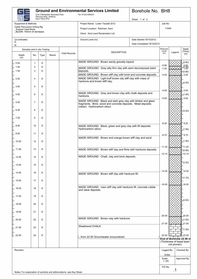
(0.80)
D
End of Borehole 22.50 m(Thickness of basal layer
not proven)
(1.50)
(1.00)
(4.00)
(1.70)
(2.20)
(0.90)
(1.50)
(1.50)
(3.20)
MADE GROUND: Black and dark grey clay with klinker and glassfragments. Brick, wood and concrete deposits. Metal deposits(rebar). Hydrocarbon odour.
(2.00)
D
(0.40)
(0.80)
(1.00)
D
MADE GROUND: Grey and brown clay with chalk deposits andhardcore.
MADE GROUND: Light buff brown sity stiff clay with mass ofhardcore and brown stiff clay.
MADE GROUND: Brown stiff clay with brick and concrete deposits.
MADE GROUND: Grey silty firm clay with semi decomposed plantdeposits.
MADE GROUND: Brown sandy gravelly topsoil.
D
D
D
D
D
D
D
D
D
D
D
D
D
D
D
0.80
D
D
D
D
22.50
-20.00
-16.00
-14.30
-12.10
-11.20
-9.70
-8.20
-5.00
-4.00
-2.00
-22.50
-0.801
21.00
20.00
16.00
14.30
12.10
11.20
9.70
8.20
5.00
4.00
2.00
1.20-1.20
14
D
24
23
22
21
20
19
18
17
-21.00
15
13
12
11
10
9
8
7
6
5
4
3
2
16
Co-ordinates:E:
Notes: For explanation of symbols and abbreviations, see Key Sheet.
Date Started:18/10/2012
Project Location: Rainham, Kent
D
MADE GROUND: Black, green and grey clay with fill deposits.Hydrocarbon odour.
Logged By:
Driller
Ground and Environmental Services Limited
Project Name: Lower Twydall 2012
Depth(m)
No.
Equipment & Methods. Job No:
11049
Legend
Depth(Thick)
(m)
Unit 2 Montpelier Business Park,Dencora Way, Ashford,Kent TN23 4FG
Client: Kent Land Reclamation Ltd
Borehole No. BH8
Scale:
.1
Sheet: 1 of 2
FIG No.
Tel: 01233 646237
Checked By:
1:120
Date Completed:19/10/2012
Equipment & Methods. Cable Percussion Driling Rig
Cable Percussion Driling Rig_Support Used:None_Backfill: 150mm Ø standpipe
Ground Level (m):
N:
Approved By:
1.50
1.00
0.50
3.50
4.50
...from 22.00 Groundwater encountered
Weathered CHALK.
MADE GROUND: Brown clay with hardcore.
MADE GROUND: rown stiff clay with hardcore fill, concrete rubbleand rebar deposits.
MADE GROUND: Brown stiff clay with hardcore fill.
MADE GROUND: Chalk, clay and brick deposits.
MADE GROUND: Brown stiff clay and flints with hardcore deposits.
MADE GROUND: Brown and orange brown stiff clay and sand.
17.50
Remarks:
22.50
Samples and In situ Testing
ResultField Records
21.50
DESCRIPTION
ReducedLevel(m)
20.50
2.50
18.50
Type
16.50
15.50
14.50
13.50
12.50
11.50
10.50
9.50
8.50
7.50
6.50
5.50
19.50
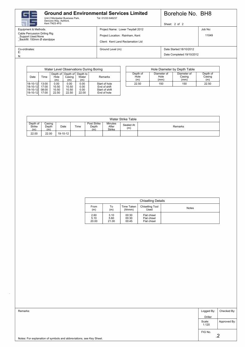
To(m)
Unit 2 Montpelier Business Park,Dencora Way, Ashford,Kent TN23 4FG
Ground and Environmental Services Limited
Project Location: Rainham, Kent
1:120
Ground Level (m):
Equipment & Methods. Cable Percussion Driling Rig
Date Completed:19/10/2012
Date Started:18/10/2012
MinutesAfterStrike
DateCasingDepth
(m)
Chiselling Details
NotesChiselling Tool
Used
Checked By:
From(m)
Time Taken(hhmm)
N:
Borehole No. BH8
Scale:
.2
Sheet: 2 of 2
FIG No.
Tel: 01233 646237
Cable Percussion Driling Rig_Support Used:None_Backfill: 150mm Ø standpipe
Depth ofStrike(m)
Project Name: Lower Twydall 2012
Notes: For explanation of symbols and abbreviations, see Key Sheet.
Remarks: Logged By:
Driller
Co-ordinates:E:
Equipment & Methods. Job No:
11049
Approved By:
Client: Kent Land Reclamation Ltd
Diameter ofCasing(mm)
Water Strike Table
Date
Water Level Observations During Boring
Diameter ofHole(mm)
Depth ofCasing
(m)
Depth ofHole(m)
Hole Diameter by Depth Table
Post StrikeDepth
(m)Time Remarks
Sealed At(m)
Depth ofCasing
(m)Remarks
Depth toWater
(m)
Depth ofHole(m)
Time
Start of holeEnd of shiftStart of shiftEnd of hole
150
22.00
3.105.6021.00
2.605.1020.00
150
22.00 19-10-12
22.500.000.000.0022.00
0.0010.5010.5022.50
0.0010.5010.5022.50
Flat chiselFlat chiselFlat chisel
18-10-1218-10-1219-10-1219-10-12
13:0017:0008:0017:00
00:3000:3000:45
22.50

Pump and Bloors Farm, Rainham
Phase 1 Ground Conditions Assessment (Geotechnical and Contamination)
\\pba.int\cbh\Projects\44538 Pump and Bloors Farm\3500 Geo\05 Reports etc\Desk Study\Phase 1 GCA Final for Issue R01.docx
Appendix F2: Extracts from Lower Twydall Chalk Pit Landfill Reports (2016-2017)
Lower Twydall Chalk Pit Annual Interpretive Report Jan – Dec 2017
Ground and Environmental Services Limited a 11714-A1 Co. Registration No: 7567478
Figure 1
Site Layout Plan
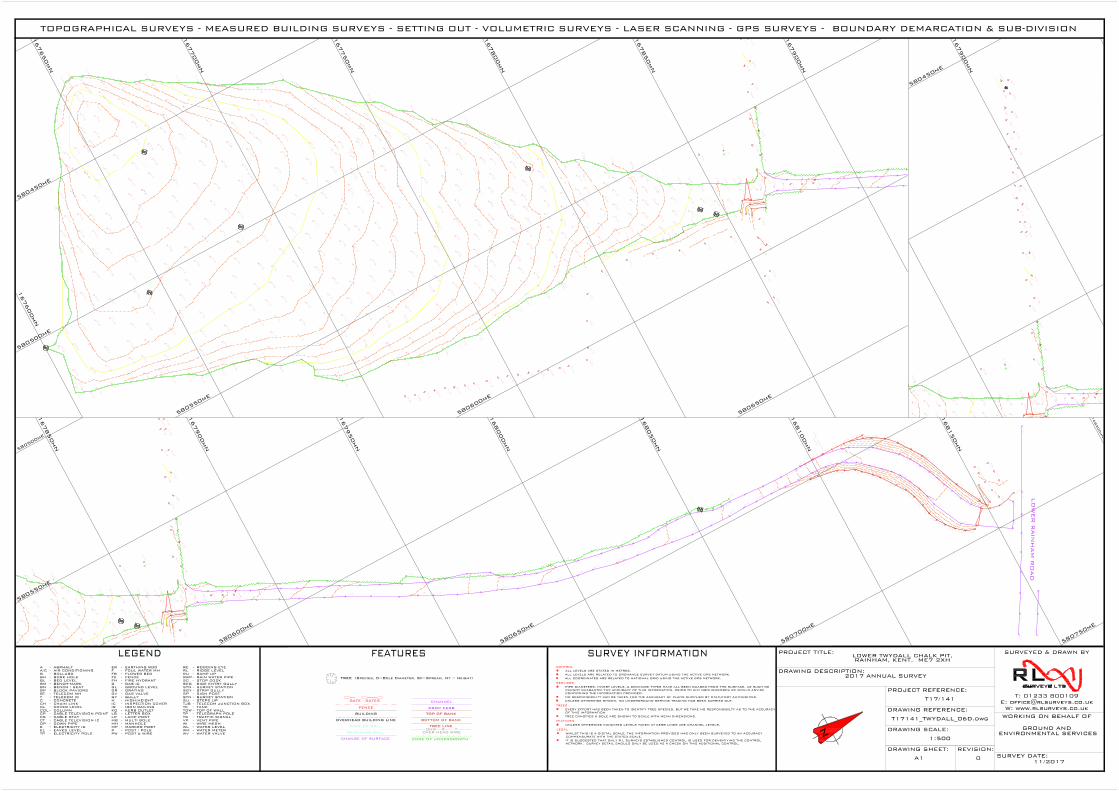
14.39
5.64
timber retaining
feature
168000mN
168050mN
168100mN
168150mN
168200mN
167950mN
167900mN
167850mN
580500mE
580550mE
580600mE
580650mE
580700mE
580750mE
14.39
167600mN
167650mN
167700mN
167750mN
167800mN
167850mN
167900mN
580450mE
580500mE
580550mE
580600mE
580650mE
14.39
167900mN
580450mE
TOPOGRAPHICAL SURVEYS - MEASURED BUILDING SURVEYS - SETTING OUT - VOLUMETRIC SURVEYS - LASER SCANNING - GPS SURVEYS - BOUNDARY DEMARCATION & SUB-DIVISION
TJB
SGY - STRIP GULLY
TELECOM JUNCTION BOX-TK - TANK
GAS IC-G
A
BBH
-
-----
------
--
ASPHALT
BOLLARDBORE HOLE
BLBMBN
BT
BED LEVELBENCH-MARKBENCH / SEAT
TELECOM MHT TELECOM IC
CHCL
C CONCRETECHAIN LINKCOVER LEVEL
COL
FE
COLUMN
FOUL WATER MH
FENCEFH FIRE HYDRANT -
-
-
-
------GL GROUND LEVEL
GR GRATINGGV GAS VALVEGY GULLYHIC
HIGH/HEIGHTINSPECTION COVER
PW POST & WIRE
RL RIDGE LEVEL
SC STOP COCKRWP RAIN WATER PIPE
EARTHING RODER -
ELECTRICITY ICDOWN PIPEDP
TP
E
-
--
CP -
ELECTRICITY POLE
CABLE TELEVISION POINT
POST / POLE
LAMP POSTLETTER BOXKERB OUTLETIRON RAILING
P
MH
LPLB -
-
-
-
MANHOLE
KOIR -
-
WIRE MESHWATER LEVEL
VENT PIPETRAFFIC SIGNALTELEGRAPH POLE
WATER METER
TS
WIWL
VP
WM
-----
TP -
SURVEY STATIONSIGN POST
STN -SP -
CABLE TELEVISION IC-CT
EAVES LEVELEL -
TOP OF WALLTOW -
CABLE STAYCS -
-FB FLOWER BED
-BP BLOCK PAVIORS
-A/C AIR CONDITIONING F -
WATER VALVE-WV
RAMP UPRU -
MARKER POST-MP
SURVEY STATIONSTN -
ALL LEVELS ARE STATED IN METRES.ALL LEVELS ARE RELATED TO ORDNANCE SURVEY DATUM USING THE ACTIVE GPS NETWORK.ALL COORDINATES ARE RELATED TO NATIONAL GRID USING THE ACTIVE GPS NETWORK.
CONTROL
PIPE DIAMETERS, INVERT LEVELS, & DRAINAGE TYPES HAVE ALL BEEN GUAGED FROM THE SURFACE, AS SUCH WECANNOT GUARANTEE THE ACCURACY OF THIS INFORMATION, PRIOR TO ANY GROUNDWORKS WE WOULD ADVISECONFIRMING THE INFORMATION PROVIDED.NO RESPONSIBILITY CAN BE TAKEN FOR THE ACCURACY OF PLANS SUPPLIED BY STATUTORY AUTHORITIES.UNLESS OTHERWISE SHOWN, NO UNDERGROUND SERVICE TRACING HAS BEEN CARRIED OUT.
SERVICES
TREE CANOPIES & BOLE ARE SHOWN TO SCALE WITH MEAN DIMENSIONS.
TREES
EVERY EFFORT HAS BEEN TAKEN TO IDENTIFY TREE SPECIES, BUT WE TAKE NO RESPONSIBILTY AS TO THE ACCURACYOF THIS INFORMATION.
FEATURES
UNLESS OTHERWISE INDICATED LEVELS TAKEN AT KERB LINES ARE CHANNEL LEVELS.
LEGAL
WHILST THIS IS A DIGITAL SCALE, THE INFORMATION PROVIDED HAS ONLY BEEN SURVEYED TO AN ACCURACYCOMMENSURATE WITH THE STATED SCALE.IT IS SUGGESTED THAT ONLY R L SURVEYS ESTABLISHED CONTROL IS USED FOR DENSIFIYING THE CONTROLNETWORK. SURVEY DETAIL SHOULD ONLY BE USED AS A CHECK ON THIS ADDITIONAL CONTROL.
SU STEPS UP-
-RE RODDING EYE
SEG SIDE ENTRY GULLY
MULTI BOLEMB -
FACE OF WALL
CHANGE OF SURFACE
FENCE
TOP OF BANKBUILDING
GATE - GATES
TREE LINE
EDGE OF UNDERGROWTH
OHW E TOVER HEAD WIRERETAINING WALL
OVERHEAD BUILDING LINE
CHANNEL
DROP KERB
BOTTOM OF BANK
N
SURVEYED & DRAWN BY
WORKING ON BEHALF OF
PROJECT TITLE:
DRAWING DESCRIPTION:
DRAWING REFERENCE:
PROJECT REFERENCE:
DRAWING SCALE:
DRAWING SHEET: REVISION:SURVEY DATE:
T: 01233 800109E: [email protected]
W: www.rlsurveys.co.uk
LOWER TWYDALL CHALK PIT,RAINHAM, KENT. ME7 2XH
2017 ANNUAL SURVEY
T17/141
T17141_TWYDALL_06D.dwg
1:500
GROUND AND ENVIRONMENTAL SERVICES
11/2017A1 0
TREE (Species, D=Bole Diameter, Sp=Spread, Ht = Height)
Lower Twydall Chalk Pit Annual Interpretive Report Jan – Dec 2017
Ground and Environmental Services Limited b 11714-A1 Co. Registration No: 7567478
Figure 2
Time Series Graphs of Gas Monitoring Data
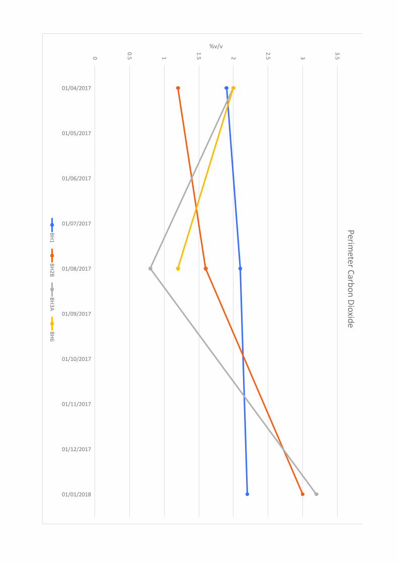
0
0.5 1
1.5 2
2.5 3
3.5
01/04/2017
01/05/2017
01/06/2017
01/07/2017
01/08/2017
01/09/2017
01/10/2017
01/11/2017
01/12/2017
01/01/2018
%v/vP
erim
ete
r Ca
rbo
n D
ioxid
e
BH
1B
H2
BB
H3
AB
H6
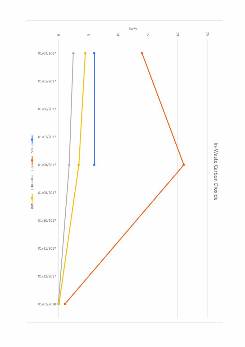
0 5
10
15
20
25
01/04/2017
01/05/2017
01/06/2017
01/07/2017
01/08/2017
01/09/2017
01/10/2017
01/11/2017
01/12/2017
01/01/2018
%v/vIn
-Wa
ste C
arb
on
Dio
xid
e
BH
4A
BH
5B
H7
BH
8
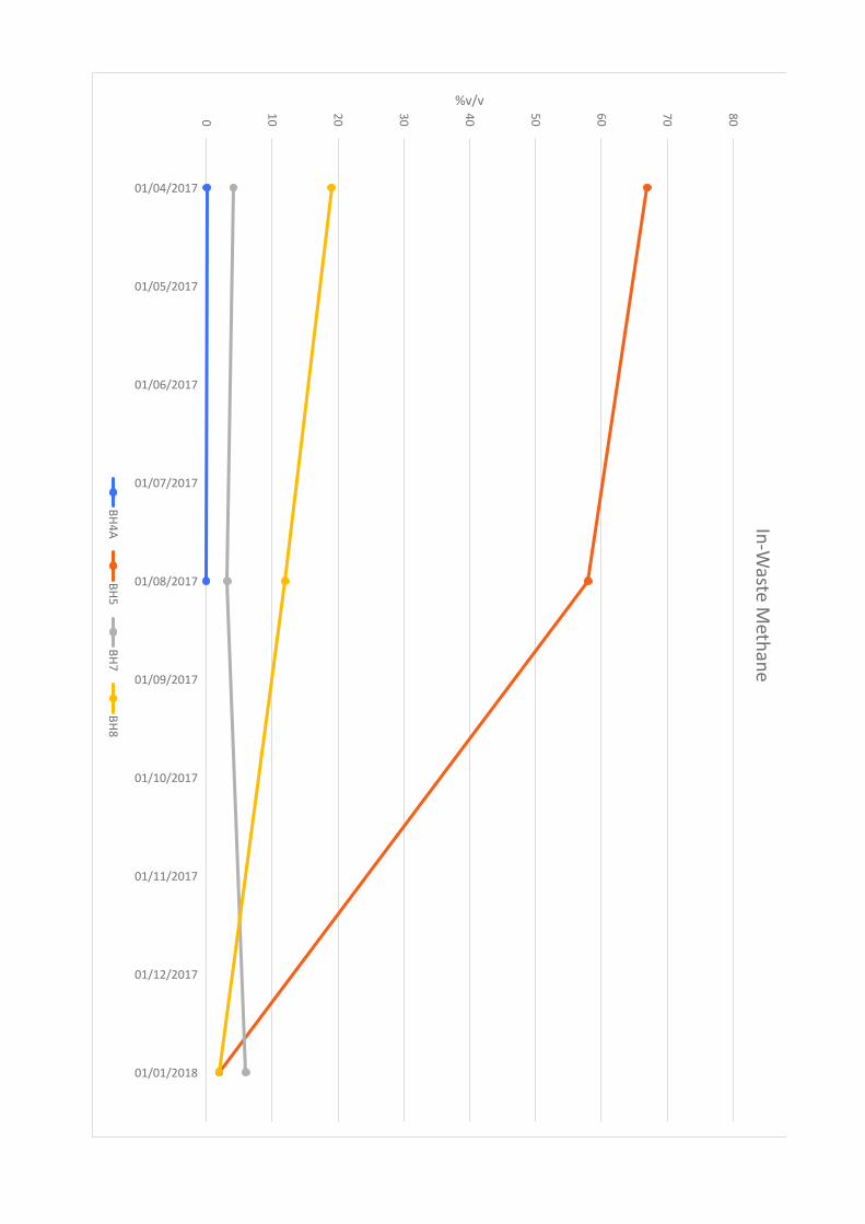
0
10
20
30
40
50
60
70
80
01/04/2017
01/05/2017
01/06/2017
01/07/2017
01/08/2017
01/09/2017
01/10/2017
01/11/2017
01/12/2017
01/01/2018
%v/vIn
-Wa
ste M
eth
an
e
BH
4A
BH
5B
H7
BH
8

Lower Twydall Chalk Pit Annual Interpretive Report Jan – Dec 2017
Ground and Environmental Services Limited c 11714-A1 Co. Registration No: 7567478
Figure 3
Time Series Graph of Groundwater Levels
1
1.5 2
2.5 3
3.5
01/04/2017
01/05/2017
01/06/2017
01/07/2017
01/08/2017
01/09/2017
01/10/2017
01/11/2017
01/12/2017
01/01/2018
mAODG
rou
nd
wa
ter Le
ve
ls mA
OD
BH
1B
H2
BB
H3
AB
H6

Lower Twydall Chalk Pit Annual Interpretive Report Jan – Dec 2017
Ground and Environmental Services Limited d 11714-A1 Co. Registration No: 7567478
Figure 4
Time Series Graphs of Groundwater Quality Data
0 5
10
15
20
25
30
35
40
01/04/2017
01/05/2017
01/06/2017
01/07/2017
01/08/2017
01/09/2017
01/10/2017
01/11/2017
01/12/2017
01/01/2018
mg/lTo
tal O
xidise
d N
itrog
en
BH
1B
H2
BB
H3
AB
H6
0
10
20
30
40
50
60
01/04/2017
01/05/2017
01/06/2017
01/07/2017
01/08/2017
01/09/2017
01/10/2017
01/11/2017
01/12/2017
01/01/2018
mg/lTo
tal O
rga
nic C
arb
on
(TO
C)
BH
1B
H2
BB
H3
AB
H6
0
20
0
40
0
60
0
80
0
10
00
12
00
14
00
01/04/2017
01/05/2017
01/06/2017
01/07/2017
01/08/2017
01/09/2017
01/10/2017
01/11/2017
01/12/2017
01/01/2018
µS/cmE
lectrica
l Co
nd
uctiv
ity
BH
1B
H2
BB
H3
AB
H6
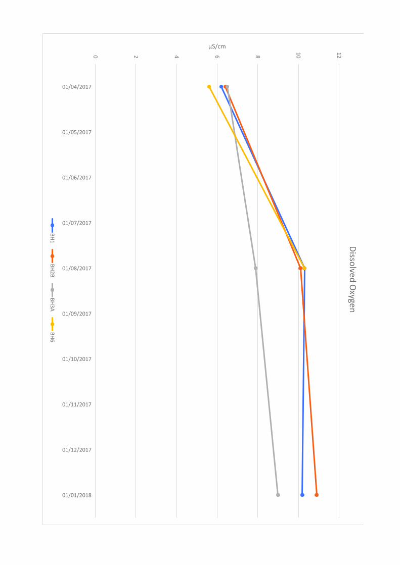
0 2 4 6 8
10
12
01/04/2017
01/05/2017
01/06/2017
01/07/2017
01/08/2017
01/09/2017
01/10/2017
01/11/2017
01/12/2017
01/01/2018
µS/cmD
issolve
d O
xyge
n
BH
1B
H2
BB
H3
AB
H6
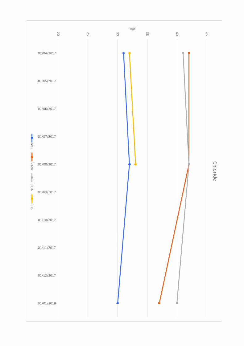
20
25
30
35
40
45
01/04/2017
01/05/2017
01/06/2017
01/07/2017
01/08/2017
01/09/2017
01/10/2017
01/11/2017
01/12/2017
01/01/2018
mg/lChlorid
e
BH1
BH2B
BH3A
BH6
Lower Twydall Chalk Pit Annual Interpretive Report Jan – Dec 2017
Ground and Environmental Services Limited e 11714-A1 Co. Registration No: 7567478
Table 1
Summary Table of Perimeter Gas Monitoring Data
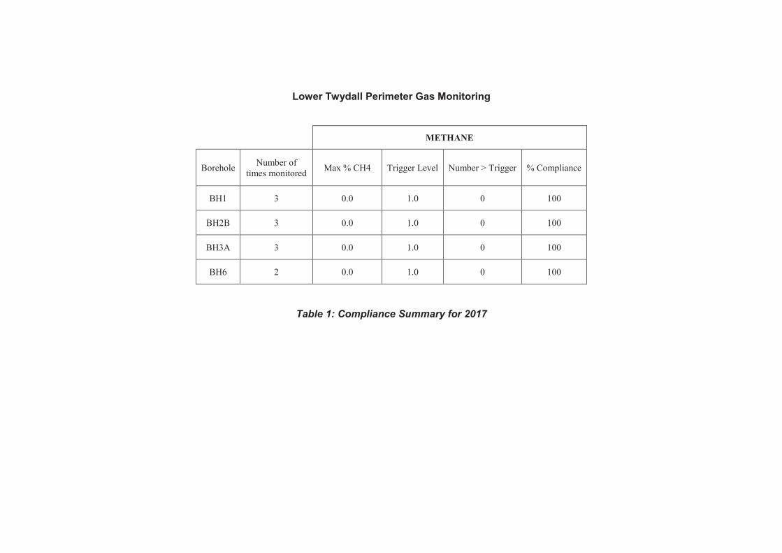
Lower Twydall Perimeter Gas Monitoring
METHANE
Borehole Number of
times monitored Max % CH4 Trigger Level Number > Trigger % Compliance
BH1 3 0.0 1.0 0 100
BH2B 3 0.0 1.0 0 100
BH3A 3 0.0 1.0 0 100
BH6 2 0.0 1.0 0 100
Table 1: Compliance Summary for 2017
Lower Twydall Chalk Pit Annual Interpretive Report Jan – Dec 2017
Ground and Environmental Services Limited f 11714-A1 Co. Registration No: 7567478
Table 2
Summary Table of In-Waste Gas Monitoring Data
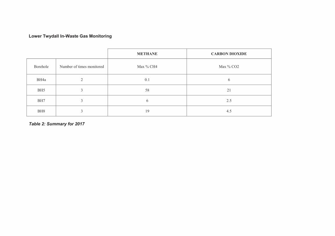
Lower Twydall In-Waste Gas Monitoring
METHANE CARBON DIOXIDE
Borehole Number of times monitored Max % CH4 Max % CO2
BH4a 2 0.1 6
BH5 3 58 21
BH7 3 6 2.5
BH8 3 19 4.5
Table 2: Summary for 2017

Lower Twydall Chalk Pit Annual Interpretive Report Jan – Dec 2017
Ground and Environmental Services Limited g 11714-A1 Co. Registration No: 7567478
Table 3
Summary Table of Groundwater Quality Data
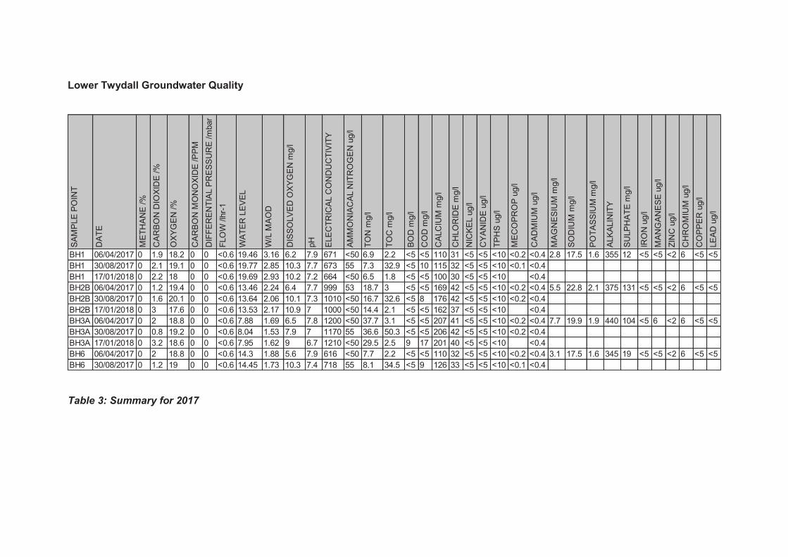
Lower Twydall Groundwater Quality
Table 3: Summary for 2017
SA
MP
LE
PO
INT
DA
TE
ME
TH
AN
E /%
CA
RB
ON
DIO
XID
E /%
OX
YG
EN
/%
CA
RB
ON
MO
NO
XID
E /P
PM
DIF
FE
RE
NT
IAL P
RE
SS
UR
E /m
bar
FLO
W /lh
r-1
WA
TE
R L
EV
EL
W/L
MA
OD
DIS
SO
LV
ED
OX
YG
EN
mg/l
pH
ELE
CT
RIC
AL C
ON
DU
CT
IVIT
Y
AM
MO
NIA
CA
L N
ITR
OG
EN
ug/l
TO
N m
g/l
TO
C m
g/l
BO
D m
g/l
CO
D m
g/l
CA
LC
IUM
mg/l
CH
LO
RID
E m
g/l
NIC
KE
L u
g/l
CY
AN
IDE
ug/l
TP
HS
ug/l
ME
CO
PR
OP
ug/l
CA
DM
IUM
ug/l
MA
GN
ES
IUM
mg/l
SO
DIU
M m
g/l
PO
TA
SS
IUM
mg/l
ALK
ALIN
ITY
SU
LP
HA
TE
mg/l
IRO
N u
g/l
MA
NG
AN
ES
E u
g/l
ZIN
C u
g/l
CH
RO
MIU
M u
g/l
CO
PP
ER
ug/l
LE
AD
ug/l
BH1 06/04/2017 0 1.9 18.2 0 0 <0.6 19.46 3.16 6.2 7.9 671 <50 6.9 2.2 <5 <5 110 31 <5 <5 <10 <0.2 <0.4 2.8 17.5 1.6 355 12 <5 <5 <2 6 <5 <5
BH1 30/08/2017 0 2.1 19.1 0 0 <0.6 19.77 2.85 10.3 7.7 673 55 7.3 32.9 <5 10 115 32 <5 <5 <10 <0.1 <0.4
BH1 17/01/2018 0 2.2 18 0 0 <0.6 19.69 2.93 10.2 7.2 664 <50 6.5 1.8 <5 <5 100 30 <5 <5 <10 <0.4
BH2B 06/04/2017 0 1.2 19.4 0 0 <0.6 13.46 2.24 6.4 7.7 999 53 18.7 3 <5 <5 169 42 <5 <5 <10 <0.2 <0.4 5.5 22.8 2.1 375 131 <5 <5 <2 6 <5 <5
BH2B 30/08/2017 0 1.6 20.1 0 0 <0.6 13.64 2.06 10.1 7.3 1010 <50 16.7 32.6 <5 8 176 42 <5 <5 <10 <0.2 <0.4
BH2B 17/01/2018 0 3 17.6 0 0 <0.6 13.53 2.17 10.9 7 1000 <50 14.4 2.1 <5 <5 162 37 <5 <5 <10 <0.4
BH3A 06/04/2017 0 2 18.8 0 0 <0.6 7.88 1.69 6.5 7.8 1200 <50 37.7 3.1 <5 <5 207 41 <5 <5 <10 <0.2 <0.4 7.7 19.9 1.9 440 104 <5 6 <2 6 <5 <5
BH3A 30/08/2017 0 0.8 19.2 0 0 <0.6 8.04 1.53 7.9 7 1170 55 36.6 50.3 <5 <5 206 42 <5 <5 <10 <0.2 <0.4
BH3A 17/01/2018 0 3.2 18.6 0 0 <0.6 7.95 1.62 9 6.7 1210 <50 29.5 2.5 9 17 201 40 <5 <5 <10 <0.4
BH6 06/04/2017 0 2 18.8 0 0 <0.6 14.3 1.88 5.6 7.9 616 <50 7.7 2.2 <5 <5 110 32 <5 <5 <10 <0.2 <0.4 3.1 17.5 1.6 345 19 <5 <5 <2 6 <5 <5
BH6 30/08/2017 0 1.2 19 0 0 <0.6 14.45 1.73 10.3 7.4 718 55 8.1 34.5 <5 9 126 33 <5 <5 <10 <0.1 <0.4
Lower Twydall Chalk Pit Annual Interpretive Report Jan – Dec 2016
Ground and Environmental Services Limited a 11547-A1 Co. Registration No: 7567478
Figure 1
Site Layout Plan
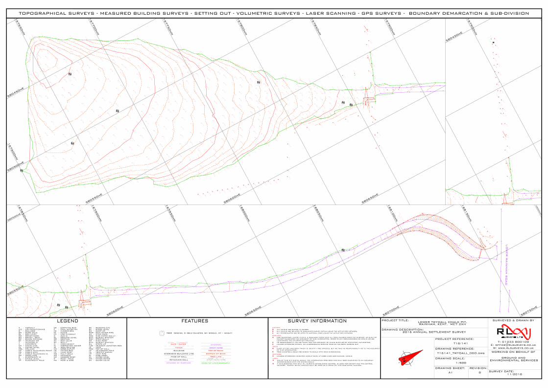
14.39
5.64
timber retaining
feature
168000mN
168050mN
168100mN
168150mN
168200mN
167950mN
167900mN
167850mN
580500mE
580550mE
580600mE
580650mE
580700mE
580750mE
14.39
167600mN
167650mN
167700mN
167750mN
167800mN
167850mN
167900mN
580450mE
580500mE
580550mE
580600mE
580650mE
14.39
167900mN
580450mE
TOPOGRAPHICAL SURVEYS - MEASURED BUILDING SURVEYS - SETTING OUT - VOLUMETRIC SURVEYS - LASER SCANNING - GPS SURVEYS - BOUNDARY DEMARCATION & SUB-DIVISION
TJB
SGY - STRIP GULLY
TELECOM JUNCTION BOX-TK - TANK
GAS IC-G
A
BBH
-
-----
------
--
ASPHALT
BOLLARDBORE HOLE
BLBMBN
BT
BED LEVELBENCH-MARKBENCH / SEAT
TELECOM MHT TELECOM IC
CHCL
C CONCRETECHAIN LINKCOVER LEVEL
COL
FE
COLUMN
FOUL WATER MH
FENCEFH FIRE HYDRANT -
-
-
-
------GL GROUND LEVEL
GR GRATINGGV GAS VALVEGY GULLYHIC
HIGH/HEIGHTINSPECTION COVER
PW POST & WIRE
RL RIDGE LEVEL
SC STOP COCKRWP RAIN WATER PIPE
EARTHING RODER -
ELECTRICITY ICDOWN PIPEDP
TP
E
-
--
CP -
ELECTRICITY POLE
CABLE TELEVISION POINT
POST / POLE
LAMP POSTLETTER BOXKERB OUTLETIRON RAILING
P
MH
LPLB -
-
-
-
MANHOLE
KOIR -
-
WIRE MESHWATER LEVEL
VENT PIPETRAFFIC SIGNALTELEGRAPH POLE
WATER METER
TS
WIWL
VP
WM
-----
TP -
SURVEY STATIONSIGN POST
STN -SP -
CABLE TELEVISION IC-CT
EAVES LEVELEL -
TOP OF WALLTOW -
CABLE STAYCS -
-FB FLOWER BED
-BP BLOCK PAVIORS
-A/C AIR CONDITIONING F -
WATER VALVE-WV
RAMP UPRU -
MARKER POST-MP
SURVEY STATIONSTN -
ALL LEVELS ARE STATED IN METRES.ALL LEVELS ARE RELATED TO ORDNANCE SURVEY DATUM USING THE ACTIVE GPS NETWORK.ALL COORDINATES ARE RELATED TO NATIONAL GRID USING THE ACTIVE GPS NETWORK.
CONTROL
PIPE DIAMETERS, INVERT LEVELS, & DRAINAGE TYPES HAVE ALL BEEN GUAGED FROM THE SURFACE, AS SUCH WECANNOT GUARANTEE THE ACCURACY OF THIS INFORMATION, PRIOR TO ANY GROUNDWORKS WE WOULD ADVISECONFIRMING THE INFORMATION PROVIDED.NO RESPONSIBILITY CAN BE TAKEN FOR THE ACCURACY OF PLANS SUPPLIED BY STATUTORY AUTHORITIES.UNLESS OTHERWISE SHOWN, NO UNDERGROUND SERVICE TRACING HAS BEEN CARRIED OUT.
SERVICES
TREE CANOPIES & BOLE ARE SHOWN TO SCALE WITH MEAN DIMENSIONS.
TREES
EVERY EFFORT HAS BEEN TAKEN TO IDENTIFY TREE SPECIES, BUT WE TAKE NO RESPONSIBILTY AS TO THE ACCURACYOF THIS INFORMATION.
FEATURES
UNLESS OTHERWISE INDICATED LEVELS TAKEN AT KERB LINES ARE CHANNEL LEVELS.
LEGAL
WHILST THIS IS A DIGITAL SCALE, THE INFORMATION PROVIDED HAS ONLY BEEN SURVEYED TO AN ACCURACYCOMMENSURATE WITH THE STATED SCALE.IT IS SUGGESTED THAT ONLY R L SURVEYS ESTABLISHED CONTROL IS USED FOR DENSIFIYING THE CONTROLNETWORK. SURVEY DETAIL SHOULD ONLY BE USED AS A CHECK ON THIS ADDITIONAL CONTROL.
SU STEPS UP-
-RE RODDING EYE
SEG SIDE ENTRY GULLY
MULTI BOLEMB -
FACE OF WALL
CHANGE OF SURFACE
FENCE
TOP OF BANKBUILDING
GATE - GATES
TREE LINE
EDGE OF UNDERGROWTH
OHW E TOVER HEAD WIRERETAINING WALL
OVERHEAD BUILDING LINE
CHANNEL
DROP KERB
BOTTOM OF BANK
N
SURVEYED & DRAWN BY
WORKING ON BEHALF OF
PROJECT TITLE:
DRAWING DESCRIPTION:
DRAWING REFERENCE:
PROJECT REFERENCE:
DRAWING SCALE:
DRAWING SHEET: REVISION:SURVEY DATE:
T: 01233 800109E: [email protected]
W: www.rlsurveys.co.uk
LOWER TWYDALL CHALK PIT,RAINHAM, KENT. ME7 2XH
2016 ANNUAL SETTLEMENT SURVEY
T16/141
T16141_TWYDALL_06D.dwg
1:500
GROUND AND ENVIRONMENTAL SERVICES
11/2016A1 0
TREE (Species, D=Bole Diameter, Sp=Spread, Ht = Height)

Lower Twydall Chalk Pit Annual Interpretive Report Jan – Dec 2016
Ground and Environmental Services Limited b 11547-A1 Co. Registration No: 7567478
Figure 2
Time Series Graphs of Gas Monitoring Data
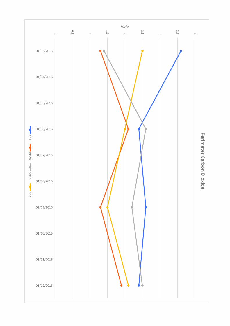
0
0.5 1
1.5 2
2.5 3
3.5 4
01/03/2016
01/04/2016
01/05/2016
01/06/2016
01/07/2016
01/08/2016
01/09/2016
01/10/2016
01/11/2016
01/12/2016
%v/vP
erim
ete
r Ca
rbo
n D
ioxid
e
BH
1B
H2
BB
H3
AB
H6
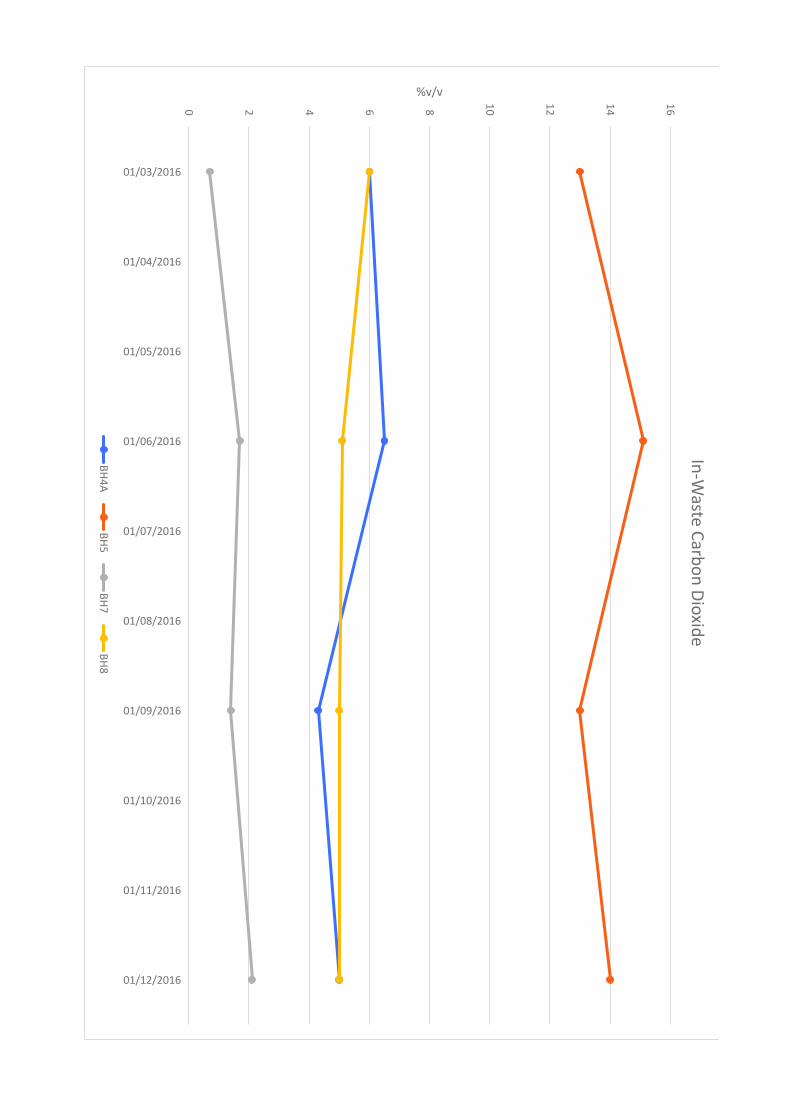
0 2 4 6 8
10
12
14
16
01/03/2016
01/04/2016
01/05/2016
01/06/2016
01/07/2016
01/08/2016
01/09/2016
01/10/2016
01/11/2016
01/12/2016
%v/vIn
-Wa
ste C
arb
on
Dio
xid
e
BH
4A
BH
5B
H7
BH
8
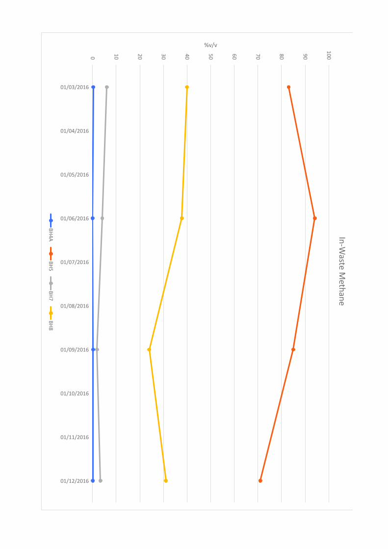
0
10
20
30
40
50
60
70
80
90
10
0
01/03/2016
01/04/2016
01/05/2016
01/06/2016
01/07/2016
01/08/2016
01/09/2016
01/10/2016
01/11/2016
01/12/2016
%v/vIn
-Wa
ste M
eth
an
e
BH
4A
BH
5B
H7
BH
8

Lower Twydall Chalk Pit Annual Interpretive Report Jan – Dec 2016
Ground and Environmental Services Limited c 11547-A1 Co. Registration No: 7567478
Figure 3
Time Series Graph of Groundwater Levels
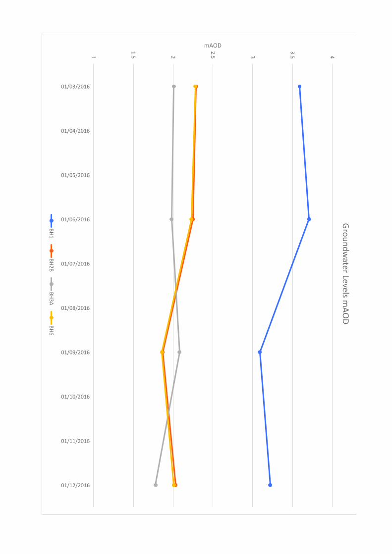
1
1.5 2
2.5 3
3.5 4
01/03/2016
01/04/2016
01/05/2016
01/06/2016
01/07/2016
01/08/2016
01/09/2016
01/10/2016
01/11/2016
01/12/2016
mAODG
rou
nd
wa
ter Le
vels m
AO
D
BH
1B
H2
BB
H3
AB
H6

Lower Twydall Chalk Pit Annual Interpretive Report Jan – Dec 2016
Ground and Environmental Services Limited d 11547-A1 Co. Registration No: 7567478
Figure 4
Time Series Graphs of Groundwater Quality Data
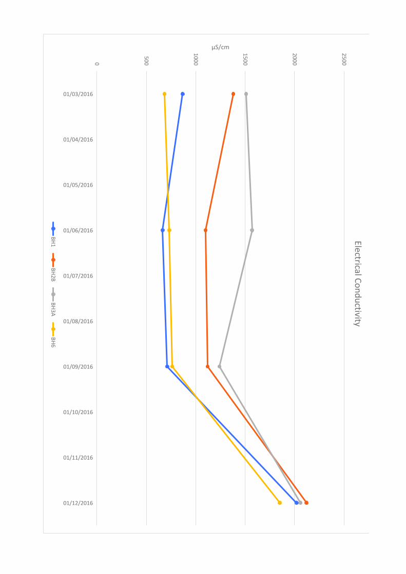
0
50
0
10
00
15
00
20
00
25
00
01/03/2016
01/04/2016
01/05/2016
01/06/2016
01/07/2016
01/08/2016
01/09/2016
01/10/2016
01/11/2016
01/12/2016
µS/cmE
lectrica
l Co
nd
uctiv
ity
BH
1B
H2
BB
H3
AB
H6
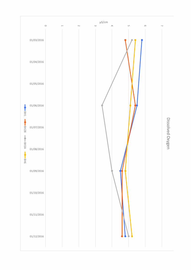
0 1 2 3 4 5 6 7
01/03/2016
01/04/2016
01/05/2016
01/06/2016
01/07/2016
01/08/2016
01/09/2016
01/10/2016
01/11/2016
01/12/2016
µS/cmD
issolve
d O
xyge
n
BH
1B
H2
BB
H3
AB
H6

20
25
30
35
40
45
50
01/03/2016
01/04/2016
01/05/2016
01/06/2016
01/07/2016
01/08/2016
01/09/2016
01/10/2016
01/11/2016
01/12/2016
mg/lC
hlo
ride
BH
1B
H2
BB
H3
AB
H6
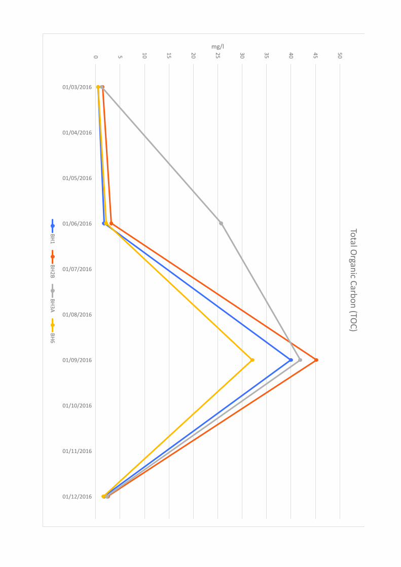
0 5
10
15
20
25
30
35
40
45
50
01/03/2016
01/04/2016
01/05/2016
01/06/2016
01/07/2016
01/08/2016
01/09/2016
01/10/2016
01/11/2016
01/12/2016
mg/lTo
tal O
rga
nic C
arb
on
(TO
C)
BH
1B
H2
BB
H3
AB
H6
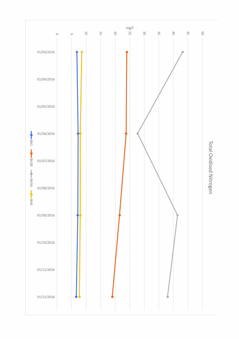
0 5
10
15
20
25
30
35
40
45
50
01/03/2016
01/04/2016
01/05/2016
01/06/2016
01/07/2016
01/08/2016
01/09/2016
01/10/2016
01/11/2016
01/12/2016
mg/lTo
tal O
xidise
d N
itrog
en
BH
1B
H2
BB
H3
AB
H6
Lower Twydall Chalk Pit Annual Interpretive Report Jan – Dec 2016
Ground and Environmental Services Limited e 11547-A1 Co. Registration No: 7567478
Table 1
Summary Table of Perimeter Gas Monitoring Data
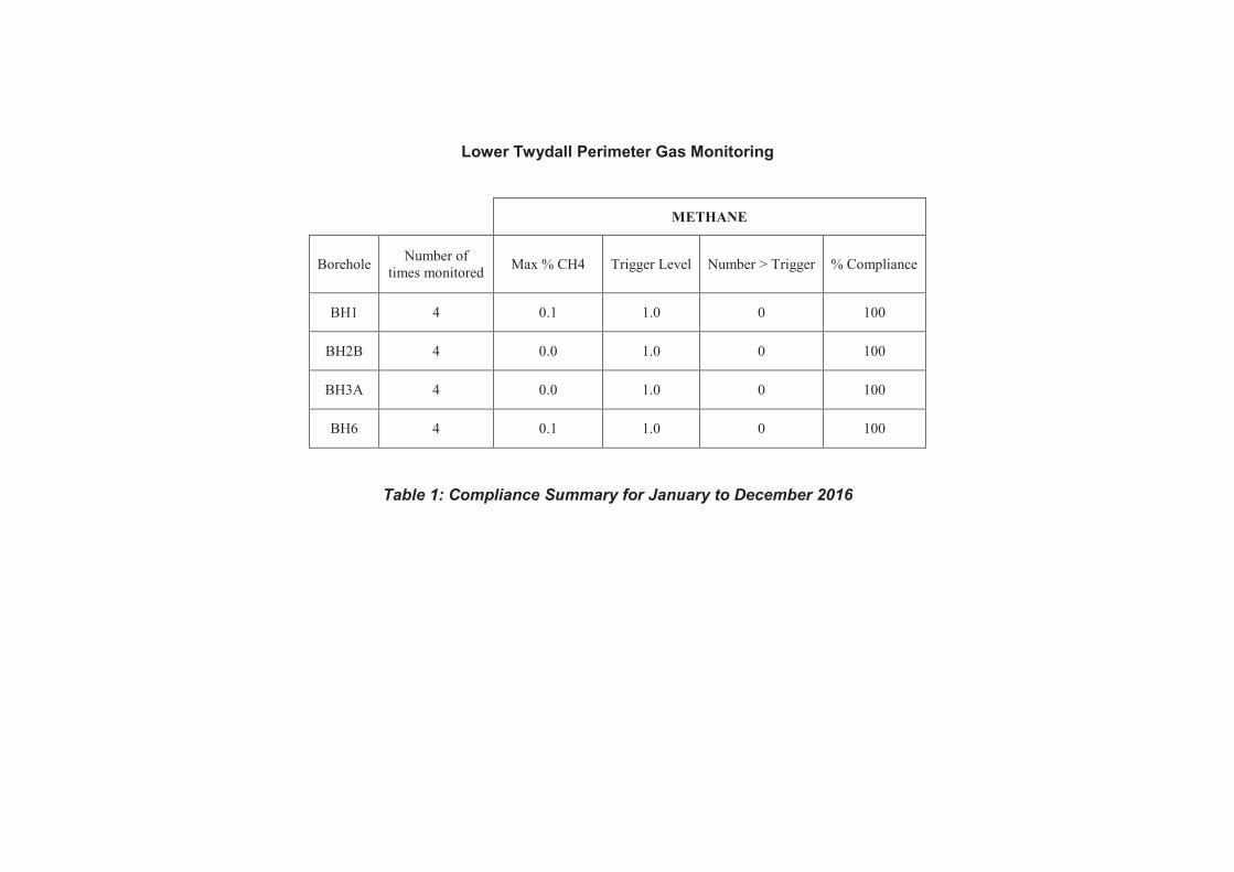
Lower Twydall Perimeter Gas Monitoring
METHANE
Borehole Number of
times monitored Max % CH4 Trigger Level Number > Trigger % Compliance
BH1 4 0.1 1.0 0 100
BH2B 4 0.0 1.0 0 100
BH3A 4 0.0 1.0 0 100
BH6 4 0.1 1.0 0 100
Table 1: Compliance Summary for January to December 2016
Lower Twydall Chalk Pit Annual Interpretive Report Jan – Dec 2016
Ground and Environmental Services Limited f 11547-A1 Co. Registration No: 7567478
Table 2
Summary Table of In-Waste Gas Monitoring Data
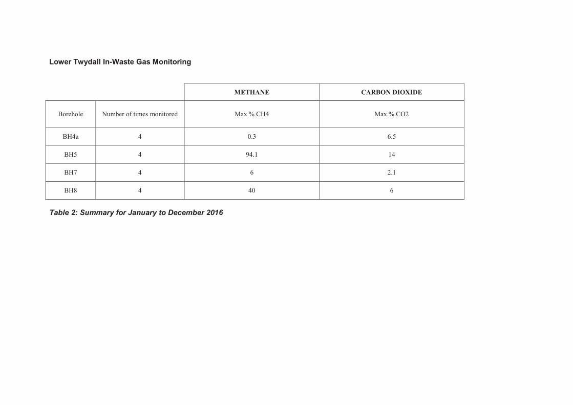
Lower Twydall In-Waste Gas Monitoring
METHANE CARBON DIOXIDE
Borehole Number of times monitored Max % CH4 Max % CO2
BH4a 4 0.3 6.5
BH5 4 94.1 14
BH7 4 6 2.1
BH8 4 40 6
Table 2: Summary for January to December 2016

Lower Twydall Chalk Pit Annual Interpretive Report Jan – Dec 2016
Ground and Environmental Services Limited g 11547-A1 Co. Registration No: 7567478
Table 3
Summary Table of Groundwater Quality Data
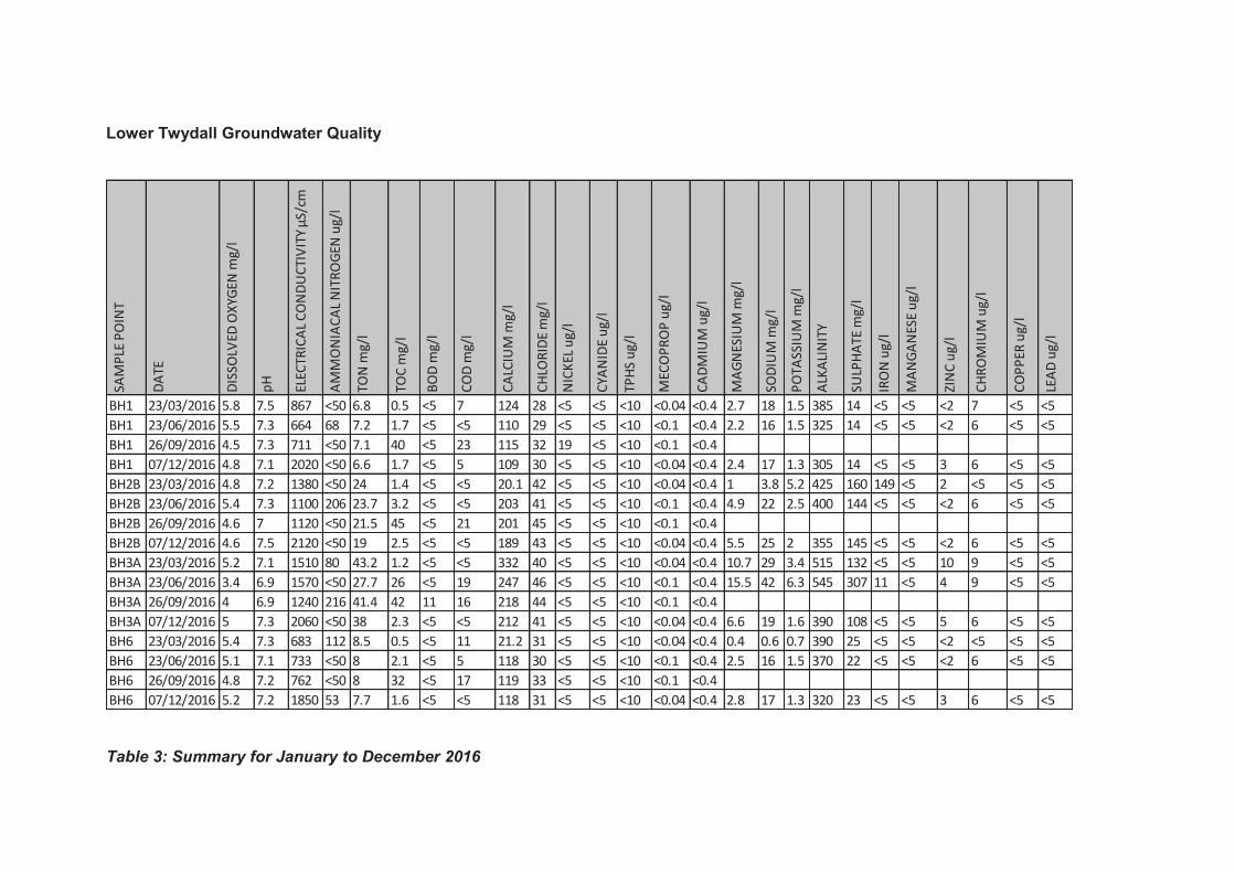
Lower Twydall Groundwater Quality
Table 3: Summary for January to December 2016
SA
MP
LE P
OIN
T
DA
TE
DIS
SO
LVE
D O
XY
GE
N m
g/l
pH
ELE
CT
RIC
AL
CO
ND
UC
TIV
ITY
µS
/cm
AM
MO
NIA
CA
L N
ITR
OG
EN
ug
/l
TO
N m
g/l
TO
C m
g/l
BO
D m
g/l
CO
D m
g/l
CA
LCIU
M m
g/l
CH
LOR
IDE
mg
/l
NIC
KE
L u
g/l
CY
AN
IDE
ug
/l
TP
HS
ug
/l
ME
CO
PR
OP
ug
/l
CA
DM
IUM
ug
/l
MA
GN
ES
IUM
mg
/l
SO
DIU
M m
g/l
PO
TA
SS
IUM
mg
/l
ALK
ALI
NIT
Y
SU
LPH
AT
E m
g/l
IRO
N u
g/l
MA
NG
AN
ES
E u
g/l
ZIN
C u
g/l
CH
RO
MIU
M u
g/l
CO
PP
ER
ug
/l
LEA
D u
g/l
BH1 23/03/2016 5.8 7.5 867 <50 6.8 0.5 <5 7 124 28 <5 <5 <10 <0.04 <0.4 2.7 18 1.5 385 14 <5 <5 <2 7 <5 <5
BH1 23/06/2016 5.5 7.3 664 68 7.2 1.7 <5 <5 110 29 <5 <5 <10 <0.1 <0.4 2.2 16 1.5 325 14 <5 <5 <2 6 <5 <5
BH1 26/09/2016 4.5 7.3 711 <50 7.1 40 <5 23 115 32 19 <5 <10 <0.1 <0.4
BH1 07/12/2016 4.8 7.1 2020 <50 6.6 1.7 <5 5 109 30 <5 <5 <10 <0.04 <0.4 2.4 17 1.3 305 14 <5 <5 3 6 <5 <5
BH2B 23/03/2016 4.8 7.2 1380 <50 24 1.4 <5 <5 20.1 42 <5 <5 <10 <0.04 <0.4 1 3.8 5.2 425 160 149 <5 2 <5 <5 <5
BH2B 23/06/2016 5.4 7.3 1100 206 23.7 3.2 <5 <5 203 41 <5 <5 <10 <0.1 <0.4 4.9 22 2.5 400 144 <5 <5 <2 6 <5 <5
BH2B 26/09/2016 4.6 7 1120 <50 21.5 45 <5 21 201 45 <5 <5 <10 <0.1 <0.4
BH2B 07/12/2016 4.6 7.5 2120 <50 19 2.5 <5 <5 189 43 <5 <5 <10 <0.04 <0.4 5.5 25 2 355 145 <5 <5 <2 6 <5 <5
BH3A 23/03/2016 5.2 7.1 1510 80 43.2 1.2 <5 <5 332 40 <5 <5 <10 <0.04 <0.4 10.7 29 3.4 515 132 <5 <5 10 9 <5 <5
BH3A 23/06/2016 3.4 6.9 1570 <50 27.7 26 <5 19 247 46 <5 <5 <10 <0.1 <0.4 15.5 42 6.3 545 307 11 <5 4 9 <5 <5
BH3A 26/09/2016 4 6.9 1240 216 41.4 42 11 16 218 44 <5 <5 <10 <0.1 <0.4
BH3A 07/12/2016 5 7.3 2060 <50 38 2.3 <5 <5 212 41 <5 <5 <10 <0.04 <0.4 6.6 19 1.6 390 108 <5 <5 5 6 <5 <5
BH6 23/03/2016 5.4 7.3 683 112 8.5 0.5 <5 11 21.2 31 <5 <5 <10 <0.04 <0.4 0.4 0.6 0.7 390 25 <5 <5 <2 <5 <5 <5
BH6 23/06/2016 5.1 7.1 733 <50 8 2.1 <5 5 118 30 <5 <5 <10 <0.1 <0.4 2.5 16 1.5 370 22 <5 <5 <2 6 <5 <5
BH6 26/09/2016 4.8 7.2 762 <50 8 32 <5 17 119 33 <5 <5 <10 <0.1 <0.4
BH6 07/12/2016 5.2 7.2 1850 53 7.7 1.6 <5 <5 118 31 <5 <5 <10 <0.04 <0.4 2.8 17 1.3 320 23 <5 <5 3 6 <5 <5

Pump and Bloors Farm, Rainham
Phase 1 Ground Conditions Assessment (Geotechnical and Contamination)
\\pba.int\cbh\Projects\44538 Pump and Bloors Farm\3500 Geo\05 Reports etc\Desk Study\Phase 1 GCA Final for Issue R01.docx
Appendix G: Proposed Development Masterplan
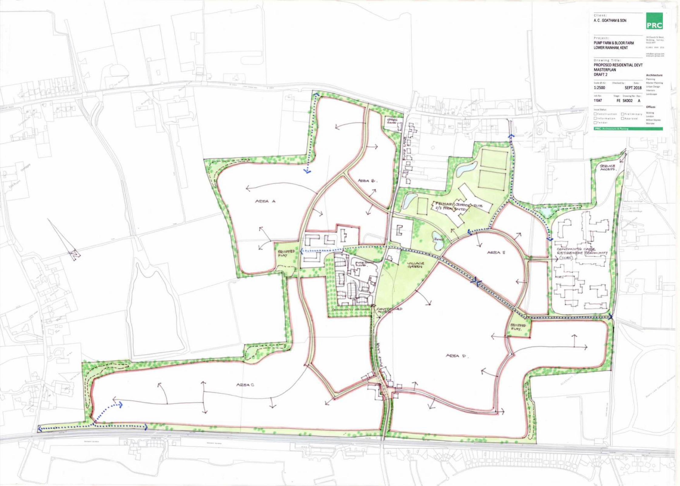

Pump and Bloors Farm, Rainham
Phase 1 Ground Conditions Assessment (Geotechnical and Contamination)
\\pba.int\cbh\Projects\44538 Pump and Bloors Farm\3500 Geo\05 Reports etc\Desk Study\Phase 1 GCA Final for Issue R01.docx
Appendix H: Table of Estimated Risk
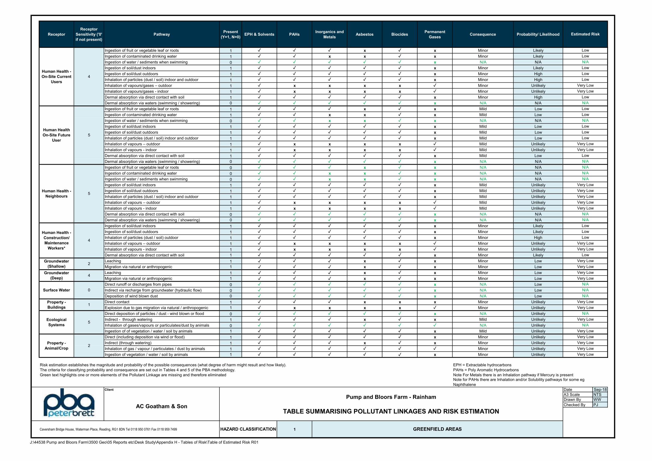
Receptor
Receptor
Sensitivity ('0'
if not present)
PathwayPresent
(Y=1, N=0)EPH & Solvents PAHs
Inorganics and
MetalsAsbestos Biocides
Permanent
GasesConsequence Probability/ Likelihood
Ingestion of fruit or vegetable leaf or roots 1 ✓ ✓ ✓ x ✓ x Minor Likely
Ingestion of contaminated drinking water 1 ✓ ✓ x x ✓ x Minor Likely
Ingestion of water / sediments when swimming 0 ✓ ✓ ✓ ✓ ✓ x N/A N/A
Ingestion of soil/dust indoors 1 ✓ ✓ ✓ ✓ ✓ x Minor Likely
Ingestion of soil/dust outdoors 1 ✓ ✓ ✓ ✓ ✓ x Minor High
Inhalation of particles (dust / soil) indoor and outdoor 1 ✓ ✓ ✓ ✓ ✓ x Minor High
Inhalation of vapours/gases – outdoor 1 ✓ x x x x ✓ Minor Unlikely
Inhalation of vapours/gases - indoor 1 ✓ x x x x ✓ Minor Unlikely
Dermal absorption via direct contact with soil 1 ✓ ✓ ✓ ✓ ✓ x Minor High
Dermal absorption via waters (swimming / showering) 0 ✓ ✓ ✓ ✓ ✓ x N/A N/A
Ingestion of fruit or vegetable leaf or roots 1 ✓ ✓ ✓ x ✓ x Mild Low
Ingestion of contaminated drinking water 1 ✓ ✓ x x ✓ x Mild Low
Ingestion of water / sediments when swimming 0 ✓ ✓ x x ✓ x N/A N/A
Ingestion of soil/dust indoors 1 ✓ ✓ ✓ ✓ ✓ x Mild Low
Ingestion of soil/dust outdoors 1 ✓ ✓ ✓ ✓ ✓ x Mild Low
Inhalation of particles (dust / soil) indoor and outdoor 1 ✓ ✓ ✓ ✓ ✓ x Mild Low
Inhalation of vapours – outdoor 1 ✓ x x x x ✓ Mild Unlikely
Inhalation of vapours - indoor 1 ✓ x x x x ✓ Mild Unlikely
Dermal absorption via direct contact with soil 1 ✓ ✓ ✓ ✓ ✓ x Mild Low
Dermal absorption via waters (swimming / showering) 0 ✓ ✓ ✓ ✓ ✓ x N/A N/A
Ingestion of fruit or vegetable leaf or roots 0 ✓ ✓ ✓ x ✓ x N/A N/A
Ingestion of contaminated drinking water 0 ✓ ✓ x x ✓ x N/A N/A
Ingestion of water / sediments when swimming 0 ✓ ✓ x x ✓ x N/A N/A
Ingestion of soil/dust indoors 1 ✓ ✓ ✓ ✓ ✓ x Mild Unlikely
Ingestion of soil/dust outdoors 1 ✓ ✓ ✓ ✓ ✓ x Mild Unlikely
Inhalation of particles (dust / soil) indoor and outdoor 1 ✓ ✓ ✓ ✓ ✓ x Mild Unlikely
Inhalation of vapours – outdoor 1 ✓ x x x x ✓ Mild Unlikely
Inhalation of vapours - indoor 1 ✓ x x x x ✓ Mild Unlikely
Dermal absorption via direct contact with soil 0 ✓ ✓ ✓ ✓ ✓ x N/A N/A
Dermal absorption via waters (swimming / showering) 0 ✓ ✓ ✓ ✓ ✓ x N/A N/A
Ingestion of soil/dust indoors 1 ✓ ✓ ✓ ✓ ✓ x Minor Likely
Ingestion of soil/dust outdoors 1 ✓ ✓ ✓ ✓ ✓ x Minor Likely
Inhalation of particles (dust / soil) outdoor 1 ✓ ✓ ✓ ✓ ✓ x Minor High
Inhalation of vapours – outdoor 1 ✓ x x x x ✓ Minor Unlikely
Inhalation of vapours - indoor 1 ✓ x x x x ✓ Minor Unlikely
Dermal absorption via direct contact with soil 1 ✓ ✓ ✓ ✓ ✓ x Minor Likely
Leaching 1 ✓ ✓ ✓ x ✓ x Minor Low
Migration via natural or anthropogenic 1 ✓ ✓ ✓ x ✓ x Minor Low
Leaching 1 ✓ ✓ ✓ x ✓ x Minor Low
Migration via natural or anthropogenic 1 ✓ ✓ ✓ x ✓ x Minor Low
Direct runoff or discharges from pipes 0 ✓ ✓ ✓ ✓ ✓ x N/A Low
Indirect via recharge from groundwater (hydraulic flow) 0 ✓ ✓ ✓ ✓ ✓ x N/A Low
Deposition of wind blown dust 0 ✓ ✓ ✓ ✓ ✓ x N/A Low
Direct contact 1 ✓ ✓ ✓ x x x Minor Unlikely
Explosion due to gas migration via natural / anthropogenic 1 ✓ x x x x ✓ Minor Unlikely
Direct deposition of particles / dust - wind blown or flood 0 ✓ ✓ ✓ ✓ ✓ x N/A Unlikely
Indirect - through watering 1 ✓ ✓ ✓ x ✓ x Mild Unlikely
Inhalation of gases/vapours or particulates/dust by animals 0 ✓ ✓ ✓ ✓ ✓ ✓ N/A Unlikely
Ingestion of of vegetation / water / soil by animals 1 ✓ ✓ ✓ ✓ ✓ x Mild Unlikely
Direct (including deposition via wind or flood) 1 ✓ ✓ ✓ ✓ ✓ x Minor Unlikely
Indirect (through watering) 1 ✓ ✓ ✓ x ✓ x Minor Unlikely
Inhalation of gas / vapour / particulates / dust by animals 1 ✓ ✓ ✓ ✓ ✓ ✓ Minor Unlikely
Ingestion of vegetation / water / soil by animals 1 ✓ ✓ ✓ ✓ ✓ x Minor Unlikely
Risk estimation establishes the magnitude and probability of the possible consequences (what degree of harm might result and how likely). EPH = Extractable hydrocarbons
The criteria for classifying probability and consequence are set out in Tables 4 and 5 of the PBA methodology. PAHs = Poly Aromatic Hydrocarbons
Green text highlights one or more elements of the Pollutant Linkage are missing and therefore eliminated Note For Metals there is an Inhalation pathway if Mercury is present
Client Date Sep-18
A3 Scale NTS
Drawn By WW
Checked By PJ
Caversham Bridge House, Waterman Place, Reading, RG1 8DN Tel 0118 950 0761 Fax 0118 959 7499 1 GREENFIELD AREASHAZARD CLASSIFICATION
Very Low
Very Low
N/A
Note for PAHs there are Inhalation and/or Solubility pathways for some eg
Naphthalene
Low
Very Low
Very Low
Very Low
N/A
Very Low
Very Low
Very Low
Low
Very Low
Low
N/A
N/A
N/A
Very Low
Low
Low
Low
Very Low
Very Low
Very Low
N/A
N/A
Low
Low
Human Health -
On-Site Current
Users
Human Health
On-Site Future
User
Human Health -
Neighbours
Human Health -
Construction/
Maintenance
Workers*
4
5
5
4
Estimated Risk
Low
N/A
Low
Very Low
Low
N/A
Low
Low
Very Low
Very Low
Low
N/A
Low
Low
N/A
Groundwater
(Shallow)
Surface Water
Property -
Buildings
Ecological
Systems
Property -
Animal/Crop2
Groundwater
(Deep)4
5
0
2
1
N/A
Very Low
Very Low
Very Low
N/A
N/A
Very Low
Very Low
Very Low
Very Low
TABLE SUMMARISING POLLUTANT LINKAGES AND RISK ESTIMATIONAC Goatham & Son
Pump and Bloors Farm - Rainham
J:\44538 Pump and Bloors Farm\3500 Geo\05 Reports etc\Desk Study\Appendix H - Tables of Risk\Table of Estimated Risk R01