Embed Size (px)
Citation preview
1
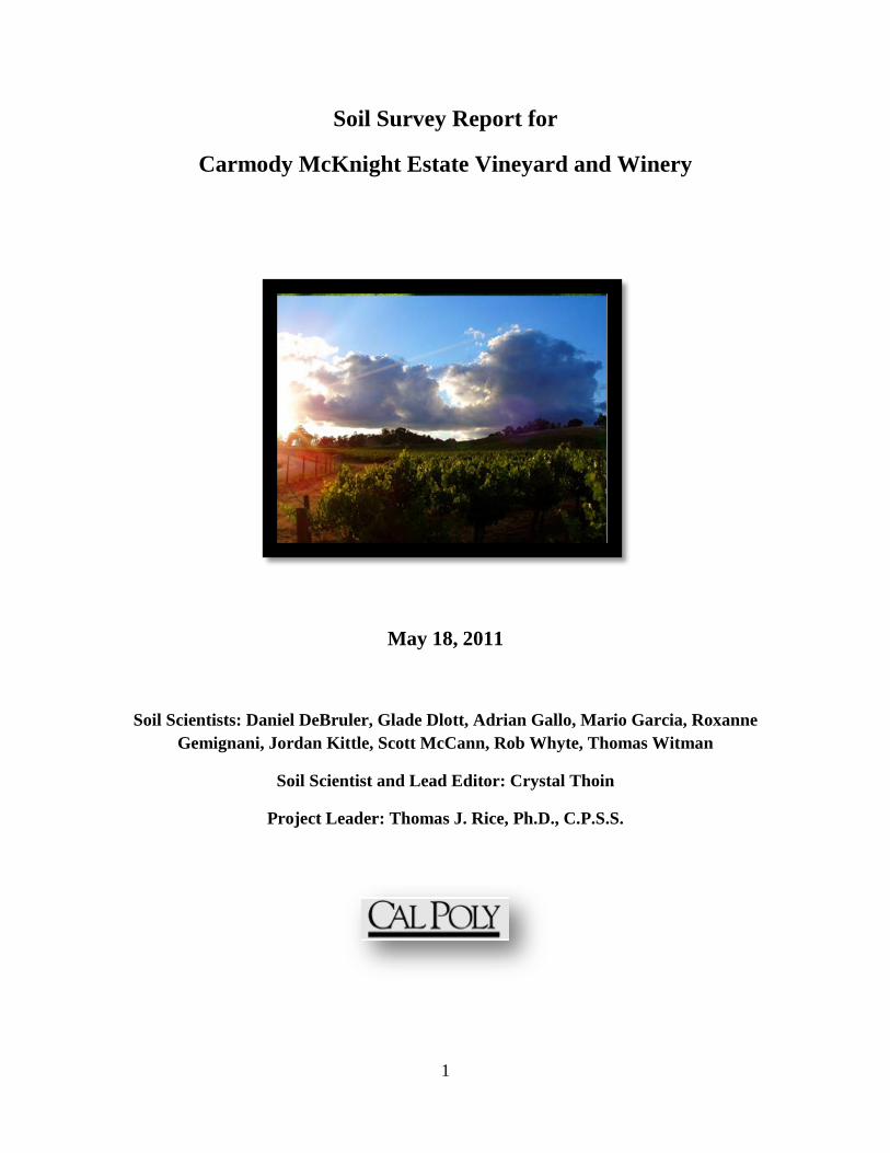
Soil Survey Report for
Carmody McKnight Estate Vineyard and Winery
May 18, 2011
Soil Scientists: Daniel DeBruler, Glade Dlott, Adrian Gallo, Mario Garcia, Roxanne Gemignani, Jordan Kittle, Scott McCann, Rob Whyte, Thomas Witman
Soil Scientist and Lead Editor: Crystal Thoin
Project Leader: Thomas J. Rice, Ph.D., C.P.S.S.
2
Table of Contents
List of Tables .................................................................................................................................. 4
List of Figures ................................................................................................................................. 5
List of Photographs ......................................................................................................................... 6
List of Maps .................................................................................................................................... 7
Introduction ..................................................................................................................................... 8
Acknowledgments ....................................................................................................................... 8
Viticulture History of Paso Robles ............................................................................................. 8
Location ....................................................................................................................................... 9
Materials and Methods .................................................................................................................. 11
Materials .................................................................................................................................... 11
Standard Field and Laboratory Methods ................................................................................... 11
Additional Field and Cartography Procedures .......................................................................... 11
Climate .......................................................................................................................................... 13
Geology and Topography ............................................................................................................. 16
Soil Taxonomic Unit Descriptions................................................................................................ 19
AYAR SERIES ......................................................................................................................... 21
BOSANKO SERIES ................................................................................................................. 25
DANVILLE SERIES ................................................................................................................ 29
DIABLO SERIES ..................................................................................................................... 33
WHYTE SERIES ...................................................................................................................... 37
Soil Map Unit Descriptions .......................................................................................................... 41
Ayar clay, 4 to 12 percent slopes. ............................................................................................. 43
Bosanko clay, 5 to 20 percent slopes. ....................................................................................... 45
Danville clay, 10 to 32 percent slopes....................................................................................... 47
Diablo clay, 5 to 20 percent slopes ........................................................................................... 49
Whyte clay, 4 to 15 percent slopes. ........................................................................................... 51
Management Recommendations ................................................................................................... 53
Rootstock Selection ................................................................................................................... 54
Rootstock Evaluation ................................................................................................................ 58
Nutrient Management ................................................................................................................ 58
3
Parent Material, pH, and Nutrient Availability Trends ......................................................... 58
Basic Cation Saturation Ratios .............................................................................................. 59
Metal Micronutrient Availability ........................................................................................... 59
Deficiencies and Fertilizer Recommendations ...................................................................... 59
Irrigation Recommendations ..................................................................................................... 60
References and Bibliography ........................................................................................................ 62
APPENDIX A: Glossary.............................................................................................................. 65
APPENDIX B: Representative Pedon Chemical Attributes ......................................................... 75
APPENDIX C: Roles and Deficiency Symptoms of Plant Essential Nutrients............................ 89
Commonalities: ....................................................................................................................... 108
Fertilizer Recommendations: .................................................................................................. 108
APENDIX D: A & L Laboratory Soil Data ................................................................................ 109
4
List of Tables
Table 1. Average temperature and precipitation by month (Fahrenheit) .................................... 13
Table 2. Average temperature and precipitation by month (Celsius) ......................................... 14
Table 4. Soil Properties influencing rootstock compatibility. ...................................................... 57
Table 5. Available Water Holding Capacity, slope, permeability, and Total Water Holding
Capacity for Carmody McKnight Estate Vineyard soils in Paso Robles California. ....... 61
5
List of Figures
Figure 1. Average temperature by month (⁰F). ........................................................................... 14
Figure 2. Average precipitation by month (in). ........................................................................... 15
Figure 3. Average temperature by month (oC). ............................................................................ 15
Figure 4. Average precipitation by month (cm). .......................................................................... 16
Figure 5.Soil pH and nutrient availability (NCCE). .................................................................... 58
Figure 6.Available Water Holding Capacity for Carmody McKnight Estate Vineyard soils in
Paso Robles California. ..................................................................................................... 61
Figure 7. Soil Series and horizon pH values. ............................................................................... 76
Figure 8. Percent organic matter by soil series and horizon. ....................................................... 77
Figure 9. Potassium (K) and Sodium (Na) cation saturation (%) by soil series and horizon. ..... 78
Figure 10. Calcium (Ca) and Magnesium (Mg) cation saturation (%) by soil series and horizon.
........................................................................................................................................... 79
Figure 11. Calcium (Ca) to magnesium (Mg) ratios by soil series and horizon. ......................... 80
Figure 12. Cation Exchange Capacity (CEC) (cmol/kg) by soil series and horizon. .................. 81
Figure 13. Metal micronutrient concentration (ppm) by soil series and horizon. ....................... 82
Figure 14. Iron (Fe) concentration (ppm) by soil series and horizon. ........................................ 83
Figure 15. Nitrate (NO3-) levels (ppm) by soil series and horizon. .............................................. 84
Figure 16. Sulfate (SO42-) levels (ppm) by soil series and horizon. ............................................ 85
Figure 17. Phosphorus (P) (ppm) levels by soil series and horizon. ........................................... 86
Figure 18. Potassium (K) (ppm) levels by soil series and horizon. ............................................ 87
Figure 19. Boron (B) (ppm) levels by soil series and horizon. ................................................... 88
6
List of Photographs
Photo 1. Ayar clay 4 to 12 percent slopes representative pedon. (Photo taken May 12, 2011). . 23
Photo 2. Bosanko clay, 5 to 20 percent slopes representative pedon.(Photo taken May 12, 2011).
........................................................................................................................................... 27
Photo 3. Danville clay, 10 to 32 percent slopes representative pedon.(Photo taken May 12,
2011). ................................................................................................................................ 31
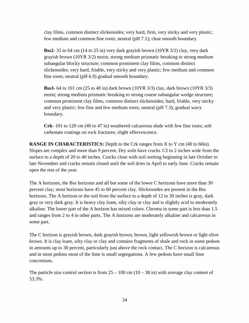
Photo 4. Diabloclay, 5 to 20 percent slopes representative pedon.(Photo taken May 12, 2011). 35
Photo 5. Whyte clay, 4 to 15 percent slopes representative pedon. (Photo taken May 12, 2011).
........................................................................................................................................... 39
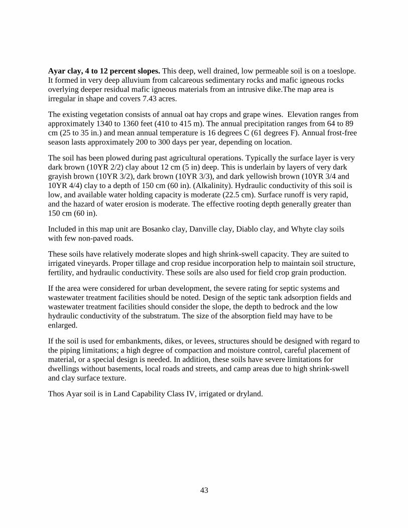
Photo 6. Ayar clay, 4 to 12 percent slopes soil map unit. (Photo taken May 12, 2011). ............. 44
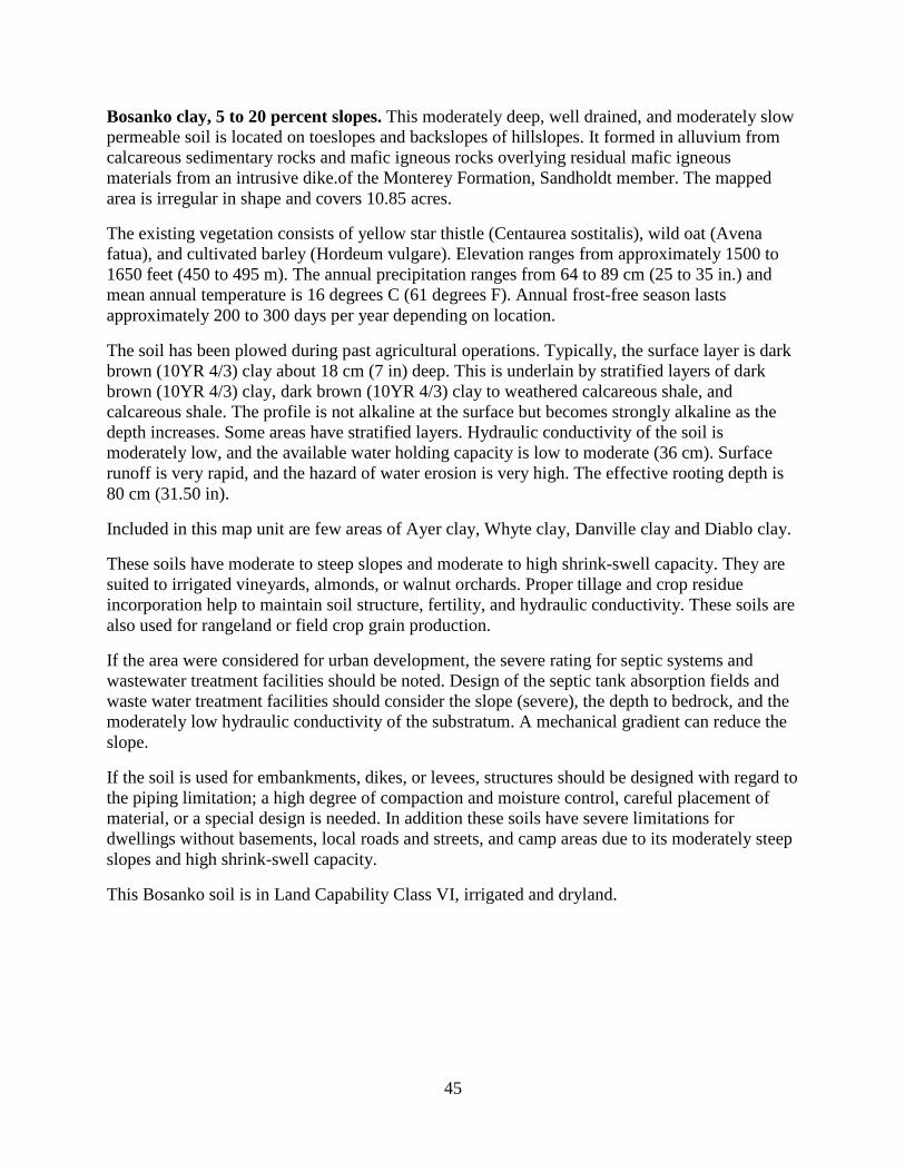
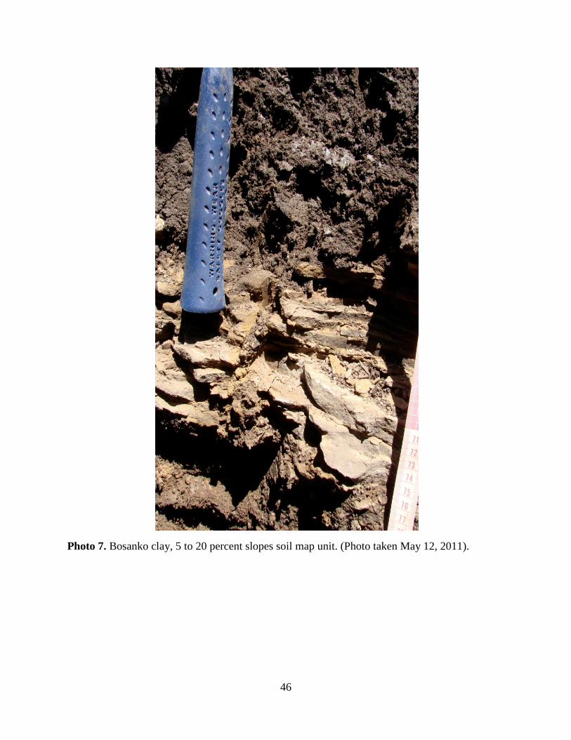
Photo 7. Bosanko clay, 5 to 20 percent slopes soil map unit. (Photo taken May 12, 2011). ....... 46
Photo 8. Danville clay, 10 to 32 percent slopes soil map unit. (Photo taken May 12, 2011). .... 48
Photo 9.Diablo clay, 5 to 20 percent slopes soil map unit. (Photo taken May 12, 2011). ........... 50
Photo 10. Whyte clay, 4 to 15 percent slopes soil map unit. (Photo taken May 12, 2011). ....... 52
7
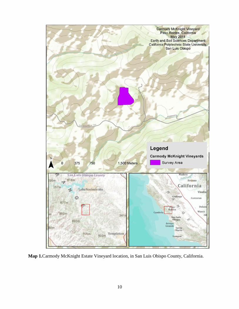
List of Maps Map 1.Carmody McKnight Estate Vineyard location, in San Luis Obispo County, California. . 10
Map 2.Carmody McKnight Estate Vineyard area geology. ......................................................... 17
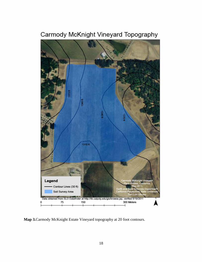
Map 3.Carmody McKnight Estate Vineyard topography at 20 foot contours. ............................ 18
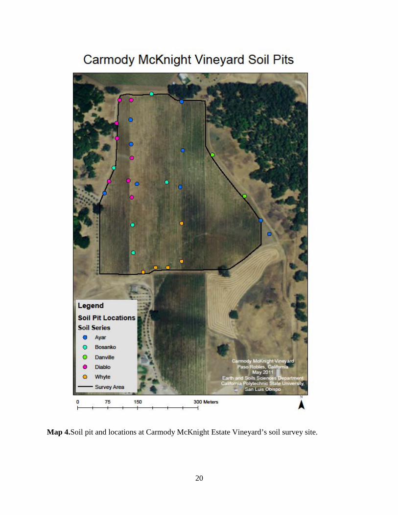
Map 4.Soil pit and locations at Carmody McKnight Estate Vineyard’s soil survey site. ............ 20
Map 5.Percent slopes soil map unit location at soil survey site, Carmody McKnight Estate
Vineyards. ......................................................................................................................... 24
Map 6.Bosanko clay, 5 to 20 percent slopes soil map unit location at soil survey site, Carmody
McKnight Estate Vineyards. ............................................................................................. 28
Map 7.Danville clay, 10 to 32 percent slopes soil map unit location at soil survey site, Carmody
McKnight Estate Vineyards. ............................................................................................. 32
Map 8.Diablo clay, 5 to 20 percent slopes soil map unit location at soil survey site, Carmody
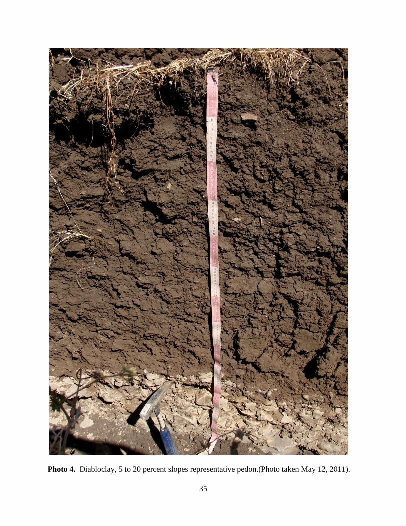
McKnight Estate Vineyards. ............................................................................................. 36
Map 9.Whyte clay, 4 to 15 percent slopes soil map unit location at soil survey site, Carmody
McKnight Estate Vineyards. ............................................................................................. 40
Map 10. Carmody McKnight Estate Vineyard soil survey site soil map units. ........................... 42
8
Introduction
Acknowledgments
Special thanks are given to the owners and staff at Carmody McKnight Estate Vineyards and Winery, notably the proprietors Gary Carmody Conway and Marian McKnight Conway, for allowing us access to their beautiful vineyards and winery.Special thanks to general manager and winemaker, Greg Cropper, for arranging excavations of the many backhoe pits. Additional thanks to Kathleen Conway, vineyard and winery business manager, for facilitating payment for the soil chemical analyses. Thanks again for the opportunity and cooperation received in the lab analysesand mapping of soils within their vineyard!
On-site soil samples, collected from the horizons of identified representative soils were sent to A&L Wetsern Agricultural Laboratories of Modesto, CA for chemical analysis.The representative soils data tables are referenced in the Appendix.
Special thanks to Craig Stubler, Cal Poly instructional support technician, for the packaging and shipping of soil samples. Also, thanks to Dr. Ron Taskey for assisting with our field work and his special lectures on soil map units.
Viticulture History of Paso Robles
Winemaking was first introduced to the Paso Robles area in 1797 by Franciscan missionaries for sacramental wine and to make brandy to be exported. In the 1840’s, the vineyards were abandoned after the Missions of California were secularized by Mexico. Winemaking was reestablished by the 1860’s, following California’s Independence, by European immigrant farmers. Influential winemakers of the time include Frenchman Pierre Hippolyte Dallidet and Englishman Henry Ditmas. Andrew York, an Indian rancher, began Paso Robles’ first commercial production of wine in 1882 with The Ascension Winery (today known as York Mountain Winery). The wines produced received state attention and were sold as far north as San Francisco. In addition he planted the first Zinfandel vines within Paso Robles, which was a highly influential varietal in the rise of early Paso Robles wine production and remains a key varietal. His success inspired immigrant farming families to settle in Paso Robles and to commercially produce wines. Paso Robles is now growing a larger variety of grape types and producing new varietals, including white wine which was introduced in 1886 by Gerd Klintworth.
The prohibition of the 1920’s stopped wine grape production in Paso Robles. Following legalization, the award winning Petite Syrah and Zinfandel produced by Ignance Paderewski from Rancho San Ignacio amplified Paso Robles wine reputation nationally. By the 1970’s, Cabernet Sauvignon, Pinot Noir and Chardonnay were being produced in Paso Robles. Cabernet Sauvignon has remained the leading varietal in Paso Robles currently at 30 % vineyard coverage. This wine varietal has received both national and international acclaim (J. Lohr, Vineyards and Wine, Treana Winery, Adelaida Cellars, and Chateau Margene). Rhone varietals became significant in Paso Robles in 1989 when the Tablas Creek Vineyard imported clones from Rhone
9
Valley’s Chateau de Beaucasteland their distribution of Rhone vine cuttings throughout California. The acreage of Rhone varieties has increased from under 100 acres (1994) to over 2,000 (2005) in California. Within the last seven years, the number of wineries of Paso Robles has doubled to approximately 100 with the rise of boutique and small family owned vineyards and wineries. Paso Robles winemakers are pursuing new innovative wine techniques (e.g., blends) to complement the distinct soils, topography, and the coast’s regional climate to create a unique and successful Terroir. (Paso Robles Wine County Alliance, 2006)
Location
The Carmody McKnight Estate Vineyards and Winery is located in western Paso Robles, CA. The vineyardsarepositioned on rolling hills withgradual slopes from 0 to 35 percent. The elevation is about 420 m (1380 ft.). The annual precipitation ranges from 64 to 89 cm (25 to 35 in.) and mean annual temperature is 16 degrees C (61 degrees F).
The soils within the vineyard contain calcareous, siliceous, and volcanic parent materials, which differentiate soil pH values. The bedrocks are derived from tectonic uplifting of marine deposits extending the California Coastline and are from the Monterey Formation dating 6 to 17.5 mya. The siliceous mudstone and shale was formed from cemented deposits of clay and silica-rich marine organisms (e.g., exoskeletons of diatoms and plankton) on deep sea floors. These rocks were formed during the Miocene period (20 to 30 mya.). Siliceous materials weather into slightly acidic (pH 6.1 to 6.5) soils. The soft calcareous shale and mudstone originated from deposits of calcium carbonate-rich marine fossils (e.g., coral, crustaceans, and fish bones) cemented on shallow sea floors. Calcareous soils are slightly to moderately alkaline (pH 7.4 to 8.4). The volcanic basaltic intrusions formed through tectonic uplift of the Monterey Formation.
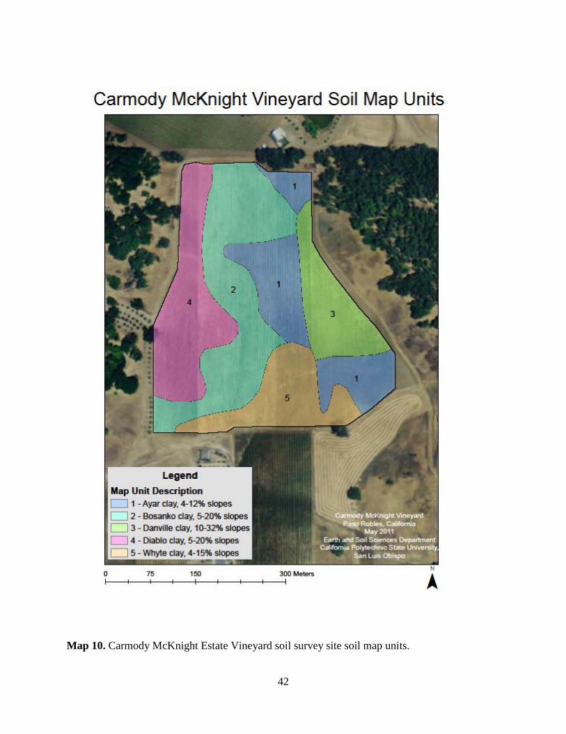
Five (5) different soil series were identified within the vineyard. A taxonomic unit description (TUD) was created for each series, providing a soil taxonomic nomenclature, a representative pedon horizonation, and ranges in characteristics. Five different (5) map unit descriptions (MUD) were distinguished within the vineyard, including morphological and environmental descriptions, soil map inclusions, hydrology, land use suitability and land capability class. Soil map units are named by soil series, surface texture, and slope.
10
Map 1.Carmody McKnight Estate Vineyard location, in San Luis Obispo County, California.
11
Materials and Methods
Materials
• Open bucket auger (used in transect confirmation) • Rounded shovel (used for scraping pit faces) • Sharpshooter shovel (used in transect confirmation) • Backhoe (used for mechanical pit digging) • Poly-D reagent pH kit (used to test field pH) • No. 10 soil sieve (used to separate fine and coarse soil fragments in the lab) • 150 cm cloth tape (used to measure soil and horizon depths) • Munsell color book (used to classify soil dry and moist color) • Hand-held clinometer (used to measure slope) • Water bottle (used to moisten the soil for hand texturing) • Soil knife or rock hammer (used to chip away at pit faces and horizons) • Garmin GPS receiver (used to document latitude and longitude on location)
Standard Field and Laboratory Methods
Standard methods were used to produce morphological pedon descriptions. Soil classification and soil land use interpretations follow those discussed in the Soil Survey Manual (Soil Survey Staff, 2000), Keys to Soil Taxonomy, 11th edition (Soil Survey Staff, 2006) and the courseware for Soil Resource Inventory (Rice, 2011). Digital maps were produced from data collected for the study site using ArcGISsoftware by Environmental Systems Research Institute (ESRI). The A & L Western Agriculture Laboratories, Modesto, CA performed comprehensive fertility assay analyses to determine the concentrations of the plant essential nutrients (ppm) in the soils, soil organic matter (%), electrical conductivity (E.C. measured in dS m-1), cation exchange capacity (CEC meq 100g-1 soil), and soil pH.
Additional Field and Cartography Procedures
Carmody McKnight Estate Vineyards was investigated using twenty nine(29) soil pits to document soil morphological properties including soil structure, soil color, soil depth, soil carbonates and soil chemical characteristics and to obtain soil samples.Soil samples from five representative soilswere delivered to A&L Western Agricultural Laboratories and to California Polytechnic State University, San Luis Obispo for further soil chemical analyses and to classify the soil using U.S. Soil Taxonomy (USDA, 2010). Over 35 additional auger holes were dug throughout the vineyards and were evaluated to obtain additional soil properties and to establish soil map unit boundaries. This collective information was used to classify the soils into five (5) different soil series using U.S. Soil Taxonomy (USDA, 2010). The surface soil textures and slope phases for these soil series were then determined in order to group the similar soil types located throughout the vineyards into five (5) different soil map units, which were mapped and delineated on aerial photographic base maps.
12
Digital soil maps were produced using ESRI ArcGIS 10 software and computer hardware. The aerial images and topographic map of the site and surrounding areas were obtained from the ESRI online database. The World Imagery Map provided by ESRI was used for aerial images, and the World Topographic Map provided by ESRI was used for a topographic map of the area surrounding the site. The geologic map and Digital Elevation Model (DEM) used for calculating and drawing topographic contour lines was obtained from the website SLO Datafinder. The geologic map was published by the San Luis Obispo County Planning and Building Department, and was created by digitizing scanned geologic maps published by the U.S. Geological Survey and the California Geological Survey. The DEM was published by San Luis Obispo County. Soil map unit boundaries were digitized onto the aerial photograph by creating a polygon shapefile and using the editor tool to draw in the map units. Areas of map units were calculated using the attributes table.
13
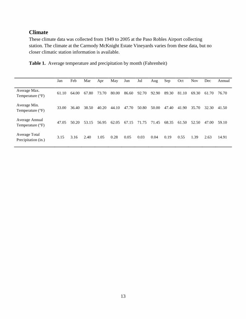
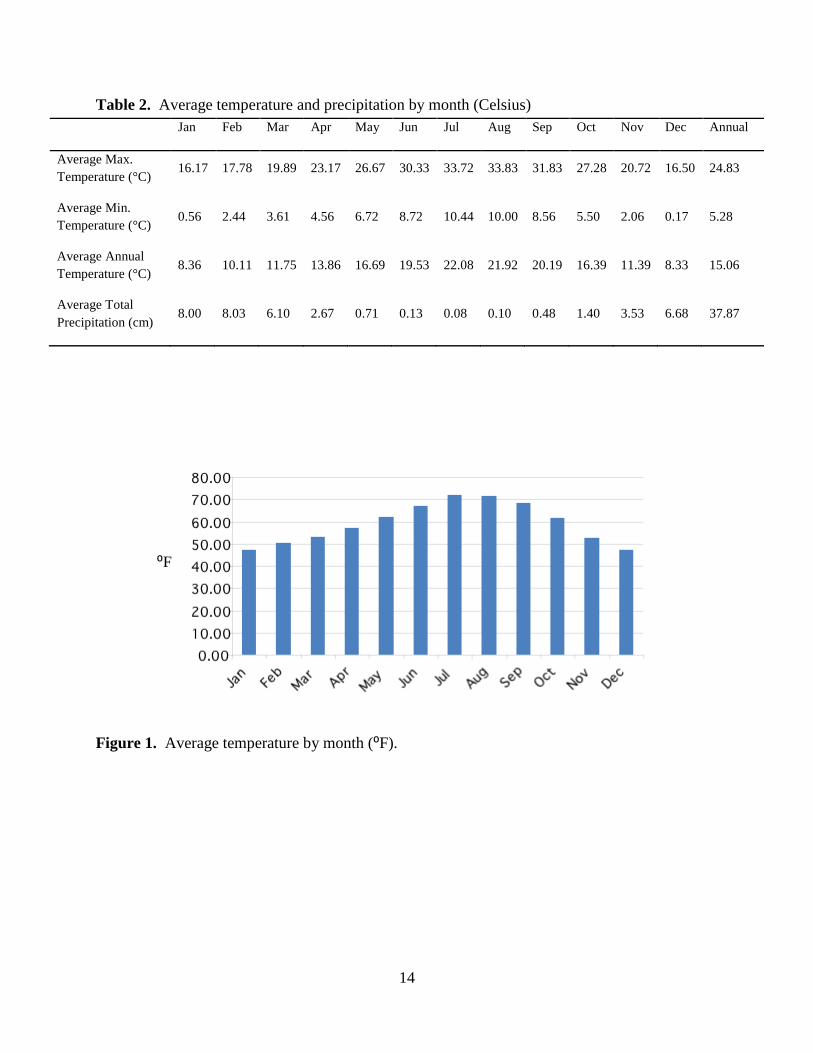
Climate These climate data was collected from 1949 to 2005 at the Paso Robles Airport collecting station. The climate at the Carmody McKnight Estate Vineyards varies from these data, but no closer climatic station information is available.
Table 1. Average temperature and precipitation by month (Fahrenheit)
Jan Feb Mar Apr May Jun Jul Aug Sep Oct Nov Dec Annual
Average Max. Temperature (°F)
61.10 64.00 67.80 73.70 80.00 86.60 92.70 92.90 89.30 81.10 69.30 61.70 76.70
Average Min. Temperature (°F)
33.00 36.40 38.50 40.20 44.10 47.70 50.80 50.00 47.40 41.90 35.70 32.30 41.50
Average Annual Temperature (°F)
47.05 50.20 53.15 56.95 62.05 67.15 71.75 71.45 68.35 61.50 52.50 47.00 59.10
Average Total Precipitation (in.)
3.15 3.16 2.40 1.05 0.28 0.05 0.03 0.04 0.19 0.55 1.39 2.63 14.91
14
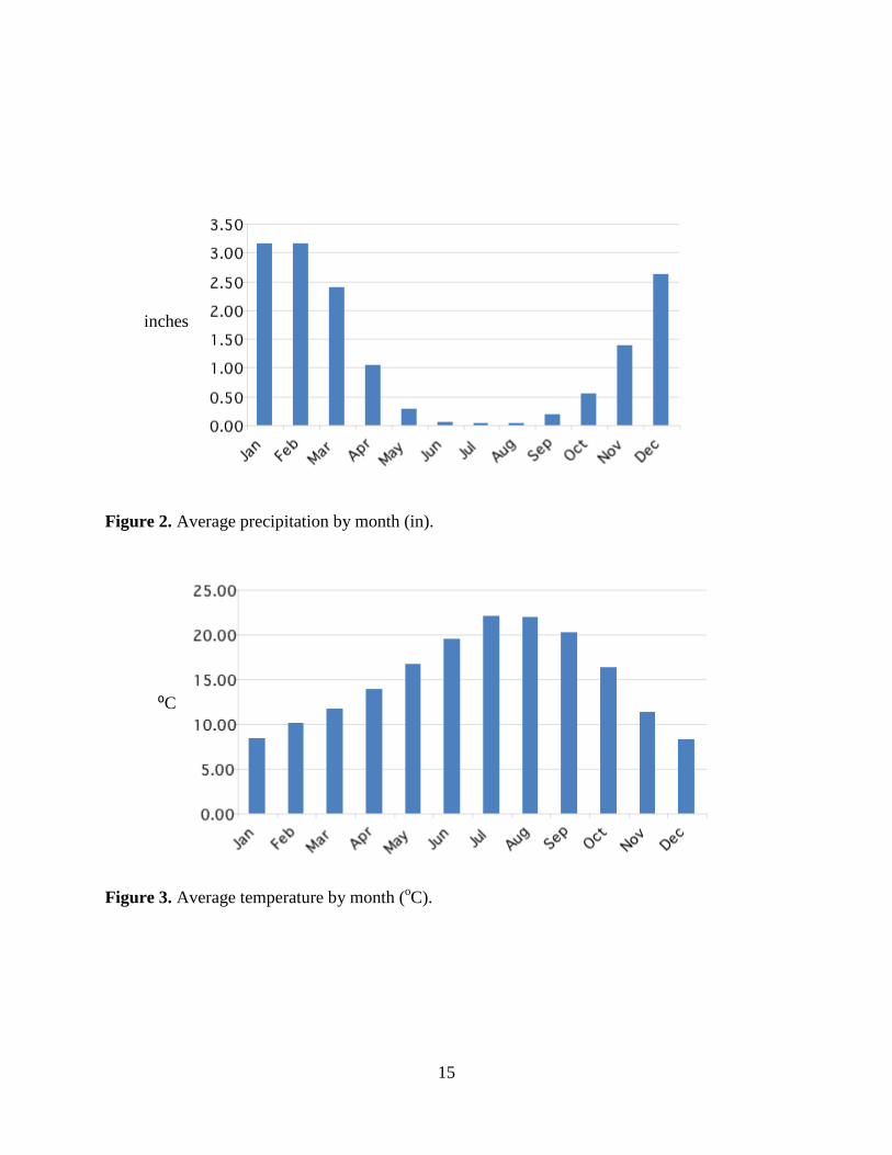
Table 2. Average temperature and precipitation by month (Celsius) Jan Feb Mar Apr May Jun Jul Aug Sep Oct Nov Dec Annual
Average Max. Temperature (°C)
16.17 17.78 19.89 23.17 26.67 30.33 33.72 33.83 31.83 27.28 20.72 16.50 24.83
Average Min. Temperature (°C)
0.56 2.44 3.61 4.56 6.72 8.72 10.44 10.00 8.56 5.50 2.06 0.17 5.28
Average Annual Temperature (°C)
8.36 10.11 11.75 13.86 16.69 19.53 22.08 21.92 20.19 16.39 11.39 8.33 15.06
Average Total Precipitation (cm)
8.00 8.03 6.10 2.67 0.71 0.13 0.08 0.10 0.48 1.40 3.53 6.68 37.87
Figure 1. Average temperature by month (⁰F).
⁰F
15
Figure 2. Average precipitation by month (in).
Figure 3. Average temperature by month (oC).
inches
⁰C
16
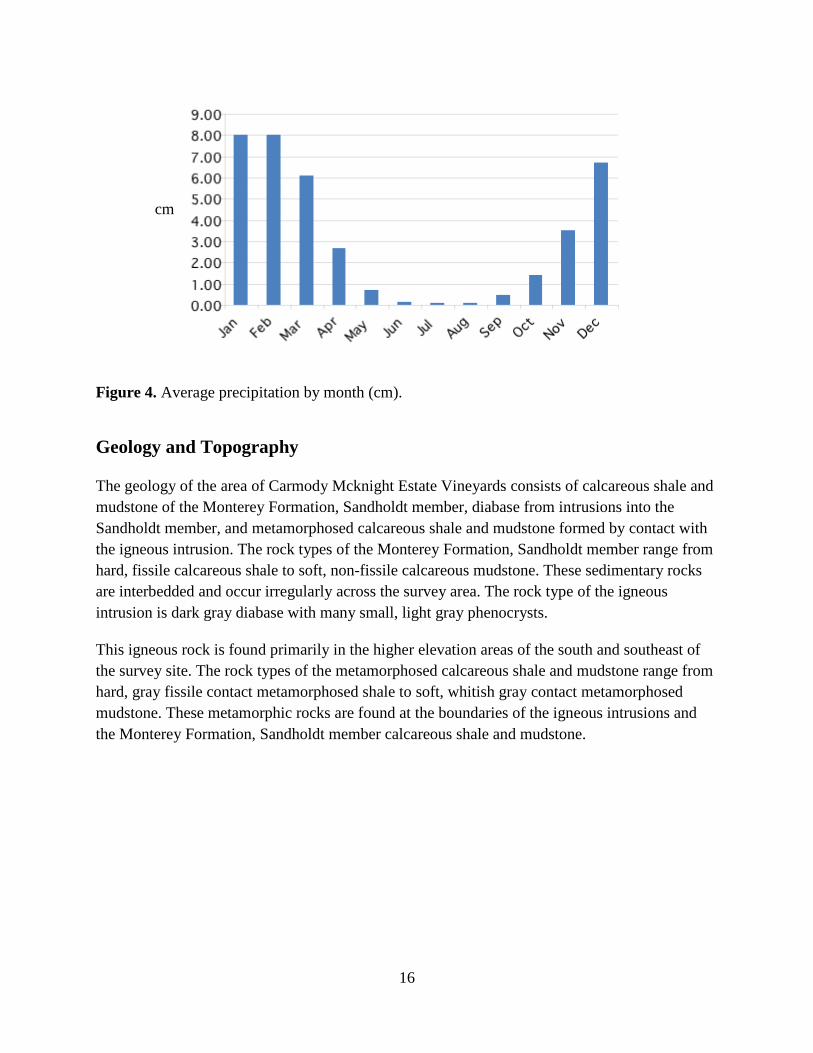
Figure 4. Average precipitation by month (cm).
Geology and Topography
The geology of the area of Carmody Mcknight Estate Vineyards consists of calcareous shale and mudstone of the Monterey Formation, Sandholdt member, diabase from intrusions into the Sandholdt member, and metamorphosed calcareous shale and mudstone formed by contact with the igneous intrusion. The rock types of the Monterey Formation, Sandholdt member range from hard, fissile calcareous shale to soft, non-fissile calcareous mudstone. These sedimentary rocks are interbedded and occur irregularly across the survey area. The rock type of the igneous intrusion is dark gray diabase with many small, light gray phenocrysts.
This igneous rock is found primarily in the higher elevation areas of the south and southeast of the survey site. The rock types of the metamorphosed calcareous shale and mudstone range from hard, gray fissile contact metamorphosed shale to soft, whitish gray contact metamorphosed mudstone. These metamorphic rocks are found at the boundaries of the igneous intrusions and the Monterey Formation, Sandholdt member calcareous shale and mudstone.
cm
17
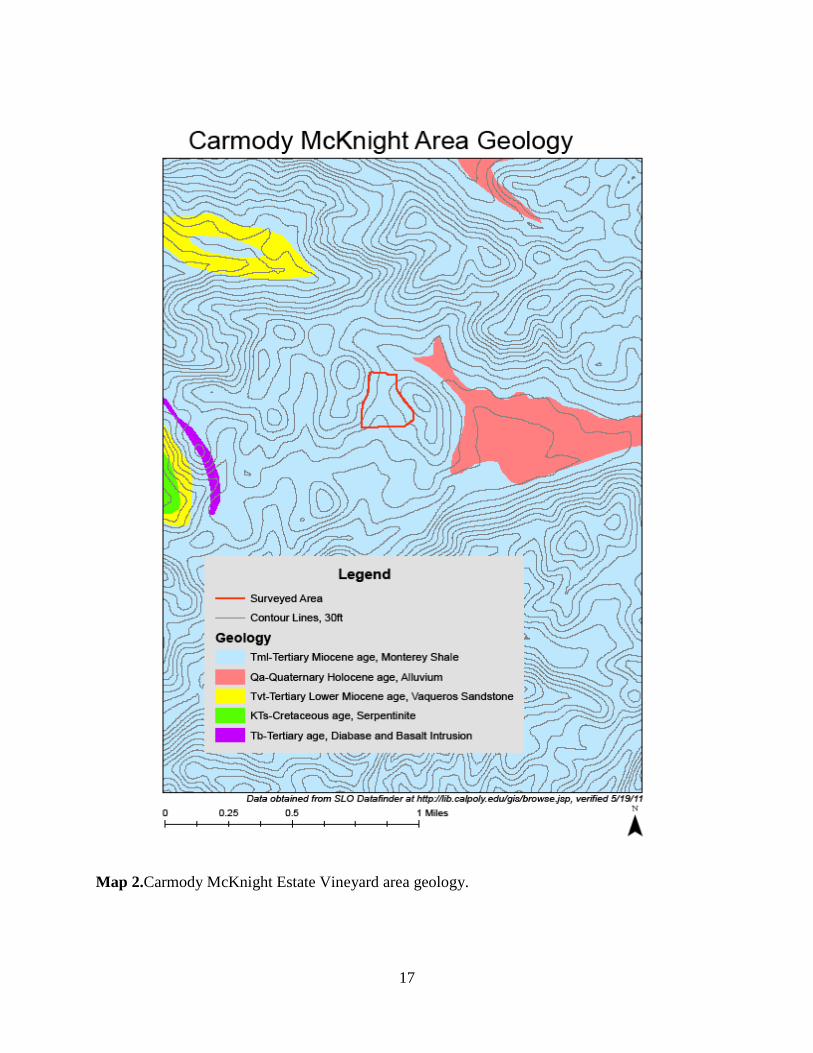
Map 2.Carmody McKnight Estate Vineyard area geology.
18
Map 3.Carmody McKnight Estate Vineyard topography at 20 foot contours.
19
Soil Taxonomic Unit Descriptions
20
Map 4.Soil pit and locations at Carmody McKnight Estate Vineyard’s soil survey site.
21
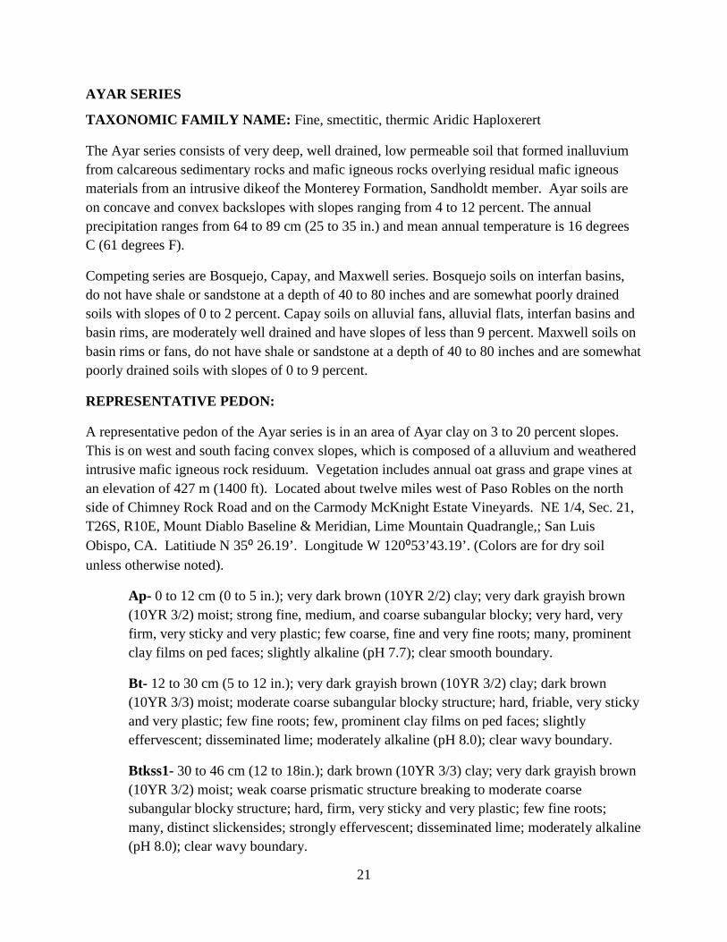
AYAR SERIES
TAXONOMIC FAMILY NAME: Fine, smectitic, thermic Aridic Haploxerert
The Ayar series consists of very deep, well drained, low permeable soil that formed inalluvium from calcareous sedimentary rocks and mafic igneous rocks overlying residual mafic igneous materials from an intrusive dikeof the Monterey Formation, Sandholdt member. Ayar soils are on concave and convex backslopes with slopes ranging from 4 to 12 percent. The annual precipitation ranges from 64 to 89 cm (25 to 35 in.) and mean annual temperature is 16 degrees C (61 degrees F).
Competing series are Bosquejo, Capay, and Maxwell series. Bosquejo soils on interfan basins, do not have shale or sandstone at a depth of 40 to 80 inches and are somewhat poorly drained soils with slopes of 0 to 2 percent. Capay soils on alluvial fans, alluvial flats, interfan basins and basin rims, are moderately well drained and have slopes of less than 9 percent. Maxwell soils on basin rims or fans, do not have shale or sandstone at a depth of 40 to 80 inches and are somewhat poorly drained soils with slopes of 0 to 9 percent.
REPRESENTATIVE PEDON:
A representative pedon of the Ayar series is in an area of Ayar clay on 3 to 20 percent slopes. This is on west and south facing convex slopes, which is composed of a alluvium and weathered intrusive mafic igneous rock residuum. Vegetation includes annual oat grass and grape vines at an elevation of 427 m (1400 ft). Located about twelve miles west of Paso Robles on the north side of Chimney Rock Road and on the Carmody McKnight Estate Vineyards. NE 1/4, Sec. 21, T26S, R10E, Mount Diablo Baseline & Meridian, Lime Mountain Quadrangle,; San Luis Obispo, CA. Latitiude N 35⁰ 26.19’. Longitude W 120⁰53’43.19’. (Colors are for dry soil unless otherwise noted).
Ap- 0 to 12 cm (0 to 5 in.); very dark brown (10YR 2/2) clay; very dark grayish brown (10YR 3/2) moist; strong fine, medium, and coarse subangular blocky; very hard, very firm, very sticky and very plastic; few coarse, fine and very fine roots; many, prominent clay films on ped faces; slightly alkaline (pH 7.7); clear smooth boundary.
Bt- 12 to 30 cm (5 to 12 in.); very dark grayish brown (10YR 3/2) clay; dark brown (10YR 3/3) moist; moderate coarse subangular blocky structure; hard, friable, very sticky and very plastic; few fine roots; few, prominent clay films on ped faces; slightly effervescent; disseminated lime; moderately alkaline (pH 8.0); clear wavy boundary.
Btkss1- 30 to 46 cm (12 to 18in.); dark brown (10YR 3/3) clay; very dark grayish brown (10YR 3/2) moist; weak coarse prismatic structure breaking to moderate coarse subangular blocky structure; hard, firm, very sticky and very plastic; few fine roots; many, distinct slickensides; strongly effervescent; disseminated lime; moderately alkaline (pH 8.0); clear wavy boundary.
22
Btkss2- 46 to 89 cm (18 to 35 in.); dark yellowish brown (10YR 3/4) clay; very dark grayish brown (10YR 3/2) moist; moderate medium subangular blocky structure; hard, firm, very sticky and very plastic; few coarse roots; many, distinct slickensides; strongly effervescent; disseminated lime; moderately alkaline (pH 8.0); clear irregular boundary.
Btkss3- 89-150 cm (35 to 59 in.); dark yellowish brown (10YR 4/4) clay; dark yellowish brown (10YR 3/4) moist; strong coarse subangular blocky structure; hard, extremely firm, very sticky and very plastic; no roots; many, distinct slickensides; slightly effervescent, lime concretions; moderately alkaline (pH 8.0).
RANGE IN CHARACTERISTICS: Depth to calcareous shale or sandstone or mafic igneous rock ranges from 150 to 200 centimeters (0 to 80 inches). Thickness of the Ap horizon ranges from 30 to 61 cm (11 to 24 in.). The Ap horizon is 7.5YR 5/2, 5/4, 4/2, 4/4; 10YR 6/4, 5/4, 5/3, 4/3, 3/3, 5/2, 4/2; 2.5Y 5/2 or 4/2. Moist colors are similar with value 1 or 2 units lower. In most pedons the profile has texture of silty clay, clay or heavy clay loam and has 35 to 55 percent clay. The profile is weakly calcareous and is slightly to strongly effervescent in lower horizons. Soil is made up from weathered igneous rocks and alluvium.
The soil profile is primarily clay textures. Calcareous soft masses and concretions are evident in lowest horizon. Deep, wide cracks remain open from June to November for 150 to 180 days and remain closed the rest of the time. Many slickensides are present in some or all of the B horizons. Thickness of the B horizons ranges from 13 to 48 cm (5 to 19 in.). The Bt horizon has colors of 2.5Y 6/4, 5/4, 5/2; 10YR 6/6, 6/4, 6/3, 5/4, 5/3, 4/3, 4/8; 7.5YR 5/2, 5/4, 6/4 or 7/4 with an increase in illuvial clay contents. In most pedons the profile has a texture of clay and has 48 to 55 percent clay. In most pedons the profile is calcareous and has neutral to moderately alkaline reaction throughout. Segregated carbonates are present in nearly all pedons. Calcium carbonate equivalent is 2 to 15 percent. Clay content decreases slightly in the deepest Btkss horizon.
23
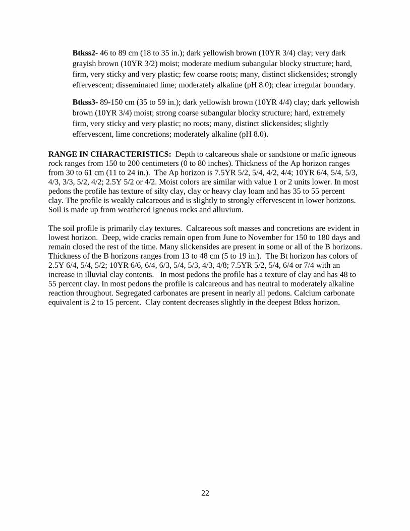
Photo 1. Ayar clay 4 to 12 percent slopes representative pedon. (Photo taken May 12, 2011).
24
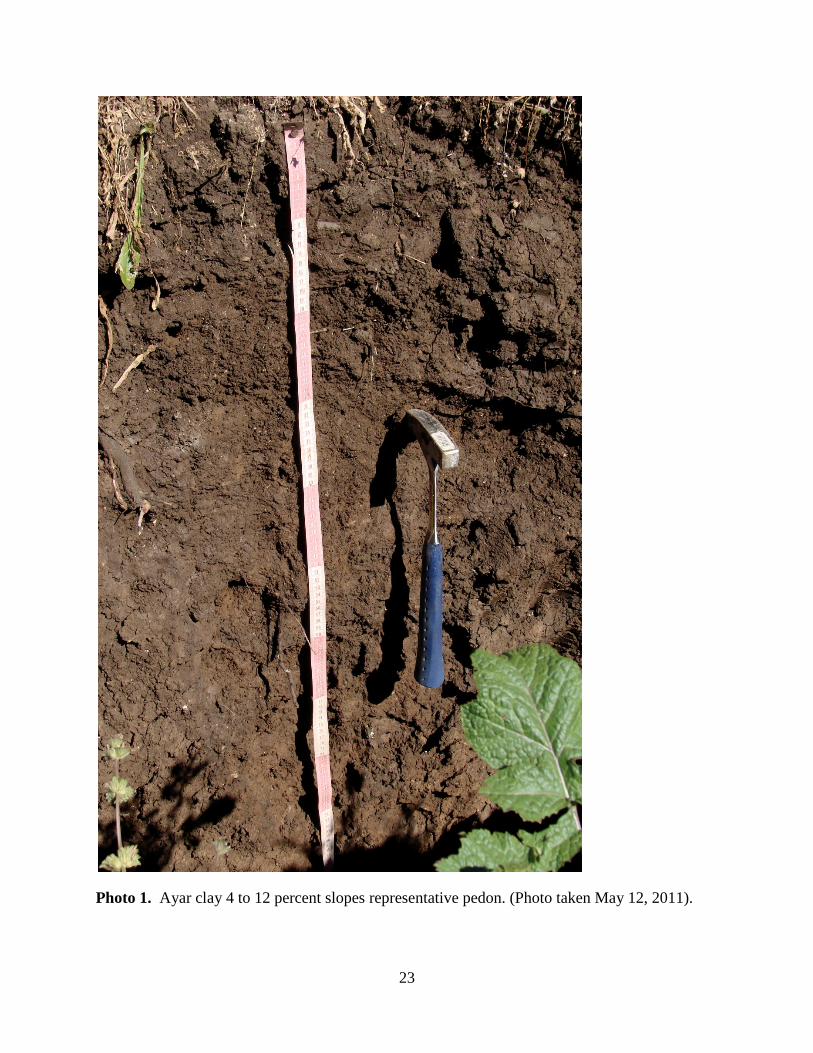
Map 5.Percent slopes soil map unit location at soil survey site, Carmody McKnight Estate Vineyards.
25
BOSANKO SERIES
TAXONOMIC FAMILY NAME: Fine, smectitic, thermic Aridic Haploxererts The Bosanko series consists of moderately deep, well drained soils, whichformed in alluvium from calcareous sedimentary rocks and mafic igneous rocks overlying residual mafic igneous materials from an intrusive dikeof the Monterey Formation, Sandholdt member. Bosanko soils are on backslopes and toeslopes of hillslopes and have slopes of 5 to 20 percent. The annual precipitation ranges from 64 to 89 cm (25 to 35 in.) and mean annual temperature is 16 degrees C (61 degrees F)with 200 to 300 frost free days. Elevations for this series are 402 to 415 meters. The competing series are the Alo, Auld, Centerville, Cibo, Climara, Cropley, and Diablo series. Alo, Auld, Centerville, and Cibo soils have chroma of 2 or more throughout the soil profile. Also, Auld soils are reddish in 5YR hue. Centerville soils have hue of 7.5YR or 5YR. Cibo soils have a lithic contact at a depth of 24 to 40 inches. Climara soils have a lithic contact and a low Ca/Mg ratio of about 2. Cropley soils lack a paralithic contact. Diablo soils have a paralithic contact at a depth of 40 to 80 inches. REPRESENTATIVE PEDON: A representative pedon of the Bosanko series is in the area of Bosanko clay on 5 to 20 percent slopes. This is on a south facing concave slope. Vegetation includes oat grass and grape vines at an elevation of 404 m. Located about 6 miles west of Paso Robles; North side of Chimney Rock Road on the Carmody McKnight Estate Vineyards. NE1/4, SEC21, T26S, R10E, Mount Diablo Baseline & Meridian, Lime Mountain Quadrangle,; San Luis Obispo County, CA. Latitude N 35° 39’ 31.5” Longitude W 120° 53’ 43.2”. (Colors are for dry unless otherwise noted).
Ap – 0 to 18 cm (0 to 7 inches); dark brown (10YR 4/3) clay, very dark grayish brown (10YR 3/2) moist; strong fine granular structure; extremely hard, firm, moderately sticky, very plastic; many fine and very fine roots; neutral (pH 7.0); clear smooth boundary. Bt – 18 to 60 cm (7 to 24 inches); dark brown (10YR 4/3) clay, very dark grayish brown (10YR 3/2) moist; strong coarse subangular blocky structure and strong medium wedges; extremely hard, firm, moderately sticky, very plastic; common fine and medium roots; many prominent clay films on ped faces; neutral (pH 6.9); clear smooth boundary. Btkss – 60 to 80 cm (24 to 31 inches); dark brown (10YR 4/3) clay, very dark grayish brown (10YR 3/2) moist; strong coarse wedges ; extremely hard, friable, moderately sticky; very plastic; common fine roots; common prominent clay films on ped faces and few slickensides; strongly effervescent, few small soft masses; slightly alkaline (pH 7.9) very abrupt broken boundary. Cr – 80 to 99 cm (31 to 39 inches); strongly effervescent weathered brown calcareous shale; very abrupt broken boundary. Crk – 99 to 177 cm (39 to 70 inches); violently effervescent calcareous mudstone with carbonate seams on rockfaces; moderately alkaline (pH 8.1).
26
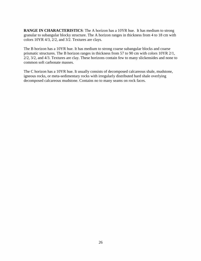
RANGE IN CHARACTERISTICS: The A horizon has a 10YR hue. It has medium to strong granular to subangular blocky structure. The A horizon ranges in thickness from 4 to 18 cm with colors 10YR 4/3, 2/2, and 3/2. Textures are clays. The B horizon has a 10YR hue. It has medium to strong coarse subangular blocks and coarse prismatic structures. The B horizon ranges in thickness from 57 to 90 cm with colors 10YR 2/1, 2/2, 3/2, and 4/3. Textures are clay. These horizons contain few to many slickensides and none to common soft carbonate masses. The C horizon has a 10YR hue. It usually consists of decomposed calcareous shale, mudstone, igneous rocks, or meta-sedimentary rocks with irregularly distributed hard shale overlying decomposed calcareous mudstone. Contains no to many seams on rock faces.
27
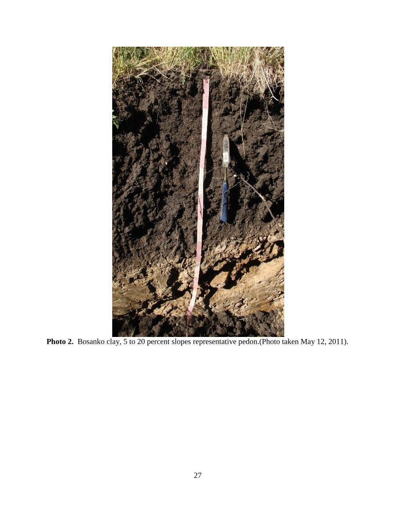
Photo 2. Bosanko clay, 5 to 20 percent slopes representative pedon.(Photo taken May 12, 2011).
28
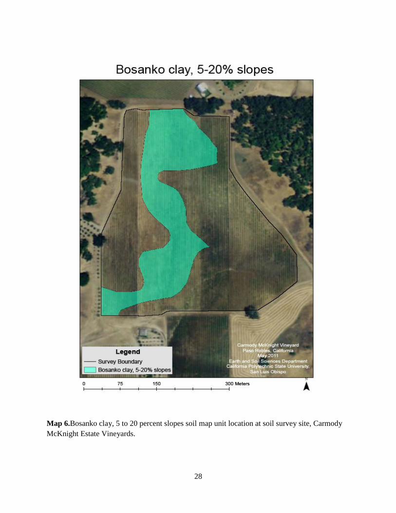
Map 6.Bosanko clay, 5 to 20 percent slopes soil map unit location at soil survey site, Carmody McKnight Estate Vineyards.
29
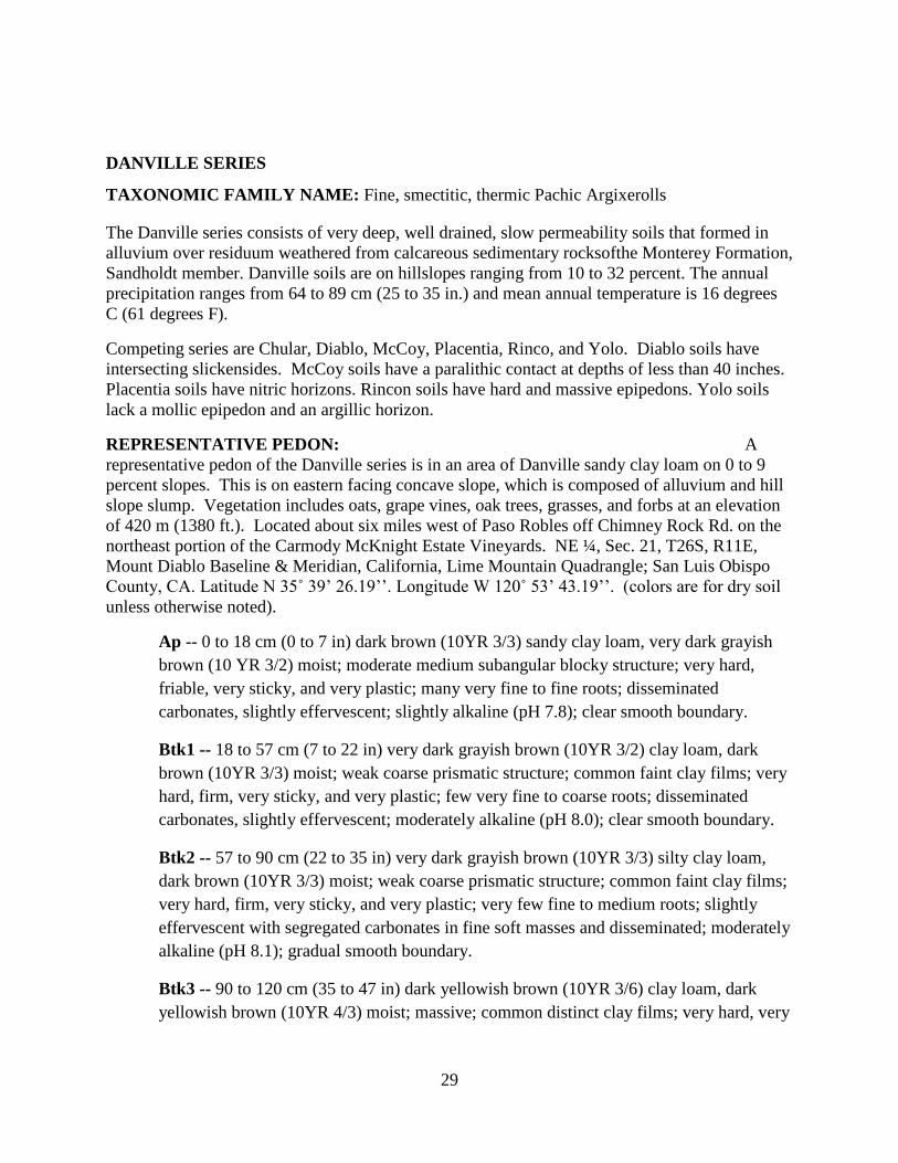
DANVILLE SERIES
TAXONOMIC FAMILY NAME: Fine, smectitic, thermic Pachic Argixerolls
The Danville series consists of very deep, well drained, slow permeability soils that formed in alluvium over residuum weathered from calcareous sedimentary rocksofthe Monterey Formation, Sandholdt member. Danville soils are on hillslopes ranging from 10 to 32 percent. The annual precipitation ranges from 64 to 89 cm (25 to 35 in.) and mean annual temperature is 16 degrees C (61 degrees F).
Competing series are Chular, Diablo, McCoy, Placentia, Rinco, and Yolo. Diablo soils have intersecting slickensides. McCoy soils have a paralithic contact at depths of less than 40 inches. Placentia soils have nitric horizons. Rincon soils have hard and massive epipedons. Yolo soils lack a mollic epipedon and an argillic horizon.
REPRESENTATIVE PEDON: A representative pedon of the Danville series is in an area of Danville sandy clay loam on 0 to 9 percent slopes. This is on eastern facing concave slope, which is composed of alluvium and hill slope slump. Vegetation includes oats, grape vines, oak trees, grasses, and forbs at an elevation of 420 m (1380 ft.). Located about six miles west of Paso Robles off Chimney Rock Rd. on the northeast portion of the Carmody McKnight Estate Vineyards. NE ¼, Sec. 21, T26S, R11E, Mount Diablo Baseline & Meridian, California, Lime Mountain Quadrangle; San Luis Obispo County, CA. Latitude N 35˚ 39’ 26.19’’. Longitude W 120˚ 53’ 43.19’’. (colors are for dry soil unless otherwise noted).
Ap -- 0 to 18 cm (0 to 7 in) dark brown (10YR 3/3) sandy clay loam, very dark grayish brown (10 YR 3/2) moist; moderate medium subangular blocky structure; very hard, friable, very sticky, and very plastic; many very fine to fine roots; disseminated carbonates, slightly effervescent; slightly alkaline (pH 7.8); clear smooth boundary.
Btk1 -- 18 to 57 cm (7 to 22 in) very dark grayish brown (10YR 3/2) clay loam, dark brown (10YR 3/3) moist; weak coarse prismatic structure; common faint clay films; very hard, firm, very sticky, and very plastic; few very fine to coarse roots; disseminated carbonates, slightly effervescent; moderately alkaline (pH 8.0); clear smooth boundary.
Btk2 -- 57 to 90 cm (22 to 35 in) very dark grayish brown (10YR 3/3) silty clay loam, dark brown (10YR 3/3) moist; weak coarse prismatic structure; common faint clay films; very hard, firm, very sticky, and very plastic; very few fine to medium roots; slightly effervescent with segregated carbonates in fine soft masses and disseminated; moderately alkaline (pH 8.1); gradual smooth boundary.
Btk3 -- 90 to 120 cm (35 to 47 in) dark yellowish brown (10YR 3/6) clay loam, dark yellowish brown (10YR 4/3) moist; massive; common distinct clay films; very hard, very
30
friable, slightly sticky, and plastic; very few medium roots; strongly effervescent with many soft masses; slightly alkaline (pH 7.9); abrupt wavy boundary.
Btk4 – 120 to 150 cm (59 in) yellowish brown (10 YR 5/6) sandy clay, dark yellowish brown (10 YR 4/4) moist; massive; common faint clay films; moderately hard, friable, sticky, and plastic; very few medium roots; violently effervescent with many soft carbonate masses; moderately alkaline (pH 8.1).
RANGE IN CHARACTERISTICS: Depth to paralithic contact is greater than 150cm. Thickness of the Ap horizon ranges from 15 to 26 cm (6 to 10 in.). The Ap horizon is very dark grayish brown (10YR 3/2) to dark grayish brown (10YR 3/3) moist. The soil is weakly to strongly calcareous and is strongly to violently effervescent in lower horizons. Soil is made up from alluvium and the slumping of hillside material composed of olivine basaltic igneous intrusion and calcareous shale and mudstone materials.
The soil profile is primarily clay and clay loam textures. Calcareous soft masses are evident in all horizons. Clay films are readily observed below the Ap horizon. Cracks caused by montmorillonite clays were observed within the subsoil, but did not reach the surface horizon. Thickness of Btk horizons ranges from 15 to 67 cm (6 to 26 in.). Carbonates are very slight in upper Btk horizons, then increasing in the deeper Btk horizons. The Btk upper horizons moist colors are dark brown (10YR 3/3), brown (10YR 5/3), and very dark grayish brown (10YR 3/2) with an increase in illuvial clay contents. The Btk lower horizons are brown (10YR 5/3) to dark yellowish brown (10YR 4/4) moist and carbonates increase with CaCO3 appearing in small, common, soft masses, which are strongly effervescent. Stickiness and plasticity remained constant in Btk horizons. Clay contents decreased slightly in the deepest Btk horizon.
31
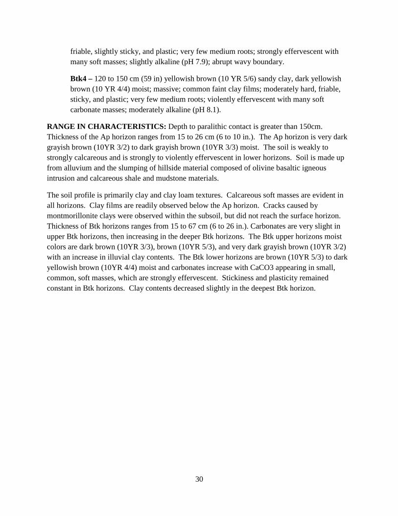
Photo 3. Danville clay, 10 to 32 percent slopes representative pedon.(Photo taken May 12, 2011).
32
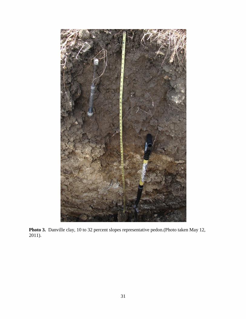
Map 7.Danville clay, 10 to 32 percent slopes soil map unit location at soil survey site, Carmody McKnight Estate Vineyards.
33
DIABLO SERIES
TAXONOMIC FAMILY NAME: Fine, smectitic, Thermic Aridic Haploxererts
The Diablo series consists of well-drained soils on uplands. Slope is 5 to 20 percent. Elevation is 50 to 1,500 feet. These soils formed in alluvium from calcareous sedimentary rocksof the Monterey Formation, Sandholdt member, and mafic igneous rocks overlying residual mafic igneous materials from an intrusive dike of the Monterey Formation, Sandholdt member.The plant cover is mostly annual grasses and scattered oaks. The annual precipitation ranges from 64 to 89 cm (25 to 35 in.) and mean annual temperature is 16 degrees C (61 degrees F). Summers are hot and dry, and winters are cool and moist. The frost-free season is 220 to 260 days. In a representative profile the surface layer is dark gray and very dark gray, acid clay 25 inches thick. The underlying material is calcareous clay 35 inches thick. It is light olive brown in the upper 12 inches and light yellowish brown in the lower 23 inches. Weathered sandstone and shale are at a depth of 60 inches. Permeability is slow. The effective rooting depth is 40 to 80 inches. Available water capacity is 6 to 10 inches.
Competing Series are the Alo, Altamont, Ayar, Bosanko, Cibo, Climara, Cropley, Linne, and Zaca series. Alo, Altamont, Ayar, and Cibo soils are brownish in the upper A horizons with chroma of 2 or more. Bosanko soils have a paralithic contact at depths of less than 40 inches. Climara soils have a lithic contact of hard igneous rock at depths of less than 40 inches. Cropley soils have smooth slopes of less than 9 percent and lack a paralithic contact at depths of less than 40 inches. Linne soils lack wide cracks and slickensides. Zaca soils are strongly calcareous in the A horizon.
REPRESENTATIVE PEDON: A representative pedon of the Diablo series is in an area of Diablo clay, 5-15 percent slopes. It is on a southern facing convex backslope with annuals and perennials dominating the area at an elevation of 395 meters. Located on the Carmody McKnight Estate Vineyardsabout 6 miles west of Paso Robles north of Chimney Rock Road and withinthe northwestern portion of the vineyard; Latitude N 35° 39.31, Longitude W 120 53.43.
Ap- 0 to 14 cm (0 to 6 in) very dark brown (10YR 2/2) silty clay, very dark gray (10YR 3/1) moist; strong fine granular structure; common prominent clay films; very hard, firm, very sticky and very plastic; many very fine and common fine roots; neutral (pH 7.0); clear smooth boundary.
Bss1- 14 to 35 cm (6 to 14 in) very dark grayish brown (10YR 3/2) clay, very dark gray (10YR 3/1) moist; moderate medium subangular blocky structure; common prominent
34
clay films, common distinct slickensides; very hard, firm, very sticky and very plastic; few medium and common fine roots; neutral (pH 7.1); clear smooth boundary.
Bss2- 35 to 64 cm (14 to 25 in) very dark grayish brown (10YR 3/2) clay, very dark grayish brown (10YR 3/2) moist; strong medium prismatic breaking to strong medium subangular blocky structure; common prominent clay films, common distinct slickensides; very hard, friable, very sticky and very plastic; few medium and common fine roots; neutral (pH 6.9) gradual smooth boundary.
Bss3- 64 to 101 cm (25 to 40 in) dark brown (10YR 3/3) clay, dark brown (10YR 3/3) moist; strong medium prismatic breaking to strong coarse subangular wedge structure; common prominent clay films, common distinct slickensides; hard, friable, very sticky and very plastic; few fine and few medium roots; neutral (pH 7.3); gradual wavy boundary.
Crk- 101 to 120 cm (40 to 47 in) weathered calcareous shale with few fine roots; soft carbonate coatings on rock fractures; slight effervescence.
RANGE IN CHARACTERISTICS: Depth to the Crk ranges from X to Y cm (40 to 60in). Slopes are complex and more than 9 percent. Dry soils have cracks 1/2 to 2 inches wide from the surface to a depth of 20 to 40 inches. Cracks close with soil wetting beginning in late October to late November and cracks remain closed until the soil dries in April to early June. Cracks remain open the rest of the year.
The A horizons, the Bss horizons and all but some of the lower C horizons have more than 30 percent clay; most horizons have 45 to 60 percent clay. Slickensides are present in the Bss horizons. The A horizon or the soil from the surface to a depth of 12 to 30 inches is gray, dark gray or very dark gray. It is heavy clay loam, silty clay or clay and is slightly acid to moderately alkaline. The lower part of the A horizon has mixed colors. Chroma in some part is less than 1.5 and ranges from 2 to 4 in other parts. The A horizons are moderately alkaline and calcareous in some part.
The C horizon is grayish brown, dark grayish brown, brown, light yellowish brown or light olive brown. It is clay loam, silty clay or clay and contains fragments of shale and rock in some pedons in amounts up to 30 percent, particularly just above the rock contact. The C horizon is calcareous and in most pedons most of the lime is small segregations. A few pedons have small lime concretions.
The particle size control section is from 25 – 100 cm (10 – 38 in) with average clay content of 53.3%.
35
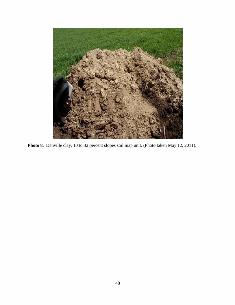
Photo 4. Diabloclay, 5 to 20 percent slopes representative pedon.(Photo taken May 12, 2011).
36
Map 8.Diablo clay, 5 to 20 percent slopes soil map unit location at soil survey site, Carmody McKnight Estate Vineyards.
37
WHYTE SERIES
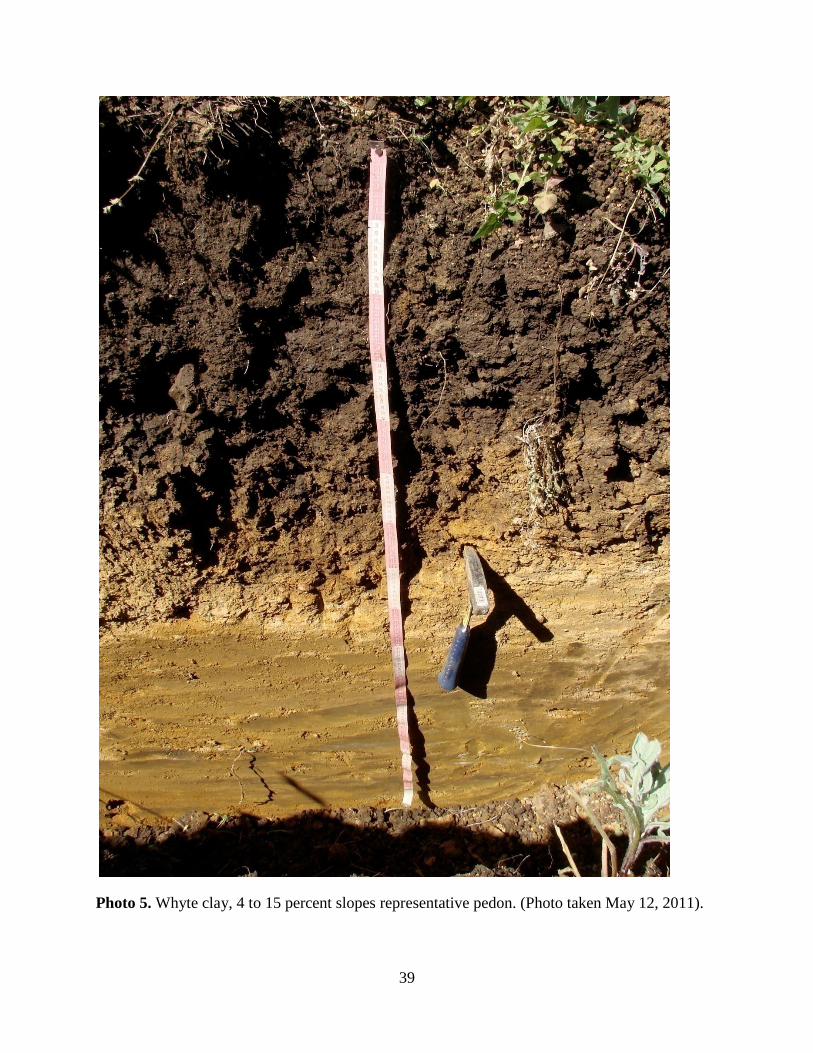
TAXONOMIC UNIT DESCRIPTION: Clayey, smectitic, thermic, shallow Typic Haploxerolls The Whyte series consists of shallow well drained soils formed in colluvium and residuum from metamorphosedcalcareous sedimentary rocks of the Monterey Formation, Sandholdt member,over residuum fromintrusive mafic igneous dikes. The soil is positioned on rolling hills at slopes of 4 to 15 percent. The annual precipitation ranges from 64 to 89 cm (25 to 35 in.) and mean annual temperature is 16 degrees C (61 degrees F). Competing series include the Peters series. Peters soils havedark grey colors and weather from sandstone. REPRESENTATIVE PEDON: A representative pedon from the Whyte series is in an area of Whyte Clay on 4 to 15 percent slopes. The soil is on a south-west facing slope. Land use is vineyard, specifically for the production of Chardonnay and Cabernet Franc wine grapes. Wild intercrop vegetation includes wild oats (Avena fatua), blue-eyed grass (Sisyrinchiummontanum), Harding grass (Phalaris aquatica), barley (Hordeum vulgare) andripgut brome (Bromus rigidus). Located on the Carmody McKnight Estate Vineyardsabout 6 miles west of Paso Robles north of Chimney Rock Road and within the southern portion of the vineyard; Elevation is 408 m (1337 ft). NE ¼, Sec. 21, T26S, R10E, Mount Diablo Baseline & Meridian, Lime Mountain Quadrangle; San Luis Obispo County, CA. Latitude N 35° 39’28.7’’. Longitude W 120°53’39.8’’. (Colors are for dry soil unless otherwise noted.)
Ap- 0 to 18 cm (0 to 7 in), very dark grayish brown (10YR 3/2) clay, dark brown (10YR 3/3) moist; moderate, fine, subangular blocky structure; moderately hard, friable; slightly sticky and very plastic; many very fine to fine roots; neutral (pH 6.6) clear smooth boundary.
Bt- 18 to 44 cm (7 to 17 in), very dark grayish brown (10YR 3/2) clay, dark yellowish brown (10YR 3/4) moist; moderate, fine to medium, subangular blocky structure; hard, friable, slightly sticky and very plastic; common fine to course roots; few faint clay films on faces of peds; slightly alkaline (pH 6.5); clear wavy boundary.
Cr- 44 to 100 cm (17 to 39 in), yellowish brown (10YR 5/6) weathered igneous basalt and gabbro, yellowish brown (10YR 5/6) moist; massive; soft, friable, non-sticky and non-plastic; neutral (pH 6.6).
RANGE IN CHARACTERISTICS: Depth to a paralithic contact is 17 to 49 cm (7 to 19 in.). Soil between the depths of 10 to 30 cm (4 to 12 in.) is naturally dry from May until October and is moist in some or all parts all the rest of the year. The soil texture ranges from 42 percent to 52 percent clay throughout the horizons.

38
The Ap horizon is very dark grayish brown to dark brown with a moist color chroma between 1 and 3. The Bt horizons range from very dark greyish brown to dark brown with a moist color ranging from dark brown to dark yellowish brown. The lower part of the profile is a Cr or Crk horizon varying from weathered igneous basalt to weathered brown calcareous shale.
39
Photo 5. Whyte clay, 4 to 15 percent slopes representative pedon. (Photo taken May 12, 2011).
40
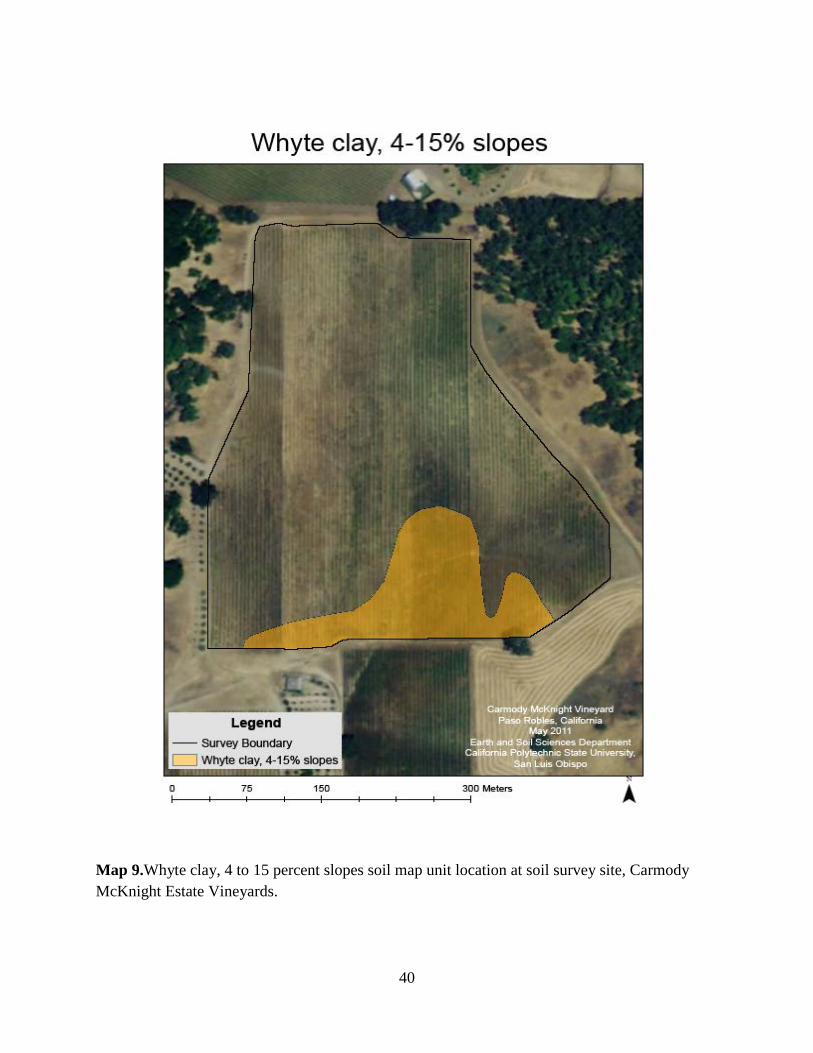
Map 9.Whyte clay, 4 to 15 percent slopes soil map unit location at soil survey site, Carmody McKnight Estate Vineyards.
41
Soil Map Unit Descriptions
42
Map 10. Carmody McKnight Estate Vineyard soil survey site soil map units.
43
Ayar clay, 4 to 12 percent slopes. This deep, well drained, low permeable soil is on a toeslope. It formed in very deep alluvium from calcareous sedimentary rocks and mafic igneous rocks overlying deeper residual mafic igneous materials from an intrusive dike.The map area is irregular in shape and covers 7.43 acres.
The existing vegetation consists of annual oat hay crops and grape wines. Elevation ranges from approximately 1340 to 1360 feet (410 to 415 m). The annual precipitation ranges from 64 to 89 cm (25 to 35 in.) and mean annual temperature is 16 degrees C (61 degrees F). Annual frost-free season lasts approximately 200 to 300 days per year, depending on location.
The soil has been plowed during past agricultural operations. Typically the surface layer is very dark brown (10YR 2/2) clay about 12 cm (5 in) deep. This is underlain by layers of very dark grayish brown (10YR 3/2), dark brown (10YR 3/3), and dark yellowish brown (10YR 3/4 and 10YR 4/4) clay to a depth of 150 cm (60 in). (Alkalinity). Hydraulic conductivity of this soil is low, and available water holding capacity is moderate (22.5 cm). Surface runoff is very rapid, and the hazard of water erosion is moderate. The effective rooting depth generally greater than 150 cm (60 in).
Included in this map unit are Bosanko clay, Danville clay, Diablo clay, and Whyte clay soils with few non-paved roads.
These soils have relatively moderate slopes and high shrink-swell capacity. They are suited to irrigated vineyards. Proper tillage and crop residue incorporation help to maintain soil structure, fertility, and hydraulic conductivity. These soils are also used for field crop grain production.
If the area were considered for urban development, the severe rating for septic systems and wastewater treatment facilities should be noted. Design of the septic tank adsorption fields and wastewater treatment facilities should consider the slope, the depth to bedrock and the low hydraulic conductivity of the substratum. The size of the absorption field may have to be enlarged.
If the soil is used for embankments, dikes, or levees, structures should be designed with regard to the piping limitations; a high degree of compaction and moisture control, careful placement of material, or a special design is needed. In addition, these soils have severe limitations for dwellings without basements, local roads and streets, and camp areas due to high shrink-swell and clay surface texture.
Thos Ayar soil is in Land Capability Class IV, irrigated or dryland.
44
Photo 6. Ayar clay, 4 to 12 percent slopes soil map unit. (Photo taken May 12, 2011).
45
Bosanko clay, 5 to 20 percent slopes. This moderately deep, well drained, and moderately slow permeable soil is located on toeslopes and backslopes of hillslopes. It formed in alluvium from calcareous sedimentary rocks and mafic igneous rocks overlying residual mafic igneous materials from an intrusive dike.of the Monterey Formation, Sandholdt member. The mapped area is irregular in shape and covers 10.85 acres.
The existing vegetation consists of yellow star thistle (Centaurea sostitalis), wild oat (Avena fatua), and cultivated barley (Hordeum vulgare). Elevation ranges from approximately 1500 to 1650 feet (450 to 495 m). The annual precipitation ranges from 64 to 89 cm (25 to 35 in.) and mean annual temperature is 16 degrees C (61 degrees F). Annual frost-free season lasts approximately 200 to 300 days per year depending on location.
The soil has been plowed during past agricultural operations. Typically, the surface layer is dark brown (10YR 4/3) clay about 18 cm (7 in) deep. This is underlain by stratified layers of dark brown (10YR 4/3) clay, dark brown (10YR 4/3) clay to weathered calcareous shale, and calcareous shale. The profile is not alkaline at the surface but becomes strongly alkaline as the depth increases. Some areas have stratified layers. Hydraulic conductivity of the soil is moderately low, and the available water holding capacity is low to moderate (36 cm). Surface runoff is very rapid, and the hazard of water erosion is very high. The effective rooting depth is 80 cm (31.50 in).
Included in this map unit are few areas of Ayer clay, Whyte clay, Danville clay and Diablo clay.
These soils have moderate to steep slopes and moderate to high shrink-swell capacity. They are suited to irrigated vineyards, almonds, or walnut orchards. Proper tillage and crop residue incorporation help to maintain soil structure, fertility, and hydraulic conductivity. These soils are also used for rangeland or field crop grain production.
If the area were considered for urban development, the severe rating for septic systems and wastewater treatment facilities should be noted. Design of the septic tank absorption fields and waste water treatment facilities should consider the slope (severe), the depth to bedrock, and the moderately low hydraulic conductivity of the substratum. A mechanical gradient can reduce the slope.
If the soil is used for embankments, dikes, or levees, structures should be designed with regard to the piping limitation; a high degree of compaction and moisture control, careful placement of material, or a special design is needed. In addition these soils have severe limitations for dwellings without basements, local roads and streets, and camp areas due to its moderately steep slopes and high shrink-swell capacity.
This Bosanko soil is in Land Capability Class VI, irrigated and dryland.
46
Photo 7. Bosanko clay, 5 to 20 percent slopes soil map unit. (Photo taken May 12, 2011).
47
Danville clay, 10 to 32 percent slopes. This very deep, well drained, slow permeable soil is on concave and convex backslopes of hillslopes. The soil formed in alluvium over residuum weathered from calcareous sedimentary rocksof the Monterey Formation, Sandholdt member. The mapped area irregular in shape and covers 5.17 acres.
The existing vegetation consists of wine grapes, annual grasses, and forbs. Elevation ranges from approximately 1,320 to 1,360 feet (402 to 415 m). The annual precipitation ranges from 64 to 89 cm (25 to 35 in.) and mean annual temperature is 16 degrees C (61 degrees F). Annual frost-free season lasts approximately 200 to 300 days per year, depending on location.
The soil has been plowed during past agricultural operations. Typically, the surface layer is dark brown (10YR 3/3) sandy clay loam about 18 cm (7 in) deep. This is underlain by stratified layers of very dark grayish brown (10YR 3/3) and yellowish brown (10YR 5/6) clay loam and clay to a depth of 150 cm (60 in) or more. Some areas have stratified layers stratified layers of calcareous shale or mudstone in the substratum. Hydraulic conductivity of this soil is low, and the available water holding capacity is moderate (22.5 cm). Surface runoff is very rapid, and the hazard of water erosion is high. The effective rooting depth is generally greater than 150 cm (60 in).
Included in this map unit area are other areas of Ayar clay, Bosanko clay, Diablo clay, Whyte clay and few non-paved roads through the map unit.
These soils have moderate to steep slopes and moderate shrink-swell capacity. They are suited to irrigated vineyards. Proper tillage and crop residue incorporation help maintain soil structure, fertility, and hydraulic conductivity. These soils are also used for rangeland or field crop grain production.
If the area were considered for urban development, the severe rating for septic systems and wastewater treatment facilities should be noted. Designs for such systems and facilities should consider the slope, depth to bedrock, and the low hydraulic conductivity of the substratum. If the soil is used for embankments, dikes, or levees, the structures should be designed with regard to the piping limitation; a high degree of compaction and moisture control, careful placement of material, or special design is needed. In addition, these soils have severe limitations for dwellings without basements, local roads and streets, and camp areas due to the moderately steep slopes.
This Danville soil is in Land Capability Class IV, irrigated or dryland.
48
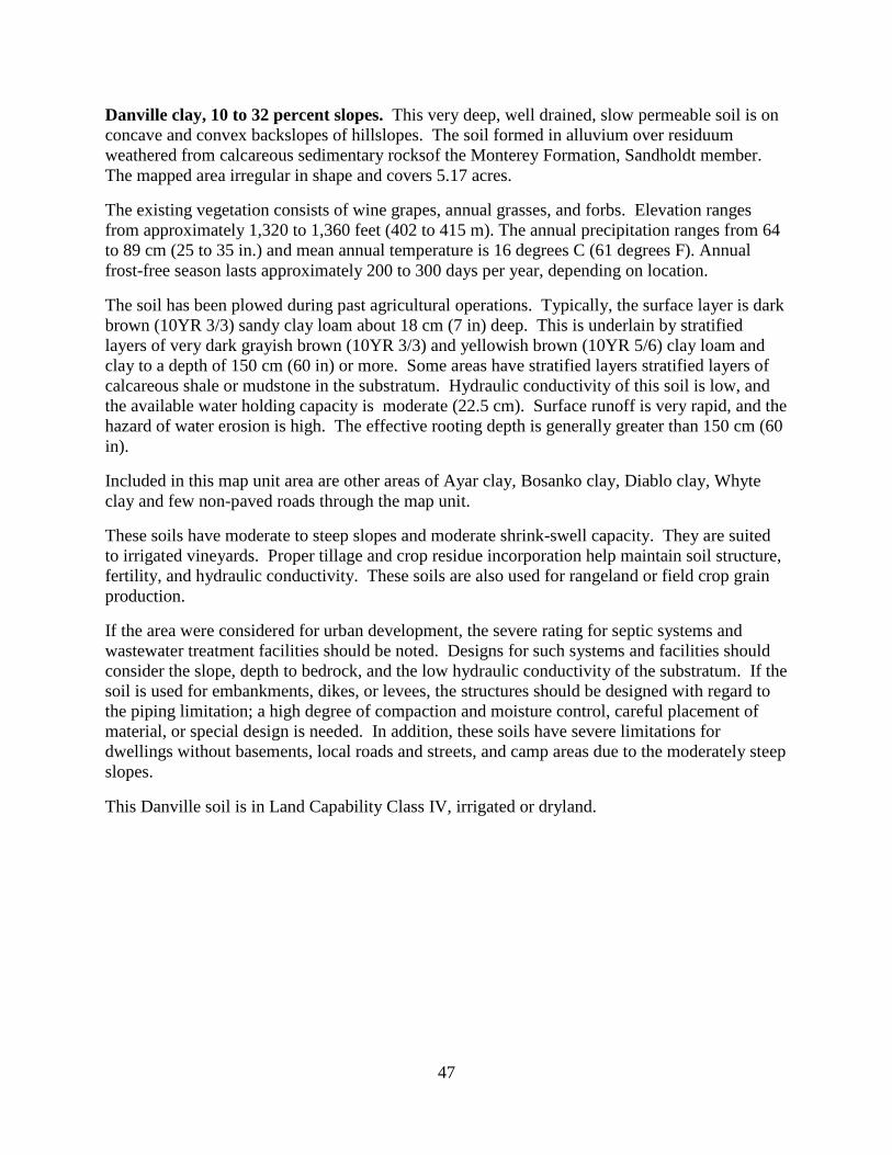
Photo 8. Danville clay, 10 to 32 percent slopes soil map unit. (Photo taken May 12, 2011).
49
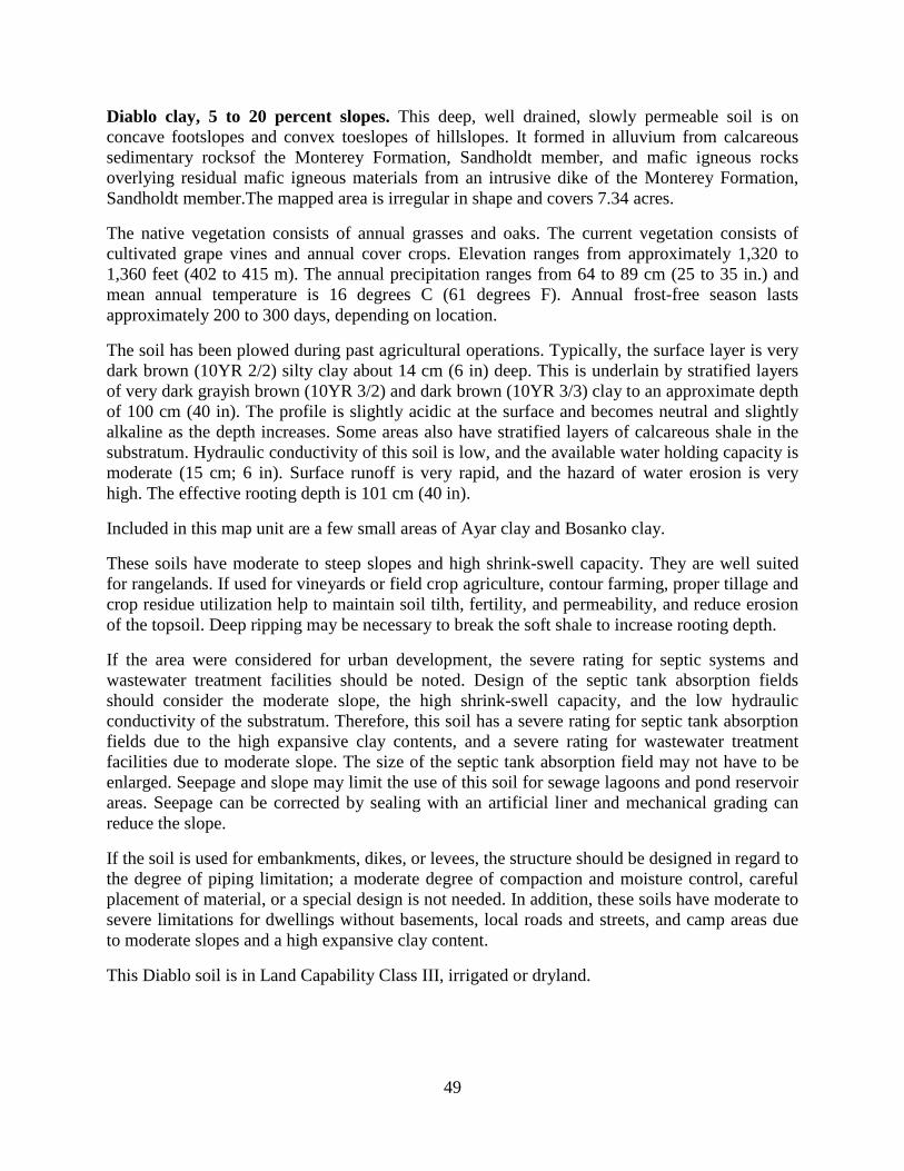
Diablo clay, 5 to 20 percent slopes. This deep, well drained, slowly permeable soil is on concave footslopes and convex toeslopes of hillslopes. It formed in alluvium from calcareous sedimentary rocksof the Monterey Formation, Sandholdt member, and mafic igneous rocks overlying residual mafic igneous materials from an intrusive dike of the Monterey Formation, Sandholdt member.The mapped area is irregular in shape and covers 7.34 acres.
The native vegetation consists of annual grasses and oaks. The current vegetation consists of cultivated grape vines and annual cover crops. Elevation ranges from approximately 1,320 to 1,360 feet (402 to 415 m). The annual precipitation ranges from 64 to 89 cm (25 to 35 in.) and mean annual temperature is 16 degrees C (61 degrees F). Annual frost-free season lasts approximately 200 to 300 days, depending on location.
The soil has been plowed during past agricultural operations. Typically, the surface layer is very dark brown (10YR 2/2) silty clay about 14 cm (6 in) deep. This is underlain by stratified layers of very dark grayish brown (10YR 3/2) and dark brown (10YR 3/3) clay to an approximate depth of 100 cm (40 in). The profile is slightly acidic at the surface and becomes neutral and slightly alkaline as the depth increases. Some areas also have stratified layers of calcareous shale in the substratum. Hydraulic conductivity of this soil is low, and the available water holding capacity is moderate (15 cm; 6 in). Surface runoff is very rapid, and the hazard of water erosion is very high. The effective rooting depth is 101 cm (40 in).
Included in this map unit are a few small areas of Ayar clay and Bosanko clay.
These soils have moderate to steep slopes and high shrink-swell capacity. They are well suited for rangelands. If used for vineyards or field crop agriculture, contour farming, proper tillage and crop residue utilization help to maintain soil tilth, fertility, and permeability, and reduce erosion of the topsoil. Deep ripping may be necessary to break the soft shale to increase rooting depth.
If the area were considered for urban development, the severe rating for septic systems and wastewater treatment facilities should be noted. Design of the septic tank absorption fields should consider the moderate slope, the high shrink-swell capacity, and the low hydraulic conductivity of the substratum. Therefore, this soil has a severe rating for septic tank absorption fields due to the high expansive clay contents, and a severe rating for wastewater treatment facilities due to moderate slope. The size of the septic tank absorption field may not have to be enlarged. Seepage and slope may limit the use of this soil for sewage lagoons and pond reservoir areas. Seepage can be corrected by sealing with an artificial liner and mechanical grading can reduce the slope.
If the soil is used for embankments, dikes, or levees, the structure should be designed in regard to the degree of piping limitation; a moderate degree of compaction and moisture control, careful placement of material, or a special design is not needed. In addition, these soils have moderate to severe limitations for dwellings without basements, local roads and streets, and camp areas due to moderate slopes and a high expansive clay content.
This Diablo soil is in Land Capability Class III, irrigated or dryland.
50
Photo 9.Diablo clay, 5 to 20 percent slopes soil map unit. (Photo taken May 12, 2011).
51
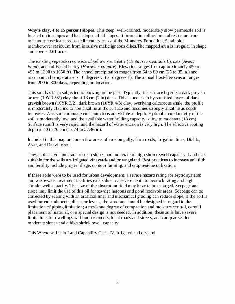
Whyte clay, 4 to 15 percent slopes. This deep, well-drained, moderately slow permeable soil is located on toeslopes and backslopes of hillslopes. It formed in colluvium and residuum from metamorphosedcalcareous sedimentary rocks of the Monterey Formation, Sandholdt member,over residuum from intrusive mafic igneous dikes.The mapped area is irregular in shape and covers 4.61 acres.
The existing vegetation consists of yellow star thistle (Centaurea sostitalis L), oats (Avena fatua), and cultivated barley (Hordeum vulgare). Elevation ranges from approximately 450 to 495 m(1300 to 1650 ft). The annual precipitation ranges from 64 to 89 cm (25 to 35 in.) and mean annual temperature is 16 degrees C (61 degrees F). The annual frost-free season ranges from 200 to 300 days, depending on location.
This soil has been subjected to plowing in the past. Typically, the surface layer is a dark greyish brown (10YR 3/2) clay about 18 cm (7 in) deep. This is underlain by stratified layers of dark greyish brown (10YR 3/2), dark brown (10YR 4/3) clay, overlying calcareous shale. the profile is moderately alkaline to non alkaline at the surface and becomes strongly alkaline as depth increases. Areas of carbonate concentrations are visible at depth. Hydraulic conductivity of the soil is moderately low, and the available water holding capacity is low to moderate (18 cm). Surface runoff is very rapid, and the hazard of water erosion is very high. The effective rooting depth is 40 to 70 cm (15.74 to 27.46 in).
Included in this map unit are a few areas of erosion gully, farm roads, irrigation lines, Diablo, Ayar, and Danville soil.
These soils have moderate to steep slopes and moderate to high shrink-swell capacity. Land uses suitable for the soils are irrigated vineyards and/or rangeland. Best practices to increase soil tilth and fertility include proper tillage, contour farming, and crop residue utilization.
If these soils were to be used for urban development, a severe hazard rating for septic systems and wastewater treatment facilities exists due to a severe depth to bedrock rating and high shrink-swell capacity. The size of the absorption field may have to be enlarged. Seepage and slope may limit the use of this oil for sewage lagoons and pond reservoir areas. Seepage can be corrected by sealing with an artificial liner and mechanical grading can reduce slope. If the soil is used for embankments, dikes, or levees, the structure should be designed in regard to the limitation of piping limitation; a moderate degree of compaction and moisture control, careful placement of material, or a special design is not needed. In addition, these soils have severe limitations for dwellings without basements, local roads and streets, and camp areas due moderate slopes and a high shrink-swell capacity
This Whyte soil is in Land Capability Class IV, irrigated and dryland.
52
Photo 10. Whyte clay, 4 to 15 percent slopes soil map unit. (Photo taken May 12, 2011).

53
Management Recommendations
54
Rootstock Selection
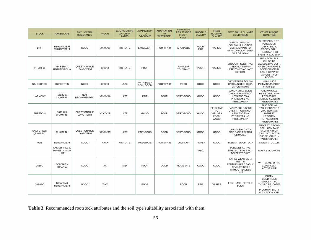
Currently, all grapes on the Carmody McKnight Estate where planted with their original rootstocks and are doing very well. However, it is well known that planting with original rootstocks is one of the riskiest strategies in the business that will often result in complete crop loss. It is our recommendation that a proper rootstock will be used for any future plantings.
When selecting the best rootstock to match the soil type, there are many variables that combine to be quite a challenge. Disease resistance and alkaline soil resistance must be balanced with vigor potential to extract the perfect terroir from the soil. When choosing a rootstock the first factor that is considered is resistance to phylloxera and nematodes. Using a rootstock that is phylloxera resistant is imperative in California, since nearly all soils contain phylloxera and improper management leads to severe crop loss.
Nematode resistance depends on the species of nematode. The two primary nematodes that pose a threat in California vineyards are root knot and Dagger. Root knot can be defended against using a variety of rootstocks, but there are only a few rootstocks resistant to Dagger. It is important to test for nematodes in the soil before choosing a rootstock.
Other factors that should be considered when choosing a rootstock include soil depth, available water holding capacity (AWHC), texture, soil vigor, future water availability, lime content, and soil salinity. Depth, AWHC, and soil texture all determine soil vigor. High vigor soils should be planted with a low vigor rootstock to ensure high grape quality and proper ripening.
When looking at future water availability, slope and aspect should also be taken into consideration. South facing slopes are generally warmer and, therefore, need more water. Drought resistance rootstocks should be planted on these areas. Drought resistance should always be taken into consideration in a semi-arid climate such as Paso Robles, CA.
Soils with high lime levels (high pH) should be planted with lime-resistant rootstocks. If these characteristics are not considered when choosing a rootstock, problems with the grape vines and fruit quality may develop due to metal micronutrient deficiencies.
55
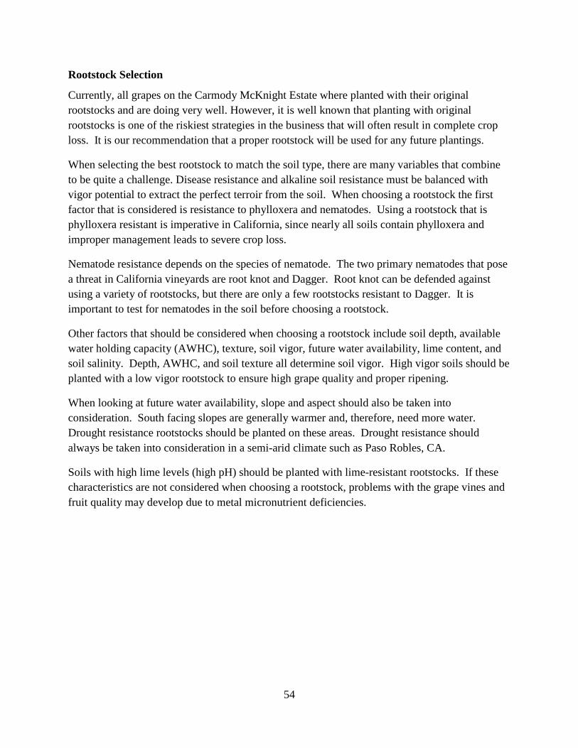
STOCK PARENTAGE PHYLLOXERA RESISTANCE VIGOR
COMPARATIVE MATURITY
RATES ADAPTATION
TO DROUGHT
ADAPTATION TO
"WET FEET"
NEMATODE RESISTANCE
(ROOT -KNOT)
ROOTING QUALITY
FIELD BUDDING QUALITY
BEST SOIL & CLIMATE CONDITIONS
OTHER UNIQUE QUALITIES
RIPARIA GLOIRE RIPARIA GOOD X EARLY POOR GOOD MODERATE GOOD GOOD
DEEP RICH SOIL IN CLOSE PLANTINGS:
MED.TO DEEP WELL - DRAINED, SANDY
GRAVELLY, ROCKY SILT; COOL
WET/COLD SOIL TOLERANT
RESISTANT TO CROWN
GALL;SURVIVES COLD & RAIN
420A BERLANDIERI X RIPARIA GOOD X EARLY POOR-FAIR POOR-FAIR POOR-FAIR POOR-
FAIR GOOD
FRESH FERTILE SOIL BEST, CAN ADAPT TO CHALKY OR HEAVY & DRY SHALLOW SOILS
W/ WATER. GOOD FOR CLOSE SPACING.
GOOD IN CHALKY SOIL; CHLOROSIS
RESISTANT; POTASSIUM DEF.; SMALL DENSITY, SHALLOW ROOT
SYSTEM
101-14Mg RIPARIA X RUPESTRIS GOOD XX EARLY POOR-FAIR GOOD MODERATE GOOD GOOD
FRESH CLAY, MOIST DEEP SOILS &
MODERATE CLIMATE; NEEDS IRR. IN HOT, DRY AREAS; LOW RESIST. TO LIME &
ACID SOILS
IMPROVES FRUIT SET; RESIST. TO CROWN GALL &
SALINITY; CLAIMS OF CHARD &
SYRAH INCOMPATIBILITY
3309C RIPARIA X RUPESTRIS GOOD XX-XXX MID DIFFERS
WIDELY FAIR POOR GOOD SENSITIVE
TO VIRUSES
FROM WOOD
FRESH DEEP NON - CLAY SOILS, CLOSE
SPACING, RESISTANT TO
CROWN GALL; CAN TAKE COLD
44 -53 MALEGUE
RIP X (CORDIF. X RUPESTRIS) GOOD XXX MID FAIR-GOOD GOOD GOOD GOOD GOOD
BETTER IN MOIST, DEEP SOILS OR
IRRIGATED IN WARM AREAS
IMPROVES FRUIT SET; TAKES ACID
SOILS; MAGNESIUM PROBLEMS
SCHWARZMANN RIPARIA X RUPESTRIS GOOD XXX MID FAIR FAIR-GOOD FAIR-GOOD GOOD GOOD
MOIST, DEEP SOILS; NOT FOR HEAVY OR
DROUGHT SOILS IMPROVES FERT. OF SCION; STEM
THICKENS QUICKLY
SO4 BERLANDIERI X RIPARIA GOOD XXXX MID POOR-FAIR FAIR-GOOD GOOD GOOD GOOD MOIST CLAY/COOL
WET; NOT FOR DRY SIMILAR TO 5C; SLIGHTLY LESS
VIGOROUS THAN 5BB
5C BERLANDIERI X RIPARIA GOOD XXXX MID FAIR FAIR GOOD GOOD GOOD
COOLER AREAS BEST WITH HUMID CLAY
LOAM SOILS, BUT CAN TAKE HEAVY CLAY;
SHALLOW ROOT SYSTEM
HAS BROAD NEMATODE
RESISTANCE/ YOUNG PLANTS
NEED WATER
5BB BERLANDIERI X RIPARIA GOOD XXXX MID DIFFERS
WIDELY POOR VARIES GOOD SENSITIVE
TO VIRUSES
FROM WOOD
COOLER AREAS BEST WITH HUMID CLAY
LOAM SOILS, BUT CAN ADAPT TO HEAVY
SOILS IF NOT WATER - LOGGED
BETTER DROUGHT RESISTANCE THAN
5C & 420A; SLIGHTLY MORE VIGOROUS THAN
SO4 & 5C
1103 PAULSEN BERLANDIERI X RUPESTRIS GOOD XXXXX MID- LATE GOOD GOOD FAIR GOOD GOOD
DROUGHT SOILS, HILLSIDES BEST; CAN
ADAPT TO WATER - LOGGING & CLAY -
LIME SOILS
RESISTANT TO LIME, SALT &
CLAY/SUSCEPTIBLE TO POTASSIUM
DEFICIENCY
110R BERLANDIERI X RUPESTRIS GOOD XXXXX MID- LATE EXCELLENT POOR-FAIR LOW-FAIR POOR-
FAIR FIELD
GRAFTS WELL
SHALLOW DROUGHT SOILS; HILLSIDES;
ADAPTS TO SANDY, GRAVELLY, SILT,
ROCKY CLAY
TOLERANT OF SOME ACID & LIME;
CROWN GALL SUSCEPT.; DEEP ROOT SYSTEM
56
Table 3. Recommended rootstock attributes and the soil type suitability associated with them.
STOCK PARENTAGE PHYLLOXERA RESISTANCE VIGOR
COMPARATIVE MATURITY
RATES ADAPTATION
TO DROUGHT
ADAPTATION TO
"WET FEET"
NEMATODE RESISTANCE
(ROOT -KNOT)
ROOTING QUALITY
FIELD BUDDING QUALITY
BEST SOIL & CLIMATE CONDITIONS
OTHER UNIQUE QUALITIES
140R BERLANDIERI X RUPESTRIS GOOD XXXXXX MID- LATE EXCELLENT POOR-FAIR ARGUABLE POOR-
FAIR VARIES SANDY DROUGHT
SOILS & HILL -SIDES BEST; ADAPTS TO
SHALLOW CLAY, DEEP SILT,OR LOAM
SUSCEPTIBLE TO POTASSIUM DEFICIENCY,
CROWN GALL; RESISTANT TO
SALINITY & ACIDITY
VR 039-16 VINIFERA X ROTUNDIFOLIA
QUESTIONABLE LONG-TERM XXXXX MID- LATE POOR FAN-LEAF
TOLERANT POOR VARIES DROUGHT SENSITIVE;
USE ONLY IN FAN- LEAF ZONES AS LAST
RESORT
HIGH SODIUM & CHLORIDE
LEVELS;ZINC-DEF. , OVER-CROPPING &
POOR COLOR IN TABLE GRAPES; LARGEST # OF
ROOTS
ST. GEORGE RUPESTRIS GOOD XXXXX LATE WITH DEEP SOIL, GOOD POOR-FAIR POOR GOOD GOOD
DRY DEEPER SOILS & ON HILLSIDES; DEEP,
LARGE ROOTS HIGH JUICE
POTASSIUM, POOR FRUIT SET
HARMONY 1613C X CHAMPINII
NOT RECOMMENDED XXXXXXA LATE FAIR POOR VERY GOOD GOOD GOOD
SANDY SOILS BEST; ONLY IF ROOTKNOT
NEMATODES A PROBLEM & NO PHYLLOXERA
CROWN GALL RESISTANT; HIGH
POTASSIUM, SODIUM & ZINC IN
TABLE GRAPES
FREEDOM 1613 C X CHAMPINII
QUESTIONABLE LONG-TERM XXXXXXB LATE GOOD POOR VERY GOOD GOOD
SENSITIVE TO
VIRUSES FROM WOOD
SANDY SOILS BEST; ONLY IF ROOTKNOT
NEMATODES A PROBLEM & NO PHYLLOXERA
ZINC DEF. W/ TABLE GRAPES &
CHARDONNAY; HIGHEST
NITROGEN, POTASSIUM IN TABLE GRAPES
SALT CREEK (RAMSEY) CHAMPINII QUESTIONABLE
LONG-TERM XXXXXXC LATE FAIR-GOOD GOOD VERY GOOD GOOD GOOD LOAMY SANDS TO
FINE SANDS; WARM CLIMATES
SUSCEPT. CROWN GALL; CAN TAKE SALINITY; HIGH
ZINC, NIT., POT. & PHOSPHORUS IN TABLE GRAPES
99R BERLANDIERI GOOD XXXX MID- LATE MODERATE POOR-FAIR LOW-FAIR FAIRLY GOOD TOLERATES UP TO 17 SIMILAR TO 110R;
LAS SORRES X RUPESTRIS DU
LOT WELL PERCENT ACTIVE
LIME, BUT DOES NOT TOLERATE SALT
NOT AS VIGOROUS
1616C SOLONIS X RIPARIA GOOD XX MID POOR GOOD MODERATE GOOD GOOD
FAIRLY WEAK VAR.; BEST IN
FERTILE,HUMID,BADLY - DRAINED SOILS
WITHOUT EXCESS LIME
WITHSTAND UP TO 11 PERCENT ACTIVE LIME
161-49C RIPARIA X BERLANDIERI GOOD X-XX POOR POOR FAIR VARIES FOR HUMID, FERTILE
SOILS
IN DRY CONDITIONS SUSCEPT. TO
THYLLOSIS. CASES OF
INCOMPATIBILITY WITH SCION VAR.
57
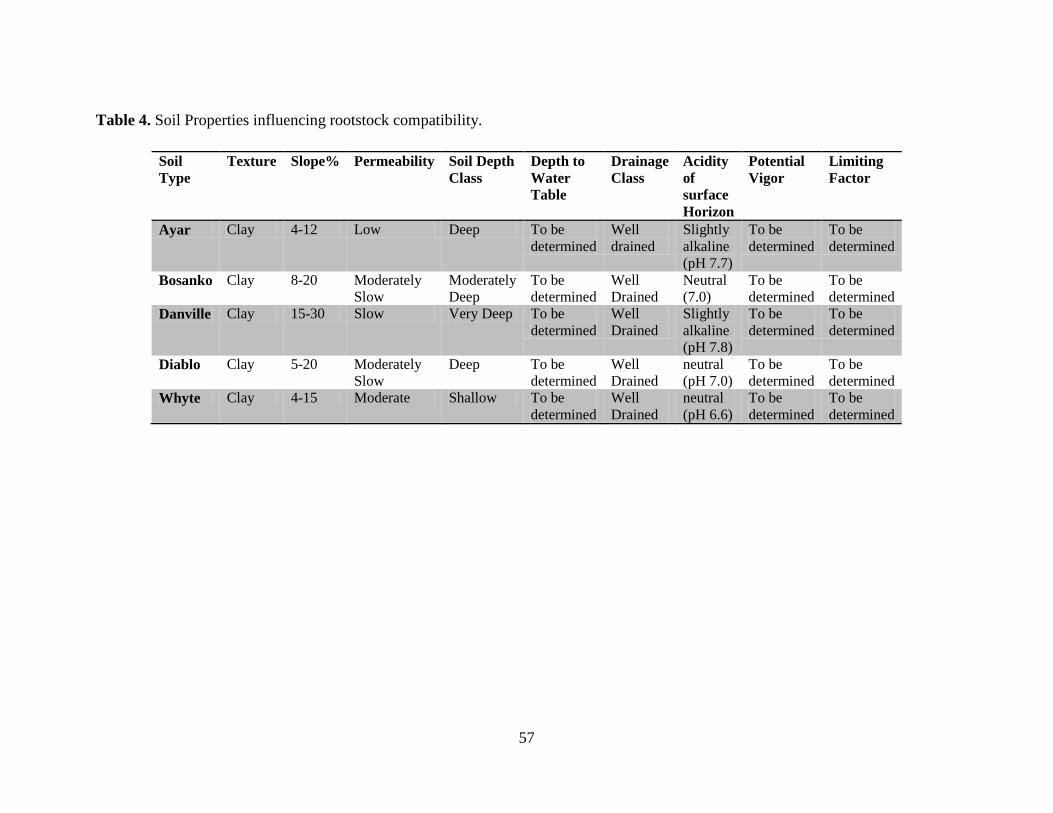
Table 4. Soil Properties influencing rootstock compatibility.
Soil Type
Texture Slope% Permeability Soil Depth Class
Depth to Water Table
Drainage Class
Acidity of surface Horizon
Potential Vigor
Limiting Factor
Ayar Clay 4-12 Low Deep To be determined
Well drained
Slightly alkaline (pH 7.7)
To be determined
To be determined
Bosanko Clay 8-20 Moderately Slow
Moderately Deep
To be determined
Well Drained
Neutral (7.0)
To be determined
To be determined
Danville Clay 15-30 Slow Very Deep To be determined
Well Drained
Slightly alkaline (pH 7.8)
To be determined
To be determined
Diablo Clay 5-20 Moderately Slow
Deep To be determined
Well Drained
neutral (pH 7.0)
To be determined
To be determined
Whyte Clay 4-15 Moderate Shallow To be determined
Well Drained
neutral (pH 6.6)
To be determined
To be determined
58
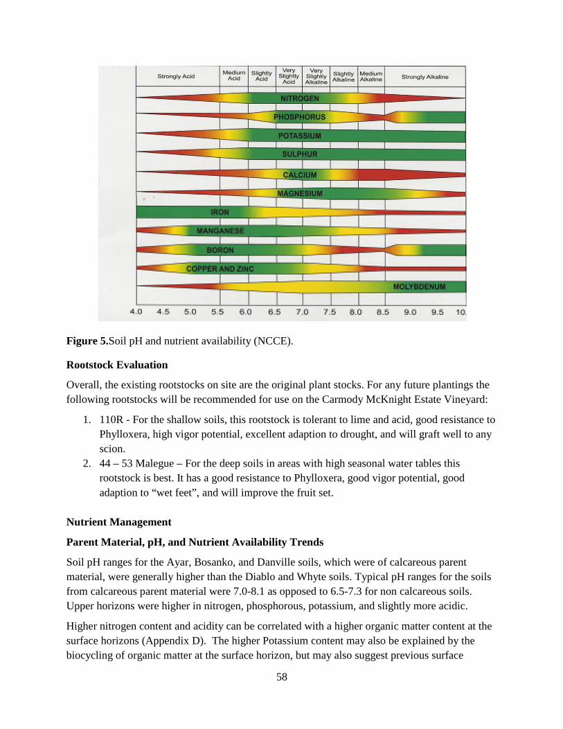
Figure 5.Soil pH and nutrient availability (NCCE).
Rootstock Evaluation
Overall, the existing rootstocks on site are the original plant stocks. For any future plantings the following rootstocks will be recommended for use on the Carmody McKnight Estate Vineyard:
1. 110R - For the shallow soils, this rootstock is tolerant to lime and acid, good resistance to Phylloxera, high vigor potential, excellent adaption to drought, and will graft well to any scion.
2. 44 – 53 Malegue – For the deep soils in areas with high seasonal water tables this rootstock is best. It has a good resistance to Phylloxera, good vigor potential, good adaption to “wet feet”, and will improve the fruit set.
Nutrient Management
Parent Material, pH, and Nutrient Availability Trends
Soil pH ranges for the Ayar, Bosanko, and Danville soils, which were of calcareous parent material, were generally higher than the Diablo and Whyte soils. Typical pH ranges for the soils from calcareous parent material were 7.0-8.1 as opposed to 6.5-7.3 for non calcareous soils. Upper horizons were higher in nitrogen, phosphorous, potassium, and slightly more acidic.
Higher nitrogen content and acidity can be correlated with a higher organic matter content at the surface horizons (Appendix D). The higher Potassium content may also be explained by the biocycling of organic matter at the surface horizon, but may also suggest previous surface
59
fertilizations. Biocycling refers to the process of nutrients being taken up by plants, then concentrated at the surface as it is released from decaying plant material. Calcium phosphate is what bones and teeth are made of, and it exists in these soils from micro and macro marine organisms. At lower pH levels, the calcium phosphate is broken down and more phosphorous becomes available. Basic Cation Saturation Ratios
Basic cation saturation ratios of Potassium to Sodium and Calcium to Magnesium were all high, which is desirable for optimal plant growth of most species. Too much sodium can cause slow growth, stunted fruiting, and thicker, smaller leaves (Bernstein, 1975). All soils tested very low for sodium (Appendix D).
Cation exchange capacity is the measure of a soils ability to retain exchangeable cations such as Ca2+, Mg2+, K+, Na+, NH4
+, and H+. Higher cation exchange capacities are generally associated
with higher ability to store nutrients (Hamza and Anderson, 2002).
Metal Micronutrient Availability
Iron concentration was more available at lower pH ranges (Appendix D). The Ayar, Bosanko, and Danville soils did contain appreciable amounts of total iron, but the availability of that iron was low because iron can become problematically unavailable in calcareous soils with high pH (Takahashi et al., 2001). Metal micronutrient availability, especially for manganese, decreased with higher pH as well. At high pH, these metal micronutrients can become tied up with hydroxide, rendering them unavailable to plants. Foliar application of micronutrients, along with continued petiole analysis may be warranted to ensure optimal plant health (Viets, 1962).
Deficiencies and Fertilizer Recommendations
All soils tested low for potassium (despite elevated levels at surface horizons) and very low for Boron (Appendix D). Potassium is an essential macro-nutrient which means plants use it in high amounts. Potassium deficiencies can cause problems such as chlorosis, low water content of leaves, and increased uptake of Sodium relative to potassium (Norman and Ulrich, 1972). This uniformly low concentration of potassium may suggest fertilization is necessary to ensure optimal plant health. Boron is an essential micro-nutrient. Boron deficiency can introduce problems such as decreased or ceased growth, impeded root growth, and reduced sexual activity such as seed production and blooming/flowering (Dell, 1997).
The majority of the soils tested low for Sulfur (Appendix D). Sulfur is an essential macro-nutrient that, at deficient concentrations, can introduce problems such as reduced protein
60
synthesis in plants. Strain on protein synthesis may stunt growth, lower yield, and reduce quality (Pumphrey and Moore, 1965).
A deficiency for both potassium and sulfur can be mitigated with the addition of liquid potassium thiosulfate fertilizer. This is an acid forming fertilizer labeled 0-0-41 (34% S), which means 0% total nitrogen (N), 0% available phosphate (P2O5), 41% soluble potash (K2O), and 34% sulfur (S). Because this fertilizer is acid forming, it may help to release a small amount of metal micronutrients that become increasingly unavailable at higher pH. Irrigation Recommendations
Permeability was determined by the permeability of the least permeable horizon. Available Water Holding Capacity (AWHC) was determined by soil texture and depth (Rice, 2011).
Slopes range from 4 to 32%. Because of the relatively steep slopes, drip irrigation is recommended. Drip irrigation minimizes erosion and can be utilized with fertigation. Drip irrigation is better utilized than other irrigation methods to control the rooting zone growth and stress on the plant to ensure high quality grapes. Water is applied to the areas just above the effective rooting zone and is not wasted on inter-row areas where weeds could grow.
Due to the topography and layout of the site, it is recommended that several holding tanks be installed at a higher elevation above the site. A drip irrigation system would be an ideal choice because gravity will power the flow of water through drip lines to the vines. Flow emitters with preset flow rates can be used to distribute irrigation water to the vines as needed. Irrigation amounts can be determined based on the soil properties of each map unit, including surface texture, slope phase, permeability, and water holding capacity (Table 5).
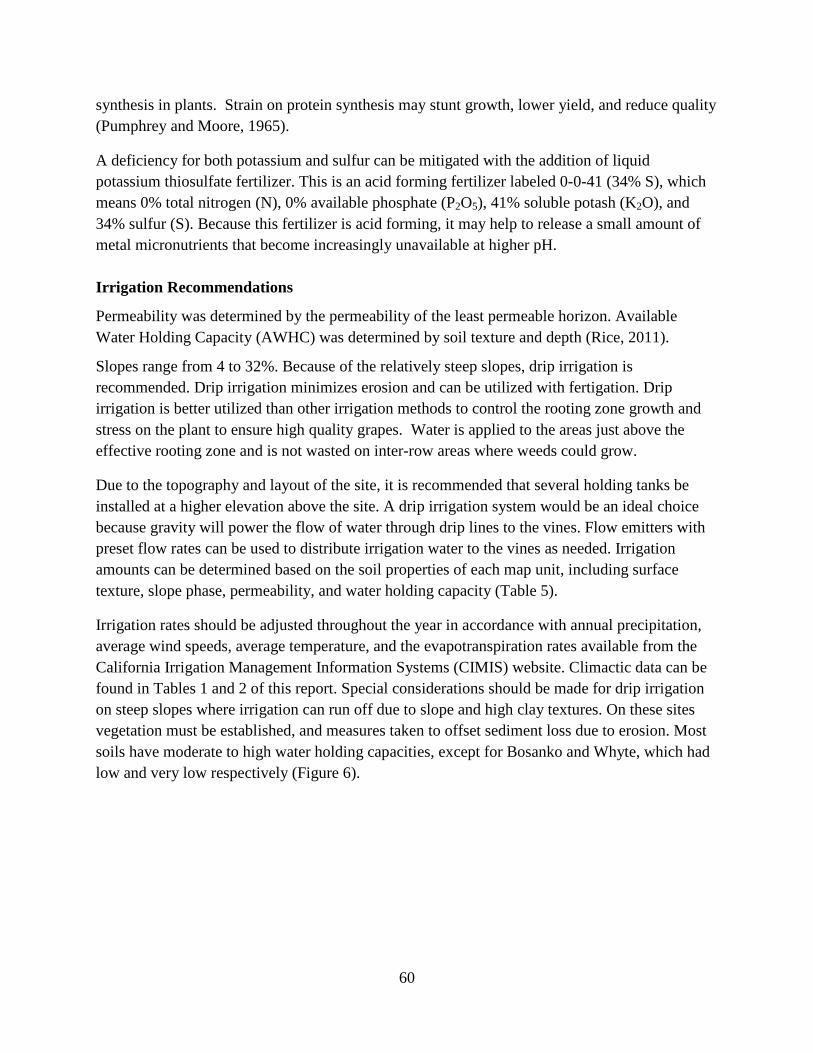
Irrigation rates should be adjusted throughout the year in accordance with annual precipitation, average wind speeds, average temperature, and the evapotranspiration rates available from the California Irrigation Management Information Systems (CIMIS) website. Climactic data can be found in Tables 1 and 2 of this report. Special considerations should be made for drip irrigation on steep slopes where irrigation can run off due to slope and high clay textures. On these sites vegetation must be established, and measures taken to offset sediment loss due to erosion. Most soils have moderate to high water holding capacities, except for Bosanko and Whyte, which had low and very low respectively (Figure 6).
61
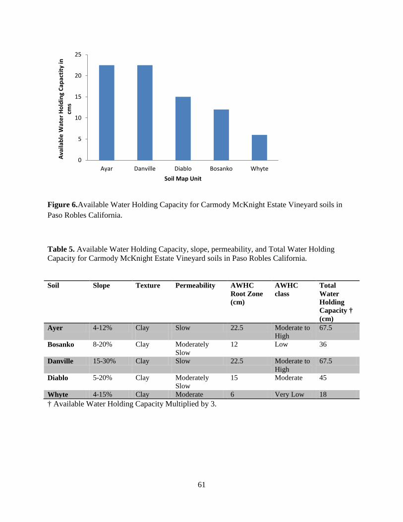
Figure 6.Available Water Holding Capacity for Carmody McKnight Estate Vineyard soils in Paso Robles California.
Table 5. Available Water Holding Capacity, slope, permeability, and Total Water Holding Capacity for Carmody McKnight Estate Vineyard soils in Paso Robles California.
Soil Slope Texture Permeability AWHC Root Zone (cm)
AWHC class
Total Water Holding Capacity † (cm)
Ayer 4-12% Clay
Slow 22.5 Moderate to High
67.5
Bosanko 8-20% Clay Moderately Slow
12 Low 36
Danville 15-30% Clay Slow 22.5 Moderate to High
67.5
Diablo 5-20% Clay Moderately Slow
15 Moderate 45
Whyte 4-15% Clay Moderate 6 Very Low 18 † Available Water Holding Capacity Multiplied by 3.
0
5
10
15
20
25
Ayar Danville Diablo Bosanko Whyte
Avai
labl
e W
ater
Hol
ding
Cap
actit
y in
cm
s
Soil Map Unit
62
References and Bibliography
Arc Map. 2006. Release 9.2. ESRI Inc. Redlands, CA.
Bernstein, L. 1975. Effects of salinity and sodicity on plant growth. Annual Review of Phytopathology 13:295-312.
California Irrigation Management Information System (CIMIS). 2008. Department of Water Resources. Office of Water Use Efficiency. 2005. http://www.cimis.water.ca.gov. 21 May 2008.
Catlin, T., J. Wolpert, D. Roberts. 1995. Proceedings of the International Symposium on Clonal Selection. American Society for Enology and Viticulture.
Coombe, B.G. and P.R. Day (eds.). 1992a. Viticulture: Vol. 1 Resources. Winetitles, Adelaide, Australia.
Coombe, B.G. and P.R. Day (eds.). 1992b. Viticulture: Vol. 2 Practices. Winetitles, Adelaide, Australia.
Dell, B. 1997. Physiological response of plants to low boron. Plant and Soil 193:103-120.
Galet, P. 1979. A Practical Ampelography Grapevine Identification. Cornell University Press, Ithica, 248.P
Grant, Stan. 2002. Balanced soil fertility management in wine grape vineyards.Winegrowing May/June.
Hamza, M.A. and Anderson, W.K. 2002. Improving soil physical fertility and crop yield on a clay soil in Western Australia. Australian J. of Ag Research 53:615-620.
Moody, L.E. and T. J. Rice. 2010. Soil Morphology Lab Manual. El Corral Publ., San Luis Obispo, CA.
Mottana, A., R.Crespi, and G. Liborio. 1978. Guide to Rocks and Minerals. Simon and Schuster, Inc. New York, NY.
Norman, T. and Ulrich, A. 1972. Effects of potassium deficiency on the photosynthesis and respiration of leaves of sugar beet. Dept of Soils and Plant Nutrition, University of California, Berkeley.
North Carolina Cooperative Extension (NCCE): The Mid-Atlantic Winegrape Grower’s Guide http://www.ces.ncsu.edu/resources/winegrape/ag535-3.pdf
63
Oklahoma State University Soil Test Interpretation and Fertilizer Decision-Support System: http://www.soiltesting.okstate.edu/Interpretation.htm.
Pongracz, D.P. 1983. Rootstocks for Grapevines. David Philip Pub., Capetown, South Africa.
Pumphrey, F.V. and Moore, D.P. 1965. Diagnosing sulfur deficiency of alfalfa (Medicago sativa L.) from plant analysis. American Society of Agronomy 57(4):364.
USDA-Natural Resources Conservation Service. Online.http://soils.usda.gov/technical/classification/osd/index.html.April 2008.
Rice, T.J. 2011. Soil Science 431 Soil Resource Inventory. El Corral Publ., San Luis Obispo, CA.
Rice, T.J. and T.G. Cervellone. 2007. Paso Robles: An American Terroir.
Soils Division Staff. United States Department of Agriculture,Natural Resources Conservation Service. Online. http://soils.usda.gov. 11 April 2008.
Soil Survey Staff. 1993. Soil Survey Manual. USDA Handbook No. 18. U.S. Govt. Print. Office, Washington, D.C.
Soil Survey Staff. 2010. Keys to Soil Taxonomy, 11th edition. U.S. Dept. of Agric., Natural Resources Conservation Service. U.S. Govt. Print. Office, Washington, D.C.
Soil Survey Staff, 2011. Official soil series descriptions. USDA-NRCS. Online: http://soils.usda.gov/
Takahashi, M., Nakanishi, H., Kawasaki, S., Nishizawa, N. K., and Mori, S. 2001. Enhanced tolerance of rice to low iron availability in alkaline soils using barley nicotianamine aminotransferase genes. Nature Biotechnology 19(5):466.
The American Heritage® Dictionary of the English Language, Fourth Edition copyright ©2000 by Houghton Mifflin Company. Updated in 2003. Published by the Houghton Mifflin Company.
Tisdale, S.L., W.L. Nelson, J.D. Beaton, and J.L. Havlin. 1985. Soil Fertility and Fertilizers. Macmillan Publ. Co., New York, NY.
Viets, F. G. Jr. 1962. Chemistry and availability of micronutrients in soils. Journal of agricultural and food chemistry 10(3):174.
Winkler, A.J., J.A. Cook, W.M. Kliewer, and L.A. Lider. 1974. General Viticulture.
Wolpert, J., A. Walker, E. Weber, L. Bettiga, R. Smith, P. Verdegaal. Rootstocks and Phylloxera.1994. Viticultural Notes, University of California Cooperative Extension Napa County, Number 6, April 1, 1994.

64
Wolpert, J., A. Walker, E. Weber. 1992.Rootstock Seminar: A Worldwide Perspective. Viticululral Notes, University of California Cooperative Extension,
2nd ed. Univ. Calif. Press, Berkeley, CA.
65
APPENDIX A: Glossary
66
Alluvial fan. Fan-shaped alluvium deposited at the mouth of a canyon or ravine where debris-laden water fan out, slow down, and deposit their burden.
Alluvium. Material such as sand, silt, or clay, deposited on land by streams.
Available water capacity (available moisture capacity). The capacity of soils to hold water available for use by most plants. It is commonly defined as the difference in the amount of soil water at field moisture capacity and the amount at wilting point. It is commonly expressed as inches of water per inch of soil. The capacity, in inches, in a 60-inch profile or to a limiting layer is expressed as-
Centimeters H2O
Very low.............................................................................. 0 to <7.5
Low...................................................................................... 7.5 to <15
Moderate.............................................................................. 15 to <22.5
High..................................................................................... ≥ 22.5
Backslope. The profile position of a hillslope situated between the shoulder and the footslope.
Bedrock. The solid rock that underlies the soil and other unconsolidated material or that is exposed at the surface.
Calcareous. Containing calcium carbonate. When applied to a rock name, it implies that as much as 50% of the rock is calcium carbonate.
Clay film. A thin coating of oriented clay on the surface of a soil aggregate or lining pores or root channels. Synonyms: clay coat, clay skin.
Coarse fragments. Mineral or rock particles up to 3 inches in diameter.
Colluvium. Soil parent material consisting of soil material, rock fragments, or both moved by creep, slide, or local outwash and deposited at the bases of steep slopes.
Compaction. Reduction in bulk volume or thickness of fine-grained sediments, owing to increasing weight of overlying material that is continually being deposited, or to pressures resulting from earth movements.
Consistence. Refers to “attributes of soil material as expressed in degree of cohesion and adhesion or in resistance to deformation on rupture.
Dry Moist
Loose (L) Loose (L)
67
Soft (S) Very Friable (VFR)
Slightly Hard (SH) Friable (FR)
Mod. Hard (MH) Firm (FI)
Hard (HA) Very Firm (VFI)
Very Hard (VH) Extremely. Firm (EF)
Extremely Hard (EH) Slightly Rigid (SR)
Rigid (R) Rigid (R)
Very Rigid (VR) Very Rigid (VR)
Dolomite. 1.A common rock forming mineral, CaMg(CO3)2. Part of the Mg may be replaced by ferrous iron. Dolomite is white to light-colored and has perfect rhombohedral cleavage. Cf: calcite. 2. A sedimentary rock, of which more than 50% by weight consist of the mineral dolomite; specif. a rock containing more than 90% mineral dolomite and less than 10% calcite. Most dolomite is associated and often interbedded with limestone.
Drainage class (natural). Refers to the frequency and duration of periods of saturation or partial saturation during soil formation, as opposed to altered drainage, which is commonly the result of artificial drainage or irrigation but may be caused by the sudden deepening of channels or the blocking of drainage outlets. Seven classes of natural soil drainage are recognized:
Excessively drained. Water is removed from the soil very rapidly. Excessively drained soils are commonly very coarse textured, rocky, or shallow. Some are steep. All are free of the mottling related to wetness.
Somewhat excessively drained. Water is removed from the soil rapidly. Many
somewhat excessively drained soils are sandy and rapidly pervious. Some are shallow. Some are so steep that much of the water they receive is lost as runoff. All are free of the mottling related to wetness.
Well drained. Water is removed from the soil readily, but not rapidly. It is
available to the plants throughout most of the growing season, and wetness does not inhibit growth of roots for significant periods during most growing seasons. Well drained soils are typically medium textured. They are mainly free of mottling.
Moderately well drained. Water is removed from the soil somewhat slowly during
68
some periods. Moderately well drained soils are wet for only a short time during the growing season, but periodically for long enough that most mesophytic plants are affected. They commonly have a slowly pervious layer within or directly below the slum, or periodically receive high rainfall, or both.
Somewhat poorly drained. Water is removed slowly enough that the soil is wet for significant periods during the growing season. Wetness markedly restricts the growth of mesophytic plants unless artificial drainage is provided. Somewhat poorly drained soils commonly have a slowly pervious layer, a high water table, additional water from seepage, nearly continuous rainfall, or a combination of these.
Poorly drained. Water is removed so slowly that the soil is saturated periodically
during the growing season or remains wet for long periods. Free water is commonly at or near the surface long enough during the growing season that many mesophytic crops cannot be grown unless artificial drainage is provided. The soil is not continuously saturated in layers directly below plow depth. Poor drainage results from a high water table, a slowly pervious layer within the profile, seepage, nearly continuous rainfall, or a combination of these.
Very poorly drained. Water is removed from the soil so slowly that free water
remains at or on the surface during most of the growing season. Unless the soil is artificially drained, most mesophytic crops cannot be grown. Very poorly drained soils are commonly level or depressed and are frequently ponded. Yet, where rainfall is high and nearly continuous, they can have moderate or high slope gradients, as for example in “hillpeats” and “climatic moors.”
Effervescence. The gaseous response (seen as bubbles) of soil to applied hydrochloric acid, hydrogen peroxide, or other chemicals. Effervescence refers only to the matrix.
Erosion. The wearing away of the land surface by running water, wind, ice or other geologic agents and by such processes as gravitational creep.
Erosion (accelerated). Erosion much more rapid than geologic erosion, mainly as a result of the activities of man or other animals or of a catastrophe in nature, for example, fire, that exposes a bare surface.
Erosion (elluvial). The wearing away of the land surface by wind.
Erosion (geologic). Erosion caused by geologic processes acting over long geologic periods and resulting in the wearing away of mountains and the building up of such landscape features as flood plains and coastal plains. Synonym: natural erosion.
69
Footslope. The lower bend of a slope or grade.
Gravel. Rounded or angular fragments of rock from 2 mm to 7.5 cm in diameter. An individual piece is a pebble.
Gravelly soil material. Material from 15 to 50 percent, by volume, rounded or angular fragments of rock, not prominently flattened, up to 3 inches in diameter.
Hydraulic Conductivity. The current standard for measuring a soil’s ability to transmit water.
Horizon. Surface soil horizons are mainly influenced by the addition of organic matter. The
organic matter that is added to a soil will first be undecomposed. Gradually organisms in the soil will begin to decompose this litter until it is no longer recognizable as leaves. Eventually this organic matter is decomposed so much it becomes colloidal in size and coats the mineral particles of the soil.
O-horizons are all organic matter and are mainly found in forest soils where the yearly addition of leaves builds up a layer of undecomposed leaves. In fact, the O horizon contains very little mineral soil.
A-horizon is a mineral horizon that is dark in color due to the incorporation of decomposed organic matter, which coats the mineral soil particles with colloidal size organic matter.
E-horizon develops when materials are elluviated out of a zone in the soil. The effect of this is to remove the organic matter and iron out of this zone, which causes it to be lighter in color than the horizons above or below it.
B-horizons. are horizons below the E horizon or A horizons, they are zones of illuviation or accumulations.
C-horizons are outside the zone of "pedogenesis" (soil development). C horizons are little altered by the soil forming processes. C horizons are referred to as the parent material of the soil.
Illuviation. Material carried down from overlying horizons which has been precipitated from solution or deposited from suspension. Characterized by a layer of accumulation.
Infiltration. The downward entry of water into the immediate soil surface or other material, as contrasted with percolation, which is movement of water through soil layers or material.
Infiltration rate. The rate at which water penetrates the surface of the soil at any given instant, usually expressed in inches per hour. The rate can be limited by the infiltration capacity of the soil or the rate at which water is applied to the surface.
70
Krotovina. Filled faunal burrows.
Leaching. The removal of soluble material from soil by percolating water.
Liquid limit. The minimum mass water content at which a small sample of soil will barely flow under a standard treatment. Synonymous with “upper plastic limit.”
Lithic. Unaltered material (rock) that is continuous, coherent, and indurated. Plant and tree roots cannot enter except in cracks.
Mineral soil. Soil that is mainly inorganic material and low in organic material. Its bulk density is greater than that of organic soil.
Miocene. a period of time that extends from about 23.03 to 5.332 million years before the present. An epoch of the early Tertiary period, after the Oligocene and before the Pliocene; refers to the corresponding series of rocks.
Morphology, soil. The physical makeup of the soil including structure, texture, porosity, consistence, color, and other physical, mineral, and biological properties of the various horizons, and the thickness and arrangement of those horizons in the soil profile.
Mudstone. An indurated mud, similar to shale, but lacking its fissility and having approximately equal portions of clay and silt.
Munsell notation. A designation of color by degrees of the three variables-hue, value, and chroma. For example, a notation of 10YR 6/4 is a color of 10YR hue, value of 6, and chroma of 4.
Paralithic. Relatively unaltered material that has an extremely weakly cemented to moderately cemented rupture-resistance class. Cementation or bulk density is such that plant and tree roots cannot enter except in cracks.
Parent material. The great variety of unconsolidated organic and mineral material in which soil forms. Consolidated bedrock is not yet parent material by this concept.
Ped. An individual natural soil aggregate, such as a granule, a prism, or a block.
Pedon. The smallest volume that can be called “a soil.” A pedon is three dimensional and large enough to permit study of all horizons.
Percolation. The downward movement of water through a soil.
Permeability. The quality that enables the soil to transmit water or air, measured as the number of inches per hour that water moves through the soil. Permeability is described by the following terms:
71
Very slow-less than 0.15 cm
Slow-0.06 to 0.51 cm
Moderately slow-0.51 to 1.5 cm
Moderate-1.5 to 5.1 cm
Moderately rapid-5.1 to 15.2 cm
Rapid-15.2 to 50.8 cm
Very rapid-more than 50.8 cm
Petrocalcic. Illuvial horizon in which secondary calcium carbonates or other carbonates have accumulated to the extent that the horizon is cemented or indurated.
Phase, soil. A subdivision of a soil series or other unit in the soil classification system based on differences on the soil that affect its management. A soil series, for example, may be divided in phases based on differences in slope, stoniness, thickness, or some other characteristic that affects management. These differences are too small to justify separate series.
pH value. A numerical designation of acidity and alkalinity in soil. The negative log of hydrogen ion activity on a scale from 0 to 14. Soil less than 7 is considered acidic, soil more than 7 is basic or alkaline, and 7 is considered neutral.
Plastic limit. The minimum water mass content at which a small sample of soil material can be deformed without rupture. Synonymous with “lower plastic limit.”
Plasticity. The degree to which “puddled” or reworked soil can be permanently deformed without rupturing.
Class Code
Non plastic 0
Slightly plastic 1
Moderately plastic 2
Very plastic 3
Pliocene. The period in the geologic timescale that extends from 5.332 million to 1.806 million years before present. The Pliocene is the second epoch of the Neogene period in the Cenozoic era. The Pliocene follows the Miocene epoch and is followed by the Pleistocene epoch; refers to the corresponding series of rocks.
72
Reaction, soil. The degree of acidity or alkalinity of a soil, expressed as pH units. A soil that tests 7.0 is described as precisely neutral in reaction because it is neither acid nor alkaline. The degree of acidity or alkalinity is expressed as-
pH
Extremely acid...............................................................Below 4.5
Very strongly acid..........................................................4.5 to 5.0
Strongly acid..................................................................5.1 to 5.5
Medium acid..................................................................5.6 to 6.0
Slightly acid...................................................................6.1 to 6.5
Neutral...........................................................................6.6 to 7.3
Mildly alkaline...............................................................7.4 to 7.8
Moderately alkaline.......................................................7.9 to 8.4
Strongly alkaline............................................................8.5 to 9.0
Very strongly alkaline....................................................9.1 and higher
Relief. The elevations or inequalities of a land surface, considered collectively.
Residuum (residual soil material). Unconsolidated, weathered, or partly weathered mineral material that accumulates over disintegrating rock.
Rock fragments. Rock or mineral fragments having a diameter of 2 millimeters or more; for example, pebbles, cobbles, stones, and boulders.
Rootstock. A plant onto which another is grafted as a new top.
Runoff. The precipitation discharged in stream channels from a drainage area. The water that flows off the land surface without sinking in is called surface runoff; that which enters the ground before reaching surface streams is called groundwater runoff or seepage flow from groundwater.
Sandstone. A sedimentary rock formed by compacted or cemented weathering products (grain size between 2 and 0.062 mm). Grains are composed of quartz (and chert), feldspar, and lithic fragments.
Secondary carbonates. Translocated lime precipitated in place from the soil solution rather than inherited from a soil parent material.
73
Sedimentary rock. Rock made up of particles deposited from suspension in water. The chief kinds of sedimentary rock are conglomerate, formed from gravel; sandstone, formed from sand; shale, formed from clay; and limestone, formed from soft masses of calcium carbonate. There are many intermediate types. Some wind-deposited sand is consolidated into sandstone.
Series, soil. A group of soils formed from a particular parent material, having horizons that, except for the texture of the A or surface horizon, are similar in all profile characteristics and in arrangement in the soil profile. Among these characteristics are color, texture, structure, reaction, consistence, and mineralogical and chemical composition.
Shale. Sedimentary rock formed by the hardening of a clay deposit.
Shoulder. The profile position of a hillslope situated between the summit and the backslope.
Shrink-swell. The shrinking of soil when dry and the swelling when wet. Shrinking and swelling can damage roads, dams, building foundations, and other structures. It can also damage plant roots.
Siliceous. Said of a rock or other substance containing abundant silica, esp. as free silica rather than silicates.
Slickensides. Stress surfaces that are polished and striated and are produced by one soil mass sliding past another.
Slope. The inclination of the land surface from the horizontal. Percentage of slope is the vertical distance divided by horizontal distance, and then multiplied by 100.
Slope class. Division of slopes according to slope gradient limits.
Solum. The upper part of a soil profile, above the C horizon, in which the processes of soil formation are active. The solum in mature soil consists of the A and B horizons. Generally, the characteristics of the material in these horizons are unlike those of the underlying material. The living roots and other plant and animal life characteristics of the soil are largely confined to the solum.
Stickiness. The capacity of soil to adhere to other objects.
Class Code
Non-sticky 0
Slightly Sticky 1
Moderately Sticky 2
74
Very Sticky 3
Structure, soil. The arrangement of primary soil particles into compound particles or aggregates that are separated from adjoining aggregates. The principal forms of soil structure are-
Platy (laminated)
Prismatic (vertical axis of aggregates longer than horizontal)
Columnar (prisms with rounded tops)
Blocky (angular or subangular)
Granular (polyhedrals with curved or irregular faces)
Structure less soils. Either single grained (each grain by itself), or massive (the particles adhering without any regular cleavage, as in many hardpans).
Subsoil. Technically, the B horizon; roughly, the part of the solum below the plow depth.
Summit. Profile position of a hillslope situated at the top of the hill above the shoulder.
Surface soil. The soil normally moved in tillage, or equivalent in uncultivated soil, ranging in depth from 4 to 10 inches (10 to 25 cm).
Tertiary. The first period of the Cenozoic era (after the Cretaceous of the Mesozoic era and before the Quaternary), thought to have covered the span of time between 65 million and 2 million years ago; also, the corresponding system of rocks. It is divided into five epochs: the Paleocene, Eocene, Oligocene, Miocene, and Pliocene.
Texture, soil. The relative proportions of sand, silt, and clay particles in a mass of soil. The basic textural classes, in order of increasing proportion of fine particles, are sand, loamy sand, sandy loam, loam, silt, silt loam, sandy clay loam, clay loam, silty clay loam, sandy clay, silty clay, and clay. The sand, loamy sand, and sandy loam classes may be further divided by specifying “coarse,” “fine,” or “very fine.”
Toeslope. Profile position of a hillslope situated at the bottom of the hill.
Water table. The upper limit of the soil or underlying rock material that is completely saturated with water.
Weathering. All physical and chemical changes produced in rocks or other sediments at or near the earth’s surface by atmospheric agents. These changes result in disintegration and decomposition of the material.
75
APPENDIX B: Representative Pedon Chemical Attributes
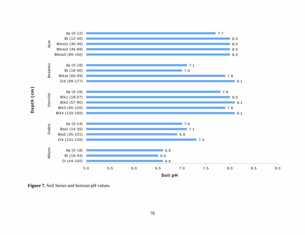
76
Figure 7. Soil Series and horizon pH values.
6.6 6.5
6.6
7.3 6.9
7.1 7.0
8.1 7.9
8.1 8.0
7.8
8.1 7.9
7.0 7.1
8.0 8.0 8.0 8.0
7.7
5.0 5.5 6.0 6.5 7.0 7.5 8.0 8.5 9.0
Cr (44-100)Bt (18-44)Ap (0-18)
Crk (101-120)Bss2 (35-101)Bss1 (14-35)
Ap (0-14)
Btk4 (120-150)Btk3 (90-120)Btk2 (57-90)Btk1 (18-57)
Ap (0-18)
Crk (99-177)Btkss (60-99)
Bt (18-60)Ap (0-18)
Btkss3 (89-150)Btkss2 (46-89)Btkss1 (30-46)
Bt (12-30)Ap (0-12)
Why
teD
iabl
oD
anvi
lleBos
anko
Aya
r
Soil pH
Dep
th (
cm)
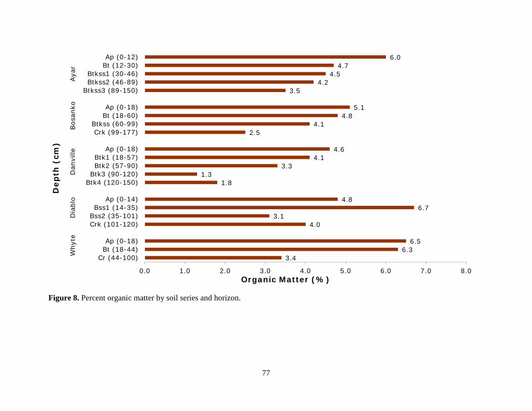
77
Figure 8. Percent organic matter by soil series and horizon.
3.4 6.3
6.5
4.0 3.1
6.7 4.8
1.8 1.3
3.3 4.1
4.6
2.5 4.1
4.8 5.1
3.5 4.2
4.5 4.7
6.0
0.0 1.0 2.0 3.0 4.0 5.0 6.0 7.0 8.0
Cr (44-100)Bt (18-44)Ap (0-18)
Crk (101-120)Bss2 (35-101)Bss1 (14-35)
Ap (0-14)
Btk4 (120-150)Btk3 (90-120)Btk2 (57-90)Btk1 (18-57)
Ap (0-18)
Crk (99-177)Btkss (60-99)
Bt (18-60)Ap (0-18)
Btkss3 (89-150)Btkss2 (46-89)Btkss1 (30-46)
Bt (12-30)Ap (0-12)
Why
teD
iabl
oD
anvi
lleBos
anko
Aya
r
Organic Matter (%)
Dep
th (
cm)
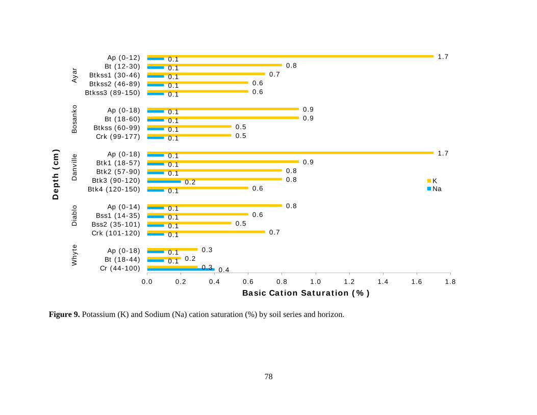
78
Figure 9. Potassium (K) and Sodium (Na) cation saturation (%) by soil series and horizon.
0.4 0.1 0.1
0.1 0.1 0.1 0.1
0.1 0.2
0.1 0.1 0.1
0.1 0.1 0.1 0.1
0.1 0.1 0.1 0.1 0.1
0.3 0.2
0.3
0.7 0.5
0.6 0.8
0.6 0.8 0.8
0.9 1.7
0.5 0.5
0.9 0.9
0.6 0.6
0.7 0.8
1.7
0.0 0.2 0.4 0.6 0.8 1.0 1.2 1.4 1.6 1.8
Cr (44-100)Bt (18-44)Ap (0-18)
Crk (101-120)Bss2 (35-101)Bss1 (14-35)
Ap (0-14)
Btk4 (120-150)Btk3 (90-120)Btk2 (57-90)Btk1 (18-57)
Ap (0-18)
Crk (99-177)Btkss (60-99)
Bt (18-60)Ap (0-18)
Btkss3 (89-150)Btkss2 (46-89)Btkss1 (30-46)
Bt (12-30)Ap (0-12)
Why
teD
iabl
oD
anvi
lleBos
anko
Aya
r
Basic Cation Saturation (%)
Dep
th (
cm)
KNa
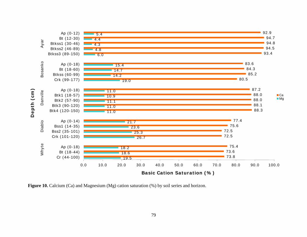
79
Figure 10. Calcium (Ca) and Magnesium (Mg) cation saturation (%) by soil series and horizon.
19.5 18.6 18.2
26.7 25.3
23.6 21.7
11.0 11.0 11.1 10.9 11.0
19.0 14.2 14.7 15.4
6.0 4.8 4.3 4.4 5.4
73.8 73.6
75.4
72.5 72.5
75.6 77.4
88.3 88.1 88.0 88.0
87.2
80.5 85.2
84.3 83.6
93.4 94.5 94.8 94.7
92.9
0.0 10.0 20.0 30.0 40.0 50.0 60.0 70.0 80.0 90.0 100.0
Cr (44-100)Bt (18-44)Ap (0-18)
Crk (101-120)Bss2 (35-101)Bss1 (14-35)
Ap (0-14)
Btk4 (120-150)Btk3 (90-120)Btk2 (57-90)Btk1 (18-57)
Ap (0-18)
Crk (99-177)Btkss (60-99)
Bt (18-60)Ap (0-18)
Btkss3 (89-150)Btkss2 (46-89)Btkss1 (30-46)
Bt (12-30)Ap (0-12)
Why
teD
iabl
oD
anvi
lleBos
anko
Aya
r
Basic Cation Saturation (%)
Dep
th (
cm)
CaMg
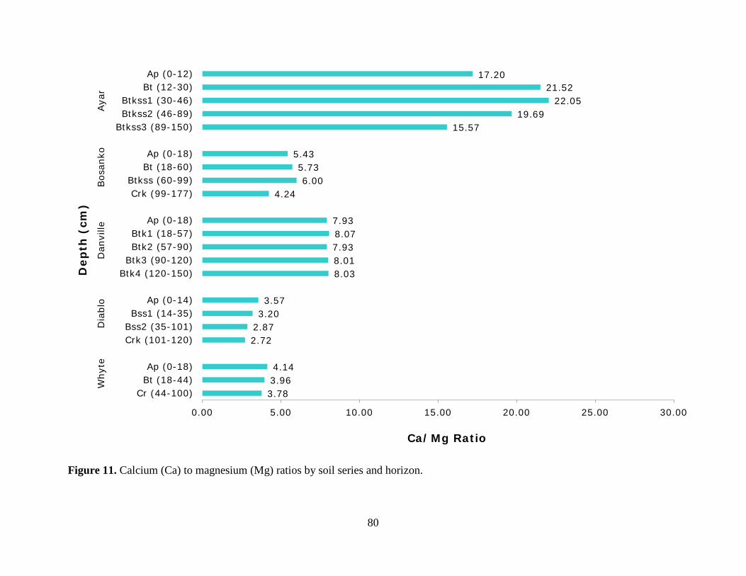
80
Figure 11. Calcium (Ca) to magnesium (Mg) ratios by soil series and horizon.
3.78 3.96 4.14
2.72 2.87 3.20 3.57
8.03 8.01 7.93 8.07 7.93
4.24 6.00
5.73 5.43
15.57 19.69
22.05 21.52
17.20
0.00 5.00 10.00 15.00 20.00 25.00 30.00
Cr (44-100)Bt (18-44)Ap (0-18)
Crk (101-120)Bss2 (35-101)Bss1 (14-35)
Ap (0-14)
Btk4 (120-150)Btk3 (90-120)Btk2 (57-90)Btk1 (18-57)
Ap (0-18)
Crk (99-177)Btkss (60-99)
Bt (18-60)Ap (0-18)
Btkss3 (89-150)Btkss2 (46-89)Btkss1 (30-46)
Bt (12-30)Ap (0-12)
Why
teD
iabl
oD
anvi
lleBos
anko
Aya
r
Ca/Mg Ratio
Dep
th (
cm)
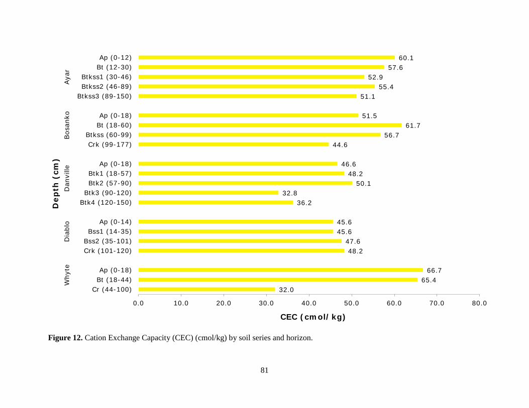
81
Figure 12. Cation Exchange Capacity (CEC) (cmol/kg) by soil series and horizon.
32.0 65.4
66.7
48.2 47.6
45.6 45.6
36.2 32.8
50.1 48.2
46.6
44.6 56.7
61.7 51.5
51.1 55.4
52.9 57.6
60.1
0.0 10.0 20.0 30.0 40.0 50.0 60.0 70.0 80.0
Cr (44-100)Bt (18-44)Ap (0-18)
Crk (101-120)Bss2 (35-101)Bss1 (14-35)
Ap (0-14)
Btk4 (120-150)Btk3 (90-120)Btk2 (57-90)Btk1 (18-57)
Ap (0-18)
Crk (99-177)Btkss (60-99)
Bt (18-60)Ap (0-18)
Btkss3 (89-150)Btkss2 (46-89)Btkss1 (30-46)
Bt (12-30)Ap (0-12)
Why
teD
iabl
oD
anvi
lleBos
anko
Aya
r
CEC (cmol/kg)
Dep
th (
cm)
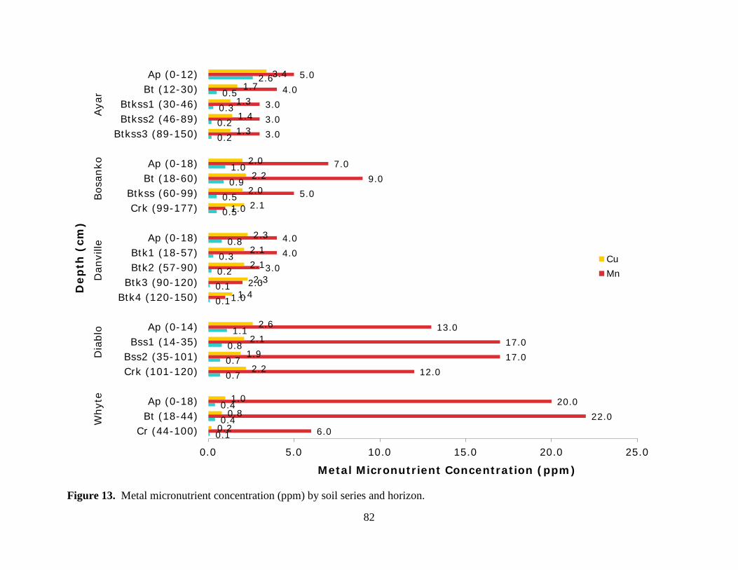
82
Figure 13. Metal micronutrient concentration (ppm) by soil series and horizon.
0.1 0.4 0.4
0.7 0.7 0.8 1.1
0.1 0.1 0.2 0.3
0.8
0.5 0.5
0.9 1.0
0.2 0.2 0.3 0.5
2.6
6.0 22.0
20.0
12.0 17.0 17.0
13.0
1.0 2.0
3.0 4.0 4.0
1.0 5.0
9.0 7.0
3.0 3.0 3.0
4.0 5.0
0.2 0.8 1.0
2.2 1.9 2.1
2.6
1.4 2.3
2.1 2.1 2.3
2.1 2.0 2.2
2.0
1.3 1.4 1.3
1.7 3.4
0.0 5.0 10.0 15.0 20.0 25.0
Cr (44-100)Bt (18-44)Ap (0-18)
Crk (101-120)Bss2 (35-101)Bss1 (14-35)
Ap (0-14)
Btk4 (120-150)Btk3 (90-120)Btk2 (57-90)Btk1 (18-57)
Ap (0-18)
Crk (99-177)Btkss (60-99)
Bt (18-60)Ap (0-18)
Btkss3 (89-150)Btkss2 (46-89)Btkss1 (30-46)
Bt (12-30)Ap (0-12)
Why
teD
iabl
oD
anvi
lleBos
anko
Aya
r
Metal Micronutrient Concentration (ppm)
Dep
th (
cm)
CuMn
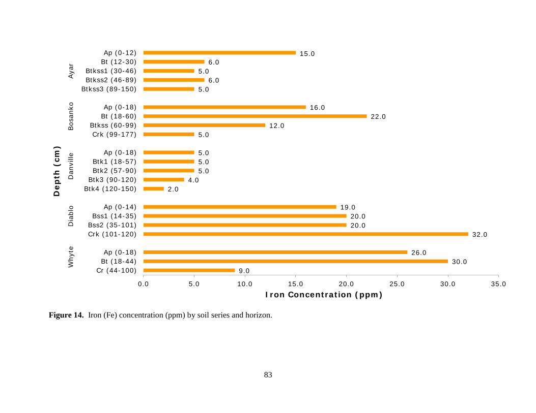
83
Figure 14. Iron (Fe) concentration (ppm) by soil series and horizon.
9.0 30.0
26.0
32.0 20.0 20.0
19.0
2.0 4.0
5.0 5.0 5.0
5.0 12.0
22.0 16.0
5.0 6.0
5.0 6.0
15.0
0.0 5.0 10.0 15.0 20.0 25.0 30.0 35.0
Cr (44-100)Bt (18-44)Ap (0-18)
Crk (101-120)Bss2 (35-101)Bss1 (14-35)
Ap (0-14)
Btk4 (120-150)Btk3 (90-120)Btk2 (57-90)Btk1 (18-57)
Ap (0-18)
Crk (99-177)Btkss (60-99)
Bt (18-60)Ap (0-18)
Btkss3 (89-150)Btkss2 (46-89)Btkss1 (30-46)
Bt (12-30)Ap (0-12)
Why
teD
iabl
oD
anvi
lleBos
anko
Aya
r
Iron Concentration (ppm)
Dep
th (
cm)

84
Figure 15. Nitrate (NO3-) levels (ppm) by soil series and horizon.
2.0 4.0
9.0
2.0 2.0
3.0 8.0
1.0 2.0
1.0 3.0
4.0
6.0 2.0
4.0 9.0
2.0 2.0
3.0 4.0
14.0
0.0 2.0 4.0 6.0 8.0 10.0 12.0 14.0 16.0
Cr (44-100)Bt (18-44)Ap (0-18)
Crk (101-120)Bss2 (35-101)Bss1 (14-35)
Ap (0-14)
Btk4 (120-150)Btk3 (90-120)Btk2 (57-90)Btk1 (18-57)
Ap (0-18)
Crk (99-177)Btkss (60-99)
Bt (18-60)Ap (0-18)
Btkss3 (89-150)Btkss2 (46-89)Btkss1 (30-46)
Bt (12-30)Ap (0-12)
Why
teD
iabl
oD
anvi
lleBos
anko
Aya
r
Nitrate-N (ppm)
Dep
th (
cm)
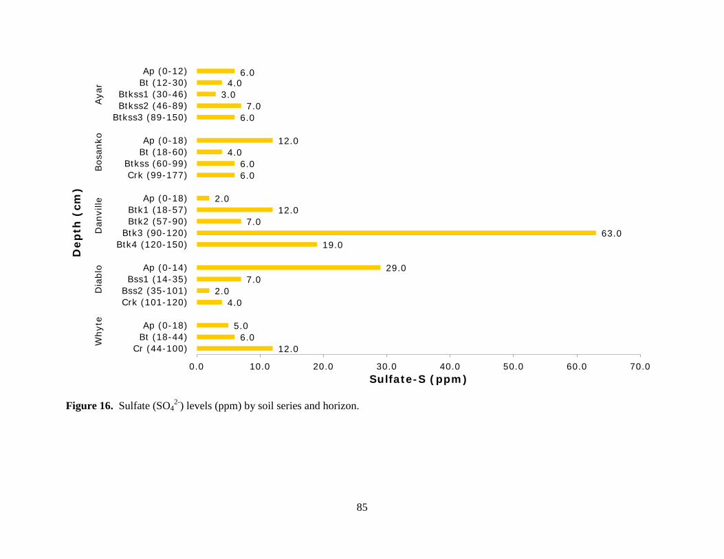
85
Figure 16. Sulfate (SO42-) levels (ppm) by soil series and horizon.
12.0 6.0
5.0
4.0 2.0
7.0 29.0
19.0 63.0
7.0 12.0
2.0
6.0 6.0
4.0 12.0
6.0 7.0
3.0 4.0
6.0
0.0 10.0 20.0 30.0 40.0 50.0 60.0 70.0
Cr (44-100)Bt (18-44)Ap (0-18)
Crk (101-120)Bss2 (35-101)Bss1 (14-35)
Ap (0-14)
Btk4 (120-150)Btk3 (90-120)Btk2 (57-90)Btk1 (18-57)
Ap (0-18)
Crk (99-177)Btkss (60-99)
Bt (18-60)Ap (0-18)
Btkss3 (89-150)Btkss2 (46-89)Btkss1 (30-46)
Bt (12-30)Ap (0-12)
Why
teD
iabl
oD
anvi
lleBos
anko
Aya
r
Sulfate-S (ppm)
Dep
th (
cm)
86
Figure 17. Phosphorus (P) (ppm) levels by soil series and horizon.
2.0 7.0 8.0
9.0 14.0
21.0 26.0
0.0 1.0
0.0 0.0
7.0
1.0 7.0
19.0 18.0
5.0 10.0
19.0 19.0
37.0
7.0 11.0
13.0
13.0 13.0
16.0 28.0
32.0 5.0 5.0
12.0 11.0
11.0 17.0
19.0 30.0
9.0 17.0
68.0 47.0
28.0
0.0 10.0 20.0 30.0 40.0 50.0 60.0 70.0 80.0
Cr (44-100)Bt (18-44)Ap (0-18)
Crk (101-120)Bss2 (35-101)Bss1 (14-35)
Ap (0-14)
Btk4 (120-150)Btk3 (90-120)Btk2 (57-90)Btk1 (18-57)
Ap (0-18)
Crk (99-177)Btkss (60-99)
Bt (18-60)Ap (0-18)
Btkss3 (89-150)Btkss2 (46-89)Btkss1 (30-46)
Bt (12-30)Ap (0-12)
Why
teD
iabl
oD
anvi
lleBos
anko
Aya
r
Soil Phosphorus (ppm)
Dep
th (
cm)
PO4-P NaHCO3
P Weak Bray
87
Figure 18. Potassium (K) (ppm) levels by soil series and horizon.
37.0 54.0
80.0
126.0 97.0
114.0 140.0
81.0 100.0
151.0 174.0
306.0
85.0 115.0
218.0 182.0
117.0 126.0
151.0 190.0
393.0
0.0 50.0 100.0 150.0 200.0 250.0 300.0 350.0 400.0 450.0
Cr (44-100)Bt (18-44)Ap (0-18)
Crk (101-120)Bss2 (35-101)Bss1 (14-35)
Ap (0-14)
Btk4 (120-150)Btk3 (90-120)Btk2 (57-90)Btk1 (18-57)
Ap (0-18)
Crk (99-177)Btkss (60-99)
Bt (18-60)Ap (0-18)
Btkss3 (89-150)Btkss2 (46-89)Btkss1 (30-46)
Bt (12-30)Ap (0-12)
Why
teD
iabl
oD
anvi
lleBos
anko
Aya
r
Soil Potassium (ppm)
Dep
th (
cm)
88
Figure 19. Boron (B) (ppm) levels by soil series and horizon.
0.1 0.1 0.1
0.1 0.1 0.1 0.1
0.1 0.1 0.1 0.1 0.1
0.1 0.1 0.1 0.1
0.1 0.1 0.1 0.1 0.1
0.0 0.0 0.0 0.1 0.1 0.1 0.1
Cr (44-100)Bt (18-44)Ap (0-18)
Crk (101-120)Bss2 (35-101)Bss1 (14-35)
Ap (0-14)
Btk4 (120-150)Btk3 (90-120)Btk2 (57-90)Btk1 (18-57)
Ap (0-18)
Crk (99-177)Btkss (60-99)
Bt (18-60)Ap (0-18)
Btkss3 (89-150)Btkss2 (46-89)Btkss1 (30-46)
Bt (12-30)Ap (0-12)
Why
teD
iabl
oD
anvi
lleBos
anko
Aya
r
Boron Concentration (ppm)
Dep
th (
cm)
89
APPENDIX C: Roles and Deficiency Symptoms of Plant Essential Nutrients
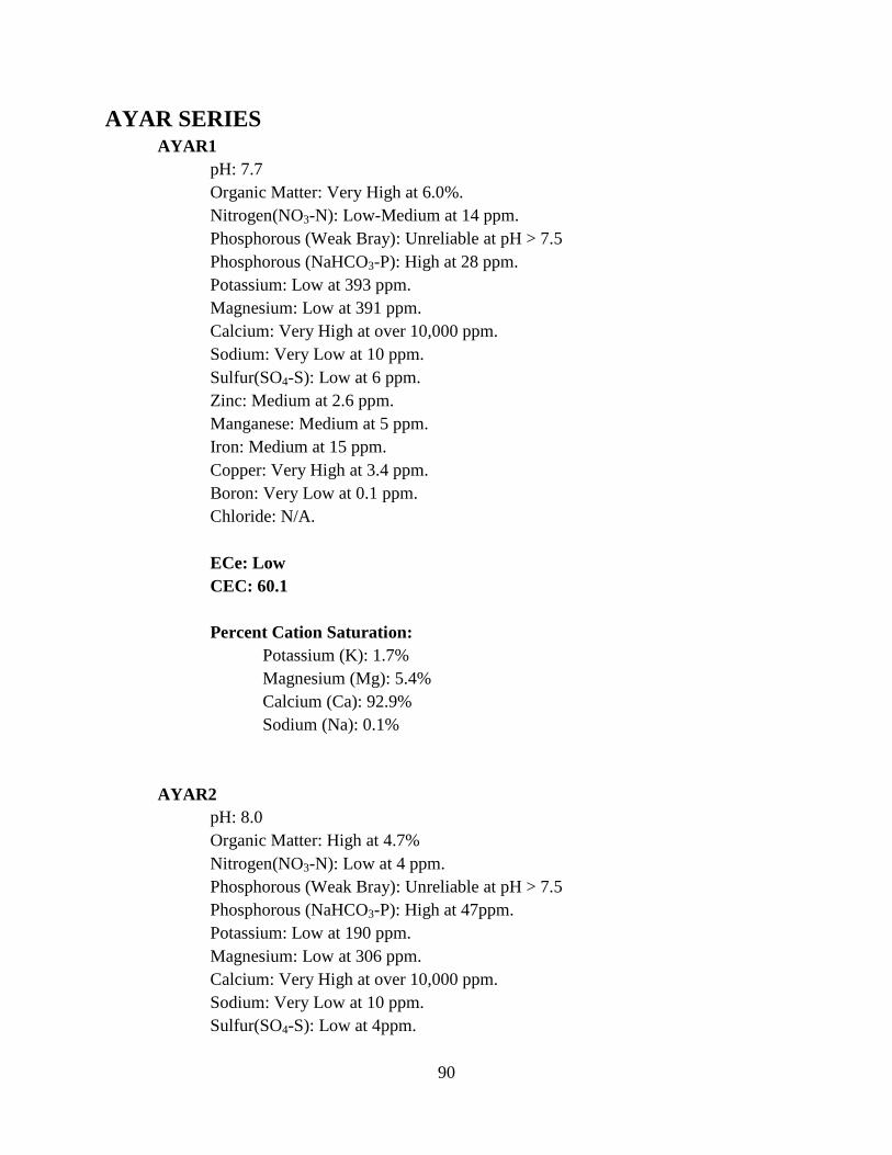
90
AYAR SERIES AYAR1 pH: 7.7 Organic Matter: Very High at 6.0%. Nitrogen(NO3-N): Low-Medium at 14 ppm. Phosphorous (Weak Bray): Unreliable at pH > 7.5 Phosphorous (NaHCO3-P): High at 28 ppm. Potassium: Low at 393 ppm. Magnesium: Low at 391 ppm. Calcium: Very High at over 10,000 ppm. Sodium: Very Low at 10 ppm. Sulfur(SO4-S): Low at 6 ppm. Zinc: Medium at 2.6 ppm. Manganese: Medium at 5 ppm. Iron: Medium at 15 ppm. Copper: Very High at 3.4 ppm. Boron: Very Low at 0.1 ppm. Chloride: N/A. ECe: Low CEC: 60.1 Percent Cation Saturation: Potassium (K): 1.7% Magnesium (Mg): 5.4% Calcium (Ca): 92.9% Sodium (Na): 0.1% AYAR2 pH: 8.0 Organic Matter: High at 4.7% Nitrogen(NO3-N): Low at 4 ppm. Phosphorous (Weak Bray): Unreliable at pH > 7.5 Phosphorous (NaHCO3-P): High at 47ppm. Potassium: Low at 190 ppm. Magnesium: Low at 306 ppm. Calcium: Very High at over 10,000 ppm. Sodium: Very Low at 10 ppm. Sulfur(SO4-S): Low at 4ppm.
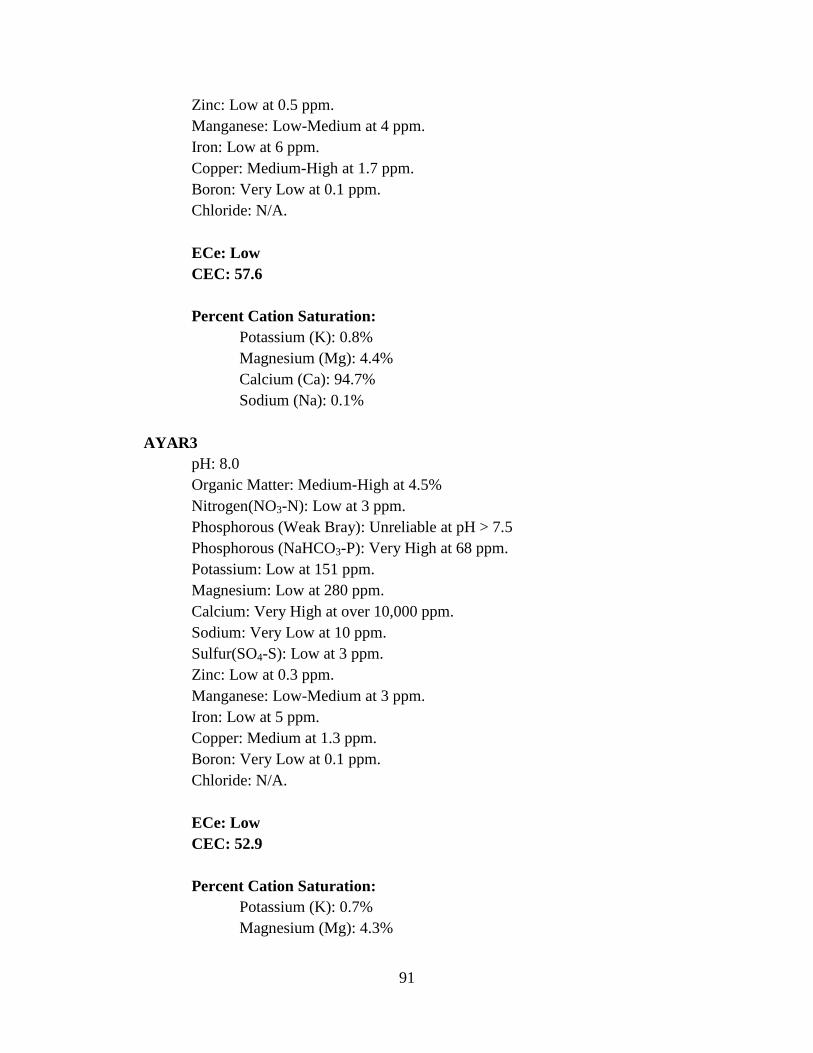
91
Zinc: Low at 0.5 ppm. Manganese: Low-Medium at 4 ppm. Iron: Low at 6 ppm. Copper: Medium-High at 1.7 ppm. Boron: Very Low at 0.1 ppm. Chloride: N/A. ECe: Low CEC: 57.6 Percent Cation Saturation: Potassium (K): 0.8% Magnesium (Mg): 4.4% Calcium (Ca): 94.7% Sodium (Na): 0.1% AYAR3 pH: 8.0 Organic Matter: Medium-High at 4.5% Nitrogen(NO3-N): Low at 3 ppm. Phosphorous (Weak Bray): Unreliable at pH > 7.5 Phosphorous (NaHCO3-P): Very High at 68 ppm. Potassium: Low at 151 ppm. Magnesium: Low at 280 ppm. Calcium: Very High at over 10,000 ppm. Sodium: Very Low at 10 ppm. Sulfur(SO4-S): Low at 3 ppm. Zinc: Low at 0.3 ppm. Manganese: Low-Medium at 3 ppm. Iron: Low at 5 ppm. Copper: Medium at 1.3 ppm. Boron: Very Low at 0.1 ppm. Chloride: N/A. ECe: Low CEC: 52.9 Percent Cation Saturation: Potassium (K): 0.7% Magnesium (Mg): 4.3%
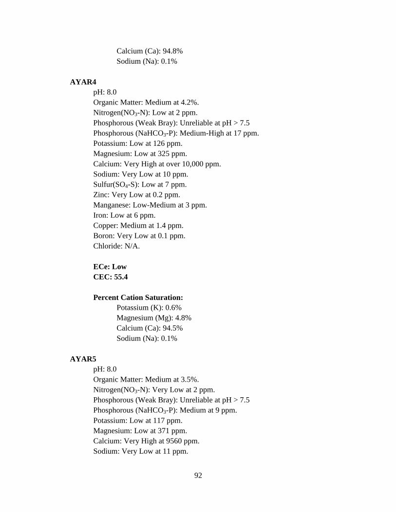
92
Calcium (Ca): 94.8% Sodium (Na): 0.1% AYAR4 pH: 8.0 Organic Matter: Medium at 4.2%. Nitrogen(NO3-N): Low at 2 ppm. Phosphorous (Weak Bray): Unreliable at pH > 7.5 Phosphorous (NaHCO3-P): Medium-High at 17 ppm. Potassium: Low at 126 ppm. Magnesium: Low at 325 ppm. Calcium: Very High at over 10,000 ppm. Sodium: Very Low at 10 ppm. Sulfur(SO4-S): Low at 7 ppm. Zinc: Very Low at 0.2 ppm. Manganese: Low-Medium at 3 ppm. Iron: Low at 6 ppm. Copper: Medium at 1.4 ppm. Boron: Very Low at 0.1 ppm. Chloride: N/A. ECe: Low CEC: 55.4 Percent Cation Saturation: Potassium (K): 0.6% Magnesium (Mg): 4.8% Calcium (Ca): 94.5% Sodium (Na): 0.1% AYAR5 pH: 8.0 Organic Matter: Medium at 3.5%. Nitrogen(NO3-N): Very Low at 2 ppm. Phosphorous (Weak Bray): Unreliable at pH > 7.5 Phosphorous (NaHCO3-P): Medium at 9 ppm. Potassium: Low at 117 ppm. Magnesium: Low at 371 ppm. Calcium: Very High at 9560 ppm. Sodium: Very Low at 11 ppm.
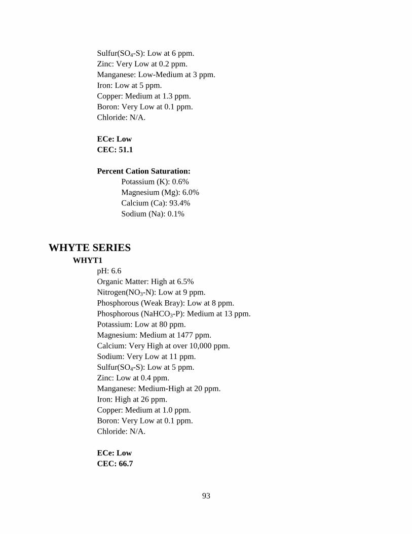
93
Sulfur(SO4-S): Low at 6 ppm. Zinc: Very Low at 0.2 ppm. Manganese: Low-Medium at 3 ppm. Iron: Low at 5 ppm. Copper: Medium at 1.3 ppm. Boron: Very Low at 0.1 ppm. Chloride: N/A. ECe: Low CEC: 51.1 Percent Cation Saturation: Potassium (K): 0.6% Magnesium (Mg): 6.0% Calcium (Ca): 93.4% Sodium (Na): 0.1% WHYTE SERIES WHYT1 pH: 6.6 Organic Matter: High at 6.5% Nitrogen(NO3-N): Low at 9 ppm. Phosphorous (Weak Bray): Low at 8 ppm. Phosphorous (NaHCO3-P): Medium at 13 ppm. Potassium: Low at 80 ppm. Magnesium: Medium at 1477 ppm. Calcium: Very High at over 10,000 ppm. Sodium: Very Low at 11 ppm. Sulfur(SO4-S): Low at 5 ppm. Zinc: Low at 0.4 ppm. Manganese: Medium-High at 20 ppm. Iron: High at 26 ppm. Copper: Medium at 1.0 ppm. Boron: Very Low at 0.1 ppm. Chloride: N/A. ECe: Low CEC: 66.7
94
Percent Cation Saturation: Potassium (K): 0.3% Magnesium (Mg): 18.2% Calcium (Ca): 75.4% Sodium (Na): 0.1% WHYT2 pH: 6.5 Organic Matter: High at 6.3% Nitrogen(NO3-N): Low at 4 ppm. Phosphorous (Weak Bray): Low at 7 ppm. Phosphorous (NaHCO3-P): Low at 11 ppm. Potassium: Very Low at 54 ppm. Magnesium: Medium at 1477 ppm. Calcium: High at 9657 ppm. Sodium: Very Low at 10 ppm. Sulfur(SO4-S): Low at 6 ppm. Zinc: Low at 0.4 ppm. Manganese: Medium-High at 22 ppm. Iron: High at 30 ppm. Copper: Low-Medium at 0.8 ppm. Boron: Very Low at 0.1 ppm. Chloride: N/A. ECe: Low CEC: 65.4 Percent Cation Saturation: Potassium (K): 0.2% Magnesium (Mg): 18.6% Calcium (Ca): 73.6% Sodium (Na): 0.1% WHYT3 pH: 6.6 Organic Matter: Medium at 3.4% Nitrogen(NO3-N): Low at 2 ppm. Phosphorous (Weak Bray): Very Low at 2 ppm. Phosphorous (NaHCO3-P): Low-Medium at 7 ppm.
95
Potassium: Low at 37 ppm. Magnesium: Medium at 760 ppm. Calcium: High at 4727 ppm. Sodium: Very Low at 28 ppm. Sulfur(SO4-S): Low-Medium at 12 ppm. Zinc: Very Low at 0.1 ppm. Manganese: Medium at 6 ppm. Iron: Low at 9 ppm. Copper: Low at 0.2 ppm. Boron: Very Low at 0.1 ppm. Chloride: N/A. ECe: Low CEC: 32.0 Percent Cation Saturation: Potassium (K): 0.3% Magnesium (Mg): 19.5% Calcium (Ca): 73.8% Sodium (Na): 0.4% DANVILLE SERIES DANV1 pH: 7.8 Organic Matter: Medium-High at 4.6% Nitrogen(NO3-N): Low at 4 ppm. Phosphorous (Weak Bray): Unreliable at pH > 7.5 Phosphorous (NaHCO3-P): Medium at 11 ppm. Potassium: Low at 306 pm. Magnesium: Low-Medium at 623 ppm. Calcium: Very High at 8144 ppm. Sodium: Very Low at 11 ppm. Sulfur(SO4-S): Low at 2 ppm. Zinc: Low at 0.8 ppm. Manganese: Medium at 4 ppm. Iron: Low at 5 ppm. Copper: High at 2.3 ppm.
96
Boron: Very Low at 0.1 ppm. Chloride: N/A. ECe: Low CEC: 46.6 Percent Cation Saturation: Potassium (K): 1.7% Magnesium (Mg): 11.0% Calcium (Ca): 87.2% Sodium (Na): 0.1% DANV2 pH: 8.0 Organic Matter: Medium at 4.1% Nitrogen(NO3-N): Low at 3 ppm. Phosphorous (Weak Bray): Unreliable at pH > 7.5 Phosphorous (NaHCO3-P): Medium at 12 ppm. Potassium: Low at 174 ppm. Magnesium: Low-Medium at 642 ppm. Calcium: Very High at 8500 ppm. Sodium: Very Low at 16 ppm. Sulfur(SO4-S): Low-Medium at 12 ppm. Zinc: Low at 0.3 ppm. Manganese: Low-Medium at 4 ppm. Iron: Low at 5 ppm. Copper: High at 2.1 ppm. Boron: Very Low at 0.1 ppm. Chloride: N/A. ECe: Low CEC: 48.2 Percent Cation Saturation: Potassium (K): 0.9% Magnesium (Mg): 10.9% Calcium (Ca): 88.0% Sodium (Na): 0.1% DANV3
97
pH: 8.1 Organic Matter: Medium at 3.3% Nitrogen(NO3-N): Very Low at 1 ppm. Phosphorous (Weak Bray): Unreliable at ph > 7.5 Phosphorous (NaHCO3-P): Low at 5 ppm. Potassium: Low at 151 ppm. Magnesium: Low-Medium at 677 ppm. Calcium: Very High at 8844 ppm. Sodium: Very Low at 11 ppm. Sulfur(SO4-S): Low at 7 ppm. Zinc: Very Low at 0.2 ppm. Manganese: Low-Medium at 3 ppm. Iron: Low at 5 ppm. Copper: High at 2.1 ppm. Boron: Very Low at 0.1 ppm. Chloride: N/A. ECe: Low CEC: 50.1 Percent Cation Saturation: Potassium (K): 0.8% Magnesium (Mg): 11.1% Calcium (Ca): 88.0% Sodium (Na): 0.1% DANV4 pH: 7.9 Organic Matter: Low at 1.3% Nitrogen(NO3-N): Low at 2 ppm. Phosphorous (Weak Bray): Unreliable at pH > 7.5 Phosphorous (NaHCO3-P): Low at 5 ppm. Potassium: Low at 100 ppm. Magnesium: Low-Medium at 440 ppm. Calcium: Very High at 5794 ppm. Sodium: Very Low at 12 ppm. Sulfur(SO4-S): Very High at 63 ppm. Zinc: Very Low at 0.1 ppm. Manganese: Low-Medium at 2 ppm. Iron: Low at 4 ppm.
98
Copper: High at 2.3 ppm. Boron: Very Low at 0.1 ppm. Chloride: N/A. ECe: Low CEC: 32.8 Percent Cation Saturation: Potassium (K): 0.8% Magnesium (Mg): 11.0% Calcium (Ca): 88.1% Sodium (Na): 0.2% DANV5 pH: 8 Organic Matter: Low at 1.8% Nitrogen(NO3-N): Very Low at 1 ppm. Phosphorous (Weak Bray): Unreliable at pH > 7.5 Phosphorous (NaHCO3-P): High at 32 ppm. Potassium: Low at 81 ppm. Magnesium: Low-Medium at 485 ppm. Calcium: Very High at 6411 ppm. Sodium: Very Low at 10 ppm. Sulfur(SO4-S): Medium at 19 ppm. Zinc: Very Low at 0.1 ppm. Manganese: Low at 1 ppm. Iron: Low at 3 ppm. Copper: Medium at 1.4 ppm. Boron: Very Low at 0.1 ppm. Chloride: N/A. ECe: Low CEC: 36.2 Percent Cation Saturation: Potassium (K): 0.6% Magnesium (Mg): 11.0% Calcium (Ca): 88.3% Sodium (Na): 0.1%
99
BOSANKO SERIES BOSA1 pH: 7.1 Organic Matter: High at 5.1% Nitrogen(NO3-N): Low at 9 ppm. Phosphorous (Weak Bray): Unreliable at High Excess Lime Phosphorous (NaHCO3-P): High at 30 ppm. Potassium: Low at 182 ppm. Magnesium: Medium at 966 ppm. Calcium: Very High at 8630 ppm. Sodium: Very Low at 11 ppm. Sulfur(SO4-S): Low-Medium at 12 ppm. Zinc: Low-Medium at 1.0 ppm. Manganese: Medium at 7 ppm. Iron: Medium at 16 ppm. Copper: Medium-High at 2.0 ppm. Boron: Very Low at 0.1 ppm. Chloride: N/A. ECe: Low CEC: 51.5 Percent Cation Saturation: Potassium (K): 0.9% Magnesium (Mg): 15.4% Calcium (Ca): 83.6% Sodium (Na): 0.1% BOSA2 pH: 7.0 Organic Matter: High at 4.8%. Nitrogen(NO3-N): Low at 4 ppm. Phosphorous (Weak Bray): Medium at 19 ppm. Phosphorous (NaHCO3-P): High at 19 ppm. Potassium: Low at 218 ppm. Magnesium: Medium at 1100 ppm. Calcium: Very High at over 10,000 ppm. Sodium: Very Low at 13 ppm. Sulfur(SO4-S): Low at 4 ppm.
100
Zinc: Low at 0.9 ppm. Manganese: Medium at 9 ppm. Iron: High at 22 ppm. Copper: High at 2.2 ppm. Boron: Very Low at 0.1 ppm. Chloride: N/A. ECe: Low CEC: 61.7 Percent Cation Saturation: Potassium (K): 0.9% Magnesium (Mg): 14.7% Calcium (Ca): 84.3% Sodium (Na): 0.1% BOSA3 pH: 7.9 Organic Matter: Medium at 4.1%. Nitrogen(NO3-N): Very Low at 2 ppm. Phosphorous (Weak Bray): Unreliable at pH > 7.5 Phosphorous (NaHCO3-P): Medium-High at 17 ppm. Potassium: Low at 115 ppm. Magnesium: Medium at 979 ppm. Calcium: Very High at 9681 ppm. Sodium: Very Low at 11 ppm. Sulfur(SO4-S): Lo at 6 ppm. Zinc: Low at 0.5 ppm. Manganese: Medium at 5 ppm. Iron: Medium at 12 ppm. Copper: Medium-High at 2.0 ppm. Boron: Very Low at 0.1 ppm. Chloride: N/A. ECe: Low CEC: 56.7 Percent Cation Saturation: Potassium (K): 0.5%
101
Magnesium (Mg): 14.2% Calcium (Ca): 85.2% Sodium (Na): 0.1% BOSA4 pH: 8.1 Organic Matter: Low-Medium at 2.5% Nitrogen(NO3-N): Low at 6 ppm. Phosphorous (Weak Bray): Unreliable at pH > 7.5 Phosphorous (NaHCO3-P): Medium at 11 ppm. Potassium: Low at 85 ppm. Magnesium: Medium at 1029 ppm. Calcium: High at 7194 ppm. Sodium: Very Low at 10 ppm. Sulfur(SO4-S): Low at 6 ppm. Zinc: Low at 0.5 ppm. Manganese: Low at 1 ppm. Iron: Low at 5 ppm. Copper: High at 2.1 ppm. Boron: Very Low at 0.1 ppm. Chloride: N/A. ECe: Low CEC: 44.6 Percent Cation Saturation: Potassium (K): 0.5% Magnesium (Mg): 19.0% Calcium (Ca): 80.5% Sodium (Na): 0.1% CROPLEY SERIES CROP1 pH: 7.8 Organic Matter: High at 5.5%. Nitrogen(NO3-N): Low at 10 ppm. Phosphorous (Weak Bray): Unreliable at pH > 7.5 Phosphorous (NaHCO3-P): HIgh at 35 ppm. Potassium: Low-Medium at 404 ppm.
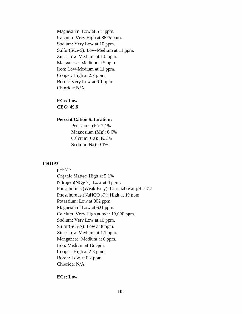
102
Magnesium: Low at 518 ppm. Calcium: Very High at 8875 ppm. Sodium: Very Low at 10 ppm. Sulfur(SO4-S): Low-Medium at 11 ppm. Zinc: Low-Medium at 1.0 ppm. Manganese: Medium at 5 ppm. Iron: Low-Medium at 11 ppm. Copper: High at 2.7 ppm. Boron: Very Low at 0.1 ppm. Chloride: N/A. ECe: Low CEC: 49.6 Percent Cation Saturation: Potassium (K): 2.1% Magnesium (Mg): 8.6% Calcium (Ca): 89.2% Sodium (Na): 0.1% CROP2 pH: 7.7 Organic Matter: High at 5.1% Nitrogen(NO3-N): Low at 4 ppm. Phosphorous (Weak Bray): Unreliable at pH > 7.5 Phosphorous (NaHCO3-P): High at 19 ppm. Potassium: Low at 302 ppm. Magnesium: Low at 621 ppm. Calcium: Very High at over 10,000 ppm. Sodium: Very Low at 10 ppm. Sulfur(SO4-S): Low at 8 ppm. Zinc: Low-Medium at 1.1 ppm. Manganese: Medium at 6 ppm. Iron: Medium at 16 ppm. Copper: High at 2.8 ppm. Boron: Low at 0.2 ppm. Chloride: N/A. ECe: Low
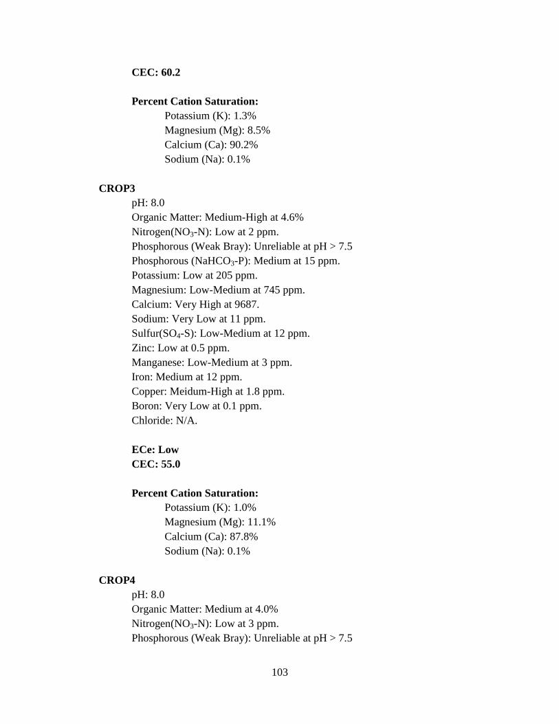
103
CEC: 60.2 Percent Cation Saturation: Potassium (K): 1.3% Magnesium (Mg): 8.5% Calcium (Ca): 90.2% Sodium (Na): 0.1% CROP3 pH: 8.0 Organic Matter: Medium-High at 4.6% Nitrogen(NO3-N): Low at 2 ppm. Phosphorous (Weak Bray): Unreliable at pH > 7.5 Phosphorous (NaHCO3-P): Medium at 15 ppm. Potassium: Low at 205 ppm. Magnesium: Low-Medium at 745 ppm. Calcium: Very High at 9687. Sodium: Very Low at 11 ppm. Sulfur(SO4-S): Low-Medium at 12 ppm. Zinc: Low at 0.5 ppm. Manganese: Low-Medium at 3 ppm. Iron: Medium at 12 ppm. Copper: Meidum-High at 1.8 ppm. Boron: Very Low at 0.1 ppm. Chloride: N/A. ECe: Low CEC: 55.0 Percent Cation Saturation: Potassium (K): 1.0% Magnesium (Mg): 11.1% Calcium (Ca): 87.8% Sodium (Na): 0.1% CROP4 pH: 8.0 Organic Matter: Medium at 4.0% Nitrogen(NO3-N): Low at 3 ppm. Phosphorous (Weak Bray): Unreliable at pH > 7.5
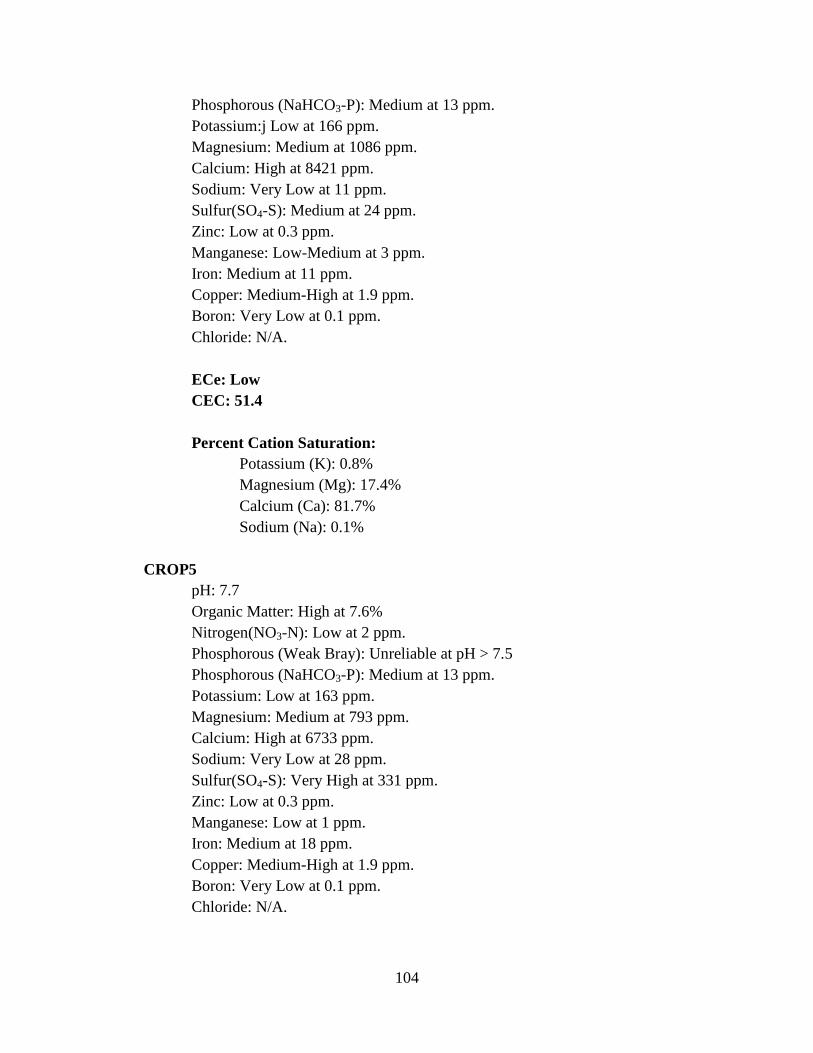
104
Phosphorous (NaHCO3-P): Medium at 13 ppm. Potassium:j Low at 166 ppm. Magnesium: Medium at 1086 ppm. Calcium: High at 8421 ppm. Sodium: Very Low at 11 ppm. Sulfur(SO4-S): Medium at 24 ppm. Zinc: Low at 0.3 ppm. Manganese: Low-Medium at 3 ppm. Iron: Medium at 11 ppm. Copper: Medium-High at 1.9 ppm. Boron: Very Low at 0.1 ppm. Chloride: N/A. ECe: Low CEC: 51.4 Percent Cation Saturation: Potassium (K): 0.8% Magnesium (Mg): 17.4% Calcium (Ca): 81.7% Sodium (Na): 0.1% CROP5 pH: 7.7 Organic Matter: High at 7.6% Nitrogen(NO3-N): Low at 2 ppm. Phosphorous (Weak Bray): Unreliable at pH > 7.5 Phosphorous (NaHCO3-P): Medium at 13 ppm. Potassium: Low at 163 ppm. Magnesium: Medium at 793 ppm. Calcium: High at 6733 ppm. Sodium: Very Low at 28 ppm. Sulfur(SO4-S): Very High at 331 ppm. Zinc: Low at 0.3 ppm. Manganese: Low at 1 ppm. Iron: Medium at 18 ppm. Copper: Medium-High at 1.9 ppm. Boron: Very Low at 0.1 ppm. Chloride: N/A.
105
ECe: Low CEC: 40.7 Percent Cation Saturation: Potassium (K): 1.0% Magnesium (Mg): 16.0% Calcium (Ca): 82.6% Sodium (Na): 0.3% DIABLO SERIES DIAB1 pH: 7.0 Organic Matter: High at 4.8% Nitrogen(NO3-N): Low at 8 ppm. Phosphorous (Weak Bray): Medium at 26 ppm. Phosphorous (NaHCO3-P): High at 28 ppm. Potassium: Low at 140 ppm. Magnesium: Medium-High at 1206 ppm. Calcium: High at 7072 ppm. Sodium: Very Low at 10 ppm. Sulfur(SO4-S): Medium-High at 29 ppm. Zinc: Low-Medium at 1.1 ppm. Manganese: Medium at 13 ppm. Iron: Medium-High at 19 ppm. Copper: High at 2.6 ppm. Boron: Very Low at 0.1 ppm. Chloride: N/A. ECe: Low CEC: 45.6 Percent Cation Saturation: Potassium (K): 0.8% Magnesium (Mg): 21.7% Calcium (Ca): 77.4% Sodium (Na): 0.1% DIAB2 pH: 7.1
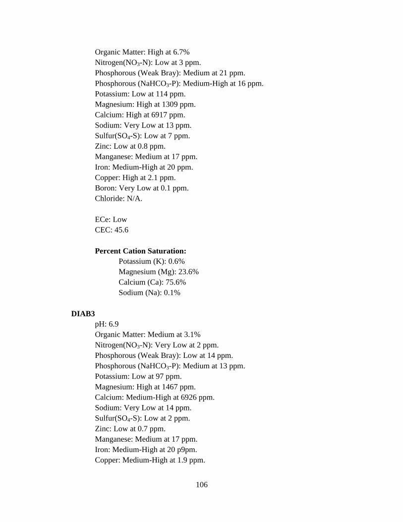
106
Organic Matter: High at 6.7% Nitrogen(NO3-N): Low at 3 ppm. Phosphorous (Weak Bray): Medium at 21 ppm. Phosphorous (NaHCO3-P): Medium-High at 16 ppm. Potassium: Low at 114 ppm. Magnesium: High at 1309 ppm. Calcium: High at 6917 ppm. Sodium: Very Low at 13 ppm. Sulfur(SO4-S): Low at 7 ppm. Zinc: Low at 0.8 ppm. Manganese: Medium at 17 ppm. Iron: Medium-High at 20 ppm. Copper: High at 2.1 ppm. Boron: Very Low at 0.1 ppm. Chloride: N/A. ECe: Low CEC: 45.6 Percent Cation Saturation: Potassium (K): 0.6% Magnesium (Mg): 23.6% Calcium (Ca): 75.6% Sodium (Na): 0.1% DIAB3 pH: 6.9 Organic Matter: Medium at 3.1% Nitrogen(NO3-N): Very Low at 2 ppm. Phosphorous (Weak Bray): Low at 14 ppm. Phosphorous (NaHCO3-P): Medium at 13 ppm. Potassium: Low at 97 ppm. Magnesium: High at 1467 ppm. Calcium: Medium-High at 6926 ppm. Sodium: Very Low at 14 ppm. Sulfur(SO4-S): Low at 2 ppm. Zinc: Low at 0.7 ppm. Manganese: Medium at 17 ppm. Iron: Medium-High at 20 p9pm. Copper: Medium-High at 1.9 ppm.
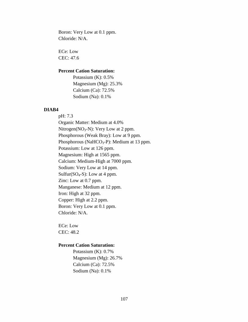
107
Boron: Very Low at 0.1 ppm. Chloride: N/A. ECe: Low CEC: 47.6 Percent Cation Saturation: Potassium (K): 0.5% Magnesium (Mg): 25.3% Calcium (Ca): 72.5% Sodium (Na): 0.1% DIAB4 pH: 7.3 Organic Matter: Medium at 4.0% Nitrogen(NO3-N): Very Low at 2 ppm. Phosphorous (Weak Bray): Low at 9 ppm. Phosphorous (NaHCO3-P): Medium at 13 ppm. Potassium: Low at 126 ppm. Magnesium: High at 1565 ppm. Calcium: Medium-High at 7000 ppm. Sodium: Very Low at 14 ppm. Sulfur(SO4-S): Low at 4 ppm. Zinc: Low at 0.7 ppm. Manganese: Medium at 12 ppm. Iron: High at 32 ppm. Copper: High at 2.2 ppm. Boron: Very Low at 0.1 ppm. Chloride: N/A. ECe: Low CEC: 48.2 Percent Cation Saturation: Potassium (K): 0.7% Magnesium (Mg): 26.7% Calcium (Ca): 72.5% Sodium (Na): 0.1%
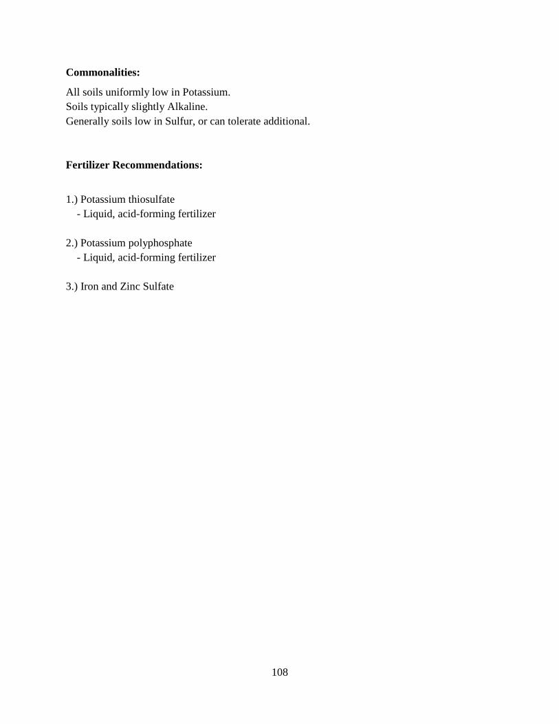
108
Commonalities:
All soils uniformly low in Potassium. Soils typically slightly Alkaline. Generally soils low in Sulfur, or can tolerate additional.
Fertilizer Recommendations:
1.) Potassium thiosulfate - Liquid, acid-forming fertilizer 2.) Potassium polyphosphate - Liquid, acid-forming fertilizer 3.) Iron and Zinc Sulfate
109
APENDIX D: A & L Laboratory Soil Data

110
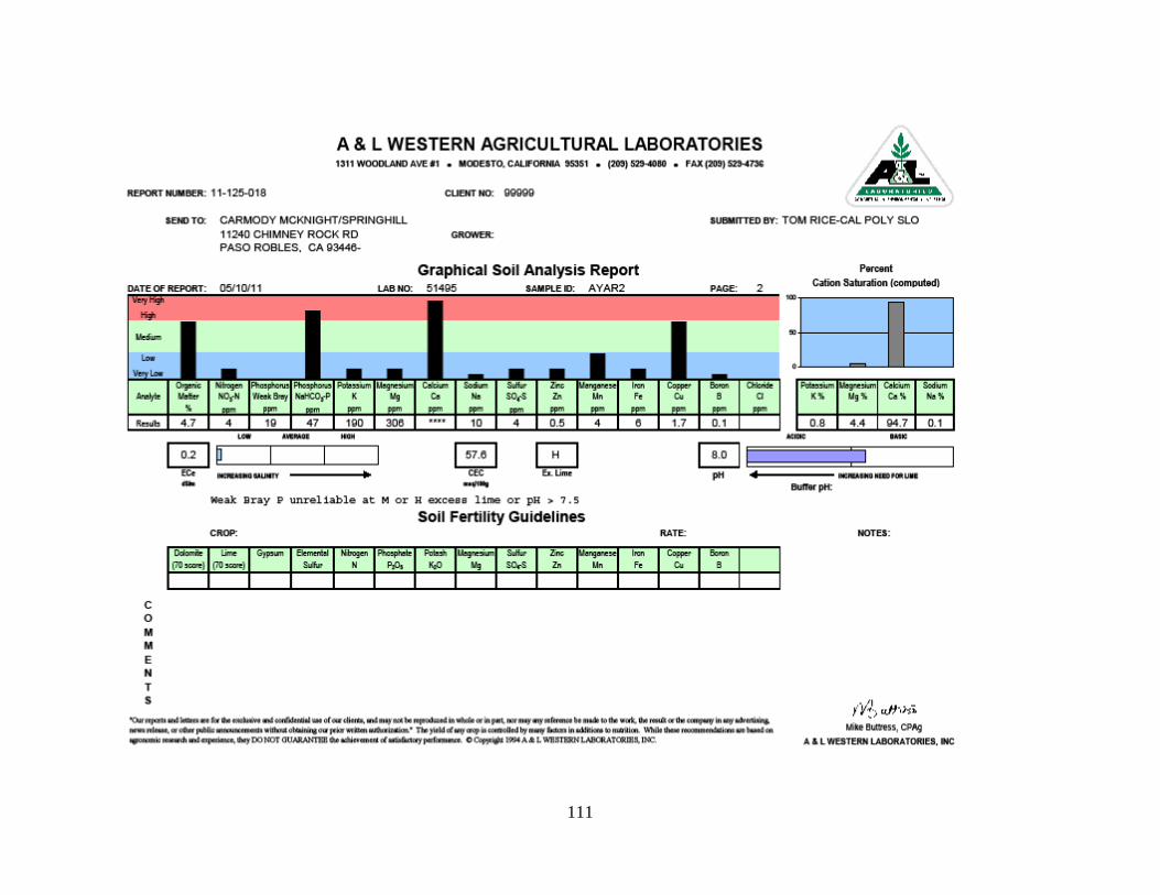
111

112

113
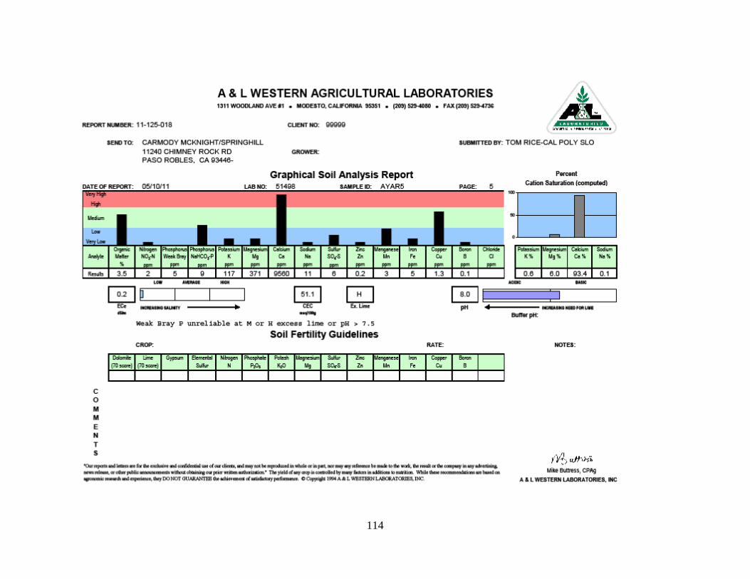
114
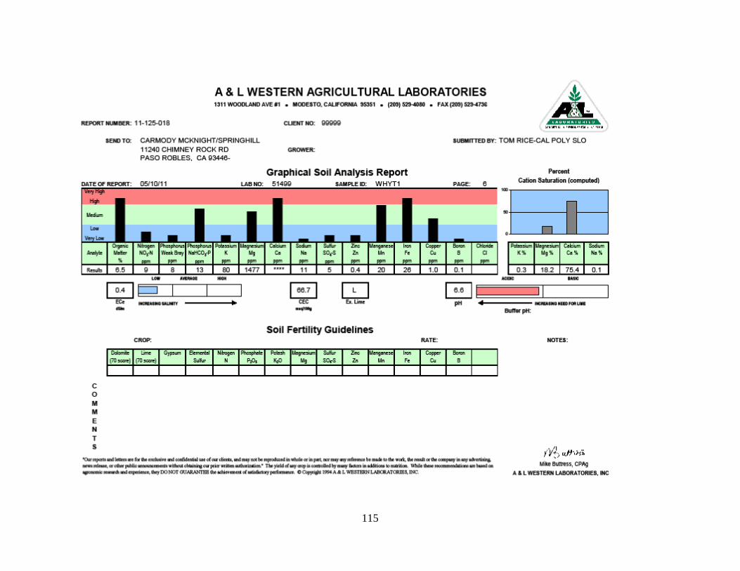
115
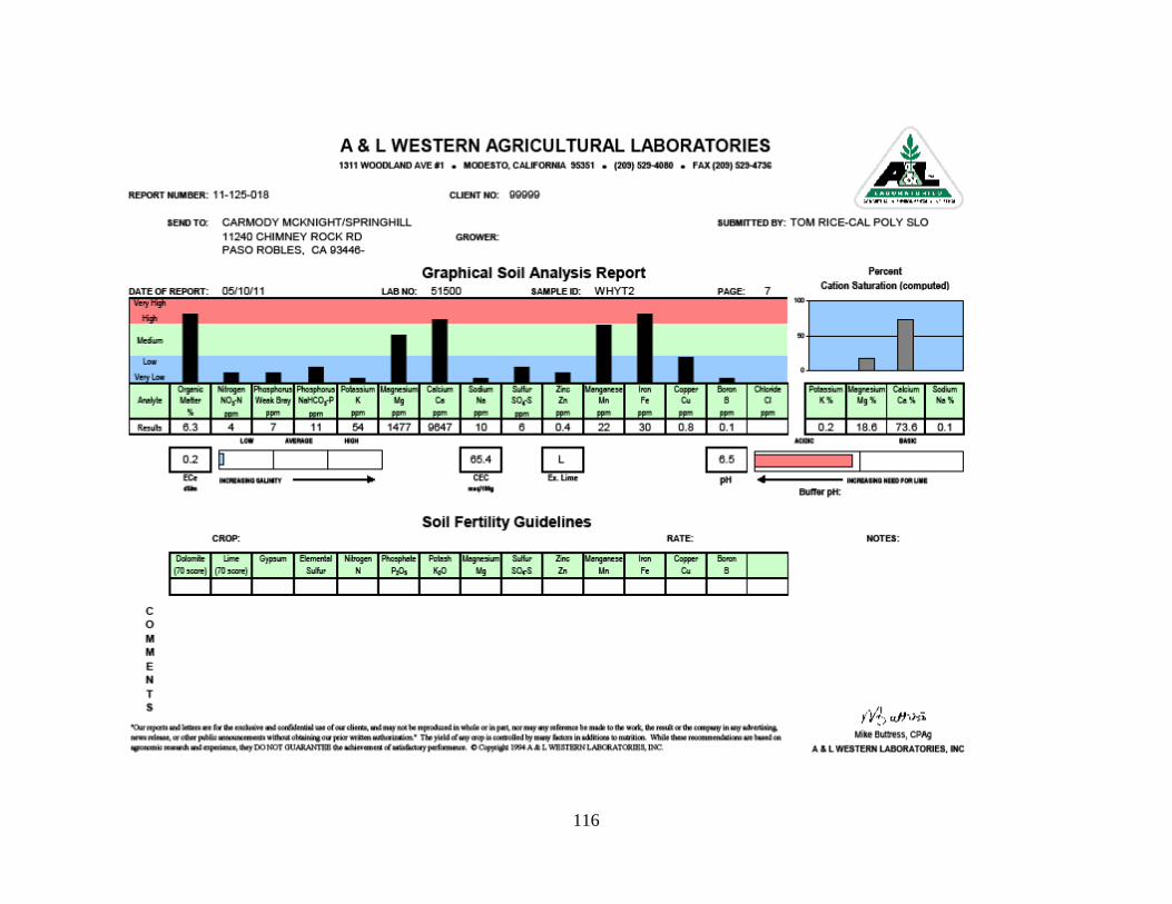
116
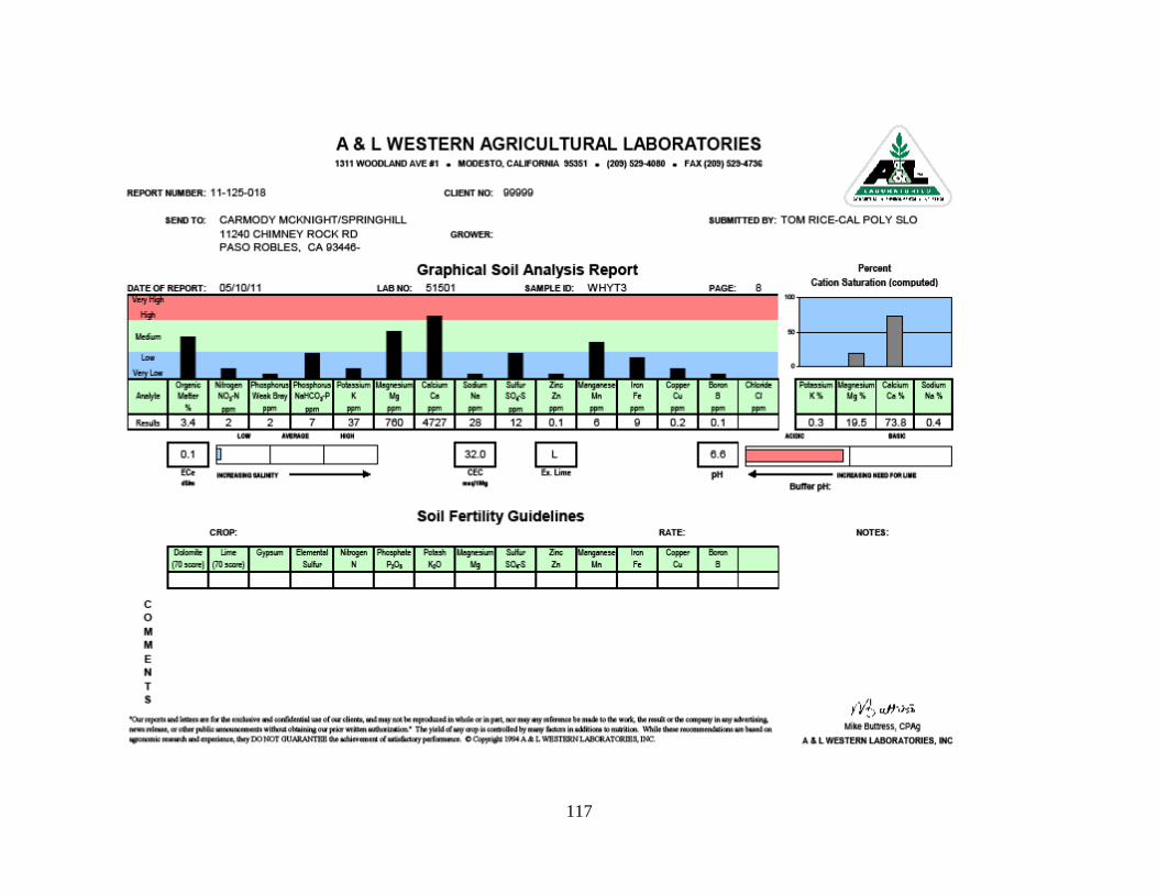
117

118

119

120
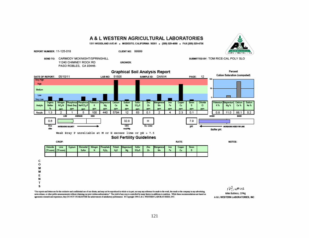
121

122
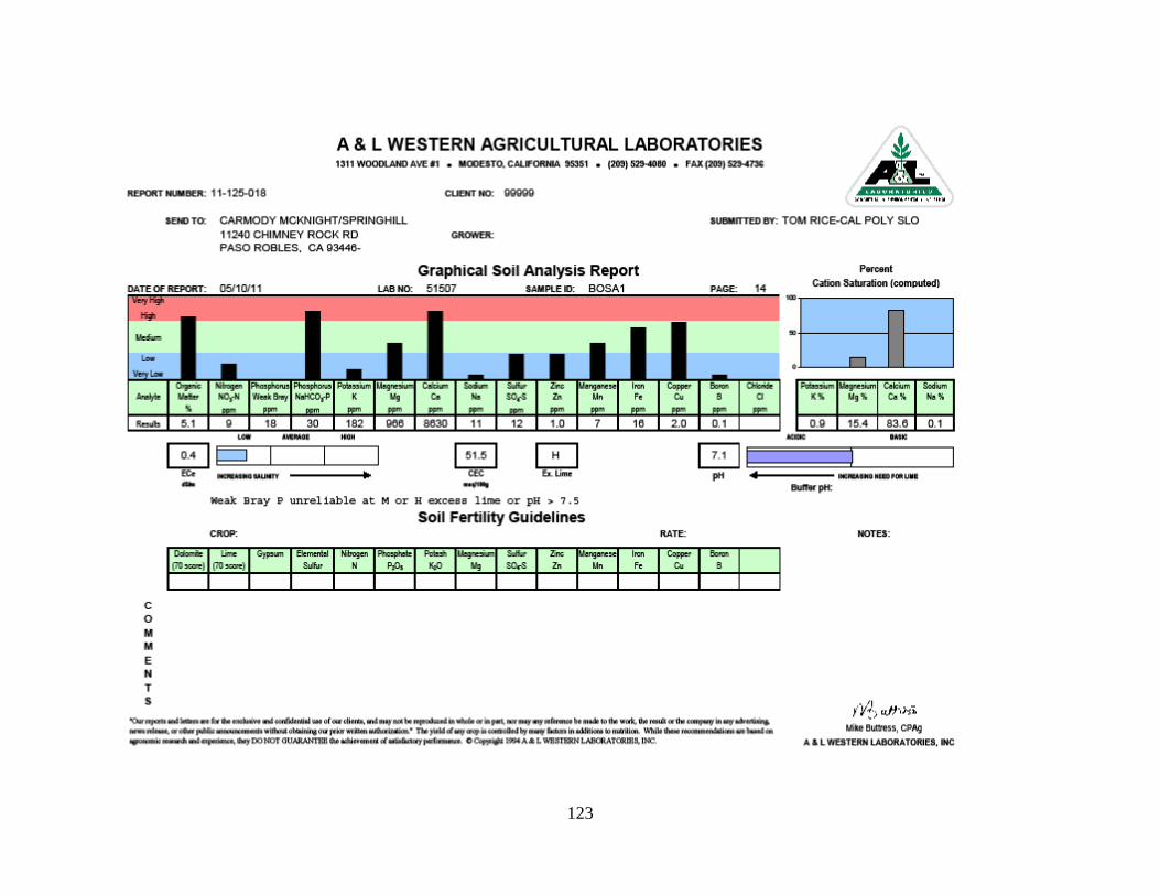
123
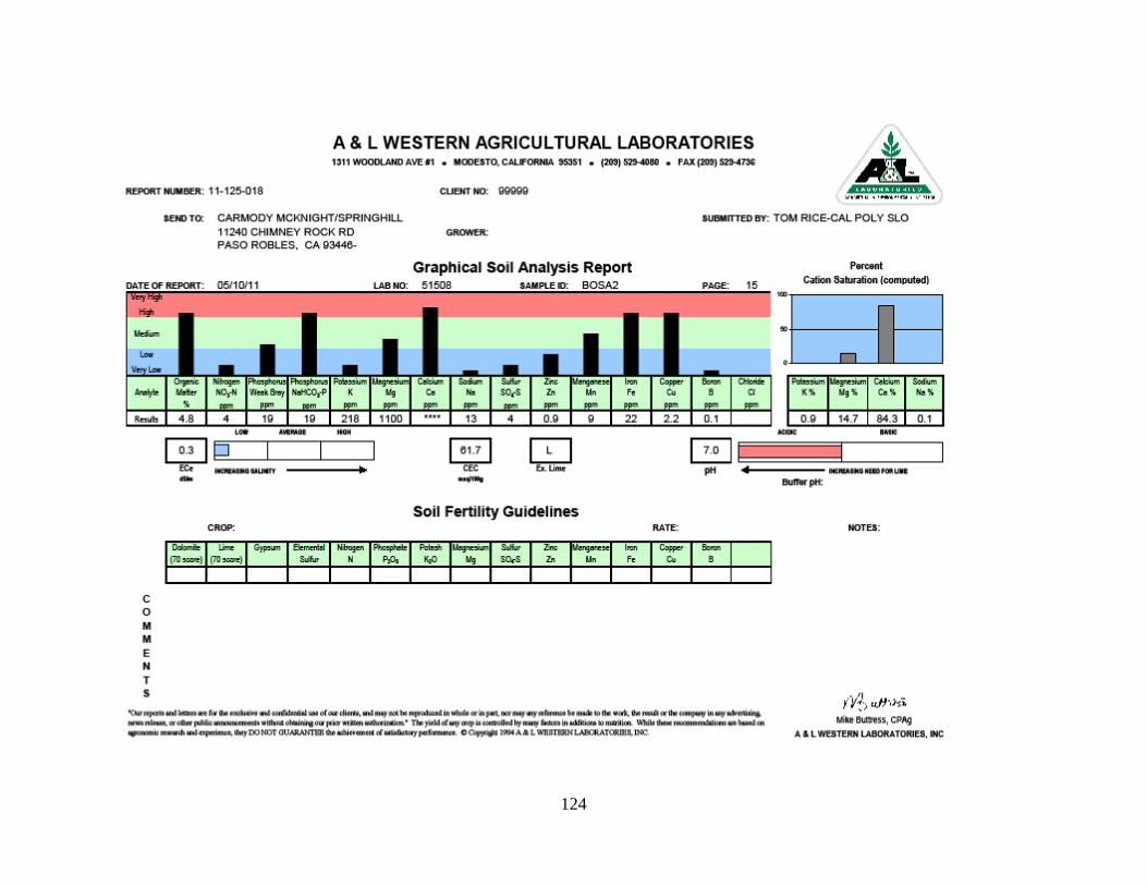
124
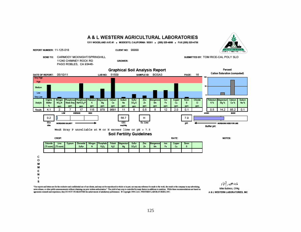
125

126
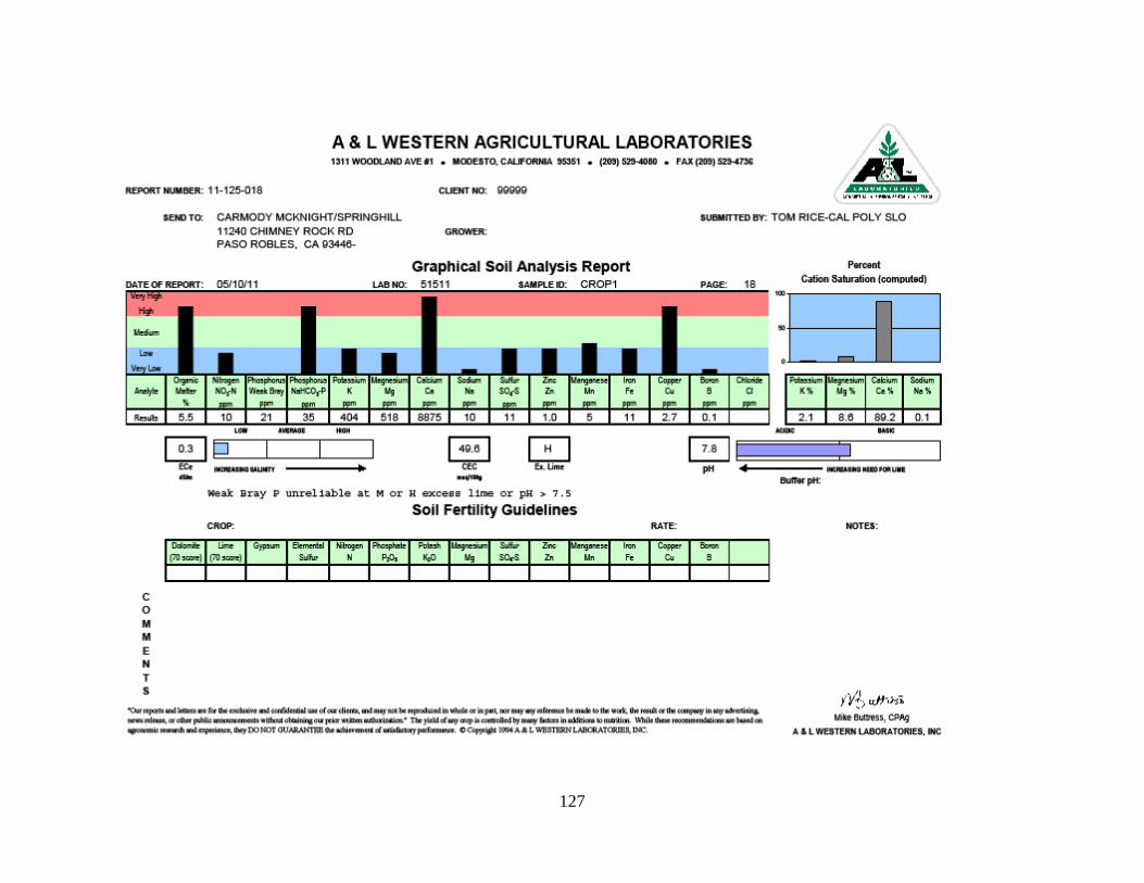
127

128

129
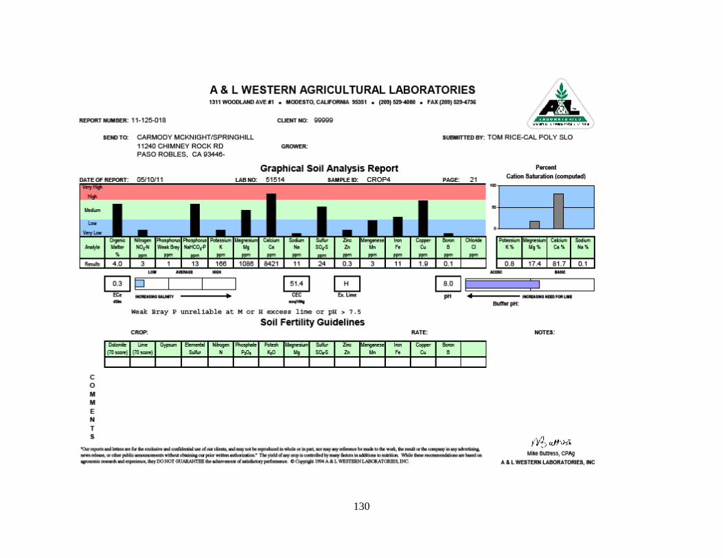
130
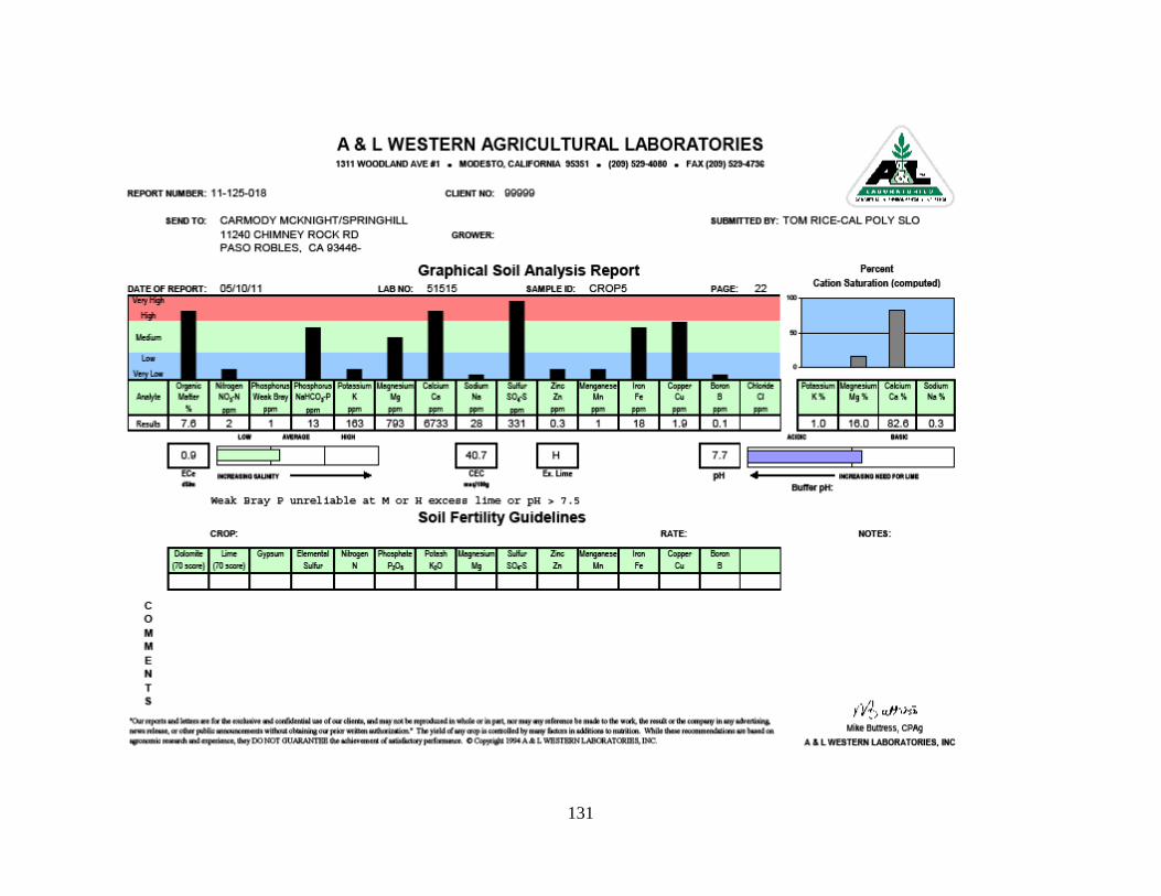
131
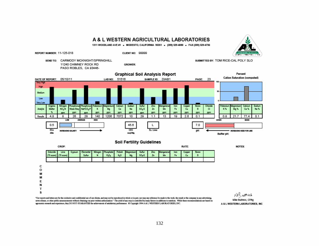
132
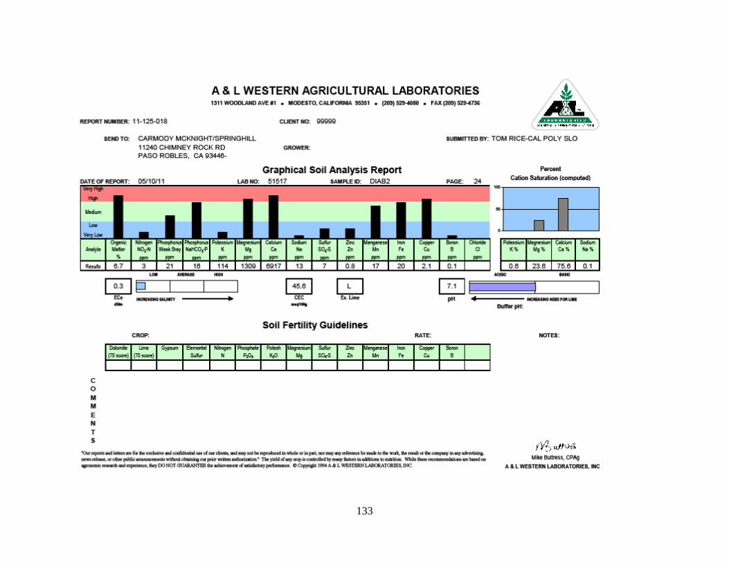
133
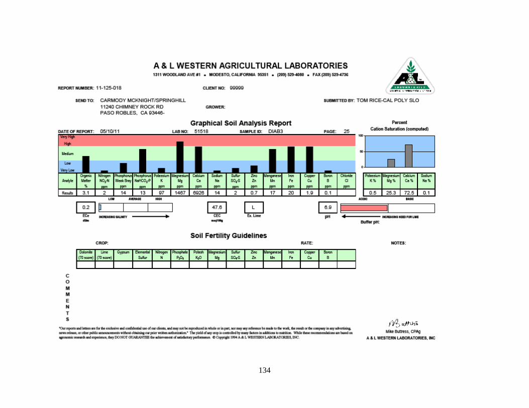
134
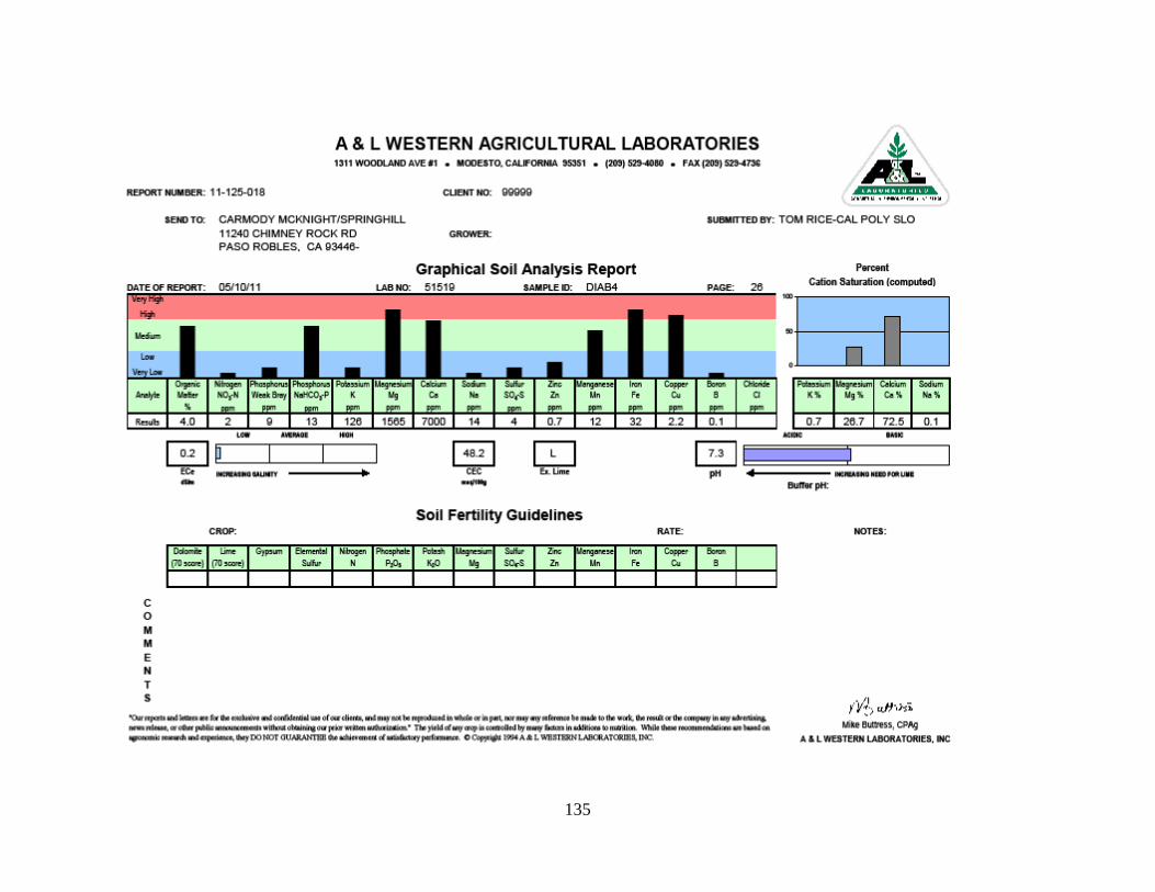
135


![2016-12-16 R v Carmody [2016] ACTSC 382€¦ · Web viewTitle: 2016-12-16 R v Carmody [2016] ACTSC 382 Created Date: 1/11/2017 12:45:00 AM Other titles: 2016-12-16 R v Carmody [2016]](https://img.pdfslide.net/doc/110x75/5ebd9d95f373de5c8f66f5e8/2016-12-16-r-v-carmody-2016-actsc-382-web-view-title-2016-12-16-r-v-carmody-2016.jpg)