Embed Size (px)
Citation preview
SD2002-03-F
South Dakota Rural ITS Architecture
Study SD2002-03Final Report
Prepared byConsensus Systems Technologies CorpPOB 517, 17 Miller Avenue Shenorock, NY 10587-0517 February 2003
South DakotaDepartment of TransportationOffice of Research
Connecting South Dakota and the Nation
DISCLAIMER
The contents of this report reflect the views of the authors who are responsible for the facts andaccuracy of the data presented herein. The contents do not necessarily reflect the official views orpolicies of the South Dakota Department of Transportation, the State Transportation Commission,or the Federal Highway Administration. This report does not constitute a standard, specification,or regulation.
ACKNOWLEDGEMENTS
This work was performed under the supervision of the SD2002-03 Technical Panel:
Greg Aalberg........................................................... Sioux Falls AreaJon Becker............................................................... Office of ResearchJana De Yong.......................................................... BITSergeant Noel Gabriel............................................. Highway PatrolCraig Genzlinger..................................................... Federal Highway AdministrationBruce Hunt.............................................................. Federal Highway AdministrationDan Martell ............................................................. Road DesignHal Rumpca ............................................................ Office of ResearchKevin Smith ............................................................ City of Sioux FallsMike Young .................................................. Operations SupportKevin Smith ............................................................ City of Sioux Falls
The work was performed in cooperation with the United States Department ofTransportation Federal Highway Administration.
TECHNICAL REPORT STANDARD TITLE PAGE
1. Report No.
SD2002-03-12. Government Accession No. 3. Recipient's Catalog No.
4. Title and Subtitle
South Dakota Rural ITS ArchitectureFinal Report
5. Report Date
February 25, 2003
6. Performing Organization Code
7. Author(s)
Robert S. Jaffe, Ph.D.Bruce Eisenhart
8. Performing Organization Report No.
9. Performing Organization Name and Address
Consensus Systems TechnologiesPOB 517, 17 Miller Avenue Shenorock, NY 10587-0517
10. Work Unit No.
11. Contract or Grant No.
SDDOT Contract Number
12. Sponsoring Agency Name and Address
South Dakota Department of Transportation Office of Research 700 East Broadway Avenue Pierre, SD 57501-2586
13. Type of Report and Period Covered
Final ReportMarch 2002 to January2003
14. Sponsoring Agency Code
15. Supplementary Notes
16. Abstract
A statewide ITS (Intelligent Transportation System) architecture was developed for SouthDakota conforming to FHWA Rule 940 and corresponding FTA policy. Following aliterature review to identify the ITS architecture of existing projects and ITS projectinvestments in neighboring states, a series of stakeholder workshops were held, and aconsensus based ITS architecture was developed responsive to the requirementsarticulated by the stakeholders. This ITS architecture was documented using the defactostandard for ITS architecture: Turbo Architecture V2, and was additionally documentedon a website for broad dissemination as a tool for stakeholder review. Finally, aninstitutional and technical methodology for maintaining the ITS architecture is included inthis report. A Users Guide to the Turbo Architecture Extensions that were developed toprepare the website documentation is also included here, so that South Dakota DOT staffor their consultants can maintain this ITS architecture in the future.17. Keywords
ITS, Architecture, Statewide, Standards.18. Distribution Statement
No restrictions. This document is availableto the public from the sponsoring agency.
19. Security Classification (of this report)
Unclassified20. Security Classification (of this page)
Unclassified21. No. of Pages
17322. Price
SD2002-3 Page ii
Table of Contents
.............................................................................................................................. i1. Executive Summary ................................................................................................................ 1
1.1. Research Objective ................................................................................................. 11.2. Research Approach ................................................................................................. 11.3. Findings................................................................................................................... 21.4. Recommendations................................................................................................... 9
1.4.1. Using the Statewide ITS Architecture ........................................................ 91.4.2. Maintaining the Statewide ITS Architecture ............................................ 121.4.3. Maintenance Responsibility...................................................................... 131.4.4. Architecture Baseline................................................................................ 131.4.5. Configuration Control............................................................................... 14
2. Problem Description.............................................................................................................. 173. Objective ............................................................................................................................... 184. Task Descriptions ................................................................................................................. 185. Findings ................................................................................................................................ 20
5.1. Introduction........................................................................................................... 205.2. ITS Architecture Development Process................................................................ 22
5.2.1. Process used to create the ITS architecture............................................... 225.2.2. Requirements of the Final FHWA Rule and FTA Policy on Architecture24
5.3. Identification of Region and Stakeholders............................................................ 255.3.1. Description of the Region ......................................................................... 25
5.3.1.1 Background ............................................................................................... 255.3.1.2 Geographic Extent .................................................................................... 265.3.1.3 Temporal Extent........................................................................................ 265.3.1.4 Service Scope in the ITS Architecture...................................................... 265.3.1.5 Communications Type Scope in the ITS Architecture ............................. 27
5.3.2 Regional Stakeholders .............................................................................. 275.4. Operational Concept ............................................................................................. 295.5. Inventory............................................................................................................... 32
5.5.1. Systems by Stakeholder ............................................................................ 335.5.2. Systems by Architecture Entity ................................................................ 47
5.6. Transportation Services ........................................................................................ 525.7. Interfaces and Information Exchanges.................................................................. 61
5.7.1. Top Level Regional System Interconnect Diagram.................................. 615.7.2. Customized Market Packages ................................................................... 645.7.3. Regional Architecture Information Flows ................................................ 65
5.8. Functional Requirements ...................................................................................... 665.9. Standards............................................................................................................... 685.10. Project Sequencing............................................................................................ 745.11. Agreements ....................................................................................................... 90
SD2002-3 Page iii
6. Implementation Recommendations ...................................................................................... 916.1. Using the Statewide ITS Architecture .................................................................. 916.2. Maintaining the Statewide ITS Architecture ........................................................ 94
6.2.1. Maintenance Responsibility...................................................................... 956.2.2. Architecture Baseline................................................................................ 956.2.3. Configuration Control............................................................................... 96
6.3. Recommendations Summary ................................................................................ 987. ITS Architecture Literature Search........................................................................................ 98Appendix A: Comments and Disposition ....................................................................... 104Appendix B: Customized Market Packages ................................................................... 113Appendix C: Architecture Interfaces .............................................................................. 133Appendix D: Functional Requirements .......................................................................... 151Appendix E: Users Guide to Extending the Architecture............................................... 1591. Guide to the Regional ITS Architecture Software Suite...................................................... 162
1.1. Turbo Architecture.............................................................................................. 1621.2. Turbo Extensions ................................................................................................ 163
1.2.1. Installation............................................................................................... 1631.2.2. Starting Turbo Extensions....................................................................... 1641.2.3. Using the Application ............................................................................. 165
1.2.3.1 Architecture Development Tab............................................................... 1661.2.3.2 Web Publication Tab............................................................................... 169
SD2002-3 Page iv
FiguresFigure 1 Sample Customized Market Package ................................................................... 8Figure 2 Sample Interface definition .................................................................................. 9Figure 3: South Dakota Statewide and CVISN ITS Architecture System Interconnect
Diagram..................................................................................................................... 63Figure 4: Example Customized Market Package............................................................. 64Figure 5: Example of Architecture Flows Between Elements.......................................... 66Figure 6: Example of Interface ......................................................................................... 73Figure 7 : Example of standards mapping page................................................................ 73Figure 8: Example of Standards Mapping ........................................................................ 74
TablesTable 1 Summary of Inventory by Stakeholder .................................................................. 3Table 2 Services provided by ITS systems ......................................................................... 6Table 3: Mapping of Requirements to Architecture Outputs........................................... 25Table 4: Stakeholders........................................................................................................ 27Table 5: Stakeholder Roles and Responsibilities.............................................................. 30Table 6: Inventory sorted by Stakeholder ......................................................................... 34Table 7: Inventory Sorted by Entity.................................................................................. 47Table 8: Statewide Market Packages ................................................................................ 52Table 9: Applicable ITS Standards ................................................................................... 69Table 10. Project List ....................................................................................................... 76Table 11: Architecture Elements associated with Projects ............................................... 89Table 12: System Engineering Requirements supported by Statewide ITS Architecture 93Table 13: Documents Reviewed for Literature Seach .................................................... 100
SD2002-3 Page 1
1. Executive Summary
Federal regulations require that major ITS (Intelligent Transportation Systems) projectsdeployed with federal funding after 8 April 2005 conform to a regional ITS architecturebased on the US National ITS Architecture, and that the ITS architecture of planned anddeployed ITS projects be documented. A number of ITS projects are in progress, andothers are planned in the near future. By April 2005, it will be necessary for theDepartment to be capable of reviewing ITS projects to determine their compliance with aregional ITS architecture based on the National ITS Architecture. Research was neededto define and develop a “regional” ITS architecture for South Dakota.
1.1. Research ObjectiveThe technical panel overseeing Research Project SD2002-03 “South Dakota Rural ITSArchitecture”, defined the following objective for the study:
To develop a regional architecture that includes South Dakota and the MetropolitanPlanning Organizations that include Sioux Falls, Rapid City and Sioux City.
1.2. Research Approach
The general approach taken for this research was to develop a single Statewide regionalITS architecture (or statewide ITS architecture) for South Dakota, to include all ITSprojects in the state, including the Metropolitan Planning Organizations (MPOs) in thestate. This statewide ITS architecture considered both the current deployments of ITS inthe state (legacy investments) as well as planned projects and harmonized them withother statewide architecture efforts such as the CVO/CVISN architecture development(which is being performed under a separate research effort).
The initial phase of the research was to perform a literature search of other state’s effortsto produce statewide ITS architecture plans, to provide context within which to developthe South Dakota Statewide ITS Architecture. Then recent literature and research effortswere surveyed to identify and document existing and near term ITS projects and efforts.With this information in hand the architecture development could commence.
The Statewide ITS Architecture, developed to be fully responsive to the federalrequirements for regional ITS Architectures, contained the following items:
! A description of the region, participating agencies and other stakeholders.! An inventory of systems, existing and planned, that are owned, operated or
maintained by the stakeholders! A description of the ITS services (e.g. market packages) that the regional ITS
architecture will provide.
SD2002-3 Page 2
! An operational concept that identifies the roles and responsibilities of participatingagencies and other stakeholders in the operation and implementation of the elementsincluded in the regional ITS architecture.
! A definition of functional requirements for the ITS systems identified.! A description of the interface requirements and information exchanges with planned
and existing systems and subsystems and architecture flows as defined in the NationalITS Architecture.
! Projects that may require sequencing for implementation.! Existing ITS standards to support regional and national interoperability.! Agreements that may need to be considered for operations including those affecting
ITS project interoperability, utilization of ITS related standards, and the operation ofthe projects identified in the regional ITS architecture.
Development of the South Dakota Rural ITS Architecture relied heavily on stakeholderinput to ensure that the ITS architecture reflected local, regional, and statewide needs. Afive-step process was used to develop the ITS architecture: 1) create an initial draftinventory of architecture elements and a draft list of Services to be provided, 2) conductstakeholder outreach through a two day Workshop, 3) create a draft ITS architecture forreview, and 4) conduct stakeholder review of the draft ITS architecture, 5) finalize theITS architecture based on review comments.
1.3. Findings
The South Dakota Statewide ITS Architecture is a statewide roadmap for transportationsystems integration over the next approximately 15 years. The architecture has beendeveloped through a cooperative effort by the state's transportation agencies, covering allmodes and all roads in the state. The architecture represents a shared vision of how eachagency’s systems will work together in the future, sharing information and resources toprovide a safer, more efficient, and more effective transportation system for travelers inthe region.
The ITS architecture is an important new tool that will be used by:
• Operating Agencies to recognize and plan for transportation integrationopportunities in the region.
• Planning Agencies to better reflect integration opportunities and operationalneeds into the transportation planning process.
• Other organizations and individuals that use the transportation system in SouthDakota.
The ITS architecture provides an overarching framework that spans all of theseorganizations and individual transportation projects. Using the ITS architecture, eachtransportation project can be viewed as an element of the overall transportation system,
SD2002-3 Page 3
providing visibility into the relationships between individual transportation projects andways to cost-effectively build an integrated transportation system over time.
The Statewide ITS Architecture provides a detailed view of the stakeholders, their rolesand responsibilities, the ITS systems that exist or are planned, the transportation servicesthat are or will be provided, the connections and information exchange requirementsbetween the systems, the key functions of the systems, the standards applicable toplanned deployments and the agreements needed for planned deployments. In additionthe relationship of ITS projects to the overarching statewide ITS architecture wasdeveloped. The Statewide ITS Architecture is documented in an detailed report (ofwhich this represents the executive summary) and in a hyperlinked website (atwww.consystec.com) that provides an easily accessible method of reviewing the detailsof elements and interfaces. The following paragraphs of this executive summary providesome key outputs of the effort.
Stakeholder coordination and involvement was one of the key elements of thedevelopment of a statewide ITS architecture. Because ITS often transcends traditionaltransportation infrastructure, it was important to consider a range of stakeholders beyondthe traditional traffic, transit, and maintenance areas. In addition, it was important toconsider stakeholders in adjoining states.
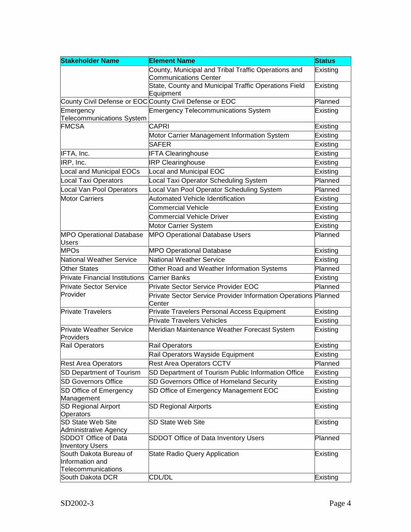
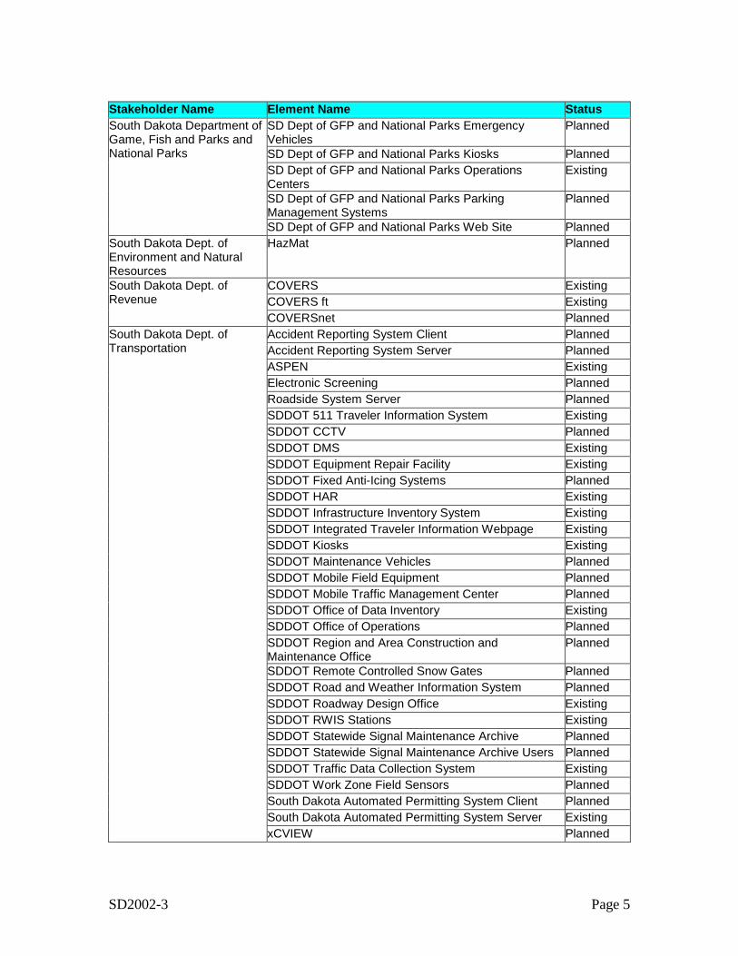
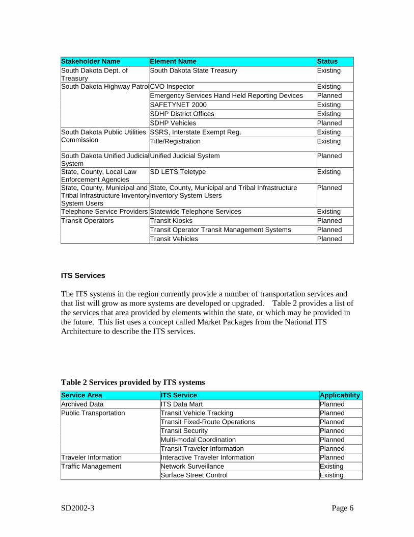
Architecture InventoryEach stakeholder agency, company, or group owns, operates, maintains or plans ITSsystems in the state. The architecture development effort created an inventory, or list of“elements” that represent all existing and planned ITS systems in the state as well as non-ITS systems that provide information to or get information from the ITS systems. Thefocus of the inventory is on those systems that support, or may support, interfaces thatcross stakeholder boundaries (e.g., inter-agency interfaces, public/private interfaces).Table 1 provides a listing of the 45 stakeholders and 101 elements that make up theStatewide ITS Architecture. The table also indicates if the element is existing or planned.
Table 1 Summary of Inventory by StakeholderStakeholder Name Element Name StatusCable Public AccessTelevision Systems
Cable Public Access Channels Planned
County Sheriff and Municipal Police Vehicles PlannedCounty, Municipal and Tribal Fire Rescue Vehicles Planned
County and Municipal PublicSafety
County, Municipal and Tribal Public Safety Dispatch PlannedCounty, Municipal and Tribal Equipment Repair Facility ExistingCounty, Municipal and Tribal Infrastructure InventorySystem
Planned
County, Municipal and Tribal Roadway MaintenanceDispatch
Existing
County, Municipal and Tribal Roadway MaintenanceVehicles
Planned
County and MunicipalTransportation Agency
County, Municipal and Tribal Traffic Data CollectionSystem
Planned
SD2002-3 Page 4
Stakeholder Name Element Name StatusCounty, Municipal and Tribal Traffic Operations andCommunications Center
Existing
State, County and Municipal Traffic Operations FieldEquipment
Existing
County Civil Defense or EOC County Civil Defense or EOC PlannedEmergencyTelecommunications System
Emergency Telecommunications System Existing
CAPRI ExistingMotor Carrier Management Information System Existing
FMCSA
SAFER ExistingIFTA, Inc. IFTA Clearinghouse ExistingIRP, Inc. IRP Clearinghouse ExistingLocal and Municipal EOCs Local and Municipal EOC ExistingLocal Taxi Operators Local Taxi Operator Scheduling System PlannedLocal Van Pool Operators Local Van Pool Operator Scheduling System Planned
Automated Vehicle Identification ExistingCommercial Vehicle ExistingCommercial Vehicle Driver Existing
Motor Carriers
Motor Carrier System ExistingMPO Operational DatabaseUsers
MPO Operational Database Users Planned
MPOs MPO Operational Database ExistingNational Weather Service National Weather Service ExistingOther States Other Road and Weather Information Systems PlannedPrivate Financial Institutions Carrier Banks Existing
Private Sector Service Provider EOC PlannedPrivate Sector ServiceProvider Private Sector Service Provider Information Operations
CenterPlanned
Private Travelers Personal Access Equipment ExistingPrivate TravelersPrivate Travelers Vehicles Existing
Private Weather ServiceProviders
Meridian Maintenance Weather Forecast System Existing
Rail Operators ExistingRail OperatorsRail Operators Wayside Equipment Existing
Rest Area Operators Rest Area Operators CCTV PlannedSD Department of Tourism SD Department of Tourism Public Information Office ExistingSD Governors Office SD Governors Office of Homeland Security ExistingSD Office of EmergencyManagement
SD Office of Emergency Management EOC Existing
SD Regional AirportOperators
SD Regional Airports Existing
SD State Web SiteAdministrative Agency
SD State Web Site Existing
SDDOT Office of DataInventory Users
SDDOT Office of Data Inventory Users Planned
South Dakota Bureau ofInformation andTelecommunications
State Radio Query Application Existing
South Dakota DCR CDL/DL Existing
SD2002-3 Page 5
Stakeholder Name Element Name StatusSD Dept of GFP and National Parks EmergencyVehicles
Planned
SD Dept of GFP and National Parks Kiosks PlannedSD Dept of GFP and National Parks OperationsCenters
Existing
SD Dept of GFP and National Parks ParkingManagement Systems
Planned
South Dakota Department ofGame, Fish and Parks andNational Parks
SD Dept of GFP and National Parks Web Site PlannedSouth Dakota Dept. ofEnvironment and NaturalResources
HazMat Planned
COVERS ExistingCOVERS ft Existing
South Dakota Dept. ofRevenue
COVERSnet PlannedAccident Reporting System Client PlannedAccident Reporting System Server PlannedASPEN ExistingElectronic Screening PlannedRoadside System Server PlannedSDDOT 511 Traveler Information System ExistingSDDOT CCTV PlannedSDDOT DMS ExistingSDDOT Equipment Repair Facility ExistingSDDOT Fixed Anti-Icing Systems PlannedSDDOT HAR ExistingSDDOT Infrastructure Inventory System ExistingSDDOT Integrated Traveler Information Webpage ExistingSDDOT Kiosks ExistingSDDOT Maintenance Vehicles PlannedSDDOT Mobile Field Equipment PlannedSDDOT Mobile Traffic Management Center PlannedSDDOT Office of Data Inventory ExistingSDDOT Office of Operations PlannedSDDOT Region and Area Construction andMaintenance Office
Planned
SDDOT Remote Controlled Snow Gates PlannedSDDOT Road and Weather Information System PlannedSDDOT Roadway Design Office ExistingSDDOT RWIS Stations ExistingSDDOT Statewide Signal Maintenance Archive PlannedSDDOT Statewide Signal Maintenance Archive Users PlannedSDDOT Traffic Data Collection System ExistingSDDOT Work Zone Field Sensors PlannedSouth Dakota Automated Permitting System Client PlannedSouth Dakota Automated Permitting System Server Existing
South Dakota Dept. ofTransportation
xCVIEW Planned
SD2002-3 Page 6
Stakeholder Name Element Name StatusSouth Dakota Dept. ofTreasury
South Dakota State Treasury Existing
CVO Inspector ExistingEmergency Services Hand Held Reporting Devices PlannedSAFETYNET 2000 ExistingSDHP District Offices Existing
South Dakota Highway Patrol
SDHP Vehicles PlannedSSRS, Interstate Exempt Reg. ExistingSouth Dakota Public Utilities
Commission Title/Registration Existing
South Dakota Unified JudicialSystem
Unified Judicial System Planned
State, County, Local LawEnforcement Agencies
SD LETS Teletype Existing
State, County, Municipal andTribal Infrastructure InventorySystem Users
State, County, Municipal and Tribal InfrastructureInventory System Users
Planned
Telephone Service Providers Statewide Telephone Services ExistingTransit Kiosks PlannedTransit Operator Transit Management Systems Planned
Transit Operators
Transit Vehicles Planned
ITS Services
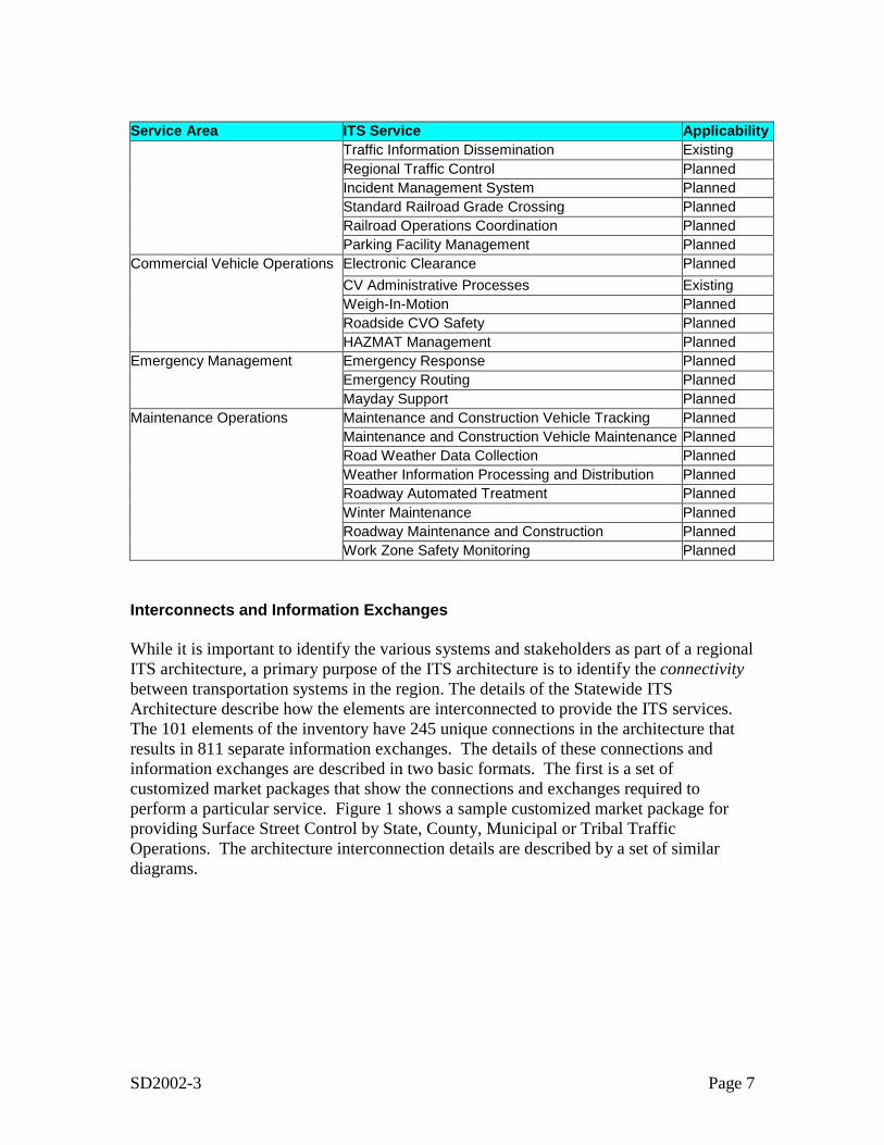
The ITS systems in the region currently provide a number of transportation services andthat list will grow as more systems are developed or upgraded. Table 2 provides a list ofthe services that area provided by elements within the state, or which may be provided inthe future. This list uses a concept called Market Packages from the National ITSArchitecture to describe the ITS services.
Table 2 Services provided by ITS systemsService Area ITS Service ApplicabilityArchived Data ITS Data Mart PlannedPublic Transportation Transit Vehicle Tracking Planned Transit Fixed-Route Operations Planned Transit Security Planned Multi-modal Coordination Planned Transit Traveler Information PlannedTraveler Information Interactive Traveler Information PlannedTraffic Management Network Surveillance Existing Surface Street Control Existing
SD2002-3 Page 7
Service Area ITS Service Applicability Traffic Information Dissemination Existing Regional Traffic Control Planned Incident Management System Planned Standard Railroad Grade Crossing Planned Railroad Operations Coordination Planned Parking Facility Management PlannedCommercial Vehicle Operations Electronic Clearance Planned CV Administrative Processes Existing Weigh-In-Motion Planned Roadside CVO Safety Planned HAZMAT Management PlannedEmergency Management Emergency Response Planned Emergency Routing Planned Mayday Support PlannedMaintenance Operations Maintenance and Construction Vehicle Tracking Planned Maintenance and Construction Vehicle Maintenance Planned Road Weather Data Collection Planned Weather Information Processing and Distribution Planned Roadway Automated Treatment Planned Winter Maintenance Planned Roadway Maintenance and Construction Planned Work Zone Safety Monitoring Planned
Interconnects and Information Exchanges
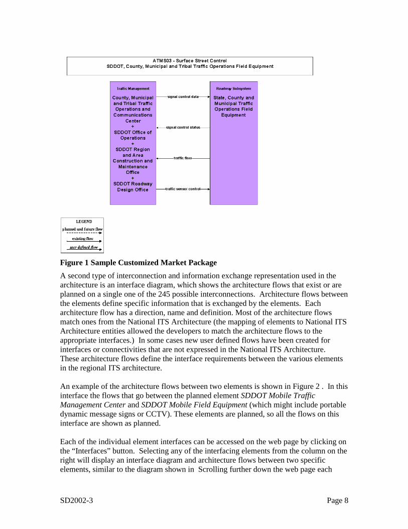
While it is important to identify the various systems and stakeholders as part of a regionalITS architecture, a primary purpose of the ITS architecture is to identify the connectivitybetween transportation systems in the region. The details of the Statewide ITSArchitecture describe how the elements are interconnected to provide the ITS services.The 101 elements of the inventory have 245 unique connections in the architecture thatresults in 811 separate information exchanges. The details of these connections andinformation exchanges are described in two basic formats. The first is a set ofcustomized market packages that show the connections and exchanges required toperform a particular service. Figure 1 shows a sample customized market package forproviding Surface Street Control by State, County, Municipal or Tribal TrafficOperations. The architecture interconnection details are described by a set of similardiagrams.
SD2002-3 Page 8
ATMS03-1
Figure 1 Sample Customized Market PackageA second type of interconnection and information exchange representation used in thearchitecture is an interface diagram, which shows the architecture flows that exist or areplanned on a single one of the 245 possible interconnections. Architecture flows betweenthe elements define specific information that is exchanged by the elements. Eacharchitecture flow has a direction, name and definition. Most of the architecture flowsmatch ones from the National ITS Architecture (the mapping of elements to National ITSArchitecture entities allowed the developers to match the architecture flows to theappropriate interfaces.) In some cases new user defined flows have been created forinterfaces or connectivities that are not expressed in the National ITS Architecture.These architecture flows define the interface requirements between the various elementsin the regional ITS architecture.
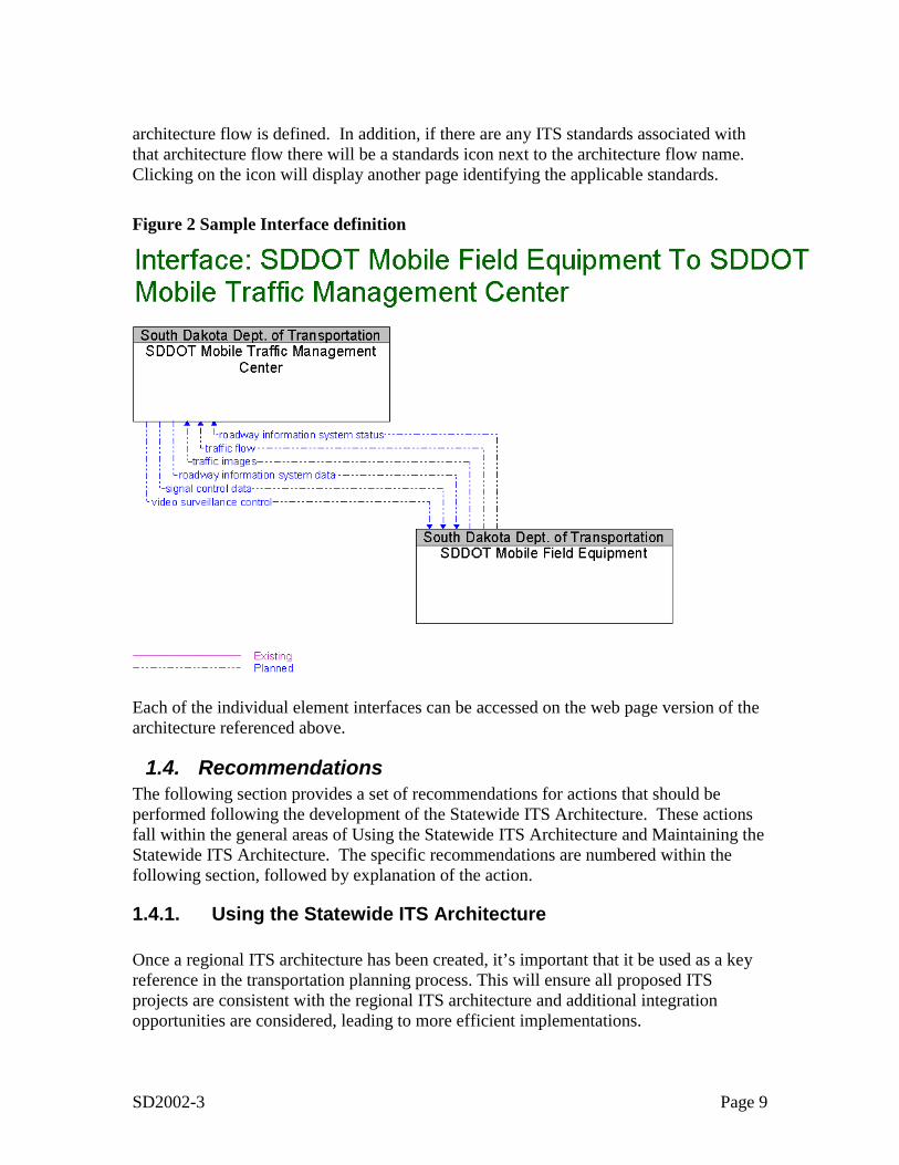
An example of the architecture flows between two elements is shown in Figure 2 . In thisinterface the flows that go between the planned element SDDOT Mobile TrafficManagement Center and SDDOT Mobile Field Equipment (which might include portabledynamic message signs or CCTV). These elements are planned, so all the flows on thisinterface are shown as planned.
Each of the individual element interfaces can be accessed on the web page by clicking onthe “Interfaces” button. Selecting any of the interfacing elements from the column on theright will display an interface diagram and architecture flows between two specificelements, similar to the diagram shown in Scrolling further down the web page each
SD2002-3 Page 9
architecture flow is defined. In addition, if there are any ITS standards associated withthat architecture flow there will be a standards icon next to the architecture flow name.Clicking on the icon will display another page identifying the applicable standards.
Figure 2 Sample Interface definition
Each of the individual element interfaces can be accessed on the web page version of thearchitecture referenced above.
1.4. RecommendationsThe following section provides a set of recommendations for actions that should beperformed following the development of the Statewide ITS Architecture. These actionsfall within the general areas of Using the Statewide ITS Architecture and Maintaining theStatewide ITS Architecture. The specific recommendations are numbered within thefollowing section, followed by explanation of the action.
1.4.1. Using the Statewide ITS Architecture
Once a regional ITS architecture has been created, it’s important that it be used as a keyreference in the transportation planning process. This will ensure all proposed ITSprojects are consistent with the regional ITS architecture and additional integrationopportunities are considered, leading to more efficient implementations.
SD2002-3 Page 10
1. Update the Recommended Projects portion of the South Dakota Rural ITSDeployment Plan using the information developed for the Architecture.
At the state level the primary planning document from an ITS standpoint is the SouthDakota Rural ITS Deployment Plan, which was published in January 2001. The originalDeployment Plan provided a blueprint for the integrated deployment of IntelligentTransportation Systems (ITS) in the state, and has been used to support the integration ofITS actions underway and to insure that future projects contribute to the effective use oftransportation technologies. The Deployment Plan included a list of recommendedprojects and identified the funding needed to implement this plan. As a part of thisoriginal plan, the need to create a Statewide ITS Architecture was identified. AStatewide ITS architecture would provide in some level of detail the ITS systems andintegration opportunities in the region.
With the completion of the initial version of the South Dakota Statewide ITSArchitecture, it is recommended that the Recommended Projects portion of theDeployment Plan be revisited and updated
2. Use the updated Project Information as input to the Statewide Intermodal LongRange Plan.
The update of the project information can then serve as a key input to the StatewideIntermodal Long Range Plan, which was last updated in 1999. It is the long-range guidefor major investments in the State’s ground transportation system.
3. Use the Statewide architecture to support the next updates of the regional LongRange Plans (e.g. Sioux Falls Metropolitan Area Long-Range TransportationPlan.
The Statewide ITS Architecture should also be considered a key reference in the MPOplanning process. Its suggested transportation system integration should be considered inthe next updates of the regional Long Range Plans (e.g. Sioux Falls Metropolitan AreaLong-Range Transportation Plan).
The statewide ITS architecture should also be considered for support in ITS projectdevelopment cycle. This begins with project definition, followed by procurement,leading to implementation. Information in the regional ITS architecture can assist in allthree of these areas of project development.
4. Consider use of the Statewide Architecture in the development of individualResearch Plans.
Project Definition may occur at several levels of detail. Early in the planning process aproject may be defined only in terms of the transportation services it will provide, or bythe major system pieces it contains. At some point prior to the beginning ofimplementation the details of the project must be developed. This could include further
SD2002-3 Page 11
system definition and interface definition including exactly what systems or parts ofsystems will make up the project, what interconnections the project entails, and whatinformation needs to flow across the system interconnections. Requirements definitionmay go through similar levels of detail, starting with very high level description ofproject functions and moving toward system specifications. By identifying the portionsof the statewide ITS architecture that define the project, the statewide ITS architectureoutputs can be used to create key aspects of the project definition.
The areas that the statewide ITS architecture can assist in project definition are:
• The identification of agency roles and responsibilities (including any inter-agencycooperation) can come from the operational concept developed as part of the regionalITS architecture. This operational concept can either serve as a starting point for amore detailed definition, or possibly provide all the needed information.
• Requirements definition can be completely or partly defined by using the regionalITS architecture functional requirements applicable to the project.
• The ITS architecture includes a map to ITS standards and the project mapping to theregional ITS architecture can extract the applicable ITS standards for the project.
Once a project is defined, and funding for it is committed, the implementation processcan commence with the generation of a Request For Proposal (RFP), which is thecommon governmental practice for initiating a contract with the private sector toimplement the project. Once a contract is in place, project implementation begins andmoves through design, development, integration, and testing.
The statewide ITS architecture, and the products produced during its development, cansupport this RFP generation. First the project definition described above forms the basisfor what is being procured.
5. Map each ITS project to the Statewide Architecture.
Mapping the project to the regional ITS architecture allows bidders to have a clearunderstanding of the scope of the project and of the interfaces that need to be developed.The functional requirements created as part of the regional ITS architecture can be usedto describe the functional requirements for the project. In addition a subset of the ITSStandards identified as part of the regional ITS architecture development can be specifiedin the RFP.
6. Use the outputs of the Statewide architecture to meet the system engineeringrequirements levied upon ITS projects that utilize Federal funds.
Because ITS projects involve systems and their interconnections, it is very important tofollow a system engineering approach to designing and implementing the project. Whilethe exact process followed is at the discretion of the local agency, the ITS Architecture
SD2002-3 Page 12
and Standards Rule/Policy lay out a set of required system engineering analyses for ITSprojects funded through the highway trust fund.
The required system engineering analysis steps are:
• Identification of portions of the regional (or in this case statewide) ITSarchitecture being implemented (or if a regional ITS architecture does not exist,the applicable portions of the National ITS Architecture);
• Identification of participating agencies’ roles and responsibilities;• Requirements definitions;• Analysis of alternative system configurations and technology options to meet
requirements;• Procurement options;• Identification of applicable ITS standards and testing procedures; and• Procedures and resources necessary for operations and management of the
system.
In summary, the regional ITS architecture represents a detailed plan for the evolution ofthe ITS systems in the region and can be used to support regional transportation planningefforts and project development efforts.
1.4.2. Maintaining the Statewide ITS Architecture
The South Dakota Statewide ITS Architecture is not a static set of outputs. It mustchange as plans change, ITS projects are implemented, and the ITS needs and servicesevolve in the region. This section describes a proposed plan for the maintenance of thearchitecture. The plan covers the following three key areas:
o Who will maintain the architecture?o What will be maintained?o How it will be maintained (i.e. what configuration control process will be
used)?
The statewide ITS architecture is created as a consensus view of what ITS systems thestakeholders in the region have currently implemented and what systems they plan toimplement in the future. The statewide ITS architecture will need to be updated to reflectchanges resulting from project implementation or resulting from the planning processitself.
• Changes for Project Definition.When actually defined, a project may add, subtract or modify elements, interfaces, orinformation flows from the regional ITS architecture. Because the regional ITSarchitecture is meant to describe the current (as well as future) regionalimplementation of ITS, it must be updated to correctly reflect how the developedprojects integrate into the region.
SD2002-3 Page 13
• Changes for Project Addition/Deletion.Occasionally a project will be added or deleted through the planning process andsome aspects of the regional ITS architecture that are associated with the project maybe expanded, changed or removed.
• Changes in Project Priority.Due to funding constraints, or other considerations, the planned project sequencingmay change. Delaying a project may have a ripple effect on other projects thatdepend on it. Raising the priority for a project’s implementation may impact thepriority of other projects that are dependent upon it.
• Changes in Regional Needs.Transportation planning is done to address regional needs. Over time these needs canchange and the corresponding aspects of the regional ITS architecture that addressesthese needs may need to be updated.
In addition, new stakeholders may come to the table and the statewide ITS architectureshould be updated to reflect their place in the regional view of ITS elements, interfaces,and information flows.
Finally, the National ITS Architecture may be expanded and updated from time to time toinclude new user services or better define how existing elements satisfy the user services.These changes should also be considered as the regional ITS architecture is updated. TheNational ITS Architecture may have expanded to include a user service that has beendiscussed in a region, but not been included in the statewide ITS architecture, or beenincluded in only a very cursory manner.
1.4.3. Maintenance Responsibility7. Determine who will maintain the architecture and what group will act as an
Institutional Framework for the maintenance of the architecture.
Responsibility for maintenance of the South Dakota Statewide ITS Architecture shouldlie with SDDOT. This organization was responsible for the original development effortand will be one of the primary users of the ITS architecture. While it is recommendedthat SDDOT assume responsibility for maintenance, it is further recommended that agroup of core stakeholders act as an “institutional framework” to review proposedchanges to the ITS architecture. The regional ITS architecture is a consensus frameworkfor integrating ITS systems in the state. As it was a consensus driven product in its initialcreation, so it should remain a consensus driven product as it is maintained.
1.4.4. Architecture Baseline8. Define the Architecture Baseline that will be maintained.
Establishing an ITS architecture baseline requires clear identification of the architectureproducts that will be maintained, including specific format and version information. For
SD2002-3 Page 14
the South Dakota Statewide ITS Architecture the following outputs are recommended asthe architecture baseline:
• Architecture Document (this document)• Turbo Architecture Database• Statewide ITS Architecture Web pages
Regarding the Architecture document, it is recommended that the source document, inMicrosoft Word format, be held by SDDOT, while a PDF version of the document iscreated for general distribution.
Regarding the Turbo Architecture Database, it is recommended that SDDOT maintain azipped version of the final delivered South Dakota Statewide Architecture database. Thename, date, and size of the database file inside the zipped file should be entered into anarchitecture log as version 1.0 of the architecture.
Regarding the web site, a CD-ROM version of the final web site should be maintained bySDDOT. It is further recommended that the version number of the architecture beentered somewhere on the home page of the web site so that the version being viewed isimmediately identifiable.
1.4.5. Configuration Control9. Define the configuration control process that will be used to maintain the
architecture and develop specific procedures for configuration control.
Once the baseline is defined, the process for making changes to this baseline must beestablished. The change management process specifies how changes are identified, howoften they will be made, and how the changes will be reviewed, implemented, andreleased.
How Changes are Identified
This involves two issues-
• who can identify a change to the architecture and• how will the change request be documented
For an architecture that covers an entire state, the question of who can make changerequests is an important one. If literally anyone can input requests the region runs therisk of being overrun by requests that will tax scarce resources to review and decideupon. On the other end of the spectrum, if too much formality or paperwork is added tothe process then many valid or needed changes may go unexpressed. Therecommendation is that only members of the “core stakeholders” who make up theinstitutional framework be allowed to identify potential changes. This effectively meansthat any change suggested has the approval of a member of the core group. This has the
SD2002-3 Page 15
added benefit of spreading the resources needed to generate or evaluate changes amongthe group.
As to how the change request should be documented—it is recommended that a simplechange request form be created that contains at least the following information:
1. Name of change2. Description of change3. Part of baseline affected (could be check boxes for document, database, web site, and
not known)4. Rationale for change5. Originator name or agency6. Date of origination
This information will ultimately be added to a change database (recommended to bemaintained by SDDOT personnel) that will add the following additional fields ofinformation:
7. Change number (some unique identifier)8. Change disposition (accepted, rejected, deferred)9. Change type (minor or significant)10. Disposition comment11. Disposition date
How often Changes are Made
It is recommended that the first update to the architecture baseline be madeapproximately a year after completion of the initial version. Depending upon the amountof change requests submitted, this could be anything from a minor update to correcterrors found to a more significant update to include changes in stakeholders, elements,and connections. Also some changes could be deferred until the next major update of thearchitecture. It is recommended that a major review and update of the architecture(including possibly additional stakeholder meetings) be tied to the update of a majorplanning document such as the Statewide Intermodal Long Range Plan. This will allowan updated version of the architecture to be used as the basis for the Plan update.Additional minor revisions of the baseline could be considered on a yearly basis.
Change Review, Implementation, and Release.
The general steps in the change review process are:
1. Define changes per the recommendations given above.
SD2002-3 Page 16
2. Assess the impact of the change. Someone needs to evaluate the change anddetermine what impact it has upon the architecture baseline. There are threeoptions for who performs this evaluation
a. the person proposing the change (i.e. the member of the core group thatbrings it forward)
b. a staff member of SDDOT (the agency responsible for architecturemaintenance) or
c. a contractor through some architecture support contract.Each of these options has positive and negative implications. The first option willwork well for minor changes (e.g. changes in status, connections, or descriptions).However, it does require each submitting person to have sufficient knowledge ofthe architecture to suggest appropriate solutions. The second option requires thearchitecture knowledge to be available through SDDOT personnel. Their long-term availability to perform the work is a possible risk. The third impliescontracting for the necessary expertise, so has the negative of additional costassociated with it.
3. Provide a recommendation to the Change Control Group. For proper changecontrol some group should be assigned responsibility for reviewing and approvingchanges to the baseline. The recommendation is that a subgroup of the corestakeholders be appointed for this purpose. This Change Control Group(sometimes referred to as a Configuration Control Board) should be lead by theindividual responsible for maintaining the architecture (or by one of theindividuals if it is a group activity). The job of the Group is to decide whatchanges go into the architecture baseline. This could be done through periodicmeetings (say quarterly), through electronic correspondence, or a combination ofboth. A recommendation is that minor changes be handled through monthlyemail distribution and approval, while major changes or areas of disagreement arehandled at the periodic face to face meetings. It is important to maintain theconsensus nature of the architecture by having a group of core stakeholders agreeon changes.
4. The Change Control Group makes a decision. Either it accepts the change, rejectsit, or asks for additional evaluation.
5. The decision is implemented. If the decision is to accept the change, then theappropriate portions of the architecture baseline are updated (per the schedulediscussed above) and an updated architecture baseline is defined.
The time required to perform this configuration control process will be a direct functionof the number of changes suggested to the architecture, which will be driven by howmuch the architecture is being used. It is suggested that the process be reviewed withinthe first year and fine-tuned to most appropriately address the level of change that hasoccurred.
10. Implement the configuration control process and maintain the architecture
SD2002-3 Page 17
2. Problem DescriptionFederal regulations require that major ITS (Intelligent Transportation Systems) projectsdeployed with federal funding after 8 April 2005 conform to a regional ITS architecturebased on the US National ITS Architecture, and that the ITS architecture of planned anddeployed ITS projects be documented. The South Dakota Rural ITS Deployment Plan,completed in 2000, recommended a program of ITS projects over the next eight years. Anumber of ITS projects are in progress, and others are planned in the near future. ByApril 2005, it will be necessary for the Department to be capable of reviewing ITSprojects to determine their compliance with a regional ITS architecture based on theNational ITS Architecture.
Research was needed to define and develop a “regional” ITS architecture for SouthDakota. The approach taken was to develop a single Statewide regional ITS architecture(or statewide ITS architecture) for South Dakota, to include all ITS projects in the state,including the Metropolitan Planning Organizations ( MPOs) in the state. This statewideITS architecture considered both the current deployments of ITS in the state (legacyinvestments) as well as accommodated planned projects and harmonized them with otherstatewide architecture efforts such as the CVO/CVISN architecture development under aseparate research effort. The widest possible array of stakeholders was identified,contacted and engaged in developing the statewide ITS Architecture. The researchproject identified each stakeholder’s ITS systems, subsystems (i.e. ITS elements), andinformation exchange requirements between subsystems (i.e. interconnects andarchitecture flows). The statewide ITS architecture considered how regional and localITS projects fit into the larger statewide view. The research created a statewide ITSarchitecture that not only reflects the consensus of the stakeholders, but the project’stechnical panel. Other ITS stakeholders had a method (over the Internet) of accessingand reviewing the architecture that allowed them to quickly and easily identify their ITSelements and information exchange requirements to/from those elements, and comment(also over the Internet) on these architecture views. Statewide ITS architectures can belarge and complex, with a large number of elements and information exchangeinterconnections. Making this information analysis easily accessible to the stakeholderswas a key problem that was solved. The documentation of the statewide ITS architectureclearly mapped to the requirements of the Federal regulations (i.e. the 8 April 2001FHWA Rule and corresponding FTA Policy on ITS Architecture).
Beyond the Federal Requirements, a regional ITS architecture represents a coherent planfor efficient deployment of information processing and data communicationstechnologies to satisfy local stakeholder surface transportation requirements. In acoherent ITS architecture, each ITS element’s functions and information exchangerequirements with other ITS elements are clearly documented and can be incorporatedinto the ITS element’s design requirements at the time of ITS element design anddeployment. These design requirements include the specification of open standards,which will lead to lower long-term deployment and maintenance costs. The benefits of
SD2002-3 Page 18
interoperability can then be increasingly realized, as ITS elements are deployed overtime.
3. ObjectiveTo develop a regional architecture that includes South Dakota and the MetropolitanPlanning Organizations that include Sioux Falls, Rapid City and Sioux City.
4. Task DescriptionsResearch Project Number SD2002-03 was undertaken to develop a statewide ITSarchitecture. It included the following 9 tasks:
1. Perform a literature search regarding other state’s efforts to produce statewideITS architecture plans.
One of the first efforts asociated with the outline and construction of the South DakotaStatewide ITS Architecture included investigation and review of current and future ITSarchitecture elements and plans within South Dakota. This was followed by aninvestigation of other state ITS architectures for innovative elements, stakeholders andapproaches to projects that may provide additional insight into ITS architectureapplication that may be included or desirable across South Dakota. The results of thisinvestigation are presented in Section 7 of this report.
2. Identify and document existing and near term ITS projects and efforts.Candidate projects were identified from the existing documentation. The followingdocuments and webpages were the primary sources of project information:
1. South Dakota Rural ITS Deployment Plan2. South Dakota Office of Research Project Webpages3. Intelligent Transportation Systems (ITS) Strategy- Phase 2, Sioux Falls, South
Dakota, SHE No. A-SIOUX0103.01, December 16, 2002The documentation of these projects is contained in section 5.10 of this report.
3. Identify and bring together stakeholders to inventory existing projects, identifyneeds, and begin the architecture development process.
A wide array of stakeholders across all aspects of surface transportation in the state wasinvited to a two-day Workshop that was held on August 19 and 20, 2002. The list ofstakeholders invited was coordinated with the SDDOT Technical Panel and SDDOTRural ITS steering committee in order to address the full range of potential stakeholders.
The first day of the workshop focused on refinement of the draft inventory, with eachparticipant’s ITS elements being discussed and clarified. In addition the services plannedat local, regional, and statewide levels were discussed.
Following the first day of the workshop, a set of customized market packages werecreated based upon the information collected during the first day. On Day 2 of theworkshop these customized market packages were reviewed with the stakeholders to
SD2002-3 Page 19
identify which elements are associated with each market package (or transportationservice), and to identify the interconnections associated with the market packages.The details of the workshop are described in Section 5.2.
4. Meet with the panel to summarize literature, findings and initial development ofarchitecture based on stakeholder meetings.
The consultant met with the panel (and Research Review Board) on the morning ofNovember 19, 2002 to discuss the results of the workshops and the status of architecturedevelopment.
5. Using the National ITS Architecture, develop a draft statewide architecture,including architecture flows, market packages, and sausage diagrams, andprovide in Turbo Architecture format that allows future modification. Includealso written descriptions indicating how subsystems interconnect.
Following the two-day Workshop, a draft architecture was created. Using the customizedmarket package diagrams (as modified during the second day of the workshop), theTurboArchitecture database was completed to create a draft ITS architecture. This draftarchitecture was merged with the TurboArchitecture database created by the concurrentSouth Dakota CVISN Program Support Project to create an overall Statewide ITSArchitecture. The draft ITS architecture was placed on a generally accessible website(www.consystec.com), stakeholders notified and asked to review the draft. A one-daydraft ITS architecture review meeting was held in Pierre on October 4, 2002. At theworkshop, stakeholders reviewed the external interfaces for each stakeholder element ofthe inventory. Following revisions, a final draft architecture was created, documentedand placed on the website.
The statewide architecture included:
! A description of the region, participating agencies and other stakeholders.! An inventory of systems, existing and planned, that are owned, operated or
maintained by the stakeholders.! A description of the ITS services (e.g. market packages) that the regional ITS
architecture will provide.! An operational concept that identifies the roles and responsibilities of participating
agencies and other stakeholders in the operation and implementation of the elementsincluded in the regional ITS architecture.
! System functional requirements.! A description of the interface requirements and information exchanges with planned
and existing systems and subsystems and architecture flows as defined in the NationalITS Architecture.
! Projects that may require sequencing for implementation.! Existing ITS standards to support regional and national interoperability.! Agreements that may need to be considered for operations including those affecting
ITS project interoperability, utilization of ITS related standards, and the operation ofthe projects identified in the regional ITS architecture.
SD2002-3 Page 20
6. Outline an implementation plan that provides SDDOT staff a method toevaluate future ITS projects to assure they comply with the statewidearchitecture.
An Implementation plan was developed and is documented in Section 6 of this document.Because regional stakeholders will have ongoing ITS-related activities, the regional ITSarchitecture will be expected to change as stakeholder ITS requirements evolve. Thisdynamic nature creates the need for a plan to maintain the architecture. This plan iscontained in Section 6 of this document.
7. Meet with the panel to present architecture materials and provide training toselect SDDOT staff.
An ITS architecture and SD Statewide ITS Architecture training presentation andworkshop was made to the Technical Panel and additional SDDOT personnel on theafternoon of November 19, 2002 and again on February 18, 2003. This included trainingon the use of Turbo Architecture and SDTurboExtensions to maintain the ITSarchitecture and web site.
8. Provide a report including methodology, findings, conclusions,recommendations, and architecture deliverables.
The result of this task is this final report.
9. Make an executive presentation to the Research Review Board.An executive briefing was prepared and presented to the Research Review Board on themorning of November 19, 2002.
5. Findings
5.1. Introduction
The South Dakota Statewide ITS Architecture is a statewide roadmap for transportationsystems integration over the next approximately 15 years. The architecture has beendeveloped through a cooperative effort by the state's transportation agencies, covering allmodes and all roads in the state. The architecture represents a shared vision of how eachagency’s systems will work together in the future, sharing information and resources toprovide a safer, more efficient, and more effective transportation system for travelers inthe region.
The ITS architecture is an important new tool that will be used by:
• Operating Agencies to recognize and plan for transportation integrationopportunities in the region.
• Planning Agencies to better reflect integration opportunities and operationalneeds into the transportation planning process.
SD2002-3 Page 21
• Other organizations and individuals that use the transportation system in SouthDakota.
The ITS architecture provides an overarching framework that spans all of theseorganizations and individual transportation projects. Using the ITS architecture, eachtransportation project can be viewed as an element of the overall transportation system,providing visibility into the relationships between individual transportation projects andways to cost-effectively build an integrated transportation system over time.
Background
ITS Architecture development is done within the context of previous efforts. The SouthDakota Rural ITS Deployment Plan, completed in 2000, represents the most importantprevious work from the standpoint of this research. This plan described at a high level(from an ITS architecture perspective) the current (or legacy) as well as proposed futureITS inventory and ITS projects. The description of these ITS projects in this report,while general from an ITS architecture perspective, includes the important existing andplanned ITS elements and information sharing concepts.
CVO will be an important aspect of the South Dakota Statewide architecture and severalcompleted and concurrent efforts will support the development of the ITS architecture.The documentation of South Dakota’s ITS/CVO Data Architecture, SD99-07 representsone completed effort that will impact this research. This report clearly documents theexisting processes allocated to specific agency and private sector entities and theirinformation sharing relationships. Second is the South Dakota ITS/CVO Business PlanStudy SD97-10, which contains a list of CVO related projects. Finally, the concurrentSouth Dakota CVISN Program Support Project has been an important resource for ITSarchitecture development. This effort has provided important inputs with regard toexisting and future ITS architecture inventory as well as information exchangerequirements.
Findings OverviewThe Findings section of this report is organized into 11 subsections. Section 5.1 providesintroductory information. Section 5.2 describes the process used to develop the SouthDakota Rural ITS architecture. The stakeholders are identified in Section 5.3, while theirsystems are inventoried in Section 5.5. The operational concept is described in Section5.4. The transportation services are described in Section 5.6. Interfaces and Informationexchanges is the topic of Section 5.7, while functional requirements and standardsassociated with the systems are discussed in Sections 5.8 and 5.9, respectively. Section5.10 describes regional ITS projects and sequencing, while Section 5.11 discusses theagreements needed between stakeholders to maximize system benefits.
SD2002-3 Page 22
5.2. ITS Architecture Development Process
5.2.1. Process used to create the ITS architectureDevelopment of the South Dakota Rural ITS Architecture relied heavily on stakeholderinput to ensure that the ITS architecture reflected local, regional, and statewide needs. Afive-step process was used to develop the ITS architecture: 1) create an initial draftinventory of architecture elements and a draft list of Services to be provided, 2) conductstakeholder outreach through a two day Workshop, 3) create a draft ITS architecture forreview, and 4) conduct stakeholder review of the draft ITS architecture, 5) finalize theITS architecture based on review comments.
1) Create Initial Inventory and ServicesA review of existing documentation and existing and planned projects was used toestablish the initial draft inventory of elements for the architecture. The South Dakotaarchitecture elements identified through this review were mapped to National ITSArchitecture Version 4 entities (subsystems and terminators). This created an initialinventory mapped to the National ITS Architecture. The existing and planned ITSprojects were used to establish an initial list of services that the elements of thearchitecture would provide. The elements and their mapping to National ITSArchitecture entities were entered into the software tool TurboArchitecture in preparationfor stakeholder outreach.
2) Stakeholder Outreach- two-day WorkshopA wide array of stakeholders across all aspects of surface transportation in the state wasinvited to a two- day Workshop that was held on August 19 and 20, 2002. The list ofstakeholders invited was coordinated with the SDDOT Technical Panel and SDDOTRural ITS steering committee in order to address the full range of potential stakeholders.A key overall objective of the workshop is that the resultant Statewide ITS Architectureshould be a consensus architecture, that is, each of the participants understands andagrees to the ITS elements and specific information exchanges between the ITS elementsidentified in the Statewide ITS architecture that they participated in defining. (This is notto say that the resulting ITS Architecture has credible funding identified that would leadto full deployment. The ITS architecture only identifies ITS elements and interfaces thatthe stakeholders agree to. Existing funding processes will continue to be used to decidehow to allocate limited resources to which ITS elements and interfaces for deployment.)The workshop also incorporated training in the National ITS Architecture and regionalITS architecture so that stakeholders would understand and more fully participate in theITS Architecture development process. The first day of the workshop focused onrefinement of the draft inventory, with each participant’s ITS elements being discussedand clarified. In addition the services planned at local, regional, and statewide levelswere discussed.
SD2002-3 Page 23
To accomplish this, the Market Packages of the National ITS Architecture were discussedwith the stakeholders and each Market Package was classified by the analyst-moderatorsto be either:
• Existing: some or all of this market package is already deployed in the State,• Planned: funds may be programmed for this market package at some time in the
future or,• Not Used: the service(s) represented by this market package are not sufficiently
relevant to the foreseeable needs of the region to warrant any further consideration.
Following the first day of the workshop, a set of customized market packages werecreated based upon the information collected during the first day. For each existing orfuture market package identified on Day 1, the market package diagram was edited sothat each National ITS Architecture subsystem or terminator was associated with thelocal stakeholder element name. In some cases, multiple instances of the market packagewere developed, where the service has more than one instance in the state. On Day 2 ofthe workshop these customized market packages were reviewed with the stakeholders toidentify which elements are associated with each market package (or transportationservice), and to identify the interconnections associated with the market packages.
3) Create a Draft Architecture for ReviewFollowing the two-day Workshop, a draft architecture was created. Using the customizedmarket package diagrams (as modified during the second day of the workshop), theTurboArchitecture database was completed to create a draft ITS architecture. Thisinvolved the following activities:
• Updating the ITS inventory• Customizing the ITS architecture interconnects (specifying which stakeholder
elements are connected to which other elements)• Customizing the architecture flows (specifying what information is sent from one
specific stakeholder ITS element to another).
In addition to creating the TurboArchitecture database, the following architectureproducts were developed or updated:
• Set of customized market package diagrams• A high level Architecture Interconnect Diagram (AID, also known as a Sausage
Diagram) of all the elements in the ITS architecture.
The concurrent South Dakota CVISN Program Support Project had also created aTurboArchitecture database representing the commercial vehicle operations architecturefor the state. The next step in the development process was to merge these two TurboArchitecture databases so that the CVO aspects of ITS architecture were fully covered inthe statewide ITS architecture.
SD2002-3 Page 24
The final draft ITS architecture product developed was a hypertext version of thecomplete Turbo Architecture database placed on a generally accessible website(www.consystec.com). This website described each ITS element of the ITS architectureand all of its interconnections with other elements of the architecture. The website wasdeveloped using additional software tools that go beyond the basic TurboArchitecturesoftware. One of the additional tools, SDTurboExtensions, is being provided to SDDOT(with a license restriction to use this software only for South Dakota’s Statewide ITSArchitecture) as a part of this contract so that the aspects of architecture outputs that gobeyond TurboArchitecture can be updated through SDDOT’s ITS Architecturemaintenance process. Appendix E provides a Users Guide for this software tool.
Stakeholders were notified by email and by a letter that a review period has commenced,and feedback was solicited. Stakeholders were encouraged to review the statewide ITSarchitecture on the website, and were encouraged to provide feedback electronically fromthe website. Comments received starting at this point in the process were maintained in adatabase. These stakeholders’ comments and their dispositions are summarized inAppendix A.
4) Conduct stakeholder review of the draft ITS architectureIn addition to the stakeholder website review, a one-day draft ITS architecture reviewmeeting was held in Pierre on October 4, 2002. At the workshop, stakeholders reviewedthe external interfaces for each stakeholder element of the inventory. These externalinterfaces were defined in the hypertext version of the draft architecture on the website.During this one day workshop the focus was on those interfaces that cross institutionalboundaries to assure that we have consensus between the affected stakeholders.
5) Finalize the architecture based on review comments.Following the one-day workshop, the draft architecture was revised based on commentsfrom the workshop and a new version of the website was generated. Additionalarchitecture aspects such as operational concepts, functional requirements, projectsequencing, and agreements were developed and additional stakeholder review commentswere solicited. The information has been compiled in this draft final report.
In recognition of the dynamic nature of ITS activities (i.e. ITS elements and interfacesthat at one time are designated future, and later become existing) and because stakeholderrequirements in a region that drive an ITS architecture will evolve, a maintenance planwas developed to provide a systematic means of keeping the architecture updated.
5.2.2. Requirements of the Final FHWA Rule and FTA Policy onArchitecture
The FHWA Final Rule (23CFR 940, and aka Rule 940) and corresponding FTA Policyon Intelligent Transportation System Architecture and Standards, which took effect onApril 8, 2001 defines a set of requirements that regional ITS architectures should meet.
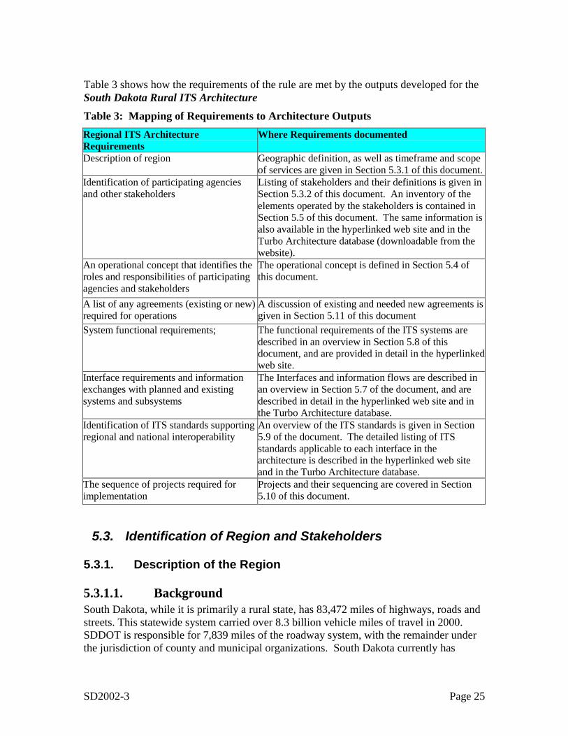
SD2002-3 Page 25
Table 3 shows how the requirements of the rule are met by the outputs developed for theSouth Dakota Rural ITS ArchitectureTable 3: Mapping of Requirements to Architecture OutputsRegional ITS ArchitectureRequirements
Where Requirements documented
Description of region Geographic definition, as well as timeframe and scopeof services are given in Section 5.3.1 of this document.
Identification of participating agenciesand other stakeholders
Listing of stakeholders and their definitions is given inSection 5.3.2 of this document. An inventory of theelements operated by the stakeholders is contained inSection 5.5 of this document. The same information isalso available in the hyperlinked web site and in theTurbo Architecture database (downloadable from thewebsite).
An operational concept that identifies theroles and responsibilities of participatingagencies and stakeholders
The operational concept is defined in Section 5.4 ofthis document.
A list of any agreements (existing or new)required for operations
A discussion of existing and needed new agreements isgiven in Section 5.11 of this document
System functional requirements; The functional requirements of the ITS systems aredescribed in an overview in Section 5.8 of thisdocument, and are provided in detail in the hyperlinkedweb site.
Interface requirements and informationexchanges with planned and existingsystems and subsystems
The Interfaces and information flows are described inan overview in Section 5.7 of the document, and aredescribed in detail in the hyperlinked web site and inthe Turbo Architecture database.
Identification of ITS standards supportingregional and national interoperability
An overview of the ITS standards is given in Section5.9 of the document. The detailed listing of ITSstandards applicable to each interface in thearchitecture is described in the hyperlinked web siteand in the Turbo Architecture database.
The sequence of projects required forimplementation
Projects and their sequencing are covered in Section5.10 of this document.
5.3. Identification of Region and Stakeholders
5.3.1. Description of the Region
5.3.1.1. BackgroundSouth Dakota, while it is primarily a rural state, has 83,472 miles of highways, roads andstreets. This statewide system carried over 8.3 billion vehicle miles of travel in 2000.SDDOT is responsible for 7,839 miles of the roadway system, with the remainder underthe jurisdiction of county and municipal organizations. South Dakota currently has
SD2002-3 Page 26
three urbanized areas (population greater than 50,000) that are Rapid City - Penningtonand Meade Counties, Sioux Falls - Minnehaha and Lincoln Counties, and North SiouxCity - Union County.
The public transportation system in the state is composed of public and private busservices. The buses and vans serve school children, the general public and individualswith special needs such as senior citizens and persons with disabilities. The Office ofPublic Transportation lists 58 public and specialized transit service providers, with 19providing public transportation. The state’s largest specialized public transportationservice is the school bus system, which is operated by the school districts and consists of1,654 buses. South Dakota is served by three private bus lines-- Greyhound, JackRabbit, and Powder River.
Commercial vehicle operations represent a major aspect of transportation in the State ofSouth Dakota. Approximately 30,000 in-state commercial license plates are issuedyearly, and significant interstate commercial traffic is carried on state highways. Rail isanother major transportation mode represented in the state. Currently there are 1,855miles of rail lines operating in South Dakota with Class I, Shortlines & RegionalRailroads operating on them.
The following constraints on the scope of the South Dakota Statewide ITS Architecturewere discussed and agreed to at the first stakeholder workshop.
5.3.1.2. Geographic ExtentThe “Region” addressed by the South Dakota Rural ITS Architecture is the entire state,and will include ITS elements and interfaces at the local, regional, and statewide levels.In additions, ITS elements outside South Dakota that communicate with ITS elementsinside South Dakota will be included, and their interfaces that cross the state boundarywill also be included.
5.3.1.3. Temporal ExtentThe architecture provides approximately a 15-year outlook for ITS activities in the state.The architecture addresses existing ITS systems as well as those planned for developmentover the next 15 years. It represents a snapshot of the currently anticipated projects basedon information from stakeholders. As such, the architecture will require regular updatesto ensure that it maintains accurate representation of the region.
5.3.1.4. Service Scope in the ITS ArchitectureThe architecture covers services across a broad range of ITS, including trafficmanagement, transit management, traveler information, commercial vehicle services,emergency services, archived data management, maintenance and constructionoperations, and electronic payment. The services in the South Dakota Statewide ITSArchitecture were limited to those with a direct ITS impact. The ITS Architecture thusdoes not include services that might be considered business data processing orInformation Technology (IT), such as payrolls, accounting and other personnel
SD2002-3 Page 27
management or general business tools, even if the staff affected have an ITS role in theexecution of their jobs.
5.3.1.5. Communications Type Scope in the ITS ArchitectureInformation encoding for transmission can be broadly classified as either interpretable bymachines or by humans. This ITS Architecture is constrained to include only datacommunication where the data is encoded and decoded by machines. This specificallyexcludes voice and fax communications, which require a human to interpret theinformation transmitted. For example, the Statewide ITS Architecture includes datacommunications between a Police dispatch CAD (Computer Aided Dispatch) system anda police vehicle MDT (Mobile Data Terminal), but does not include voicecommunications between police officers in the field and their police dispatchers.
5.3.2. Regional StakeholdersStakeholder coordination and involvement is one of the key elements of the developmentof a statewide ITS architecture. Because ITS often transcends traditional transportationinfrastructure, it is important to consider a range of stakeholders beyond the traditionaltraffic, transit, and maintenance areas. In addition, it is important to considerstakeholders in adjoining states.
The South Dakota Rural ITS Architecture includes a wide range of stakeholders. Table 4identifies the stakeholders and provides a description of the agency, department, ororganization represented by the stakeholder.
Table 4: Stakeholders
Name DescriptionCable Public Access TelevisionSystems
Cable television public access television operators.Programming provides traveler information.
Cellular Telephone ServiceProviders
Owner/Operators and service providers of cellular telephoneservice.
County and Municipal PublicSafety
County and municipality public safety agencies Including lawenforcement, fire rescue, and emergency medical.
County and MunicipalTransportation Agency
County and municipal agency responsible for operation of thetransportation system.
County Civil Defense or EOC County civil defense or emergency operations center.EmergencyTelecommunications System
Telco owner operators of emergency telecommunications (9-1-1)call routing systems.
FMCSA Federal Motor Carrier Safety Administration is part of the USDepartment of Transportation. Administration activitiescontribute to ensuring safety in motor carrier operations throughstrong enforcement of safety regulations, targeting high-riskcarriers and commercial motor vehicle drivers; improving safetyinformation systems and commercial motor vehicle technologies;strengthening commercial motor vehicle equipment andoperating standards; and increasing safety awareness.
IFTA, Inc. The corporation that administers the IFTA Clearinghouse.
SD2002-3 Page 28
Name DescriptionIRP, Inc. The corporation that administers the IRP Clearinghouse for
netting of registration funds.Local and Municipal EOCs Local and Municipal emergency operations centers.Local Taxi Operators Owner operators of taxi services.Local Van Pool Operators Owner/operators of van pool services.Motor Carriers This stakeholder represents private companies who manage a
fleet of commercial vehicles.MPO Operational DatabaseUsers
Users of the Metropolitan Planning Organizations OperationalDatabase archive.
MPOs Metropolitan Planning OrganizationsNational Weather Service National Weather Service provided by NOAA (National Oceanic
and Atmospheric Administration).Other States Neighboring states with which information exchange and
coordination of transportation activities (via ITS systems) takeplace.
Private Sector Service Provider Private sector traveler information service provider.Private Travelers Individual travelers/owners of computing and information access
equipment that can access traveler information.Private Weather ServiceProviders
Private environmental and transportation weather informationservice providers. E.g. Meridian.
Rail Operators Owner/operators of rail transportation facilities and associatedITS equipment and communications.
Rest Area Operators Operators of Rest Areas whether DOT, County, Parks, etc.SD Department of Tourism South Dakota Department of TourismSD Governors Office South Dakota Governors OfficeSD Office of EmergencyManagement
South Dakota Office of Emergency Management
SD Regional Airport Operators South Dakota Regional Airport OperatorsSD State Web SiteAdministrative Agency
SD State Web Site Administrative Agency
SDDOT Office of Data InventoryUsers
Users of the SDDOT Office of Data Inventory Archive.
South Dakota Bureau ofInformation andTelecommunications
The state agency responsible for all information systems andtelecommunications, including support through the data center,application development services, telecommunicationsconnectivity, and public broadcasting.
South Dakota DCR South Dakota Department of Commerce and Regulation, whichis responsible for regulating the banking, insurance, securities,and gaming industries and twenty-three (23) professions,enforcing traffic and criminal laws, licensing drivers, inspectingfacilities, inspecting weighing and measuring devices,investigating charges of discrimination, providing fire servicetraining, promoting highway safety, and providing funding for thecleanup of petroleum releases.
South Dakota Department ofGame, Fish and Parks andNational Parks
South Dakota Department of Game, Fish and Parks andNational Parks including Conservation Officers.SD GF&P includes: Custer State Park, Camping, Hunting,Fishing, Boating, and Recreational Areas
SD2002-3 Page 29
Name DescriptionNational Park units include: Badlands National Park, Wind CaveNP, Jewel Cave National Monument, and Mount RushmoreNational Memorial.
South Dakota Dept. ofEnvironment and NaturalResources
Department mission is to provide environmental and naturalresources assessment, financial assistance, and regulation in acustomer service manner that protects the public health,conserves natural resources, preserves the environment, andpromotes economic development. The agency responsible foradministering the Hazardous Materials system throughout SouthDakota.
South Dakota Dept. of Revenue Manages both the IFTA and IRP credentials applications,issuance, renewals, and refunds.
South Dakota Dept. ofTransportation
South Dakota Department of Transportation
South Dakota Dept. of Treasury State department responsible for financial transactions relatingto commercial vehicles credentials and licensing.
South Dakota Highway Patrol Agency of state government charged with promoting trafficsafety, enforcing existing statutes, recognizing and eliminatingtraffic hazards, and encouraging motorists to practice safedriving techniques
South Dakota Public UtilitiesCommission
Mission of the commission is to serve and protect the public byensuring safe, reliable and high quality utility services at ratesreflecting either a competitive market, in areas wherecompetition develops, or fair regulation, in areas wherecompetition does not exist.
South Dakota Unified JudicialSystem
State agency responsible for the three tiers of the judicialsystem- supreme court, circuit courts, and magistrate courts.
State, County, Local LawEnforcement Agencies
State, County, Local Law Enforcement Agencies that participatein LETS
State, County, Municipal andTribal Infrastructure InventorySystem Users
Agencies, institutions, or individuals who access the informationin the Infrastructure Inventory System.
Telephone Service Providers Wireless and wireline local carriers in South Dakota.Transit Operators Publicly and privately (e.g. Greyhound and Casino buses)
operated bus services.
The stakeholders listed in Table 4 represent a mix of specific agencies or organizationsand generic names used to represent a variety of stakeholders. Examples of specificagencies or organizations would be South Dakota Department of Transportation andSouth Dakota Highway Patrol. An example of a generic stakeholder name would beCounty and Municipal Transportation Agency, which represents any of the counties ormunicipalities in the state that have ITS elements.
5.4. Operational ConceptAn Operational Concept documents each stakeholder’s current and future roles andresponsibilities in the operation of the regional ITS systems. The operational conceptdocuments these roles and responsibilities across a range of transportation services. Theservices covered are:
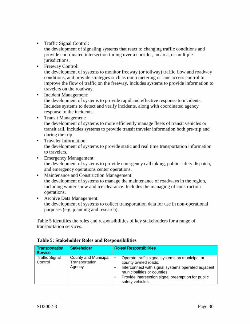
SD2002-3 Page 30
• Traffic Signal Control:the development of signaling systems that react to changing traffic conditions andprovide coordinated intersection timing over a corridor, an area, or multiplejurisdictions.
• Freeway Control:the development of systems to monitor freeway (or tollway) traffic flow and roadwayconditions, and provide strategies such as ramp metering or lane access control toimprove the flow of traffic on the freeway. Includes systems to provide information totravelers on the roadway.
• Incident Management:the development of systems to provide rapid and effective response to incidents.Includes systems to detect and verify incidents, along with coordinated agencyresponse to the incidents.
• Transit Management:the development of systems to more efficiently manage fleets of transit vehicles ortransit rail. Includes systems to provide transit traveler information both pre-trip andduring the trip.
• Traveler Information:the development of systems to provide static and real time transportation informationto travelers.
• Emergency Management:the development of systems to provide emergency call taking, public safety dispatch,and emergency operations center operations.
• Maintenance and Construction Management:the development of systems to manage the maintenance of roadways in the region,including winter snow and ice clearance. Includes the managing of constructionoperations.
• Archive Data Management:the development of systems to collect transportation data for use in non-operationalpurposes (e.g. planning and research).
Table 5 identifies the roles and responsibilities of key stakeholders for a range oftransportation services.
Table 5: Stakeholder Roles and ResponsibilitiesTransportationTransportationTransportationTransportationServiceServiceServiceService
StakeholderStakeholderStakeholderStakeholder Roles/ ResponsibilitiesRoles/ ResponsibilitiesRoles/ ResponsibilitiesRoles/ Responsibilities
Traffic SignalControl
County and MunicipalTransportationAgency
• Operate traffic signal systems on municipal orcounty owned roads.
• Interconnect with signal systems operated adjacentmunicipalities or counties.
• Provide intersection signal preemption for publicsafety vehicles.

SD2002-3 Page 31
TransportationTransportationTransportationTransportationServiceServiceServiceService
StakeholderStakeholderStakeholderStakeholder Roles/ ResponsibilitiesRoles/ ResponsibilitiesRoles/ ResponsibilitiesRoles/ Responsibilities
County and MunicipalTransportationAgency
• Perform incident detection and verification formunicipal or county streets.
• Coordinate incident response with County andMunicipal Public Safety
• Provide incident information to County andMunicipal Public Safety, Local emergencyoperations, and the South Dakota Bureau ofInformation Technology (who are responsible forState Radio Query Application)
• Provide incident video to County and MunicipalPublic Safety
County and MunicipalPublic Safety
• Receive emergency calls for incidents within thestakeholder jurisdiction
• Dispatch Police, Fire, and EMS to incidents withinjurisdiction
• Provide incident information to County andMunicipal Transportation Agency
South DakotaDepartment of Game,Fish and Parks andNational Parks
• Receive emergency calls for incidents within thestakeholder jurisdiction
• Dispatch Police, Fire, and EMS to incidents withinjurisdiction
• Provide incident information to County andMunicipal Transportation Agency
IncidentManagement
South DakotaDepartment ofTransportation
• Perform incident detection and verification forinterstate and major state operated highways.
• Provide incident information to County andMunicipal Public Safety
TransitManagement
Transit Operators • Provide fixed route and paratransit bus tomunicipal, county, or multi-county areas.
TravelerInformation
South DakotaDepartment ofTransportation
• Provide traffic and maintenance information to thepublic via website.
• Provide telephone information system for stateincluding travel times, road/lane closures, andconstruction information for interstate and statehighways and major arterials. This includes thestatewide 511 system.
• Provide road weather information to the public viatelephone system and at rest stop computerterminals.
• Collect traffic and incident information fromtransportation agencies in the region
• Provide traveler interface• Provide road congestion and construction data
County and MunicipalPublic SafetyDispatch
• Provide emergency call taking (9-1-1) for municipalor county jurisdictions.
• Dispatch police, fire, and EMS for municipal orcounty jurisdiction
EmergencyManagement
South DakotaHighway Patrol
• Dispatch of state police vehicles operating on thestate roads within the region.
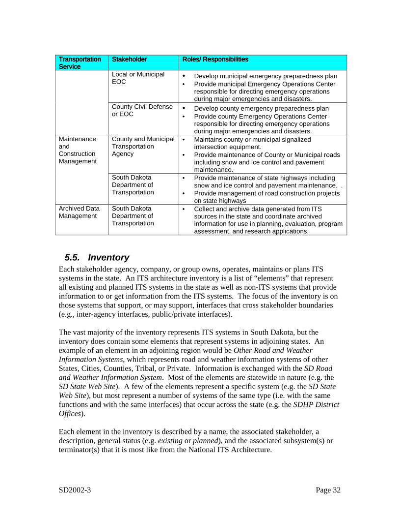
SD2002-3 Page 32
TransportationTransportationTransportationTransportationServiceServiceServiceService
StakeholderStakeholderStakeholderStakeholder Roles/ ResponsibilitiesRoles/ ResponsibilitiesRoles/ ResponsibilitiesRoles/ Responsibilities
Local or MunicipalEOC
• Develop municipal emergency preparedness plan• Provide municipal Emergency Operations Center
responsible for directing emergency operationsduring major emergencies and disasters.
County Civil Defenseor EOC
• Develop county emergency preparedness plan• Provide county Emergency Operations Center
responsible for directing emergency operationsduring major emergencies and disasters.
County and MunicipalTransportationAgency
• Maintains county or municipal signalizedintersection equipment.
• Provide maintenance of County or Municipal roadsincluding snow and ice control and pavementmaintenance.
MaintenanceandConstructionManagement
South DakotaDepartment ofTransportation
• Provide maintenance of state highways includingsnow and ice control and pavement maintenance. .
• Provide management of road construction projectson state highways
Archived DataManagement
South DakotaDepartment ofTransportation
• Collect and archive data generated from ITSsources in the state and coordinate archivedinformation for use in planning, evaluation, programassessment, and research applications.
5.5. InventoryEach stakeholder agency, company, or group owns, operates, maintains or plans ITSsystems in the state. An ITS architecture inventory is a list of “elements” that representall existing and planned ITS systems in the state as well as non-ITS systems that provideinformation to or get information from the ITS systems. The focus of the inventory is onthose systems that support, or may support, interfaces that cross stakeholder boundaries(e.g., inter-agency interfaces, public/private interfaces).
The vast majority of the inventory represents ITS systems in South Dakota, but theinventory does contain some elements that represent systems in adjoining states. Anexample of an element in an adjoining region would be Other Road and WeatherInformation Systems, which represents road and weather information systems of otherStates, Cities, Counties, Tribal, or Private. Information is exchanged with the SD Roadand Weather Information System. Most of the elements are statewide in nature (e.g. theSD State Web Site). A few of the elements represent a specific system (e.g. the SD StateWeb Site), but most represent a number of systems of the same type (i.e. with the samefunctions and with the same interfaces) that occur across the state (e.g. the SDHP DistrictOffices).
Each element in the inventory is described by a name, the associated stakeholder, adescription, general status (e.g. existing or planned), and the associated subsystem(s) orterminator(s) that it is most like from the National ITS Architecture.
SD2002-3 Page 33
5.5.1. Systems by Stakeholder
Table 6 sorts the South Dakota ITS inventory by stakeholder so that each stakeholder caneasily identify all the relevant elements that are allocated to them in the ITS architecture.For each element in the inventory the table provides an element description and anindication of whether the element exists or is planned.
The majority of elements in the inventory represent a specific existing or planned system.Some examples of specific systems are SDDOT Road and Weather Information Systemand the South Dakota Automated Permitting System Server.
Some of the elements represent sets of devices, rather than a single specific system ordevice. An example of this type of element is the element SDDOT Mobile FieldEquipment. This element represents all of the mobile Dynamic Message Signs (DMS),Highway Advisory Radio (HAR), and other equipment that will be operated by SDDOT.The element describes the type of devices, not the specific number of devices. Forexample, the element calls out DMS, but does say how many there are, or where theymight be located.
A third type of element in the inventory is a “generic” element that represents all of thesystems of a certain type in the region. An example of this type of element is County,Municipal, and Tribal Public Safety Dispatch, which represents the many county,municipal, or tribal public safety answering points (PSAPs) in the state.
These generic elements have been created for two primary reasons. First, they representelements with similar types of interfaces, so from a standardization standpoint, describinghow one of the major elements in the state (e.g. SDDOT Road and Weather InformationSystem) interfaces with individual PSAPs describes all of them. Second, describing many(there are over 100 PSAPs in the state) systems with a single element helps keep the ITSarchitecture from growing large with no apparent benefit.
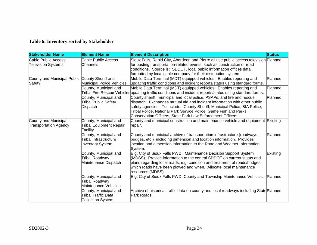
SD2002-3 Page 34
Table 6: Inventory sorted by Stakeholder
Stakeholder Name Element Name Element Description StatusCable Public AccessTelevision Systems
Cable Public AccessChannels
Sioux Falls, Rapid City, Aberdeen and Pierre all use public access televisionfor posting transportation-related events, such as construction or roadconditions. Source is: SDDOT, local public information offices dataformatted by local cable company for their distribution system.
Planned
County and Municipal PublicSafety
County Sheriff andMunicipal Police Vehicles
Mobile Data Terminal (MDT) equipped vehicles. Enables reporting andupdating traffic conditions and incident reports/status using standard forms.
Planned
County, Municipal andTribal Fire Rescue Vehicles
Mobile Data Terminal (MDT) equipped vehicles. Enables reporting andupdating traffic conditions and incident reports/status using standard forms.
Planned
County, Municipal andTribal Public SafetyDispatch
County sheriff, municipal and local police, PSAPs, and fire and rescuedispatch. Exchanges mutual aid and incident information with other publicsafety agencies. To include: County Sheriff, Municipal Police, BIA Police,Tribal Police, National Park Service Police, Game Fish and ParksConservation Officers, State Park Law Enforcement Officers.
Planned
County and MunicipalTransportation Agency
County, Municipal andTribal Equipment RepairFacility
County and municipal construction and maintenance vehicle and equipmentrepair.
Existing
County, Municipal andTribal InfrastructureInventory System
County and municipal archive of transportation infrastructure (roadways,bridges, etc.) including dimension and location information. Provideslocation and dimension information to the Road and Weather InformationSystem.
Planned
County, Municipal andTribal RoadwayMaintenance Dispatch
E.g. City of Sioux Falls PWD. Maintenance Decision Support System(MDSS). Provide information to the central SDDOT on current status andplans regarding local roads, e.g. condition and treatment of roads/bridges,which roads have been plowed and when. Allocate local maintenanceresources (MDSS).
Existing
County, Municipal andTribal RoadwayMaintenance Vehicles
E.g. City of Sioux Falls PWD, County and Township Maintenance Vehicles. Planned
County, Municipal andTribal Traffic DataCollection System
Archive of historical traffic data on county and local roadways including StatePark Roads.
Planned
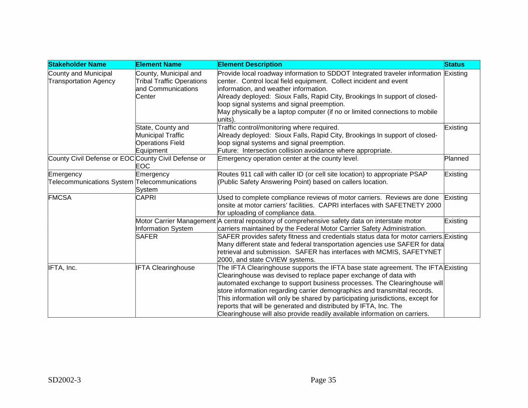
SD2002-3 Page 35
Stakeholder Name Element Name Element Description StatusCounty and MunicipalTransportation Agency
County, Municipal andTribal Traffic Operationsand CommunicationsCenter
Provide local roadway information to SDDOT Integrated traveler informationcenter. Control local field equipment. Collect incident and eventinformation, and weather information.Already deployed: Sioux Falls, Rapid City, Brookings In support of closed-loop signal systems and signal preemption.May physically be a laptop computer (if no or limited connections to mobileunits).
Existing
State, County andMunicipal TrafficOperations FieldEquipment
Traffic control/monitoring where required.Already deployed: Sioux Falls, Rapid City, Brookings In support of closed-loop signal systems and signal preemption.Future: Intersection collision avoidance where appropriate.
Existing
County Civil Defense or EOC County Civil Defense orEOC
Emergency operation center at the county level. Planned
EmergencyTelecommunications System
EmergencyTelecommunicationsSystem
Routes 911 call with caller ID (or cell site location) to appropriate PSAP(Public Safety Answering Point) based on callers location.
Existing
FMCSA CAPRI Used to complete compliance reviews of motor carriers. Reviews are doneonsite at motor carriers’ facilities. CAPRI interfaces with SAFETNETY 2000for uploading of compliance data.
Existing
Motor Carrier ManagementInformation System
A central repository of comprehensive safety data on interstate motorcarriers maintained by the Federal Motor Carrier Safety Administration.
Existing
SAFER SAFER provides safety fitness and credentials status data for motor carriers.Many different state and federal transportation agencies use SAFER for dataretrieval and submission. SAFER has interfaces with MCMIS, SAFETYNET2000, and state CVIEW systems.
Existing
IFTA, Inc. IFTA Clearinghouse The IFTA Clearinghouse supports the IFTA base state agreement. The IFTAClearinghouse was devised to replace paper exchange of data withautomated exchange to support business processes. The Clearinghouse willstore information regarding carrier demographics and transmittal records.This information will only be shared by participating jurisdictions, except forreports that will be generated and distributed by IFTA, Inc. TheClearinghouse will also provide readily available information on carriers.
Existing
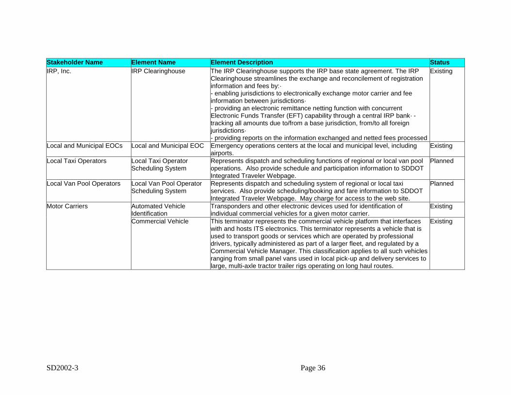
SD2002-3 Page 36
Stakeholder Name Element Name Element Description StatusIRP, Inc. IRP Clearinghouse The IRP Clearinghouse supports the IRP base state agreement. The IRP
Clearinghouse streamlines the exchange and reconcilement of registrationinformation and fees by:·- enabling jurisdictions to electronically exchange motor carrier and feeinformation between jurisdictions·- providing an electronic remittance netting function with concurrentElectronic Funds Transfer (EFT) capability through a central IRP bank· -tracking all amounts due to/from a base jurisdiction, from/to all foreignjurisdictions·- providing reports on the information exchanged and netted fees processed
Existing
Local and Municipal EOCs Local and Municipal EOC Emergency operations centers at the local and municipal level, includingairports.
Existing
Local Taxi Operators Local Taxi OperatorScheduling System
Represents dispatch and scheduling functions of regional or local van pooloperations. Also provide schedule and participation information to SDDOTIntegrated Traveler Webpage.
Planned
Local Van Pool Operators Local Van Pool OperatorScheduling System
Represents dispatch and scheduling system of regional or local taxiservices. Also provide scheduling/booking and fare information to SDDOTIntegrated Traveler Webpage. May charge for access to the web site.
Planned
Motor Carriers Automated VehicleIdentification
Transponders and other electronic devices used for identification ofindividual commercial vehicles for a given motor carrier.
Existing
Commercial Vehicle This terminator represents the commercial vehicle platform that interfaceswith and hosts ITS electronics. This terminator represents a vehicle that isused to transport goods or services which are operated by professionaldrivers, typically administered as part of a larger fleet, and regulated by aCommercial Vehicle Manager. This classification applies to all such vehiclesranging from small panel vans used in local pick-up and delivery services tolarge, multi-axle tractor trailer rigs operating on long haul routes.
Existing
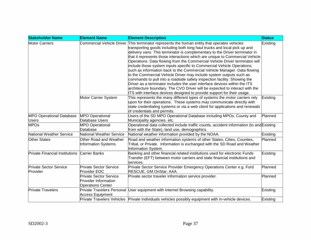
SD2002-3 Page 37
Stakeholder Name Element Name Element Description StatusMotor Carriers Commercial Vehicle Driver This terminator represents the human entity that operates vehicles
transporting goods including both long haul trucks and local pick up anddelivery vans. This terminator is complementary to the Driver terminator inthat it represents those interactions which are unique to Commercial VehicleOperations. Data flowing from the Commercial Vehicle Driver terminator willinclude those system inputs specific to Commercial Vehicle Operations,such as information back to the Commercial Vehicle Manager. Data flowingto the Commercial Vehicle Driver may include system outputs such ascommands to pull into a roadside safety inspection facility. Showing theDriver as a terminator includes the user interface devices within the ITSarchitecture boundary. The CVO Driver will be expected to interact with theITS with interface devices designed to provide support for their usage.
Existing
Motor Carrier System This represents the many different types of systems the motor carriers relyupon for their operations. These systems may communicate directly withstate credentialing systems or via a web client for applications and renewalsof credentials and permits.
Existing
MPO Operational DatabaseUsers
MPO OperationalDatabase Users
Users of the SD MPO Operational Database including MPOs, County andMunicipality agencies, etc.
Planned
MPOs MPO OperationalDatabase
Operational data collected include traffic counts, accident information (to andfrom with the State), land use, demographics.
Existing
National Weather Service National Weather Service National weather information provided by the NOAA. ExistingOther States Other Road and Weather
Information SystemsRoad and weather information systems of other States, Cities, Counties,Tribal, or Private. Information is exchanged with the SD Road and WeatherInformation System.
Planned
Private Financial Institutions Carrier Banks Banking and other financial related institutions used for electronic FundsTransfer (EFT) between motor carriers and state financial institutions andservices.
Existing
Private Sector ServiceProvider
Private Sector ServiceProvider EOC
Private Sector Service Provider Emergency Operations Center e.g. FordRESCUE, GM OnStar, AAA.
Planned
Private Sector ServiceProvider InformationOperations Center
Private sector traveler information service provider. Planned
Private Travelers Private Travelers PersonalAccess Equipment
User equipment with Internet Browsing capability. Existing
Private Travelers Vehicles Private individuals vehicles possibly equipment with in-vehicle devices. Existing
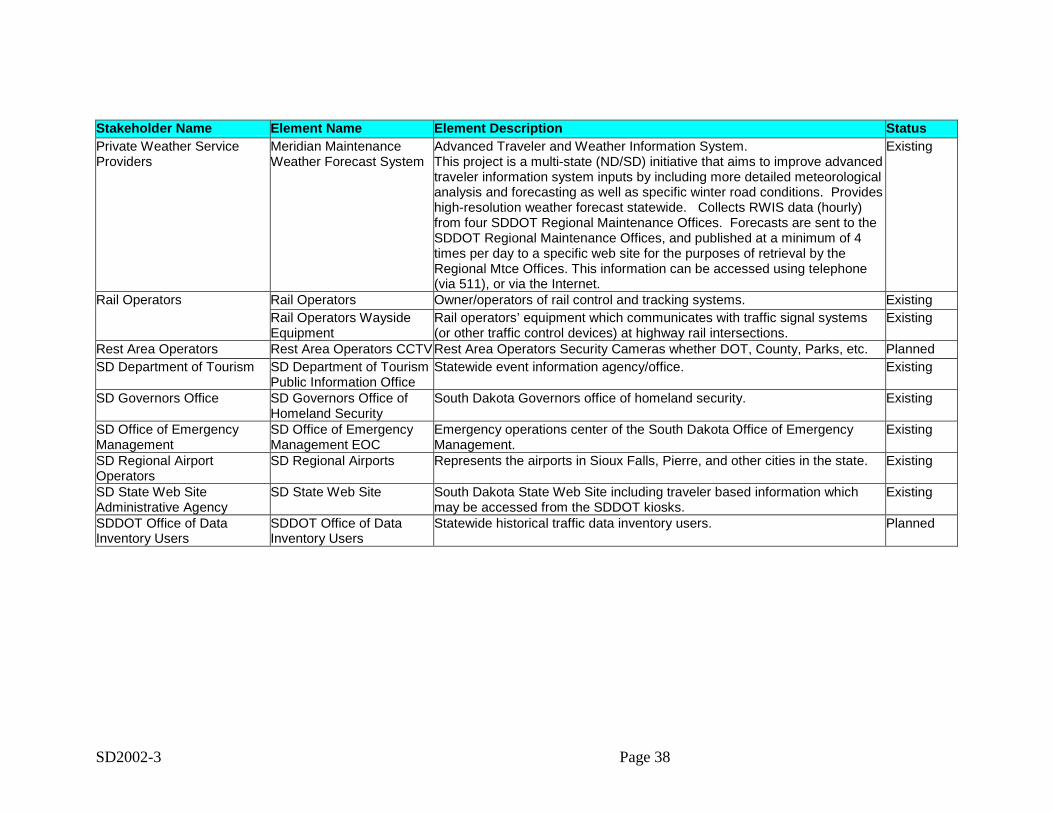
SD2002-3 Page 38
Stakeholder Name Element Name Element Description StatusPrivate Weather ServiceProviders
Meridian MaintenanceWeather Forecast System
Advanced Traveler and Weather Information System.This project is a multi-state (ND/SD) initiative that aims to improve advancedtraveler information system inputs by including more detailed meteorologicalanalysis and forecasting as well as specific winter road conditions. Provideshigh-resolution weather forecast statewide. Collects RWIS data (hourly)from four SDDOT Regional Maintenance Offices. Forecasts are sent to theSDDOT Regional Maintenance Offices, and published at a minimum of 4times per day to a specific web site for the purposes of retrieval by theRegional Mtce Offices. This information can be accessed using telephone(via 511), or via the Internet.
Existing
Rail Operators Rail Operators Owner/operators of rail control and tracking systems. ExistingRail Operators WaysideEquipment
Rail operators’ equipment which communicates with traffic signal systems(or other traffic control devices) at highway rail intersections.
Existing
Rest Area Operators Rest Area Operators CCTVRest Area Operators Security Cameras whether DOT, County, Parks, etc. PlannedSD Department of Tourism SD Department of Tourism
Public Information OfficeStatewide event information agency/office. Existing
SD Governors Office SD Governors Office ofHomeland Security
South Dakota Governors office of homeland security. Existing
SD Office of EmergencyManagement
SD Office of EmergencyManagement EOC
Emergency operations center of the South Dakota Office of EmergencyManagement.
Existing
SD Regional AirportOperators
SD Regional Airports Represents the airports in Sioux Falls, Pierre, and other cities in the state. Existing
SD State Web SiteAdministrative Agency
SD State Web Site South Dakota State Web Site including traveler based information whichmay be accessed from the SDDOT kiosks.
Existing
SDDOT Office of DataInventory Users
SDDOT Office of DataInventory Users
Statewide historical traffic data inventory users. Planned

SD2002-3 Page 39
Stakeholder Name Element Name Element Description StatusSouth Dakota Bureau ofInformation andTelecommunications
State Radio QueryApplication
The State Radio application is a part of the NLETS network. South Dakota'sportion of the network is called SDLETS. All queries from South Dakota lawenforcement, other state's law enforcement or federal authorities to SouthDakota come through the RS6000 or state switcher. Based on the type ofquery, there are a number of South Dakota databases accessed and theappropriate responses returned. The application connects to driverslicensing, title & registration, criminal history through various systems.Provides road conditions electronically to SDDOT.Exchanges mutual aid and incident information with other public safetyagencies.
Existing
South Dakota DCR CDL/DL Functionally serves as the primary system for driver licensing issuance, datamaintenance, retrieval, and dissemination. Connects to Unified JudicialSystem for moving-violation data coordination. This system also providescitation and violation data for commercial vehicle personnel to access.Roadside personnel will access CDL data from this system duringinspections and other enforcement related operations.
Existing
South Dakota Department ofGame, Fish and Parks andNational Parks
SD Dept of GFP andNational Parks EmergencyVehicles
SD Dept of Game, Fish and Parks and National Parks Emergency Vehicles.Dispatched by County and Municipal Public Safety Dispatch.
Planned
SD Dept of GFP andNational Parks Kiosks
SD Dept of GFP and National Parks kiosks and remote traveler informationsupport.
Planned
SD Dept of GFP andNational Parks OperationsCenters
SD Dept of Game, Fish and Parks and National Parks Operations Center(primarily law enforcement and security) - Conservation Officers.
Existing
SD Dept of GFP andNational Parks ParkingManagement Systems
Parking Management Systems of State and National Parks implementedprimarily for monitoring of parking availability for tourists.
Planned
South Dakota Department ofGame, Fish and Parks andNational Parks
SD Dept of GFP andNational Parks Web Site
SD Dept of GFP and National Parks Web Site Planned
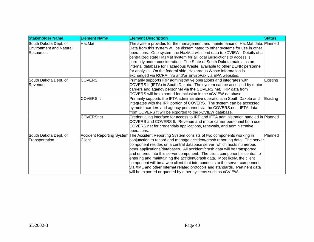
SD2002-3 Page 40
Stakeholder Name Element Name Element Description StatusSouth Dakota Dept. ofEnvironment and NaturalResources
HazMat The system provides for the management and maintenance of HazMat data.Data from this system will be disseminated to other systems for use in otheroperations. One system the HazMat will send data to xCVIEW. Details of acentralized state HazMat system for all local jurisdictions to access iscurrently under consideration. The State of South Dakota maintains aninternal database for Hazardous Waste, available to other DENR personnelfor analysis. On the federal side, Hazardous Waste information isexchanged via RCRA Info and/or EnviroFax via EPA websites.
Planned
South Dakota Dept. ofRevenue
COVERS Primarily supports IRP administrative operations and integrates withCOVERS ft (IFTA) in South Dakota. The system can be accessed by motorcarriers and agency personnel via the COVERS.net. IRP data fromCOVERS will be exported for inclusion in the xCVIEW database.
Existing
COVERS ft Primarily supports the IFTA administrative operations in South Dakota andintegrates with the IRP portion of COVERS. The system can be accessedby motor carriers and agency personnel via the COVERS.net. IFTA datafrom COVERS ft will be exported to the xCVIEW database.
Existing
COVERSnet Credentialing interface for access to IRP and IFTA administration handled inCOVERS and COVERS ft. Revenue and motor carrier personnel both useCOVERS.net for credentials applications, renewals, and administrativeoperations.
Planned
South Dakota Dept. ofTransportation
Accident Reporting SystemClient
The Accident Reporting System consists of two components working inconjunction to record and manage accident/crash reporting data. The servercomponent resides on a central database server, which hosts numerousother applications/databases. All accident/crash data will be transportedand entered into this server component. The client component is central toentering and maintaining the accident/crash data. Most likely, the clientcomponent will be a web client that interconnects to the server componentvia XML and other Internet related protocols and standards. Pertinent datawill be exported or queried by other systems such as xCVIEW.
Planned
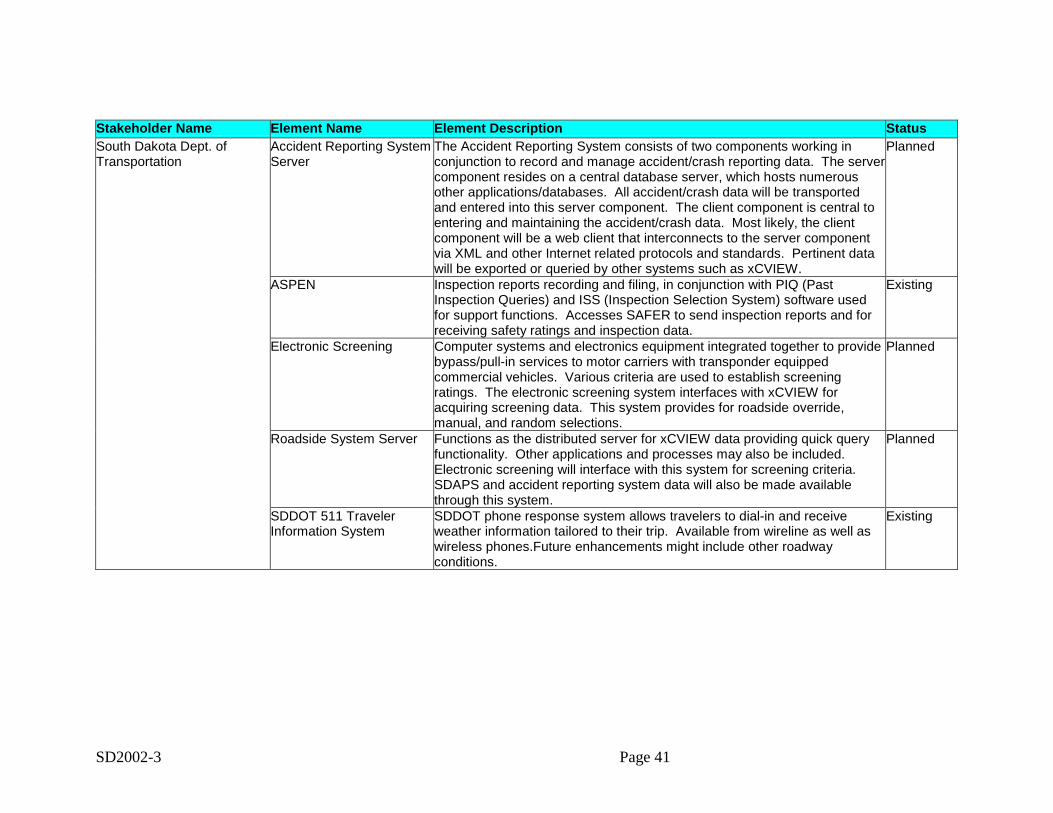
SD2002-3 Page 41
Stakeholder Name Element Name Element Description StatusSouth Dakota Dept. ofTransportation
Accident Reporting SystemServer
The Accident Reporting System consists of two components working inconjunction to record and manage accident/crash reporting data. The servercomponent resides on a central database server, which hosts numerousother applications/databases. All accident/crash data will be transportedand entered into this server component. The client component is central toentering and maintaining the accident/crash data. Most likely, the clientcomponent will be a web client that interconnects to the server componentvia XML and other Internet related protocols and standards. Pertinent datawill be exported or queried by other systems such as xCVIEW.
Planned
ASPEN Inspection reports recording and filing, in conjunction with PIQ (PastInspection Queries) and ISS (Inspection Selection System) software usedfor support functions. Accesses SAFER to send inspection reports and forreceiving safety ratings and inspection data.
Existing
Electronic Screening Computer systems and electronics equipment integrated together to providebypass/pull-in services to motor carriers with transponder equippedcommercial vehicles. Various criteria are used to establish screeningratings. The electronic screening system interfaces with xCVIEW foracquiring screening data. This system provides for roadside override,manual, and random selections.
Planned
Roadside System Server Functions as the distributed server for xCVIEW data providing quick queryfunctionality. Other applications and processes may also be included.Electronic screening will interface with this system for screening criteria.SDAPS and accident reporting system data will also be made availablethrough this system.
Planned
SDDOT 511 TravelerInformation System
SDDOT phone response system allows travelers to dial-in and receiveweather information tailored to their trip. Available from wireline as well aswireless phones.Future enhancements might include other roadwayconditions.
Existing
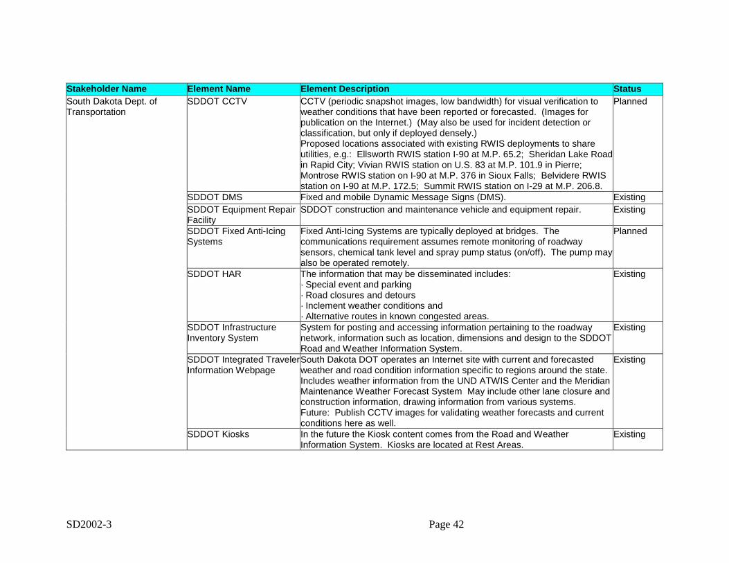
SD2002-3 Page 42
Stakeholder Name Element Name Element Description StatusSouth Dakota Dept. ofTransportation
SDDOT CCTV CCTV (periodic snapshot images, low bandwidth) for visual verification toweather conditions that have been reported or forecasted. (Images forpublication on the Internet.) (May also be used for incident detection orclassification, but only if deployed densely.)Proposed locations associated with existing RWIS deployments to shareutilities, e.g.: Ellsworth RWIS station I-90 at M.P. 65.2; Sheridan Lake Roadin Rapid City; Vivian RWIS station on U.S. 83 at M.P. 101.9 in Pierre;Montrose RWIS station on I-90 at M.P. 376 in Sioux Falls; Belvidere RWISstation on I-90 at M.P. 172.5; Summit RWIS station on I-29 at M.P. 206.8.
Planned
SDDOT DMS Fixed and mobile Dynamic Message Signs (DMS). ExistingSDDOT Equipment RepairFacility
SDDOT construction and maintenance vehicle and equipment repair. Existing
SDDOT Fixed Anti-IcingSystems
Fixed Anti-Icing Systems are typically deployed at bridges. Thecommunications requirement assumes remote monitoring of roadwaysensors, chemical tank level and spray pump status (on/off). The pump mayalso be operated remotely.
Planned
SDDOT HAR The information that may be disseminated includes:· Special event and parking· Road closures and detours· Inclement weather conditions and· Alternative routes in known congested areas.
Existing
SDDOT InfrastructureInventory System
System for posting and accessing information pertaining to the roadwaynetwork, information such as location, dimensions and design to the SDDOTRoad and Weather Information System.
Existing
SDDOT Integrated TravelerInformation Webpage
South Dakota DOT operates an Internet site with current and forecastedweather and road condition information specific to regions around the state.Includes weather information from the UND ATWIS Center and the MeridianMaintenance Weather Forecast System May include other lane closure andconstruction information, drawing information from various systems.Future: Publish CCTV images for validating weather forecasts and currentconditions here as well.
Existing
SDDOT Kiosks In the future the Kiosk content comes from the Road and WeatherInformation System. Kiosks are located at Rest Areas.
Existing
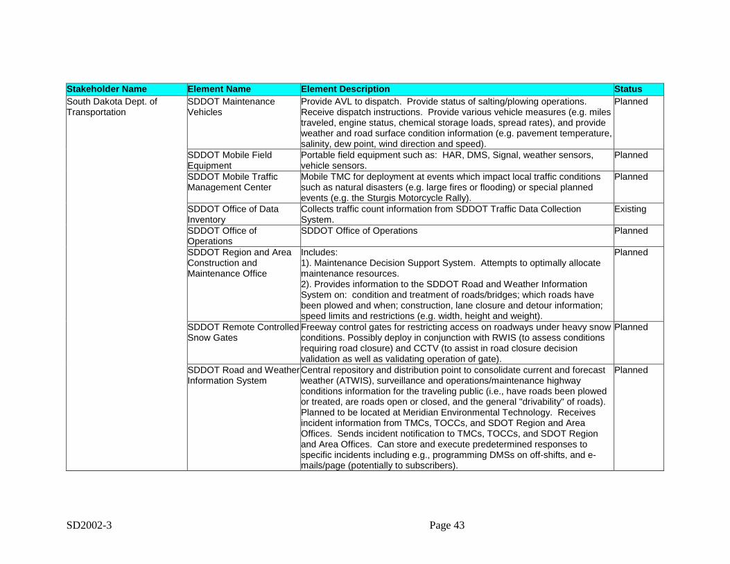
SD2002-3 Page 43
Stakeholder Name Element Name Element Description StatusSouth Dakota Dept. ofTransportation
SDDOT MaintenanceVehicles
Provide AVL to dispatch. Provide status of salting/plowing operations.Receive dispatch instructions. Provide various vehicle measures (e.g. milestraveled, engine status, chemical storage loads, spread rates), and provideweather and road surface condition information (e.g. pavement temperature,salinity, dew point, wind direction and speed).
Planned
SDDOT Mobile FieldEquipment
Portable field equipment such as: HAR, DMS, Signal, weather sensors,vehicle sensors.
Planned
SDDOT Mobile TrafficManagement Center
Mobile TMC for deployment at events which impact local traffic conditionssuch as natural disasters (e.g. large fires or flooding) or special plannedevents (e.g. the Sturgis Motorcycle Rally).
Planned
SDDOT Office of DataInventory
Collects traffic count information from SDDOT Traffic Data CollectionSystem.
Existing
SDDOT Office ofOperations
SDDOT Office of Operations Planned
SDDOT Region and AreaConstruction andMaintenance Office
Includes:1). Maintenance Decision Support System. Attempts to optimally allocatemaintenance resources.2). Provides information to the SDDOT Road and Weather InformationSystem on: condition and treatment of roads/bridges; which roads havebeen plowed and when; construction, lane closure and detour information;speed limits and restrictions (e.g. width, height and weight).
Planned
SDDOT Remote ControlledSnow Gates
Freeway control gates for restricting access on roadways under heavy snowconditions. Possibly deploy in conjunction with RWIS (to assess conditionsrequiring road closure) and CCTV (to assist in road closure decisionvalidation as well as validating operation of gate).
Planned
SDDOT Road and WeatherInformation System
Central repository and distribution point to consolidate current and forecastweather (ATWIS), surveillance and operations/maintenance highwayconditions information for the traveling public (i.e., have roads been plowedor treated, are roads open or closed, and the general "drivability" of roads).Planned to be located at Meridian Environmental Technology. Receivesincident information from TMCs, TOCCs, and SDOT Region and AreaOffices. Sends incident notification to TMCs, TOCCs, and SDOT Regionand Area Offices. Can store and execute predetermined responses tospecific incidents including e.g., programming DMSs on off-shifts, and e-mails/page (potentially to subscribers).
Planned
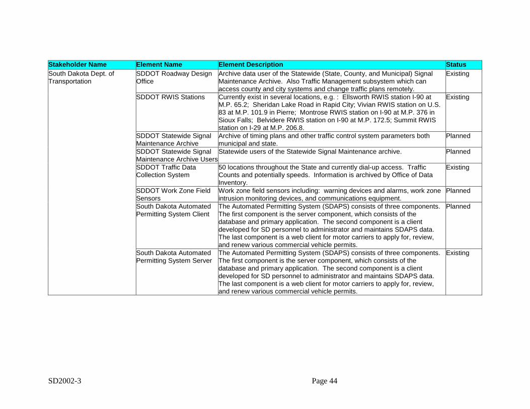
SD2002-3 Page 44
Stakeholder Name Element Name Element Description StatusSouth Dakota Dept. ofTransportation
SDDOT Roadway DesignOffice
Archive data user of the Statewide (State, County, and Municipal) SignalMaintenance Archive. Also Traffic Management subsystem which canaccess county and city systems and change traffic plans remotely.
Existing
SDDOT RWIS Stations Currently exist in several locations, e.g. : Ellsworth RWIS station I-90 atM.P. 65.2; Sheridan Lake Road in Rapid City; Vivian RWIS station on U.S.83 at M.P. 101.9 in Pierre; Montrose RWIS station on I-90 at M.P. 376 inSioux Falls; Belvidere RWIS station on I-90 at M.P. 172.5; Summit RWISstation on I-29 at M.P. 206.8.
Existing
SDDOT Statewide SignalMaintenance Archive
Archive of timing plans and other traffic control system parameters bothmunicipal and state.
Planned
SDDOT Statewide SignalMaintenance Archive Users
Statewide users of the Statewide Signal Maintenance archive. Planned
SDDOT Traffic DataCollection System
50 locations throughout the State and currently dial-up access. TrafficCounts and potentially speeds. Information is archived by Office of DataInventory.
Existing
SDDOT Work Zone FieldSensors
Work zone field sensors including: warning devices and alarms, work zoneintrusion monitoring devices, and communications equipment.
Planned
South Dakota AutomatedPermitting System Client
The Automated Permitting System (SDAPS) consists of three components.The first component is the server component, which consists of thedatabase and primary application. The second component is a clientdeveloped for SD personnel to administrator and maintains SDAPS data.The last component is a web client for motor carriers to apply for, review,and renew various commercial vehicle permits.
Planned
South Dakota AutomatedPermitting System Server
The Automated Permitting System (SDAPS) consists of three components.The first component is the server component, which consists of thedatabase and primary application. The second component is a clientdeveloped for SD personnel to administrator and maintains SDAPS data.The last component is a web client for motor carriers to apply for, review,and renew various commercial vehicle permits.
Existing
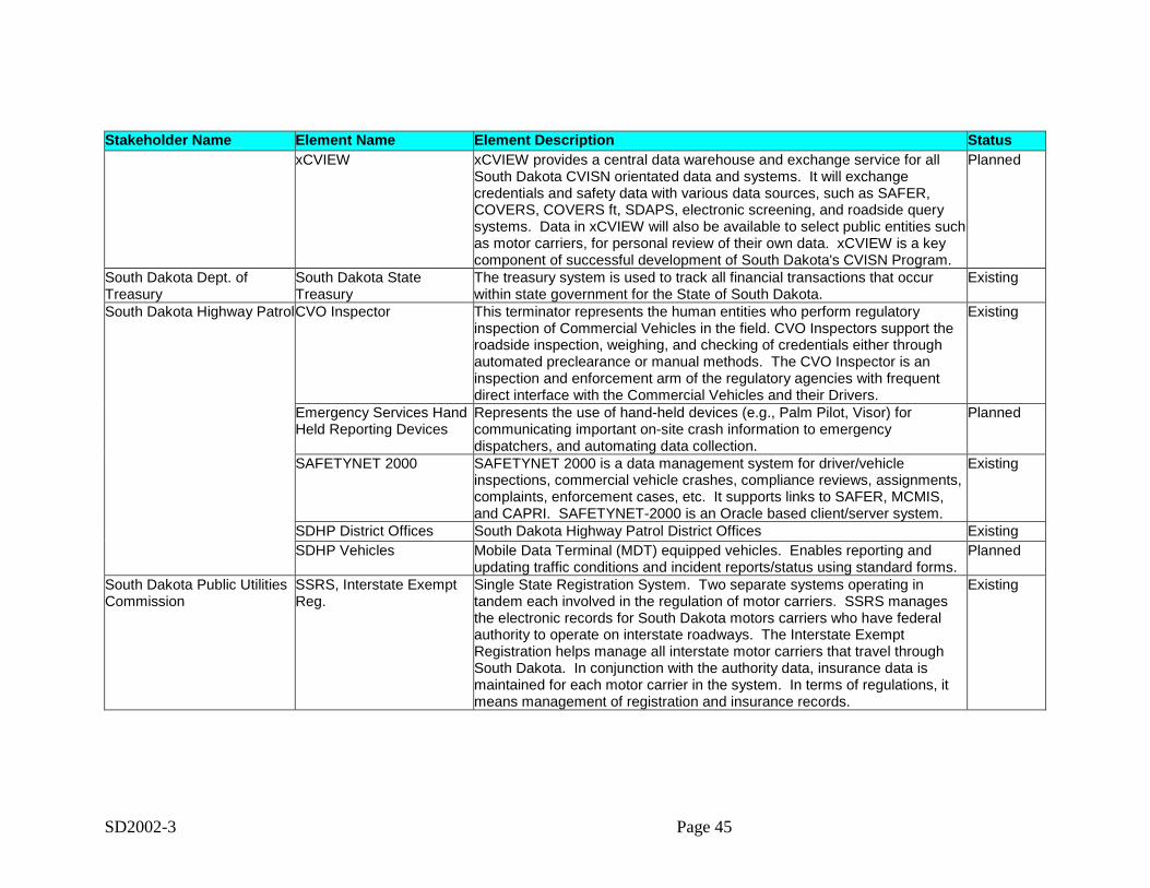
SD2002-3 Page 45
Stakeholder Name Element Name Element Description StatusxCVIEW xCVIEW provides a central data warehouse and exchange service for all
South Dakota CVISN orientated data and systems. It will exchangecredentials and safety data with various data sources, such as SAFER,COVERS, COVERS ft, SDAPS, electronic screening, and roadside querysystems. Data in xCVIEW will also be available to select public entities suchas motor carriers, for personal review of their own data. xCVIEW is a keycomponent of successful development of South Dakota's CVISN Program.
Planned
South Dakota Dept. ofTreasury
South Dakota StateTreasury
The treasury system is used to track all financial transactions that occurwithin state government for the State of South Dakota.
Existing
South Dakota Highway PatrolCVO Inspector This terminator represents the human entities who perform regulatoryinspection of Commercial Vehicles in the field. CVO Inspectors support theroadside inspection, weighing, and checking of credentials either throughautomated preclearance or manual methods. The CVO Inspector is aninspection and enforcement arm of the regulatory agencies with frequentdirect interface with the Commercial Vehicles and their Drivers.
Existing
Emergency Services HandHeld Reporting Devices
Represents the use of hand-held devices (e.g., Palm Pilot, Visor) forcommunicating important on-site crash information to emergencydispatchers, and automating data collection.
Planned
SAFETYNET 2000 SAFETYNET 2000 is a data management system for driver/vehicleinspections, commercial vehicle crashes, compliance reviews, assignments,complaints, enforcement cases, etc. It supports links to SAFER, MCMIS,and CAPRI. SAFETYNET-2000 is an Oracle based client/server system.
Existing
SDHP District Offices South Dakota Highway Patrol District Offices ExistingSDHP Vehicles Mobile Data Terminal (MDT) equipped vehicles. Enables reporting and
updating traffic conditions and incident reports/status using standard forms.Planned
South Dakota Public UtilitiesCommission
SSRS, Interstate ExemptReg.
Single State Registration System. Two separate systems operating intandem each involved in the regulation of motor carriers. SSRS managesthe electronic records for South Dakota motors carriers who have federalauthority to operate on interstate roadways. The Interstate ExemptRegistration helps manage all interstate motor carriers that travel throughSouth Dakota. In conjunction with the authority data, insurance data ismaintained for each motor carrier in the system. In terms of regulations, itmeans management of registration and insurance records.
Existing
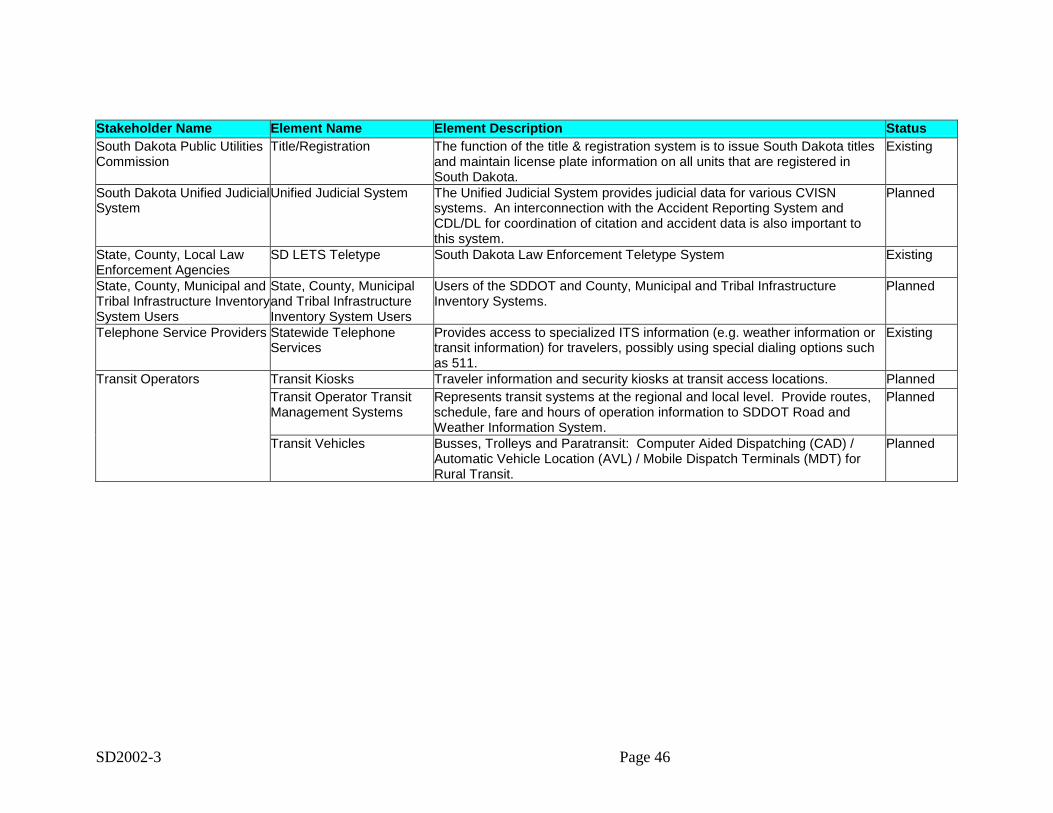
SD2002-3 Page 46
Stakeholder Name Element Name Element Description StatusSouth Dakota Public UtilitiesCommission
Title/Registration The function of the title & registration system is to issue South Dakota titlesand maintain license plate information on all units that are registered inSouth Dakota.
Existing
South Dakota Unified JudicialSystem
Unified Judicial System The Unified Judicial System provides judicial data for various CVISNsystems. An interconnection with the Accident Reporting System andCDL/DL for coordination of citation and accident data is also important tothis system.
Planned
State, County, Local LawEnforcement Agencies
SD LETS Teletype South Dakota Law Enforcement Teletype System Existing
State, County, Municipal andTribal Infrastructure InventorySystem Users
State, County, Municipaland Tribal InfrastructureInventory System Users
Users of the SDDOT and County, Municipal and Tribal InfrastructureInventory Systems.
Planned
Telephone Service Providers Statewide TelephoneServices
Provides access to specialized ITS information (e.g. weather information ortransit information) for travelers, possibly using special dialing options suchas 511.
Existing
Transit Operators Transit Kiosks Traveler information and security kiosks at transit access locations. PlannedTransit Operator TransitManagement Systems
Represents transit systems at the regional and local level. Provide routes,schedule, fare and hours of operation information to SDDOT Road andWeather Information System.
Planned
Transit Vehicles Busses, Trolleys and Paratransit: Computer Aided Dispatching (CAD) /Automatic Vehicle Location (AVL) / Mobile Dispatch Terminals (MDT) forRural Transit.
Planned
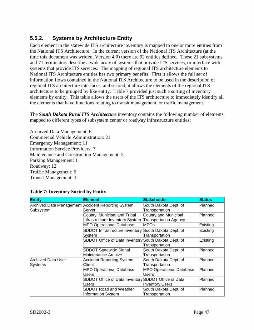
SD2002-3 Page 47
5.5.2. Systems by Architecture EntityEach element in the statewide ITS architecture inventory is mapped to one or more entities fromthe National ITS Architecture. In the current version of the National ITS Architecture (at thetime this document was written, Version 4.0) there are 92 entities defined. These 21 subsystemsand 71 terminators describe a wide array of systems that provide ITS services, or interface withsystems that provide ITS services. The mapping of regional ITS architecture elements toNational ITS Architecture entities has two primary benefits. First it allows the full set ofinformation flows contained in the National ITS Architecture to be used in the description ofregional ITS architecture interfaces, and second, it allows the elements of the regional ITSarchitecture to be grouped by like entity. Table 7 provided just such a sorting of inventoryelements by entity. This table allows the users of the ITS architecture to immediately identify allthe elements that have functions relating to transit management, or traffic management.
The South Dakota Rural ITS Architecture inventory contains the following number of elementsmapped to different types of subsystem center or roadway infrastructure entities:
Archived Data Management: 6Commercial Vehicle Administration: 21Emergency Management: 11Information Service Providers: 7Maintenance and Construction Management: 5Parking Management: 1Roadway: 12Traffic Management: 6Transit Management: 1
Table 7: Inventory Sorted by EntityEntity Element Stakeholder StatusArchived Data ManagementSubsystem
Accident Reporting SystemServer
South Dakota Dept. ofTransportation
Planned
County, Municipal and TribalInfrastructure Inventory System
County and MunicipalTransportation Agency
Planned
MPO Operational Database MPOs ExistingSDDOT Infrastructure InventorySystem
South Dakota Dept. ofTransportation
Existing
SDDOT Office of Data InventorySouth Dakota Dept. ofTransportation
Existing
SDDOT Statewide SignalMaintenance Archive
South Dakota Dept. ofTransportation
Planned
Archived Data UserSystems
Accident Reporting SystemClient
South Dakota Dept. ofTransportation
Planned
MPO Operational DatabaseUsers
MPO Operational DatabaseUsers
Planned
SDDOT Office of Data InventoryUsers
SDDOT Office of DataInventory Users
Planned
SDDOT Road and WeatherInformation System
South Dakota Dept. ofTransportation
Planned
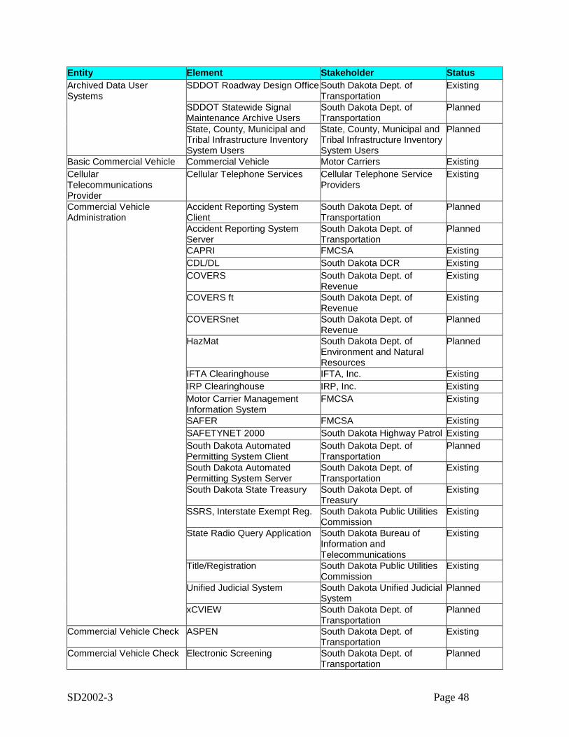
SD2002-3 Page 48
Entity Element Stakeholder StatusArchived Data UserSystems
SDDOT Roadway Design Office South Dakota Dept. ofTransportation
Existing
SDDOT Statewide SignalMaintenance Archive Users
South Dakota Dept. ofTransportation
Planned
State, County, Municipal andTribal Infrastructure InventorySystem Users
State, County, Municipal andTribal Infrastructure InventorySystem Users
Planned
Basic Commercial Vehicle Commercial Vehicle Motor Carriers ExistingCellularTelecommunicationsProvider
Cellular Telephone Services Cellular Telephone ServiceProviders
Existing
Commercial VehicleAdministration
Accident Reporting SystemClient
South Dakota Dept. ofTransportation
Planned
Accident Reporting SystemServer
South Dakota Dept. ofTransportation
Planned
CAPRI FMCSA ExistingCDL/DL South Dakota DCR ExistingCOVERS South Dakota Dept. of
RevenueExisting
COVERS ft South Dakota Dept. ofRevenue
Existing
COVERSnet South Dakota Dept. ofRevenue
Planned
HazMat South Dakota Dept. ofEnvironment and NaturalResources
Planned
IFTA Clearinghouse IFTA, Inc. ExistingIRP Clearinghouse IRP, Inc. ExistingMotor Carrier ManagementInformation System
FMCSA Existing
SAFER FMCSA ExistingSAFETYNET 2000 South Dakota Highway Patrol ExistingSouth Dakota AutomatedPermitting System Client
South Dakota Dept. ofTransportation
Planned
South Dakota AutomatedPermitting System Server
South Dakota Dept. ofTransportation
Existing
South Dakota State Treasury South Dakota Dept. ofTreasury
Existing
SSRS, Interstate Exempt Reg. South Dakota Public UtilitiesCommission
Existing
State Radio Query Application South Dakota Bureau ofInformation andTelecommunications
Existing
Title/Registration South Dakota Public UtilitiesCommission
Existing
Unified Judicial System South Dakota Unified JudicialSystem
Planned
xCVIEW South Dakota Dept. ofTransportation
Planned
Commercial Vehicle Check ASPEN South Dakota Dept. ofTransportation
Existing
Commercial Vehicle Check Electronic Screening South Dakota Dept. ofTransportation
Planned

SD2002-3 Page 49
Entity Element Stakeholder StatusRoadside System Server South Dakota Dept. of
TransportationPlanned
Commercial Vehicle Driver Commercial Vehicle Driver Motor Carriers ExistingCommercial VehicleSubsystem
Automated Vehicle Identification Motor Carriers Existing
CVO Inspector CVO Inspector South Dakota Highway Patrol ExistingEmergency Management County Civil Defense or EOC County Civil Defense or EOC Planned
County, Municipal and TribalPublic Safety Dispatch
County and Municipal PublicSafety
Planned
HazMat South Dakota Dept. ofEnvironment and NaturalResources
Planned
Local and Municipal EOC Local and Municipal EOCs ExistingPrivate Sector Service ProviderEOC
Private Sector ServiceProvider
Planned
SD Dept of GFP and NationalParks Operations Centers
South Dakota Department ofGame, Fish and Parks andNational Parks
Existing
SD Governors Office ofHomeland Security
SD Governors Office Existing
SD LETS Teletype State, County, Local LawEnforcement Agencies
Existing
SD Office of EmergencyManagement EOC
SD Office of EmergencyManagement
Existing
SDHP District Offices SDHP ExistingState Radio Query Application South Dakota Bureau of
Information andTelecommunications
Existing
EmergencyTelecommunicationsSystem
EmergencyTelecommunications System
EmergencyTelecommunications System
Existing
Emergency VehicleSubsystem
County Sheriff and MunicipalPolice Vehicles
County and Municipal PublicSafety
Planned
County, Municipal and TribalFire Rescue Vehicles
County and Municipal PublicSafety
Planned
SD Dept of GFP and NationalParks Emergency Vehicles
South Dakota Department ofGame, Fish and Parks andNational Parks
Planned
SDHP Vehicles SDHP PlannedEnforcement Agency Accident Reporting System
ClientSouth Dakota Dept. ofTransportation
Planned
Accident Reporting SystemServer
South Dakota Dept. ofTransportation
Planned
CVO Inspector South Dakota Highway Patrol ExistingUnified Judicial System South Dakota Unified Judicial
SystemPlanned
Equipment Repair Facility County, Municipal and TribalEquipment Repair Facility
County and MunicipalTransportation Agency
Existing
SDDOT Equipment RepairFacility
South Dakota Dept. ofTransportation
Existing
Event Promoters SD Department of TourismPublic Information Office
SD Department of Tourism Existing
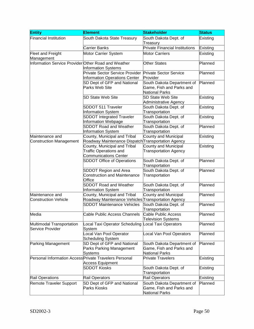
SD2002-3 Page 50
Entity Element Stakeholder StatusFinancial Institution South Dakota State Treasury South Dakota Dept. of
TreasuryExisting
Carrier Banks Private Financial Institutions ExistingFleet and FreightManagement
Motor Carrier System Motor Carriers Existing
Information Service Provider Other Road and WeatherInformation Systems
Other States Planned
Private Sector Service ProviderInformation Operations Center
Private Sector ServiceProvider
Planned
SD Dept of GFP and NationalParks Web Site
South Dakota Department ofGame, Fish and Parks andNational Parks
Planned
SD State Web Site SD State Web SiteAdministrative Agency
Existing
SDDOT 511 TravelerInformation System
South Dakota Dept. ofTransportation
Existing
SDDOT Integrated TravelerInformation Webpage
South Dakota Dept. ofTransportation
Existing
SDDOT Road and WeatherInformation System
South Dakota Dept. ofTransportation
Planned
Maintenance andConstruction Management
County, Municipal and TribalRoadway Maintenance Dispatch
County and MunicipalTransportation Agency
Existing
County, Municipal and TribalTraffic Operations andCommunications Center
County and MunicipalTransportation Agency
Existing
SDDOT Office of Operations South Dakota Dept. ofTransportation
Planned
SDDOT Region and AreaConstruction and MaintenanceOffice
South Dakota Dept. ofTransportation
Planned
SDDOT Road and WeatherInformation System
South Dakota Dept. ofTransportation
Planned
Maintenance andConstruction Vehicle
County, Municipal and TribalRoadway Maintenance Vehicles
County and MunicipalTransportation Agency
Planned
SDDOT Maintenance Vehicles South Dakota Dept. ofTransportation
Planned
Media Cable Public Access Channels Cable Public AccessTelevision Systems
Planned
Multimodal TransportationService Provider
Local Taxi Operator SchedulingSystem
Local Taxi Operators Planned
Local Van Pool OperatorScheduling System
Local Van Pool Operators Planned
Parking Management SD Dept of GFP and NationalParks Parking ManagementSystems
South Dakota Department ofGame, Fish and Parks andNational Parks
Planned
Personal Information AccessPrivate Travelers PersonalAccess Equipment
Private Travelers Existing
SDDOT Kiosks South Dakota Dept. ofTransportation
Existing
Rail Operations Rail Operators Rail Operators ExistingRemote Traveler Support SD Dept of GFP and National
Parks KiosksSouth Dakota Department ofGame, Fish and Parks andNational Parks
Planned
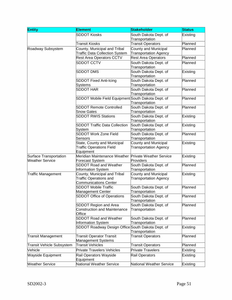
SD2002-3 Page 51
Entity Element Stakeholder StatusSDDOT Kiosks South Dakota Dept. of
TransportationExisting
Transit Kiosks Transit Operators PlannedRoadway Subsystem County, Municipal and Tribal
Traffic Data Collection SystemCounty and MunicipalTransportation Agency
Planned
Rest Area Operators CCTV Rest Area Operators PlannedSDDOT CCTV South Dakota Dept. of
TransportationPlanned
SDDOT DMS South Dakota Dept. ofTransportation
Existing
SDDOT Fixed Anti-IcingSystems
South Dakota Dept. ofTransportation
Planned
SDDOT HAR South Dakota Dept. ofTransportation
Planned
SDDOT Mobile Field Equipment South Dakota Dept. ofTransportation
Planned
SDDOT Remote ControlledSnow Gates
South Dakota Dept. ofTransportation
Planned
SDDOT RWIS Stations South Dakota Dept. ofTransportation
Existing
SDDOT Traffic Data CollectionSystem
South Dakota Dept. ofTransportation
Existing
SDDOT Work Zone FieldSensors
South Dakota Dept. ofTransportation
Planned
State, County and MunicipalTraffic Operations FieldEquipment
County and MunicipalTransportation Agency
Existing
Surface TransportationWeather Service
Meridian Maintenance WeatherForecast System
Private Weather ServiceProviders
Existing
SDDOT Road and WeatherInformation System
South Dakota Dept. ofTransportation
Planned
Traffic Management County, Municipal and TribalTraffic Operations andCommunications Center
County and MunicipalTransportation Agency
Existing
SDDOT Mobile TrafficManagement Center
South Dakota Dept. ofTransportation
Planned
SDDOT Office of Operations South Dakota Dept. ofTransportation
Planned
SDDOT Region and AreaConstruction and MaintenanceOffice
South Dakota Dept. ofTransportation
Planned
SDDOT Road and WeatherInformation System
South Dakota Dept. ofTransportation
Planned
SDDOT Roadway Design Office South Dakota Dept. ofTransportation
Existing
Transit Management Transit Operator TransitManagement Systems
Transit Operators Planned
Transit Vehicle Subsystem Transit Vehicles Transit Operators PlannedVehicle Private Travelers Vehicles Private Travelers ExistingWayside Equipment Rail Operators Wayside
EquipmentRail Operators Existing
Weather Service National Weather Service National Weather Service Existing
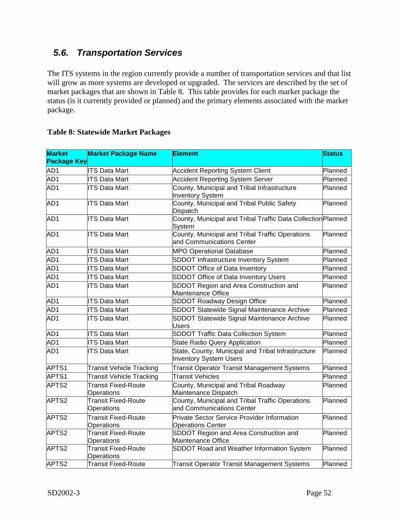
SD2002-3 Page 52
5.6. Transportation Services
The ITS systems in the region currently provide a number of transportation services and that listwill grow as more systems are developed or upgraded. The services are described by the set ofmarket packages that are shown in Table 8. This table provides for each market package thestatus (is it currently provided or planned) and the primary elements associated with the marketpackage.
Table 8: Statewide Market Packages
MarketPackage Key
Market Package Name Element Status
AD1 ITS Data Mart Accident Reporting System Client PlannedAD1 ITS Data Mart Accident Reporting System Server PlannedAD1 ITS Data Mart County, Municipal and Tribal Infrastructure
Inventory SystemPlanned
AD1 ITS Data Mart County, Municipal and Tribal Public SafetyDispatch
Planned
AD1 ITS Data Mart County, Municipal and Tribal Traffic Data CollectionSystem
Planned
AD1 ITS Data Mart County, Municipal and Tribal Traffic Operationsand Communications Center
Planned
AD1 ITS Data Mart MPO Operational Database PlannedAD1 ITS Data Mart SDDOT Infrastructure Inventory System PlannedAD1 ITS Data Mart SDDOT Office of Data Inventory PlannedAD1 ITS Data Mart SDDOT Office of Data Inventory Users PlannedAD1 ITS Data Mart SDDOT Region and Area Construction and
Maintenance OfficePlanned
AD1 ITS Data Mart SDDOT Roadway Design Office PlannedAD1 ITS Data Mart SDDOT Statewide Signal Maintenance Archive PlannedAD1 ITS Data Mart SDDOT Statewide Signal Maintenance Archive
UsersPlanned
AD1 ITS Data Mart SDDOT Traffic Data Collection System PlannedAD1 ITS Data Mart State Radio Query Application PlannedAD1 ITS Data Mart State, County, Municipal and Tribal Infrastructure
Inventory System UsersPlanned
APTS1 Transit Vehicle Tracking Transit Operator Transit Management Systems PlannedAPTS1 Transit Vehicle Tracking Transit Vehicles PlannedAPTS2 Transit Fixed-Route
OperationsCounty, Municipal and Tribal RoadwayMaintenance Dispatch
Planned
APTS2 Transit Fixed-RouteOperations
County, Municipal and Tribal Traffic Operationsand Communications Center
Planned
APTS2 Transit Fixed-RouteOperations
Private Sector Service Provider InformationOperations Center
Planned
APTS2 Transit Fixed-RouteOperations
SDDOT Region and Area Construction andMaintenance Office
Planned
APTS2 Transit Fixed-RouteOperations
SDDOT Road and Weather Information System Planned
APTS2 Transit Fixed-Route Transit Operator Transit Management Systems Planned
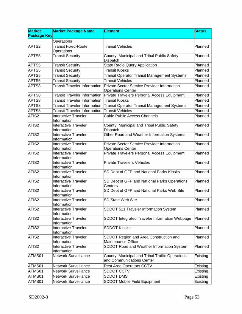
SD2002-3 Page 53
MarketPackage Key
Market Package Name Element Status
OperationsAPTS2 Transit Fixed-Route
OperationsTransit Vehicles Planned
APTS5 Transit Security County, Municipal and Tribal Public SafetyDispatch
Planned
APTS5 Transit Security State Radio Query Application PlannedAPTS5 Transit Security Transit Kiosks PlannedAPTS5 Transit Security Transit Operator Transit Management Systems PlannedAPTS5 Transit Security Transit Vehicles PlannedAPTS8 Transit Traveler Information Private Sector Service Provider Information
Operations CenterPlanned
APTS8 Transit Traveler Information Private Travelers Personal Access Equipment PlannedAPTS8 Transit Traveler Information Transit Kiosks PlannedAPTS8 Transit Traveler Information Transit Operator Transit Management Systems PlannedAPTS8 Transit Traveler Information Transit Vehicles PlannedATIS2 Interactive Traveler
InformationCable Public Access Channels Planned
ATIS2 Interactive TravelerInformation
County, Municipal and Tribal Public SafetyDispatch
Planned
ATIS2 Interactive TravelerInformation
Other Road and Weather Information Systems Planned
ATIS2 Interactive TravelerInformation
Private Sector Service Provider InformationOperations Center
Planned
ATIS2 Interactive TravelerInformation
Private Travelers Personal Access Equipment Planned
ATIS2 Interactive TravelerInformation
Private Travelers Vehicles Planned
ATIS2 Interactive TravelerInformation
SD Dept of GFP and National Parks Kiosks Planned
ATIS2 Interactive TravelerInformation
SD Dept of GFP and National Parks OperationsCenters
Planned
ATIS2 Interactive TravelerInformation
SD Dept of GFP and National Parks Web Site Planned
ATIS2 Interactive TravelerInformation
SD State Web Site Planned
ATIS2 Interactive TravelerInformation
SDDOT 511 Traveler Information System Planned
ATIS2 Interactive TravelerInformation
SDDOT Integrated Traveler Information Webpage Planned
ATIS2 Interactive TravelerInformation
SDDOT Kiosks Planned
ATIS2 Interactive TravelerInformation
SDDOT Region and Area Construction andMaintenance Office
Planned
ATIS2 Interactive TravelerInformation
SDDOT Road and Weather Information System Planned
ATMS01 Network Surveillance County, Municipal and Tribal Traffic Operationsand Communications Center
Existing
ATMS01 Network Surveillance Rest Area Operators CCTV ExistingATMS01 Network Surveillance SDDOT CCTV ExistingATMS01 Network Surveillance SDDOT DMS ExistingATMS01 Network Surveillance SDDOT Mobile Field Equipment Existing
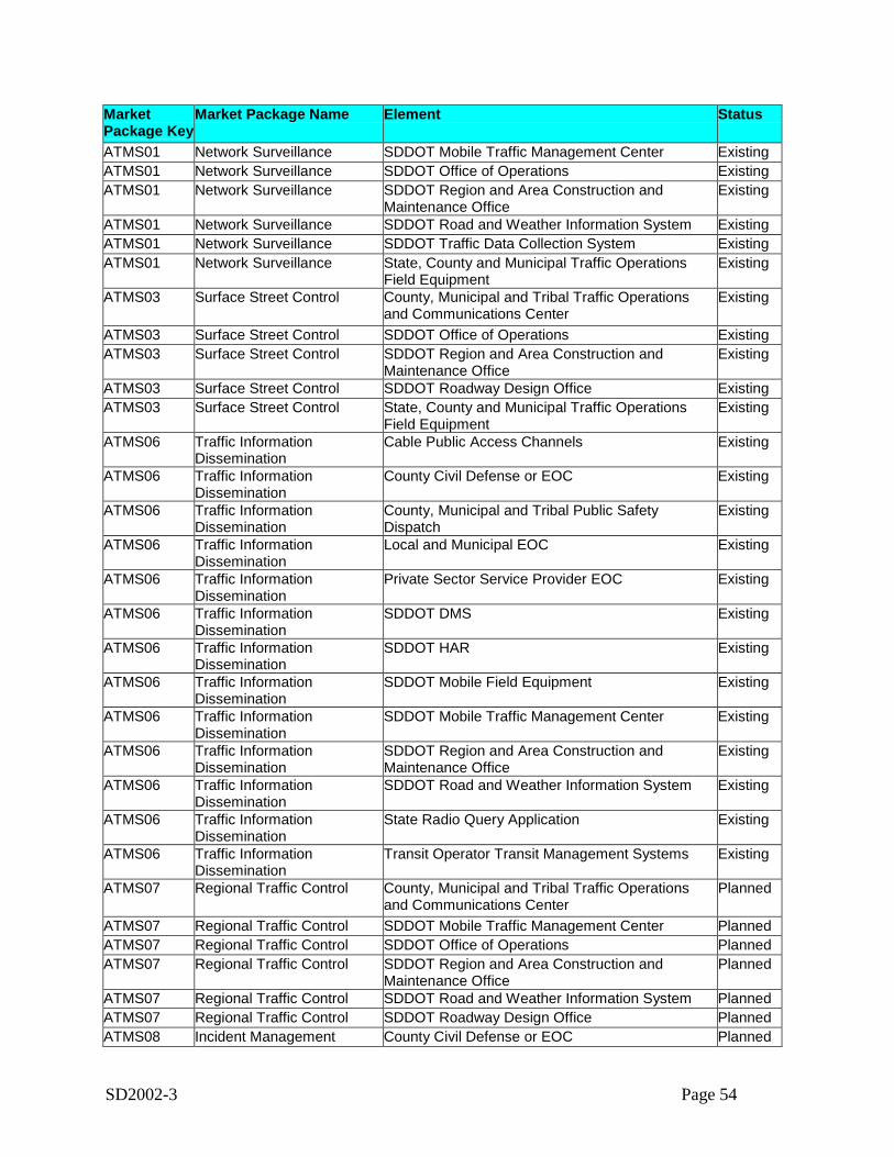
SD2002-3 Page 54
MarketPackage Key
Market Package Name Element Status
ATMS01 Network Surveillance SDDOT Mobile Traffic Management Center ExistingATMS01 Network Surveillance SDDOT Office of Operations ExistingATMS01 Network Surveillance SDDOT Region and Area Construction and
Maintenance OfficeExisting
ATMS01 Network Surveillance SDDOT Road and Weather Information System ExistingATMS01 Network Surveillance SDDOT Traffic Data Collection System ExistingATMS01 Network Surveillance State, County and Municipal Traffic Operations
Field EquipmentExisting
ATMS03 Surface Street Control County, Municipal and Tribal Traffic Operationsand Communications Center
Existing
ATMS03 Surface Street Control SDDOT Office of Operations ExistingATMS03 Surface Street Control SDDOT Region and Area Construction and
Maintenance OfficeExisting
ATMS03 Surface Street Control SDDOT Roadway Design Office ExistingATMS03 Surface Street Control State, County and Municipal Traffic Operations
Field EquipmentExisting
ATMS06 Traffic InformationDissemination
Cable Public Access Channels Existing
ATMS06 Traffic InformationDissemination
County Civil Defense or EOC Existing
ATMS06 Traffic InformationDissemination
County, Municipal and Tribal Public SafetyDispatch
Existing
ATMS06 Traffic InformationDissemination
Local and Municipal EOC Existing
ATMS06 Traffic InformationDissemination
Private Sector Service Provider EOC Existing
ATMS06 Traffic InformationDissemination
SDDOT DMS Existing
ATMS06 Traffic InformationDissemination
SDDOT HAR Existing
ATMS06 Traffic InformationDissemination
SDDOT Mobile Field Equipment Existing
ATMS06 Traffic InformationDissemination
SDDOT Mobile Traffic Management Center Existing
ATMS06 Traffic InformationDissemination
SDDOT Region and Area Construction andMaintenance Office
Existing
ATMS06 Traffic InformationDissemination
SDDOT Road and Weather Information System Existing
ATMS06 Traffic InformationDissemination
State Radio Query Application Existing
ATMS06 Traffic InformationDissemination
Transit Operator Transit Management Systems Existing
ATMS07 Regional Traffic Control County, Municipal and Tribal Traffic Operationsand Communications Center
Planned
ATMS07 Regional Traffic Control SDDOT Mobile Traffic Management Center PlannedATMS07 Regional Traffic Control SDDOT Office of Operations PlannedATMS07 Regional Traffic Control SDDOT Region and Area Construction and
Maintenance OfficePlanned
ATMS07 Regional Traffic Control SDDOT Road and Weather Information System PlannedATMS07 Regional Traffic Control SDDOT Roadway Design Office PlannedATMS08 Incident Management County Civil Defense or EOC Planned
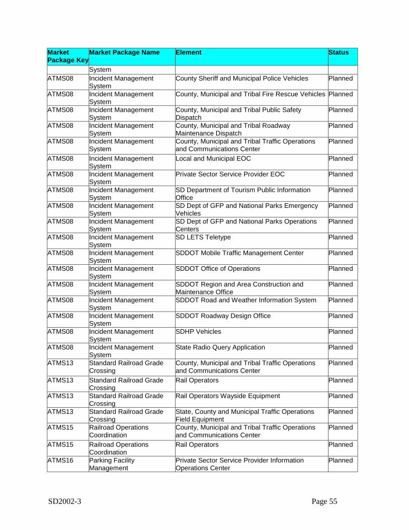
SD2002-3 Page 55
MarketPackage Key
Market Package Name Element Status
SystemATMS08 Incident Management
SystemCounty Sheriff and Municipal Police Vehicles Planned
ATMS08 Incident ManagementSystem
County, Municipal and Tribal Fire Rescue Vehicles Planned
ATMS08 Incident ManagementSystem
County, Municipal and Tribal Public SafetyDispatch
Planned
ATMS08 Incident ManagementSystem
County, Municipal and Tribal RoadwayMaintenance Dispatch
Planned
ATMS08 Incident ManagementSystem
County, Municipal and Tribal Traffic Operationsand Communications Center
Planned
ATMS08 Incident ManagementSystem
Local and Municipal EOC Planned
ATMS08 Incident ManagementSystem
Private Sector Service Provider EOC Planned
ATMS08 Incident ManagementSystem
SD Department of Tourism Public InformationOffice
Planned
ATMS08 Incident ManagementSystem
SD Dept of GFP and National Parks EmergencyVehicles
Planned
ATMS08 Incident ManagementSystem
SD Dept of GFP and National Parks OperationsCenters
Planned
ATMS08 Incident ManagementSystem
SD LETS Teletype Planned
ATMS08 Incident ManagementSystem
SDDOT Mobile Traffic Management Center Planned
ATMS08 Incident ManagementSystem
SDDOT Office of Operations Planned
ATMS08 Incident ManagementSystem
SDDOT Region and Area Construction andMaintenance Office
Planned
ATMS08 Incident ManagementSystem
SDDOT Road and Weather Information System Planned
ATMS08 Incident ManagementSystem
SDDOT Roadway Design Office Planned
ATMS08 Incident ManagementSystem
SDHP Vehicles Planned
ATMS08 Incident ManagementSystem
State Radio Query Application Planned
ATMS13 Standard Railroad GradeCrossing
County, Municipal and Tribal Traffic Operationsand Communications Center
Planned
ATMS13 Standard Railroad GradeCrossing
Rail Operators Planned
ATMS13 Standard Railroad GradeCrossing
Rail Operators Wayside Equipment Planned
ATMS13 Standard Railroad GradeCrossing
State, County and Municipal Traffic OperationsField Equipment
Planned
ATMS15 Railroad OperationsCoordination
County, Municipal and Tribal Traffic Operationsand Communications Center
Planned
ATMS15 Railroad OperationsCoordination
Rail Operators Planned
ATMS16 Parking FacilityManagement
Private Sector Service Provider InformationOperations Center
Planned
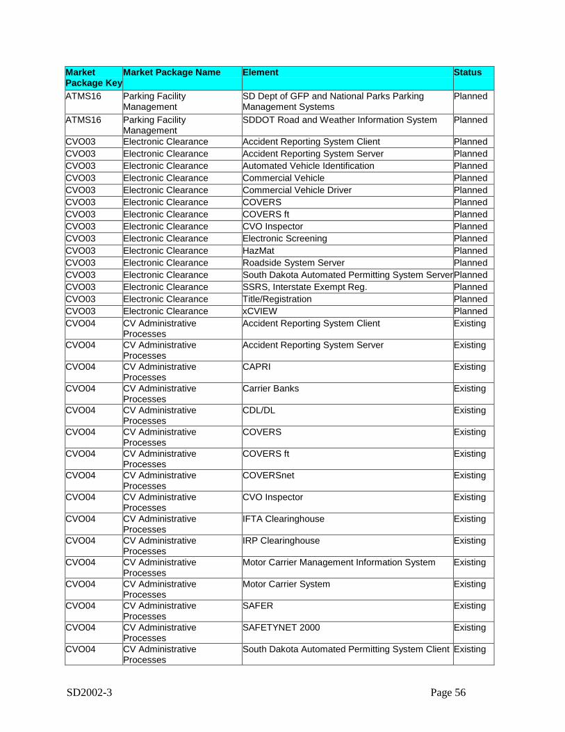
SD2002-3 Page 56
MarketPackage Key
Market Package Name Element Status
ATMS16 Parking FacilityManagement
SD Dept of GFP and National Parks ParkingManagement Systems
Planned
ATMS16 Parking FacilityManagement
SDDOT Road and Weather Information System Planned
CVO03 Electronic Clearance Accident Reporting System Client PlannedCVO03 Electronic Clearance Accident Reporting System Server PlannedCVO03 Electronic Clearance Automated Vehicle Identification PlannedCVO03 Electronic Clearance Commercial Vehicle PlannedCVO03 Electronic Clearance Commercial Vehicle Driver PlannedCVO03 Electronic Clearance COVERS PlannedCVO03 Electronic Clearance COVERS ft PlannedCVO03 Electronic Clearance CVO Inspector PlannedCVO03 Electronic Clearance Electronic Screening PlannedCVO03 Electronic Clearance HazMat PlannedCVO03 Electronic Clearance Roadside System Server PlannedCVO03 Electronic Clearance South Dakota Automated Permitting System ServerPlannedCVO03 Electronic Clearance SSRS, Interstate Exempt Reg. PlannedCVO03 Electronic Clearance Title/Registration PlannedCVO03 Electronic Clearance xCVIEW PlannedCVO04 CV Administrative
ProcessesAccident Reporting System Client Existing
CVO04 CV AdministrativeProcesses
Accident Reporting System Server Existing
CVO04 CV AdministrativeProcesses
CAPRI Existing
CVO04 CV AdministrativeProcesses
Carrier Banks Existing
CVO04 CV AdministrativeProcesses
CDL/DL Existing
CVO04 CV AdministrativeProcesses
COVERS Existing
CVO04 CV AdministrativeProcesses
COVERS ft Existing
CVO04 CV AdministrativeProcesses
COVERSnet Existing
CVO04 CV AdministrativeProcesses
CVO Inspector Existing
CVO04 CV AdministrativeProcesses
IFTA Clearinghouse Existing
CVO04 CV AdministrativeProcesses
IRP Clearinghouse Existing
CVO04 CV AdministrativeProcesses
Motor Carrier Management Information System Existing
CVO04 CV AdministrativeProcesses
Motor Carrier System Existing
CVO04 CV AdministrativeProcesses
SAFER Existing
CVO04 CV AdministrativeProcesses
SAFETYNET 2000 Existing
CVO04 CV AdministrativeProcesses
South Dakota Automated Permitting System Client Existing
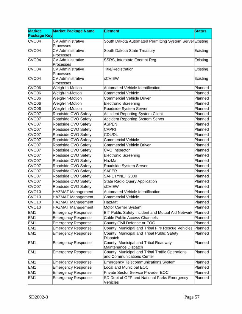
SD2002-3 Page 57
MarketPackage Key
Market Package Name Element Status
CVO04 CV AdministrativeProcesses
South Dakota Automated Permitting System ServerExisting
CVO04 CV AdministrativeProcesses
South Dakota State Treasury Existing
CVO04 CV AdministrativeProcesses
SSRS, Interstate Exempt Reg. Existing
CVO04 CV AdministrativeProcesses
Title/Registration Existing
CVO04 CV AdministrativeProcesses
xCVIEW Existing
CVO06 Weigh-In-Motion Automated Vehicle Identification PlannedCVO06 Weigh-In-Motion Commercial Vehicle PlannedCVO06 Weigh-In-Motion Commercial Vehicle Driver PlannedCVO06 Weigh-In-Motion Electronic Screening PlannedCVO06 Weigh-In-Motion Roadside System Server PlannedCVO07 Roadside CVO Safety Accident Reporting System Client PlannedCVO07 Roadside CVO Safety Accident Reporting System Server PlannedCVO07 Roadside CVO Safety ASPEN PlannedCVO07 Roadside CVO Safety CAPRI PlannedCVO07 Roadside CVO Safety CDL/DL PlannedCVO07 Roadside CVO Safety Commercial Vehicle PlannedCVO07 Roadside CVO Safety Commercial Vehicle Driver PlannedCVO07 Roadside CVO Safety CVO Inspector PlannedCVO07 Roadside CVO Safety Electronic Screening PlannedCVO07 Roadside CVO Safety HazMat PlannedCVO07 Roadside CVO Safety Roadside System Server PlannedCVO07 Roadside CVO Safety SAFER PlannedCVO07 Roadside CVO Safety SAFETYNET 2000 PlannedCVO07 Roadside CVO Safety State Radio Query Application PlannedCVO07 Roadside CVO Safety xCVIEW PlannedCVO10 HAZMAT Management Automated Vehicle Identification PlannedCVO10 HAZMAT Management Commercial Vehicle PlannedCVO10 HAZMAT Management HazMat PlannedCVO10 HAZMAT Management Motor Carrier System PlannedEM1 Emergency Response BIT Public Safety Incident and Mutual Aid Network PlannedEM1 Emergency Response Cable Public Access Channels PlannedEM1 Emergency Response County Civil Defense or EOC PlannedEM1 Emergency Response County, Municipal and Tribal Fire Rescue Vehicles PlannedEM1 Emergency Response County, Municipal and Tribal Public Safety
DispatchPlanned
EM1 Emergency Response County, Municipal and Tribal RoadwayMaintenance Dispatch
Planned
EM1 Emergency Response County, Municipal and Tribal Traffic Operationsand Communications Center
Planned
EM1 Emergency Response Emergency Telecommunications System PlannedEM1 Emergency Response Local and Municipal EOC PlannedEM1 Emergency Response Private Sector Service Provider EOC PlannedEM1 Emergency Response SD Dept of GFP and National Parks Emergency
VehiclesPlanned
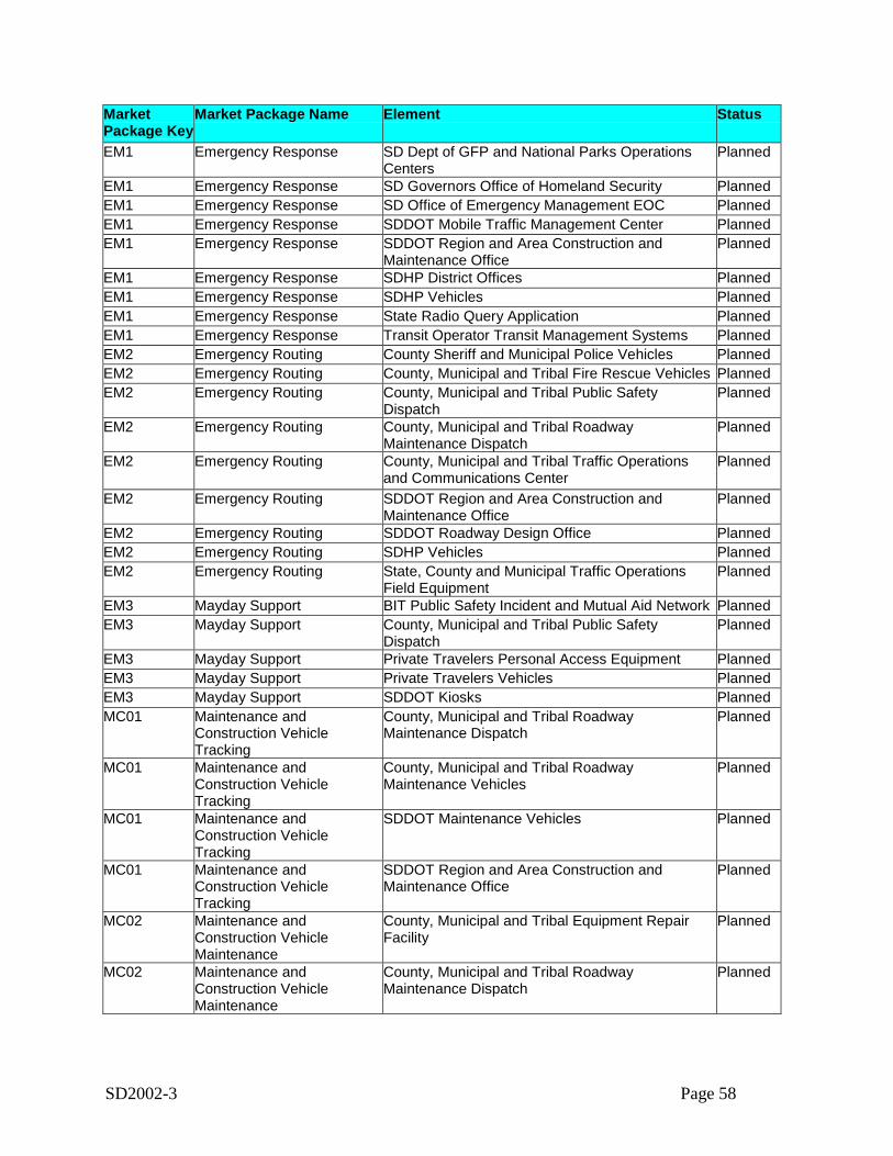
SD2002-3 Page 58
MarketPackage Key
Market Package Name Element Status
EM1 Emergency Response SD Dept of GFP and National Parks OperationsCenters
Planned
EM1 Emergency Response SD Governors Office of Homeland Security PlannedEM1 Emergency Response SD Office of Emergency Management EOC PlannedEM1 Emergency Response SDDOT Mobile Traffic Management Center PlannedEM1 Emergency Response SDDOT Region and Area Construction and
Maintenance OfficePlanned
EM1 Emergency Response SDHP District Offices PlannedEM1 Emergency Response SDHP Vehicles PlannedEM1 Emergency Response State Radio Query Application PlannedEM1 Emergency Response Transit Operator Transit Management Systems PlannedEM2 Emergency Routing County Sheriff and Municipal Police Vehicles PlannedEM2 Emergency Routing County, Municipal and Tribal Fire Rescue Vehicles PlannedEM2 Emergency Routing County, Municipal and Tribal Public Safety
DispatchPlanned
EM2 Emergency Routing County, Municipal and Tribal RoadwayMaintenance Dispatch
Planned
EM2 Emergency Routing County, Municipal and Tribal Traffic Operationsand Communications Center
Planned
EM2 Emergency Routing SDDOT Region and Area Construction andMaintenance Office
Planned
EM2 Emergency Routing SDDOT Roadway Design Office PlannedEM2 Emergency Routing SDHP Vehicles PlannedEM2 Emergency Routing State, County and Municipal Traffic Operations
Field EquipmentPlanned
EM3 Mayday Support BIT Public Safety Incident and Mutual Aid Network PlannedEM3 Mayday Support County, Municipal and Tribal Public Safety
DispatchPlanned
EM3 Mayday Support Private Travelers Personal Access Equipment PlannedEM3 Mayday Support Private Travelers Vehicles PlannedEM3 Mayday Support SDDOT Kiosks PlannedMC01 Maintenance and
Construction VehicleTracking
County, Municipal and Tribal RoadwayMaintenance Dispatch
Planned
MC01 Maintenance andConstruction VehicleTracking
County, Municipal and Tribal RoadwayMaintenance Vehicles
Planned
MC01 Maintenance andConstruction VehicleTracking
SDDOT Maintenance Vehicles Planned
MC01 Maintenance andConstruction VehicleTracking
SDDOT Region and Area Construction andMaintenance Office
Planned
MC02 Maintenance andConstruction VehicleMaintenance
County, Municipal and Tribal Equipment RepairFacility
Planned
MC02 Maintenance andConstruction VehicleMaintenance
County, Municipal and Tribal RoadwayMaintenance Dispatch
Planned
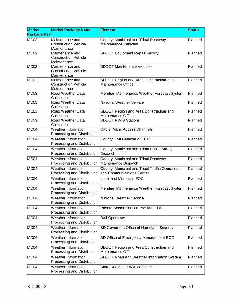
SD2002-3 Page 59
MarketPackage Key
Market Package Name Element Status
MC02 Maintenance andConstruction VehicleMaintenance
County, Municipal and Tribal RoadwayMaintenance Vehicles
Planned
MC02 Maintenance andConstruction VehicleMaintenance
SDDOT Equipment Repair Facility Planned
MC02 Maintenance andConstruction VehicleMaintenance
SDDOT Maintenance Vehicles Planned
MC02 Maintenance andConstruction VehicleMaintenance
SDDOT Region and Area Construction andMaintenance Office
Planned
MC03 Road Weather DataCollection
Meridian Maintenance Weather Forecast System Planned
MC03 Road Weather DataCollection
National Weather Service Planned
MC03 Road Weather DataCollection
SDDOT Region and Area Construction andMaintenance Office
Planned
MC03 Road Weather DataCollection
SDDOT RWIS Stations Planned
MC04 Weather InformationProcessing and Distribution
Cable Public Access Channels Planned
MC04 Weather InformationProcessing and Distribution
County Civil Defense or EOC Planned
MC04 Weather InformationProcessing and Distribution
County, Municipal and Tribal Public SafetyDispatch
Planned
MC04 Weather InformationProcessing and Distribution
County, Municipal and Tribal RoadwayMaintenance Dispatch
Planned
MC04 Weather InformationProcessing and Distribution
County, Municipal and Tribal Traffic Operationsand Communications Center
Planned
MC04 Weather InformationProcessing and Distribution
Local and Municipal EOC Planned
MC04 Weather InformationProcessing and Distribution
Meridian Maintenance Weather Forecast System Planned
MC04 Weather InformationProcessing and Distribution
National Weather Service Planned
MC04 Weather InformationProcessing and Distribution
Private Sector Service Provider EOC Planned
MC04 Weather InformationProcessing and Distribution
Rail Operators Planned
MC04 Weather InformationProcessing and Distribution
SD Governors Office of Homeland Security Planned
MC04 Weather InformationProcessing and Distribution
SD Office of Emergency Management EOC Planned
MC04 Weather InformationProcessing and Distribution
SDDOT Region and Area Construction andMaintenance Office
Planned
MC04 Weather InformationProcessing and Distribution
SDDOT Road and Weather Information System Planned
MC04 Weather InformationProcessing and Distribution
State Radio Query Application Planned
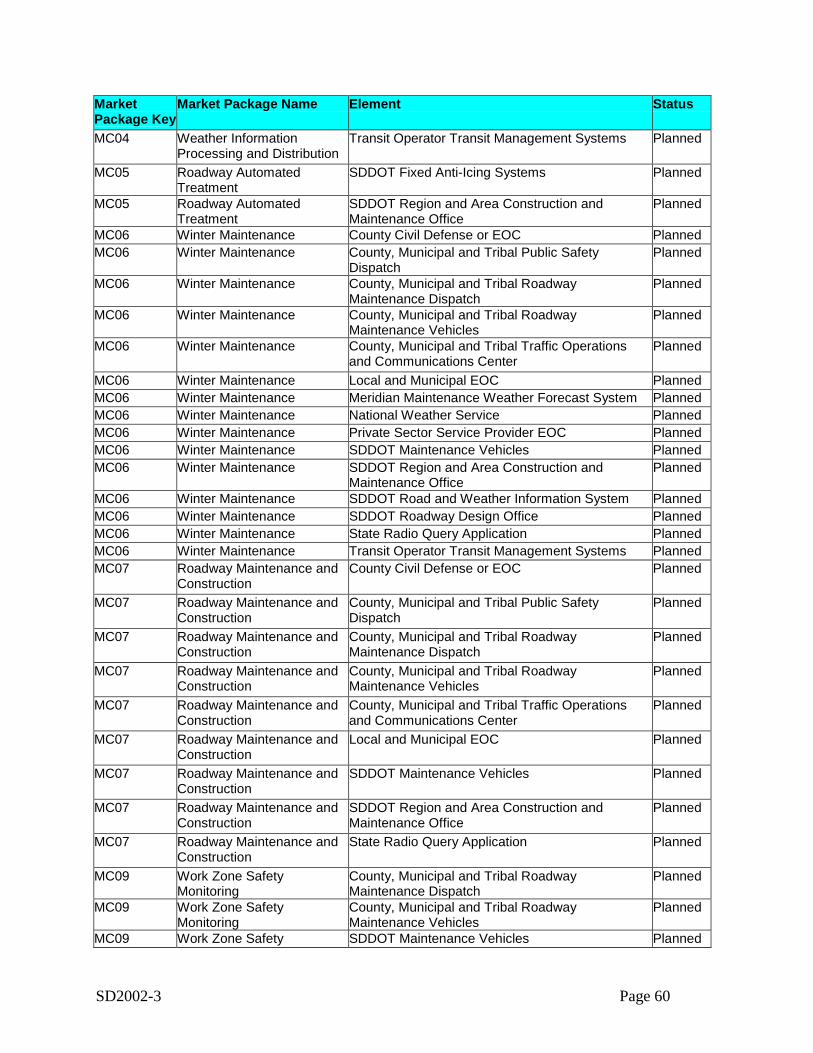
SD2002-3 Page 60
MarketPackage Key
Market Package Name Element Status
MC04 Weather InformationProcessing and Distribution
Transit Operator Transit Management Systems Planned
MC05 Roadway AutomatedTreatment
SDDOT Fixed Anti-Icing Systems Planned
MC05 Roadway AutomatedTreatment
SDDOT Region and Area Construction andMaintenance Office
Planned
MC06 Winter Maintenance County Civil Defense or EOC PlannedMC06 Winter Maintenance County, Municipal and Tribal Public Safety
DispatchPlanned
MC06 Winter Maintenance County, Municipal and Tribal RoadwayMaintenance Dispatch
Planned
MC06 Winter Maintenance County, Municipal and Tribal RoadwayMaintenance Vehicles
Planned
MC06 Winter Maintenance County, Municipal and Tribal Traffic Operationsand Communications Center
Planned
MC06 Winter Maintenance Local and Municipal EOC PlannedMC06 Winter Maintenance Meridian Maintenance Weather Forecast System PlannedMC06 Winter Maintenance National Weather Service PlannedMC06 Winter Maintenance Private Sector Service Provider EOC PlannedMC06 Winter Maintenance SDDOT Maintenance Vehicles PlannedMC06 Winter Maintenance SDDOT Region and Area Construction and
Maintenance OfficePlanned
MC06 Winter Maintenance SDDOT Road and Weather Information System PlannedMC06 Winter Maintenance SDDOT Roadway Design Office PlannedMC06 Winter Maintenance State Radio Query Application PlannedMC06 Winter Maintenance Transit Operator Transit Management Systems PlannedMC07 Roadway Maintenance and
ConstructionCounty Civil Defense or EOC Planned
MC07 Roadway Maintenance andConstruction
County, Municipal and Tribal Public SafetyDispatch
Planned
MC07 Roadway Maintenance andConstruction
County, Municipal and Tribal RoadwayMaintenance Dispatch
Planned
MC07 Roadway Maintenance andConstruction
County, Municipal and Tribal RoadwayMaintenance Vehicles
Planned
MC07 Roadway Maintenance andConstruction
County, Municipal and Tribal Traffic Operationsand Communications Center
Planned
MC07 Roadway Maintenance andConstruction
Local and Municipal EOC Planned
MC07 Roadway Maintenance andConstruction
SDDOT Maintenance Vehicles Planned
MC07 Roadway Maintenance andConstruction
SDDOT Region and Area Construction andMaintenance Office
Planned
MC07 Roadway Maintenance andConstruction
State Radio Query Application Planned
MC09 Work Zone SafetyMonitoring
County, Municipal and Tribal RoadwayMaintenance Dispatch
Planned
MC09 Work Zone SafetyMonitoring
County, Municipal and Tribal RoadwayMaintenance Vehicles
Planned
MC09 Work Zone Safety SDDOT Maintenance Vehicles Planned
SD2002-3 Page 61
MarketPackage Key
Market Package Name Element Status
MonitoringMC09 Work Zone Safety
MonitoringSDDOT Region and Area Construction andMaintenance Office
Planned
MC09 Work Zone SafetyMonitoring
SDDOT Work Zone Field Sensors Planned
MC09 Work Zone SafetyMonitoring
State, County and Municipal Traffic OperationsField Equipment
Planned
5.7. Interfaces and Information Exchanges
5.7.1. Top Level Regional System Interconnect DiagramA system interconnect diagram, or sausage diagram, shows the systems and primary types ofinterconnections in the region. The National ITS Architecture interconnect diagram has beencustomized for South Dakota based on the information gathered from the stakeholders and thesystem inventory. Figure 3 on the following page summarizes the existing and planned ITSelements for the region in the context of physical interconnects. ITS elements identified forSouth Dakota ITS deployments (and their primary associated National ITS Architecture entity)are called out in the boxes surrounding the central interconnect diagram. In the center of thefigure the rectangles represent the subsystems of the National ITS Architecture. The SouthDakota Rural ITS architecture has elements that map to 18 of the 21 subsystems of the NationalITS Architecture. In addition, the regional ITS architecture has elements that map to 13terminators of the National ITS Architecture. These terminators are represented by the rightmostcolumn of boxes on the diagram and include entities such as Event Promoters (which map to theSD Department of Tourism Public Information Office).
The diagram also identifies the three basic types of communications used to interconnect theelements of the ITS architecture. These communications types are defined as:
• Wireline Communications:A communications link serving stationary sources. It may be implemented using a variety ofpublic or private communications networks that may physically include wireless (e.g.,microwave) as well as wireline infrastructure. Both dedicated and shared communicationsresources may be used.
• Wide Area Wireless Communications:A communications link that provides communications via a wireless device between a userand an infrastructure-based system. Both broadcast (one-way) and interactive (two-way)communications services are grouped into wide-area wireless communications. These linkssupport a range of services including real-time traveler information and various forms of fleetcommunications.
• Dedicated Short Range Communications:A wireless communications channel used for close-proximity communications betweenvehicles and the immediate infrastructure. It supports location-specific communications for

SD2002-3 Page 62
ITS capabilities such as toll collection, transit vehicle management, driver information, andautomated commercial vehicle operations.
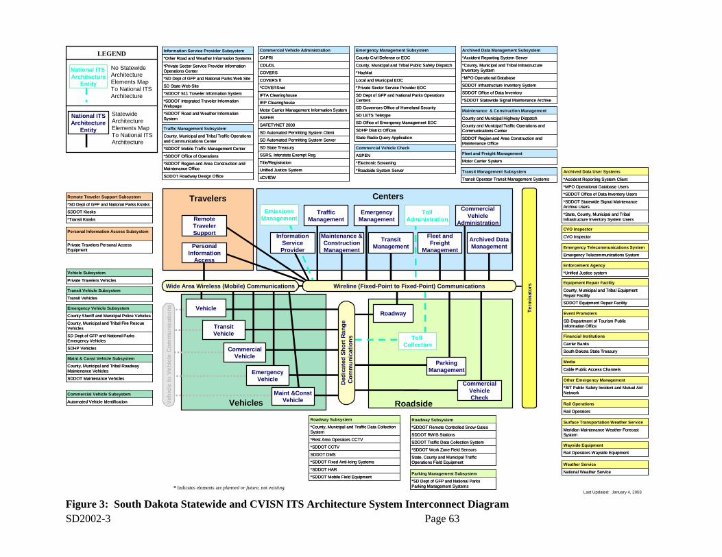
SD2002-3 Page 63Figure 3: South Dakota Statewide and CVISN ITS Architecture System Interconnect Diagram
Travelers
Vehicles Roadside
CentersCommercial
VehicleAdministration
Archived DataManagementPersonal
InformationAccess
TollAdministration
EmergencyManagement
TrafficManagement
Fleet andFreight
Management
TransitManagement
Maintenance &ConstructionManagement
Toll Collection
CommercialVehicleCheck
EmergencyVehicle
RemoteTravelerSupport
Roadway
Ded
icat
ed S
hort
Ran
geC
omm
unic
atio
ns
Wide Area Wireless (Mobile) Communications
InformationServiceProvider
EmissionsManagement
CommercialVehicle
ParkingManagement
TransitVehicle
Last Updated: January 4, 2003* Indicates elements are planned or future, not existing.
Maint &ConstVehicle
Vehicle
Vehi
cle
to V
ehic
le C
omm
unic
atio
ns
SD State Web Site
*SD Dept of GFP and National Parks Web Site
*SDDOT Road and Weather Information System
*Private Sector Service Provider Information Operations Center
*SDDOT Integrated Traveler Information Webpage
*Other Road and Weather Information Systems
*SDDOT 511 Traveler Information System
Information Service Provider Subsystem
SDDOT Region and Area Construction and Maintenance Office
County and Municipal Traffic Operations and Communications Center
County and Municipal Highway Dispatch
Maintenance & Construction Management
SDDOT Region and Area Construction and Maintenance Office
County and Municipal Traffic Operations and Communications Center
County and Municipal Highway Dispatch
Maintenance & Construction Management
*SDDOT Office of Operations
*SDDOT Region and Area Construction and Maintenance Office
SDDOT Roadway Design Office
*SDDOT Mobile Traffic Management Center
County, Municipal and Tribal Traffic Operations and Communications Center
Traffic Management Subsystem
*SDDOT Office of Operations
*SDDOT Region and Area Construction and Maintenance Office
SDDOT Roadway Design Office
*SDDOT Mobile Traffic Management Center
County, Municipal and Tribal Traffic Operations and Communications Center
Traffic Management Subsystem
State Radio Query Application
SDHP District Offices
County Civil Defense or EOC
*Private Sector Service Provider EOC
SD LETS Teletype
*HazMat
SD Office of Emergency Management EOC
SD Governors Office of Homeland Security
SD Dept of GFP and National Parks Operations Centers
Local and Municipal EOC
County, Municipal and Tribal Public Safety Dispatch
Emergency Management Subsystem
Transit Operator Transit Management Systems
Transit Management Subsystem
Transit Operator Transit Management Systems
Transit Management Subsystem
*Accident Reporting System Server
*SDDOT Statewide Signal Maintenance Archive
SDDOT Office of Data Inventory
SDDOT Infrastructure Inventory System
*MPO Operational Database
*County, Municipal and Tribal Infrastructure Inventory System
Archived Data Management Subsystem
*Accident Reporting System Server
*SDDOT Statewide Signal Maintenance Archive
SDDOT Office of Data Inventory
SDDOT Infrastructure Inventory System
*MPO Operational Database
*County, Municipal and Tribal Infrastructure Inventory System
Archived Data Management Subsystem
Emergency Telecommunications System
Emergency Telecommunications System
Emergency Telecommunications System
Emergency Telecommunications System
SDDOT Equipment Repair Facility
County, Municipal and Tribal Equipment Repair Facility
Equipment Repair Facility
SDDOT Equipment Repair Facility
County, Municipal and Tribal Equipment Repair Facility
Equipment Repair Facility
South Dakota State Treasury
Carrier Banks
Financial Institutions
South Dakota State Treasury
Carrier Banks
Financial Institutions
Rail Operators
Rail Operations
Rail Operators
Rail Operations
National Weather Service
Weather Service
National Weather Service
Weather Service
*SD Dept of GFP and National Parks Parking Management Systems
Parking Management Subsystem
*SD Dept of GFP and National Parks Parking Management Systems
Parking Management Subsystem*SDDOT Mobile Field Equipment
*SDDOT CCTV
*Rest Area Operators CCTV
*SDDOT Fixed Anti-Icing Systems
*SDDOT HAR
SDDOT DMS
*County, Municipal and Traffic Data Collection System
Roadway Subsystem
*SDDOT Mobile Field Equipment
*SDDOT CCTV
*Rest Area Operators CCTV
*SDDOT Fixed Anti-Icing Systems
*SDDOT HAR
SDDOT DMS
*County, Municipal and Traffic Data Collection System
Roadway Subsystem
SDDOT Maintenance Vehicles
County, Municipal and Tribal Roadway Maintenance Vehicles
Maint & Const Vehicle Subsystem
SDDOT Maintenance Vehicles
County, Municipal and Tribal Roadway Maintenance Vehicles
Maint & Const Vehicle Subsystem
County Sheriff and Municipal Police Vehicles
SDHP Vehicles
SD Dept of GFP and National Parks Emergency Vehicles
County, Municipal and Tribal Fire Rescue Vehicles
Emergency Vehicle Subsystem
County Sheriff and Municipal Police Vehicles
SDHP Vehicles
SD Dept of GFP and National Parks Emergency Vehicles
County, Municipal and Tribal Fire Rescue Vehicles
Emergency Vehicle Subsystem
Transit Vehicles
Transit Vehicle Subsystem
Transit Vehicles
Transit Vehicle Subsystem
Private Travelers Vehicles
Vehicle Subsystem
Private Travelers Vehicles
Vehicle Subsystem
*SD Dept of GFP and National Parks Kiosks
*Transit Kiosks
SDDOT Kiosks
Remote Traveler Support Subsystem
*SD Dept of GFP and National Parks Kiosks
*Transit Kiosks
SDDOT Kiosks
Remote Traveler Support Subsystem
Private Travelers Personal Access Equipment
Personal Information Access Subsystem
Private Travelers Personal Access Equipment
Personal Information Access Subsystem
*State, County, Municipal and Tribal Infrastructure Inventory System Users
*Accident Reporting System Client
*SDDOT Statewide Signal Maintenance Archive Users
*SDDOT Office of Data Inventory Users
*MPO Operational Database Users
Archived Data User Systems
*State, County, Municipal and Tribal Infrastructure Inventory System Users
*Accident Reporting System Client
*SDDOT Statewide Signal Maintenance Archive Users
*SDDOT Office of Data Inventory Users
*MPO Operational Database Users
Archived Data User Systems
Meridian Maintenance Weather Forecast System
Surface Transportation Weather Service
Meridian Maintenance Weather Forecast System
Surface Transportation Weather Service
State, County and Municipal Traffic Operations Field Equipment
*SDDOT Work Zone Field Sensors
SDDOT Traffic Data Collection System
SDDOT RWIS Stations
*SDDOT Remote Controlled Snow Gates
Roadway Subsystem
State, County and Municipal Traffic Operations Field Equipment
*SDDOT Work Zone Field Sensors
SDDOT Traffic Data Collection System
SDDOT RWIS Stations
*SDDOT Remote Controlled Snow Gates
Roadway Subsystem
SD Department of Tourism Public Information Office
Event Promoters
SD Department of Tourism Public Information Office
Event Promoters
*BIT Public Safety Incident and Mutual Aid Network
Other Emergency Management
*BIT Public Safety Incident and Mutual Aid Network
Other Emergency Management
Rail Operators Wayside Equipment
Wayside Equipment
Rail Operators Wayside Equipment
Wayside Equipment
LEGEND
National ITS Architecture
Entity
National ITSArchitecture
Entity
No Statewide Architecture Elements Map To National ITS Architecture
Statewide Architecture Elements Map To National ITS Architecture
xCVIEW
Unified Justice System
Title/Registration
SSRS, Interstate Exempt Reg.
SD State Treasury
SD Automated Permitting System Server
SD Automated Permitting System Client
SAFETYNET 2000
SAFER
Motor Carrier Management Information System
IRP Clearinghouse
IFTA Clearinghouse
*COVERSnet
CDL/DL
COVERS ft
CAPRI
COVERS
Commercial Vehicle Administration
*Electronic Screening
*Roadside System Server
ASPEN
Commercial Vehicle Check
*Electronic Screening
*Roadside System Server
ASPEN
Commercial Vehicle Check
Motor Carrier System
Fleet and Freight Management
Motor Carrier System
Fleet and Freight Management
Automated Vehicle Identification
Commercial Vehicle Subsystem
Automated Vehicle Identification
Commercial Vehicle Subsystem
CVO Inspector
CVO Inspector
CVO Inspector
CVO Inspector
Wireline (Fixed-Point to Fixed-Point) Communications
*Unified Justice system
Enforcement Agency
*Unified Justice system
Enforcement Agency
Cable Public Access Channels
Media
Cable Public Access Channels
Media
Term
inat
ors
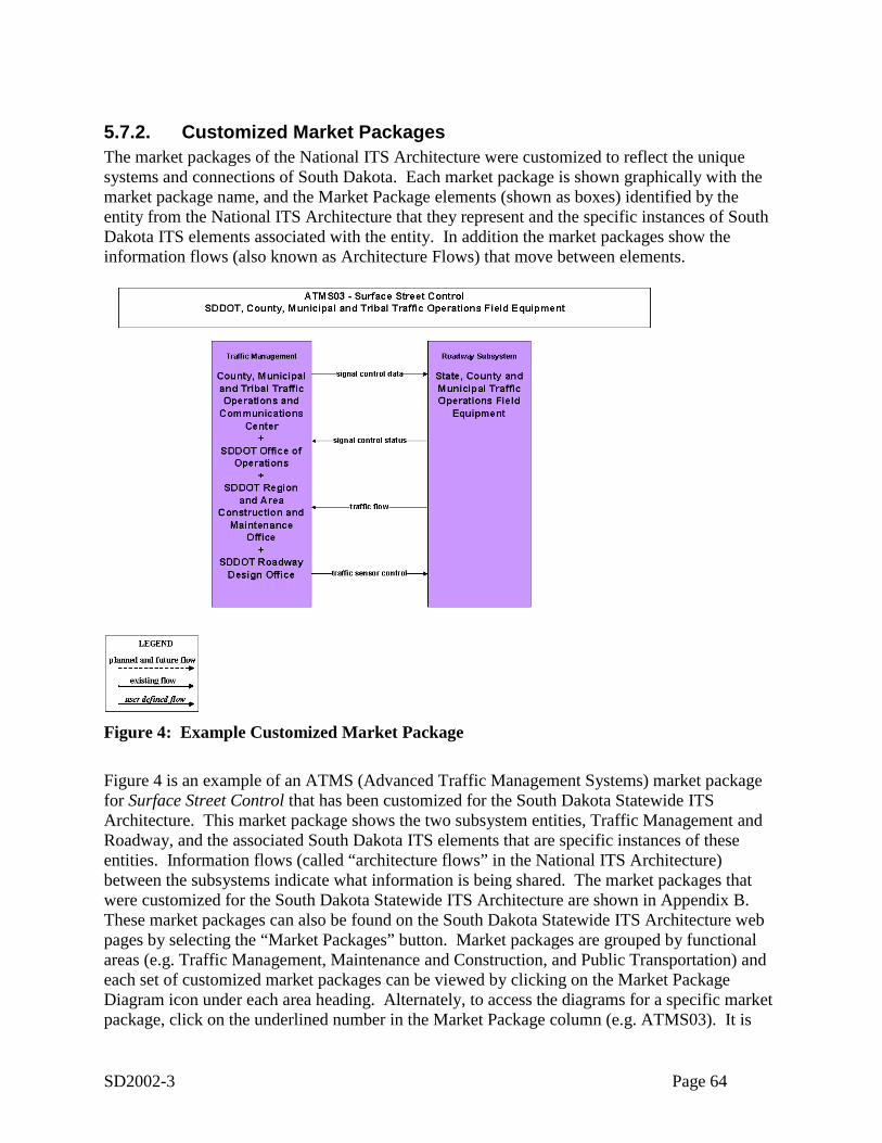
SD2002-3 Page 64
5.7.2. Customized Market PackagesThe market packages of the National ITS Architecture were customized to reflect the uniquesystems and connections of South Dakota. Each market package is shown graphically with themarket package name, and the Market Package elements (shown as boxes) identified by theentity from the National ITS Architecture that they represent and the specific instances of SouthDakota ITS elements associated with the entity. In addition the market packages show theinformation flows (also known as Architecture Flows) that move between elements.
ATMS03-1
Figure 4: Example Customized Market Package
Figure 4 is an example of an ATMS (Advanced Traffic Management Systems) market packagefor Surface Street Control that has been customized for the South Dakota Statewide ITSArchitecture. This market package shows the two subsystem entities, Traffic Management andRoadway, and the associated South Dakota ITS elements that are specific instances of theseentities. Information flows (called “architecture flows” in the National ITS Architecture)between the subsystems indicate what information is being shared. The market packages thatwere customized for the South Dakota Statewide ITS Architecture are shown in Appendix B.These market packages can also be found on the South Dakota Statewide ITS Architecture webpages by selecting the “Market Packages” button. Market packages are grouped by functionalareas (e.g. Traffic Management, Maintenance and Construction, and Public Transportation) andeach set of customized market packages can be viewed by clicking on the Market PackageDiagram icon under each area heading. Alternately, to access the diagrams for a specific marketpackage, click on the underlined number in the Market Package column (e.g. ATMS03). It is
SD2002-3 Page 65
important to note that while the market package table on the web page shows all of the marketpackages from the National ITS Architecture, only those selected for the South Dakota Statewidearchitecture are included in the diagrams. The selected market packages on the web page arehighlighted in the web page table with bold print and are indicated as existing or planned.
5.7.3. Regional Architecture Information FlowsWhile it is important to identify the various systems and stakeholders as part of a regional ITSarchitecture, a primary purpose of the ITS architecture is to identify the connectivity betweentransportation systems in the region. The interconnect diagram shown previously in Figure 3showed the high level relationships of the elements in the region. The customized marketpackages represent services that can be deployed as an integrated capability, and the marketpackage diagrams show the information flows between the subsystems and terminators that aremost important to the operation of the market packages. How these systems interface with eachother is an integral part of the overall architecture.
There are 101 different elements identified as part of the South Dakota Rural ITS Architecture.These elements include city, county and state traffic and maintenance centers, maintenancevehicles, transit centers, transit vehicles, public safety dispatch centers, media outlets, andothers—essentially all of the existing and planned physical components that contribute to thestatewide intelligent transportation system. Interfaces have been defined for each element in thearchitecture. For example, the SDDOT Road and Weather Information System has existing orplanned interfaces with 27 other elements in the state ranging from field equipment to transitcenters. Some of the interfaces are far less complex. For example the SDDOT RWIS Sensorshas interfaces with only one other element in the ITS architecture.
Each element and its defined interfaces are listed in tabular form in Appendix C. Elements andtheir interfaces are also accessible via the South Dakota Statewide ITS Architecture web page byclicking on the Interfaces button. On the web page elements are listed alphabetically in thecolumn on the left, and each entry in the Interfacing Element column on the right is a link tomore detailed information about the particular interface.
Architecture flows between the elements define specific information that is exchanged by theelements. Each architecture flow has a direction, name and definition. Most of the architectureflows match ones from the National ITS Architecture (the mapping of elements to National ITSArchitecture entities allowed the developers to match the architecture flows to the appropriateinterfaces.) In some cases new user defined flows have been created for interfaces orconnectivities that are not expressed in the National ITS Architecture. These architecture flowsdefine the interface requirements between the various elements in the regional ITS architecture.
An example of the architecture flows between two elements is shown in Figure 5. In thisinterface the flows that go between the planned element SDDOT Mobile Traffic ManagementCenter and SDDOT Mobile Field Equipment (which might include portable dynamic messagesigns or CCTV). These elements are planned, so all the flows on this interface are shown asplanned.
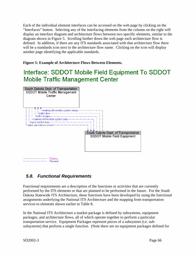
SD2002-3 Page 66
Each of the individual element interfaces can be accessed on the web page by clicking on the“Interfaces” button. Selecting any of the interfacing elements from the column on the right willdisplay an interface diagram and architecture flows between two specific elements, similar to thediagram shown in Figure 5. Scrolling further down the web page each architecture flow isdefined. In addition, if there are any ITS standards associated with that architecture flow therewill be a standards icon next to the architecture flow name. Clicking on the icon will displayanother page identifying the applicable standards.
Figure 5: Example of Architecture Flows Between Elements.
5.8. Functional Requirements
Functional requirements are a description of the functions or activities that are currentlyperformed by the ITS elements or that are planned to be performed in the future. For the SouthDakota Statewide ITS Architecture, these functions have been developed by using the functionalassignments underlying the National ITS Architecture and the mapping from transportationservices to elements shown earlier in Table 8.
In the National ITS Architecture a market package is defined by subsystems, equipmentpackages, and architecture flows, all of which operate together to perform a particulartransportation service. Equipment Packages represent pieces of a subsystem (i.e. sub-subsystems) that perform a single function. (Note there are no equipment packages defined for
SD2002-3 Page 67
the Terminators of the National ITS Architecture, since they represent systems on the boundaryof the architecture and do not have functional descriptions within the architecture.) For examplethe Surface Street Control market package is composed of the two Traffic ManagementSubsystem equipment packages TMC Signal Control and Traffic Maintenance and the twoRoadway Subsystem with its two equipment packages Roadway Signal Control and RoadwayEquipment Coordination. The definitions of these four equipment packages, copied fromversion 4.0 of the National ITS Architecture are:
• TMC Signal Control-This Equipment package provides the capability for traffic managers to monitor andmanage the traffic flow at signalized intersections. This capability includes analyzing andreducing the collected data from traffic surveillance equipment and developing andimplementing control plans for signalized intersections. Control plans may be developedand implemented that coordinate signals at many intersections under the domain of asingle traffic management subsystem. In advanced implementations, this package collectsroute planning information and integrates and uses this information in predicting futuretraffic conditions and optimizing the traffic control strategy for these conditions. Thesecapabilities are achieved through real-time communication of logged routes from anInformation Service Provider. The planned control strategies can be passed back to theInformation Service Provider so that the intended strategies can be reflected in futureroute planning.
• Traffic Maintenance-This equipment package provides monitoring and remote diagnostics of field equipmentto detect field equipment failures, issues problem reports, and tracks the repair orreplacement of the failed equipment.
• Roadway Signal Controls-This equipment package provides the capabilities to control traffic signals at majorintersections and on main highways for urban areas. This Equipment package is generallyconstrained to a single jurisdiction.
• Roadway Equipment Coordination-This equipment package coordinates field equipment that is distributed along theroadway by supporting direct communications between field equipment. This includescoordination between remote sensors and field devices (e.g., Dynamic Message Signs)and coordination between the field devices themselves (e.g., coordination between trafficcontrollers that are controlling adjacent intersections.).
The approach used in the South Dakota Statewide ITS architecture is to begin with the mappingof equipment packages to market packages to elements as an initial definition of the functionsbeing performed by each element. Then this mapping is tailored to provide a more accuratepicture of the functions performed by the element. In doing this mapping to equipment packagesand then tailoring, the architecture has moved beyond the range of capabilities provided by theTurbo Architecture tool. Using additional codes the basic Turbo Architecture database wasextended to include this customized equipment package information.
The details of this functional definition are provided on the hyperlinked web site version of thearchitecture. To access the functions for each element that has been mapped to a subsystem
SD2002-3 Page 68
entity (eg. traffic management subsystem) the user must click on the Functionality Details icon.This will provide a listing of the equipment packages, along with their definitions that have beenassigned to the element.
For example, the SDDOT Mobile Traffic Management Center element has the followingequipment packages (i.e. functions) assigned to it:
• Collect Traffic Surveillance• TMC Incident Detection• TMC Incident Dispatch Coordination/Communication • TMC Regional Traffic Control• TMC Traffic Information Dissemination• Traffic Maintenance
This represents a first level of detail that can be obtained in the hyperlinked web site inconnection with functionality. For each of the equipment packages shown, there is another“Details” icon. Selecting this link will take the user to additional levels of detail about thefunction. The hyperlinked web site uses the relationships inherent in the National ITSArchitecture (equipment packages are mapped to process specifications which are mapped touser service requirements) to provide the additional levels of detail.
The assignment of equipment packages to elements (the first level of detail discussed above) isprovided in this document in Appendix D. For additional details of functionality, refer to the website as described above.
5.9. StandardsDiscussion of key standards in the regionITS standards establish a common way in which devices connect and communicate with oneanother. This allows transportation agencies to implement systems that cost-effectivelyexchange pertinent data and accommodate equipment replacement, system upgrades, and systemexpansion. Standards benefit the traveling public by providing products that will functionconsistently and reliably throughout the region. ITS standards contribute to a safer and moreefficient transportation system, facilitate regional interoperability, and promote an innovative andcompetitive market for transportation products and services.
Use of ITS standards will be very important to project development in South Dakota. Table 9identifies the ITS standards that are potentially applicable to the state. This table was created bytaking the standards information available in the Turbo Architecture database (which identifiesstandards applicable to each architecture flow) and taking the total set of standards that resultfrom all of the selected flows. The table provides the status of the standards effort as ofNovember 2002 (the most recent update of the information). The status is defined by thefollowing entries:
• Published Standard:Available for purchase from the SDO listed.
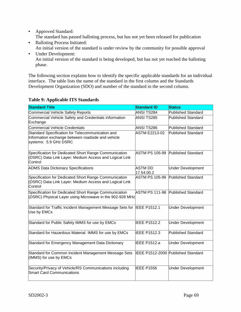
SD2002-3 Page 69
• Approved Standard:The standard has passed balloting process, but has not yet been released for publication
• Balloting Process Initiated:An initial version of the standard is under review by the community for possible approval
• Under Development:An initial version of the standard is being developed, but has not yet reached the ballotingphase.
The following section explains how to identify the specific applicable standards for an individualinterface. The table lists the name of the standard in the first column and the StandardsDevelopment Organization (SDO) and number of the standard in the second column.
Table 9: Applicable ITS StandardsStandard Title Standard ID StatusCommercial Vehicle Safety Reports ANSI TS284 Published StandardCommercial Vehicle Safety and Credentials InformationExchange
ANSI TS285 Published Standard
Commercial Vehicle Credentials ANSI TS286 Published StandardStandard Specification for Telecommunication andInformation exchange between roadside and vehiclesystems: 5.9 GHz DSRC
ASTM E2213-02 Published Standard
Specification for Dedicated Short Range Communication(DSRC) Data Link Layer: Medium Access and Logical LinkControl
ASTM PS 105-99 Published Standard
ADMS Data Dictionary Specifications ASTM DD17.54.00.2
Under Development
Specification for Dedicated Short Range Communication(DSRC) Data Link Layer: Medium Access and Logical LinkControl
ASTM PS 105-99 Published Standard
Specification for Dedicated Short Range Communication(DSRC) Physical Layer using Microwave in the 902-928 MHz
ASTM PS 111-98 Published Standard
Standard for Traffic Incident Management Message Sets forUse by EMCs
IEEE P1512.1 Under Development
Standard for Public Safety IMMS for use by EMCs IEEE P1512.2 Under Development
Standard for Hazardous Material IMMS for use by EMCs IEEE P1512.3 Published Standard
Standard for Emergency Management Data Dictionary IEEE P1512.a Under Development
Standard for Common Incident Management Message Sets(IMMS) for use by EMCs
IEEE P1512-2000 Published Standard
Security/Privacy of Vehicle/RS Communications includingSmart Card Communications
IEEE P1556 Under Development
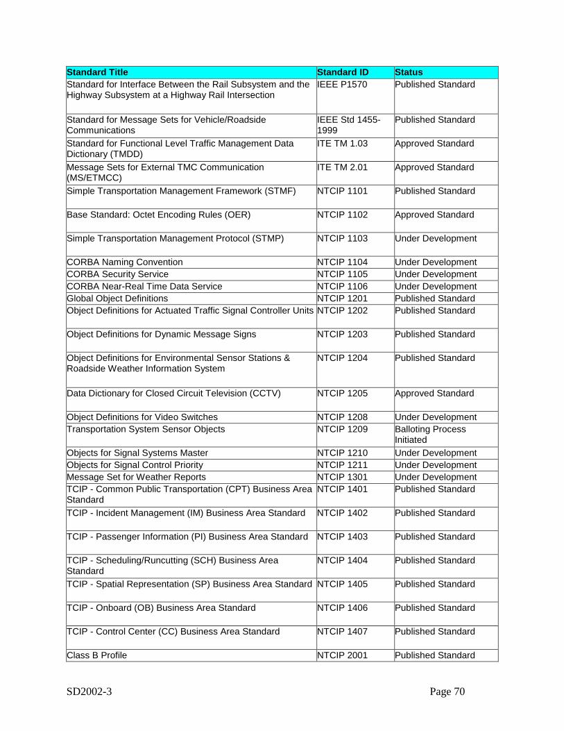
SD2002-3 Page 70
Standard Title Standard ID StatusStandard for Interface Between the Rail Subsystem and theHighway Subsystem at a Highway Rail Intersection
IEEE P1570 Published Standard
Standard for Message Sets for Vehicle/RoadsideCommunications
IEEE Std 1455-1999
Published Standard
Standard for Functional Level Traffic Management DataDictionary (TMDD)
ITE TM 1.03 Approved Standard
Message Sets for External TMC Communication(MS/ETMCC)
ITE TM 2.01 Approved Standard
Simple Transportation Management Framework (STMF) NTCIP 1101 Published Standard
Base Standard: Octet Encoding Rules (OER) NTCIP 1102 Approved Standard
Simple Transportation Management Protocol (STMP) NTCIP 1103 Under Development
CORBA Naming Convention NTCIP 1104 Under DevelopmentCORBA Security Service NTCIP 1105 Under DevelopmentCORBA Near-Real Time Data Service NTCIP 1106 Under DevelopmentGlobal Object Definitions NTCIP 1201 Published StandardObject Definitions for Actuated Traffic Signal Controller Units NTCIP 1202 Published Standard
Object Definitions for Dynamic Message Signs NTCIP 1203 Published Standard
Object Definitions for Environmental Sensor Stations &Roadside Weather Information System
NTCIP 1204 Published Standard
Data Dictionary for Closed Circuit Television (CCTV) NTCIP 1205 Approved Standard
Object Definitions for Video Switches NTCIP 1208 Under DevelopmentTransportation System Sensor Objects NTCIP 1209 Balloting Process
InitiatedObjects for Signal Systems Master NTCIP 1210 Under DevelopmentObjects for Signal Control Priority NTCIP 1211 Under DevelopmentMessage Set for Weather Reports NTCIP 1301 Under DevelopmentTCIP - Common Public Transportation (CPT) Business AreaStandard
NTCIP 1401 Published Standard
TCIP - Incident Management (IM) Business Area Standard NTCIP 1402 Published Standard
TCIP - Passenger Information (PI) Business Area Standard NTCIP 1403 Published Standard
TCIP - Scheduling/Runcutting (SCH) Business AreaStandard
NTCIP 1404 Published Standard
TCIP - Spatial Representation (SP) Business Area Standard NTCIP 1405 Published Standard
TCIP - Onboard (OB) Business Area Standard NTCIP 1406 Published Standard
TCIP - Control Center (CC) Business Area Standard NTCIP 1407 Published Standard
Class B Profile NTCIP 2001 Published Standard
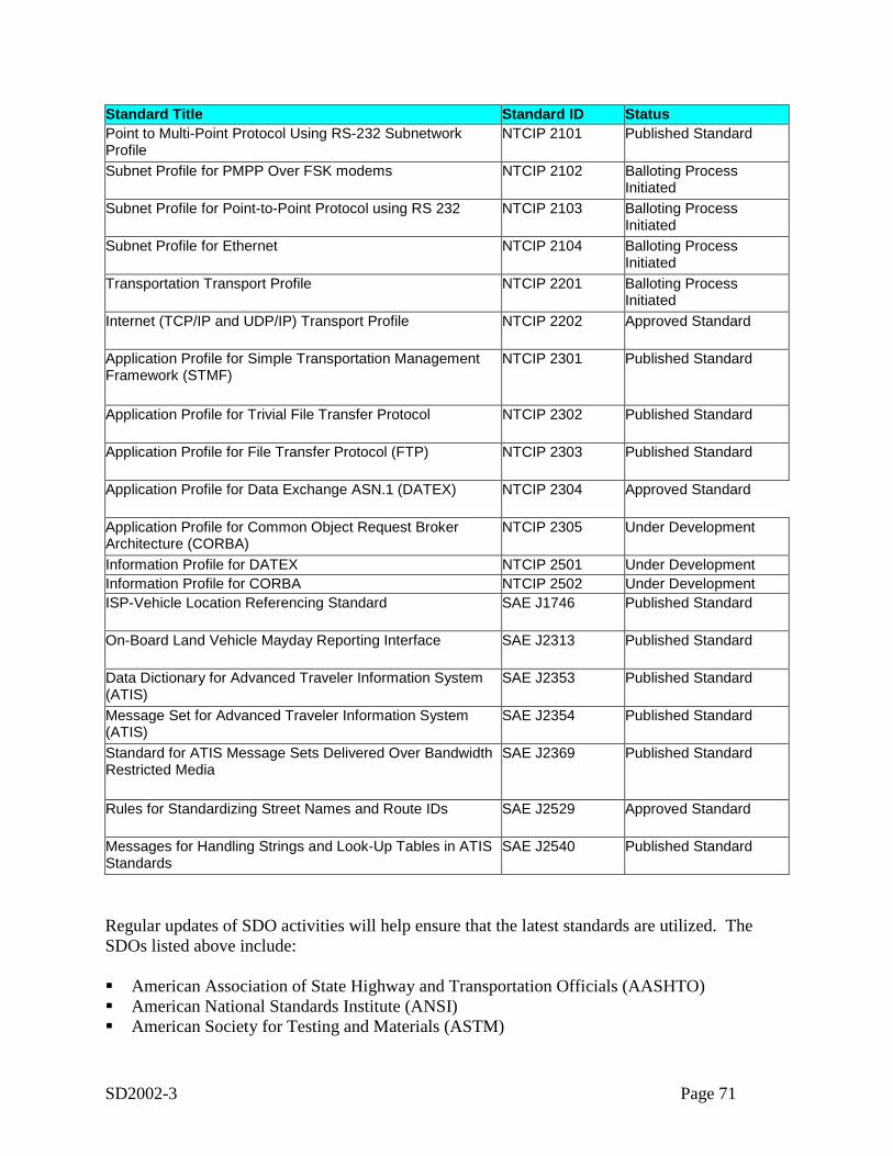
SD2002-3 Page 71
Standard Title Standard ID StatusPoint to Multi-Point Protocol Using RS-232 SubnetworkProfile
NTCIP 2101 Published Standard
Subnet Profile for PMPP Over FSK modems NTCIP 2102 Balloting ProcessInitiated
Subnet Profile for Point-to-Point Protocol using RS 232 NTCIP 2103 Balloting ProcessInitiated
Subnet Profile for Ethernet NTCIP 2104 Balloting ProcessInitiated
Transportation Transport Profile NTCIP 2201 Balloting ProcessInitiated
Internet (TCP/IP and UDP/IP) Transport Profile NTCIP 2202 Approved Standard
Application Profile for Simple Transportation ManagementFramework (STMF)
NTCIP 2301 Published Standard
Application Profile for Trivial File Transfer Protocol NTCIP 2302 Published Standard
Application Profile for File Transfer Protocol (FTP) NTCIP 2303 Published Standard
Application Profile for Data Exchange ASN.1 (DATEX) NTCIP 2304 Approved Standard
Application Profile for Common Object Request BrokerArchitecture (CORBA)
NTCIP 2305 Under Development
Information Profile for DATEX NTCIP 2501 Under DevelopmentInformation Profile for CORBA NTCIP 2502 Under DevelopmentISP-Vehicle Location Referencing Standard SAE J1746 Published Standard
On-Board Land Vehicle Mayday Reporting Interface SAE J2313 Published Standard
Data Dictionary for Advanced Traveler Information System(ATIS)
SAE J2353 Published Standard
Message Set for Advanced Traveler Information System(ATIS)
SAE J2354 Published Standard
Standard for ATIS Message Sets Delivered Over BandwidthRestricted Media
SAE J2369 Published Standard
Rules for Standardizing Street Names and Route IDs SAE J2529 Approved Standard
Messages for Handling Strings and Look-Up Tables in ATISStandards
SAE J2540 Published Standard
Regular updates of SDO activities will help ensure that the latest standards are utilized. TheSDOs listed above include:
! American Association of State Highway and Transportation Officials (AASHTO)! American National Standards Institute (ANSI)! American Society for Testing and Materials (ASTM)
SD2002-3 Page 72
! Electronic Industries Alliance/Consumer Electronic Association (EIA/CEA)! Institute of Electrical and Electronics Engineers (IEEE)! Institute of Transportation Engineers (ITE)! Society of Automotive Engineers (SAE)
Reference to the detailed standards information on the Web SiteThe previous section provides a general discussion of the standards applicable to statewideprojects. However the architecture does contain a far more detailed standards view, one thatmaps applicable standards to the individual information flows that go from one element toanother. This detailed information is contained in the hyperlinked web site and can be accessedin two different ways. Each element description page has a set of links that describe theinformation flowing to and from the element to other elements of the architecture. Selecting anyof these interface links brings the user an interface page. For example, the interface between theSDDOT RWIS Stations and the SDDOT Region and Area Construction and Maintenance Officeis shown in Figure 6. The two information flows in the diagram are defined at the bottom of thepage and have standards icons following the definitions. Selecting the standards icon willprovide the applicable standards for the flow. An example, for the environmental conditions dataflow, is shown in Figure 7 . A second way to access standards information on the web site is toselect the Standards button on the left side of the page. The standards web page has a list ofstandards organized by SDO, with each of the standards title a hot link to a detail page. Figure 6shows an example of the web page the user sees when they select the standard Object Definitionsfor Environmental Sensor Stations & Roadside Weather Information System.
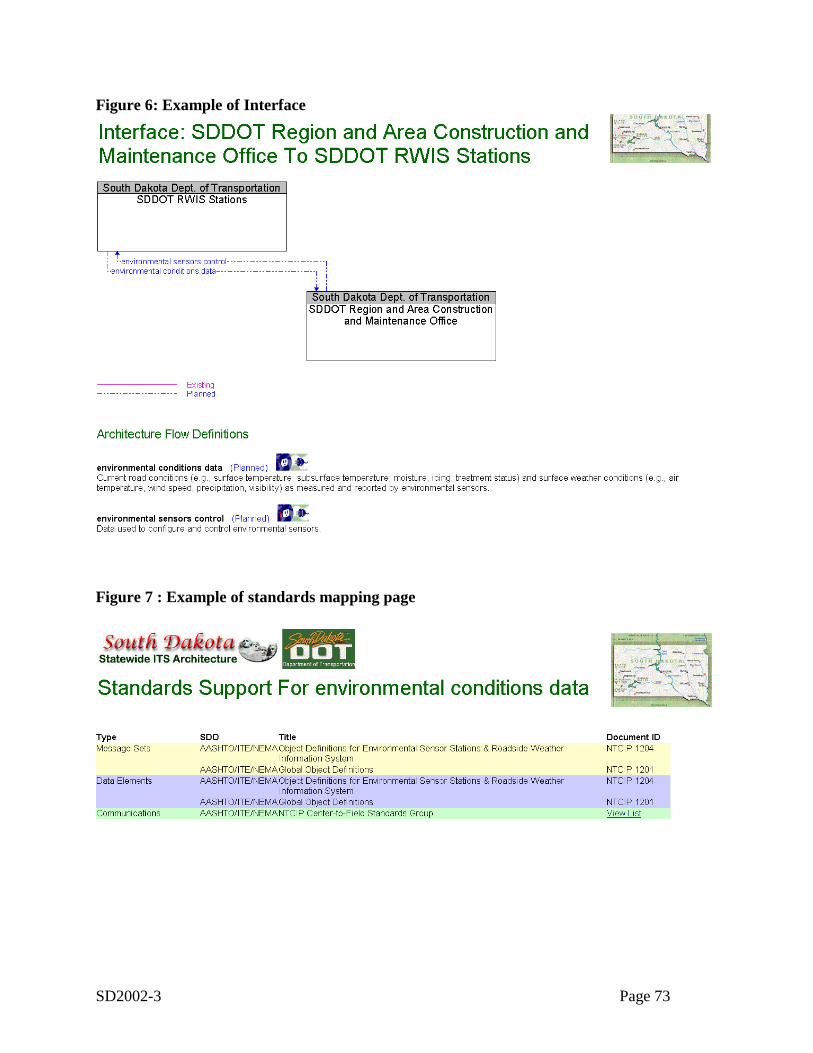
SD2002-3 Page 73
Figure 6: Example of Interface
Figure 7 : Example of standards mapping page
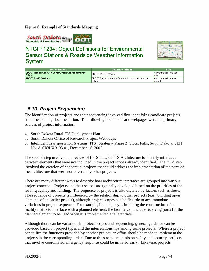
SD2002-3 Page 74
Figure 8: Example of Standards Mapping
5.10. Project SequencingThe identification of projects and their sequencing involved first identifying candidate projectsfrom the existing documentation. The following documents and webpages were the primarysources of project information:
4. South Dakota Rural ITS Deployment Plan5. South Dakota Office of Research Project Webpages6. Intelligent Transportation Systems (ITS) Strategy- Phase 2, Sioux Falls, South Dakota, SEH
No. A-SIOUX0103.01, December 16, 2002
The second step involved the review of the Statewide ITS Architecture to identify interfacesbetween elements that were not included in the project scopes already identified. The third stepinvolved the creation of conceptual projects that could address the implementation of the parts ofthe architecture that were not covered by other projects.
There are many different ways to describe how architecture interfaces are grouped into variousproject concepts. Projects and their scopes are typically developed based on the priorities of theleading agency and funding. The sequence of projects is also dictated by factors such as these.The sequence of projects is influenced by the relationship to other projects (e.g., building uponelements of an earlier project), although project scopes can be flexible to accommodatevariations in project sequence. For example, if an agency is initiating the construction of afacility that is to interface with a planned element, the facility can include receiving ports for theplanned element to be used when it is implemented at a later date.
Although there can be variations in project scopes and sequencing, general guidance can beprovided based on project types and the interrelationships among some projects. Where a projectcan utilize the functions provided by another project, an effort should be made to implement theprojects in the corresponding order. Due to the strong emphasis on safety and security, projectsthat involve coordinated emergency response could be initiated early. Likewise, projects
SD2002-3 Page 75
involving commercial vehicle operations (particularly hazardous materials) could also be givenearly consideration. A broad, second level sequence could include projects involving trafficmanagement and traveler information dissemination. Finally, a third sequence level couldinclude projects related to data archiving or independent operational improvements. Table 10provides a list of projects identified in existing documentation along with additional key projectconcepts. Table 11 provides a mapping from the projects to elements of the StatewideArchitecture.
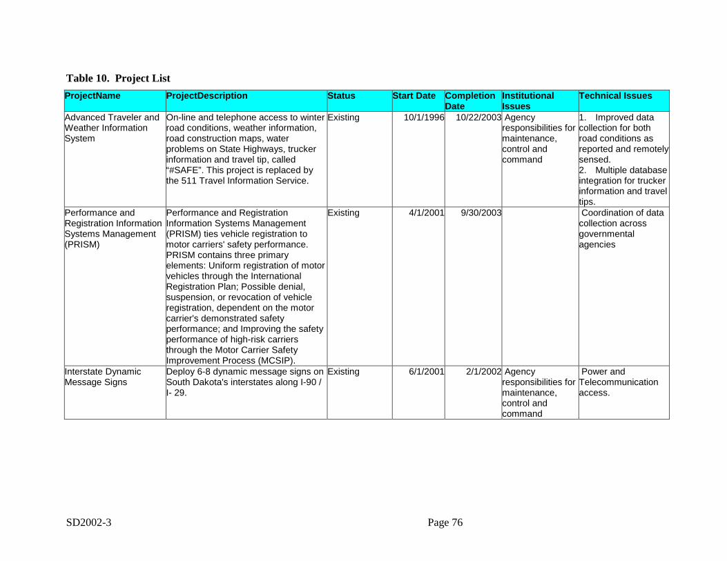
SD2002-3 Page 76
Table 10. Project ListProjectName ProjectDescription Status Start Date Completion
DateInstitutionalIssues
Technical Issues
Advanced Traveler andWeather InformationSystem
On-line and telephone access to winterroad conditions, weather information,road construction maps, waterproblems on State Highways, truckerinformation and travel tip, called“#SAFE”. This project is replaced bythe 511 Travel Information Service.
Existing 10/1/1996 10/22/2003 Agencyresponsibilities formaintenance,control andcommand
1. Improved datacollection for bothroad conditions asreported and remotelysensed.2. Multiple databaseintegration for truckerinformation and traveltips.
Performance andRegistration InformationSystems Management(PRISM)
Performance and RegistrationInformation Systems Management(PRISM) ties vehicle registration tomotor carriers' safety performance.PRISM contains three primaryelements: Uniform registration of motorvehicles through the InternationalRegistration Plan; Possible denial,suspension, or revocation of vehicleregistration, dependent on the motorcarrier's demonstrated safetyperformance; and Improving the safetyperformance of high-risk carriersthrough the Motor Carrier SafetyImprovement Process (MCSIP).
Existing 4/1/2001 9/30/2003 Coordination of datacollection acrossgovernmentalagencies
Interstate DynamicMessage Signs
Deploy 6-8 dynamic message signs onSouth Dakota's interstates along I-90 /I- 29.
Existing 6/1/2001 2/1/2002 Agencyresponsibilities formaintenance,control andcommand
Power andTelecommunicationaccess.
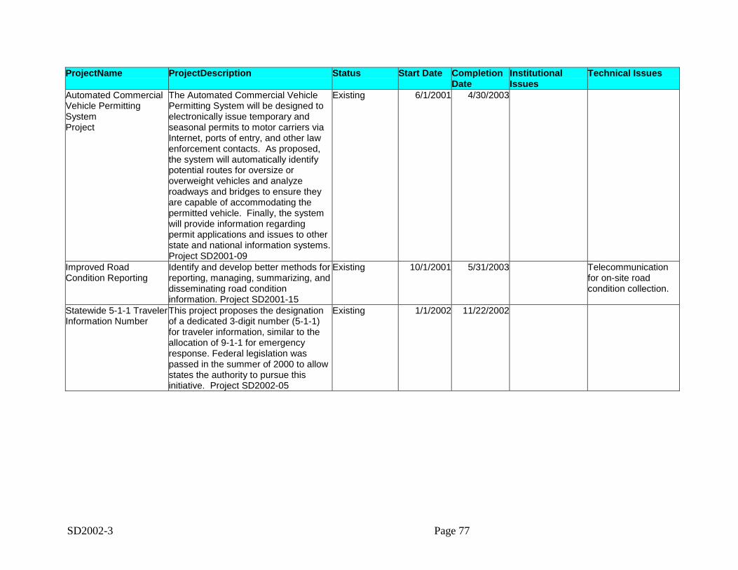
SD2002-3 Page 77
ProjectName ProjectDescription Status Start Date CompletionDate
InstitutionalIssues
Technical Issues
Automated CommercialVehicle PermittingSystemProject
The Automated Commercial VehiclePermitting System will be designed toelectronically issue temporary andseasonal permits to motor carriers viaInternet, ports of entry, and other lawenforcement contacts. As proposed,the system will automatically identifypotential routes for oversize oroverweight vehicles and analyzeroadways and bridges to ensure theyare capable of accommodating thepermitted vehicle. Finally, the systemwill provide information regardingpermit applications and issues to otherstate and national information systems.Project SD2001-09
Existing 6/1/2001 4/30/2003
Improved RoadCondition Reporting
Identify and develop better methods forreporting, managing, summarizing, anddisseminating road conditioninformation. Project SD2001-15
Existing 10/1/2001 5/31/2003 Telecommunicationfor on-site roadcondition collection.
Statewide 5-1-1 TravelerInformation Number
This project proposes the designationof a dedicated 3-digit number (5-1-1)for traveler information, similar to theallocation of 9-1-1 for emergencyresponse. Federal legislation waspassed in the summer of 2000 to allowstates the authority to pursue thisinitiative. Project SD2002-05
Existing 1/1/2002 11/22/2002
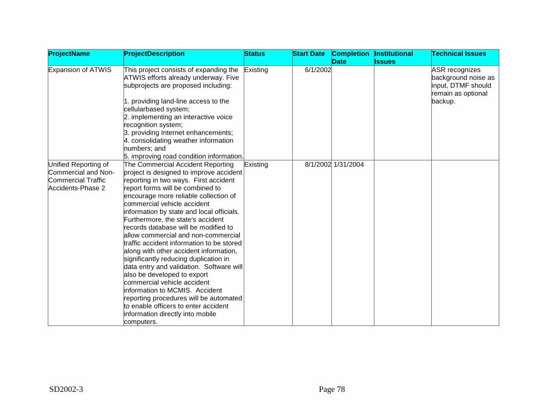
SD2002-3 Page 78
ProjectName ProjectDescription Status Start Date CompletionDate
InstitutionalIssues
Technical Issues
Expansion of ATWIS This project consists of expanding theATWIS efforts already underway. Fivesubprojects are proposed including:
1. providing land-line access to thecellularbased system;2. implementing an interactive voicerecognition system;3. providing Internet enhancements;4. consolidating weather informationnumbers; and5. improving road condition information.
Existing 6/1/2002 ASR recognizesbackground noise asinput, DTMF shouldremain as optionalbackup.
Unified Reporting ofCommercial and Non-Commercial TrafficAccidents-Phase 2
The Commercial Accident Reportingproject is designed to improve accidentreporting in two ways. First accidentreport forms will be combined toencourage more reliable collection ofcommercial vehicle accidentinformation by state and local officials.Furthermore, the state's accidentrecords database will be modified toallow commercial and non-commercialtraffic accident information to be storedalong with other accident information,significantly reducing duplication indata entry and validation. Software willalso be developed to exportcommercial vehicle accidentinformation to MCMIS. Accidentreporting procedures will be automatedto enable officers to enter accidentinformation directly into mobilecomputers.
Existing 8/1/2002 1/31/2004
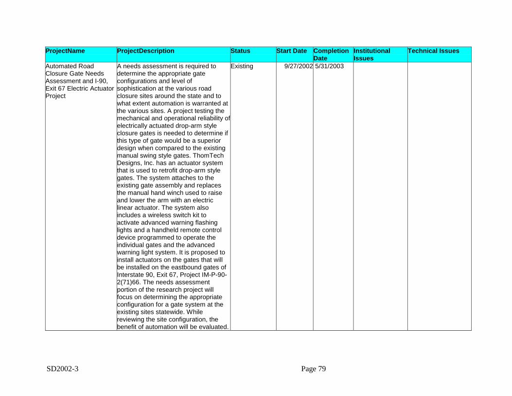
SD2002-3 Page 79
ProjectName ProjectDescription Status Start Date CompletionDate
InstitutionalIssues
Technical Issues
Automated RoadClosure Gate NeedsAssessment and I-90,Exit 67 Electric ActuatorProject
A needs assessment is required todetermine the appropriate gateconfigurations and level ofsophistication at the various roadclosure sites around the state and towhat extent automation is warranted atthe various sites. A project testing themechanical and operational reliability ofelectrically actuated drop-arm styleclosure gates is needed to determine ifthis type of gate would be a superiordesign when compared to the existingmanual swing style gates. ThomTechDesigns, Inc. has an actuator systemthat is used to retrofit drop-arm stylegates. The system attaches to theexisting gate assembly and replacesthe manual hand winch used to raiseand lower the arm with an electriclinear actuator. The system alsoincludes a wireless switch kit toactivate advanced warning flashinglights and a handheld remote controldevice programmed to operate theindividual gates and the advancedwarning light system. It is proposed toinstall actuators on the gates that willbe installed on the eastbound gates ofInterstate 90, Exit 67, Project IM-P-90-2(71)66. The needs assessmentportion of the research project willfocus on determining the appropriateconfiguration for a gate system at theexisting sites statewide. Whilereviewing the site configuration, thebenefit of automation will be evaluated.
Existing 9/27/2002 5/31/2003
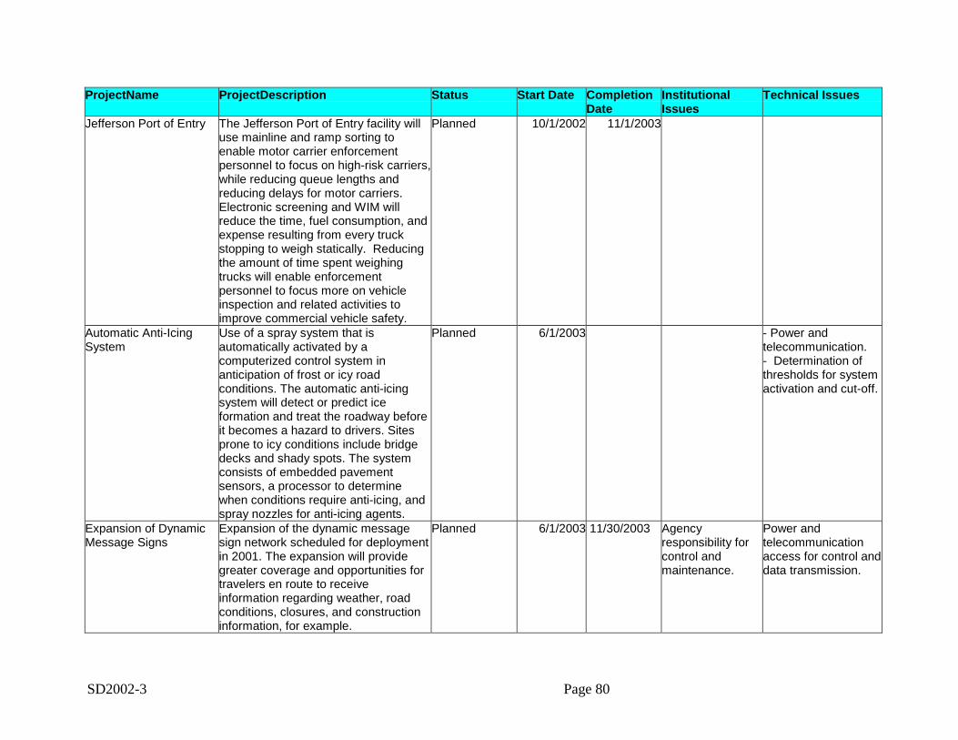
SD2002-3 Page 80
ProjectName ProjectDescription Status Start Date CompletionDate
InstitutionalIssues
Technical Issues
Jefferson Port of Entry The Jefferson Port of Entry facility willuse mainline and ramp sorting toenable motor carrier enforcementpersonnel to focus on high-risk carriers,while reducing queue lengths andreducing delays for motor carriers.Electronic screening and WIM willreduce the time, fuel consumption, andexpense resulting from every truckstopping to weigh statically. Reducingthe amount of time spent weighingtrucks will enable enforcementpersonnel to focus more on vehicleinspection and related activities toimprove commercial vehicle safety.
Planned 10/1/2002 11/1/2003
Automatic Anti-IcingSystem
Use of a spray system that isautomatically activated by acomputerized control system inanticipation of frost or icy roadconditions. The automatic anti-icingsystem will detect or predict iceformation and treat the roadway beforeit becomes a hazard to drivers. Sitesprone to icy conditions include bridgedecks and shady spots. The systemconsists of embedded pavementsensors, a processor to determinewhen conditions require anti-icing, andspray nozzles for anti-icing agents.
Planned 6/1/2003 - Power andtelecommunication.- Determination ofthresholds for systemactivation and cut-off.
Expansion of DynamicMessage Signs
Expansion of the dynamic messagesign network scheduled for deploymentin 2001. The expansion will providegreater coverage and opportunities fortravelers en route to receiveinformation regarding weather, roadconditions, closures, and constructioninformation, for example.
Planned 6/1/2003 11/30/2003 Agencyresponsibility forcontrol andmaintenance.
Power andtelecommunicationaccess for control anddata transmission.
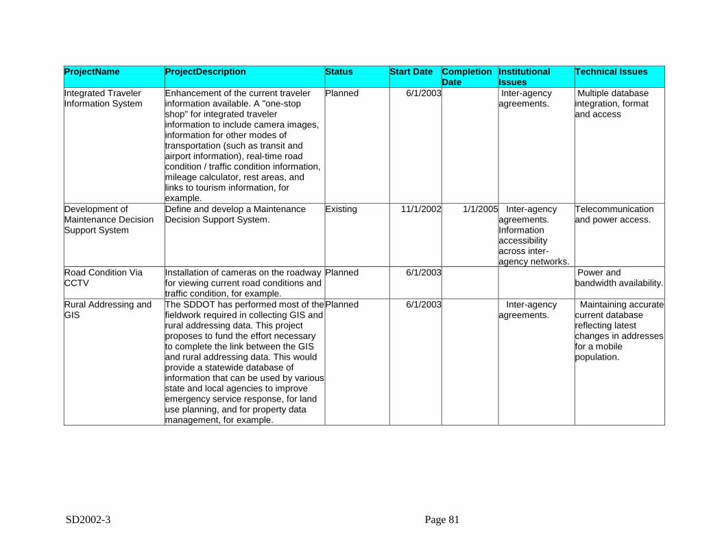
SD2002-3 Page 81
ProjectName ProjectDescription Status Start Date CompletionDate
InstitutionalIssues
Technical Issues
Integrated TravelerInformation System
Enhancement of the current travelerinformation available. A "one-stopshop" for integrated travelerinformation to include camera images,information for other modes oftransportation (such as transit andairport information), real-time roadcondition / traffic condition information,mileage calculator, rest areas, andlinks to tourism information, forexample.
Planned 6/1/2003 Inter-agencyagreements.
Multiple databaseintegration, formatand access
Development ofMaintenance DecisionSupport System
Define and develop a MaintenanceDecision Support System.
Existing 11/1/2002 1/1/2005 Inter-agencyagreements.Informationaccessibilityacross inter-agency networks.
Telecommunicationand power access.
Road Condition ViaCCTV
Installation of cameras on the roadwayfor viewing current road conditions andtraffic condition, for example.
Planned 6/1/2003 Power andbandwidth availability.
Rural Addressing andGIS
The SDDOT has performed most of thefieldwork required in collecting GIS andrural addressing data. This projectproposes to fund the effort necessaryto complete the link between the GISand rural addressing data. This wouldprovide a statewide database ofinformation that can be used by variousstate and local agencies to improveemergency service response, for landuse planning, and for property datamanagement, for example.
Planned 6/1/2003 Inter-agencyagreements.
Maintaining accuratecurrent databasereflecting latestchanges in addressesfor a mobilepopulation.
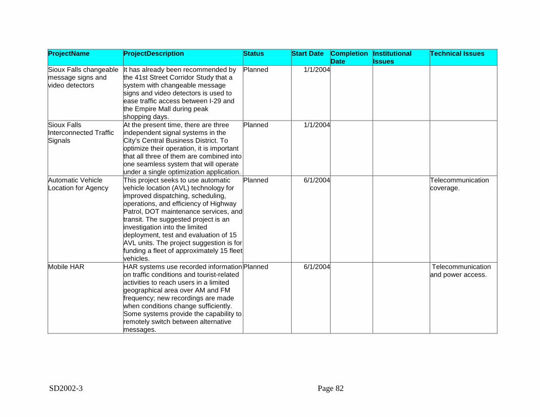
SD2002-3 Page 82
ProjectName ProjectDescription Status Start Date CompletionDate
InstitutionalIssues
Technical Issues
Sioux Falls changeablemessage signs andvideo detectors
It has already been recommended bythe 41st Street Corridor Study that asystem with changeable messagesigns and video detectors is used toease traffic access between I-29 andthe Empire Mall during peakshopping days.
Planned 1/1/2004
Sioux FallsInterconnected TrafficSignals
At the present time, there are threeindependent signal systems in theCity’s Central Business District. Tooptimize their operation, it is importantthat all three of them are combined intoone seamless system that will operateunder a single optimization application.
Planned 1/1/2004
Automatic VehicleLocation for Agency
This project seeks to use automaticvehicle location (AVL) technology forimproved dispatching, scheduling,operations, and efficiency of HighwayPatrol, DOT maintenance services, andtransit. The suggested project is aninvestigation into the limiteddeployment, test and evaluation of 15AVL units. The project suggestion is forfunding a fleet of approximately 15 fleetvehicles.
Planned 6/1/2004 Telecommunicationcoverage.
Mobile HAR HAR systems use recorded informationon traffic conditions and tourist-relatedactivities to reach users in a limitedgeographical area over AM and FMfrequency; new recordings are madewhen conditions change sufficiently.Some systems provide the capability toremotely switch between alternativemessages.
Planned 6/1/2004 Telecommunicationand power access.
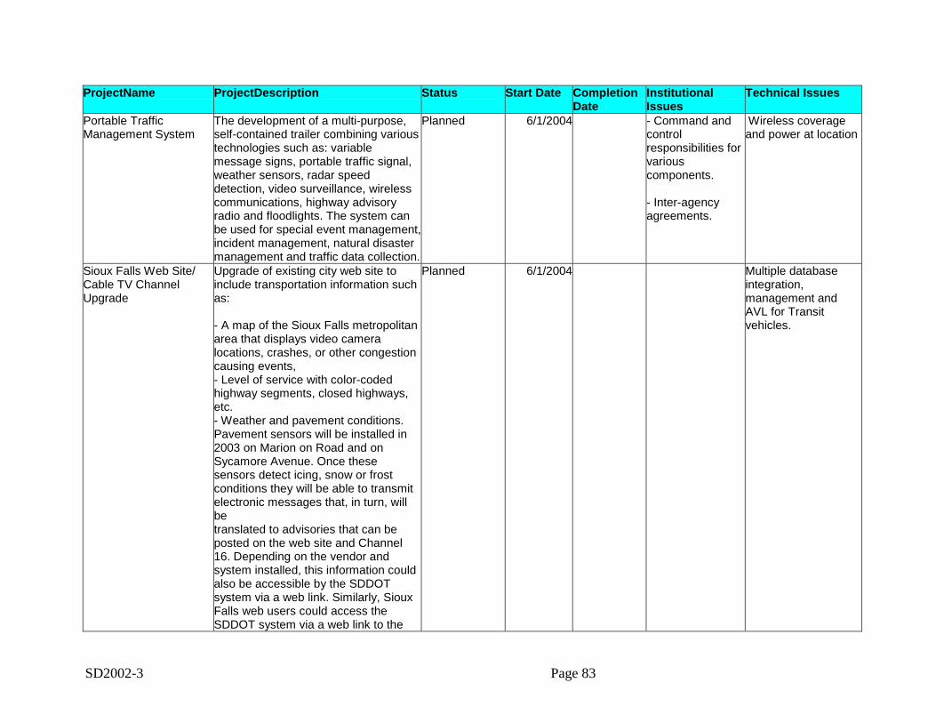
SD2002-3 Page 83
ProjectName ProjectDescription Status Start Date CompletionDate
InstitutionalIssues
Technical Issues
Portable TrafficManagement System
The development of a multi-purpose,self-contained trailer combining varioustechnologies such as: variablemessage signs, portable traffic signal,weather sensors, radar speeddetection, video surveillance, wirelesscommunications, highway advisoryradio and floodlights. The system canbe used for special event management,incident management, natural disastermanagement and traffic data collection.
Planned 6/1/2004 - Command andcontrolresponsibilities forvariouscomponents.
- Inter-agencyagreements.
Wireless coverageand power at location
Sioux Falls Web Site/Cable TV ChannelUpgrade
Upgrade of existing city web site toinclude transportation information suchas:
- A map of the Sioux Falls metropolitanarea that displays video cameralocations, crashes, or other congestioncausing events,- Level of service with color-codedhighway segments, closed highways,etc.- Weather and pavement conditions.Pavement sensors will be installed in2003 on Marion on Road and onSycamore Avenue. Once thesesensors detect icing, snow or frostconditions they will be able to transmitelectronic messages that, in turn, willbetranslated to advisories that can beposted on the web site and Channel16. Depending on the vendor andsystem installed, this information couldalso be accessible by the SDDOTsystem via a web link. Similarly, SiouxFalls web users could access theSDDOT system via a web link to the
Planned 6/1/2004 Multiple databaseintegration,management andAVL for Transitvehicles.
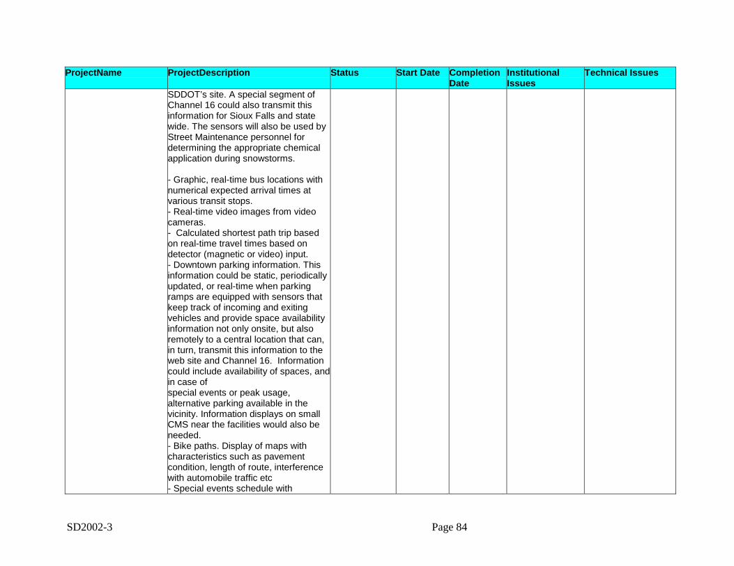
SD2002-3 Page 84
ProjectName ProjectDescription Status Start Date CompletionDate
InstitutionalIssues
Technical Issues
SDDOT’s site. A special segment ofChannel 16 could also transmit thisinformation for Sioux Falls and statewide. The sensors will also be used byStreet Maintenance personnel fordetermining the appropriate chemicalapplication during snowstorms.
- Graphic, real-time bus locations withnumerical expected arrival times atvarious transit stops.- Real-time video images from videocameras.- Calculated shortest path trip basedon real-time travel times based ondetector (magnetic or video) input.- Downtown parking information. Thisinformation could be static, periodicallyupdated, or real-time when parkingramps are equipped with sensors thatkeep track of incoming and exitingvehicles and provide space availabilityinformation not only onsite, but alsoremotely to a central location that can,in turn, transmit this information to theweb site and Channel 16. Informationcould include availability of spaces, andin case ofspecial events or peak usage,alternative parking available in thevicinity. Information displays on smallCMS near the facilities would also beneeded.- Bike paths. Display of maps withcharacteristics such as pavementcondition, length of route, interferencewith automobile traffic etc- Special events schedule with
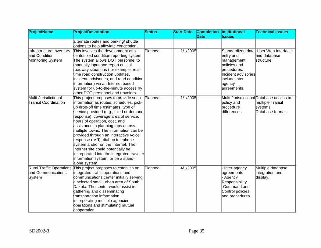
SD2002-3 Page 85
ProjectName ProjectDescription Status Start Date CompletionDate
InstitutionalIssues
Technical Issues
alternate routes and parking/ shuttleoptions to help alleviate congestion.
Infrastructure Inventoryand ConditionMonitoring System
This involves the development of acentralized condition reporting system.The system allows DOT personnel tomanually input and report criticalroadway situations (for example, real-time road construction updates,incident, advisories, and road conditioninformation) via an Internet basedsystem for up-to-the-minute access byother DOT personnel and travelers.
Planned 1/1/2005 Standardized dataentry andmanagementpolicies andprocedures.Incident advisoriesinclude inter-agencyagreements.
User Web Interfaceand databasestructure.
Multi-JurisdictionalTransit Coordination
This project proposes to provide suchinformation as routes, schedules, pick-up drop-off time estimates, type ofservice provided (e.g., fixed or demandresponse), coverage area of service,hours of operation, cost, andassistance in planning trips acrossmultiple towns. The information can beprovided through an interactive voiceresponse (IVR), dial-up telephonesystem and/or on the Internet. TheInternet site could potentially beincorporated into the integrated travelerinformation system, or be a stand-alone system.
Planned 1/1/2005 Multi-Jurisdictionalpolicy andproceduredifferences
Database access tomultiple Transitsystems.Database format.
Rural Traffic Operationsand CommunicationsSystem
This project proposes to establish anintegrated traffic operations andcommunications center initially servinga selected small urban area of SouthDakota. The center would assist ingathering and disseminatingtransportation information,incorporating multiple agenciesoperations and stimulating mutualcooperation.
Planned 4/1/2005 - Inter-agencyagreements- AgencyResponsibility.-Command andControl policiesand procedures.
Multiple databaseintegration anddisplay.
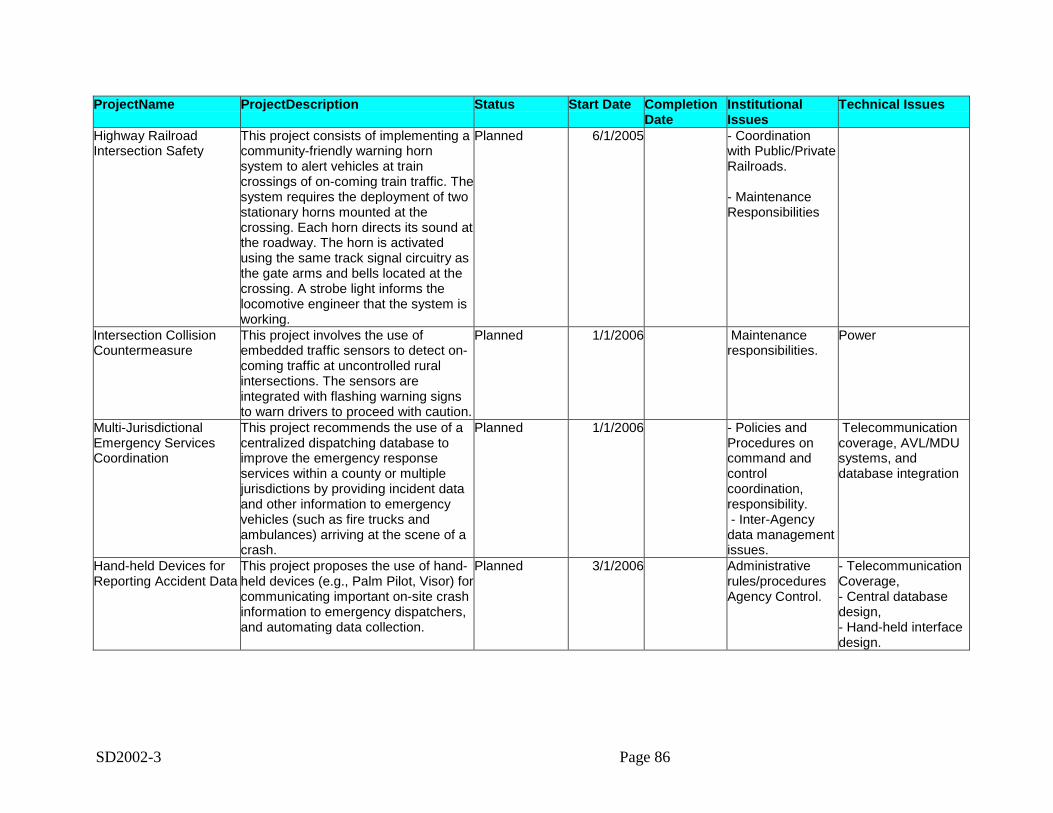
SD2002-3 Page 86
ProjectName ProjectDescription Status Start Date CompletionDate
InstitutionalIssues
Technical Issues
Highway RailroadIntersection Safety
This project consists of implementing acommunity-friendly warning hornsystem to alert vehicles at traincrossings of on-coming train traffic. Thesystem requires the deployment of twostationary horns mounted at thecrossing. Each horn directs its sound atthe roadway. The horn is activatedusing the same track signal circuitry asthe gate arms and bells located at thecrossing. A strobe light informs thelocomotive engineer that the system isworking.
Planned 6/1/2005 - Coordinationwith Public/PrivateRailroads.
- MaintenanceResponsibilities
Intersection CollisionCountermeasure
This project involves the use ofembedded traffic sensors to detect on-coming traffic at uncontrolled ruralintersections. The sensors areintegrated with flashing warning signsto warn drivers to proceed with caution.
Planned 1/1/2006 Maintenanceresponsibilities.
Power
Multi-JurisdictionalEmergency ServicesCoordination
This project recommends the use of acentralized dispatching database toimprove the emergency responseservices within a county or multiplejurisdictions by providing incident dataand other information to emergencyvehicles (such as fire trucks andambulances) arriving at the scene of acrash.
Planned 1/1/2006 - Policies andProcedures oncommand andcontrolcoordination,responsibility. - Inter-Agencydata managementissues.
Telecommunicationcoverage, AVL/MDUsystems, anddatabase integration
Hand-held Devices forReporting Accident Data
This project proposes the use of hand-held devices (e.g., Palm Pilot, Visor) forcommunicating important on-site crashinformation to emergency dispatchers,and automating data collection.
Planned 3/1/2006 Administrativerules/proceduresAgency Control.
- TelecommunicationCoverage,- Central databasedesign,- Hand-held interfacedesign.
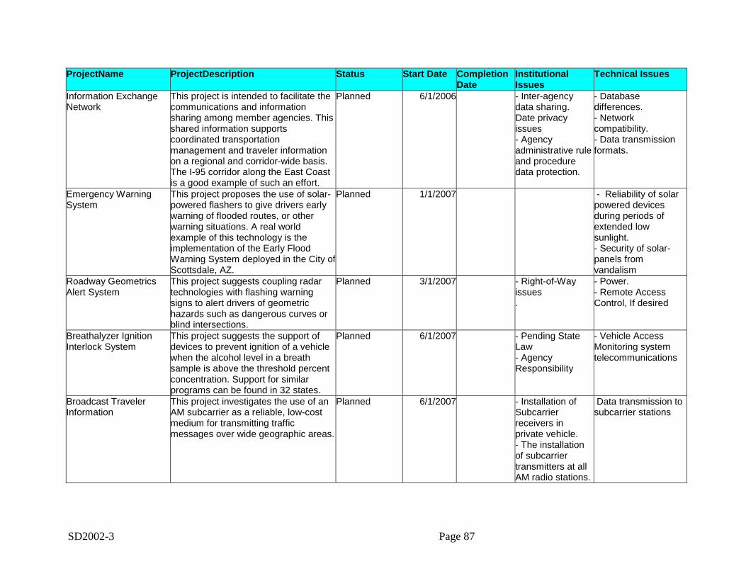
SD2002-3 Page 87
ProjectName ProjectDescription Status Start Date CompletionDate
InstitutionalIssues
Technical Issues
Information ExchangeNetwork
This project is intended to facilitate thecommunications and informationsharing among member agencies. Thisshared information supportscoordinated transportationmanagement and traveler informationon a regional and corridor-wide basis.The I-95 corridor along the East Coastis a good example of such an effort.
Planned 6/1/2006 - Inter-agencydata sharing.Date privacyissues- Agencyadministrative ruleand proceduredata protection.
- Databasedifferences.- Networkcompatibility.- Data transmissionformats.
Emergency WarningSystem
This project proposes the use of solar-powered flashers to give drivers earlywarning of flooded routes, or otherwarning situations. A real worldexample of this technology is theimplementation of the Early FloodWarning System deployed in the City ofScottsdale, AZ.
Planned 1/1/2007 - Reliability of solarpowered devicesduring periods ofextended lowsunlight.- Security of solar-panels fromvandalism
Roadway GeometricsAlert System
This project suggests coupling radartechnologies with flashing warningsigns to alert drivers of geometrichazards such as dangerous curves orblind intersections.
Planned 3/1/2007 - Right-of-Wayissues.
- Power.- Remote AccessControl, If desired
Breathalyzer IgnitionInterlock System
This project suggests the support ofdevices to prevent ignition of a vehiclewhen the alcohol level in a breathsample is above the threshold percentconcentration. Support for similarprograms can be found in 32 states.
Planned 6/1/2007 - Pending StateLaw- AgencyResponsibility
- Vehicle AccessMonitoring systemtelecommunications
Broadcast TravelerInformation
This project investigates the use of anAM subcarrier as a reliable, low-costmedium for transmitting trafficmessages over wide geographic areas.
Planned 6/1/2007 - Installation ofSubcarrierreceivers inprivate vehicle.- The installationof subcarriertransmitters at allAM radio stations.
Data transmission tosubcarrier stations
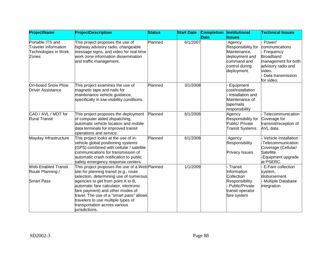
SD2002-3 Page 88
ProjectName ProjectDescription Status Start Date CompletionDate
InstitutionalIssues
Technical Issues
Portable ITS andTraveler InformationTechnologies in WorkZones
This project proposes the use ofhighway advisory radio, changeablemessage signs, and video for real-timework zone information disseminationand traffic management.
Planned 6/1/2007 AgencyResponsibility forMaintenance,deployment andcommand andcontrol duringdeployment.
- Power/communications- FrequencyBroadbandmanagement for bothadvisory radio andvideo.- Data transmissionfor video.
On-board Snow PlowDriver Assistance
This project examines the use ofmagnetic tape and nails formaintenance vehicle guidance,specifically in low-visibility conditions.
Planned 3/1/2008 - Equipmentcost/installation- Installation andMaintenance oftape/nailsresponsibility
CAD / AVL / MDT forRural Transit
This project proposes the deploymentof computer aided dispatching,automatic vehicle location and mobiledata terminals for improved transitoperations and service.
Planned 6/1/2008 AgencyResponsibility forPublic/ PrivateTransit Systems.
- TelecommunicationCoverage fortransmit/reception ofAVL data.
Mayday Infrastructure This project looks at the use of in-vehicle global positioning systems(GPS) combined with cellular / satellitecommunications for transmission ofautomatic crash notification to publicsafety emergency response centers.
Planned 6/1/2008 AgencyResponsibility
Privacy Issues
- Vehicle Installation-TelecommunicationCoverage (Cellular/Satellite.-Equipment upgradeat PSERC.
Web-Enabled TransitRoute Planning /
Smart Pass
This project proposes the use of a Website for planning transit (e.g., routeselection, determining use of numerousagencies to get from point A to B,automatic fare calculator, electronicfare payment) and other modes oftravel. The use of a "smart pass" allowstravelers to use multiple types oftransportation across variousjurisdictions.
Planned 1/1/2009 - TransitInformationCollectionResponsibility.- Public/Privatetransit operatorfare system
- E-Fare collectionsystem,disbursement.- Multiple Databaseintegration
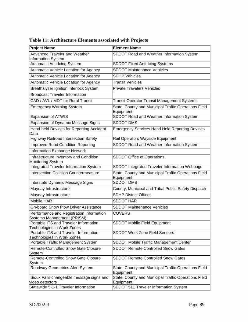
SD2002-3 Page 89
Table 11: Architecture Elements associated with ProjectsProject Name Element Name Advanced Traveler and WeatherInformation System
SDDOT Road and Weather Information System
Automatic Anti-Icing System SDDOT Fixed Anti-Icing Systems Automatic Vehicle Location for Agency SDDOT Maintenance Vehicles Automatic Vehicle Location for Agency SDHP Vehicles Automatic Vehicle Location for Agency Transit Vehicles Breathalyzer Ignition Interlock System Private Travelers Vehicles Broadcast Traveler Information CAD / AVL / MDT for Rural Transit Transit Operator Transit Management Systems Emergency Warning System State, County and Municipal Traffic Operations Field
Equipment Expansion of ATWIS SDDOT Road and Weather Information System Expansion of Dynamic Message Signs SDDOT DMS Hand-held Devices for Reporting AccidentData
Emergency Services Hand Held Reporting Devices
Highway Railroad Intersection Safety Rail Operators Wayside Equipment Improved Road Condition Reporting SDDOT Road and Weather Information System Information Exchange Network Infrastructure Inventory and ConditionMonitoring System
SDDOT Office of Operations
Integrated Traveler Information System SDDOT Integrated Traveler Information Webpage Intersection Collision Countermeasure State, County and Municipal Traffic Operations Field
Equipment Interstate Dynamic Message Signs SDDOT DMS Mayday Infrastructure County, Municipal and Tribal Public Safety Dispatch Mayday Infrastructure SDHP District Offices Mobile HAR SDDOT HAR On-board Snow Plow Driver Assistance SDDOT Maintenance Vehicles Performance and Registration InformationSystems Management (PRISM)
COVERS
Portable ITS and Traveler InformationTechnologies in Work Zones
SDDOT Mobile Field Equipment
Portable ITS and Traveler InformationTechnologies in Work Zones
SDDOT Work Zone Field Sensors
Portable Traffic Management System SDDOT Mobile Traffic Management Center Remote-Controlled Snow Gate ClosureSystem
SDDOT Remote Controlled Snow Gates
Remote-Controlled Snow Gate ClosureSystem
SDDOT Remote Controlled Snow Gates
Roadway Geometrics Alert System State, County and Municipal Traffic Operations FieldEquipment
Sioux Falls changeable message signs andvideo detectors
State, County and Municipal Traffic Operations FieldEquipment
Statewide 5-1-1 Traveler Information SDDOT 511 Traveler Information System
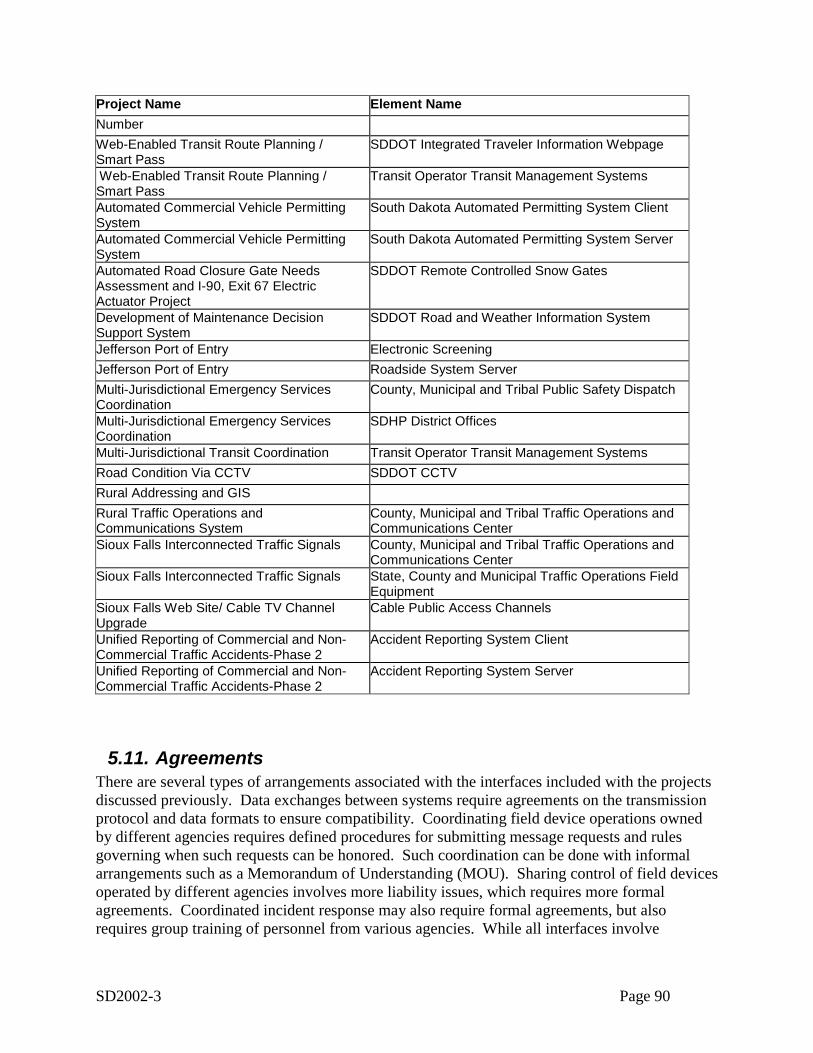
SD2002-3 Page 90
Project Name Element NameNumberWeb-Enabled Transit Route Planning /Smart Pass
SDDOT Integrated Traveler Information Webpage
Web-Enabled Transit Route Planning /Smart Pass
Transit Operator Transit Management Systems
Automated Commercial Vehicle PermittingSystem
South Dakota Automated Permitting System Client
Automated Commercial Vehicle PermittingSystem
South Dakota Automated Permitting System Server
Automated Road Closure Gate NeedsAssessment and I-90, Exit 67 ElectricActuator Project
SDDOT Remote Controlled Snow Gates
Development of Maintenance DecisionSupport System
SDDOT Road and Weather Information System
Jefferson Port of Entry Electronic ScreeningJefferson Port of Entry Roadside System ServerMulti-Jurisdictional Emergency ServicesCoordination
County, Municipal and Tribal Public Safety Dispatch
Multi-Jurisdictional Emergency ServicesCoordination
SDHP District Offices
Multi-Jurisdictional Transit Coordination Transit Operator Transit Management SystemsRoad Condition Via CCTV SDDOT CCTVRural Addressing and GISRural Traffic Operations andCommunications System
County, Municipal and Tribal Traffic Operations andCommunications Center
Sioux Falls Interconnected Traffic Signals County, Municipal and Tribal Traffic Operations andCommunications Center
Sioux Falls Interconnected Traffic Signals State, County and Municipal Traffic Operations FieldEquipment
Sioux Falls Web Site/ Cable TV ChannelUpgrade
Cable Public Access Channels
Unified Reporting of Commercial and Non-Commercial Traffic Accidents-Phase 2
Accident Reporting System Client
Unified Reporting of Commercial and Non-Commercial Traffic Accidents-Phase 2
Accident Reporting System Server
5.11. AgreementsThere are several types of arrangements associated with the interfaces included with the projectsdiscussed previously. Data exchanges between systems require agreements on the transmissionprotocol and data formats to ensure compatibility. Coordinating field device operations ownedby different agencies requires defined procedures for submitting message requests and rulesgoverning when such requests can be honored. Such coordination can be done with informalarrangements such as a Memorandum of Understanding (MOU). Sharing control of field devicesoperated by different agencies involves more liability issues, which requires more formalagreements. Coordinated incident response may also require formal agreements, but alsorequires group training of personnel from various agencies. While all interfaces involve
SD2002-3 Page 91
agreements for data compatibility, agreements for procedure and operation as well as trainingcan also be critical elements to optimizing the benefits of the architecture.
6. Implementation RecommendationsThe following section provides a set of recommendations for actions that should be performedfollowing the development of the Statewide ITS Architecture. These actions fall within thegeneral areas of Using the Statewide ITS Architecture and Maintaining the Statewide ITSArchitecture. The specific recommendations are numbered within the following section,followed by explanation of the action.
6.1. Using the Statewide ITS Architecture
Once a regional ITS architecture has been created, it’s important that it be used as a keyreference in the transportation planning process. This will ensure all proposed ITS projects areconsistent with the regional ITS architecture and additional integration opportunities areconsidered, leading to more efficient implementations.
1. Update the Recommended Projects portion of the South Dakota Rural ITS DeploymentPlan using the information developed for the Architecture.
At the state level the primary planning document from an ITS standpoint is the South DakotaRural ITS Deployment Plan, which was published in January 2001. The original DeploymentPlan provided a blueprint for the integrated deployment of Intelligent Transportation Systems(ITS) in the state, and has been used to support the integration of ITS actions underway and toinsure that future projects contribute to the effective use of transportation technologies. TheDeployment Plan included a list of recommended projects and identified the funding needed toimplement this plan. As a part of this original plan, the need to create a Statewide ITSArchitecture was identified. A Statewide ITS architecture would provide in some level of detailthe ITS systems and integration opportunities in the region.
With the completion of the initial version of the South Dakota Statewide ITS Architecture, it isrecommended that the Recommended Projects portion of the Deployment Plan be revisited andupdated
2. Use the updated Project Information as input to the Statewide Intermodal Long RangePlan.
The update of the project information can then serve as a key input to the Statewide IntermodalLong Range Plan, which was last updated in 1999. It is the long-range guide for majorinvestments in the State’s ground transportation system.
SD2002-3 Page 92
3. Use the Statewide architecture to support the next updates of the regional Long RangePlans (e.g. Sioux Falls Metropolitan Area Long-Range Transportation Plan.
The Statewide ITS Architecture should also be considered a key reference in the MPO planningprocess. Its suggested transportation system integration should be considered in the next updatesof the regional Long Range Plans (e.g. Sioux Falls Metropolitan Area Long-RangeTransportation Plan).
The statewide ITS architecture should also be considered for support in ITS project developmentcycle. This begins with project definition, followed by procurement, leading to implementation.Information in the regional ITS architecture can assist in all three of these areas of projectdevelopment.
4. Consider use of the Statewide Architecture in the development of individual ResearchPlans.
Project Definition may occur at several levels of detail. Early in the planning process a projectmay be defined only in terms of the transportation services it will provide, or by the majorsystem pieces it contains. At some point prior to the beginning of implementation the details ofthe project must be developed. This could include further system definition and interfacedefinition including exactly what systems or parts of systems will make up the project, whatinterconnections the project entails, and what information needs to flow across the systeminterconnections. Requirements definition may go through similar levels of detail, starting withvery high level description of project functions and moving toward system specifications. Byidentifying the portions of the statewide ITS architecture that define the project, the statewideITS architecture outputs can be used to create key aspects of the project definition.
The areas that the statewide ITS architecture can assist in project definition are:
• The identification of agency roles and responsibilities (including any inter-agencycooperation) can come from the operational concept developed as part of the regional ITSarchitecture. This operational concept can either serve as a starting point for a more detaileddefinition, or possibly provide all the needed information.
• Requirements definition can be completely or partly defined by using the regional ITSarchitecture functional requirements applicable to the project.
• The ITS architecture includes a map to ITS standards and the project mapping to the regionalITS architecture can extract the applicable ITS standards for the project.
Once a project is defined, and funding for it is committed, the implementation process cancommence with the generation of a Request For Proposal (RFP), which is the commongovernmental practice for initiating a contract with the private sector to implement the project.Once a contract is in place, project implementation begins and moves through design,development, integration, and testing.
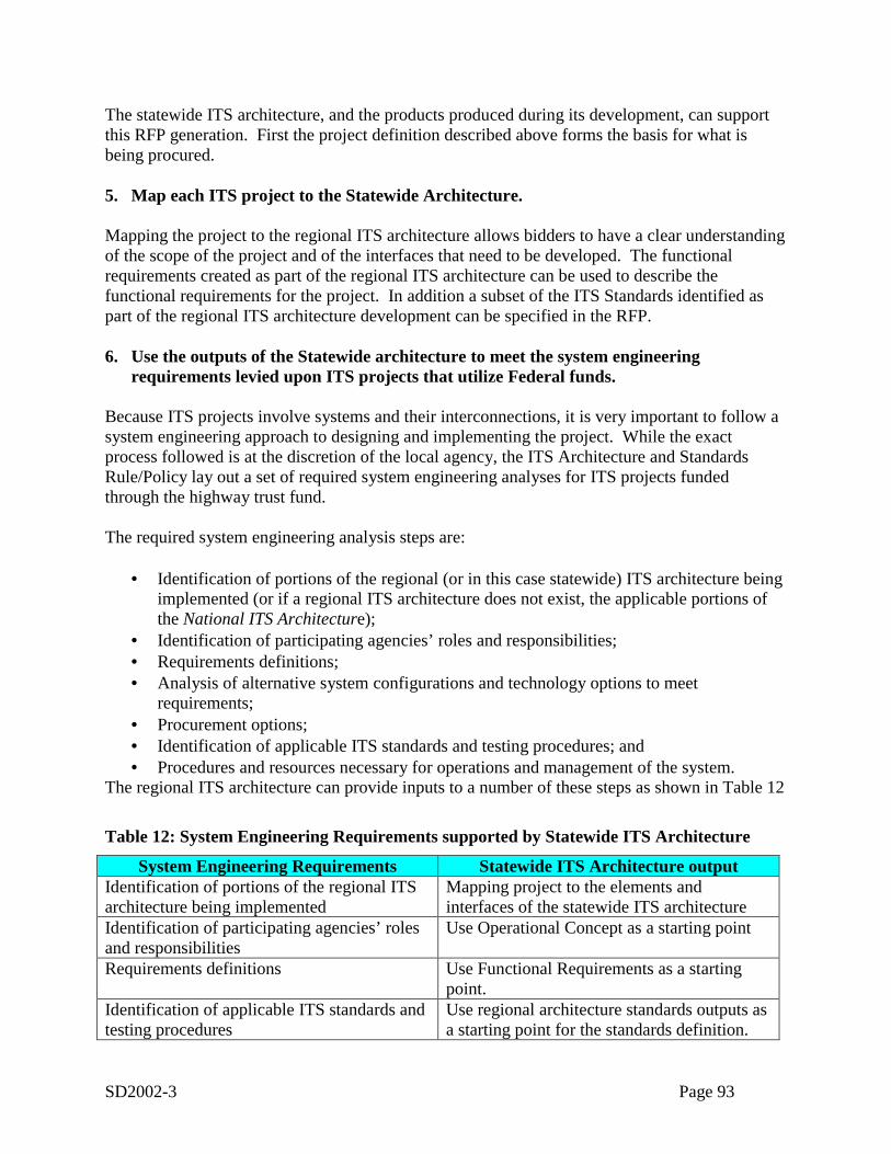
SD2002-3 Page 93
The statewide ITS architecture, and the products produced during its development, can supportthis RFP generation. First the project definition described above forms the basis for what isbeing procured.
5. Map each ITS project to the Statewide Architecture.
Mapping the project to the regional ITS architecture allows bidders to have a clear understandingof the scope of the project and of the interfaces that need to be developed. The functionalrequirements created as part of the regional ITS architecture can be used to describe thefunctional requirements for the project. In addition a subset of the ITS Standards identified aspart of the regional ITS architecture development can be specified in the RFP.
6. Use the outputs of the Statewide architecture to meet the system engineeringrequirements levied upon ITS projects that utilize Federal funds.
Because ITS projects involve systems and their interconnections, it is very important to follow asystem engineering approach to designing and implementing the project. While the exactprocess followed is at the discretion of the local agency, the ITS Architecture and StandardsRule/Policy lay out a set of required system engineering analyses for ITS projects fundedthrough the highway trust fund.
The required system engineering analysis steps are:
• Identification of portions of the regional (or in this case statewide) ITS architecture beingimplemented (or if a regional ITS architecture does not exist, the applicable portions ofthe National ITS Architecture);
• Identification of participating agencies’ roles and responsibilities;• Requirements definitions;• Analysis of alternative system configurations and technology options to meet
requirements;• Procurement options;• Identification of applicable ITS standards and testing procedures; and• Procedures and resources necessary for operations and management of the system.
The regional ITS architecture can provide inputs to a number of these steps as shown in Table 12
Table 12: System Engineering Requirements supported by Statewide ITS Architecture
System Engineering Requirements Statewide ITS Architecture outputIdentification of portions of the regional ITSarchitecture being implemented
Mapping project to the elements andinterfaces of the statewide ITS architecture
Identification of participating agencies’ rolesand responsibilities
Use Operational Concept as a starting point
Requirements definitions Use Functional Requirements as a startingpoint.
Identification of applicable ITS standards andtesting procedures
Use regional architecture standards outputs asa starting point for the standards definition.
SD2002-3 Page 94
In summary, the regional ITS architecture represents a detailed plan for the evolution of the ITSsystems in the region and can be used to support regional transportation planning efforts andproject development efforts.
6.2. Maintaining the Statewide ITS Architecture
The South Dakota Statewide ITS Architecture is not a static set of outputs. It must change asplans change, ITS projects are implemented, and the ITS needs and services evolve in the region.This section describes a proposed plan for the maintenance of the architecture. The plan coversthe following three key areas:
o Who will maintain the architecture?o What will be maintained?o How it will be maintained (i.e. what configuration control process will be used)?
The statewide ITS architecture is created as a consensus view of what ITS systems thestakeholders in the region have currently implemented and what systems they plan to implementin the future. The statewide ITS architecture will need to be updated to reflect changes resultingfrom project implementation or resulting from the planning process itself.
• Changes for Project Definition.When actually defined, a project may add, subtract or modify elements, interfaces, orinformation flows from the regional ITS architecture. Because the regional ITS architectureis meant to describe the current (as well as future) regional implementation of ITS, it must beupdated to correctly reflect how the developed projects integrate into the region.
• Changes for Project Addition/Deletion.Occasionally a project will be added or deleted through the planning process and someaspects of the regional ITS architecture that are associated with the project may be expanded,changed or removed.
• Changes in Project Priority.Due to funding constraints, or other considerations, the planned project sequencing maychange. Delaying a project may have a ripple effect on other projects that depend on it.Raising the priority for a project’s implementation may impact the priority of other projectsthat are dependent upon it.
• Changes in Regional Needs.Transportation planning is done to address regional needs. Over time these needs can changeand the corresponding aspects of the regional ITS architecture that addresses these needs mayneed to be updated.
In addition, new stakeholders may come to the table and the statewide ITS architecture should beupdated to reflect their place in the regional view of ITS elements, interfaces, and informationflows.
Finally, the National ITS Architecture may be expanded and updated from time to time toinclude new user services or better define how existing elements satisfy the user services. These
SD2002-3 Page 95
changes should also be considered as the regional ITS architecture is updated. The National ITSArchitecture may have expanded to include a user service that has been discussed in a region, butnot been included in the statewide ITS architecture, or been included in only a very cursorymanner.
6.2.1. Maintenance Responsibility7. Determine who will maintain the architecture and what group will act as an
Institutional Framework for the maintenance of the architecture.
Responsibility for maintenance of the South Dakota Statewide ITS Architecture should lie withSDDOT. This organization was responsible for the original development effort and will be oneof the primary users of the ITS architecture. While it is recommended that SDDOT assumeresponsibility for maintenance, it is further recommended that a group of core stakeholders act asan “institutional framework” to review proposed changes to the ITS architecture. The regionalITS architecture is a consensus framework for integrating ITS systems in the state. As it was aconsensus driven product in its initial creation, so it should remain a consensus driven product asit is maintained.
6.2.2. Architecture Baseline8. Define the Architecture Baseline that will be maintained.
Establishing an ITS architecture baseline requires clear identification of the architecture productsthat will be maintained, including specific format and version information. For the South DakotaStatewide ITS Architecture the following outputs are recommended as the architecture baseline:
• Architecture Document (this document)• Turbo Architecture Database• Statewide ITS Architecture Web pages
Regarding the Architecture document, it is recommended that the source document, in MicrosoftWord format, be held by SDDOT, while a PDF version of the document is created for generaldistribution.
Regarding the Turbo Architecture Database, it is recommended that SDDOT maintain a zippedversion of the final delivered South Dakota Statewide Architecture database. The name, date,and size of the database file inside the zipped file should be entered into an architecture log asversion 1.0 of the architecture.
Regarding the web site, a CD-ROM version of the final web site should be maintained bySDDOT. It is further recommended that the version number of the architecture be enteredsomewhere on the home page of the web site so that the version being viewed is immediatelyidentifiable.
SD2002-3 Page 96
6.2.3. Configuration Control9. Define the configuration control process that will be used to maintain the architecture
and develop specific procedures for configuration control.
Once the baseline is defined, the process for making changes to this baseline must be established.The change management process specifies how changes are identified, how often they will bemade, and how the changes will be reviewed, implemented, and released.
How Changes are Identified
This involves two issues-
• who can identify a change to the architecture and• how will the change request be documented
For an architecture that covers an entire state, the question of who can make change requests isan important one. If literally anyone can input requests the region runs the risk of being overrunby requests that will tax scarce resources to review and decide upon. On the other end of thespectrum, if too much formality or paperwork is added to the process then many valid or neededchanges may go unexpressed. The recommendation is that only members of the “corestakeholders” who make up the institutional framework be allowed to identify potential changes.This effectively means that any change suggested has the approval of a member of the coregroup. This has the added benefit of spreading the resources needed to generate or evaluatechanges among the group.
As to how the change request should be documented—it is recommended that a simple changerequest form be created that contains at least the following information:
12. Name of change13. Description of change14. Part of baseline affected (could be check boxes for document, database, web site, and not
known)15. Rationale for change16. Originator name or agency17. Date of origination
This information will ultimately be added to a change database (recommended to be maintainedby SDDOT personnel) that will add the following additional fields of information:
18. Change number (some unique identifier)19. Change disposition (accepted, rejected, deferred)20. Change type (minor or significant)21. Disposition comment22. Disposition date
SD2002-3 Page 97
How often Changes are Made
It is recommended that the first update to the architecture baseline be made approximately a yearafter completion of the initial version. Depending upon the amount of change requestssubmitted, this could be anything from a minor update to correct errors found to a moresignificant update to include changes in stakeholders, elements, and connections. Also somechanges could be deferred until the next major update of the architecture. It is recommended thata major review and update of the architecture (including possibly additional stakeholdermeetings) be tied to the update of a major planning document such as the Statewide IntermodalLong Range Plan. This will allow an updated version of the architecture to be used as the basisfor the Plan update. Additional minor revisions of the baseline could be considered on a yearlybasis.
Change Review, Implementation, and Release.
The general steps in the change review process are:
6. Define changes per the recommendations given above.7. Assess the impact of the change. Someone needs to evaluate the change and determine
what impact it has upon the architecture baseline. There are three options for whoperforms this evaluation
a. the person proposing the change (i.e. the member of the core group that brings itforward)
b. a staff member of SDDOT (the agency responsible for architecture maintenance)or
c. a contractor through some architecture support contract.Each of these options has positive and negative implications. The first option will workwell for minor changes (e.g. changes in status, connections, or descriptions). However,it does require each submitting person to have sufficient knowledge of the architecture tosuggest appropriate solutions. The second option requires the architecture knowledge tobe available through SDDOT personnel. Their long-term availability to perform thework is a possible risk. The third implies contracting for the necessary expertise, so hasthe negative of additional cost associated with it.
8. Provide a recommendation to the Change Control Group. For proper change controlsome group should be assigned responsibility for reviewing and approving changes to thebaseline. The recommendation is that a subgroup of the core stakeholders be appointedfor this purpose. This Change Control Group (sometimes referred to as a ConfigurationControl Board) should be lead by the individual responsible for maintaining thearchitecture (or by one of the individuals if it is a group activity). The job of the Group isto decide what changes go into the architecture baseline. This could be done throughperiodic meetings (say quarterly), through electronic correspondence, or a combination ofboth. A recommendation is that minor changes be handled through monthly emaildistribution and approval, while major changes or areas of disagreement are handled atthe periodic face to face meetings. It is important to maintain the consensus nature of thearchitecture by having a group of core stakeholders agree on changes.
SD2002-3 Page 98
9. The Change Control Group makes a decision. Either it accepts the change, rejects it, orasks for additional evaluation.
10. The decision is implemented. If the decision is to accept the change, then theappropriate portions of the architecture baseline are updated (per the schedule discussedabove) and an updated architecture baseline is defined.
The time required to perform this configuration control process will be a direct function of thenumber of changes suggested to the architecture, which will be driven by how much thearchitecture is being used. It is suggested that the process be reviewed within the first year andfine-tuned to most appropriately address the level of change that has occurred.
10. Implement the configuration control process and maintain the architecture
6.3. Recommendations SummaryThe following are the recommended actions as a result of the development of the South DakotaStatewide ITS Architecture. These actions fall into three general areas:
Use the Architecture to support transportation planning at the State and regional level
1. Update the Recommended Projects portion of the South Dakota Rural ITS Deployment Planusing the information developed for the Architecture
2. Use the updated Project Information as input to the Statewide Intermodal Long Range Plan3. Use the Statewide architecture to support the next updates of the regional Long Range Plans
(e.g. Sioux Falls Metropolitan Area Long-Range Transportation Plan
Use the Architecture to support ITS Project Development4. Consider use of the Statewide Architecture in the development of individual Research Plans.5. Map each ITS project to the Statewide Architecture6. Use the outputs of the Statewide architecture to meet the system engineering requirements
levied upon ITS projects that utilize Federal funds.
Maintain the Architecture7. Determine who will maintain the architecture and what group will act as an Institutional
Framework for the maintenance of the architecture8. Define the Architecture Baseline that will be maintained9. Define the configuration control process that will be used to maintain the architecture and
develop specific procedures for configuration control.10. Implement the configuration control process and maintain the architecture
7. ITS Architecture Literature SearchOne of the first efforts asociated with the outline and construction of the South Dakota StatewideITS Architecture included investigation and review of current and future ITS architectureelements and plans within South Dakota. This was followed by an investigation of other stateITS architectures for innovative elements, stakeholders and approaches to projects that may
SD2002-3 Page 99
provide additional insight into ITS architecture application that may be included or desirableacross South Dakota.
Current ITS architectures, both project and regional were sought across South Dakota. Key datawere believed to be in city ITS plans in both Sioux Falls and Rapid City, as well as a multi-stateITS architecture planning meeting held in Rapid City which included the South DakotaDepartment of Transportation. Each of these intra-state activities held the promise of timesavingresearch for identifying both current and future projects as well as some of the local stakeholders.
While Rapid City was in the early stages or just beginning its ITS plans and could provide noadditional information or documents outside the existing information that was currentlyavailable, the Sioux Falls phase I report on local ITS project elements provided a small amountof information on possible ITS infrastructure. Copies of South Dakota internal CommercialVehicle Operations (CVO) research plans were reviewed and included in the literature review.A copy of the multi-state ITS architecture-planning meeting minutes provided information oncurrent ITS elements within the state of South Dakota as well as those elements currently insome of the surrounding states including Montana, Wyoming, Nebraska and North Dakota.
Other state plans reviewed included Greater Yellowstone Rural ITS Priority Corridor Project inMontana, Kansas Statewide Intelligent Transportation Plan, Oregon ITS Strategic Plan 1997-2017, Minnesota Guidestar ITS plan and the Castle Rock Consultants report SD1999-11. Thesurrounding states sharing boarders with South Dakota were in the process of developing theirown ITS architecture plans and could not provide additional information or did not wish to sharedraft components of their work to date.
Research was conducted across the US to determine the current status of statewide ITSarchitecture plans. While two ITS project plans were included in this review, MinnesotaGuidestar and Greater Yellowstone Rural ITS Priority Corridor of Montana, these project planswere only reviewed because they were projects in adjoining states. The remainder of the searchoutside the region included only statewide ITS plans. A large number of states were in theprocess of creating their own statewide ITS architectures, however did not wish to release draftsof work done to date. Missouri stated they were merely copying Kansas statewide plans basedon its award status.
The following chart outlines some of the more interesting or innovative parts of the abovementioned plans or projects that were included in this review and that may provide assistance inthe development of a statewide ITS architecture.

SD2002-3 Page 100
Table 13: Documents Reviewed for Literature Seach
Plan or Project Type Includes Comments
Greater Yellowstone RuralITS Priority Corridor ofMontana
Project -Regional –Multi-state
1. Key stakeholders within Montanaand region of the project.
2. Provided a list of Market Packagesfor this project.
3. Systems inventory andArchitecture mapping for thisproject.
4. Interconnect of systems withinthese Market Packages
5. Provides application of ITSArchitecture in a rural view.
This plan document, while regional andproject oriented, provided a rural view ofITS Architecture application. Allows forthe consideration of functions andinterconnect applications of ITStechnology that could be overlooked.Additionally, provides alternativedefinition of system and ITS elements andtheir interconnects.
Minnesota Guidestar Project -Statewide
Statewide ITS strategic plan.Discusses past work and futureplanned project very generally.
Very little useful information. Discussespast projects and a general description offuture projects. Contains some elementsof a strategic plan.
Oregon ITS Strategic Plan1997-2017
Statewide 1. Provides an outline for a strategicplan.
2. List stakeholders common to thesystems, elements and marketpackages with application withinOregon.
This plan after complete review offeredvery little aside from a list of stakeholdersto use as a review to ensure key SouthDakota stakeholders were included in theprocess.
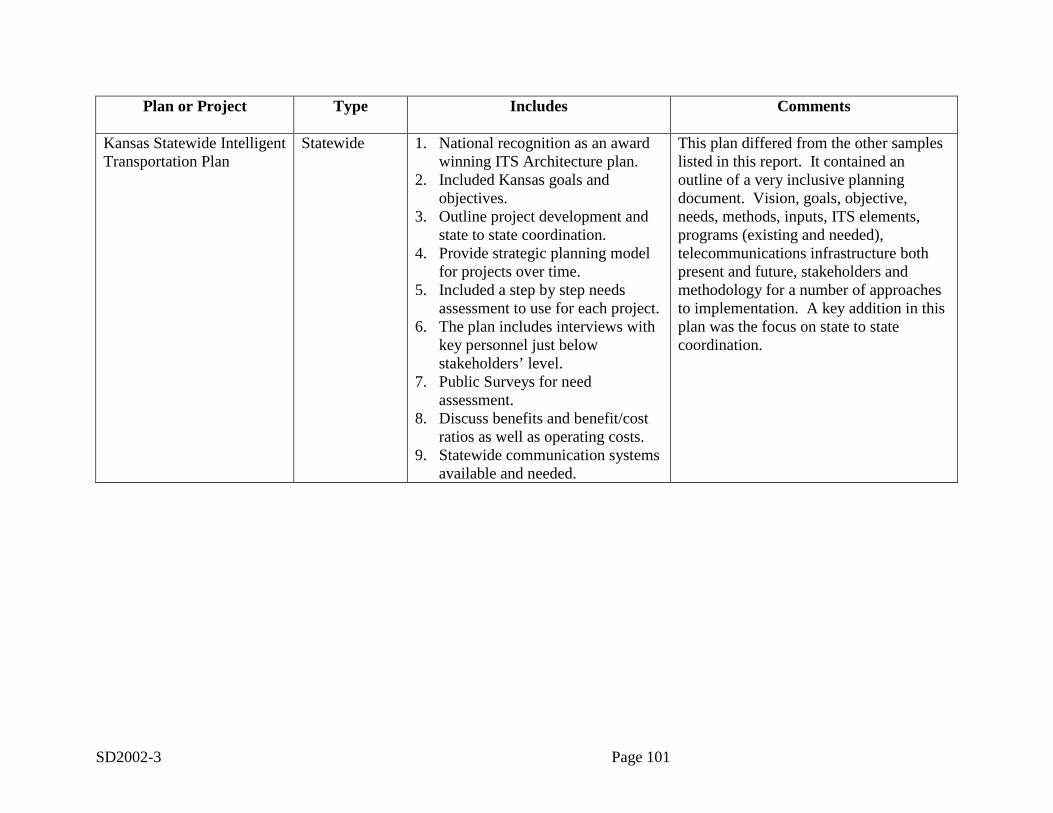
SD2002-3 Page 101
Plan or Project Type Includes Comments
Kansas Statewide IntelligentTransportation Plan
Statewide 1. National recognition as an awardwinning ITS Architecture plan.
2. Included Kansas goals andobjectives.
3. Outline project development andstate to state coordination.
4. Provide strategic planning modelfor projects over time.
5. Included a step by step needsassessment to use for each project.
6. The plan includes interviews withkey personnel just belowstakeholders’ level.
7. Public Surveys for needassessment.
8. Discuss benefits and benefit/costratios as well as operating costs.
9. Statewide communication systemsavailable and needed.
This plan differed from the other sampleslisted in this report. It contained anoutline of a very inclusive planningdocument. Vision, goals, objective,needs, methods, inputs, ITS elements,programs (existing and needed),telecommunications infrastructure bothpresent and future, stakeholders andmethodology for a number of approachesto implementation. A key addition in thisplan was the focus on state to statecoordination.
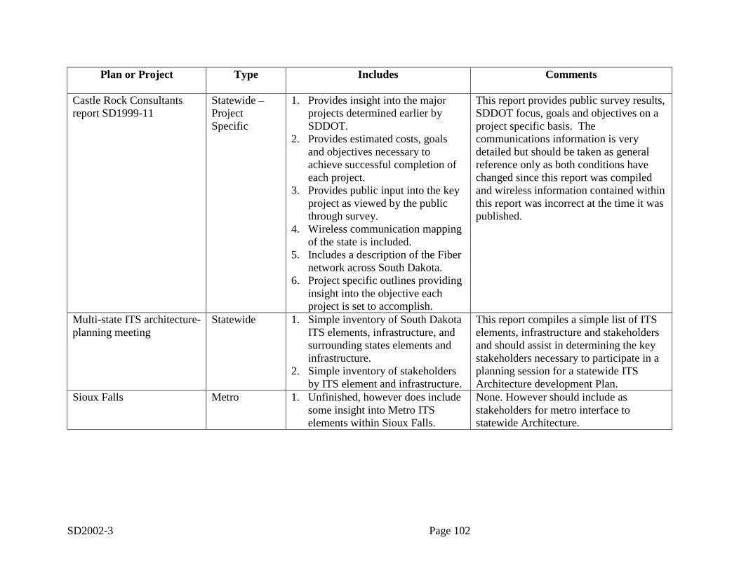
SD2002-3 Page 102
Plan or Project Type Includes Comments
Castle Rock Consultantsreport SD1999-11
Statewide –ProjectSpecific
1. Provides insight into the majorprojects determined earlier bySDDOT.
2. Provides estimated costs, goalsand objectives necessary toachieve successful completion ofeach project.
3. Provides public input into the keyproject as viewed by the publicthrough survey.
4. Wireless communication mappingof the state is included.
5. Includes a description of the Fibernetwork across South Dakota.
6. Project specific outlines providinginsight into the objective eachproject is set to accomplish.
This report provides public survey results,SDDOT focus, goals and objectives on aproject specific basis. Thecommunications information is verydetailed but should be taken as generalreference only as both conditions havechanged since this report was compiledand wireless information contained withinthis report was incorrect at the time it waspublished.
Multi-state ITS architecture-planning meeting
Statewide 1. Simple inventory of South DakotaITS elements, infrastructure, andsurrounding states elements andinfrastructure.
2. Simple inventory of stakeholdersby ITS element and infrastructure.
This report compiles a simple list of ITSelements, infrastructure and stakeholdersand should assist in determining the keystakeholders necessary to participate in aplanning session for a statewide ITSArchitecture development Plan.
Sioux Falls Metro 1. Unfinished, however does includesome insight into Metro ITSelements within Sioux Falls.
None. However should include asstakeholders for metro interface tostatewide Architecture.
SD2002-3 Page 103
The multi-state ITS architecture planning meeting, Kansas Statewide ITS Strategic Plan and theCastle Rock Consultants report SD1999-11 contain the most useful and valuable informationcurrently available with regards to South Dakota. The Kansas Statewide ITS Strategic Planprovides a very complete view of a strategic plan and its process, the multi-state ITS architectureplanning meeting and the Castle Rock Consultants report SD1999-11 provides infrastructureinformation that is direct to the subject of the South Dakota ITS Architecture. These latter twodocuments list projects, stakeholders and elements that must be considered during thedevelopment of the South Dakota Statewide ITS Architecture.

SD2002-3 Page 104
Appendix A: Comments and Disposition
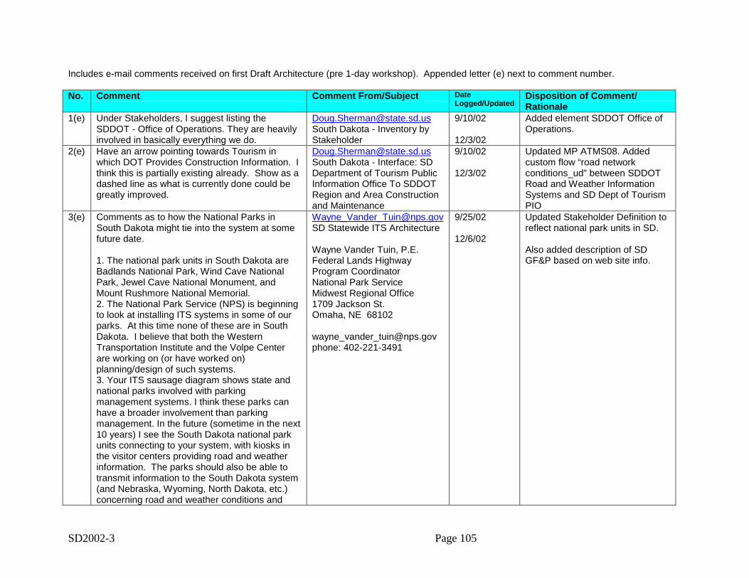
SD2002-3 Page 105
Includes e-mail comments received on first Draft Architecture (pre 1-day workshop). Appended letter (e) next to comment number.
No. Comment Comment From/Subject DateLogged/Updated
Disposition of Comment/Rationale
1(e) Under Stakeholders, I suggest listing theSDDOT - Office of Operations. They are heavilyinvolved in basically everything we do.
[email protected] Dakota - Inventory byStakeholder
9/10/02
12/3/02
Added element SDDOT Office ofOperations.
2(e) Have an arrow pointing towards Tourism inwhich DOT Provides Construction Information. Ithink this is partially existing already. Show as adashed line as what is currently done could begreatly improved.
[email protected] Dakota - Interface: SDDepartment of Tourism PublicInformation Office To SDDOTRegion and Area Constructionand Maintenance
9/10/02
12/3/02
Updated MP ATMS08. Addedcustom flow “road networkconditions_ud” between SDDOTRoad and Weather InformationSystems and SD Dept of TourismPIO
3(e) Comments as to how the National Parks inSouth Dakota might tie into the system at somefuture date.
1. The national park units in South Dakota areBadlands National Park, Wind Cave NationalPark, Jewel Cave National Monument, andMount Rushmore National Memorial.2. The National Park Service (NPS) is beginningto look at installing ITS systems in some of ourparks. At this time none of these are in SouthDakota. I believe that both the WesternTransportation Institute and the Volpe Centerare working on (or have worked on)planning/design of such systems.3. Your ITS sausage diagram shows state andnational parks involved with parkingmanagement systems. I think these parks canhave a broader involvement than parkingmanagement. In the future (sometime in the next10 years) I see the South Dakota national parkunits connecting to your system, with kiosks inthe visitor centers providing road and weatherinformation. The parks should also be able totransmit information to the South Dakota system(and Nebraska, Wyoming, North Dakota, etc.)concerning road and weather conditions and
[email protected] Statewide ITS Architecture
Wayne Vander Tuin, P.E.Federal Lands HighwayProgram CoordinatorNational Park ServiceMidwest Regional Office1709 Jackson St.Omaha, NE 68102
[email protected]: 402-221-3491
9/25/02
12/6/02
Updated Stakeholder Definition toreflect national park units in SD.
Also added description of SDGF&P based on web site info.
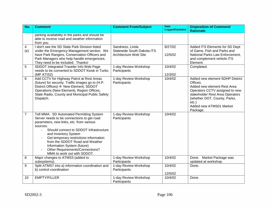
SD2002-3 Page 106
No. Comment Comment From/Subject DateLogged/Updated
Disposition of Comment/Rationale
parking availability in the parks and should beable to receive road and weather informationfrom you.
4(e)
I don't see the SD State Park Division listedunder the Emergency Management section. Wehave Park Rangers, Conservation Officers andPark Managers who help handle emergencies. They need to be included. Thanks!
Sandness, LindaStatewide South Dakota ITSArchitecture Web Site
9/27/02
12/5/02
Added ITS Elements for SD Deptof Game, Fish and Parks andNational Parks Law Enforcement,and complement vehicle ITSElement.
5 SDDOT Integrated Traveler Info Web Pageneeds to be converted to SDDOT Kiosk in Turbo(MP ATIS2)
1-day Review WorkshopParticipants
10/4/02
12/3/02
Completed.
6 Add CCTV for Highway Patrol at Rest Areas(future) for security. Traffic images go to (H.P.District Offices) " New Element, SDDOTOperations (New Element), Region Offices,State Radio, County and Municipal Public SafetyDispatch.
1-day Review WorkshopParticipants
10/4/02 Added new element SDHP DistrictOffices.Added new element Rest AreaOperators CCTV assigned to newstakeholder Rest Area Operators(whether DOT, County, Parks,etc.)Added new ATMS01 MarketPackage.
7 Tell MMA: SD Automated Permitting SystemServer needs to be connections to get roadparameters, new links, etc. from varioussources.
- Should connect to SDDOT Infrastructureand Inventory System
- Get temporary restrictions informationfrom the SDDOT Road and WeatherInformation System (future)
- Other Requirements/Connections?MMA to work out with SDDOT.
1-day Review WorkshopParticipants
10/4/02
8 Major changes to ATMS3 (added tosubsystems).
1-day Review WorkshopParticipants
10/4/02 Done. Market Package wasupdated at workshop.
9 Split ATMS7 into a) information coordination andb) control coordination
1-day Review WorkshopParticipants
10/4/02
12/5/02
Done.
10 EMPTY/FILLER 1-day Review WorkshopParticipants
10/4/02 Done.
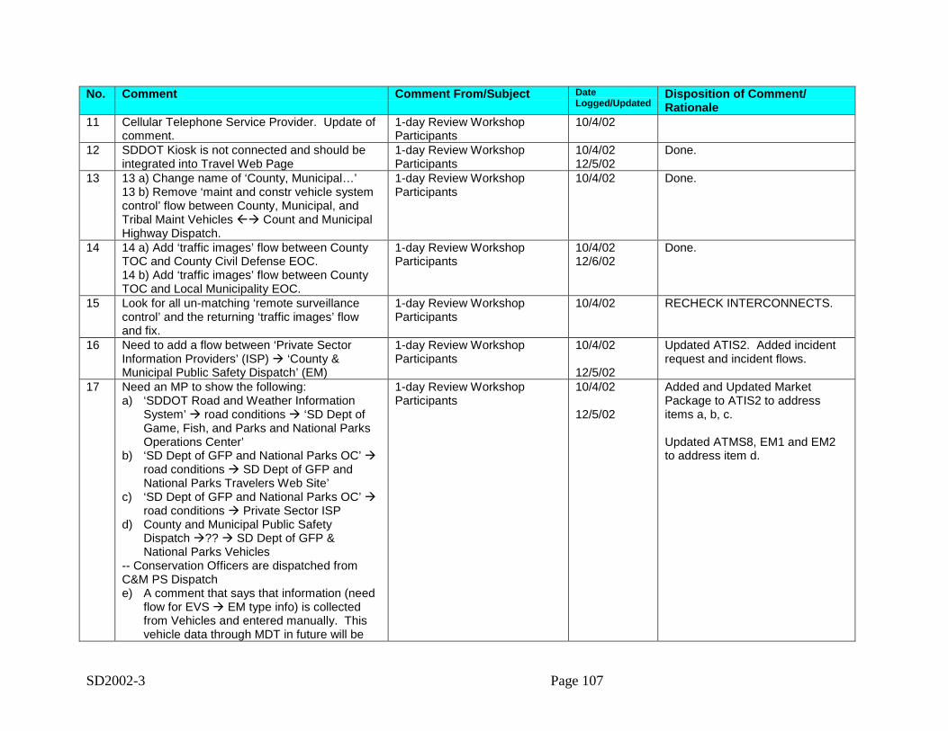
SD2002-3 Page 107
No. Comment Comment From/Subject DateLogged/Updated
Disposition of Comment/Rationale
11 Cellular Telephone Service Provider. Update ofcomment.
1-day Review WorkshopParticipants
10/4/02
12 SDDOT Kiosk is not connected and should beintegrated into Travel Web Page
1-day Review WorkshopParticipants
10/4/0212/5/02
Done.
13 13 a) Change name of ‘County, Municipal…’13 b) Remove ‘maint and constr vehicle systemcontrol’ flow between County, Municipal, andTribal Maint Vehicles "# Count and MunicipalHighway Dispatch.
1-day Review WorkshopParticipants
10/4/02 Done.
14 14 a) Add ‘traffic images’ flow between CountyTOC and County Civil Defense EOC.14 b) Add ‘traffic images’ flow between CountyTOC and Local Municipality EOC.
1-day Review WorkshopParticipants
10/4/0212/6/02
Done.
15 Look for all un-matching ‘remote surveillancecontrol’ and the returning ‘traffic images’ flowand fix.
1-day Review WorkshopParticipants
10/4/02 RECHECK INTERCONNECTS.
16 Need to add a flow between ‘Private SectorInformation Providers’ (ISP) # ‘County &Municipal Public Safety Dispatch’ (EM)
1-day Review WorkshopParticipants
10/4/02
12/5/02
Updated ATIS2. Added incidentrequest and incident flows.
17 Need an MP to show the following:a) ‘SDDOT Road and Weather Information
System’ # road conditions # ‘SD Dept ofGame, Fish, and Parks and National ParksOperations Center’
b) ‘SD Dept of GFP and National Parks OC’ #road conditions # SD Dept of GFP andNational Parks Travelers Web Site’
c) ‘SD Dept of GFP and National Parks OC’ #road conditions # Private Sector ISP
d) County and Municipal Public SafetyDispatch #?? # SD Dept of GFP &National Parks Vehicles
-- Conservation Officers are dispatched fromC&M PS Dispatche) A comment that says that information (need
flow for EVS # EM type info) is collectedfrom Vehicles and entered manually. Thisvehicle data through MDT in future will be
1-day Review WorkshopParticipants
10/4/02
12/5/02
Added and Updated MarketPackage to ATIS2 to addressitems a, b, c.
Updated ATMS8, EM1 and EM2to address item d.
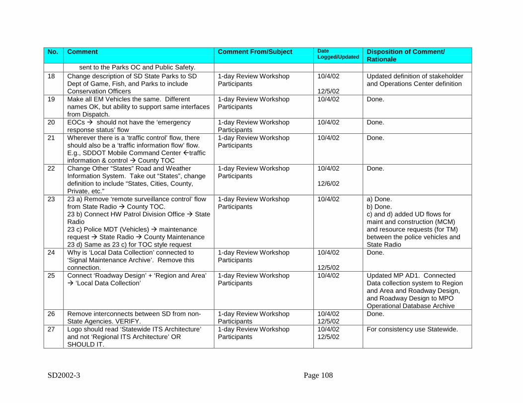
SD2002-3 Page 108
No. Comment Comment From/Subject DateLogged/Updated
Disposition of Comment/Rationale
sent to the Parks OC and Public Safety.18 Change description of SD State Parks to SD
Dept of Game, Fish, and Parks to includeConservation Officers
1-day Review WorkshopParticipants
10/4/02
12/5/02
Updated definition of stakeholderand Operations Center definition
19 Make all EM Vehicles the same. Differentnames OK, but ability to support same interfacesfrom Dispatch.
1-day Review WorkshopParticipants
10/4/02 Done.
20 EOCs # should not have the ‘emergencyresponse status’ flow
1-day Review WorkshopParticipants
10/4/02 Done.
21 Wherever there is a ‘traffic control’ flow, thereshould also be a ‘traffic information flow’ flow.E.g., SDDOT Mobile Command Center "trafficinformation & control # County TOC
1-day Review WorkshopParticipants
10/4/02 Done.
22 Change Other “States” Road and WeatherInformation System. Take out “States”, changedefinition to include “States, Cities, County,Private, etc.”
1-day Review WorkshopParticipants
10/4/02
12/6/02
Done.
23 23 a) Remove ‘remote surveillance control’ flowfrom State Radio # County TOC.23 b) Connect HW Patrol Division Office # StateRadio23 c) Police MDT (Vehicles) # maintenancerequest # State Radio # County Maintenance23 d) Same as 23 c) for TOC style request
1-day Review WorkshopParticipants
10/4/02 a) Done.b) Done.c) and d) added UD flows formaint and construction (MCM)and resource requests (for TM)between the police vehicles andState Radio
24 Why is ‘Local Data Collection’ connected to‘Signal Maintenance Archive’. Remove thisconnection.
1-day Review WorkshopParticipants
10/4/02
12/5/02
Done.
25 Connect ‘Roadway Design’ + ‘Region and Area’# ‘Local Data Collection’
1-day Review WorkshopParticipants
10/4/02 Updated MP AD1. ConnectedData collection system to Regionand Area and Roadway Design,and Roadway Design to MPOOperational Database Archive
26 Remove interconnects between SD from non-State Agencies. VERIFY.
1-day Review WorkshopParticipants
10/4/0212/5/02
Done.
27 Logo should read ‘Statewide ITS Architecture’and not ‘Regional ITS Architecture’ ORSHOULD IT.
1-day Review WorkshopParticipants
10/4/0212/5/02
For consistency use Statewide.
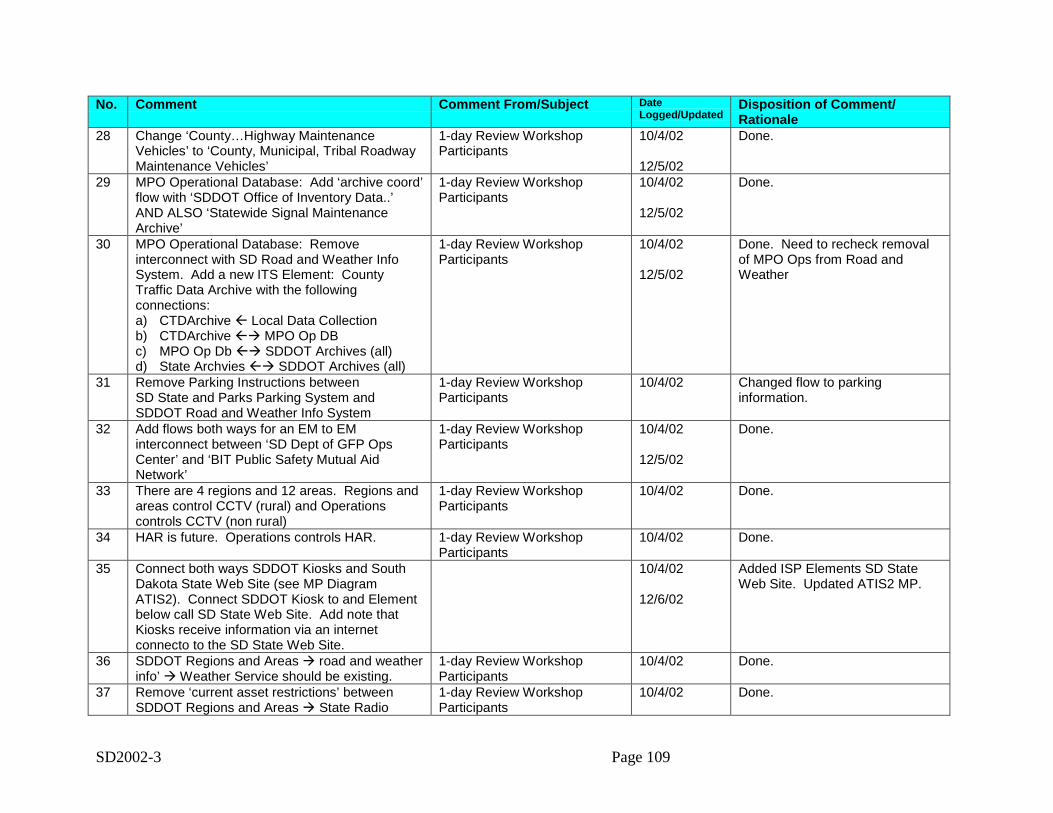
SD2002-3 Page 109
No. Comment Comment From/Subject DateLogged/Updated
Disposition of Comment/Rationale
28 Change ‘County…Highway MaintenanceVehicles’ to ‘County, Municipal, Tribal RoadwayMaintenance Vehicles’
1-day Review WorkshopParticipants
10/4/02
12/5/02
Done.
29 MPO Operational Database: Add ‘archive coord’flow with ‘SDDOT Office of Inventory Data..’AND ALSO ‘Statewide Signal MaintenanceArchive’
1-day Review WorkshopParticipants
10/4/02
12/5/02
Done.
30 MPO Operational Database: Removeinterconnect with SD Road and Weather InfoSystem. Add a new ITS Element: CountyTraffic Data Archive with the followingconnections:a) CTDArchive " Local Data Collectionb) CTDArchive "# MPO Op DBc) MPO Op Db "# SDDOT Archives (all)d) State Archvies "# SDDOT Archives (all)
1-day Review WorkshopParticipants
10/4/02
12/5/02
Done. Need to recheck removalof MPO Ops from Road andWeather
31 Remove Parking Instructions betweenSD State and Parks Parking System andSDDOT Road and Weather Info System
1-day Review WorkshopParticipants
10/4/02 Changed flow to parkinginformation.
32 Add flows both ways for an EM to EMinterconnect between ‘SD Dept of GFP OpsCenter’ and ‘BIT Public Safety Mutual AidNetwork’
1-day Review WorkshopParticipants
10/4/02
12/5/02
Done.
33 There are 4 regions and 12 areas. Regions andareas control CCTV (rural) and Operationscontrols CCTV (non rural)
1-day Review WorkshopParticipants
10/4/02 Done.
34 HAR is future. Operations controls HAR. 1-day Review WorkshopParticipants
10/4/02 Done.
35 Connect both ways SDDOT Kiosks and SouthDakota State Web Site (see MP DiagramATIS2). Connect SDDOT Kiosk to and Elementbelow call SD State Web Site. Add note thatKiosks receive information via an internetconnecto to the SD State Web Site.
10/4/02
12/6/02
Added ISP Elements SD StateWeb Site. Updated ATIS2 MP.
36 SDDOT Regions and Areas # road and weatherinfo’ # Weather Service should be existing.
1-day Review WorkshopParticipants
10/4/02 Done.
37 Remove ‘current asset restrictions’ betweenSDDOT Regions and Areas # State Radio
1-day Review WorkshopParticipants
10/4/02 Done.
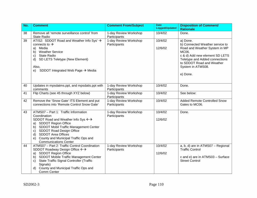
SD2002-3 Page 110
No. Comment Comment From/Subject DateLogged/Updated
Disposition of Comment/Rationale
38 Remove all ‘remote surveillance control’ fromState Radio
1-day Review WorkshopParticipants
10/4/02 Done.
39 ATIS2: SDDOT Road and Weather Info Sys’ #connects to #a) Mediab) Weather Servicec) State Radiod) SD LETS Teletype (New Element)
Also,e) SDDOT Integrated Web Page # Media
1-day Review WorkshopParticipants
10/4/02
12/6/02
a) Done.b) Connected Weather service toRoad and Weather System in MPMC06.c & d) Add new element SD LETSTeletype and Added connectionsto SDDOT Road and WeatherSystem in ATMS08.
e) Done.
40 Updates in mpsdatms.ppt, and mpsdatis.ppt withcomments
1-day Review WorkshopParticipants
10/4/02 Done.
41 Flip Charts (see 45 through XYZ below) 1-day Review WorkshopParticipants
10/4/02 See below:
42 Remove the ‘Snow Gate’ ITS Element and putconnections into ‘Remote Control Snow Gate’
1-day Review WorkshopParticipants
10/4/02 Added Remote Controlled SnowGates to MC06.
43 ATMS07 – Part 1: Traffic InformationCoordinationSDDOT Road and Weather Info Sys "#a) SDDOT Region Officeb) SDDOT Mobil Traffic Management Centerc) SDDOT Road Design Officed) SDDOT Area Officese) County and Municipal Traffic Ops and
Communications Center
1-day Review WorkshopParticipants
10/4/02
12/6/02
Done.
44 ATMS07 – Part 2: Traffic Control CoordinationSDDOT Roadway Design Office "#a) SDDOT Region Officeb) SDDOT Mobile Traffic Management Centerc) State Traffic Signal Controller (Traffic
Signals)d) County and Municipal Traffic Ops and
Comm Center
1-day Review WorkshopParticipants
10/4/02
12/6/02
a, b, d) are in ATMS07 – RegionalTraffic Control
c and e) are in ATMS03 – SurfaceStreet Control
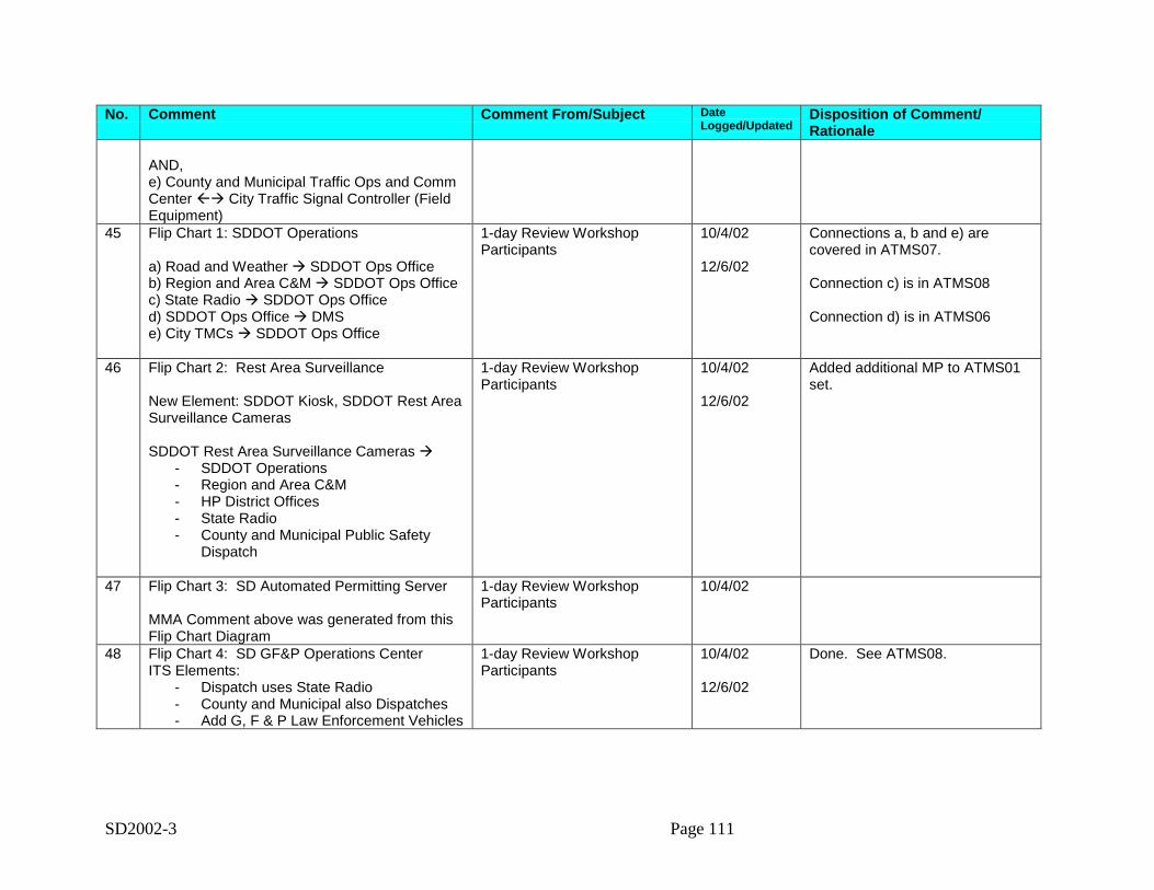
SD2002-3 Page 111
No. Comment Comment From/Subject DateLogged/Updated
Disposition of Comment/Rationale
AND,e) County and Municipal Traffic Ops and CommCenter "# City Traffic Signal Controller (FieldEquipment)
45 Flip Chart 1: SDDOT Operations
a) Road and Weather # SDDOT Ops Officeb) Region and Area C&M # SDDOT Ops Officec) State Radio # SDDOT Ops Officed) SDDOT Ops Office # DMSe) City TMCs # SDDOT Ops Office
1-day Review WorkshopParticipants
10/4/02
12/6/02
Connections a, b and e) arecovered in ATMS07.
Connection c) is in ATMS08
Connection d) is in ATMS06
46 Flip Chart 2: Rest Area Surveillance
New Element: SDDOT Kiosk, SDDOT Rest AreaSurveillance Cameras
SDDOT Rest Area Surveillance Cameras #- SDDOT Operations- Region and Area C&M- HP District Offices- State Radio- County and Municipal Public Safety
Dispatch
1-day Review WorkshopParticipants
10/4/02
12/6/02
Added additional MP to ATMS01set.
47 Flip Chart 3: SD Automated Permitting Server
MMA Comment above was generated from thisFlip Chart Diagram
1-day Review WorkshopParticipants
10/4/02
48 Flip Chart 4: SD GF&P Operations CenterITS Elements:
- Dispatch uses State Radio- County and Municipal also Dispatches- Add G, F & P Law Enforcement Vehicles
1-day Review WorkshopParticipants
10/4/02
12/6/02
Done. See ATMS08.

SD2002-3 Page 113
Appendix B: Customized Market Packages
SD2002-3 Page 114
SD Statewide
AD
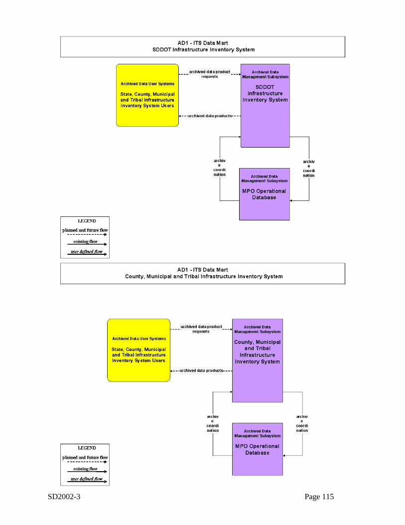
SD2002-3 Page 115
AD1-1
AD1-2
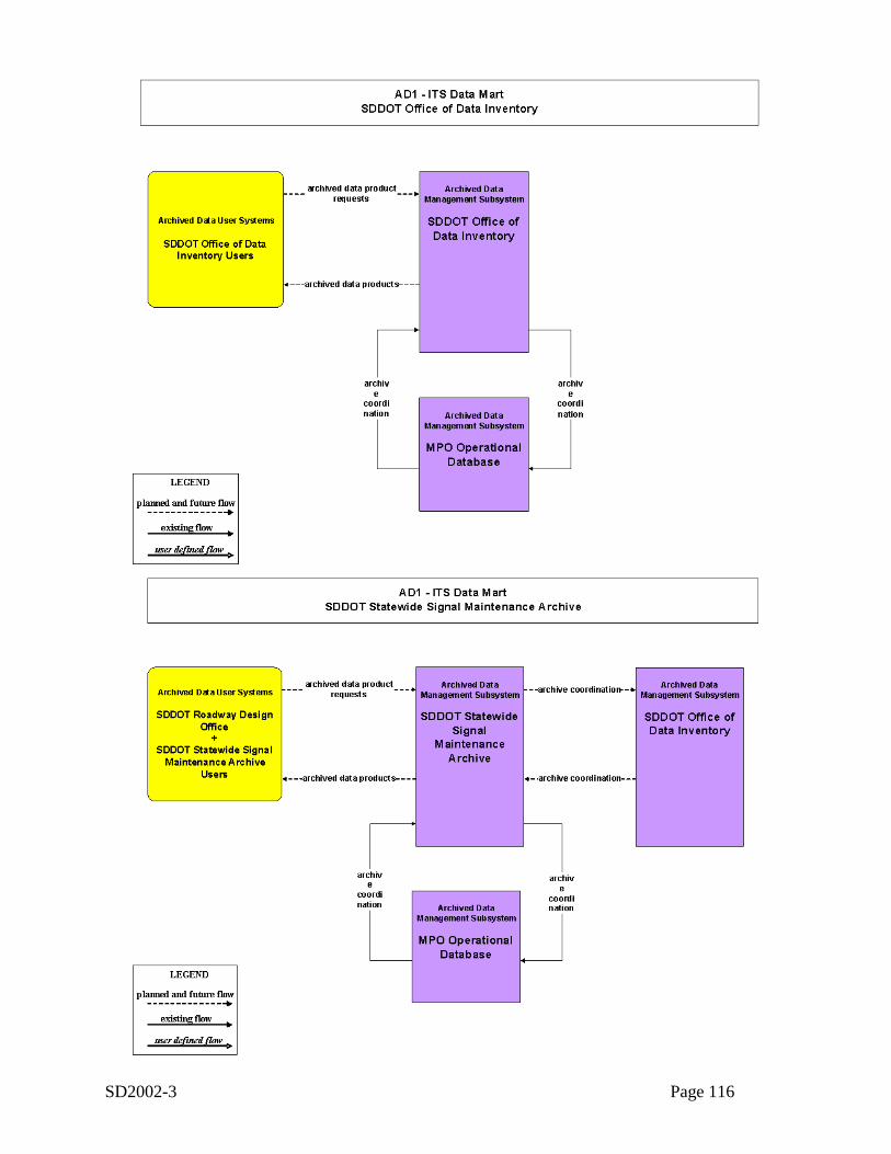
SD2002-3 Page 116
AD1-4
AD1-5
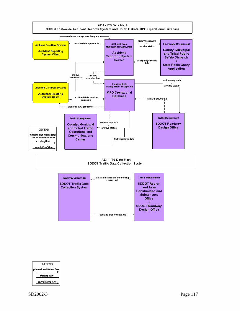
SD2002-3 Page 117
AD1-6
AD1-7
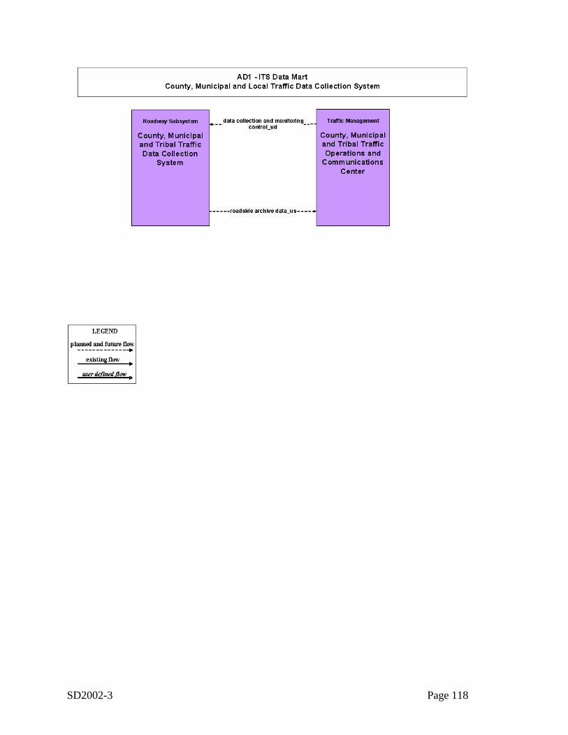
SD2002-3 Page 118
AD1-8
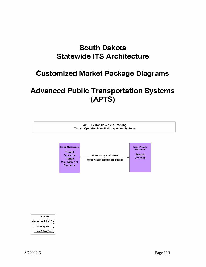
SD2002-3 Page 119
APTS1-1
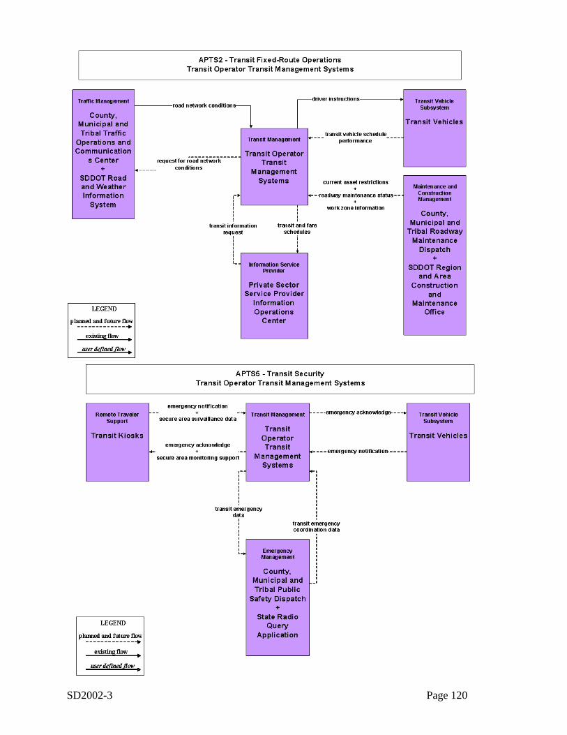
SD2002-3 Page 120
APTS2-1
APTS5-1
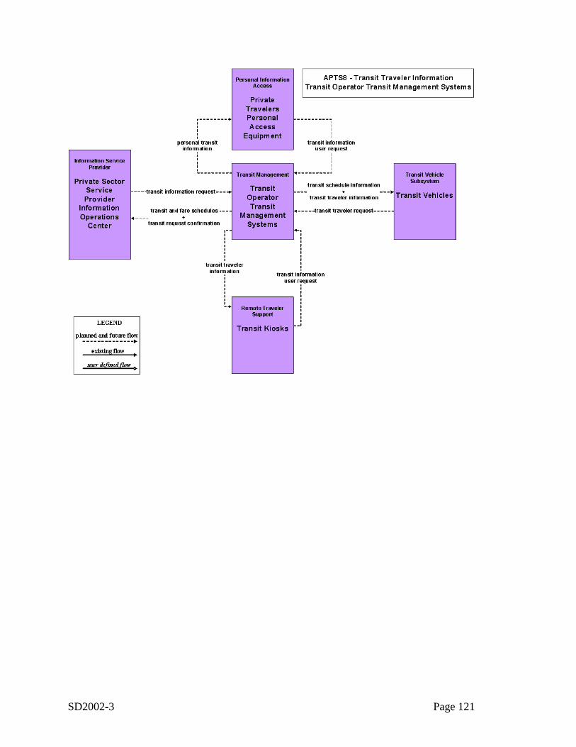
SD2002-3 Page 121
APTS8-1
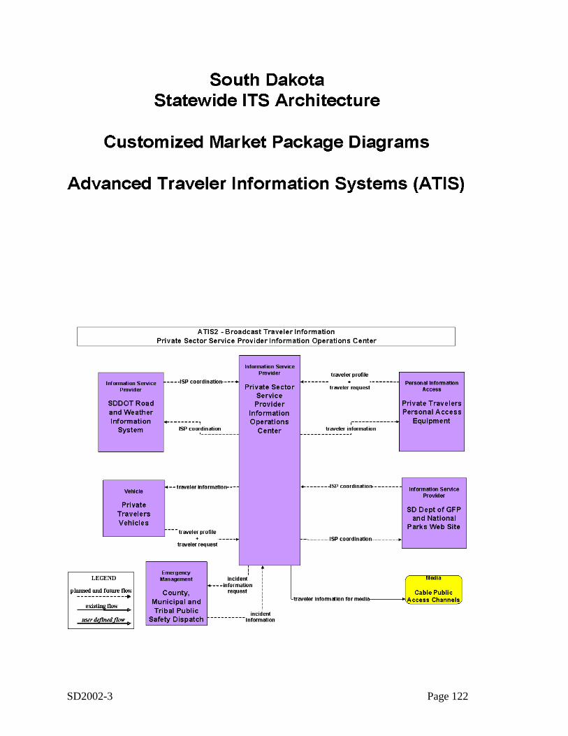
SD2002-3 Page 122
ATIS
ATIS2-1
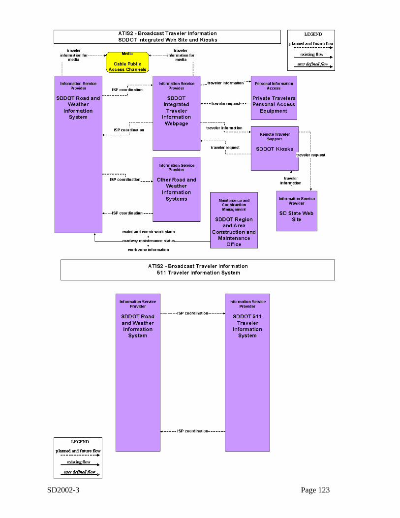
SD2002-3 Page 123
ATIS2-2
ATIS2-3
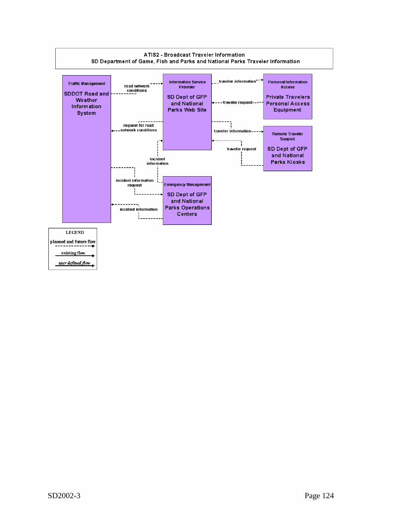
SD2002-3 Page 124
ATIS2-4
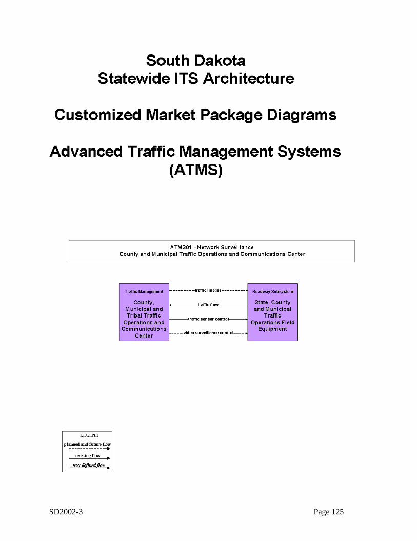
SD2002-3 Page 125
ATMS
ATMS01-1
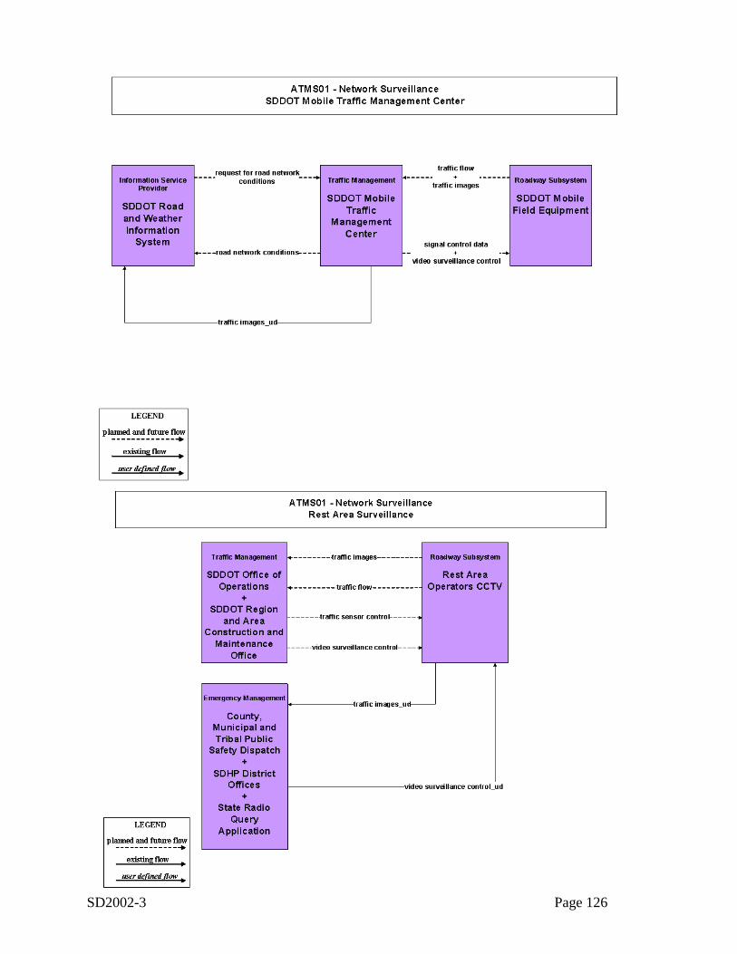
SD2002-3 Page 126
ATMS01-2
ATMS01-3
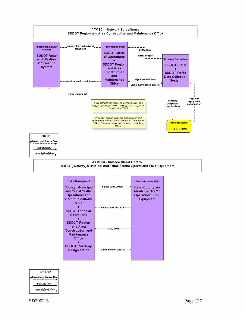
SD2002-3 Page 127
ATMS01-4
ATMS03-1
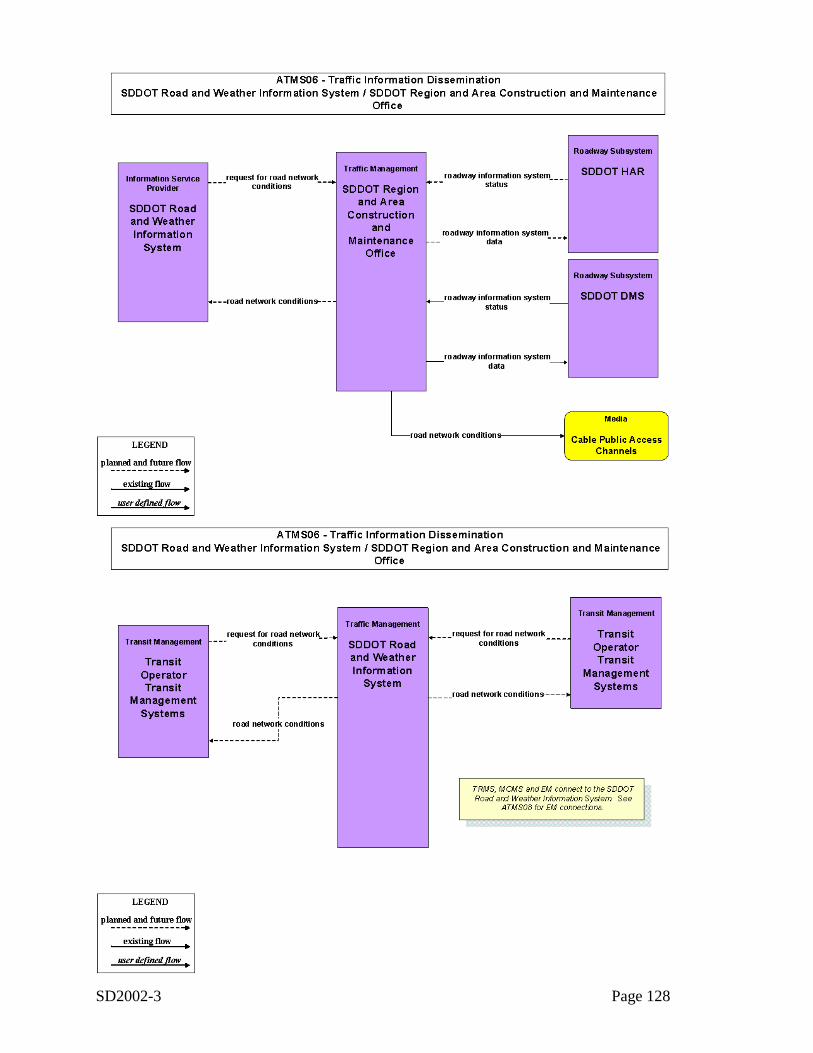
SD2002-3 Page 128
ATMS06-1
ATMS06-2
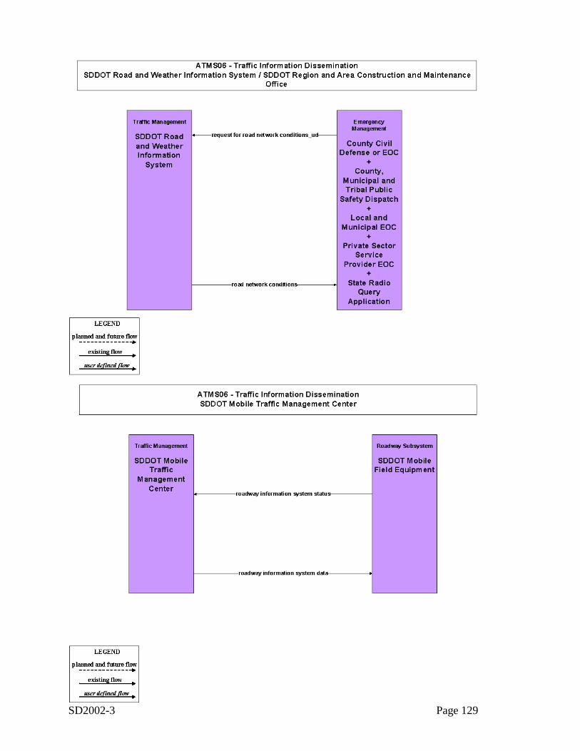
SD2002-3 Page 129
ATMS06-3
ATMS06-4
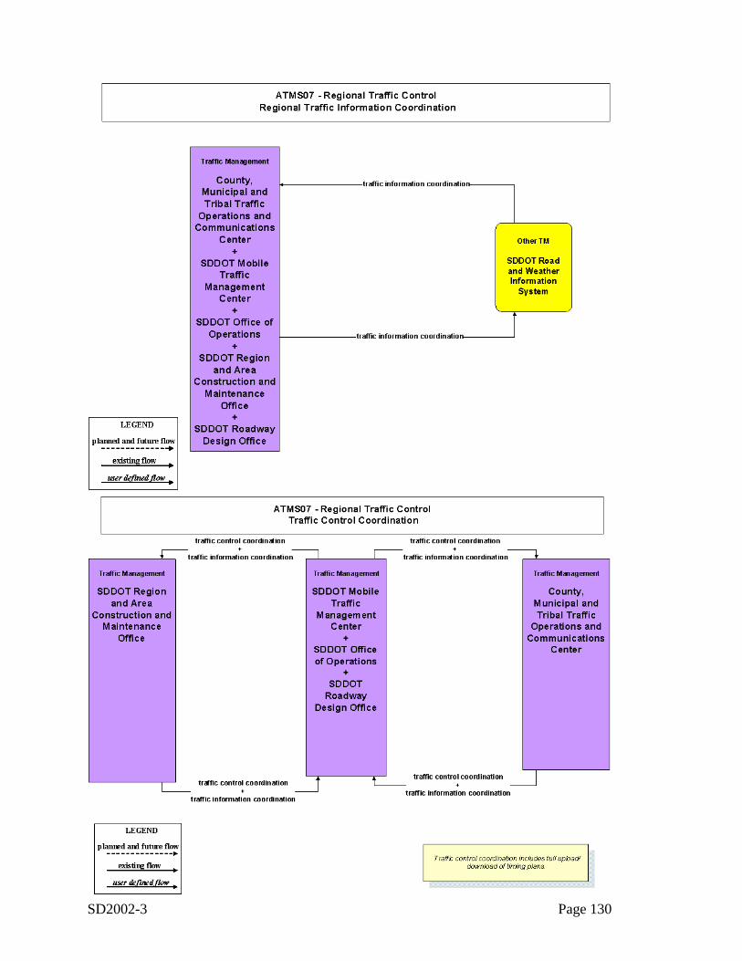
SD2002-3 Page 130
ATMS07-1
ATMS07-2
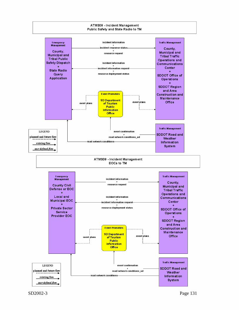
SD2002-3 Page 131
ATMS08-1
ATMS08-2
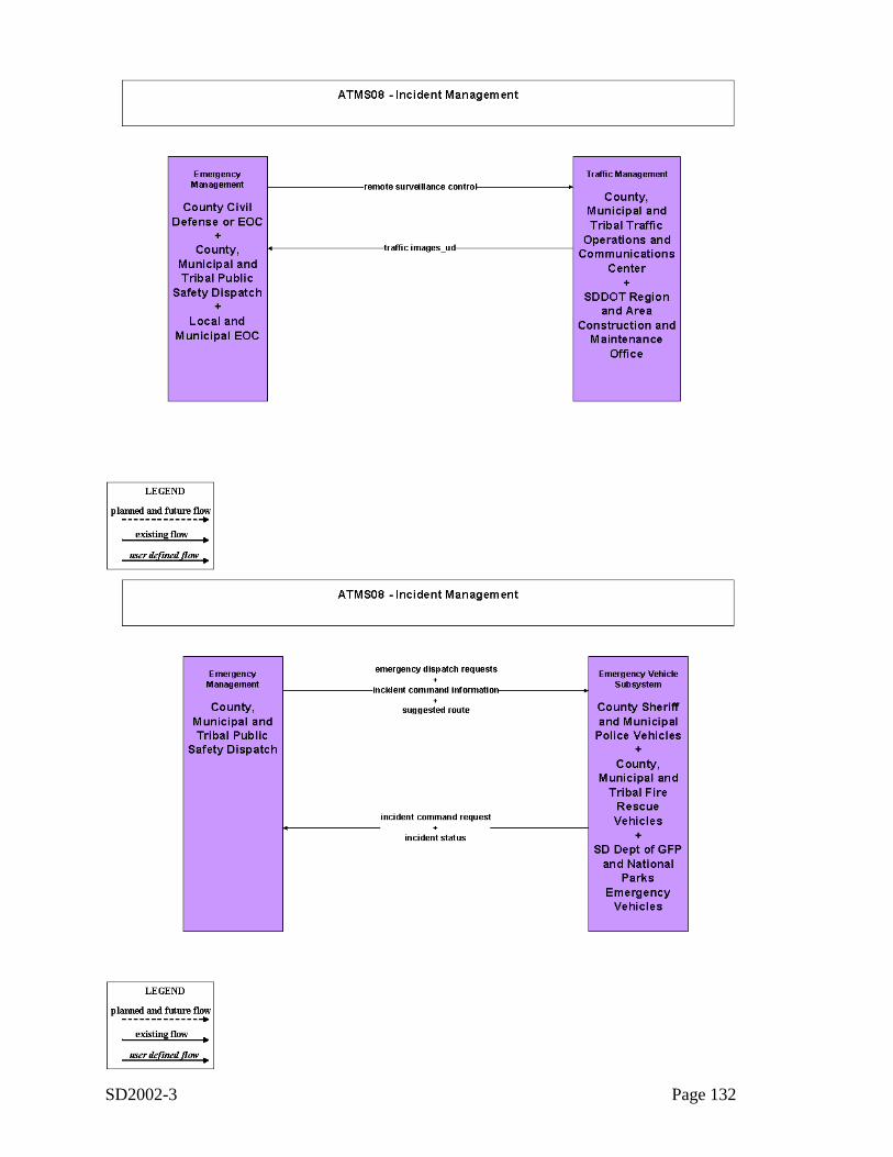
SD2002-3 Page 132
ATMS08-3
ATMS08-4

SD2002-3 Page 133
Appendix C: Architecture Interfaces
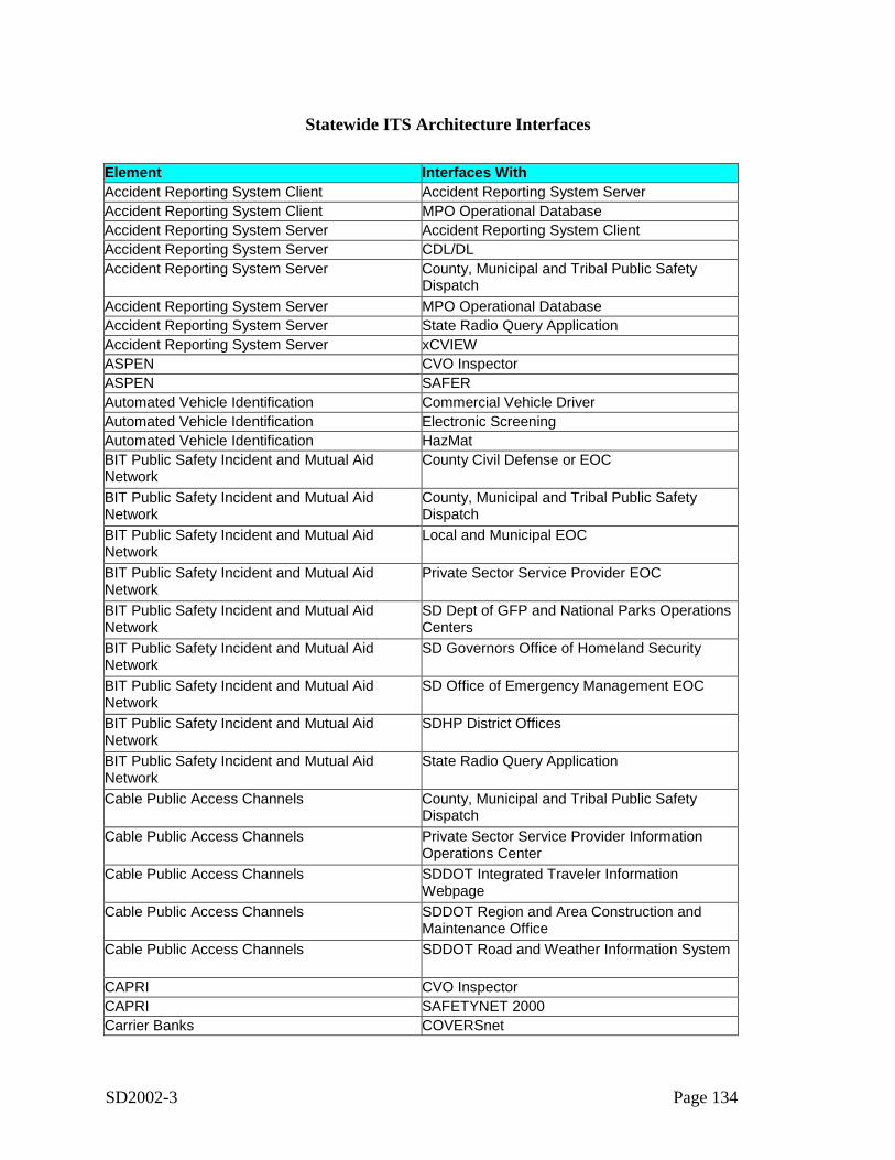
SD2002-3 Page 134
Statewide ITS Architecture Interfaces
Element Interfaces WithAccident Reporting System Client Accident Reporting System ServerAccident Reporting System Client MPO Operational DatabaseAccident Reporting System Server Accident Reporting System ClientAccident Reporting System Server CDL/DLAccident Reporting System Server County, Municipal and Tribal Public Safety
DispatchAccident Reporting System Server MPO Operational DatabaseAccident Reporting System Server State Radio Query ApplicationAccident Reporting System Server xCVIEWASPEN CVO InspectorASPEN SAFERAutomated Vehicle Identification Commercial Vehicle DriverAutomated Vehicle Identification Electronic ScreeningAutomated Vehicle Identification HazMatBIT Public Safety Incident and Mutual AidNetwork
County Civil Defense or EOC
BIT Public Safety Incident and Mutual AidNetwork
County, Municipal and Tribal Public SafetyDispatch
BIT Public Safety Incident and Mutual AidNetwork
Local and Municipal EOC
BIT Public Safety Incident and Mutual AidNetwork
Private Sector Service Provider EOC
BIT Public Safety Incident and Mutual AidNetwork
SD Dept of GFP and National Parks OperationsCenters
BIT Public Safety Incident and Mutual AidNetwork
SD Governors Office of Homeland Security
BIT Public Safety Incident and Mutual AidNetwork
SD Office of Emergency Management EOC
BIT Public Safety Incident and Mutual AidNetwork
SDHP District Offices
BIT Public Safety Incident and Mutual AidNetwork
State Radio Query Application
Cable Public Access Channels County, Municipal and Tribal Public SafetyDispatch
Cable Public Access Channels Private Sector Service Provider InformationOperations Center
Cable Public Access Channels SDDOT Integrated Traveler InformationWebpage
Cable Public Access Channels SDDOT Region and Area Construction andMaintenance Office
Cable Public Access Channels SDDOT Road and Weather Information System
CAPRI CVO InspectorCAPRI SAFETYNET 2000Carrier Banks COVERSnet
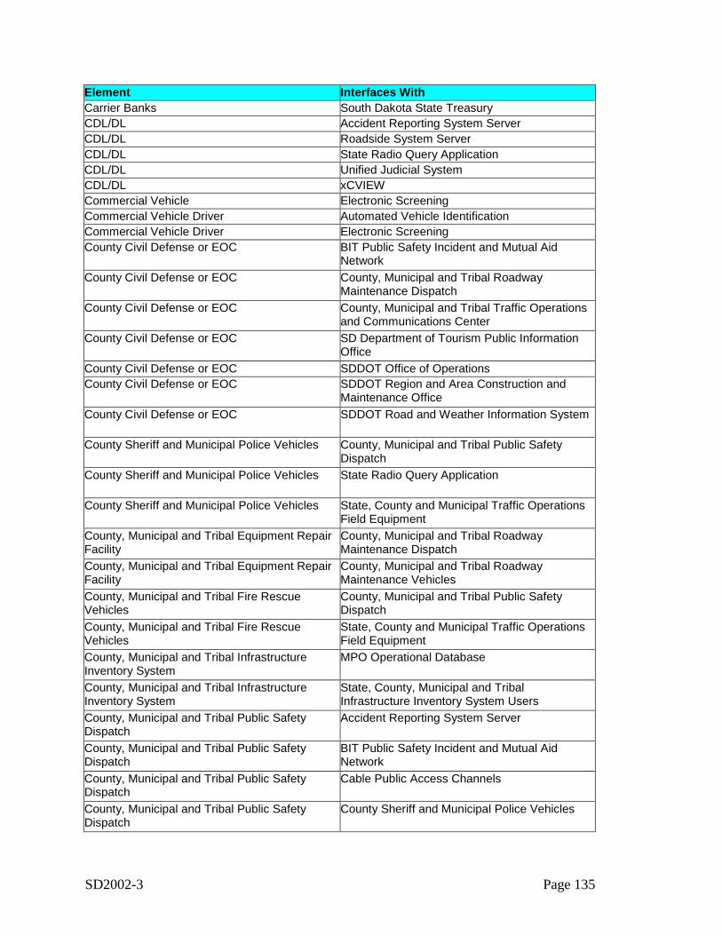
SD2002-3 Page 135
Element Interfaces WithCarrier Banks South Dakota State TreasuryCDL/DL Accident Reporting System ServerCDL/DL Roadside System ServerCDL/DL State Radio Query ApplicationCDL/DL Unified Judicial SystemCDL/DL xCVIEWCommercial Vehicle Electronic ScreeningCommercial Vehicle Driver Automated Vehicle IdentificationCommercial Vehicle Driver Electronic ScreeningCounty Civil Defense or EOC BIT Public Safety Incident and Mutual Aid
NetworkCounty Civil Defense or EOC County, Municipal and Tribal Roadway
Maintenance DispatchCounty Civil Defense or EOC County, Municipal and Tribal Traffic Operations
and Communications CenterCounty Civil Defense or EOC SD Department of Tourism Public Information
OfficeCounty Civil Defense or EOC SDDOT Office of OperationsCounty Civil Defense or EOC SDDOT Region and Area Construction and
Maintenance OfficeCounty Civil Defense or EOC SDDOT Road and Weather Information System
County Sheriff and Municipal Police Vehicles County, Municipal and Tribal Public SafetyDispatch
County Sheriff and Municipal Police Vehicles State Radio Query Application
County Sheriff and Municipal Police Vehicles State, County and Municipal Traffic OperationsField Equipment
County, Municipal and Tribal Equipment RepairFacility
County, Municipal and Tribal RoadwayMaintenance Dispatch
County, Municipal and Tribal Equipment RepairFacility
County, Municipal and Tribal RoadwayMaintenance Vehicles
County, Municipal and Tribal Fire RescueVehicles
County, Municipal and Tribal Public SafetyDispatch
County, Municipal and Tribal Fire RescueVehicles
State, County and Municipal Traffic OperationsField Equipment
County, Municipal and Tribal InfrastructureInventory System
MPO Operational Database
County, Municipal and Tribal InfrastructureInventory System
State, County, Municipal and TribalInfrastructure Inventory System Users
County, Municipal and Tribal Public SafetyDispatch
Accident Reporting System Server
County, Municipal and Tribal Public SafetyDispatch
BIT Public Safety Incident and Mutual AidNetwork
County, Municipal and Tribal Public SafetyDispatch
Cable Public Access Channels
County, Municipal and Tribal Public SafetyDispatch
County Sheriff and Municipal Police Vehicles
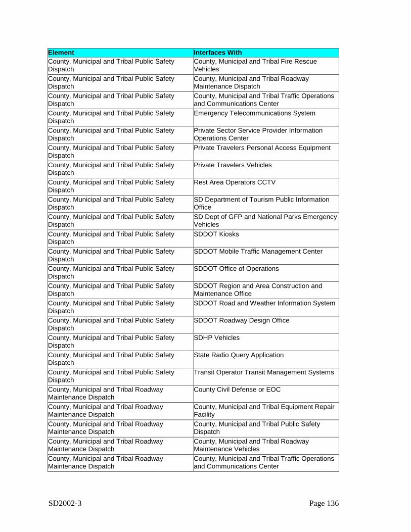
SD2002-3 Page 136
Element Interfaces WithCounty, Municipal and Tribal Public SafetyDispatch
County, Municipal and Tribal Fire RescueVehicles
County, Municipal and Tribal Public SafetyDispatch
County, Municipal and Tribal RoadwayMaintenance Dispatch
County, Municipal and Tribal Public SafetyDispatch
County, Municipal and Tribal Traffic Operationsand Communications Center
County, Municipal and Tribal Public SafetyDispatch
Emergency Telecommunications System
County, Municipal and Tribal Public SafetyDispatch
Private Sector Service Provider InformationOperations Center
County, Municipal and Tribal Public SafetyDispatch
Private Travelers Personal Access Equipment
County, Municipal and Tribal Public SafetyDispatch
Private Travelers Vehicles
County, Municipal and Tribal Public SafetyDispatch
Rest Area Operators CCTV
County, Municipal and Tribal Public SafetyDispatch
SD Department of Tourism Public InformationOffice
County, Municipal and Tribal Public SafetyDispatch
SD Dept of GFP and National Parks EmergencyVehicles
County, Municipal and Tribal Public SafetyDispatch
SDDOT Kiosks
County, Municipal and Tribal Public SafetyDispatch
SDDOT Mobile Traffic Management Center
County, Municipal and Tribal Public SafetyDispatch
SDDOT Office of Operations
County, Municipal and Tribal Public SafetyDispatch
SDDOT Region and Area Construction andMaintenance Office
County, Municipal and Tribal Public SafetyDispatch
SDDOT Road and Weather Information System
County, Municipal and Tribal Public SafetyDispatch
SDDOT Roadway Design Office
County, Municipal and Tribal Public SafetyDispatch
SDHP Vehicles
County, Municipal and Tribal Public SafetyDispatch
State Radio Query Application
County, Municipal and Tribal Public SafetyDispatch
Transit Operator Transit Management Systems
County, Municipal and Tribal RoadwayMaintenance Dispatch
County Civil Defense or EOC
County, Municipal and Tribal RoadwayMaintenance Dispatch
County, Municipal and Tribal Equipment RepairFacility
County, Municipal and Tribal RoadwayMaintenance Dispatch
County, Municipal and Tribal Public SafetyDispatch
County, Municipal and Tribal RoadwayMaintenance Dispatch
County, Municipal and Tribal RoadwayMaintenance Vehicles
County, Municipal and Tribal RoadwayMaintenance Dispatch
County, Municipal and Tribal Traffic Operationsand Communications Center

SD2002-3 Page 137
Element Interfaces WithCounty, Municipal and Tribal RoadwayMaintenance Dispatch
Local and Municipal EOC
County, Municipal and Tribal RoadwayMaintenance Dispatch
National Weather Service
County, Municipal and Tribal RoadwayMaintenance Dispatch
Private Sector Service Provider EOC
County, Municipal and Tribal RoadwayMaintenance Dispatch
SDDOT Region and Area Construction andMaintenance Office
County, Municipal and Tribal RoadwayMaintenance Dispatch
SDDOT Road and Weather Information System
County, Municipal and Tribal RoadwayMaintenance Dispatch
SDDOT Roadway Design Office
County, Municipal and Tribal RoadwayMaintenance Dispatch
SDHP District Offices
County, Municipal and Tribal RoadwayMaintenance Dispatch
State Radio Query Application
County, Municipal and Tribal RoadwayMaintenance Dispatch
Transit Operator Transit Management Systems
County, Municipal and Tribal RoadwayMaintenance Vehicles
County, Municipal and Tribal Equipment RepairFacility
County, Municipal and Tribal RoadwayMaintenance Vehicles
County, Municipal and Tribal RoadwayMaintenance Dispatch
County, Municipal and Tribal RoadwayMaintenance Vehicles
State, County and Municipal Traffic OperationsField Equipment
County, Municipal and Tribal Traffic DataCollection System
County, Municipal and Tribal Traffic Operationsand Communications Center
County, Municipal and Tribal Traffic Operationsand Communications Center
County Civil Defense or EOC
County, Municipal and Tribal Traffic Operationsand Communications Center
County, Municipal and Tribal Public SafetyDispatch
County, Municipal and Tribal Traffic Operationsand Communications Center
County, Municipal and Tribal RoadwayMaintenance Dispatch
County, Municipal and Tribal Traffic Operationsand Communications Center
County, Municipal and Tribal Traffic DataCollection System
County, Municipal and Tribal Traffic Operationsand Communications Center
Local and Municipal EOC
County, Municipal and Tribal Traffic Operationsand Communications Center
MPO Operational Database
County, Municipal and Tribal Traffic Operationsand Communications Center
Private Sector Service Provider EOC
County, Municipal and Tribal Traffic Operationsand Communications Center
Rail Operators
County, Municipal and Tribal Traffic Operationsand Communications Center
SD Department of Tourism Public InformationOffice
County, Municipal and Tribal Traffic Operationsand Communications Center
SDDOT Mobile Traffic Management Center
County, Municipal and Tribal Traffic Operationsand Communications Center
SDDOT Office of Operations
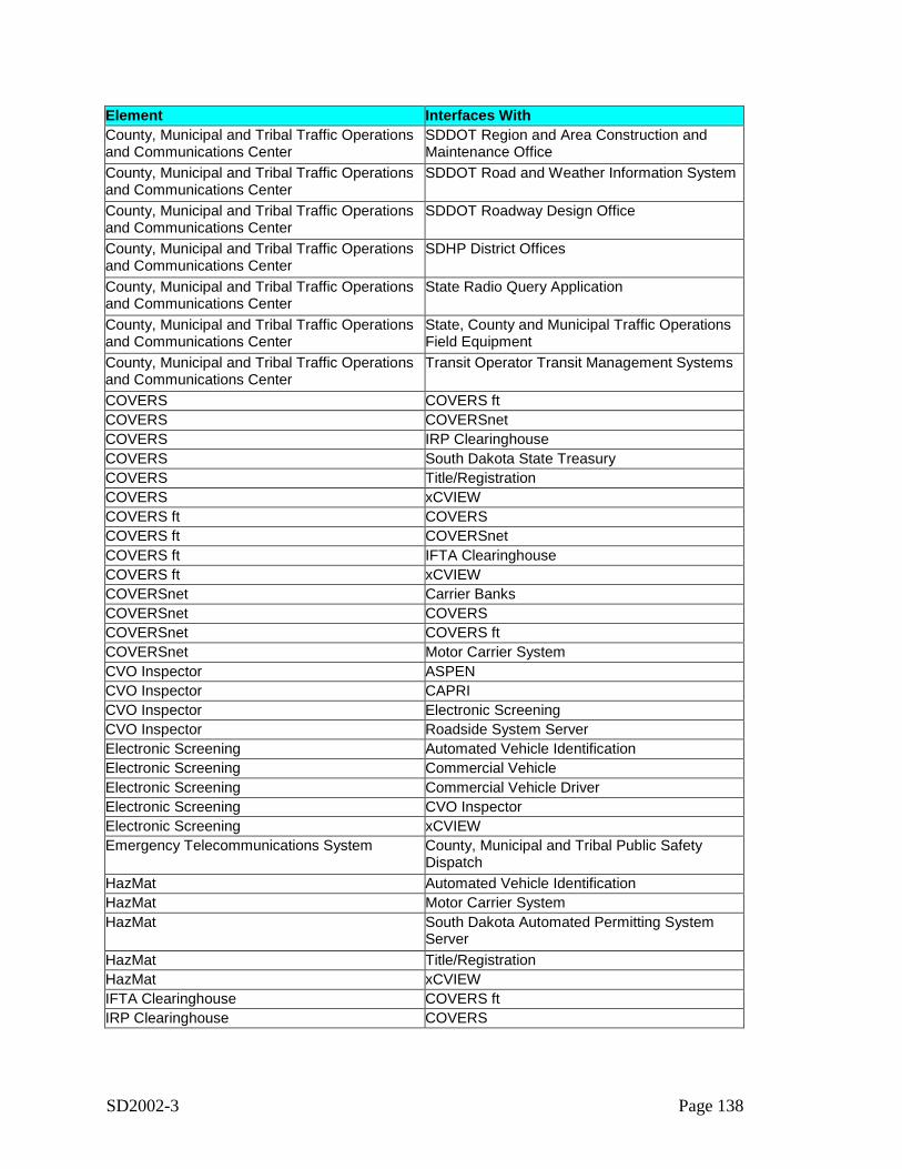
SD2002-3 Page 138
Element Interfaces WithCounty, Municipal and Tribal Traffic Operationsand Communications Center
SDDOT Region and Area Construction andMaintenance Office
County, Municipal and Tribal Traffic Operationsand Communications Center
SDDOT Road and Weather Information System
County, Municipal and Tribal Traffic Operationsand Communications Center
SDDOT Roadway Design Office
County, Municipal and Tribal Traffic Operationsand Communications Center
SDHP District Offices
County, Municipal and Tribal Traffic Operationsand Communications Center
State Radio Query Application
County, Municipal and Tribal Traffic Operationsand Communications Center
State, County and Municipal Traffic OperationsField Equipment
County, Municipal and Tribal Traffic Operationsand Communications Center
Transit Operator Transit Management Systems
COVERS COVERS ftCOVERS COVERSnetCOVERS IRP ClearinghouseCOVERS South Dakota State TreasuryCOVERS Title/RegistrationCOVERS xCVIEWCOVERS ft COVERSCOVERS ft COVERSnetCOVERS ft IFTA ClearinghouseCOVERS ft xCVIEWCOVERSnet Carrier BanksCOVERSnet COVERSCOVERSnet COVERS ftCOVERSnet Motor Carrier SystemCVO Inspector ASPENCVO Inspector CAPRICVO Inspector Electronic ScreeningCVO Inspector Roadside System ServerElectronic Screening Automated Vehicle IdentificationElectronic Screening Commercial VehicleElectronic Screening Commercial Vehicle DriverElectronic Screening CVO InspectorElectronic Screening xCVIEWEmergency Telecommunications System County, Municipal and Tribal Public Safety
DispatchHazMat Automated Vehicle IdentificationHazMat Motor Carrier SystemHazMat South Dakota Automated Permitting System
ServerHazMat Title/RegistrationHazMat xCVIEWIFTA Clearinghouse COVERS ftIRP Clearinghouse COVERS
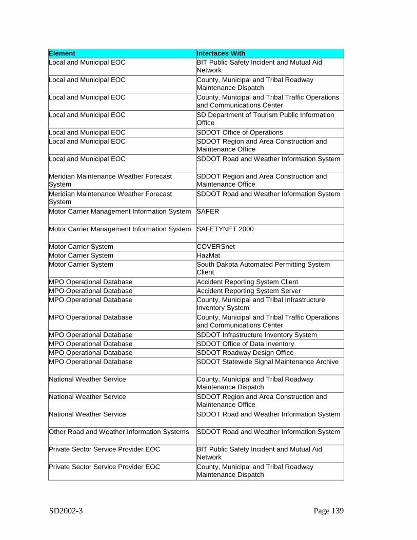
SD2002-3 Page 139
Element Interfaces WithLocal and Municipal EOC BIT Public Safety Incident and Mutual Aid
NetworkLocal and Municipal EOC County, Municipal and Tribal Roadway
Maintenance DispatchLocal and Municipal EOC County, Municipal and Tribal Traffic Operations
and Communications CenterLocal and Municipal EOC SD Department of Tourism Public Information
OfficeLocal and Municipal EOC SDDOT Office of OperationsLocal and Municipal EOC SDDOT Region and Area Construction and
Maintenance OfficeLocal and Municipal EOC SDDOT Road and Weather Information System
Meridian Maintenance Weather ForecastSystem
SDDOT Region and Area Construction andMaintenance Office
Meridian Maintenance Weather ForecastSystem
SDDOT Road and Weather Information System
Motor Carrier Management Information System SAFER
Motor Carrier Management Information System SAFETYNET 2000
Motor Carrier System COVERSnetMotor Carrier System HazMatMotor Carrier System South Dakota Automated Permitting System
ClientMPO Operational Database Accident Reporting System ClientMPO Operational Database Accident Reporting System ServerMPO Operational Database County, Municipal and Tribal Infrastructure
Inventory SystemMPO Operational Database County, Municipal and Tribal Traffic Operations
and Communications CenterMPO Operational Database SDDOT Infrastructure Inventory SystemMPO Operational Database SDDOT Office of Data InventoryMPO Operational Database SDDOT Roadway Design OfficeMPO Operational Database SDDOT Statewide Signal Maintenance Archive
National Weather Service County, Municipal and Tribal RoadwayMaintenance Dispatch
National Weather Service SDDOT Region and Area Construction andMaintenance Office
National Weather Service SDDOT Road and Weather Information System
Other Road and Weather Information Systems SDDOT Road and Weather Information System
Private Sector Service Provider EOC BIT Public Safety Incident and Mutual AidNetwork
Private Sector Service Provider EOC County, Municipal and Tribal RoadwayMaintenance Dispatch
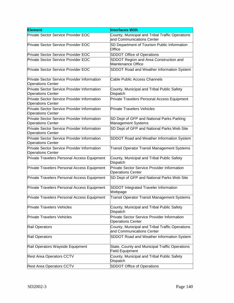
SD2002-3 Page 140
Element Interfaces WithPrivate Sector Service Provider EOC County, Municipal and Tribal Traffic Operations
and Communications CenterPrivate Sector Service Provider EOC SD Department of Tourism Public Information
OfficePrivate Sector Service Provider EOC SDDOT Office of OperationsPrivate Sector Service Provider EOC SDDOT Region and Area Construction and
Maintenance OfficePrivate Sector Service Provider EOC SDDOT Road and Weather Information System
Private Sector Service Provider InformationOperations Center
Cable Public Access Channels
Private Sector Service Provider InformationOperations Center
County, Municipal and Tribal Public SafetyDispatch
Private Sector Service Provider InformationOperations Center
Private Travelers Personal Access Equipment
Private Sector Service Provider InformationOperations Center
Private Travelers Vehicles
Private Sector Service Provider InformationOperations Center
SD Dept of GFP and National Parks ParkingManagement Systems
Private Sector Service Provider InformationOperations Center
SD Dept of GFP and National Parks Web Site
Private Sector Service Provider InformationOperations Center
SDDOT Road and Weather Information System
Private Sector Service Provider InformationOperations Center
Transit Operator Transit Management Systems
Private Travelers Personal Access Equipment County, Municipal and Tribal Public SafetyDispatch
Private Travelers Personal Access Equipment Private Sector Service Provider InformationOperations Center
Private Travelers Personal Access Equipment SD Dept of GFP and National Parks Web Site
Private Travelers Personal Access Equipment SDDOT Integrated Traveler InformationWebpage
Private Travelers Personal Access Equipment Transit Operator Transit Management Systems
Private Travelers Vehicles County, Municipal and Tribal Public SafetyDispatch
Private Travelers Vehicles Private Sector Service Provider InformationOperations Center
Rail Operators County, Municipal and Tribal Traffic Operationsand Communications Center
Rail Operators SDDOT Road and Weather Information System
Rail Operators Wayside Equipment State, County and Municipal Traffic OperationsField Equipment
Rest Area Operators CCTV County, Municipal and Tribal Public SafetyDispatch
Rest Area Operators CCTV SDDOT Office of Operations
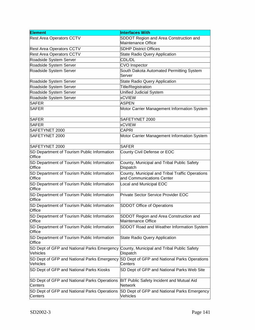
SD2002-3 Page 141
Element Interfaces WithRest Area Operators CCTV SDDOT Region and Area Construction and
Maintenance OfficeRest Area Operators CCTV SDHP District OfficesRest Area Operators CCTV State Radio Query ApplicationRoadside System Server CDL/DLRoadside System Server CVO InspectorRoadside System Server South Dakota Automated Permitting System
ServerRoadside System Server State Radio Query ApplicationRoadside System Server Title/RegistrationRoadside System Server Unified Judicial SystemRoadside System Server xCVIEWSAFER ASPENSAFER Motor Carrier Management Information System
SAFER SAFETYNET 2000SAFER xCVIEWSAFETYNET 2000 CAPRISAFETYNET 2000 Motor Carrier Management Information System
SAFETYNET 2000 SAFERSD Department of Tourism Public InformationOffice
County Civil Defense or EOC
SD Department of Tourism Public InformationOffice
County, Municipal and Tribal Public SafetyDispatch
SD Department of Tourism Public InformationOffice
County, Municipal and Tribal Traffic Operationsand Communications Center
SD Department of Tourism Public InformationOffice
Local and Municipal EOC
SD Department of Tourism Public InformationOffice
Private Sector Service Provider EOC
SD Department of Tourism Public InformationOffice
SDDOT Office of Operations
SD Department of Tourism Public InformationOffice
SDDOT Region and Area Construction andMaintenance Office
SD Department of Tourism Public InformationOffice
SDDOT Road and Weather Information System
SD Department of Tourism Public InformationOffice
State Radio Query Application
SD Dept of GFP and National Parks EmergencyVehicles
County, Municipal and Tribal Public SafetyDispatch
SD Dept of GFP and National Parks EmergencyVehicles
SD Dept of GFP and National Parks OperationsCenters
SD Dept of GFP and National Parks Kiosks SD Dept of GFP and National Parks Web Site
SD Dept of GFP and National Parks OperationsCenters
BIT Public Safety Incident and Mutual AidNetwork
SD Dept of GFP and National Parks OperationsCenters
SD Dept of GFP and National Parks EmergencyVehicles
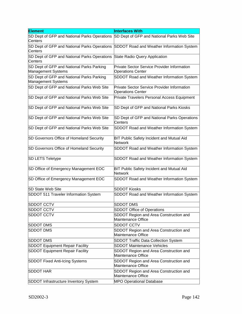
SD2002-3 Page 142
Element Interfaces WithSD Dept of GFP and National Parks OperationsCenters
SD Dept of GFP and National Parks Web Site
SD Dept of GFP and National Parks OperationsCenters
SDDOT Road and Weather Information System
SD Dept of GFP and National Parks OperationsCenters
State Radio Query Application
SD Dept of GFP and National Parks ParkingManagement Systems
Private Sector Service Provider InformationOperations Center
SD Dept of GFP and National Parks ParkingManagement Systems
SDDOT Road and Weather Information System
SD Dept of GFP and National Parks Web Site Private Sector Service Provider InformationOperations Center
SD Dept of GFP and National Parks Web Site Private Travelers Personal Access Equipment
SD Dept of GFP and National Parks Web Site SD Dept of GFP and National Parks Kiosks
SD Dept of GFP and National Parks Web Site SD Dept of GFP and National Parks OperationsCenters
SD Dept of GFP and National Parks Web Site SDDOT Road and Weather Information System
SD Governors Office of Homeland Security BIT Public Safety Incident and Mutual AidNetwork
SD Governors Office of Homeland Security SDDOT Road and Weather Information System
SD LETS Teletype SDDOT Road and Weather Information System
SD Office of Emergency Management EOC BIT Public Safety Incident and Mutual AidNetwork
SD Office of Emergency Management EOC SDDOT Road and Weather Information System
SD State Web Site SDDOT KiosksSDDOT 511 Traveler Information System SDDOT Road and Weather Information System
SDDOT CCTV SDDOT DMSSDDOT CCTV SDDOT Office of OperationsSDDOT CCTV SDDOT Region and Area Construction and
Maintenance OfficeSDDOT DMS SDDOT CCTVSDDOT DMS SDDOT Region and Area Construction and
Maintenance OfficeSDDOT DMS SDDOT Traffic Data Collection SystemSDDOT Equipment Repair Facility SDDOT Maintenance VehiclesSDDOT Equipment Repair Facility SDDOT Region and Area Construction and
Maintenance OfficeSDDOT Fixed Anti-Icing Systems SDDOT Region and Area Construction and
Maintenance OfficeSDDOT HAR SDDOT Region and Area Construction and
Maintenance OfficeSDDOT Infrastructure Inventory System MPO Operational Database
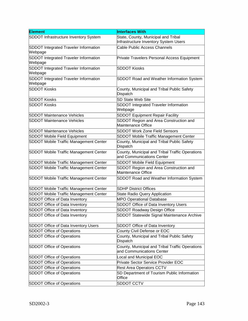
SD2002-3 Page 143
Element Interfaces WithSDDOT Infrastructure Inventory System State, County, Municipal and Tribal
Infrastructure Inventory System UsersSDDOT Integrated Traveler InformationWebpage
Cable Public Access Channels
SDDOT Integrated Traveler InformationWebpage
Private Travelers Personal Access Equipment
SDDOT Integrated Traveler InformationWebpage
SDDOT Kiosks
SDDOT Integrated Traveler InformationWebpage
SDDOT Road and Weather Information System
SDDOT Kiosks County, Municipal and Tribal Public SafetyDispatch
SDDOT Kiosks SD State Web SiteSDDOT Kiosks SDDOT Integrated Traveler Information
WebpageSDDOT Maintenance Vehicles SDDOT Equipment Repair FacilitySDDOT Maintenance Vehicles SDDOT Region and Area Construction and
Maintenance OfficeSDDOT Maintenance Vehicles SDDOT Work Zone Field SensorsSDDOT Mobile Field Equipment SDDOT Mobile Traffic Management CenterSDDOT Mobile Traffic Management Center County, Municipal and Tribal Public Safety
DispatchSDDOT Mobile Traffic Management Center County, Municipal and Tribal Traffic Operations
and Communications CenterSDDOT Mobile Traffic Management Center SDDOT Mobile Field EquipmentSDDOT Mobile Traffic Management Center SDDOT Region and Area Construction and
Maintenance OfficeSDDOT Mobile Traffic Management Center SDDOT Road and Weather Information System
SDDOT Mobile Traffic Management Center SDHP District OfficesSDDOT Mobile Traffic Management Center State Radio Query ApplicationSDDOT Office of Data Inventory MPO Operational DatabaseSDDOT Office of Data Inventory SDDOT Office of Data Inventory UsersSDDOT Office of Data Inventory SDDOT Roadway Design OfficeSDDOT Office of Data Inventory SDDOT Statewide Signal Maintenance Archive
SDDOT Office of Data Inventory Users SDDOT Office of Data InventorySDDOT Office of Operations County Civil Defense or EOCSDDOT Office of Operations County, Municipal and Tribal Public Safety
DispatchSDDOT Office of Operations County, Municipal and Tribal Traffic Operations
and Communications CenterSDDOT Office of Operations Local and Municipal EOCSDDOT Office of Operations Private Sector Service Provider EOCSDDOT Office of Operations Rest Area Operators CCTVSDDOT Office of Operations SD Department of Tourism Public Information
OfficeSDDOT Office of Operations SDDOT CCTV
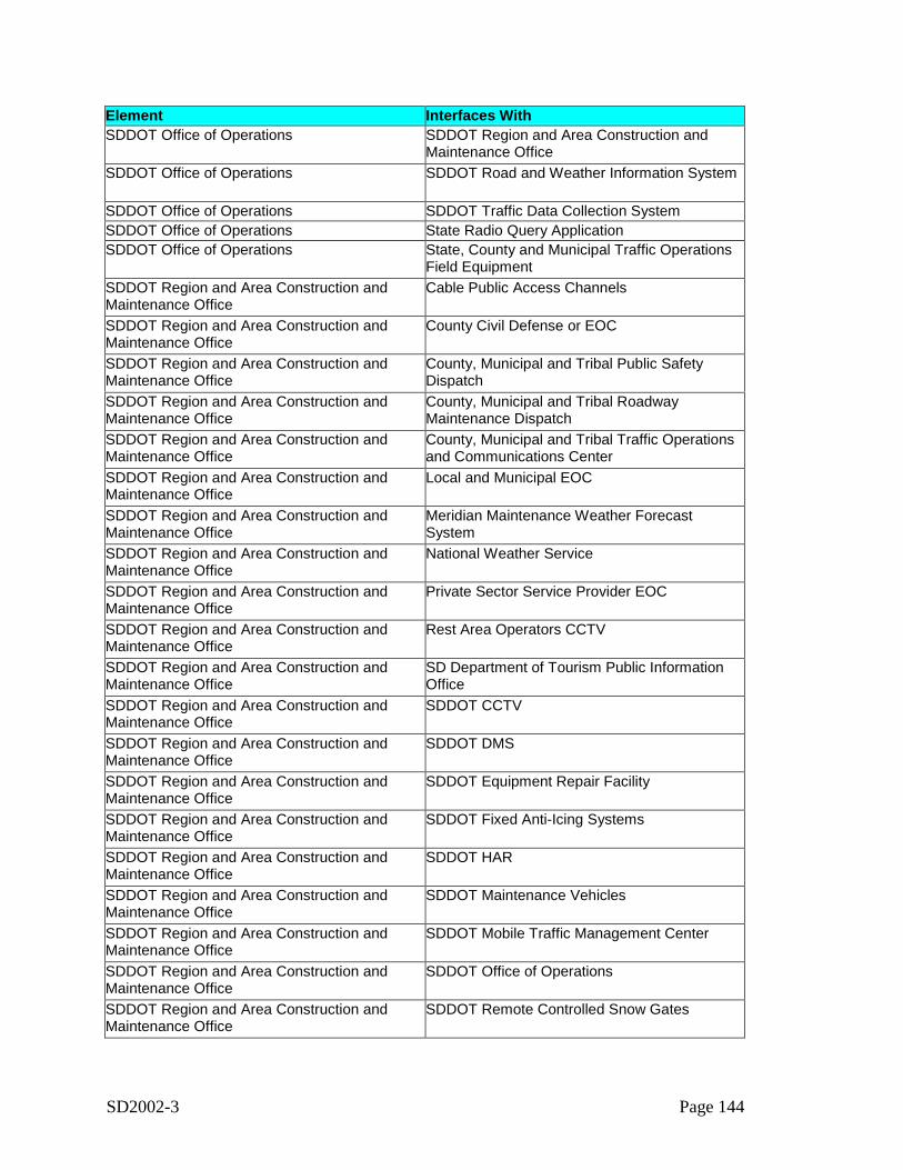
SD2002-3 Page 144
Element Interfaces WithSDDOT Office of Operations SDDOT Region and Area Construction and
Maintenance OfficeSDDOT Office of Operations SDDOT Road and Weather Information System
SDDOT Office of Operations SDDOT Traffic Data Collection SystemSDDOT Office of Operations State Radio Query ApplicationSDDOT Office of Operations State, County and Municipal Traffic Operations
Field EquipmentSDDOT Region and Area Construction andMaintenance Office
Cable Public Access Channels
SDDOT Region and Area Construction andMaintenance Office
County Civil Defense or EOC
SDDOT Region and Area Construction andMaintenance Office
County, Municipal and Tribal Public SafetyDispatch
SDDOT Region and Area Construction andMaintenance Office
County, Municipal and Tribal RoadwayMaintenance Dispatch
SDDOT Region and Area Construction andMaintenance Office
County, Municipal and Tribal Traffic Operationsand Communications Center
SDDOT Region and Area Construction andMaintenance Office
Local and Municipal EOC
SDDOT Region and Area Construction andMaintenance Office
Meridian Maintenance Weather ForecastSystem
SDDOT Region and Area Construction andMaintenance Office
National Weather Service
SDDOT Region and Area Construction andMaintenance Office
Private Sector Service Provider EOC
SDDOT Region and Area Construction andMaintenance Office
Rest Area Operators CCTV
SDDOT Region and Area Construction andMaintenance Office
SD Department of Tourism Public InformationOffice
SDDOT Region and Area Construction andMaintenance Office
SDDOT CCTV
SDDOT Region and Area Construction andMaintenance Office
SDDOT DMS
SDDOT Region and Area Construction andMaintenance Office
SDDOT Equipment Repair Facility
SDDOT Region and Area Construction andMaintenance Office
SDDOT Fixed Anti-Icing Systems
SDDOT Region and Area Construction andMaintenance Office
SDDOT HAR
SDDOT Region and Area Construction andMaintenance Office
SDDOT Maintenance Vehicles
SDDOT Region and Area Construction andMaintenance Office
SDDOT Mobile Traffic Management Center
SDDOT Region and Area Construction andMaintenance Office
SDDOT Office of Operations
SDDOT Region and Area Construction andMaintenance Office
SDDOT Remote Controlled Snow Gates
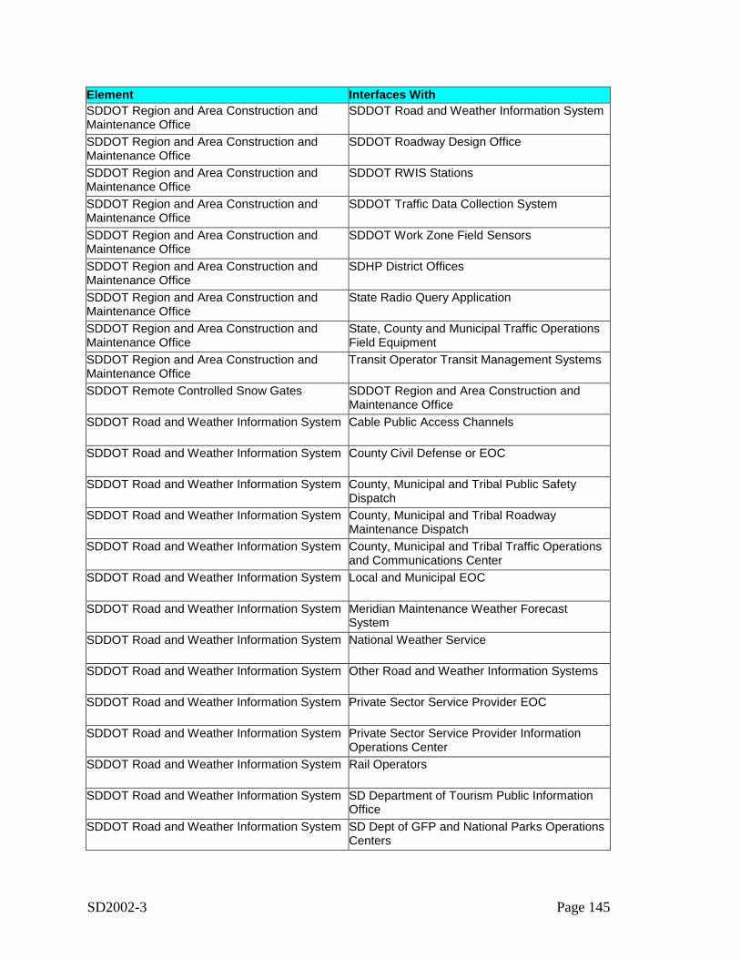
SD2002-3 Page 145
Element Interfaces WithSDDOT Region and Area Construction andMaintenance Office
SDDOT Road and Weather Information System
SDDOT Region and Area Construction andMaintenance Office
SDDOT Roadway Design Office
SDDOT Region and Area Construction andMaintenance Office
SDDOT RWIS Stations
SDDOT Region and Area Construction andMaintenance Office
SDDOT Traffic Data Collection System
SDDOT Region and Area Construction andMaintenance Office
SDDOT Work Zone Field Sensors
SDDOT Region and Area Construction andMaintenance Office
SDHP District Offices
SDDOT Region and Area Construction andMaintenance Office
State Radio Query Application
SDDOT Region and Area Construction andMaintenance Office
State, County and Municipal Traffic OperationsField Equipment
SDDOT Region and Area Construction andMaintenance Office
Transit Operator Transit Management Systems
SDDOT Remote Controlled Snow Gates SDDOT Region and Area Construction andMaintenance Office
SDDOT Road and Weather Information System Cable Public Access Channels
SDDOT Road and Weather Information System County Civil Defense or EOC
SDDOT Road and Weather Information System County, Municipal and Tribal Public SafetyDispatch
SDDOT Road and Weather Information System County, Municipal and Tribal RoadwayMaintenance Dispatch
SDDOT Road and Weather Information System County, Municipal and Tribal Traffic Operationsand Communications Center
SDDOT Road and Weather Information System Local and Municipal EOC
SDDOT Road and Weather Information System Meridian Maintenance Weather ForecastSystem
SDDOT Road and Weather Information System National Weather Service
SDDOT Road and Weather Information System Other Road and Weather Information Systems
SDDOT Road and Weather Information System Private Sector Service Provider EOC
SDDOT Road and Weather Information System Private Sector Service Provider InformationOperations Center
SDDOT Road and Weather Information System Rail Operators
SDDOT Road and Weather Information System SD Department of Tourism Public InformationOffice
SDDOT Road and Weather Information System SD Dept of GFP and National Parks OperationsCenters

SD2002-3 Page 146
Element Interfaces WithSDDOT Road and Weather Information System SD Dept of GFP and National Parks Parking
Management SystemsSDDOT Road and Weather Information System SD Dept of GFP and National Parks Web Site
SDDOT Road and Weather Information System SD Governors Office of Homeland Security
SDDOT Road and Weather Information System SD LETS Teletype
SDDOT Road and Weather Information System SD Office of Emergency Management EOC
SDDOT Road and Weather Information System SDDOT 511 Traveler Information System
SDDOT Road and Weather Information System SDDOT Integrated Traveler InformationWebpage
SDDOT Road and Weather Information System SDDOT Mobile Traffic Management Center
SDDOT Road and Weather Information System SDDOT Office of Operations
SDDOT Road and Weather Information System SDDOT Region and Area Construction andMaintenance Office
SDDOT Road and Weather Information System SDDOT Roadway Design Office
SDDOT Road and Weather Information System State Radio Query Application
SDDOT Road and Weather Information System Transit Operator Transit Management Systems
SDDOT Roadway Design Office County, Municipal and Tribal Public SafetyDispatch
SDDOT Roadway Design Office County, Municipal and Tribal RoadwayMaintenance Dispatch
SDDOT Roadway Design Office County, Municipal and Tribal Traffic Operationsand Communications Center
SDDOT Roadway Design Office MPO Operational DatabaseSDDOT Roadway Design Office SDDOT Office of Data InventorySDDOT Roadway Design Office SDDOT Region and Area Construction and
Maintenance OfficeSDDOT Roadway Design Office SDDOT Road and Weather Information System
SDDOT Roadway Design Office SDDOT Statewide Signal Maintenance Archive
SDDOT Roadway Design Office SDDOT Traffic Data Collection SystemSDDOT Roadway Design Office State Radio Query ApplicationSDDOT Roadway Design Office State, County and Municipal Traffic Operations
Field EquipmentSDDOT RWIS Stations SDDOT Region and Area Construction and
Maintenance OfficeSDDOT Statewide Signal Maintenance Archive MPO Operational Database
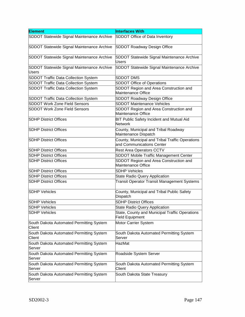
SD2002-3 Page 147
Element Interfaces WithSDDOT Statewide Signal Maintenance Archive SDDOT Office of Data Inventory
SDDOT Statewide Signal Maintenance Archive SDDOT Roadway Design Office
SDDOT Statewide Signal Maintenance Archive SDDOT Statewide Signal Maintenance ArchiveUsers
SDDOT Statewide Signal Maintenance ArchiveUsers
SDDOT Statewide Signal Maintenance Archive
SDDOT Traffic Data Collection System SDDOT DMSSDDOT Traffic Data Collection System SDDOT Office of OperationsSDDOT Traffic Data Collection System SDDOT Region and Area Construction and
Maintenance OfficeSDDOT Traffic Data Collection System SDDOT Roadway Design OfficeSDDOT Work Zone Field Sensors SDDOT Maintenance VehiclesSDDOT Work Zone Field Sensors SDDOT Region and Area Construction and
Maintenance OfficeSDHP District Offices BIT Public Safety Incident and Mutual Aid
NetworkSDHP District Offices County, Municipal and Tribal Roadway
Maintenance DispatchSDHP District Offices County, Municipal and Tribal Traffic Operations
and Communications CenterSDHP District Offices Rest Area Operators CCTVSDHP District Offices SDDOT Mobile Traffic Management CenterSDHP District Offices SDDOT Region and Area Construction and
Maintenance OfficeSDHP District Offices SDHP VehiclesSDHP District Offices State Radio Query ApplicationSDHP District Offices Transit Operator Transit Management Systems
SDHP Vehicles County, Municipal and Tribal Public SafetyDispatch
SDHP Vehicles SDHP District OfficesSDHP Vehicles State Radio Query ApplicationSDHP Vehicles State, County and Municipal Traffic Operations
Field EquipmentSouth Dakota Automated Permitting SystemClient
Motor Carrier System
South Dakota Automated Permitting SystemClient
South Dakota Automated Permitting SystemServer
South Dakota Automated Permitting SystemServer
HazMat
South Dakota Automated Permitting SystemServer
Roadside System Server
South Dakota Automated Permitting SystemServer
South Dakota Automated Permitting SystemClient
South Dakota Automated Permitting SystemServer
South Dakota State Treasury
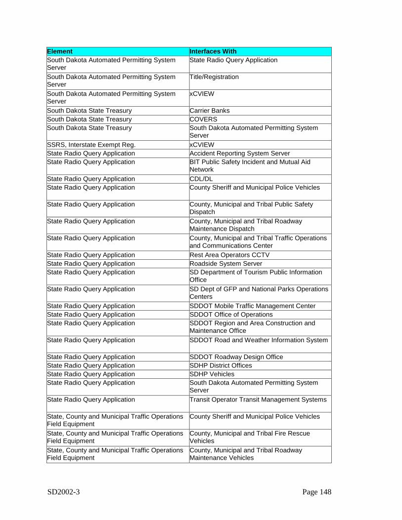
SD2002-3 Page 148
Element Interfaces WithSouth Dakota Automated Permitting SystemServer
State Radio Query Application
South Dakota Automated Permitting SystemServer
Title/Registration
South Dakota Automated Permitting SystemServer
xCVIEW
South Dakota State Treasury Carrier BanksSouth Dakota State Treasury COVERSSouth Dakota State Treasury South Dakota Automated Permitting System
ServerSSRS, Interstate Exempt Reg. xCVIEWState Radio Query Application Accident Reporting System ServerState Radio Query Application BIT Public Safety Incident and Mutual Aid
NetworkState Radio Query Application CDL/DLState Radio Query Application County Sheriff and Municipal Police Vehicles
State Radio Query Application County, Municipal and Tribal Public SafetyDispatch
State Radio Query Application County, Municipal and Tribal RoadwayMaintenance Dispatch
State Radio Query Application County, Municipal and Tribal Traffic Operationsand Communications Center
State Radio Query Application Rest Area Operators CCTVState Radio Query Application Roadside System ServerState Radio Query Application SD Department of Tourism Public Information
OfficeState Radio Query Application SD Dept of GFP and National Parks Operations
CentersState Radio Query Application SDDOT Mobile Traffic Management CenterState Radio Query Application SDDOT Office of OperationsState Radio Query Application SDDOT Region and Area Construction and
Maintenance OfficeState Radio Query Application SDDOT Road and Weather Information System
State Radio Query Application SDDOT Roadway Design OfficeState Radio Query Application SDHP District OfficesState Radio Query Application SDHP VehiclesState Radio Query Application South Dakota Automated Permitting System
ServerState Radio Query Application Transit Operator Transit Management Systems
State, County and Municipal Traffic OperationsField Equipment
County Sheriff and Municipal Police Vehicles
State, County and Municipal Traffic OperationsField Equipment
County, Municipal and Tribal Fire RescueVehicles
State, County and Municipal Traffic OperationsField Equipment
County, Municipal and Tribal RoadwayMaintenance Vehicles
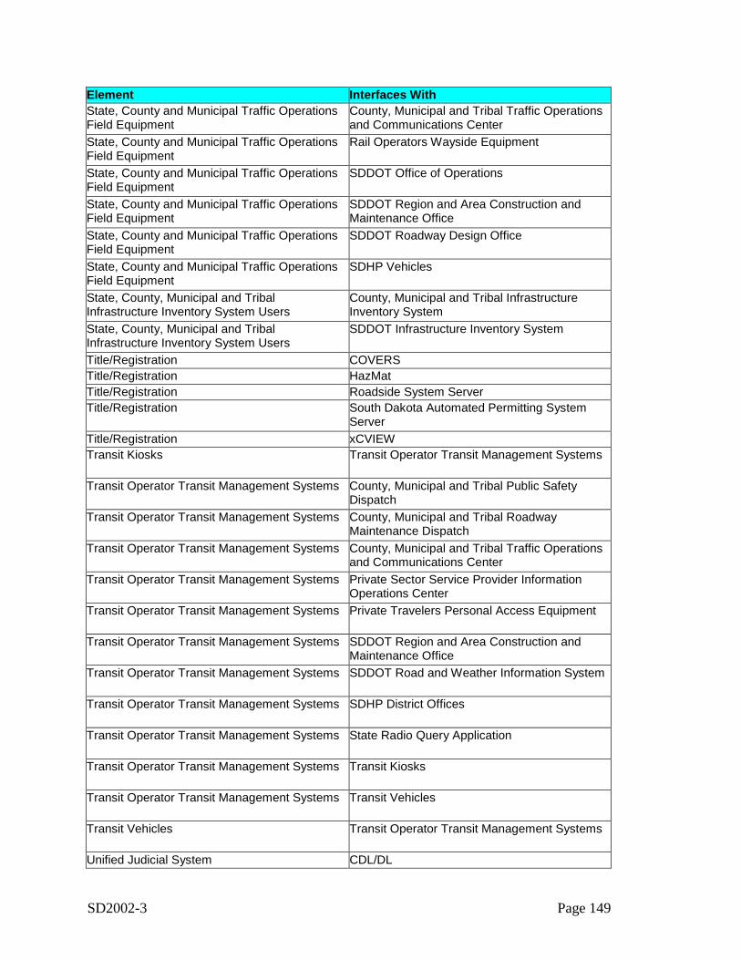
SD2002-3 Page 149
Element Interfaces WithState, County and Municipal Traffic OperationsField Equipment
County, Municipal and Tribal Traffic Operationsand Communications Center
State, County and Municipal Traffic OperationsField Equipment
Rail Operators Wayside Equipment
State, County and Municipal Traffic OperationsField Equipment
SDDOT Office of Operations
State, County and Municipal Traffic OperationsField Equipment
SDDOT Region and Area Construction andMaintenance Office
State, County and Municipal Traffic OperationsField Equipment
SDDOT Roadway Design Office
State, County and Municipal Traffic OperationsField Equipment
SDHP Vehicles
State, County, Municipal and TribalInfrastructure Inventory System Users
County, Municipal and Tribal InfrastructureInventory System
State, County, Municipal and TribalInfrastructure Inventory System Users
SDDOT Infrastructure Inventory System
Title/Registration COVERSTitle/Registration HazMatTitle/Registration Roadside System ServerTitle/Registration South Dakota Automated Permitting System
ServerTitle/Registration xCVIEWTransit Kiosks Transit Operator Transit Management Systems
Transit Operator Transit Management Systems County, Municipal and Tribal Public SafetyDispatch
Transit Operator Transit Management Systems County, Municipal and Tribal RoadwayMaintenance Dispatch
Transit Operator Transit Management Systems County, Municipal and Tribal Traffic Operationsand Communications Center
Transit Operator Transit Management Systems Private Sector Service Provider InformationOperations Center
Transit Operator Transit Management Systems Private Travelers Personal Access Equipment
Transit Operator Transit Management Systems SDDOT Region and Area Construction andMaintenance Office
Transit Operator Transit Management Systems SDDOT Road and Weather Information System
Transit Operator Transit Management Systems SDHP District Offices
Transit Operator Transit Management Systems State Radio Query Application
Transit Operator Transit Management Systems Transit Kiosks
Transit Operator Transit Management Systems Transit Vehicles
Transit Vehicles Transit Operator Transit Management Systems
Unified Judicial System CDL/DL
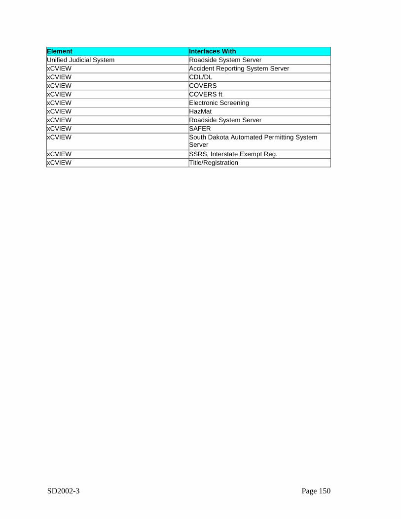
SD2002-3 Page 150
Element Interfaces WithUnified Judicial System Roadside System ServerxCVIEW Accident Reporting System ServerxCVIEW CDL/DLxCVIEW COVERSxCVIEW COVERS ftxCVIEW Electronic ScreeningxCVIEW HazMatxCVIEW Roadside System ServerxCVIEW SAFERxCVIEW South Dakota Automated Permitting System
ServerxCVIEW SSRS, Interstate Exempt Reg.xCVIEW Title/Registration
SD2002-3 Page 151
Appendix D: Functional Requirements
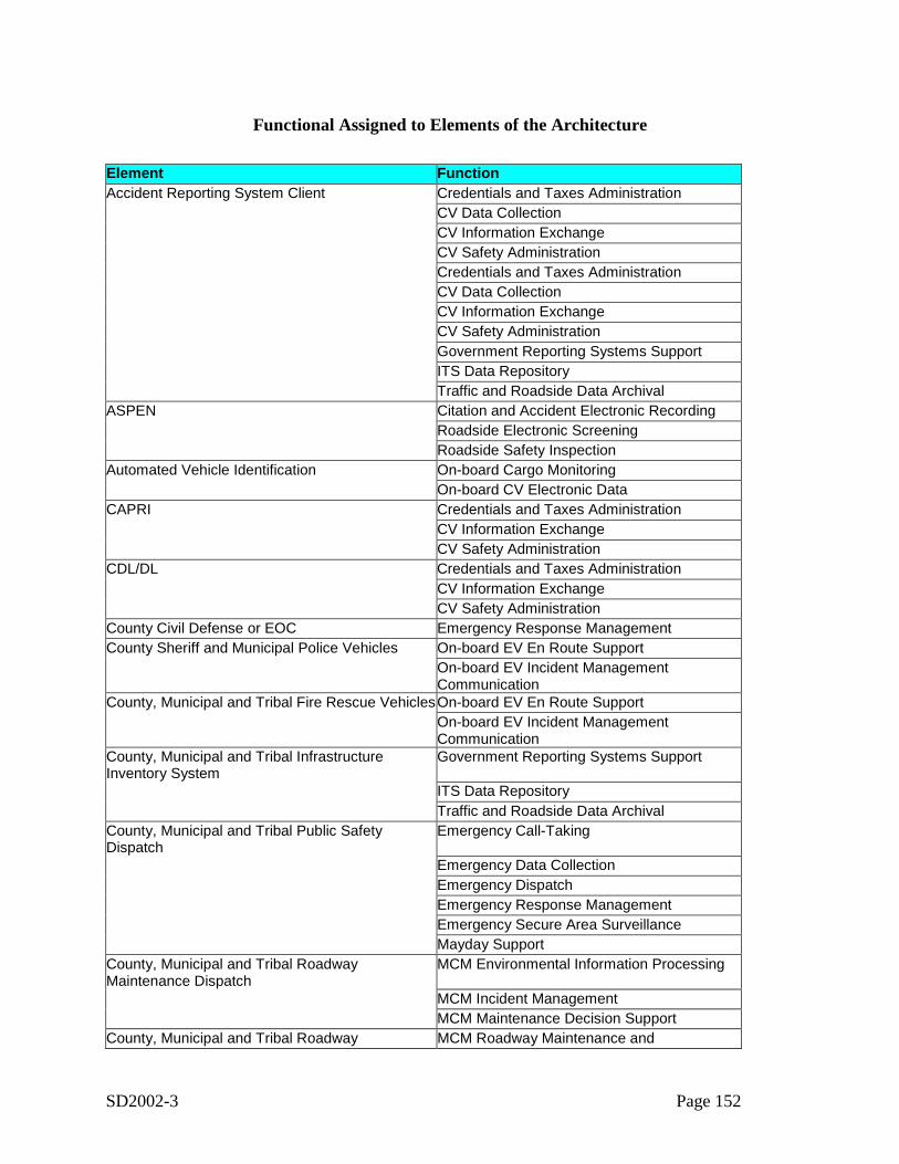
SD2002-3 Page 152
Functional Assigned to Elements of the Architecture
Element FunctionAccident Reporting System Client Credentials and Taxes Administration
CV Data CollectionCV Information ExchangeCV Safety AdministrationCredentials and Taxes AdministrationCV Data CollectionCV Information ExchangeCV Safety AdministrationGovernment Reporting Systems SupportITS Data RepositoryTraffic and Roadside Data Archival
ASPEN Citation and Accident Electronic RecordingRoadside Electronic ScreeningRoadside Safety Inspection
Automated Vehicle Identification On-board Cargo MonitoringOn-board CV Electronic Data
CAPRI Credentials and Taxes AdministrationCV Information ExchangeCV Safety Administration
CDL/DL Credentials and Taxes AdministrationCV Information ExchangeCV Safety Administration
County Civil Defense or EOC Emergency Response ManagementCounty Sheriff and Municipal Police Vehicles On-board EV En Route Support
On-board EV Incident ManagementCommunication
County, Municipal and Tribal Fire Rescue VehiclesOn-board EV En Route SupportOn-board EV Incident ManagementCommunication
County, Municipal and Tribal InfrastructureInventory System
Government Reporting Systems Support
ITS Data RepositoryTraffic and Roadside Data Archival
County, Municipal and Tribal Public SafetyDispatch
Emergency Call-Taking
Emergency Data CollectionEmergency DispatchEmergency Response ManagementEmergency Secure Area SurveillanceMayday Support
County, Municipal and Tribal RoadwayMaintenance Dispatch
MCM Environmental Information Processing
MCM Incident ManagementMCM Maintenance Decision Support
County, Municipal and Tribal Roadway MCM Roadway Maintenance and
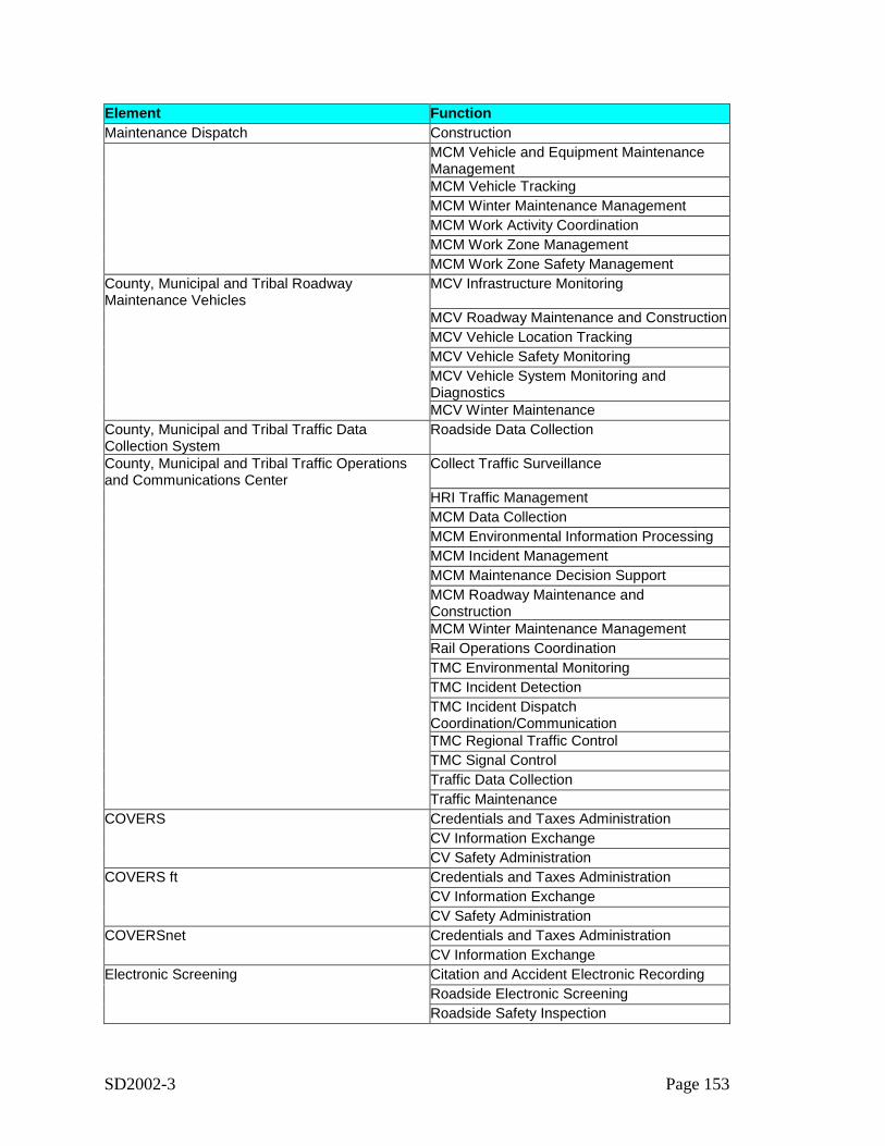
SD2002-3 Page 153
Element FunctionMaintenance Dispatch Construction
MCM Vehicle and Equipment MaintenanceManagementMCM Vehicle TrackingMCM Winter Maintenance ManagementMCM Work Activity CoordinationMCM Work Zone ManagementMCM Work Zone Safety Management
County, Municipal and Tribal RoadwayMaintenance Vehicles
MCV Infrastructure Monitoring
MCV Roadway Maintenance and ConstructionMCV Vehicle Location TrackingMCV Vehicle Safety MonitoringMCV Vehicle System Monitoring andDiagnosticsMCV Winter Maintenance
County, Municipal and Tribal Traffic DataCollection System
Roadside Data Collection
County, Municipal and Tribal Traffic Operationsand Communications Center
Collect Traffic Surveillance
HRI Traffic ManagementMCM Data CollectionMCM Environmental Information ProcessingMCM Incident ManagementMCM Maintenance Decision SupportMCM Roadway Maintenance andConstructionMCM Winter Maintenance ManagementRail Operations CoordinationTMC Environmental MonitoringTMC Incident DetectionTMC Incident DispatchCoordination/CommunicationTMC Regional Traffic ControlTMC Signal ControlTraffic Data CollectionTraffic Maintenance
COVERS Credentials and Taxes AdministrationCV Information ExchangeCV Safety Administration
COVERS ft Credentials and Taxes AdministrationCV Information ExchangeCV Safety Administration
COVERSnet Credentials and Taxes AdministrationCV Information Exchange
Electronic Screening Citation and Accident Electronic RecordingRoadside Electronic ScreeningRoadside Safety Inspection
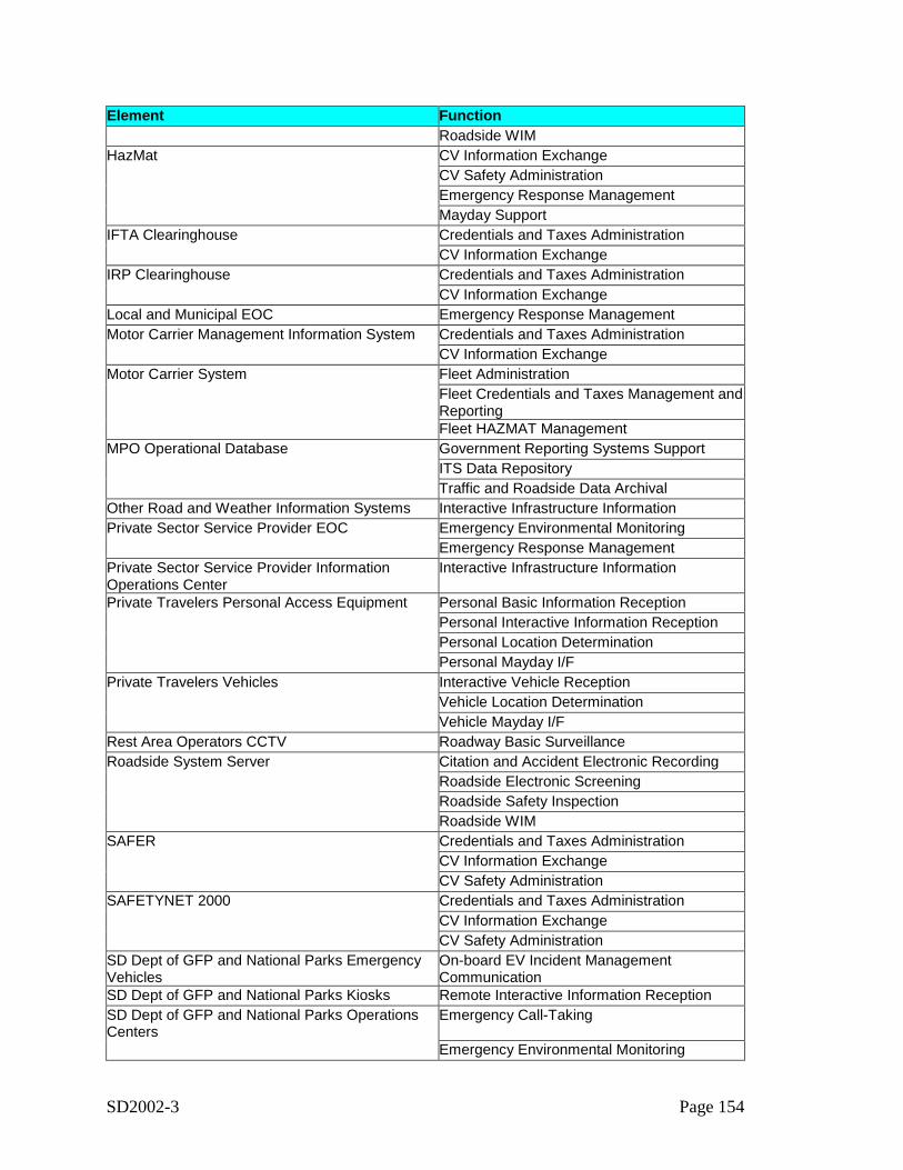
SD2002-3 Page 154
Element FunctionRoadside WIM
HazMat CV Information ExchangeCV Safety AdministrationEmergency Response ManagementMayday Support
IFTA Clearinghouse Credentials and Taxes AdministrationCV Information Exchange
IRP Clearinghouse Credentials and Taxes AdministrationCV Information Exchange
Local and Municipal EOC Emergency Response ManagementMotor Carrier Management Information System Credentials and Taxes Administration
CV Information ExchangeMotor Carrier System Fleet Administration
Fleet Credentials and Taxes Management andReportingFleet HAZMAT Management
MPO Operational Database Government Reporting Systems SupportITS Data RepositoryTraffic and Roadside Data Archival
Other Road and Weather Information Systems Interactive Infrastructure InformationPrivate Sector Service Provider EOC Emergency Environmental Monitoring
Emergency Response ManagementPrivate Sector Service Provider InformationOperations Center
Interactive Infrastructure Information
Private Travelers Personal Access Equipment Personal Basic Information ReceptionPersonal Interactive Information ReceptionPersonal Location DeterminationPersonal Mayday I/F
Private Travelers Vehicles Interactive Vehicle ReceptionVehicle Location DeterminationVehicle Mayday I/F
Rest Area Operators CCTV Roadway Basic SurveillanceRoadside System Server Citation and Accident Electronic Recording
Roadside Electronic ScreeningRoadside Safety InspectionRoadside WIM
SAFER Credentials and Taxes AdministrationCV Information ExchangeCV Safety Administration
SAFETYNET 2000 Credentials and Taxes AdministrationCV Information ExchangeCV Safety Administration
SD Dept of GFP and National Parks EmergencyVehicles
On-board EV Incident ManagementCommunication
SD Dept of GFP and National Parks Kiosks Remote Interactive Information ReceptionSD Dept of GFP and National Parks OperationsCenters
Emergency Call-Taking
Emergency Environmental Monitoring

SD2002-3 Page 155
Element FunctionEmergency Response Management
SD Dept of GFP and National Parks ParkingManagement Systems
Parking Electronic Payment
Parking ManagementParking Surveillance
SD Dept of GFP and National Parks Web Site Basic Information BroadcastInteractive Infrastructure Information
SD Governors Office of Homeland Security Emergency Response ManagementSD LETS Teletype Emergency Response ManagementSD Office of Emergency Management EOC Emergency Environmental Monitoring
Emergency Response ManagementSD State Web Site Basic Information Broadcast
Interactive Infrastructure InformationSDDOT 511 Traveler Information System Interactive Infrastructure InformationSDDOT CCTV Roadway Basic Surveillance
Roadway Incident DetectionSDDOT DMS Roadway Equipment Coordination
Roadway Traffic Information DisseminationSDDOT Fixed Anti-Icing Systems Roadway Automated TreatmentSDDOT HAR Roadway Equipment Coordination
Roadway Traffic Information DisseminationSDDOT Infrastructure Inventory System Government Reporting Systems Support
ITS Data RepositoryTraffic and Roadside Data Archival
SDDOT Integrated Traveler Information Webpage Basic Information BroadcastInteractive Infrastructure Information
SDDOT Kiosks Personal Basic Information ReceptionPersonal Interactive Information ReceptionPersonal Location DeterminationPersonal Mayday I/FRemote Interactive Information ReceptionRemote Mayday I/F
SDDOT Maintenance Vehicles MCV Infrastructure MonitoringMCV Roadway Maintenance and ConstructionMCV Vehicle Location TrackingMCV Vehicle Safety MonitoringMCV Vehicle System Monitoring andDiagnosticsMCV Winter MaintenanceMCV Work Zone Support
SDDOT Mobile Field Equipment Roadway Basic SurveillanceRoadway Equipment CoordinationRoadway Incident DetectionRoadway Traffic Information Dissemination
SDDOT Mobile Traffic Management Center Collect Traffic SurveillanceTMC Incident DetectionTMC Incident Dispatch
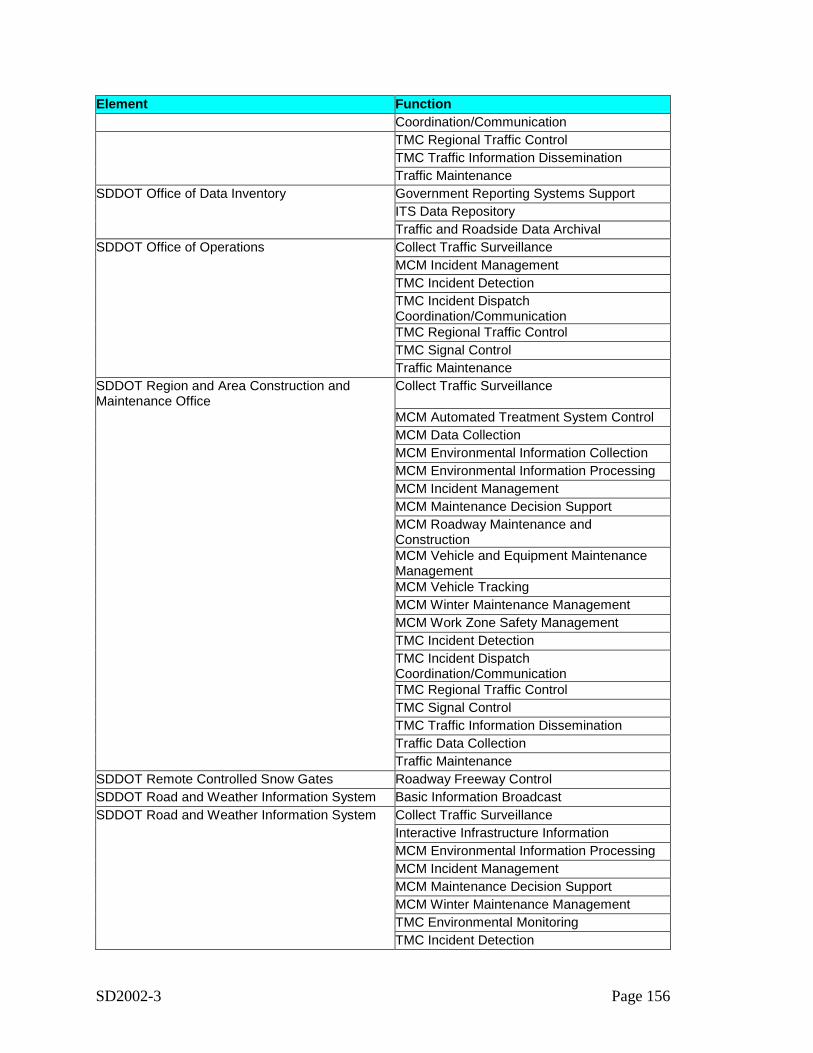
SD2002-3 Page 156
Element FunctionCoordination/CommunicationTMC Regional Traffic ControlTMC Traffic Information DisseminationTraffic Maintenance
SDDOT Office of Data Inventory Government Reporting Systems SupportITS Data RepositoryTraffic and Roadside Data Archival
SDDOT Office of Operations Collect Traffic SurveillanceMCM Incident ManagementTMC Incident DetectionTMC Incident DispatchCoordination/CommunicationTMC Regional Traffic ControlTMC Signal ControlTraffic Maintenance
SDDOT Region and Area Construction andMaintenance Office
Collect Traffic Surveillance
MCM Automated Treatment System ControlMCM Data CollectionMCM Environmental Information CollectionMCM Environmental Information ProcessingMCM Incident ManagementMCM Maintenance Decision SupportMCM Roadway Maintenance andConstructionMCM Vehicle and Equipment MaintenanceManagementMCM Vehicle TrackingMCM Winter Maintenance ManagementMCM Work Zone Safety ManagementTMC Incident DetectionTMC Incident DispatchCoordination/CommunicationTMC Regional Traffic ControlTMC Signal ControlTMC Traffic Information DisseminationTraffic Data CollectionTraffic Maintenance
SDDOT Remote Controlled Snow Gates Roadway Freeway ControlSDDOT Road and Weather Information System Basic Information BroadcastSDDOT Road and Weather Information System Collect Traffic Surveillance
Interactive Infrastructure InformationMCM Environmental Information ProcessingMCM Incident ManagementMCM Maintenance Decision SupportMCM Winter Maintenance ManagementTMC Environmental MonitoringTMC Incident Detection
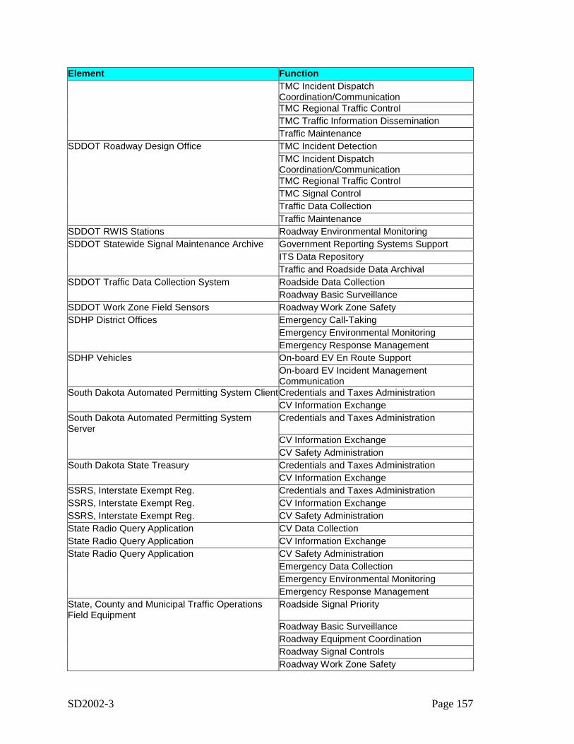
SD2002-3 Page 157
Element FunctionTMC Incident DispatchCoordination/CommunicationTMC Regional Traffic ControlTMC Traffic Information DisseminationTraffic Maintenance
SDDOT Roadway Design Office TMC Incident DetectionTMC Incident DispatchCoordination/CommunicationTMC Regional Traffic ControlTMC Signal ControlTraffic Data CollectionTraffic Maintenance
SDDOT RWIS Stations Roadway Environmental MonitoringSDDOT Statewide Signal Maintenance Archive Government Reporting Systems Support
ITS Data RepositoryTraffic and Roadside Data Archival
SDDOT Traffic Data Collection System Roadside Data CollectionRoadway Basic Surveillance
SDDOT Work Zone Field Sensors Roadway Work Zone SafetySDHP District Offices Emergency Call-Taking
Emergency Environmental MonitoringEmergency Response Management
SDHP Vehicles On-board EV En Route SupportOn-board EV Incident ManagementCommunication
South Dakota Automated Permitting System ClientCredentials and Taxes AdministrationCV Information Exchange
South Dakota Automated Permitting SystemServer
Credentials and Taxes Administration
CV Information ExchangeCV Safety Administration
South Dakota State Treasury Credentials and Taxes AdministrationCV Information Exchange
SSRS, Interstate Exempt Reg. Credentials and Taxes AdministrationSSRS, Interstate Exempt Reg. CV Information ExchangeSSRS, Interstate Exempt Reg. CV Safety AdministrationState Radio Query Application CV Data CollectionState Radio Query Application CV Information ExchangeState Radio Query Application CV Safety Administration
Emergency Data CollectionEmergency Environmental MonitoringEmergency Response Management
State, County and Municipal Traffic OperationsField Equipment
Roadside Signal Priority
Roadway Basic SurveillanceRoadway Equipment CoordinationRoadway Signal ControlsRoadway Work Zone Safety
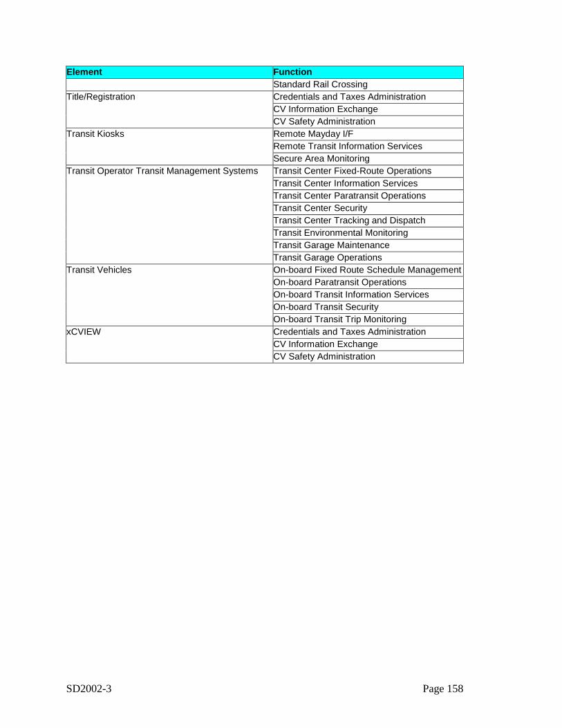
SD2002-3 Page 158
Element FunctionStandard Rail Crossing
Title/Registration Credentials and Taxes AdministrationCV Information ExchangeCV Safety Administration
Transit Kiosks Remote Mayday I/FRemote Transit Information ServicesSecure Area Monitoring
Transit Operator Transit Management Systems Transit Center Fixed-Route OperationsTransit Center Information ServicesTransit Center Paratransit OperationsTransit Center SecurityTransit Center Tracking and DispatchTransit Environmental MonitoringTransit Garage MaintenanceTransit Garage Operations
Transit Vehicles On-board Fixed Route Schedule ManagementOn-board Paratransit OperationsOn-board Transit Information ServicesOn-board Transit SecurityOn-board Transit Trip Monitoring
xCVIEW Credentials and Taxes AdministrationCV Information ExchangeCV Safety Administration
SD2002-3 Page 159
Appendix E: Users Guide to Extending the Architecture
SD2002-3 Page 160
South Dakota Statewide ITS Architecture
Regional ITS ArchitectureSoftware User Guide
161
Table of Contents1 Guide to the Regional ITS Architecture Software Suite ................................................................... 162
1.1 Turbo Architecture.......................................................................................................... 1621.2 Turbo Extensions ............................................................................................................ 163
1.2.1nstallation.................................................................................................................... 1631.2.2Starting Turbo Extensions........................................................................................... 1641.2.3Using the Application ................................................................................................. 165
1.2.3.1 Architecture Development Tab........................................................................... 1661.2.3.2 Web Publication Tab........................................................................................... 169
162
1. Guide to the Regional ITS Architecture Software SuiteA suite of software tools was used to develop the South Dakota Statewide ITS Architecture andpublish the architecture web site. The software tools that were used are either commerciallyavailable or provided as a contract deliverable. The required tools are:
• Turbo Architecture Version 2.0 – Used to develop the South Dakota StatewideITS Architecture
• Turbo Extensions Version 2.2 – Includes tools that augment the capabilities ofTurbo Architecture, including a tool that generates the architecture web site.
• Microsoft Access 2000 (or newer) – Required to run Turbo Extensions. Alsoallows direct access to Turbo Architecture databases, supporting development ofother custom extensions to support South Dakota’s specific regional architectureneeds.
• Any HTML Editor (e.g., Microsoft Front Page) – Used to create and maintain theTemplate HTML files that include the narrative text that is included on the website.
• Graphics software (e.g., Adobe Photoshop, Microsoft PowerPoint) – PowerPointwas used to generate the Market Package diagrams and Sausage Diagram for theregion. A graphics program is also required to prepare the various GIF and JPGfiles that are included on the web site.
• Adobe Acrobat – Used to generate the PDF-format market package diagrams thatare used on the web site.
The first two tools in this list are specialized regional ITS architecture development tools thatmay not be familiar to many readers. These two tools are documented in the followingparagraphs. The last four tools are all common commercially available tools that are widelyunderstood and are not discussed further in this document.
1.1. Turbo ArchitectureTurbo Architecture is the industry-standard software for development of regional and projectITS architectures. Version 2.0 of this software was used to develop the South Dakota RegionalITS Architecture. Turbo Architecture is a standard Windows Application that includes a user'smanual, installation guide, and on-line help. The product is available from the McTransSoftware Center at the University of Florida for $190. Discounts are available for multiple andagency licenses and upgrade pricing ($50) is available to those who own older versions.Contact McTrans at:
McTrans Center, University of Florida512 Weil HallP.O. Box 116585Gainesville, FL 32611-6585FEID # 59-6002052(352) 392-0378Messages 800-226-1013
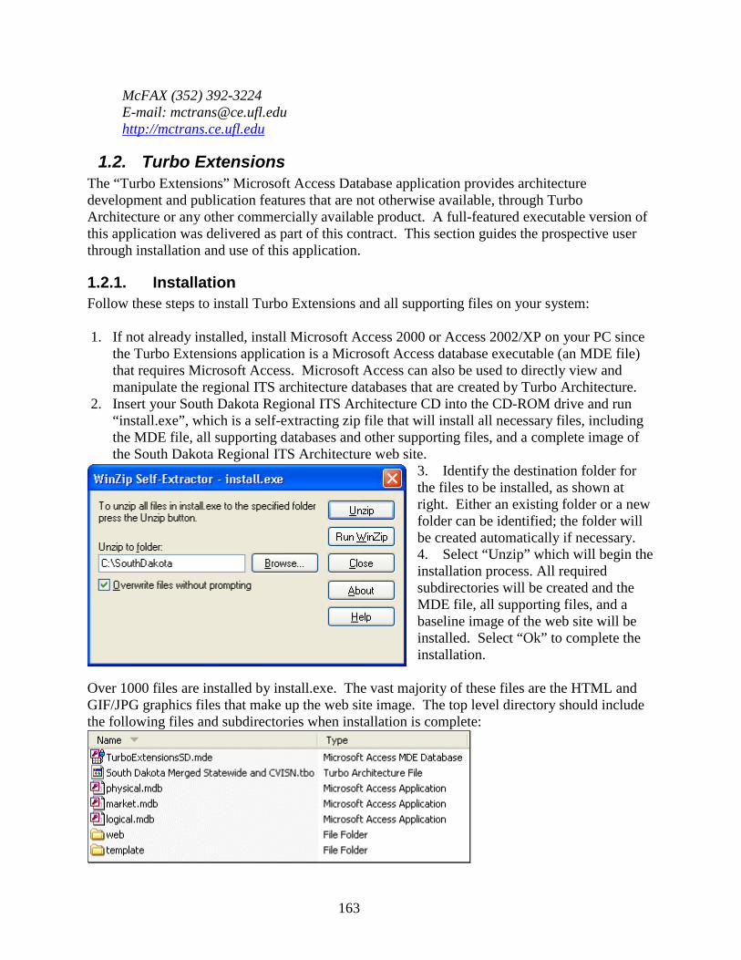
163
McFAX (352) 392-3224E-mail: [email protected]://mctrans.ce.ufl.edu
1.2. Turbo ExtensionsThe “Turbo Extensions” Microsoft Access Database application provides architecturedevelopment and publication features that are not otherwise available, through TurboArchitecture or any other commercially available product. A full-featured executable version ofthis application was delivered as part of this contract. This section guides the prospective userthrough installation and use of this application.
1.2.1. InstallationFollow these steps to install Turbo Extensions and all supporting files on your system:
1. If not already installed, install Microsoft Access 2000 or Access 2002/XP on your PC sincethe Turbo Extensions application is a Microsoft Access database executable (an MDE file)that requires Microsoft Access. Microsoft Access can also be used to directly view andmanipulate the regional ITS architecture databases that are created by Turbo Architecture.
2. Insert your South Dakota Regional ITS Architecture CD into the CD-ROM drive and run“install.exe”, which is a self-extracting zip file that will install all necessary files, includingthe MDE file, all supporting databases and other supporting files, and a complete image ofthe South Dakota Regional ITS Architecture web site.
3. Identify the destination folder forthe files to be installed, as shown atright. Either an existing folder or a newfolder can be identified; the folder willbe created automatically if necessary.4. Select “Unzip” which will begin theinstallation process. All requiredsubdirectories will be created and theMDE file, all supporting files, and abaseline image of the web site will beinstalled. Select “Ok” to complete theinstallation.
Over 1000 files are installed by install.exe. The vast majority of these files are the HTML andGIF/JPG graphics files that make up the web site image. The top level directory should includethe following files and subdirectories when installation is complete:
164
TurboExtensionsSD.mde – The Turbo Extensions Microsoft Access database executable. Thisis the tool that provides the extended architecture management and web site generationcapabilities. See the following section for more information on using this tool.South Dakota Merged Statewide and CVISN.tbo – The Turbo Architecture database thatcontains the South Dakota Regional ITS Architecture. (Note that the tbo file name may varydepending on the name of the final Turbo Architecture database.)Physical.mdb, market.mdb, logical.mdb – These Version 4.0 National ITS Architecturedatabases are also available on the National ITS Architecture Version 4.0 CD. They are includedin the installation as a convenience and to ensure that the baseline architecture configuration thatwas used to originally generate the architecture is maintained.Web folder – This folder contains a complete image of the South Dakota Regional ITSArchitecture, including all graphics and HTML files. The HTML files in this directory can beupdated using the Turbo Extensions software.Template folder – Turbo Extensions uses template HTML files that contain the basic text thatdescribes the regional architecture and the various pages that are included in the web site. All ofthe template files are included in this directory. They may be edited (using an HTML editor) tochange the “front matter” text that is included on the web site.
1.2.2. Starting Turbo Extensions1. Run the TurboExtensionSD.mde file, either by double-clicking on it or opening the file with
Microsoft Access. The application may take a minute to open the first time it runs afterinstallation because it must update all external database references (“linked tables”) and sothey are consistent with the file structure on your PC. In the unlikely event that some of thereferences cannot be resolved, you will be notified of the files that cannot be found.
2. The application will now present the terms and conditions of use. Read these terms andconditions and select “I Agree” if you agree with, and can abide by, the terms andconditions. Please notify ConSysTec, Corp. (914-248-8466) if you have a question aboutthese terms or are aware of use of this tool that is inconsistent with these terms andconditions.
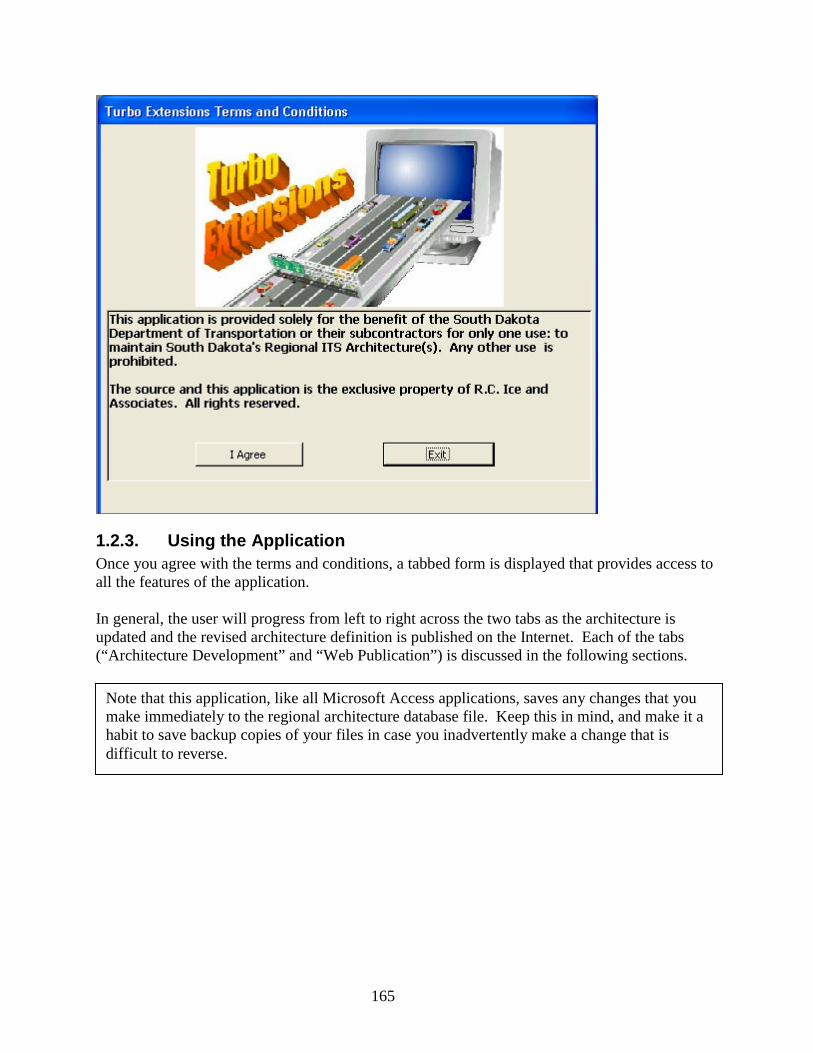
165
1.2.3. Using the ApplicationOnce you agree with the terms and conditions, a tabbed form is displayed that provides access toall the features of the application.
In general, the user will progress from left to right across the two tabs as the architecture isupdated and the revised architecture definition is published on the Internet. Each of the tabs(“Architecture Development” and “Web Publication”) is discussed in the following sections.
Note that this application, like all Microsoft Access applications, saves any changes that youmake immediately to the regional architecture database file. Keep this in mind, and make it ahabit to save backup copies of your files in case you inadvertently make a change that isdifficult to reverse.

166
1.2.3.1. Architecture Development TabThis tab provides enhanced architecture development tools that extend the basic tools availablein Turbo Architecture. Enhanced data entry forms were used during the workshops to developthe inventory for the regional architecture. Several custom reports also augment the reportingcapabilities of Turbo Architecture. Each of these architecture development tools is described inthe following paragraphs.
This pull-down menu indicates that thecurrent web site is South Dakota. This is the only web site that can be updated with this versionof the software.
This text box identifies the directory thatTurboExtensions is to use for access to the Turbo Architecture database and National ITSArchitecture databases. This is normally the same directory where the Turbo Extensions mdefile is stored, but you can change the directory by selecting the command button with the threedots (…) and browsing to the directory that includes the databases. It is recommended that youleave the file locations in the “as installed” location.
Click here to display the tabular inventory form that wasused to develop the inventory for the regional ITS architecture during the workshops. This formprovides essentially the same functionality as the “Inventory Tab” in Turbo Architecture, butfacilitates quick updates because it allows the inventory to be sorted by Stakeholder, by Element,or by Entity.
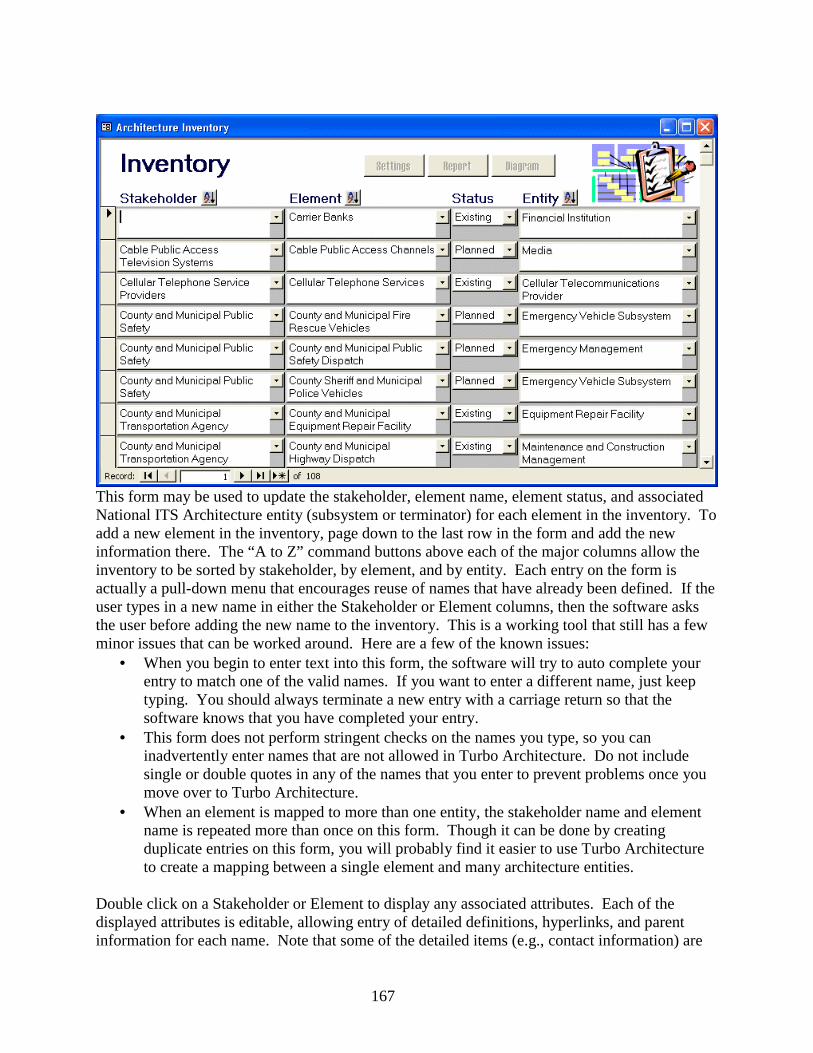
167
This form may be used to update the stakeholder, element name, element status, and associatedNational ITS Architecture entity (subsystem or terminator) for each element in the inventory. Toadd a new element in the inventory, page down to the last row in the form and add the newinformation there. The “A to Z” command buttons above each of the major columns allow theinventory to be sorted by stakeholder, by element, and by entity. Each entry on the form isactually a pull-down menu that encourages reuse of names that have already been defined. If theuser types in a new name in either the Stakeholder or Element columns, then the software asksthe user before adding the new name to the inventory. This is a working tool that still has a fewminor issues that can be worked around. Here are a few of the known issues:
• When you begin to enter text into this form, the software will try to auto complete yourentry to match one of the valid names. If you want to enter a different name, just keeptyping. You should always terminate a new entry with a carriage return so that thesoftware knows that you have completed your entry.
• This form does not perform stringent checks on the names you type, so you caninadvertently enter names that are not allowed in Turbo Architecture. Do not includesingle or double quotes in any of the names that you enter to prevent problems once youmove over to Turbo Architecture.
• When an element is mapped to more than one entity, the stakeholder name and elementname is repeated more than once on this form. Though it can be done by creatingduplicate entries on this form, you will probably find it easier to use Turbo Architectureto create a mapping between a single element and many architecture entities.
Double click on a Stakeholder or Element to display any associated attributes. Each of thedisplayed attributes is editable, allowing entry of detailed definitions, hyperlinks, and parentinformation for each name. Note that some of the detailed items (e.g., contact information) are
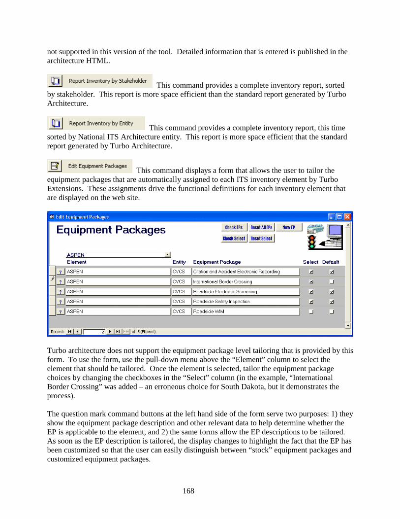
168
not supported in this version of the tool. Detailed information that is entered is published in thearchitecture HTML.
This command provides a complete inventory report, sortedby stakeholder. This report is more space efficient than the standard report generated by TurboArchitecture.
This command provides a complete inventory report, this timesorted by National ITS Architecture entity. This report is more space efficient that the standardreport generated by Turbo Architecture.
This command displays a form that allows the user to tailor theequipment packages that are automatically assigned to each ITS inventory element by TurboExtensions. These assignments drive the functional definitions for each inventory element thatare displayed on the web site.
Turbo architecture does not support the equipment package level tailoring that is provided by thisform. To use the form, use the pull-down menu above the “Element” column to select theelement that should be tailored. Once the element is selected, tailor the equipment packagechoices by changing the checkboxes in the “Select” column (in the example, “InternationalBorder Crossing” was added – an erroneous choice for South Dakota, but it demonstrates theprocess).
The question mark command buttons at the left hand side of the form serve two purposes: 1) theyshow the equipment package description and other relevant data to help determine whether theEP is applicable to the element, and 2) the same forms allow the EP descriptions to be tailored.As soon as the EP description is tailored, the display changes to highlight the fact that the EP hasbeen customized so that the user can easily distinguish between “stock” equipment packages andcustomized equipment packages.
169
The various command buttons at the top of the form provide the following functions:Check EPs – This command identifies any equipment package level tailoring that has beenperformed in the database. If EP descriptions have been modified or new custom equipmentpackages have been created, this command will identify all of these changes.Check Select – This command identifies any changes that have been made in the “Select”column. It identifies any differences between the “Default” column and the “Select” column inthe entire database. Since the “Default” column matches the default functionality that isassigned by Turbo Extensions, this report identifies any equipment package selection-leveltailoring that has been done.Reset All EPs – This command provides a warning, and then removes all equipment packagecustomization that has been performed. (After this command is run, “Check EPs” will find nodifferences.)Reset Select – This command provides a warning, and then removes all “Select” customizationfrom the regional architecture. (After this command is run, “Check Select” will find nodifferences.)New EP – This command allows a new custom equipment package to be defined. For example,an equipment package could be defined for a National ITS Architecture terminator so thatfunctionality that is important to a regional architecture, but omitted from the National ITSArchitecture, can be included.
This command identifies elements that have beenmapped to one or more National ITS Architecture subsystems that have not yet been allocatedany equipment packages based on Market Package associations or custom tailoring using the“Edit Equipment Packages” function. This report can be used to verify that the functionaldefinitions are as complete as possible. Consider adding market package associations for anyelements that are identified by this report so that functional specifications based on the NationalITS Architecture can be generated.
1.2.3.2. Web Publication TabOne of the distinguishing features of the South Dakota Statewide Architecture is the detailedarchitecture web site that provides comprehensive, hyperlinked access to the architecturedefinitions. This tab provides access to tools that generate these web pages and a report thatguides the user in use of Turbo Architecture to regenerate the architecture graphics that are alsoincluded in the web site. The proper operation of this tab is described in the followingparagraphs.
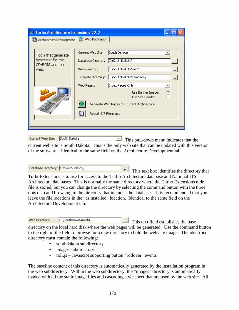
170
This pull-down menu indicates that thecurrent web site is South Dakota. This is the only web site that can be updated with this versionof the software. Identical to the same field on the Architecture Development tab.
This text box identifies the directory thatTurboExtensions is to use for access to the Turbo Architecture database and National ITSArchitecture databases. This is normally the same directory where the Turbo Extensions mdefile is stored, but you can change the directory by selecting the command button with the threedots (…) and browsing to the directory that includes the databases. It is recommended that youleave the file locations in the “as installed” location. Identical to the same field on theArchitecture Development tab.
This text field establishes the basedirectory on the local hard disk where the web pages will be generated. Use the command buttonto the right of the field to browse for a new directory to hold the web site image. The identifieddirectory must contain the following:
• southdakota subdirectory• images subdirectory• roll.js – Javascipt supporting button “rollover” events
The baseline content of this directory is automatically generated by the installation program inthe web subdirectory. Within the web subdirectory, the “images” directory is automaticallyloaded with all the static image files and cascading style sheet that are used by the web site. All
171
other subdirectories underneath the “southdakota” subdirectory are automatically populated withall required HTML files by the commands on this tab.
This text field establishes the directory onthe local hard disk where the template HTML files are stored. The template files contain thenarrative text that is included on many of the top level pages on the web site. Use the commandbutton to the right of the field to browse for a new directory to hold the web site image. Theinstallation program automatically creates a “template” subdirectory that holds all the initialtemplate files that were delivered with the contract.
This pull-down menu controls how manydifferent web pages are generated when the web generation commands are invoked. The “AllPages” option is used most of the time, but the other options may be useful for rapidly testingchanges without taking the time to generate a full web site. The pull-down menu offers thefollowing choices:Index Pages Only: This option will only generate the top-level web pages that are immediatelyselectable from the left-hand menu of the web site. Use this option to regenerate just a few pagesto test a design or format change, or to regenerate the top level pages to reflect a content changemade to the template files.Index Pages + Sample Detailed Pages: This option will generate all the top level index pagesand also a sample page of every other type of page. This option is useful after a change to imagefiles or another change is made and the impact to all the different types of pages is desired.All Pages: When “All” is selected, the web generator will regenerate the entire web siteincluding inventory, context diagram, functionality, interface, and standards pages.
This command causes the web generator to generatethe web pages identified in the “Web Pages” pull-down menu. If substantial changes are made,it is recommended that you clear all HTML files from the web subdirectories prior to generatingthe web pages so that old widowed pages will not remain in the subdirectory after web sitegeneration.
This command identifies the subdirectories and filenames where GIFfiles must be updated on the web site if the interfaces to a particular element are changed.
Turbo Architecture is used to generate the detailed architecture graphics that are used for the website. Two basic types of graphics are generated:
1) A context diagram is generated for every element in the inventory. A contextdiagram shows every interface for a particular element. A context diagram isgenerated in Turbo Architecture by selecting a single element in the ElementSelection form and selecting the “Show All” checkbox on the Diagrams form.
2) An Interface Control Diagram (ICD) is generated for every interface (pair ofinterconnected elements) in the architecture. The ICD shows every architecture flowthat goes between a specific pair of elements. An ICD is generated in Turbo
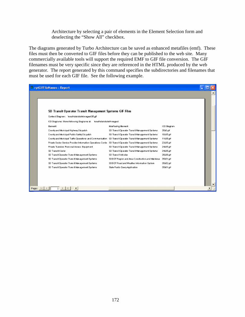
172
Architecture by selecting a pair of elements in the Element Selection form anddeselecting the “Show All” checkbox.
The diagrams generated by Turbo Architecture can be saved as enhanced metafiles (emf). Thesefiles must then be converted to GIF files before they can be published to the web site. Manycommercially available tools will support the required EMF to GIF file conversion. The GIFfilenames must be very specific since they are referenced in the HTML produced by the webgenerator. The report generated by this command specifies the subdirectories and filenames thatmust be used for each GIF file. See the following example.