Embed Size (px)
Citation preview
Spatial Concepts are Critical in Science Education
Lynn S. LibenIn collaboration with Kim A. Kastens & Shruti Agrawal (Columbia University) Adam E. Christensen & Lauren J. Myers (Penn State)
Overview
As developmental and Earth scientists, we collaborate to understand how spatial concepts & skills relate to science learning. Here we highlight findings on general map use and then describe our research on students' success in observing, mapping, and reasoning about geological data.
Spatial concepts and skills differ among individuals, often showing age and gender differences. Such differences are seen in performance on the water level task (WLT, see below) used to assess individuals' concepts of horizontality.
Maps Challenge Learners
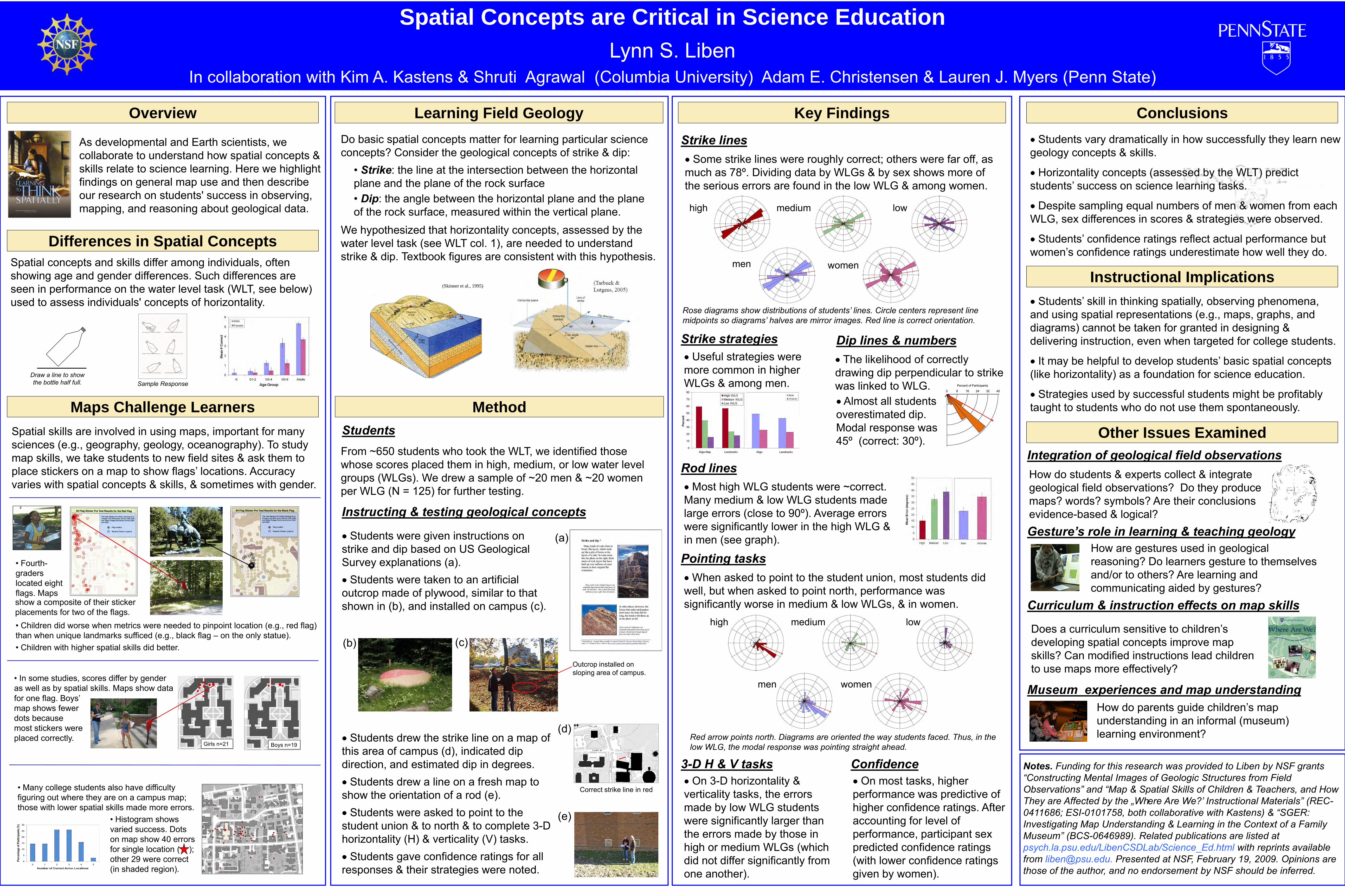
Spatial skills are involved in using maps, important for many sciences (e.g., geography, geology, oceanography). To study map skills, we take students to new field sites & ask them to place stickers on a map to show flags’ locations. Accuracy varies with spatial concepts & skills, & sometimes with gender.
• Children did worse when metrics were needed to pinpoint location (e.g., red flag) than when unique landmarks sufficed (e.g., black flag – on the only statue).• Children with higher spatial skills did better.
• Fourth-graders located eight flags. Maps
• In some studies, scores differ by gender as well as by spatial skills. Maps show data
• Many college students also have difficulty figuring out where they are on a campus map; those with lower spatial skills made more errors.
for one flag. Boys’ map shows fewer dots because most stickers were placed correctly.
Girls n=21
• Histogram shows varied success. Dots on map show 40 errors for single location ( ); other 29 were correct (in shaded region).
Key Findings
Strike linesSome strike lines were roughly correct; others were far off, as
much as 78º. Dividing data by WLGs & by sex shows more of the serious errors are found in the low WLG & among women.
Rose diagrams show distributions of students‟ lines. Circle centers represent line midpoints so diagrams‟ halves are mirror images. Red line is correct orientation.
lowmediumhigh
womenmen
When asked to point to the student union, most students did well, but when asked to point north, performance was significantly worse in medium & low WLGs, & in women.
Pointing tasks
lowmediumhigh
womenmen
Red arrow points north. Diagrams are oriented the way students faced. Thus, in the low WLG, the modal response was pointing straight ahead.
Strike strategies
Confidence
Useful strategies were more common in higher WLGs & among men.
On most tasks, higher performance was predictive of higher confidence ratings. After accounting for level of performance, participant sex predicted confidence ratings (with lower confidence ratings given by women).
Most high WLG students were ~correct. Many medium & low WLG students made large errors (close to 90º). Average errors were significantly lower in the high WLG & in men (see graph).
Rod lines
Differences in Spatial Concepts
Learning Field Geology
We hypothesized that horizontality concepts, assessed by the water level task (see WLT col. 1), are needed to understand strike & dip. Textbook figures are consistent with this hypothesis.
• Strike: the line at the intersection between the horizontal plane and the plane of the rock surface• Dip: the angle between the horizontal plane and the plane of the rock surface, measured within the vertical plane.
Do basic spatial concepts matter for learning particular science concepts? Consider the geological concepts of strike & dip:
(Skinner et al., 1995)
Correct strike line in red
From ~650 students who took the WLT, we identified those whose scores placed them in high, medium, or low water level groups (WLGs). We drew a sample of ~20 men & ~20 women per WLG (N = 125) for further testing.
(e)
(d)
Students were given instructions on strike and dip based on US Geological Survey explanations (a).
Students drew the strike line on a map of this area of campus (d), indicated dip direction, and estimated dip in degrees.
Students drew a line on a fresh map to show the orientation of a rod (e).
Students were asked to point to the student union & to north & to complete 3-D horizontality (H) & verticality (V) tasks.
Students gave confidence ratings for all responses & their strategies were noted.
(b)
Students were taken to an artificial outcrop made of plywood, similar to that shown in (b), and installed on campus (c).
(a)
(c)
Instructing & testing geological concepts
Method
Outcrop installed on sloping area of campus.
3-D H & V tasksOn 3-D horizontality &
verticality tasks, the errors made by low WLG students were significantly larger than the errors made by those in high or medium WLGs (which did not differ significantly from one another).
Dip lines & numbersThe likelihood of correctly
drawing dip perpendicular to strike was linked to WLG.
Almost all students overestimated dip. Modal response was 45º (correct: 30º).
Students
Notes. Funding for this research was provided to Liben by NSF grants “Constructing Mental Images of Geologic Structures from Field Observations” and “Map & Spatial Skills of Children & Teachers, and How They are Affected by the „Where Are We?‟ Instructional Materials” (REC-0411686; ESI-0101758, both collaborative with Kastens) & “SGER: Investigating Map Understanding & Learning in the Context of a Family Museum” (BCS-0646989). Related publications are listed at psych.la.psu.edu/LibenCSDLab/Science_Ed.html with reprints available from [email protected]. Presented at NSF, February 19, 2009. Opinions are those of the author, and no endorsement by NSF should be inferred.
Conclusions
Students vary dramatically in how successfully they learn new geology concepts & skills.
Horizontality concepts (assessed by the WLT) predict students’ success on science learning tasks.
Despite sampling equal numbers of men & women from each WLG, sex differences in scores & strategies were observed.
Students’ confidence ratings reflect actual performance but women’s confidence ratings underestimate how well they do.
Instructional Implications
Students’ skill in thinking spatially, observing phenomena, and using spatial representations (e.g., maps, graphs, and diagrams) cannot be taken for granted in designing & delivering instruction, even when targeted for college students.
It may be helpful to develop students’ basic spatial concepts (like horizontality) as a foundation for science education.
Strategies used by successful students might be profitably taught to students who do not use them spontaneously.
Other Issues Examined
Draw a line to show the bottle half full. Sample Response
Does a curriculum sensitive to children’s developing spatial concepts improve map skills? Can modified instructions lead children to use maps more effectively?
Integration of geological field observations
Gesture’s role in learning & teaching geology
Museum experiences and map understanding
Curriculum & instruction effects on map skills
How do parents guide children’s map understanding in an informal (museum) learning environment?
How do students & experts collect & integrate geological field observations? Do they produce maps? words? symbols? Are their conclusions evidence-based & logical?
How are gestures used in geological reasoning? Do learners gesture to themselves and/or to others? Are learning and communicating aided by gestures?
show a composite of their sticker placements for two of the flags.
Boys n=19