Embed Size (px)
Citation preview

11
Spatial Decision Support System for Bank-Industry Based on GIS
and Expert Systems Integration
Ana Maria Carnasciali and Luciene Delazari Parana Federal University
Brazil
1. Introduction
This chapter performs a case analysis of the integrated use of Geographic Information Systems (GIS) and Expert Systems (ES) to assist decision-making process specifically on the question: where is the best place for a new retailer at the bank-industry? Choosing the best location for a new commerce unit is an important and complex decision because both spatial and symbolic variables are involved. The choice of locations requires strategic decisions based not only on common sense but also on the experience of experts, and this involves solid research. The integration of GIS with other special-purpose software can improve the potential of performed analysis. Particularly GIS integrated with ES can assist those tasks by making them less subjective. GIS can subsidize spatial marketing analysis by combining company socio-economic variables with the concurrence ones, while ES can store the expert’s logical sequence of reasoning and even the importance order of symbolic variables. When the expert queries the ES, he or she gets data collected by other professionals otherwise dependant on them. In bank industry those decisions are critical, because opening a new unit must take in account the spatial variables, as concurrence proximity, and symbolic variables concerned about the building where it will be located. This chapter was based on a dissertation for Master Degree (Carnasciali, A. M. S., 2007) in
which a study case was developed, on an analysis using integrated ES and GIS to open a
new retailer of HSBC Bank Brazil S/A, in the city of Curitiba, Paraná – Brazil. A comparison
was made between the methods used by the HSBC experts against the proposed system.
Conclusions pointed out that the proposed system has contributed to an improvement in the
decision-making process for the banking industry location problems, enlarging possibilities
for spatial analysis and assisting the experts with subjective tasks.
2. Expert systems and geographic information systems
The use of expert systems (ES) aims to solve major problems which, otherwise, would
demand too much effort from non-expert users. According to Waterman (1986) the key to
the success of an ES is to identify the type of problem and the circumstances for which the
ES is suitable: Source: Decision Support Systems, Book edited by: Chiang S. Jao,
ISBN 978-953-7619-64-0, pp. 406, January 2010, INTECH, Croatia, downloaded from SCIYO.COM
www.intechopen.com

Decision Support Systems
186
- The problem can not be too large or complicated, for example, a specialist should take a few hours to solve it, not many days;
- Procedures should be established to solve the problem, and this solution should be consensus among the experts;
- Sources must exist to solve the problem (in the form of a system or roll of procedures) and should be accessible;
- The solution to the problem should not be based only on "common sense". In addition, Waterman (1986) also mentions that an ES is applicable when there is need to replicate the solution of the problem and the resources are not sufficient (there are few professionals, or professional work load is excessive). In this context, according to Rodriguez-Bachiller & Glasson (2004), the ES can be used to free the specialists to perform more complex tasks. That would allow the system to work as a learning support tool for non-specialists. This approach would result the ES to be an instrument of technology transfer, which according to the authors, makes them more attractive.
Expert Systems were first developed from Artificial Intelligence, aiming the design of computer systems which could be “trained” to perform specific operations. Examples are neural networks, software that can be trained to recognize, for instance, specific patterns detected by sensors, so they could identify the same patterns in other situations. At the same time, studies started aiming to understand how the brain performs certain operations to trying to capture and use this knowledge to solve problems as humans do. This emphasis on the acquisition of knowledge promoted the interest in methods of knowledge representation to codify the knowledge applicable in particular situations. We investigated two methods of representation of knowledge: declarative knowledge, which describes a situation in a context, its elements and relationships. The semantic networks are the key to this approach, and were originally developed by Quillian in 1968, to represent the meaning of words, describing the objects in the classes to which they belong, their components and their characteristics. The second method, known as procedural knowledge, focuses on describing how to use the knowledge we have to solve the problem. Examples of this method are the production rules to represent logical solution, with "IF-then" rules that express how to infer values of certain variables (conclusions) from the knowledge of values of other variables (conditions) (Rodriguez-Bachiller & Glasson , 2004). The latter method was used in developing the experiment presented in this article. The components of an ES are: - Knowledge necessary to solve the problem, represented as If-then rules that are stored
in so-called base of knowledge; - The rules used in the chain of inference, called the inference engine; - The interface that allows the user to provide any information necessary for the initiation
of proceedings by the chain of inference. A limitation presented by the ES is related to the difficulty of manipulating the spatial information with the traditional features of such systems. Furthermore, another class of programs has the special function of handling spatial data and their relationships: the Geographic Information Systems (GIS). One of the best definitions that may express a GIS was given by Maguire (1991): GIS can be seen simply as a spatially referenced database. According to Burrough & McDonnell (1998), GIS store spatial data, which describe the geography of the area (shape and position) and descriptive data, i.e., they provide both qualitative and quantitative information about spatial data. GIS allows the user to associate descriptive information to spatial entities.
www.intechopen.com

Spatial Decision Support System for Bank-Industry Based on GIS and Expert Systems Integration
187
GIS is the most appropriate system for the spatial analysis of geographic data. It has the ability to establish spatial relationships between elements. This ability is known as topology, i.e. the mathematical method used to define the spatial relationships. The structure of data in GIS, in addition to describing the location and geometry of the entities, defines relations of connectivity, adjacency, proximity, relevance, continence and intersection (Aronoff, 1989). Spatial data in a GIS are presented in the form of maps, which, within this system, may be object of a large number of transformation and manipulation processes. Examples are the operations of overlay, in which the maps are superimposed to produce new maps. The overlay operations are popularly known as the map algebra: the information on different maps receives weights and are then combined by arithmetic or logic operations. Example of this operation is the use of multi-criteria analysis to evaluate possible locations for a commercial activity. Other operations include "clipping", which means cutting part of a map at the limits of polygons, to obtain the descriptive statistics for the objects in the map, perform analysis and multivariate correlation and regression of values of different attributes on the map to define areas of influence of objects (buffers) such as, for example, areas in risk of flooding. The ability of GIS can also be expanded with the creation of scripts by the user or with its integration with other systems. In this case, the use of integrated GIS and ES presents some advantages. The GIS gathers the data needed for spatial analysis in a unique digital base, stores the rank of importance of the spatial variables and still has all the operational advantages system, especially the ease of viewing combinations of different data. The ES stores the sequence of reasoning of the experts, as well as the rank of importance of symbolic variables, which is defined and accepted by all specialists. A new specialist, by consulting the ES, will get information that might take much more time to be collected with other specialists working in the institution.
2.1 Examples of integrated GIS and ES The development of an integrated GIS to an ES is shown by Eldrandaly et al. (2003). The authors propose a system of spatial decision support that includes an ES and a GIS to select the best location of an industry. The main components of the system are: GIS, ES, user interface and multicriteria analysis using the AHP technique (analytical hierarchical process), used to define the weights of different variables. Once the knowledge base that supports the expert system is fairly limited, the authors consider the solution presented as a prototype and which can be extended to similar applications. Zhu et al. (1996) developed a decision support system to assist in space planning and use of land in rural Scotland. The main functions are consultations, formulation and evaluation of models of land use through the integration of database and rules-based system. The system allows the user to specify what is their interest as well as the factors to be considered in evaluating the potential land use. The system can then formulate a model of land use that meets the user's preferences. MacDonald (1996) developed a system of spatial decision support to help minimize the squandering of solid waste, integrating GIS and ES. To the author, the research is significant because it integrates various tools and provides easy to understand results. These tools include multi-criteria analysis, models of planning, sensitivity analysis and the presentation of results in a georeferenced way. As benefits of the research the author highlights the possibility of making scientific techniques more accessible to the sector of solid waste by allowing users to make the analysis more quickly and easily. The author also stresses that
www.intechopen.com

Decision Support Systems
188
the system allows a better understanding of the sector of solid waste, since it presents several conflicts of interpretation, such as different environmental and economic approaches. According to the papers presented, one realizes that the integration of GIS and ES may assist decision making in different applications, such as in selecting the best location of an industry, in the land use and planning in rural areas, in minimization of solid waste. Probably one of the factors that contribute to facilitate the decision process is the ability to gather more information, being the new information generated from the integration of GIS and ES, helpful in various analyses and planning tasks. The literature on the subject is about the isolated use of either GIS or ES in problems involving location of bank branches. No integrated system of GIS and ES to assist location decision-making of a bank branch was found. Therefore, this article proposes the use of both systems jointly.
3. Integrating GIS and ES for defining the location of a new branch
3.1 Background This study was conducted in the city of Curitiba, located in the State of Paraná, southern Brazil, as shown in Figure 1.
Fig. 1. Study Area
The HSBC Bank Brazil S/A - Multiple Bank is present in Brazil in about 550 municipalities, and has more than 1700 branches and service sites. In the city of Curitiba-PR, HSBC has a total of 29 branches, 49 in company dedicated offices (DO) and 41 sites of Electronic Services (SES) (in March 2006). The analysis of expansion, reduction or reshuffling the network of
www.intechopen.com

Spatial Decision Support System for Bank-Industry Based on GIS and Expert Systems Integration
189
products or services is performed by three departments: Branch Network, DO and Payroll and Real Estate Administration. The Department of Branch Network performs feasibility studies of each branch. DO and Payroll Department performs feasibility studies of small and limited banking service sites. Real Estate Administration is responsible for selecting and contracting realties for the branches and DOs. Through outsourced service of real estate companies, buildings are identified as possible locations of a new branch, considering the existing branches, competitor bank branches, traffic generators and main streets. Subsequently, it is considered the best option based on rental values, physical structure and radius of action, ending the process with the concurrence of the Executive Board. The Department of Real Estate Administration does not make use of GIS or ES. The department receives maps (usually paper maps purchased in stationeries or newspaper stands or images obtained in internet) from the hired real estate companies providing base information on the surveyed properties and surroundings. In the case of paper maps, interest points are marked manually. For the banking sector, selecting the best location for a new branch is an important and complex task, because it involves a number of variables, not only spatial but also symbolic and often includes personal opinions. It is important to emphasize the use of ES as an aid tool in location decision-making. To identify available properties for a new branch, either for purchase or rental, consults to real estate companies and newspaper advertisements area necessary, and even local visits to the region, checking for signs or personal information. The use of ES becomes necessary because keeping an updated GIS database of available properties including surrounding characteristics such as transport and advertising possibilities would be too costly. Therefore, the task of deciding on the most appropriate site for a new branch can be improved through the integration of GIS and ES. The integration of systems improves the location decision in banking sector, because it extends possibilities for spatial analysis and assists specialists in tasks that involve subjective and often personal opinions. To make the choice of a new branch with the use of GIS and SE in an integrated way the activities are presented in the following topics.
3.2 Structuring geographic information system The main analysis to be made concerns to the location decision, i.e., choosing the best location for the deployment of a new branch. The best region should be first considered and then the best spot in the chosen region. The analysis of the region was held jointly with experts from the HSBC Bank Brazil S/A of Curitiba, in the areas of Contracts, Law and Equity, on the digital base map of the city of Curitiba. When selecting the region, the existing network of branches, in company dedicated offices (DO) and sites of Electronic Services (SES), both HSBC and competitors’, should be considered. The street network, neighborhood limits and bus terminals were defined as the cartographic basis. The base map was obtained from IPPUC (Curitiba Institute for Research and Urban Planning). Moreover, information on traffic generator sites, such as colleges and universities, schools, supermarkets, hospitals, libraries, shopping malls are also relevant to the analysis. The data that comprise the database of bank branches and other bank service sites, have been identified from the analysis to be performed in the GIS. The addresses were obtained from the Brazilian Central Bank (BC). The HSBC Court Cases Department provided the addresses of HSBC branches, DO and SES in Microsoft Excel (XLS) file for March 2006,
www.intechopen.com

Decision Support Systems
190
which were compared with the list provided by BC and updated. The socioeconomic data were obtained from the Brazilian Institute of Geography and Statistics (IBGE) - Census of the year 2000.
3.2.1 Determination of spatial variables Based on meetings with experts from the Department of Real Estate Administration of HSBC Curitiba, the relevant spatial variables for the region choice were defined: income, population density, population, traffic generators and growth rate of the neighborhoods. An important decision regarding the classification of numerical data is the number of classes and their limits. For the income variable, the ranges were defined based on purchasing power limits according to the HSBC categories Premier, Gold Class, Super Class and investor segment. For the population density, population, traffic generators and growth rate of the districts variables, several simulations were performed to define the limits of classes that best represent all the information in accordance with the understanding of experts. As there are different spatial variables that contribute to the choice of most appropriate site for a new branch, it was necessary to establish a hierarchy, i.e. an order of importance in order to identify the relative contribution of each one, as shown in Table 1.
Hierarchy
Income (BR R$)
Population density(Inhab/Km²)
Population (Inhab)
Traffic generators
(#)
Growth rate of neighborhoods
(% per year)
196,78 a 750,00 0,01 a 25,00 1 a 500 5 a 10 -3,66 a 0,00
750,01 a 1500,00 25,01 a 50,00 501 a 750 11 a 20 0,01 a 1,00
1500,01 a 2500,00 50,01 a 100,00 751 a 1000 21 a 30 1,01 a 3,00
2500,01 a 5000,00 100,01 a 200,00 1001 a 1500 31 a 40 3,01 a 5,00
5000,00 a 11242,37 200,01 a 3216,15 1501 a 4227 41 a 64 5,01 a 16,88
Table 1. Hierarchy of Spatial Variables Source: Carnasciali, A. M. S., 2007
3.2.2 Definition of the region In the development of the GIS, the software ESRI ArcGIS 9.0 was used. The first step was to perform the geoprocessing (geographic positioning) of branches, DOs and SES of both HSBC and competition, totaling approximately 900 points, for later viewing in combination with socioeconomic data, traffic generators and others. The positioning process resulted in points on the center line of the streets, but as these centerlines could be the borders of neighborhoods, the points were moved to the left or right side of the street based on odd or even numbers of the property, respectively. For the analysis of the regions, the limits defined by census tracts were considered, what allowed better detail compared with the limits of neighborhoods. According to the IBGE - Brazilian Institute of Geography and Statistics, the census tract is the territorial unit for data collection, formed by continuous area, with homogeneous occupancy and not cut but any relevant obstacle. The formation of a census tract for population survey is based on the number of private households. Each census tract has an average of 250 households.
+ -
www.intechopen.com

Spatial Decision Support System for Bank-Industry Based on GIS and Expert Systems Integration
191
The spatial variables received weights from the experts and then were combined, producing a grade for the region. An interval of five classes for the regions was established; that allowed the identification of the best scored ones. The selection of the region was conducted by experts from HSBC on the digital cartographic base, being observed, beyond the census tracts, the unities of the HSBC and competition, schools, main streets, as shown in Figure 2.
Fig. 2. Census tracts, HSBC branches, branches of other banks, schools and street network Source: Carnasciali, A. M. S., 2007
The first choice of a neighborhood was Capão da Imbúia, an area with influence of the demand of neighbor city of Pinhais-PR, and an important attractive site, Unibrasil College. The Department of Real Estate Administration of HSBC contacted real state agents but as no suitable property was found in the area, another region was selected. This second option was for Sítio Cercado district, with emphasis on Izaac Ferreira da Cruz Street (Figure 3). According to the IBGE 2000 Census, Sítio Cercado has presented significant growth. The district has a population of 102,410 inhabitants, population density of 92.07 inhabitants/km² and a number of schools, supermarkets, and other services but only one branch of competitor bank: Banco Itaú S/A.
www.intechopen.com

Decision Support Systems
192
Fig. 3. Sítio Cercado District, stressing Izaac Ferreira da Cruz Street Source: Carnasciali, A. M. S., 2007
3.3 Expert system development Alongside the development of GIS, acquisition of knowledge was held, which is a decisive stage for the development of ES. It consisted of studies of books on marketing, and Geomarketing, regional economy as well as articles related to making decisions involving the best location of a point for location of banks and industries. Later, meetings were held with experts from the Department of Real Estate Administration of HSBC in order to gather information on how the decision on the best location to open a new branch is taken and what procedures are adopted, in an approach that aimed to make clear their reasoning. From these meetings with experts, some symbolic variables, relevant to the analysis of sites, were identified: region, purpose, constructed area, number of floors, price, location of the property/block, visibility, location of the property/street, street network, walking facilities, environment, transportation, access to street and building, access for the physically disabled, lighting and ventilation, toilets, parking, access to parking, use of parking, 2nd fire exit and advertising. As there are different symbolic variables that contribute to choosing the most appropriate location for a new branch, experts have established a hierarchy, i.e. an order of importance between them in order to identify the relative contribution of each item (Table 2).
3.3.1 Software For the development of ES, Shell Expert SINTA 1.1 was chosen. Shell Expert SINTA is a computational tool by the Applied Intelligent Systems of the Artificial Intelligence Laboratory of the Federal University of Ceará, that uses artificial intelligence techniques for automatic generation of expert systems. Some of its features include: the graphical interface, confidence factors, tools for debugging, possibility to include online help for each database, and others.
www.intechopen.com

Spatial Decision Support System for Bank-Industry Based on GIS and Expert Systems Integration
193
Group Symbolic Variables Region Purpose Constructed area Number of floors Price Accesso to street and building Access for the physically disabled Lighting and ventilation Toilets Access to parking Advertising
1
2nd fire exit Parking Surroundings 2
Walking facilities Uso Estacionamento Location of the property/block Sistema Viário Visibility Location of the property/street
Hierarchy
3
Transportation
Table 2. Hierarchy of symbolic variables Source: Carnasciali, A. M. S., 2007
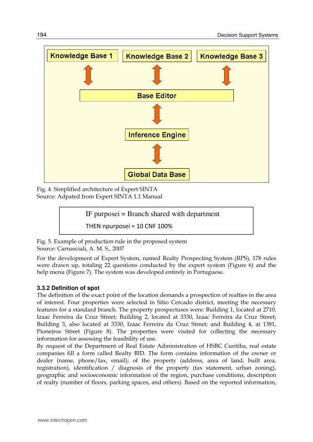
To manage the knowledge base, it was necessary to feed the system the following data: the variables (problems, factors that must be observed), the rules, the questions (interaction with the user's system specialist) and goals (the result of a query). A simplified architecture of Expert SINTO (Figure 4) is composed of:
• Knowledge: information (facts and rules) that the experts use;
• Base Editor: used for the implementation of the desired base;
• Inference Engine: sector of the ES responsible for deductions founded on the knowledge base;
• Global Database: evidences given by the user of ES during a consultation. Once Expert SINTA already has an inference engine the concern is focused only on the
representation of knowledge; the interprets this knowledge and runs it. The knowledge base
generated in this work contains a base of information on how to determine the best point for
the location of a new branch of HSBC Bank Brazil S/A. Menus were also prepared to help
with explanations on the question that is being made. HelpScribble 7.6.1 was used to
develop the Help menus.
The production rules used by Expert SINTA are a set of IF THEN rules, with the possibility of including logic connections to link the attributes in the scope of the database. An example is shown in Figure 5.
+
-
www.intechopen.com
Decision Support Systems
194
Fig. 4. Simplified architecture of Expert SINTA Source: Adpated from Expert SINTA 1.1 Manual
IF purposei = Branch shared with department
THEN npurposei = 10 CNF 100%
Fig. 5. Example of production rule in the proposed system Source: Carnasciali, A. M. S., 2007
For the development of Expert System, named Realty Prospecting System (RPS), 178 rules were drawn up, totaling 22 questions conducted by the expert system (Figure 6) and the help menu (Figure 7). The system was developed entirely in Portuguese.
3.3.2 Definition of spot The definition of the exact point of the location demands a prospection of realties in the area of interest. Four properties were selected in Sítio Cercado district, meeting the necessary features for a standard branch. The property prospectuses were: Building 1, located at 2710, Izaac Ferreira da Cruz Street; Building 2, located at 3330, Izaac Ferreira da Cruz Street; Building 3, also located at 3330, Izaac Ferreira da Cruz Street; and Building 4, at 1381, Pioneiros Street (Figure 8). The properties were visited for collecting the necessary information for assessing the feasibility of use. By request of the Department of Real Estate Administration of HSBC Curitiba, real estate companies fill a form called Realty BID. The form contains information of the owner or dealer (name, phone/fax, email); of the property (address, area of land, built area, registration), identification / diagnosis of the property (tax statement, urban zoning), geographic and socioeconomic information of the region, purchase conditions, description of realty (number of floors, parking spaces, and others). Based on the reported information,
www.intechopen.com

Spatial Decision Support System for Bank-Industry Based on GIS and Expert Systems Integration
195
Fig. 6. Screen on question to the expert Source: Carnasciali, A. M. S., 2007
Fig. 7. Help Menus Source: Carnasciali, A. M. S., 2007
www.intechopen.com

Decision Support Systems
196
Fig. 8. Location of prospected realties Source: Carnasciali, A. M. S., 2007
a pre-analysis, conducted by experts in Legal Matters, Maintenance, Fire & Safety, Trading, etc, is produced. In order to compare the used and proposed methods the author filled the forms of the selected properties. During this process the experts of the bank were asked to issue their opinions and justified them, listing the factors that influenced or assisted in their trial. The experts were also demanded to establish a ranking of the properties. Subsequently, the assessment was made using the Realty Prospecting System developed for the study.
3.4 Systems Integration The Realty Prospecting System for the Banking Sector (RPS) integrates GIS and the specific ES (Figure 9). The user, in this case the expert of HSBC, is questioned whether there is a previously defined region, if not he or she is instructed to select it in the GIS. Once the region is defined, the prospecting process starts.
Fig. 9. Realty Prospecting System for Bank Industry Source: Carnasciali, A. M. S., 2007
www.intechopen.com

Spatial Decision Support System for Bank-Industry Based on GIS and Expert Systems Integration
197
Later, the expert returns to RPS for selecting the best spot. At the end of the consultation of each property the system displays a score and its position in a raking of scores (Figure 10). Thus the system assists the expert in selecting the best spot. Microsoft Visual Basic 6.0 was chosen as tool for the development of the integration between the systems.
Fig. 10. Realty Prospecting System for Bank Industry Source: Carnasciali, A. M. S., 2007
4. Results
The forms filled by the experts and the correlate ones produced by RPS were compared, resulting some considerations. No expert considered all the variables that comprise the proposed system. It is important to emphasize that these variables they were defined by the experts as essential to the analysis, during the development. Just as an illustration of the importance of all variables in the analysis, we can mention that the variable access street/ building may indicate the need of construction work, which certainly will lead to an increase in costs and time. Only three variables, constructed area, access for people with disabilities mobility and price were considered by all experts, for at least one property. This shows that experts do not consider all the variables in the symbolic analysis either because some variables do not reflect their focuses or just by involuntary omission. All variables were considered qualitatively by three experts, a fact evidenced by the use of subjective terms and adjectives such as “desirable”, “above the desirable”, “well above the desirable level”, “below the desirable”, “excellent”, “good”, and others. Tabulation was made of a hierarchy of prospected properties based on the results presented
by the Realty Prospecting System the analysis of the experts, as shown in Table 3.
www.intechopen.com
Decision Support Systems
198
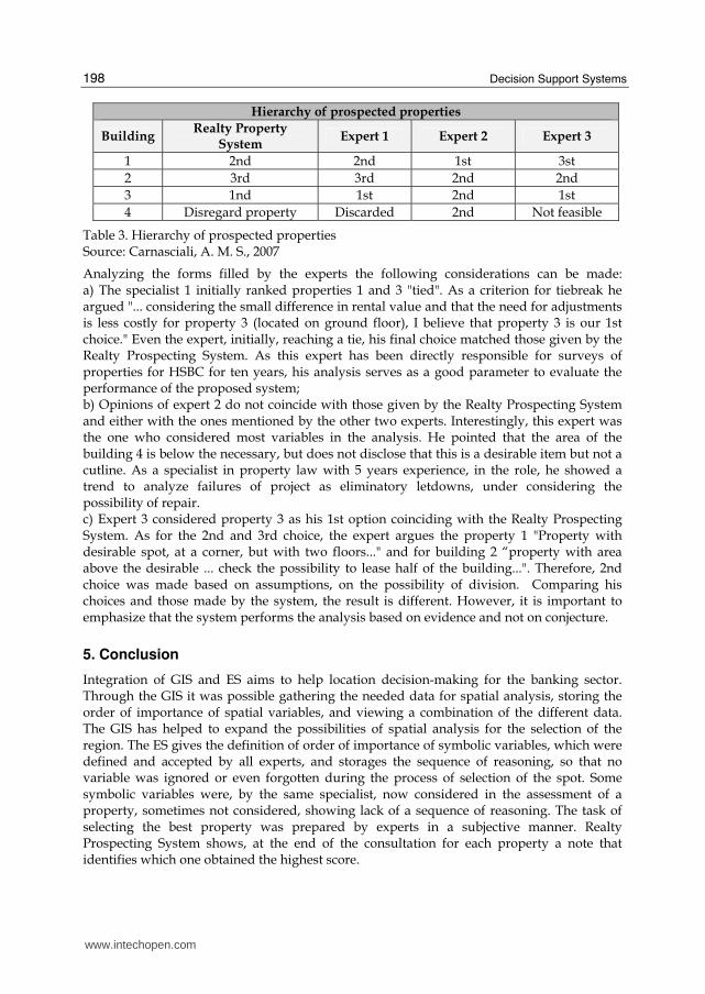
Hierarchy of prospected properties
Building Realty Property
System Expert 1 Expert 2 Expert 3
1 2nd 2nd 1st 3st
2 3rd 3rd 2nd 2nd
3 1nd 1st 2nd 1st
4 Disregard property Discarded 2nd Not feasible
Table 3. Hierarchy of prospected properties Source: Carnasciali, A. M. S., 2007
Analyzing the forms filled by the experts the following considerations can be made: a) The specialist 1 initially ranked properties 1 and 3 "tied". As a criterion for tiebreak he argued "... considering the small difference in rental value and that the need for adjustments is less costly for property 3 (located on ground floor), I believe that property 3 is our 1st choice." Even the expert, initially, reaching a tie, his final choice matched those given by the Realty Prospecting System. As this expert has been directly responsible for surveys of properties for HSBC for ten years, his analysis serves as a good parameter to evaluate the performance of the proposed system; b) Opinions of expert 2 do not coincide with those given by the Realty Prospecting System and either with the ones mentioned by the other two experts. Interestingly, this expert was the one who considered most variables in the analysis. He pointed that the area of the building 4 is below the necessary, but does not disclose that this is a desirable item but not a cutline. As a specialist in property law with 5 years experience, in the role, he showed a trend to analyze failures of project as eliminatory letdowns, under considering the possibility of repair. c) Expert 3 considered property 3 as his 1st option coinciding with the Realty Prospecting System. As for the 2nd and 3rd choice, the expert argues the property 1 "Property with desirable spot, at a corner, but with two floors..." and for building 2 “property with area above the desirable ... check the possibility to lease half of the building...". Therefore, 2nd choice was made based on assumptions, on the possibility of division. Comparing his choices and those made by the system, the result is different. However, it is important to emphasize that the system performs the analysis based on evidence and not on conjecture.
5. Conclusion
Integration of GIS and ES aims to help location decision-making for the banking sector. Through the GIS it was possible gathering the needed data for spatial analysis, storing the order of importance of spatial variables, and viewing a combination of the different data. The GIS has helped to expand the possibilities of spatial analysis for the selection of the region. The ES gives the definition of order of importance of symbolic variables, which were defined and accepted by all experts, and storages the sequence of reasoning, so that no variable was ignored or even forgotten during the process of selection of the spot. Some symbolic variables were, by the same specialist, now considered in the assessment of a property, sometimes not considered, showing lack of a sequence of reasoning. The task of selecting the best property was prepared by experts in a subjective manner. Realty Prospecting System shows, at the end of the consultation for each property a note that identifies which one obtained the highest score.
www.intechopen.com

Spatial Decision Support System for Bank-Industry Based on GIS and Expert Systems Integration
199
This work enables experts of Department of Real Estate Administration of HSBC Bank Brazil S/A - a comparison between the methods usually used and the integrated GIS and ES to help in location decision. According to the experts the use of the proposed system will benefit the professional involved with this task, providing technical bases for the analysis, and considering a large number of information necessary for the complete decision process, reducing potentially mistaken judgments, and the consequent risk of hiring buildings not suitable for the objectives outlined by the company. Suggestions for the continuation of this work are: a. Definition of areas of influence of the branches to identify possible blanks or overlaps in
services. This would therefore be another spatial variable to be considered assisting in the selection of the region. However, there may be difficulties in dealing with this variable once its configuration may require reserved data such as the addresses of customers of each branch;
b. Implementation of options for reports of analyzed data for each property, as well as for generating graphs for scores achieved by each property;
c. Implementation of a system of Technical, Legal and Location Conformity Assessment of bank branches by integrating Geographic Information System and Expert System.
An emphasized recommendation is for the knowledge base of the ES to be increased, receiving information concerning the documentation of the property, including: approved project, property taxes, real estate registration, among others. Information concerning the documentation of the property, once considered simultaneously with the market value, constructed area, number of floors and others, could serve to prevent the hiring of a non conform property.
6. Acknowledgment
To HSBC Bank Brazil S/A – Department of Real Estate Administration for collaboration in developing the work. To CAPES - Coordination for Improvement of Higher Education Personal - for granting the scholarship. To CNPq - National Counsel of Technological and Scientific Development - for granting the Research scholarship - Process 3088892/2008-9. To the Post Graduation Course in Geodesic Sciences of UFPR – The Federal University of Paraná – for financially supporting the publication.
7. References
Aronoff, S. (1989). Geographic information systems: a management perspective. WDL, ISBN: 0921804911, Ottawa.
Burrough, P.A. & Mcdonell, R. (1998). Principles of Geographical Information System for Land Resource Assessment. Claderon Press, Oxford. ISBN : 978-019823366, Oxford.
Carnasciali, A. M. S. (2007). Integração de sistemas de informações geográficas e sistema especialista visando auxiliar a tomada de decisão locacional do setor bancário. Dissertação (Mestrado em Ciências Geodésicas) – Universidade Federal do Paraná, Curitiba.
Eldrandaly, K., Eldin, N. & Sui, D. Z. (2003). A COM-based Spatial Decision Support System for Industrial Site Selection. Journal of Geographic Information and Decision Analysis. Vol. 7, No. 2, p. 72-92, ISSN: 1480-8943
www.intechopen.com

Decision Support Systems
200
Macdonald, M. L. (1996). A multi-attribute spatial decision support system for solid waste planning. Computers, Environment and Urban Systems. Vol. 20, No. 1, January 1996, p. 1-17, ISSN: 0198-971
Maguire, D.J. (1991). Geographical information systems : principles and applications. Longman Sci & Techn, ISBN: 0582056616, Harlow.
Rodriguez-Bachiller, A. & Glasson, J. (2004). Expert Systems and Geographical Information Systems for Impact Assessment. Taylor & Francis, ISBN: 0–415–30725–2, London.
Waterman, D. A. (1986). A Guide to Expert Systems. Addison-Wesley, ISBN: 0201083132, Canadá.
Zhu, X., & Aspinall, R. J. & Healey, R. G. (1996). ILUDSS: A knowledge-based system for strategic land-use planning. Computers and Electronics in Agriculture. .Vol. 15, No 4, October 1996, p. 279-301. ISSN: 0168-1699
www.intechopen.com

Decision Support SystemsEdited by Chiang S. Jao
ISBN 978-953-7619-64-0Hard cover, 406 pagesPublisher InTechPublished online 01, January, 2010Published in print edition January, 2010
InTech EuropeUniversity Campus STeP Ri Slavka Krautzeka 83/A 51000 Rijeka, Croatia Phone: +385 (51) 770 447 Fax: +385 (51) 686 166www.intechopen.com
InTech ChinaUnit 405, Office Block, Hotel Equatorial Shanghai No.65, Yan An Road (West), Shanghai, 200040, China
Phone: +86-21-62489820 Fax: +86-21-62489821
Decision support systems (DSS) have evolved over the past four decades from theoretical concepts into realworld computerized applications. DSS architecture contains three key components: knowledge base,computerized model, and user interface. DSS simulate cognitive decision-making functions of humans basedon artificial intelligence methodologies (including expert systems, data mining, machine learning,connectionism, logistical reasoning, etc.) in order to perform decision support functions. The applications ofDSS cover many domains, ranging from aviation monitoring, transportation safety, clinical diagnosis, weatherforecast, business management to internet search strategy. By combining knowledge bases with inferencerules, DSS are able to provide suggestions to end users to improve decisions and outcomes. This book iswritten as a textbook so that it can be used in formal courses examining decision support systems. It may beused by both undergraduate and graduate students from diverse computer-related fields. It will also be ofvalue to established professionals as a text for self-study or for reference.
How to referenceIn order to correctly reference this scholarly work, feel free to copy and paste the following:
Ana Maria Carnasciali and Luciene Delazari (2010). Spatial Decision Support System for Bank-Industry Basedon GIS and Expert Systems Integration, Decision Support Systems, Chiang S. Jao (Ed.), ISBN: 978-953-7619-64-0, InTech, Available from: http://www.intechopen.com/books/decision-support-systems/spatial-decision-support-system-for-bank-industry-based-on-gis-and-expert-systems-integration

© 2010 The Author(s). Licensee IntechOpen. This chapter is distributedunder the terms of the Creative Commons Attribution-NonCommercial-ShareAlike-3.0 License, which permits use, distribution and reproduction fornon-commercial purposes, provided the original is properly cited andderivative works building on this content are distributed under the samelicense.