Embed Size (px)
Citation preview
Socio-Economic Agricultural Plan for the Philippi Horticultural Area
Spatial Planning and Land Development Management Input
Socio-Economic Agricultural Plan for the Philippi Horticultural Area Spatial Planning Component
2
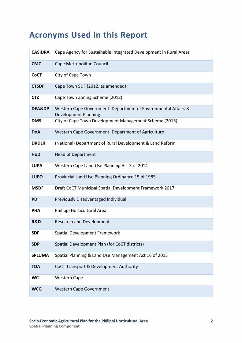
Acronyms Used in this Report
CASIDRA Cape Agency for Sustainable Integrated Development in Rural Areas
CMC Cape Metropolitan Council
CoCT City of Cape Town
CTSDF Cape Town SDF (2012, as amended)
CTZ Cape Town Zoning Scheme (2012)
DEA&DP Western Cape Government: Department of Environmental Affairs & Development Planning
DMS City of Cape Town Development Management Scheme (2015)
DoA Western Cape Government: Department of Agriculture
DRDLR (National) Department of Rural Development & Land Reform
HoD Head of Department
LUPA Western Cape Land Use Planning Act 3 of 2014
LUPO Provincial Land Use Planning Ordinance 15 of 1985
MSDF Draft CoCT Municipal Spatial Development Framework 2017
PDI Previously Disadvantaged Individual
PHA Philippi Horticultural Area
R&D Research and Development
SDF Spatial Development Framework
SDP Spatial Development Plan (for CoCT districts)
SPLUMA Spatial Planning & Land Use Management Act 16 of 2013
TDA CoCT Transport & Development Authority
WC Western Cape
WCG Western Cape Government

Socio-Economic Agricultural Plan for the Philippi Horticultural Area Spatial Planning Component
3
Contents 1 Introduction .................................................................................................................................... 1
1.1 This Report .............................................................................................................................. 1 1.2 Points of Departure ................................................................................................................. 1 1.3 Approach and Methodology ................................................................................................... 2 1.4 The Study Area ........................................................................................................................ 3
2 Spatial Planning & Land Use Management Assessment ................................................................. 5 2.1 Legislation and Policy Directives ............................................................................................. 5 2.2 Spatial Planning Instruments and Regulations ..................................................................... 15 2.3 Current Land Use and Trends ............................................................................................... 34
2.3.1 Overview of the PHA Land Use Make-Up ..................................................................... 34 2.3.2 Informal Settlement in the PHA Study Area ................................................................. 43 2.3.3 The PHA’s District- and Metro-Wide Spatial Linkages and Related Opportunities ...... 44 2.3.4 Conclusion: The Impact of Land Use Transformation on the PHA ................................ 46
2.4 Current Cadastre and Land Ownership Patterns .................................................................. 47 2.4.1 Survey Area ................................................................................................................... 47
2.5 Outcomes of Structured Interviews ...................................................................................... 51 2.5.1 Key Points from the Engagement with CoCT: TDA (Spatial Planning) .......................... 51 2.5.2 Key Points from the Engagement with CoCT: Directorate Informal Settlements......... 52 2.5.3 Key Points from the Engagement with CoCT: TDA (Land Development Management) 53 2.5.4 Key Points from the Engagement with WCG: DEA&DP ................................................ 54
3 Key Spatial Issues and Informants to the Socio-Economic Agricultural Plan ................................ 56 4 Spatial Proposals ........................................................................................................................... 59
4.1 Objectives of the Spatial Proposals ....................................................................................... 59 4.2 Defining the Spatial Components of the PHA ....................................................................... 59 4.3 Key Spatial Elements Requiring Development to Enhance the Functionality of the PHA .... 63 4.4 Implementing the Spatial Reservation of the PHA ............................................................... 67
Figures
Figure 1: PHA Study Area ........................................................................................................................ 4 Figure 2: 1967 Reservation of Land Area for Silica Sand and Horticulture ............................................. 9 Figure 3:PHA Area Definition per Cape Metropolitan Area Guide Plan, 1988 ....................................... 9 Figure 4: Urban Edges, Developed & Developable Land as at December 2016 ................................... 30 Figure 5:Draft CoCT MSDF map, 2017 .................................................................................................. 30 Figure 6:Agricultural Areas of Significance (CoCT Draft MSDF, 2017) .................................................. 31 Figure 7:Heritage Resources Map (CoCT Draft MSDF, 2017)................................................................ 31 Figure 8: Dominant Land Use Categories (Land Cover Data, 2014) ...................................................... 42 Figure 9:PHA Land Use (per reclassified Land Cover Data, 2014) ......................................................... 42 Figure 10: Configuration of Land Ownership in the PHA ...................................................................... 50 Figure 11: Spatial Proposals – PHA Spatial Components ...................................................................... 62 Figure 12: Proposed gateways to the PHA ............................................................................................ 65 Figure 13: Key Movement Routes and Linkages to/from the PHA ....................................................... 65 Figure 14:Facility and Community Resource Linkages Complementary to the PHA ............................ 66 Figure 15: District- and Metro-Wide Agri-Sector Linkages ................................................................... 66 Tables
Table 1: Breakdown of Land Use (ha) per Component Area of the PHA .............................................. 41
Socio-Economic Agricultural Plan for the Philippi Horticultural Area Spatial Planning Component
i
Executive Summary As part of a multi-disciplinary team led by Indego Consulting, charged with developing a Socio-Economic Plan for the Philippi Horticultural Area (PHA), Setplan Western Cape was requested to provide input and develop broad proposals with regard to relevant aspects of Spatial Planning, Land Use and Land Development Management in the study area.
Problem Statement In terms of spatial planning and land-use management guidelines affecting the PHA, the work set out herein indicates that a broadly-held and long-established policy consensus remains in place that the PHA is a unique area that should be retained for sand mining, horticulture and silica sand mining. This is so, notwithstanding the fact that this policy consensus has been undermined by inadequate policing of zoning scheme regulations that have resulted in an intrusion of non-conforming land uses in areas on the fringe of the PHA; the precedent-setting land development applications for the Oaklands Development in the south-eastern quadrant of the PHA in 2011; and amendments to the City of Cape Town’s SDF and urban edge in 2011 and 2014. In fact, a sequence of decisions since 1988 has led to a reduction in the core PHA footprint from around 3,186.54 ha to the present area (excluding currently functional horticultural areas that fall within amended urban edges) of around 1,884.80 ha: a loss of over 1,300 ha (a loss of just more than 40% of the 1988 land area over a period of almost 30 years). The above circumstances have led to: uncertainty of land owners and farmers regarding the future development path of the PHA; an increase in the land price differential between agri- and urban-development leading, in turn, to increasing speculation in land; threats to the integrity of the PHA land area and productive activities; safety and security pressures on horticultural activities from surrounding areas; an increase in the costs of doing business in order to manage risks; and uncertainty on the part of informal settlements located on the fringes of the PHA regarding long-term tenure security and socio-economic prospects. Such uncertainty persists with the current draft of the City of Cape Town’s Municipal Spatial Development Framework (MSDF, September 2017) as it sends mixed signals regarding the future protection of the PHA, containing as it does proposals variously flagging the PHA as a “Unique Case” requiring strategic decisions to guide its future development trajectory; illustrating it as an area of “Incremental Growth and Consolidation” whilst, in its Technical Appendices, also containing specific policies that mandate the continued protection of the PHA as an Agricultural Area of Significance.
The Importance of the PHA The Risks associated with the loss of the PHA agricultural footprint to-date as well as on-going erosion of the remaining 1884.80 ha through unchecked land use transformation (i.e. to urban uses) and formal conversion to non-agri land use (e.g. residential) include the following:
• Potential loss of irreplaceable areas of significant/ unique agricultural land, including the South-Western Quadrant, which is highly productive, all-year round soft-leaf vegetable growing area because of its favourable micro-climate and adequate groundwater resource quality and quantity.
• Threat to the Cape Town metropolitan region’s food security through loss of agricultural land not replicable elsewhere. Such land loss also contributing to Cape Town food insecurity, especially in the Khayelitsha-Cape Flats District, diminishing the PHA capability to provide affordable locally
Socio-Economic Agricultural Plan for the Philippi Horticultural Area Spatial Planning Component
ii
produced vegetables and the opportunity for community-based gardens to supplement household food baskets.
• Loss of a viable and sustainable platform for agrarian reform opportunities (subsistence and commercial growers) within all agri-commodity sectors (cultivation, agri-processing, transport, marketing, agri-business, etc.) given working farms and opportunities suited to current agrarian reform models and programmes (e.g. ownership, pro-active land acquisition, mentorship, research and development, agri-tourism).
• Jeopardizing of existing and emerging city, provincial and national “game changers” founded on agri-processing and export of agri-product to Africa and overseas markets (e.g. Project Khulisa) through the loss of an integral production component (i.e. the PHA) critical to such programmes (e.g. Philippi Fresh Produce Market, Philippi East/ Aerotropolis, Airport Industria, Joostebergvlakte Agri-Processing Platform, etc.).
• Loss of one of the last agri-working landscapes (i.e. cultural landscapes), with a heritage loss and impact on potential agri-tourism focussing on agrarian reform, food security and sustainability, and healthy living.
• Loss of opportunity for agri-/food production R&D, education in food security and nutrition, and organic food production within the City boundaries, highly accessible to all residents.
• Loss of an important open-space and corridor component within the city-wide open-space and biodiversity network.
Proposals In order to provide a spatially defined area within which development proposals can be made in terms of the Socio-Economic Agricultural Plan for the PHA, the Spatial Planning and Land Use /Land Development Management component identifies the following:
1. The proposed Spatial Components of the PHA; and
2. The Key Spatial Elements, the development and/or preservation of which are seen as essential to the future sustainable and efficient functioning of the PHA as an Agricultural Area of Significance.
The Spatial Components of the PHA
The following proposed Spatial Components of the PHA are based on a consideration of (i) current land uses in the study area as well as identified land use trends and issues; and (ii) legal and policy informants:
1. A Core Functional Horticultural Area comprising a total area of some 2,174.69 ha in extent where the prescribed preferred land use outcomes will be reinforced as sand and silica-sand mining and horticulture, being made up of:
a. The current remaining “Central” Horticultural Area (Area 1 on the map below) plus
b. The proposed reintegration of the area identified as the South-Western Quadrant (Area 2 on the map below).
Socio-Economic Agricultural Plan for the Philippi Horticultural Area Spatial Planning Component
iii
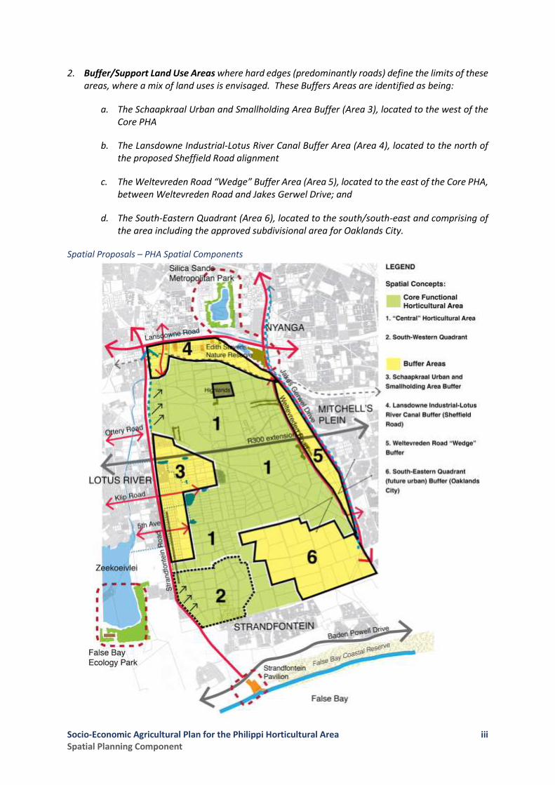
2. Buffer/Support Land Use Areas where hard edges (predominantly roads) define the limits of these areas, where a mix of land uses is envisaged. These Buffers Areas are identified as being:
a. The Schaapkraal Urban and Smallholding Area Buffer (Area 3), located to the west of the Core PHA
b. The Lansdowne Industrial-Lotus River Canal Buffer Area (Area 4), located to the north of the proposed Sheffield Road alignment
c. The Weltevreden Road “Wedge” Buffer Area (Area 5), located to the east of the Core PHA, between Weltevreden Road and Jakes Gerwel Drive; and
d. The South-Eastern Quadrant (Area 6), located to the south/south-east and comprising of the area including the approved subdivisional area for Oaklands City.
Spatial Proposals – PHA Spatial Components
Socio-Economic Agricultural Plan for the Philippi Horticultural Area Spatial Planning Component
iv
Key Spatial Elements Requiring Development to Enhance the Functionality of the PHA
The sustainability and functioning of the PHA and the development and ongoing management of its Buffer Areas to ensure support for the optimal performance of the predominant horticultural activity is seen as being dependent on the introduction and/or strengthening of the following spatial (urban design) elements as put forward in the 2012 Draft Urban Edge and Development Guidelines Study for the Schaapkraal Area and Environs (PHA) (CoCT, 2012):
1. Gateways: creating visible and easily accessible entry points to the PHA to improve and facilitate public access to enable the PHA to develop as a destination in future;
2. Movement Linkages: focusing on developing appropriate links to reintegrate the PHA with its surrounding Buffer Areas in order to redefine and reinforce the respective functional roles of these areas in relation to each other;
3. Developing or Improving Complementary Facility and Resource Linkages: developing pathways to link higher order metropolitan environmental and recreation facilities/resources, several of which are currently underutilized, through the PHA and Schaapkraal could reinforce the study area as a metro-scale eco-environmental and recreational destination;
4. District and Metro-scale Agri-Sector Linkages: referring to strengthening existing, and developing new linkages to regional and metro-wide agri-production, processing, packaging, marketing and distribution destinations, hubs and platforms; and
5. Urban Horticulture Edges: In order to effectively limit urban transformation and non-agricultural land uses within the horticultural area, and optimise the role of the Buffer Areas in securing the horticultural area, clear transitions and edges between the urban areas and horticultural activities are required. To be effective, such edges must not only clearly define the boundary, but reflect a strong defensible space/ element, including a major roadway, canal, NMT route, or dominant land use (e.g. school, sporting facility or protected natural area such as a Critical Biodiversity Area [CBA]) etc.
Land Use Within the Spatial Components
The effective and sustainable implementation of the Socio-Economic Agricultural Plan for the Philippi Horticultural area requires the support and maintenance of a range of land uses to ensure economic diversity within the Core Horticultural Area and the effective functioning of the Buffer Support Areas. Accordingly, the following is proposed:
1. The Core Functional Horticultural Area be retained under the CoCT Development Management Scheme’s (DMS MPB-L:2015) Agricultural Zoning which “promotes and protects agriculture on farms as an important economic, environmental and cultural resource. Limited provision is made for non-agricultural uses to provide owners with an opportunity to increase the economic potential of their properties, without causing a significant negative impact on the primary agricultural resource”. In addition, Overlay Zonings should be made applicable to give effect to the PHA’s status as an Agricultural Area of Significance and a Heritage Resource area.
2. The Buffer Areas being zoned to permit uses that are identified as being supportive of the Core Functional Horticultural Area, including business, residential, community facilities (e.g. guesthouses, B&B’s, farm-stays, agri-and enviro-education facilities), home industry (e.g.

Socio-Economic Agricultural Plan for the Philippi Horticultural Area Spatial Planning Component
v
vegetable preserving, pickling and processing), and non-noxious light and general industry (e.g. vegetable packaging, processing and agri-requisite suppliers).
Application and Enforcement of Other Relevant Legislation
In addition to the above, the sustainable use of agricultural and natural resources within both the Core Functional Horticultural Area and its Buffer Areas requires the following:
• The strict application of the Regulations made in terms of the National Environmental Management Act (NEMA, Act 107 of 1998, as amended) when listed activities are triggered requiring environmental authorisation (i.e. for existing and proposed activities);
• The NEMA Waste Act (Act 59 of 2008) with regard to preventing the contamination or potential contamination of land, control of emergency incidents leading to pollution and remediation of contaminated land (e.g. building rubble sites); and
• The National Water Act (Act 36 of 1998) regarding verification of water rights, requirement for Water Use Licences, and the control and management of waste water quality and discharge, etc.
In the above regard, it is crucial that the rigorous application of the NEMA Regulations as well as the CoCT DMS in line with the applicable Zoning of land parcels and the policing of permitted land uses and the development rules pertaining to such Zoning categories be carried out on a sustained basis by the CoCT and/or any other agency so authorized in terms of assigned functional competencies and responsibilities for environmental and/or land use and land development management.
Structure of the Report This report is structured as follows: -
Section 1 Sets out the background to this report and establishes the Points of Departure and the Study Area
Section 2 Sets out the findings of the Spatial Planning and Land Development Management Status Quo Assessment and related investigations carried out
Section 3 Highlights the key Spatial Informants derived from the Status Quo Assessment work
Section 4 Sets out the proposals of the Spatial Planning and Land Development Management study as well as key recommendations flowing therefrom.

Socio-Economic Agricultural Plan for the Philippi Horticultural Area Spatial Planning Component
1
1 Introduction
Following due process, Indego Consulting were appointed by the Western Cape Government: Department of Agriculture in July 2017 to lead a team of specialists in developing a Socio-Economic Agricultural Plan for the Philippi Horticultural Area (PHA), which is located on the Cape Flats, within the jurisdiction of the City of Cape Town (CoCT).
1.1 This Report
As part of the multi-disciplinary team led by Indego Consulting, Setplan’s brief was to provide input and develop relevant proposals with regard to Spatial Planning and Land Use/Land Development Management in the PHA. In this regard, the following specific outcomes were sought: -
1. An understanding of the current mix of land ownership (i.e. state-owned, privately owned, other etc.);
2. Proposals regarding the optimal utilisation of available land in the PHA, within the scope of the SDF of the City of Cape Town and the regulatory prescripts and directives applicable to the Land Use Management Framework;
3. From a spatial planning and land development management perspective, proposals on the possibility of creating a “buffer zone” around the PHA, including the development of specialised industries and other activities compatible with agriculture as job creation opportunities for the surrounding communities;
4. From a strategic spatial development perspective, identify opportunities and/or potential spatial linkages to other economic catalytic projects, including the integration of primary and secondary agricultural opportunities, and relate these to the potential role to be played by the PHA in this regard; and
5. Propose specific and practical land development management recommendations to secure a core area or “footprint” for the PHA.
1.2 Points of Departure
Since its designation for horticultural use, mining and beneficiation of silica in terms of the Physical Planning Act (Act 88 of 1967) and subsequent boundary amendments as per the Cape Metropolitan Area Guide Plan; Volume 1: Peninsula (1988) and numerous iterations of spatial plans, to date, the area known as the Philippi Horticultural Area (PHA) has been subject to a range of pressures for land use transformation, particularly in its outer fringe areas. As a consequence of this – and in recognition of its unique status as a high-productive sand mining and horticultural area of great significance to the economy of the greater Cape Town area – the PHA has been the subject of a number of studies looking at elements such as the area’s spatial, socio-cultural, heritage, environmental and agricultural dimensions. Where these previous studies have application and relevance to the spatial planning and land use management focus of this report, they have been referenced, built upon and, where warranted, incorporated into the work done herein.

Socio-Economic Agricultural Plan for the Philippi Horticultural Area Spatial Planning Component
2
This is especially the case with the following: -
1. Work done previously on identifying the application of past legislation and spatial planning policies to the PHA;
2. Informants as regards a western urban edge definition for the PHA drawn from the draft report
entitled “Development Guidelines Study for the Schaapkraal Area and Environsin the Philippi Horticultural Area” (iKapa et al, May 2013).
3. Information relating to recent and current land development applications that have had – or may have – a material effect on the definition of an outer edge for a functional core PHA; and
4. The current Cape Town City SDF (CSDF, 2012) and the present Urban Edge definitions relevant to the PHA.
In addition, two unresolved factors that may yet impact on how the Spatial Planning and Land Development aspects relating to the PHA are best dealt with are noted as: -
1. At the time of writing, the CoCT is reviewing comments made on its Draft Municipal SDF (MSDF, 2017). Whilst that draft document has also been taken into account in the work done on the spatial planning and land use management component of the Socio-Economic Agricultural Plan, it must be noted that the provisions set out in the draft document may be refined and/or amended, subject to decisions taken with regard to comments received; and
2. Finally, it should also be noted that, whilst a number of landmark decisions have been made regarding land development approvals and urban edge amendments affecting the PHA, particularly since 2009, it is understood that some of these decisions are currently subject to challenge and, potentially, review, following legal actions instituted by the PHA Food and Farming Campaign and Mr N. Sonday (First and Second Applicants, respectively) on 17 September 2017.
The above factors do render the terrain for the spatial planning and land use management component of the Plan dynamic and, potentially, subject to change.
1.3 Approach and Methodology
Accepting the above, our approach to the tasks at hand has been to maintain a focused and targeted issues-based approach aimed at the following: -
1. Defining a functional and sustainable PHA Core Area to serve as the minimum footprint for horticultural and allied activities to be identified in the Socio-Economic Agricultural Plan;
2. Identifying hard edges or other elements of the built environment to best define the outer limits of the PHA Core Area; and
3. Determining a way to secure legally the long-term integrity of the PHA Core Area by recourse to available statutory planning instruments.
Socio-Economic Agricultural Plan for the Philippi Horticultural Area Spatial Planning Component
3
The methodology adopted for the spatial planning and land use management component of the Plan was as follows: -
• In the first instance, a Desk-Top review was undertaken of relevant documentation setting out previous work on the PHA;
• Initial land use assessments were based on March 2017 high-resolution aerial photography allied with the latest available Land Cover Datasets (2014);
• This work was subject to in-field verification over the period July to September 2017;
• Land ownership data was assembled from the latest available datasets accessible to the Team in order to determine patterns of land ownership (private vs state or municipal-owned land);
• Primary data was obtained via a series of structured interviews with officials representing the following institutions: -
o The City of Cape Town
▪ Transport & Development Authority: Spatial Planning on 28 August 2017
▪ Directorate: Informal Settlements and Backyarders on 1 September 2017
▪ Transport & Development Authority: Land Development Management on 12 September 2017
▪ Directorate: Informal Settlements and Backyarders on 5 October 2017
o The WCG: Department of Environmental Affairs and Development Planning
▪ Introductory meeting with all relevant Directorates on 31 August 2017
▪ Follow-up meeting with Directorate: Spatial Planning on 18 September 2017
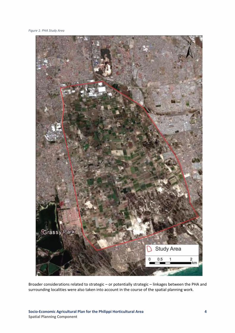
1.4 The Study Area
Notwithstanding the reductions to the spatial extent of the PHA effected over time by land development decisions, the study area for the spatial planning and land use management component of the project is based on the original extent of the PHA as defined in the Metropolitan Peninsula Guide Plan 1988, as illustrated below in Figure 1. The focus of the work done has been on the area delineated by the following features: -
• To the north by Govan Mbeki Road (M9)
• To the west by Strandfontein Road (M17)
• To the east by Jakes Gerwel Drive (M7)
• To the south by the urban township of Strandfontein and the southern cadastral boundaries of the properties described as Remaining Extent of Farm 648, Remaining Extent of Farm 650, and Farms 651 and 652 Schaap Kraal.
Socio-Economic Agricultural Plan for the Philippi Horticultural Area Spatial Planning Component
4
Figure 1: PHA Study Area
Broader considerations related to strategic – or potentially strategic – linkages between the PHA and surrounding localities were also taken into account in the course of the spatial planning work.
Socio-Economic Agricultural Plan for the Philippi Horticultural Area Spatial Planning Component
5
2 Spatial Planning & Land Use Management Assessment
The following sections set out the key findings and related informants for spatial planning and land use (incorporating land development) management in the PHA, stemming from the following aspects considered: -
1. Legislation and/or Policy Directives, which are held either to be of application to the PHA (in the past or currently) and may have had (or may still have) a role to play in how spatial planning and land use management is to be applied in the study area;
2. Spatial Planning and Land Use Management Instruments, taken as those planning documents that have applied to the PHA in the past or apply currently, and have a bearing on how land use and land development processes have been (or currently are being) managed there;
3. An assessment of the current land use pattern in the PHA, together with a consideration of the most notable land use trends in the study area, or impacting on it, at present;
4. A broad-stroke analysis of land ownership patterns in the PHA, together with an assessment of the current cadastre; and
5. Key issues raised by stakeholders with whom the spatial planning team have interacted in the course of this assignment.
2.1 Legislation and Policy Directives
The report sets out below the key legislation and policy directives that have (or have had) the following applications in the PHA:
• The protection and/or reservation of the area.
• Land use prescription within the area.
• Defining the extent of the area.
• Fixing of a development edge peripheral to the area
Socio-Economic Agricultural Plan for the Philippi Horticultural Area Spatial Planning Component
6
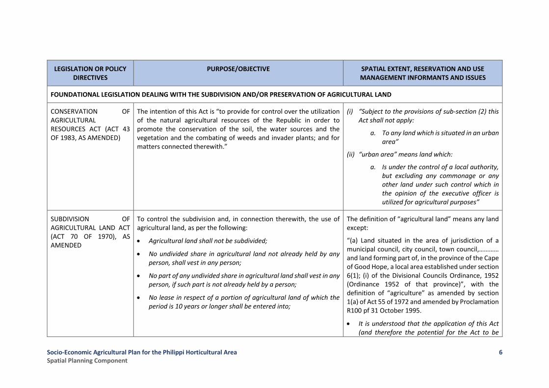
LEGISLATION OR POLICY DIRECTIVES
PURPOSE/OBJECTIVE SPATIAL EXTENT, RESERVATION AND USE MANAGEMENT INFORMANTS AND ISSUES
FOUNDATIONAL LEGISLATION DEALING WITH THE SUBDIVISION AND/OR PRESERVATION OF AGRICULTURAL LAND
CONSERVATION OF AGRICULTURAL RESOURCES ACT (ACT 43 OF 1983, AS AMENDED)
The intention of this Act is “to provide for control over the utilization of the natural agricultural resources of the Republic in order to promote the conservation of the soil, the water sources and the vegetation and the combating of weeds and invader plants; and for matters connected therewith.”
(i) “Subject to the provisions of sub-section (2) this Act shall not apply:
a. To any land which is situated in an urban area”
(ii) “urban area” means land which:
a. Is under the control of a local authority, but excluding any commonage or any other land under such control which in the opinion of the executive officer is utilized for agricultural purposes”
SUBDIVISION OF AGRICULTURAL LAND ACT (ACT 70 OF 1970), AS AMENDED
To control the subdivision and, in connection therewith, the use of agricultural land, as per the following:
• Agricultural land shall not be subdivided;
• No undivided share in agricultural land not already held by any person, shall vest in any person;
• No part of any undivided share in agricultural land shall vest in any person, if such part is not already held by a person;
• No lease in respect of a portion of agricultural land of which the period is 10 years or longer shall be entered into;
The definition of “agricultural land” means any land except:
“(a) Land situated in the area of jurisdiction of a municipal council, city council, town council,………… and land forming part of, in the province of the Cape of Good Hope, a local area established under section 6(1); (i) of the Divisional Councils Ordinance, 1952 (Ordinance 1952 of that province)”, with the definition of “agriculture” as amended by section 1(a) of Act 55 of 1972 and amended by Proclamation R100 pf 31 October 1995.
• It is understood that the application of this Act (and therefore the potential for the Act to be
Socio-Economic Agricultural Plan for the Philippi Horticultural Area Spatial Planning Component
7
LEGISLATION OR POLICY DIRECTIVES
PURPOSE/OBJECTIVE SPATIAL EXTENT, RESERVATION AND USE MANAGEMENT INFORMANTS AND ISSUES
• No portion of agricultural land, whether surveyed or not, and whether there is any building thereon or not, shall be sold or advertised for sale;
• No right to such portion shall be sold or granted for a period of more than 10 years;
• No area of jurisdiction, (local area, development area, peri-urban area or other area) shall be established on, or enlarged so as to include, any land which is agricultural land.
applied and to restrict land use change/transformation in the PHA) is a technical issue that appears to be under further investigation at the moment due to pending legal action being brought by the PHA Food Campaign and others.
• However, the consensus view amongst spatial planners in DEA&DP (Province) and CoCT is that Act 70 of 1970 does not (and did not ever) apply to the PHA in its entirety.
• Should this view be found to be incorrect in full or in part as a result of the legal action now underway, this might call into question the legal status of decisions taken in regard to land development applications and urban edge amendments that resulted in the loss of land previously reserved for horticulture (agriculture) in the PHA.
Note also: the pending promulgation of the “Preservation and Development of Agriculture Land Act”
Socio-Economic Agricultural Plan for the Philippi Horticultural Area Spatial Planning Component
8
LEGISLATION OR POLICY DIRECTIVES
PURPOSE/OBJECTIVE SPATIAL EXTENT, RESERVATION AND USE MANAGEMENT INFORMANTS AND ISSUES
LEGISLATION DEALING WITH THE RESERVATION/ PROCLAMATION OF THE PHILIPPI HORTICULTURAL AREA AND SILICA DEPOSIT AREA
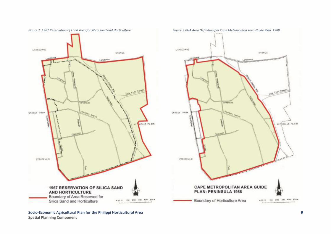
GOVERNMENT GAZETTE OF 4 OCTOBER 1968 (NOTICE 1760): PROTECTION OF CERTAIN LAND USES IN THE PHILIPPI HORTICULTURAL AND SILICA AREA IN TERMS OF ARTICLE 4 (1) OF THE PHYSICAL PLANNING ACT (ACT 88 OF 1967)
Declare that in the Philippi area land may only be used for the purpose of horticulture and/ or mining and beneficiation of silica. Purpose of reservation was to protect/ conserve the high potential for agriculture, as well as the high quality of glass-sand deposits, and to ensure land use in the area does not interfere with such purpose.
Refer to Figure 2
CAPE METROPOLITAN AREA GUIDE PLAN; VOLUME 1: PENINSULA (1988) COMPILED IN TERMS OF SECTION 6A OF THE PHYSICAL PLANNING ACT, 1967 (ACT 88 OF 1967)
The existing “double reservation” of the Philippi area repealed and replaced with a proclamation reserving the area for “horticultural purposes” only (i.e. together with silica exploitation and dune sand removal, the latter only to be removed to the general surface of the land).
• The Guide Plan (1988) puts forward the reservation of the Philippi Horticultural Area as per Figure 3
Socio-Economic Agricultural Plan for the Philippi Horticultural Area Spatial Planning Component
9
Figure 2: 1967 Reservation of Land Area for Silica Sand and Horticulture
Figure 3:PHA Area Definition per Cape Metropolitan Area Guide Plan, 1988

Socio-Economic Agricultural Plan for the Philippi Horticultural Area Spatial Planning Component
10
LEGISLATION OR POLICY DIRECTIVES
PURPOSE/OBJECTIVE SPATIAL EXTENT, RESERVATION AND USE MANAGEMENT INFORMANTS AND ISSUES
GOVERNMENT PROCLAMATION OF 1989
Proclamation served to reduce the extent of the PHA by reducing the area fixed by the Guide Plan in 1988, with the following being excluded:
• Land between Vlei and Boom Roads, north of Olieboom and south of Ottery Road;
• Area east of Strandfontein Road and north of New Ottery Road, extending up to Lansdowne Road; and
• Land south of 18th Avenue, including Erven 572 and 1932.
• Continued erosion of the PHA through boundary adjustments.
• Recognition of non-agri land use intrusion between Vlei and Boom Roads, with such area being withdrawn from the horticultural area and included in the Schaapkraal Smallholdings area.
PHYSICAL PLANNING ACT (ACT 125 OF 1991)
The promulgation of this Act had the following implications for the PHA:
• Need to obtain permits for the removal of sand abolished from January 1992;
• In terms of a transitional clause, Guide Plans would remain in place until converted into or replaced by an urban structure plan. Accordingly, land owners still had to make application to the relevant authorities for mining and land use rights (i.e. LUPO application); and
• The horticulture proclamation protecting the PHA was abolished.
The latter initiated the following to dispel uncertainty of the PHA:
• Proposed declaration of the PHA as a “Special Area” was put forward and approved by the Cape Rural Council of the former
• The need for hard and clearly defined edges was recognised.
• Value of horticultural area realized, despite intrusion of “non-agricultural” uses, with horticultural area expanded despite previous proclamation.
• Need for reservation of PHA to protect horticultural area and sand resources.
• Recognition of the negative impact of mixed agricultural uses (e.g. piggery, composting) on horticultural activity performance.
• Fixing the extent of the Schaapkraal Smallholding area.
Socio-Economic Agricultural Plan for the Philippi Horticultural Area Spatial Planning Component
11
LEGISLATION OR POLICY DIRECTIVES
PURPOSE/OBJECTIVE SPATIAL EXTENT, RESERVATION AND USE MANAGEMENT INFORMANTS AND ISSUES
Western Cape Regional Services Council in 1992. Proposals included the following:
o Boundary of Philippi Special Area to revert to the former Guide Plan Area, including the area between Vlei and Boom Roads;
o Northern “hard edge” to prevent urban encroachment to include a proposed industrial area between Lansdowne and Sheffield Roads (i.e. proposed);
o No further subdivision in the PHA, except for in the Schaapkraal Smallholdings, which forms a transitional zone between urban and horticulture;
o Entire area be zoned for “Rural Use” and predominant use to remain horticultural;
o No new applications for equestrian activities be approved, with restrictions on expansion. Only a maximum of 4 horses per ha allowed per property;
o No compost manufacturing be permitted in the Special Area, only in the Schaapkraal Smallholdings west of Vlei Road;
o No pig, poultry or dog-breeding to be permitted; and
o Vegetable packaging facilities to require CMC approval.
• The area north of 3rd Avenue (i.e. Schaapkraal Estate) was excluded in terms of a 1916 General Plan permitting the subdivision of 164 erven (± 495m² in extent).

Socio-Economic Agricultural Plan for the Philippi Horticultural Area Spatial Planning Component
12
LEGISLATION OR POLICY DIRECTIVES
PURPOSE/OBJECTIVE SPATIAL EXTENT, RESERVATION AND USE MANAGEMENT INFORMANTS AND ISSUES
WESTERN CAPE LAND USE PLANNING ACT (ACT 3 OF 2014)
This Provincial Act (LUPA) follows the promulgation of the national Spatial Planning and Land Use Management Act (Act 16 of 2013 aka SPLUMA) and is intended to consolidate legislation in the WC relating to a range of spatial planning and land use management activities.
Amongst its objects are to “…provide for minimum norms and standards for effective municipal development management”; “… to regulate the effect of land development on agriculture”; and “… to provide for land use planning principles…”
With regard to LUPA’s object to regulate the effect of land development on agriculture, there are two relevant sections of the Act: Section 45, which, in terms of subsection (c) requires a municipality to refer any land development application that proposes the rezoning of land currently zoned for agricultural purposes for comment by the Head of Department of the Department of Environmental Affairs and Development Planning (DEA&DP); and Section 53, which in terms of subsection (1)(c) provides that any land development that would have a “substantial effect” on “agriculture” needs to be approved in terms of an application made in the first instance to the HoD of DEA&DP.
The precise application of these sections of LUPA is currently under consideration by the Province but, in the interim, the Regulations made in terms of LUPA (see below) have provided a definition of when an application in terms of Section 53 is required.
Moreover, it should be noted that the provisions of Section 53(3)(a-d) allow for instances where the Provincial Minister may exempt categories of land development from requiring approval in terms of Section 53(1). These instances include where such land development is in line with an approved Municipal SDF and/or when provincial
• The provisions made in Section 53 of LUPA appear to have potentially positive implications for the level of “protection” that could be afforded the current zoning of agricultural land in the PHA in terms of LUPA.
• Moreover, the LUPA Land Use Principles (and the SPLUMA Development Principles) could well be used to motivate in support of the retention of a core area of the PHA to be preserved for horticultural purposes as this would align with and promote the following SPLUMA and LUPA Principles:
o The reservation/ designation of the PHA contributes to addressing past spatial injustice through improving access to new farmers (i.e. PDIs).
o While agri-resource use is not entirely sustainable, the unlocking of the latent benefit and synergy vested in the agri-resource through food security, job creation, food production and innovation, providing open/ green space, training and education contributes to spatial sustainability.
o The location of the PHA relative to the proximity of its product use (metro-Cape Town) ensures efficiency through reduced transport cost and reducing
Socio-Economic Agricultural Plan for the Philippi Horticultural Area Spatial Planning Component
13
LEGISLATION OR POLICY DIRECTIVES
PURPOSE/OBJECTIVE SPATIAL EXTENT, RESERVATION AND USE MANAGEMENT INFORMANTS AND ISSUES
approval for the land development was granted in terms of other legislation.
Moreover, Section 53(4) allows for the Provincial Minister also to, by notice in the Provincial gazette, issue guidelines to provide for categories of land development contemplated in Section 53(1).
Finally, it is noted that the LUPA Land Use Planning Principles (Section 59 of LUPA), these are in line with and almost akin to the “Development Principles on spatial planning, land development and land use management” in Section 7 of SPLUMA.
•
impact (i.e. maintenance and public road safety), increasing the product shelf life and limiting the carbon footprint (refrigerated storage and transport).
o The resource availability (soil, water) and unique vegetable growing micro-climate mitigate against climate change improving spatial resilience through ensuring improved sustainable community livelihoods and addressing the impact of environmental shocks (e.g. climate change) on its communities.
o Sustained protection of the environment; through the agri-production having regard for remaining natural habitats and systems and cultural resources, together with regular monitoring and remediation of impact on natural resources in order to limit any “legacy costs”.
o Realising the economic potential of the area; through a phased PHA development approach, initially allowing for construction sand removal, a critical urban development resource, followed by horticultural production through harnessing the unique agri-production resources for intensive/ high
Socio-Economic Agricultural Plan for the Philippi Horticultural Area Spatial Planning Component
14
LEGISLATION OR POLICY DIRECTIVES
PURPOSE/OBJECTIVE SPATIAL EXTENT, RESERVATION AND USE MANAGEMENT INFORMANTS AND ISSUES
volume vegetable production in close proximity to a metropolitan consumer market, all permitting the later exploitation of subsurface silica deposits, a high value domestic and export product.
WESTERN CAPE LAND USE PLANNING REGULATIONS, 2015
The Western Cape Land Use Planning Regulations (Provincial Notice 203 of 2015) were made in terms of Section 76 of LUPA and, under Section 10(1) of the Regulations, provide that an application must be made to the HoD of DEA&DP in respect of any land development that is “proposed on agricultural land that has been cultivated or irrigated during the 10-year period immediately preceding the proposed land
development”.
• As noted above, this potentially wide-ranging provision/interpretation of the application of Section 53(1) of LUPA is currently subject to further consideration and, potentially, refinement.
• Nevertheless, in the interim, it may be taken that the provisions of Section 53(1) read with Section 10(1) of the Land Use Planning Regulations offer some form of recourse to Provincial oversight regarding any future non-agricultural land development in the PHA.

Socio-Economic Agricultural Plan for the Philippi Horticultural Area Spatial Planning Component
15
LEGISLATION OR POLICY DIRECTIVES
PURPOSE/OBJECTIVE SPATIAL EXTENT, RESERVATION AND USE MANAGEMENT INFORMANTS AND ISSUES
POLICY
PROVINCE OF THE WESTERN CAPE: POLICY FOR THE ESTABLISHMENT OF AGRICULTURAL HOLDINGS IN THE URBAN FRINGE (2000)
To create opportunities for aspirant farmers to access land and develop agricultural holdings in the urban fringe and achieve land reform.
• Need to restrict settlement rights on agricultural holdings in line with those applicable to agricultural land in rural areas.
• Agri-holdings should preferably be project-based in order for agri-holding beneficiaries to benefit from combined Agri-Resources (e.g. irrigation, farm extension services and marketing channels).
2.2 Spatial Planning Instruments and Regulations
The following statutory prescriptions, regulations and guidelines have in the past and currently prescribe land use development and management within the PHA, especially insofar the extent of such area, sub-division policy and non-agricultural activities permitted, as well as the fixing of a development edge.
POLICY, PLAN OR GUIDELINE
STRATEGY, GUIDELINE OR FINDINGS SPATIAL EXTENT, RESERVATION AND USE MANAGEMENT INFORMANTS AND ISSUES
URBAN STRUCTURE PLANS, SPATIAL DEVELOPMENT FRAMEWORK, DISTRICT AND LOCAL PLANS
CAPE METROPOLITAN GUIDE PLAN VOLUME 1: PENINSULA (1988)
The Guide Plan, later approved as an Urban Structure Plan in terms of the provincial Land Use Planning Ordinance (LUPO, 1985), puts forward the repealing of the “double reservation” and a proclamation reserving a smaller area
• Applications for land use change only to be considered in highly exceptional circumstances.
• Removal of building sand only permitted where such removal will contribute to the development of cultivatable land (i.e. levelling of dunes to 1,0m above the winter water table).
Socio-Economic Agricultural Plan for the Philippi Horticultural Area Spatial Planning Component
16
POLICY, PLAN OR GUIDELINE
STRATEGY, GUIDELINE OR FINDINGS SPATIAL EXTENT, RESERVATION AND USE MANAGEMENT INFORMANTS AND ISSUES
(refer Figure 3) (i.e. opposed to proclamation area (refer Figure 2) in terms of Act 88 of 1967) for the following:
• Horticultural purposes (i.e. “cultivation of vegetables, fruit, cut flowers and ornamental shrubs, for which a certain soil/water/climate relationship is required”);
• Smallholdings within two strips of land along Strandfontein and Lansdowne Roads respectively; and
• Silica sand deposits.
LANSDOWNE ROAD – PHILIPPI LOCAL STRUCTURE PLAN
This Plan put forward land uses for the area bounded by Lansdowne Road in the north and the proposed Sheffield Road alignment in the south, extending between Strandfontein Road in the west and the Mitchells Plain – Khayelitsha railway line in the east.
Areas directly abutting the PHA are designated for “General Industrial”.
• Provides a clearly delineated hard edge to the PHA, preventing future urban encroachment from the north.
METRO SOUTH-EAST PLAN: THE FUTURE OF THE PHILIPPI HORTICULTURAL AREA, 1997 (adopted by Cape Metropolitan Council in 1997)
Given the Philippi Horticultural Area (PHA) being under urbanization threat the Plan had as its objective the following:
• Gather information to inform future uses within the PHA;
• Identify issues that will impact on agricultural, amenity or urban future of the PHA;
• Determine conditions under which the PHA should be retained for agriculture or be developed; and
• Danger of the PHA being urbanized in a piece-meal fashion which will fail to create a satisfactory urban environment, while effectively destroying the long-term agricultural viability of the area.
• PHA is facing increasing urbanization and erosional pressures from within and along its borders by illegal and undesirable land uses.
• Characteristics observed in the PHA, including part-time farming, absentee landlords, underutilized agricultural land
Socio-Economic Agricultural Plan for the Philippi Horticultural Area Spatial Planning Component
17
POLICY, PLAN OR GUIDELINE
STRATEGY, GUIDELINE OR FINDINGS SPATIAL EXTENT, RESERVATION AND USE MANAGEMENT INFORMANTS AND ISSUES
• Suggest a possible interim management action.
The plan puts forward the following scenarios for the development of the PHA:
• An urban future, through creating a housing estate with up to 140 000 dwelling units;
• A mixed “green future” in which urban, recreational and agricultural as opposed to horticultural uses co-exist; and
• A horticultural future through maintaining the status quo.
The latter two options call for the fixing of an urban edge, with the following land use management actions being required:
• Legal protection of the PHA from urbanization and instituting “right to farm” legislation; and
• Stricter control over non-conforming uses within the PHA and the Schaapkraal smallholding area.
and a reduction in capital investment, being common signals marking the anticipation of urban development.
• A complex set of interacting factors underlies the change in the attitude of farmers and structure of farming brought about by anticipated urbanization. These include the following:
• Rise in land value, private land-banking, speculation, proliferation of incompatible land uses and underutilized farmland, together with a lack of effective land use management; and
• Loss of political, economic and social status of the farming community due to competition with and being outnumbered by persons/groups with different economic and political interests (i.e. industrial job creation and housing given proximity of PHA to urban opportunities). Such loss of status can seriously diminish the ability of farmers to collectively preserve their farmland, even if they are economically viable and successful. Such altitudinal change is further influenced by increasing environmental impacts on farming (e.g. air pollution), capital and income leakage through infrastructure vandalism and product theft and better prospects for farmers in other agricultural areas and farmworkers in the urban environment (e.g. industrial).
PHILIPPI HORTICULTURAL AREA MANAGEMENT PLAN, 2000 (prepared for the City of Cape Town)
The Management Plan had as its purpose the addressing of the current management issues through putting in place short-term management actions required as well as establishing the basis for longer-term sustainable PHA
• Significance and uniqueness of the PHA requires management measures in both the short and long-term to improve and manage this fast-declining metropolitan asset and resource.
• Need for proclamation of the PHA insofar protection of the silica sand resource and horticultural land use.

Socio-Economic Agricultural Plan for the Philippi Horticultural Area Spatial Planning Component
18
POLICY, PLAN OR GUIDELINE
STRATEGY, GUIDELINE OR FINDINGS SPATIAL EXTENT, RESERVATION AND USE MANAGEMENT INFORMANTS AND ISSUES
management vested in “local” management tools (i.e. community-based).
• Need for the establishment and maintenance of a functional PHA interface (i.e. through built structures or functional land uses).
• Need to retain and reinforce the Schaapkraal smallholding area.
• Need for rationalization and formalization of informal settlements.
AN ASSESSMENT OF THREE POTENTIAL GROWTH AREAS FOR FUTURE HOUSING AND CITY DEVELOPMENT, 2002 (prepared for the City of Cape Town Spatial Planning Department)
This desktop study assessed the suitability of the following three areas for low-income housing from a strategic metropolitan point of view:
• Blaauwberg Central Region
• Greater Blue Downs
• Philippi Horticultural Area
The assessments focussed on the strengths, weaknesses, opportunities and threats of each area, prior to making recommendations.
Of the three areas, Greater Blue Downs and Blaauwberg Central Region represented the best options for social housing in the short-term.
Regarding the PHA, it was recommended that the City investigate the possible use of this area for a multiplicity of uses including housing, with such investigation giving proper consideration to the inherent qualities and location of the area within the urban structure.
• Need to retain the entire PHA for horticultural and mining purposes is no longer self-evident.
• Extent of PHA can allow for compatibility and integration of different uses, both internally and with surrounding areas.
• Present uses within the PHA not being compatible with metropolitan growth trends, especially within the immediate environs of the PHA.

Socio-Economic Agricultural Plan for the Philippi Horticultural Area Spatial Planning Component
19
POLICY, PLAN OR GUIDELINE
STRATEGY, GUIDELINE OR FINDINGS SPATIAL EXTENT, RESERVATION AND USE MANAGEMENT INFORMANTS AND ISSUES
CAPE TOWN DEVELOPMENT EDGES POLICY: URBAN AND COASTAL EDGE, 2009 (draft) and WESTERN CAPE PSDF: URBAN EDGE GUIDELINE POLICY (2005)
These policies provide clear directions regarding the delineation/demarcation of Urban Edge lines, or their amendment, and the management of land uses on either side of the lines. The urban edge line is put forward as a medium to long-term edge line that has been demarcated in a position to prevent urban sprawl or to protect and conserve natural, agricultural and historical resources, while managing these resources in a sustainable manner.
• Of significance for the Schaapkraal/PHA area are the following detailed informants and factors relating to:
o The fixing of area-specific urban edges:
o Valuable soils (i.e. silica sands, agricultural soils);
o Hydrology (i.e. surface and groundwater features), especially the Cape Flats Aquifer;
o Ecological resources (i.e. aquatic and terrestrial), for example the Varkensvlei Reserve (wetland);
o High intensity and significant agricultural resources (i.e. soil, micro-climate);
o Services infrastructure (i.e. capacity and reach);
o Higher order roads, access routes and transport infrastructure (e.g. R300, proposed rail);
o Urban agriculture and small-scale farming; and
o Informal settlements.
• The management of areas outside the urban edge:
o Mitigate negative impacts of urban development on farmlands by establishing a buffer/transition zone of low intensity uses;
o Entrench the “right to farm” along the urban edge and protect farming precincts from subdivision into unusable portions;
Socio-Economic Agricultural Plan for the Philippi Horticultural Area Spatial Planning Component
20
POLICY, PLAN OR GUIDELINE
STRATEGY, GUIDELINE OR FINDINGS SPATIAL EXTENT, RESERVATION AND USE MANAGEMENT INFORMANTS AND ISSUES
o Maintain the character of smallholding areas and do not establish any more smallholding areas outside the urban edge; and
o Augmentation of bulk infrastructure capacity in rural periphery not to be prioritised.
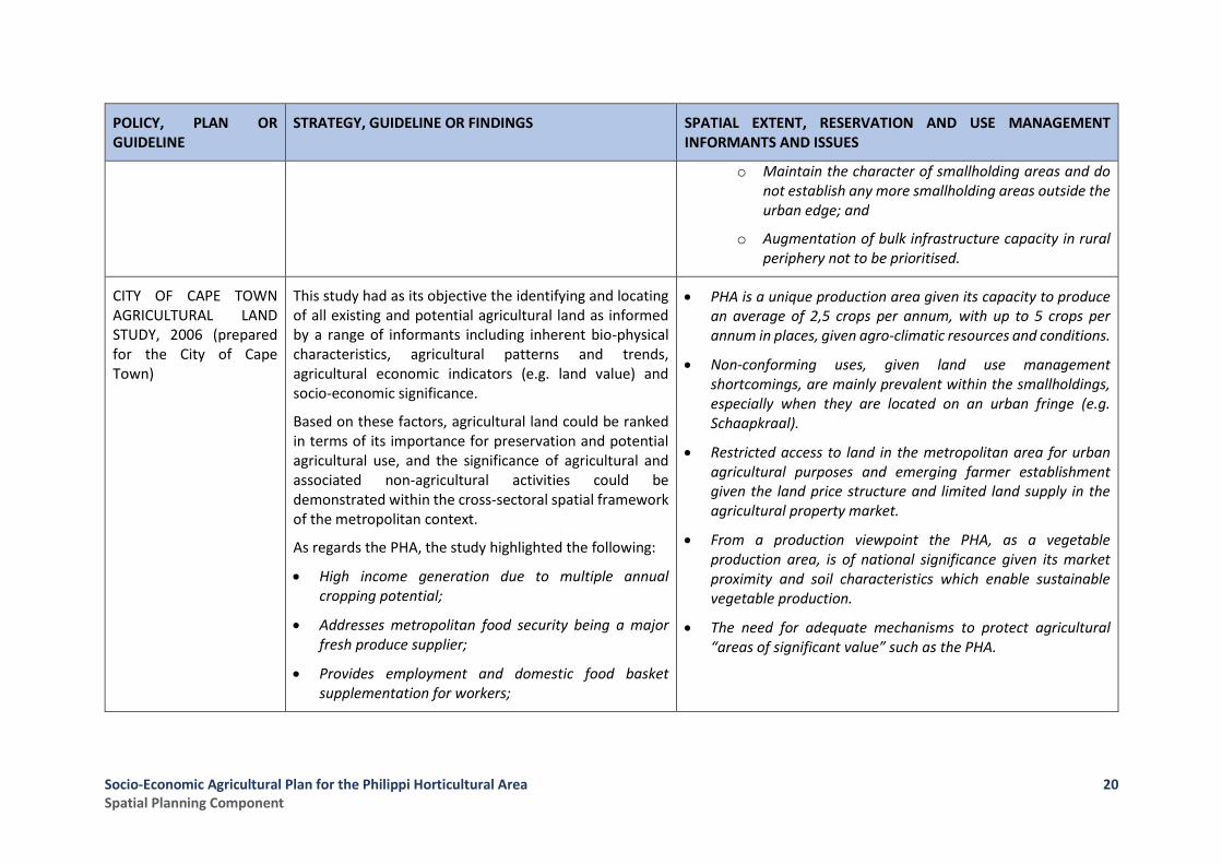
CITY OF CAPE TOWN AGRICULTURAL LAND STUDY, 2006 (prepared for the City of Cape Town)
This study had as its objective the identifying and locating of all existing and potential agricultural land as informed by a range of informants including inherent bio-physical characteristics, agricultural patterns and trends, agricultural economic indicators (e.g. land value) and socio-economic significance.
Based on these factors, agricultural land could be ranked in terms of its importance for preservation and potential agricultural use, and the significance of agricultural and associated non-agricultural activities could be demonstrated within the cross-sectoral spatial framework of the metropolitan context.
As regards the PHA, the study highlighted the following:
• High income generation due to multiple annual cropping potential;
• Addresses metropolitan food security being a major fresh produce supplier;
• Provides employment and domestic food basket supplementation for workers;
• PHA is a unique production area given its capacity to produce an average of 2,5 crops per annum, with up to 5 crops per annum in places, given agro-climatic resources and conditions.
• Non-conforming uses, given land use management shortcomings, are mainly prevalent within the smallholdings, especially when they are located on an urban fringe (e.g. Schaapkraal).
• Restricted access to land in the metropolitan area for urban agricultural purposes and emerging farmer establishment given the land price structure and limited land supply in the agricultural property market.
• From a production viewpoint the PHA, as a vegetable production area, is of national significance given its market proximity and soil characteristics which enable sustainable vegetable production.
• The need for adequate mechanisms to protect agricultural “areas of significant value” such as the PHA.
Socio-Economic Agricultural Plan for the Philippi Horticultural Area Spatial Planning Component
21
POLICY, PLAN OR GUIDELINE
STRATEGY, GUIDELINE OR FINDINGS SPATIAL EXTENT, RESERVATION AND USE MANAGEMENT INFORMANTS AND ISSUES
• Highly accessible in terms of requisite inputs, market and labour-sending communities;
• Poor visual performance (informal settlements and poor socio-economic conditions (worker accommodation); and
• Contribution to visual and landscape variety in an urban landscape.
CITY OF CAPE TOWN AGRICULTURAL LAND REVIEW, 2008 (prepared for the City of Cape Town)
While the 2006 Agricultural Land Study identified the broader agricultural blocks in the City’s area of jurisdiction, this study ascertained the need for their protection, defined their boundaries and established the spatial relationship between such agricultural areas and existing and future urban building blocks.
• The review assessed the following for each of the agricultural areas, including the PHA:
• Status as a “homogenous” farming area (i.e. degree of fragmentation);
• Current and future agricultural performance and significance;
• Environmental status and future performance;
• Specific agricultural potential informants inherent to the area; and
• Other considerations (e.g. cultural, heritage, aesthetic).
• The protection and use status of agricultural areas inform the fixing, amendment and management of the City’s urban edge.
• PHA identified as an agricultural area of “significant value” given its current and future role in food security.
• Intensive food production areas such as the PHA be secured, and where possible consolidated and expanded in order to reinforce food security, especially when such areas are highly accessible to the urban poor.
• Homogeneity of intensive agricultural protection areas can be impacted negatively or positively by fragmentation/consolidation/reinforcement of such areas by urban building block finalization.
• Occurrence of functional edges (e.g. river, road, rail) be explored to serve as edge between agricultural areas and urban building blocks.
Socio-Economic Agricultural Plan for the Philippi Horticultural Area Spatial Planning Component
22
POLICY, PLAN OR GUIDELINE
STRATEGY, GUIDELINE OR FINDINGS SPATIAL EXTENT, RESERVATION AND USE MANAGEMENT INFORMANTS AND ISSUES
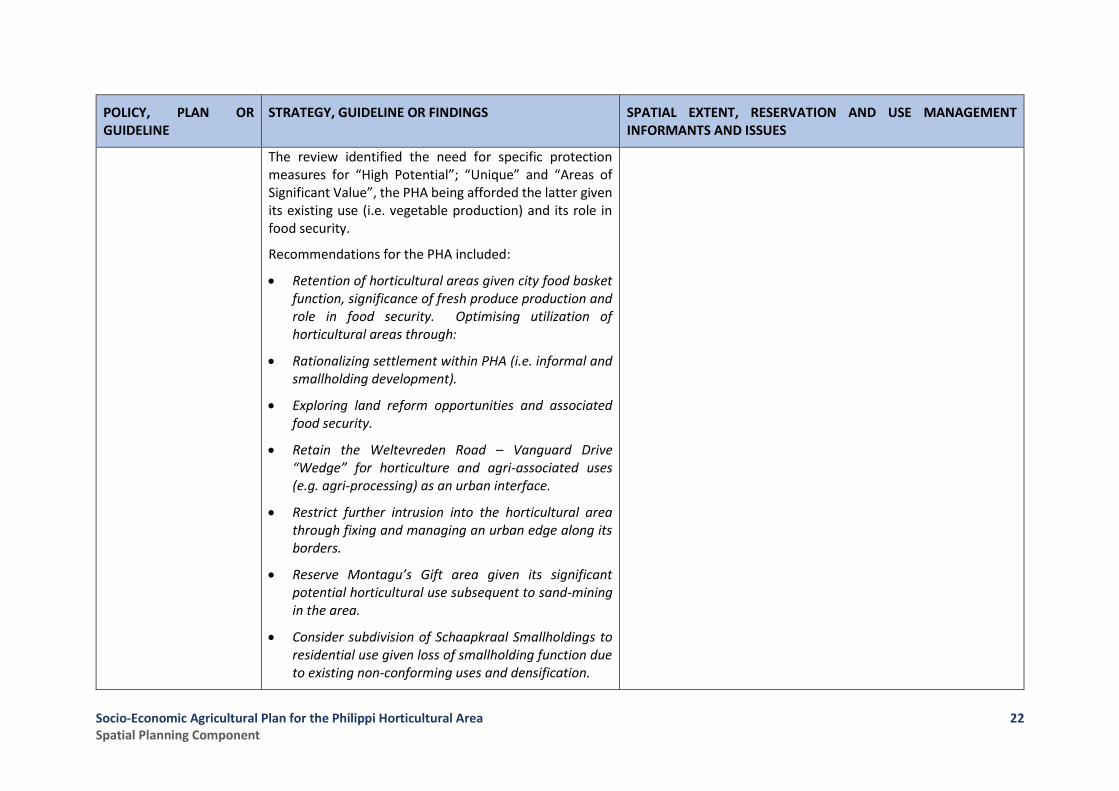
The review identified the need for specific protection measures for “High Potential”; “Unique” and “Areas of Significant Value”, the PHA being afforded the latter given its existing use (i.e. vegetable production) and its role in food security.
Recommendations for the PHA included:
• Retention of horticultural areas given city food basket function, significance of fresh produce production and role in food security. Optimising utilization of horticultural areas through:
• Rationalizing settlement within PHA (i.e. informal and smallholding development).
• Exploring land reform opportunities and associated food security.
• Retain the Weltevreden Road – Vanguard Drive “Wedge” for horticulture and agri-associated uses (e.g. agri-processing) as an urban interface.
• Restrict further intrusion into the horticultural area through fixing and managing an urban edge along its borders.
• Reserve Montagu’s Gift area given its significant potential horticultural use subsequent to sand-mining in the area.
• Consider subdivision of Schaapkraal Smallholdings to residential use given loss of smallholding function due to existing non-conforming uses and densification.
Socio-Economic Agricultural Plan for the Philippi Horticultural Area Spatial Planning Component
23
POLICY, PLAN OR GUIDELINE
STRATEGY, GUIDELINE OR FINDINGS SPATIAL EXTENT, RESERVATION AND USE MANAGEMENT INFORMANTS AND ISSUES
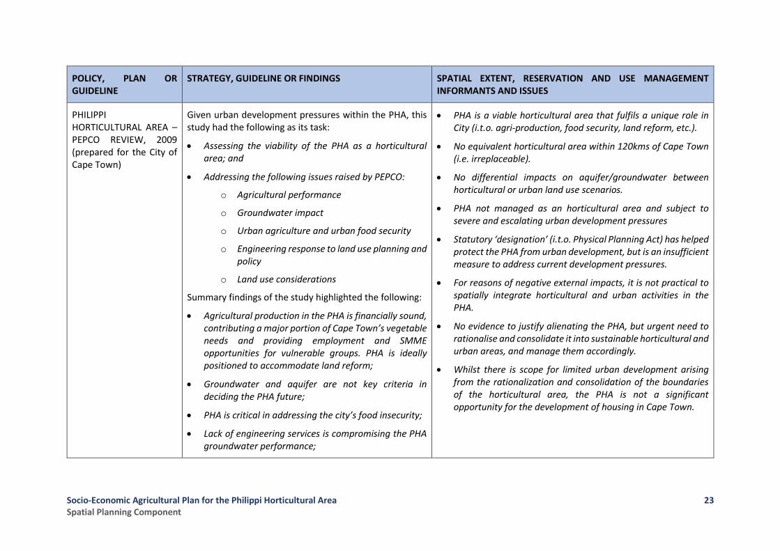
PHILIPPI HORTICULTURAL AREA – PEPCO REVIEW, 2009 (prepared for the City of Cape Town)
Given urban development pressures within the PHA, this study had the following as its task:
• Assessing the viability of the PHA as a horticultural area; and
• Addressing the following issues raised by PEPCO:
o Agricultural performance
o Groundwater impact
o Urban agriculture and urban food security
o Engineering response to land use planning and policy
o Land use considerations
Summary findings of the study highlighted the following:
• Agricultural production in the PHA is financially sound, contributing a major portion of Cape Town’s vegetable needs and providing employment and SMME opportunities for vulnerable groups. PHA is ideally positioned to accommodate land reform;
• Groundwater and aquifer are not key criteria in deciding the PHA future;
• PHA is critical in addressing the city’s food insecurity;
• Lack of engineering services is compromising the PHA groundwater performance;
• PHA is a viable horticultural area that fulfils a unique role in City (i.t.o. agri-production, food security, land reform, etc.).
• No equivalent horticultural area within 120kms of Cape Town (i.e. irreplaceable).
• No differential impacts on aquifer/groundwater between horticultural or urban land use scenarios.
• PHA not managed as an horticultural area and subject to severe and escalating urban development pressures
• Statutory ‘designation’ (i.t.o. Physical Planning Act) has helped protect the PHA from urban development, but is an insufficient measure to address current development pressures.
• For reasons of negative external impacts, it is not practical to spatially integrate horticultural and urban activities in the PHA.
• No evidence to justify alienating the PHA, but urgent need to rationalise and consolidate it into sustainable horticultural and urban areas, and manage them accordingly.
• Whilst there is scope for limited urban development arising from the rationalization and consolidation of the boundaries of the horticultural area, the PHA is not a significant opportunity for the development of housing in Cape Town.
Socio-Economic Agricultural Plan for the Philippi Horticultural Area Spatial Planning Component
24
POLICY, PLAN OR GUIDELINE
STRATEGY, GUIDELINE OR FINDINGS SPATIAL EXTENT, RESERVATION AND USE MANAGEMENT INFORMANTS AND ISSUES
• Future land use interface needs to be sensitive to external activities;
• Land use management within and peripheral to the PHA is a critical requirement; and
• Strict adherence to zoning is needed to keep land prices in line with agricultural production values.
CAPE TOWN SPATIAL DEVELOPMENT FRAMEWORK; STATUTORY REPORT (2012 – AS AMENDED UNTIL END-2016)
The framework has as its basis the following three (3) key strategies:
• Key Strategy 1 – Plan for employment and improve access to economic opportunities.
• Key Strategy 2 – Manage urban growth and create a balance between urban development and environmental/resource protection.
• Key Strategy 3 – build an inclusive, integrated and vibrant city.
CTSDF (2012) as amended to 2016 puts forward the following urban edges for the PHA (refer Figure 4)
• Southern edge; including the south-west and south-east quadrants and Strandfontein built edge
• Eastern edge; being to western edge of the “wedge” (i.e. between Weltevreden Road and the M5)
• Northern edge; being the southern road reserve edge of the proposed Sheffield Road alignment
• Western edge; (i.e. Schaapkraal) to be determined
Of significance to establishing a fixed urban edge (or area boundary) for the PHA and management thereof are the following points emanating from sub-strategies, policies and guidelines included within the key strategies:
• Policy 20: Facilitate urban development and direct phasing of urban growth:
o Phasing of urban development to be guided by the bulk take-up of land within the urban edge; and
o Higher density and a greater mix of land uses must be promoted in appropriate locations where the urban edge is guided by the District SDP and Cape Town Densification Policy (draft 2010).
• Policy 23: Contain development footprint of the city with development edges:
o No urban development should be encouraged beyond the urban edge unless exceptional and unique circumstances exist.
Socio-Economic Agricultural Plan for the Philippi Horticultural Area Spatial Planning Component
25
POLICY, PLAN OR GUIDELINE
STRATEGY, GUIDELINE OR FINDINGS SPATIAL EXTENT, RESERVATION AND USE MANAGEMENT INFORMANTS AND ISSUES
• Policy 28: Protect valuable agricultural areas, existing farmed areas and horticultural areas from urban encroachment and support urban agriculture.
o Investigate ways in which all agricultural areas of significant value (e.g. PHA) could receive local protection over and above the urban edge (e.g. environmental overlay zone applied through relevant zoning regulations);
o Investigate and encourage the development of opportunities for expanding urban agriculture, particularly in areas where this can link to other economic activities and provide livelihoods to “vulnerable communities” and provide for direct household consumption; and
o Prepare and implement management plans for areas inside and outside the urban edge that prevent urban encroachment and unlawful land use in agricultural areas, minimize negative impacts of urban development on farmed land and manage use of water and other natural resources.
• Policy 29: requires “adopting a pro-active planning approach to mineral resource management “through the City” pro-actively managing current and future development areas to ensure that sand mining resources are, where applicable, exploited prior to development commencing”.
Specific actions and policy guidelines include:
Socio-Economic Agricultural Plan for the Philippi Horticultural Area Spatial Planning Component
26
POLICY, PLAN OR GUIDELINE
STRATEGY, GUIDELINE OR FINDINGS SPATIAL EXTENT, RESERVATION AND USE MANAGEMENT INFORMANTS AND ISSUES
• The portion of the PHA excluded from urban development by the urban edge (i.e. as per District SDP) should be retained for horticultural purposes and the exploitation of silica in the long-term;
• Land subdivision in the PHA be discouraged (i.e. below zoning regulations) and no future township development should be permitted;
• Any activity that undermines agricultural activity in the PHA be discouraged;
• Schaapkraal urban edge investigation to be conducted; and
• Development of non-conforming uses in the PHA be actively policed.
URBAN EDGE AND DEVELOPMENT GUIDELINES STUDY FOR THE SCHAAPKRAAL SMALLHOLDINGS AREA AND ENVIRONS IN THE PHILIPPI HORTICULTURAL AREA (2012)
The Schaapkraal Study (which followed on the recommendations in the CTSDF, 2012 – refer above) puts forward the following appropriate development concept to achieve an urban edge within the Schaapkraal Smallholdings environs and define the role and value of Schaapkraal and the PHA:
• Putting in place an “Urban-Horticultural Concept and Vision” comprising a compact urban form for Schaapkraap (i.e. footprint) within a well-defined and managed urban-horticultural (PHA) urban edge.
• Recognising the PHA as a valuable asset that must continue to function as a productive farming area for future generations.
The Schaapkraal “development concept” puts forward the following “guiding themes” to achieve the identified vision within and peripheral to the PHA:
• Revitalising and Celebrating the PHA; Improvement and development of gateways into the PHA to provide legible, visible and easy access to the horticultural area, together with attractions (e.g. agri-market, community gardens, environmental centre) will encourage visitors to the area.
• Adding Value to the PHA; Linkage of the PHA via cycle/ bridle paths to several natural and recreational nodes peripheral to the PHA, including the Flase Bay Ecology Park, Zeekoeivlei, Silica Sands Metropolitan Park, Strandfontein Pavilion and the Edith Stevens and False Bay Nature Reserves. Such PHA linkage to include viewing platforms at elevated locations,
Socio-Economic Agricultural Plan for the Philippi Horticultural Area Spatial Planning Component
27
POLICY, PLAN OR GUIDELINE
STRATEGY, GUIDELINE OR FINDINGS SPATIAL EXTENT, RESERVATION AND USE MANAGEMENT INFORMANTS AND ISSUES
• Ensuring that all existing and future development in Schaapkraal should reinforce and support the optimal functioning of the horticultural activities occurring on its edges.
In doing this, it is envisaged that the Schaapkraal Smallholdings area and the PHA can be transformed into a symbolic and mutually reinforcing system that celebrates its urban-horticultural character as a place of food production, learning and amenity value.
The study puts forward a western urban edge to the PHA, with such edge predominantly informed by:
• Strong defensible physical edges
• A clear distinction between the current urban and horticultural land use, with all urban transformed land being included within the urban edge.
environmental centre(s) and periodic farmers’ markets, with the PHA elevating the South-east Metro as an alternative environmental and recreation destination centre for the City.
• Promoting Integration of the PHA with its Surrounds; Upgrading and aligning the Schaapkraal area with the Strandfontein MBT route and access via NMT routes into the PHA will further integrate the PHA with its surroundings.
• Defining Clear Transitions and Edges between Urban and Horticultural Activities; To limit the future intrusion of urban expansion and/ or land use transformation within the PHA, a range of edge defining elements need to be considered (e.g. canals, roads, location of public facilities including schools/ sports fields, NMT routes etc.) which will also assist with place-making, thereby adding value to the PHA as an amenity attraction.
DRAFT CAPE TOWN MUNICIPAL SPATIAL DEVELOPMENT FRAMEWORK (2017)
The CoCT published its draft Municipal SDF 2017-2022 for comment in July 2017. As this is a draft document, it is conceivable that material changes might be made to its provisions. Nevertheless, it is important to take note of some of the key proposals contained therein that might have an impact on spatial planning, land development and land use management in the PHA.
Firstly, the MSDF 2017 retains the three (3) key strategies of the 2012 SDF:
With regard to the PHA, the draft MSDF may potentially be seen to contain contradictory provisions in that it variously illustrates the following: -
• On the overall MSDF plan (Map 6.1 on page 66 of the draft MSDF – refer Figure 4), the PHA is identified as being an “Incremental Growth Area”, which is understood in the MSDF to refer to areas where “the city will focus on maintenance and upgrading of infrastructure and services in support of spatial transformation” – in contrast to the Spatial Transformation Areas (STAs) that are the outright priority for city and private sector investment;

Socio-Economic Agricultural Plan for the Philippi Horticultural Area Spatial Planning Component
28
POLICY, PLAN OR GUIDELINE
STRATEGY, GUIDELINE OR FINDINGS SPATIAL EXTENT, RESERVATION AND USE MANAGEMENT INFORMANTS AND ISSUES
• Key Strategy 1 – Plan for employment and improve access to economic opportunities.
• Key Strategy 2 – Manage urban growth and create a balance between urban development and environmental/resource protection.
• Key Strategy 3 – build an inclusive, integrated and vibrant city.
However, it makes clear that the way the previous SDF conceived of directing spatial planning and land development is to change, as guided by the changes in both the statutory and regulatory environment (due to the promulgation of SPLUMA and LUPA) as well as key strategy and policy changes made by the CoCT over the period 2012 to 2017. Included amongst these key informants are the following: -
• The 11 Transformation Priorities established in the CCT IDP 2017-2022, where particular relevance for the PHA might be inferred from Priority (4) to achieve Dense and Transit-oriented urban growth and development; Priority (8) which focuses on Resource-efficiency and security; Priority (9) which is Building integrated communities; and Priority (10) which is the achievement of Economic Inclusion.;
• The CoCT’s approved Transit-Oriented Development (TOD) Framework and Comprehensive Land Use Model, which prioritises the following:
• However, in the main body of the MSDF in Table 5.3 on page 55, the PHA is specifically identified as a “Unique Case” where its eventual status vis a vis “ its future role and investment direction” is made subject to “an appropriate development management response”. Such a response is presumably to be based on a dedicated study of the area and it is conceivable that the Socioeconomic Agricultural Plan may serve such a purpose;
• In addition, in the Technical Supplements to the MSDF, the following contradictory illustrations are given:
o In Technical Supplement D: Analysis of Drivers of Urban Change, Map D1 on page 117 reflects the urban edges as approved to the end of 2016 (refer Figure 5), thus highlighting the south-eastern and south-western quadrants of the PHA as containing tracts of so-called “Developable Land”; and
o In contrast, Technical Supplement G: MSDF Policy Statements, Map G7 on page 192 (refer Figure 6) highlights the entire PHA excluding the township of Highlands, the area east of Weltevreden Road and the south-eastern quadrant as being an Agricultural Area of Significance.
o This is expanded upon in Policy 26: Protect valuable agricultural areas, existing farmed areas and horticultural areas from urban encroachment and support urban agriculture (previously Policy 28 in the SDF 2012), which makes provision for the following two relevant Policy Guidelines:
Socio-Economic Agricultural Plan for the Philippi Horticultural Area Spatial Planning Component
29
POLICY, PLAN OR GUIDELINE
STRATEGY, GUIDELINE OR FINDINGS SPATIAL EXTENT, RESERVATION AND USE MANAGEMENT INFORMANTS AND ISSUES
o The (re-) structuring of urban form and function of the City around the existing and emerging public transport network (principally, the 98 rail stations and 42 BRT stations;
o Reducing urban sprawl and creating more housing opportunities in identified Integration Zones and the Urban Inner Core of the City;
o Optimising associated future land use and transport efficiencies; and
o Increasing the structural and resource efficiency of the City (for instance in adopting measures to reduce CO2 generation through extensive transportation networks)
Of note with regard to the above is the proposal in the draft MSDF to move away from the application and enforcement of urban edges as defined in the SDF 2012 and subsequent revisions up the end of 2016. Rather, the draft MSDF proposes that land development considerations would be “evidence-based”, with priority being given to land development in four primary Spatial Transformation Areas (STAs – essentially regarded as the Urban Inner Core of the City) and certain localised areas where applicable.
▪ 26.2 Discourage the further subdivision of land in the Philippi Horticultural Area below what is permitted by the zoning and no further township development should be considered, unless such subdivisions or development proposals are in line with the recommendations of the draft Schaapkraal study as it relates to the western side of the Philippi Horticultural Area.
▪ 26.3 Discourage development that undermines agricultural activity in Philippi Horticultural Area and Constantia, Lourensford and Durbanville, West Coast and Bottelary Hills winelands/cultural landscapes (refer Figure 7).
• Of note in regard to the provisions of Policy 26, Footnote 106 makes specific reference to land described in Section 53(1) – (3) of LUPA (refer to Annexure A) as being included in the land referred to in the Policy.

Socio-Economic Agricultural Plan for the Philippi Horticultural Area Spatial Planning Component
30
Figure 4: Draft CoCT MSDF map, 2017
Figure 5: Urban Edges, Developed & Developable Land as at December 2016
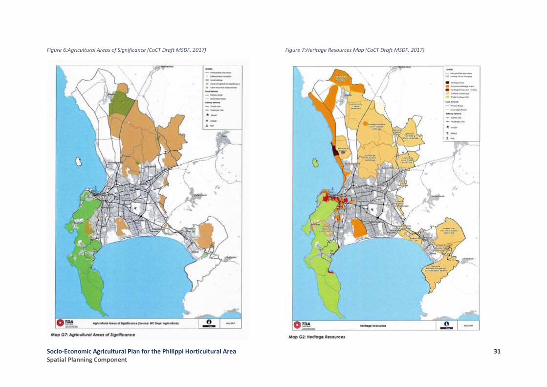
Socio-Economic Agricultural Plan for the Philippi Horticultural Area Spatial Planning Component
31
Figure 6:Agricultural Areas of Significance (CoCT Draft MSDF, 2017)
Figure 7:Heritage Resources Map (CoCT Draft MSDF, 2017)
Socio-Economic Agricultural Plan for the Philippi Horticultural Area Spatial Planning Component
32
POLICY, PLAN OR GUIDELINE
STRATEGY, GUIDELINE OR FINDINGS SPATIAL EXTENT, RESERVATION AND USE MANAGEMENT INFORMANTS AND ISSUES
TOWN PLANNING AND ZONING REGULATIONS
DIVISIONAL COUNCIL OF THE CAPE TOWN PLANNING REGULATIONS (1973; as amended)
The Cape Metropolitan Council (CMC) Zoning Scheme Regulations, originally promulgated in terms of the Township Ordinance (33 of 1934) and later enacted in terms of the Land Use Planning Ordinance (1985), put forward a Rural Use Zone applicable to the major portion of the PHA. Such zone allows any type of farming, a minimum subdivision size of 21,5ha and conditional uses subject to the following:
• Building plan approval;
• 30 metre building line and 8,0m road reserve;
• Maximum building height of 8,0m;
• Total coverage of dwelling per erf, including labourers accommodation, being 500m²;
• All waste and effluent to be disposed of with minimum damage to property and environment; and
• Restoration of mined properties.
• Conditional uses include:
o Mining;
o Refuse disposal;
o Earthworks; and
o Contractors yards
• Except for mining, all other conditional uses are contradictory to land use prescriptions for the PHA.
• CMC Zoning Scheme regulations were superseded by the Cape Town Zoning Scheme (CTZS) in 2012.
CAPE TOWN ZONING SCHEME (2012) AND CAPE TOWN DEVELOPMENT MANAGEMENT SCHEME (2015)
The Cape Town Zoning Scheme 2012 (CTZS) served as an umbrella scheme for 27 previous zoning schemes applicable to different parts of the City.
In 2015 the CTZS was included as Schedule 3: City of Cape Town Development Management Scheme (DMS) within the City of Cape Town Municipal Planning By-Law, 2015.
• DMS includes a range of zoning categories which could replace the existing “all-encompassing” “Rural Use” zone, thereby facilitating more specific and applicable rules for a given use and addressing the diversity of use in the PHA/Schaapkraal Smallholdings. Examples include:

Socio-Economic Agricultural Plan for the Philippi Horticultural Area Spatial Planning Component
33
POLICY, PLAN OR GUIDELINE
STRATEGY, GUIDELINE OR FINDINGS SPATIAL EXTENT, RESERVATION AND USE MANAGEMENT INFORMANTS AND ISSUES
The provision of rules for a broad range of land use categories and linkages to policy plans allow for proactive land management and development, and in so doing, implementation of the vision set out in the CTSDF and District SDPs. Furthermore, the DMS includes an “overlay” zoning category, whereby policy guidelines (such as those contained in the CTSDF) can be translated into development rules after a prescribed process.
o Agricultural Zone: Provides and protects agriculture on farms;
o Rural Zone: Provides for smaller properties that may be used for agriculture and occupied as places of residence for people seeking a country lifestyle;
o Mixed Zone: provides for a mixture of business, industrial and residential development; and
o Incremental Housing: Provides for the upgrading of informal settlement to a formal settlement through incremental housing processes.
• DMS provides for local protection of an “agricultural area of significant value” such as the PHA over and above the urban edge through the application of an overlay zone for specific management mechanisms, including:
o Urban Edge Overlay Zone: Provide for management of the urban edge in order to achieve sensitive transition between urban, rural and conservation areas;
o Environmental Management Overlay Zone: Provide for the management of special natural and environmental characteristics of an area; and
o Local Area Overlay Zone: Provide for specific local development rules.
Socio-Economic Agricultural Plan for the Philippi Horticultural Area Spatial Planning Component
34
2.3 Current Land Use and Trends
Critical to the Socio-Economic Agricultural Plan for the PHA is the spatial definition of the PHA’s horticultural area, its support and buffer areas, as well as its metro-region/ district-wide linkages necessary to realise its socio-economic function. Given the dominant role of land use in such spatial definition and linkage identification, the following land use assessment of land use types/ categories, trends and issues serves to identify, confirm and put in place the necessary PHA spatial land use components to inform the Socio-Economic Agricultural Plan for the PHA.
2.3.1 Overview of the PHA Land Use Make-Up
The ”greater” PHA area which comprises 3168.65ha (excluding Highlands Estate) includes a broad range of both formal and informal land uses, including horticulture and industry at either end of the land use spectrum. Assessment both the existing land use status and the occurrence and dominance of land use transformation per geographic area within the PHA, necessitated the reclassification of the 2014 PHA Land Cover data into the following dominant land use classes:
• Rivers, wetlands, waterbodies
• Thicket, bush, shrubland
• Agriculture (i.e. cultivated)
• Mining
• Eroded, no vegetation areas
• Urban areas, including commercial, industrial, formal and informal residential, sport and education
• Smallholdings (including both residential and cultivated)
• Grassland (i.e. livestock grazing)
The reclassified land use classes as illustrated in Figure 8, reflect the following:
• A dominance of agriculture and smallholding, with smallholding being inclusive of “lifestyle/ residential/ mixed-use” smallholdings (e.g. Schaapkraal: Area 1) and small commercial farms (e.g. horticulture area; Area Remainder)
• Occurrence of urban (including residential, industrial, business, etc.) in Schaapkraal, Knole Park and Schaapkraal Estate (Area 1), the northern area abutting the Lansdowne Industrial Area (Area 3), Highlands residential area (Area Highlands) and west of Weltevreden Road (Area 4).
• Figure 8 also indicates the location of the informal settlements as detailed in Section 2.3.2 below.
• Area 5 being predominantly thicket and grassland covered dunes together with mining.
Socio-Economic Agricultural Plan for the Philippi Horticultural Area Spatial Planning Component
35
• Area 6 being predominantly agriculture and smallholding, together with dune and grassland covered dunes in the south.
• In order to asses transformation of land use within the PHA, particularly the transformation of horticultural land, the following was undertaken:
• Composite areas as informed by statutory prescriptions (i.e. existing and proposed urban edges), existing and proposed urban developments, emerging industrial/ non-agricultural use areas, transformed smallholding/ agricultural areas and predominantly horticultural areas, were identified (i.e. Areas 1, 3, 4, 5, 6, Area Remainder and Area Highlands as per Figure 8). Additionally, the September 2017 records of CoCT: TDA; Development Management informed and confirmed non-agricultural land use trends in each of the composite land use areas insofar noteworthy/ significant non-agricultural proposed and pending applications, approved and draft urban edges and approved rezonings and subdivisions. Furthermore, issues arising from and confronting such land use trends as highlighted by TDA: Development Management were recorded.
• The dominant land use classes as depicted in Figure 8 were further reclassified, in order to;
o include “grassland” (livestock grazing or fallow cultivated fields) and “smallholding” (limited horticulture transformation; Area Remainder and Areas 5 & 6) within “agriculture” in Area Remainder and Areas 5 & 6; and to
o include “smallholding” in Areas 1, 3 and 4 within the category of “urban” given the transformation from agricultural uses of the smallholdings in these areas.
In accordance with the above methodology, Table 1 read with Figure 9 below illustrates a number of composite land use areas in the PHA. These are described overleaf, including the composition and performance of each composite area, together with the key land use and spatial trends and issues characterising each area.
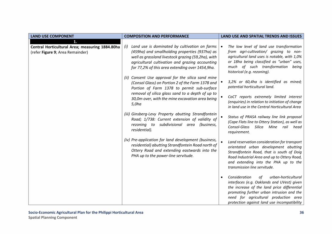
Socio-Economic Agricultural Plan for the Philippi Horticultural Area Spatial Planning Component
36
LAND USE COMPONENT COMPOSITION AND PERFORMANCE LAND USE AND SPATIAL TRENDS AND ISSUES
1. Central Horticultural Area; measuring 1884.80ha (refer Figure 9; Area Remainder)
(i) Land use is dominated by cultivation on farms (459ha) and smallholding properties (937ha) as well as grassland livestock grazing (59,2ha), with agricultural cultivation and grazing accounting for 77,2% of this area extending over 1454,9ha.
(ii) Consent Use approval for the silica sand mine (Consol Glass) on Portion 2 of the Farm 1378 and Portion of Farm 1378 to permit sub-surface removal of silica glass sand to a depth of up to 30,0m over, with the mine excavation area being 5,0ha
(iii) Ginsberg-Levy Property abutting Strandfontein Road; 1/738: Current extension of validity of rezoning to subdivisional area (business, residential).
(iv) Pre-application for land development (business, residential) abutting Strandfontein Road north of Ottery Road and extending eastwards into the PHA up to the power-line servitude.
• The low level of land use transformation from agri-cultivation/ grazing to non-agricultural land uses is notable, with 1,0% or 18ha being classified as “urban” uses, much of such transformation being historical (e.g. rezoning).
• 3,2% or 60,4ha is identified as mined; potential horticultural land.
• CoCT reports extremely limited interest (enquiries) in relation to initiation of change in land use in the Central Horticultural Area
• Status of PRASA railway line link proposal (Cape Flats line to Ottery Station), as well as Consol-Glass Silica Mine rail head requirement.
• Land reservation consideration for transport orientated urban development abutting Strandfontein Road, that is south of Doig Road Industrial Area and up to Ottery Road, and extending into the PHA up to the transmission line servitude.
• Consideration of urban-horticultural interfaces (e.g. Oaklands and UVest) given the increase of the land price differential promoting further urban intrusion and the need for agricultural production area protection against land use incompatibility

Socio-Economic Agricultural Plan for the Philippi Horticultural Area Spatial Planning Component
37
LAND USE COMPONENT COMPOSITION AND PERFORMANCE LAND USE AND SPATIAL TRENDS AND ISSUES and complaints (e.g. spray drift, fertilizer odour, etc.).
• Impact of Oakland City’s westward access link requirement on the horticultural area (i.e. the south-west quadrant)
2. South-Western Quadrant; measuring 289.89ha (refer Figure 9; Area 6)
(i) This area, similar to the Central Horticultural Area, comprises 53,9% predominantly agri-cultivation and livestock production with farm cultivation (123.63ha) and smallholding cultivation 54.45ha), as well as grassland livestock grazing (33.75ha)
(ii) 1% (3.02ha) is being mined (i.e. potential horticultural land).
(iii) MSP/ UVest status:
(iv) Type of Application: Rezoning to Subdivisional Area (LUPO Application) i.e. stand-alone Zoning Overlay, with no erf subdivision. Includes a total of 15 private properties totalling 114ha
(v) Approval: Accepted by Interim Planning Committee for consideration
(vi) Urban Edge Status:
(vii) South-West: CoCT amendment as per CTSDF (2014), includes MSP-UVest application areas
• Limited agri-land transformation, with 2.8% comprising urban uses.
• While the majority of the MSP-Uvest development applications (+-114ha) do not currently impact on existing cultivated horticultural land, +-99ha of such land (i.e. 34% of the S-W Quadrant) has the potential of becoming horticultural land subject to landform shaping through mining.

Socio-Economic Agricultural Plan for the Philippi Horticultural Area Spatial Planning Component
38
LAND USE COMPONENT COMPOSITION AND PERFORMANCE LAND USE AND SPATIAL TRENDS AND ISSUES
3. South-Eastern Quadrant; measuring 482.13ha (refer Figure 9; Area 5)
(i) The South-Eastern Quadrant comprises naturally vegetated dunes over 67% or 325ha of its area.
(ii) Cultivation on farms (13,3ha) and smallholdings (2,63ha), together with grassland grazing (89,48ha) results in 21,9% of the area being in agri-production
(iii) Given landform engineering to allow future horticultural/ urban development, mining is prevalent, with 10,6% or 51,4ha being mined.
(iv) Oakland City Status:
(v) Type of Application: Rezoning to Subdivisional Area (LUPO Application)
(vi) Approval: Subdivision Zoning (finalised)
(vii) Urban Edge Status:
(viii) South-East: CoCT amendment as per Urban Structure Plan, including Oakland City application approval area.
• 19% of the area or 89.5ha is grassland, often underutilized, this being post-mined and even post-cultivated land awaiting urban development.
• Despite reservation of biodiversity significant areas, a sizable extent would be highly suited for cultivation had it not been designated for urban purposes, including 22 farms totalling 471,1ha.
• Negligible (i.e. 0,0%) urban land use (apart from mining, a temporary use)
• Identification/ requirement for retention of a biodiversity strip along the Strandfontein boundary to meet biodiversity targets (ERM)
4. Schaapkraal Smallholding Area and Urban Area (i.e. Knole Park and Schaapkraal Estate), comprising 340.26ha in total (refer Figure 9; Area 1)
(i) This area is significantly transformed, with non-agricultural land uses dominant on both smallholdings and small farms resulting in 86% or 293ha being “urban” in use and character.
• The Schaapkraal Study (2012) indicated that 37,7% of the smallholdings were used solely for residential proposes and 40% for non-agricultural use (i.e. business, industrial, religious), with only 7,9% being
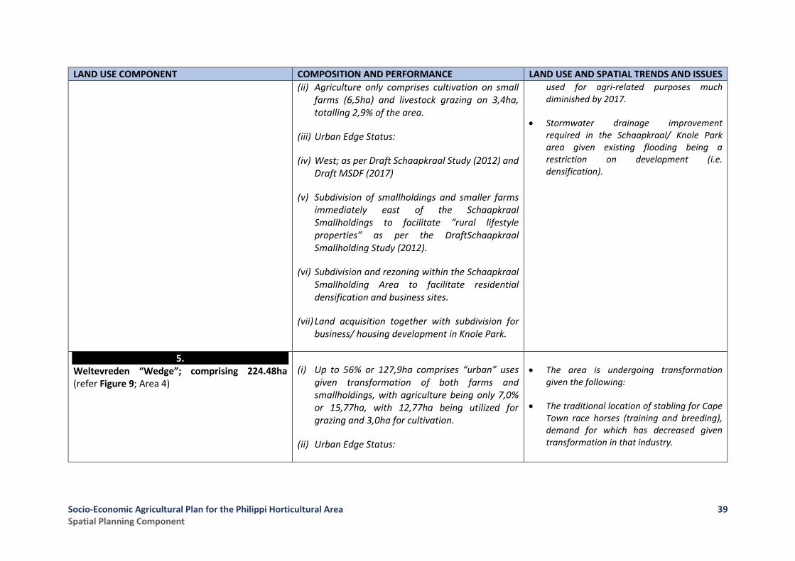
Socio-Economic Agricultural Plan for the Philippi Horticultural Area Spatial Planning Component
39
LAND USE COMPONENT COMPOSITION AND PERFORMANCE LAND USE AND SPATIAL TRENDS AND ISSUES
(ii) Agriculture only comprises cultivation on small farms (6,5ha) and livestock grazing on 3,4ha, totalling 2,9% of the area.
(iii) Urban Edge Status:
(iv) West; as per Draft Schaapkraal Study (2012) and Draft MSDF (2017)
(v) Subdivision of smallholdings and smaller farms immediately east of the Schaapkraal Smallholdings to facilitate “rural lifestyle properties” as per the DraftSchaapkraal Smallholding Study (2012).
(vi) Subdivision and rezoning within the Schaapkraal Smallholding Area to facilitate residential densification and business sites.
(vii) Land acquisition together with subdivision for business/ housing development in Knole Park.
used for agri-related purposes much diminished by 2017.
• Stormwater drainage improvement required in the Schaapkraal/ Knole Park area given existing flooding being a restriction on development (i.e. densification).
5. Weltevreden “Wedge”; comprising 224.48ha (refer Figure 9; Area 4)
(i) Up to 56% or 127,9ha comprises “urban” uses given transformation of both farms and smallholdings, with agriculture being only 7,0% or 15,77ha, with 12,77ha being utilized for grazing and 3,0ha for cultivation.
(ii) Urban Edge Status:
• The area is undergoing transformation given the following:
• The traditional location of stabling for Cape Town race horses (training and breeding), demand for which has decreased given transformation in that industry.
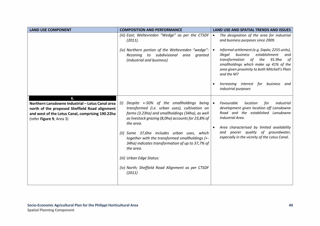
Socio-Economic Agricultural Plan for the Philippi Horticultural Area Spatial Planning Component
40
LAND USE COMPONENT COMPOSITION AND PERFORMANCE LAND USE AND SPATIAL TRENDS AND ISSUES
(iii) East; Weltevreden “Wedge” as per the CTSDF (2011).
(iv) Northern portion of the Weltevreden “wedge”: Rezoning to subdivisional area granted (industrial and business)
• The designation of the area for industrial and business purposes since 2009.
• Informal settlement (e.g. Siqalo; 2255 units), illegal business establishment and transformation of the 91.9ha of smallholdings which make up 41% of the area given proximity to both Mitchell’s Plain and the M7
• Increasing interest for business and industrial purposes
6. Northern Lansdowne Industrial – Lotus Canal area north of the proposed Sheffield Road alignment and west of the Lotus Canal, comprising 190.22ha (refer Figure 9; Area 3)
(i) Despite +-50% of the smallholdings being transformed (i.e. urban uses), cultivation on farms (3.23ha) and smallholdings (34ha), as well as livestock grazing (8,0ha) accounts for 23,8% of the area.
(ii) Some 37,6ha includes urban uses, which together with the transformed smallholdings (+-34ha) indicates transformation of up to 37,7% of the area.
(iii) Urban Edge Status:
(iv) North; Sheffield Road Alignment as per CTSDF (2011)
• Favourable location for industrial development given location off Lansdowne Road and the established Lansdowne Industrial Area.
• Area characterised by limited availability and poorer quality of groundwater, especially in the vicinity of the Lotus Canal.
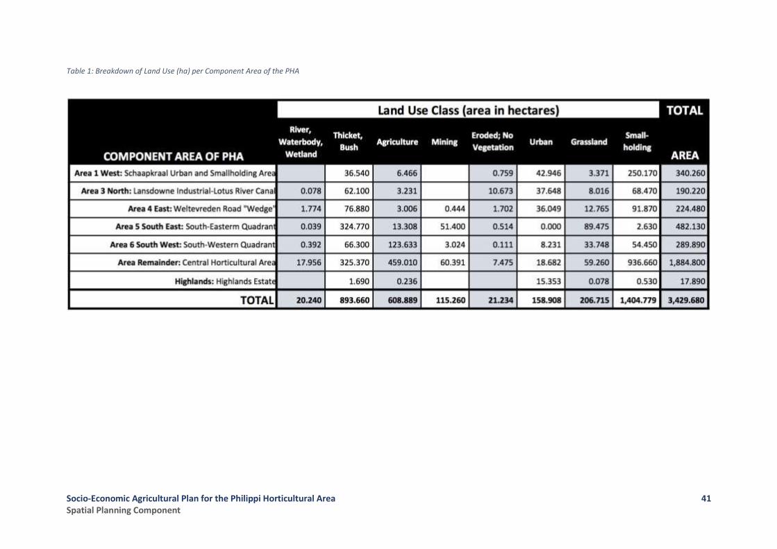
Socio-Economic Agricultural Plan for the Philippi Horticultural Area Spatial Planning Component
41
Table 1: Breakdown of Land Use (ha) per Component Area of the PHA
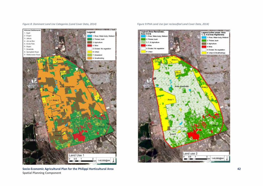
Socio-Economic Agricultural Plan for the Philippi Horticultural Area Spatial Planning Component
42
Figure 8: Dominant Land Use Categories (Land Cover Data, 2014)
Figure 9:PHA Land Use (per reclassified Land Cover Data, 2014)

Socio-Economic Agricultural Plan for the Philippi Horticultural Area Spatial Planning Component
43
2.3.2 Informal Settlement in the PHA Study Area
Informal settlement within the broader PHA, as per 2011/12 and 2016/17 records of CoCT: Informal Settlements and Backyards, occurs as follows (refer Figure 8):
Settlement Name Number of Residential
Units
Comment
2011 2016
Egoli (Philippi) (Boundary Road) 351 448 27,6% growth (2011-2016)
Engen (Strandfontein Road) 7 4
Jabula (Olieboom Road, Highlands Estate) 60 70
Jim se Bos (Olieboom Road) 303 429 41,5% growth (2011-2016)
Knole Park (Williston Road) 44 28
Siqalo (Jakes Gerwel Drive) - 2,255
Smallville TRA (Olieboom Road) 64 58
Springfield Road (Springfield Road) 38 26 Small-Farmers’ Residential Village
Weltevreden Road (south) - 3
TOTAL 867 3,321
Informal settlement within the broader PHA is characterised by the following:
• A nett 5-year increase of 199 units or 22.9% if the development of Siqalo is excluded, otherwise a 383% increase in 5 years (2011-2016).
• No new informal settlement within the Central Horticultural Area, with a slight decrease (6 units) in the extent of the only settlement, namely the Smallville Transitional Residential Area (TRA), located immediately adjacent to Jim se Bos in Olieboom Road.
• Informal settlement within areas peripheral and immediately abutting the Central Horticultural Area is dominated by the Siqalo settlement (2255 units), with Jim se Bos (429 units) and Egoli (448 units) showing +- 41.5% and 27,6% growth respectively over the 5-year period.
• Need for public housing to address informal settlements; need for schools and community facilities within or peripheral to the broader PHA.
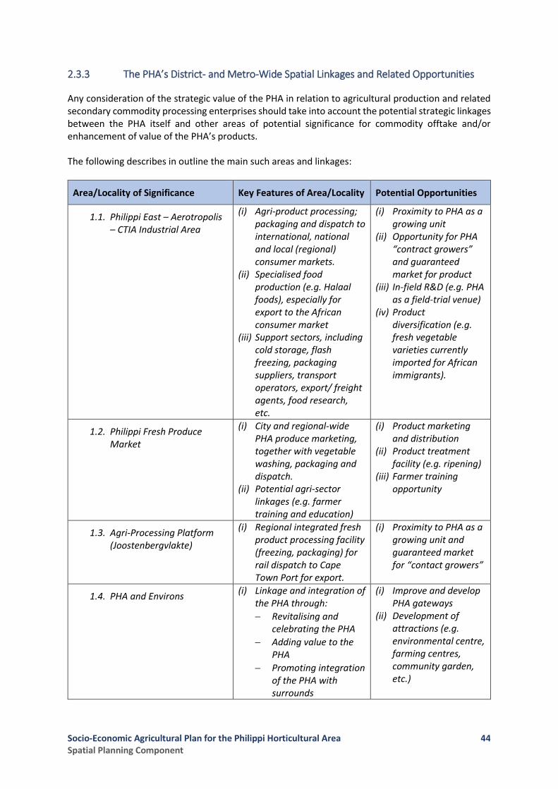
Socio-Economic Agricultural Plan for the Philippi Horticultural Area Spatial Planning Component
44
2.3.3 The PHA’s District- and Metro-Wide Spatial Linkages and Related Opportunities
Any consideration of the strategic value of the PHA in relation to agricultural production and related secondary commodity processing enterprises should take into account the potential strategic linkages between the PHA itself and other areas of potential significance for commodity offtake and/or enhancement of value of the PHA’s products. The following describes in outline the main such areas and linkages:
Area/Locality of Significance Key Features of Area/Locality Potential Opportunities
1.1. Philippi East – Aerotropolis – CTIA Industrial Area
(i) Agri-product processing; packaging and dispatch to international, national and local (regional) consumer markets.
(ii) Specialised food production (e.g. Halaal foods), especially for export to the African consumer market
(iii) Support sectors, including cold storage, flash freezing, packaging suppliers, transport operators, export/ freight agents, food research, etc.
(i) Proximity to PHA as a growing unit
(ii) Opportunity for PHA “contract growers” and guaranteed market for product
(iii) In-field R&D (e.g. PHA as a field-trial venue)
(iv) Product diversification (e.g. fresh vegetable varieties currently imported for African immigrants).
1.2. Philippi Fresh Produce Market
(i) City and regional-wide PHA produce marketing, together with vegetable washing, packaging and dispatch.
(ii) Potential agri-sector linkages (e.g. farmer training and education)
(i) Product marketing and distribution
(ii) Product treatment facility (e.g. ripening)
(iii) Farmer training opportunity
1.3. Agri-Processing Platform (Joostenbergvlakte)
(i) Regional integrated fresh product processing facility (freezing, packaging) for rail dispatch to Cape Town Port for export.
(i) Proximity to PHA as a growing unit and guaranteed market for “contact growers”
1.4. PHA and Environs (i) Linkage and integration of
the PHA through:
Revitalising and celebrating the PHA
Adding value to the PHA
Promoting integration of the PHA with surrounds
(i) Improve and develop PHA gateways
(ii) Development of attractions (e.g. environmental centre, farming centres, community garden, etc.)
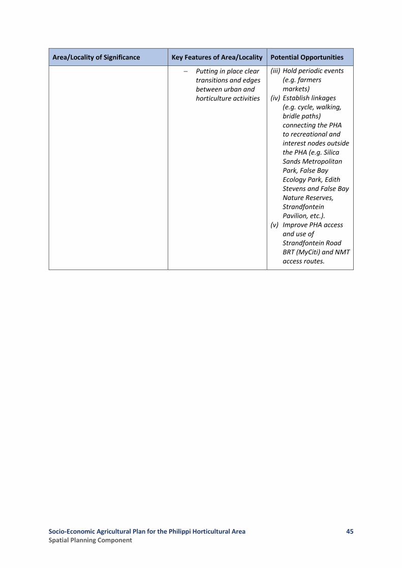
Socio-Economic Agricultural Plan for the Philippi Horticultural Area Spatial Planning Component
45
Area/Locality of Significance Key Features of Area/Locality Potential Opportunities
Putting in place clear transitions and edges between urban and horticulture activities
(iii) Hold periodic events (e.g. farmers markets)
(iv) Establish linkages (e.g. cycle, walking, bridle paths) connecting the PHA to recreational and interest nodes outside the PHA (e.g. Silica Sands Metropolitan Park, False Bay Ecology Park, Edith Stevens and False Bay Nature Reserves, Strandfontein Pavilion, etc.).
(v) Improve PHA access and use of Strandfontein Road BRT (MyCiti) and NMT access routes.

Socio-Economic Agricultural Plan for the Philippi Horticultural Area Spatial Planning Component
46
2.3.4 Conclusion: The Impact of Land Use Transformation on the PHA
The impact of non-agricultural land use intrusion as well as formal conversion of agricultural land in the PHA on the extent of land originally reserved in 1988 has resulted in a loss of some 1301.74 ha of existing/potential agricultural land of significance, to-date. Diagrams 1b-1f depict PHA horticultural land loss over the past 29-year timeline, while Diagram 1a indicates the extent of the original 1967 reservation of such land.
Socio-Economic Agricultural Plan for the Philippi Horticultural Area Spatial Planning Component
47
2.4 Current Cadastre and Land Ownership Patterns
The cadastral configuration (i.e. extent and location) of properties within the PHA, together with ownership (i.e. public v/s private) thereof directly informs the Socio-Economic Agricultural Plan for PHA insofar economic performance, scale and type of agri-enterprise and accessibility / entry for participants through such a Plan.
2.4.1 Survey Area
Property and ownership details of all cadastrally defined properties within the Central Horticultural Area, the South-Eastern Quadrant and the South-Western Quadrant (refer Figure 10) were sourced from the Department of Rural Development and Land Reform (DRDLR): Surveyor General; Deeds Office. These data are captured electronically in shapefiles for the three respective areas, noting that the PHA is located in two separate Registration Districts, namely the Cape Registration District (Cape RD) and the Schaap Kraal Urban Area, north and south of Boundary Road respectively. The data set provides the following cadastral/ ownership details as at 2015 for properties in the Central Horticultural, South-Eastern Quadrant and South-Western Quadrant areas of the PHA respectively:
• Farm Number
• Title Deed Number
• SG Number
• Registration District
• Farm Name
• Extent of Property (ha or m²)
• Date of Purchase
• Date of Registration
• Owner (name)
• Previous Owner (name)
The cadastre and ownership characteristics of the 481 properties accessed (refer Figure 10) reflect the following trends and issues for the PHA Socio-Economic Agricultural Plan.
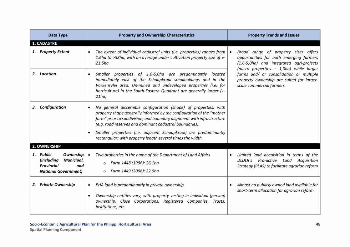
Socio-Economic Agricultural Plan for the Philippi Horticultural Area Spatial Planning Component
48
Data Type Property and Ownership Characteristics Property Trends and Issues
1. CADASTRE
1. Property Extent • The extent of individual cadastral units (i.e. properties) ranges from 1.6ha to >58ha; with an average under cultivation property size of +- 21.5ha
• Broad range of property sizes offers opportunities for both emerging farmers (1.6-5,0ha) and integrated agri-projects (micro properties – 1,0ha) while larger farms and/ or consolidation or multiple property ownership are suited for larger-scale commercial farmers.
2. Location • Smaller properties of 1,6-5,0ha are predominantly located immediately east of the Schaapkraal smallholdings and in the Varkensvlei area. Un-mined and undeveloped properties (i.e. for horticulture) in the South-Eastern Quadrant are generally larger (+-21ha)
3. Configuration • No general discernible configuration (shape) of properties, with property shape generally informed by the configuration of the “mother farm” prior to subdivision; and boundary alignment with infrastructure (e.g. road reserves and dominant cadastral boundaries).
• Smaller properties (i.e. adjacent Schaapkraal) are predominantly rectangular; with property length several times the width.
2. OWNERSHIP
1. Public Ownership (including Municipal, Provincial and National Government)
• Two properties in the name of the Department of Land Affairs
o Farm 1448 (1996): 26,1ha
o Farm 1449 (2008): 22,0ha
• Limited land acquisition in terms of the DLDLR’s Pro-active Land Acquisition Strategy (PLAS) to facilitate agrarian reform
2. Private Ownership • PHA land is predominantly in private ownership
• Ownership entities vary, with property vesting in individual (person) ownership, Close Corporations, Registered Companies, Trusts, Institutions, etc.
• Almost no publicly owned land available for short-term allocation for agrarian reform.
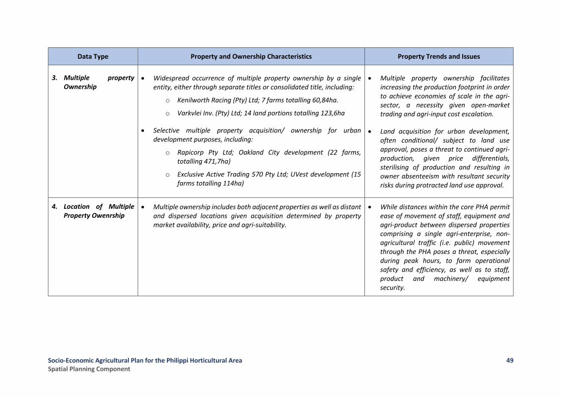
Socio-Economic Agricultural Plan for the Philippi Horticultural Area Spatial Planning Component
49
Data Type Property and Ownership Characteristics Property Trends and Issues
3. Multiple property Ownership
• Widespread occurrence of multiple property ownership by a single entity, either through separate titles or consolidated title, including:
o Kenilworth Racing (Pty) Ltd; 7 farms totalling 60,84ha.
o Varkvlei Inv. (Pty) Ltd; 14 land portions totalling 123,6ha
• Selective multiple property acquisition/ ownership for urban development purposes, including:
o Rapicorp Pty Ltd; Oakland City development (22 farms, totalling 471,7ha)
o Exclusive Active Trading 570 Pty Ltd; UVest development (15 farms totalling 114ha)
• Multiple property ownership facilitates increasing the production footprint in order to achieve economies of scale in the agri-sector, a necessity given open-market trading and agri-input cost escalation.
• Land acquisition for urban development, often conditional/ subject to land use approval, poses a threat to continued agri-production, given price differentials, sterilising of production and resulting in owner absenteeism with resultant security risks during protracted land use approval.
4. Location of Multiple Property Owenrship
• Multiple ownership includes both adjacent properties as well as distant and dispersed locations given acquisition determined by property market availability, price and agri-suitability.
• While distances within the core PHA permit ease of movement of staff, equipment and agri-product between dispersed properties comprising a single agri-enterprise, non-agricultural traffic (i.e. public) movement through the PHA poses a threat, especially during peak hours, to farm operational safety and efficiency, as well as to staff, product and machinery/ equipment security.

Socio-Economic Agricultural Plan for the Philippi Horticultural Area Spatial Planning Component
50
Figure 10: Configuration of Land Ownership in the PHA

Socio-Economic Agricultural Plan for the Philippi Horticultural Area Spatial Planning Component
51
2.5 Outcomes of Structured Interviews
As noted in Section 1.3 above, the work-stream for the spatial planning and land use management component was informed by a series of structured interviews held with officials representing what may be described as the principal authorities concerned with spatial planning and land use management matters in the PHA: that is, the City of Cape Town and the WCG: Department of Environmental Affairs & Development Planning. These interviews took place as follows: -
• The City of Cape Town
o Transport & Development Authority: Spatial Planning on 28 August 2017
o Directorate: Informal Settlements and Backyarders on 1 September 2017
o Transport & Development Authority: Land Development Management on 12 September 2017
o Directorate: Informal Settlements and Backyarders on 5 October 2017
• The WCG: Department of Environmental Affairs and Development Planning
o Introductory meeting with all relevant Directorates on 31 August 2017
o Follow-up meeting with Directorate: Spatial Planning on 18 September 2017
The complete outline of the notes taken at the meeting are attached as Annexure A to this report.
The summarised outcomes of the interviews are noted below: -
2.5.1 Key Points from the Engagement with CoCT: TDA (Spatial Planning)
(i) Land Development Management issues and trends (i.e. non-agri use; formal/ informal; additional
pressures stemming from sand mining applications; land adjacent to Strandfontein/Ottery Road
junction being targeted for development)
(ii) Erosion of PHA Agri-Space
Need to record all the reductions in the agri-footprint together with reasons for that (logical
and illogical e.g. development targeting the “prime agricultural potential” southern portion
of the PHA rather than the area north of the R300 route alignment)
(iii) PHA Footprint Considerations
The MSDF review (2017), while including the PHA within an “Incremental Growth Area”, flags
the PHA as a “unique case” requiring an appropriate development management approach to
shape the future role of investment direction of the area, acknowledging the PHA being of
significant agricultural importance, as endorsed by WCG: DoA.

Socio-Economic Agricultural Plan for the Philippi Horticultural Area Spatial Planning Component
52
Future PHA footprint will be informed by “Transit Orientated Development”, including MyCity
“trunk planning” extending along Lansdowne Road and southwards along Strandfontein
Road up to Ottery Road, putting urban development pressure within the PHA along
Strandfontein Road, between the Doig Road Industrial Area and Ottery Road.
Development edges to the PHA as per the 2009 Rapid Review and PEPCO Review to inform
the 2012 SDF, and the Schaapkraal Study (2012) to inform the 2017 SDF review, including:
• The Sheffield Road reserve being the northern boundary
• The “island” (Weltevreden Road-M5) being the eastern boundary
• The western boundary as per the Schaapkraal Study (2012) given the transformation of
agricultural holdings abutting the Schaapkraal Smallholdings
• Southern Boundary as per the revised SDF (2016)?
(iv) Securing and Protecting the PHA Agri-Space
Objective; retain all land as the legacy of the PHA
Motivation; not only a food production area ensuring food security, but an asset providing
the following:
• An open-space central to historically displaced communities within vast urban areas (e.g.
Nyanga, Khayelitsha, Mitchells Plain and associated informal residential areas).
• Employment, for the very poor and unskilled (new urban entrants).
• Variation in landscape, with Swartklip (Denel property) and the PHA being the remaining
significant “open spaces” within the Cape Flats.
• A working example and show-piece of agrarian reform in peri-urban agriculture.
• The role of the PHA in climate change resilience insofar vegetable production and
addressing food insecurity at a city-scale.
Protection; need to elevate the status of the PHA in both the civic and public sectors in regard
to its significance, the need for protection, and increased access potentially through the
following:
• The PHA becoming a sought-after “destination” (e.g. similar to the “Winelands”) with
such destination being underpinned by its peri-urban character and value to be derived
from the following:
o Providing for the needs of surrounding intensive urban areas (e.g. passive recreation,
a visitor meander, fresh-food market);
2.5.2 Key Points from the Engagement with CoCT: Directorate Informal Settlements
1. Questions and Issues Raised
• Role of City of Cape Town in managing informal settlement processes.
• Current data on informal settlements in the PHA.
• Informal settlement trends in PHA.
• CoCT intentions regarding provision of housing opportunities in the areas close to the PHA.
2. Discussion Points
• The Directorate: Informal Settlements and Backyarders has as its focus the management and
upgrading of informal settlements (development of infrastructure to ensure a reasonable level of
Socio-Economic Agricultural Plan for the Philippi Horticultural Area Spatial Planning Component
53
environmental health and habitability) and dealing with situations of extensive informal
backyard accommodation.
• Latest survey data was provided, describing the numbers of households and current status of
infrastructure/facilities provided to each area in the PHA.
• Based on available data, it appears as if CoCT may be persuaded to seek solutions for informal
settlements in PHA outside the footprint of the PHA. Some initial planning processes initiated,
which would require follow up with TDA Directorates: Urban Development and Investment.
• Prospective developments in the Rapicor (Oaklands) and UVEST quadrants still on the table but
complex due to landholdings and negotiations around land acquisitions.
• Concerns regarding the shallow water table and its suitability for mass-housing in these
southern-lying areas.
• CoCT would likely be interested in engaging with technical findings of our Study related to the
strategic value of the PHA as a predominantly agricultural and natural resource space.
2.5.3 Key Points from the Engagement with CoCT: TDA (Land Development Management)
1. Questions Raised
• Application type and approval status of major non-agricultural land developments
• Trends in non-agricultural development within the various land use components of the PHA (i.e.
smallholdings, “wedge”, horticultural area).
• Land use issues informing the PHA footprint
• Status of the current and proposed urban edge re the draft MSDF (2017).
2. Clarification of larger-scale land development applications/ approvals
(i) Oakland City (south-eastern quadrant):
Application: Rezoning to Subdivisional Area (LUPO)
Approval: Subdivision Zoning (finalised)
(ii) UVest (south-western quadrant):
Application: Rezoning to subdivisional Area (LUPO)
Approval: Accepted by Interim Planning Committee for consideration
(iii) Silica Glass-sand Mine (1378/3 and 4):
Application: Consent to mine within Agricultural Zone
Approval: Consent to mine
(iv) Ginsberg Levy; 738/1:
Application: Current for extension of validity of sub-divisional area zoning
(v) Northern portion of Weltevreden “Wedge”:
Approval: Rezoning to subdivisional area (business and industrial)
(vi) Strandfontein Road:
Pre-Application: Land development comprising business and residential

Socio-Economic Agricultural Plan for the Philippi Horticultural Area Spatial Planning Component
54
3. Non-agricultural land use trends identified including:
• Very few (if any) enquiries with regard to change of land use within the Central Horticultural
Area.
• Increased interest in the Weltevreden “Wedge” and northern Lansdowne Industrial area.
• Subdivision of smallholdings and adjacent smaller farm portions immediately east of Schaapkraal
to facilitate “rural lifestyle properties”.
• Subdivision and rezoning within the Schaapkraal Smallholding Area and Knole Park to facilitate
residential and business development and existing residential densification.
4. Horticultural Area footprint impacts tabled including:
• Stormwater management, especially within Knole Park and Schaapkraal
• East-west access routes that are required to permit full scale of Oaklands development
• Status of long-proposed PRASA rail link crossing the PHA
• Biodiversity corridor requirement along Strandfontein edge
• Land reservation for Transport Orientated Development (Strandfontein Road)
• Urban-horticultural interfaces
• Need for social housing and community facilities in relation to informal settlements
5. Urban Edge Considerations:
• Current Plan needs to take the current CTSDF (as at end-2016) as point of departure, together with Draft MSDF (2017) insofar as the identification (mapping) of “Agricultural Areas of Significance”.
• Also take into account that the south-western urban edge defining the “south-western quadrant” of the PHA includes a significant portion of intensive agriculture, despite current urban application considerations.
2.5.4 Key Points from the Engagement with WCG: DEA&DP
1. Questions and Issues Raised
• Role of City of Cape Town in the study.
• “Evidence based incremental development” in lieu of an urban edge.
• Proclamation consideration for PHA.
• Status and timelines of major non-agricultural applications (south-west and south-east “quadrants” of PHA).
• Need for a position statement on the application of LUPA as well as draft CoCT MSDF interpretation
• Need to take cognisance of mineral resources and current applications related thereto
• Occurrence of illegal dumping
Socio-Economic Agricultural Plan for the Philippi Horticultural Area Spatial Planning Component
55
2. Discussion Points
• DEADP’s involvement (since 1988 and before) can bring institutional knowledge to the table, especially regarding major non-agricultural land use applications. Furthermore, given DEADP’s mandate in terms of LUPA, the Department needs to support the project and the initiative of WCG: DoA to put forward a policy directive for the PHA.
• Opportune time to consider the future of the PHA in relation to:
o CoCT MSDF review,
o Clarifying the strategic value and the purpose of large vacant land parcels within the CoCT for urban development,
o TOD led development and associated priorities for inward densification of the urban footprint.
• Changing role of the PHA given its proximity to the urban nexus, including its role in food security (WCG: DoA); the need to protect its status as “natural space”; it’s role/ linkage in the development of Philippi East; accommodation of existing informal settlements; mineral resource extraction; and a venue for peri-urban agrarian reform.
• Need to protect the PHA’s productive landscape from non-agricultural land use (especially urban development), and erosion of the agri-footprint through resource degradation (e.g. illegal dumping)
• Consideration of both legal protection of the PHA as an agricultural development zone/ area, as well as land development management to address loss of agri-land and its misuse.
3. Confirmation of Rapicorp and MSP Land Details
• Received from Development Planning Intelligence and Research: Provincial Gazette (27 May
2011); Amendment of Urban Structure Plan for the Cape Metropolitan Area, Peninsula (Vol. 1,
1988) confirming the properties (Rapicorp) included within the CoCT Urban Edge.
Socio-Economic Agricultural Plan for the Philippi Horticultural Area Spatial Planning Component
56
3 Key Spatial Issues and Informants to the Socio-Economic Agricultural Plan
From a spatial planning and land use management perspective, a number of Spatial Issues and Informants have been identified, based on the assessments set out. These are identified as follows: -
1. Overall, there is clearly a trend towards increasing conflict between the previously dominant horticultural land uses and the increasing number of non-agricultural land uses in the Schaapkraal Smallholdings as well as formal township areas (e.g. Knole Park, Highlands Estate) and informal residential settlements (e.g. Siqalo, Egoli, Jim se Bos etc.).
2. The spatial disjuncture of land uses in fringe areas of the PHA, together with the impact of extending/intensifying infrastructure (e.g. the upgrade of Strandfontein Road) is impacting negatively on commodity production and the security of agricultural activities in the PHA which, in turn, is reinforcing the pressures for even further land use change and progressively eroding the integrity of previously established and/or proposed interface areas.
3. This ongoing erosion of the production footprint and agri-resource of the PHA may also be linked to a failure by responsible authorities to sustain consistent and effective land use management and infrastructure maintenance as previously conceived in the various policy guidelines and statutory planning instruments applicable in the area.
4. Such institutional inconsistency may be seen to have been especially deleterious given the unique nature of the PHA as an extensive agricultural/horticultural area located within an extended urban management area and is evidenced by:
a. Piecemeal and ad hoc proposals for urban development that seek to challenge the previously established policy and regulatory consensus that the PHA should be retained as an area of agricultural significance with potential to expand its socio-economic and productive functions. Examples of this are most notably:
i. The area identified herein as the “South-Eastern Quadrant” which was approved for large-scale urban development in 2011 and is now known as the Oaklands development area; and
ii. The area identified herein as the “South-Western Quadrant” which is defined by an Urban Edge amendment approved by the CoCT in May 2014 and within which two land development applications are currently under consideration.
b. The negative impact on productive land resources of external ground and surface water pollution (e.g. area abutting Lotus Canal).
c. Continued displacement of smaller agricultural holdings (small-farm production units) to the “urban-edge”, mixed land use and subdivision.
d. Fragmentation and under-use or abandonment of homogenous, intensive agricultural production areas through sub-division of “lower quality” properties,
e. Development uncertainty (e.g. question marks over the implementation of the extension of the R300, Sheffield Road, False Bay Coastal Arterial etc.)
Socio-Economic Agricultural Plan for the Philippi Horticultural Area Spatial Planning Component
57
5. In line with the identified trend of inadequate application of regulatory instruments in the PHA, there is an increasing intrusion of illegal activities (e.g. sand mining, rubble dumping and multiple residential development) on horticultural properties.
6. Again, this is impacting negatively on crop security, environmental performance and property values (the latter point of which renders previously productive land owners again more susceptible to entertaining alternative ways and means of realizing value from their land, including accepting speculative conditional offers of purchase).
7. This decreasing effectiveness of spatial definition, reservation and protection of the PHA is reflected in the progressively reduced extent (ha) of the PHA from the original 3186.54 ha identified in the Cape Metropolitan Area: Peninsula Guide Plan (1988) to a current reduced footprint (excluding the Schaapkrall Smallholdings, the Weltevreden “Wedge” and the two urban edge amendments notionally removing the South-Western and South-Eastern Quadrants from the overall area) of some 1884.80 ha.
8. Moreover, the present Draft of the CoCT Municipal SDF can be read to contain contradictory positions on the envisaged future of the PHA insofar as it variously identifies the area as an “Incremental Growth Area” whilst also flagging the area as a “Unique Case” requiring a focused effort at resolving its future and then, in its Technical Appendices, highlighting the area as an Agricultural Area of Significance requiring protection through the application of Policy 26, which includes the following provision: “Discourage development that undermines agricultural activity in Philippi Horticultural Area”.
9. Of importance, however, is the fact that the Draft MSDF also provides for “protection of the PHA” through acknowledging the requirement for an application for land development in the area to be submitted as a prior application to the WCG DEA&DP in terms of Section 53(1) of the Land Use Planning Act (Act 4 of 2014) (read with Section 10(1) of the Western Cape Planning regulations, 2015).
10. In effect, given the lack of a clearly defined and rigorously applied “functional edge” and a concomitant commitment to the statutory status of the PHA as a “proclaimed agricultural resource area worthy of protection” to ensure no further erosion of it as an acknowledged “area of agricultural significance”, current trends suggest that the area is likely to be sequentially transformed, leading ultimately to the loss of one of the last remaining working landscapes (agricultural) within the footprint of the greater city area.
11. The Risks associated with the loss of the PHA agricultural footprint to-date as well as on-going erosion of the remaining 1884.80 ha through unchecked land use transformation (i.e. to urban uses) and formal conversion to non-agri land use (e.g. residential) include the following:
(i) Potential loss of irreplaceable areas of significant/ unique agricultural land, including the
South-Western Quadrant being an all-year round soft-leaf vegetable growing area given a
favourable micro-climate and having adequate groundwater resource quality and quantity.
(ii) Threat to the Cape Town metropolitan region’s food security through loss of agricultural
land not replicable elsewhere. Such land loss also contributing to Cape Town food insecurity,
especially in the Khayelitsha-Cape Flats District, diminishing the PHA capability to provide
affordable locally produced vegetables and the opportunity for community-based gardens to
supplement household food baskets.
Socio-Economic Agricultural Plan for the Philippi Horticultural Area Spatial Planning Component
58
(iii) Loss of a viable and sustainable platform for agrarian reform opportunities (subsistence
and commercial growers) within all agri-commodity sectors (cultivation, agri-processing,
transport, marketing, agri-business, etc.) given working farms and opportunities suited to
current agrarian reform models and programmes (e.g. ownership, pro-active land
acquisition, mentorship, research and development, agri-tourism).
(iv) Jeopardizing of existing and emerging city, provincial and national “game changers”
founded on agri-processing and export of agri-product to Africa and overseas markets (e.g.
Project Khulisa) through the loss of an integral production component (i.e. the PHA) critical to
such programmes (e.g. Philippi Fresh Produce Market, Philippi East/ Aerotropolis, Airport
Industria, Joostebergvlakte Agri-Processing Platform, etc.).
(v) Loss of one of the last agri-working landscapes (i.e. cultural landscapes), with a heritage loss
and impact on potential agri-tourism focussing on agrarian reform, food security and
sustainability, and healthy living.
(vi) Loss of opportunity for agri-/food production R&D, education in food security and
nutrition, and organic food production within the City boundaries, highly accessible to all
residents.
(vii) Loss of an important open-space and corridor component within the city-wide open-space
and biodiversity network.
12. Therefore, the main objective of the spatial proposals to underpin the Socio-Economic Agricultural Plan for the PHA should be to secure endorsement and recognition of a minimum core functional area that must be subject to statutory protection against further non-agricultural land use intrusions or excisions.
Socio-Economic Agricultural Plan for the Philippi Horticultural Area Spatial Planning Component
59
4 Spatial Proposals
In order to provide a spatial platform (or footprint area) for the application of proposals to be made in terms of the Socio-Economic Agricultural Plan for the PHA, the Spatial Planning and Land Use /Land Development Management component proposes to identify the basic Spatial Components of the PHA and to highlight what are viewed as the key Spatial Elements, the development and/or preservation of which are seen as essential to the future sustainable and efficient functioning of the PHA as an Agricultural Area of Significance both within the context of the City of Cape Town as well as within the context of its role as a crucial supplier of commodities in the regional and national food supply chains.
4.1 Objectives of the Spatial Proposals
The following are the Objectives sought by the formulated Spatial Proposals:
1. To halt erosion of the PHA “core functional area”, ideally together with a reversal of the designation of the so-called South-Western Quadrant for urban development, through clearly defining the “core functional area” and its buffer/ support areas.
2. To spatially improve and facilitate access to the PHA, both for farming and public use (e.g. passive recreation, food education and research, agri-tourism, etc.).
3. To integrate the PHA with its local, metro and regional socio-economic hinterland (e.g. Philippi East, Aerotropolis, Airport Industria, Joostenbergvlakte “agri-processing platform”)
4.2 Defining the Spatial Components of the PHA
The land use assessment undertaken for the “greater” PHA in Section 2.3 above (i.e. land use types/ categories, trends and issues) and the legislation and policy informants highlighted in Sections 2.1 and 2.2 (i.e. urban edges, land use prescriptions) identify, confirm and motivate the following proposed spatial components for the “greater” PHA (refer Figure 11).
Spatial Component Extent (in hectares) Definition and Function
1.
Core Functional Horticultural Area
1.1
“Central” Horticultural Area
(Area 1 in Figure 11)
1884.80 ha
Identified as the “central” horticultural area and depicted spatially as Component Area 1 in Figure 11, this area is located between “buffer/ support areas” to the north, west, east and south, with horticultural activity also dominant in the South-Western Quadrant of the PHA.
Given that the “central” horticultural area functions as the dominant agri-production area, with limited transformation in use evident, it is proposed that the agri-footprint must be maintained and protected.
Socio-Economic Agricultural Plan for the Philippi Horticultural Area Spatial Planning Component
60
Spatial Component Extent (in hectares) Definition and Function
1.2
South-Western Quadrant
(Area 2 in Figure 11)
289.89 ha This area is identified as developable land in the CTSDF as per an urban edge amendment of 2014, to accommodate future urban development (as depicted in Figure 5).
However, given that only 2.8% (+-8,2ha) of this area is classified as having “urban” land uses and, moreover, given that the area represents a significant agri-production area within the PHA because of its advantageous micro-climate and groundwater quality/quantity, the reversal of the urban edge amendment impacting this area is proposed and it should, accordingly, be reaffirmed and designated as best suited for horticultural purposes.
Should urban development (partially or totally) be permitted nonetheless, such development must include an appropriate urban-horticulture interface.
2.
Buffer/Support Areas
2.1
Schaapkraal Urban and Smallholding Area Buffer
(Area 3 in Figure 11)
340.26 ha Defined as per the 2012 Draft Urban Edge and Development Guidelines Study for the Schaapkraal Area and Environs (PHA) to include all urban land and transformed small-holding/ small farm areas as depicted in Figure 11. This buffer area supports the horticultural area in that it purposefully accommodates opportunities for urban and business development, as well as rural lifestyle development (smallholdings, boutique farms) without negative impact thereof on the horticultural area, but rather offering opportunities in support of horticulture (e.g. contract growers, speciality product cultivation, farm-stays/ guesthouses, agri-tourism, micro-processing of agri-product, marketing, retails outlets for agri-product, etc.).
2.2
Lansdowne Industrial – Lotus River Canal Buffer
(Area 4 in Figure 11)
190.22 ha Defined as land north of the southern road reserve edge of the proposed Sheffield Road alignment and west of the Lotus River Canal linkage to Strandfontein Road (refer Figure 11). This area is seen as a favourable location for industrial development (i.e. the southerly extension of the Lansdowne Industrial Area), with the potential of including agri-processing (vegetable canning, freezing) and agri-support sectors (e.g. agri-requisite suppliers and manufacturers, transport, etc.).

Socio-Economic Agricultural Plan for the Philippi Horticultural Area Spatial Planning Component
61
Spatial Component Extent (in hectares) Definition and Function
2.3
Weltevreden Road “Wedge” Buffer
(Area 5 in Figure 11)
224.48 ha Defined by the western edge of the Weltevreden Road reserve, this “wedge” extends to the M7 and forms an interface between the horticultural area and the predominant urban area of Mitchells Plein (refer Figure 11). Undergoing transformation and traditionally accommodating race horse stabling, the “wedge” is designated for business/ industrial purposes, of which some could ideally serve the horticultural area.
2.4
South-Eastern Quadrant Buffer
(Area 6 in Figure 11)
482.13 ha Defined as per the spatial policy amendment (i.e. Urban Structure Plan) to accommodate the pending urban development (Oakland City) (refer Figure 11). However, the interface/ edge of such development needs to provide a compatible urban-horticulture interface in order to ensure a defensible edge.
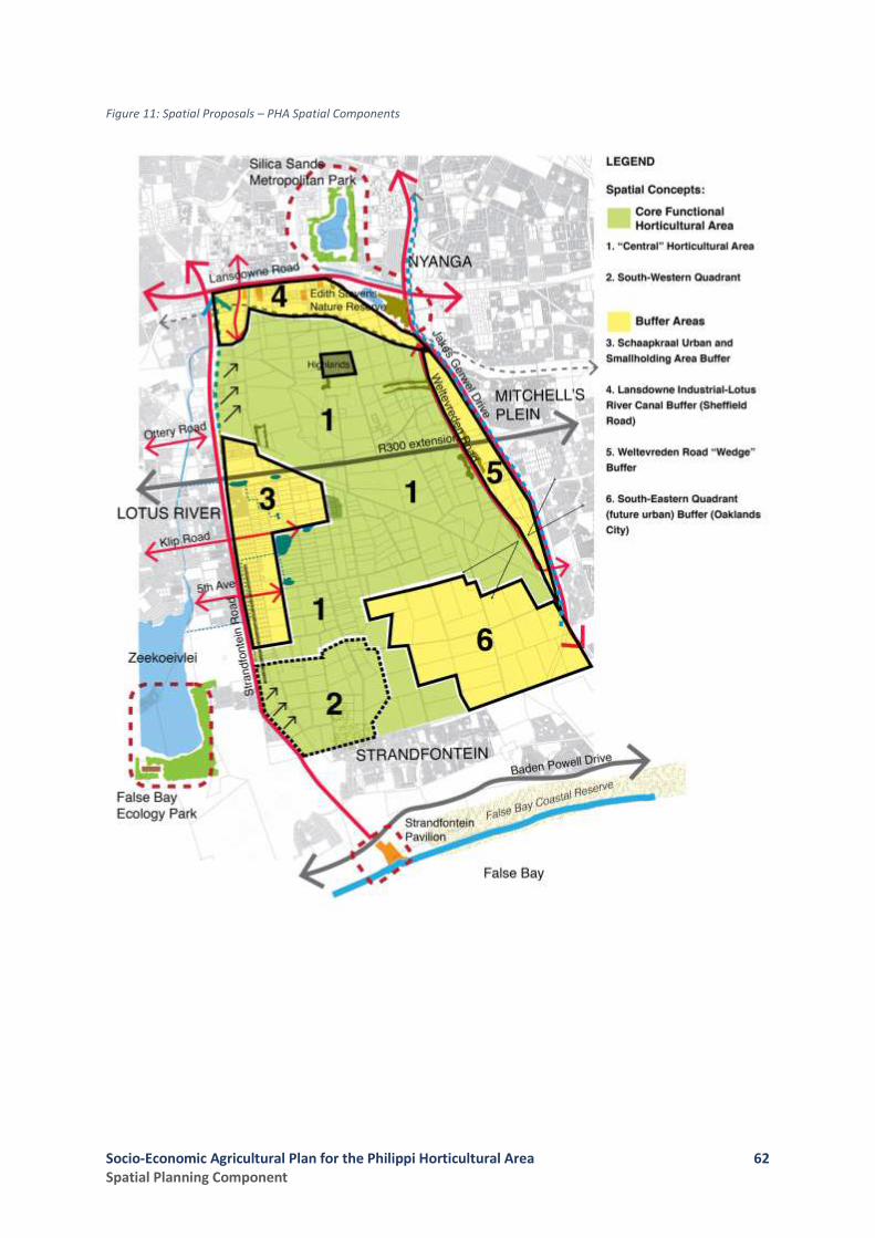
Socio-Economic Agricultural Plan for the Philippi Horticultural Area Spatial Planning Component
62
Figure 11: Spatial Proposals – PHA Spatial Components

Socio-Economic Agricultural Plan for the Philippi Horticultural Area Spatial Planning Component
63
4.3 Key Spatial Elements Requiring Development to Enhance the Functionality of the PHA
The sustainability and functioning of the horticultural area and the development and ongoing management of its buffer areas to ensure support for the optimal performance of the horticultural activity is seen as being dependent on the introduction and/or strengthening of the following spatial elements as put forward in the 2012 Draft Urban Edge and Development Guidelines Study for the Schaapkraal Area and Environs (PHA) (CoCT, 2012)
Spatial Element Description and Function
1.
Gateways
(refer to Figure 12)
In order to improve and facilitate public access to the horticultural area (i.e. for viewing, food education, visiting periodic farmers’ markets, participating in community gardens, passive recreation, etc.) the development of three(3) gateways as depicted in Diagram 2a are put forward, including:
• Off Strandfontein Road into Ottery Road
• Off Strandfontein Road into 18th Avenue
• Off Weltevreden Road into Varkens Vlei Road
Such gateways create legible, visible and easily accessible entry points, with periodic agri-markets, community gardens and other agri-related activities to characterise these gateway spaces and encourage visitor entry. Accordingly future land use to reserve such spaces for this purpose.
2.
Movement Linkages
(refer to Figure 13)
Improvement of access to the horticultural area and its buffer areas is critical in the redefining of the role of such areas, with a focus on movement links (e.g. public transport, private transport, NMT, etc.) to reintegrate such areas with their environs. Of particular note are the following:
• MyCiti route from Lansdowne Road into Strandfontein Road up to Ottery Road
• Recently constructed linkages from the Strandfontein Road upgrade into Schaapkraal and the PHA
• Potential NMT routes and bridal paths through the horticultural area and Schaapkraal.
3.
Complementary Facility and Resource Linkages
(refer to Figure 14)
The linkage of high order metropolitan environmental and recreation facilities/ resources (refer Diagram 2c), several currently underutilized, through the horticultural area and Schaapkraal can elevate the horticultural area as a metro environmental and recreational destination, which together with such facilities and resources can elevate the South-East Metro as an alternative environmental and recreation destination within the City.
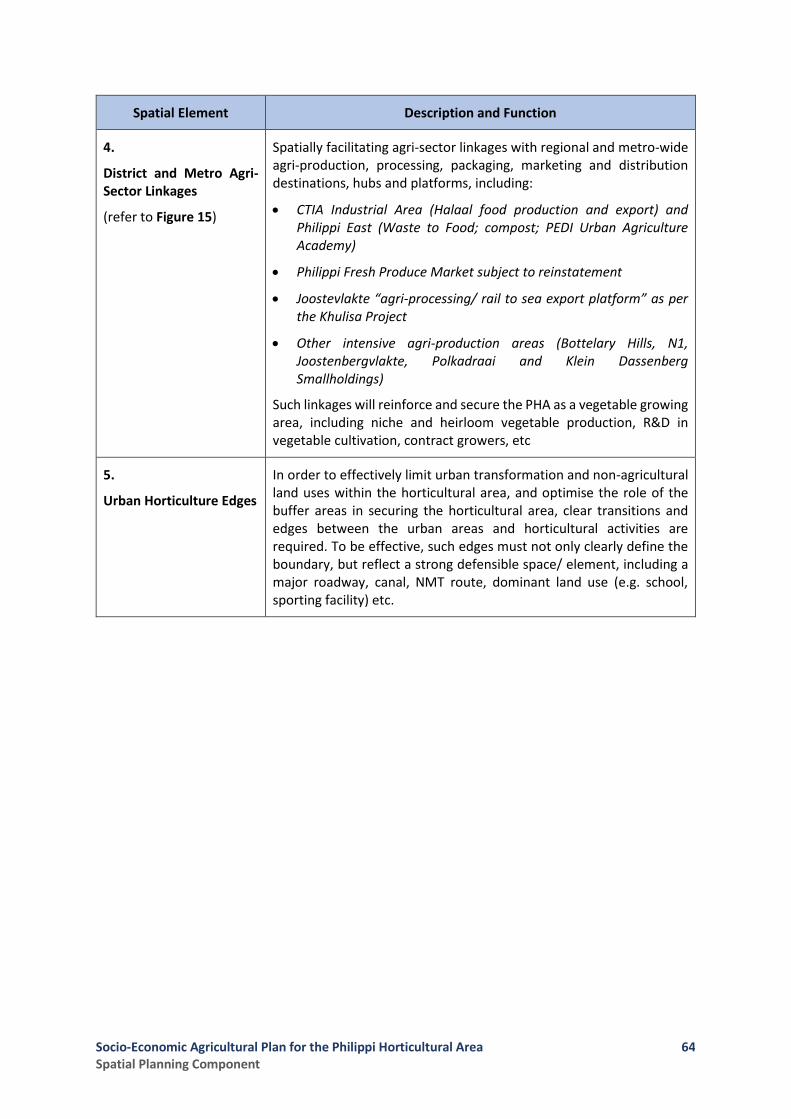
Socio-Economic Agricultural Plan for the Philippi Horticultural Area Spatial Planning Component
64
Spatial Element Description and Function
4.
District and Metro Agri-Sector Linkages
(refer to Figure 15)
Spatially facilitating agri-sector linkages with regional and metro-wide agri-production, processing, packaging, marketing and distribution destinations, hubs and platforms, including:
• CTIA Industrial Area (Halaal food production and export) and Philippi East (Waste to Food; compost; PEDI Urban Agriculture Academy)
• Philippi Fresh Produce Market subject to reinstatement
• Joostevlakte “agri-processing/ rail to sea export platform” as per the Khulisa Project
• Other intensive agri-production areas (Bottelary Hills, N1, Joostenbergvlakte, Polkadraai and Klein Dassenberg Smallholdings)
Such linkages will reinforce and secure the PHA as a vegetable growing area, including niche and heirloom vegetable production, R&D in vegetable cultivation, contract growers, etc
5.
Urban Horticulture Edges
In order to effectively limit urban transformation and non-agricultural land uses within the horticultural area, and optimise the role of the buffer areas in securing the horticultural area, clear transitions and edges between the urban areas and horticultural activities are required. To be effective, such edges must not only clearly define the boundary, but reflect a strong defensible space/ element, including a major roadway, canal, NMT route, dominant land use (e.g. school, sporting facility) etc.
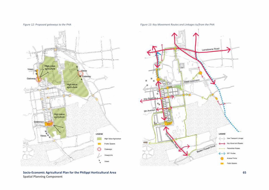
Socio-Economic Agricultural Plan for the Philippi Horticultural Area Spatial Planning Component
65
Figure 12: Proposed gateways to the PHA
Figure 13: Key Movement Routes and Linkages to/from the PHA
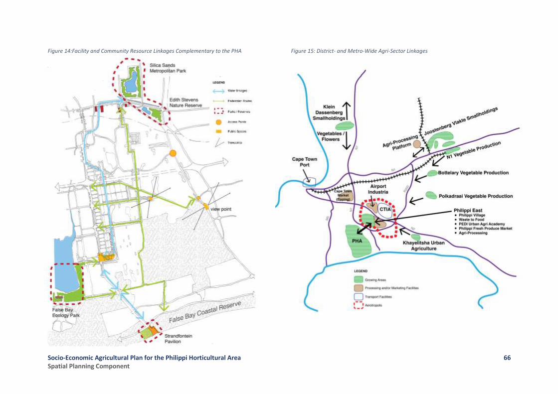
Socio-Economic Agricultural Plan for the Philippi Horticultural Area Spatial Planning Component
66
Figure 14:Facility and Community Resource Linkages Complementary to the PHA
Figure 15: District- and Metro-Wide Agri-Sector Linkages
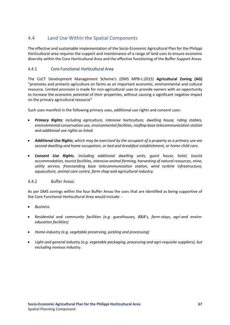
Socio-Economic Agricultural Plan for the Philippi Horticultural Area Spatial Planning Component
67
4.4 Land Use Within the Spatial Components
The effective and sustainable implementation of the Socio-Economic Agricultural Plan for the Philippi Horticultural area requires the support and maintenance of a range of land uses to ensure economic diversity within the Core Horticultural Area and the effective functioning of the Buffer Support Areas.
4.4.1 Core Functional Horticultural Area
The CoCT Development Management Scheme’s (DMS MPB-L:2015) Agricultural Zoning (AG) “promotes and protects agriculture on farms as an important economic, environmental and cultural resource. Limited provision is made for non-agricultural uses to provide owners with an opportunity to increase the economic potential of their properties, without causing a significant negative impact on the primary agricultural resource” Such uses manifest in the following primary uses, additional use rights and consent uses:
• Primary Rights; including agriculture, intensive horticulture, dwelling house, riding stables, environmental conservation use, environmental facilities, rooftop base telecommunication station and additional use rights as listed.
• Additional Use Rights; which may be exercised by the occupant of a property as a primary use are second dwelling and home occupation, or bed and breakfast establishment, or home child care.
• Consent Use Rights, including additional dwelling units, guest house, hotel, tourist accommodation, tourist facilities, intensive animal farming, harvesting of natural resources, mine, utility service, freestanding base telecommunication station, wind turbine infrastructure, aquaculture, animal care centre, farm shop and agricultural industry.
4.4.2 Buffer Areas:
As per DMS zonings within the four Buffer Areas the uses that are identified as being supportive of the Core Functional Horticultural Area would include: -
• Business
• Residential and community facilities (e.g. guesthouses, B&B’s, farm-stays, agri-and enviro-education facilities)
• Home-industry (e.g. vegetable preserving, pickling and processing)
• Light-and general industry (e.g. vegetable packaging, processing and agri-requisite suppliers), but excluding noxious industry.

Socio-Economic Agricultural Plan for the Philippi Horticultural Area Spatial Planning Component
68
4.5 Implementing the Spatial Reservation of the PHA
The “Core Functional Horticultural Area” as depicted in Figure 10 must be spatially reserved to ensure its sustainability, with the following actions being identified:
• Retention of the Central Horticultural Area (Area 1)
• Reversal of the urban edge demarcating the South-Western Quadrant (Area 2)
• Reincorporation of the South-Western Quadrant with the “Central Horticultural Area”
4.5.1 Development Management in the Core Functional Horticultural Area
The spatial reservation of the Core Functional Horticultural Area should be given expression in the rigorous application of the following land development and land use management mechanisms:
• The DMS as per the City of Cape Town Municipal Planning By-Law (2015) being applied as follows:
o Agriculture being the primary use as per Agricultural Zoning (AG) and the “development rules” applying to this primary use as regards dwelling density, building lines, parking, building height and property subdivision.
o An Overlay Zoning to be made applicable as per the Significant Agriculture Areas map in the Draft MSDF (said map having been prepared by the CoCT in consultation with the WCG: DoA, 2016) (refer Figure 6).
o A further Overlay Zoning to be made applicable as per the Heritage Resources map in the Draft MSDF (refer Figure 7)
• Dual land use authorisation (WCG and CoCT) in terms of which “land development” applications that relate to land that has been irrigated or ploughed for agricultural purposes within a period of ten (10) years of said application shall be deemed to trigger the application of Section 53(1) of LUPA (2014) and Section 10(1) of the Land Use Planning Regulations (2015). It should further be noted that, in terms of LUPA and the applicable Regulations, the WCG may in future refine, or designate additional instances where land development applications would be subject to the provisions of either Sections 45 or 53 of LUPA, and the applicable Regulations, by Notice in the Provincial Gazette.
• Finally, it should be noted that there may be the potential in future to designate the Core Functional Horticultural Area as a Protected Agricultural Area in terms of the Preservation and Development of Agricultural Land Act (currently in draft [Bill] form).
4.5.2 Development Management in the Buffer Areas
The “Buffer Areas” abutting the core functional horticultural area as depicted in Figure 10 must be subject to strict land use and environmental resource management to ensure their support function to the Core Functional Horticultural Area through the following:
• Putting in place “Buffer Interface” land uses and related Zonings (i.e. ensuring appropriate use activity and resource management) in the Buffer Areas in order to support the Resource Quality Objectives of the Cape Flats Aquifer, with a specific focus being placed on managing and controlling the type of industrial activity, intensive animal farming or other high-volume waste/

Socio-Economic Agricultural Plan for the Philippi Horticultural Area Spatial Planning Component
69
waste water discharge activities, particularly regarding how wastes, waste water streams and spillages are regulated and managed.
• The rigorous application of the DMS in line with the applicable Zoning of land parcels and the policing of permitted land uses and the development rules pertaining to such Zoning categories.
4.5.3 Application and Enforcement of Other Relevant Legislation
In addition to the above, the sustainable use of agricultural and natural resources within both the Core Functional Horticultural Area and its Buffer Areas requires the following:
• The strict application of the Regulations made in terms of the National Environmental Management Act (NEMA, Act 107 of 1998, as amended) when listed activities are triggered requiring environmental authorisation (i.e. for existing and proposed activities);
• The NEMA Waste Act (Act 59 of 2008) with regard to preventing the contamination or potential contamination of land, control of emergency incidents leading to pollution and remediation of contaminated land (e.g. building rubble sites); and
• The National Water Act (Act 36 of 1998) regarding verification of water rights, requirement for Water Use Licences, and the control and management of waste water quality and discharge, etc.
Socio-Economic Agricultural Plan for the Philippi Horticultural Area Spatial Planning Component
70
References Cape Metropolitan Council, Metro South-East Plan: The Future of the Philippi Horticultural Area, 1997 City of Cape Town, Draft Municipal Spatial Development Framework, 2017 City of Cape Town, City of Cape Town Development Management Scheme, Schedule 3 of Municipal Planning By-Law, 2015 City of Cape Town, Urban Edge and Development Guidelines Study for the Schaapkraal Area and Environs in the Philippi Horticultural Area, 2013 City of Cape Town, Cape Town Zoning Scheme (final draft), 2012 City of Cape Town, Cape Town Spatial Development Framework; Statutory Report, 2011 City of Cape Town, Philippi Horticultural Area; PEPCO Review, 2009 City of Cape Town, Cape Town Development Edges Policy : Urban and Coastal Edges Policy (draft) 2009 City of Cape Town, Agricultural Land Review, 2008 City of Cape Town, Agricultural Land Study, 2006 City of Cape Town, An Assessment of Three Potential Growth Areas for Future Housing and City Development, 2002 City of Cape Town, Philippi Horticultural Area Management Plan, 2000 City of Cape Town, Lansdowne Road – Philippi Local Structure Plan, 1995 Divisional Council of the Cape, Town Planning Regulations, 1973 Guide Plan Committee, Cape Metropolitan Guide Plan Volume 1 : Peninsula, 1988 Western Cape Regional Services Council, Policy Framework for Smallholdings in Metropolitan Cape Town, 1994 Western Cape Regional Services Council, Proposed Land Use Development Control Policies for the Schaapkraal Smallholding Area, September 1992

Socio-Economic Agricultural Plan for the Philippi Horticultural Area Spatial Planning Component
71
Annexure A
Record of Meetings Held with the following Stakeholders:
• The City of Cape Town
o Transport & Development Authority: Spatial Planning on 28 August 2017
o Directorate: Informal Settlements and Backyarders on 1 September 2017
o Transport & Development Authority: Land Development Management on 12 September 2017
o Directorate: Informal Settlements and Backyarders on 5 October 2017
• The WCG: Department of Environmental Affairs and Development Planning
o Meeting with all relevant Directorates on 31 August 2017