Embed Size (px)
Citation preview
75
STATE ROUTE-75
TRANSPORTATION CONCEPT SUMMARY
This Transportation Concept Summary (TCS) for State Route 75 in District 11 serves as an analysis tool and conceptual long-range guide
for future investment decisions in the transportation corridor.
DISCLAIMER The information and data contained in this document are for planning purposes only and should not be relied upon for final design of any project. Any information in this TCS is subject to modification as conditions change and new information is obtained. Although planning information is dynamic and ever-changing, the District 11 Planning Division makes every effort to ensure the accuracy and timeliness of the information contained in the TCS. The information in the TCS does not constitute a standard, specification, or regulation, nor is it intended to address design policies and procedures. If you encounter information that you deem to be inaccurate or unreliable, please contact [email protected] or at 619-688-6967.
DRAFT
1
SR-75 Transportation Concept Summary
October 2011 CORRIDOR PURPOSE The primary purpose of State Route 75 is to provide intraregional access between the cities of Imperial Beach, Coronado, and San Diego. SR-75 provides the only
vehicular access to the Coronado peninsula by both the Silver Strand and the San Diego-Coronado Bay Bridge. The route carries a large number of civilian and
military commuters to the North Island Naval Air Station and the Naval Amphibious Base in Coronado.
CORRIDOR NEEDS SR-75 will experience increased traffic from regional growth. Safety spot improvements, limitation and separation of left turn movements, limited
driveways, and other transportation system management (TSM) improvements could be provided in the corridor. Employer-based incentives such as
telecommuting, vanpooling, and additional park and ride lots should be considered.
CORRIDOR ANALYSIS The City of Coronado has spent several years researching and identifying any possible solutions to alleviate traffic impacts within the city. This process has
revealed that the most significant traffic problems in Coronado continue to be traffic to and from Naval Air Station North Island (NASNI) along the Third and
Fourth Street couplets.
In 1988, 41 percent of voters supported "construction of a cut and cover tunnel" and in 1998, 83 percent of voters supported the City of Coronado in "seeking
funding sources to construct a bored tunnel" between the Coronado Bridge and NASNI.
Since the 1998 vote, the City has pursued and secured funding to complete the
SR-75/SR-282 Transportation Corridor engineering and environmental studies as
required by the National Environmental Policy Act (NEPA) and the California Environmental Quality Act (CEQA) for possible traffic-reducing alternatives. The
Study was approximately 90 percent complete in March 2010 and included analysis of nine alternatives. Two alternatives were no-build options and seven
alternatives were major construction projects. The two no-build alternatives were
DRAFT
2
status quo and traffic management solutions such as traffic calming, mass
transit, and ridesharing. Of the seven alternatives that involved a major project, one included Orange Avenue Underpasses at Third and Fourth Streets; four were
cut and cover tunnels beneath Fourth Street; and two were bored tunnels that would have run underneath Fourth Street.
The Coronado City Council placed Proposition H, the “City of Coronado Traffic
Tunnel Advisory Vote”, on the June 8, 2010 ballot. Specifically, the question on the ballot was, "Do you support the city continuing to use and seek federal, state
and local funding to complete the study of long-term traffic-relief options, including a tunnel, between the Coronado Bridge and Naval Air Station North
Island?"
Coronado voters defeated the measure with 69% voting no and 31% voting yes. With this defeat, the city of Coronado ended the study and ended all analysis of
funding options for the various project alternatives, including the tunnel options.
Although it is unlikely the tunnel will ever get built, the City of Coronado will
continue to pursue lower cost local transportation improvements to improve traffic flow within their jurisdiction. In general, some recommended SR-75
improvements include:
Study and consider modifying traffic patterns Eliminate some left turns and minimize overall turning movements
Concentrate pedestrian and bike crossings at certain intersections Consider raised medians at key locations
Utilize more “Right In, Right Out” access Consider modifying certain streets to one way only
Consider modifying on street parking in certain areas
The Caltrans District 11 Maintenance Division is under an agreement with the
City of Coronado to maintain sections of SR-75 from Rainbow Drive near Imperial Beach to the Toll Plaza. Predominant maintenance activities include landscaping
crack sealing, pavement markers, signs, attenuator barriers, litter patrol, sweeping, and irrigation repairs. The scheduling and frequency of maintenance
work is based on the level of service and maintenance type required for the specific maintenance activity. Factors such as safety, traffic volume and
complexity determine priority and workload schedules.
DRAFT
3
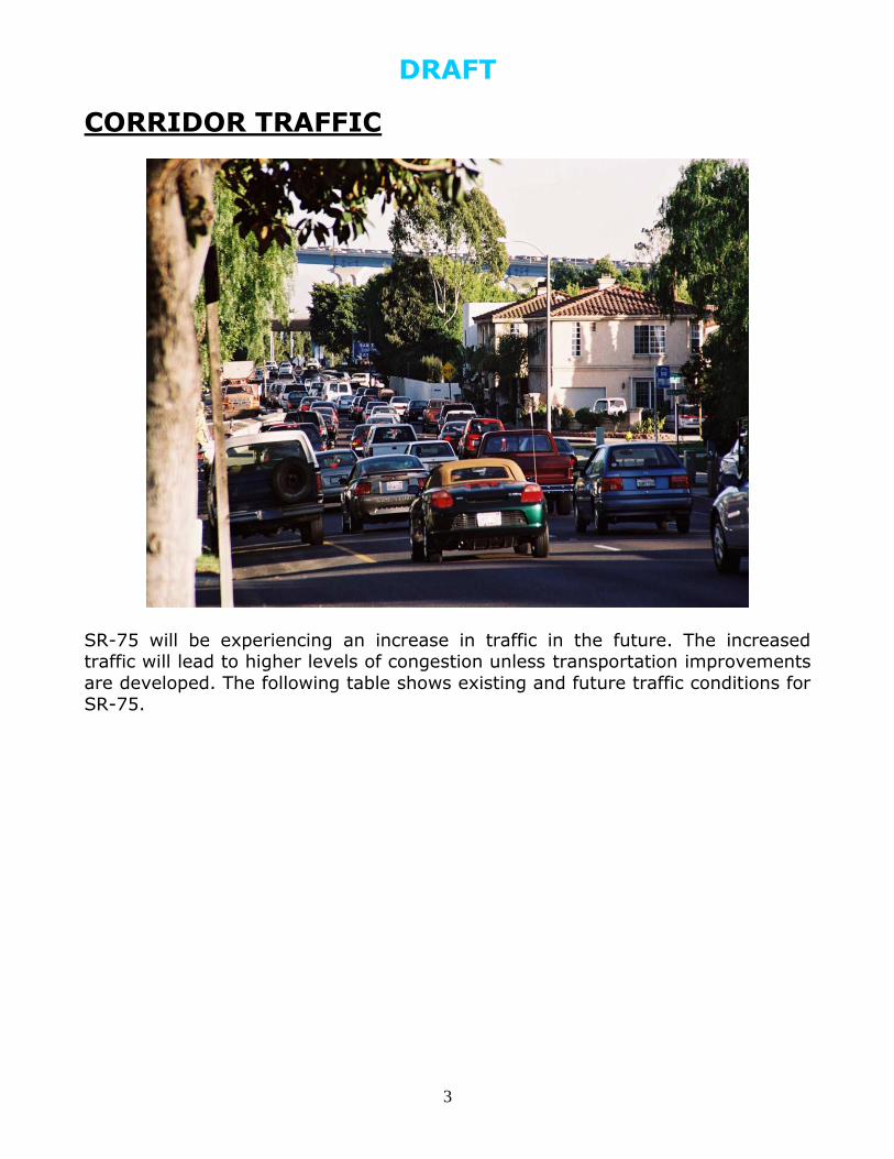
CORRIDOR TRAFFIC
SR-75 will be experiencing an increase in traffic in the future. The increased traffic will lead to higher levels of congestion unless transportation improvements
are developed. The following table shows existing and future traffic conditions for SR-75.
DRAFT
4
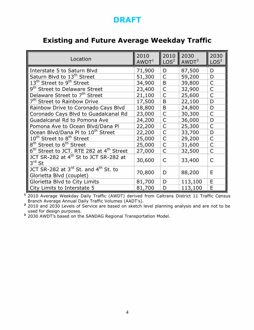
Existing and Future Average Weekday Traffic
Location 2010
AWDT1
2010
LOS2
2030
AWDT3
2030
LOS2
Interstate 5 to Saturn Blvd 71,900 D 87,500 D
Saturn Blvd to 13th Street 51,300 C 59,200 D
13th Street to 9th Street 34,900 B 39,800 C
9th Street to Delaware Street 23,400 C 32,900 C
Delaware Street to 7th Street 21,100 C 25,600 C
7th Street to Rainbow Drive 17,500 B 22,100 D
Rainbow Drive to Coronado Cays Blvd 18,800 B 24,800 D
Coronado Cays Blvd to Guadalcanal Rd 23,000 C 30,300 C
Guadalcanal Rd to Pomona Ave 24,200 C 36,000 D
Pomona Ave to Ocean Blvd/Dana Pl 22,200 C 25,300 C
Ocean Blvd/Dana Pl to 10th Street 22,200 C 33,700 D
10th Street to 8th Street 25,000 C 29,200 C
8th Street to 6th Street 25,000 C 31,600 C
6th Street to JCT. RTE 282 at 4th Street 27,000 C 32,500 C
JCT SR-282 at 4th St to JCT SR-282 at 3rd St
30,600 C 33,400 C
JCT SR-282 at 3rd St. and 4th St. to Glorietta Blvd (couplet)
70,800 D 88,200 E
Glorietta Blvd to City Limits 81,700 D 113,100 E
City Limits to Interstate 5 81,700 D 113,100 E 1 2010 Average Weekday Daily Traffic (AWDT) derived from Caltrans District 11 Traffic Census
Branch Average Annual Daily Traffic Volumes (AADT’s). 2 2010 and 2030 Levels of Service are based on sketch level planning analysis and are not to be
used for design purposes. 3 2030 AWDT’s based on the SANDAG Regional Transportation Model.
DRAFT
5
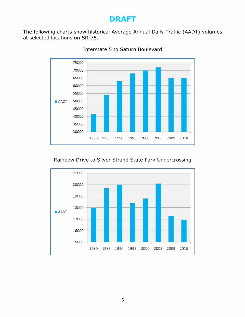
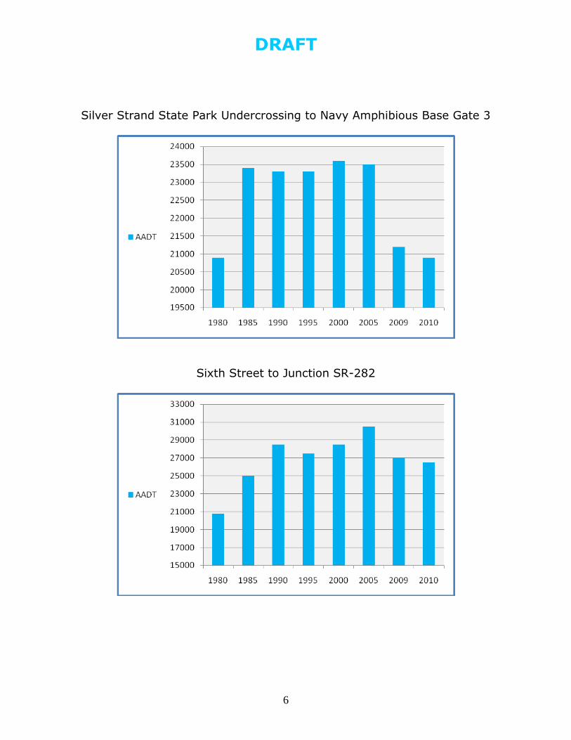
The following charts show historical Average Annual Daily Traffic (AADT) volumes
at selected locations on SR-75.
Interstate 5 to Saturn Boulevard
Rainbow Drive to Silver Strand State Park Undercrossing
DRAFT
6
Silver Strand State Park Undercrossing to Navy Amphibious Base Gate 3
Sixth Street to Junction SR-282
DRAFT
7
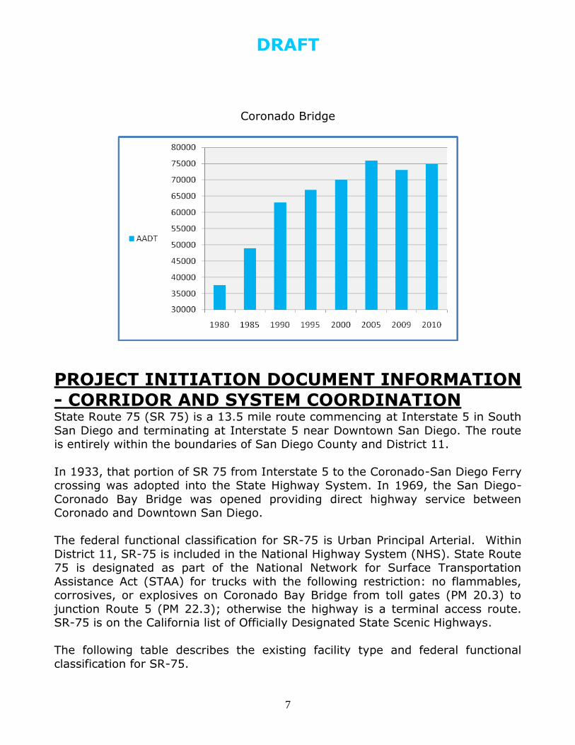
Coronado Bridge
PROJECT INITIATION DOCUMENT INFORMATION - CORRIDOR AND SYSTEM COORDINATION State Route 75 (SR 75) is a 13.5 mile route commencing at Interstate 5 in South
San Diego and terminating at Interstate 5 near Downtown San Diego. The route is entirely within the boundaries of San Diego County and District 11.
In 1933, that portion of SR 75 from Interstate 5 to the Coronado-San Diego Ferry crossing was adopted into the State Highway System. In 1969, the San Diego-
Coronado Bay Bridge was opened providing direct highway service between Coronado and Downtown San Diego.
The federal functional classification for SR-75 is Urban Principal Arterial. Within
District 11, SR-75 is included in the National Highway System (NHS). State Route 75 is designated as part of the National Network for Surface Transportation
Assistance Act (STAA) for trucks with the following restriction: no flammables, corrosives, or explosives on Coronado Bay Bridge from toll gates (PM 20.3) to
junction Route 5 (PM 22.3); otherwise the highway is a terminal access route. SR-75 is on the California list of Officially Designated State Scenic Highways.
The following table describes the existing facility type and federal functional
classification for SR-75.
DRAFT
8
Post Mile Location Rural/
Urban
Lanes/ Facility
Type*
Functional
Classification
8.93-10.72 Interstate 5 to
Delaware Street Urban 6C Principal Arterial
10.72-17.61 Delaware Street to
Naval Amphibious Base Urban 4E Principal Arterial
17.61-19.70 Naval Amphibious Base to 3rd Street
Urban 4C Principal Arterial
19.70-20.03 3rd Street to Pomona
Ave Urban 6Cp Principal Arterial
20.03-22.47 Pomona Ave to
Interstate 5 Urban 5E Principal Arterial
* Facility Type: C=Conventional; E=Expressway; Cp=Couplet
RECOMMENDED CORRIDOR IMPROVEMENTS
Highway Improvements Recommended transportation improvements for SR-75 are from the 2010 State Highway Operation and Protection Plan (SHOPP), the District 11 Project
Information Reporting System (PIRS), the most recent Status of Projects, the District 11 2007 and 2009 Ten-Year SHOPP Needs Plans, and the District 11
Planning Division.
There are no planned capacity-enhancing transportation projects for SR-75.
There is a pending Safety Project to install new intersection warning signs and adding flashing beacons to the signs approximately 500 feet on either side of the
T-intersection at SR-75/Fiddler’s Cove (PM 16.0). This project is on the Caltrans District 11 Minor “A” list and is projected for funding and construction in fiscal
year 2012/2013.
The following table shows 2010 SHOPP and PIRS projects for SR-75.
Post Mile Location Improvement Description Source/Phase*
11.0 -17.4 Rainbow Drive to Amphibious Base Gate 4
Pavement Rehabilitation of Mainline and Shoulders
2010 SHOPP/PSE
PSE = Plans, Specifications, and Estimates
DRAFT
9
The following table shows the 2007 10-Year SHOPP Needs Plan Projects for SR-
75.
Post Mile Location Improvement Description Category/Fiscal Year
8.9 -22.3 Entire Route Relinquish Route Emergency and Mandated FY2010/11
8.9 -22.3 Entire Route
Upgrade 52 Signs (Materials and Exit #s)
and Overhead Lighting to Inductive Technology
Roadway
Preservation FY 2014/15
10.99/17.35 Rainbow Drive to the Naval Amphibious Base
Pavement rehabilitation, PCC grinding, slabs replacement
Roadway Preservation 2013/14
VAR In San Diego at various locations on Route 75
Joint seals, deck rehabilitation Bridge Preservation 2011/12
The following table shows the 2009 10-Year SHOPP Needs Plan Projects for SR-75.
Post Mile Location Improvement Description Category/Fiscal Year
18.0-20.1 Avenida Lunar to Glorietta Blvd
Relinquish Highway Mandates FY2015/16
9.3 -10.1 Saturn Boulvevard to 13th Street
Construct curb ramps and Pedestrian sidewalks
Mandates FY 2010/11
R20.5 Coronado Bridge Bridge and substructure rehabilitation
Bridge
Preservation
2016/17
DRAFT
10
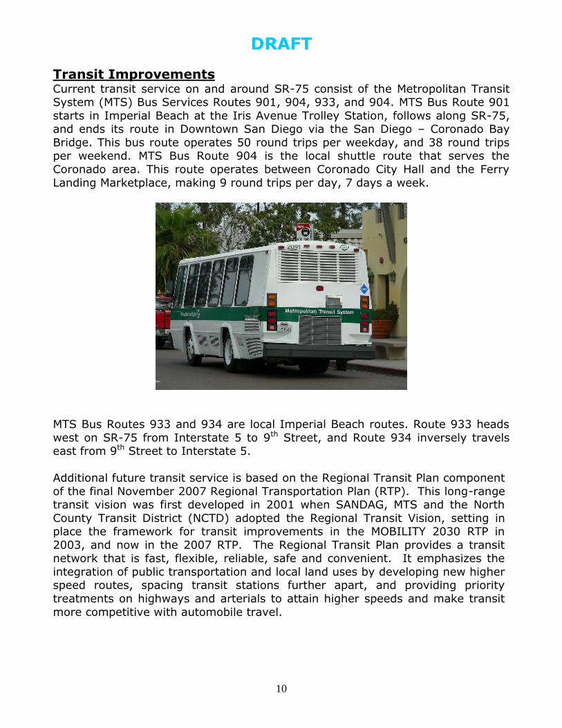
Transit Improvements Current transit service on and around SR-75 consist of the Metropolitan Transit System (MTS) Bus Services Routes 901, 904, 933, and 904. MTS Bus Route 901
starts in Imperial Beach at the Iris Avenue Trolley Station, follows along SR-75, and ends its route in Downtown San Diego via the San Diego – Coronado Bay
Bridge. This bus route operates 50 round trips per weekday, and 38 round trips per weekend. MTS Bus Route 904 is the local shuttle route that serves the
Coronado area. This route operates between Coronado City Hall and the Ferry
Landing Marketplace, making 9 round trips per day, 7 days a week.
MTS Bus Routes 933 and 934 are local Imperial Beach routes. Route 933 heads
west on SR-75 from Interstate 5 to 9th Street, and Route 934 inversely travels east from 9th Street to Interstate 5.
Additional future transit service is based on the Regional Transit Plan component
of the final November 2007 Regional Transportation Plan (RTP). This long-range transit vision was first developed in 2001 when SANDAG, MTS and the North
County Transit District (NCTD) adopted the Regional Transit Vision, setting in place the framework for transit improvements in the MOBILITY 2030 RTP in
2003, and now in the 2007 RTP. The Regional Transit Plan provides a transit network that is fast, flexible, reliable, safe and convenient. It emphasizes the
integration of public transportation and local land uses by developing new higher speed routes, spacing transit stations further apart, and providing priority
treatments on highways and arterials to attain higher speeds and make transit
more competitive with automobile travel.
DRAFT
11
Urban Area Transit Strategy
As part of the development of the 2050 Regional Transportation Plan, SANDAG is preparing an “Urban Area Transit Strategy” which will serve as the basis of the
regional transit network to be included in the 2050 RTP. Through the planning process, SANDAG staff is developing and testing three transit network
alternatives with a focus on the urban areas of the San Diego region. Ultimately, one of the networks (or a combination or variation of) will be incorporated into
the 2050 RTP and its Sustainable Communities Strategy (SCS). The overarching goal is to create a world-class transit system for the San Diego region in 2050
that significantly increases the use of transit, walking, and biking in the urbanized areas of the region, makes transit time competitive with the car,
maximizes the use of transit during peak periods, and reduces greenhouse gas emissions and vehicle miles traveled in the region. The transit alternatives under
study are grouped into these three themes:
“Transit Propensity” (expanding transit in the most urbanized areas);
“Commuter Point-to-Point” (emphasizing quick access to work); and “Many Centers” (connecting local smart growth areas and activity centers).
Additional transit information will be provided in the next update of this TCS.
Complete Streets Under the guidance of Deputy Directive 64-R1, Caltrans develops integrated multimodal projects in balance with community goals, plans, and values.
Addressing the safety and mobility needs of bicyclists, pedestrians, and transit users in all projects, regardless of funding, is implicit in these objectives. Bicycle,
pedestrian, and transit travel is facilitated by creating "complete streets" beginning early in system planning and continuing through project delivery,
maintenance, and operations. Transit options and safe pedestrian crossings are some examples of efforts to meet these goals.
Nonmotorized Transportation Bicycle riders and pedestrians have a legal right to access most public roads in
California. While pedestrians are prohibited from virtually all freeways, bicycles are permitted on the outside shoulders of nearly 25 percent of all freeways
located within the state. The legal authority to prohibit bicycle and pedestrian use from freeways and expressways is specified in the California Vehicle Code section
21960.
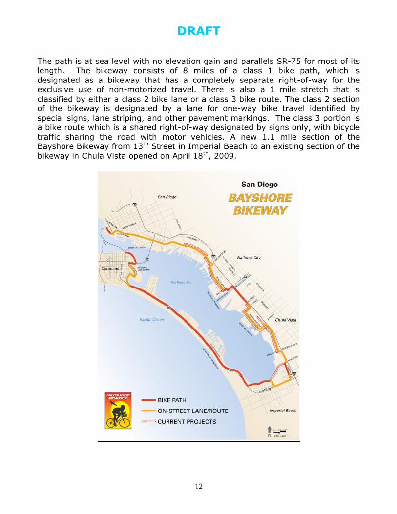
The Silver Strand Bikeway is a 9 mile bicycle and pedestrian path along SR-75,
from Imperial Beach to the Ferry Landing Marketplace (corner of 1st Street and B Avenue) in Coronado. The bikeway is part of the longer 24 mile bicycle facility
around San Diego Bay known as the Bayshore Bikeway.
DRAFT
12
The path is at sea level with no elevation gain and parallels SR-75 for most of its length. The bikeway consists of 8 miles of a class 1 bike path, which is
designated as a bikeway that has a completely separate right-of-way for the exclusive use of non-motorized travel. There is also a 1 mile stretch that is
classified by either a class 2 bike lane or a class 3 bike route. The class 2 section of the bikeway is designated by a lane for one-way bike travel identified by
special signs, lane striping, and other pavement markings. The class 3 portion is a bike route which is a shared right-of-way designated by signs only, with bicycle
traffic sharing the road with motor vehicles. A new 1.1 mile section of the Bayshore Bikeway from 13th Street in Imperial Beach to an existing section of the
bikeway in Chula Vista opened on April 18th, 2009.
DRAFT
13
Other Transportation Improvements Additional modal option improvements such as park and ride, transportation demand management, transportation system management, and Intelligent
Transportation Systems (ITS) should be developed for the SR-75 corridor.
In 2007, the City of Imperial Beach hired MIG, a land-use planning firm with offices in San Diego, to create the Palm Avenue Commercial Corridor Master Plan.
The $18.6 million plan will create a new “main street” that will entice drivers to stop and shop at the businesses along Palm Avenue, encourage private
investment in the area, and create a more defined route to the shoreline. The
Imperial Beach City Council unanimously approved the Master Plan in February 2009. Also in February 2009, the consultant-prepared Imperial Beach Traffic
Impact Study was developed to analyze potential modifications to traffic lanes, parking areas, medians, landscaping, sidewalks, crosswalks, curbs, and gutters.
The Master Plan divides Palm Avenue into four sections from Rainbow Drive to 13th Street. Each section – West End Gateway, Park, Mid-Town and East End Gateway – represents a distinct district that will be connected to the others with
new landscaping and improved sidewalks, medians and bike paths. The most significant design changes are planned for the Mid-Town section from Florida to
Delaware Streets. The Master Plan proposes keeping two lanes of the highway in
each direction for through-traffic and using one lane to access businesses. That lane will be separated from the other two with a median. Another section that
may change drastically is the Park area, from Delaware to Seventh Streets. The area is now a mix of odd-shaped medians and traffic islands and a confusing
series of diagonal streets and merging lanes. The new design creates a better flow of traffic toward a more prominent entrance to the city's Seacoast
commercial district.
The proposed changes, including the loss of the one through-lane in the Mid-Town section, narrower intersections and wider medians with more trees and
traffic signals that work together, will improve traffic movement along this
portion of SR-75.
Caltrans strongly encourages the City of Imperial to ascertain at an early stage if
any or all portions of this project will require relinquishment of SR-75, so that the City may begin consultations with the City of San Diego and the City of Coronado
for acceptance of portions of the route that may fall within their jurisdiction and require relinquishment.
DEVELOPMENT REVIEW
Caltrans District 11 Development Review staff in the Planning Division review
federal, state, and local planned or proposed development activities that have the
DRAFT
14
potential to impact state transportation facilities or other resources under
Caltrans' jurisdiction, and recommend conditions of project approval that eliminate those impacts or reduce them to a level of insignificance. Typically, this
involves the review of development proposals in which Caltrans is either a responsible (permitting) or commenting (reviewing) agency, but has no
discretionary approval power over the project other than permit authority. Development Review staff work cooperatively with local lead agencies and
developers in determining the type and level of mitigation needed to offset project impacts. They are also responsible for identifying other functional areas
within District 11 that are affected by the proposal, and coordinating the circulation of appropriate documents with other functional areas for review and
comment.
Based on the Caltrans Traffic Impact Study (TIS) guidelines, a 1,000 Average Daily Traffic (ADT) threshold size triggers the need for developers to prepare a
traffic study for their project. The following information generally includes
projects for which an Environmental Document, a Specific Plan, or a Master Plan has been or will be prepared. There are currently two potential development
projects within or adjacent to the proposed SR-75 corridor that will generate approximately 11,800 ADT. There may be an additional number of smaller
development projects that may have additional cumulative impacts on traffic in the corridor. Due to uncertainties associated with future demographic,
socioeconomic, and political climates, the scale of development may be subject to change. Changes in land use prompting rapid commercial and industrial
development growth will need to be monitored closely by all impacted jurisdictions and agencies. Appropriate traffic studies for proposed developments
will need to be conducted by developers and reviewed carefully by Caltrans staff. Land development and local capital improvement projects should also be
coordinated with Caltrans projects.
The following table shows proposed projects on or near to SR-75 that currently
within the development review process:
Post Mile Project Name ADT Project Description
10.07 Palm Avenue Car Wash 900 Commercial
10.57 Palm Ave/Commercial Redevelopment
10,912 Commercial/redevelopment


![[Archived] Georgia Departement of Transportation ...2 WORKSHOOP DETAILS. CHAPTER 1. 1.1. Opening Session. The i-75 from sr 54 North to Aviation Boulevard – for hov Lanes workshop](https://img.pdfslide.net/doc/110x75/5f40561c245d474ffd2cda1e/archived-georgia-departement-of-transportation-2-workshoop-details-chapter.jpg)