Embed Size (px)
Citation preview
(August 2oo7) united states Carlsbtfd tleld Of
DEPARTMENT OF THE INTERIOR „BUREAU OF LAND MANAGEMENT flOubS
SUNDRY NOTICES AND REPORTS ON WELLSDo not use this form for proposals to drill or to re-enter an
abandoned well. Use form 3160-3 (APD) for such pro4«4*$0B§ OO C
Kpn FORM APPROVEDlIv-V OMB NO. 1004-0135
Expires: July 31,2010
5. Lease Serial No.
NMNM27508
6. If Indian, Allottee or Tribe Name
SUBMIT IN TRIPLICATE - Other instructions on reverse s|^y 3 20J67. If Unit or CA/Agreement, Name and/or No.
1. Type of Well0 Oil Well □ Gas Well □ Other / PPPCh/Cn
8. Well Name and No. /
WILDER 28 FEDERAL 1H /2. Name of Operator J Contact: ASHLEY BERGEN^
CONOCOPHILLIPS COMPANY / E-Mail: [email protected]. API Well No.
30-025-40261-00-S1
3a. Address 3b. Phone No. (include area code)
, Ph: 432-688-6938MIDLAND, TX 79710 /
10. Field and Pool, or Exploratory
JENNINGS
4. Location of Well (Footage, Sec., T., R., M„ or Survey Description)
Sec 28 T26S R32E NENE 610FNL 835FEL /11. County or Parish, and State /
LEA COUNTY, NM /
12. CHECK APPROPRIATE BOX(ES) TO INDICATE NATURE OF NOTICE, REPORT, OR OTHER DATA
TYPE OF SUBMISSION TYPE OF ACTION
0 Notice of Intent□ Acidize □ Deepen □ Production (Start/Resume) □ Water Shut-Off
□ Alter Casing □ Fracture Treat □ Reclamation □ Well Integrity
□ Subsequent Report(“I Casing Repair □ New Construction □ Recomplete 0 Other
□ Final Abandonment Notice □ Change Plans □ Plug and Abandon □ Temporarily AbandonSurface Commingling
□ Convert to Injection □ Plug Back □ Water Disposal
13. Describe Proposed or Completed Operation (clearly state all pertinent details, including estimated starting date of any proposed work and approximate duration thereof. If the proposal is to deepen directionally or recomplete horizontally, give subsurface locations and measured and true vertical depths of all pertinent markers and zones. Attach the Bond under which the work will be performed or provide the Bond No. on file with BLM/B1A. Required subsequent reports shall be filed within 30 days following completion of the involved operations. If the operation results in a multiple completion or recompletion in a new interval, a Form 3160-4 shall be filed once testing has been completed. Final Abandonment Notices shall be filed only after all requirements, including reclamation, have been completed, and the operator has determined that the site is ready for final inspection.)
Wilder Federal 28 1H Sect. 28, NENE, T26S, R32E 30-025-40261 Wilder Federal 28 2H Sect. 28, NWNE, T26S, R32E 30-025-40329 Wilder Federal 29 1H Sect. 29, NENE, T26S, R32E 30-025- Yo?9<3 Wilder Federal AC 29 2H Sect. 29, NWNE, T26S, R32E 30-025-41511 Wilder Federal 29 5H Sect. 29, NENE, T26S, R32E 30-025-41509 Wilder 28 AC Federal COM 3H Sect. 28, NENW, T26S, R32E 30-02-40501 Wilder 28 AC Federal COM 4H Sect. 28, NWNW, T26S, R32E 30-025-40502 Wilder 28 AC Federal COM 8H Sect. 28, NWNW, T26S, R32E 30-025-41692
See attached detailed commingling information, diagram and map(s).
14. I hereby certify that the foregoing is true and correctElectronic Submission #336818 verifie
For CONOCOPHILLIPS CO Committed to AFMSS for processing by PRI
Name (Printed/Typed) ASHLEY BERGEN
d by the BLM Well Information SystemVIPANY, sent to the Hobbs5CILLA PEREZ on 04/21/2016 (16PP0577SE)
Title REGULATORY SPECIALIST
Signature (Electronic Submission) Date 04/18/2016
THIS SPACE FOR FEDERAL OR STATE OFFICE USE
Approved By '/- 4^-Title ^^7’ Dat//7//£,
Conditions ofUppfbval, if any, are attached. Approvafof this notice does not warrant or certify that ftferapplicant holds legal or equitable title to those rights in the subject lease
which would entitle the applicant to conduct operations thereon. Office
•artncnt or ajTitle 18 U.S.C. Section 1001 and Title 43 U.S.C. Section 1212, make it a crime for any person knowingly and willfully to make to any dep; States any false, fictitious or fraudulent statements or representations as to any matter within its jurisdiction.
ir agency of the United
** BLM REVISED ** BLM REVISED ** BLM REVISED ** BLM REVISED ** BLM REVISED **
APPLICATION FOR, COMMINGLING AT A COMMON CENTRAL TANK BATTERY
Proposal for Wilder 28 Federal 1H, Wilder 28 Federal 2H, Wilder 29 Federal 1H, Wilder
Federal AC 29 2H, Wilder 29 Federal AC 5H, Wilder Federal 28 3H, Wilder Federal AC 28
4H, and Wilder Federal AC COM 28 8H.
Federal Lease NM27508 which is 12.5% Royalty Rate
Well Name Location API# Pool 97838 OilBOPD
Gravities MCFPD BTU/d
Wilder 28 Federal 1H SEC 28, NENE
T26S R32E
30-025-40261 Jennings, Upper
Bone Spring
Shale
14 48.5 60 1167
Wilder 28 Federal 2H SEC 28, NWNE
T26S R32E
30-025-40329 Jennings, Upper
Bone Spring
Shale
15 47 69 1321
Wilder 29 Federal 1H SEC 29, NENE
T26S R32E
30-025-40790 Jennings, Upper
Bone Spring
Shale
68 47.5 118 1186
Wilder Federal AC 29 2H SEC 29,NWNE
T26S R32E
30-025-41511 Jennings, Upper
Bone Spring
Shale
345* 46* 1000* 1400*
Wilder 29 Federal AC 5H SEC 29, T26S
32E NENE
30-025-41509 Jennings, Upper
Bone Spring
Shale
345* 48.7* 1000* 1300*
Federal Lease NM27508 & Federal Lease NM130738 is 12.5% Royalty Rate- CA# NM134716
Wilder Federal 28 3H SEC 28, NENW
T26S32E
30-025-40501 Jennings, Upper
Bone Spring
Shale
480* 48.7* 1400* 1300*
Wilder Federal AC 28 4H SEC 28, NWNW
T26S R32E
30-025-40502 Jennings, Upper
Bone Spring
Shale
480* 48.7* 1400* 1300*
Wilder Federal AC COM 28 8H SEC 28, NWNW
T26S R32E
30-025-41692 Jennings, Upper
Bone Spring
Shale
480* 48.7* 1000* 1300*
*These are proposed totals for these wells; once these wells are producing the production
information will be amended. I will submit BOPD & MCFPD for the Wilder Wells upon
receipt.
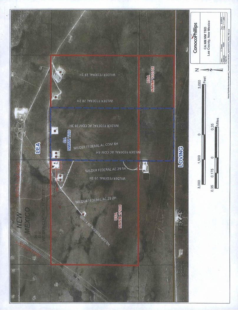
Attached map shows the federal leases and well locations in Section 28, 29 & 33 T26S 32E.
Lease NM27508 royalty rate at 12.5% and lease NM130738 royalty rate 12.5%. Communitization agreement NM134716 includes acreage from both of these leases.
Location:
The central tank battery is located on Sec 29, NENE, T26S, R32Eon federal lease NM27508
in Lea County, NM. Wells served are the wells listed above.
Overview:
The flow of production is shown in the facility lay out which is enclosed. The enclosed map shows the Facility boundary, location of wells, and gas sales meter. The commingling of this production will not result in reduced royalty or improper measurement of production. The proposed commingling will reduce the surface facility footprint and overall emissions.
Conoco Phillips understands the requested approval will not constitute the granting of any right-of-way or construction rights not granted by the lease instrument.
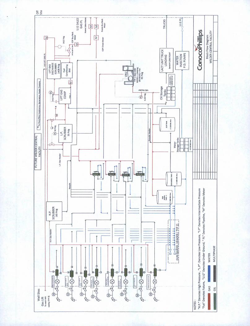
Process and Flow Descriptions:
The facility will be as follows. The production for each well will flow to a dedicated 3 phase Production Separator for gas, water, and oil to be metered. Oil is metered through a Coriolis meter* and the gas is metered through an EFM gas allocation meter*. The water is metered through a turbine meter. The oil production for the Wilder Central Facility has (8) 500 bbl oil tanks at the tank battery that all wells can utilize. Oil will be sold through a common LACT meter*. The volume of all tanks is determined by both Guided Wave Radar and Differential Pressure Level.
The gas off of the HP separators is sent to the High Pressure Scrubber and goes to sales or to the LP scrubber as gas make-up to Compression. Excess gas is sold at the sales gas meter*. Deductions are made for the Gas Lift Meter* Nuevo's Buy Back Meter* and the fuel gas meter*.
Produced water flows from the Production Separator and Heater Treater to one of two onsite 1000 bbl gun barrels. Water and any lighter hydrocarbon is separated in these two units and the hydrocarbon is decanted to a 500 bbl Slop tank, the water is transferred to any of [8) 500 bbl water tanks. Hydrocarbon from the slop tank is sent back one of the designated Heater Treaters for reprocessing. The water is transferred to the Wilder SWD injection well, to another facility, or via truck.
*Meter information for each well and sales meter is attached below, see metering section.
Metering:
Wilder 28 Federal 1H production is measured at a three phase separator which includes Micro Motion meter allocation #119-21-070. Gas is measure through allocation Meter #119-33-004 and lift meter # 119-09-024 is located at the wellhead. Water is measured through a turbine meter.
Wilder 28 Federal 2H production is measured at a three phase separator which includes Micro Motion Coriolis meter allocation #119-21-071. Gas is measure through allocation Meter# 119-33-005 and lift meter #119-09-022 is located at the wellhead. Water is
measured through a turbine meter.
Wilder 29 Federal 1H production is measured at a three phase separator which includes Micro Motion Coriolis meter allocation #119-21-076. Gas is measure through allocation
meter #119-33-010 and lift meter # 119-09-026 is located at the wellhead. Water is
measured through a turbine meter.
Wilder Federal AC 29 2H production is measured at a three phase separator which includes Micro Motion Coriolis meter allocation #119-21-077. Gas is measure through allocation meter # 119-33-011and lift meter # 119-09-028 is located at the wellhead. Water is measured through a turbine meter.
Wilder 29 Federal AC 5H production is measured at a three phase separator which includes Micro Motion Coriolis meter allocation #119-21-075. Gas is measure through allocation meter #119-33-009 and lift meter #119-09-025 is located at the wellhead. Water is measured through a turbine meter.
Wilder Federal 28 3H production is measured at a three phase separator which includes Micro Motion Coriolis meter allocation #119-21-072. Gas is measure through allocation Meter# 119-33-006 and lift meter #119-09-021 is located at the wellhead. Water is measured through a turbine meter.
Wilder Federal AC 28 4H production is measured at a three phase separator which includes Micro Motion Coriolis meter allocation #119-21-074. Gas is measure through allocation Meter #119-33-008 and lift meter #119-09-027 is located at the wellhead. Water is
measured through a turbine meter.
Wilder Federal AC COM 28 8H production is measured at a three phase separator which includes Micro Motion Coriolis meter allocation #119-21-073. Gas is measure through allocation Meter # 119-33007 and lift meter #119-09-023 is located at the wellhead. Water is measured through a turbine meter.
The gas obtained from heater treater and VRU will be allocated back to each well based off oil production.
The facility has a common gas offtake to Nuevo Midstream which is located on the West side of the facility. Flow is metered using Nuevo’s sales meter #119-87-004, this flow is checked using COP's meter #119-87-005 to validate the flow. A Nuevo buy back meter #01612043 and checked against a COP buy back meter #119-05-001 monitors the gas used on lease. The fuel gas meter # 1119-06-007 will measure the gas used for the flare assist, flare pilot, generators and heater treaters. The meter off of the Fuel Conditioning Skid measures the compression engine consumption and is meter #11906010. The Gas Lift meter # 1410771DC monitors the gas used for gas lift.
The transfer of oil from the battery to sales will be a LACT unit (Serial #-L206570347 equipped with a Smith Meter unit to either truck or to pipeline to Western Refining.
The oil meters will be proven, as per API, NMOCD, and BLM specifications, when installed, once per month for the first 3 months (to establish a consistent repeatability factor), and
then quarterly thereafter, the factor obtained will be used to allocate the production
volumes.
hiszivuaaaa uacniM
HZ 8Z 3V83Q33 UidUM
HE 8Z IAIOD DV 3V83Q33 83QHM
\WILDER FEDERAL AC COM 8H
Ht> IAIOD DV 1V83033 83Q1IAA
WILDER FEDERAL AC 29 5HV-----^ L
HI 6Z IV83033 83aHM
\ mu nFRFEDERAL AC 29 2H
O
i §
to O S J.a X
Q S j |00 2
Ri SI1 'O 2 ^fi 0 2 £
2 c *c < o s' i
1 o o n
raa>
o
_J
j>
ji}
_J
Z

NM
LC
0068
281A

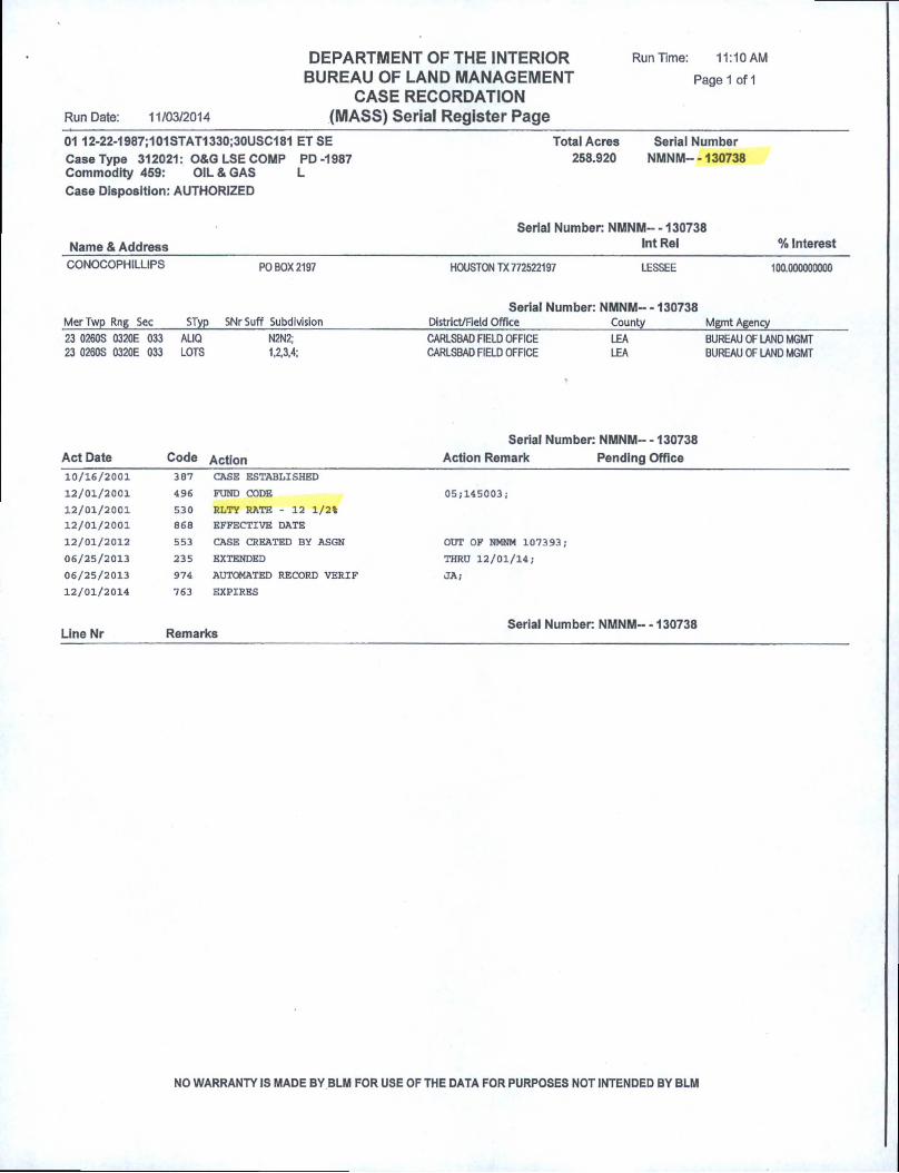
Run Time: 11:10 AMDEPARTMENT OF THE INTERIOR BUREAU OF LAND MANAGEMENT Page 1 of 1
CASE RECORDATIONRun Date: 11/03/2014 (MASS) Serial Register Page01 12-22-1987;101STAT1330;30USC181 ET SE Total Acres Serial NumberCase Type 312021: O&G LSE COMP PD-1987 258.920 NMNM--130738Commodity 459: OIL & GAS LCase Disposition: AUTHORIZED
Serial Number: NMNM-- -130738Name & Address ^el % Interest
CONOCOPHILLIPS PO BOX 2197 HOUSTON TX772522197 LESSEE 100.000000000
Serial Number: NMNM-- -130738MerTwp Rng Sec STyp SNrSuff SubdivisionDistrict/Field Office _____________ CountyMgmt Agency
23 0260S 0320E 033 AUQ N2N2; CARLSBAD FIELD OFFICE LEA BUREAU OF LAND MGMT23 0260S 0320E 033 LOTS 1,2,3,4; CARLSBAD FIELD OFFICE LEA BUREAU OF LAND MGMT
Serial Number: NMNM-- -130738Act Date Code Action Action Remark Pending Office10/16/2001 387 CASE ESTABLISHED
12/01/2001 496 FUND CODE 05,-145003i
12/01/2001 530 RLTY RATE - 12 1/2%
12/01/2001 868 EFFECTIVE DATE
12/01/2012 553 CASE CREATED BY ASGN OUT OF NMNM 107393;
06/25/2013 235 EXTENDED THRU 12/01/14;
06/25/2013 974 AUTOMATED RECORD VERIF JA;
12/01/2014 763 EXPIRES
Line Nr RemarksSerial Number: NMNM- -130738
NO WARRANTY IS MADE BY BLM FOR USE OF THE DATA FOR PURPOSES NOT INTENDED BY BLM

Run Time: 02:30 PMDEPARTMENT OF THE INTERIOR BUREAU OF LAND MANAGEMENT Page 1 of 2
CASE RECORDATIONRun Date: 09/23/2014 (MASS) Serial Register Page
01 02-25-1920;041STAT0437;30USC226 Total Acres Serial NumberCase Type 311111: O&G LSE NONCOMP PUB LAND 1,440.000 NMNM--027508Commodity 459: OIL & GAS LCase Disposition: AUTHORIZED
Name & Address
Serial Number: NMNM-- - 027508Int Rel % Interest
ACME LAND COCHILDRESS ROYALTY CO CONOCOPHILLIPS CO HIGHLAND PROD CO
PO BOX 10280PO BOX 66PO BOX 7500
PO BOX 6326
MIDLAND TX 79702 OPERATING RIGHTSJOPLIN MO 64802 OPERATING RIGHTSBARTLESVILLE OK 740057500 LESSEE
ODESSA TX 79762 OPERATING RIGHTS
0.0000000000.000000000
100.0000000000.000000000
MerTwp Rng Sec STyp SNrSuff Subdivision
Serial Number: NMNM-- - 027508District/Field Office County Mgmt Agency
23 0260S 0320E 23 0260S 0320E
23 0260S 0320E
026 ALIQ028 ALL029 ALL
NWNE.N2NW.SWNW;ENTIRE SECTION
ENTIRE SECTION
CARLSBAD FIELD OFFICE CARLSBAD FIELD OFFICE CARLSBAD FIELD OFFICE
LEALEALEA
BUREAU OF LAND MGMTBUREAU OF LAND MGMTBUREAU OF LAND MGMT
Serial Number: NMNM-- - 027508Act Date Code Action Action Remark Pending Office06/30/1951 387 CASE ESTABLISHED
07/01/1951 496 FUND CODE 05;145003
07/01/1951 530 RLTY RATE - 12 1/2%
07/01/1951 868 EFFECTIVE DATE
11/01/1973 209 CASE CREATED BY SEQR OUT OF NMLC069515;
11/01/1973 648 EXT BY PROD ON ASSOC LSE NMLC069515;
10/24/1979 940 NAME CHANGE RECOGNIZED CONTL OIL/CONOCO INC
06/06/1984 in RENTAL RECEIVED $0;84-85
06/10/1985 111 RENTAL RECEIVED $0;85-86
06/06/1986 111 RENTAL RECEIVED $0/86-87
05/02/1987 974 AUTOMATED RECORD VERIF JAM
06/05/1987 963 CASE MICROFILMED CNUM 100,539 DS
06/09/1987 111 RENTAL RECEIVED $1440.00;lYR/87-88
06/05/1988 111 RENTAL RECBIVED $1440.00/1YR/89-90
06/06/1988 111 RENTAL RECEIVED $1440.00;lYR/88-89
06/04/1990 111 RENTAL RECBIVED $1440.00;21/1103249
06/06/1991 111 RENTAL RECEIVED $1440.00/21/1108912
06/05/1992 974 AUTOMATED RECORD VERIF AR/KRP
07/09/1992 575 APD FILED TOPAT OIL CORP CE
07/29/1992 576 APD APPROVED CONOCO FED NO 1-89
06/17/1993 111 RENTAL RECEIVED $1440.00/21/1126215
09/21/1993 932 TRF OPER RGTS FILED CONOCO/HIGHLAND PROD
11/17/1993 933 TRF OPER RGTS APPROVED EFF 10/01/93/
11/17/1993 974 AUTOMATED RECORD VERIF JLV/KRP
06/16/1994 111 RENTAL RECEIVED $1440.00/21/1132000
08/15/1994 932 TRF OPER RGTS FILED (1)CONOCO/CHILDRESS
08/15/1994 932 TRF OPER RGTS FILED (2)CONOCO/CHILDRESS
08/15/1994 932 TRF OPER RGTS FILED (3)CONOCO/CHILDRESS
01/10/1995 933 TRF OPER RGTS APPROVED (1)EFF 09/01/94;
01/10/1995 933 TRF OPER RGTS APPROVED (2)EFF 09/01/94;
01/10/1995 933 TRF OPER RGTS APPROVED (3)EFF 09/01/94;
01/10/1995 974 AUTOMATED RECORD VERIF MV/MV
06/19/1995 084 RENTAL RECEIVED BY ONRR $1440.00/21/000001137
NO WARRANTY IS MADE BY BLM FOR USE OF THE DATA FOR PURPOSES NOT INTENDED BY BLM
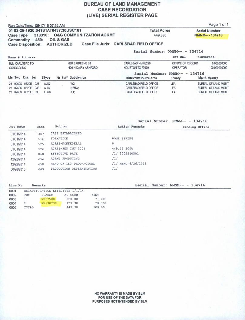
BUREAU OF LAND MANAGEMENT CASE RECORDATION
(LIVE) SERIAL REGISTER PAGE
Page 1 of 1
01 02-25-1920;041STAT0437;30USC181 Total Acres Serial NumberCase Type 318310: O&G COMMUNITZATION AGRMT 449.380 NMNM- -134716Commodity 459: OIL & GASCase Disposition: AUTHORIZED Case File Juris: CARLSBAD FIELD OFFICE
Serial Number: NMNM— - 134716
Name & Address Int Rel %Interest
BLM CARLSBAD FO 620 E GREENE ST CARLSBAD NM 88220 OFFICE OF RECORD 0.000000000
CONOCO INC 600 N DAIRY ASHFORD HOUSTON TX 77079 OPERATOR 100.000000000
Serial Number: NMNM-- - 134716MerTwp Rng Sec SType Nr Suff Subdivision District/Resource Area County Mgmt Agency
23 0260S 0320E 028 ALIQ W2; CARLSBAD FIELD OFFICE LEA BUREAU OF LAND MGMT
23 0260S 0320E 033 ALIQ N2NW; CARLSBAD FIELD OFFICE LEA BUREAU OF LAND MGMT
23 0260S 0320E 033 LOTS 3,4; CARLSBAD FIELD OFFICE LEA BUREAU OF LAND MGMT
Serial Number : NMNM-- - 134716
Act Date Code Action Action Remarks Pending Office
01/01/2014 387 CASE ESTABLISHED
01/01/2014 516 FORMATION BONE; SPRING
01/01/2014 525 ACRES-NONFEDERAL 0
01/01/2014 526 ACRES-FED INT 100% 449. 38 100%
01/01/2014 868 EFFECTIVE DATE /!/ 3002540501
12/22/2014 654 AGRMT PRODUCING n/
12/22/2014 658 MEMO OF 1ST PROD-ACTUAL /!/ MEMO 6/26/2015
06/26/2015 643 PRODUCTION DETERMINATION /I/
Line Nr Remarks Serial Number: NMNM— - 134716
0001 RECAPITULATION EFFECTIVE 1/1/14
0002 TR# LEASE# AC COMM %INT
0003 1 NM27508 320.00 71.209
0004 2 NM130738 129.38 28.791
0005 TOTAL 449.38 100.00
NO WARRANTY IS MADE BY BLMFOR USE OF THE DATA FOR
PURPOSES NOT INTENDED BY BLM
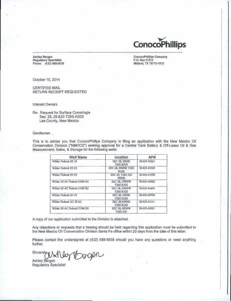
ConocoPhillips
Ashley Bergen Regulatory Specialist Phone: (432) 688-6938
ConocoPhillips Company P.O. Box 51810 Midland, TX 79710-1810
October 15, 2014
CERTIFIED MAILRETURN RECEIPT REQUESTED
Interest Owners
Re: Request for Surface Commingle Sec. 28, 29 &33 T26S-R32E Lea County, New Mexico
Gentlemen: .
This is to advise you that ConocoPhillips Company is filing an application with the New Mexico Oil Conservation Division ("NMOCD”) seeking approval for a Central Tank Battery & Off-Lease Oil & Gas Measurement, Sales, & Storage for the following wells:
Well Name Location API#Wilder Federal 28 1H SEC 28, NENE
T26S R32E30-025-40261
Wilder Federal 28 2H SEC 28, NWNET26S
R32E
30-025-40329
Wilder Federal 29 5H SEC 29, T26S 32E NENE
30-02541509
Wilder 28 AC Federal COM 4H SEC 28, NWNWT26S R32E
30-02540502
Wilder 28 AC Federal COM 8H SEC 28, NWNW T26SR32E
30-02541692
Wilder Federal 29 1H SEC 29, NENE
T26SR32E30-02540790
Wilder Federal AC 29 2H SEC 29.NWNET26SR32E
30-025-41511
Wilder 28 AC Federal COM 3H SEC 28, NENWT26S 32E
30-02540501
A copy of our application submitted to the Division is attached.
Any objections or requests that a hearing should be held regarding this application must be submitted to the New Mexico Oil Conservation Division Santa Fe office within 20 days from the date of this letter.
Please contact the undersigned at (432) 688-6938 should you have any questions or need anything further.
Ashley Bergen ' 'Regulatory Specialist
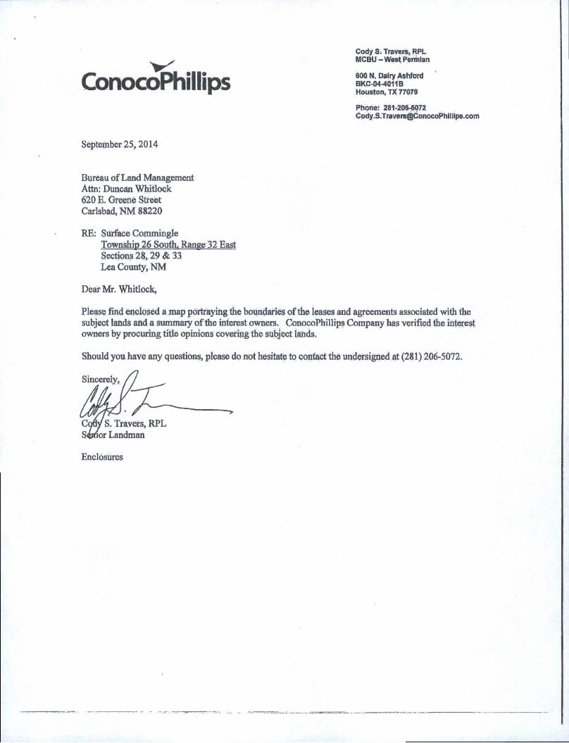
ConocoPhillips
Cody S. Travers, RPL MCBU - West Permian
600 N. Dairy Ashford BKC-04-4011B Houston, TX 77079
Phone: 281-206-6072 [email protected]
September 25,2014
Bureau of Land Management
Attn: Duncan Whitlock
620 E. Greene Street
Carlsbad, NM 88220
RE: Surface Commingle
Township 26 South. Range 32 East
Sections 28,29 & 33
Lea County, NM
Dear Mr. Whitlock,
Please find enclosed a map portraying the boundaries of the leases and agreements associated with the
subject lands and a summary of the interest owners. ConocoPhillips Company has verified the interest
owners by procuring title opinions covering the subject lands.
Should you have any questions, please do not hesitate to contact the undersigned at (281) 206-5072.
Enclosures
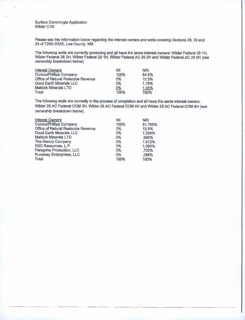
Surface Commingle Application Wilder CTB
Please see the information below regarding the interest owners and wells covering Sections 28, 29 and 33 of T26S-R32E, Lea County, NM.
The following wells are currently producing and all have the same interest owners: Wilder Federal 28 1H, Wilder Federal 28 2H, Wilder Federal 29 1H, Wilder Federal AC 29 2H and Wilder Federal AC 29 5H (see ownership breakdown below).
Interest Owners Wl NRIConocoPhillips Company 100% 84.5%Office of Natural Resource Revenue 0% 12.5%Good Earth Minerals LLC 0% 1.75%Matlock Minerals LTD 0% 1.25%Total 100% 100%
The following wells are currently in the process of completion and all have the same interest owners:
Wilder 28 AC Federal COM 3H, Wilder 28 AC Federal COM 4H and Wilder 28 AC Federal COM 8H (see
ownership breakdown below).
Interest Owners Wl NRIConocoPhillips Company 100% 81.765%Office of Natural Resource Revenue 0% 12.5%Good Earth Minerals LLC 0% 1.246%Matlock Minerals LTD 0% .890%The Blanco Company 0% 1.512%RSC Resources, L.P. 0% 1.080%Peregrine Production, LLC 0% .720%Runaway Enterprises, LLC 0% .288%Total 100% 100%
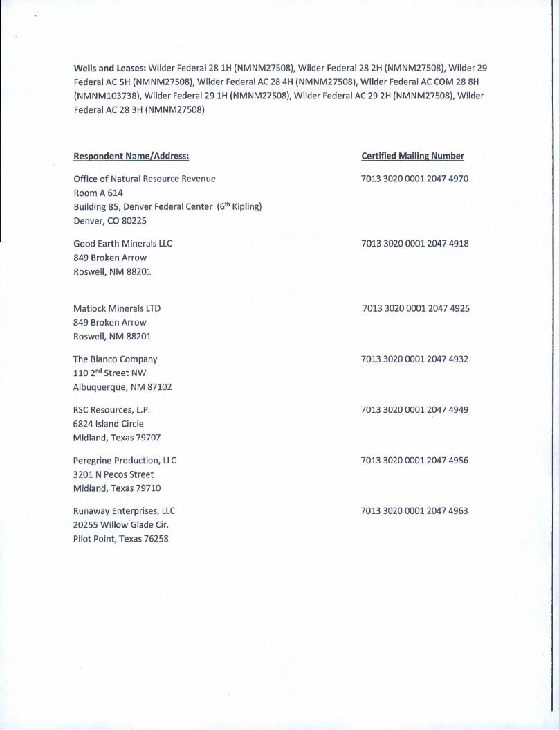
Wells and Leases: Wilder Federal 28 1H (NMNM27508), Wilder Federal 28 2H (NMNM27508), Wilder 29
Federal AC 5H (NMNM27508), Wilder Federal AC 28 4H (NMNM27508), Wilder Federal AC COM 28 8H
(NMNM103738), Wilder Federal 29 1H (NMNM27508), Wilder Federal AC 29 2H (NMNM27508), Wilder
Federal AC 28 3H (NMNM27508)
Respondent Name/Address: Certified Mailing Number
Office of Natural Resource Revenue
Room A 614
Building 85, Denver Federal Center (6th Kipling)
Denver, CO 80225
7013 3020 0001 2047 4970
Good Earth Minerals LLC
849 Broken Arrow
Roswell, NM 88201
7013 3020 0001 2047 4918
Matlock Minerals LTD
849 Broken Arrow
Roswell, NM 88201
7013 3020 0001 2047 4925
The Blanco Company
110 2nd Street NW
Albuquerque, NM 87102
7013 3020 0001 2047 4932
RSC Resources, L.P.
6824 Island Circle
Midland, Texas 79707
7013 3020 0001 2047 4949
Peregrine Production, LLC
3201 N Pecos Street
Midland, Texas 79710
7013 3020 0001 2047 4956
Runaway Enterprises, LLC
20255 Willow Glade Cir.
Pilot Point, Texas 76258
7013 3020 0001 2047 4963
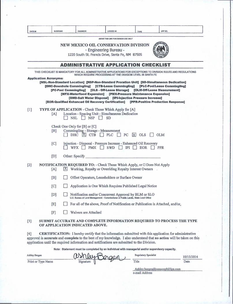
DATE IN SUSPENSE ENONEER LOGGED N TYPE APP NO.
ABOVE THIS l WE FOR DIVISION USE ONLY
NEW MEXICO OIL CONSERVATION DIVISION - Engineering Bureau -
1220 South St. Francis Drive, Santa Fe, NM 87505
ADMINISTRATIVE APPLICATION CHECKLIST
THIS CHECKUST IS MANDATORY FOR ALL ADMINISTRATIVE APPLICATIONS FOR EXCEPTIONS TO DIVISION RULES AND REGULATIONS WHICH REQUIRE PROCESSING AT THE DIVISION LEVEL IN SANTA FE
Application Acronyms:[NSL-Non-Standard Location] [NSP-Non-Standard Proration Unit] [SD-SImultaneous Dedication]
[DHC-Downhole Commingling] [CTB-Lease Commingling] [PLC-Pool/Lease Commingling]
[PC-Pool Commingling] [OLS - Off-Lease Storage] [OLM-Off-Lease Measurement] [WFX-Waterflood Expansion] [PMX-Pressure Maintenance Expansion]
[SWD-Salt Water Disposal] [IPI-Injection Pressure Increase][EOR-Qualified Enhanced Oil Recovery Certification] [PPR-Positive Production Response]
11 ] TYPE OF APPLICATION - Check Those Which Apply for [A]
[A] Location - Spacing Unit - Simultaneous Dedication □ NSL □ NSP □ SD
Check
[B]
One Only for [B] or [C]
Commingling - Storage - Measurement □ DHC 0 CTB □ PLC □ PC H OLS □ OLM
[C] Injection - Disposal - Pressure Increase - Enhanced Oil Recovery □ WFX □ PMX □ SWD □ IPI □ EOR □ PPR
[D] Other: Specify
[2][A] 0
[B] □
[C] □
[D] □
[E] □
[F] □
U.S. Bureau of Land Management - Commissioner of Public Lands, State Land Office
[3] SUBMIT ACCURATE AND COMPLETE INFORMATION REQUIRED TO PROCESS THE TYPE
OF APPLICATION INDICATED ABOVE.
[4] CERTIFICATION: I hereby certify that the information submitted with this application for administrative
approval is accurate and complete to the best of my knowledge. I also understand that no action will be taken on this
application until the required information and notifications are submitted to the Division.
Note: Statement must be completed by an individual with managerial and/or supervisory capacity.
A,hleyBetgen0^VSlih^Yr\nnA ) Rciulatory Specialist 10/15/2014Signature (j Title Date
Print or Type Name
e-mail Address
District 1
1625 N. French Drive, Hobbs, NM 88240
District 118)1 S. Fim St., Artesio, NM 88210
PigtripiJ.ll1000 Rio Brazos Rood, Aztec, NM 87410District IV
1220 S. St Francis Dr, Sanla Fe, NM
87505
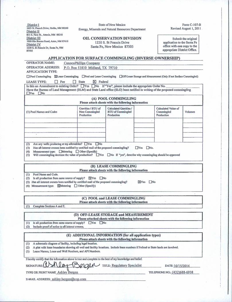
State of New Mexico
Energy, Minerals and Natural Resources Department
OIL CONSERVATION DIVISION1220 S. St Francis Drive
Santa Fe, New Mexico 87505
Form C-107-B
Revised August 1,2011
Submit the original
application to the Santa Fe
office with one copy to the
appropriate District Office.
APPLICATION FOR SURFACE COMMINGLING (DIVERSE OWNERSHIP)ConocoPhillips Company
P.O.Box51810 Midland,TX 79710
OPERATOR NAME:
OPERATOR ADDRESS:
APPLICATION TYPE:
□ Pool Commingling ElLease Commingling OPool and Lease Commingling
LEASE TYPE: □ Fee □ State K1 Federal
QOff-Lease Storage and Measurement (Only if not Surface Commingled)
Is this an Amendment to existing Order? OYcs [UNo If “Yes”, please include the appropriate OrderNo.____________________
Have the Bureau of Land Management (BLM) and State Land office (SLO) been notified in writing of the proposed commingling QVcs DNo
(A) POOL COMMINGLING
Please attach sheets with the following information
(1) Pool Names and Codes
Gravities/BTU ofNon-CommingledProduction
Calculated Gravities / BTU of Commingled Production
Calculated Value ofCommingledProduction
Volumes
(3) Has all interest owners been notified by certified mail of the proposed commingling? QYes ClNo.
(4) Measurement type: □Metering □ Ollier (Specify)(5) Will commingling decrease die value of production? OYes ONo If “yes”, describe why commingling should be approved
(B) LEASE COMMINGLING
Please attach sheets with the following information
(1) Pool Name and Code.(2) Is all production from same source of supply? ElYes ONo
(3) Has all interest owners been notified by certified mail of the proposed commingling?
(4) Measurement type: ^Metering Q Other (Specify)
ElYes QNo
(C) POOL and LEASE COMMINGLING
Please attach sheets with the following information
(1) Complete Sections A and E.
(D) OFF-LEASE STORAGE and MEASUREMENT
____________________________________________ Please attached sheets with the following information
(1) Js all production from same source of supply? OYes ONo
(2) include proof of notice to all interest owners._______________________________________________________
(E) ADDITIONAL INFORMATION (for all application types)
__________________________________ ________ Please attach sheets with the following information
(1) A schematic diagram of facility, including legal location.
(2) A plat with lease boundaries showing all well and facility locations. Include lease numbeis if Federal or State lands are involved.
(3) Lease Names, Lease and Well Numbers, and API Numbers.
I hereby certify that the information above is true and complete to the best of my knowledge and belief.
SIGNATURE:
TYPE OR PRINT NAME Ashley Bergen______________
TITLE: Regulatory Specialist __________ DATE: 10/[5/2014
TELEPHONE NO.-. (432)688-6938
E-MAIL ADDRESS: [email protected]
Bureau of Land Management Carlsbad Field Office
620 East Greene Street Carlsbad, New Mexico 88220
575-234-5972
Wilder 28 Federal 1H-3002540261, Wilder 28 Federal 2H-3002540329, Wilder 29 Federal 1H-3002540790, Wilder Federal AC 29 2H-3002541511, Wilder 29 Federal AC 5H-3002541509, Wilder Federal 28 3H-3002540501,
Wilder Federal AC 28 4H-3002540502, Wilder Federal AC Com 28 8H-3002541692
Leases: NM27508, NM130738, CA: NM134716
ConocoPhillips CompanyMay 17, 2016
Condition of Approval
Commingling of lease and CA production, variance to use Coriolis meter for oil measurement,
and off CA storage, measurement and sales
1. This approval is subject to like approval by the New Mexico Oil Conservation Division.
2. This agency shall be notified of any spill or discharge as required by NTL-3A.
3. This agency reserves the right to modify or rescind approval whenever it determines continued use of the
approved method may adversely affect the surface or subsurface environments.\
4. This approval does not constitute right-of-way approval for any off-lease activities. Within 30 days, an application
for right-of-way approval must be submitted to the Realty Section if not already done.
5. Approval for combining production from various sources is a privilege which is granted to lessees for the purpose
of aiding conservation and extending the economic life of leases. Applicants should be cognizant that failure to
operate in accordance with the provisions outlined in the Authorized Officer's conditions of approval and/or
subsequent stipulations or modifications will subject such approval to revocation.
6. Gas measurement for allocation must be measured as per Onshore Order #5 for sales meters.
7. All gas and oil subject to royalty shall be measured as per federal regulations and shall be reported to ONRR as
required. All gas' which is vented, flared or used on lease shall be reported as per NTL-4A to ONRR. All gas
which is vented or flared shall be subject to royalty, unless prior approval was given by the authorized officer.
8. This agency shall be notified of any change in sales method or location of sales point.
9. Additional wells and/or leases require additional commingling approvals.
10. Notify this office 24 Hrs. prior to any meter proving to allow time for an inspector to witness.
11. Variance to Onshore Order #4 oil measurement to use Coriolis meters is approved with this approval.