Embed Size (px)
Citation preview

© 2020 Sunderland City Council: HIA Methodology Page 1 of 19
Sunderland Riverside Strategic Heritage Impact Assessments: Methodology Sunderland City Council October 2020

© 2020 Sunderland City Council: HIA Methodology Page 2 of 19
TABLE OF CONTENTS
1. INTRODUCTION ...................................................................................................................... 3
2. THE FRAMEWORK ................................................................................................................... 5
DUTY TO CO‐OPERATE ............................................................................................................................... ................. 5
HERITAGE IMPACT ASSESSMENT ............................................................................................................................... . 6
STEP 1: WHICH HERITAGE ASSETS? ............................................................................................................................. 8
STEP 2: CONTRIBUTION TO SIGNIFICANCE? .............................................................................................................. 10
STEP 3: IDENTIFY IMPACT ............................................................................................................................... .......... 12
STEP 4: JUSTIFICATION OF HARM AND MITIGATION ................................................................................................. 14
STEP 5: NPPF TESTS OF SOUNDNESS ......................................................................................................................... 15
2. THE ASSESSMENTS.................................................................................................................. 16

© 2020 Sunderland City Council: HIA Methodology Page 3 of 19
1. INTRODUCTION This document explores the impact of the development localities identified
within the Revised Draft Riverside Sunderland Supplementary Planning
Document (SPD). It has been prepared in response to comments received
from Historic England in regard to Heritage Impact Assessments and the
Draft Riverside Sunderland SPD.
The historic environment covers a wide range of assets including buildings,
structures, archaeological remains, landscape features and historic open
spaces. These are collectively known as heritage assets. Heritage assets are
identified as being either designated or non‐ designated. Designated
heritage assets include:
World Heritage Sites;
Listed Buildings;
Registered Parks and Gardens;
Scheduled Monuments;
Registered Battlefields;
Conservation Areas; and,
Protected Wrecks.
Non‐designated heritage assets are buildings, structures, sites, places and
landscapes that have been identified as having a degree of significance
meriting consideration in planning decisions because of their heritage
interest but that are not formally designated. Some assets are known,
others are unknown but the potential for them to exist is known.
This Heritage Impact Assessment seeks to provide robust and defensible
evidence of the potential risk of development within the localities identified
in the emerging Riverside SPD and also to inform the emerging Allocations
and Designations Plan (A&D Plan) with regard to the significance of heritage
assets and their settings. In addition to identifying the potential risks to
heritage of development, and whether or not development can be justified,
the study seeks to provide guidance on the opportunities and strategies for
mitigating any impact on the significance of heritage assets and to consider
opportunities for positive enhancement or for an asset to be better
revealed. The Heritage Impact Assessments also make suggestions about
further work required and future monitoring.
It is intended to provide a proportionate understanding of the significance
and sensitivity to change of heritage assets both within sites and those that
would be affected by changes to their settings as a consequence of

© 2020 Sunderland City Council: HIA Methodology Page 4 of 19
development. This understanding will be based on evidence gathered
through a high level desk top research and site visits. It is acknowledged
that further primary evidence and research may yield more significance
which is not detailed in this assessment but may be better understood
through the development management process.
The findings of this study will provide further safeguards for the historic
environment within the Riverside SPD and supporting text for site
allocations within the emerging A&D Plan where appropriate or potential
significant effects on the historic environment have been identified.

© 2020 Sunderland City Council: HIA Methodology Page 5 of 19
2. THE FRAMEWORK The National Planning Policy Framework (NPPF) requires Local Planning
Authorities to meet objectively assessed needs (OAN) for housing, business
and other development, with sufficient flexibility to adapt to change. The
strategy adopted by Sunderland City Council is to establish Riverside
Sunderland as a successful business location, a popular place to live and a
focal point for civic, cultural and community life.
The key elements of Riverside Sunderland will include:
• a new central business district;
• new city centre residential neighbourhoods;
• civic buildings, community facilities and cultural attractions;
• an enhanced and restored riverside park;
• new bridges across the River Wear as part of an improved walking and
cycling network;
• the transformation of St Mary’s Boulevard into pedestrian‐friendly city street; and
• digital (5G) infrastructure and sustainable urban drainage systems (SuDS).
The Supplementary Planning Document (SPD) provides the planning policy
framework for the development proposals within Riverside Sunderland as
set out in the saved Unitary Development Plan (UDP) Alteration No.2
policies and the adopted Core Strategy and Development Plan (CSDP) (2015‐
2033). It will also inform the emerging A&D Plan, which proposes to replace
the relevant policies contained within UDP Alteration No.2 and the CSDP
with a new Riverside Sunderland allocation.
The purpose of this Heritage Impact Assessment (HIA) is to inform the
Riverside SPD and A&D Plan by demonstrating how the historic environment
has been considered in the site selection process and to assess the likely
impact on heritage assets, both designated and non‐designated, and
whether those impacts could be mitigated. There is also potential for as yet
unknown surviving archaeological remains to be discovered. The findings and recommendations of each assessment will feed into the
Sustainability Appraisal for the A&D Plan which considers a range of
sustainability considerations that will assist in informing the site allocations
within the A&D Plan. The preparation of the SA and HIA are an iterative
process with each informing the other and will directly inform any resultant
policy that would form part of any site allocation, should the site proceed
and be allocated for development.
Duty to Co-operate

© 2020 Sunderland City Council: HIA Methodology Page 6 of 19
Local authorities in the North East have worked collaboratively and
undertaken extensive dialogue to address strategic planning issues for a
number of years. In response to the requirements of the Localism Act, the
Chief Executives and Leaders of the 7 North East Authorities signed a
Memorandum of Understanding together with a Joint Position Statement,
which sets out the strategic issues which the seven Councils agreed to focus
on discussing in respect of the DTC. In order to demonstrate that it has fulfilled its duty to co‐operate
obligations, the council has actively engaged with statutory consultees
throughout the preparation of the Local Plan, working closely with Historic
England on matters relating to heritage. In particular, the Council sought
advice from Historic England on a methodology for the HIA and clarification
on which sites should be assessed, and has taken on board Historic
England’s recommendation to employ a 200m buffer, although this may be
expanded if it is considered that the setting of a heritage asset beyond the
200m buffer will be affected.
Heritage Impact Assessment
The Heritage Impact Assessment is part of the Sustainability Assessment
which is a tool used to ensure sustainable development is promoted
through economic, social and environmental objectives. The potential
environmental impacts are assessed using the Strategic Environmental
Assessment (SEA). The Heritage Impact Assessment is a methodology used
for sites identified within the Supplementary Planning Document for the
Riverside Sunderland and the emerging A&D Plan. It considers the likely
effects of allocations in the emerging plan against the potential impacts of
development on identified heritage assets, both designated and non‐
designated either directly affected or within the setting of assets. It forms
the evidence base for the Strategic Environmental Assessment and
consequently a sound base from which to allocate potential sites for
development in line with current planning policy.
This document, which considers the Heritage Impact Assessments of the
potential sites, has been prepared using the assessment methodology
provided in:
• Historic England’s Advice Note 3: The Historic Environment and Site
Allocations in Local Plans (2015); and
• Historic England’s Advice Note 8: Sustainability Appraisal and Strategic Environmental Assessment (2016)

© 2020 Sunderland City Council: HIA Methodology Page 7 of 19
In addition, the following advice published by Historic England has been
used in assessing each site:
• Good Practice Advice in Planning 2: Managing Significance in Decision‐
Taking in the Historic Environment (2015); and
• Good Practice Advice in Planning 3: The Setting of Heritage Assets
(2017).
• CIfA Standard and Guidance: Historic Environment Desk Based
Assessment Methodology for the Assessment of Significance
This assessment uses the 5‐step site selection methodology as set out in
Historic England’s Advice Note 3: The Historic Environment and Site
Allocations in Local Plans (2015) as the methodology for assessment. The
five steps are:
STEP 1 Identify which heritage assets are affected by the potential
site allocation; STEP 2 Understand what contribution the site (in its current form)
makes to the significance of the heritage asset(s);
STEP 3 Identify what impact the allocation might have on that
significance;
STEP 4 Consider opportunities to maximise enhancements and
minimise harm;
STEP 5 Determine whether the proposed site allocation is
appropriate in light of the NPPF’s tests of soundness.
© 2020 Sunderland City Council: HIA Methodology Page 8 of 19
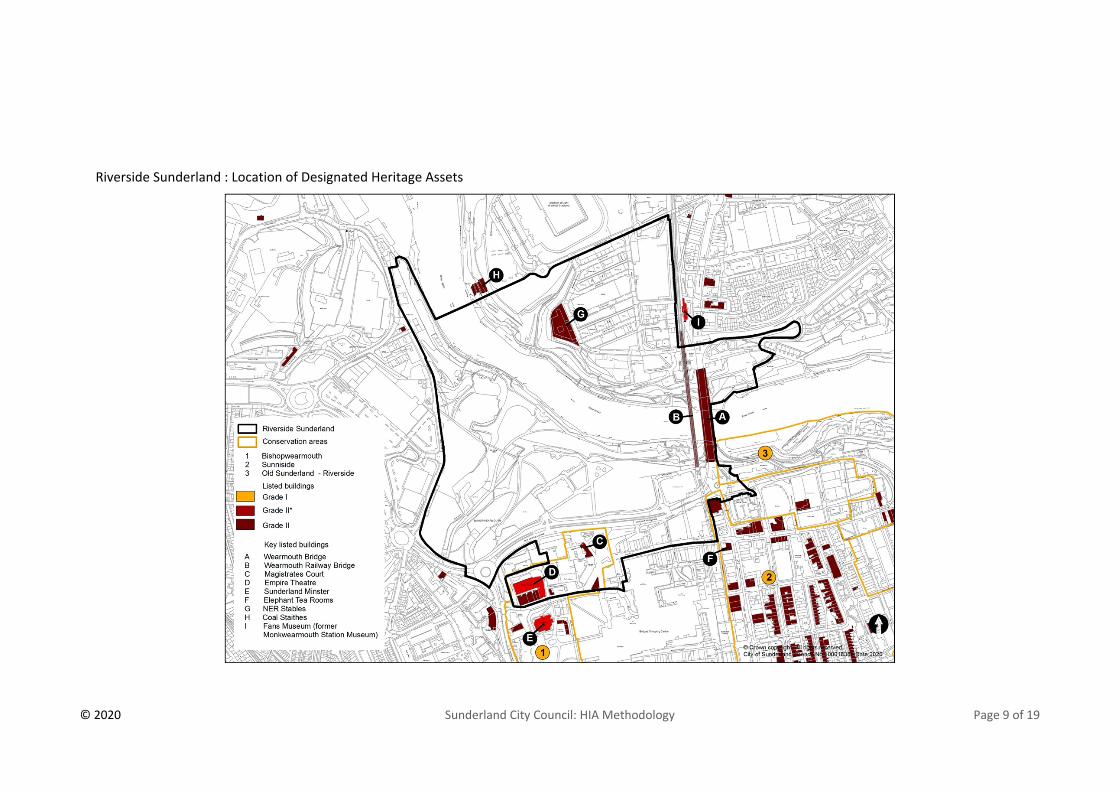
STEP 1: Which Heritage Assets?
Identify which heritage assets are affected by the potential site
allocation
This is informed by the evidence base, principally desk‐based assessment
and, where necessary, site surveys. The map below shows the location of
the designated heritage assets within all the sites of Riverside Sunderland.
Other sources consulted when undertaking this assessment include:
• Available GIS data;
• The National Heritage List for England;
• Tyne & Wear Historic Environment Record;
• Historic England’s Register of Heritage at Risk;
• Heritage Gateway;
• Sunderland Heritage Forum;
• Conservation Area Appraisals;
• Photographic records;
• Tyne & Wear Historic Landscape Characterisation;
• Pevsner Architectural Guides;
• Historic Maps;
• Google Earth;
• Historic Area Assessment of Sunderland ‐ Historic England
https://research.historicengland.org.uk/ 2017; and
• Sheepfolds Archaeological Desk Based Assessment, Building Recording
and Geological Assessment by Northern Archaeological Associates Ltd.
2017.
© 2020 Sunderland City Council: HIA Methodology Page 9 of 19
Riverside Sunderland : Location of Designated Heritage Assets
© 2020 Sunderland City Council: HIA Methodology Page 10 of 19
STEP 2: Contribution to Significance?
Understand what contribution the site (in its current form) makes
to the significance of the heritage asset(s)
Historic England’s Advice Note 12 states that significance is one of the guiding principles running through the historic environment section of the
NPPF. The NPPF defines significance as ‘the value of a heritage asset to this and future generations because of its heritage interest’. Such interest may
be archaeological, architectural, artistic or historic ’and it may derive ‘not only from a heritage asset’s physical presence, but also from its setting’. Significance is what conservation sustains, and where appropriate enhances,
in managing change to heritage assets. Therefore, it follows from the NPPF
requirement that an understanding of significance must stem from the
interest(s) of the heritage asset, whether archaeological, architectural,
artistic or historic, or a combination of these. Each interest is defined as:
Archaeological interest
There will be archaeological interest in a heritage asset if it holds, or
potentially holds, evidence of past human activity worthy of expert
investigation at some point.
Architectural and artistic interest
These are interests in the design and general aesthetics of a place. They can
arise from conscious design or fortuitously from the way in which the
heritage asset has evolved. More specifically, architectural interest is an
interest in the art or science of the design, construction, craftsmanship and
decoration of buildings and structures of all types. Artistic interest is an
interest in other human creative skills, like sculpture.
Historic Interest
An interest in past lives and events (including pre‐historic). Heritage assets
can illustrate or be associated with them. Heritage assets with historic
interest not only provide a material record of our nation’s history, but can also provide meaning for communities derived from their collective
experience of a place and can symbolise wider values such as faith and
cultural identity.
The level of detail is proportionate to each asset’s importance and no more
than sufficient to understand the potential impact of development on their
significance. The degree of protection afforded to a heritage asset will
reflect its position within the hierarchy of designations.

© 2020 Sunderland City Council: HIA Methodology Page 11 of 19
Assignment of significance is a value judgement based on the knowledge
and professional expertise of the author of the HIA. Ranking significance
provides assistance in understanding the relative importance of different
elements and assessing the likely impact of allocation. The identification of
‘low ’significance does not mean assets are of no importance.
Table 1 shows the standard broad categories for each asset type; high,
medium, low, negligible and unknown. These categories are not fixed but
are guidance. For example, it may be that a Grade II listed building or
structure, such as the Monkwearmouth Bridge is a high significance because
of its national role in being emblematic of Sunderland.
Significance Value Definition
High
Assets which can be demonstrated to have international or national significance. This includes Scheduled Monuments and all Listed Buildings at Grade I and II*, Registered Parks and Gardens at Grade I and II*, and non-designated structures of clear national importance.
Medium
Assets with importance within a national or regional context due to special archaeological, architectural, artistic or historic interest. This includes Listed Buildings at Grade II, Registered Parks and Gardens at Grade II, Conservation Areas and undesignated assets of regional importance.
Low
Assets of local importance. Undesignated assets with modest archaeological, architectural, historic or artistic interest. Includes historic townscapes or landscapes of limited historic integrity (including any locally listed assets outside of conservation areas).
Negligible Assets of limited local importance with little architectural or historic interest.
Unknown The importance of the asset has not been ascertained.

© 2020 Sunderland City Council: HIA Methodology Page 12 of 19
STEP 3: Identify Impact
Identify what impact the allocation may have on that significance
The next step is to consider any direct impacts on the significance of
heritage assets as a result of the potential site allocation, taking into
account:
• Location and siting of development, including proximity, extent,
position, topography, relationship, understanding and key views
• Form and appearance of development, including prominence, scale,
massing, materials and movement
• Other effects of development, including noise, odour, vibration, lighting,
changes to character, access and use, landscape, context, permanence,
cumulative impact, ownership, viability and communal use.
• Secondary effects, such as increased traffic through a historic village as
a result of new development.
Scale of Impact
Definition
Major Adverse
The significance of the asset would be totally altered or destroyed. Comprehensive change to setting affecting significance, resulting in changes in our ability to understand and appreciate the resource and its historical context and setting.
Moderate Adverse
The significance of the asset would be affected. Changes such that the setting of the asset is noticeably different, affecting significance resulting in changes in our ability to understand and appreciate the resource and its historical context and setting.
Minor Adverse
The significance of the asset would be slightly affected. Changes to the setting that have a slight impact on significance, resulting in changes in our ability to understand and appreciate the resource and its historical context and setting.
Beneficial
Elements which contribute to the significance of assets, including their setting and have the potential to enhance or better reveal that significance. Changes to the asset may have a major or minor positive benefit to significance.
No Change
The development would not affect the significance of the asset. Changes to the setting do not affect the significance of the asset or our appreciation of it.
The potential impact of allocation on the significance of heritage assets may
be adverse, beneficial or neutral. Significance may be affected by direct

© 2020 Sunderland City Council: HIA Methodology Page 13 of 19
physical impact, including destruction, demolition and alteration or by
changes to setting, including changes to historic character of an area,
alterations to views to and from sites and loss of amenity (increased traffic,
noise and air pollution etc.).
Adverse impacts are identified, and subject to the nature of the asset and
the potential impact, consideration has been given to mitigation with a view
to removing or reducing potential harm to the heritage asset. The
effectiveness of any proposed mitigation has been evaluated with regard to
the situation of the site and the site’s (and the assets’) situation, topography, key views, wider landscape characteristics etc. and is also a
value judgement based on observations and expertise of the author.
Further details will also need to be assessed through development
management process at planning application stage. Not all impacts will
require mitigation; some may offer opportunities for enhancement which is
made clear in the assessment.
In order to ensure that the development of allocated sites takes place in a
manner consistent with the conservation of the heritage assets in their
vicinity, it is recommended that the mitigation measures set out in the
Heritage Impact Assessment are incorporated into the emerging Allocations
and Designations Plan where possible.
© 2020 Sunderland City Council: HIA Methodology Page 14 of 19
STEP 4: Justification of Harm and Mitigation
Consider whether identified harm can be justified and how such harm can
be mitigated
Where development would impact on the significance of a heritage asset
and its setting, it will be necessary to determine if this would constitute
harm and, if so, whether this harm would be acceptable. Where it is
possible to mitigate against impact or harm, the assessment proformas set
out ways in which this could be achieved. Ways in which enhancements
could be maximised might include:
• Public access and interpretation
• Increasing understanding through research and recording
• Repair/regeneration of heritage assets
• Removal from the Heritage at Risk Register
• Better revealing of significance of assets, e.g. creation of viewpoints and
access routes, use of appropriate materials, public realm improvements,
design
Ways in which harm could be avoided or minimised might include:
• Identifying reasonable alternative sites
• Amendments to site boundary, quantum of development and types of
development
• Relocating development within the site
• Identifying specific design requirements including open space,
landscaping, protection of key views, density, layout and heights of
buildings
• Addressing infrastructure issues such as traffic management.
• Again, any requirements should be proportionate to the heritage
significance of the asset and no more than is sufficient

© 2020 Sunderland City Council: HIA Methodology Page 15 of 19
STEP 5: NPPF Tests of Soundness
Determine whether the proposed site allocation is appropriate in the light
of the NPPF’s tests of soundness The fifth step in each assessment considers whether the principle of
development would reflect national policy. Ensuring that objectively
assessed development and infrastructure needs are met whilst having
regard to conservation of the historic environment. Conclusions reached
should be in accordance with National Policy whilst also having regard to the
need to conserve heritage assets in a manner appropriate to their
significance.
The NPPF paragraph 182 sets out four tests to consider in judging whether a
local plan is “sound”. These include whether it is:
• Positively prepared;
• Justified;
• Effective; and
• Consistent with National Policy.

© 2020 Sunderland City Council: HIA Methodology Page 16 of 19
2. THE ASSESSMENTS There are currently six localities which are identified within the Riverside
SPD and which would form a part of the Riverside Sunderland allocation in
the Draft A&D Plan. These are:
• The former Vaux brewery site
• Farringdon Row/Ayre’s Quay
• Sheepfolds
• Bonnersfield
• Heart of the City
• Riverside Park
Each HIA describes how development is likely to impact on heritage
significance and makes recommendations for maximising enhancement
and/or minimising harm.

1
HERITAGE IMPACT ASSESSMENT PROFORMA Site Reference 01 – The VauxSite Address The former Vaux Brewery Site, St Mary’s Boulevard, SunderlandProposed Use Part of the larger Sunderland Riverside Site for mixed use development including residential and new central business district with
offices around City Hall. Designated Heritage Asset Map

2
HER Map
STEP 1 - Identify which heritage assets are affected by the potential site allocation World Heritage Sites n/aListed Buildings None on the Vaux site, but a number adjacent to the site. Scheduled Monuments None on siteConservation Areas No Conservation Area designation over the site but Sunniside Conservation Area to the South and East and Bishopwearmouth
Conservation Area to the South Registered Parks and Gardens n/aNon‐designated Assets above ground noneNon‐designated Assets below ground There are known below ground archaeological remains present on this site. These range from prehistoric to early modern in date. Heritage Assets in the wider setting Livingstone’s Public House (now the The Isis) Grade II 1218062 85m to the South West

3
These are the heritage assets which fall within 200m radius of the site or where the asset is further out than 200m but there is a visual connection where new development may affect setting of that asset.
The Empire Theatre Grade II*1279891 200m to the South The Dun Cow Grade II 1208545 200m to the South Former Gas Board Offices with walls and piers Grade II 1207094 200m to the South West The Londonderry Public House Grade II (now The Peacock) 1293067 145m to the South Magistrates’ Court Grade II 1208328 75m to the South Church of St Mary and attached railings Grade II 1207805 140m to the South East Monkwearmouth Railway Bridge over the River Wear with Viaduct to the North Grade II 1207051 170m to the East Wearmouth Bridge Grade II 1279911 175m to the East Hebron Church with Attached Gates Grade II 1207111 460m to the North East
Step 2 - Understand what contribution the site (in its current form) makes to the significance of the heritage asset(s) Name of asset Significance of the asset (heritage values) and the setting (physical
surroundings and experience of the asset) Site contribution to the significance of the asset
Designated Heritage Asset There are no listed buildings on the site
n/a n/a
Non designated assetsNon designated archaeology The Vaux site has provided archaeological insights into the lives of the earliest
occupants of Sunderland from the Mesolithic, Neolithic, Bronze Age and Iron Age periods. The Vaux site was also a key location for 19th and 20th century industrial endeavors including the use of the site for the Vaux brewery (HER 13759) The Vaux brewery was the first British brewery to introduce bottled ales and stouts. The company was also a major employer in the city from 1875 until its closure in 1999.
This site has the potential to enhance understanding of the history and development of Sunderland
Unlisted historic building None n/a Heritage Assets in the wider setting Sunniside Conservation Area The significance of Sunniside Conservation Area is derived from its early 19th
century development as a middle‐class residential area, from the fine late Georgian and early Victorian terraces to excellent individual buildings of both Classical and Gothic styles. Much of the original grid‐iron layout of the Fawcett Estate survives, although there have been changes in the urban grain due to various redevelopment schemes. The character of the area is heavily influenced by its location in what is now Sunderland's central business district Sunniside Gardens make a significant contribution to the character of the area. The conservation area is considered to be of medium significance
The site is brownfield land within the centre of Sunderland. This site would have once contributed to significance as part of the Vaux site, but these buildings together with all the industrial buildings and structures leading to the River Wear have now been demolished. Sunniside Conservation Area boundary falls within the 200m buffer to the site and it now represents part of the historic town centre on the South side of St Mary’s Boulevard, the setting of which is legible and the

4
development of the site should retain key views and connections to preserve and enhance that setting.
Bishopwearmouth Conservation Area Bishopwearmouth, the conservation area closest to the site, derives its significance from a combination of its medieval origins and subsequent Victorian and Edwardian development. It is predominantly characterised by distinctive Victorian and Edwardian landmark buildings with towers, domes and cupolas rising above refined terraced streets. These are set within a medieval street pattern and around an elevated Town Park upon which the historic St Michael and All Angels Church, now Sunderland Minster, proudly stands as the dominant feature of the conservation area. The conservation area is considered to be of medium significance
The site is brownfield land within the centre of Sunderland. This site would have once contributed to significance as part of the Vaux site, but these buildings together with all the industrial buildings and structures leading to the River Wear have now been demolished. Bishopwearmouth Conservation Area boundary falls within the 200m buffer to the site and it now represents part of the historic town centre on the South side of St Mary’s Boulevard, the setting of which is legible and the development of the site should retain key views and connections to preserve and enhance that setting.
Livingstone’s (The Isis) Public House Grade II
The significance of this public house is constituted of a combination of its age, (1885) its architecturally late Victorian decorative front elevation in an Italianate style and its use of fine ashlar sandstone. Its setting is in the context of the existing townscape which is a mix of 19th and 20th Century buildings of mixed quality. This listed building is considered to be of medium significance
Development on the site is unlikely to affect the setting of Livingstone’s Public House, but high quality development would contribute to the character of the area.
The Empire Theatre Grade II* The significance of The Empire Theatre, in the context of setting, is derived fromits contribution to the Sunderland skyline, which includes the distinctive cupola roofline. Its setting is within the Edwardian quarter of Sunderland alongside 20th Century buildings of mixed quality. This listed building is considered to be of high significance
The distinctive cupola to The Empire Theatre can be seen from view points out with the conservation area and so development proposals should take these views into consideration.
The Dun Cow Grade II The significance of this public house is constituted of a combination of its age, (1901) its Edwardian decorative front elevation in free Baroque style and its use of fine ashlar sandstone. Its setting is within the Edwardian quarter of Sunderland alongside 20th Century buildings of mixed quality. This listed building is considered to be of medium significance
The setting of the Dun Cow is limited to the intimate area within which its sits. There is no intervisibility and therefore development on the site is unlikely to affect its setting unless it was to be visible above the roofline.

5
Former Gas Board Offices with walls and piers Grade II
The former gas board building derives its significance from the curved floorplan, its age (1900) and its architectural detailing and use of materials including yellow faience dressings and Lakeland slates. Its setting is within the Edwardian quarter of Sunderland alongside 20th Century buildings of mixed quality. This listed building is considered to be of medium significance
Development on the site is unlikely to affect the setting of this heritage asset but high quality development would contribute to the character of the area.
The Londonderry Public House (now The Peacock) Grade II
The significance of The Peacock, in the context of setting, is derived from its contribution to the Sunderland skyline, which includes the distinctive cupola roofline. Its setting is within the Edwardian quarter of Sunderland alongside 20th Century buildings of mixed quality. This listed building is considered to be of medium significance
The distinctive cupola to this heritage asset can be seen from view points out with the conservation area and so development proposals should take these views into consideration.
Magistrates’ Court Grade II The Magistrates’ Court which is the closest listed building to the site and derives its significance from its period (1905), its use as an important civic building and its association with influential Edwardian Sunderland architects, W& TR Milburn who designed the building with Wills and Anderson. Its setting is within the Edwardian quarter of Sunderland alongside 20th Century buildings of mixed quality. This listed building is considered to be of medium significance
The distinctive clock tower to this heritage asset can be seen from view points out with the conservation area and so development proposals should take these views into consideration.
Church of St Mary and attached railings Grade II
St Mary’s is a Roman Catholic parish church. Its significance is made up of its age (1830). It is the earliest Gothic revival church that survives in Sunderland. Its association with the designer, a regionally important architect, Ignatious Bonomi, its architectural detailing, use of material such as sandstone and some limestone, welsh slate roof. Its setting has changed considerably in the late 20th Century and marks the boundary to the conservation area adjacent to St Mary’s boulevard. This listed building is considered to be of medium significance
The setting to the church is only in part drawn from the site. It is largely in the context of the townscape Bridge street and separated from the site by St Mary’s Boulevard.
Wearmouth Bridge Grade II Wearmouth Bridge is a road bridge built in 1929. It was designed by GL Groves of Mott, Hay and Anderson. Its significance is derived from its design, its location on the site of an earlier bridge of 1793 then widened by Robert Stephenson in 1856 and for which the cast iron balustrades incorporate some of the 1856 work. The bridge has a steel superstructure, parabolic 3‐pinned arch, of 2 ribs with a span of 375 feet. Its setting together with the railway bridge form an iconic pair of bridges across the River Wear which are visible along the riverside corridor.
The setting to the bridges is within the context of the dramatic riverside valley and the raised plateau to either bank. Their size and location mean that views, both glimpsed and sustained, are possible from the site and these views contribute to significance.
6
This listed building is considered to be of high significance. It has interest of national significance as a symbol of the city of Sunderland.
Monkwearmouth Railway Bridge over the River Wear with Viaduct to the North Grade II
The Monkwearmouth railway bridge derives its significance from its age, 1879, its association with an important NER railway engineer, Thomas Harrison and its design, comprising a girder deck and bow‐string arch with girder ties braced by pierced plates graduating from circles to tall ovals. The bridge linked Newcastle with Sunderland by rail for the first time and is described as `the largest hog‐back iron girder bridge in the world'. Its setting together with the road bridge form an iconic pair of bridges across the River Wear which are visible along the riverside corridor. This listed building is considered to be of high significance. It has interest of national significance as a symbol of the city of Sunderland.
The setting to the bridges is within the context of the dramatic riverside valley and the raised plateau to either bank. Their size and location mean that views, both glimpsed and sustained, are possible from the site and these views contribute to significance.
Hebron Church with Attached Gates Grade II
The spire to the Hebron Church is visible across the River Wear from the site to the North and East. This Presbyterian church is significant because of its age (1891) its association with architect WL Newcombe and its design using rock faced sandstone with ashlar dressings, quoins and spire. This listed building is considered to be of medium significance
The setting to the Hebron Church is within the context existing townscape but its spire is highly visible on the North plateau for miles around including from the site.
STEP 3 Identify what impact the allocation may have on that significance Location and siting (e.g. proximity, extent, topography, key views) Form and appearance (e.g. prominence, massing, scale and materials) Secondary effects (e.g. increased traffic movement, vibration, noise, lighting, access and use of landscape) All Designated Heritage Assets for the Vaux site fall within the wider setting of the site. There are no designated heritage assets on the site.Name of asset Description of ImpactHeritage Assets in the wider setting Livingstone’s Public House (now the The Isis) Grade II The Empire Theatre Grade II* The Dun Cow Grade II Former Gas Board Offices with walls and piers Grade II The Londonderry Public House Grade II (now The Peacock) Magistrates’ Court Grade II
The Vaux site has an elevated position above the River Wear can be viewed in the context of the Bishopwearmouth conservation area which contains a number of designated heritage assets and therefore development may impact on setting. Development on this site has the potential to sustain the contribution to significance made by setting to the designated heritage assets through careful consideration of location and siting, with particular consideration given to form and appearance through scale, massing and materials. Proximity to the conservation areas and listed buildings will have greater impact where development will be prominent and should consider key views of very visible listed buildings in the roofscape of the skyline and the urban landscape such as the bridges across the River Wear. These matters can be dealt with through the normal planning application and development management processes and should be highlighted at an early stage in pre‐application discussions.

7
Church of St Mary and attached railings Grade II Monkwearmouth Railway Bridge over the River Wear with Viaduct to the North Grade II Wearmouth Bridge Grade II Hebron Church with Attached Gates Grade II
Development on this site will have the potential for a minor adverse as well as a beneficial impact on the contribution of setting to the significance of these adjacent designated heritage assets. Archaeological remains on this site have potential to enhance understanding of local and or regional historic development of the area, particularly related to the earliest occupants of Sunderland and subsequent commerce and industrial activities
STEP 4 Consider whether identified harm can be justified and how such harm can be mitigated Identify Potential Harm Mitigating Harm (e.g. identify alternative sites, amendments to site boundary, relocate development within the site, identify design
requirements, open space, protection of key views, density, layout and heights of buildings, traffic management) The potential for a minor adverse impact on the contribution that setting makes to the significance of nearby designated heritage assets, as identified in step 3. This means there could be the potential for harmful impact that would equate to less than substantial harm.
Minor adverse impact could be identified if the scale and location of development would be such that it affected the contribution setting makes to the significance of heritage assets by impacting on key and important views and overall urban form within the existing cityscape. This harm could be mitigated through the normal planning and development management process and the early identification of potential impact on the heritage assets. This process should include the production of a heritage statement by the applicant that identifies significance of the heritage assets, assesses the impact. Steps taken to avoid or minimise harm to the setting of the nearby heritage assets should be identified as part of this assessment. The development of sites within the Vaux site should be considered for archaeological potential on a site‐to‐site basis.
Maximising Enhancement Opportunities e.g. Public access, interpretation, increase understanding through research, repair/regenerate heritage assets, removal from HAR register, better reveal significance through new viewpoints There are enhancement opportunities available through the of this site. These include high quality development and the creation of new viewpoints which enhance the setting of the nearby designated heritage assets in a way that could better reveal our understanding of those assets. Information boards and greater public access through sites will also enhance understanding of the historic environment. Reflecting the historic vernacular and high‐quality public realm of this part of Sunderland, as at Bishopwearmouth Conservation Area and Keel Square, through careful consideration of scale, mass, design, materials, form, style and rhythm to help to enhance the quality of the urban environment and the public realm. This will support its historic character and appearance. This could be achieved through the normal planning process. Development could provide an opportunity to find out more about the archaeological potential in the area through desk‐based assessments and evaluation as appropriate.

8
STEP 5 Determine whether the proposed site allocation is appropriate in the light of the NPPF’s tests of soundness The Vaux development site has the potential to result inminor adverse as well as beneficial impact on the significance of the setting of the nearby designated heritage assets. A minor adverse impact means that the significance of the heritage asset may only be slightly affected. This would equate to less than substantial harm to the setting of the identified heritage assets. The level of harm would depend on the scale and massing of development and whether a proposal has fully considered the impact on the nearby heritage assets and demonstrated whether any harm could be avoided or outweighed by public benefits. It is considered that the level of potential harm, should it arise, could be mitigated through careful and considered design that limits the impact on the designated heritage assets. The normal planning processes, in accordance with the relevant national and local plan policies relating to heritage, design and landscaping, will ensure that development on this site is delivered in a manner that minimises harm to the historic environment and takes the opportunity to enhance significance where possible. The Vaux site also has the potential, as a brownfield development site close to the centre of the city to sustain and enhance the setting of the conservation areas through careful design in terms of layout, scale, massing and materials. Furthermore, there are opportunities to better reveal and to expand upon our understanding of the historic environment through the development of this site. It is therefore considered that this site is appropriate for mixed use development in the light of the NPPF’s tests of soundness

1
HERITAGE IMPACT ASSESSMENT PROFORMA Site Reference 02 Farringdon Row / Ayre’s QuaySite Address Land to the West of Galley’s Gill, South of the River Wear Proposed Use Part of the larger Sunderland Riverside Site for mixed use development including residential and business uses including
Live/Workspace and workspace pods. Designated Heritage Asset Map

2
HER Map
STEP 1 - Identify which heritage assets are affected by the potential site allocation World Heritage Sites n/aListed Buildings None on siteScheduled Monuments None on siteConservation Areas None on siteRegistered Parks and Gardens n/aNon‐designated Assets above ground Hanover Place Public House, Hanover PlaceNon‐designated Assets below ground There are known below ground archaeological remains present on this site. These are predominantly post‐medieval and early modern
and relate to industrial and commercial uses. Heritage Assets in the wider setting Kings Arms Public House Grade II 1279890 80m to the West

3
These are the heritage assets which fall within 200m radius of the site or where the asset is further out than 200m but there is a visual connection where new development may affect setting of that asset.
Drinking Fountain to the West of Saltgrass Public House – Grade II 1292011 200m to the North WestCoal Staith at Wearmouth Colliery Grade II 1218456 170m to the East Livingstone’s (now the Isis) Public House Grade II 1218062 200m to the South Monkwearmouth Railway Bridge over the River Wear with Viaduct to the North Grade II 1207051 725m East Wearmouth Bridge Grade II 1279911 760m to the East
Step 2 - Understand what contribution the site (in its current form) makes to the significance of the heritage asset(s) Name of asset Significance of the asset (heritage values) and the setting (physical
surroundings and experience of the asset) Site contribution to the significance of the asset
Designated Heritage Asset N/A Non designated assetsNon designated archaeology The Lambton Wagonway (HER 2833) was used to transport coal to the Lambton
Drops, (HER 2832), on the Wear. It was constructed in 1815 by the Nesham family and was used until c.1870. Hetton Company Railway (HER 2848) also crossed parts of this site to transport coal from Hetton Colliery (HER 2989) to Hetton Drops (HER 2808). This line linked Hetton Colliery to Sunderland and operated between 1822 and 1959. It was the first complete line engineered by George Stephenson.
This site has the potential to enhance understanding of the history and development of Sunderland.
Hanover Place Public House This building appears on the second edition OS Map dated 1897 although not marked as a public house. This non designated heritage asset is considered to be of unknown significance and further work would be required to establish this in any detail.
It is prominent building at the bottom of the hill. It is experienced within the semi industrial context of the large Liebherr’s warehouse to the West and various smaller structures to the East.
Heritage Assets in the wider setting Kings Arms Public House Grade II Public House built in 1880 with decorative frontage. Significance is derived from
its historic and architectural interest as an example of a late 19th century Public House. Its setting is now substantially changed from its originally setting. It is now within the context of 20th Century industrial estates and somewhat isolated from other historic buildings. This listed building is considered to be of medium significance.
This is the one of the few surviving historic buildings in the area. It is topographically lower than the site however, the site is within the building’s immediate and wider urban industrial setting so development could potentially have some impact on its setting and significance.
4
Drinking Fountain to the West of Saltgrass Public House
Small granite drinking fountain erected in 1893 to commemorate Philip Laing founder of Laing’s shipyard. Not in its original location. Its significance derives from its connection to the shipbuilding industry. This listed building is considered to be of medium significance.
The setting to this listed building is very intimate, adjacent to the pub. The site makes little or no contribution to the significance of the drinking fountain.
Coal Staith at Wearmouth Colliery Grade II
The Coal Staithe is listed for its historic interest as the last surviving staithe on the River Wear which was once lined by staithes from which ships were loaded with coal. Constructed in 1900 the brick piers and platform facing survive but the timber superstructure has been lost. This listed building is considered to be of medium significance.
The staithe is on the North bank and was associated with activities relating to the Wearmouth Colliery. The site makes little or no contribution to the significance of the staithe.
Livingstone’s (now the Isis) Public House Grade II
This public house was constructed circa 1885 of ashlar sandstone in an Italianate style. Decorative public elevation its significance is derived from its historic and architectural interest as an example of a public house. This listed building is considered to be of medium significance.
Development on the site is unlikely to affect the setting of Livingstone’s Public House, but high‐quality development would contribute to the character of the area.
Wearmouth Bridge Grade II Wearmouth Bridge is a road bridge built in 1929. It was designed by GL Groves of Mott, Hay and Anderson. Its significance is derived from its design, its location on the site of an earlier bridge of 1793 then widened by Robert Stephenson in 1856 and for which the cast iron balustrades incorporate some of the 1856 work. The bridge has a steel superstructure, parabolic 3‐pinned arch, of 2 ribs with a span of 375 feet. This listed building is considered to be of high significance. It has interest of national significance as a symbol of the city of Sunderland.
The setting to the bridges is within the context of the dramatic riverside valley and the raised plateau to either bank. Their size and location mean that views, both glimpsed and sustained, are possible from the site and these views contribute to significance.
Monkwearmouth Railway Bridge over the River Wear with Viaduct to the North Grade II
The Monkwearmouth railway bridge derives its significance from its age, 1879, its association with an important NER railway engineer, Thomas Harrison and its design, comprising a girder deck and bow‐string arch with girder ties braced by pierced plates graduating from circles to tall ovals. The bridge linked Newcastle with Sunderland by rail for the first time and is described as `the largest hog‐back iron girder bridge in the world'. This listed building is considered to be of high significance. It has interest of national significance as a symbol of the city of Sunderland.
The setting to the bridges is within the context of the dramatic riverside valley and the raised plateau to either bank. Their size and location mean that views, both glimpsed and sustained, are possible from the site and these views contribute to significance.
STEP 3 Identify what impact the allocation may have on that significance Location and siting (e.g. proximity, extent, topography, key views) Form and appearance (e.g. prominence, massing, scale and materials) Secondary effects (e.g. increased traffic movement, vibration, noise, lighting, access and use of landscape)

5
There are no designated heritage assets in the Farringdon Row/ Ayres Quay site. There are designated heritage assets which fall within the wider setting of the site. Name of asset Description of ImpactNon‐designated heritage assets Hanover Place Public House
The Farringdon Row/Ayres Quay site includes Hanover Place Public House which is in use as a pub. There is a potential beneficial impact for the identified non‐designated heritage asset through development nearby that enhances its setting and which will bring people and customers to the building. Proposals which seek to demolish or design a proposal which does not sustain its significance would have a harmful impact. Development could have the potential for adverse as well as a beneficial impact depending on the proposals for change.
Assets in the wider setting: Kings Arms Public House Grade II Drinking Fountain to the West of Saltgrass Public House – Grade II Coal Staith at Wearmouth Colliery Livingstone’s (now the Isis) Public House Grade II Monkwearmouth Railway Bridge over the River Wear with Viaduct to the North Grade II Wearmouth Bridge Grade II
The Farringdon Row/Ayres Quay site is elevated on the plateau above the River Wear. It is visible in views across the River from the North and in the context of the listed buildings identified which contribute to the wider setting and significance of the site. The elevation and visibility of the site means that topography is likely to play an important role as part of an assessment of impact on the setting of heritage assets. Development on this site has the potential to sustain the contribution to significance made by setting to the designated heritage assets through careful consideration of location and siting of development proposals, with particular consideration given to form and appearance through scale, massing and materials. Early consultation with the National Design Guide (2019) is recommended. Proximity to listed buildings will have greater impact on setting where development will be prominent. Future detailed proposals should consider key views of very prominent listed buildings in the roofscape and the urban landscape including the bridges across the River Wear. These matters can be dealt with through the normal planning application and development management processes and should be highlighted at an early stage in pre‐application discussions. Poorly designed proposals, which do not take advantage of the existing setting of heritage assets, will have a potentially harmful impact on the contribution setting makes to the significance of those assets. The impact of secondary effects such as increased traffic movement, noise and lighting should be judged at the time of the application within the existing city context. Greater numbers of people living and using the site will mean greater use of the Riverside walkways with the opportunity to understand the historic routes and uses around the riverside through the existing information boards. Development on this site will have the potential for a minor adverse as well as a beneficial impact on the contribution significance makes by the setting of these adjacent designated heritage assets. Archaeological remains on this site have potential to enhance understanding of local and or regional historic development of the area, particularly related to commerce and industry from the post‐medieval period to the present.
STEP 4 Consider whether identified harm can be justified and how such harm can be mitigated Identify Potential Harm Mitigating Harm (e.g. identify alternative sites, amendments to site boundary, relocate development within the site, identify design
requirements, open space, protection of key views, density, layout and heights of buildings, traffic management) The potential for a minor adverse impact on the contribution that
Minor adverse impact could be identified if the design and scale of development would be such that the heritage assets is retained but that it adversely affects the contribution of setting to the significance of the designated heritage assets. This could be by impacting

6
setting makes to the significance of nearby designated heritage assets, as identified in step 3. This means there could be the potential for harmful impact that would equate to less than substantial harm.
on key or important element of the building and the scale of the overall form not being compatible with the existing structure. This harm could be mitigated through the normal planning and development management process and the early identification of significance and the potential impact on that significance. This process should include the production of a heritage statement, in accordance with para 189 of the NPPF, by the applicant that identifies significance of the heritage assets and assesses the impact. It should set out the options considered and the steps taken to avoid or minimise harm to the setting of the nearby heritage assets should be identified as part of this assessment. Future proposals should take account of best practice advice as set out by Historic England and the National Design Guide (at the time of writing 2019) published by MHCLG. The development of sites within the Farringdon Row should be considered for archaeological potential on a site‐to‐site basis.
Maximising Enhancement Opportunities e.g. Public access, interpretation, increase understanding through research, repair/regenerate heritage assets, removal from HAR register, better reveal significance through new viewpoints There are enhancement opportunities available through the of this site for the non‐designated heritage asset on the site and the setting of several listed buildings. Information boards and greater public access through sites will also enhance understanding of the historic environment and improve understanding of what makes this area important. Reflecting the historic vernacular and high‐quality public realm of Sunderland in association with the Riverside and through careful consideration of scale, mass, design, materials, form, style and rhythm to help to enhance the quality of the urban environment and the public realm. This will support its historic character and appearance. This could be achieved through the normal planning process. Development could provide an opportunity to find out more about the archaeological potential in the area through desk based assessments and evaluation as appropriate. STEP 5 Determine whether the proposed site allocation is appropriate in the light of the NPPF’s tests of soundness The Farringdon Row/Ayres Quay development site has the potential to result inminor adverse as well as beneficial impact on the significance of the identified heritage assets and their setting. A minor adverse impact means that the significance of the identified heritage assets could be affected particularly through impact on the contribution setting makes to significance, but that this impact could be avoided through an understanding of the heritage assets to minimise harm. Development within the setting could be harmful, and this would equate to less than substantial harm to the setting of the identified heritage assets. The level of harm would depend on the scale and massing of development and whether a proposal has fully considered the impact on the nearby heritage assets and demonstrated whether any harm could be avoided or outweighed by public benefits. It is considered that the level of potential harm, should it arise, could be mitigated through careful and considered design that limits the impact on the designated heritage assets. The normal planning processes, in accordance with the relevant national and local plan policies relating to heritage, design and landscaping, will ensure that development on this site is delivered in a manner that minimises harm to the historic environment and takes the opportunity to enhance significance where possible.

7
The Farringdon Row/Ayres Quay site also has the potential, as a brownfield development site close to the centre of the city, to sustain and enhance the setting of nearby heritage assets through careful design in terms of layout, scale, massing and materials. Furthermore, there are opportunities to better reveal and to expand upon our understanding of the historic environment through the development of this site that may be taken up by a developer. It is therefore considered this site is appropriate for mixed use development in the light of the NPPF’s tests of soundness

1
HERITAGE IMPACT ASSESSMENT PROFORMA Site Reference 03 SheepfoldsSite Address Land to the West of A1018, North of the River Wear Proposed Use Part of the Sunderland Riverside Site for mixed use development including residential, commercial and business uses including hotel,
café and restaurant, student accommodation, school/non‐residential education and training centre and community meeting space. Designated Heritage Asset Map

2
HER Map
STEP 1 - Identify which heritage assets are affected by the potential site allocation World Heritage Sites n/aListed Buildings Former North‐Eastern Railway Stables – Grade II 1031895 Scheduled Monuments None on siteConservation Areas None on siteRegistered Parks and Gardens n/aNon‐designated Assets above ground NER Goods Shed Hays Street (HER REF 17574)
Hays Ropery West Wall (HER REF 17571) Former Smithy to Clarks Foundry (HER REF 2748)

3
Non‐designated Assets below ground There are known below ground archaeological remains present on this site. These range from the medieval period to the 20th century. Heritage Assets in the wider setting These are the heritage assets which fall within 200m radius of the site or where the asset is further out than 200m but there is a visual connection where new development may affect setting of that asset.
Monkwearmouth Museum of Land Transport and Screen walls to the Museum Grade II* 1209029 180 m to the EastMonkwearmouth Railway Bridge over the River Wear with Viaduct to the North Grade II 1207051 275m to the South East Wearmouth Bridge Grade II 1279911 325m to the South East Hebron Church with Attached Gates Grade II 1207111 200m to the East
Step 2 - Understand what contribution the site (in its current form) makes to the significance of the heritage asset(s) Name of asset Significance of the asset (heritage values) and the setting (physical
surroundings and experience of the asset) Site contribution to the significance of the asset
Designated Heritage Asset Former North‐Eastern Railway Stables – Grade II
The former railway stables were designed in 1883 by William Bell for the North Eastern Railway Company with alterations in the 1930’s. The range, constructed of brick with ashlar dressings and Welsh slate roof are formed of two wings either side of a central archway. In the inner courtyard contains a Horse Hospital block. Later used as a motor workshop. Its significance is derived from its age, its use as a stable and its association with NER. William Bell was the chief architect for NER from 1877 ‐ 1914 and designed many railway buildings including Tynemouth Station and extensions to Newcastle Station. These are a rare example of their type as railway stables. This listed building is considered to be of medium significance
The former railway stables are located on the Western edge of the site on Easington Street. To the East is Monkwearmouth Station where the historic maps show the former goods yard and Goods Shed. Therefore, the Sheepfolds area of Sunderland was home to several associated railway structures and buildings as well as housing and other uses. Much of the railway associated buildings on Sheepfolds have been demolished, therefore the stables are illustrative of a former important use in this area and represent a connection with Monkwearmouth Station and a previously larger transport hub
Non designated assetsNon designated archaeology The Sheepfolds area was once in agricultural use, the southern‐most extent of
the site was part of Monkwearmouth’s shore township (HER 51). The earliest reference to the village was from when it was granted to Aldwin at Wearmouth in 1075. The area later became industrialised and housed premises such as pottery works (HER 2752 and 17569), lime works (HER 2753), timber yards (HER 2750 and 17587), iron foundries (HER 2748 and 17570), metal works, a ropery (HER 17575) and scrap yards. Refer also to Sheepfolds, Monkwearmouth, Archaeological Desk based assessment, building recording and Geological Assessment 2017 – Northern Archaeological Associates Ltd.
This site has the potential to enhance understanding of the history and development of Sunderland.

4
NER Goods Shed, Hay Street (HER REF 17574)
Text from the HER. The NER goods shed/warehouse was built on the east side of the northern end of Hay Street towards the end of the 19th century. A substantial part of Hay's Ropery (HER 17571) was demolished to make way for the extended goods yard. Rectangular red brick building with large arched openings. Currently in use as Ward Bros (Steel) Ltd. More information should be gathered to understand this building better, but its significance is derived from its age, its association with the railway and NER. Many good sheds have been lost or substantially altered, or in poor repair, so becoming rare. Its setting is within the 20th Century townscape and the 19th Century street layout. This non designated heritage asset is considered to be of low significance.
This is a large building within the site and its relationship with the station is clearly legible. It forms one an important group of railway buildings in or adjacent to this site.
Hays Ropery, Hay Street (HER REF 17571)
Text from the HER. Hay's Ropery, located to the west of Monkwearmouth Station, replaced the old ropery on the junction of the Newcastle and South Shields Road. The long narrow open workshop, for stretching and twisting hemp, ran north to south along Kingfisher Road (later Hays Road), measuring 280m in length. The west wall appears to be the only possible surviving evidence of the former ropery. This non designated heritage asset is considered to be of low significance.
This is a linear structure, now just the West wall, which relates to the footprint of the former ropery building. These were usually long and narrow buildings designed for a specific purpose of making rope. The historic connection with rope making is forms part of the significance of this part of Sheepfolds.
Clarks Foundry, Stobart Street. (HER REF 2748)
Text from the HER. Clark's Foundry (Iron). This was located on the south side of Stobart Street. It is shown on the 25‐inch OS map, dominating the eastern half of the street. It comprised a range of buildings and yards. The central block was occupied by a smithy, suggesting the production of both wrought and cast goods. Adjoining the works to the east was a Fitting Shop, adjacent to Kingfisher Road. The furnace and boiler were located on the north side of the complex. The two‐storey building survives to full height, constructed of rubble stone with handmade brick window and door surrounds. Fragments of related walls and structures were also visible in the vicinity. This non designated heritage asset is considered to be of low significance.
This is an interesting two storey building former smithy building within the site and one of few surviving historic structures in the site.
Heritage Assets in the wider setting

5
Monkwearmouth Museum of Land Transport and Screen walls to the Museum Grade II*
The former branch terminus railway station was built in 1848 with alter alterations thought to have been designed by local architect Thomas Moore for the York, Newcastle and Berwick Railway Company. Constructed of sandstone ashlar with Welsh slate roof in classical style including Tuscan pilasters and flited Greek Doric columns and a giant tetrastyle portico. It is an elegant building on a slightly elevated position adjacent to the A1018. Although no longer operating as a station, its significance is derived from its age, its construction and its association with the emerging railway network of the mid 19th Century. Its setting is still within the context of the working railway line and the wider townscape This listed building is considered to be of high significance.
The station and railway line form a visible linear east boundary to the site. It relates to historic surviving structures within the site and so forms part of its significance.
Wearmouth Bridge Grade II Wearmouth Bridge is a road bridge built in 1929. It was designed by GL Groves of Mott, Hay and Anderson. Its significance is derived from its design, its location on the site of an earlier bridge of 1793 then widened by Robert Stephenson in 1856 and for which the cast iron balustrades incorporate some of the 1856 work. The bridge has a steel superstructure, parabolic 3‐pinned arch, of 2 ribs with a span of 375 feet. This listed building is considered to be of high significance. It has interest of national significance as a symbol of the city of Sunderland.
The setting to the bridges is within the context of the dramatic riverside valley and the raised plateau to either bank. Their size and location mean that views, both glimpsed and sustained, are possible from the site and these views contribute to significance.
Monkwearmouth Railway Bridge over the River Wear with Viaduct to the North Grade II
The Monkwearmouth railway bridge derives its significance from its age, 1879, its association with an important NER railway engineer, Thomas Harrison and its design, comprising a girder deck and bow‐string arch with girder ties braced by pierced plates graduating from circles to tall ovals. The bridge linked Newcastle with Sunderland by rail for the first time and is described as `the largest hog‐back iron girder bridge in the world'. This listed building is considered to be of high significance. It has interest of national significance as a symbol of the city of Sunderland.
The setting to the bridges is within the context of the dramatic riverside valley and the raised plateau to either bank. Their size and location mean that views, both glimpsed and sustained, are possible from the site and these views contribute to significance.
Hebron Church with Attached Gates Grade II
The spire to the Hebron Church is visible across the River Wear from the site to the North and East. This Presbyterian church is significant because of its age (1891) its association with architect WL Newcombe and its design using rock faced sandstone with ashlar dressings, quoins and spire. This listed building is considered to be of medium significance
The setting to the Hebron Church is within the context existing townscape but its spire is highly visible on the North plateau for miles around including from the site.
STEP 3 Identify what impact the allocation may have on that significance Location and siting (e.g. proximity, extent, topography, key views)
6
Form and appearance (e.g. prominence, massing, scale and materials)Secondary effects (e.g. increased traffic movement, vibration, noise, lighting, access and use of landscape) There is one designated heritage asset in the Sheepfold site. There are three identified non designated heritage assets within the Sheepfold site. There are designated heritage assets which fall within the wider setting of the site. Name of asset Description of ImpactFormer North‐Eastern Railway Stables – Grade II
The Sheepfolds site includes the Grade II listed Railway Stables and so represents an opportunity for their repair and re‐use, particularly important as they are rapidly deteriorating. There is a potential beneficial impact for the sensitive conversation of the identified designated and non‐designated heritage assets if they are re‐used and therefore protected from further deterioration. There are also opportunities to contribute to an improved understanding of these buildings. The stables are in an elevated position on the plateau above the River Wear and so visible in the wider views from the riverbank and from the Vaux site to the South. Listed buildings are protected by law and alterations fall under the requirements set out in the Planning (Listed Buildings and Conservation Areas) Act 1990. Proposals which seek to alter the building in a way which sustains and enhances it significance, including it setting and any sensitive additions are likely to be supported and the overall impact on the structure will be beneficial. Proposals brought forward will be assessed through the development management process. Proposals which seek to demolish or design a proposal which does not sustain its significance would have a harmful impact Development of this listed building will have the potential for adverse as well as a beneficial impact depending on the proposals for change.
Non‐designated heritage assets NER Goods Shed, Hay Street (HER REF 17574) Hays Ropery, Hay Street (HER REF 17571) Clarks Foundry, Stobart Street. (HER REF 2748)
The former railway Goods Shed on Hay Street was designed with a specific purpose in mind. It represents the railway legacy of this part of the Sheepfolds site and an opportunity to incorporate this substantial building within future development proposals. This building sits within the wider 19th Century street pattern which is largely intact. Future proposals for this part of the site will be assessed through a planning application and appropriate weight will be given to proposals which seek to retain this building. Its loss would have an adverse impact on our understanding of this area. The remains of the former Hays Ropery and the Clarks Foundry represent historic buildings and as non‐designated heritage assets are afforded some limited protection through the planning process in the NPPF. They represent an opportunity for development proposals to retain and incorporate into future uses. Their loss would contribute to the erosion of our understanding of the historic legacy of this part of Sheepfolds site. Proposals which seek to demolish or design a proposal which does not sustain the significance of these would have a harmful impact. Development of these non‐designated heritage assets will have the potential for adverse as well as a beneficial impact depending on the proposals for change.

7
Archaeological remains on this site have potential to enhance understanding of local and or regional historic development of the area, particularly related to commerce and industry in the post‐medieval and early modern periods.
Assets in the wider setting: Monkwearmouth Museum of Land Transport and Screen walls to the Museum Grade II* 1209029 180 m to the East Monkwearmouth Railway Bridge over the River Wear with Viaduct to the North Grade II 1207051 275m to the South East Wearmouth Bridge Grade II 1279911 325m to the South East Hebron Church with Attached Gates Grade II 1207111 200m to the East
The Sheepfolds site is elevated on the plateau above the River Wear. It is visible in views across the River from the South and in the context of the listed buildings identified to fall contribute to the wider setting and significance of the site. The elevation and visibility of the site means that topography is likely to play an important role as part of an assessment of impact on the setting of heritage assets. Development on this site has the potential to sustain the contribution to significance made by setting to the designated heritage assets through careful consideration of location and siting of development proposals, with particular consideration given to form and appearance through scale, massing and materials. Proximity to listed buildings will have greater impact on setting where development will be prominent. Future detailed proposals should consider key views of very prominent listed buildings in the roofscape and the urban landscape including the bridges across the River Wear. These matters can be dealt with through the normal planning application and development management processes and should be highlighted at an early stage in pre‐application discussions. Poorly designed proposals, which do not take advantage of the existing setting of heritage assets, will have a potentially harmful impact on the contribution setting makes to the significance of those assets. The impact of secondary effects such as increased traffic movement, noise and lighting should be judged at the time of the application within the existing city context. Greater numbers of people living and using the site will mean greater use of the Riverside walkways with the opportunity to understand the historic routes and uses around the riverside through the existing information boards. Development on this site will have the potential for a minor adverse as well as a beneficial impact on the contribution significance makes by the setting of these adjacent designated heritage assets.
STEP 4 Consider whether identified harm can be justified and how such harm can be mitigated Identify Potential Harm Mitigating Harm (e.g. identify alternative sites, amendments to site boundary, relocate development within the site, identify design
requirements, open space, protection of key views, density, layout and heights of buildings, traffic management) The potential for major adverse impact where total demolition and loss of a designated heritage asset is proposed. This would equate to substantial harm. The potential for a minor adverse impact on the contribution that setting makes to the significance of
Major adverse impact could be identified if the development proposal includes for the demolition of the designated or non‐designated heritage assets. This would constitute substantial harm to the heritage asset and would need to have clear and convincing justification for that harm which would be weighed against public benefits brought about by a proposal. Mitigation may be to understand the limitations of the proposal and to identify areas that would be less sensitive to change to secure the optimum viable scheme. Minor adverse impact could be identified if the design and scale of development would be such that the heritage asset is retained but that it adversely affects the significance of the designated or non‐designated heritage assets. This could be by impacting on key or important element of the building and the scale of the overall form not being compatible with the existing structure. This harm could be mitigated through the normal planning and development management process and the early identification of significance and the potential impact on that significance. This process should include the production of a heritage statement, in accordance with para 189 of the NPPF, by the applicant that identifies significance of the heritage assets and assesses the impact. It should set out the

8
nearby designated heritage assets, as identified in step 3. This means there could be the potential for harmful impact that would equate to less than substantial harm.
options considered, and the steps taken to avoid or minimise harm to the setting of the nearby heritage assets should be identified as part of this assessment. Future proposals should take account of best practice advice as set out by Historic England and the National Design Guide (at the time of writing 2019) published by MHCLG. Development on the rest of the site should reflect the existing 19th Century street pattern and use as a basis to inform new development taking the opportunity through good design principles of, for example, scale, height, mass, materials, location, appearance to enhance the character of the former industrial site. The development of sites within the Sheepfolds should be considered for archaeological potential on a site‐to‐site basis.
Maximising Enhancement Opportunities e.g. Public access, interpretation, increase understanding through research, repair/regenerate heritage assets, removal from HAR register, better reveal significance through new viewpoints There are enhancement opportunities available for this site for one listed building and at least three non‐designated heritage assets. These include the repair of historic buildings put to a new use, the creation of new viewpoints within the wider site, which would enhance the setting of the nearby designated heritage assets in a way that could better reveal our understanding of those assets. Information boards and greater public access through sites will also enhance understanding of the historic environment. Reflecting the historic vernacular and high‐quality public realm of Sunderland in association with the Riverside and through careful consideration of scale, mass, design, materials, form, style and rhythm to help to enhance the quality of the urban environment and the public realm. This will support its historic character and appearance. This could be achieved through the normal planning process. Development could provide an opportunity to find out more about the archaeological potential in the area through desk‐based assessments and evaluation as appropriate. STEP 5 Determine whether the proposed site allocation is appropriate in the light of the NPPF’s tests of soundness Development on the Sheepfolds site has the potential to result in major to minor adverse impact as well as a beneficial impact on the significance of the identified heritage assets and their setting. A major adverse impact would constitute substantial harm, but it is likely that this would not present itself and could be avoided. There is also the opportunity of a beneficial impact should the heritage assets be re‐purposed for a new use. The sensitive repair and adaptive re‐use of the heritage asset could have a considerably positive impact on its significance. A minor adverse impact means that the significance of the heritage asset could be severely affected, but that this impact could be avoided through an understanding of the building and a realistic prospect of their re‐use. Development within the setting could be harmful, and this would equate to less than substantial harm to the setting of the identified heritage assets. The level of harm would depend on the scale and massing of development and whether a proposal has fully considered the impact on the nearby heritage assets and demonstrated whether any harm could be avoided or outweighed by public benefits.

9
It is considered that the level of potential harm, should it arise, could be mitigated through careful and considered design that limits the impact on the designated heritage assets. The normal planning processes, in accordance with the relevant national and local plan policies relating to heritage, design and landscaping, will ensure that development on this site is delivered in a manner that minimises harm to the historic environment and takes the opportunity to enhance significance where possible. The Sheepfolds site also has the potential, as a brownfield development site close to the centre of the city, to sustain and enhance the setting of nearby heritage assets through careful design in terms of layout, scale, massing and materials. Furthermore, there are opportunities to better reveal and to expand upon our understanding of the historic environment through the development of this site that may be taken up by a developer. It is therefore considered that this site is appropriate for mixed use development in the light of the NPPF’s tests of soundness

1
HERITAGE IMPACT ASSESSMENT PROFORMA Site Reference 04 BonnersfieldSite Address Land to the East of A1018, North of the River Wear around Bonner’s FieldProposed Use Part of the larger Sunderland Riverside Site for mixed use development including residential, commercial and business uses, café and
restaurant. Designated Heritage Assets Map

2
HER Map
STEP 1 - Identify which heritage assets are affected by the potential site allocation World Heritage Sites n/aListed Buildings None on siteScheduled Monuments None on siteConservation Areas None on siteRegistered Parks and Gardens n/aNon‐designated Assets above ground NoneNon‐designated Assets below ground There are known below ground archaeological remains that are present on this site. These range from medieval to 20th century in
date.

3
Heritage Assets in the wider setting These are the heritage assets which fall within 200m radius of the site or where the asset is further out than 200m but there is a visual connection where new development may affect setting of that asset.
Monkwearmouth Museum of Land Transport and Screen walls to the Museum Grade II* 1209029 167 m to the WestChurch of St Peter Grade I 1217958 430 m to East Monkwearmouth Anglo‐Saxon Monastery and Medieval Priory Scheduled Monument 1017222 430 m to the East Monkwearmouth Railway Bridge over the River Wear with Viaduct to the North Grade II 1207051 222m to the South Wearmouth Bridge Grade II 1279911 182m to the South Hebron Church with Attached Gates Grade II 1207111 165m to the North
Step 2 - Understand what contribution the site (in its current form) makes to the significance of the heritage asset(s) Name of asset Significance of the asset (heritage values) and the setting (physical
surroundings and experience of the asset) Site contribution to the significance of the asset
Designated Heritage Asset There are no listed buildings on the site
n/a n/a
Non designated assetsNon designated archaeology The site is located within the western extent of Monkwearmouth Medieval village
and the eastern extent of Monkwearmouth shore township (HER 51). The earliest reference to the village is from 1075 when the village of Wearmouth was granted to Aldwin at Wearmouth. It remained a possession of the priory of Durham until the Dissolution. In later periods the site became connected to industrial activities including Monkwearmouth Ironworks (HER 4878) and Duxfield Iron Foundry (HER 2735).
This site has the potential to enhance understanding of the history and development of Sunderland.
Unlisted historic building None n/a Heritage Assets in the wider setting Monkwearmouth Museum of Land Transport and Screen walls to the Museum Grade II*
The former branch terminus railway station was built in 1848 with alter alterations thought to have been designed by local architect Thomas Moore for the York, Newcastle and Berwick Railway Company. Constructed of sandstone ashlar with Welsh slate roof in classical style including Tuscan pilasters and flited Greek Doric columns and a giant tetrastyle portico. It is an elegant building on a slightly elevated position adjacent to the A1018. Although no longer operating as a station, Its significance is derived from its age, its construction and its association with the emerging railway network of the mid 19th Century. This listed building is considered to be of high significance.
The station and railway line are located to the West of the site and form part of the setting of the site.

4
Church of St Peter Grade I The Church of St Peter is a former monastic Anglo Saxon church dating to 674 – 5 for Benedict Biscop the founder. The Norman tower dates to before 1000. Later alterations known from the 14th C to the 19th C. Its significance is derived from its Anglo Saxon origins which are reflected in the design, its association with a pre‐conquest monastery. This listed building is considered to be of high significance.
This is a very sensitive site for which there are channelled views to and from the site towards the Church of St Peter. The church is currently experienced within much later modern townscape but sits within its own buffer.
Monkwearmouth Anglo‐Saxon Monastery and Medieval Priory Scheduled Monument
Monkwearmouth Anglo‐Saxon Monastery and Medieval Priory encompasses a larger area than just the church. It represents an era following St Augustine's mission to re‐establish Christianity in AD 597 monasticism formed an important facet of both religious and secular life in the British Isles. The Monastery and Priory are representative of the physical survival of a rare monument type and one which made a major contribution to the development of Anglo‐Saxon England, all pre‐Conquest monasteries for men exhibiting survival of archaeological remains which are worthy of protection. Its significance is derived from the form, layout and history of the monastery in association with the surviving archaeological remains on the site This Scheduled Monument is considered to be of high significance.
The Church building excluded from the scheduling, albeit elements are part of the Medieval complex. Development on this site is unlikely to affect significance of the surviving archaeological remains on the site.
Wearmouth Bridge Grade II Wearmouth Bridge is a road bridge built in 1929. It was designed by GL Groves of Mott, Hay and Anderson. Its significance is derived from its design, its location on the site of an earlier bridge of 1793 then widened by Robert Stephenson in 1856 and for which the cast iron balustrades incorporate some of the 1856 work. The bridge has a steel superstructure, parabolic 3‐pinned arch, of 2 ribs with a span of 375 feet. This listed building is considered to be of high significance. It has interest of national significance as a symbol of the city of Sunderland.
The setting to the bridges is within the context of the dramatic riverside valley and the raised plateau to either bank. Their size and location mean that views, both glimpsed and sustained, are possible from the site and these views contribute to significance.
Monkwearmouth Railway Bridge over the River Wear with Viaduct to the North Grade II
The Monkwearmouth railway bridge derives its significance from its age, 1879, its association with an important NER railway engineer, Thomas Harrison and its design, comprising a girder deck and bow‐string arch with girder ties braced by pierced plates graduating from circles to tall ovals. The bridge linked Newcastle with Sunderland by rail for the first time and is described as `the largest hog‐back iron girder bridge in the world'.
The setting to the bridges is within the context of the dramatic riverside valley and the raised plateau to either bank. Their size and location mean that views, both glimpsed and sustained, are possible from the site and these views contribute to significance.

5
This listed building is considered to be of high significance. It has interest of national significance as a symbol of the city of Sunderland.
Hebron Church with Attached Gates Grade II
The spire to the Hebron Church is visible across the River Wear from the site to the North and East. This Presbyterian church is significant because of its age (1891) its association with architect WL Newcombe and its design using rock faced sandstone with ashlar dressings, quoins and spire. This listed building is considered to be of medium significance
The setting to the Hebron Church is within the context existing townscape but its spire is highly visible on the North plateau for miles around including from the site.
STEP 3 Identify what impact the allocation may have on that significance Location and siting (e.g. proximity, extent, topography, key views) Form and appearance (e.g. prominence, massing, scale and materials) Secondary effects (e.g. increased traffic movement, vibration, noise, lighting, access and use of landscape) All Designated Heritage Assets for the Bonnersfield site fall within the wider setting of the site. There are no designated heritage assets on the site and therefore no direct impact. Name of asset Description of ImpactThe Bonnersfield site has an elevated position above to the North of the banks of the River Wear. The site can be viewed from the South looking North where development would be viewed within the wider setting of the Wearmouth and Monkwearmouth Railway bridges.
The existing site slopes southwards towards the banks for the River Wear and so topography is likely to play an important role as part of an assessment of impact on the setting of heritage assets. Development on this site has the potential to sustain the contribution to significance made by setting to the designated heritage assets through careful consideration of location and siting, with particular consideration given to form and appearance through scale, massing and materials. Proximity to listed buildings will have greater impact on setting where development will be prominent. Future detailed proposals should consider key views of very prominent listed buildings in the roofscape and the urban landscape including the bridges across the River Wear. These matters can be dealt with through the normal planning application and development management processes and should be highlighted at an early stage in pre‐application discussions. Poorly designed proposals which do not take advantage of the existing setting of heritage assets will have a harmful impact on the contribution setting makes to the significance of those assets. The impact of secondary effects such as increased traffic movement, noise and lighting should be judged at the time of the application within the existing city context. Greater numbers of people living and using the site will mean greater use of the Riverside walkways with the opportunity to understand the historic routes and uses around the riverside through the existing information boards. Development on this site will have the potential for a minor adverse as well as a beneficial impact on the contribution significance makes by the setting of these adjacent designated heritage assets. Archaeological remains on this site have potential to enhance understanding of local and or regional historic development of the area.
The contribution to significance setting made by setting to the
Development on this site has the potential to sustain significance of the designated heritage assets through careful consideration of location and siting, with particular consideration given to form and appearance through scale, massing and materials. Proximity to

6
individual listed buildings, such as the bridges may be affected by development on this site
the listed buildings will have greater impact where development will be prominent and should consider key views of very visible listed buildings in the roofscape of the skyline and the urban landscape such as the bridges across the River Wear in the context of significance. Development on this site will have the potential for a minor adverse as well as a beneficial impact on the contribution setting makes to the significance of the adjacent designated heritage assets.
STEP 4 Consider whether identified harm can be justified and how such harm can be mitigated Identify Potential Harm Mitigating Harm (e.g. identify alternative sites, amendments to site boundary, relocate development within the site, identify design
requirements, open space, protection of key views, density, layout and heights of buildings, traffic management) The potential for a minor adverse impact on the contribution that setting makes to the significance of nearby designated heritage assets, as identified in step 3. This means there could be the potential for harmful impact that would equate to less than substantial harm.
Minor adverse impact could be identified if the design, scale and location of development would be such that it adversely affected the contribution setting makes to the significance of heritage assets. This could be by impacting on key and important views and the scale of the overall form not being compatible with the existing cityscape of the city. This harm could be mitigated through the normal planning and development management process and the early identification of potential impact on the heritage assets. This process should include the production of a heritage statement, in accordance with para 189 of the NPPF, by the applicant that identifies significance of the heritage assets and assesses the impact. Steps taken to avoid or minimise harm to the setting of the nearby heritage assets should be identified as part of this assessment. The development of sites within the Bonnersfield site should be considered for archaeological potential on a site‐to‐site basis.
Maximising Enhancement Opportunities e.g. Public access, interpretation, increase understanding through research, repair/regenerate heritage assets, removal from HAR register, better reveal significance through new viewpoints There are enhancement opportunities available through development of this site. These include the creation of new viewpoints which enhance the setting of the nearby designated heritage assets in a way that could better reveal our understanding of those assets. Information boards and greater public access through sites will also enhance understanding of the historic environment. Reflecting the historic vernacular and high‐quality public realm of Sunderland in association with the Riverside and through careful consideration of scale, mass, design, materials, form, style and rhythm to help to enhance the quality of the urban environment and the public realm. This will support its historic character and appearance. This could be achieved through the normal planning process. Development could provide an opportunity to find out more about the archaeological potential in the area through desk‐based assessments and evaluation as appropriate. STEP 5 Determine whether the proposed site allocation is appropriate in the light of the NPPF’s tests of soundness The Bonnersfield development site has the potential to result inminor adverse as well as beneficial impact on the significance of the setting of the nearby designated heritage assets. A minor adverse impact means that the significance of the heritage asset may only be slightly affected. This would equate to less than substantial harm to the setting

7
of the identified heritage assets. The level of harm would depend on the scale and massing of development and whether a proposal has fully considered the impact on the nearby heritage assets and demonstrated whether any harm could be avoided or outweighed by public benefits. It is considered that the level of potential harm, should it arise, could be mitigated through careful and considered design that limits the impact on the designated heritage assets. The normal planning processes, in accordance with the relevant national and local plan policies relating to heritage, design and landscaping, will ensure that development on this site is delivered in a manner that minimises harm to the historic environment and takes the opportunity to enhance significance where possible. The Bonnersfield site also has the potential, as a brownfield development site close to the centre of the city, to sustain and enhance the setting of the conservation areas through careful design in terms of layout, scale, massing and materials. Furthermore, there are opportunities to better reveal and to expand upon our understanding of the historic environment through the development of this site that may be taken up by a developer. It is therefore considered that this site is appropriate for mixed use development in the light of the NPPF’s tests of soundness
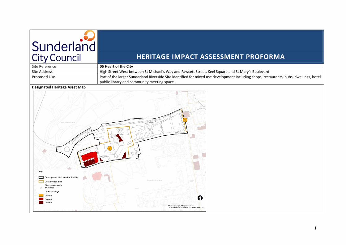
1
HERITAGE IMPACT ASSESSMENT PROFORMA Site Reference 05 Heart of the CitySite Address High Street West between St Michael’s Way and Fawcett Street, Keel Square and St Mary’s BoulevardProposed Use Part of the larger Sunderland Riverside Site identified for mixed use development including shops, restaurants, pubs, dwellings, hotel,
public library and community meeting space Designated Heritage Asset Map
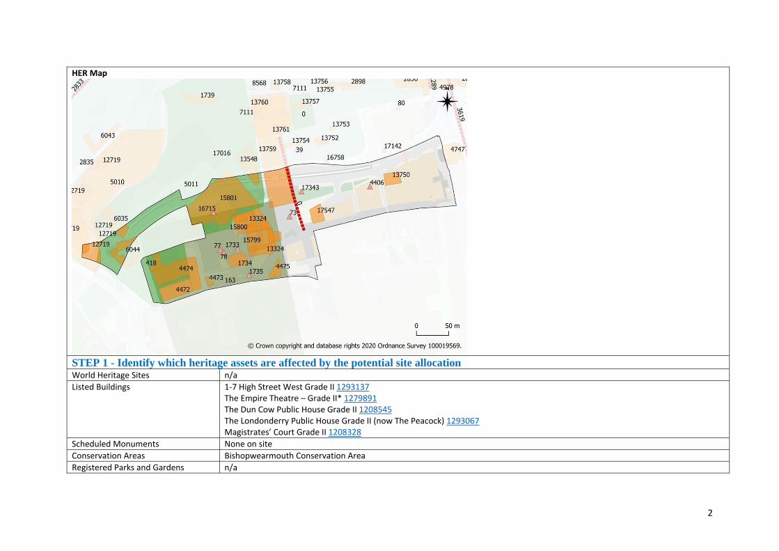
2
HER Map
STEP 1 - Identify which heritage assets are affected by the potential site allocation World Heritage Sites n/aListed Buildings 1‐7 High Street West Grade II 1293137
The Empire Theatre – Grade II* 1279891 The Dun Cow Public House Grade II 1208545 The Londonderry Public House Grade II (now The Peacock) 1293067 Magistrates’ Court Grade II 1208328
Scheduled Monuments None on siteConservation Areas Bishopwearmouth Conservation AreaRegistered Parks and Gardens n/a
3
Non‐designated Assets above ground Central Fire Station (HER 1734) High Street West77 High Street West (currently Marks and Spencer) 90 High Street West (currently Dicksons) 92 High Street West (previously JD Sports) 95 High Street West (currently Pro Nails)
Non‐designated Assets below ground There are known below ground archaeological remains present on this site. These range from Roman to 20th century in date. Heritage Assets in the wider setting These are the heritage assets which fall within 200m radius of the site or where the asset is further out than 200m but there is a visual connection where new development may affect setting of that asset.
Sunniside Conservation AreaGreens Public House Grade II 1208778 135m to the South West Former Gas Board Offices with walls and piers Grade II 1207094 172m to the South West Church of St Michael Grade II* 1207993 105m to the South Mowbray Almshouses Forecourt, Walls and Piers Grade II 1207067 126m to South Mackies Corner Grade II 1207090 200m to the East Elephant Tea Warehouse and Grocers Grade II 1208244 200m to the East Church of St Mary and attached railings Grade II 1207805 140m to the South East Monkwearmouth Railway Bridge over the River Wear with Viaduct to the North Grade II 1207051 170m to the East Wearmouth Bridge Grade II 1279911 175m to the East
Step 2 - Understand what contribution the site (in its current form) makes to the significance of the heritage asset(s) Name of asset Significance of the asset (heritage values) and the setting (physical
surroundings and experience of the asset) Site contribution to the significance of the asset
Designated Heritage Asset Bishopwearmouth Conservation Area Bishopwearmouth Conservation Area derives its significance from a combination
of its medieval origins and subsequent Victorian and Edwardian development. It is predominantly characterised by distinctive Victorian and Edwardian landmark buildings with towers, domes and cupolas rising above refined terraced streets. These are set within a medieval street pattern and around an elevated Town Park upon which the historic St Michael and All Angels Church, now Sunderland Minster, proudly stand as the dominant feature of the conservation area. The conservation area is considered to be of medium significance
The significance of this conservation area is set out in the appraisal Bishopwearmouth‐Character‐Appraisal‐2018.
1‐7 High Street West Grade II Early 19th Century terrace of houses, now shops and offices. Constructed of course stone with ashlar quoins and Welsh slate roof. Their significance is derived from the age and appearance representing early examples of terrace housing in Sunderland. Site faces the raised churchyard of the church of St Michael and so its relationship to other buildings is important. This listed building is considered to be of medium significance.
These heritage assets form part of the significance of the conservation area as examples of early 19th century terrace housing.
4
The Empire Theatre – Grade II*
Early 20th century theatre designed by W and TR Milburn. Ashlar entrance with large rear auditorium. Distinctive and visible copper dome, slate roof topped with a female figure (Terpischore) in a free Baroque style. Its significance is derived from its age, level of detail and decoration and its association with important theatre designers. This listed building is considered to be of high significance.
This heritage asset forms part of the significance of the conservation area. It is an important and architecturally accomplished component to the conservation area.
The Dun Cow Public House Grade II
Early 20th Century public house designed by Benjamin F Simpson for Robert Deuchar. Sandstone ashlar on a grey granite plinth with roof of graduated Lakeland slate. The interior has a largely early or original back bar fitting. Its significance comes from its highly decorative free Baroque style, its continued use as a public house and its interior. This listed building is considered to be of medium significance.
This heritage asset forms part of the significance of the conservation area. It is an important and architecturally accomplished component to the conservation area.
The Londonderry Public House Grade II (now The Peacock)
The Public House by HTD Hedley dated 1901 is on a triangular plan constructed of sandstone ashlar with granite entrance columns. The significance of The Peacock, in the context of setting, is derived from its contribution to the Sunderland skyline, which includes the distinctive cupola roofline. This listed building is considered to be of medium significance
This heritage asset forms part of the significance of the conservation area. It is an important and architecturally accomplished component to the conservation area.
Magistrates’ Court Grade II The Magistrates’ Court derives its significance from its period (1905), its use as animportant civic building and its association with influential Edwardian Sunderland architects, W& TR Milburn who designed the building with Wills and Anderson. This listed building is considered to be of medium significance
This heritage asset forms part of the significance of the conservation area. It is an important and architecturally accomplished component to the conservation area.
Non designated assetsCentral Fire Station (HER 1734) High Street West
Shown as Central Fire Station on Ordnance Survey third and fourth editions. The fire station opened in 1907 designed by Sunderland architects William Milburn (1850‐1935) and Thomas Ridley Milburn (1862‐1943). It significance relates to its design, its age , its connection to important local architects This non designated heritage asset is considered to be of medium significance
This heritage asset forms part of the significance of the conservation area. It is an important and architecturally accomplished component to the conservation area.
77 High Street West (currently Marks and Spencer)
77 High Street, is currently occupied by Marks and Spencer occupies a large block. The light Portland stone façade with grey green marble detail across 15 bays and 3 storeys. The central projecting gold clock and the entablature which is inscribed Marks and Spencer. This building first appears on the 1964 OS map suggesting it
This building is not listed but the façade is considered to have some architectural merit which contributes to the character and quality of the area

5
was constructed late 1950’s. It is the largest building within this stretch of High Street West. Visually, its significance relates to the façade, as an example of mid 20th Century retail design and in its scale and use of materials. This non designated heritage asset is considered to be of unknown significance and further work would be required to establish this in any detail.
90 High Street West (currently Dicksons)
90 High Street West is marked on the first edition OS map. A tall, narrow building with neoclassical façade in fainece tiles with Edwardian baroque details probably added towards the end of the 19th/early 20th Century. Formerly a temperance hotel and then Lockhart’s Cocoa Room. Tall and narrow it is representative of the early burgage plots that have largely been lost along High Street West and probably the original building line. This non designated heritage asset is considered to be of low significance and further work would be required to establish this in any detail.
This building is not listed but the building is considered to have some historic and architectural merit which contributes to the character and quality of the area.
92 High Street West (previously JD Sports)
The High Street West elevation appears very unpromising, but the East elevation on Panns Lane contains the remnants of the former Three Crowns Public House. Three arches highly decorated in faience green and brown tiles. Not much is known about what survives on the main front elevation, but this building is marked as a Public House on the first edition OS map 1858. This non designated heritage asset is considered to be of low significance and further work would be required to establish this in any detail.
This building is not listed but the building is considered to have some historic and architectural merit which contributes to the character and quality of the area.
95 High Street West (currently Pro Nails)
95 High Street West is shown on the first edition OS Map 1858 as the last surviving building which was once part of a long narrow burgage plot of a series of buildings heading north to the River Wear, most of which were removed to install ventilation shafts for the railway tunnel at the end of the 19th Century. Its significance is in its age and representative of the burgage plots that were once common in Sunderland. This non designated heritage asset is considered to be of unknown significance and further work would be required to establish this in any detail.
This building is not listed but the building is considered to have some historic and architectural merit which contributes to the character and quality of the area.
Non designated archaeology Roman stray finds have been identified within the Heart of the City area (HER
17343). The site is located within the northern extent of Bishopwearmouth early Medieval village (HER 163). The settlement is first thought to have been
This site has the potential to enhance understanding of the history and development of Sunderland.

6
referenced in 930 when King Athelstan gave "South Wearmouth" and its appendages to the see of Durham. The north western extent of the area formed part of Rectors Park (HER 5011) and was included within the area covered by Galley Gill cemetery (HER 5010).
Heritage Assets in the wider setting Sunniside Conservation Area
The significance of Sunniside Conservation Area is derived from its early 19th century development as a middle‐class residential area, from the fine late Georgian and early Victorian terraces to excellent individual buildings of both Classical and Gothic styles. Much of the original grid‐iron layout of the Fawcett Estate survives, although there have been changes in the urban grain due to various redevelopment schemes. The character of the area is heavily influenced by its location in what is now Sunderland's central business district Sunniside Gardens make a significant contribution to the character of the area. The conservation area is considered to be of medium significance
Sunniside Conservation Area boundary falls within the 200m buffer to the site which represents part of the historic town centre Its setting comprises historic and architecturally important buildings. The development of the site should retain key views and connections to preserve and enhance that setting.
Greens Public House Grade II This public house was built in 1901 of ashlar stone with grey granite plinth in Baroque style. It significance comprises its age, its decorative appearance as one of three of examples of listed public houses in this area with similar construction dates. This listed building is considered to be of medium significance
This heritage asset forms part of the significance of the Bishopwearmouth Conservation Area. It is an important historic and architecturally accomplished component to the conservation area.
Former Gas Board Offices with walls and piers Grade II
The former gas board building derives its significance from the curved floorplan, its age (1900) and its architectural detailing and use of materials including yellow faience dressings and Lakeland slates. This listed building is considered to be of medium significance
This heritage asset forms part of existing townscape in the setting to the Bishopwearmouth Conservation Area. It is an important historic and architecturally accomplished component to the conservation area.
Church of St Michael Grade II*
Bishopwearmouth Parish church with a medieval chancel and later tower (1807) transepts added by John Dobson in 1849 and the nave rebuilt with double aisles in 1933 – 35 by W.D Caroe. Its significance is derived from its age, its later alterations and connections to important British architects. This listed building is considered to be of high significance
This heritage asset forms part of the significance of the Bishopwearmouth Conservation Area. It is an important historic and architectural component to the conservation area and prominent landmark adjacent the site.
Mowbray Almshouses Forecourt, Walls and Piers Grade II
Almshouses that were rebuilt for Elizabeth Gray Mowbray in 1863 by ER Robson (better known for his influential design of schools for the Board of Education).
This heritage asset forms part of the significance of the Bishopwearmouth Conservation Area. It is

7
Replaced earlier Almshouses form was 1772. These buildings derived their significance from age, construction, use and appearance. This listed building is considered to be of medium significance
an important historic and architectural component to the conservation area.
Mackies Corner Grade II Mackies Corner is listed for its architectural interest as a handsome mid 19th
Century commercial design utilising fine ‐ quality materials which combine to produce a well‐detailed classical façade. The lead covered dome and corner elevation is visible along High Street West. This listed building is considered to be of medium significance
This heritage asset forms part of the significance of the Sunniside Conservation Area. It is an important historic and architecturally accomplished component to the conservation area.
Elephant Tea Warehouse and Grocers Grade II
The former Elephant Tea Warehouse and Grocers, 1873 to 1877 for Grimshaw & Son to designs by Frank Caws, with C20 alterations. Its significance is derived from its exotic Hindu–Gothic architecture with intricate terracotta exterior decorative scheme by Doulton and Co. It is a striking building in red and white occupying a prominent site on High Street West associated with an important local architect. This listed building is considered to be of medium significance
This heritage asset forms part of the significance of the Sunniside Conservation Area. It is an important historic and architecturally accomplished component to the conservation area.
Church of St Mary and attached railings Grade II
St Mary’s is a Roman Catholic parish church. Its significance is made up of its age (1830). It is the earliest Gothic revival church that survives in Sunderland. Its association with the designer, a regionally important architect, Ignatious Bonomi, its architectural detailing, use of material such as sandstone and some limestone, welsh slate roof. This listed building is considered to be of medium significance
The setting to the church is only in part drawn from the site. It is largely in the context of the townscape Bridge street and separated from Bishopwearmouth and High Street West.
Wearmouth Bridge Grade II Wearmouth Bridge is a road bridge built in 1929. It was designed by GL Groves of Mott, Hay and Anderson. Its significance is derived from its design, its location on the site of an earlier bridge of 1793 then widened by Robert Stephenson in 1856 and for which the cast iron balustrades incorporate some of the 1856 work. The bridge has a steel superstructure, parabolic 3‐pinned arch, of 2 ribs with a span of 375 feet. This listed building is considered to be of high significance. It has interest of national significance as a symbol of the city of Sunderland.
The setting to the bridges is within the context of the dramatic riverside valley and the raised plateau to either bank. Their size and location mean that views, both glimpsed and sustained, are possible from the periphery of the site and these should be retained or enhanced. High quality development is likely to contribute positively to the setting of these heritage assets.

8
Monkwearmouth Railway Bridge over the River Wear with Viaduct to the North Grade II
The Monkwearmouth railway bridge derives its significance from its age, 1879, its association with an important NER railway engineer, Thomas Harrison and its design, comprising a girder deck and bow‐string arch with girder ties braced by pierced plates graduating from circles to tall ovals. The bridge linked Newcastle with Sunderland by rail for the first time and is described as `the largest hog‐back iron girder bridge in the world'. This listed building is considered to be of high significance. It has interest of national significance as a symbol of the city of Sunderland.
The setting to the bridges is within the context of the dramatic riverside valley and the raised plateau to either bank. Their size and location mean that views, both glimpsed and sustained are possible from the periphery of the site and these should be retained or enhanced. High quality development is likely to contribute positively to the setting of these heritage assets.
STEP 3 Identify what impact the allocation may have on that significance Location and siting (e.g. proximity, extent, topography, key views) Form and appearance (e.g. prominence, massing, scale and materials) Secondary effects (e.g. increased traffic movement, vibration, noise, lighting, access and use of landscape) The Heart of the City is, as the name suggests, part of the commercial centre of Sunderland. There are 5 listed buildings and 1 conservation area across the Heart of the City site. There are also designated heritage assets which fall within the wider setting of the site. Name of asset Description of ImpactDesignated Heritage assets Bishopwearmouth Conservation Area 1‐7 High Street West Grade II The Empire Theatre – Grade II* The Dun Cow Public House Grade II The Londonderry Public House Grade II (now The Peacock) Magistrates’ Court Grade II
Development on the Heart of the City site has the potential to affect the setting of a number of listed buildings and the character and appearance of the Bishopwearmouth Conservation Area. In regard to impact, proposed development should reflect the design characteristics set out in the National Design Guide (2019). A future proposal should also prepare a full assessment, to inform and understand the contribution significance makes to the setting of the designated heritage assets through careful consideration of location and siting that responds positively to the existing local character and appearance. Particular consideration should be given to form and appearance through scale, massing and materials. Development within the conservation area or adjacent to listed buildings will have greater impact where development will be prominent and should consider key views of very visible listed buildings in the roofscape or the skyline of Sunderland. These matters can be dealt with in detail through the normal planning application and development management processes and should be highlighted at an early stage in pre‐application discussions. Development which fails to respond to local character and appearance or to take opportunities to better reveal or enhance significance would have the potential for a harmful impact scaled minor to major adverse depending on the nature of the proposal. Well designed, high quality development will reinforce character and the identity of a place and so have a beneficial impact. Development within the Heart of the City site will have the potential for a major or minor adverse as well as a beneficial impact on the character and appearance of the conservation area and the contribution setting makes to the significance of identified designated heritage assets.
Non Designated Heritage Assets Central Fire Station (HER 1734) High Street West
Proposal for development may impact directly or to the setting of identified non designated heritage assets.
9
77 High Street West (currently Marks and Spencer) 90 High Street West (currently Dicksons) 92 High Street West (previously JD Sports) 95 High Street West (currently Pro Nails)
Development on this a site will have the potential for a minor adverse as well as a beneficial impact on non‐designated heritage assets. Proposals that seek to better reveal or enhance the significance of or re‐use non designated heritage assets will have a beneficial impact. Development within the Heart of the City site will have the potential for a minor adverse impact where the proposals would harm the asset, as well as a beneficial impact on the significance of non‐designated heritage assets. Archaeological remains on this site have potential to enhance understanding of local and or regional historic development of the area.
Assets in the wider setting Sunniside Conservation Area Greens Public House Grade II Former Gas Board Offices with walls and piers Grade II Church of St Michael Grade II* Mowbray Almshouses Forcourt, Walls and Piers Grade II 1207067 Mackies Corner Grade II 1207090 Elephant Tea Warehouse and Grocers Grade II 1208244 200m to the East Church of St Mary and attached railings Grade II 1207805 140m to the South East Monkwearmouth Railway Bridge over the River Wear with Viaduct to the North Grade II 1207051 170m to the East Wearmouth Bridge Grade II 1279911 175m to the East
Heritage Assets which fall within the wider setting of the Heart of the City site form a collective setting that combined contributes the overall appearance of Sunderland. Development within the site may impact on the setting of a number of designated heritage assets and as such should be assessed at that time, with consideration given to the protected status of listed buildings and the policy requirement to sustain and enhance the character and appearance of conservation areas. Development within the Heart of the City site will have the potential for a minor adverse impact where the proposals would harm the setting of an asset, as well as a beneficial impact on the contribution setting makes to the significance makes of designated heritage assets.
STEP 4 Consider whether identified harm can be justified and how such harm can be mitigated Identify Potential Harm Mitigating Harm (e.g. identify alternative sites, amendments to site boundary, relocate development within the site, identify design
requirements, open space, protection of key views, density, layout and heights of buildings, traffic management)

10
The potential for major adverse impact where total demolition and loss of a designated heritage asset is proposed. This would equate to total loss or substantial harm. The potential for a minor adverse impact on the contribution that setting makes to the significance of nearby designated heritage assets, as identified in step 3. This means there could be the potential for harmful impact that would equate to less than substantial harm.
Major adverse impact could be identified if the development proposal includes for the demolition of a designated or non‐designated heritage asset(s). This would constitute substantial harm to the heritage asset and would need to have clear and convincing justification for that harm which would be weighed against public benefits brought about by a proposal. Mitigation may be to understand the limitations of the proposal and to identify areas that would be less sensitive to change to secure the optimum viable scheme. Minor adverse impact could be identified if the design and scale of development would be such that the heritage asset is retained but that it adversely affects the significance of the designated or non‐designated heritage assets. This could be by impacting on key or important element of the building and the scale of the overall form not being compatible with the existing structure. This harm could be mitigated through the normal planning and development management process and the early identification of significance and the potential impact on that significance. This process should include the production of a heritage statement, in accordance with para 189 of the NPPF, by the applicant that identifies significance of the heritage assets and assesses the impact. It should set out the options considered, and the steps taken to avoid or minimise harm to the setting of the nearby heritage assets should be identified as part of this assessment. Future proposals should take account of best practice advice as set out by Historic England and the National Design Guide (at the time of writing 2019) published by MHCLG. Development on the rest of the site could reflect the existing 19th Century street pattern and use as a basis to inform new development taking the opportunity through good design principles of, for example, scale, height, mass, materials, location, appearance to enhance the character of the former industrial site. The development of sites within the Heart of the City should be considered for archaeological potential on a site‐to‐site basis.
Maximising Enhancement Opportunities e.g. Public access, interpretation, increase understanding through research, repair/regenerate heritage assets, removal from HAR register, better reveal significance through new viewpoints There are enhancement opportunities available through the development of this site for several listed buildings, non‐designated heritage assets and conservation areas. These could include the repair and restoration of historic buildings, their sympathetic adaptive re‐use, and the creation of or opening up new viewpoints within the wider site incorporating vistas of historic buildings, which would enhance the setting of the nearby designated heritage assets in a way that could better reveal our understanding of those assets. Information boards and greater public access through sites will also enhance understanding of the historic environment and active re‐use will ensure buildings and spaces are maintained for at least another building lifecycle. Reflecting the historic vernacular and high‐quality public realm of Sunderland in association with the Riverside and through careful consideration of scale, mass, design, materials, form, style and rhythm to help to enhance the quality of the urban environment and the public realm. This will support its historic character and appearance. This could be achieved through the normal planning process. Development could provide an opportunity to find out more about the archaeological potential in the area through desk‐based assessments and evaluation as appropriate STEP 5 Determine whether the proposed site allocation is appropriate in the light of the NPPF’s tests of soundness
11
The Heart of the City site identified for re development has the potential to result inmajor to minor adverse as well as beneficial impact on the significance of the identified heritage assets and their setting. A major adverse impact would constitute substantial harm, but it is likely that this would not present itself and could be avoided. There is also the opportunity of a beneficial impact should the heritage assets be re‐purposed for a new use. The sensitive repair and adaptive re‐use of the heritage asset could have a considerably positive impact on its significance. A minor adverse impact means that the significance of the heritage asset could be severely affected by a proposal that fails to consider the heritage assets, but that this impact could be avoided through an understanding of the building and connection between places and bring forward a realistic prospect of their re‐use. Development within the setting could be harmful, and this would equate to less than substantial harm to the setting of the identified heritage assets. The level of harm would depend on the scale and massing of development and whether a proposal has fully considered the impact on the nearby heritage assets and demonstrated whether any harm could be avoided or outweighed by public benefits. It is considered that the level of potential harm, should it arise, could be mitigated through careful and considered design that limits the impact on the designated heritage assets. The normal planning processes, in accordance with the relevant national and local plan policies relating to heritage, design and landscaping, will ensure that development on this site is delivered in a manner that minimises harm to the historic environment and takes the opportunity to enhance significance where possible. The Heart of the City site also has the potential, as part of the centre of the city, to sustain and enhance the setting of nearby heritage assets through careful design in terms of layout, scale, massing and materials. Furthermore, there are opportunities to better reveal and to expand upon our understanding of the historic environment through the development of this site that may be taken up by a developer. It is therefore considered this site is appropriate for mixed use development in the light of the NPPF’s tests of soundness
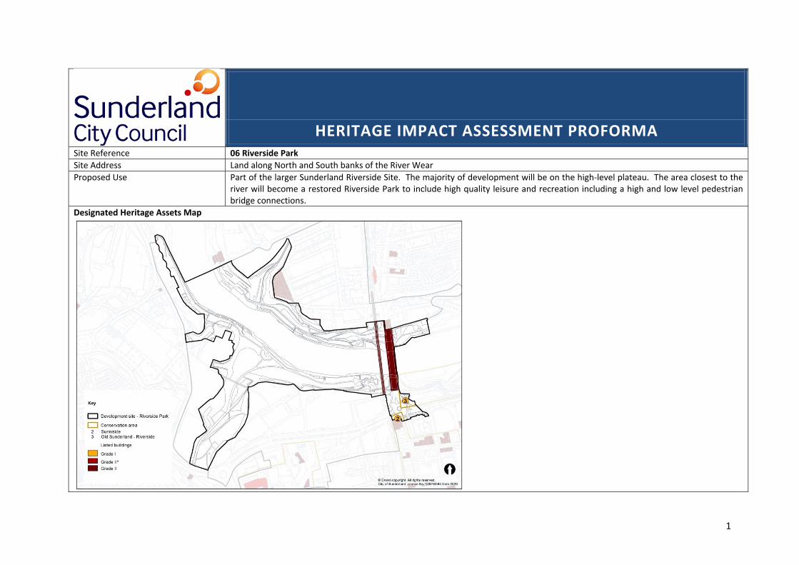
1
HERITAGE IMPACT ASSESSMENT PROFORMA Site Reference 06 Riverside ParkSite Address Land along North and South banks of the River Wear Proposed Use Part of the larger Sunderland Riverside Site. The majority of development will be on the high‐level plateau. The area closest to the
river will become a restored Riverside Park to include high quality leisure and recreation including a high and low level pedestrian bridge connections.
Designated Heritage Assets Map

2
HER Map
STEP 1 - Identify which heritage assets are affected by the potential site allocation World Heritage Sites n/aListed Buildings Coal Staith at Wearmouth Colliery Grade II 1218456
Monkwearmouth Railway Bridge over the River Wear with Viaduct to the North Grade II Wearmouth Bridge Grade II 1279911
Scheduled Monuments None on siteConservation Areas None on site

3
Registered Parks and Gardens n/aNon‐designated Assets above ground Refer to HERNon‐designated Assets below ground There are known below ground archaeological remains present on this site. These range from medieval to the 20th century in date. Heritage Assets in the wider setting These are the heritage assets which fall within 200m radius of the site or where the asset is further out than 200m but there is a visual connection where new development may affect setting of that asset.
Bishopwearmouth Conservation Area Bishopwearmouth‐Character‐Appraisal‐June_2018. – 135m to boundary to South East Livingstone’s (now the Isis) Public House Grade II 1218062 100 m to the South
Step 2 - Understand what contribution the site (in its current form) makes to the significance of the heritage asset(s) Name of asset Significance of the asset (heritage values) and the setting (physical
surroundings and experience of the asset) Site contribution to the significance of the asset
Designated Heritage Asset Coal Staith at Wearmouth Colliery Grade II
The Coal Staithe is listed for its historic interest as the last surviving staithe on the River Wear which was once lined by staithes from which ships were loaded with coal. Constructed in 1900 the brick piers and platform facing survive but the timber superstructure has been lost. This listed building is considered to be of medium significance.
The Coal Staithe is located on the Northern bank of the River Wear. It is a large brick structure which is now out of context having lost the timber superstructure. The staithe is the remaining large structure which is now illustrative the many staithes which once lined the banks of the River Wear and forms part of the historic and industrial heritage. The River Wear and this structure are closely linked in our understanding.
Wearmouth Bridge Grade II Wearmouth Bridge is a road bridge built in 1929. It was designed by GL Groves of Mott, Hay and Anderson. Its significance is derived from its design, its location on the site of an earlier bridge of 1793 then widened by Robert Stephenson in 1856 and for which the cast iron balustrades incorporate some of the 1856 work. The bridge has a steel superstructure, parabolic 3‐pinned arch, of 2 ribs with a span of 375 feet. This listed building is considered to be of high significance. It has interest of national significance as a symbol of the city of Sunderland.
The setting to the bridges is within the context of the dramatic riverside valley and the raised plateau to either bank. Their size and location mean that views, both glimpsed and sustained, are possible from the site and these views contribute to significance.
Monkwearmouth Railway Bridge over the River Wear with Viaduct to the North Grade II
The Monkwearmouth railway bridge derives its significance from its age, 1879, its association with an important NER railway engineer, Thomas Harrison and its design, comprising a girder deck and bow‐string arch with girder ties braced by
The setting to the bridges is within the context of the dramatic riverside valley and the raised plateau to either bank. Their size and location

4
pierced plates graduating from circles to tall ovals. The bridge linked Newcastle with Sunderland by rail for the first time and is described as `the largest hog‐back iron girder bridge in the world'. This listed building is considered to be of high significance. It has interest of national significance as a symbol of the city of Sunderland.
mean that views, both glimpsed and sustained, are possible from the site and these views contribute to significance.
Non designated assetsNon designated archaeology Monkwearmouth Shore Township (HER 31) was located on the northern bank of
the River and first referred to in 1075. Within the Riverside Park area there was a 19th century cemetery (HER 5010) which was used as an overflow for Bishopwearmouth church yard until 1854. Archaeological remains associated with the industrial use of this site may also still be present here. Coal staithes and depots are noted on the riverside (HER 2746, 2831, 2832 and 6043) including Pemberton’s Drops, where coal from Monkwearmouth Colliery (HER 2743) was loaded onto ships. The site is associated with a series of wagonways and railway (HER 2833, 2745, 6902 and 2692) lines and tunnels that were used to transport coal to the river via Riverside Park. The Bishopwearmouth Glasshouse (HER 2836) was also located here. The glasshouse was opened in 1765 by John Hopton to produce Table Glass.
This site has the potential to enhance understanding of the history and development of Sunderland.
Heritage Assets in the wider setting Bishopwearmouth Conservation Area The Riverside park area extends southwards from the River along Galley’s Gill
towards to the city. At this point it is close to the Bishopwearmouth Conservation Area. Bishopwearmouth Conservation Area derives its significance from a combination of its medieval origins and subsequent Victorian and Edwardian development. It is predominantly characterised by distinctive Victorian and Edwardian landmark buildings with towers, domes and cupolas rising above refined terraced streets. These are set within a medieval street pattern and around an elevated Town Park upon which the historic St Michael and All Angels Church, now Sunderland Minster, proudly stand as the dominant feature of the conservation area. The conservation area is considered to be of medium significance
The site is brownfield land within the centre of Sunderland. This site would have once contributed to significance as part of busy Riverbanks of the Wear, most structures have now been demolished. Bishopwearmouth Conservation Area boundary falls within the 200m buffer to the site and it now represents part of the historic town centre on the South side of St Mary’s Boulevard, the setting of which is legible and the development of the site should retain key views and connections to preserve and enhance that setting.
Livingstone’s (now the Isis) Public House Grade II
This public house was constructed circa 1885 of ashlar sandstone in an Italianate style. Decorative public elevation its significance is derived from its historic and architectural interest as an example of a public house.
Development on the site is unlikely to affect the setting of Livingstone’s Public House, but high
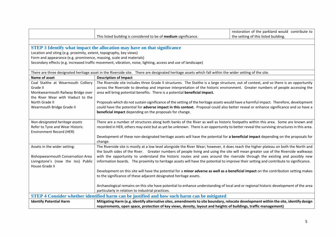
5
This listed building is considered to be of medium significance.
restoration of the parkland would contribute to the setting of this listed building.
STEP 3 Identify what impact the allocation may have on that significance Location and siting (e.g. proximity, extent, topography, key views) Form and appearance (e.g. prominence, massing, scale and materials) Secondary effects (e.g. increased traffic movement, vibration, noise, lighting, access and use of landscape) There are three designated heritage asset in the Riverside site. There are designated heritage assets which fall within the wider setting of the site. Name of asset Description of ImpactCoal Staithe at Wearmouth Colliery Grade II Monkwearmouth Railway Bridge over the River Wear with Viaduct to the North Grade II Wearmouth Bridge Grade II
The Riverside site includes three Grade II structures. The Staithe is a large structure, out of context, and so there is an opportunity across the Riverside to develop and improve interpretation of the historic environment. Greater numbers of people accessing the area will bring potential benefits. There is a potential beneficial impact. Proposals which do not sustain significance of the setting of the heritage assets would have a harmful impact. Therefore, development could have the potential for adverse impact in this context. Proposal could also better reveal or enhance significance and so have a beneficial impact depending on the proposals for change.
Non‐designated heritage assets Refer to Tyne and Wear Historic Environment Record (HER)
There are a number of structures along both banks of the River as well as historic footpaths within this area. Some are known and recorded in HER, others may exist but as yet be unknown. There is an opportunity to better reveal the surviving structures in this area. Development of these non‐designated heritage assets will have the potential for a beneficial impact depending on the proposals for change.
Assets in the wider setting: Bishopwearmouth Conservation Area Livingstone’s (now the Isis) Public House Grade II
The Riverside site is mostly at a low level alongside the River Wear; however, it does reach the higher plateau on both the North and the South sides of the River. Greater numbers of people living and using the site will mean greater use of the Riverside walkways with the opportunity to understand the historic routes and uses around the riverside through the existing and possibly new information boards. The proximity to heritage assets will have the potential to improve their setting and contribute to significance. Development on this site will have the potential for a minor adverse as well as a beneficial impact on the contribution setting makes to the significance of these adjacent designated heritage assets. Archaeological remains on this site have potential to enhance understanding of local and or regional historic development of the area particularly in relation to industrial practices.
STEP 4 Consider whether identified harm can be justified and how such harm can be mitigated Identify Potential Harm Mitigating Harm (e.g. identify alternative sites, amendments to site boundary, relocate development within the site, identify design
requirements, open space, protection of key views, density, layout and heights of buildings, traffic management)

6
The potential for a minor adverse impact on the contribution that setting makes to the significance of nearby designated heritage assets, as identified in step 3. This means there could be the potential for harmful impact that would equate to less than substantial harm.
The Riverside proposal is for restoration creating a parkland for Sunderland by repairing footpaths and lighting to impact is generally likely to be minimal. The landing points for the pedestrian bridges on both sides of the River Wear should ensure there is a Design based assessment undertaken that confirms there are no unknown structures or finds that would enhance our understanding of the area and minimise the loss of information. Minor adverse impact could be identified if the scale and location of development would be such that it affected the contribution setting makes to the significance of heritage assets by impacting on key and important views and overall urban form within the existing cityscape. The development of sites within the Bonnersfield site should be considered for archaeological potential on a site‐to‐site basis.
Maximising Enhancement Opportunities e.g. Public access, interpretation, increase understanding through research, repair/regenerate heritage assets, removal from HAR register, better reveal significance through new viewpoints There are enhancement opportunities available through the of this site for improvements to the Riverside. The creation of high‐quality public realm around the Riverside will support its historic character and appearance. The proposal for two pedestrian bridges at high and low levels will have the capacity to bring new and sustained views towards the road and rail bridges and along the River Wear. Any potential harm could be mitigated through the normal planning and development management process and the early identification of significance and the potential impact on that significance. This process should include the production of a heritage statement, in accordance with para 189 of the NPPF, by the applicant that identifies significance of the heritage assets and assesses the impact. It should set out the options considered, and the steps taken to avoid or minimise harm to the setting of the nearby heritage assets should be identified as part of this assessment. Future proposals should take account of best practice advice as set out by Historic England and the National Design Guide (at the time of writing 2019) published by MHCLG. Development could provide an opportunity to find out more about the archaeological potential in the area through desk‐based assessments and evaluation as appropriate. STEP 5 Determine whether the proposed site allocation is appropriate in the light of the NPPF’s tests of soundness The Riverside development site has the potential to result in minor adverse or beneficial impact on the significance of the identified heritage assets and their setting. A minor adverse impact means that the significance of the identified heritage assets could be affected particularly through impact on the contribution setting makes to significance, but that this impact could be avoided through an understanding of the heritage assets to minimise harm. Development within the setting of heritage assets could be harmful, and this would equate to less than substantial harm to the setting of the identified heritage assets. The level of harm would depend on the scale and massing of development and whether a proposal has fully considered the impact on the nearby heritage assets and demonstrated whether any harm could be avoided or outweighed by public benefits.

7
It is considered that the level of potential harm, should it arise, could be mitigated through careful and considered design that limits the impact on the designated heritage assets. The normal planning processes, in accordance with the relevant national and local plan policies relating to heritage, design and landscaping, will ensure that development on this site is delivered in a manner that minimises harm to the historic environment and takes the opportunity to enhance significance where possible. The site is more likely to have a beneficial impact of the significance of the identified heritage assets through the creation of a high‐quality Riverside Park that will provide environmental and landscape improvements that will in general terms enhance the wider river corridor setting of the heritage settings. It is therefore considered that this site is appropriate for development as a Riverside Park in the light of the NPPF’s tests of soundness