Embed Size (px)
Citation preview
SURFACE RUNOFF ESTIMATION USING SCS- CN METHOD AND GIS TOOL
FOR THE PALAR WATERSHED, KARNATAKA
Amritha Thankachan1, Mohammed Badiuddin Parvez2, Chalapathi K3, M. Inayathulla4,
Chithaiah.E5
1,2,3 Research Scholar, Department of Civil Engineering, UVCE, Bangalore University
4 Professor, Department of Civil Engineering, UVCE, Bangalore University
5Guest Faculty, Department of Civil Engineering, UVCE, Bangalore University
Abstract:
Adequate knowledge about the hydrology is very much required for the proper planning
and management of water resources in an area. Rainfall and runoff are the important
constituents in determining the hydrology of an area to determine the water management
strategies. SCS- CN method is a widely used method for the calculation of surface runoff
considering the land use pattern, soil type and antecedent moisture condition. In the present
study runoff of the Palar watershed, Karnataka state, South India has been calculated using the
SCS-CN method. The watershed consists of a total area of 2872.357 km2. The maximum
rainfall of 1231.67 mm in the year 2005 and a minimum of 418.7 mm in the year 2003. The
average annual runoff is calculated as 218.26 mm and 626.91MCM. The rainfall- runoff
correlation value is 0.8253. The study results can be effectively coordinated for the watershed
management activities.
Key Words: Antecedent Moisture Condition, Hydrological Soil Group, Runoff, SCS- CN
method
Introduction:
A watershed is defined as an area of land that feds all the water running under it and
draining off into a waterbody. Rainfall and runoff are important processes involved in
hydrologic cycle. Rainfall is the common form of the precipitation in which liquid water is
received from the condensed atmospheric water vapour. Where ever rainfall is involved in that
region’s hydrologic cycle, it serves major role not only to serve the needs of the humanity, but
also for the existence of the life.
Surface runoff is the term used to mention the flow of excess water through the surface
of earth. Runoff depends on many factors like meteorological factors, physical characteristic
of the basin etc. in which rainfall and its characteristics have major influence. Also it is very
much important to study how the runoff varies with rainfall under the prevailing conditions as
rainfall- runoff studies are very essential for the construction of hydraulic structures, watershed
management, flood forecasting, water harvesting and also for any hydrologic studies.
Soil Conservation Services Curve Number method abbreviated as SCS-CN method is
a widely accepted and used method for the calculation of runoff. This method was developed
Compliance Engineering Journal
Volume 11, Issue 2, 2020
ISSN NO: 0898-3577
Page No: 258
by United Stated Department of Agriculture and Natural Resources Conservation Services. It
is also called as CN method. It is mainly based on the concept of water balance.
The major hypothesis behind SCS-CN method are the ratio of ‘Q’ and (P-Ia) is equal to
the ratio of ‘F’ and ‘S’; where ‘Q’ is the actual runoff, (P-Ia) is the potential runoff, ‘P’ is
rainfall, ‘Ia’ is the initial abstractions, ‘F’ is the cumulative infiltration excluding Ia and ‘S’ is
the potential infiltration and the amount of initial abstraction is some fraction of potential
infiltration.
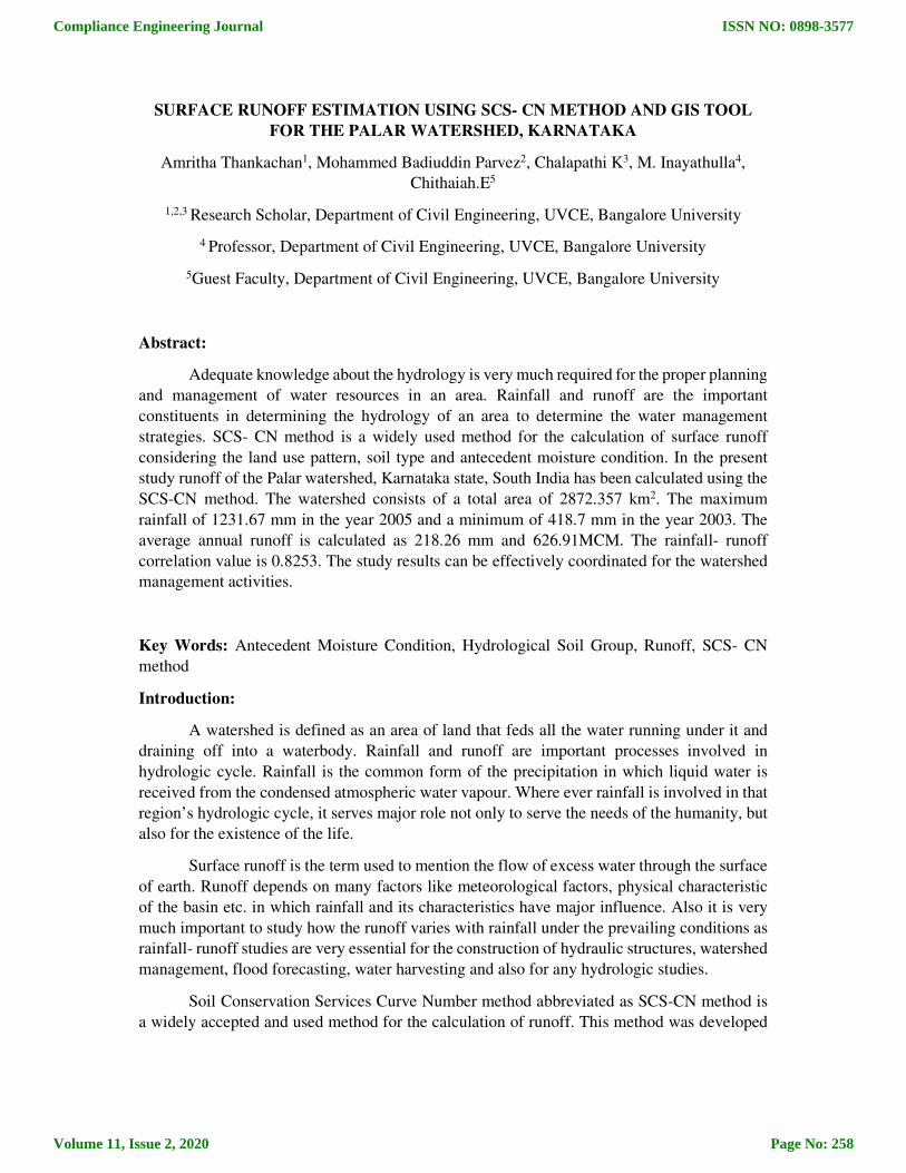
Description of the study area:
Palar is a river which originates in Nandi Hills in Chikkaballapura , Karnataka. It pours
out to Bay of Bangal at Vayalur, Tamil Nadu after flowing a distance of 348 km through
Karnataka, Andra Pradesh and Tamil Nadu. It has seven tributaries. The study area situates
between latitude 12051’39’’ and 13028’08’’ and longitude 77052’47’’ and 78034’53’’. It is having
a total area of 2872.357 km2.
Fig. 1. Location of study area
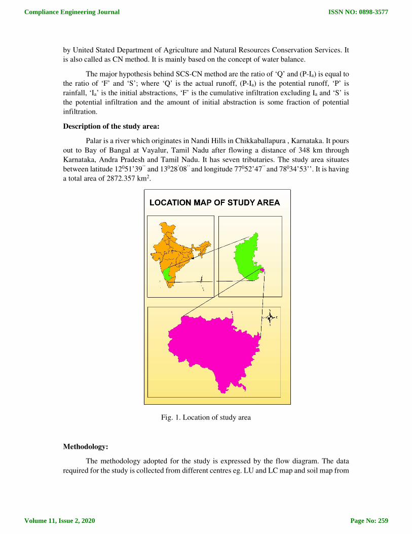
Methodology:
The methodology adopted for the study is expressed by the flow diagram. The data
required for the study is collected from different centres eg. LU and LC map and soil map from
Compliance Engineering Journal
Volume 11, Issue 2, 2020
ISSN NO: 0898-3577
Page No: 259
KSRSAC, rainfall data from the year 1986 to 2015 from IMD, SCS-CN method is adopted for
the calculation of runoff.
In SCS-CN method, boundary of the watershed, soil map and land cover and land use
map and rainfall data serve as major inputs. Curve numbers are assigned to the different land
use classes based on the soil groups. Soil is grouped into hydrological soil groups A, B, C and
D based on their infiltration capacity. Rainfall data from the six rain gauge stations are used
for the study. CN I and CN III are calculated from the obtained CN II value based on the
antecedent moisture conditions using the equations. Potential maximum retention ‘S’ is
calculated from the equation:
Runoff ‘Q’ is calculated from rainfall ‘P’ and ‘S’ value from the equation.
Fig. 2 . Methodology Adopted for the study
Compliance Engineering Journal
Volume 11, Issue 2, 2020
ISSN NO: 0898-3577
Page No: 260
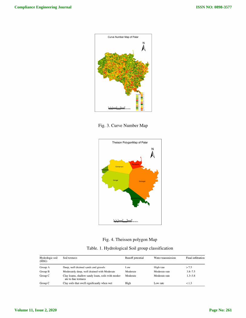
Fig. 3. Curve Number Map
Fig. 4. Theissen polygon Map
Table. 1. Hydrological Soil group classification
Compliance Engineering Journal
Volume 11, Issue 2, 2020
ISSN NO: 0898-3577
Page No: 261
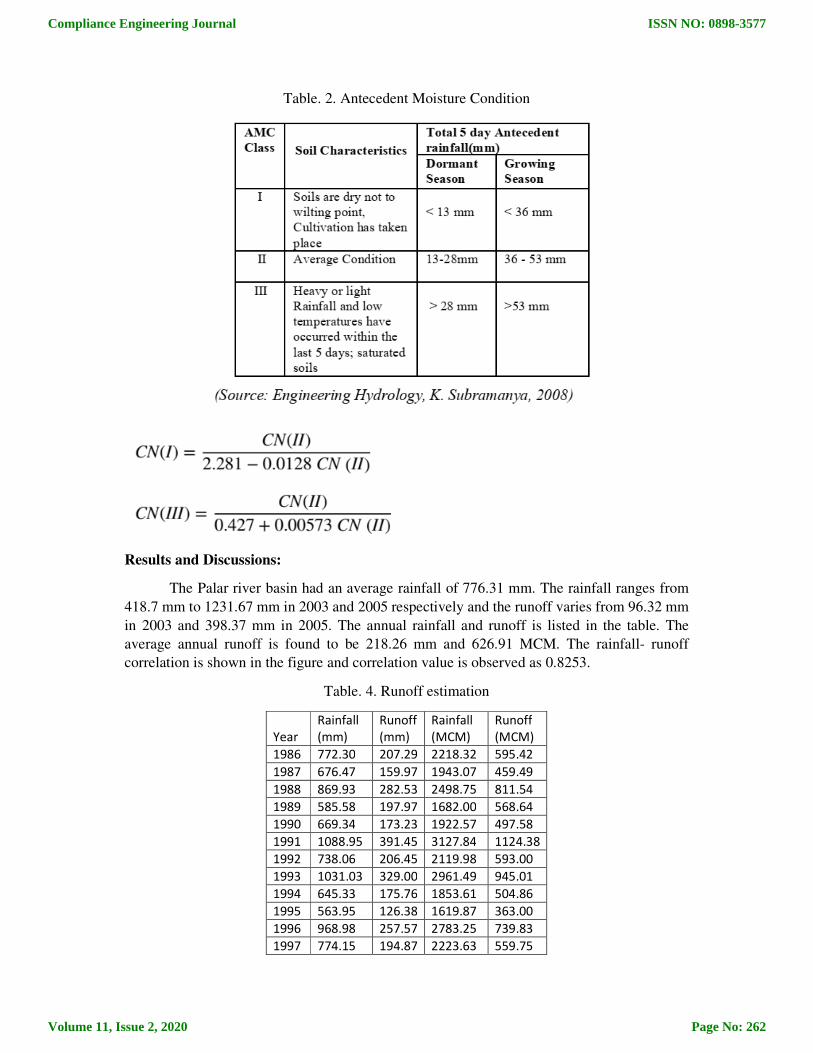
Table. 2. Antecedent Moisture Condition
Results and Discussions:
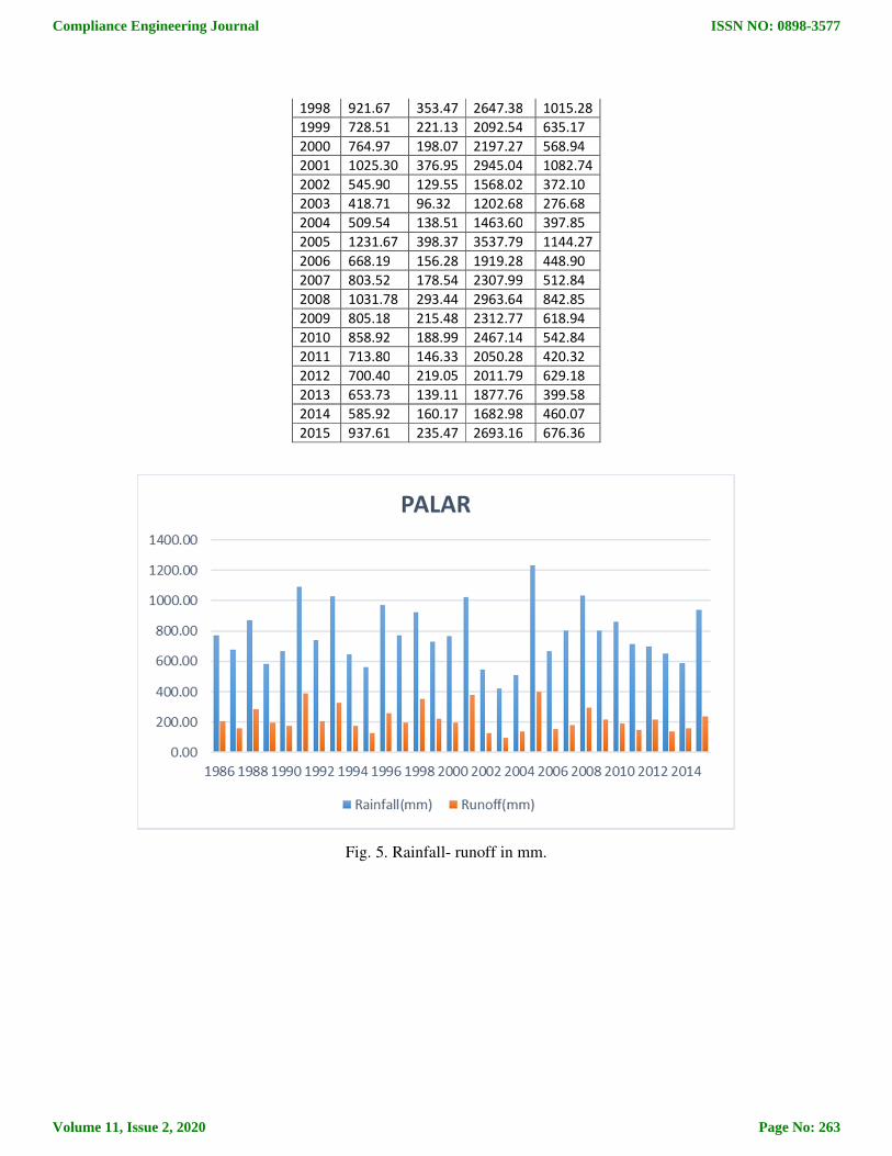
The Palar river basin had an average rainfall of 776.31 mm. The rainfall ranges from
418.7 mm to 1231.67 mm in 2003 and 2005 respectively and the runoff varies from 96.32 mm
in 2003 and 398.37 mm in 2005. The annual rainfall and runoff is listed in the table. The
average annual runoff is found to be 218.26 mm and 626.91 MCM. The rainfall- runoff
correlation is shown in the figure and correlation value is observed as 0.8253.
Table. 4. Runoff estimation
Year
Rainfall
(mm)
Runoff
(mm)
Rainfall
(MCM)
Runoff
(MCM)
1986 772.30 207.29 2218.32 595.42
1987 676.47 159.97 1943.07 459.49
1988 869.93 282.53 2498.75 811.54
1989 585.58 197.97 1682.00 568.64
1990 669.34 173.23 1922.57 497.58
1991 1088.95 391.45 3127.84 1124.38
1992 738.06 206.45 2119.98 593.00
1993 1031.03 329.00 2961.49 945.01
1994 645.33 175.76 1853.61 504.86
1995 563.95 126.38 1619.87 363.00
1996 968.98 257.57 2783.25 739.83
1997 774.15 194.87 2223.63 559.75
Compliance Engineering Journal
Volume 11, Issue 2, 2020
ISSN NO: 0898-3577
Page No: 262
1998 921.67 353.47 2647.38 1015.28
1999 728.51 221.13 2092.54 635.17
2000 764.97 198.07 2197.27 568.94
2001 1025.30 376.95 2945.04 1082.74
2002 545.90 129.55 1568.02 372.10
2003 418.71 96.32 1202.68 276.68
2004 509.54 138.51 1463.60 397.85
2005 1231.67 398.37 3537.79 1144.27
2006 668.19 156.28 1919.28 448.90
2007 803.52 178.54 2307.99 512.84
2008 1031.78 293.44 2963.64 842.85
2009 805.18 215.48 2312.77 618.94
2010 858.92 188.99 2467.14 542.84
2011 713.80 146.33 2050.28 420.32
2012 700.40 219.05 2011.79 629.18
2013 653.73 139.11 1877.76 399.58
2014 585.92 160.17 1682.98 460.07
2015 937.61 235.47 2693.16 676.36
Fig. 5. Rainfall- runoff in mm.
Compliance Engineering Journal
Volume 11, Issue 2, 2020
ISSN NO: 0898-3577
Page No: 263
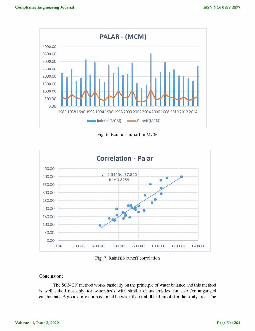
Fig. 6. Rainfall- runoff in MCM
Fig. 7. Rainfall- runoff correlation
Conclusion:
The SCS-CN method works basically on the principle of water balance and this method
is well suited not only for watersheds with similar characteristics but also for ungauged
catchments. A good correlation is found between the rainfall and runoff for the study area. The
Compliance Engineering Journal
Volume 11, Issue 2, 2020
ISSN NO: 0898-3577
Page No: 264
runoff is found to be 28% of the rainfall obtained in the watershed. Even though the method is
designed for a single storm event, it can be scaled to find average annual runoff values. This
study can be effectively useful for the watershed management of Palar watershed.
References:
1. Amutha R, Porchelvan P, 2009. Estimation of surface runoff in Malattar sub-watershed
using SCS- CN method, J Soc Remote Sens, 37(2): 291-304
2. Bansode A, Patil KA, 2014. Estimation of runoff by using SCS curve number method
and arc GIS, Int J Sci Eng Res 5(7): 1283-1287
3. Chow V T, Maidment D K, Mays L W, 2002. Applied Hydrology, Publisher McGraw
Hills, New York, USA.
4. Dhvani Tailor, Narendra J S, 2016. Surface runoff estimation by SCS- Curve Number
method suing GIS for Rupen- Khan watershed, Mehsana district, Gujarat, Journal of
Indian Water Resources Society, Vol.36, No.4
5. Handbook of Hydrology,1972. Soil Conservation Department, Ministry of Agriculture,
New Delhi.
6. Jesrotia AS, Dhiman SD and Aggarwal SP, 2002. Rainfall-runoff and soil erosion
modellingnusing remote sensing and GIS technique- A case study on tons watershed,
Journal of Indian Society of Remote Sensing, Vol.30(3), pp. 167-180.
7. Mishra SK, Jain MK, Singh VP, 2004. Evaluation of the SCS- CN based model
incorporating antecedent moisture. Water Resour Manag 18:567-589.
8. Mohammed Badiuddin Parvez, Chalapathi K and M Inayathulla. " Geomorphological
Analysis of Two Mini-Watersheds in Raichur City Karnataka" International Research
Journal of Engineering and Technology (IRJET) Volume 6 Issue 6 June 2019 Page
2896-2901
9. Mohammed Badiuddin Parvez, M Inayathulla, "Geomorphological Analysis of
Landforms of Upper Cauvery Karnataka India", International Journal of Scientific
Research in Multidisciplinary Studies , Vol.5, Issue.10, pp.33-38, 2019.
10. Mohammed Badiuddin Parvez, Chalapathi k, Amritha Thankachan, M Inayathulla, "
Modelling of Intensity-Duration Frequency curves for Upper Cauvery Karnataka
through Normal Distribution", IJITEE, Vol.9, Issue.1, pp.4480-4502, 2019.
11. Mohammed Badiuddin Parvez, M Inayathulla, "Multivariate Geomorphometric
Approach to Prioritize Erosion Prone Watershed of Upper Cauvery Karnataka", World
Academics Journal of Engineering Sciences, Vol.6, Issue.1, pp.7-17, 2019.
12. Mohammed Badiuddin Parvez, M Inayathulla, "Assesment of the Intensity Duration
Frequency Curves for Storms in Upper Cauvery Karnataka Based on Pearson Type III
Extreme Value", World Academics Journal of Engineering Sciences, Vol.6, Issue.1,
pp.26-46, 2019.
13. Mohammed Badiuddin Parvez, M Inayathulla, " Estimation of Surface Runoff by Soil
Conservation Service Curve Number Model for Upper Cauvery Karnataka ",
International Journal of Scientific Research in Multidisciplinary Studies , Vol.5,
Issue.11, pp.7-17, 2019.
14. Mohammed Badiuddin Parvez, Chalapathi k, Amritha Thankachan, M Inayathulla, "
Isopluvial Maps of Daily Maximum Precipitation for Different Frequency for Upper
Compliance Engineering Journal
Volume 11, Issue 2, 2020
ISSN NO: 0898-3577
Page No: 265
Cauvery Karnataka", Praxis Science and Technology Journal, Vol.8, Issue.10, pp.20-
38, 2019.
15. S. Satheesh Kumar, S. Venketeswaran, R. Kannan, 2017. Rainfall- runoff estimation
using SCS-CN and GIS approach in the Pappiredipatti watershed of Vaniyar sub basin,
South India, Springer Model. Earth Syst. Environ., 3-24
16. Saravanan S, Manjula R, 2015. Geomorphology based semi- distributed approach for
modelling rainfall- runoff modelling using GIS. Aquat Proc 4: 908-916.
17. Sindhu D, Shivakumar B, Ravikumar AS, 2013. Estimation of surface runoff in Nallur
amanikere watershed using SCS-CN method, International Journal of Research in
Engineering and Technology, eISSN:2319-1163, 404- 409
18. Subramanya K, 2008. Engineering Hydrology, Publisher Tata Mc Graw Hills, 3rd
edition, pp 139-195.
19. Vinithra R, Yeshodha L, 2016. Rainfall- runoff modelling using SCS-CN method: a
case study of Krishnagiri District, Tamilnadu. Int J Sci Res 5(3):2319-7064.
Compliance Engineering Journal
Volume 11, Issue 2, 2020
ISSN NO: 0898-3577
Page No: 266